1A Terrestrial Data Collection: Goals Objectives Produce detailed spatial raw data (3D point clouds) with registered imagery for several bridge structures using high-density surveying (HDS) technologies including LIDAR (Light Detection and Ranging) and photography.

Welcome message from author
This document is posted to help you gain knowledge. Please leave a comment to let me know what you think about it! Share it to your friends and learn new things together.
Transcript

1A Terrestrial Data Collection:Goals
Objectives
Produce detailed spatial raw data (3D point clouds) with registered imagery for several bridge structures using high-density surveying (HDS) technologies including LIDAR (Light Detection and Ranging) and photography.

1A Terrestrial Data Collection:Input/Output
Needed Deliverables:
• Detailed, high-resolution point cloud of bridge shape and geometry for input to solid modeling process
• High-resolution, dense photographs of bridge structure for input to defect detection process
Tools
• High resolution laser scanning (LIDAR) system
• High resolution digital camera

1A Terrestrial Data Collection:Tools: Laser Scanner
Trimble TX5 Faro Focus 3D X330 laser scanner
Leica ScanstationC-10

1A Terrestrial Data Collection:Tools: How Laser Scanning works
Millions of points
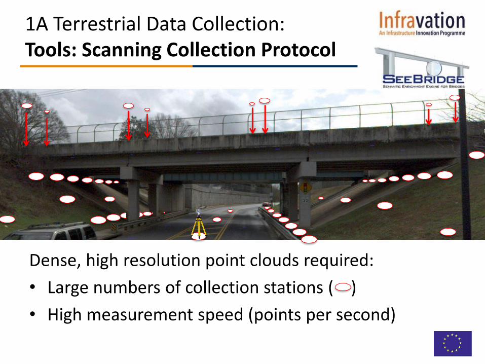
1A Terrestrial Data Collection:Tools: Scanning Collection Protocol
Dense, high resolution point clouds required:
• Large numbers of collection stations ( )
• High measurement speed (points per second)

1A Terrestrial Data Collection:Tools: Close-Up Photography

1A Terrestrial Data Collection:Tools: Photography Protocol
Collection Protocol:
• 42 MP resolution camera enables 0.1 mm resolution per pixel needed for crack identification
• 50% overlap between adjacent photos (for photogrammetry)

1A Terrestrial Data Collection:Results
Atlanta, USA
Cambridge, UK
Haifa, Israel
3 1
10

1A Terrestrial Data Collection:Results: What is possible…
Acworth, GA 067-5252-0
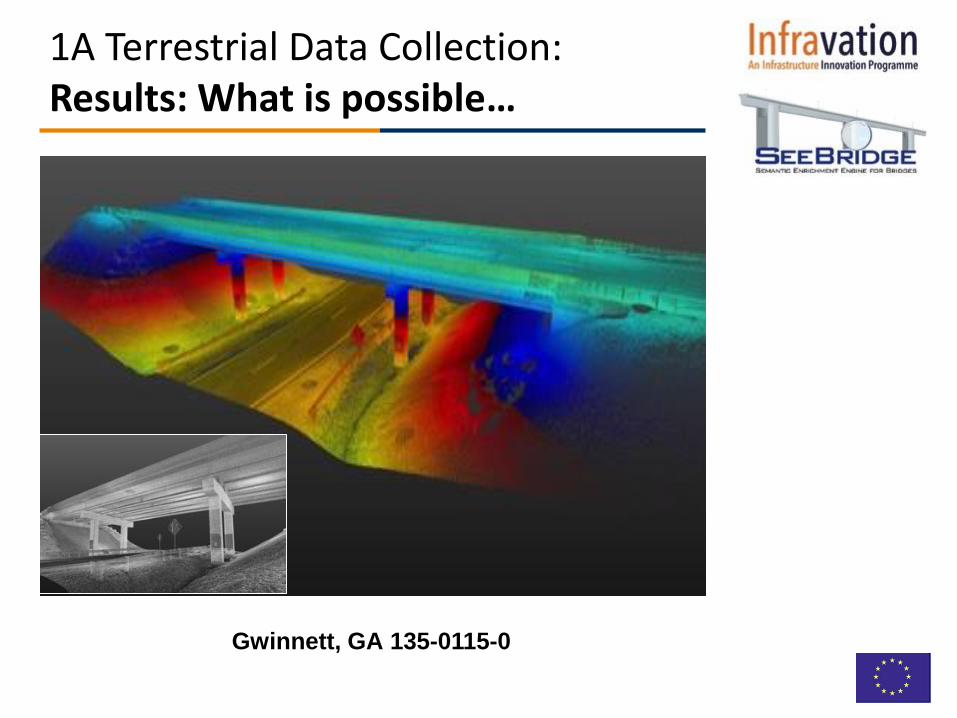
1A Terrestrial Data Collection:Results: What is possible…
Gwinnett, GA 135-0115-0

1A Terrestrial Data Collection:Results: What is possible…
Cambridge, UK #2
Cambridge, UK #8

1A Terrestrial Data Collection:Results: What is possible…
Route 79, Haifa

1A Terrestrial Data Collection:Results: High Res Close ups

1A Terrestrial Data Collection:Results: High Res Close ups
• Larger point clouds provide more data for solid modeling processor– More survey locations
– Faster scanner
• Photos: More overlap
1A Terrestrial Data Collection:Recommendations

• Intensive Data Collection– Detailed point cloud requires intense laser scanning with far more stations
than normal survey
– High resolution photography also very labor intensive
• Processing massive files requires skill & time consuming
• Focus should be on Preliminary Survey or Poor / Deficient bridges
1A Terrestrial Data Collection:Limitations
Bridge # of ScansOn site Scanning
Time (h:mm)
post-processing
time (h)registration
qualitytotal
points# points in deliverable
Ackworth 067-5252-0 47 2:48 3 very good 3,804 M 2,782 M
Gwinnett 135-0115-0 21 1:20 8 very good 1,430 M 902 M
Gwinnett 135-50880 27 1:54 12 good 2,150 M 762 M

1A Terrestrial Data Collection:End
Related Documents