UP-TP A.3.a. PROPOSED BEVERLY HILLS FREE\-lAY

Welcome message from author
This document is posted to help you gain knowledge. Please leave a comment to let me know what you think about it! Share it to your friends and learn new things together.
Transcript

UP-TPA.3.a.
PROPOSEDBEVERLYHILLSFREE\-lAY

I
CIII
•
IIJ
,.
III
~$'R ~~.eport on ~:'.
GEOMETRIC DESIGN ~~.
PROPOSED BEVERLY HILLS FREEWAY
for
BEVERLY HILLS CITY COUNCIL
April 1964
DE LEUW, CATHER & COMPANY. ENGINEERS. SAN FRANCISCO

I
J
'--
IIIIIIIIIIIIII
DE LEUW, CATHER & COMPANYENGINEERS
WESTERN OFFICE1256 MARKET STREET
SAN FRANCISCO 2,CALIFORNIAUNOERI-IILL 1-1302
April 22, 1964
Honorable Leonard HorwinMayor of the City of Beverly Hillsand Members of the City Council
City of Beverly HillsCalifornia
Gentlemen:
It is with great pleasure that we submit to you herewith our final reporton our alignment studies, geometric design and estimates of cost forthe proposed Beverly Hills Freeway.
Our report concludes that a freeway is urgently needed in a generallyeast-west direction in the Beverly Hills area. Secondly, we conclude thata freeway through the City of Beverly Hills and along the Santa MonicaBoulevard right-of-way, fully depressed and concealed as indicated inyour City Council Statement of Policy, is both practical and feasible. Asa matter of fact, the preferred freeway presents certain advantages overthe several alternative geometric designs which we investigated.
During the course of our assignment, we enjoyed splendid working relationships with numerous public agencies and private organizations.Principal among these are the Beverly Hills Improvement Association,Mr. Irving Stone, Chairman; the Western Freeway Council, and othercommunity associations. Additionally, we wish to acknowledge the excellent cooperation afforded us by Mr. Edward T. Telford and his staff at theDistrict office of the California Division of Highways. As you know, yourDepartment of Public Works and traffic and planning consultants have madeavailable to us their full resources.
Following formal presentation of this report, we will be pleased to meetwith you for further detailed discussions at your convenience. We sincerely appreciate this opportunity of serving you on what we consider tobe an assignment of unusual importance.
Very truly yours,
DE LEUW, CATHER &: COMPANY
-Yt.~ ~H. E. Ll~yd
Chief Engineer

I
.J
IIIIIIIIIIC
III
TABLE OF CONTENTS
INTRODUCTION
FREEWAY JUSTIFICATION
Service to CommunityTraffic DemandRoadway Capacity
PROPOSED FREEWAY CORRIDORS
Red Cor:HdorBlue CorridorEstimates of Cost
EVALUATION OF FREEWAY CORRIDORS
Traffic ServiceBenefitsEstimates of CostPreferred Route Alignment
PREFERRED FREEWAY ALIGNMENT
Geometric Design CriteriaGeometric Design - Robertson
Boulevard to Century CityDescription of Concealed FreewayOperating Characteristics of
Concealed FreewaysCost Comparison - T-l Route and White Route
1
3
334
5
556
7
7899
9
9
1013
1316

I
IIIIIIIIIIIIII
Exhibit
1
2
3
4
5
6
Appendix
LIST OF EXHIBITS
Location - Alternative Red and Blue Corridors
Location of White Alternative Alignment
Plan and Profile Robertson Boulevard to Century City
Sectional Perspective near Rodeo Drive Showing the FreewayCovered with Landscaped Parking Area
Typical Sections of Concealed Freeway
Typical Block Plan of Underground Ventilation System
Applicable Sections of Beverly Hills City CouncilStatement of Policy

I
IIIIIIIIII~
III
INTROD UC TION
For a number of years the residents and business people in the areasouth of Hollywood and west of Los Angeles have been concerned over tentative plans for a freeway, generally following an east-west route from theVermont district westerly to Santa Monica. The cOlnmunities which havebeen most particularly concerned are Beverly Hills, Bel Air, BrentwoodPark, Pacific Palisades, and Santa Monica, although the route involves anumber of neighborhood communities within the Los Angeles area.
Shortly after World War II, the California Division of Highways andvarious communities began informal discussions concerning the preliminarylocation of a freeway route serving the above areas. The adoption of thefreeway plan for the Greater Los Angeles area in the late 1940's and thelater expansion of this plan to include new freeway routes as well as Federalinterstate routes resulted in the establislunent of a general area throughwhich the proposed freeway would pass.
Studies commenced by the California Division of Highways some fouryears ago and by affected city governments and community associationsfinally resulted in the establislunent of two separate and roughly parallelcorridors. One of these corridors involves a freeway route beginning at theHollywood Freeway between Vermont and Western Avenues and extendingwesterly through the South Hollywood district in the vicinity of MelroseAvenue, passing through the Beverly Hills residential areas north of SantaMonica Boulevard, Bel Air, and other communities to the west, and terminating at a point approximately where Sunset Boulevard intersects~··the
San Diego Freeway at Sepulveda Boulevard. The second major corridorinvolves a freeway location commencing at the same point at the HollywoodFreeway and extending westerly in the vicinity of Beverly Boulevard toSanta Monica Boulevard in Beverly Hills. From this point, the frkewaywould turn southwest and would generally follow Santa Monica Boulevard,over any of several alternative routes or combination of routes to a pointof termination roughly in the vicinity of Santa Monica Boulevard and theSan Diego Freeway.
During 1963, it was announced that public hearings would be heldby the California Division of Highways leading to the adoption of a freewayroute through the area, which hearings would be held sometime in 1964.Because of the uniqueness of the areas through which the freeway would
-1-

I
IIIIIIIIII
III
pass, and because of the special physical and operational problemsencountered, the City of Beverly Hills and numerous residential propertyowner's and business men's associations decided to engage special consultants to study in detail all of the special conditions attendant upon thisfreeway.
Early in 1963, the Beverly Hills City Council commenced discussions concerning its desires with respect to the freeway location,design, and traffic service characteristicso These meetings werefollowed by public hearings which culminated in the adoption of a statement of policy of the City Council with respect to the Beverly HillsFreeway at its meeting of November 5, 1963. Applicable sections ofthis policy are included in this report as an Appendix.
Among others, De Leuw, Cather & Company were engaged latein 1963 to undertake special engineering studies including, but notlimited to, the following~
a determination of the most feasible freeway route or"corridor" from the point of view of traffic service andaccessibility
correlation and analyses of estimates of construction costfor specific alternative freeway designs
preparation of estimates of cost for a freeway generallyalong Santa Monica Boulevard conforming to the requirements of the Beverly Hills City Council statement ofpolicy described above
a determination of user benefit of the preferred freewayroute, incorporating the conditions of the Beverly HillsCity Council statement of policy
a general discussion of the merits of the favored routein terms of all of the criteria under consideration,including traffic service, disruption to abutting properties,preservation of community standards and including aestheticconsiderationso
This report is supplemented by reports of traffic consultants, economicconsultants and land use planning consultants, each dealing with particularaspects of the freeway location and de.sign. Because of the specific natureof the project, we have limited our investigations necessarily to questionsincluded within the scope of our assignment, including service to the community, traffic demand, capacity, and economic justification as hereinafterdescribedo
-2-
I
IIIIIIIIII..III
FREEWAY JUSTIFICATION
Our initial studies generally involved the determination of themost practicable corridor or general route location. The CaliforniaDivision of Highways had for some time investigated two principalcorridors, as mentioned above, and we confirmed that these were thetwo most logical corridors in terms of traffic service, conformancewith the area freeway master plan, existing topographical controls, andon the basis of economic considerations.
Service to Community
Our studies of the traffic data made available by the State Divisionof Highways, including traffic volume counts, screen-line checks, origindestination studies and land use and developmental plans, indicate that afreeway is definitely justified within the general area under study. Thecommunities between Hollywood and East Santa Monica are without directfreeway service and, as a matter of fact, the City of Beverly Hills is morethan two miles from the nearest freeway. Moreover, population trendsand projections, and present plans and programs for the development ofland in the general area of the proposed freeway indicate that a freewaywill be urgently needed to serve present and additional population withinthe next ten years.
Our studies of the early Los Angeles Metropolitan Area OriginDestination Studies, recent screen line traffic volume studies and examination of the prelitninary findings of the current Los Angeles MetropolitanArea Origin-Destination Study indicate that the predominant transportationneed will be in an east-west direction through the area under study.
In addition to providing additional traffic capacity through the corridor, a freeway_ in this general location would free existing surface streetfacilities for continuing use by local vehicle trips. Of primary consideration is the elimination of commercial vehicle trips from city streets. Thegreatly increased safety provided by freeways as opposed to surface streetsis a matter of record.
Traffic Demand
As indicated in the special report of the City of Beverly Hills I
traffic consultant, the 1963 east-west traffic through the Beverly Hillsarea approximates 283,000 vehicle trips per day in both directions acrossthe La Cienega screen line. These vehicles are all accommodated onsurface streets between, and including, Pico Boulevard and SunsetBoulevard. Further analyses of the traffic consultants indicate that eastwest streets are now operating at or above practical capacity during peakhours. Additional traffic capacity is currently being provided by means
- 3-

I
~
IIIIIIIIIIII
'--
III
of the prohibition of curb parking, the use of off-center lane movementduring peak hours, traffic signal modernization and coordination, andother similar operational devices. The provision of additional trafficcapacity by physical means such as street widening is out of the questionboth from an economic and practical point of view, and would at be stonly provide interim relief.
Studies of the State Division of Highways and others with regard topopulation increase in the areas to be served by the proposed Beverly HillsFreeway indicate that the east-west vehicular traffic can be expected toincrease by approximately 65 per cent by 1990. We conclude that it wouldbe virtually impossible to provide the needed additional traffic capacity byimproved surface street facilities. Because of the unique travel habits ofmotorists in the Los Angeles area, whose average trip lengths far exceedthose in any other area in the world, it would be uneconomic in any eventto expand surface street facilities to accommodate the additional trafficvolumes.
Roadway Capacity
To demonstrate the insufficient capacity provided by east-westsurface streets in the Beverly Hills area with a typical example, SantaMonica Boulevard presently has a peak hour traffic capacity of 1800vehicles in one direction; and Sunset Boulevard has a peak hour capacityof 1300 vehicles in one direction. The 1962 observed traffic volumes onSanta Monica Boulevard and Sunset Boulevard during a typical peak hourapproximated 2340 and 1750 vehicles, respectively, which represents33 per cent excess traffic volume over practical capacity.
This situation of excess volume over practical capacity generallyoccurs on most east-west streets throughout the length of the proposedfreeway route and is in some cases more severe than as described above.It is fairly obvious that surface streets, even with both operational andphysical improvements where possible and feasible, cannot indefinitelycontinue to cope with the increasing traffic demand.
Economic Considerations
Principal among the economic benefits to the corrununity are thereduced cost of freeway travel vs. travel on city streets; a reduction inaccidents and their cost; and lower motor vehicle operating costs onfreeways as opposed to surface streets. Indirectly, the communitiesalong the freeway route will benefit considerably by savings in the cost ofphysical and operational improvements of surface streets and street maintenance, Direct benefits to the communities in terms of savings to usersoccasioned by the existence of a freeway will be the subject of later discus s ions in this report.
-4-

I
III~
IIIII-III
In summary and conclusion, we consider that a freeway is urgentlyneeded through the area in question based upon all the above generalcriteria -- service to community, traffic demand, roadway capacity andeconomic considerations. Moreover, it is our conclusion that from thepoint of view of traffic demand, vehicle trip characteristics and expectedpopulation increase, the proposed freeway corridor is well located withrespect to the area which it serves.
PROPOSED FREEWAY CORRIDORS
The California Division of Highways studies of several alternativeroute locations through the area, as discus sed above, resulted in the preliminary selection of two principal corridor s shown On Exhibit I, asfollows:
Red Corridor
The red route commences at Ardmore Avenue just south of MelroseAvenue on elevated alignment, and passes under Melrose Avenue slightlywest of the RKO and Paramount Studios. From that point, the freewaycontinues westerly on depressed alignment north and parallel to MelroseAvenue and becomes elevated again just west of Fairfax Avenue. Thefreeway would continue on elevated alignment west across Santa MonicaBoulevard and would pass under Doheny Drive and Arden Drive in the cityof Beverly Hills. At Maple Drive the freeway would again become elevatedand would continue over Sunset Boulevard at Alpine Drive. The freewaywould continue On an alternatively depressed and elevated alignment throughthe northwest residential areas of Beverly Hills, Bel Air, Holmby Hills andWestwood, and would terminate at an interchange with the San Diego Freewayat Sunset Boulevard, with a pair of through ramp connections extendingwesterly into the community of Brentwood.
Blue Corridor
The blue route as studied by the State Division of Highways andothers generally involves several alternatives or combinations of routes.Basically, the Division of Highwayls blue route corridor involves commencing the freeway at Ardmore Avenue with a variable depressed andelevated alignment westerly to Santa Monica Boulevard. The basic blueroute then follows Santa Monica Boulevard southwesterly on eitherelevated, depressed, or at-grade construction to the San Diego Freewayat approximately Santa Monica.
Some variations of the blue route alignment involve a freewaylocation through Beverly Hills along Santa Monica Boulevard except forthe portion in the vicinity of the three churches. In that case, one of the
-5 -

I
J
IIJ•...J
IIII-III
alternatives involves a freeway route to the north of the churches. In thearea to the west of Century City, one of the alternative aligmnents involvesa location along Santa Monica Boulevard and another in the area of OhioAvenue north of the Mormon Temple. A third location we st of CenturyCity would involve a route several hundred feet to the south and parallel toSanta Monica Boulevard. All of the proposed blue route locations west ofBeverly Hills, as studied by the Division of Highways, would involveelevated construction. The blue route would terminate at an interchangewith the San Diego Freeway, except for a possible extension southwesterlyalong Ohio Avenue.
One of the combination routes through Beverly Hills studied by theDivision of Highways involves an alignment along Santa Monica Boulevard,with the freeway covered for a portion of the route. This configuration isknown as the T-l route.
Combinations of the red route and the blue route could be achievedby a connection between segments of the two routes in the vicinity of theeast Beverly Hills city limit. Three such connections have been suggestedby the Division of Highways; One along Santa Monica Boulevard, one justnorth of Santa Monica Boulevard, and one somewhat south of Santa MonicaBoulevard. In all case s the red route would be utilized east of Santa MonicaBoulevard and the blue route we st of Santa Monica Boulevard.
Estimates of Cost
The followil,'lg table summarizes the cost estimates of the Divisionof Highways for the red route, the basic blue route, and the blue routecombination - - including the T -1 route,respectively.
Cost. Estimate
($ Million)
Right User BenefitLength Con- of (Savings in 20 yrs. )
State Route (Miles) struction Way Total ($ Million)
Red 10. 1 33 135 168 600Basic Blue 10. 1 46 133 179 609Broken greenBroken blue (T-l Route)Brown A and Red 9.4 56 142 198 609
The above table also include s the user benefits for the three route sin terms of savings to motorists over a twenty year period. It will be notedthat the savings to motorists are somewhat greater over the blue route
-6 -
•-•IJ
-IIII
III
($609,000,000) than the red route ($600,000,000). This is a function largelyof the greater traffic service and traffic volum.es accom.m.odated by the blueroute alignm.ents. It should be noted that the above cost estimates are asdeveloped by the Division of Highways and do not include the cost estimatesfor the "white route" as determ.ined by De Leuw, Cather & Com.pany, whichwill be discussed later in this report. The following table presents a COm
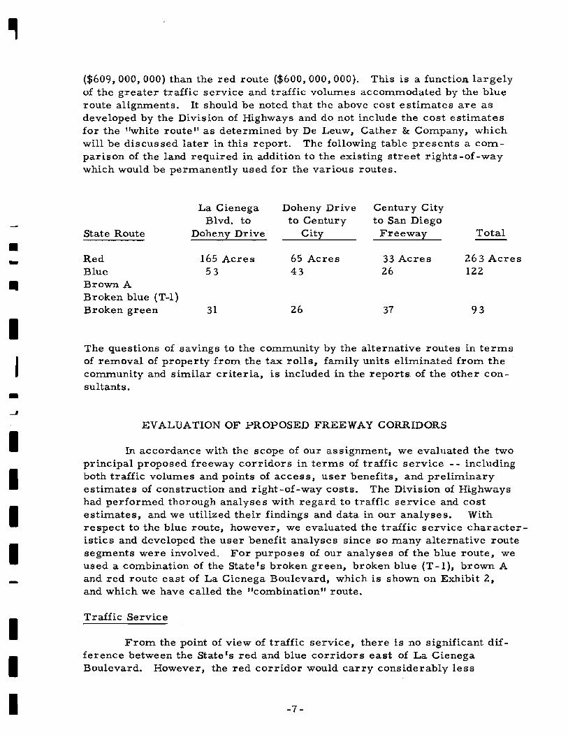
parison of the land required in addition to the existing street rights -of -waywhich would be permanently used for the various routes.
La Cienega Doheny Drive Century CityBlvd. to to Century to San Diego
State Route Doheny Drive City Freeway Total
Red 165 Acres 65 Acres 33 Acres 263 AcresBlue 53 43 26 122Brown ABroken blue (T-1 )Broken green 31 26 37 93
The questions of savings to the com.m.unity by the alternative routes in termsof rem.oval of property from the tax rolls, family units eliminated from thecommunity and similar criteria, is included in the reports of the other consultants.
EVALUATION OF PROPOSED FREEWAY CORRIDORS
In accordance with the scope of our assignment, we evaluated the twoprincipal proposed freeway corridors in terms of traffic service - - inclUdingboth traffic volumes and points of access, user benefits, and preliminaryestimates of construction and right-of-way costs. The Division of Highwayshad performed thorough analyses with regard to traffic service and costestimates, and we utilized their findings and data in our analyses. Withrespect to the blue route, however, we evaluated the traffic service characteristics and developed the user benefit analyses since so many alternative routesegments were involved. For purposes of our analyses of the blue route, weused a combination of the Statets broken green, broken blue (T-l), brown Aand red route east of La Cienega Boulevard, which is shown on Exhibit 2,and which we have called the "combination" route.
Traffic Service
From the point of view of traffic service, there is no significant difference between the Staters red and blue corridors east of La CienegaBoulevard. However, the red corridor would carry considerably less
-7 -

I
~
IIIIIIIIIrIII
traffic than the blue corridor as it proceeds through Beverly Hills andBel Air and approaches the San Diego Freeway. The blue corridor onthe other hand, because of its location through a heavily populated areawest of La Cienega Boulevard, would accommodate 21 to 49 per centmore traffic than the red corridor, assuming adequate access and egressfacilities.
In particular, the two principal traffic generators along the bluecorridor are the Beverly Hills Central Business District, including thenew hotel and shopping complex at Santa Monica Boulevard and WilshireBoulevard, and Century City -- which at present is rapidly developinginto a major traffic generator. Additionally, the blue corridor intersectsWilshire Boulevard which in turn is a major traffic artery serving newhigh-rise residential developments west of the Los Angeles Country Club.
Benefits
The table in the previous section of this report includes figures onbenefits to users of the proposed Beverly Hills Freeway. In addition tothe increased user benefits of the blue corridor over the red corridor,other benefits include the following:
disruption of existing surface streets. The red routeinvolves the termination of significantly more existingsurface streets than the blue corridor.
provisions for cross -freeway traffic. The blue corridorprovides a far greater number of streets crossing thefreeway, particularly in the heavily developed areasthrough which the freeway passes, and provides greatertraffic capacity across the freeway
relief of surface street traffic. By virtue of its locationthrough the heavily developed areas of Beverly Hills andto the west, the blue corridor provides more direct accessfor a greater number of motorists, relieving both parallelstreets and those serving as access streets to the freeway
termination considerations. Terminating in the vicinityof Santa Monica Boulevard and the San Diego Freeway,the blue corridor provides better access and trafficservice than the red corridor for residents of the Cityof Santa Monica and for trips beginning or ending in theSanta Monica busines s district.
There are numerous additional benefits, both tangible and intangible,which are considered in the reports of the other consultants.
-8-
IEstimates of Cost
The preliminary cost estimate for the combination blue route(broken green, broken blue (T-l), brown A and red) is approximately18 per cent greater than the red route. The combination route, however,would carry far greater traffic volumes than the red route in the areawest of La CienegaB,Q,ulevard. This fact alone more than justifies theslight additional cost"of the combination route.
PREFERRED FREEWAY ALIGNMENT
Preferred Route Alignment
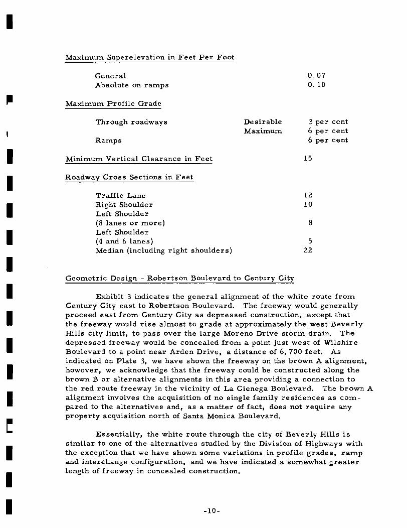
Geometric Design Criteria
Standard California Division of Highways geometric design criteriahave been utilized throughout our design studies. We conformed to theBeverly Hills City Council statement of policy, however, with respect toaesthetic design criteria, and for the most part, the section of freewaythrough Beverly Hills conforms to this policy.
705030
600350200
1750850300
Through roadwaysTurning roadwaysRa:mps
-9-
Design Speed in Miles per Hour
We consider that either the red or blue route corridors wouldserve equally satisfactorily in the areas east of La Cienega Boulevard,although there appears to be some minor advantages favoring the redroute alignment through this area. For purposes of this discussion,therefore, we will consider only the blue route alignment west ofLa Cienega Boulevard.
Through roadwaysTurning roadwaysRamps
Minimum Sight Distance
In consideration of the several criteria which we used in determining the preferred alignment, this discussion will be Ilmited toconsiderations of the white route, which follows the blue combination(broken green, broken blue (T -1), brown A) alignment, but with ageometric configuration differing from the State IS preliminary designas hereinafter discussed.
Through roadwaysTurning roadwaysRamps
Minimum Radius of Horizontal Curves in Feet
rIIIIIIIII~
III
I
IIIII
Maximum Superelevation in Feet Per Foot
GeneralAbsolute on ramps
Maximum Profile Grade
Through roadways
Ramps
Minimum Vertical Clearance in Feet
Roadway Cross Sections in Feet
Traffic LaneRight ShoulderLeft Shoulde r(8 lanes or more)Left Shoulder(4 and 6 lanes)Median (including right shoulders)
DesirableMaximum
0,070.10
3 per cent6 per cent6 per cent
15
1210
8
522
IIIII
III
Geometric Design - Robertson Boulevard to Century City
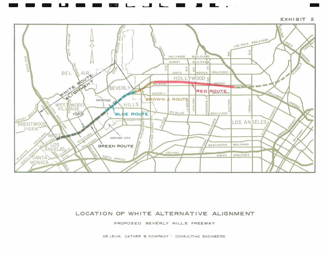
Exhibit 3 indicates the general alignment of the white route fromCentury City east to Robertson Boulevard. The freeway would generallyproceed east from Century City as depressed construction, except thatthe freeway would rise almost to grade at approximately the west BeverlyHills city limit, to pas s over the large Moreno Drive stonn drain. Thedepressed freeway would be concealed from a point just west of WilshireBoulevard to a point near Arden Drive, a distance of 6, 700 feet. Asindicated on Plate 3, we have shown the freeway on the brown A alignment,however, we acknowledge that the freeway could be constructed along thebrown B or alternative alignments in this area providing a connection tothe red route freeway in the vicinity of La Cienega Boulevard. The brown Aalignment involves the acquisition of no single family residences as COmpared to the alternatives and, as a matter of fact, does not require anyproperty acquisition north of Santa Monica Boulevard.
Es sentially, the white route through the city of Beverly Hills issimilar to one of the alternatives studied by the Division of Highways withthe exception that we have shown some variations in profile grades, ratnpand interchange configuration, and we have indicated a somewhat greaterlength of freeway in concealed construction.
-10-
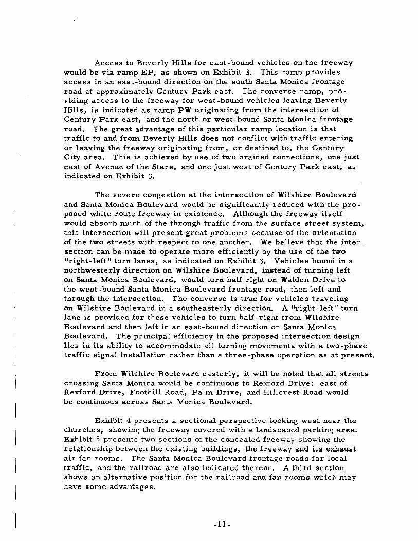
Access to Beverly Hills for east-bound vehicles on the freewaywould be via ramp EP, as shown on Exhibit 3. This ramp providesaCCess in an east-bound direction on the south Santa Monica frontageroad at approximately Century Park east. The converse raIIlp, providing access to the freeway for west-bound vehicles leaving BeverlyHills, i.s indicated as ram.p PW originating from the intersection ofCentury Park east, and the north or west-bound Santa Monica frontageroad. The great advantage of this particular ramp location is thattraffic to and from Beverly Hills does not conflict with traffic enteringor leaving the freeway originating from, or destined to, the CenturyCity area. This is achieved by use of two braided connections 3 one justeast of Avenue of the Stars, and One just west of Century Park east, asindicated on Exhibit 3.
The severe congestion at the intersection of Wilshire Boulevardand Santa Monica Boulevard would be significantly reduced with the proposed white route freeway in existence. Although the freeway itselfwould absorb much of the through traffic from the surface street system,this intersection will present great problems because of the orientationof the two streets with respect to one another. We believe that the intersection can be made to operate more efficiently by the use of the two"right-Ieft" turn lanes, as indicated on Exhibit 3. Vehicles bound in anorthwesterly direction on Wilshire Boulevard, instead of turning lefton Santa M0l1:ica Boulevard, would turn half right on Walden Drive tothe west-bound Santa Monica Boulevard frontage road3 then left andthrough the intersection. The converse is true for vehicles travelingOn Wilshire Boulevard in a southeasterly direction. A "r ight-Ieft" turnlane is provided for these vehicles to turn half -right from WilshireBoulevard and then left in an east-bound direction on Santa MonicaBoulevard. The principal efficiency in the proposed intersection designlies in its ability to accommodate all turning movements with a two-phasetraffic signal installation rather than a three-phase operation as at present.
From Wilshire Boulevard easterly, it will be noted that all streetscrossing Santa Monica would be continuous to Rexford Drive; east ofRexford Drive, Foothill Road, Palm Drive, and Hillcrest Road wouldbe continuous across Santa Monica Boulevard.
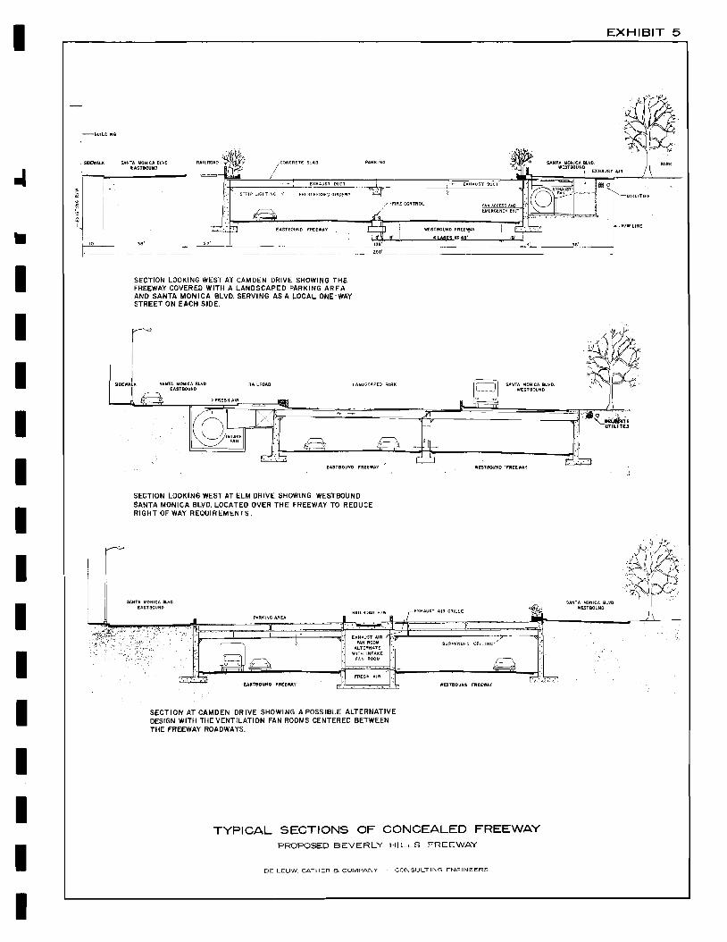
Exhibit 4 presents a sectional perspective looking west near thechurches, showing the freeway covered with a landscaped parking area.Exhibit 5 presents two sections of the concealed freeway showing therelationship between the existing buildings 3 the freeway and its exhaustair fan rooms. The Santa Monica Boulevard frontage roads for localtraffic, and the railroad are also indicated thereon. A third sectionshows an alternative position for the railroad and fan rooms which mayhave some advantages.
-11-

I
I
•IIIIIIIIIIIIII
Description of Concealed Freeway
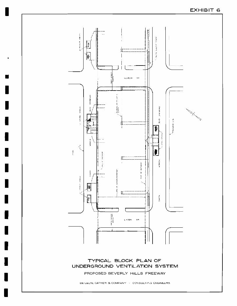
The structural sections shown on Exhibit 5 involve standard bridgeconstruction. Because of the complex stage construction simple spanswith self-supporting abutments are used. In general, prestressed girdersas indicated, or steel girders can be used to advantage, providing spacebetween the girder s for the intake and exhaust ducts, minimiz ing thedepth of construction. Concealed underground fan rooms are desirablefrom the standpoint of aesthetics. With the provision of three fan rOOmsper block as indicated on Exhibit 6, the fan and duct sizes are reducedand greater flexibility of fan operation is possible. Exhaust air andintake air would be vented through metal grilles located in the SantaMonica frontage roads, as commonly used in subway construction.
We have indicated the area over the concealed freeway as beingused for landscaped parks or off-street parking lots. Parking is greatlyneeded here, particularly in the areas adjacent to the churches and thecentral business district between Wilshire Boulevard and the Post Office.
Operating Characteristics of Concealed Freeways
We conducted special research relating to operating characteristicsof tunnels and covered freeways. Included in our studies were severaltunnels within California and numerous tunnels and covered freeway sectionsthroughout the United States. Our principal studies were directed towardthe questions of traffic capacity, vehicular requirements, accident historyand such questions as noise, vibration, emergency requirements, anddriver physchology.
Numerous agencies and organizations -- including the AmericanBridge, Tunnel and Turnpike Association, U. S. Bureau of Public Roadsand the California Division of Highways have for a number of years maintained detailed records concerning the operating conditions of tunnels. Itappears that the three major areas of difference between tunnels and openfreeways involve ventilation, drainage, and lighting. So far as the questionof drainage is concerned, the proposed Beverly Hills section of concealedfreeway is well above the ground water table, and seepage presents noproblem. Water entering the concealed freeway section from the portalscan easily be disposed of.
We find that tunnels over 500 feet in length require special lighting;in consideration of the time required for adjustment of the human eye fromdaylight to artificial lighting conditions. This situation is easily overcome,however, by the use of high intensity lighting transition zones. This, andthe other operating details of the concealed freeways, are discussed asfollows:
-13-

I
a. Capacity - The following table indicates the capacities of severalexisting tunnels in California:
.J
LocationLengthin Feet
Numberof Lanes
Peak Month1963 ADT
1963Peak Hour
Volume
DesignCapacity
V. P. H. *::',(
-14-
c. Lighting - We consider that adequate illumination in tunnels orconcealed freeways is of primary importance, and we haveincluded an allowance in our freeway design for a higher level
It will be noted that the actual observed peak hour volumes greatlyexceed, in most instances, the practical capacity as computed fromthe Bureau of Public Roads Highway Capacity Manual.
b. Speed - There is every indication that vehicle speeds in tunnels orconcealed freeways approximate those on open freeways of siInilargeometric configuration. As a matter of fact, there is undoubtedlya smaller range between high and low speeds in tunnel sectionsbecause of the elimination of driver distractions.
2, 300
5,500
8,000
9,600
4,200
6,400
2,800
5,250
8,000
4,850
6,450
10,500
33,700
56,000
63,000
52,000
127,000
103,0008
6
6*
4*
2*
8 or 9*540
750+460
1,000
1,900
*Before recent improvements
Oakland,Caldecott Tunnel 3, 000
*~~Based on 10 per cent trucks with 2/3 peak direction distribution
Alameda,Posey Tube
Yerba BuenaIsland Tunnel,S. F.
Sepulveda Blvd.Airport Tunnel
Golden GateFwy. TunnelUS 101
Pasadena Fwy.Tunnel, L. A.
IIIIIIIIIIIIII

I
•IIIIIIIIII
III
of illumination than California State Standards. During daytime hours, it is particularly important that the range betweennormal daylight outside the covered freeway section and theartificial lighting in the covered section be as low as possible;also the question of transition is particularly important and wehave allowed for an even higher level of lighting at the portals.
d. Ventilation - To exhaust combustion gas and control the concentration of carbon monoxide within safe limits, we have includedextensive mechanical ventilation in our design. Ventilation isprincipally accomplished by the use of underground fan roomsconnected to the covered section of freeway by a system of airducts and registers. Exhaust air would be filtered to removevisible smoke particles and odors. The full capacity of the fansprovides for movement of six cubic feet of air per minute foreach square foot of traveled way. The design control would beunder the condition when all vehicles were stopped in the tunnelpresumably with engines idling. The schematic arrangementsfor the ventilation system are shown on Exhibits 5 and 6.
e. Emergency Requirements - The emergency warning system forthe section of concealed freeway would include traffic controlsignals approaching the entrance portals. The signals wouldbe actuated before carbon monoxide concentrations reach dangerous proportions and could also be manually operated by trafficofficers if required. Under such conditions, traffic would bediverted from the freeway to the two Santa Monica Boulevardone -way frontage roads to bypas s the concealed freeway section.
An emergency telephone system would be provided throughoutthe concealed freeway section at regular intervals for suchconditions as stalled vehicles, accidents and fire. Emergencyexits for pedestrians would be provided from the concealedfreeway section to the streets above at approximately 400 -footintervals. These would be operated by means of one-way lockingdoors, opening from the freeway side only. High pressure firehydrants with hoses, and C02 fire extinguishers would be provided within the covered freeway section at regular intervals.
f. Accoustical Considerations - The ventilation fan ducts would beprovided with accousticallining to reduce exhaust air sounds tothe street above. Additionally, it would be possible to treat theinside of the freeway itself accoustLcally to minimize trafficnoise. However, in our studies of other tunnels, we have foundthat traffic noise does not present a particular problem.
-15-
I
g. Driver Psychology - There has been considerable discussionwith respect to the question of driver psychology in tunnels.Specifically, it has been suggested that driving in tunnels maycontribute to anyone of several phobias, especially claustrophobia. We can find no information, however, to substantiatethis position.
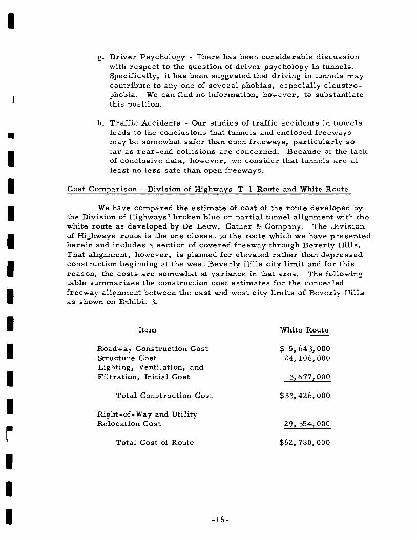
Cost Comparison - Division of Highways T -1 Route and White Route
h. Traffic Accidents - Our studies of traffic accidents in tunnelsleads to the conclusions that tunnels and enclosed freewaysmay be somewhat safer than open freeways, particularly sofar as rear-end collisions are concerned. Because of the lackof conclusive data, however, we consider that tunnels are atleast no less safe than open freeways.
We have compared the estimate of cost of the route developed bythe Division of Highways I broken blue or partial tunnel alignment with thewhite route as developed by De Leuw, Cather & Company. The Divisionof Highways route is the one closest to the route which we have presentedherein and includes a section of covered freeway through Beverly Hills.That alignment, however, is planned for elevated rather than depressedconstruction beginning at the west Beverly Hills city limit and for thisreason, the costs are somewhat at variance in that area. The followingtable swnmarizes the construction cost estimates for the concealedfreeway alignment between the east and west city limits of Beverly Hillsas shown on Exhibit 3.
•IIIIIIIIIIrIII
Item
Roadway Construction CostStructure CostLighting, Ventilation, andFiltration, Initial Cost
Total Construction Cost
Right-of- Way and UtilityRelocation Cost
Total Cost of Route
-16-
White Route
$ 5,643,00024,106,000
3,677,000
$33,426,000
29, 354,000
$62,780,000

I
•IIIIIIIIIIIII
Annual operation costs of $401,000 would be required for lighting,ventilation, and filtration.
There is some indication that an additional saving of approximately$1,440,000 can be made if the area above the freeway, between the crossstreets, is designed for a 100-lbo per square foot live load to accommodatepassenger car parking lots.
The cost for the partially concealed T -1 freeway as studied by theDivision of Highways along this alignment totals $49,400,000 or $13, 380,000less than the preferred alignment,
In summary, we consider that the preferred freeway route throughthe City of Beverly Hills as described above, is entirely feasible fromevery point of view. The route offers superior traffic service and generallyfalls within the Beverly Hills City Council Statement of Policy with one minorexception~ the inclusion of a pair of access ramps at the East BeverlyHills city limits. The preferred geometric configuration, involving a fullyconcealed freeway presents several advantages over an open freeway andfully satisfies all of the stated requirements.
-17-

____________________EXHIBITS
I
•••I

BOULEVARO
BOULEVARO
_________ -..J __ i...J '. _
EXHIBIT
» « 0
! ~-< -0- g; I .• 't-
I. 0
~~ ~ A "I lRt~loRR'DoR • ::~~E~OO'... l:: / c>. ' llJ" r."n. '-.-''' ~ \ .., >o __ , ;,£ AI_ • "-J";:: •• SANTA"
REDLOCATIONAND BLUE
OF ALTE R NATIVEFREEWAY CORRI DORS
PROPOSED BEVERLY HILLS FREEWAY
DE LEUW, CATHER a COMPANY· CONSULTING ENGINEERS
- - - ~ - - - L.- --.. L....- - • - • -EXHIBIT 2
BOULEVARD
BOIJLEVIl.RO
SAN TIl
SUNSET
HOLLYWOOD
a>
~PI<J1l;Qr
-o~..
~\ \,. AgPI
"0
LOCATION OF WHITE ALTERNATIVE ALIGNMENT
PROPOS ED BEVERLY HILLS FREEWAY
DE LEUw. CATHER a COMPANY" CONSULTING ENGINE:ERS

I......
I· ·U
,I-)
:
"II'
=
)
:
280
26 ....
~I
II
_c.lLrs 1M
H
Jt>=~~~~=---:=~~ 91') ., o DII
V 1o:i'1-"
=
~..I~:CTIL.. - r
10
160 ·--------U:;-------~"':"~-~-----i.
220
200

E
.-c
II
=:J..
-----------,-------.---5!------------r--------- ~ ---I !40
'",--....,r-=:=-=;;:""'"--==-'==----------+---------~-~-l
-~- -
-I-.. ~
PLA PROFILECE~I T 'RY CITY TO ROBERTSON B \10.
OPos l f:-3F.:V R Y HILLS FP"=EWAY

~XHIBIT 4
w
P. ASP CTIV OK I 13A'o 0 O~lV
H EEWA,y OVEn: 0D:3CAPE:D PAAKINI3 AA~A
DE LEU..... ~ATHt::F1 COMPANY
I EXHIBIT 5
UTKtTlES
lVWllNE
SANTA MONICA BLVO.WESTBOUND
/ "FIRE CONTROL
w£STeOl/ND FREE~AV
4! S' 4!.AHES .4T 48'
~--_ ...-_~~O_· _
LANOSCAPED PARKRAILROAD
EASTBOUNO fREEWAY
SECTION LOOKING WEST AT CAMDEN DRIVE SHOWING THEFREEWAY COVERED WITH A LANDSCAPED PARKING AREAAND SANTA MON ICA BLVD. SERVING AS A LOCAL ONE-WAYSTREET ON EACH SIDE.
SANTA MONICA BLliD.EASTSOUND
r-~
ISlo(wALK SANTA MONICA BLVD.
EASTBOUNO
f.luILOING
I
•
I
II
I
IIII
SECTION LOOKING WEST AT ELM DRIVE SHOWING WESTBOUNDSANTA MONICA BLVD. LOCATED OVER THE FREEWAY TO REDUCERIGHT OF WAY REQUIREMENTS.
rI'
SANTA MONiCA 81.VOEASTBOUND
E)(HALI$T AIR" "FAN ROOM •
o\l..TERNATEWITH INTAKE
FAN ROOM
FRESIi AIR
SUSPENOEO
lI'EST80UMO FIUE.AT'
SANTA '-lONICA ~lVO
WESTBOUNO
I SECTION AT CAMDEN DRIVE SHOWING A POSSIBLE ALTERNATIVEDESIGN WITH THE VENTILATION FAN ROOMS CENTERED BETWEENTHE FREEWAY ROADWAYS.
I
PROPOSED BEVERLY HI LLS FREEWAY
TYPICAL SECTIONS OF CONCEALED FREEWAYII DE LEUW, CATHER a COMPANY CONSULTING ENGINEERS
I
I EXHIBIT 6
•
III :I I
II;':r------------~L_~ _
ROX BIJ R'f DR
I
I
L_
II
L
Il-
.!,
_ J-' '\IIII
II
8' ! I~. I
"'" I
fl
' ---=---=-~=.=-=~l, _I [!}:~.'1
I 'f II ~
I~: ---]1
_,,' - I
~~l
!~ I
i
\ '\ 'j \ -----
i '-~
PROPOSED BEVERLY HILLS FREEWAY
DE LEUW. CATHER 8< COMPANY CONSULTING ENGINEERS
TYPICAL BLOCK PLAN OFUNDERGROUND VENTILATION SYSTEM
IIIIIIIIIIIIII

I
___________APPENDIX
•I
•
~
C
III
III

I
IIIIIIIIIIIIII
APPENDIX
APPLICABLE SECTIONS OF STATEMENT OF POLICYADOPTED BY THE CITY COUNCIL OF BEVERLY HILLS
WITH RESPECT TO POSSIBLE BEVERLY HILLS FREEWAY
Adopted at Form.al Council Meeting Novem.her 5, 1963
1) Such project must not take any single family residences in BeverlyHUls nor remove, destroy or reduce any of its parks p nor interfere withits churche s or schools. We find as a fact that it is" entirely possible ifa freeway is constructed through Beverly Hills, to construct a completefreeway of four driving lanes in each direction, plus emergency storagelanes on each side and m.edian strips, while a.dhering to the foregoingstatement 'of principle. This is only possible, however, if such freewayis constructed along Santa Monica Boulevard, or along Santa MonicaBoulevard from the westerly boundary of Beverly Hills and through theso-called industrial area of Beverly Hills east of the City Hall to the'easterly boundary of Beverly Hills" We further find that if such freewayis constructed along Santa Monica Boulevard as contem.plated in one ofthe alternative routes designated by the Division of Highways for hearing,the preservation of the entire park axea along that Boulevard will be anindispensable part of the buffer betw.eell freeway and single family residences.
2) Such freeway m.ust be depressed at least twenty feet below the surfacethro\lghout Beverly Hills, excepting only to the extent absolutely necessaryto get under or over Fed,.; ral storm drains. In this connection~ we find thatif such freeway is constructed along Santa Monica Boulevard for its entirelength Or along Santa Monica Boulevard and through the industrial andapartment house district lying between Santa 'Monica Boulevard and BurtonWay as contem.plated in several of the alternative routes of the Divisionof Highways, the only interfering storm. drain would be at Moreno Driveand that if' such freeway rises to go over this drain, it is not necessaryand definitely not desirable for the rise to commence until west of WilshireBouleyard~ It is indispensable for the protection of the essential interestsof Beverly Hills, that such freeway be so depressed, from the easternrnostlimit of Beverly Hills at Doheny Drive, at least to the westerly side ofWilshire Boulevard. We further find that suitable mea.sures by way ofacoustical baffle and appropriate landscaping m.ust be taken if such riseoccurS west of Wilshire Boulevard, to protect the nearby apartment houseareas and the Beverly Hills High School on Moreno Drive against increaseof volume of noise incident to the freeway grade which would then exist alongSanta Monica Boulevard. It is further apparent that such freeway if constructed along Santa Monica Bouievard m.ust go under Wilshire Boulevard, toadequately protect adjoining single family residences. We find also. that thiswo~ld improve the intersection at Wilshire and Santa Monica Boulevards byseparating! the major portion of east-west through traffic from the flow of

I
••IIIIIIIIIIIIII
local movements at that important intersection.
3) To comply with the principles in Points 1} and 2) above~ such freewaywould necessitate the covering of a substantial portion of the route bywhat is knownas cut-and-cover method. We' further find that as yet wehave not had demonstrated any sufficient guarantee against projection intothe surrounding re sidential neighborhoods of the noise volume and fume sincident to a very heavily travelled freeway such as we find the BeverlyHills Freeway would be. Therefore, to the extent that such route is in thevicinity of' single family residences or churches, it must be totally coveredand pass below Wilshire Boulevard and Doheny Drive. This means that theroute must be totally covered to the extent that it follows Santa MonicaBoulevard. We further find that we have not been shown any evidence thata p".roperly designed and lighted covered freeway increases the incidence ofacddents or offers any significant inconvenience to drivers on such freeway.- We find that the extra cost, if any, of such covered freeway is aprdper expenditure of the State of California rather than the City of BeverlyHills, bearin.g in mind that the freeway will principally serve through trafficrather than-traffic originating or ending in Beverly Hills, and bearing inmind further that suc;h cover is indispensabl~ to pro-teet the interests ofBeverly hills while accommodating at the same time the interests of thecommunities benefited by the through traffic.
4} The City must not be divided, and therefore, all Beverly Hills streetsessential to the movement of local traffic must continue to run withoutohstruction at surface grade. This tneans that all north-south streets calledfor bn the City's General Plan and Central Business District Studies wouldbridge the freeway at existing surface grade. The principle stated in Point 2)is an addit~onal factor in preventing the appearance of division of the City.
5) The freeway must not destroy or litnit the usefulness of any existingstreets or highways in the City. This tneans that provision tnust be tnade forretaining at surface adequate lanes for east and west bound local traffic. Thiswould have result of freeing the surface lanes for local traffic, and have theeffed of d~verting to the freeway below, the noise and other undesirableaspects of·the heavy through traffic.
6} We are' opposed to freeway on or off ratnps inside Beverly Hills, becauseof the complications they introduce in choice of acceptable route s and de signof routes, the traffic and traffic congestions·which they Inay generate, andbecause we feel surface routes when relieved of the through freeway trafficbelow, should furnish reasonably easy access and ingress to Beverly Hills.
7) There should be maxiInutn attention to the design of walls, ramps, abuttnents and landscaping of any freeway through Beverly Hills, so as to maximizeits beauty to persons driving through and screen its existence by landscaping andotlberwise~ from surrounding surface.

I
J
~
IIIIIIIIIIIIII
8) In general, the selection of route, design and manner of constructionshould be based on long range benefits to the community rather than shortrange benefits related to convenience in time or cost of construction.We find, however, that by proper scheduling and cooperation betweenthe Divsion of Highways and the City of Beverly Hills, in the event ofconstruction of a Beverly Hi.lls Freeway, the inconvenience s and disruptions incident to construction can, and should be, held to a lUinimum.
Related Documents