[1] Caution: Please contact the FAA before launch. Take steps to minimize chances of mid-air collisions. 1337ARTS Fall 2009 Project Icarus: A step-by-step recount of the original $150 balloon launch. TAKING PICTURES OF SPACE We always wanted to see what the earth looked like from space. On September 2, 2009, we launched a camera attached to a balloon into near space. The capsule soared over 17 miles above ground, snapping beautiful pictures of the earth and capturing both the curvature of the earth and the blackness of space. After the balloon popped, the capsule floated back down to earth with a parachute. We retrieved the capsule with an onboard GPS phone that transmitted the landing location. We were absolutely ecstatic about the launch success. We posted our pictures online and created a website dedicated to sharing out photos with the world. We also wanted to share the process with the public because we believe strongly in the Do-In-Yourself movement. All components including electronics of our launch are available commercially. The project cost did not exceed 150 dollars, making it affordable to the general population. We wanted to show people that it does not take an advanced technical education to do awesome projects. In this guide we discuss the logistics of our balloon launch. We included information on the design decisions we made as well as the challenges we encountered.

Welcome message from author
This document is posted to help you gain knowledge. Please leave a comment to let me know what you think about it! Share it to your friends and learn new things together.
Transcript
[1]
Caution:Please contact the FAA before launch. Take steps to minimize chances of mid-air collisions.
1337ARTSFall 2009
Project Icarus:A step-by-step recount of the original $150 balloon launch.
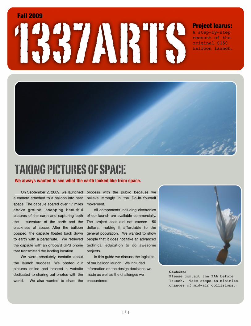
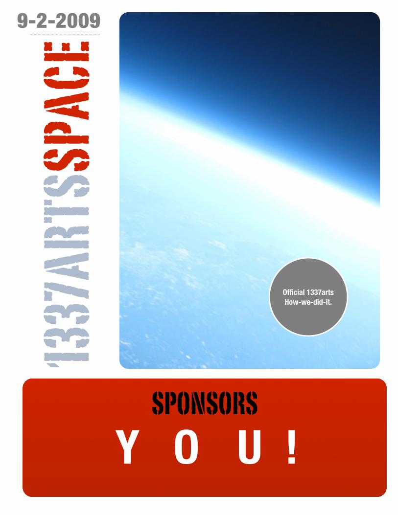
TAKING PICTURES OF SPACEWe always wanted to see what the earth looked like from space.
On September 2, 2009, we launched
a camera attached to a balloon into near
space. The capsule soared over 17 miles
above ground, snapping beautiful
pictures of the earth and capturing both
the curvature of the earth and the
blackness of space. After the balloon
popped, the capsule floated back down
to earth with a parachute. We retrieved
the capsule with an onboard GPS phone
that transmitted the landing location.
We were absolutely ecstatic about
the launch success. We posted our
pictures online and created a website
dedicated to sharing out photos with the
world. We also wanted to share the
process with the public because we
believe strongly in the Do-In-Yourself
movement.
All components including electronics
of our launch are available commercially.
The project cost did not exceed 150
dollars, making it affordable to the
general population. We wanted to show
people that it does not take an advanced
technical education to do awesome
projects.
In this guide we discuss the logistics
of our balloon launch. We included
information on the design decisions we
made as well as the challenges we
encountered.
[2]
9-2-2009
SPONSORS
Y O U !
Official 1337arts How-we-did-it.
1337
ARTS
SPAC
E
[3]
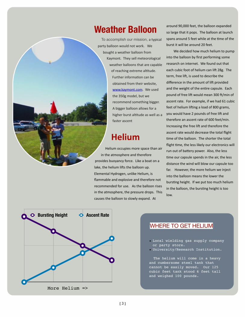
Weather BalloonTo accomplish our mission, atypical
partyballoonwouldnotwork.We
boughtaweatherballoonfrom
Kaymont.Theysellmeteorological
weatherballoonsthatarecapable
ofreachingextremeal<tude.
Furtherinforma<oncanbe
obtainedfromtheirwebsite,
www.kaymont.com.Weused
the350gmodel,butwe
recommendsomethingbigger.
Abiggerballoonallowsfora
higherburstal<tudeaswellasa
fasterascent
HeliumHeliumoccupiesmorespacethanair
intheatmosphereandtherefore
providesbuoyancyforce.Likeaboatona
lake,theheliumliFstheballoonup.
ElementalHydrogen,unlikeHelium,is
flammableandexplosiveandthereforenot
recommendedforuse.Astheballoonrises
intheatmosphere,thepressuredrops.This
causestheballoontoslowlyexpand.At
around90,000feet,theballoonexpanded
solargethatitpops.Theballoonatlaunch
spansaround5feetwhileatthe<meofthe
burstitwillbearound20feet.
Wedecidedhowmuchheliumtopump
intotheballoonbyfirstperformingsome
researchoninternet.Wefoundoutthat
eachcubicfootofheliumcanliF28g.The
term,freeliF,isusedtodescribethe
differenceintheamountofliFprovided
andtheweightoftheen<recapsule.Each
poundoffreeliFwouldmean300F/minof
ascentrate.Forexample,ifwehad61cubic
feetofheliumliFingaloadof800grams,
youwouldhave2poundsoffreeliFand
thereforeanascentrateof600feet/min.
IncreasingthefreeliFandthereforethe
ascentratewoulddecreasethetotalflight
<meoftheballoon.Theshorterthetotal
flight<me,thelesslikelyourelectronicswill
runoutofbaRerypower.Also,theless
<meourcapsulespendsintheair,theless
distancethewindwillblowourcapsuletoo
far.However,themoreheliumweinject
intotheballoonmeansthelowerthe
burs<ngheight.Ifweputtoomuchhelium
intheballoon,theburs<ngheightistoo
low.
WHERE TO GET HELIUM
• Local wielding gas supply company or party store.
• University/Research Institution.
The helium will come in a heavy and cumbersome steel tank that cannot be easily moved. Our 125 cubic feet tank stood 6 feet tall and weighed 100 pounds.
More Helium =>
Bursting Height Ascent Rate

[4]
THE HARSH ENVIRONMENT OF THE UPPER ATMOSPHERE
At 90,000 feet, temperature
drops to a frigid -50 degrees C (-58
F). The frigid temperature slows
the chemical reaction that powers
normal batteries to a standstill.
Even though the battery may be
brand new, it will act as if it is dead.
Air pressure in the upper
atmosphere drops to a mere
fraction of the level at the ground.
Harmful cosmic radiations increase
hundredfold. This may have an
effect on sensitive electronics.
Because of the lack of air
molecules, heat transfer between
the capsule and its surrounding
tends to be poor.
Electronics
Canon Point and Shoot
Camera- This will capture the stunning views at 100,000 feet. We chose a standard
point-and-shoot camera. We achieved automatic triggering of the camera
through a software called CHDK. The majority of canon point-and-shoot
cameras are supported. Be sure to visit hRp://mighty‐hoernsche.de/before
making any purchases.
GPS Enabled Phone/ Satellite Messenger-The phone/messenger sent the GPS coordinates of the landing location to a
website we had. Please go to www.instamapper.com or www.accutracking.com
for more information. Without GPS, it would have been impossible to retrieve the
camera and its awesome pictures.
We found out in our tests that the battery life of the phone was too short for
the predicted flight time of the capsule. We decided to supplement the battery
with a Duracell USB charger powered by Lithium AA batteries. Keep in mind that
these are specially designed batteries that have the ability to withstand extreme
temperature.
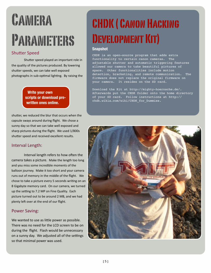
CHDK ( Canon Hacking Development Kit)SnapshotCHDK is an open-source program that adds extra functionality to certain canon cameras. The adjustable shutter and automatic triggering features allowed our camera to take beautiful pictures of space. Other functionalities include motion detection, bracketing, and remote communication. The firmware does not replace the original firmware on your camera. It resides on the SD card.
Download the Kit at http://mighty-hoernsche.de/.Afterwards put the CHDK folder onto the home directory of your SD card. Follow instructions at http://chdk.wikia.com/wiki/CHDK_for_Dummies.
[5]
Camera ParametersShuRerSpeed ShuRerspeedplayedanimportantrolein
thequalityofthepicturesproduced.Bylowering
shuRerspeeds,wecantakewellexposed
photographsinsub‐op<malligh<ng.Byraisingthe
shuRer,wereducedtheblurthatoccurswhenthe
capsuleswaysaroundduringflight.Wechosea
sunnydaysothatwecantakewellexposedand
sharppicturesduringtheflight.Weused1/800s
shuRerspeedandreceivedexcellentresults.
IntervalLength:
IntervallengthreferstohowoFenthecameratakesapicture.Makethelengthtoolong
andyoumisssomeincrediblemomentsofthe
balloonjourney.Makeittooshortandyourcamera
runsoutofmemoryinthemiddleoftheflight.We
chosetotakeapictureevery5secondswri<ngonan
8Gigabytememorycard.Onourcamera,weturned
upthese\ngto7.2MPonFineQuality.Each
pictureturnedouttobearound2MB,andwehad
plentyleFoverattheendofourflight.
PowerSaving:
WewantedtouseasliRlepoweraspossible.TherewasnoneedfortheLCDscreentobeonduringtheflight.Flashwouldbeunnecessaryonasunnyday.Weadjustedallofthese\ngssothatminimalpowerwasused.
Write your own scripts or download pre-written ones online.
[6]
Items we thought were helpful in the success of our mission but not absolutely required.
External Antenna: Wediscoveredthattheexternal
antennaincreasedourrecep<onbyonerecep<on
baronthecellphone.Wehadnootherwayto
testthesignalstrength.Theantennaweplucked
outofunusedWirelessrouter.Toobtainthe
correctconnector,weusedaU.fltoRP‐SMA
pigtailconnectorobtainedfromRadioshack.The
RP‐SMAendshouldconnectwithawireless
routerantenna.TheU.flendshouldbeableto
connectwithanexternalconnectorfoundonthe
backoftheBoostmobilei290cellphone.
Audio Beeper:
Thisaudiobeeperwillallowyouto
locatethecapsuleindensefoliage.GPScan
typicallynarrowtheloca<onofthecapsuletoa
20feetradius.Itwillsaveyouhoursof<meifthecapsulehappenstolandinthewrongspotbutwill
addweighttothecapsule.Weconsideredalarm
clocks,smokedetectors,andelectronicshorns.Thebeepershouldbeplacedontheoutsideof
thecapsuletomaximizethesoundpropaga<on.
Flashing Lights:
Againthisisforretrievalpurposes.
Flashinglightswillhelpimmenselyifrecovery
happensduringnight.Theposi<veeffectisless
duringthedaybuts<llnon‐trivial.However,
peoplemightmistakethecapsuleforabombon
theground.
Lithium Batteries:NottobeconfusedwithLithium‐ion
rechargeablebaReriesthatarecommonlyused
incellphones,LithiumbaRerieslastlongerthan
regularbaReries(8xaccordingtoEnergizer).In
addi<on,theycanwithstandtheextreme
temperaturesoftheupperatmosphere.
Spray Paint:Weconsideredspraypain<ngourcapsule
blacktoabsorbmoresunlight.Thatwill
increasethetemperaturewithinthecapsule.
Theheatgeneratedbytheelectronicsshouldbe
enough,butpain<ngitdoesn’thurt!Becareful
tobuyspecialspraypaint.Normalspraypaint
disintegratesthestyrofoam.
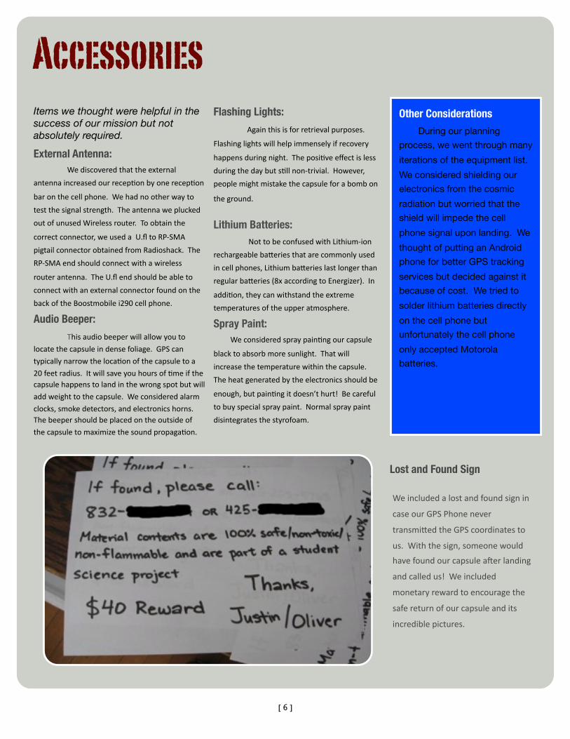
Lost and Found SignWeincludedalostandfoundsignin
caseourGPSPhonenever
transmiRedtheGPScoordinatesto
us.Withthesign,someonewould
havefoundourcapsuleaFerlanding
andcalledus!Weincluded
monetaryrewardtoencouragethe
safereturnofourcapsuleandits
incrediblepictures.
Other Considerations
During our planning
process, we went through many
iterations of the equipment list.
We considered shielding our
electronics from the cosmic
radiation but worried that the
shield will impede the cell
phone signal upon landing. We
thought of putting an Android
phone for better GPS tracking
services but decided against it
because of cost. We tried to
solder lithium batteries directly
on the cell phone but
unfortunately the cell phone
only accepted Motorola
batteries.
Accessories
[7]
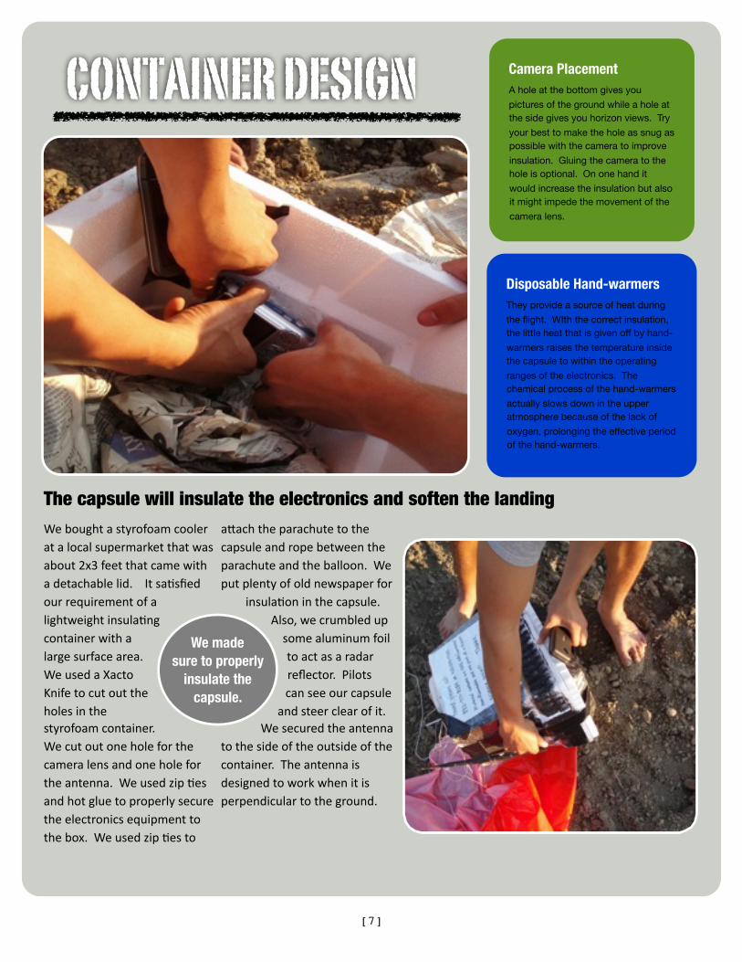
The capsule will insulate the electronics and soften the landingWeboughtastyrofoamcooleratalocalsupermarketthatwasabout2x3feetthatcamewithadetachablelid.Itsa<sfiedourrequirementofalightweightinsula<ngcontainerwithalargesurfacearea.WeusedaXactoKnifetocutouttheholesinthestyrofoamcontainer.Wecutoutoneholeforthecameralensandoneholefortheantenna.Weusedzip<esandhotgluetoproperlysecuretheelectronicsequipmenttothebox.Weusedzip<esto
aRachtheparachutetothecapsuleandropebetweentheparachuteandtheballoon.Weputplentyofoldnewspaperfor
insula<oninthecapsule.Also,wecrumbledupsomealuminumfoiltoactasaradarreflector.Pilotscanseeourcapsule
andsteerclearofit.Wesecuredtheantenna
tothesideoftheoutsideofthecontainer.Theantennaisdesignedtoworkwhenitisperpendiculartotheground.
Camera PlacementA hole at the bottom gives you
pictures of the ground while a hole at the side gives you horizon views. Try
your best to make the hole as snug as possible with the camera to improve
insulation. Gluing the camera to the hole is optional. On one hand it
would increase the insulation but also it might impede the movement of the
camera lens.
We made sure to properly
insulate the capsule.
CONTAINER DESIGN
Disposable Hand-warmersThey provide a source of heat during
the flight. WIth the correct insulation, the little heat that is given off by hand-
warmers raises the temperature inside the capsule to within the operating
ranges of the electronics. The chemical process of the hand-warmers
actually slows down in the upper atmosphere because of the lack of
oxygen, prolonging the effective period of the hand-warmers.

[8]
ElectronicComponents‐Makesuretheelectronicsoperateunderlowtemperatures.Weputthecameraandthephoneinourfreezerwhiletakingpicturesandtransmi\ngGPSloca<ons.Wealsoprogrammedthefreezertoitslowesttemperaturetobestsimulatenear‐spacecondi<ons.Weperformedmul<pleteststoverifyourresults.Towarmthecapsuleup,weaRachedhand‐warmers.Weconsideredpurchasingdryicefortes<ngatevencoldertemperaturebutdecidedagainstitontheaccountofcost.
Parachute‐Wemadesurethattheparachute
wasabletoopenwhendropped.Itisveryimportantthattheterminaldescentspeedisslowenoughtopreventdamagetoelectronicsaswellasproperty/peopleontheground.Wetestedourparachutebypu\ngeggsinsideofourstyrofoamboxandtossingtheboxoffofa5storybuilding.Wewerenotsa<sfiedwiththelandingspeedofourboxun<ltheeggsdidnotbreakuponthebox’simpact.Toslowdownthedescent,weaddedabiggerparachute.AFerourtests,wecameupwithaparachutethatwas5feetindiameter.
GPSPhone‐WewalkedaroundwiththeGPS
trackingforacouplehours.AFerwards,we
notedtheaccuracyofthepointsaswellasthefrequency.Wemarkedoutthepointswheretherewasnorecep<on.Werepeatedourwalkwithourexternalantennainstalledandrecordedthe
improvement.Weobtainedanaverageincreaseoftwobarswithourantenna.Also,90percentofthespotsthatweremissingduringthefirsttestappearedinthesecond.
Testing increases chance
of success!
[email protected] to contact us?
Email: [email protected] to get in contact with us.
If we don’t respond immediately, please be patient. We are
students and have busy schedules! We would love to talk to
you though!
Testing
[9]
FAA REGULATIONS Remember that there are other flying
objects occupying the same airspace. Be
sure to take all necessary precautions
against a mid-air collision. The airspace
above United States is governed by the
Federal Aviation Authority. For other
countries, please consult the appropriate
agency for further rules. Balloon launching
is illegal in some countries. Please check
before attempting. If you are launching in
the US, notify the FAA before launching.
The number to post an NOTAM (Notice to
Airmen) is 1800-WXBRIEF. Predict the
flight of the balloon by using University of
Wyoming’s website and inform the FAA of
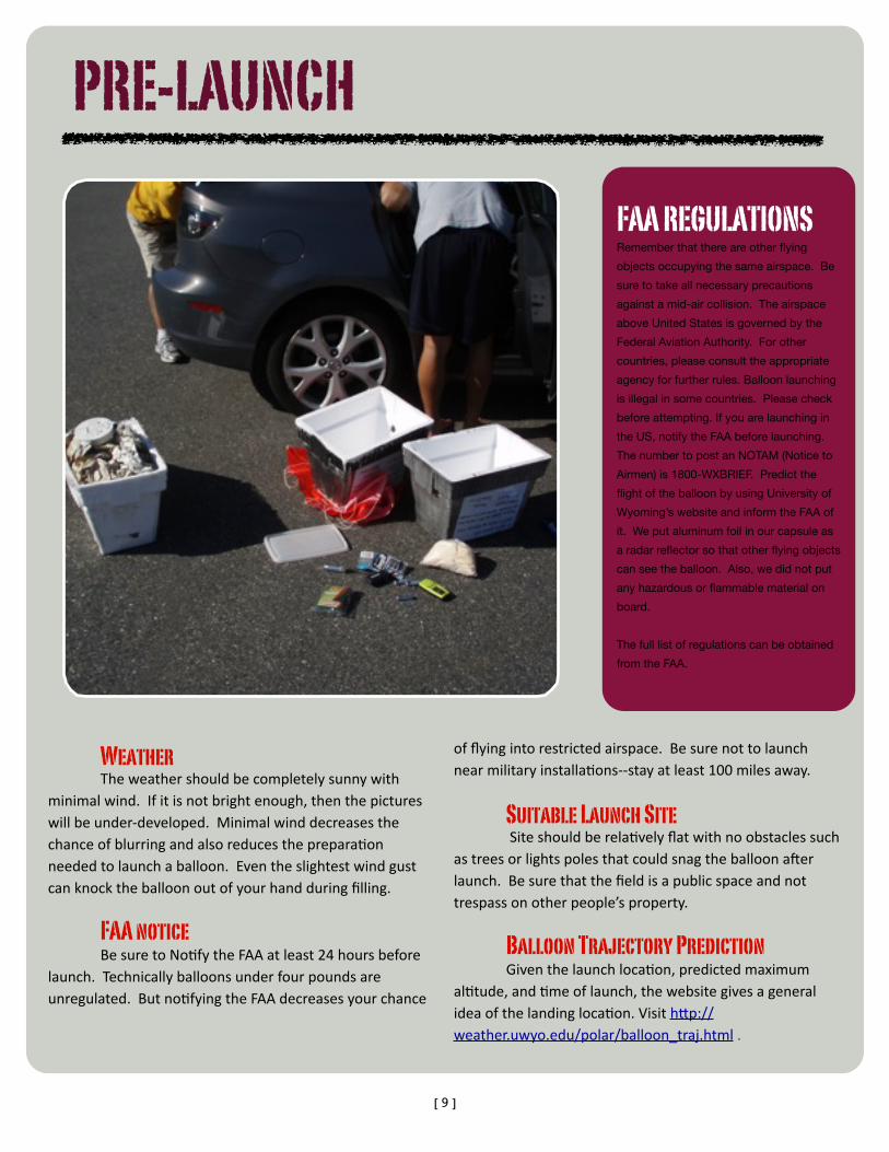
it. We put aluminum foil in our capsule as
a radar reflector so that other flying objects
can see the balloon. Also, we did not put
any hazardous or flammable material on
board.
The full list of regulations can be obtained
from the FAA.
PRE-LAUNCH
Weather Theweathershouldbecompletelysunnywithminimalwind.Ifitisnotbrightenough,thenthepictureswillbeunder‐developed.Minimalwinddecreasesthechanceofblurringandalsoreducestheprepara<onneededtolaunchaballoon.Eventheslightestwindgustcanknocktheballoonoutofyourhandduringfilling.
FAA notice BesuretoNo<fytheFAAatleast24hoursbeforelaunch.Technicallyballoonsunderfourpoundsareunregulated.Butno<fyingtheFAAdecreasesyourchance
offlyingintorestrictedairspace.Besurenottolaunchnearmilitaryinstalla<ons‐‐stayatleast100milesaway.
Suitable Launch Site Siteshouldberela<velyflatwithnoobstaclessuchastreesorlightspolesthatcouldsnagtheballoonaFerlaunch.Besurethatthefieldisapublicspaceandnottrespassonotherpeople’sproperty.
Balloon Trajectory Prediction Giventhelaunchloca<on,predictedmaximumal<tude,and<meoflaunch,thewebsitegivesageneralideaofthelandingloca<on.VisithRp://weather.uwyo.edu/polar/balloon_traj.html.

[10]
BoostMobile phone Motorola i290 with GPS and Web Functionality Since this is a cellphone, the capsule must land in an area of cell phone coverage. Make sure
to attempt transmitting only when the cell phone is on the ground. It is against FCC
regulations to operate a cell phone in the air. The instructions for the downloading the
programs can either be found at www.accutracking.com or www.instamapper.com. We tested
the cell phone by walking around to observe the timing of the GPS signals. We did not increase
the cache size to its full setting, and as a result some of our flight path is lost. Also, to increase
our chance of finding the capsule, we turned on cell tower location transmission. This feature
allows the phone to send off the location of its cell tower if a GPS location cannot be fixed. For
the plan, we chose the web add-on option with the pay-and-go plan. With this selection, our
cost was only 35 cents per day because we did not make any calls nor send text messages.
GPS TRACKING SOFTWARE
ACCUTRACKING INSTAMAPPER
$5.99 a month with one month free trial
Free, same functionality as Accutracking
RETRIEVAL
Different Types of GPS coordinates:
There are multiple ways of displaying a
given location on a map. Be sure to verify the
units on your GPS systems before
proceeding. The three different formats:
(Degrees, Minutes, Seconds), (Decimal,
Degrees), and (GPS Coordinates). Forgetting
to account for units can mean a difference of
miles! There are online converters that can
transform between different units.
SPOT Satellite Messenger/Tracker
If we had a more generous budget, we would have chosen the SPOT satellite
messenger. Since the device communicates through satellites, it can operate
almost anywhere. The messenger will automatically send GPS location updates
every ten minutes. The device stops transmitting above 60,000 feet, and does
not restart until around 15,000 feet during the descent. This device increases the
reliability and the success rate of a near-space balloon launch.
[11]
AtMIT,Imadeanameformyselfcomingupwithawesomebutridiculousideas.Lastsummer,IbikedacrossCanadawithmyfriendThomasMoulia(MIT‘10).Alongtheway,wehikedaroundBanffna<onalparkandwitnessedsomeofthemostamazingviewsintheworld.Wesleptatgolfcourses,abandonedhouses,churchlawns,andcarnivalbooths.
Lastspring,ThomasandIdecidedtobuildaraFoutofPolandSpringboRles,andweraFedacrosstheCharlesRiverwithourhomemadecontrap<on.ThisspringIwantedtoseewhatBostonlookedlikefromtheair.Itetheredaballoonandacamerawithfishinglinetotheground.AFerge\ngsomebeau<fulpictures,Iwantedtogohigher!
OLIVER YEHThe Dreamer.Motto: Live as if there is no tomorrow.
Why Did We Do it?Because we wanted to see what the Earth
looked like from near-space.
Three Things Oliver Does For Fun• Biking• Tumbling (Gymnastics)• Brain puzzles
Celebrities Justin Hopes to Meet:• Jessica Alba• Caitlin Kinney
SPACE.1337ARTS.COMLiked the Guide?Consider giving a donation at our website,
http://space.1337arts.com .
Any money raised will go a long way in
helping us keep our website running and
funding future work.
JUSTIN LEEThe Meticulous.Motto: Let’s prepare for tomorrow
IamafirstyeargraduatestudentinMIT’sDepartmentofMechanicalEngineering(focusinvolumeholography).ForundergraduateworkatMIT,Istudiedphysicsandbiology.
Inmyfree<me,Iliketobuildthingsandblogaboutcancerscience&anthropology.Ihopetosomedayhelpdevelopmedicaltechnologiestoaidcancerpreven<on,diagnosis,andtreatment.
Forthisproject,IwentalongwithOliverononeofhislower‐levellaunchesintheSpring,andheexpressedhisdesiretogoevenhigher‐‐totake"spacepictures."Overthesummer,weteamedupanddidalotofbackgroundresearchintowhatwerethedifficul<esofsuchataskandwhatweneededtohave/doinordertomaximizeourchancesforsuccess.Itwastrulyagreatexperience.
Related Documents