Indaver Ringaskiddy Resource Recovery Centre Environmental Impact Statement EIS Ch 13_Soils, Geology, Hydrogeology, Hydrology & Coastal Recession | Issue 1 | January 2016 | Arup Ch 13 Page | 1 13 Soils, Geology, Hydrogeology, Hydrology and Coastal Recession Introduction This chapter describes and assesses the potential impacts of the proposed development on soils, geology, hydrogeology, hydrology and coastal recession. The existing environment is also described. Mitigation measures are proposed and the predicted residual impacts are described. The proposed development will consist principally of a waste-to-energy facility (waste incinerator) for the treatment of up to 240,000 tonnes per annum of residual household, commercial and industrial non-hazardous and hazardous waste and the recovery of energy. Of the 240,000 tonnes of waste, up to 24,000 tonnes per annum of suitable hazardous waste will be treated at the facility. In addition to the provision of the waste-to-energy facility, the proposed development will include an upgrade of a section of the L2545 road, a connection to the national electrical grid, an increase in ground levels in part of the site, coastal protection measures above the foreshore on Gobby beach and an amenity walkway towards the Ringaskiddy Martello tower. Methodology This chapter has been prepared having regard to the following guidelines: Revised Guidelines on the Information to be Contained in Environmental Impact Statements (Environmental Protection Agency, draft September 2015); Advice Notes for Preparing Environmental Impact Statements (Draft September 2015) Guidelines on the Information to be contained in Environmental Impact Statements (EPA 2002) Advice Notes on Current Practice in the Preparation of Environmental Impact Statements (EPA 2003) Geology in Environmental Impact Statements – a Guide (Institute of Geologists of Ireland (IGI) 2002) Groundwater Directives (80/68/EEC) and (2006/118/EC) Environmental Impact Assessment of National Road Schemes – A Practical Guide (NRA) 2008a) Guidelines on Procedures for Assessment and Treatment of Geology, Hydrology and Hydrogeology for National Road Schemes (NRA 2008b) Guidelines for the Preparation of Soils, Geology and Hydrogeology Chapters of Environmental Impact Statements (IGI 2013) Good practice guidelines on the control of water pollution from construction sites (Construction Industry Research and Information Association (CIRIA) 2001)

Welcome message from author
This document is posted to help you gain knowledge. Please leave a comment to let me know what you think about it! Share it to your friends and learn new things together.
Transcript
Indaver Ringaskiddy Resource Recovery Centre
Environmental Impact Statement
EIS Ch 13_Soils, Geology, Hydrogeology, Hydrology & Coastal Recession | Issue 1 | January 2016 | Arup
C h 1 3 P a g e | 1
13 Soils, Geology, Hydrogeology, Hydrology and Coastal Recession
Introduction
This chapter describes and assesses the potential impacts of the proposed
development on soils, geology, hydrogeology, hydrology and coastal recession.
The existing environment is also described. Mitigation measures are proposed
and the predicted residual impacts are described.
The proposed development will consist principally of a waste-to-energy facility
(waste incinerator) for the treatment of up to 240,000 tonnes per annum of
residual household, commercial and industrial non-hazardous and hazardous
waste and the recovery of energy. Of the 240,000 tonnes of waste, up to 24,000
tonnes per annum of suitable hazardous waste will be treated at the facility.
In addition to the provision of the waste-to-energy facility, the proposed
development will include an upgrade of a section of the L2545 road, a connection
to the national electrical grid, an increase in ground levels in part of the site,
coastal protection measures above the foreshore on Gobby beach and an
amenity walkway towards the Ringaskiddy Martello tower.
Methodology
This chapter has been prepared having regard to the following guidelines:
Revised Guidelines on the Information to be Contained in Environmental
Impact Statements (Environmental Protection Agency, draft September
2015);
Advice Notes for Preparing Environmental Impact Statements (Draft
September 2015)
Guidelines on the Information to be contained in Environmental Impact
Statements (EPA 2002)
Advice Notes on Current Practice in the Preparation of Environmental Impact
Statements (EPA 2003)
Geology in Environmental Impact Statements – a Guide (Institute of
Geologists of Ireland (IGI) 2002)
Groundwater Directives (80/68/EEC) and (2006/118/EC)
Environmental Impact Assessment of National Road Schemes – A Practical
Guide (NRA) 2008a)
Guidelines on Procedures for Assessment and Treatment of Geology,
Hydrology and Hydrogeology for National Road Schemes (NRA 2008b)
Guidelines for the Preparation of Soils, Geology and Hydrogeology Chapters
of Environmental Impact Statements (IGI 2013)
Good practice guidelines on the control of water pollution from construction
sites (Construction Industry Research and Information Association (CIRIA)
2001)

Indaver Ringaskiddy Resource Recovery Centre
Environmental Impact Statement
EIS Ch 13_Soils, Geology, Hydrogeology, Hydrology & Coastal Recession | Issue 1 | January 2016 | Arup
C h 1 3 P a g e | 2
Guideline on Procedures for Assessment and Treatment of Geology,
Hydrology and Hydrogeology for National Road Schemes (NRA 2008c)
Guidelines for Planning Authorities on ‘The Planning System and Flood Risk
Management’ published in November 2009, jointly by the Office of Public
Works (OPW) and the then Department of Environment, Heritage and Local
Government (DEHLG);
Desk Study
The information in this section comes from a number of different sources,
including:
Walkover surveys.
Site Investigations and previous studies
Public Information Sources (listed below)
Site Investigations and previous studies
Soil and Hydrogeological Investigation undertaken by K.T. Cullen & Co. Ltd
2001 (Appendix 13.1)
Hydrogeological Assessment for Hammond Lane Metal Company,
undertaken by O’Callaghan Moran & Associates in 2011 (Appendix 13.2).
Coastal erosion study completed by Arup as part of current EIS (Appendix
13.3)
Flood Risk Assessment completed by Arup as part of current EIS (Appendix
13.4)
Ground investigation undertaken by Soil Mechanics Ltd in 2012 on the glacial
till slope along the eastern boundary of the site.
Public Information Sources
The public sources of information used are as follows:
Historical Maps, Ordnance Survey of Ireland
National Parks and Wildlife Service online maps of designated conservation
areas
Published geological, soil, groundwater, surface water, aquifer, recharge and
aggregate potential maps obtained from the Geological survey of Ireland
(GSI)
Geological Map of the Cork District (University College Cork (UCC) 1988)
Waste and IPPC licensed facility maps (EPA Geoportal).
EPA online Envision Map Viewer (www.epa.ie)
Review and analysis of relevant reports from the Lee CFRAM Study, January
2014 (available to download from http://www.leecframs.ie/
Predicted extreme water levels and flood extent maps from the Irish Coastal
Protection Strategy Study (ICPSS), May 2011.
Indaver Ringaskiddy Resource Recovery Centre
Environmental Impact Statement
EIS Ch 13_Soils, Geology, Hydrogeology, Hydrology & Coastal Recession | Issue 1 | January 2016 | Arup
C h 1 3 P a g e | 3
Flood history of the site from the OPW National Flood Hazard Mapping
website (www.floodmaps.ie);
Preliminary Flood Risk Assessment (PFRA) Mapping produced by the OPW,
March 2012 (www.cfram.ie/pfra);
Aerial photography and mapping from Google Maps (2015);
Water level data from a number of periods from the gauge maintained at
Cobh by the Port of Cork;
Site Description
The site for the Ringaskiddy Resource Recovery Centre is located approximately
15km to the south-east of Cork City, in the townland of Ringaskiddy on the
Ringaskiddy Peninsula in the lower part of Cork harbour.
The L2545, the main road from Ringaskiddy village to Haulbowline Island forms
the northern boundary of the site. The eastern boundary of the site extends to the
foreshore of Cork harbour along Gobby Beach. The lands to the immediate south
and west are in agricultural use. The site surrounds the Hammond Lane Metal
Recycling Co Ltd facility. The site is located approximately 800m east of the
village of Ringaskiddy.
The coastline along the eastern boundary of the Indaver site consists of a glacial
till face adjoining Gobby Beach. The glacial till face is very shallow near Gobby
Beach carpark to the north and steepens to the south to a maximum of 10-12m
high. There are rock outcrops along the beach to the north east and south east of
the site boundary.
The ground levels of the site vary considerably in both the North-South direction
and the East-West direction. In the South of the site the levels vary from circa
10m OD to circa 41m OD. In the North of the site the ground levels vary from
circa 2.05m OD to circa 4.0m OD. There is a steep escarpment in the centre of
the site, aligned in a north-east to south-west direction. Anecdotal evidence
suggests that the site was used as a source of material for land reclamation
elsewhere in Ringaskiddy, and that this accounts for the escarpment
A detailed description of the proposed development is provided in Chapter 4
Description of the Proposed Development of this EIS.
Receiving Environment
The existing environment is discussed in terms of geomorphology (landscape
and topography), superficial and solid geology, groundwater/hydrogeology,
hydrology and coastal erosion. The assessment draws on desk study information,
related reports, site history, and historic and recent ground investigations.
The regional review of geological and hydrogeological conditions covers a zone
of 2 km from the site boundary, as suggested in the IGI guidelines.

Indaver Ringaskiddy Resource Recovery Centre
Environmental Impact Statement
EIS Ch 13_Soils, Geology, Hydrogeology, Hydrology & Coastal Recession | Issue 1 | January 2016 | Arup
C h 1 3 P a g e | 4
Bedrock Geology
Regional Bedrock Geology
The geology of Cork Harbour (Figure 13.1) is characterised by east-north-east to
west-south-west trending ridges of Upper Devonian sandstone, silt-mudstones
and valleys of carboniferous limestone, sandstone, and mud-siltstones. The
Devonian lithologies were deposited sediments on a continental landmass in a
progressively deepening hollow called the Munster Basin. At the end of the
Devonian period, tectonic activity resulted in a marine invasion of the basin and
marked the onset of the Carboniferous period. Shallow marine sandstone,
mudstone and limestone replaced the former land-based sediments.
At the end of the Carboniferous period, the Devonian and Carboniferous rocks
were subjected to intense folding and faulting, which is known as the Variscan
Orogeny. This major phase of folding resulted in the creation of the prominent
ridge and trough topography that exists in South Cork today. Regionally, the
folds are cut by east-west trending strike slip faults parallel to the strike and
north-north-west to south-south-east normal faults.
Local Bedrock Geology
The site is located on the northern side of one of the east-north-east to west-
south-west trending ridges known as the Ringaskiddy anticline. The site is
underlain by Lower Carboniferous marine interbedded grey/brown sandstone,
siltstone and mudstone referred to as the Cuskinny formation of the Kinsale
group (Figure 13.1). As the bedrock geology at this site is not limestone, there is
no potential risk of solution features on the site.
Bedrock outcrops along the coastline northeast and southeast of the
development site. It was noted during the walkover survey that the bedrock
lithology to the southeast graded from interbedded sandstone and siltstone at the
northern end to interbedded sandstone/siltstone and mudstone towards the
south. The bedrock has a strike of north-east to south-west. Measurements
taken on this outcrop recorded the bedrock to be dipping 80° to the South West,
and a prominent joint set was noted to be aligned north west-south east.
According to the Geology of the Cork District Map (UCC 1988) bedrock dips
between 35° to 75 ° to the North West on the site. The rock outcrops show the
rock to be moderately strong to strong, grey/brown and very thinly bedded. Beds
could thicken with increasing depth.
Site investigations were undertaken within and around the site. Refer to Figure
13.2. These are discussed in more detail in Section 13.3.2. Bedrock encountered
during the site investigations was noted as pale green MUDSTONE/green grey
fine grained SANDSTONE, and depth to bedrock was found to vary across the
site, from 0.3m below ground level (bgl) in the centre of the site, to 10.1m bgl to
the east of the site. Bedrock encountered in the trial pits TP1, TP2, TP3, TP7,
TP9 and TP10 and the top 30cm to 90cm of the bedrock at the monitoring
boreholes at the Hammond Lane site (see Figure 13.2 and Figure 13.3a-13.3)
was described as broken/weathered and fractured.

Indaver Ringaskiddy Resource Recovery Centre
Environmental Impact Statement
EIS Ch 13_Soils, Geology, Hydrogeology, Hydrology & Coastal Recession | Issue 1 | January 2016 | Arup
C h 1 3 P a g e | 5
Mineral / Aggregate Resources
There are no pits or quarries at the site or adjacent to the site of the proposed
development. The GSI online maps indicate that the nearest active quarry to the
proposed development is a crushed rock quarry approximately 2.4km to the
south-west of the proposed development. Pre-1946, there were also quarries in
operation 3 km from the site and in the centre of Carrigaline. The location of
these resources is shown on Figure 13.4.
Since these features are a considerable distance from the site, they will not be
considered further in this assessment.
Geological Heritage Sites
The Geological Survey of Ireland (GSI) in partnership with the Department of
Environment, Heritage and Local Government has designed the Irish Geological
Heritage Programme, which aims to identify, document and protect the wealth of
geological heritage in Ireland. Certain geologically valuable sites are designated
as Geological Heritage Sites (GHSs).
There are no GHSs on the site of the proposed development. There are two GHS
sites in the general vicinity of the site. These are listed in the online geological
heritage dataset on the GSI web site (Figure 13.5). The closest GHS, which is a
county geological site is Ringaskiddy Golden Rock, which is a Lower
Carboniferous rock outcrop approximately 400m southeast of the proposed
development. The second GHS is approximately 1.4 km southwest of the site of
the proposed development and is known as Lough Beg Section, a coastal armour
stone. Neither GHS will be affected by the proposed development and therefore
will not be considered further in this assessment.
Soils
Regional Soils
Cork was covered by ice until approximately 20,000 years ago. The ice sheet
originated in the Cork/Kerry mountains and flowed eastwards and southwards
into the Celtic Sea. As the ice moved eastwards, it sculpted crushed rock debris,
known as boulder clay or till, into streamlined ridges called drumlins or eskers.
Glacial till is exposed along the eastern boundary of the site. It ranges from 1.0m
to 12.0m in height. Coastal glacial till face slopes vary in this area, to the south
some are vertical, with some sections appearing concave due to undercutting
from the sea.
The Teagasc Subsoils Map shows that the region is predominately till derived
from Devonian sandstones, with some areas of till derived from Namurian shales
and sandstones and from Carboniferous limestone, bedrock outcrops and made
ground.
The soil data from the EPA classifies the upper soil profile as acid brown earths
that are glacial in origin, and are derived from the parent bedrock of Old Red
Sandstone and Carboniferous Limestone (Figure 13.5). Research into the soils
reveals them to be relatively mature, well-drained mineral soils possessing a
rather uniform profile, with little differentiation into horizons. They occur on lime-

Indaver Ringaskiddy Resource Recovery Centre
Environmental Impact Statement
EIS Ch 13_Soils, Geology, Hydrogeology, Hydrology & Coastal Recession | Issue 1 | January 2016 | Arup
C h 1 3 P a g e | 6
deficient parent materials and are therefore acid in nature. They possess
medium textures of sandy loam, loam and sandy clay loam.
Site Specific Soils
The data from the site investigations undertaken within and around the proposed
site development (Figure 13.2) were reviewed to provide information on the
ground conditions across the site.
Seventeen trial pits (TP1 to TP17) and five monitoring boreholes (BH1 to BH5)
were completed during the 2000 and 2001 investigations (K.T. Cullen & Co. Ltd,
2001). The trial pits reached depths ranging between 1.0m and 5.6m below
ground level (bgl) and the boreholes reached depths between 7.6m and 15.0m
bgl respectively. A further four trial pits (TP1-2012 to TP4-2012) and four
boreholes (BH1-2012 to BH4-2012) were excavated during the 2012 site
investigation (Soil Mechanics, 2012). The trial pits reached depths of between
3.6m and 4.0m bgl and the boreholes reached depths between 9.0m and 10.2m
bgl respectively.
Information on ground conditions available from the adjacent Hammond Lane
Metal Company site was also used in the assessment. A total of four monitoring
boreholes (MW1 to MW4) were excavated in 2011 for the Hammond Lane Metal
Company site investigation (O’Callaghan Moran & Associates, 2011), reaching
depths between 10.0m and 14.0m bgl.
The GSI website was checked for any site investigation data in the area of the
Indaver site. The database contained the details of a selection of boreholes and
pits investigated during a 1974 site investigation for Irish Steel (R3033). Some of
these boreholes and trial pits have been used to enhance the ground model for
the site, the locations of which are presented in Figures 13.3a, 13.3b and 13.3c.
A stratigraphic profile of topsoil over orange/orange brown gravelly SILT/CLAY
over brown gravelly SILT/CLAY becoming brown sandy gravelly SILT/CLAY was
recorded. Interbedded lenses of silty, gravelly SAND were encountered in TP7,
TP13, TP16, TP17, BH1-2012, BH2-2012, TP1-2012, TP2-2012, TP3-2012 and
TP4-2012 within the sandy gravelly SILT/CLAY stratum. Made ground was noted
in BH2 towards the eastern end of the site, and in MW2 and MW3 located in the
Hammond Lane Metal Company site. A thin bed of gravel was encountered at the
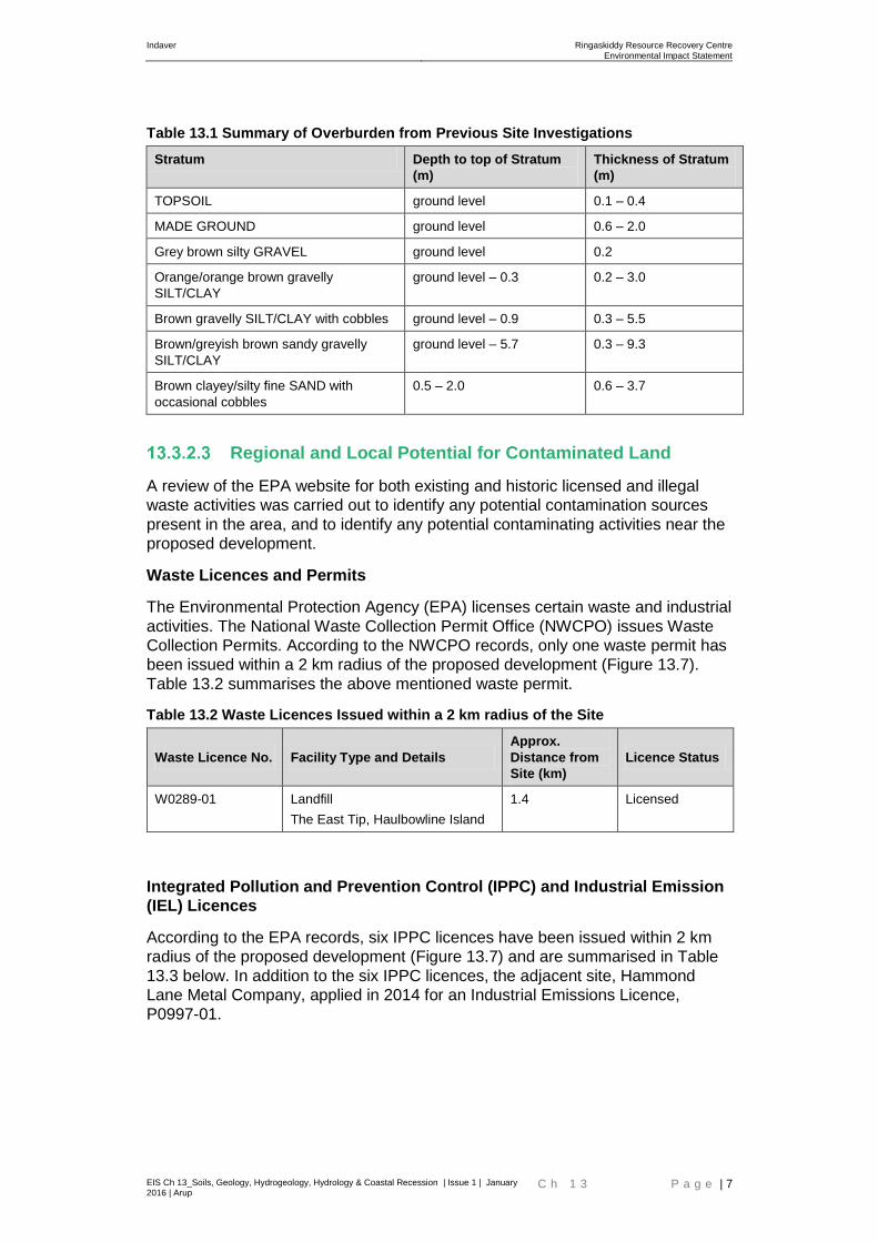
surface of TP13 only. Table 13.1 summarises the site investigation results.
Indaver Ringaskiddy Resource Recovery Centre
Environmental Impact Statement
EIS Ch 13_Soils, Geology, Hydrogeology, Hydrology & Coastal Recession | Issue 1 | January 2016 | Arup
C h 1 3 P a g e | 7
Table 13.1 Summary of Overburden from Previous Site Investigations
Stratum Depth to top of Stratum
(m)
Thickness of Stratum
(m)
TOPSOIL ground level 0.1 – 0.4
MADE GROUND ground level 0.6 – 2.0
Grey brown silty GRAVEL ground level 0.2
Orange/orange brown gravelly
SILT/CLAY
ground level – 0.3 0.2 – 3.0
Brown gravelly SILT/CLAY with cobbles ground level – 0.9 0.3 – 5.5
Brown/greyish brown sandy gravelly
SILT/CLAY
ground level – 5.7 0.3 – 9.3
Brown clayey/silty fine SAND with
occasional cobbles
0.5 – 2.0 0.6 – 3.7
Regional and Local Potential for Contaminated Land
A review of the EPA website for both existing and historic licensed and illegal
waste activities was carried out to identify any potential contamination sources
present in the area, and to identify any potential contaminating activities near the
proposed development.
Waste Licences and Permits
The Environmental Protection Agency (EPA) licenses certain waste and industrial
activities. The National Waste Collection Permit Office (NWCPO) issues Waste
Collection Permits. According to the NWCPO records, only one waste permit has
been issued within a 2 km radius of the proposed development (Figure 13.7).
Table 13.2 summarises the above mentioned waste permit.
Table 13.2 Waste Licences Issued within a 2 km radius of the Site
Waste Licence No. Facility Type and Details
Approx.
Distance from
Site (km)
Licence Status
W0289-01 Landfill
The East Tip, Haulbowline Island
1.4 Licensed
Integrated Pollution and Prevention Control (IPPC) and Industrial Emission
(IEL) Licences
According to the EPA records, six IPPC licences have been issued within 2 km
radius of the proposed development (Figure 13.7) and are summarised in Table
13.3 below. In addition to the six IPPC licences, the adjacent site, Hammond
Lane Metal Company, applied in 2014 for an Industrial Emissions Licence,
P0997-01.

Indaver Ringaskiddy Resource Recovery Centre
Environmental Impact Statement
EIS Ch 13_Soils, Geology, Hydrogeology, Hydrology & Coastal Recession | Issue 1 | January 2016 | Arup
C h 1 3 P a g e | 8
Table 13.3 Integrated Pollution and Prevention Control (now industrial emission)
Licensed sites within a 2 km radius of the Site
IPPC Licence No. Type of Activity and Details Approx. Distance
from Site (km) Licence Status
P0010-04 Chemicals
Hovione Limited
0.9 Licensed
P0004-04 Chemicals
SmithKline Beecham Limited
1.5 Licensed
P0498-01 Metals
Irish Ispat Limited
1.5 This licence has
been surrendered
and the facility
demolished
P0778-01 Chemicals
Janssen Biologics Limited
1.7 Licensed
P0013-04 Chemicals
Pfizer Ireland Pharmaceuticals
1.9 Licensed
P0476-02 Chemicals
Recordati Ireland Limited
1.9 Licensed
These licensed activities are not expected to have any implications for the soil,
geology, hydrology and hydrogeology at the Indaver site.
Potential Illegal Dumping
According to the EPA publication, The Nature and Extent of Unauthorised Waste
Activities in Ireland (2005), unauthorised waste activity has not been noted at or
within 2 km radius of the Site.
Potential Contamination in Surrounding Sites
Environmental groundwater testing was undertaken in 2011 as part of the
development of the adjacent Hammond Lane Metal Company site, (Appendix
13.2). The groundwater results are discussed in Section 13.3.3 below. In the
2011 report, it was noted that an initial assessment of the subsoils was
undertaken in 1997 and again in 2010. Neither report identified the presence of
any significant impacts on the subsoils due to the operations on site.
The 2011 groundwater samples were analysed for a range of parameters based
on the use of the site as a metal processing facility. All results were below the
Interim Guideline Values (IGV) published by the EPA.
Environmental Soil Sampling
An environmental soil baseline study was undertaken as part of the 2000 and
2001 site investigations (K.T. Cullen & Co. Ltd, 2001) (Appendix 13.1). At the
time of the 2000 and 2001 site investigations, soil laboratory test results were
compared to Dutch MAC (maximum admissible concentration) thresholds. Under
the Dutch criteria, the degree of contamination was assessed using the following
guidelines:
S-Value Reference for normal uncontaminated soil/groundwater
I- Value Threshold for intervention
Indaver Ringaskiddy Resource Recovery Centre
Environmental Impact Statement
EIS Ch 13_Soils, Geology, Hydrogeology, Hydrology & Coastal Recession | Issue 1 | January 2016 | Arup
C h 1 3 P a g e | 9
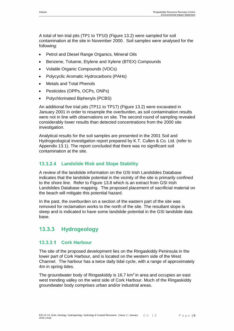
A total of ten trial pits (TP1 to TP10) (Figure 13.2) were sampled for soil
contamination at the site in November 2000. Soil samples were analysed for the
following:
Petrol and Diesel Range Organics, Mineral Oils
Benzene, Toluene, Etylene and Xylene (BTEX) Compounds
Volatile Organic Compounds (VOCs)
Polycyclic Aromatic Hydrocarbons (PAHs)
Metals and Total Phenols
Pesticides (OPPs, OCPs, ONPs)
Polychlorinated Biphenyls (PCBS)
An additional five trial pits (TP11 to TP17) (Figure 13.2) were excavated in
January 2001 in order to resample the overburden, as soil contamination results
were not in line with observations on site. The second round of sampling revealed
considerably lower results than detected concentrations from the 2000 site
investigation.
Analytical results for the soil samples are presented in the 2001 Soil and
Hydrogeological investigation report prepared by K.T. Cullen & Co. Ltd. (refer to
Appendix 13.1). The report concluded that there was no significant soil
contamination at the site.
Landslide Risk and Slope Stability
A review of the landslide information on the GSI Irish Landslides Database
indicates that the landslide potential in the vicinity of the site is primarily confined
to the shore line. Refer to Figure 13.8 which is an extract from GSI Irish
Landslides Database mapping. The proposed placement of sacrificial material on
the beach will mitigate this potential hazard.
In the past, the overburden on a section of the eastern part of the site was
removed for reclamation works to the north of the site. The resultant slope is
steep and is indicated to have some landslide potential in the GSI landslide data
base.
Hydrogeology
Cork Harbour
The site of the proposed development lies on the Ringaskiddy Peninsula in the
lower part of Cork Harbour, and is located on the western side of the West
Channel. The harbour has a twice daily tidal cycle, with a range of approximately
4m in spring tides.
The groundwater body of Ringaskiddy is 16.7 km2 in area and occupies an east
west trending valley on the west side of Cork Harbour. Much of the Ringaskiddy
groundwater body comprises urban and/or industrial areas.
Indaver Ringaskiddy Resource Recovery Centre
Environmental Impact Statement
EIS Ch 13_Soils, Geology, Hydrogeology, Hydrology & Coastal Recession | Issue 1 | January 2016 | Arup
C h 1 3 P a g e | 10
Groundwater Resources
The Geological Survey of Ireland has devised a system for classifying the
aquifers in Ireland based on the hydrogeological characteristics, size and
productivity of the groundwater resource into the National Draft Bedrock Aquifer
Map. The three main classifications are Regionally Important Aquifers, Locally
Important Aquifers, and Poor Aquifers. Each of these types of aquifer is further
subdivided and has a specific range of criteria associated with it, such as the
transmissivity (m²/day), productivity, yield, and the potential for springs.
The bedrock aquifer beneath the site and Ringaskiddy area is classified as “LI:
Locally Important Aquifer – Bedrock which is moderately productive only in local
zones” and “LK: Locally Important Aquifer – Karstified” (Figure 13.9). The site is
not underlain by karst. Consequently, LK is not applicable to the aquifer under
the site.
The GSI have delineated certain areas nationwide as groundwater Source
Protection Areas in order to provide protection for groundwater resources,
particularly group water schemes and public water supplies. A Source Protection
Area is delineated according to the hydrogeological characteristics of the aquifer,
the pumping rate, and the recharge in the area. Activities that may impact on
groundwater are tightly controlled within the Source Protection Area. There are
no Source Protection Areas located within 2km of the Site.
The GSI databases and maps were consulted to see if any records existed for
wells in the area. According to the GSI and the EPA, there are 19 wells within 2
km of the site (Figure 13.10). All of the wells are located to the south of the site.
Eighteen of the wells are categorised as for “other use”, and were drilled during
site investigations undertaken by Pettits in 1997 and 1998. They are located in a
cluster together in the current Hovione site. The one other well is located
approximately 1.6km south of the site in the vicinity of the current
GlaxoSmithKline site in Curraghbinny. It was drilled for industrial use in 2000.
Details of groundwater monitoring wells at the Indaver site and at the adjacent
Hammond Lane site are provided in Section 13.3.3.7.
Based on the available information, groundwater flow direction in the immediate
vicinity of the site is considered to be in a south to north direction. Due to the
distance and predicted groundwater flow direction, it is not likely that any of these
wells will be impacted by the proposed Indaver development. They will not be
considered further in this assessment
Groundwater Vulnerability
According to the GSI Well Database and the Groundwater Vulnerability map for
South Cork, groundwater is not used for public or private water supply in the
Ringaskiddy area.
Aquifer or groundwater vulnerability is the ease with which the groundwater may
be contaminated by human activity and depends upon the aquifer’s intrinsic
geological and hydrogeological characteristics. The vulnerability is determined
by the permeability and the attenuation capacity of any overlying deposits. For
example: bedrock with a thick, low permeability, and clay-rich overburden is less
vulnerable than bedrock with a thin, high permeability, and gravelly overburden.

Indaver Ringaskiddy Resource Recovery Centre
Environmental Impact Statement
EIS Ch 13_Soils, Geology, Hydrogeology, Hydrology & Coastal Recession | Issue 1 | January 2016 | Arup
C h 1 3 P a g e | 11
The vulnerability of the aquifer at the Site is classified by the GSI as having
‘Extreme’ vulnerability, with some areas classified as ‘Rock at or near Surface, or
Karst’ (Figure 13.11). (Note - as the bedrock geology at this site is not limestone
no karst is present). Within an area of 2 km from the proposed development, the
majority of the aquifer falls into ‘Extreme’ vulnerability classes, becoming ‘High’
further west and south.
Groundwater Recharge Characteristics
The GSI has published Groundwater Recharge Mapping for almost all of Ireland.
The location of the proposed development is categorised in the map as generally
having an average recharge of 200mm/yr, with some parts of the surrounding
area yielding an average recharge of up to 627mm/yr and 443mm/yr (Figure
13.10).
Potential or effective rainfall is the amount of rainfall that is available to infiltrate
the ground and that will not evaporate or be taken up by plants. The effective
rainfall for the area is 738mm/yr.
These values influence the amount of recharge the study area receives and will
influence the groundwater throughput beneath the study area.
Actual recharge is the measure of how much rainfall can actually be assumed to
infiltrate the ground and recharge the water table. It is based on the potential
rainfall but also takes into account rainwater that does not enter the ground but
becomes overland flow and enters streams. This occurs when the soil is
saturated or has reached its field capacity, which is common in Ireland.
Groundwater-dependent Terrestrial Eco-systems
The purpose of this section is to assess any impacts on groundwater-dependent
terrestrial ecosystems that may be influenced by any potential changes in the
groundwater regime as a result of the proposed development. The National Parks
and Wildlife Service online database was consulted to establish whether any
groundwater-dependent terrestrial ecosystems are located within 2km of the site
of the proposed development. No groundwater-dependent ecosystems within
2kms of the proposed development were identified from the database. A full
assessment of the ecological features in the vicinity of the site is outlined in
Chapter 12 Biodiversity, of the EIS.
Potential Groundwater Contamination in Surrounding Sites
Environmental groundwater testing was undertaken in 2011 as part of the
development of the adjacent site, the Hammond Lane Metal Company
(O’Callaghan Moran & Associates, 2011), refer to Appendix 13.2.
The 2011 groundwater samples were analysed for a range of parameters based
on the use of the site as a metal processing facility. All results were below the
Interim Guideline Values (IGV) published by the EPA.

Indaver Ringaskiddy Resource Recovery Centre
Environmental Impact Statement
EIS Ch 13_Soils, Geology, Hydrogeology, Hydrology & Coastal Recession | Issue 1 | January 2016 | Arup
C h 1 3 P a g e | 12
Site Specific Hydrogeology
Five groundwater monitoring wells (BH1 to BH5) (refer to Figure 13.2) were
installed in both the overburden and the bedrock at selected locations across the
site as part of the 2000 to 2001 site investigation (Appendix 13.1). Four
groundwater monitoring wells (MW1 to MW4) were installed as part of the 2011
Hammond Lane site investigation (refer to Figure 13.2).
Groundwater depths and levels recorded in the trial pits and the boreholes
excavated in the previous site investigations across the site are presented in
Table 13.4. It should be noted that in the case of the 2000 and 2001 SI, and the
2011 SI performed on behalf of Hammond Lane Metal Company, the
groundwater levels to Malin Head Ordnance Datum have been inferred from the
topographic survey completed on the site, and therefore the inferred elevations
are approximate. Groundwater depths range from 1m to 12m bgl and levels are
approximately between 8m OD and -5m OD.
Table 13.4 Water Strike Records from Previous Site Investigations (refer to Figure
13.2)
Exploratory Hole No Depth (mbgl) Elevation (mOD) Water Strike Rose (m)
TP1 (2000) 1.8 1.45 0.8
TP2 (2000) 5 -0.75 0.5
TP4 (2000) 3.4 1.35
TP5 (2000) 1 1.5 -1.0
TP5 (2000) 2.5 0 0.5
TP7 (2000) 3 1.25
TP11 (2001) 2.1 4.9
TP13 (2001) 3.4 -0.3
TP14 (2001) 3 1.95
TP16 (2001) 2.5 0.75 1.0
TP17 (2001) 1.5 0.73 0.5
BH1 (2000) 4.5 -1.25
BH2 (2000) 6 -3
BH3 (2000) 12 -4.5
BH4 (2000) 8 -1
BH5 (2000) 8.5 -3.75
BH2 (2012) 8.4 0.59 1.3
BH4 (2012) 9.6 2.00
TP4 (2012) 4.0 8.35
MW1 (2011) 2.8 0.20
MW2 (2011) 8.2 -4.20
MW3 (2011) 6.7 -1.20
MW4 (2011) 8.6 5.40
Based on the available information, groundwater flow direction in the immediate
vicinity of the site is considered to be in a south to north direction.
Indaver Ringaskiddy Resource Recovery Centre
Environmental Impact Statement
EIS Ch 13_Soils, Geology, Hydrogeology, Hydrology & Coastal Recession | Issue 1 | January 2016 | Arup
C h 1 3 P a g e | 13
Environmental Groundwater Sampling
An environmental groundwater contamination baseline study was undertaken as
part of the 2000 and 2001 site investigations undertaken by KT Cullen & Co. At
the time of the 2000 and 2001 site investigations, groundwater test results were
compared to Dutch MAC (maximum admissible concentration) thresholds for soil
and groundwater. Groundwater analytical results were also compared to the Irish
Water Quality Standard for Drinking Water (S.I. No 81 of 1988).
Under the Dutch criteria, the degree of contamination was assessed using the
following guidelines:
S-Value Reference for normal uncontaminated soil/groundwater
I- Value Threshold for intervention
A total of five groundwater monitoring wells (BH1 to BH5) (refer to Figure 13.2)
were sampled for groundwater contamination at the site in November 2000.
Groundwater samples were analysed for the following:
Petrol and Diesel Range Organics, Mineral Oils
Benzene, Toluene, Ethylbenzene and Xylene (BTEX) Compounds
Volatile Organic Compounds (VOCs)
Polycyclic Aromatic Hydrocarbons (PAHs)
Metals and Total Phenols
Pesticides (OPPs, OCPs, ONPs)
Polychlorinated Biphenyls (PCBS).
Analytical results for the groundwater samples are presented in the Soil and
Hydrogeological investigation report prepared by K.T. Cullen & Co. Ltd (refer to
Appendix 13.1). The report concluded that there was no significant groundwater
contamination at the site and that the slightly elevated levels of ammonia and
nitrite were most likely of agricultural origin.
Conceptual Site Model
A conceptual site model (CSM) for the site has been developed, using the site
investigation data for the site. It is summarised in Table 13.5 below and
presented in Figures 13.3a and Figure 13.3b. Refer to Figure 13.2 for the location
of the site cross-sections.
Table 13.5 Conceptual Site Model
Stratum Depth to top of
Stratum (m)
Thickness of
Stratum (m)
TOPSOIL/MADE GROUND 0.0 0.1 – 2.0
sandy gravelly SILT/CLAY locally with medium
to very thick beds of sand
0.0 – 0.7 0.3 – 9.9
pale green MUDSTONE/green grey fine grained
SANDSTONE bedrock
0.3 - 10.1
The bedrock beneath the site is a ‘Locally Important Aquifer’, with a vulnerability
rating of ‘Extreme’, overlain by a thin layer of sandy gravelly CLAY/SILT
Indaver Ringaskiddy Resource Recovery Centre
Environmental Impact Statement
EIS Ch 13_Soils, Geology, Hydrogeology, Hydrology & Coastal Recession | Issue 1 | January 2016 | Arup
C h 1 3 P a g e | 14
interbedded with sand strata. The thickness of overburden across the site was
found to range from 0.3m bgl to 10.1m bgl.
Regional flow in the bedrock and subsoil is towards Cork Harbour. This has been
confirmed locally as a south to north direction from the groundwater levels
recorded in some local site investigations (refer to Appendices 13.2 and 13.3).
Importance of Features
As part of the appraisal of the receiving environment, the importance of the
following features has been ranked, based on NRA 2008 criteria.
Table 13.5 Importance of Features
Feature Importance
Ranking Justification
Locally Important Aquifer Medium The site is underlain by a Locally Important Aquifer
Environment Type
From the Conceptual Site Model (CSM) presented in Section 13.3.4 above, the
proposed development site is categorised as a Type A environment. According
to the IGI 2013 Guidelines, the definition of this is:
Type A: Passive geological/hydrogeological environments e.g. areas of thick low
permeability subsoil, areas underlain by poor aquifers, recharge areas,
historically stable geological environments.
The other categories from the IGI 2013 Guidelines are also presented below
Type A – Passive geological / hydrogeological environments e.g. areas of thick low
permeability subsoil, areas underlain by poor aquifers, recharge areas, historically stable
geological environments
Type B – Naturally dynamic hydrogeological environments e.g. groundwater discharge areas,
areas underlain by regionally important aquifers, nearby spring rises, areas underlain by
permeable subsoils;
Type C – Man-Made dynamic hydrogeological environments e.g. nearby groundwater
abstractions, nearby quarrying or mining activities below the water table, nearby waste water
discharges to ground, nearby geothermal systems;
Type D – Sensitive geological / hydrogeological environments e.g. potentially unstable
geological environments, groundwater source protection zones, karst;
Type E – Groundwater dependent eco systems e.g. wetlands, nearby rivers with a high
groundwater component of base flow.
Indaver Ringaskiddy Resource Recovery Centre
Environmental Impact Statement
EIS Ch 13_Soils, Geology, Hydrogeology, Hydrology & Coastal Recession | Issue 1 | January 2016 | Arup
C h 1 3 P a g e | 15
Hydrology
Existing Hydrological Environment
The main hydrological feature in the vicinity of the site is the West Channel of
Cork Harbour, which is adjacent to the eastern boundary of the site. The nearest
rivers and streams are the Glounatouig Stream that flows into Monkstown Creek,
approximately 3km to the west of the site, and the Owenboy River that flows into
Cork Harbour, approximately 2.5km to the south of the site. These surface water
features are indicated on the following Figure 13.12. The online EPA envison
mapping (consulted 6 July 2015) shows the water quality in Cork Harbour to be
‘Unpolluted’.
Surface water within the site boundary appears to drain through naturally
occurring channels along the field boundaries following the natural topography of
the landscape which falls from 41m OD in the south of the site to 2m – 3m OD at
the northern boundary with the road. The relatively flat and low-lying areas in the
northern parts of the site adjacent to the road, to the east and west of the
Hammond Lane facility, are poorly drained due to the gradient and possibly due
to the presence of the thicker glacial deposits. Ponding of water has been noted
in these areas during winter months. The potential for flooding of the low-lying
parts of the site is further discussed in the following Section 13.3.7.2 below and in
Appendix 13.4 (Flood Risk Assessment).
Flood Risk
The Indaver site was assessed by Arup to determine whether the site was at risk
with respect to flooding (Refer to Appendix 13.4 (Flood Risk Assessment).
Potential sources of flooding considered included:
Fluvial Flooding
Tidal/Coastal Flooding
Groundwater Flooding
Pluvial/Urban Drainage Flooding
A summary of the findings of the flood risk assessment is as follows:
Given the absence of any significant watercourse in the vicinity of the site, the
risk of fluvial flooding is very low.
The site is not indicated as being within the design 1000 year tidal floodplain.
Consequently the site is classified as lying within Flood Zone C.
There is a low risk of groundwater flooding of the site.
Based on a review of all available information, the 1 in 200 year design tidal
level at the site has been estimated as 2.73m OD. Sections of the road close
to Gobby beach car park are below this level and are therefore at risk of tidal
flooding during a 1 in 200 year tidal event.
Small areas of the site along the northern boundary are also below the
predicted 1 in 200 year design tidal level (2.73m OD). The majority of the site
is above 2.73m OD.

Indaver Ringaskiddy Resource Recovery Centre
Environmental Impact Statement
EIS Ch 13_Soils, Geology, Hydrogeology, Hydrology & Coastal Recession | Issue 1 | January 2016 | Arup
C h 1 3 P a g e | 16
There is a risk of pluvial flooding to the L2545 and the low lying areas of the
site during periods of heavy rainfall due to an insufficient drainage network
and tide locking of the existing drainage outfall. This is described further
below.
The existing storm water drainage system along the road consists of a 450mm
diameter pipe and is unable to cater for the volume of water falling on the road
and consequently the road is subject to flooding. This drainage pipe outfalls into
the sea at Gobby Beach. The invert level of the outfall of the road drainage
network is set at -0.28mOD. Once the level of the tide rises above this elevation
the drainage system can become tide locked if there is insufficient differential
head at the outfall. When this occurs the surface water is unable to discharge
through the outfall and collects in the drainage pipe, the discharge pipe becomes
surcharged and any subsequent rain water falling on the road causes it to flood.
In addition, there are a minimal number of gullies along the road to accept water
and transfer it the storm water sewer. A number of channels have been cut in the
berm on the southern side of the road which allow surface water drain from the
road and into the western field area of the Indaver site as a section of this field is
lower than the adjacent road level. Therefore, it can be concluded that the
existing formal drainage system on the L2545 is inadequate.
Coastal Recession
Introduction
The coastline along the eastern boundary of the Indaver site consists of a glacial
till face adjoining Gobby Beach. The glacial till face is very shallow near the
public car park to the north and steepens to the south to a maximum of 10-12m
high.
A detailed coastal erosion study is provided in Appendix 13.3 (Coastal Erosion)
of this EIS. The details provided in this chapter summarise Appendix 13.3.
In November 2008, Arup carried out an assessment of coastal retreat and coastal
flooding at the site of the development. The coastline, which forms the eastern
boundary of the site, was found to have eroded over the past 100 years at a
varying rate, with the most significant erosion occurring along the south eastern
boundary of the site. It was also noted that some accretion or increase by natural
growth of sediment has occurred along a section of the beach to the north east of
the site.
From 2008 to 2015 a series of studies were carried out to get an understanding
of coastal erosion patterns in the area with a view to assess if any coastal
protection measures were needed.
A site investigation was carried out in 2012 in order to investigate the causes of
the coastal recession at the site. The results of the 2012 investigation are
summarised in Appendix 13.3 (Coastal Erosion). The 2012 study concluded
that the ground conditions and water seepage along the eastern coastal
boundary of the site make the slope vulnerable to coastal erosion. This is
combined with wave action from the sea, which creates turbulence on the beach
and at the base of the coastal slope, leading to recession of the glacial till slope
line at the toe. The glacial till slope recedes through a cycle of notching and
Indaver Ringaskiddy Resource Recovery Centre
Environmental Impact Statement
EIS Ch 13_Soils, Geology, Hydrogeology, Hydrology & Coastal Recession | Issue 1 | January 2016 | Arup
C h 1 3 P a g e | 17
fissures forming at the base of the glacial till slope due to the wave action, the
subsequent slumping of the overhanging material, and the washing away of the
slumped material at the base.
Between 2014 and 2015, further studies were carried out including:
Topographic survey for the beach and glacial till slope at the eastern
boundary of the Indaver site
Bathymetric survey in the nearshore area adjacent to the eastern boundary of
the Indaver site,
Coastal erosion study which included:
Assessment of the retreat rate based on historical information and the
new surveys
Numerical wave model and beach sediment transport
Assessment of expected coastal retreat
Appraisal of potential impacts of expected coastal retreat on the proposed
Ringaskiddy Resource Recovery Centre, and
Mitigation measures to minimise potential impacts
Refer to Appendix 13.3 (Coastal Erosion) for details.
Retreat rates
It was necessary to make an estimate of coastal erosion rate along the eastern
side boundary in order to assess whether the proposed development could be
impacted by coastal erosion.
An initial estimate of the coastal erosion rate was made using historical data sets
collected from various sources including the Geological Survey of Ireland (GSI)
and the Ordnance Survey of Ireland (OSI). Rates identified from these historical
datasets were extrapolated to give future retreat rates of up to 36 or 55m over
110 years (1897-2008). Refer to Section 2 (Assessment of historical retreat) of
Appendix 13.3 (Coastal Erosion) for further details.
The level of uncertainty associated with using historical datasets was high due to
a number of factors including the fact that there were large variations in the
coastal retreat over the 110 year period, there were large gaps between surveys
and the precision and accuracy of historical mapping cannot be quality checked
to the same level as modern surveying/monitoring.
Therefore it was necessary to also estimate the coastal erosion rate using recent
topographic surveys as it would have a higher level of accuracy than the
historical data sets. Periodic topographic surveys were carried out between 2008
and 2014. The information obtained from these topographic surveys was used to
assess the coastal retreat since 2008 with a higher level of accuracy than the
historical datasets.
As detailed in Section 2.3 of Appendix 13.3 (Coastal Erosion), a conservative
approach was used to calculate a maximum retreat line at the site based on the
topographic survey data. The approach was based on observations and takes a
conservative absolute maximum of any retreat observed within the site boundary
over a six year period (2008-2014). Erosion is likely to be the result of episodic
Indaver Ringaskiddy Resource Recovery Centre
Environmental Impact Statement
EIS Ch 13_Soils, Geology, Hydrogeology, Hydrology & Coastal Recession | Issue 1 | January 2016 | Arup
C h 1 3 P a g e | 18
events i.e. a similar event will most likely not occur in the following year and may
not occur for a number of years. Therefore for the most accurate estimation of the
erosion rate it is necessary to analyse data spanning the largest period available,
which in this case is six years. This period of six years is considered to be
conservative to extrapolate an erosion rate.
A maximum localised retreat rate was measured at a particular location along the
Indaver eastern boundary and based on that an erosion rate of 0.47m per year
over the six year period was calculated. However, a conservative rate of 0.5m per
year was used in order to calculate the erosion rate into the future.
The topographic surveys carried out between 2008 and 2014 confirm the retreat
rates found in the historical maps, surveys and aerial photographs (1897-2008)
were within the correct range (36-55m over 110 years).
As discussed elsewhere in the EIS, Indaver is applying for a 10-year planning
permission to commence and complete the construction phase.In addition,
permission is sought to operate the proposed development for an initial period of
30 years after commissioning with the option to extend the operating period for a
further 30 year period, subject to obtaining a grant of permission for that
extended period.
The maximum predicted retreat of 0.5m/year was applied to the entire length of
the top of the glacial till slope line adjacent to the site in order to calculate how
much erosion would occur over the lifetime of the proposed development (30 and
40 years). This approach is conservative as in reality, some areas may
experience a lower retreat rate per year and some areas may experience
accretion.
Applying the predicted conservative rate of erosion of 0.5m/year gives an
expected retreat (of the glacial till face) of 15m in 30 years’ time, 20m in 40 years’
time and 50m in 100 years’ time. Refer to Appendix 13.3 for further details. Refer
also to planning drawing No 238129-C-000-060 which shows the estimated
retreat lines and the proposed development with and without mitigation. The
impact of the predicted erosion retreat on the proposed development is discussed
further in Section 13.4.4 below.
Characteristics of Proposed Development
General
The proposed development will consist principally of a waste-to-energy facility
(waste incinerator) for the treatment of up to 240,000 tonnes per annum of
residual household, commercial and industrial non-hazardous and hazardous
waste and the recovery of energy. Of the 240,000 tonnes of waste, up to 24,000
tonnes per annum of suitable hazardous waste will be treated at the facility.
In addition to the provision of the waste-to-energy facility, the proposed
development will include an upgrade of a section of the L2545 road, a connection
to the national electrical grid, an increase in ground levels in part of the site,
coastal protection measures above the foreshore on Gobby beach and an
amenity walkway towards the Ringaskiddy Martello tower.
Indaver Ringaskiddy Resource Recovery Centre
Environmental Impact Statement
EIS Ch 13_Soils, Geology, Hydrogeology, Hydrology & Coastal Recession | Issue 1 | January 2016 | Arup
C h 1 3 P a g e | 19
Connection to the national grid within the ESB networks Lough Beg substation is
described in Section 4.5.10 of Chapter 4. It is envisaged that the works within the
substation lands will be carried out at the same time as the Indaver development.
Soils and Geology
Site preparation will involve the re-grading of the eastern part of the site for the
construction of the waste-to-energy facility. Significant earth retaining structures
will be required within the proposed development. Where loose/soft soils are
encountered in the northern part of the site, excavation and replacement of these
soils with more suitable fill will be required to minimise settlement of the ground.
The low-lying areas of the site including the western fields will be raised to above
4.55m OD.
It is estimated that up 74,664m3 of material will be removed from the site and up
to 30,261m3 of material will be imported onto the site during the construction
phase. These figures include an allowance for bulking up of material for
transportation.
Some works will be carried out below the existing ground level on the site. For
the works involved with the proposed resource recovery centre, these will include
the following:
Diversion of existing services including the gas main and overhead power
lines.
Stripping topsoil and vegetation.
Bulk excavation and general site re-grading.
Raising the level of the western field to above 4.55mOD.
Construction of earth retaining structures.
Construction of foundations, including piling.
Construction of the bunker, underground tanks, drainage, and underground
services.
The road upgrade works will include the following:
Raising a section of the road to a maximum height of 3.41mOD.
Upgrading the road drainage by installing additional large diameter pipes
under the road and new road gullies in the road.
Diversion of some existing services in the road.
Surface Water Drainage
Standards and Regulations
Surface water will be collected in underground drainage systems. All of the
underground drainage systems will be designed and constructed as a minimum
to comply with the Building Regulations 2010, BS EN 752-4 Drain and Sewer
Systems outside Buildings.
Indaver Ringaskiddy Resource Recovery Centre
Environmental Impact Statement
EIS Ch 13_Soils, Geology, Hydrogeology, Hydrology & Coastal Recession | Issue 1 | January 2016 | Arup
C h 1 3 P a g e | 20
Surface Water Drainage from the Waste-to-energy Facility
The eastern part of the resource recovery facility, when constructed, will form a
rainwater catchment area of 3ha consisting of roofed areas, roads and hard
standings. The storm water runoff will be discharged to the Local Authority sewer
located in the L2545 road to the north of the site.
In order to prevent flooding of the local sewers, the rate of discharge from the site
will be controlled to the Greenfield rate, based on the SUDS Design Guidelines.
The site will be provided with attenuation to store and control the storm water
discharge. The attenuation tank will have a Greenfield discharge rate of 18l/s.
The attenuation tank will be constructed from reinforced concrete and will be
located beneath the car park adjacent to the administration building.
A combined surface water tank (attenuation tank) and a firewater retention tank
will be provided. Both tanks will be located underground beneath the
administration building car park to the west of the main entrance.
A dedicated surface water drainage network will collect and convey all the road
and service yard runoff to Surface Water Holding Tank 01 via a Class 1 full
retention hydrocarbon interceptor. A second dedicated drainage network will
collect and convey all the runoff from all roof areas and discharge them direct to
Surface Water Holding Tank 02.
Surface Water Tank 01, which will have a capacity of 1690m³.
The tanking unloading area, which is located adjacent to the fuel tank, will be
provided with cut off drains to collect any minor spillage that may occur during
loading of the fuel and ammonia tanks. A local holding tank with a 2m3 capacity
will be provided. The outlet valve of the local holding tank will be closed during
any tanker loading or unloading operation. If a spillage occurs during a loading or
unloading operation, the spilled liquid will be collected in the local holding tank.
The contents of the tank will then be pumped out and dealt with appropriately.
When the unloading operation has finished, if no spillage has occurred, the valve
will be opened and the contents of the tank will drain via a forecourt interceptor to
the holding tank.
The fill will be placed in western field to raise the ground level. The area will be
finished with stone. Any storm water will infiltrate into the ground. There will be no
sources of potential contamination in the area. A new filter drain will be located
between the bottom of the raise plateau embankment and the site boundary to
aid with the infiltration to ground.
Storm Water Monitoring
All runoff from the road and hardstanding areas which drain direct Tank 01 will be
monitored by an internal Indaver monitoring and sampling station. In the event of
there being an out of specification reading Tank 01 can be isolated from Tank 2
and the water removed in accordance with Indaver operational procedures for
dealing with contaminated water. This arrangement allows for the roof runoff to
continue to be discharged from the site. Monitoring will also take place at the
outfall from the attenuation tank. If the monitoring at either location detects
contamination, the outlet valve will be closed and the contaminated water will not
be discharged. The contaminated water may be conveyed by tanker to the

Indaver Ringaskiddy Resource Recovery Centre
Environmental Impact Statement
EIS Ch 13_Soils, Geology, Hydrogeology, Hydrology & Coastal Recession | Issue 1 | January 2016 | Arup
C h 1 3 P a g e | 21
aqueous waste tank, for injection into the process, or removed off site for
appropriate disposal. It is expected that monitoring will normally show the storm
water to be uncontaminated so the holding tank will typically be empty.
Fire Water Management
Fire water retention, for the retention and control of contaminated water
generated when fighting a fire, will be provided to the waste-to-energy facility
area.
A firewater retention tank will be provided. It will be will be located underground
beneath the administration building car park to the west of the main entrance.
In the event of a fire in the bunker, the water used to fight the fire will be captured
in the bunker where it will be stored for disposal. The bunker will have more than
adequate capacity for the volume of water used to fight the fire as well as the
waste which will be in it. If there is a fire in any other part of the waste-to-energy
facility, the water used to fight the fire will be captured the recovered water tank
or clean water tank which are located below the building floor. The bunker and
the recovered water tank will be designed as water retaining structures. The fire-
fighting water from any fire in an outdoor area would be captured in the storm
water drainage system and will be collected in both the surface water holding
tanks, where it can be stored for disposal. The surface water pumps which are
located in Tank 02 will be switched if the fire alarm is activated. The combination
of both of the surface water tanks will provide sufficient retention capacity in
accordance with the EPA guidelines for fire water retention.
L2545 Road Drainage Upgrade
The storm water drainage in the L2545 road will be improved as part of the road
upgrade works. The proposed L2545 upgrade works will include raising a 185m
section of the road to a maximum height of 3.45m OD between the car park and
the eastern end of the Hammond Lane Metal Company. This is approximately
0.9m above the existing road level. This will elevate the road to above the 200
year design tidal water level plus an allowance for climate change. This will offer
a high level of protection to the road from tidal flooding. The road will be raised
over a length of approximately 185m in order to ensure a smooth transition down
to existing road levels, in accordance with road design standards. The recently
constructed footpath on the northern side of the road will also be raised to the
new road level.
The proposed road drainage network upgrade will extend along the entire
northern boundary of the Indaver site. It has been designed to cater for the 7
hours when the storm water outfall is tide locked during a 200 year tidal event
and a 1 in 30 year rainfall event plus an allowance for climate change. The
increased storage will be in the form of 2No. 1500mm oversized pipes placed
underneath the road. This is described further below.
A 260 metre length of new linear concrete surface water channel will extend from
the western boundary of the Western Field site and will run along the southern
edge of the L2545 until it meets the entrance to the Hammond Lane Metal
Company. This section of the L2545 is currently super-elevated – i.e. the camber
on the road falls from north to south, therefore surface water drains to the south.
Indaver Ringaskiddy Resource Recovery Centre
Environmental Impact Statement
EIS Ch 13_Soils, Geology, Hydrogeology, Hydrology & Coastal Recession | Issue 1 | January 2016 | Arup
C h 1 3 P a g e | 22
This section of the L2545 will not be raised as the existing levels are already
above the predicted 1 in 200 year design tidal level (2.73m OD). The new surface
water channel will be drained at regular intervals by gullies which will outfall to the
existing 450mm diameter surface water sewer beneath the road. Therefore
surface water will no longer flow from the road into the Indaver site (western
fields) to the south.
The raised section of the L2545 between the car park and the eastern end of the
Hammond Lane Metal Company will be drained by a kerb and gully sealed
drainage system which will be connected to two new surface water pipes
underneath the road. The two 1500mm diameter pipes will be approximately
190m in length and will provide 660m3 of surface water storage. There will be
three large concrete chambers constructed on the line of the twin surface water
pipes at the start, middle and end of the run. The first two chambers will be
situated in the road and the terminal chamber will be constructed at the entrance
to the car park by Gobby Beach. The recently constructed surface water drainage
system on the Haulbowline road will be diverted into the terminal chamber. This
chamber will be connected to the existing 450mm diameter surface water sewer
via a short length of new 450mm diameter pipe, a new Class 1 bypass
hydrocarbon interceptor and a new manhole constructed on the line of the
existing pipe. This will allow the upgraded surface water drainage system to
discharge to sea via the existing 450mm surface water outfall at Gobby Beach.
The design of the new drainage system will cater for the 7 hours when the storm
water outfall is tide locked by a 200 year tidal event combined with a 1 in 30 year
rainfall event plus an allowance for climate change.
All of the above works will be within Indaver ownership, apart from a small area in
Hammond Lane ownership. Consent has been given by Hammond Lane to
undertake these works.
Increase in levels of the Indaver site
The minimum design flood defence level of the proposed development has been
calculated as 3.8m OD Malin. Arup however has proposed a far more
conservative flood defence level of 4.55m OD Malin for the site.
The levels of the low-lying parts of the site will be raised to 4.55m OD. This level will offer a very high standard of flood protection to the site. Refer to Appendix
13.4 (Flood Risk Assessment) for further details. This measure will ensure that
the risk of flooding to the site is very remote. The finished floor level of the
buildings on the site will be set at even more conservative levels, all above
5mOD.
Sanitary Drainage
During the operation of the proposed development, sanitary wastewater will be
treated as follows:
All sanitary wastewater will be collected and treated in a standalone
wastewater treatment facility that will treat the wastewater to a 20:30
standard, i.e. 20mg/l BOD and 30mg/L SS.
The treated domestic effluent will then be pumped to Irish Water’s foul sewer
located east of Ringaskiddy Village.
Indaver Ringaskiddy Resource Recovery Centre
Environmental Impact Statement
EIS Ch 13_Soils, Geology, Hydrogeology, Hydrology & Coastal Recession | Issue 1 | January 2016 | Arup
C h 1 3 P a g e | 23
Once the Irish Water Lower Harbour sewage treatment facility has been
constructed and becomes operational, the pumped untreated sanitary water
will go directly to the Irish Water sewer located east of Ringaskiddy Village,
which will then be pumped to the Lower Harbour wastewater treatment
facility. The site wastewater treatment facility will be removed.
Coastal Recession
As discussed in Section 13.3.8.2 above, a conservative rate of 0.5m per year was
used in order to calculate the erosion rate into the future. Applying this predicted
rate of erosion gives an expected retreat of the glacial till face of 15m in 30 years’
time, 20m in 40 years’ time and 50m in 100 years’ time. Refer to Appendix 13.3
for further details. Refer also to planning drawing No 238129-C-000-060 which
shows the estimated retreat lines and the proposed development with and
without mitigation.
The study found that there would be no impact from coastal erosion on the
proposed development after 30 years. The study found that there could be a risk
of an impact on a small section of the proposed development after 40 years
however this would be confined only to the amenity walkway and viewing
platform and a small section of a diverted gas pipeline outside of the security
fence line. However, even allowing for the conservative assumptions used to
predict the rate of erosion, the waste-to-energy facility itself will not be impacted
by coastal erosion after 40 years.
The study also found that the proposed development will not increase the current
rate of erosion of the glacial till face.
Coastal protection mitigation measures are not required for the waste-to-energy
facility element of the development. However, given the concerns raised by An
Bord Pleanála in 2008/2009 and given the low risk that the amenity walkway and
viewing platform and a section of the diverted gas pipeline could be impacted in
40 years’ time, coastal protection measures to reduce the rate of erosion have
been included in this planning application as a precautionary measure so as to
reduce the rate of erosion of the glacial till face.
Arup investigated a number of coastal protection options that could be applied to
the Indaver site. This is detailed further in Appendix 13.3 of this EIS.
In modern coastal engineering practice it is generally thought that the benefits of
using ‘soft’ solutions (where possible) far outweigh the benefits of using ‘hard’
solutions. Also, ‘soft’ solutions have a degree of adaptability and dynamism
compared to ‘hard’ solutions. Similarly there is evidence that certain ‘hard’
solutions can cause wave reflection and can in fact worsen the issue of erosion.
For these reasons there is a trend in employing ‘soft’ solutions wherever possible.
It is proposed that the Indaver coastal boundary is monitored on an annual basis.
In addition, approximately 1100m3 of sacrificial material (shingle) of appropriate
size and shape (rounded) will be placed above the foreshore on Gobby beach
along the eastern boundary of the Indaver site. This will be a ‘soft’ solution which
will potentially reduce erosion rates by limiting the exposure of the toe of the
glacial till face to wave action.

Indaver Ringaskiddy Resource Recovery Centre
Environmental Impact Statement
EIS Ch 13_Soils, Geology, Hydrogeology, Hydrology & Coastal Recession | Issue 1 | January 2016 | Arup
C h 1 3 P a g e | 24
The shingle will be confined to the beach adjacent to the site within Indaver
ownership. It will be necessary for tracked machines to access the beach, above
the high tide line to spread the shingle.
It is proposed that the sacrificial material (shingle) is placed during the
construction period of the Indaver site. Thereafter, it is proposed that the
placement of further additional sacrificial material (shingle) is carried out if the
glacial till slope erosion rate is more than 0.5m per year measured over a period
of six years, which would indicate some acceleration in the current erosion rate,
or when the glacial till slope has retreated by approximately 3m, whichever is
sooner. For this reason the coastal boundary of the Indaver site will be monitored
for erosion on an annual basis.
The proactive monitoring will comprise:
Annual topographic surveys which will include 0m contour, top and bottom of
glacial till face monitoring and specified sections.
An assessment of the retreat and reporting over the design life of the proposed
development including the construction period (40 years).
Proactive and reactive management of the beach comprising placement of
imported shingle to areas of the beach where deemed necessary from beach
monitoring data.
The main aim of placing the material is to act as a proactive measure for the
coastal area adjacent to the Indaver site only. The solution will have no negative
impacts on the adjoining areas. However there will be benefits associated with
the works as well as the provision of an environmentally friendly solution. The net
coastal sediment transport goes from south to north according to wind conditions
and swell; therefore the material is likely to move towards the north in the
medium and long term. The Cork Harbour Special Protection Area (SPA) is
located to the south west of the site and therefore the sacrificial material will not
impact on the SPA. Refer to Appendix 13.3 for further details.
Potential Impacts
Soils and Geology
The following section details the potential impacts of the construction and
operational phases of the proposed development on soils and geology.
Construction Phase
Excavation works below the existing ground level will be required during the
construction of the proposed facility. In the eastern area of the site, bedrock
levels in boreholes range from 1.0m bgl to 9m bgl. Bedrock in trial pits was
recorded at depths between 0.30m bgl in trial pit TP9 to 5.5m bgl in trial pit TP2.
The proposed foundation levels of the site will be in stepped levels across the
site, ranging from circa -1mOD to 10m OD and will require excavations of up to
10m bgl. This will involve the excavation of soil and bedrock.
In the event that soft soils are encountered that will not support the applied loads,
or risk settlement over time, additional excavations may be required. This might
Indaver Ringaskiddy Resource Recovery Centre
Environmental Impact Statement
EIS Ch 13_Soils, Geology, Hydrogeology, Hydrology & Coastal Recession | Issue 1 | January 2016 | Arup
C h 1 3 P a g e | 25
be to either bedrock or a sufficient depth within the soil where more competent
soils are encountered. Additional fill will then be required to create a competent
foundation and reinstate the ground level to that which is required. Piles
foundations may also be used.
For bedrock excavation, trial pit and borehole records indicate that the upper
0.5m to 1m of weathered material can be extracted using a large excavator while
the remainder will be removed using a chisel or hammer-operated rock breaker. If
the removal of the more competent bedrock is required, this has the potential to
impact on the environment in terms of creation of additional noise, vibrations and
dust.
Existing slopes in the southern part of the waste-to-energy facility will be re-
profiled to accommodate the proposed development.
The construction of the proposed development will require considerable
movements of materials to and from the site. Most of the materials leaving the
site will consist of spoil from the excavation works. Where possible, excavated
materials will be reused on site for backfilling purposes, re-grading and
landscaping. However, it is expected some of the excavated material may not be
suitable for reuse on site. Any excavated materials suitable for re-use may
deteriorate due to poor materials handling, storage, and exposure to adverse
weather conditions. In particular, where materials consist of high fines content
and wet weather is experienced during the excavation activities, such materials
may become unusable.
It is estimated that almost 74,664m3 of surplus material will be removed from the
site. This figure includes an allowance for bulking up of material. Uncontaminated
soil and stone materials which are not suitable for re-use will be disposed of to an
appropriate site which is permitted under the Waste Management (Collection
Permit) Regulations 2007 and 2008 to accept soil and stone. There are 13 such
permitted sites within a 40km radius of the proposed resource recovery centre
site. The environmental impacts associated with the permitted site have already
been assessed by the planning authority under the approval process specified in
the Waste Management (Collection Permit) Regulations 2007 and 2008. All traffic
movements associated with the export of materials have been included in the
construction traffic impact assessment. Refer to Chapter 7 (Roads and Traffic) for
further details
Almost 30,261m3 of engineering fill and crushed stone will be imported onto the
site. This figure include an allowance for bulking up of material. The material will
be transported by road.
Of the 30,261m3 of imported engineering fill and crushed stone required for the
construction works, approximately 1,100m3 of shingle will be required for the
coastal protection works and approximately 4,796m3 will be required for the road
upgrade.
Materials required for the construction works will be sourced locally where
possible. Materials required from quarries will only be sourced from quarries
which are listed on the register maintained by the local authority. The
environmental impacts associated with the registered quarry have already been
assessed by the local authority under Section 261 of the Planning and
Development Act 2000, as amended. All traffic movements associated with the
Indaver Ringaskiddy Resource Recovery Centre
Environmental Impact Statement
EIS Ch 13_Soils, Geology, Hydrogeology, Hydrology & Coastal Recession | Issue 1 | January 2016 | Arup
C h 1 3 P a g e | 26
import of materials have been included in the construction traffic impact
assessment. Refer to Chapter 7 (Roads and Traffic) for further details.
Potential impacts also include the risk that soils could become polluted by
accidental spillage of substances including fuels, oil, paints, grout and liquid
wastes as a result of the construction activities.
Operation Phase
The potential impacts on soils and geology during the operational phase will be
limited to accidental spillage of potentially polluting substances including fuel,
oils, paints, incoming wastes, raw materials such as lime, hydrochloric acid,
caustic soda or ammonia/urea, activated carbon or clay and residues.
Hydrogeology
Construction Phase
There is the potential for groundwater to become polluted by accidental spillages
during construction e.g. of fuel or hydrocarbon leaks from construction vehicles.
The re-grading of the site has the potential to impact on hydrogeology. Alteration
of the topography could result in localised alteration of the groundwater table and
ground water flow in the immediate vicinity of the re-graded parts of the site.
Operation Phase
There will be no direct discharges to groundwater during the operational phase of
the proposed development. Due to the creation of roads, yards, hardstanding
areas and buildings, infiltration of surface water will be reduced.
The potential impacts on hydrogeology during the operational phase will be
limited to accidental spillage of potentially polluting substances including fuel,
oils, paints, incoming wastes, raw materials such as lime, hydrochloric acid,
caustic soda or ammonia/urea, activated carbon or clay and residues.
Hydrology
Construction Phase
Surface water could potentially become polluted by spillages such as
hydrocarbon leaks from construction machinery or by siltation as a result of
runoff, during construction.
Operation Phase
There will be no discharges of process effluent from the site to surface water.
Potential sources of pollution during the operational phase of the facility would be
the accidental spillage or leakage of process materials or wastes, particularly
during unloading or loading operations, which could then enter the surface water
drainage system.
Indaver Ringaskiddy Resource Recovery Centre
Environmental Impact Statement
EIS Ch 13_Soils, Geology, Hydrogeology, Hydrology & Coastal Recession | Issue 1 | January 2016 | Arup
C h 1 3 P a g e | 27
A fire on site during operations could cause water use for fire-fighting to become
contaminated, with the potential for this contaminated water to be discharged to
the surface water system.
Other potential sources of pollution that may have an effect on surface water
during the operational phase could be oil/fuel leaks from parked cars, trucks and
service vehicles.
During operation, all sanitary wastewater will be collected and treated in a
standalone wastewater treatment plant that will treat the wastewater to a 20:30
standard, i.e. 20mg/l BOD and 30mg/L SS. The treated domestic process effluent
will then be pumped to the Irish Water foul sewer which is located east of
Ringaskiddy village. When the Shanbally plant commences operations, the site
wastewater treatment plant will be removed, and the untreated sanitary
wastewater will be pumped directly to the same Irish Water sewer east of
Ringaskiddy village, from which sewage will be pumped to the Lower Harbour
wastewater treatment plant.
Potential Impacts on Coastal Erosion
Construction Phase
As discussed above, the works associated with the placing of sacrificial beach
material, acting as beach nourishment, will consist of the deposition of shingle at
the base of the glacial till slope, above the foreshore on Gobby Beach. The
shingle will be confined to the beach adjacent to the site within Indaver
ownership. It will be necessary for tracked machines to access the beach, above
the high tide line to spread the shingle.
Access to the recreational amenity of Gobby Beach shoreline and nearby car
park will be a temporarily impacted (for approximately 3 weeks) during the
placement of sacrificial beach material. The sacrificial material consists of
imported shingle which will be temporarily deposited on the car park. To ensure
the safety of the general public, it is envisaged that the area of the beach, in
which the construction works will taking place and the area of the car park in
which the materials will be stored, and which will be used by the machinery, will
be closed to the public for the duration of the proposed works. However, access
to other sections of the beach will be maintained for the duration of the works.
The construction of the proposed development is not expected to have any
negative impact on the rate of coastal retreat. It is noted that the construction
impacts experienced during the placement of the shingle will be repeated when
the shingle is reapplied in the future. See Section 13.5.4.2 below.
Operation Phase
As detailed in Section 13.4.4 above, without the mitigation, there will be no
impact on the proposed development from coastal erosion after 30 years. The
study found that there could be a risk of an impact from coastal erosion (without
mitigation) on a small section of the proposed development after 40 years
however this would be confined only to the amenity walkway and viewing
platform and a small section of a diverted gas pipeline outside of the security
fence line. However, even allowing for the conservative assumptions used to
Indaver Ringaskiddy Resource Recovery Centre
Environmental Impact Statement
EIS Ch 13_Soils, Geology, Hydrogeology, Hydrology & Coastal Recession | Issue 1 | January 2016 | Arup
C h 1 3 P a g e | 28
predict the rate of erosion, the waste-to-energy facility itself (without mitigation)
will not be impacted by coastal erosion after 40-years.
The study also found that the proposed development will not increase the current
rate of erosion of the glacial till face.
As discussed previously, it is proposed that the additional sacrificial material is
placed during the construction period of the Indaver site. Thereafter, it is
proposed that the placement of further additional sacrificial material is carried out
if the erosion rate is more than 0.5m per year measured over a period of six
years, which would indicate some acceleration in the current erosion rate, or
when the glacial till slope has retreated by approximately 3m, whichever is
sooner. For this reason the coastal boundary of the Indaver site will be monitored
for erosion on an annual basis.
The proposed placing of sacrificial material on the beach will have a beneficial
impact on the glacial till line at site and the adjoining areas of the beach and
coastline. The Cork Harbour Special Protection Area (SPA) is located to the
south west of the site and therefore the sacrificial material will not impact on the
SPA.
The operation of the proposed development is not expected to have any negative
impact on the rate of coastal retreat.
It is expected that the sacrificial material placed will remain within the coastal
sediment cell, which is delimited by the rock headlands to the north and south of
the glacial till slope at the site, since these offer a partial barrier to sediment
movement.
The extent to which the deposited shingle remains in place will depend on the
severity and frequency of storm events which occur at the site. The south and
south east wind directions will created the greatest wave action at the beach.
Consequently, the likely direction for any movement of the sacrificial beach
material due to extreme storm events is from south to north. Any movement of
the sacrificial material would have the effect of protecting the shoreline north of
the site.
The proposed size of the shingle has been chosen to ensure that it can remain in
place within the beach. Potential seasonal movements of the material are
expected. However, this effect will be positive for the beach, since the material
will offer an additional protection for the emerged beach in storm conditions.
It is noted that the construction impacts experienced during the placement of the
shingle will be repeated when the shingle is reapplied in the future.
Based on an assessment of existing topographic and site investigation
information, as detailed in Section 5 of Appendix 13.3, it can be concluded that
the sacrificial material will reduce the existing erosion rate. Refer to planning
drawing No 238129-C-000-060 which shows the estimated retreat lines and the
proposed development with and without mitigation.
The results show that with the application of the sacrificial material, there will
continue to be no coastal erosion impact on the entire proposed development
after 30 years. With the application of the sacrificial material, the diverted gas
pipeline will not be impacted after 40 years. However, there is still low a risk of an
Indaver Ringaskiddy Resource Recovery Centre
Environmental Impact Statement
EIS Ch 13_Soils, Geology, Hydrogeology, Hydrology & Coastal Recession | Issue 1 | January 2016 | Arup
C h 1 3 P a g e | 29
impact on a very small section of the amenity walkway and viewing platform after
40 years.
The waste-to-energy section of the proposed development will not be impacted
by coastal erosion for the entire duration of the planning permission.
Landslide Risk and Slope Stability
The proposed placement of sacrificial beach nourishment material will mitigate
the potential landslide hazard, which is primarily confined to the shore line at the
site.
Works on the eastern part of the site will alter the site gradients and earth/rock
retaining structures will be constructed as required to ensure the continued
stability of this part of the site.
‘Do Nothing’ Impacts
In the scenario where the proposed Indaver facility and road upgrade were not to
be developed, there would be no resulting impacts on the soils, geology or
hydrogeology of the area. The impact would therefore be neutral.
If the proposed development did not go ahead, there would be no impact on
hydrology. The L2545 road would continue to flood following heavy rainfall
because the road drainage is inadequate. Excess surface water from the road
would be diverted to the western field. There is a risk that a 1 in 200 year tidal
flood event, combined with sea level rise as a result of climate change, would
cause flooding to a small area of the site adjacent to the road.
In the scenario where the proposed sacrificial beach material was not to be
undertaken, coastal recession would continue as it is at present.
Mitigation Measures
General
Excavated material will be reused onsite where feasible. Material not suitable for
reuse will be transported off site for disposal or recovery at appropriately licensed
or permitted sites.
Material derived from excavations that could be re-used as engineering fill will be
assessed for its suitability for such use, and will be subject to appropriate control
and testing in accordance with the NRA Specifications for Road Works.
Excavated soil materials will be stockpiled appropriately to minimise the effects of
weathering. Care will be undertaken in re-working this material to minimise dust
generation, groundwater infiltration, and generation of run-off.
Earthworks operations will be carried out such that surfaces shall be designed
with adequate falls, profiling and drainage to promote safe run-off and prevent
ponding and flooding. Run-off will be controlled through erosion and sediments
control structures appropriate to minimise the silt in the run-off. Care will be
taken to ensure that the bank surfaces are stable to minimise erosion.
Indaver Ringaskiddy Resource Recovery Centre
Environmental Impact Statement
EIS Ch 13_Soils, Geology, Hydrogeology, Hydrology & Coastal Recession | Issue 1 | January 2016 | Arup
C h 1 3 P a g e | 30
Groundwater pollution will be minimised by the implementation of good
construction practices. Refer to Chapter 5 Construction Activities, Section
5.8.5., of this EIS.
Soils and Geology Mitigation Measures
Construction Phase
Mitigation measures to prevent impacts on soils and geology during the
construction phase are described in Section 5.11 in Chapter 5 Construction
Activities of this EIS.
Operation Phase
All substances that would have the potential to cause a negative impact on the
soils and geology will be stored in appropriate containers and, if required, placed
within bunded areas in the proposed development. All storage tanks for
chemicals will be fully bunded or double skinned. Raw materials for the process
will be stored in containers or silos within the process building. Residues will be
stored in the bottom ash hall and silos within the process building.
All waste entering the facility will be stored in fully contained structures. All waste
storage facilities will be rendered impervious to the materials stored therein. All
concrete underground storage structures whether for waste or liquid (as there is a
possibility that firewater run-off may enter any of the tanks) will be constructed as
watertight structures in accordance with the requirements of relevant Codes of
practice such as EN 1992-3:2006 Eurocode 2 – Design of Concrete Structures –
Part 3: Liquid retaining and containment structures.
Typically these structures will be reinforced concrete with minimum wall and base
thicknesses of 250 mm or greater depending on the structural requirements. The
construction of these tanks will comply with the requirements of the Eurocode.
The structures will be integrity tested to confirm that they are watertight. This will
be demonstrated to the satisfaction of the EPA following installation and prior to
use for storage.
Similarly, the storm water attenuation tank (which could also contain fire-water
run-off) will be a watertight unit, which will be tested and demonstrated to be
watertight to the satisfaction of the EPA.
The waste bunker will be constructed in accordance with the requirements of
relevant Codes of practice such as EN 1992-3:2006 Eurocode 2 – Design of
Concrete Structures – Part 3: Liquid retaining and containment structures. This
will prevent any potential leakage of leachate from the waste to soil or
groundwater.
All underground process piping or process drains, which will contain liquids which
could cause contamination, will be double contained and regularly maintained
and inspected for integrity.
Rainwater run-off from fire-fighting in external areas, which could be
contaminated, will drain to the surface water drainage system and will be
collected in the storm water holding tank. Run-off from fire-fighting in the bunker
Indaver Ringaskiddy Resource Recovery Centre
Environmental Impact Statement
EIS Ch 13_Soils, Geology, Hydrogeology, Hydrology & Coastal Recession | Issue 1 | January 2016 | Arup
C h 1 3 P a g e | 31
area will be collected in the bunker. Run-off from fire-fighting in other parts of the
waste-to-energy building will be collected by the floor drains and held in the
recovered water tank. Refer to Section 4.5.9 of Chapter 4 Description of the
Proposed Development of this EIS, for a description of the firewater
containment systems.
Roads, hard standings and yard areas will be paved to prevent any
contamination of groundwater or soil. Storm water run-off from these areas will
drain via hydrocarbon interceptors and will be collected in the storm water holding
tank where it will be sampled to ensure that contaminated surface water will not
be discharged from the site. Refer to Section 4.16.3 of Chapter 4 Description of
the Proposed Development of this EIS for a description of drainage systems.
Tanker loading and unloading operations in the waste-to-energy facility will be
undertaking in a dedicated tanker loading/unloading bay which will have a local
collection system and holding tank to contain any spillage. Refer to Section
4.16.3 for a description of the measures which will be in place to control any
spillage from tanker unloading operations.
Landslide Risk Mitigation Measures
The proposed placement of sacrificial beach nourishment material will mitigate
the potential landslide hazard, which is primarily confined to the shore line at the
site.
Earth/rock retaining structures will be constructed in the eastern part of the site
as required to ensure the continued stability of this part of the site.
Hydrogeology Mitigation Measures
Construction Phase
Mitigation measures to prevent impact on groundwater during the construction
phase are described in Section 5.13.4 in Chapter 5, Construction Activities, of
this EIS. The measures described above, to prevent a negative impact on soils
and geology during the construction stage will also prevent a negative impact on
hydrogeology.
It is expected that the EPA will impose a condition, in the industrial emissions
licence, requiring the monitoring of soil on site at regular intervals.
Operational Phase
Roads, hard standings and yard areas in the eastern part of the site will be
paved. Surface water run-off from such areas and from the roofs of the buildings
will be collected in the surface water drainage system. This will reduce the
infiltration of surface water into the groundwater, in the eastern part of the site,
and have a minor impact on the groundwater flow regime under this part of the
site. The levels of the western field will be raised but the area will not be paved.
This will allow the infiltration of surface water into the groundwater. There will be
negligible impact on the groundwater flow regime under the western part of the
site. Raising the road levels will have a negligible impact on the groundwater flow
Indaver Ringaskiddy Resource Recovery Centre
Environmental Impact Statement
EIS Ch 13_Soils, Geology, Hydrogeology, Hydrology & Coastal Recession | Issue 1 | January 2016 | Arup
C h 1 3 P a g e | 32
regime under the road. Similarly, the placing of sacrificial beach material will have
a negligible impact on the groundwater flow regime of the beach.
The measures described above, to prevent contamination of soils which would
have a negative impact on soils and geology during operations, will also prevent
contamination of groundwater and a negative impact on hydrogeology during
operations.
A network of groundwater monitoring wells will be installed on the eastern part of
the site. Regular monitoring of groundwater will be a requirement of the industrial
emissions licence. The monitoring will detect any changes in groundwater quality
during the operational phase of the facility.
Hydrology mitigation measures
Construction Phase
There are no existing watercourses on site. Cork Harbour lies adjacent to the
eastern boundary of the site. The employment of good construction management
practices will minimise the risk of pollution of soil, storm water run-off, seawater
or groundwater. In general, storm water will be infiltrated to ground via managed
soakaways. The laydown areas will be suitably drained and any areas which will
involve the storage of fuel and refuelling will have paved areas with bunding and
hydrocarbon interceptors to ensure that no spillages will get into the surface
water or groundwater systems. Refer also to mitigation measures described in
Section 5.13.4 Soil, Surface Water and Groundwater of Chapter 5 Construction
Activities of this EIS.
The proposed placement of sacrificial material on the beach will be undertaken
above the foreshore on Gobby Beach. Clean material will be used and there is
not expected to be a significant impact on water quality. Refuelling of equipment
will not be allowed on the beach.
Operation Phase
During operation, as described above, surface water will be contained within the
site. The surface water discharge will be monitored prior to discharge and if an
out of specification reading is detected the pumps will be shut off and all
contaminated runoff will be contained within the retention tank system i.e. both
surface water tanks..
In the event of a fire on site, the water used for fire-fighting will be retained.
As discussed above, the levels of the low-lying parts of the site will be raised to
4.55m OD. This level will offer a very high standard of flood protection to the site. Refer to Appendix 13.4 (Flood Risk Assessment) for further details. This
measure will ensure that the risk of flooding to the site is very remote. The
finished floor level of the buildings on the site will be set at even more
conservative levels, all above 5mOD.
It is proposed to upgrade the L2545 to address the risk of flooding of the road.
The upgrade works will include raising a 185m section of the road to a maximum
height of 3.45m OD between the car park adjacent to Gobby Beach and the

Indaver Ringaskiddy Resource Recovery Centre
Environmental Impact Statement
EIS Ch 13_Soils, Geology, Hydrogeology, Hydrology & Coastal Recession | Issue 1 | January 2016 | Arup
C h 1 3 P a g e | 33
eastern end of the Hammond Lane Metal Company site. This is approximately
1.0m above the existing road level. This will elevate the road to above the 200
year design tidal water level plus an allowance for climate change. This will offer
a high level of protection to the road from tidal flooding and ensure that access
and egress routes are maintained during extreme flood events.
A new dedicated surface water drainage system will also be installed as part of
the upgrade works to collect, convey and attenuate the runoff from the road
before connecting back into the existing drainage to discharge to the foreshore.
These measures are sufficient to ensure that the risk of flooding of the site and
the L2545 is extremely low.
With the mitigation measures in place, there will be no impact on surface water
as a result of the operation of the proposed development.
Coastal Recession mitigation measures
Construction Phase
Access to the recreational amenity of Gobby Beach shoreline and nearby car
park will be a temporarily impacted (for approximately 3 weeks) during the
placement of sacrificial beach material. The sacrificial material consists of
imported shingle which will be temporarily deposited on the car park. To ensure
the safety of the general public, it is envisaged that the area of the beach, in
which the construction works will taking place and the area of the car park in
which the materials will be stored, and which will be used by the machinery, will
be closed to the public for the duration of the proposed works. However, access
to other sections of the beach will be maintained for the duration of the works.
It is noted that the construction impacts experienced during the placement of the
shingle will be repeated when the shingle is reapplied in the future. The same
mitigation measures as described above will be applied for repeat applications.
Operational Phase
Refer to Section 13.5.4.2 above. No other mitigation measures are proposed.
Cumulative Impacts
The potential for cumulative impacts as a result of the construction and operation
of the proposed development and the following projects has been evaluated:
Proposed Projects
M28 Cork to Ringaskiddy Motorway Scheme
Haulbowline East Tip and steelworks remediation projects and Spike Island
Master Plan
Port of Cork expansion
Possible district heating system from Indaver to local users
Municipal Sewage Treatment Plan at Shanbally

Indaver Ringaskiddy Resource Recovery Centre
Environmental Impact Statement
EIS Ch 13_Soils, Geology, Hydrogeology, Hydrology & Coastal Recession | Issue 1 | January 2016 | Arup
C h 1 3 P a g e | 34
Novartis Wind Turbine
Existing Projects
Wind turbines at DePuy, GSK and Janssen
Hammond Lane extension
Irish National Maritime College
Beaufort Laboratory
It is expected that the construction phases of the new M28, the Haulbowline
remediation works and Spike Island Master plan, the Port of Cork Expansion, the
Cork Lower Harbour Main Drainage Scheme, the Novartis turbine and the
possible district heating system, from Indaver to local users, would each have
potential impacts on soils, geology and hydrogeology, which will be similar to the
potential impact of the construction phase of the Ringaskiddy Resource Recovery
Centre. However, due to the distances involved and/or the likely timing of these
projects, is not expected that these projects and the Ringaskiddy resource
recovery centre will have a significant cumulative impact on soils, geology and
hydrogeology.
Construction of the Hammond Lane extension has been completed. No
cumulative construction impacts on soils, geology, hydrogeology or hydrology are
likely with the Hammond Lane extension. During operation of the Hammond
Lane and Indaver facilities, is considered that there will be no significant negative
cumulative impacts on soils, geology, hydrogeology or hydrology. The operations
of both facilities will be subject to strict licence conditions, which will be audited
by the EPA. The EPA is precluded from issuing a licence to a facility which would
cause significant environmental pollution. Consequently, it is unlikely that the
operations of the two facilities would result in significant cumulative impacts on
soils, geology, hydrology and hydrogeology.
Connection to the national grid within the ESB networks Lough Beg substation is
described in Section 4.5.10 of Chapter 4. It is envisaged that the works within the
substation lands will be carried out at the same time as the Indaver development.
Given the minor nature of the works required, the potential impacts on soils,
geology, hydrogeology and hydrology are considered to be negligible.
Residual Impacts
It is expected that, with the implementation of the mitigation measures described
above, the construction and operation of the proposed development will not result
in significant negative impacts on soils, geology, hydrology or hydrogeology and
coastal recession. There will be a positive impact on the L2545 due to the
improvement in drainage.
The placing of the sacrificial material, acting as beach nourishment on Gobby
Beach above the foreshore, will reduce the rate of recession of the glacial till
slope along the eastern site boundary. It is noted that the construction impacts
experienced during the placement of the shingle will be repeated when the
shingle is reapplied in the future.
With the application of the sacrificial material, there will continue to be no impact
from coastal erosion on the entire proposed development after 30 years. With the
Indaver Ringaskiddy Resource Recovery Centre
Environmental Impact Statement
EIS Ch 13_Soils, Geology, Hydrogeology, Hydrology & Coastal Recession | Issue 1 | January 2016 | Arup
C h 1 3 P a g e | 35
application of the sacrificial material, the diverted gas pipeline will not be
impacted after 40 years. However, there is still low a risk of an impact on small
section of the amenity walkway and viewing platform after 40 years.
The waste-to-energy section of the proposed development will not be impacted
by coastal erosion for the entire duration of the planning permission.
The coastal protection measures will have no negative impacts on the adjoining
areas. However, there will be benefits associated with the works as well as the
provision of an environmentally friendly solution. The net coastal sediment
transport goes from south to north according to wind conditions and swell,
therefore the material is likely to move towards the north in the medium and long
term. The Cork Harbour Special Protection Area (SPA) is located to the south
west of the site therefore the sacrificial material will not impact on the SPA.
References
Arup Consulting Engineers (2008) Ringaskiddy Waste-to-Energy Facility: EIS
Coastal Recession and Sea Flooding Assessment
Arup Consulting Engineers (2012) Ringaskiddy Waste Management Facility:
Coastal Recession Mechanisms Investigation – Phase 1: Establishment of the Cause of Coastal Recession
CIRIA (2001) Good practice guidelines on the control of water pollution from
construction sites (Construction Industry Research and Information Association
(CIRIA) 2001)
EN 1992-3:2006 Eurocode 2 – Design of Concrete Structures – Part 3: Liquid
retaining and containment structures
VROM (2000) Circular on target values and intervention values for soil
remediation, Ministry of Housing, Spatial Planning and Environment
Environmental Protection Agency (2015) Revised Guidelines on the Information
to be Contained in Environmental Impact Statements (Environmental Protection Agency, draft September 2015);
Environmental Protection Agency (2015) Advice Notes for Preparing
Environmental Impact Statements Draft September 2015
Environmental Protection Agency (2002) Guidelines on the Information to be
contained in Environmental Impact Statements. Retrieved from http://www.epa.ie/pubs/advice/ea/guidelines/EPA_Guidelines_EIS_2002.pdf
Environmental Protection Agency (2003) Advice Notes on Current Practice in the
Preparation of Environmental Impact Statements. Retrieved from http://www.epa.ie/pubs/advice/ea/guidelines/EPA_advice_on_EIS_2003.pdf
Environmental Protection Agency online maps. Retrieved from http://gis.epa.ie/Envision
Environmental Protection Agency (2013) Towards Setting Guideline Values for
the Protection of Groundwater in Ireland, Interim Report. Retrieved from
http://www.epa.ie/pubs/advice/water/ground/towardssettingguidelinevaluesfortheprotectionofgroundwaterinireland.html#.Ve1snaNON9A
Indaver Ringaskiddy Resource Recovery Centre
Environmental Impact Statement
EIS Ch 13_Soils, Geology, Hydrogeology, Hydrology & Coastal Recession | Issue 1 | January 2016 | Arup
C h 1 3 P a g e | 36
European Commission (2003) 2003/33/EC: Council Decision of 19 December
2002 establishing criteria and procedures for the acceptance of waste at landfills
pursuant to Article 16 of and Annex II to Directive 1999/31/EC. Retrieved from
http://www.complianceandrisks.com/regulations/eu-criteria-and-procedures-for-
accepting-waste-at-landfills-under-directive-1999-31-ec-council-decision-2003-33-ec-7036/
Statutory Instruments (2010) European Communities Environmental Objectives
(Groundwater) Regulations (2010) S.I. No. 9 of 2010.Dublin. Retrieved from
http://www.environ.ie/en/Legislation/Environment/Water/FileDownLoad,22163,en.pdf
European Commission (2006) European Council Directive 2006/118/EC of the
European Parliament and of the Council of 12 December 2006 on the protection
of groundwater against pollution and deterioration
European Commission (1980) European Council Directive 80/68/EC of the
European Parliament and of the Council of 17 December 1979 on the protection of groundwater against pollution caused by certain dangerous substances
Geological Survey of Ireland online groundwater data viewer (http://spatial.dcenr.gov.ie/GeologicalSurvey/Groundwater/index.html)
Geological Survey of Ireland online soils (drift), bedrock, aquifer and aquifer
vulnerability maps. Retrieved from http://spatial.dcenr.gov.ie/imf/imf.jsp?site=GSI_Simple
Geology in Environmental Impact Statements – a Guide (2002). University of College of Dublin, Institute of Geologists of Ireland. Dublin, Ireland
Guidelines for the Preparation of Soil, Geology and Hydrogeology Chapters of
Environmental Impact Statements (2013). University of Dublin, Institute of
Geologists of Ireland. Dublin, Ireland
K.T. Cullen & Co. Ltd (2001). Soil and Hydrogeological Investigation at Greenfield
Site, Ringaskiddy, Co. Cork
Masters-Williams et al (2001) Control of Water Pollution from Construction Sites,
Guidance for Consultants and Contractors. Construction Industry Research and Information Association, CIRIA, UK.
National Parks and Wildlife Service online maps. Retrieved from http://www.npws.ie/mapsanddata/
National Roads Authority (2008a) Environmental Impact Assessment of National
Road Schemes – A Practical Guide
National Roads Authority (2008b) Guidelines on Procedures for Assessment and
Treatment of Geology, Hydrology and Hydrogeology for National Road Schemes
O’Callaghan Moran & Associates (2011) Hydrogeological Assessment. Hammond Lane Metal Company Ringaskiddy Cork
Office of Public Works (2009). Guidelines for Planning Authorities on ‘The
Planning System and Flood Risk Management’ published in November 2009,
jointly by the Office of Public Works (OPW) and the then Department of
Environment, Heritage and Local Government (DEHLG);

Indaver Ringaskiddy Resource Recovery Centre
Environmental Impact Statement
EIS Ch 13_Soils, Geology, Hydrogeology, Hydrology & Coastal Recession | Issue 1 | January 2016 | Arup
C h 1 3 P a g e | 37
Ordnance Survey Ireland Maps: (OSI) 6 inch (1829-1841) and 25 inch (1897-
1913) mapping series; (OSI) Discovery Series and online maps. Retrieved from http://maps.osi.ie/publicviewer
Soil Mechanics (2012) Coastal Recession Mechanisms Investigation,
Ringaskiddy, County Cork, Factual Report on Ground Investigation
Geological Map of the Cork, (1988). University College Cork, District University
College Cork, Cork
Related Documents