VCCS Geospatial Institute Chapter 1 - Overview and Introduction to Geospatial Technologies Blacksburg, VA July 24 th – 30 th , 2010 ArcMap Interface Basics | Page 1 ArcMap Interface ArcMap Interface Basics Basics Prepared by: Jh MG With support from: NSF DUE-0903270 in partnership with: John McGee Jennifer McKee Geospatial Technician Education Through Virginia’s Community Colleges (GTEVCC) Section 1: Objectives • Become familiar with some of the GIS “lingo” • Become familiar with the ArcMap interface • Become familiar with some common techniques used in most GIS applications • You will learn how to • You will learn how to – add data to ArcMap, – modify the way it is represented, – use basic analysis and querying tools, and – produce a final map. Section 1 Outline • Basic Terminology • Introduction to ArcGIS Software • Introduction to data • Introduction to Projections and Coordinate Systems Introduction to Projections and Coordinate Systems • Hands on stuff

Welcome message from author
This document is posted to help you gain knowledge. Please leave a comment to let me know what you think about it! Share it to your friends and learn new things together.
Transcript

VCCS Geospatial Institute Chapter 1 - Overview and Introduction to Geospatial Technologies
Blacksburg, VAJuly 24th – 30th, 2010 ArcMap Interface Basics | Page 1
ArcMap Interface ArcMap Interface BasicsBasics
Prepared by:
J h M G
With support from:
NSF DUE-0903270
in partnership with:
John McGeeJennifer McKee
Geospatial Technician Education Through Virginia’s Community Colleges (GTEVCC)
Section 1: Objectives
• Become familiar with some of the GIS “lingo”• Become familiar with the ArcMap interface• Become familiar with some common techniques
used in most GIS applications• You will learn how to• You will learn how to
– add data to ArcMap,– modify the way it is represented,– use basic analysis and querying tools, and– produce a final map.
Section 1 Outline
• Basic Terminology• Introduction to ArcGIS Software• Introduction to data• Introduction to Projections and Coordinate SystemsIntroduction to Projections and Coordinate Systems• Hands on stuff

VCCS Geospatial Institute Chapter 1 - Overview and Introduction to Geospatial Technologies
Blacksburg, VAJuly 24th – 30th, 2010 ArcMap Interface Basics | Page 2
Lingo:Some terms you need to know
• ESRI-• ArcGIS –• Layer-• Shapefile -• Shapefile -• Projection -
What is ESRI?
Environmental Systems Research Institute
The “Microsoft” of GIS software
GIS software product isGIS software product is called “ArcGIS”
http://www.esri.com
What is ArcGIS?
ESRI’s Premiere GIS software
A scalable GIS system: yArcView, ArcEditor, and ArcInfo
Provides a wide range of GIS tools: Desktop mapping to Geostatistical Analysis

VCCS Geospatial Institute Chapter 1 - Overview and Introduction to Geospatial Technologies
Blacksburg, VAJuly 24th – 30th, 2010 ArcMap Interface Basics | Page 3
ArcGIS Software Packages
ArcGIS – ArcView lowest licensing levelArcGIS – ArcEditorArcGIS – ArcInfo (Workstation) highest licensing level
All licensing levels have similar look, but higher levels have f l (b d )more functionality (buttons and options)
You have been given an installation copy of ArcGIS-ArcView. ArcEditor and ArcInfo are also available to you at no cost.
There are some advantages and disadvantages to “scaling up” to ArcEditor and ArcInfo…
Advantages and Disadvantages
ArcView + ArcEditor - Totally portable. No Internet connection required, no hardware key required (dongle).
ArcInfo – more capabilities, requires internet connection OR hardware key (dongle)
George McLeod will discuss this in further detail later this week.
ArcGIS has a three part interface: (i.e. 3 software modules in one)
ArcCatalog – for navigating spatial data (moving spatial data, copying spatial data files, etc.)
S
ArcMap – for creating presentation graphics (maps)
ArcToolbox – powerful geoprocessing tools (buffering, converting data, etc.)
Arc
GIS

VCCS Geospatial Institute Chapter 1 - Overview and Introduction to Geospatial Technologies
Blacksburg, VAJuly 24th – 30th, 2010 ArcMap Interface Basics | Page 4
ArcGIS
ArcMap
ArcToolbox
ArcCatalog
ArcCatalogArcCatalog comparable to Windows “explorer” or the “My
Computer” on your windows desktopTool for navigating your GIS datasetsArcCatalog has been specially designed for use with
spatial (i.e. GIS) data
ArcCatalog
The Windows “explorer” for GIS (spatial) data
VCCS Geospatial Institute Chapter 1 - Overview and Introduction to Geospatial Technologies
Blacksburg, VAJuly 24th – 30th, 2010 ArcMap Interface Basics | Page 5
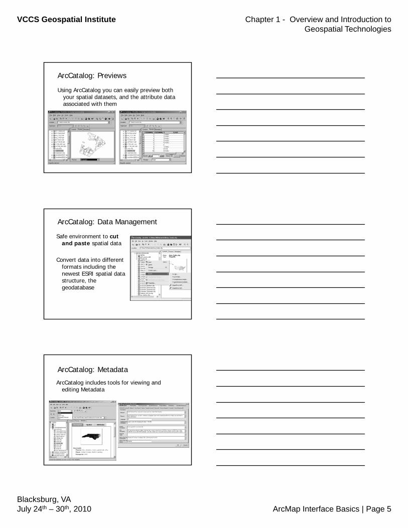
ArcCatalog: Previews
Using ArcCatalog you can easily preview both your spatial datasets, and the attribute data associated with them
ArcCatalog: Data Management
Safe environment to cut and paste spatial data
Convert data into different formats including the newest ESRI spatial data structure, the geodatabase
ArcCatalog: Metadata
ArcCatalog includes tools for viewing and editing Metadata

VCCS Geospatial Institute Chapter 1 - Overview and Introduction to Geospatial Technologies
Blacksburg, VAJuly 24th – 30th, 2010 ArcMap Interface Basics | Page 6
Metadata
We will discuss metadata more in depth later in the week.
There are 1 day metadata training classesThere are 1 day metadata training classes available through Virginia Information Technologies Agency (VITA). Information can be found here: http://gisdata.virginia.gov/
ArcMap
We’ll spend 80% of our time over the next week working in ArcMap.
This is the softwareThis is the software module where you “make maps”
ArcMap
ArcMap is like a virtual drafting table with 2 main parts:
Canvas where GIS data layers are drawnCanvas where GIS data layers are drawnTable of Contents (TOC) lists all data in the canvas
For desktop mapping you will spend most of your time in ArcMap

VCCS Geospatial Institute Chapter 1 - Overview and Introduction to Geospatial Technologies
Blacksburg, VAJuly 24th – 30th, 2010 ArcMap Interface Basics | Page 7
ArcMap
The canvas can be viewed in two states:
Data view which is where most of the analysis is done.
Layout View is where you create a final map (similar to “Print Preview” in Microsoft Office). In layout view you gain access to cartographic tools (scale bar, north arrow, etc.).
ArcMap: Toolbars
Standard: basic file management tools (new, open, save, cut/paste, etc)
Tools: navigation tools, identification, and selection tools
Draw: basic windows style drawing toolbar
There are several other special need toolbars available from the View menu. Among other things, there is an edit toolbar and there are special toolbars for extensions that are available (for free) through the VCCS GIS software license.
ArcMap: Toolbars
Additional toolbars available from the View menu
Menu barStandard Toolbar
Table of Contents
Canvas / Map Display Window
Tools Toolbar
Draw Toolbar

VCCS Geospatial Institute Chapter 1 - Overview and Introduction to Geospatial Technologies
Blacksburg, VAJuly 24th – 30th, 2010 ArcMap Interface Basics | Page 8
ArcMap: Toolbars
To turn on/off a toolbar:Go to the <View> menu, select
T lb d<Toolbars>, and select your toolbar of choice
Table of Map Window /
Toolbars
Contents(list of data layers that you can show on the canvas)
Map Display Window, etc.(the virtual drawing canvas)
Status bar (i.e. cursor location)
Drawing Tools(similar to PowerPt, etc.)
ArcMap
In addition to the toolbars, there are several menus available in ArcMap.
The menus contain some commonly used items f t lb ll f f tifrom toolbars as well as a few common functions from ArcCatalog and ArcToolbox.

VCCS Geospatial Institute Chapter 1 - Overview and Introduction to Geospatial Technologies
Blacksburg, VAJuly 24th – 30th, 2010 ArcMap Interface Basics | Page 9
ArcMap
Data View Layout View
Saving your work in ArcMap
Map Documents (.mxd) – Saves your map set up and display
Map documents do NOT save GIS data, just the view
Saving your work in ArcMap
• Map Documents (.mxd)• Layer Files (.lyr) – Saves symbology and other
display properties for a data source, Does NOTsave data

VCCS Geospatial Institute Chapter 1 - Overview and Introduction to Geospatial Technologies
Blacksburg, VAJuly 24th – 30th, 2010 ArcMap Interface Basics | Page 10
Saving your work in ArcMap
• Map Documents (.mxd)
• Layer Files (.lyr)• Map Templates (.mxt)Map Templates (.mxt)
If you are going to create several maps with a similar layout, the template can be a time-saving tool.
Saving your work in ArcMap
• Set your .mxd to RELATIVE paths so your mxd works reconnects to your data
• When you move mxdsand data if you do not set relative paths you will “loose” your data connection (!)and have to reconnect your data
ArcToolbox
Central location to find, manage, and execute heavy duty processing (geoprocessing) tools
Contains a multitude of tools such as analysis, conversion, and data management tools
Also allows for the construction of custom tools

VCCS Geospatial Institute Chapter 1 - Overview and Introduction to Geospatial Technologies
Blacksburg, VAJuly 24th – 30th, 2010 ArcMap Interface Basics | Page 11
An Introduction to “Spatial Data” Layers
Why is it called “spatial data”?
Every data entity is associated with a coordinate system, and therefore has a geographical (or spatial) reference.
What is a “layer”?
Layers are data. They form the basic “building blocks” of a GIS.
There are 2 types of data “layers”: vector data
-points-lines-polygons
raster data-images (aerial photos, digital topomaps, etc.)

VCCS Geospatial Institute Chapter 1 - Overview and Introduction to Geospatial Technologies
Blacksburg, VAJuly 24th – 30th, 2010 ArcMap Interface Basics | Page 12
Layers are the basic building blocks..
FSA Common Land Unit Bndrys
Livestock Premise Locations
Zoning
Soil Types + Characteristics
Elevation, Aspect, & Slope
Zoning or Parcel Information
Flood zones / flood prone areas
Rivers and Streams
FSA Common Land Unit Bndrys
GIS can efficiently support incident assessments, monitoring, analysis, and reporting…
Vector Data
The data maintains its quality as you zoom in…
Vector Data

VCCS Geospatial Institute Chapter 1 - Overview and Introduction to Geospatial Technologies
Blacksburg, VAJuly 24th – 30th, 2010 ArcMap Interface Basics | Page 13
Vector Data
Raster Data (Imagery)
Is comprised of individual pixels
The smaller the pixel, the p ,“sharper the image”
Remember when digital cameras first came out??(1 megapixel vs. 10 megapixel cameras)
Images: ©R.N. Clark http://www.clarkvision.com/articles/scandetail/index.html
Raster Data

VCCS Geospatial Institute Chapter 1 - Overview and Introduction to Geospatial Technologies
Blacksburg, VAJuly 24th – 30th, 2010 ArcMap Interface Basics | Page 14
Raster Data
Raster Data
Raster Data
This is a pixel

VCCS Geospatial Institute Chapter 1 - Overview and Introduction to Geospatial Technologies
Blacksburg, VAJuly 24th – 30th, 2010 ArcMap Interface Basics | Page 15
Raster Data
Imagery copyright 2002 Commonwealth of Virginia
Raster Data
All of these points have coordinatesAll of these points have coordinatesassociated with them…associated with them…
In Fact, every point on every photograph In Fact, every point on every photograph
Raster Data
is associated with coordinates!!!is associated with coordinates!!!

VCCS Geospatial Institute Chapter 1 - Overview and Introduction to Geospatial Technologies
Blacksburg, VAJuly 24th – 30th, 2010 ArcMap Interface Basics | Page 16
“Digital Orthophotography”
This means that accurate information can be obtained directly from the photographs:
• Location: Where is a particular coordinate?Distance: How far is it from “point A” to “point B”?
Raster Data
• Distance: How far is it from “point A” to “point B”?• Area measurements: How many acres are
associated with this field or development site?• Length/Perimeter measurements: What is the
distance around this lake?
Vector data – roads, buildings, drivewaysSpatial Resolution
Acknowledgements: Greg Bonynge
30 meter TM w/ vector data overlay
Spatial Resolution
Acknowledgements: Greg Bonynge

VCCS Geospatial Institute Chapter 1 - Overview and Introduction to Geospatial Technologies
Blacksburg, VAJuly 24th – 30th, 2010 ArcMap Interface Basics | Page 17
Sub-meter ADAR w/ vector data overlay
Spatial Resolution
Acknowledgements: Greg Bonynge
Satellite Imagery
Google Earth
Another example of raster data(Oblique photography)

VCCS Geospatial Institute Chapter 1 - Overview and Introduction to Geospatial Technologies
Blacksburg, VAJuly 24th – 30th, 2010 ArcMap Interface Basics | Page 18
Raster Data
Raster Data
Data formats for ArcGIS
Vector Data– ArcView Shapefiles– ArcInfo Coverages– Geodatabase– CAD drawings
Raster Data– Most common imagery (aerial
photographs, digital topomaps, etc.) formats can be read
– ArcInfo GRIDs, MRSID, geoTiff’s

VCCS Geospatial Institute Chapter 1 - Overview and Introduction to Geospatial Technologies
Blacksburg, VAJuly 24th – 30th, 2010 ArcMap Interface Basics | Page 19
ArcView ShapefilesThere are several files associated
with a single shapefile layer
To copy or move, must move ALL associated files (ie. with the same name)same name)
ArcCatalog does this automatically for you
ArcView Shapefiles
15 min Break then Exercises
Related Documents