tauranga city : : landscape study 86 86 part two landscape character units part two 12. MAUNGATAPU - WELCOME BAY Mangatapu - Welcome Bay : Landscape Character Description This character area mainly comprises established suburban housing development around the coastal edge of Welcome Bay and the Maungatapu peninsula. Residential housing extends along the Mangatapu peninsula either side of the State Highway 2 expressway. Within Welcome Bay, residential development extends along the ridgelines and valley sides further south up toward the rural hillside. Development in Welcome Bay has not recognised the natural landform and vegetation pattern which comprise the landscape structure. Consequently, in places, the scale, character and pattern of subdivision imposed on the landscape have been inappropriate. In many places development has also relied on substantial earthworks for access and the creation of building platforms. This has resulted in a loss of recognition of the underlying natural processes and patterns. Generally new subdivision has resulted in a dramatic change to the vegetation patterns and landform character of the site. Of particular importance are the vegetated stream valleys that drain northwards to the harbour estuary. At their outfall there are wetlands and mangroves and in places these areas have been designated as reserves. Besides their ecological significance, these reserves maintain a public connection to the harbour edge where much development has otherwise blocked public views and restricted access. In addition, the vegetated valleys are, or are potentially, significant ecological corridors between the harbour and the hills to the south. It is intended that these areas are identified and will be retained to assist in urban stormwater management and to provide ecological and amenity corridors for any remaining development in the area. The maintenance of public access to the coast and valley areas is particularly important, both in terms of recreation and for education. Mangatapu Peninsula provides an elevated harbour edge on its northern side, with public access to the harbour edge restricted by private subdivision. The southern side of the peninsula includes Rotary Park which provides access to the Tauranga Harbour and views across the Welcome Bay Estuary. Landscape Character Values Defining Elements: • Suburban residential development, detached housing. • Vegetated gully networks. • Vegetated harbour edge. • Single - Two storey housing. Viewshafts to Outstanding Natural Features and Landscapes: • Mauao. Amenity Values: • Large scaled exotic trees within private properties and gully systems. • Native vegetation along the harbour edge. • Detached single and two storey residential housing. • Wide streets with views to the Tauranga Harbour, Mauao and the wider City. Opportunities to Enhance Landscape Character: • Protect and enhance vegetation corridors through gully systems and harbour margin. • Promote retention of existing tree cover for new subdivision development. • Protect remaining ridgelines from residential development. • Promote sensitive housing along the harbour margin. • Promote large scale tree cover to integrate built form into the landscape. Threats to Degrade Landscape Character: • Further loss of natural landforms and habitats through large scaled earthworks. • Redevelopment of sites on ridgelines creating dominant built form. • Loss of vegetation cover through private view shaft protection. Management Guidelines: • Protect the harbour edge from dominant and ribbon residential housing. • Provide building controls for housing along the harbour margin, ridgelines and the top of harbour edge escarpments. • Enhance the gully systems and stream connections. • Manage built form, scale and character considering the rural / residential interface. • Avoid, where possible, built form on ridgelines.

Welcome message from author
This document is posted to help you gain knowledge. Please leave a comment to let me know what you think about it! Share it to your friends and learn new things together.
Transcript

tauranga city : : landscape study86 86 part two landscape character units
part two
1 2 . M A U N G A T A P U - W E L C O M E B A YMangatapu - Welcome Bay : Landscape Character Description
This character area mainly comprises established suburban housing development around the coastal edge of Welcome Bay and the Maungatapu peninsula. Residential housing extends along the Mangatapu peninsula either side of the State Highway 2 expressway.
Within Welcome Bay, residential development extends along the ridgelines and valley sides further south up toward the rural hillside.
Development in Welcome Bay has not recognised the natural landform and vegetation pattern which comprise the landscape structure. Consequently, in places, the scale, character and pattern of subdivision imposed on the landscape have been inappropriate. In many places development has also relied on substantial earthworks for access and the creation of building platforms. This has resulted in a loss of recognition of the underlying natural processes and patterns. Generally new subdivision has resulted in a dramatic change to the vegetation patterns and landform character of the site.
Of particular importance are the vegetated stream valleys that drain northwards to the harbour estuary. At their outfall there are wetlands and mangroves and in places these areas have been designated as reserves. Besides their ecological significance, these reserves maintain a public connection to the harbour edge where much development has otherwise blocked public views and restricted access.
In addition, the vegetated valleys are, or are potentially, significant ecological corridors between the harbour and the hills to the south. It is intended that these areas are identified and will be retained to assist in urban stormwater management and to provide ecological and amenity corridors for any remaining development in the area.
The maintenance of public access to the coast and valley areas is particularly important, both in terms of recreation and for education.
Mangatapu Peninsula provides an elevated harbour edge on its northern side, with public access to the harbour edge restricted by private subdivision. The southern side of the peninsula includes Rotary Park which provides access to the Tauranga Harbour and views across the Welcome Bay Estuary.
Landscape Character ValuesDefining Elements:• Suburban residential development, detached housing. • Vegetated gully networks. • Vegetated harbour edge.• Single - Two storey housing.
Viewshafts to Outstanding Natural Features and Landscapes:• Mauao.
Amenity Values:• Large scaled exotic trees within private properties and gully systems. • Native vegetation along the harbour edge.• Detached single and two storey residential housing. • Wide streets with views to the Tauranga Harbour, Mauao and the wider City.
Opportunities to Enhance Landscape Character:• Protect and enhance vegetation corridors through gully systems and harbour
margin. • Promote retention of existing tree cover for new subdivision development. • Protect remaining ridgelines from residential development.• Promote sensitive housing along the harbour margin. • Promote large scale tree cover to integrate built form into the landscape.
Threats to Degrade Landscape Character:• Further loss of natural landforms and habitats through large scaled earthworks. • Redevelopment of sites on ridgelines creating dominant built form. • Loss of vegetation cover through private view shaft protection.
Management Guidelines:• Protect the harbour edge from dominant and ribbon residential housing. • Provide building controls for housing along the harbour margin, ridgelines and
the top of harbour edge escarpments. • Enhance the gully systems and stream connections. • Manage built form, scale and character considering the rural / residential
interface. • Avoid, where possible, built form on ridgelines.

87 tauranga city : : landscape studypart two landscape character units
part two
Landform:Four ridgelines extend northward down toward the water’s edge in Welcome Bay, providing the structure for the road network which extends on top of these.
There are steep gully systems which are located between these ridgelines providing for a series of streams and wetlands. The landform within the gully systems is generally very steep and limited built form extends into these areas.
Maungatapu is a wider ridgeline with a significant amount of residential housing, a school and commercial centre. The northern harbour edge is raised some 20-30m above the water level, however some smaller gullies that extend into the peninsula allow built form and roading to move closer to the water level.
The southern side of the peninsula is divided from its northern side by an incised cut made for the State Highway 2 expressway. The harbour edge is less steep along the southern edge whilst the northern side comprises a steep escarpment face which is subject to erosion.
Hydrology:The steep gully networks throughout Welcome Bay each contain streams which further support numerous wetlands.
The harbour margin drains almost completely at low tide with small channels remaining where streams connect to the harbour’s edge. The estuarine margin provides brackish water conditions in which the saltmarsh and mangrove habitat thrive.
WELCOME BAY ROAD
OHAU
ITI R
OAD
TURRET ROAD
STAT
E HIG
HWAY
2 SO
UTH
WAIKITE ROAD
STATE HIGHWAY 29
KAITEMAKO ROAD
WAI
TAHA
ROA
D
POIKE ROAD
FRASER STR
EET FIFTEENTH AVENUE
HAIRINI STREET
0 500 1,000 1,500 2,000m
Elevation0 - 10m10 - 20m20 - 30m30 - 40m40 - 50m50 - 60m60 - 70m70 - 80m>80 m
RoadFlood Hazard
Rail
M A U N G A T A P U - W E L C O M E B A Y : landform & hydro logy

tauranga city : : landscape study88 88 part two landscape character units
part two
Open Space:Numerous parks are located throughout the unit, with Welcome Bay providing a strong gully network. The walkway network between the open space areas is generally through the street network. The reserves include:
Maungatapu:• Vine Avenue Reserve.• Anchorage Grove Reserve.• Ariki Park.• Wikitoria Reserve.• Miriana Reserve.• Maungtapu Peninsula Esplanade Reserve.• Rotary Park.• Te Wati Park.• Taipari Park.• Hammond Street Esplanade Reserve.• Hammond Street Reserve.
Welcome Bay:• Welcome Bay Road Esplanade Reserve. • Waipuna Park.• Johnson Reserve.• Endeavour Heights Reserve.• Selwyn Park.• Osprey Park.• Pelorus Street Reserve.• Keam Reserve.• Jonathon Brown Park.• Owens Park.• Forrestor Drive Esplanade Reserve.• Esmeralda Street Esplanade Reserve.• Tye Park.
Trees:The street tree cover in both Maungatapu and Welcome Bay is relatively young and sparse within the older subdivisions. The newer subdivisions have full juvenile street tree cover which will contribute positively to urban amenity values in years to come.
Native Vegetation Cover:Native bush and wetland vegetation presides mainly in the valley floors and sides. Current threats to the integration of built form into the landscape is the loss of mature vegetation cover, including trees, through private gardening practice, erosion, and infill housing.
Estuarine Vegetation:The harbour margin within the Welcome Bay Estuary supports a significant amount of mangrove habitat. Further north along the coastal edge, the harbour margin vegetation transitions to native bush planting with minimal coastal estuarine vegetation and sandy beach areas (Rotary Park).
M A U N G A T A P U - W E L C O M E B A Y : ecology

89 tauranga city : : landscape studypart two landscape character units
part two
Zoning:Predominantly residential zoning, both Maungatapu and Welcome Bay contain small commercial nodes that support convienience shopping for the local residents.
Recreation zoning is provided for through a number of small pocketed reserves and gully reserves. The connections between the reserves are good, however some interconnection would further support the walkability of the neighbourhoods.
Archaeological / Heritage Values:Numerous archaeological sites, including historical pa are located within both Maungatapu and Welcome Bay. These features have been highly modified with a few remaining pa sites being protected through classification as reserve.
Viewshafts from Marae to Mauao:
(Refer to Part 4 - Significant Viewshafts• Viewspoint 005 - Hairini Marae
Maungatapu and Hairini marae are the two key marae located on the Maungatapu peninsula. Hairini enjoys views across the Tauranga Harbour, the CBD and the Port of Tauranga to Mauao. Development in the intermediary view has the potential to partially obscure the view and potentially degrade the visual connection.
Maungatapu Marae enjoys views of Mangatawa and Upuhue, with the Tauranga Harbour in the intermediary view.
Viewshafts to Outstanding Natural Features and Landscapes:(Refer to Part 4 - Significant Viewshafts)Mauao• Viewpoint 014 - Waikite Road• Viewpoint 015 - Ohauiti Road
[e
[e
[e
[e
[e
[e
[e
OHAU
ITI R
OAD
WAI
TAHA
ROA
D
KAITEMAKO ROAD
TURRET ROAD
STATE HIGHWAY 2 SOUTH
WAIKITE ROAD
STATE HIGHWAY 29 WELCOME B AY ROAD
POIKE ROAD
FRASER STR
EET FIFTEENTH AVENUE
HAIRIN I STREET WELCOME BAY ROAD
Hairi
ni
Hairini
Maungatapu
0 580 1,160 1,740 2,320m
[e Marae
Marae SightlineVisible and Important
Compromised and Important
# Heritage Sites
! Archaeological Site
Archaeological Extent
Rail
Landscape Unit
M A U N G A T A P U - W E L C O M E B A Y : people

tauranga city : : landscape study90 90 part two landscape character units
part two
M A U N G A T A P U - W E L C O M E B A Y : photography
View from Rotary Park, looking southward across Welcome Bay Estuary
View from Hairini Bridge, Turret Road, looking toward Maungatapu peninsula

91 tauranga city : : landscape studypart two landscape character units
part two
1 3 . O R O P I - O H A U I T I - K A I T E M A K OOropi - Ohauiti - Kaitemako : Landscape Character Description
This unit is delineated to the north by State Highway 29 and the city boundary to the south. The unit encompasses the rural landscape of upper Welcome Bay and the urban residential subdivision along Ohauiti Road.
The landform comprises a series of ridgelines that are incised by narrow and broader valleys that extend across the landscape toward the Tauranga Harbour.
Land use is a mixture of pastoral farming, horticultural cropping and residential development. Substantial vegetation, apart from occasional remnant mature trees is mainly confined to the steeper valley and gully slopes.
Built development is located throughout this area, primarily associated with farms and lifestyle lots. Recent development along Ohauiti Road has seen an extension of residential and rural residential subdivision along its ridgeline.
Some quarrying of the sandstone has occurred in the past and the remaining exposed rock faces can be visually intrusive and are prone to erosion.
A large Transpower substation is located off Wade Place and comprises a significant area of open pastoral land along its ridgeline. The integration of the overhead powerlines should be considered in any future development, to integrate the structure into the residential character of the surrounding area.
The gully systems assist in the separation of built form and residential neighbourhoods, whilst also separating physical connection between these areas. The retention of the gully systems and the ridgelines is important to the maintenance of the landscape character. Landscape Character Values
Defining Elements:• Suburban residential development, detached housing. • Rural residential housing.• Vegetated gully networks. • Single - Two storey housing. • Open pastoral landscape.• Large rural trees.
Views to Outstanding Natural Features and Landscapes:• Mauao.
Amenity Values:• Large scale exotic trees.• Native vegetation along the harbour edge.• Wide streets with connection between gully systems. • Recreational walkway connections between open space and gully networks. • Small scale pastoral landscape along ridgelines.
Opportunities to Enhance Landscape Character:• Protect and enhance vegetation corridors through gully systems.• Promote retention of existing tree cover for new subdivision development. • Protect remaining ridgelines from residential development.• Promote large scale tree cover to integrate built form into the landscape.
Threats to Degrade Landscape Character:• Loss of natural landforms and habitats through large scaled earthworks. • Redevelopment of sites on ridgelines creating dominant built form. • Loss of vegetation cover through private view shaft protection. • Rural residential sprawl within the rural landscape.
Management Guidelines• Provide building controls for housing along the ridgelines and rural zoned
interface. • Enhance the gully systems and stream connections. • Manage built development within the rural landscape to avoid fragmentation of
the land. • Protect open space within the Greenbelt. • Manage built form, scale and character considering the rural / residential
interface.

tauranga city : : landscape study92 92 part two landscape character units
part two
Landform:The unit is typified by steeply incised and often broad valley features eroded into the sandstone/siltstone plateau. Some quarrying of the sandstone has occurred in the past and the remaining exposed rock faces can be visually intrusive and prone to erosion. The landform in the area demonstrates the low erosive resistance of this rock type and in a number of locations on the steeper slopes there is evidence of erosion.
The original landform in this unit is largely left intact with small areas of earthworks for ribbon residential development.
Elevated well above the residential area of Welcome Bay, the rural and rural residential developments enjoy extensive views across the City.
Hydrology:Steeply incised gully systems provide for a series of streams and further downstream, as the gradient lessens, a number of wetlands.
OHAU
ITI R
OAD
STATE HIGHWAY 29
WELCOME BAY ROAD
OROPI ROAD
WAIKITE ROAD
POIKE ROAD
KAITE
MAKO
ROA
D
FRAS
ER ST
REET
HOLL
ISTE
R LA
NE
WAI
TAHA
ROA
D
ROWESDALE DRIVE
HAIRINI STREET
HOLL
ISTE
R LA
NE
0 600 1,200 1,800 2,400m
Elevation0 - 10m10 - 20m20 - 30m30 - 40m40 - 50m50 - 60m60 - 70m70 - 80m>80 m
RoadFlood Hazard
Rail
O R O P I - O H A U I T I - K A I T E M A K O : landform & hydro logy
93 tauranga city : : landscape studypart two landscape character units
part two
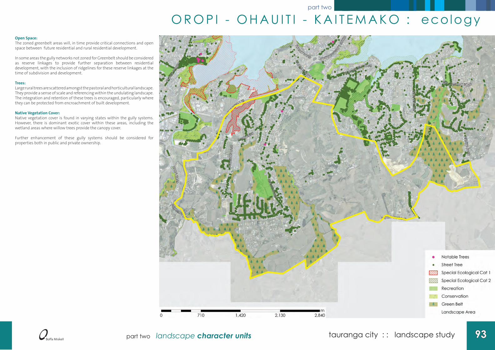
Open Space:The zoned greenbelt areas will, in time provide critical connections and open space between future residential and rural residential development.
In some areas the gully networks not zoned for Greenbelt should be considered as reserve linkages to provide further separation between residential development, with the inclusion of ridgelines for these reserve linkages at the time of subdivision and development.
Trees:Large rural trees are scattered amongst the pastoral and horticultural landscape. They provide a sense of scale and referencing within the undulating landscape. The integration and retention of these trees is encouraged, particularly where they can be protected from encroachment of built development.
Native Vegetation Cover:Native vegetation cover is found in varying states within the gully systems. However, there is dominant exotic cover within these areas, including the wetland areas where willow trees provide the canopy cover.
Further enhancement of these gully systems should be considered for properties both in public and private ownership.
O R O P I - O H A U I T I - K A I T E M A K O : ecology

tauranga city : : landscape study94 94 part two landscape character units
part two
Zoning:Zoned suburban in the lower slopes the interface between the rural zone in the elevated areas of the unit is managed by the rural residential zone.
The zone edges do not appear to respond to the underlying landform and this may result in poor responses to the underlying landscape. The greenbelt zoning and rural zoning adajcent to the City boundary provides for an improved integration with rural landscape within Western Bay of Plenty District. However in some areas the interface between rural and residential development is primarily managed through the location of a road and is unresponsive to the landscape.
Archaeological / Heritage Values:Numerous archaelogical sites are located within this unit and must be taken into consideration to ensure the recognition of their location and value to Tangata Whenua.
Viewshafts from Marae to Mauao:(Refer to Part 4 - Significant Viewshafts)No marae are located within this unit.
Viewshafts to Outstanding Natural Features and Landscapes:(Refer to Part 4 - Significant Viewshafts)Mauao• Viewshaft 010 - Poike Road/Hollister Lane
[e
[e
[e
[e
[e
[e
[e
OHAU
ITI R
OAD
STAT
E HIGHWAY 29
OROPI ROAD
KAITEMAKO ROAD
WAI
TAHA
ROA
D
WAIKITE ROAD
WELCOME BAY ROAD
POIKE ROAD
FRAS
ER ST
REET
TURRET ROAD
HOLL
ISTE
R LA
NE
PUKEMAPU ROAD
STATE HIGHWAY 2 SO
UTH
HA IRINI STREET
WELCOME BAY RO AD
Hairi
ni
Hairini
Waimapu
0 710 1,420 2,130 2,840m
[e Marae
Marae SightlineVisible and Important
Compromised and Important
# Heritage Sites
! Archaeological Site
Archaeological Extent
Rail
Landscape Unit
O R O P I - O H A U I T I - K A I T E M A K O : people

95 tauranga city : : landscape studypart two landscape character units
part two
O R O P I - O H A U I T I - K A I T E M A K O : photography
View eastward from Cheyne Road East looking across Oropi Road toward Ohauiti

tauranga city : : landscape study96 96 part two landscape character units
part two
1 4 . W A I M A P U L O W L A N D SWaimapu Lowlands: Landscape Character Description
This character area is delineated by State Highway 29 and the higher elevated plateau of Cheyne Road East to the south and east and by Greerton to the west. In the north the boundary is formed by the Waimapu Estuary, a relatively inaccessible part of the harbour.
The unit is divided into two key areas: 1. Maleme Street Industrial Area; and 2. Windermere. Generally low lying, the unit also includes the Bay of Plenty Polytechnic grounds. The harbour edge along the Windermere edge is generally in a degraded state with erosion and exotic weed cover. Built form is generally close to the edge of the escarpment and whilst small scale in built form, the edge remains visually sensitive and requires careful management.
The Waimapu Stream meanders through this character area which is predominantly low lying with wetlands, saltmarsh and swampy pasture. Some wetland areas have been recently drained and developed into light commercial activities resulting in a loss of the lowland’s natural character values.
In the southwestern corner there is a small pocket of industrial activities accessed off Maleme Street, many of which back onto the State Highway. The native screen planting along this road frontage does little to screen the industrial area from neighbouring residential or the State Highway.
The open space corridor formed by the low lying stream valley provides a distinct area of separation between the elevated landforms of Greerton and Hairini/Waimapu.
The Waimapu Stream is also of significance to Tangata Whenua as it is said to be the path that Mauao (Mount Maunganui) took whilst being moved to its current location. Landscape Character Values
Defining Elements:• Suburban residential development, detached housing. • Maleme Street Industrial Area.• Low lying river and wetland landscape.
Viewshafts to Outstanding Natural Features and Landscapes:• No identified viewshaft origins are found within this unit.
Amenity Values:• Wide industrial streets.• Good pedestrian connections to open space from Windermere.• Estuarine and river margin wetlands• Vegetated escarpments.
Opportunities to Enhance Character:• Protect and enhance vegetation corridors through lowland and riparian
vegetation.• Harbour margin planting. • Promote retention of existing tree cover for inclusion into new subdivision
development.
• Enhance the vegetated buffer between the industrial activity and State Highway 29 to screen industrial areas.
Threats to Degrade Character:• Loss of natural lowland areas to built development through filling. • Continued prolific and uncoordinated signage within industrial zone.• Lack of screening between industrial activities, residential and the State Highway
2 edge. • Loss of tree cover within private and public land.
Management Guidelines:• Enhance the harbour edge and riparian areas. • Manage built form, scale and character considering the natural character values
of the Tauranga Harbour edge. • Enhance street tree cover and edge planting within industrial areas of Maleme
Street.

97 tauranga city : : landscape studypart two landscape character units
part two
Landform:Generally low lying, the unit provides the toe slopes of a spur that extends down from Poike into the Tauranga Harbour. There are wide low lying areas that contain estuarine habitats and wide valleys between the plateaus of Greerton and Hairini.
Hydrology:Some of the wetland areas have been drained to allow for industrial development. These areas have been extensively drained and the water is channelised and discharged into the Waimapu catchment.
The Waimapu Stream meets the Tauranga Harbour adjacent to Yatton Park. The brackish water conditions support the existing large saltmarsh habitat.
STATE HIGHWAY 29
OROPI ROAD
CAMERON ROAD
OHAU
ITI R
OAD
CHEYNE ROAD
FRAS
ER ST
REET
POIKE ROAD
CHADWICK ROAD
HYND
S ROA
D
HOLL
ISTE
R LA
NE
KENT STREET
0 370 740 1,110 1,480m
Elevation0 - 10m10 - 20m20 - 30m30 - 40m40 - 50m50 - 60m60 - 70m70 - 80m>80 m
RoadFlood Hazard
Rail
W A I M A P U L O W L A N D S : landform & hydro logy

tauranga city : : landscape study98 98 part two landscape character units
part two
Open Space:There is a significant amount of open space provided for alongside the Waimapu Stream with future plans to provide a walkway connection between Yatton Park and Greerton Park.
Windermere is connected to Greerton by a bridge that crosses the Waimapu Stream. The estuarine margin at the Waimapu Stream mouth provides for a large saltmarsh and mangrove habitat. This is a registered special ecological area.
Trees:There is limited tree cover within the public street environment and along the edge of the industrial areas. Further tree cover is needed to ensure the integration of the industrial activity is managed appropriately.
Estuarine Vegetation:The harbour margin along the northern end of Windermere provides very little native vegetation cover along the harbour edge. The saltmarsh and mangrove habitat along the harbour edge includes a significant area of native estuarine species, contributing to the natural character values of the Tauranga Harbour.
W A I M A P U L O W L A N D S : ecology

99 tauranga city : : landscape studypart two landscape character units
part two
Zoning:The western lowland area is zoned industrial and supports the Maleme Street industrial area.
The residential zone in Poike provides for the Bay of Plenty Polytechnic and residential subdivision. The conservation zone which extends around the periperhy of the Windermere peninsula provides a level of protection to the harbour edge.
The rural zoning remaining within the unit does not respond to the underlying landscape and an opportunity exists to re consider this land use.
Archaeological / Heritage Values:There are a number of sites of archaeological signficance. The saltmarsh is also of significance to tangata whenua and should continue to be protected.
Viewshafts from Marae to Mauao:
(Refer to Part 4 - Significant Viewshafts)There are no marae directly within the unit, however the Waimapu Marae is in the adjoining unit and enjoys views across this landscape.
Viewshafts to Outstanding Natural Features and Landscapes:(Refer to Part 4 - Significant Viewshafts)
No identified viewshaft origins are found within this unit.
[e
[e
[e
[e
[e
[e
[e
[e
[e
[e
[e
[e
STATE HIGHWAY 29
OROPI ROAD
CAMERON ROAD
OHAU
ITI R
OAD
FRAS
ER ST
REET
CHADWICK ROAD
POIKE ROAD
CH E YNE R
OAD
HOLL
ISTE
R LA
NE
KENT STREET
HYND
S RO
AD
TUTHILL STREET
Hairini
Waimapu
0 425 850 1,275 1,700m
[e Marae
Marae SightlineVisible and Important
Compromised and Important
# Heritage Sites
! Archaeological Site
Archaeological Extent
Rail
Landscape Unit
W A I M A P U L O W L A N D S : people

tauranga city : : landscape study100 100 part two landscape character units
part two
W A I M A P U L O W L A N D S : photography
View from harbour margin at Yatton Park, across the Waimapu Saltmarsh

101 tauranga city : : landscape studypart two landscape character units
part two
1 5 . P Y E S P A - T A U R I K OPyes Pa - Tauriko : Landscape Character Description
Pyes Pa and Tauriko, until recently, provided the rural edge to the City. In recent years the area has been modified to incoporate extensive residential subdivision and a new industrial business park.
Residential development extends along Pyes Pa Road and extends eastward to Cheyne Road East and the associated ridgeline. The northern extent of the unit is formed by State Highway 29 and the southern extent by Joyce Road (TCC City Boundary).
A mixture of detached residential, retirement village, rural residential housing, commercial and a secondary school are located within the Pyes Pa unit.
The Tauriko component comprises The Lakes subdivision and Tauriko Business Estate. The landscape in this area has undergone a significant transformation with large scale earthworks modifying hillsides, valley floors and providing new walkways, reserves and large lakes and ponds.
The Kopurererua Stream meanders between these two developments and provides the remaining unmodified element of the landscape.
The small Tauriko settlement is elevated above the Tauriko Business Estate and comprises a small commercial node with a service station, some fruit shops and a school. This area and its surrounding landscape comprises lifestyle and pastoral grazing with built development located adjacent to the State Highway.
Development on the ridgeline within this unit has resulted in built form dominating the landscape. The street planting is relatively immature in this area and in time will assist in the integration of the built form into the landscape.
A significant amount of native mass planting has occurred within the valleys, escarpments and reserves, which will in time contribute positively to the overall vegetation pattern of the area.
Landscape Character Values
Defining Elements:• Kopurererua Stream.• Wide valley floor in Pyes Pa West.• Pyes Pa ridgeline• Rural pastoral and horticultural practices.• Recent rural residential and residential development.
Views to Outstanding Natural Features and Landscapes:• No identified viewshaft origins are found within this unit.
Amenity Values:• Large scale exotic trees in remaining pastoral landscape.• Native vegetation within valleys.• Wide streets with small scale street planting. • Large scale industrial buildings. • Small scale pastoral landscape along ridgelines.
Opportunities to Enhance Landscape Character:• Protect and enhance vegetation corridors through gully systems.• Protect remaining ridgelines from residential development.• Promote large scale tree cover to integrate built form into the landscape. • Promote riparian planting enhancement along the Kopurererua Stream.
Threats to Degrade Landscape Character:• Loss of natural landforms and habitats through large scale earthworks. • Redevelopment of sites on ridgelines creating dominant built form. • Rural residential sprawl within the rural landscape.
Management Guidelines:• Provide building controls for housing along the ridgelines and rural zoned
interface. • Enhance the gully systems and stream connections. • Manage built development within the rural landscape to avoid fragmentation of
the rural landscape. • Manage built form, scale and character considering the rural / residential
interface.
tauranga city : : landscape study102 part two landscape character units
part two
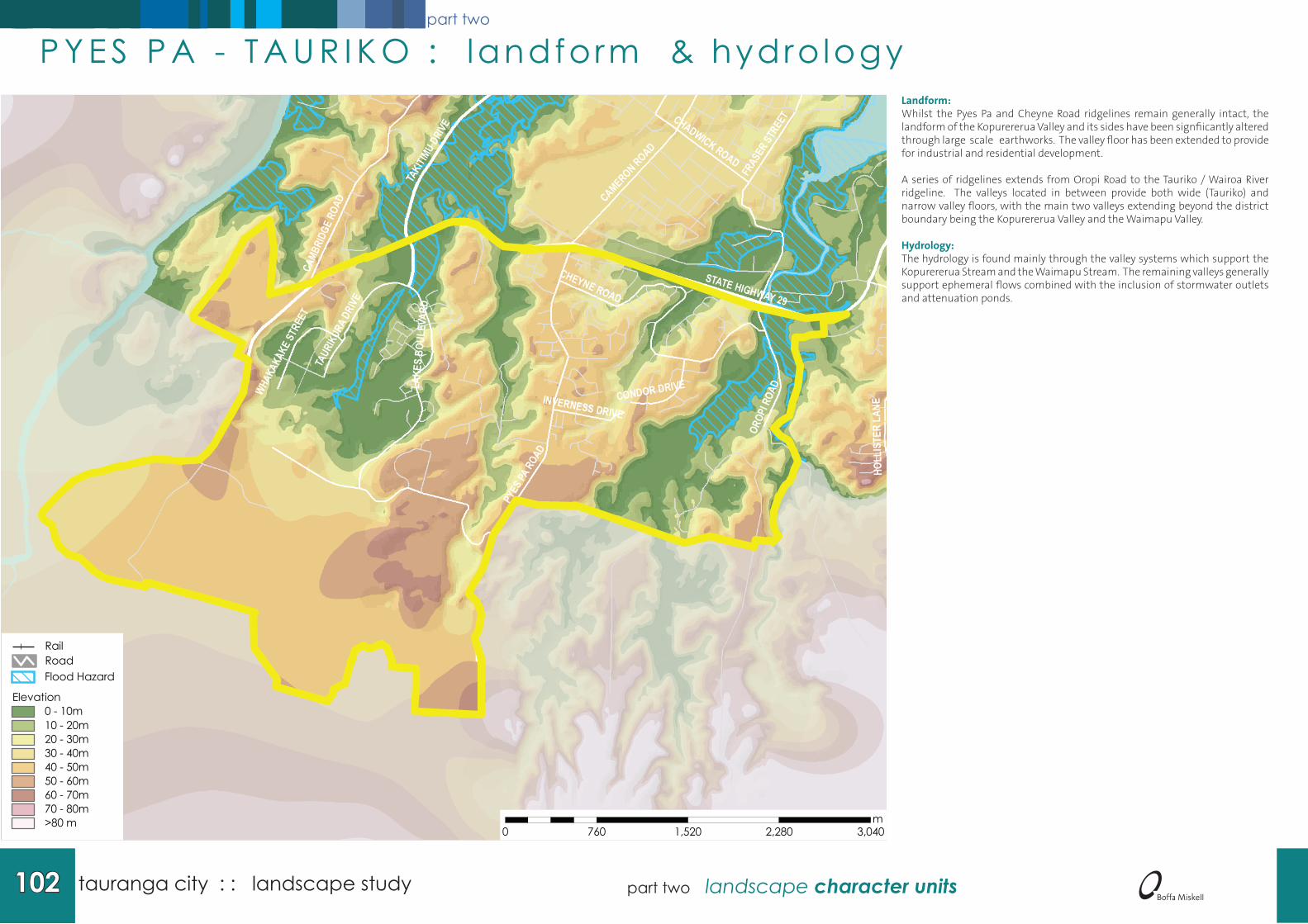
Landform:Whilst the Pyes Pa and Cheyne Road ridgelines remain generally intact, the landform of the Kopurererua Valley and its sides have been signfiicantly altered through large scale earthworks. The valley floor has been extended to provide for industrial and residential development.
A series of ridgelines extends from Oropi Road to the Tauriko / Wairoa River ridgeline. The valleys located in between provide both wide (Tauriko) and narrow valley floors, with the main two valleys extending beyond the district boundary being the Kopurererua Valley and the Waimapu Valley.
Hydrology:The hydrology is found mainly through the valley systems which support the Kopurererua Stream and the Waimapu Stream. The remaining valleys generally support ephemeral flows combined with the inclusion of stormwater outlets and attenuation ponds.
STATE HIGHWAY 29
OROP
I ROA
D
CHEYNE ROAD
PYES
PA RO
AD
TAKIT
IMU D
RIVE
CAMB
RIDG
E RO
AD CAMERON ROAD
TAUR
IKUR
A DRI
VE
CHADWICK ROAD
FRAS
ER ST
REET
CONDOR DRIVEINVERNESS DRIVE
WHAKA
KAKE
STRE
ET
LAKE
S BO
ULEV
ARD
HOLL
ISTE
R LA
NE
0 760 1,520 2,280 3,040m
Elevation0 - 10m10 - 20m20 - 30m30 - 40m40 - 50m50 - 60m60 - 70m70 - 80m>80 m
RoadFlood Hazard
Rail
P Y E S P A - T A U R I K O : landform & hydro logy
103 tauranga city : : landscape studypart two landscape character units
part two
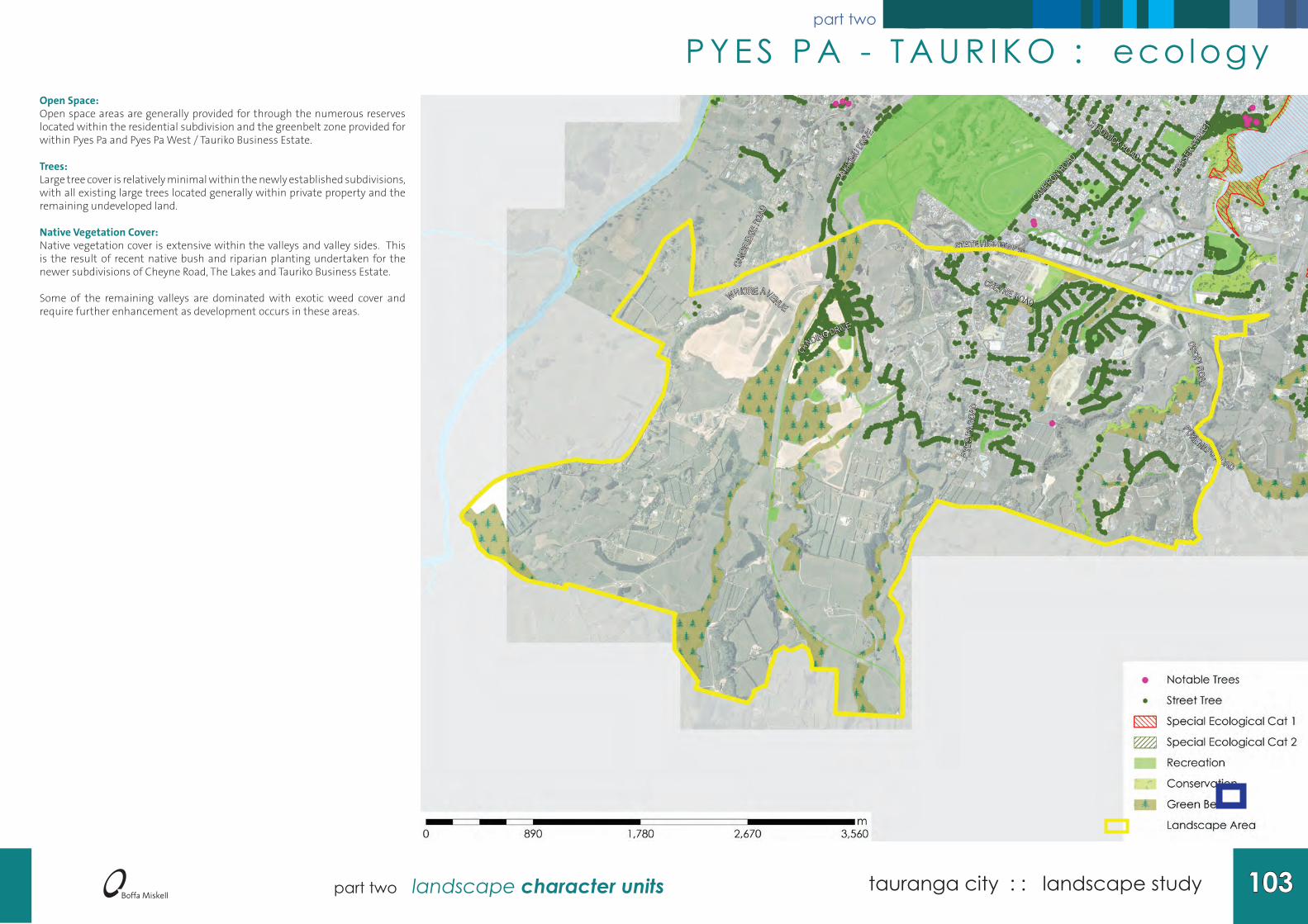
Open Space:Open space areas are generally provided for through the numerous reserves located within the residential subdivision and the greenbelt zone provided for within Pyes Pa and Pyes Pa West / Tauriko Business Estate.
Trees:Large tree cover is relatively minimal within the newly established subdivisions, with all existing large trees located generally within private property and the remaining undeveloped land.
Native Vegetation Cover:Native vegetation cover is extensive within the valleys and valley sides. This is the result of recent native bush and riparian planting undertaken for the newer subdivisions of Cheyne Road, The Lakes and Tauriko Business Estate.
Some of the remaining valleys are dominated with exotic weed cover and require further enhancement as development occurs in these areas.
P Y E S P A - T A U R I K O : ecology

tauranga city : : landscape study104 part two landscape character units
part two
Zoning:Remnant rural zoning extends into the centre and edge of this unit. The rural zoned land between The Lakes and Pyes Pa Road is reminiscent of its surrounding zoning which was historically rural. Further development in this area should take into account the surrounding zoning, while protecting the ridgeline from built form, which extends toward State Highway 29.
The Greenbelt zone provides separation between industrial and residential activity. The Greenbelt zone within the Cheyne Road subdivision provides a break in the residential development and further defines the valley network that extends toward the State Highway.
Archaeological / Heritage Values:A number of registered archaeological sites exist along the ridgelines. A number have been preserved through protection within subdivision development.
Viewshafts from Marae to Mauao:(Refer to Part 4 - Significant Viewshafts)• There are no current marae within this unit.
Viewshafts to Outstanding Natural Features and Landscapes:(Refer to Part 4 - Significant Viewshafts)• No identified viewshaft origins are found within this unit.
[e
[e
[e
[e
[e
[e
[e
[e
[e
[e
[e
[e
STATE HIGHWAY 29
OROPI ROAD
P YES
PA
ROAD
TAKIT
IMU D
RIVE
CAMB
RIDG
E RO
AD
CHEYNE ROAD
CAMERON ROAD
CHADWICK ROAD
FRAS
ER ST
REET
PUKEMAPU ROAD
WHIORE AVENUE
LANDING DRIVE
REXFORD HEIGHTS
Waimapu
0 890 1,780 2,670 3,560m
[e Marae
Marae SightlineVisible and Important
Compromised and Important
# Heritage Sites
! Archaeological Site
Archaeological Extent
Rail
Landscape Unit
P Y E S P A - T A U R I K O : people

105 tauranga city : : landscape studypart two landscape character units
part two
P Y E S P A - T A U R I K O : photography
View west across Tauriko Industrial Park from The Lakes residential development.
View east to the Lakes from Tauriko Industrial Park development

tauranga city : : landscape study106 part two landscape character units
part two
1 6 . G R E E R T O NGreerton: Landscape Character Description
This landscape unit contains the central ridgeline of Cameron Road and extends between the Waimapu Estuary and Kopurererua Stream Valley. The northern area is bounded by Eighteenth and Seventeenth Avenues with State Highway 29 and the Waimapu Lowland unit providing the southern extent.
The street pattern is influenced by the dissected nature of the landform. Small streams have eroded steep sided valleys which extend green fingers of bush into the heart of the suburban area with residential development occupying the elevated flat land. These bush filled valleys are valuable both as a recreation and ecological resource and should be protected against industrial and residential development.
The pattern of residential streets is less ordered and responds to the landform, creating meandering streets which follow the landform. Closer to the central ridge the grid street pattern connects to Cameron Road. The width of these streets, relative lack of maturity of the garden vegetation and lack of vertical scale results in a dominant suburban built character.
Cameron Road forms the main transport spine of this unit tracing the centre of the broad ridge. A diverse range of activities co-exist along this busy thoroughfare with residential, retail, accommodation, fast food, and service industries providing a mixed pattern of activity.
As a major entry to the City and shopping environment Cameron Road requires quality and comprehensive landscape treatment. Definition between community nodes along Cameron Road is needed. Whilst Greerton Village forms a neighbourhood centre, the dispersal of commercial activity along Cameron Road is gradually reducing the definition of the central Greerton area. Further enhancement of the street environment along Cameron Road and the consolidation of commercial activities around nodes will assist in the definition of neighbourhoods.
The racecourse located at the western edge of Barkes Corner provides an important open space at the entry to the City. Yatton Park contributes a significant stand of mature and notable trees and provides a visual reference point for the Greerton area.
Large commercial buildings along the Cameron Road ridgeline have resulted in the loss of residential character. Brightly coloured large scaled commercial buildings have the ability to create significant visual impact on the cityscape, for example Mega Mitre 10.
Landscape Character Values
Defining Elements:• Suburban residential. • Ribbon commercial development .• Vegetated gully systems.• Yatton Park including its significant stand of trees.• Open space found within Tauranga Race Course and Tauranga Golf Club.
Viewshafts to Outstanding Natural Features and Landscapes:• No identified viewshaft origins are found within this unit.
Amenity Values:• Large scale exotic trees within reserve land.• Vegetated valley sides.• Wide streets with small scale street planting. • Large scale commercial buildings.
Opportunities to Enhance Landscape Character:• Protection and enhancement of vegetation corridors along harbour edge.• Promotion of large scale tree cover to integrate built form into the landscape. • Restriction on commercial creep into residential neighbourhoods.
Threats to Degrade Landscape Character:• Redevelopment of sites on ridgelines and escarpment edges creating dominant
built form. • Loss of vegetation cover through private view shaft protection. • Rural residential sprawl within the rural landscape. • Large scale commercial development with high reflectivity located prominently
on ridgelines. • Poorly defined and integrated industrial / residential edges.
Management Guidelines: • Provision of building controls for housing along the ridgelines and rural zoned
interface. • Provision of reflectivity controls on large scale commercial buildings. • Enhancement of the gully systems and stream connections. • Management of built form, scale and character considering the industrial /
residential interface.

107 tauranga city : : landscape studypart two landscape character units
part two
Landform:Located along the central ridgeline and plateau, this unit provides an elevated position within the cityscape. Spurs and valleys interconnect throughout the edges of the main ridgeline providing an undulated edge.
The harbour edge comprises a steep escarpment with pockets of development in lower-lying areas. Fraser Cove and Courtney Road Industrial Zones have developed upon one of the low lying historical harbour edges resulting in a modified harbour edge along Fraser Street.
Hydrology:The low lying edges along the harbour and Kopurererua Valley sides provide for the intertidal and wetland habitats along the margins.
The valley systems support the streams, wetland and attenuation of stormwater. The low lying area by Watling Street contains areas of open standing water that also cater for stormwater discharge into the wetland.
CAMERON ROAD
TAKITI
MU DRIVE
FRASER STR
EET
CAMBRIDGE ROAD
MOFF
AT R
OAD
STATE HIGHWAY 29
OROP
I ROA
D
CHADWICK ROAD
FIFTEENTH AVENUE
HYND
S ROA
D
WATLING STREET
POIKE ROAD
COURTNEY ROAD
COOP
ERS
ROAD
TOM
MUIR
DRI
VE
KENT STREET
STATE HIGHWAY 290 425 850 1,275 1,700
m
Elevation0 - 10m10 - 20m20 - 30m30 - 40m40 - 50m50 - 60m60 - 70m70 - 80m>80 m
RoadFlood Hazard
Rail
G R E E R T O N : landform & hydro logy

tauranga city : : landscape study108 part two landscape character units
part two
Open Space:Large areas of open space are found within the Tauranga Race Course and Golf Course, which provide a significant contribution of open space to the unit. Open space appears to be weighted toward the southern end of the unit with the latter Avenues area comprising less areas of open space. However these areas comprise the Tauranga Intermediate and Tauranga Girls College, which provide large fields and open areas.
Trees:Significant stands of trees are found within the Tauranga Golf Course and Yatton Park. The latter Avenue street trees are large established trees which contribute positively to the urban amenity values of this area.
The Greerton neighbourhood comprises smaller street trees which provide little toward the scale and integration of built form into the landscape.
Native Vegetation Cover:The valleys provide for native vegetation within the wetland and gully floors. These areas are a mixture of native understorey vegetation with willow dominated canopy cover. Recent enhancement planting within the Kopurererua Valley has resulted in an increase in young native planting within this area.
Estuarine Vegetation:The harbour edge comprises a mangrove habitat along the edge. This edge is currently being maintained through the implementation of a consent, which manages the long term spread of mangroves further into the harbour.
A raised bund along the Merivale area has resulted in some estuarine ponds which drain at one point. Native vegetation along the harbour edge competes with aggressive weed species.
G R E E R T O N : ecology

109 tauranga city : : landscape studypart two landscape character units
part two
Zoning:Several commercial precincts exist along Cameron Road, comprising 17th Avenue Commercial area, Gate Pa and Greerton. Fraser Cove also provides a signficant commercial precinct for the Greerton unit.
The remainder of the zoning is residential with conservation and recreation zoning supporting the open space areas. Connections between open space are limited in some parts and would benefit from further connections between reserves and harbour edges.
Archaeological / Heritage Values:Gate Pa is a distinct and internationally significant heritage site for Tauranga City. This area is of particular importance to both Tangata Whenua and European history.
Viewshafts from Marae to Mauao:(Refer to Part 4 - Significant Viewshafts)No marae are located within this unit.
Viewshafts to Outstanding Natural Features and Landscapes:(Refer to Part 4 - Significant Viewshafts)No identified viewshaft origins are found within this unit.
[e
[e
[e
[e
[e
[e
[e
[e
[e
[e
[e
[e
CAMERON ROAD
TAKITIMU DRIVE
FRAS
ER ST
REET
CAMBRIDGE ROAD
CHADWICK ROAD
STATE HIGHWAY 29
OROP
I ROA
D
FIFTEENTH AVENUE
POIKE ROAD
COURTNEY ROAD
COOP
ERS R
OAD
PYES
PA R
OAD
KENT STREET
TUTHILL STREET
STATE HIGHWAY 29
0 510 1,020 1,530 2,040m
[e Marae
Marae SightlineVisible and Important
Compromised and Important
# Heritage Sites
! Archaeological Site
Archaeological Extent
Rail
Landscape Unit
G R E E R T O N : people

tauranga city : : landscape study110 part two landscape character units
part two
G R E E R T O N : photography
View along Cameron Road through Greerton CBD area.
Related Documents