133 What Does Genetics Have to Do with It? Alaska Sea Grant 2014, doi:10.4027/wdghdi.2008.12 Up to now, we’ve looked at genetics and fishes in a number of ways. We’ve examined the principles of the science of genetics (Chapter 1. Even Fish Obey Mendel’s Laws); looked at the forces that generate genetic changes (Chapter 2. How Genes Vary in Fish Populations, Chapter 3. History of a Salmon Population, and Chapter 5. Fish Population du Jour); explored the tools that are used by geneticists (Chapter 4. Molecular Tools for Population Genetics); and examined several applications of genetics (Chapter 6. Genetics and Hatcheries, Chapter 7. e Lowdown on Frankenfish, Chapter 8. How Is Genetics Used for Stock Identification, and Chapter 11. Is a Rougheye Rockfish Really a Rougheye Rockfish?). In this chapter, we examine the physical nature of the Gulf of Alaska. e short term and long term success of species depends on their ability to adapt to and flourish in this complicated environment. 12 It’s a Dangerous World Out There! Oceanography of the Gulf of Alaska A.J. Gharrett University of Alaska Fairbanks, School of Fisheries and Ocean Sciences, Fisheries Division, Juneau, Alaska T.J. Weingartner University of Alaska Fairbanks, School of Fisheries and Ocean Sciences, Institute of Marine Science, Fairbanks, Alaska Long term (evolutionary time) persistence of a species ultimately depends on the ability of multiple populations to succeed, which means that they must be able to adapt to changes in their environments. In the short term (seconds to hours or days), they must be genetically “wired” to respond physiologically to cues in their immediate environment, such as presence of predators or prey, or to physical changes such as chemistry or temperature. e genetic “wiring” both designs and maintains their nervous and hormonal systems. For example, adrenalin is one of the many hormones that are always present just waiting for something to do. In the longer term, genetic changes that make a population more

Welcome message from author
This document is posted to help you gain knowledge. Please leave a comment to let me know what you think about it! Share it to your friends and learn new things together.
Transcript
133
What Does Genetics Have to Do with It?Alaska Sea Grant 2014, doi:10.4027/wdghdi.2008.12
Up to now, we’ve looked at genetics and fishes in a number of ways. We’ve examined the principles of the science of genetics (Chapter 1. Even Fish Obey Mendel’s Laws); looked at the forces that generate genetic changes (Chapter 2. How Genes Vary in Fish Populations, Chapter 3. History of a Salmon Population, and Chapter 5. Fish Population du Jour); explored the tools that are used by geneticists (Chapter 4. Molecular Tools for Population Genetics); and examined several applications of genetics (Chapter 6. Genetics and Hatcheries, Chapter 7. The Lowdown on Frankenfish, Chapter 8. How Is Genetics Used for Stock Identification, and Chapter 11. Is a Rougheye Rockfish Really a Rougheye Rockfish?). In this chapter, we examine the physical nature of the Gulf of Alaska. The short term and long term success of species depends on their ability to adapt to and flourish in this complicated environment.
12 It’s a Dangerous World Out There!
Oceanography of the Gulf of Alaska
A.J. GharrettUniversity of Alaska Fairbanks, School of Fisheries and Ocean Sciences, Fisheries Division, Juneau, Alaska
T.J. Weingartner University of Alaska Fairbanks, School of Fisheries and Ocean Sciences, Institute of Marine Science, Fairbanks, Alaska
Long term (evolutionary time) persistence of a species ultimately depends on the ability of multiple populations to succeed, which means that they must be able to adapt to changes in their environments. In the short term (seconds to hours or days), they must be genetically “wired” to respond physiologically to cues in their immediate environment, such as
presence of predators or prey, or to physical changes such as chemistry or temperature. The genetic “wiring” both designs and maintains their nervous and hormonal systems. For example, adrenalin is one of the many hormones that are always present just waiting for something to do. In the longer term, genetic changes that make a population more
134 What Does Genetics Have to Do with It?
productive can result in local adaptation (see Chapter 5). And in the very long term, environmental changes may occur that result in the emergence of new species (e.g., Chapter 11).
We have talked fairly loosely about the “environment,” but we are long overdue in paying attention to an environment in more detail. Obviously, the interaction of an individual and a population with their environment is key to their success (producing more of their kind) or failure (extinction); and each species, population, and individual has unique environmental experiences during their lifetimes. There are, however, some environments that are common to many species. What we will learn is that environments can be very complicated, even if we ignore year-to-year variation.
In this chapter, we examine the Gulf of Alaska (GOA), which is the environment for a wide variety of species such as rockfishes and (for substantial parts of their lives) salmon. If the GOA were a big bathtub in which the water just sat, it would be easy to describe. However, it is more like a very complicated Jacuzzi that has many currents and is surrounded by and filled with many mountains as well; each of these features influences the environment. Also, multiple sources of water feed the GOA and it drains into other bodies of water such as the Bering Sea and northern Pacific Ocean. The study of oceans is called oceanography and includes its biological, chemical, and physical properties. My knowledge of oceanography is limited, especially physical oceanography, and it is about time I learned a bit more. So as I learn, I will take you on a personally guided voyage that focuses on the GOA. The good news is my coauthor, Dr. Tom Weingartner, is a physical oceanographer: a specialist in understanding the physical factors that describe and drive ocean systems. Tom will ensure that what we learn is correct and current.
So where do we start? The first thing we must do is learn what physical factors and processes characterize oceans. In particular, we are interested in currents, tides, physical habitats, and sources of nutrition. What we will find is that these factors cause ripples (a little joke) that connect all of the earth’s oceans and create large subareas, such as the GOA,
that can be looked at as individual entities, although they are all connected to some degree. Next, we’ll look at the common connecting processes and finally we’ll examine the GOA in more detail.
Physical factors responsible for oceanographic featuresThe earth’s surface is about 30% land, which is unevenly distributed around the earth and scarred with features such a mountain ranges, canyons, and deserts. The remaining 70% is water, mostly seawater. The earth is surrounded by an atmosphere, which is primarily nitrogen and oxygen but also has important amounts of carbon dioxide (CO2) and gaseous water (H2O). We will see that atmospheric and oceanic processes are very tightly linked. Three factors exert enormous effects on the atmosphere and oceans: the sun, the earth’s primary energy source; the earth itself, which has (in a human life time scale) a relatively fixed shape and spins on its axis; and the moon.
Effects of the earthThe earth itself has multiple effects on the ocean. First, the earth rotates around its axis; looking down from above the North Pole, it rotates counterclockwise. As we stand on earth and look outward, we are aware that night follows day follows night follows... If we look at the earth from space, we see that even while it rapidly circles (orbits) the sun, it rotates around its own axis, spinning like a top. The fattest place on earth, the equator, moves the fastest—almost twice as fast as commercial jet airplanes fly. So if you want to fly west, why can’t you just take off and hover and let the earth move beneath you? The answer is that because of friction the rotating earth carries the atmosphere with it. If it did not, we would experience colossal winds all the time, except at the North and South Poles. In fact, there are prevailing winds that blow toward the east, so it actually takes more time to fly west than east because of these “headwinds.” The rotation of the earth does have an important phenomenon called the Coriolis Effect, which is related to the different rotational speeds of the surface of the earth at different latitudes (see sidebar 1). Another important effect is that the axis about which the earth turns

It’s a Dangerous World Out There! Oceanography of the Gulf of Alaska 135
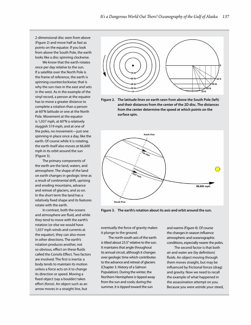
(North Pole to South Pole) is not straight up and down relative to the sun, but tilted at about 23.5°. That tilt is responsible for the seasons: during summer in the Northern Hemisphere, the North Pole is tipped toward the sun and during the winter it is tipped away (sidebar 1).
Other processes also affect the ocean. As we are aware, the surface of the earth is very irregular. The land is characterized by mountain ranges, valleys, plains, and plateaus. Terrestrial elevations dip to 1,371 feet below sea level along the Dead Sea coast and rise to 29,029 feet (nearly 5.5 miles) at the top of Mt. Everest. The seabed is also irregular and characterized by the same kinds of features. The deepest point, the Challenger Deep in the Mariana Trench, plunges to 35,797 feet, more than 6¾ miles deep. Although the shapes are ever changing, the time scale for change is too long to be significant for most day-to-day or year-to-year processes. However, the changes clearly influenced the evolution and distributions of species as we see them today (see Chapter 3. History of a Salmon Population). Finally, the sun and moon influence both water and atmospheric movements on earth.
Effects of the sun The sun is essential for life on earth. Without the sun, the earth would be a frigid chunk of rock floating in the universe. Energy from the sun fuels most living things, either directly for many plants or indirectly for things that eat plants or animals that eat things that eat plants. The sun warms the earth, so that water over much of the earth is liquid: streams, lakes, rivers, and oceans; rain; and about 70% of our bodies. In some areas of the earth or during certain times, water is solid in the form of ice and snow. Water as a gas is important for cycling water between aquatic and terrestrial habitats. In this chapter, we will see how the sun produces these and other oceanographic effects. The sun is important for influencing the weather as well as the oceans, and the effects of weather and oceanography cannot always be separated.
Let’s start with a simple, but important, example. You are on a boat at the equator, say in the middle of the Pacific Ocean. What is it like? Generally hot. Why? Because even with seasonal variation, the sun
shines straight down at midday. The atmosphere is relatively transparent to the sun, but when light hits the water from directly overhead, most of its energy is absorbed rather than reflected by the water’s surface, and converted to thermal energy (heat). Because you’re in the middle of the ocean, sun-warmed water is all around you. The warming water also heats the air at the water’s surface, and causes some evaporation (changing water from liquid to gas). What happens when air is warmed? Just as with the colorful hot air balloons (for example in the wine region of Napa Valley, which take tourists up in the air to enjoy the view) heating air causes it to expand so it is less dense (lighter) than the cooler air around it. The more buoyant balloon rises into the sky. Because air thins (becomes less dense) as you ascend until there is none at all, the balloon will eventually climb to air of the same density.
Similarly, the warmed air at the equator will ascend until it reaches air of the same density. The newly arrived air displaces air already there and pushes it north and south. At the higher altitude the warmer air cools, but it moves from the equator (0° latitude) to about 30° north or south latitude until it has cooled sufficiently to become heavy enough (denser) to sink closer to the earth, where it is again warmed as it descends. The air at the equator is replaced along the sea surface by air from the north and south. The result is a circle of air that produces a net wind at the equator. But because of the Coriolis Effect (sidebar 1), the winds blow regularly from east to west near the equator. These “trade winds” (see sidebar 2) push water before them to produce the North Equatorial Current. If you don’t believe that wind can drive currents, fill up your washbasin and blow on the surface along one of the sides. You can even use drops of food coloring to help you track the motion. After a little huffing and puffing, you will see that the water is moving around the bowl in the direction you are blowing. Notice also that waves are created by the friction between the air and water. Bigger winds produce larger waves. I use the size and number of whitecaps (frothy tips of waves) that form in a brisk wind to help me decide if I want to go fishing in my small boat.
The cold climates in the far north and south cool

136 What Does Genetics Have to Do with It?
THE CORIOLIS AND OTHER EARTHLY EFFECTS
Sidebar 1
Let’s start this sidebar with a practical example of what “frame of reference” is and how objects that rotate can influence perception. You are the target of an assassination attempt. The assassin is following you, waiting for an opportunity. He only takes headshots. As luck would have it, you are near an amusement park that has one of the world’s fastest carousels (18 mph—10.3 revolutions per minute counterclockwise. Hang on!). You get on and the assassin mounts the second horse behind you and begins to take aim with his 38 special, which has a muzzle velocity of 600 feet per second (fps) (Figure 1). To avoid the attention that would be generated by your falling off a stationary horse, he waits until the carousel is rotating. You remain calm as he takes dead aim because your high school trigonometry class enabled you to quickly calculate that the speed of your horse rotating around the center of the carousel will move you out of the path of the bullet. In fact, the bullet will miss the center of your noggin by a bit more than 6 inches—you will feel the bullet buzz by your right ear (Figure1).
So what happened here? Once the bullet is fired, it goes straight in the direction it was aimed with the combined velocity of the carousel and the muzzle velocity. It does not curve! Curving would require a sidewise force on the bullet, which no longer exists once it clears the barrel. If the assassin had fired before the carousel was turning, you would be out of luck. If you were both on bicycles going in a straight line, again you would be toast. The idea is that once something (like a bullet) begins to move, it goes straight. Of course, things like
gravity and air resistance will alter its path.
We can use this example to define “frame of reference,” a term that describes how things look from a particular position. Spectators watching the carousel will see you and the assassin rotating around counterclockwise, but to you on the carousel, the spectators are moving clockwise around the carousel. From your (and the assassin’s) frame of reference, when the bullet is fired it starts straight at you at a speed of 600 fps, but appears to curve to your right. Actually, the bullet is going straight and you are moving to the left. To the spectators, the bullet travels straight from the gun at a speed of 600 fps plus the speed of the carousel when the gun was fired.
Another thing we need to know is that on rotating objects, the farther you go from the center the faster they go. If you had been on a
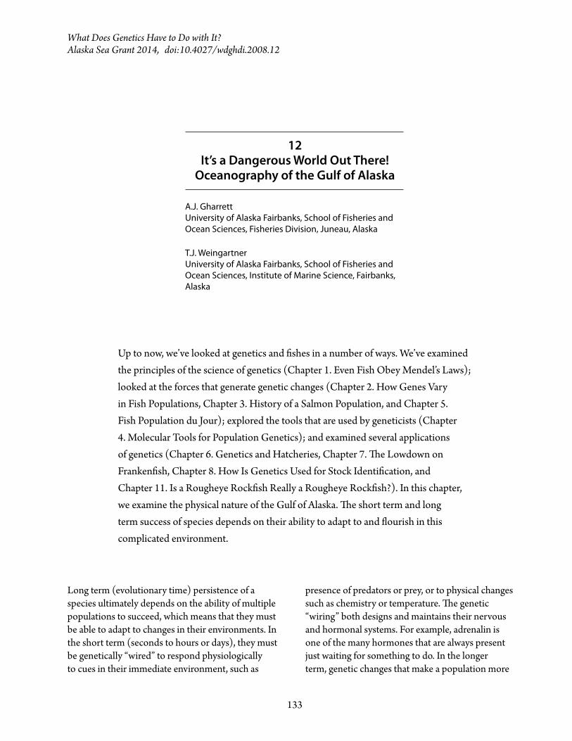
horse closer to the center of the carousel, you probably would have been hit because the horse would not have moved fast enough to get you out of the way. Imagine an old-fashioned vinyl record on a turntable. Records rotate clockwise at 33⅓ revolutions per minute. They measure 6 inches from their center to the outside edge. That means that a point at the edge moves about 1.19 mph. A point midway between the center and the edge moves half as far around in each revolution, so it moves half as fast. The same idea works with rotating spheres (like the earth). Look at the earth from above the North Pole. It looks like a counterclockwise rotating disc. Although it would seem that latitude 45°N is halfway between the equator (outer edge latitude 0°) and the North Pole (the center at latitude 90°N), points at latitude 60° are actually the midpoint on the
Figure 1. A demonstration of the Coriolis Effect. An assassin on a rotating carousel must adjust his aim. The bullet will travel straight from the gun, but the target will move both forward and to the left.
It’s a Dangerous World Out There! Oceanography of the Gulf of Alaska 137
2-dimensional disc seen from above (Figure 2) and move half as fast as points on the equator. If you look from above the South Pole, the earth looks like a disc spinning clockwise.
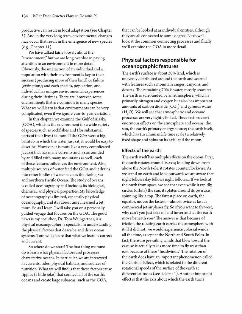
We know that the earth rotates once per day relative to the sun. If a satellite over the North Pole is the frame of reference, the earth is spinning counterclockwise; that is why the sun rises in the east and sets in the west. As in the example of the vinyl record, a person at the equator has to move a greater distance to complete a rotation than a person at 60°N latitude or one at the North Pole. Movement at the equator is 1,037 mph, at 60°N a relatively sluggish 519 mph, and at one of the poles, no movement—just one spinning in place once a day, like the earth. Of course while it is rotating, the earth itself also moves at 66,600 mph in its orbit around the sun (Figure 3).
The primary components of the earth are the land, waters, and atmosphere. The shape of the land on earth changes in geologic time as a result of continental drift, uprising and eroding mountains, advance and retreat of glaciers, and so on. In the short term the land has a relatively fixed shape and its features rotate with the earth.
In contrast, both the oceans and atmosphere are fluid, and while they tend to move with the earth’s rotation (or else we would have 1,037 mph winds and currents at the equator), they can also move in other directions. The earth’s rotation produces another, not so obvious, effect on these fluids called the Coriolis Effect. Two factors are involved. The first is inertia: a body tends to maintain its motion unless a force acts on it to change its direction or speed. Moving a fixed object (say a boulder) takes effort (force). An object such as an arrow moves in a straight line, but
eventually the force of gravity makes it plunge to the ground.
The north-south axis of the earth is tilted about 23.5° relative to the sun. It maintains that angle throughout its annual circuit, although it changes over geologic time which contributes to the advance and retreat of glaciers (Chapter 3. History of a Salmon Population). During the winter, the Northern Hemisphere is tipped away from the sun and cools; during the summer, it is tipped toward the sun
and warms (Figure 4). Of course the changes in season influence atmospheric and oceanographic conditions, especially nearer the poles.
The second factor is that both air and water are (by definition) fluids. An object moving through them moves straight, but may be influenced by frictional forces (drag) and gravity. Now we need to recall the example of what happened in the assassination attempt on you. Because you were astride your steed,
Figure 2. The latitude lines on earth seen from above the South Pole (left) and their distances from the center of the 2D disc. The distances from the center determine the speed at which points on the surface spin.
Figure 3. The earth’s rotation about its axis and orbit around the sun.
138 What Does Genetics Have to Do with It?
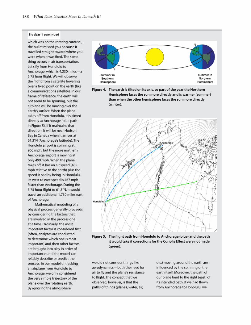
which was on the rotating carousel, the bullet missed you because it travelled straight toward where you were when it was fired. The same thing occurs in air transportation. Let’s fly from Honolulu to Anchorage, which is 4,230 miles—a 5.75 hour flight. We will observe the flight from a satellite hovering over a fixed point on the earth (like a communications satellite). In our frame of reference, the earth will not seem to be spinning, but the airplane will be moving over the earth’s surface. When the plane takes off from Honolulu, it is aimed directly at Anchorage (blue path in Figure 5). If it maintains that direction, it will be near Hudson Bay in Canada when it arrives at 61.3°N (Anchorage’s latitude). The Honolulu airport is spinning at 966 mph, but the more northern Anchorage airport is moving at only 499 mph. When the plane takes off, it has an air speed (485 mph relative to the earth) plus the speed it had by being in Honolulu. Its west to east speed is 467 mph faster than Anchorage. During the 5.75 hour flight to 61.3°N, it would travel an additional 1,730 miles east of Anchorage.
Mathematical modeling of a physical process generally proceeds by considering the factors that are involved in the process one at a time. Ordinarily, the most important factor is considered first (often, analyses are conducted to determine which one is most important) and then other factors are brought into play in order of importance until the model can reliably describe or predict the process. In our model of tracking an airplane from Honolulu to Anchorage, we only considered the very simple trajectory of the plane over the rotating earth. By ignoring the atmosphere,
we did not consider things like aerodynamics—both the need for air to fly and the plane’s resistance to flight. The concept that we observed, however, is that the paths of things (planes, water, air,
etc.) moving around the earth are influenced by the spinning of the earth itself. Moreover, the path of our plane bent to the right (east) of its intended path. If we had flown from Anchorage to Honolulu, we
Sidebar 1 continued
Figure 4. The earth is tilted on its axis, so part of the year the Northern Hemisphere faces the sun more directly and is warmer (summer) than when the other hemisphere faces the sun more directly (winter).
Figure 5. The flight path from Honolulu to Anchorage (blue) and the path it would take if corrections for the Coriolis Effect were not made (green).

It’s a Dangerous World Out There! Oceanography of the Gulf of Alaska 139
the oceans, often freezing it at the surface. Colder (liquid) water is denser than warmer water and tends to sink. Salt lowers the freezing point of water; and when saltwater freezes, the ice often leaves the salt behind. The result is higher salinity water at or near the freezing point on which the ice floats. The colder, more saline water displaces the warmer, less saline water below it and initiates an underwater current. Note that the influence of the sun at the equator primarily generates surface currents, whereas the effects of cold climates at the poles generally produce subsurface currents.
Effects of the atmosphere—weatherWeather has a profound effect on the oceanography of the Gulf of Alaska. Water has a very high specific heat capacity. Specific heat capacity is a measure of the amount of energy (heat) that is required to increase the temperature of a substance. Liquid water has one of the highest heat capacities of all substances (1 calorie per gram per degree Celsius (cal/g/°C), versus 0.11 cal/g/°C for cast iron, 0.41 for wood, 0.19 for quartz sand, and 0.5 for ice). In addition, it takes
energy to evaporate it from liquid water (540 cal/g) or to melt it from ice (80 cal/g). It should be clear that water tends to remain liquid unless a lot of heat is added to or removed from it, and that liquid water does not change temperature very rapidly. That means water is an excellent source of or acceptor of heat (heat sink) from the land or the atmosphere, and once warmed, an excellent heat donor.
So how does the specific heat of water translate to weather? In the far north, winter temperatures cause the land to lose heat (become colder), which in turn cools the air and makes it dense (heavy). Over the sea, however, a different situation occurs: the air is warmed by the ocean (to 32°F, 0°C) and is warm compared to the subzero polar temperatures over the land and ice, so is not as dense. The weight of the air above any particular location is the atmospheric pressure there (measured by barometers). In fact, the barometric pressure can have real effects on the sea surface level. Sea levels are actually higher where there is low barometric pressure and lower where pressure is high, and those levels can be measured remotely by satellite imaging. These pressure changes in sea level are in addition to tidal cycles.
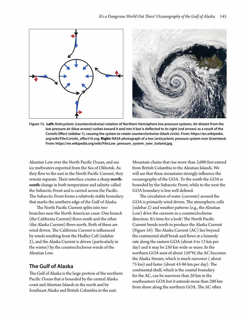
An area of low air pressure, known as the Aleutian Low, often sits just south of the western end of the Aleutian Islands during the winter and influences weather over the entire region. Differences in atmospheric pressure produce the same kind of effect that we see in the Hadley Cell (sidebar 2) because air tends to move from high pressure to low pressure. Air movement around low pressure areas is counterclockwise because the Coriolis Effect causes the air rushing toward the low pressure area to deflect to its right (Figure 13). Consequently, prevailing winds generally blow toward the southwest along the Kamchatka Peninsula and to the northwest along the British Columbia and Southeast Alaska coasts. Those winds produce surface currents in the ocean that flow in the same direction as the wind.
At our house in Juneau, the prevailing winds are from the south, just like the effect of the Aleutian Low would predict. The house, which fronts on a saltwater cove and faces northwest, is protected from those winds. Occasionally in the winter, however, a cold, high pressure system will descend from the north,
would have missed it by the same distance, but to the west. In the Southern Hemisphere, the effect is reversed. Flying to the south would also bend our path to the east, which in this case would be to the left of the plane’s flight path.
It should be clear that the distances over which the Coriolis Effect is significant are large. Where the Coriolis Effect modifies movements (as perceived by us earthbound creatures), we can summarize the effect as follows: the paths of movements in the Northern Hemisphere tend to bend right, and paths in the Southern Hemisphere tend to bend left. Only along the equator is there no left or right deflection. Also note that the linear scale (inches) of water swirling down a drain is too small to experience an obvious Coriolis Effect; the popular notion that water swirling in different directions in sinks of the Southern and Northern Hemispheres is a myth (e.g., http://mentalfloss.com/article/30358/australian-toilets-dont-flush-backwards-because-coriolis-effect, https://en.wikipedia.org/wiki/Coriolis_effect#Draining_in_bathtubs_and_toilets.

140 What Does Genetics Have to Do with It?
THE HADLEY AND OTHER ATMOSPHERIC CIRCULATION CELLS
Sidebar 2
Atmospheric conditions are responsible for many oceanographic processes. Of course, energy from the sun drives a lot of them. We’ll start at (or near depending on the season) the equator where the sun beams straight down on the water. Sunlight readily penetrates the atmosphere, but water absorbs energy from the light that is not reflected. Consequently, the water at the equator heats up and warms the air immediately above it; some water evaporates into the atmosphere. Warm air is less dense (lighter) than colder air and can carry more water vapor. The warm moist air rises, like a hot air balloon. As it rises, it cools and the water condenses to rain. So near the equator, it is often rainy. In some places, the weather cycles between hot and rainy seasons, a result of the tilt of the earth relative to the sun. But our focus is on the rising warm air. Gravity prevents it from rising too far and as it cools it becomes colder and denser (heavier). However, other air rising below it pushes it out of the way, and because the upper air mass can only rise so far, it is pushed toward the poles. As it moves north (or south) it continues to lose water to rain until it dries thoroughly and, as it cools, becomes heavy enough to sink back toward the earth. The downward movement of dry air takes place at about 30°N (or south) latitude. As it descends it warms up from heat produced by the sun at the earth’s surface. The air that rises at the equator sucks air along the earth’s surface to replace it, producing a net circular movement of air called the Hadley cell.
There are several notable results of the Hadley Cell. First, if
you circle the earth near 30°N (or S) latitude, you will see many deserts: in Africa (the Sahara and Kalahari), Australia, Mexico, India, and Chile (Atacama Desert). Why didn’t I learn about this from junior high science or geography?! It’s really cool stuff! The second result of the Hadley Cell is the trade winds. These winds blow nearly continuously at the earth’s surface from east to west just north and south of the equator in the Pacific, Atlantic, and southern Indian oceans. How does that work? Hadley Cells tend to make air flow toward the equator, but the Coriolis Effect (sidebar 1) bends the airflow toward the west (right in the Northern and left in the Southern Hemisphere). The result is continual airflow (trade winds) that averages a bit over 10 mph, although they can be stronger. The third result is that the air movement higher in the atmosphere (roughly 8 miles up) also experiences the Coriolis Effect, which makes it bend right (east in the Northern Hemisphere) producing the Subtropical Jet Stream. This jet stream can exceed 100 mph! Why so much faster than the trade winds? One reason is that the trade winds encounter more
friction in passing over the water; another is that the air is less dense at higher altitudes. Another part of the story is that a stronger pressure gradient aloft drives stronger winds. In this case the meridional (or north-south) thermal gradient (associated with the pressure gradient) is stronger at higher altitudes than at the surface.
In contrast to the Hadley Cell, the Polar Cell is driven by cold, dense (heavy) air that descends over the poles and pushes air toward the equator. As the air moves toward the equator it warms, becoming less dense and moister until at about 60°N (or S) it rises and again moves toward the pole. As it cools, the water condenses into precipitation: rain in the summer and snow in the winter. The effect is certainly noticeable in Juneau (58°N), where I live, where average rainfall is about 62 inches as compared to 50 for New York City, 37 for Seattle and Chicago, and 13 for Los Angeles.
Between the Hadley and Polar Cells, air moves toward the poles along the earth’s surface, and the cycle of this Ferrel Cell is completed by movement at higher altitude. Again the Coriolis Effect bends the
Figure 6. Atmospheric circulation cells in the Northern Hemisphere. Source: http://en.wikipedia.org/wiki/File:Jetcrosssection.jpg.

It’s a Dangerous World Out There! Oceanography of the Gulf of Alaska 141
and at those times the house is assaulted by winds from the north that reach 60 mph and hit the house hard enough to cause it to move and make waves in our little cove and even our toilet bowl! Those winds are the result of the clockwise movement created by the high pressure system, in which the air moves down and out from its center and is influenced by the Coriolis Effect to produce a pattern just the reverse of that shown in Figure 13.
Effects of the MoonThe moon is primarily responsible for producing tides on earth (sidebar 3). Tides are responsible for large movements of water, particularly in coastal areas. Advance and retreat of the tides continually renew important components of the nearshore environments, by removing and replacing water that replenishes oxygen and food and by maintaining temperatures. Strong tidal currents occur in locations that have landforms that channel water. The stage of a tide (e.g., high or low) can determine whether or not a boat can safely navigate, if it is possible to dig clams or rake crabs, or when small salmon should descend from its stream to the estuary. Most of the small salmon with which I work emigrate to the ocean in mid April. Why? At that time there is a new moon and predators have a harder time detecting them in the dark. In addition, a high tide (sidebar 3) shortens the distance they must travel to salt water.
Fitting the parts of the puzzle that influence GOA oceanographySo I hear you yelling: “Get on with the Gulf of Alaska Oceanography!” Well, it’s not quite that simple. There are a number of factors (pieces to the puzzle) away from the GOA that influence GOA currents and water
movements. So let’s pick up where we ended when we looked at Hadley Cells (sidebar 2). Remember that one result was that currents near the equator flow from east to west. The currents we will describe are persistent over decades, although their magnitude may change because of weather patterns. Since the GOA is in the Northern Hemisphere, we’ll follow the current north of the equator, the North Equatorial Current (Figure 14). The North Equatorial Current approaches land near the Philippine coast and splits into two branches, one that flows north and one that flows south. The northerly flowing current, the Kuroshio Current, carries warm water past Taiwan and along the southern Japanese coast. Here, the warm Kuroshio water collides with the cold Oyashio Current and bends east across the northwestern Pacific Ocean (where it is called the Kuroshio Extension). The Oyashio Current originates from the southern tail of the East Kamchatka Current after part of it has taken an excursion into the southern Sea of Okhotsk. The Oyashio Current splits near the south end of Japan’s Hokkaido Island. Part of it moves southwest along the east coast of Japan where it collides with the Kuroshio Current and swings east to form the Subarctic Current. At about the International Date Line (180°), the Kuroshio Extension and Subarctic Current meet and flow east parallel to each other to form the broad (40-50°N latitude) North Pacific Current, which flows to the northeast of Hawaii and continues east to the Pacific coast of North America. Note that the winds from the atmospheric cells and both landforms and ocean bottom topography (bathymetry) determine these paths. If you need proof that there is a current that transits the North Pacific, take notice of the debris from the 11 March 2011 tsunami in Japan that has washed ashore on the coasts of Hawaii (a boat), Oregon and Washington (floating docks), and British Columbia (a motorcycle) (http://www.huffingtonpost.com/2013/03/09/japan-tsunami-debris-earthquake-photos_n_2843978.html#slide=1163971).
The water from the Kuroshio Current is warm and salty, whereas the Oyashio water is cold and has low salinity because it is carrying runoff from the land, the heavy precipitation associated with the
winds toward the east (right in the Northern and left in the Southern Hemisphere). A polar jet moves air to the east near the high atmosphere intersections (4 to 8 miles) of the Ferrel and Polar Cells. You can look at the Ferrel cell as a gear that connects the Hadley and Polar Cells.

142 What Does Genetics Have to Do with It?
THE TIDES
Sidebar 3
My grandfather did highway maintenance in the state of Washington. One day when he was working near some tidal marshes, a flatlander (an Ohioan I think) stopped, got out of his car, and asked where the water he had seen in the slough the previous day had gone. My grandfather politely told him that he had seen the water at high tide and it was now low tide. The man did not believe him; he’d never heard of tides. I wonder what he thought had happened to the water. Tides are familiar to coastal residents, and most of us know they are in some way correlated with the phases of the moon because tide tables include that information (look at the at bottom of Figure 7). Tide tables also often include a prediction of the probable fishing success (which may be related to the ease of keeping the bait on the bottom where the fish live) by showing fish drawings (halibut in our area) of different sizes.
Tides, which are the rise and fall of sea level, can be predicted at any location on earth. A number of things influence the tides. The most important is the moon but other things such as the earth’s rotation, the sun, the shape of the ocean bottom (referred to as bathymetry), and the isolation of parts of the oceans by land masses (continents and islands) all play roles. Let’s do something scientific: construct a conceptual model to explain tides, starting with the most significant factor and adding others until the model is predictive of observed processes.
We will begin the process with the moon, the most important factor (the moon accounts for about
two-thirds of the total effect of the sun and moon). The earth and moon attract each other because of gravitational force (recall Isaac Newton and his apple). Although we think of the moon orbiting the earth, they actually orbit each other. This means that the earth is not a fixed point around which the moon rotates. Both rotate around a point called the center of
rotation, but they are not equal distances from it. That means that not only does the earth spin on its own axis, it also moves as a body around the moon. Here is an example that will demonstrate why the center of rotation is closer to the earth than the moon. Let’s consider the hammer throw (one of four throwing events in track and field). The hammer is a 16 pound weight
Figure 7. A page from a tide table: times of high and
low tides in Juneau, Alaska, during June 2013. At the
bottom is information about phases of the moon. Note
that the lowest and highest tides are just after the full
moon, which are also predicted as the worst time to fish
because of current strength.

It’s a Dangerous World Out There! Oceanography of the Gulf of Alaska 143
attached to an approximately 4 foot chain. The athlete spins around holding onto the handle and then releases it tossing it as far as possible. In Figure 8 an athlete in mid throw is leaning away from the weight. The actual center of rotation is between the athlete and hammer, closer to the athlete because of his
greater mass. Similarly, the center of the earth/moon pair is much closer to the earth. Why is this important? If the earth and moon did not orbit each other, they would attract each other and the moon would crash into the earth, like Newton’s apple and the ground, causing mass extinctions of life on earth.
Remember, our goal is to understand what generates tides. Unlike the hammer, the earth is not completely solid; it is surrounded by a gaseous atmosphere and has an abundance of liquid on its surface. Because water and air are fluids, they can be distorted by the moon’s gravitational attraction. Think of swinging a water balloon around on a string. The force of the string will draw one end of the balloon toward the string, but the other side will pull in the opposite direction (centrifugal force from the inertial tendency of the water to keep going outward, like a child flinging off of a merry-go-round). The balloon will distort into an elongated shape (Figure 9). Similarly, the earth’s waters bulge toward and away from the moon depending on where the water is in relation to the moon (Figure 10). The bulge away from the moon is not quite as large as the one toward the moon. The two bulges mean that in many places on earth there are two tidal cycles per day.
If the earth were smooth and completely covered in water, we would be finished considering the effect of the moon on tides. But there are a few other things to consider. One is that the moon orbits the earth in the same direction that the earth rotates, just not as fast. The earth completes a rotation in 24 hours. However, during that time the moon has also moved so it takes about 24 hours plus another 50.5 minutes until the moon is over the same place on earth that it was the
previous day (Figure 11). This means that the tides do not have a precise 12 hour cycle (Figure 1). Because the water and the solid earth on which it sits are not frictionless and water has inertia (sidebar 1), the water tends to rotate with the earth. As a result, the bulge of water is not directly below the moon; its position lags a bit behind the moon’s position. Note on the tide table that the very high and low tides are on June 24 and 25, not on June 23, the day of the full moon (Figure 7). Also note that there was another high tide series earlier in the month near the timing of the new moon. These two moon phases
Figure 8. A hammer thrower in
action. The record is more than 280
feet. Earth art source: http://www.
esri.com/news/arcuser/0610/nospin.
html; thrower source: http://www.
sikerado.hu/sport/2013/05/18/
Ifjusagi_vilagrekordot_dobott_a_
kalapacsveto_Gyuratz_Reka.
Figure 9. Effect of swinging a water
balloon. Don’t try this inside, and
prepare to get wet if you try it outside!
Figure 10. Distortion of the
waters on earth from the moon’s
gravitational attraction and the
orbiting of the earth.
Figure 11. Apparent movement of
the moon.
144 What Does Genetics Have to Do with It?
Sidebar 3 continued
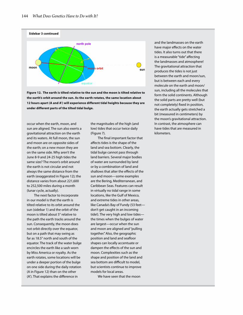
occur when the earth, moon, and sun are aligned. The sun also exerts a gravitational attraction on the earth and its waters. At full moon, the sun and moon are on opposite sides of the earth; on a new moon they are on the same side. Why aren’t the June 8-9 and 24-25 high tides the same size? The moon’s orbit around the earth is not circular and not always the same distance from the earth (exaggerated in Figure 12); the distance varies from about 221,600 to 252,500 miles during a month (lunar cycle, actually).
The next factor to incorporate in our model is that the earth is tilted relative to its orbit around the sun (sidebar 1) and the orbit of the moon is tilted about 5° relative to the path the earth tracks around the sun. Consequently, the moon does not orbit directly over the equator, but on a path that may swing as far as 18.5° north and south of the equator. The track of the water bulge encircles the earth like a sash worn by Miss America or royalty. As the earth rotates, some locations will be under a deeper portion of the bulge on one side during the daily rotation (A in Figure 12) than on the other (A’). That explains the difference in
the magnitudes of the high (and low) tides that occur twice daily (Figure 7).
The final important factor that affects tides is the shape of the land and sea bottom. Clearly, the tidal bulge cannot pass through land barriers. Several major bodies of water are surrounded by land or by a combination of land and shallows that alter the effects of the sun and moon—some examples are the Bering, Mediterranean, and Caribbean Seas. Features can result in virtually no tidal range in some locations, like the Gulf of Mexico, and extreme tides in other areas, like Canada’s Bay of Fundy (53 feet—don’t get caught in an incoming tide!). The very high and low tides—the times when the bulges of water are largest—occur when the sun and moon are aligned and “pulling together.” Also, the geographic position and land and seafloor shapes can locally accentuate or dampen the effects of the sun and moon. Complexities such as the shape and position of the land and sea bottom are difficult to model, but scientists continue to improve models for local areas.
We have seen that the moon
and the landmasses on the earth have major effects on the water tides. It also turns out that there is a measurable “tide” affecting the landmasses and atmosphere! The gravitational attraction that produces the tides is not just between the earth and moon/sun, but is between each and every molecule on the earth and moon/sun, including all the molecules that form the solid continents. Although the solid parts are pretty well (but not completely) fixed in position, the earth actually gets stretched a bit (measured in centimeters) by the moon’s gravitational attraction. In contrast, the atmosphere can have tides that are measured in kilometers.
Figure 12. The earth is tilted relative to the sun and the moon is tilted relative to
the earth’s orbit around the sun. As the earth rotates, the same location about
12 hours apart (A and A’) will experience different tidal heights because they are
under different parts of the tilted tidal bulge.
It’s a Dangerous World Out There! Oceanography of the Gulf of Alaska 145
Aleutian Low over the North Pacific Ocean, and sea ice meltwaters exported from the Sea of Okhotsk. As they flow to the east in the North Pacific Current, they remain separate. Their interface creates a sharp north-south change in both temperature and salinity called the Subarctic Front and is carried across the Pacific. The Subarctic Front forms a relatively stable boundary that marks the southern edge of the Gulf of Alaska.
The North Pacific Current splits into two branches near the North American coast. One branch (the California Current) flows south and the other (the Alaska Current) flows north. Both of these are wind driven. The California Current is influenced by winds resulting from the Hadley Cell (sidebar 2), and the Alaska Current is driven (particularly in the winter) by the counterclockwise winds of the Aleutian Low.
The Gulf of AlaskaThe Gulf of Alaska is the large portion of the northern Pacific Ocean that is bounded by the central Alaska coast and Aleutian Islands in the north and by Southeast Alaska and British Columbia in the east.
Mountain chains that rise more than 3,000 feet extend from British Columbia to the Aleutian Islands. We will see that these mountains strongly influence the oceanography of the GOA. To the south the GOA is bounded by the Subarctic Front, while to the west the GOA boundary is less well defined.
The circulation of water (currents) around the GOA is primarily wind driven. The atmospheric cells (sidebar 2) and weather patterns (e.g., the Aleutian Low) drive the currents in a counterclockwise direction. It’s time for a look! The North Pacific Current bends north to produce the Alaska Current (Figure 16). The Alaska Current (AC) lies beyond the continental shelf break and flows at a leisurely rate along the eastern GOA (about 4 to 13 km per day) and it may be 250 km wide or more. In the northern GOA west of about 150°W, the AC becomes the Alaska Stream, which is much narrower ( about 75 km) and faster (about 43-86 km per day). The continental shelf, which is the coastal boundary for the AC, can be narrower than 20 km in the southeastern GOA but it extends more than 200 km from shore along the northern GOA. The AC often
Figure 13. Left: Anticyclonic (counterclockwise) rotation of Northern Hemisphere low pressure systems. Air distant from the low pressure air (blue arrows) rushes toward it and into it but is deflected to its right (red arrows) as a result of the Coriolis Effect (sidebar 1), causing the system to rotate counterclockwise (black circle). From: https://en.wikipedia.org/wiki/File:Coriolis_effect10.svg. Right: NASA photograph of a low (anticyclonic pressure system over Greenland. From: https://en.wikipedia.org/wiki/File:Low_pressure_system_over_Iceland.jpg.

146 What Does Genetics Have to Do with It?
Figure 14. Current patterns associated with the subtropical and subarctic gyres in the western North Pacific Ocean. From: B. Qiu. 2001. Kuroshio and Oyashio Currents. Encyclopedia of Ocean Sciences, Academic Press, pp. 1413-1425.
Figure 15. Gulf of Alaska bottom topography (bathymetry) and topography of the surrounding land. (From: T. Weingartner. 2007. Sect. 2.2. The physical environment of the Gulf of Alaska. In: R.B. Spies, ed. Long-term ecological change in the northern Gulf of Alaska, Elsevier, Amsterdam, pp. 12-47) .

It’s a Dangerous World Out There! Oceanography of the Gulf of Alaska 147
flows near the continental slope in the southeast but in the north is somewhat farther off shore but continues to hug the continental shelf until it turns into the Alaska Stream, which moves rapidly along the Aleutian Islands. Some of the Alaska Stream penetrates passes between the Aleutian Islands at several locations and feeds a counterclockwise current
system in the Bering Sea (Figure 17). Following the incursion into the Bering Sea this current system coalesces into the southwest-flowing East Kamchatka Current along the western boundary of the Bering Sea, whereupon it will eventually feed the Oyashio and then the North Pacific Current to complete the circuit.
Another GOA current is the nearshore Alaska Coastal Current (ACC), which hugs the coastline over the continental shelf from British Columbia in the south to the Aleutian Islands in the west (Figure 16). The ACC is driven by wind and freshwater runoff and generally extends less than 50 km from the coastline. Its speed can approach 90 km per day in the fall and winter when freshwater discharge is large and winds are strong, but it is much weaker in spring and summer. Much of the land bordering the GOA is the recipient of the precipitation produced by the Arctic Low (sidebar 2). In addition, the surrounding mountains substantially increase the amount of rain and snow. How? The winds that pick up moisture from the ocean and blow from the southeast encounter the mountains and are forced to rise. As the
Figure 16. Northeastern Pacific currents. The vertical bars show annual precipitation. UP is Unimak Pass, S is Seward, and K is Ketchikan. From: T. Weingartner et al. 2005. Deep Sea Research Part II: Topical Studies in Oceanography 52:169-191.
Figure 17. Currents in the Bering Sea. From: http://www.pmel.noaa.gov/np/pages/seas/bseamap5.html.

148 What Does Genetics Have to Do with It?
air ascends, though, it cools and releases most of its moisture before passing over the mountains (Figure 17). The air that ultimately passes over has lost its moisture to rain and snow and the other side of the mountains is often much drier. Also, because the air is not tempered by the high specific heat of the ocean water, which warms the atmosphere in the winter and cools it in the summer, the interior climate is also more extreme—often referred to as a continental climate. Figure 16 includes bars along the coast that
show average annual precipitation. Note that 2 meters per year is nearly 80 inches and many locations receive more than that—Yakutat receives 169 inches of precipitation per year!
In contrast to the large, relatively stable Alaska Current and Alaska Coastal Current, large clockwise eddies form along the continental slope between British Columbia and Yakutat. These eddies typically originate annually in winter. Eddies that form off British Columbia usually move across the interior GOA basin, while those that form between Sitka and Yakutat generally hug the continental slope and move around the GOA. The eddies are large (about 150 km in diameter) and deep (they extend vertically at least 2,000 m). They can persist for from 2 to 5 years, while moving slowly (about 2-3 km per day). During spring and summer at some times and locations, the eddies can impinge onto the continental slope and shelf break and alter outer shelf currents. Although the eddies themselves are moving slowly, the currents within the eddies may be quite vigorous and have swirling velocities of 20 to 40 km per day. In Southeast Alaska the edge of the eddies may even reverse direction of the ACC. These eddies are ecologically important: they bring into contact water from rains and melting snow and ice, which picks up the element iron as it flows over the land, with nitrogen-rich water
Figure 18. Removal of moisture in the air by coastal mountains. From: http://en.wikipedia.org/wiki/Precipitation_types#Stratiform.
Figure 19. Plot of the 8 day average of chlorophyll abundance in the Gulf of Alaska during summer 2010. Note the high concentration of chlorophyll a pools off shore that probably indicate the presence of eddies. Analyses and visualizations were produced with the Giovanni online data system, developed and maintained by NASA GES DISC.

It’s a Dangerous World Out There! Oceanography of the Gulf of Alaska 149
from the GOA basin to create a rich environment for phytoplankton, zooplankton, and ultimately fish. The eddies can be detected by remote sensing of the chlorophyll that is produced by phytoplankton in those nutrient-rich water mixtures (Figure 19).
There are also much smaller ( about 20-30 km wide) eddies that form on the continental shelf. They are generated through interaction of the coastal current with the rough bottom topography or upon flowing past something that sticks out and alters the flow, such as coastal headlands like Cape Edgecumbe near Sitka and Kayak Island near Yakutat. Underwater canyons (e.g., Amatouli Trough and Hinchinbrook Canyon) may alter water and large intrusions from freshwater runoff (e.g., through Cross Sound and from the Copper River) may be involved. Finally, wind reversals, such as may occur as a result of intrusions of arctic cold fronts in the winter may alter water flows.
In addition to the many roles the Coriolis Effect plays in oceanographic features that we have reviewed so far, there is one more behavior of water that is critical for coastal organisms: upwelling and downwelling. Along the GOA coast, the wind blows counterclockwise. These winds push surface water to the right of the winds and toward shore. This phenomenon, known as the Ekman effect, is due to the Coriolis Effect in conjunction with frictional forces in the water. As the surface waters move onshore they raise the sea level and force nearshore water downward (downwelling) at the coast.
In areas where the wind blows to the south, such as where the Oyashio and California Currents occur, upwelling results because the wind blows surface waters offshore, lowering coastal sea levels and bringing deeper water to the surface near the coast. Upwelling carries nutrients from the bottom and makes them available to organisms closer to the surface. As a result, areas of upwelling are often very rich in the diversity of sea life, which explains why those coastal areas are often biologically richer than open ocean areas.
SummaryThe description of Gulf of Alaska oceanography that has been presented suggests a relatively static situation. Do not interpret it as such! What we really
have done is provide a beginning. From that we have to include variations that occur in time frames from minutes to decades (or more if you are interested in evolutionary changes). We all know that even though science underlies weather forecasts, the weathermen in some regions of the country ( Juneau for instance) are not always accurate. So, look at this description as a theme (as in music) and appreciate the variations on the theme that time presents you. And if you are in Yakutat, do not forget your boots and raincoat!
8/14

Related Documents


