NOTICE!! These documents have been scanned! Do not place un-scanned documents beneath this notice! Do not remove this notice from this file! GPO Jacket No. 560-102 Print Order 61540 Rise Business Services, LLC Job=AZ15 5/10/2019 ®¤®1111111imiiniI miIIIIIHI Box Number= AZ15030 Claim Begin-End: AMC430190-AMC430190 1 Initial Receipt 1 Ill'lli Illilllili lilli 111111 11 Illi AZ15030-18 AMC429998-AMC430297

Welcome message from author
This document is posted to help you gain knowledge. Please leave a comment to let me know what you think about it! Share it to your friends and learn new things together.
Transcript
NOTICE!!
These documents have been scanned!
Do not place un-scanned documents beneath this notice!
Do not remove this notice from this file!
GPO Jacket No. 560-102Print Order 61540
Rise Business Services, LLCJob=AZ15 5/10/2019
®¤®1111111imiiniI miIIIIIHIBox Number= AZ15030
Claim Begin-End: AMC430190-AMC430190
1 Initial Receipt
1 Ill'lli Illilllili lilli 111111 11 Illi AZ15030-18 AMC429998-AMC430297
AMC# DATE CLOSED REMARKS430 l90
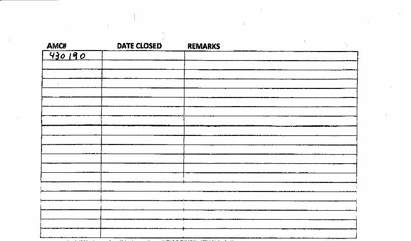
Receipt Page 1 of 2..United States Department of the Interior
Bureau of Land Management ReceiptLANDS/RECREATION & PLANNING
ONE N CENTRAL AVEPHOENIX, AZ 85004 -2203 No: 3198557
Phone: 602-417-9200
Transaction #: 3292029Date of Transaction: 12/29/2014
CUSTOMER:TED BIGELOW . W I -. . ;-W ItPO BOX 138WITTMANN,AZ 85361-0138 US ..1 JAN 1 2 0015 1 ~
1 5
LINE UNIT# QTY DESCRIPTION REMARKS TOTALPRICELOCATABLE MINERALS / MINING CLAIMS-
1 1.00 NEW,UNADJUD, ONE OR MORE AUTH NOS / - n/a - 37.00NEW MINING CLAIMS LOCATION FEECASES: AMC430190/$37.00LOCATABLE MINERALS / MINING CLAIMS-NEW,UNADJUD, ONE OR MORE AUTH NOS /2 1.00 - n/a - 20.00NEW MINING CLAIM PROCESSING FEECASES: AMC430190/$20.00LOCATABLE MINERALS / MINING CLAIMS-NEW,UNADJUD, ONE OR MORE AUTH NOS /3 1.00 -n/a - 155.00NEW MINING CLAIMS MAINTENANCE FEECASES: AMC430190/$155.00
TOTAL: $212.00
PAYMENT INFORMATIONNOTE: Items will appear on credit card statement as "Bureau of Land Mgmt CO".
1 AMOUNT: 212.00 POSTMARKED: N/ATYPE: CREDIT CARD RECEIVED: 12/29/2014
NAME: BIGELOW, TEDPO BOX 138WITTMANN AZ 85361-0138 US
CARD NO: XXXXXXXXXXXX6656 AUTH CODE: 143846NAME ON THEODORE S BIGELOWCARD:EXPIRES: 02/2017
SIGNATURE:
http://ilmnirmOap301/egibin/cbsp/zorder 12/29/2014
Receipt Page 2 of 2
REMARKS
This receipt was generated by the automated BLM Collections and Billing System and is a paper representation of a portionofthe official electronic record contained therein.
http://ilmnirmOap301/cgibin/cbsp/zorder 12/29/2014
.NOTICE! !
These documents have been scanned!
Do not place un-scanned documents beneath this notice!
Do not remove this notice from this file!
GPO Jacket No. 560-102Print Order 61540
Rise Business Services, LLCjob=AZ15 5/10/2019
I I lill Ill li Illi lilli 1 ill 1 111® lill 1 li~li I li li li li li Ill illBox Number= AZ15030
.
e
Claim Begin-End: AMC430190-AMC430190
2 Correspondence
Illl'llilll'llilll 11111111111 111'll AZ15030-18 AMC429998-AMC430297

NODOCUMENTS
FOUNDNO DOCUMENTS FOUNDNO DOCUMENTS FOUND

NOTICE! !
These documents have been scanned!
Do not place un-scanned documents beneath this notice!
Do not remove this notice from this file!
GPO Jacket No. 560-102Print Order 61540
Rise Business Services, LLCjob=AZ15 5/10/2019
1 lilli I lill lill Ilill Ili lill ill ill Ill lilli li ll I li li il li li ill IllBox Number= AZ15030
Claim Begin-End: AMC430190-AMC430190
3 Transfers
Illl'llilll'llilll Illill'llillillil AZ15030-18 AMC429998-AMC430297

. I 9
..Pm c 430 190
613019@_
QUIT CLAIM DEED
THIS QUIT CLAIM DEED, Executed this 5th Day of January, 2015,
by the following party, hereinafter referred to as GRANTOR,m.,1 DATE STAMP:
Names: Ted Bigelow
Whose Address is: P.O. Box 138Wittmann, AZ 85361 RECEIVED
*ENIX DISTRICT OFE.
To second parties, hereinafter referred to as GRANTEE, EIS JAN 26 i',3 9: 26p."in"P'.1. hct,,J Cr L .....4;'':•': i
Name: Casey Wertz PHOEND'.. /\Z
Whose 1490 Ralston Ave.Address Is: Defiance, OH 43512
WITNESSETH, That the said GRANTOR, for good consideration and the sumof Ten Dollars ($10.00 ), paid by the GRANTEE, the receipt whereof is herebyacknowledged, does hereby remise, release and quitclaim unto the said GRANTEEforever, all the right, title, interest, and claim which the said GRANTOR has in and to thefollowing described 20 acre mining claim, and improvements and appurtenances theretoin the County of: Maricopa, State of: Arizona, to wit:
20 ACREMINING CLAIM: AMC430190; Golden Sunrise #1
NO TRANSFER FEE NECESSARYEXEMPT PER ARS 11-1134 A-6
ENT"x m~r 11'FE~ 4 10,6 L
BY: fIL L-

F .
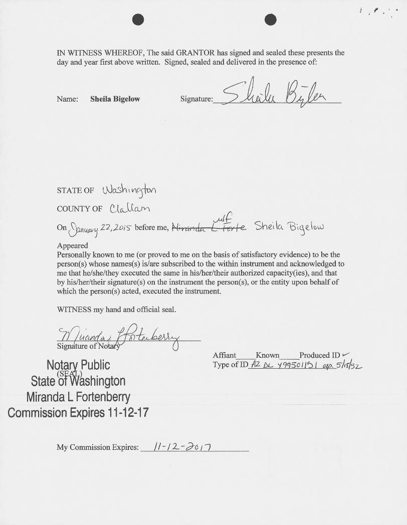
..IN WITNESS WHEREOF, The said GRANTOR has signed and sealed these presents theday and year first above written. Signed, sealed and delivered in the presence of:
Name: Ted Bigelow Signature: i (23
STATE OF
COUNTY OF
On~twat~ 22,20/5- before me, ~-7*d -digi/ow
AppearedPersonally known to me (or proved to me on the basis of satisfactory evidence) to be theperson(s) whose names(s) is/are subscribed to the within instrument and acknowledged tome that he/she/they executed the same in his/her/their authorized capacity(ies), and thatby his/her/their signature(s) on the instrument the person(s), or the entity upon behalf ofwhich the person(s) acted, executed the instrument.
WITNESS my hand and official seal.
07«,/4474 -442 -44SignatGre of Nota«
Affiant Known Produced ID/Type ofID Al. bL 616 0-1274 J .exp. IN,BInNmiary Public
State of WashingtonMiranda L Fortenberry
Commission Expires 11-12-17
My Commission Expires:

..
QUIT CLAIM DEED
THIS QUIT CLAIM DEED, Executed this 13'h Day of January, 2015,
by the following party, hereinafter referred to as GRANTOR,RI,M DATE STAMP:
Name: Sheila Bigelow
Whose Address is: P.O. Box 138Wittmann, AZ 85361
RECEIVED' . - :11 ..1 X DIST~i'CT (] :.5 .
To second parties, hereinafter referred to as GRANTEE, 2015 JAN 25 AM 9: 26Name: William Horn SUREAU OF LA,ND MAN. -PlIOENIX. AZWhose P.O. Box 27172Address Is: Prescott Valley, AZ 86312
WITNESSETH, That the said GRANTOR, for good consideration and the sumof Ten Dollars ($10.00), paid by the GRANTEE, the receipt whereof is herebyacknowledged, does hereby remise, release and quitclaim unto the said GRANTEEforever, all the right, title, interest, and claim which the said GRANTOR has in and to thefollowing described 20 acre mining claim, and improvements and appurtenances theretoin the County of: Maricopa, State of: Arizona, to wit:
20 ACREMINING CLAIM: AMC430193; Golden Sunrise #6
NO TRANSFER FEE NECESSARY~NTEFEE~ EXEMPT PER ARS 11-1134 A-6
FEB 6 4 20{5 ~
i ,
.
IN WITNESS WHEREOF, The said GRANTOR has signed and sealed these presents theday and year first above written. Signed, sealed and delivered in the presence of:
Name: Sheila Bigelow Signature: 614 LE»
STATE OF 600507, 4(31M
COUNTY OF ClLUmnn
on <f)~Al(Gv'j 22, lois before me, Mikd, ldoc- L-+erke- Shel l(1 -6 \(59 ( 6U)
AppearedPersonally known to me (or proved to me on the basis of satisfactory evidence) to be theperson(s) whose names(s) is/are subscribed to the within instrument and acknowledged tome that he/she/they executed the same in his/her/their authorized capacity(ies), and thatby his/her/their signature(s) on the instrument the person(s), or the entity upon behalf ofwhich the person(s) acted, executed the instrument.
WITNESS my hand and official seal.
Signature of NotaiFAffiant Known Produced ID v
Notarv Public TypeofID Az AL 49950//5/ of). 5Ag/{52.
State Sf*shingtonMiranda L Fortenberry
Commission Expires 11-12-17
My Commission Expires: ll -/ 1.-Ptl --1

'. ' ygeceipt Page 1 of 1
United States Department of the InteriorBureau of Land Management Receipt
PHOENIX DISTRICT OFFICE21605 N. 7TH AVENUE
PHOENIX, AZ 85027 -0000 No: 3215185Phone: 623/580-5500
Transaction #: 3308925Date of Transaction: 01/26/2015
CUSTOMER:TED BIGELOWPO BOX 138WITTMANN,AZ 85361-0138 US
LINE UNIT# QTY DESCRIPTION REMARKS TOTALPRICELOCATABLE MINERALS / MINING CLAIMS-
1 1.00 NOT NEW-UNADJUD,ONE AUTH NO. ONLY / TRANSFER -n/a - 20.00MINING CLAIM MONEY RECEIVED - 2CASES: AMC430190/$20.00
TOTAL: $20.00
PAYMENT INFORMATIONNOTE: Items will appear on credit card statement as "Bureau of Land Mgmt CO" .
1 AMOUNT: 20.00 POSTMARKED: N/ATYPE: CREDIT CARD RECEIVED: 01/26/2015
NAME: BIGELOW, TEDPO BOX 138WITTMANN AZ 85361-0138 US
CARD NO: XXXXXXXXXXXX7379 AUTH CODE: 103286NAME ON THEODORE S BIGELOWCARD:EXPIRES: 03/2018
SIGNATURE:
REMARKS
This receipt was generated by the automated BLM Collections and Billing System and is a paper representation of a portionof the official electronic record contained therein.
http://ilmnirmOap301/cgibin/cbsp/zorder 1/26/2015
..NOTICE!!
These documents have been scanned!
Do not place un-scanned documents beneath this notice!
Do not remove this notice from this file!
GPO jacket No. 560-102Print Order 61540
Rise Business Services, LLCJob=AZ15 5/10/2019
'i
I Ill ill ill li~1111 Ill Ill Ill li I~I I Il lillBox Number= AZ15030
Claim Begin-End: AMC430190-AMC430190
4 Annual Filings
111111~ 1111111111 illilll'llillilli AZ15030-18 AMC429998-AMC430297

DEPARTMENT OF THE INTERIORBUREAU OF LAND MANAGEMENT
MINING CLAIMSRun Date/Time: 9/11/2018 MC Maintenance Fees Paid Through the BLM Pay Portal Page 278 Of 723
(by Date Paid)
CBS Receipt: 4244619 Printed For Lead File # AMC43019O 1
Agency Tracking ID: 1535289985
Assessment Year: 2019 Number of BLM Serial Nr: 7
Paid On: 8/26/2018 Total Amount Paid: $1,085.00
Claim Name BLM Serial No Lead File No Amount Paid
EMERALD RIVER AMC425590 AMC425589 $155.00
KING SOLOMON EAST AMC425599 AMC425597 $155.00
KING SOLOMON WEST AMC425600 AMC425597 $155.00
PAYDAY #3 AMC426112 AMC426104 $155.00
GOLDEN SUNRISE #1 AMC430190 AMC430190 $155.00
COMPASS GOLD MINE AMC431286 AMC431285 $155.00
BELMONT MINE AMC435795 AMC435795 $155.00
NO WARRANTY IS MADE BY BLM FOR USE OF THE DATA FOR PURPOSES NOT INTENDED BY BLM

9/25/2018 Receipt
United States Department of the InteriorBureau of Land Management Receipt
BUSINESS & SUPPORT SVCS DIVONE N CENTRAL AVE SUITE 800
PHOENIX, AZ 85004 -4427 No: 4244619Phone: 602-417-9200
Transaction #: 4360068Date of Transaction: 08/26/2018
CUSTOMER:CASEY WERTZ1490 RALSTON AVEDEFIANCE,OH 43512 US
LINE UNIT# QTY DESCRIPTION REMARKS TOTALPRICELOCATABLE MINERALS / MINING CLAIMS-NOT NEW-
1 1.00 UNADJUD,ONE AUTH NO. ONLY / MINING CLAIM - n/a - 1085.00MONEY RECEIVEDCASES: AMC425590/$1085.00
TOTAL: $1,085.00
PAYMENT INFORMATIONNOTE: Items will appear on credit card statement as "BLM 0 Mining Claim".
1 AMOUNT: 1085.00 POSTMARKED: N/ATYPE: CREDIT CARD RECEIVED: 08/26/2018
NAME: CASEY WERTZ1490 RALSTON AVEDEFIANCE OH 43512 US
CARD NO: XXXXXXXXXXXX1232 AUTH CODE: 322847NAME ON CARD: CASEY WERTZ
SIGNATURE:
REMARKS
This receipt was generated by the automated BLM Collections and Billing System and is a paper representation o f a portion of the officialelectronic record contained therein.
https://ilmocopOap933.blm.doi.neVcgibin/cbsp/cbs_start2 1/1
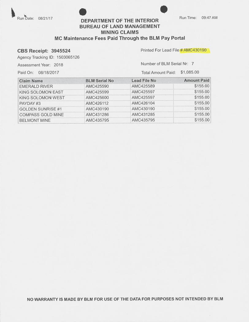
b# • 0Run Date: 08/21/17 Run Time: 09:47 AM
DEPARTMENT OF THE INTERIORBUREAU OF LAND MANAGEMENT
MINING CLAIMSMC Maintenance Fees Paid Through the BLM Pay Portal
CBS Receipt: 3945524 Printed For Lead File # AMC430190
Agency Tracking ID: 1503065126
Assessment Year: 2018 Number of BLM Serial Nr: 7
Paid On: 08/18/2017 Total Amount Paid: $1,085.00
Claim Name ' r BLM Serial No '*~ Lead File No .1.1;g Amount Paid1*,~ii>
EMERALD RIVER AMC425590 ' AMC425589 $155.00KING SOLOMON EAST AMC425599 , AMC425597 $155.00KING SOLOMON WEST AMC425600 AMC425597 $155.00PAYDAY #3 AMC426112 AMC426104 $155.00GOLDEN SUNRISE#1 AMC430190 AMC430190 $155.00COMPASS GOLD MINE AMC431286 AMC431285 $155.00BELMONT MINE AMC435795 AMC435795 $155.00
NO WARRANTY IS MADE BY BLM FOR USE OF THE DATA FOR PURPOSES NOT INTENDED BY BLM

Receipt Page 76 of 101
United States Department of the InteriorBureau of Land Management Receipt
BUSINESS & SUPPORT SVCS DIVONE N CENTRAL AVE SUITE 800
PHOENIX, AZ 85004 -4427 No: 3945524Phone: 602-417-9200
Transaction #: 4055218Date of Transaction: 08/18/2017
CUSTOMER:CASEY WERTZ1490 RALSTON AVEDEFIANCE,OH 43512 US
LINE UNIT# QTY DESCRIPTION REMARKS TOTALPRICELOCATABLE MINERALS / MINING CLAIMS-NOT NEW-UNADJUD,ONE AUTH NO. ONLY /1 1.00 -n/a - 1085.00MINING CLAIM MONEY RECEIVEDCASES: AMC430190/$1085.00
TOTAL: $1,085.00
PAYMENT INFORMATIONNOTE: Items will appear on credit card statement as "BLM 0 Mining Claim".
1 AMOUNT: 1085.00 POSTMARKED: N/ATYPE: CREDIT CARD RECEIVED: 08/18/2017
NAME: CASEY WERTZ1490 RALSTON AVEDEFIANCE OH 43512 US
CARD NO:11XXXXXXXXXXXX1232 AUTH CODE: 431296NAME ON CASEY WERTZCARD:EXPIRES: 09/2019
SIGNATURE:
REMARKS
This receipt was generated by the automated BLM Collections and Billing System and is a paper representation of a portionof the official electronic record contained therein.
https://ilmocopOap93 3.blm.doi.net/cgibin/cbsp/zorder_search?screen_mode=RECEIPT 8/21/2017

..Run Date: 09/08/15 Run Time: 09:20 AMDEPARTMENT OF THE INTERIOR
BUREAU OF LAND MANAGEMENTMINING CLAIMS
MC Maintenance Fees Paid Through the BLM Pay Portal
CBS Receipt: 3380894 Printed For Lead File # AMC430190
Agency Tracking ID: 1440948471
Assessment Year: 2016 Number of BLM Serial Nr: 6
Paid On: 08/30/2015 Total Amount Paid: $930.00
Claim Name BLM Serial No Lead File No Amount Paid*&5*6
EMERALD RIVER ~ AMC425590 AMC425589 $155.00KING SOLOMON EAST AMC425599 1 AMC425597 $155.00KING SOLOMON WEST AMC425600 AMC425597 $155.00PAYDAY #3 AMC426112 , AMC426104 $155.00GOLDEN SUNRISE #1 AMC430190 f AMC430190 $155.00COMPASS GOLD MINE AMC431286 AMC431285 $155.00
NO WARRANTY IS MADE BY BLM FOR USE OF THE DATA FOR PURPOSES NOT INTENDED BY BLM

Receipt rage 10I 1
* United States Department of the InteriorBureau of Land Management Receipt
BUSINESS & SUPPORT SVCS DIVONE N CENTRAL AVE SUITE 800
PHOENIX, AZ 85004 -4427 No: 3380894Phone: (602) 417-9200
Transaction #: 3479181Date of Transaction: 08/30/2015
CUSTOMER:CASEY WERTZ1490 RALSTON AVEDEFIANCE,OH 43512 US
LINE UNIT# QTY DESCRIPTION REMARKS TOTALPRICELOCATABLE MINERALS / MINING CLAIMS-NOT NEW-UNADJUD,ONE AUTH NO. ONLY /1 1.00 -n/a - 930.00MINING CLAIM MONEY RECEIVEDCASES: AMC426112/$930.00
TOTAL: $930.00
PAYMENT INFORMATIONNOTE: Items will appear on credit card statement as "BLM 0 Mining Claim".
1 AMOUNT: 930.00 POSTMARKED: N/ATYPE: CREDIT CARD RECEIVED: 08/30/2015
NAME: CASEY WERTZ1490 RALSTON AVEDEFIANCE OH 43512 US
CARD NO: XXXXXXXXXXXX1232 AUTH CODE: 000659NAME ON CASEY WERTZCARD:EXPIRES: 04/2016
SIGNATURE:
REMARKS
This receipt was generated by the automated BLM Collections and Billing System and is a paper representation of a portionof the official electronic record contained therein.
http://ilmnirmOap301/egibin/cbsp/zorder_search?screen_mode=UPDATE 9/8/2015
..NOTICE!!
These documents have been scanned!
Do not place un-scanned documents beneath this notice!
Do not remove this notice from this file!
GPO Jacket No. 560-102Print Order 61540
Rise Business Services, LLCJob=AZ15 5/10/2019
I I li li~ Ill li~I I I Ill Ilu Ill I , iiI I I I~ lillBox Number= AZ15030
Claim Begin-End: AMC430190-AMC430190
5 Miscellaneous
I'llilli lll'llilll Illil illill 111'll AZ15030-18 AMC429998-AMC430297
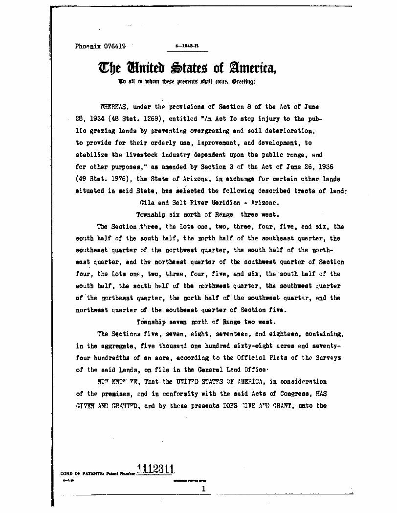
Phoenix 076419 4-1048-R
1Ehe 21niteb States of Smerica,5 all to inbom *efle present* *aI[ come, areeting:
WHEREAS, under the provisions of Section 8 of the Act of June
28, 1934 (48 Stat. 1269) , entitled "/n Aot To stop injury to the pub-lic grazing lands by preventing overgrezing and soil deterioration,to provide for their orderly use, improvement, and development, tostabilize the livestock industry dependent upon the public range, 8 ndfor other purposes," as amended by Section 3 of the Act of June 26, 1936
(49 Stat. 1976), the State of Arizona, in exchange for certain other landssituated in said State, has selected the following described tracts of land:
Gila and Snlt River Meridian - trizone.
Township six north o f Renge three west.
The Section.three, the Lots one, two, three, four, five, end six, thesouth half of the south half, the north half of the southeast quarter, thesoutheast quarter of the northwest quarter, the south half of the north-east quarter, and the northeast quarter of the southwest quarter of Sectionfour, the Lots one, two, three, four, five, and six, the south half of the
south half, the south half of the northwest quarter, the southwest quarterof the mrtheast quarter, the north half of the southwest quarter, end thenorthwest querter of the southeast quarter of Section five.
Township seven north of Range two west.
The Sections five, seven, eight, seventeen, and eighteen, containing,
in the aggregate, five thousand one hundred sixty-eight acres and seventy-four hundredths of an acre, according to the Official Plats of the Surveys
of the said Lands, on file in the General Lend Office·NOw KNOw YE, That the UNITFD STATES OF V?AFRICA, in consideration
of the premises, end in conformity with the said Acts of Congress, HAS
GIVEN AND GRANTFD, and by these presents DOES lIVE A'rD GRANT, unto the
1112311CORD OF PATENTS: Patent Number6-2388 ---'-,- -,/
1

.
Phoenix 076419
4-1044-R
said State of Arizona, in fee simple, the tracts of land above described;TO H'VF PX TO HOLD the seme, together with s11 the rights, privileges,immunities, and eppurtennnces, of whatsoever nature thereunto belonging,unto the spid Stete of Arizona, End to its assigns forever; subject toeny vested and accrued water rights for mining, agricultural, manufactur-ing, or other purposes, and rights to ditohes End reservoirs used in con-nection with such water rights, es may be recognized and acknowledged bythe local customs, lews, and decisions of courts; and there is reservedfrom the Innds hereby granted, a right of way thereon for ditches or canalsconstructed by the euthority of the United States Reserving, ala to theUnited States, ell minerals in the'lands so grant;d, together with the rightto prospect for, mine and remove the same as authorized by the provisionsof spid section 8, as amended as aforesail The Lots two three, five, andsix end the southeast cuarter of the northwest quarter 02 Section four andthe Lot six and the south half of the southeast quarter of Section five,in said Township six north of Range three west; and the northeast quarterof the southeast quarter And the south half of the southeast quartgr of Sec-tion eight, the west half of the west helf, the east helf of the northwestquarter, and the northwest quarter of the northeast quarter of Sectionseventeen, and the southeast quarter of the southeast quarter of Sectioneighteen in said To,inship seven north of Renge two west are subject to suchrizhts of way as the 'fountain St4tes Telephone end Telegraph Company meyhave, under the Act of varch 4, 1911.
IN TESTIMONY WHEREOF. I, Franklin D. Roosevelt,President of the United [States of America, have caused these letters to be made
Patent, and the Seal of the General Land Office to be hereunto affixed.
GIVEN under my hand, at the City of Washington, the TWENTIETH
(SEAL) day of OCTOBER in the year of our Lord one thousand
nine hundred and FORTY-ONE and of the Independence of the
United States the one hundred and sIXTY-SIXTH
By the pre,adent~hA*lidl* )D, -R*nu,d:t,sy aliy-~hl·9~vt-1 CluiduLs-·
rD r Ar -4.-
1112311 Chief, Petents Division, m=*120-4 L-d **
RECORD OF PATENTS: Patent Number...._............_-HUI .................
..NOTICE!!
These documents have been scanned!
Do not place un-scanned documents beneath this notice!
Do not remove this notice from this file!
GPO jacket No. 560-102Print Order 61540
Rise Business Services, LLCjob=AZ15 5/10/2019
I Ill lizi Ill li~l lilill Ill ill il ~~I I Ill il ilBox Number= AZ15030
Claim Begin-End: AMC430190-AMC430190
6 Location Notices-Amendments and Supporting Documents
ill'llill'llilll'll'llill'llilillil AZ15030-18 AMC429998-AMC430297
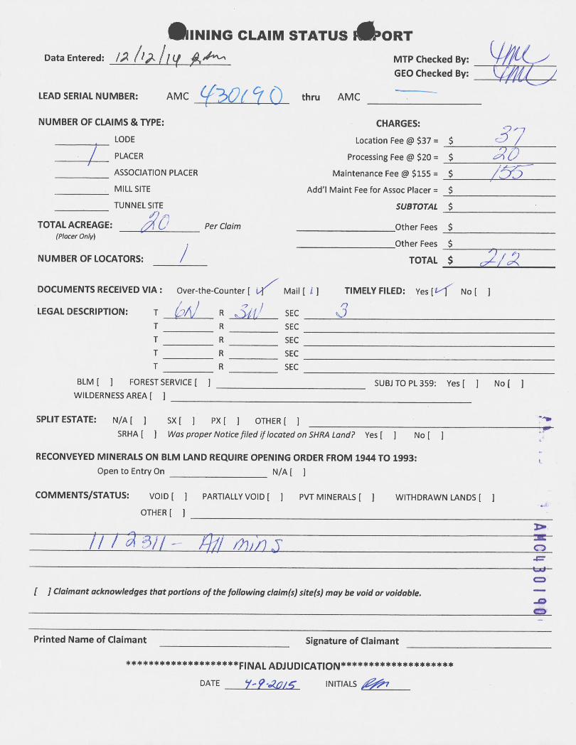
~INING CLAIM STATUS 1~'ORTData Entered : /02 LIBillf */4-.- MTP Checked By:
GEO Checked By: 9AtdyLEAD SERIAL NUMBER: AMC *0< 9 ~ thru AMC
NUMBER OF CLAIMS & TYPE: CHARGES:LODE Location Fee @ $37 = $ 61PLACER Processing Fee @ $20 = $ 54 6/
ASSOCIATION PLACER Maintenance Fee @ $155 = $ i93MILL SITE Add'I Maint Fee for Assoc Placer = $
TUNNEL SITE SUBTOTAL $51 =N
TOTAL ACREAGE : Per Claim Other Fees $(Placer Only)
Other Fees $
NUMBER OF LOCATORS : ~ TOTAL $ OLI Of
DOCUMENTS RECEIVED VIA: Over-the-Counter [ ~- Mail [i] TIMELY FILED: Yes [t/f No [ 1n
LEGAL DESCRIPTION: T (-41/1 R 3 32; 1 SEC Q)T R SECT R SECT R SECT R SEC
BLM [ 1 FOREST SERVICE [ ] SUBJ TO PL 359: Yes[ 1 No [ 1WILDERNESS AREA [ 1
SPLIT ESTATE: N/A [ 1 SX [ ] PX[ ] OTHER[ ] -1.
SRHA [ ] Was proper Notice filed if located on SHRA Land? Yes [ ] No [ 1
1 AMC430
40
RECONVEYED MINERALS ON BLM LAND REQUIRE OPENING ORDER FROM 1944 TO 1993:Open to Entry On N/A [ ]
COMMENTS/STATUS: Vol D [ ] PARTIALLY VOID [ ] PVT MINERALS [ ] WITHDRAWN LANDS [ ]
OTHER [ ]
i 1 1 ..a ~j 1 - f.j j' 011 in 3[ 1 Claimant acknowledges that portions of the following claim(s) site(s) may be void or voidable.
Printed Name of Claimant Signature of Claimant
******************** FINAL ADJUDICATION ********************DATE W-9 .20l.5 INITIALS ~77

LOCATION NOTICE FOR PLACER MINING CLAIMNOTICE IS HEREBY GIVEN that the Go A k e,* Sunrise- *¥ 1 placer mining claim
has been located by T€~6 S , 9~~0 61 P.0. 5 OQ 'llik 9' 4-v-cdKAR , Al9631\ 1.1 9
.
The general course of this claim is R. to 6, and it is situated inVV.jout. r'/OpCK County(ies), Arizona
This claim is \ 33-0 feet in length and to 60 feet in width. This claim runs from thelocation monument on which the location notice is posted approximately 660 feet in a
S direction to the S end line and f 3 j.,0 feet in a ~direction to the S end line. This claim is marked by four monuments, one at each corner ofthe claim.
The location monument on which this notice is posted is situated within Section 3 ,Township 6.10 , Range 3 LJ , Gila Salt River Base and Meridian, Arizona. This claimencompasses portions of the following legal subdivision(s) if located by legal subdivision or the followingquarter section(s), Section(s), Township(s), and Range(s): l·U •~51 9 0,> ~C~ 13 LA 1($ 58 0,
3t TIoM R) LA) , Gila Salt River Base and Meridian, Arizona.The locality of this claim with reference to some natural object or permanent monument and
additional information (ifany) concerning its localityareas folio¥vs: Tko~ 20 0-0 re-5 0~-
AMC430 90'
934£ A *e, RAL.o; 13 locoted 00< SAA hi, Ulc: of Gern 3,T leN RZ \0,
DATED AND POSTED on the ground this o day of Oot ' ,2014·.
LOCATOR(s) 1 8<~DBLM DATE STAMP:
ZV 'XIN30 Hd
bE :1 d 62 030 4101331330 3.l,Li 6 77 s·,rn'(703~, 11' 0-,'w ~
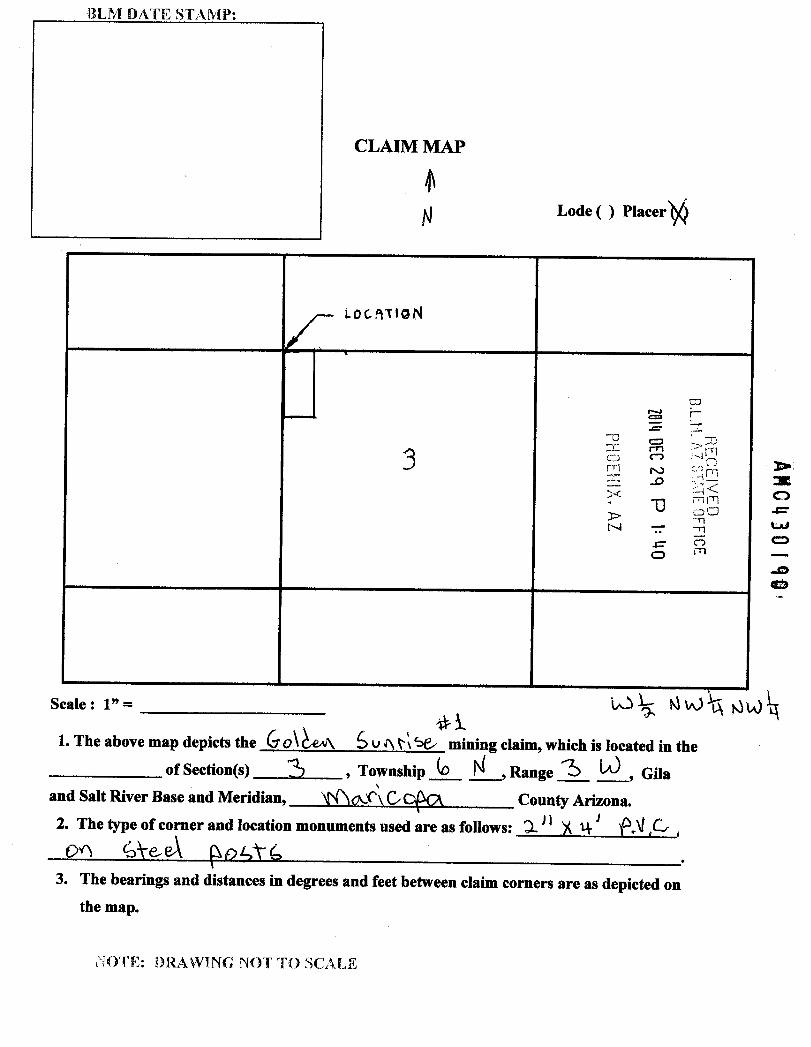
BLM DATE STAMP:
CLAIM MAP
N Lode ( ) Placer *4
LOCATIONCL . CO
r-Z
~C 0 1..., -77
3 3 59 RIA52 ro :] M:4<
U m m> 00-n
71
AM0430 90'
.= 520&''
Scale: 1" = U ts Ajvtf AU) ]11*1
1. The above map depicts the 60\ZAA, 6 v Ar, 545 mining claim, which is located in theof Section(s) 3 , Township G N , Range 3 1.J , Gila
and Salt River Base and Meridian, *(heer\Oc)~kx County Arizona.2. The type of corner and location monuments used are as follows: 4 .* 4 ~ f.v *CD ,04 626€A (104¥G
3. The bearings and distances in degrees and feet between claim corners are as depicted onthe map.
NOTE: DRAWING NOT TO SCALE

RUN TIME: 01:34 PM RUN DATE: 12/29/2014DEPARTMENT OF INTERIOR
BUREAU OF LAND MANAGEMENT Page 1 of 1
Input Parameters for Geographic Report with Land
System Id = CR
Admin State = AZGeo State =
Casetype Begins With
Case Disp Txt = AUTHORIZED, CANCELLED, EXPIRED, PENDING, REJECTED, RELINQUISHED, VOID, WITHDRAWN
Mer Twp Rng
Section
Mtrs = 14 006ON 003OW 003, 14 006ON 003OW 999
Commodity =
Commodity Txt
Pending Org =
Pend Org Decode
Total Rows Returned: 0
NO WARRANTY IS MADE BY BLM FOR USE OF THE DATAFOR PURPOSES NOT INTENDED BY BLM

TOWNSHIP 6 NORTH RANGE 3 WEST OF THE GILA AND SALT RIVER MERIDIAN, ARIZONASTATUS OF PUBLIC DOMAINLAND AND MINERALTITLES
MARICOPA COUNTY
4 41.48 3 42.60 1 2 42.52 | 1 42.42 -4 4233 1 3 4224 4 42.14 [1 42.05 4 4200 | 3 4201 1 2 4201 1 1 42.02 3~·00 t 3 41,96 ' 2 41.92 ! 1 4188 4 41.74 ' 3 41.48 !2 4124 4 4298 4 40.75 '3 40.54 '2 40.32 '1 40.111 1 ~_fll 441 11_111 111 INDEX TO SEGREGATED TRACTS
5 38.86 5 2658 5 39.42 RESURVEY CRIG[NAL SURVEY1 -Fl ~A MS 3905 TRACTI T R SEC SUBDIVISI[»1/20.661
4 3 2 16 lilli :' 6 3767
11 =67-
7 38.84PHI 083587 1]123. IL 237
. 231 1 254 R// 7/ 56 4/15/1919 .C./. LIC 1 VE /1,/ *
13887' \ /
- A2 38.951115292 FOR ORDERS EFFECTING DISPOSAL W USE Or
, 2 laIWIT/FIED LANEr 1//THWAV¥ HIP CLASSI//ITIA1 9 10 11
3 3901 MINERALS, WATER AND/OR OTHER PUBLE Prm/ISES.
REFER TO INDEX OF MISCELLANEOUS DOCUPENTS
WIT. Ml 25 38 071072/0/ 1082895 'L 238 k 242 lL 238 / /2 IL 238W. -C .C D/C D/C ./C Bil MDS 252 NW
139.11PHX 063602
-3 ,g.oil ~IL 242 1 -i J 16559%./C 'ff/ .C
3 39.07 11 17 16 15 14 13
-44 3905Imi IL 242 IL 235D/C I. 56 4/354%9 .C
13907 '
_-1957756B/C -B/C /
J-~~ 11 20 21 22 23 244 39.29
/ 242'066204 ./C I . 2.0 . 242/ 1071856I/C U/C B/r 1 D/C A~ Min
139.35'
239.40M62434 IL 250D/C AU Min .C
23 ZO 8 26 253 39.46
-
4 39.51 : :27& 249 %9475 1058938 IL 240 IL 254D/C D/C % Min D/C D/C ./C
1139.51 -0
- 4 **k* 2 -1
2 39.4510724/D/C
3 39.3 s 31 32 I3 34 35 36
CURRENT TO By3/19/2001 BT
4 39-33|1 233 JOW938 104!719 8/768IIC 56 4/15/1/9 D/C 06 8/C 06 ./C 36 4/5/19Jg tr, 'i:,414
SCALE160 9 20 50 ...........52)ME**15*22{E T.5-NL_30 c,/:5 1. 11,0 i.ek R 3¥_.
25®<ted I laleral movemen. I riven or other bodle~ of wRterRe{*r ~0 th, -da#ral :ur•,e,s for ca10a1 survey Ieformalloo
Related Documents