11 Castle Street, Conwy Archaeological Evaluation I.P. Brooks Engineering Archaeological Services Ltd EAS Client Report 2012/12

Welcome message from author
This document is posted to help you gain knowledge. Please leave a comment to let me know what you think about it! Share it to your friends and learn new things together.
Transcript

11 Castle Street, ConwyArchaeological Evaluation
I.P. BrooksEngineering Archaeological Services Ltd
EAS Client Report 2012/12

Archaeological Evaluation of 11 Castle Street Conwy
Commissioned byA.E.M. Jones
Fieldwork and Analysis by:I.P. Brooks
Engineering Archaeological Services Ltd
Pottery report by:J. Edwards
Faunal Report by:S. James
Engineering Archaeological Services Ltd isRegistered in England No 286978
Archaeological Evaluation of 11 Castle Street, Conwy.
Engineering Archaeological Services LtdClient Report 2012/12
December 2012

Summary
1. Introduction
2. Location
3. Methodology
4. Trench 1
4.1. Topsoil and destruction4.2. Eastern building4.3. Western building4.4. Yard and garden
5. Trench 2
5.1. Kitchen floor5.2. Modern disturbance5.3. Pre-kitchen surface5.4. Dumped material5.5. Possible floors5.6. The rear wall of 11 Castle Street, second yard surface and the well5.7. Third yard surface and activity on the yard5.8. Fourth yard surface and build-up5.9. Fifth yard surface5.10. Clay sealing layer5.11. Upper floors and hearths5.12. Middle floors and hearths5.13. Floors and hearths5.14. Samples
6. Pottery (J. Edwards)
7. Faunal Report (S. James)
8. Other Finds
8.1. Lead8.2. Copper Alloy8.3. Bone handle8.4. Clay pipes

9. Discussion
10. Implications and Recommendations
11. Acknowledgments
12. References
Appendix 1: Context Summary
Appendix 2: Finds Summary
Appendix 3: Specification
List of Figures
Figure 1: LocationFigure 2: Location of the TrenchesFigure 3: Trench 1 plansFigure 4: Trench 1 SectionFigure 5: Trench 2 plansFigure 6: Trench 2 plansFigure 7: Trench 2 plansFigure 8: Trench 2 plansFigure 9: Trench 2 plansFigure 10: Trench 2 SectionsFigure 11: Trench 2 SectionsFigure 12: Number of Identified Specimens Present (NISP) for all Species (N=167).Figure 13: Number of Identified Specimens Present (NISP) for all Elements (N=167).Figure 14: Number of Identified Specimens Present (NISP) for all Cattle (N=26).Figure 15: Number of Identified Specimens Present (NISP) for all Pig (N=21).Figure 16: Number of Identified Specimens Present (NISP) for all Sheep/goat (N=52).Figure 17: Number of Identified Specimens Present (NISP) for all other animals (N=35).Figure 18: Number of Identified Specimens Present (NISP) for all Shells (N=33).
Tables
Table 1: Number of Identified Specimens Present (NISP) for all Species and Elements (N=167
Table 2: NISP species for contexts from Trench 1 (N=38).Table 3: NISP species for contexts from Trench 2 (N=129).
Plates
Plate 1: Trench 1 looking westPlate 2: Trench 1, floor of eastern building

Plate 3: Trench 1, context 10Plate 4: Trench 1, western building, Contexts 6 and 13.Plate 5; Trench 1, the eastern face of Context 6Plate 6: Trench 1, Context 16 showing through Context 12Plate 7: Trench 1, brick patch (Context 11) within Context 12Plate 8: Trench 1, top of Context 19Plate 9: Trench 1, hoof print in top of Context 19Plate 10: Trench 1, hoof print in top of Context 19Plate 11: Trench 1, Context 20Plate 12: Trench 2, Context 25Plate 13: Trench 2, Context 30, looking northPlate 14: Trench 2, Context 28Plate 15: Trench 2, Contexts 31, 32 and 33Plate 16: Trench 2, Contexts 35 and 37Plate 17: Trench 2, Context 36Plate 18: Trench 2, Worn top surface of Context 34Plate 19: Trench 2, Front face of Context 34Plate 20: Trench 2, the wellPlate 21: Trench 2, Contexts 39, 41 and 43Plate 22: Trench 2, Context 40Plate 23: Trench 2, Context 43Plate 24: Trench 2, Context 46Plate 25: Trench 2, Contexts 48 and 49Plate 26: Trench 2, Context 49Plate 27: Trench 2, slates at the base of Context 49Plate 28: Trench 2, Context 50Plate 29: Trench 2, Contexts 51, 52, 53, 54, 55 and 56Plate 30: Trench 2, Contexts 57, 58, 60, 61, 62, 63 and 65

1
Archaeological Evaluation of 11 Castle Street, Conwy
Summary
Two trenches were excavated in the grounds of 11 Castle Street, Conwy. One of these trenches was within the garden, whilst the other was within the 19th century kitchen extension of the house. Both trenches had extensive deposits and were stopped at depths of approximately 1.1 m. Trench 1, in the garden, had the remains of two buildings and a range of yard deposits. Trench 2 had a complex stratigraphy with a sequence of yard deposits giving way to rammed clay floors with hearths.
1. INTRODUCTION
It is intended to adapt 11 Castle Street so that it can revert to a domestic property. The owner, Miss A.E.M. Jones, commissioned this study on the advice of the Gwynedd Archaeological Planning Service, prior to the first phase of the restoration of this important building. This report was commissioned in relationship to a planning application (planning applications 0/38740 and 0/38741) for:
(a) The excavation of one ground floor room providing drainage from a well under the floor (to cure damp)
(b) The Excavation and laying of foul and rainwater drainage system
(c) The erection of a new car port with roof garden over (back of site) excavation for footings for supports (4)
(d) The re-construct the lean to, to provide an outside toilet and change of use to dwelling
The report also has implications for any work to be carried out within the curtilage. The aim of the trenching was to establish the significance of the below ground deposits, in terms of their nature, character and extent, in order to develop a mitigation strategy for any works associated with the restoration of the house and garden.
11 Castle Street is a distinctive building within the centre of Conwy. The house is listed as Grade II* (Listed Building Ref. 3256) and is both within the Castles and Town Walls of Edward I in Gwynedd World Heritage Site, and the Conwy Conservation Area. Previously, a standing building survey and desktop study was commissioned by Miss A.E.M. Jones and carried out in 2009 by Engineering Archaeological Services Ltd and Govannon Consultancy (Gwyn, Brooks and Laws 2009). This revealed a more complex history to the building than had been previously described particularly showing that although the building was assumed to originate in or about 1589, based on the date plaque above the front door, 11 Castle Street incorporated an earlier timber phase of construction. This was dated to 1441/1442 by a series of dendrochronological samples commissioned by the Royal Commission on the Ancient and Historical Monuments of Wales (Miles and Bridge 2010). The later use of the house included its conversion to a public house in the eighteenth century(The Black Lion). It is referred to here as 11 Castle Street, although it has also been known as the Black Lion and Brickdall House.

2
2. LOCATION
No. 11 Castle Street/the Black Lion is situated on the east side of Castle Street in the town and community of Conwy, in the Borough of Aberconwy (formerly the parish of Conwy in Caernarvonshire), at SH 7824 7759 (Figure 1). Two trenches were excavated (Figure 2), one in the rear garden and the other within the 19th century kitchen extension.
3. METHODOLOGY
A specification for the works was written (Appendix 3) and approved by Ashley Batten of the Gwynedd Archaeological Planning Service. Two trenches were defined, one in the garden (Trench 1) and the other within the 19th century kitchen extension to the rear of the property (Trench 2). The excavations took place between 8th
September and 6th October 2012. The topsoil and superficial deposits of Trench 1 were removed with a micro excavator with a smooth faced bucket. All further work was carried out with hand tools.
It was not possible to use a mechanical excavator for Trench 2, partly because of the restriction of space within the building, but largely because of restrictions place on the excavation by Peter Jones-Hughes, the Principal Planning Officer of the Conwy County Council Conservation and Regeneration Section. These restrictions required the tiles, which covered the floor, to be lifted by hand. The concrete bed below the floor was then broken using an electric breaker.
4. TRENCH 1
Trench 1 was 8.3 m long and approximately 1 m wide, it was positioned to sample both of the buildings recognized from the desk top study within the garden and the space between these two structures. It was not practical to excavate this trench completely across width of the garden; however, the trench was of sufficient size to achieve the characterization of the features. The location of the layers and features, below the level removed with the machine, is shown in Figures 3 and 4.
4.1. Topsoil and Destruction
The trench was covered by a layer of topsoil (Context 1) within which was a thin (up to 50 mm) layer of weak concrete at the western end of the trench. This layer is a continuation of the passageway through to the back garden and is therefore a modern attempt to harden the garden surface, probably to allow a car to be parked.
At the eastern end of the trench, Context 2 was a tip of crushed lime mortar and coal fragments. This sits above one of the demolition deposits (Context 3) described below to which it is probably related.
Below the topsoil are a series of demolition layers. Contexts 3, 4 and 5 are loosely packed dumps of large stone blocks and bricks which interleave suggesting that they are broadly contemporary with the different contexts representing different tips of material. The inclusion of corrugated plastic within Context 3 would suggest a twentieth century date for these deposits. At the western end of the trench, within the western building, is a deposit (Context 7) consisting of stone blocks up to 400 x

3
350 mm in size carefully packed into the space left from the destruction of the building at this side of the garden. They are retained by the stub of the western wall of the building which was not completely removed by demolition. It is assumed that Context 7 is contemporary with the other demolition deposits (Contexts 3, 4 and 5). This phase of destruction raised the level of the garden by approximately 400 mm sealing the remains of the buildings and their associated yard surfaces.
4.2. Eastern Building
The building at the eastern end of the trench (Context 14) is a continuation of the service range which runs at right angles to the main range along the eastern side of the property. The floor of the building consisted of a cast concrete floor with a brick lined gutter (Context 8, Plate 1). There are also a series of lines scored into the top surface of the concrete, presumably to encourage drainage. This floor appears to be a relatively late insertion into the building, however its character is reminiscent of a stable with a brick lined gully within a passageway in front of the stalls.
The wall of the building (Context 9) has been heavily robbed, such that only the footings now survive. The wall was originally 550 mm thick and was constructed of stone blocks with a yellow clay bond. This feature aligns with the western wall of the service wing and is a continuation of the standing wall. The width of Context 9 is comparable with that of the standing wall suggesting the demolished section may have been of a similar height with at least 1 � storeys.
Outside the building (to the west) there was a cobbled path running parallel with Context 9 (Context 10, Plate 3). This had a line of bricks, 170 m wide immediately adjacent to the wall (Context 9) which acted as a drip gully. The rest of the surface consisted of well packed stone cobbles typically 120 x 50 mm in size in a sandy mortared base. The surviving path is approximately 600 mm wide, although there is limited evidence that this path may have been slightly truncated. The date of the path is uncertain, whilst stratgraphically it is contemporary the wall of the eastern building, it is more likely that it was constructed at a later date, however its form would suggest that it may be earlier than the concrete floor (Context 8) within the building.
4.3. Western Building
Prior to the excavation the position of the western building could be assessed both from documentary sources and from unevenness in the elevation of western boundary wall of the garden. The floor of the building consists of at least two cast concrete slabs (Context 13) with a series of parallel lines engraved in their surfaces at approximately 130 mm intervals (Plate 4). It is not certain whether this floor is contemporary with the wall of the building (Context 6), however the use of concrete may suggest that it was a later modification of an existing building. The grooves in the surface of the concrete presumably are for drainage, possibly suggesting the housing of animals in this building.
The wall of the western building (Context 6) stands to a height of 260 mm above that of the floor (Context 13). It consists of a series of roughly coursed, stone block faces, 545 mm apart, with a core of loosely packed stones in a yellow lime mortar matrix. The wall has a foundation course which increases the width of the wall by an extra 80 mm. This sits within a foundation trench (Context 17) which has been backfilled

4
with mid-yellowish brown very sandy silt (Context 18) between the wall and the foundation trench. The foundation reached a depth of 145 mm giving a total height of surviving wall 490 mm (Plate 5).
4.4. Yards and Garden
Between the two buildings were a series of yard and garden deposits. The removal of the demolition deposits revealed a yard surface (Context 12) of well packed gravel. This surface had undergone a level of wear, having worn through to the underlying sand bed (Context 16, Plate 6) in one place and having been patched with bricks (Context 11) near to the cobbled path (Context 10, Plate 7). It is likely that this gravel surface is at least partly contemporary with the cobble path (Context 10), however it is possible that the gravel surface was not laid down until a later phase in the use of the cobble path. The sand bed is cut by the foundation trench for the wall of the western building (Context 17) suggesting that the gravel yard surface is contemporary with the construction of the western building.
Below the clean sand bed (Context 16) for gravel surface (Context 12) is a soily layer (Context 19), approximately 70 mm thick whose upper surface was highly poached (Plate 8). Indeed it was possible to identify at least two animal hoof prints in this disturbed surface. Both of these appeared to be from a small pony (Plates 9 and 10).
Context 19 overlay Context 22. This appeared to be a layer of garden soil, approximately 210 mm thick. Whilst this layer included a few fragments of marine shells and animal bones it was relatively devoid of finds. Cut into the top of this layer was a small, shallow, feature of unknown function (Context 20, Plate 11). This feature was at least 600 mm x 380 mm in size, however, the feature extends into the southern baulk of the trench and has been truncated by the construction of the western building. The feature is up to 60 mm thick and is filled with mid-yellowish brown clayey silt with flecks of coal and some shell fragments.
Because of safety factors the excavation was stopped at a depth of 1.1 m below the current garden surface. At this level was Context 23 a layer similar in character to Context 22. However, it contained a noticeably increased quantity of demolition debris including fragments of purple coloured slate, stone flakes and fragments of lime mortar. This layer presumably relates to soil layers developing after a period of destruction; unfortunately it was not possible to investigate this layer further.
5. TRENCH 2
Trench 2 was located within the “New Kitchen” of 11 Castle Street. This range is attached to the north western corner of the main range and is aligned at right angles to the main axis of the building. It is thought that this range was added to the building in the nineteenth century (Gwyn, Brooks and Laws 2009). It is of some interest that the kitchen range was built partly over a well which also extends into the passageway running along the western side of the house. Trench 2 was positioned in an attempt to answer three main questions
1. How does the well relate to the development of the main range of the house?2. Where was the original rear wall of the main range?3. Are there any archaeologically significant deposits preserved below the house?

5
Because of concerns from the Principal Planning Officer of the Conwy County Council Conservation and Regeneration Section it was necessary to lift the tiles covering the floor of the kitchen carefully so that they could be re-used if necessary. Luckily some of the tiles were loose which allowed access to the joint between the tiles and their bed so that the tiles could be lifted with the use of a bolster and hammer.
5.1. Kitchen floor
The kitchen floor consisted of red tiles (Context 25, Plate 12) bedded in cement. Eachof the tiles is 150 mm square and 12.5 mm thick. The top surface has a red slip surface and the underneath is stamped "Dennis", "Ruabon", "Made in Wales” and a variety of batch letters including "M", "O" and "J". Similar tile are still being made at the Hafod Tileries, Ruabon today (http://www.ruabonsales.co.uk/index.htm). The tiles are bedded in a thin layer of cement (Context 26) which in turn sits upon a layer of concrete (Context 27). This floor would appear to be of no great age, possibly relating to the last attempt to restore 11 Castle Street between 2004 and 2008.
5.2. Modern disturbance
Cutting through the underlying deposits is an irregular feature (Context 30) at the northern end of the trench (Figures 5 and 11, Plate 13). Filled with Context 29, this feature ran along the northern end of the trench and became deeper in the north western corner near to the well. The fill was very loose, containing some building debris together with a sparse distribution of domestic rubbish including 20th century china, animal bones and clay pipe fragments. Cutting through the soil layer (Context 28) below the tile bedding (Context 27), this feature would appear to be relatively modern, possibly associated with an investigation of the top of the well prior to laying the tile floor.
5.3. Pre-kitchen surface
Below the bedding for the tiles (Context 27) and cut by the feature at the northern end of the trench (Context 30) was a compacted soily layer (Context 28, Figure 5, Plate 14). It is assumed that this was the garden soil before the construction of the new kitchen range, probably in the 19th century. This layer tended to be thicker away from the wall in the southern end (Context 34) of the trench which is assumed to be the rear wall of the house in 1589.
5.4. Dumped material
Sealed by Context 28 was a series of what appeared to be dumped deposits. Context 31, (Figures 5 and 10, Plate 15) consisted of a dump of crushed lime plaster with the occasional fragment of slate tile. Immediately to the north was a dump of clayey material (Context 32) with occasional flecks of a similar lime mortar to Context 31. Although there were no diagnostic fragments this layer gave the impression of having been part of a daub structure, possibly a wall. It is therefore possible that these layers mark a restructuring of part of the house with the replacement or destruction of a wattle and daub wall together with part of its associated roof. This interpretation remains speculative, however, given the small size of the trench.
6
Partly sealed by both Contexts 31 and 32 was a very thin layer (up to 5 mm) of veryclean gingery orange silty clay (Context 33). The origins of this context is not clear, however it would appear to be accumulating on the underlying yard surface.
5.5. Possible floors
Below Context 33 (Figure 6, Plate 16) were the remains of a hard packed clay floor surface (Context 37). This layer became very thin towards the south, where the underlying deposits were exposed and merged laterally with what appeared to be a rough yard surface (Context 35) to the north. The character of Context 37 suggests that it may have been an internal floor with a smooth, rammed clay surface. Context 35, however had a series of large angular and sub-angular blocks and at least one large stone cobble forming a rough surface. No structural remains were recorded to separate these two deposits, possibly suggesting a fairly flimsy structure attached to the rear of the house before the 19th century kitchen was constructed.
5.6. The rear wall of 11 Castle Street, second yard surface and the well
Sealed below the possible floor (Context 37) and extended over the majority of Trench 2 was a well preserved cobbled surface (Context 36, Figure 6, Plate 17). Although there is a slight dip at the northern end of the trench this layer links the top of the rear wall of the main range of the house (Context 34) to the surviving top surface of the well. Clearly a well-made cobbled yard surface this layer has a series of pitched cobbles set in gritty sand bedding. Adjacent to the junction with Context 34 there is a tendency for larger, flat blocks to have been used and this area has been consolidated with lime mortar, an approach which has not been used for the rest of the surface.
The top of the wall (Context 34) appears to have a worn surface (Plate 18), which given the hardening of the cobble surface at this end of the trench may suggest that there may have been a doorway at this point of the house. This would make some sense as a doorway at this end of the building would give easy access to the well. The wall is within a foundation trench (Context 44, Figures 6 and 7) which is filled with Context 38. This feature, although 0.3 m wide at the top, becomes very narrow with the wall being constructed against the cut only 80 mm below the level from which the foundation trench was cut. This is just below the base of the cobbled surface (Context 36) suggesting the wall and the yard surface were contemporary. The face of the wall extended down through the trench (Plate 19) and continued below the level at which the excavation was stopped. This depth of foundations for a wall only supporting two storeys is unusual, possibly hinting at a cellar below the main range.
The well is constructed of coursed stone blocks forming a tube 1.04 m in diameter (Plate 20) reaching a depth of 3.4 m with 1.1 m of water in its base at the time of the excavation. The rear of the blocks lining the well reaches through to the north western section of Trench 2. Here they are irregular in shape demonstrating that only the internal face of the well was finished to any standard. The blocks are packed with a soily layer (Context 42 within a cut (Context 45) which appear to be slightly irregularin shape. This cut is evident down to a depth of approximately 0.80 m below the tile floor, possibly suggesting that the tube cut to build the well had a bell shaped top leading to a near vertical shaft which was then lined with the stonework.

7
Stratigraphically, it would appear that the well, rear wall of the main range and the cobbled yard surface are contemporary. The cobbled surface contained a lead musket ball, amongst the cobbles and it was noticeable that the few clay pipe fragments recovered were all from above the cobbled surface. Pottery recovered from below the cobbled surface would suggest that this surface may be 17th century in date (Edwards this report)
5.7. Third yard surface and activity on the yard
Below the cobbled floor is a layer of yellowish orange sandy silt (Contexts 39 and 41, Figure 7, Plate 21) which, although divided into two separate contexts, is probably a single context with a worn patch through which the underlying stratigraphy shows. Pottery recovered from this context would appear to be 17th century in date (Edwards this report) giving a possible terminus post quem for the cobbled yard surface above.
Perhaps the most surprising feature to be recorded was a stake-hole (Context 40) cut through Context 39. This feature was completely empty, possibly suggesting that the timber it held was still in place when the cobble yard surface was laid and that consolidation took place before the timber rotted. It was an oval hole, 110 x 89 mm in plan, reaching a depth of 500 mm. The timber appears not to have been vertical as the hole is angled to the west (Figure 7, 10 and 11, Plate 22).
The base of Context 39 becomes sandier with patches of discoloured sand (Context 43) which suggest it has been heated (Figure 7, Plate 23). Within the largest of these discoloured patched was a cake of lead (see below) which was possibly cast on site.
Below Context 43 was a possible yard surface (Context 46, Figure 7) consisting of a series of irregular stones with worn upper surfaces in a matrix of grey/brown gravelly sand (Plate 24).
5.8. Fourth yard surface and build-up
A lower possible yard surface (Context 48, Figure 8, Plate 25) consisted of a tumble of large angular stone blocks with the occasional slate fragment which appear to have a worn top surface. Sitting on top of this surface was a soily layer which presumably built up on the possible yard surface.
5.9. Fifth yard surface
Below the stone blocks of Context 48 was a better defined surface consisting of rammed mottled yellow clay with the occasional stone block (Context 49, Figure 8, Plates 25 and 26). The only sherd of pottery from this layer is dated to the mid to late 13th century (Edwards this report), although this would only give a terminus post quem as the sherd could be residual. Resting at the base of this layer were two “moss” slates (Plate 27) which appear to be related to each other and possible slipped from a roof at the same time prior to the laying of Context 49.
5.10. Clay sealing layer
Lying below Context 49 and sealing the whole of the trench was a thick (up to 150 mm) layer of stiff brown clay (Context 50, Plate 28). This layer was very clean without other inclusions except the rare fleck of charcoal. It is clearly a deliberate

8
attempt to seal the underlying deposits. Indeed the character of the underlying contexts changes from probable external yard surfaces to what would appear to be a series of internal floor levels with a very complex stratigraphical sequence.
5.11. Upper floors and hearths
The change in character of the contexts below the clay floor became immediately evident (Plate 29). Possibly three phase of changing floor surfaces were identified, the top of which consisted of Context 53 (Figure 8), a rammed clay floor with a burnt patch, probably a hearth (Context 55) at its northern end. A second possible hearth was located in the south east corner of the trench. Although this feature (Context 51 was less well fired than Context 55, it consisted of a quadrant of rammed clay, slightly hardened through heat. Assuming this was originally a circular, or near circular, feature it would have been 0.8 m in diameter. It is now cut by the foundation trench for the wall (Context 44) demonstrating that it is earlier than the standing building. The northern side of the trench has a gravel surface (Context 54) possibly suggesting a break between an internal and external space, however, the small size of the trench makes this speculative.
5.12. Middle floors and hearths
Below a mid grey soily layer (Context 52) was a rammed clay floor (Figure 9, Plate 30) with a hearth (Context 61) on its surface. The north western corner of Context 60 has also been discoloured through heat, although this feature does not have the structure of the probable hearth which had a dished surface filled with fragments of charcoal. Speculatively, the eastern edge of Context 60 appears to form a near straight line. If this marks the alignment of the building associated with Contexts 60 and 61 then this building was on a slightly different alignment to the standing building. The relationship with Context 65, a similar rammed clay floor on the eastern side of the trench is uncertain.
5.13. Floors and hearths
Stratigraphically below Context 60, although at the same level physically was a layer of yellowish grey clayey silt with pieces of charcoal trampled into its top surface, which has been interpreted as a possible disturbed clay floor. This context would appear to be associated with another possible hearth (Context 63) in the north western corner of the trench (Figure 9).
At the other end of the trench, separating Contexts 60 and 65 was a soily layer (Context 59) which gave way to greyish yellow clayey silt with the occasional patches of raw clay (Context 58) which appeared to run below both Contexts 60 and 65). Below this level (seen only in a small sondage) was a soily layer with some domestic rubbish (largely marine shells) within its matrix.
5.14. Samples
During the course of the excavation, ten samples were taken for possible further investigation. All of these samples were from Tr 2 and consist of one sample of crushed mortar, two of clay and seven of charcoal. These are detailed below.

9
Sample Trench Context Type1 Tr 2 31 Crushed mortar2 Tr 2 43 Possible clay floor3 Tr 2 50 Sealing clay layer4 Tr 2 39 Charcoal5 Tr 2 41 Charcoal6 Tr 2 48 Charcoal7 Tr 2 52 Charcoal8 Tr 2 57 Charcoal9 Tr 2 61 Charcoal
10 Tr 2 62 Charcoal
To date no further analysis of any of the samples has taken place. They will be retained, however at this point the added information gained from the samples is not considered to sufficient for further work to be commissioned.
6. Medieval and post-medieval pottery (J. Edwards)
Sixty-eight sherds (1106 g) of predominantly post-medieval pottery were retrieved from two trenches at the rear of 11 Castle Street, Conwy, a property that backs on to the town wall on the eastern side of the town.
Methodology
The pottery has been identified and recorded in accordance with the minimum standards of the Medieval Pottery Research Group (MPRG 2001). All the pottery has been quantified by sherd count and weight according to ware type and where possible form within context groups; any particular features of form, decoration or peculiaritiesof ware have also been noted. The terms used to identify the wares are those common ware names used in the Cheshire West and Chester Historic Environment Team (CWAC) ceramic reference collection supplemented by post-medieval terms recommended by the Potteries Museum during an English Heritage sponsored training course in 1999. Forms have been defined as far as possible using terms recommended by the Medieval Pottery Research Group (MPRG 1998).
Fabric descriptions are given for the medieval and earlier post-medieval wares and are appended to the report. These descriptions are written in line with the methodology set out in the Pottery Archive Users Handbook, produced by the former Departmentof Urban Archaeology, Museum of London (DUA 1984). A fabric number has been assigned in a series starting with one, this is correlated to fabric numbers in CWAC series where appropriate.
This report describes and discusses the ceramic assemblage; details of each sherd are recorded separately in a Microsoft Excel spreadsheet.
Condition
The assemblage is made up of fragments of vessels. No complete vessels survive but some fragments are large and join to form parts of two vessels – a blackware costrel in (39) and a bowl in (28). Surface condition varies, some of the smaller fragments are
10
slightly abraded but larger fragments appear freshly broken, particularly the sherds from contexts (28), (36) and (39). These sherds are potentially contemporary which prompts a suggestion that part of the assemblage may be derived from a primary deposit of pottery perhaps of seventeenth century date.
Range
The assemblage is not particularly large and the fragments were produced from thirteen numbered deposits and unstratified material therefore it is difficult to draw any firm conclusions from material present or absent. Blackwares form the largest ware group in the assemblage (23 sherds, 360 g) which is quite common for the North Wales/Chester region in the post-medieval period.
The assemblage contains material dating from the thirteenth century through to the late nineteenth or early twentieth however it does fall into two principal chronological groups. Nineteen fragments, 213 g, are from vessels produced in the nineteenth and/or twentieth centuries and 40 sherds, 779 g in the sixteenth – possibly early eighteenth century. This earlier group consists of blackwares, brown-glazed wares, slipware, yellow ware, Midland Purple-type ware and Cistercian type ware. There are three fragments from medieval wares.
Whilst the later wares are mass-produced products that could have been made in a number of factories operating in the British Isles the earlier wares are likely to have been largely made in North Wales, Merseyside or Staffordshire.
There are no Continental imports in the assemblage which might perhaps been expected from an urban household assemblage and only one fragment from a vessel that may have been made from beyond the region outlined above.
When they can be identified the forms represented consist of table and storage wares: jars, cups, dishes, plates and a small standing costrel. One vessel can be identified as having a food preparation function, a white ware mould for making blancmange or some other jelly type food, this was found unstratified in Trench 2. The mould is printed in black lettering.
Description
Trench 1
Pottery was found in contexts (4) a layer of collapse/tumble, (12) gravel yard surface, (19) yard surface and (22) garden soil. The fragments are small and a number of pieces are abraded or have surface deposits/accretions probably acquired post-deposition. The larger pieces survive because they are part of a base (Cistercian-type ware cup) or a handle (Staffordshire slip-coated ware mug) and are relatively thick compared to the other fragments.
The assemblage is mixed in date, varying from a sixteenth-century Cistercian-type ware, a Midland Purple-type ware similar to that from Trench 2 and of sixteenth or early seventeenth century date, seventeenth century blackwares, brown-glazed ware and slipwares, an early eighteenth century Staffordshire mug fragment and nineteenth-twentieth century mass produced fine earthenwares and storage wares. There is a

11
broad chronological progression from the seventeenth century ware in context (22) through to the nineteenth century in (4) however residuality is clearly quite high and it would be unwise, considering the condition of the material, to treat this dating evidence as anything other than a terminus post quem. The brown glazed ware in (22) is very similar to the bowl in Trench 2 (28) but the piece is too small to be able to identify it from the same vessel.
Table 1 - Trench 1 wares by context
Context Ware FormSherd count Weight (g)
4 Transfer printed ware-Flow blue jug? 1 312 19th/20th century whiteware - 1 112 Transfer Printed Ware 19th/20th 1 112 Buff stoneware bowl 1 719 Slipware – trailed dish 1 819 Blackware – slip-trailed cup 1 219 Cistercian-type ware cup 1 2419 Midland Purple-type ware - 1 619 Staffs slip-coated ware mug 1 1322 Vitrified brick/daub - 1 1222 Brown glazed ware bowl 1 3
Total 11 80
Trench 2
The contexts from this trench are discussed under the phase headings provided by Ian Brooks. A table showing the wares and forms from each context can be found below.
Phase 1 Floors and hearths and associated layers at the bottom of trench
No pottery was found.
Phase 2 Floor and hearth and activity on the floor
No pottery was found.
Phase 3 Floors and hearths
No pottery was found.
Phase 4 Clay seal
No pottery was found.
Phase 5 Yard surface
A single fragment of medieval pottery was found in context (49) (7 g); the sherd is abraded but made from a red/grey firing iron-rich earthenware clay with a reduced green glaze on the exterior. The fabric is similar to sample sherds in the Cheshire

12
West and Chester Fabric Reference collection from the Rhuddlan kiln excavations of 1969-73 (Fabric 267, Axworthy Rutter 1990) although it differs from those described in Quinnell (1994). The kiln is dated to the mid-late thirteenth century. Despite the doubt over its identification the sherd is the earliest retrieved from the site.
Phase 6 Yard surface and activity on the surface
No pottery was found.
Phase 7 Stake hole and activity in yard on the yard surface
An abraded fragment (1 g) of an oxidised ceramic which cannot be identified as to pottery or building was found along with two fragments of pottery (13 g) with a glazed Coal Measure clay fabric in this phase. The pottery appears to be from the same vessel and is comparable to pottery found as kiln waste in the Ewloe/Buckley area of north-east Wales which is dated to the fourteenth or fifteenth century (Rutter 1977, Davey and Harrison 1977).
Phase 8 Activity in the yard
Context (39) contained four fragments of blackwares. Two are quite small (4 g) and difficult to identify closely to form or date, they may span the seventeenth and eighteenth centuries. Two sherds join to form the upper part of a small standing costrel which is similar to types found in seventeenth century contexts in Chester (unpublished Hunter St School excavations 1982). Apart from being broken and incomplete the piece is in an unabraded condition and appears freshly broken.
Phase 9 Cobbled yard surface and wall to main house, construction of the well
Context (36) contained fragments of blackware, Midland Purple-type wares, yellow ware and a dish fragment whose ware type could not be identified in the time available.
The blackwares consist of body sherds that are mainly too small to identify as to form but four pieces have the same bright red sandy fabric (fabric 5) and are possibly from the same vessel, perhaps a jar. These survive as larger pieces and in a noticeably better condition that the other blackwares in this context. Blackwares date from the beginning of the seventeenth century and continue throughout the post-medieval period. It is difficult to identify the date body sherds and insufficient work has been carried out to define fabric groups in relation to date, although attempts have been begun in Chester (Edwards 2008). Fabric 5 is similar to blackwares in a mid-seventeenth century group from Chester (Edwards 2009).
Also likely to be from a jar or cistern are three fragments (fabric 7) of Midland Purple-type ware. These wares tend to occur as storage vessels and appear as highly fired vessels varying in colour from brownish purple to greyish purple, they were probably made over a wide area. This particular fabric is found associated with a bung-hole cistern with grid iron stamps and incised wavy lines at the shoulder above the bung-hole of mid sixteenth – early seventeenth century (Edwards 2008, 194-195).

13
Tablewares are represented by three joining sherds from the rim of a seventeenth yellow ware (fabric 8) cup with a brown slip decoration.
The unidentified ware dish (fabric 4) is wheelthrown and has a fine red earthenware fabric, it is probably an import to North Wales and North West England. The dish was glazed but the glaze appears to have been damaged either during firing or after deposition so that it has a dull toffee like appearance. Not enough of the vessel survives to adequately judge its shape or details of the rim form.
Phase 10 Clay floor
Two fragments of a bone china cup with a green transfer print were found in context (35); they date to the late nineteenth or early twentieth century.
Phase 11 Yard surface
No pottery was found.
Phase 12 Demolition debris
A single sherd (6 g) of a seventeenth or early eighteenth century blackware was found in context (32) in this phase.
Phase 13 Trampled garden surface
Context (28) contained blackwares wares which include the base of a mug (fabric 9) and fragments that may be from jars (fabric 3). Most notably in this context are three sherds (244 g) from a brown glazed ware bowl that join to form a complete profile of the vessel, the largest surviving vessel remains from the site.
The bowl (rim radius 130 mm, base 80 mm) has a pinkish buff fabric (fabric 10) with a clear lead glaze giving a yellowish brown colour. Dark red, black and white coloured inclusions in the clay appear as coloured flecks under the glaze and streaks of red and white clay also appear. The bowl has a flared profile and a clubbed rim. A kiln scar consisting of a fragment of red clay sits on the interior of the base partly covered by glaze; it is probably the remains of a spacer used to support a vessel placed within the bowl during firing.
A similar bowl occurs in a group from Crook St Chester (CHE/CRS 73-4 SF101 F128) with a vertical looped strap handle placed below the rim on one side of the body. It is possible this bowl also had a handle. The Crook St assemblage is dated c.1650-1670 (Rutter and Davey 1980, 71).
A fragment in Trench 1 (22) may be from the same or a very similar vessel, it appears to be burnt on the edge of the base.
Phase 14 Investigation of the well top
Context (29) in this phase contained tablewares of largely nineteenth or twentieth century date which include bone china cup, saucer and dish fragments; lusterware jug fragment, transfer printed ware plate, factory slipware bowl with mocha decoration. One of the bone china cup fragments has the same design as the cup in context (35)

14
and may be from the same vessel. Residual in this phase are fragments of brown glazed ware jar (fabric 10) which have a surface deposit that is possibly cess and blackware (fabric 12).
Phase 15 Kitchen floor
No pottery was found.
Table 2 - Trench 2 wares by context
Context Ware Form SherdCount Weight (g)
28 Blackware - 2 1528 Blackware mug 1 2828 Blackware jar 5 3428 Brown glazed ware bowl 3 24428 Brown glazed ware - 1 1929 Blackware - 1 129 Transfer Printed Ware plate 1 229 Bone China dish 1 629 Bone China cup 1 829 19th/20th century whiteware - 1 1029 19th/20th decorated ware plate 1 1529 Factory slipware - Mocha bowl 1 2229 Bone China saucer 1 329 Lustreware jug 1 229 Brown glazed ware jar 2 9632 Blackware - 1 635 Bone China cup 2 236 Blackware jar 3 16836 Blackware - 1 236 Blackware - 1 236 Midland Purple type ware jar 3 3536 Unidentified dish 1 3536 Blackware - 1 836 Blackware - 1 236 Blackware - 1 136 Slipware - trailed? 1 336 Yellow ware cup 3 339 Blackware costrel 2 4839 Blackware - 1 339 Blackware - 1 146 Ewloe-type? 2 1346 abraded ceramic - 1 149 Rhuddlan-type? - 1 7u/s Blackware - 1 41

15
Context Ware Form SherdCount Weight (g)
u/s Transfer Printed Ware mould 1 97u/s Pearlware-Shell edged plate 1 14u/s 19th C buffware - 1 1u/s 19th/20th decorated ware plate 1 16u/s Porcelain dish 1 3u/s Wall tile-C20th - 1 9
Total 57 1026
Discussion
Whilst most of the pottery is quite fragmentary some sherds, particularly in (28), (36) and (39) are in a relatively good condition, comparatively large in size and with the appearance that they are from freshly broken vessels. This may suggest that whilstthey are not in their original place of deposition they have not been disturbed greatly and are perhaps from a disturbed primary deposit such as a pit or perhaps infilling of the well on the site. Whilst blackware body sherds are difficult to closely date the pieces present in these three contexts are accompanied by other wares and fragments of vessels that suggest a potential seventeenth century date. Comparison with well stratified assemblages from Chester that have associated finds dating (clay tobacco pipes and wine bottle) also tends to suggest that there is a seventeenth century element to the assemblage from Trench 2.
The assemblage is relatively small but the range of wares is not dissimilar to that which could be expected from a seventeenth century or possibly late seventeenth/early eighteenth century urban site and is similar to assemblages from the centre of Beaumaris or Chester for this period.
The condition of this earlier post-medieval pottery suggests that there is the potential for a good assemblage of pottery of this period to exist on the site if further excavation took place.
The medieval assemblage is very small (three sherds) and residual to the contexts in which the sherds were found. The condition of the sherds does not rule out the possibility that the pieces may have been brought on to the site during construction or backfilling activity in the past. However outside of high status buildings such as castles and ecclesiastical establishments assemblages of medieval pottery are not common in North Wales and thus the precise role of these pieces in relation to activity on the site in the past must remain open to question.
Appendix
Fabric descriptions
Medieval
Fabric 1 Rhuddlan-type ware

16
Grey core with a red interior margin and surface and a pale grey exterior margin and surface. A hard fabric with a rough feel and an irregular texture. Inclusions: Moderate ill-assorted sub-angular colourless and opaque white quartz grains; sparse grey and brown, sub-angular iron-rich pellets; sparse irregular calcareous fragments and voids. Degraded reduced green glaze on exterior.
Fabric 2 Ewloe-type ware
Grey core and interior margin with a pinkish buff exterior margin. Hard fabric with a harsh feel and an irregular texture. Inclusions: ill-assorted fine to medium sub-angular colourless quartz grains; moderate fine to medium sub-angular red to black iron-rich pellets. Thin dark reduced greenish brown glaze on interior and exterior.
Post-medieval
Blackware
Fabric 3
Colour varies from red to a purple-brown colour, sometimes within the same vessel. The fabric is hard with a feel that can vary from smooth to rough and a fine texture. Inclusions consist of moderate but not very well sorted colourless and opaque grey/white quartz grains that are angular or sub-angular and fine to medium in size; sparse to moderate dark red/brown medium size iron-rich inclusions angular or sub-angular in shape; sparse white clay inclusions appearing as fine to medium lenses orpellets. The black to brown glaze is glossy but can be thin and lustrous. (Comparable to CWAC fabric 121, Edwards 2008, 227).
Occurs as a small standing costrel in context (39) and fragments from other contexts that are possibly jars.
Fabric 5
A hard red fabric with a harsh feel and hackly texture. Inclusions: abundant, well-sorted sub-angular and angular medium sized quartz grains; moderate fine streaks of white clay; moderate ill-sorted, fine to very coarse red iron-rich compound. A glossy crazed glaze. (Similar to fabric 1 at 10 Commonhall St Chester Edwards 2009 unpub grey lit report for LP-Archaeology)
Present as body sherds in context (36).
Fabric 6
A pale red to buff very hard fabric with an irregular texture. Inclusions consist of abundant fine to coarse sub-angular clear, colourless and opaque white quartz; moderate fine to coarse sub-angular and rounded red iron-rich material also present as fine streaks and lenses; moderate fine to very coarse rounded and sub-angular fragments and streaks of white clay. A glossy but sometimes thin black glaze sometimes with a thin layer of red slip beneath. (Comparable to fabric 38 in the CWAC reference collection Edwards 2008, 227)

17
Fabric 9
Orange red fabric which is hard with rough feel and a fine texture. Inclusions: fine to very fine sub-rounded quartz grains; sparse medium sub-angular iron-rich compound; sparse very coarse red sandstone fragments. Glossy black/brown glaze on the interior and exterior.
Present as the base of a mug with horizontal ribbing above base in context (28).
Fabric 12
Hard purple fabric with a fine texture. Inclusion consist of sparse sub-angular whit and colourless fine quartz grains; spars fine to coarse rounded and sub-angular dark red iron-rich inclusions; fine streaks and lenses of white clay. Well glazed on the interior and exterior; glaze can be lustrous on the exterior. (comparable to CWAC fabric 776).
Fabric 4
Unidentified glazed ware
Orange brown/brown core with pale brown exterior margin and surface with a brown interior margin, brown interior surface. Hard fabric with a smooth feel and an irregular texture.
Inclusions: Moderate ill-assorted colourless quartz grains that are pre-dominantly sub-angular and fine to medium in size (up to 0.25mm) and sparse 0.40mm; sparse coarse (1.25mm) sub-rounded pieces of grog, which is a pale brown in colour with quartz and iron rich inclusions; sparse irregular voids up to 1 mm in size which appear to contain remnants of a calcareous material.
The exterior is unglazed and the rim has a thin glaze but a thick dull brown glaze covers the centre with runs going over the rim that have glossy edges. The glaze appears to have been damaged either during firing or after deposition so that it has a dull toffee like appearance.
One vessel is present in this fabric a wheelthrown dish (36) which is probably an import to North Wales and North West England; not enough of the vessel survives to adequately judge its shape or details of the rim form.
Fabric 7
Midland Purple type ware
A fine smooth-looking fabric, ranging in colour from red, brown to purple. A very hard fabric with a rough feel and fine texture. Inclusions: moderate opaque, white and colourless sub-angular quartz, fine pellets and streaks of dark red clay, fine streaks and sub-angular fragments of white clay and angular red-black iron-rich fragments. The glaze is thin and lustrous varying in colour from brown to purple/black.
Comparable to fabric 779 in the Cheshire West and Chester fabric reference collection In Chester this fabric is found associated with a bung-hole cistern with grid iron

18
stamps and incised wavy lines at the shoulder above the bung-hole of mid sixteenth –early seventeenth century (Edwards 2008, 194-195).
Present as three sherds in context (36)
Fabric 8
Yellow ware
A very hard pinkish white fabric with a smooth feel and a fine texture. Inclusions consist of: moderate very fine red clay specks; sparse coarse irregular red clay particles; sparse sub-angular and angular yellow vitrified clay fragments with sparse fragments up to 1.5 mm; sparse fine-medium red iron-rich pellets and irregular fragments; fine streaks of red clay.
Yellow wares are found in a variety of fabrics, they appear to be restricted to the seventeenth century. It is unclear where they were all made but a known site in North West England is at Rainford on Mersey side (see Davey 1991, 127; Edwards 2008, 204).
Fabric 10
Brown glazed ware
Pale pink/buff with an orange/brown unglazed exterior surface. The fabric is hard with a rough feel and an irregular texture. Inclusions are ill-assorted: moderate fine to medium angular and sub-angular colourless quartz grains; moderate rounded and sub-angular iron-rich inclusions and streaks of red clay; moderate fine to very coarse (2 mm) angular and irregular white clay fragments. Glossy clear glaze on the interior through which inclusions show as black/brown flecks and streaks and yellowish flecks.
Seven fragments, 362 g, in contexts (22), (28) and (29) representing a flared bowl and a hollow vessel possibly a jar.
Fabric 11
Brown glazed ware
A hard orange/pink fabric with a smooth feel and an irregular texture. Inclusions: moderate fine to medium colourless and pink sub-angular quartz; moderate fine, medium red and black rounded and sub-angular iron-rich fragments; sparse irregular hard yellow/white clay fragments; moderate red and white clay streaks; sparse sub-angular fine grained pink/white rock fragments. A dull crazed glaze. (comparable to CWAC fabric 295, Edwards 2009)
Fabric 13
Cistercian-type ware
A hard purplish brown fabric with a smooth feel and a fine texture. Inclusions: moderate fine and sparse medium colourless sub-angular quartz grains; sparse

19
medium rounded dark red iron-rich pellets. Crazed, dull brown/black glaze on interior and exterior.
Fabric 14
Slipware
A reddish-brown to purple colour which often appears bright red. The fabric is hard with a smooth feel and fine texture. Inclusions: moderate to sparse colourless and opaque white sub-angular quartz grains which can vary from fine to medium in size; sparse red to brown iron rich inclusion which may be rounded or sub-angular; sparse white inclusions (white clay?) that may be over 1 mm in size. (Comparable to CWAC blackware fabric 784, Edwards 2008, 201)
7. FAUNAL REPORT (S. James)
The majority of the 167 fragments of bone and shell were derived from traditional food-animals (Table 1. and Figure 12.). This assemblage is very small so it is hard to make any meaningful conclusions regarding its formation and significance, however, even a small sample can still provide some useful facts about a site (O’Connor 2003:205). The majority of remains came from Trench 2 (N=129) (Table 2.), with Trench 1 producing very few fragments (N=38) (Table 3). If viewed as a whole assemblage, sheep/goat were the species most commonly identified (N=57 when sheep/goat sized also taken into consideration); these species were treated together because of the difficulty of distinguishing between the certain parts of the skeleton present (Bossneck 1969). Long bones, especially ribs, front and lower hind leg bones dominate the assemblage (Figure 13). A large proportion of the remains also came from sea-shells (N=33), which is to be expected considering the site’s close proximity to the quay and seashore (Shackleton 1969) and Conwy’s long tradition of maritime activity.
Cat
tle
Cat
tle-s
ized
Pig
Pig-
size
d
Shee
p/G
oat
Shee
p/G
oat-s
ized
Hor
se
Cat
Cat
-siz
ed
Har
e
Bird
Oys
ter
Mus
sel
Win
kle
Coc
kle
Non
Iden
tifia
ble
Gra
nd T
otal
Horn core 1 1Maxilla 1 1I1 1 1I2 1 1M1 2 2Atlas 1 2 3Axis 1 1Cervical vertebrae 1 1Scapula 1 1 2Humerus 2 1 4 1 1 9Radius 1 1 6 8Ulna 3 1 4Thoratic vertebrae 1 1 1 1 4

20
Cat
tle
Cat
tle-s
ized
Pig
Pig-
size
d
Shee
p/G
oat
Shee
p/G
oat-s
ized
Hor
se
Cat
Cat
-siz
ed
Har
e
Bird
Oys
ter
Mus
sel
Win
kle
Coc
kle
Non
Iden
tifia
ble
Gra
nd T
otal
Rib 1 4 2 114 5 2 1 1 2 33
Lumbar vertebrae 1 2 1 4Pelvis 1 1 2 1 2 7Femur 1 1 1 3Tibia 1 4 2 1 8Calcaneum 1 1Astragalus 1 1 1 3Metatarsal 1 1 2 1 5Phalange 1 1 2Vertebrae 2 1 1 4Long bone 1 8 8 17
Shell 115
10 5 3 34
Non Identifiable 1 7 8
Grand Total 18 8 14 735
17 3 3 1 1 4
15
10 5 3
23
167
Table 1. Number of Identified Specimens Present (NISP) for all Species and Elements (N=167).
Figure 12. Number of Identified Specimens Present (NISP) for all Species (N=167).
NISP Species (N=167)
0
5
10
15
20
25
30
35
40
Cow
Cow
-siz
ed Pig
Pig-
size
d
Shee
p/G
oat
Shee
p/G
oat-s
ized
Hor
se Cat
Cat
-siz
ed
Har
e
Bird
Oys
ter
Mus
sel
Win
kle
Cock
le
Non
Iden
tifia
ble
NISP
Count of Element:
Species:
21
Figure 13. Number of Identified Specimens Present (NISP) for all Elements (N=167).
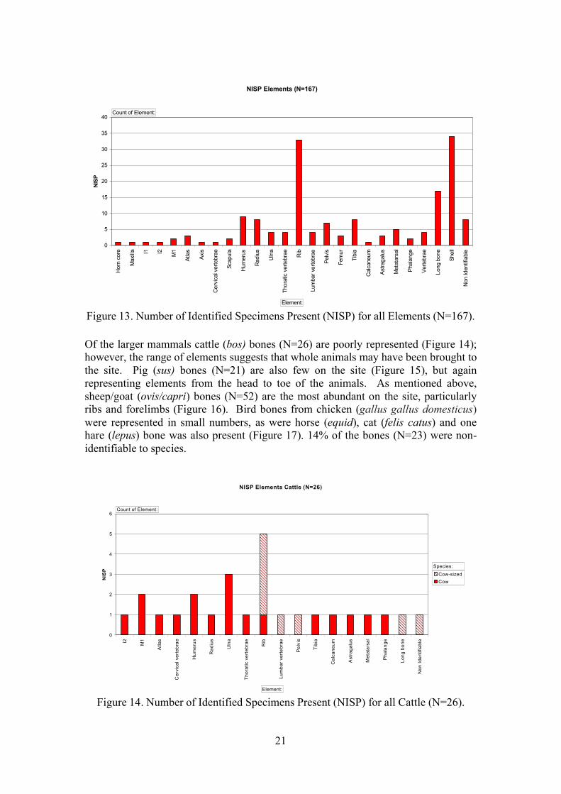
Of the larger mammals cattle (bos) bones (N=26) are poorly represented (Figure 14);however, the range of elements suggests that whole animals may have been brought to the site. Pig (sus) bones (N=21) are also few on the site (Figure 15), but again representing elements from the head to toe of the animals. As mentioned above, sheep/goat (ovis/capri) bones (N=52) are the most abundant on the site, particularly ribs and forelimbs (Figure 16). Bird bones from chicken (gallus gallus domesticus)were represented in small numbers, as were horse (equid), cat (felis catus) and one hare (lepus) bone was also present (Figure 17). 14% of the bones (N=23) were non-identifiable to species.
Figure 14. Number of Identified Specimens Present (NISP) for all Cattle (N=26).
NISP Elements (N=167)
0
5
10
15
20
25
30
35
40H
orn
core
Max
illa I1 I2 M1
Atla
s
Axis
Cer
vica
l ver
tebr
ae
Scap
ula
Hum
erus
Rad
ius
Uln
a
Thor
atic
ver
tebr
ae Rib
Lum
bar v
erte
brae
Pelv
is
Fem
ur
Tibi
a
Cal
cane
um
Astra
galu
s
Met
atar
sal
Phal
ange
Verte
brae
Long
bon
e
Shel
l
Non
Iden
tifia
ble
NISP
Count of Element:
Element:
NISP Elements Cattle (N=26)
0
1
2
3
4
5
6
I2 M1
Atla
s
Cer
vica
l ver
tebr
ae
Hum
erus
Rad
ius
Uln
a
Tho
ratic
ver
tebr
ae Rib
Lum
bar
vert
ebra
e
Pel
vis
Tib
ia
Cal
cane
um
Ast
raga
lus
Met
atar
sal
Pha
lang
e
Long
bon
e
Non
Iden
tifia
ble
NIS
P
Cow-sizedCow
Count of Element:
Element:
Species:

22
Figure 15. Number of Identified Specimens Present (NISP) for all Pig (N=21).
Figure 16. Number of Identified Specimens Present (NISP) for all Sheep/goat (N=52).
NISP Pig (N=21)
0
1
2
3
4
5M
axilla I1
Axis
Hum
erus
Rad
ius
Thor
atic
ver
tebr
ae Rib
Lum
bar v
erte
brae
Pelv
is
Tibi
a
Met
atar
sal
Phal
ange
Verte
brae
NISP Pig-sized
Pig
Count of Element:
Element:
Species:
NISP Elements Sheep/Goat (N=52)
0
2
4
6
8
10
12
14
16
18
20
Hor
n co
re
Atla
s
Scap
ula
Hum
erus
Rad
ius
Rib
Lum
bar v
erte
brae
Pelv
is
Fem
ur
Tibi
a
Astra
galu
s
Met
atar
sal
Verte
brae
Long
bon
e
Shel
l
NISP Sheep/Goat-sized
Sheep/Goat
Count of Element:
Element:
Species:

23
Figure 17. Number of Identified Specimens Present (NISP) for all other animals (N=35).
The shells represented came from four different species, primarily oyster (ostreidae edulis) (N=15), mussel (mytilus edulis) (N=10), winkle (littorina littorea) (N=5) and a few cockles (cerastoderma edule) (N=3) (Figure 7.). No fish bones were present in the assemblage.
Figure 18. Number of Identified Specimens Present (NISP) for all Shells (N=33).
For Trench 1, context 19 produced the most evidence of faunal activity. Not only did it produce bones from all the three main domesticates (cattle, pig and sheep/goat) and some sea-shells (Table 2.) but it also appeared to be trampled by various animals
NISP Elements Other Animals (N=35)
0
1
2
3
4
5
6
7
8
9Sc
apul
a
Hum
erus
Uln
a
Thor
atic
ver
tebr
ae Rib
Pelv
is
Fem
ur
Tibi
a
Astra
galu
s
Met
atar
sal
Verte
brae
Long
bon
e
Non
Iden
tifia
ble
NISP
HorseCatCat-sizedHareBirdNon Identifiable
Count of Element:
Element:
Species:
NISP Shells (N=33)
0
2
4
6
8
10
12
14
16
Shell
NISP
OysterMusselWinkleCockle
Count of Element:
Element:
Species:

24
including a possible pony. Eight of the bones from this context also displayed butchery evidence in the forms of chop marks (N=5), cut marks (N=2) of being deliberately split (N=1). Many of the remains from this context were highly fragmented, possibly due to trampling or as the result of domestic butchery.
Context: Cow
Cow
-siz
ed
Pig
Pig-
size
d
Shee
p/G
oat
Shee
p/G
oat-s
ized
Hor
se
Cat
Cat
-siz
ed
Har
e
Bird
Oys
ter
Mus
sel
Win
kle
Coc
kle
Non
Iden
tifia
ble
Gra
nd T
otal
7 2 1 3 619 3 1 2 1 4 2 3 1 1 1821 1 1 222 1 2 1 1 1 1 723 1 1 1 2 5
Grand Total 4 3 4 2 9 4 1 0 0 0 0 3 1 3 0 4 38
Table 2. NISP species for contexts from Trench 1 (N=38).
For Trench 2, contexts 29 and 49 produced the most evidence of faunal activity. Context 29 was made up of a mixture of modern domestic waste including faunal remains, ceramics and stone fragments. The animal bone from this context comes from the main domesticates and one cat. Bones from context 29 generally do not display any butchery evidence but they are highly fragmented. All three main domesticates were represented in context 49; there were no sea-shells from this context. Butchery evidence is rare apart from some chop marks (N=4) and a cut mark (N=1). The bones were highly fragmented. Faunal remains from older contexts appear to coincide with activity in the yard (Phases 8-5) rather than floor and hearth activity (Phases 3-1).
Context: Cow
Cow
-siz
ed
Pig
Pig
-siz
ed
She
ep/G
oat
She
ep/G
oat-s
ized
Hor
se
Cat
Cat
-siz
ed
Har
e
Bird
Oys
ter
Mus
sel
Win
kle
Coc
kle
Non
Iden
tifia
ble
Gra
nd T
otal
28 3 2 3 829 1 1 1 7 1 1 1 7 2031 1 132 2 1 1 1 2 1 1 1 1035 1 136 1 2 4 2 3 3 1537 1 1 238 2 239 1 1 4 3 4 1 1441 1 142 1 143 1 1 246 2 2 3 2 1 1047 1 1 2 3 1 1 1 1 1148 1 2 1 1 5

25
Context: Cow
Cow
-siz
ed
Pig
Pig
-siz
ed
She
ep/G
oat
She
ep/G
oat-s
ized
Hor
se
Cat
Cat
-siz
ed
Har
e
Bird
Oys
ter
Mus
sel
Win
kle
Coc
kle
Non
Iden
tifia
ble
Gra
nd T
otal
49 4 3 3 2 2 3 1752 1 1 1 1 453 1 3 1 5
Grand Total
14 5
10 5
26
13 2 3 1 1 4
12 9 2 3
19
129
Table 3. NISP species for contexts from Trench 2 (N=129).
Whole animals are not represented from either Trench 1 or 2, suggesting that the animal remains were brought purposefully to the site by people rather than from natural taphonomic processes. The remains are also spread throughout many different contexts and phases of the site suggesting that this assemblage represents many different individual animals rather than different elements of the same animal. The remains are unarticulated; instances where two contemporary bones may belong to the same animal are noted within the database. Most of the remains are very well preserved, some of the sea-shells are beginning to flake and fragment. No gnawing is evident on any of the remains which suggests that they were covered soon after they were discarded. It is impossible to tell the age of death for most animals; some fusing was present on identifiable bone (Silver 1969). One cattle bone was from an individual older than 3.5 years and one from an individual less than 3.5 years old, two pig bones were from animals less than 1year old and seven sheep/goat bones came from animals at least 10-12 months old. With such a small sample it is impossible to comment on farming or dietary choices represented by this assemblage. Measurements were taken where possible from the bones following Von Den Driesch’s (1976) guidelines; these are noted within the database but too few to draw any meaningful discussion from. Four bones were completely black from burning. Although evidence of butchery is rare on the bones (N=30), it does seem probably that domestic and culinary activity was carried out on the site and the assemblage represents the build up of refuse material from over 500 years of site occupation.
8. OTHER FINDS
8.1. Lead
Two lead objects were found, both from Trench 2.
TR 2 Context 36, SF1. Lead ball 19.54 mm (0.77 inch) in diameter weighing 39.5 g (1.39 oz). There is a moulding sprue 4.9 mm in diameter and 3.4 mm long on the top. Probably a musket ball. Its size and weight would suggest an 11 bore weapon (Foard 2009)

26
Tr 2 Context 38, SF2. Part of a lead cake which, originally, would have been 99 mm in diameter. It forms a shallow dish shaped cake, 11 mm thick with a lip 21 mm high. Several other fragments were associated with this object. It is possible that this cake was cast in situ.
8.2. Cooper alloy
Tr2, Context 38, SF 3. A copper alloy tube 29.6 mm in length and 2.4 mm in diameter, with an internal bore of about 1.6 mm. The function of this object is unknown.

27
Tr1 . A cast oval plaque 56.7 x 40.1 mm in size, showing a classical urn with a wreath decoration around the rim. It is assumed this is a 19th century furniture fitting and having been found in an unstratified context it is of limited interest.
8.3. Bone handle
Tr2, Context 29. The bone handle for a knife, 77.2 x 14.3 x 8.7 mm in size. The handle tapers slightly towards blade and has the remains of an iron tang still in position. This was clearly a small knife, possibly a fruit knife, and is likely to be late 19th or 20th century in date
8.4. Clay Pipes
A total of 14 fragment of clay pipes were recovered during the course of the excavation. Three of these were from Context 12 of Trench 1, whilst the rest were found in Trench 2. Only one bowl fragment was found (Tr2, Context 29), this was from a large bowl (probably 20 mm in diameter and 35 mm deep) of 19th century type.
Within Trench 2 the clay pipe fragments were recovered from Contexts 28, 36 and 37. All of these are above or within the cobbled yard surface (Context 36) suggesting the deposits below this level were earlier than 17th century. It is noticeable that the bore of three stems found in either Context 36 or 37 are relatively large possibly suggesting that these pipes were relatively early examples.

28
9. DISCUSSION
Based on the information then available, Kelly (1977) recognized the eastern side of Castle Street as one of archaeological potential, for the buildup of deposits on the inside of the town walls. He did not, however, consider this to be a key area,recommending only that any development in this area of the town was covered by an archaeological watching brief. This recommendation was inevitably a product of its time having been made before developer funded archaeology became the norm and it can therefore only be used as an example of changing archaeological priorities. More recently there have been a number of development led archaeological projects within the town (Evans 2001, Davidson et al 2009, Riley and Dutton 1993, Martin 2002, Owen 2002, Roberts 2010 and Webster 2006) which have added to the known pattern of archaeological survival within Conwy. Of particular interest are the evaluationexcavations and watching brief carried out by Gifford’s in 2002 on the former TA centre off Berry Street (Owen 2002, Martin 2002). Here a series of clay surfaces with remains of several hearths or ovens dating from between the late 13th to early 15th
century were recorded. It was also noted that there was a considerable buildup of 19th
and 20th century material adjacent to the interior of the town walls, a pattern that is replicated behind 11 Castle Street. Other excavations, also by Gifford’s, document approximately 1 m of 18th and 19th century deposits from 31/33 High Street (Webster 2006). This excavation was undertaken because earlier excavations in 1975 on the site of the Old Estate Office recorded the truncated remains of medieval pits to a depth of 1.2 – 1.5 m below the ground level (Webster 2009, 13). Also within the 1970s, the report on the excavations in the Old Vicarage carried out between 1963 and 1964 (now the Vicarage Gardens car park) (Butler and Evans 1979) included a note on a small collection of medieval and later sherds of pottery recovered during clearance work on the Conwy Library site in 1970 (Butler and Evans, 1979, 85).
The excavations at 11 Castle Street, therefore, fit into a growing pattern of archaeological survival with a considerable buildup of deposits on the inside of the town walls. Where 11 Castle Street differs, however, is in the complexity and depth of deposits from beneath a standing structure. Trench 1 demonstrates the depth of 18th
and 19th century deposits in the rear of the garden. Whilst the excavation stopped at a depth of 1.1 m below the current garden level the difference in levels between the garden and the quayside immediately on the other side of the Town Walls would suggest that there may be between 2 and 3 m of archaeological deposits within the lower end of the garden. Whilst the top 1.1 m of these deposits are of 18th and 19th
century date it is likely that the lower deposits may be considerably earlier. This section of the town walls were constructed in 1287 (Ashbee 2009, 50) so it is possible that deposits of that age may be at the base of the sequence. The difference in the level of medieval or early post medieval deposits between the two trenches is notable. Two possible interpretations of this discrepancy are possible: firstly that there is a fairly steep slope down the garden with deposits dipping down by 2 – 3 m over the length of the garden; or, secondly the garden many have originally been terraced. Of the two interpretations the second is probably more likely, although Tr 2 covered a relatively small area, the deposits in this trench do not appear to dip at a sufficient rate. Also the early seventeenth century view of the town (reproduced in Ashbee 2007) would appear to show formal gardens within this part of the town, although it is distorted such that 11 Castle Street, itself, cannot be identified.

29
Trench 1 was successful in locating both of the buildings seen on the historic mapping. The western building is recorded on the 1889 Ordnance Survey Map and is therefore likely to be 19th century in date. It had received a new concrete floor at sometime late in its use, as had the eastern building, and was still standing in 1935 when it appears on the map attached to the Conveyance of the property. The building was deliberately demolished in the mid to late 20th century and the rubble used to level this end of the garden and fill the remains of the building.
The eastern building probably had a more complex history. It is known to have existed by 1776 as it appears on the Bowler map, however it is likely that it is part of the 1589 redevelopment of the property by Rev. J. Brickdall. The clay bonding of the wall suggest that it is part of the surviving service range and is considerably earlier than the mortared walls of the western building. As with the western building, it received a new concrete floor sometime late in its development. The cobble path is probably contemporary with a re-organization of the garden which saw the construction of the western building and the laying of the gravel surface between the two buildings. Earlier than this redevelopment it is somewhat surprising to recover the prints of a small pony in a poached layer. This would suggest that animals were being kept in the garden. Traditionally the “Black Lion” was regarded as the site of the pig market (Gwyn et al 2009) in the 18th century so it is somewhat surprising that the only footprints that could be determined were from a small pony and that so few pig bones have been recovered. The lower deposits within this trench suggest that there may have been a period of little activity, apart from gardening, which followed the destruction of an earlier structure. This remains very tentative as Context 24 which contains a higher quantity of building debris was not excavated.
Trench 2 proved to be of considerable interest, demonstrating a long sequence of deposits which in their lower portion probably pre-date the standing building. It is likely that the tiles of the kitchen floor (Context 25) are relatively modern and may even date to the last attempt to restore 11 Castle Street, in the early 2000’s. It is also likely that the irregular feature (Context 30), at the northern end of this trench, may be of this date and was possible dug to investigate the structure of the well.
Immediately prior to the construction of the kitchen, in the 19th century, the plot would appear to have been an open garden or yard though out most of its history. The one exception is a possible rammed floor level (Context 37) whose character would suggest that it was an internal floor. The structure to which this floor was associated is not known, however, it was likely to have been a relatively temporary structure, possibly attached to the rear of the house.
There would appear to have been a major re-organisation of the yard, possibly in the 17th century. A well-made cobbled floor (Context 36) linked the rear of the house to the top of the well. The wear on the top surface of the wall (Context 34) and the re-enforcement of this end of the cobbled yard would suggest that there was a door in the north eastern corner of the house which gave access to the yard and the well. This arrangement probably lasted until the house was converted into a public house in the 18th century (Gwyn, Brooks and Laws 2009) when a passageway was cut through the ground floor levels of the house giving access to the rear garden. The date of the cobble is suggested to be in the second half of the 17th century by pottery dated to the 17th century, including part of a costrel, (Edwards this report.) in the layer below in

30
Context 39. Also it is noticeable that no clay pipe fragments were recovered from below the level of the cobbles.
The rear wall of the standing building (Context 33) proved to be much deeper than was expected. It reached a depth of at least 1 m below the current floor and appeared to be continuing below the level of the excavation. This possibly hints at a possible cellar below the current building for which there is no other evidence.
It is possible that a limited quantity of industrial activity took place within the yard before the cobbles were laid. The cake of lead was associated with a patch of sand which was discoloured through heat, thus it is possible that it was cast in situ. Below this level were a series of possible yard surfaces. The date of each of these yard surfaces is unknown. Only limited dating evidence was recovered, however, a single sherd of 14th/15th century pottery was recovered from Context 46 and another sherd of possibly mid-late 13th pottery was found in Context 49. It is possible that both of these sherds are residual. It would seem likely that these yard surfaces are related to the standing structure, although their depth might suggest that this was early in the development. Dendrochronological dating of the three main trusses in the house (Miles and Bridge 2010) suggest a date of 1441/1442 for the first phase of the construct of the current house and it is likely that the earliest of the yard levels relate to this date.
The clay layer (Context 50) was distinctive and marked a major change in the character of the deposits. This layer appears to be a deliberate sealing of the site below a thick layer of relatively clean clay. It is tempting to see this layer as a deliberate attempt to seal the destruction wrought on Conwy by the supporters of Owain Glyndŵr in 1401 (Ashbee 2009, 12), however this must remain speculativebecause of the relatively small area exposed within Tr2. Below this level there was a series of clay floors and hearths in a complex sequence, which, given the small size of the trench is not fully understood. It is possible that at least some of these floor levelshint at a slightly different orientation to the current building. The floors predate the standing structure, although their actual date is unknown. The town walls in this part of the town were constructed in 1287 (Asbee 2009, 50) and Conwy gained its charter a year earlier (GAT 1999) so it is possible that the stratigraphy below the current excavation may extend back to the 13th century. Indeed one sherd of possibly mid to late 13th century pottery was found higher in the excavation (Edwards this report.). Another slight possibility is that the deposits may go back as far as the grant in 1186 of the present site of Conwy to the Cistercian order by Llywelyn Fawr (GAT 1999), although this is highly speculative and it is more likely that the deposits in the base of the excavation are from the period between the construction of the town walls in 1287 and the burning of the town in 1401.
A distinctive feature within the curtilage of 11 Castle Street is the well. This carefully constructed feature clearly dates from before the 18th century re-organisation of the property as an inn, as it would have partly blocked the passageway through to the garden. The stratigraphy of Tr 2 would suggest that at least the top of the structure is contemporary with the cobbled yard surface (Context 36) which is assumed to be 17th
century in date. The total number of wells within the town walls of Conwy is unknown, however, three are known from the archaeological record. There is a well of medieval date within the castle (RCHMWM 1956, 50) which acquired a well house in 1316, another of probable 17th century date at Plas Mawr (64) and a third was

31
uncovered during the excavation of the Old Vicarage site in 1963 – 64 (Butler and Evans 1979, 54). This last well is undated, although the excavators commented that upper portions were completed by mortared walling of small shale similar to that in the town wall, unfortunately the top course of the lining was of 19th century brick, although this could be a later coping. Even if other well exist within the town walls they are not common and therefore the well at 11 Castle Street should be treated with some care so that its integrity is not compromised.
10. IMPLICATIONS AND RECOMMENDATIONS
The complexity of the archaeological stratigraphy between the two trenches is as yet an unknown factor. The detailed sequence of layers, recorded in Tr 2, must give way to the somewhat simpler stratigraphy recorded in the lower part of the garden. It is possible that the plot behind 11 Castle Street was originally terraced and therefore the complex stratigraphy recorded in Tr 2 will give way suddenly to the simpler yard deposits. It is possible to interpret the patterning shown in this area of the town on the early seventeenth century view of the town (reproduced in Ashbee 2007) as formal gardens, possibly giving some credence to this possibility. This scenario would mean that in an unknown area near to the rear of the house similar deposits to those encountered in Tr 2 should be expected. Within a metre of the ground surface it is possible that deposits relating to the before the construction of current house survive and above this a series of yard levels from the late fifteenth to the nineteenth centuries. The other possible scenario is that original ground surface sloped down to near sea level and that pre- eighteenth century deposits could be found at increasing depth throughout the garden. It is also noticeable that the excavation recovered very little in the way of cultural remains associated with the use of the building as an inn. Quantities of clay pipes, ceramic, glass and faunal remains would be expected and it is possible that there may be a series of midden or rubbish pits within the garden.
Trench 2 can only be taken to indicate the survival of complex stratigraphy behind the house originally built in 1440/41. No direct evidence was recovered for the survival of archaeologically significant deposits from below the house itself. It is possible that the depth of the footing for the rear wall of the house (Context 34) suggests a filled cellar below the eastern room.
Trench 1, however suggest that there is at least a metre of eighteen century and later build up at this end of the garden consisting largely of demolition debris from the two buildings, known to have been still standing in 1935, and general yard buildup. Whilst there are some details surviving, such as the hoof prints, they are not of any more than of passing interest. The survival of earlier deposits, below 1.1 m from the garden surface, is to be expected. It is probable that there are at least another metre of deposits below the level which has been investigated, the lower level of which may relate to the construction of the town walls. If any ground works, however, are kept to a depth of less than 1.1 m these important deposits should be protected.
The difference in the complexity of the stratigraphy between the two trenches suggests that the archaeological response to any ground works should be different in different parts of the plot. At the end of the garden, furthest away from the house, it is unlikely that significant archaeological deposits will be encountered, however any works should be monitored and sufficient time left in the construction programme for the recording of any archaeological deposits revealed. Nearer to the house, however, a

32
more robust archaeological response will be needed. Ideally any trench or ground disturbance in this part of the garden should be kept to a minimum and be as shallow as possible. All works, below topsoil level, should be carried out by hand, ideally by a suitably qualified archaeologist or at least under archaeological control. The interface between the two levels of response is difficult to assess with the current level of knowledge. A flexible level of response should be adopted with initial archaeological monitoring of any ground works and the provision to convert these works to hand digging under archaeological supervision. The area around the well is of particular interest and all work here should be under strict archaeological control.
The recommendations can be summarized as below:
Any ground works in the northern end of the garden should be restricted to a depth of less than 1.1 m. These works should be subjected to an archaeological watching brief with sufficient time allowed in the construction programme for the recording of any archaeologically significant deposits. This recommendation relates specifically the proposed supports to the carport/raised garden. If other works are considered it will be prudent to consult the Gwynedd Archaeological Planning Service
If practical, any works should avoid the footprint of the buildings known tohave existed in the rear garden. If this is not possible time should be made within the construction programme for the recording of any structures revealed.
In the middle part of the garden, a flexible response should be adopted. Ideally any ground works should be as shallow as possible. Trenches should be dug under a detailed archaeological monitoring with the digging, if possible, done by hand. It is important that time is allowed in the construction programme for the archaeological investigation of any ground works and that the archaeologist has the right to stop the works at short notice if significant deposits are encountered.
In the area near to the house all ground works should be as shallow as possible. Works should be done by hand, ideally by a suitably qualified archaeologist, although it may be possible to do at least some of the work under direct archaeological control. Time should be built into the construction programme for the recording of any archaeologically significant deposits revealed.
In the area around the well, all works should be under taken with direct archaeological control. All works should be as shallow as possible, avoiding damage to the well structure.
Within the house, all works should be as shallow as possible. If any floors are lifted in the house, time must be allowed in the construction programme for the archaeological investigation of any deposits revealed. Further consultation with the Gwynedd Archaeological Planning Service before any works within the house, may be advisable.

33
Within the passageway to the west of the house, any ground works should be restricted to a minimum. Ideally the trench for the existing sewer should be used if practical. If new works are required all work should be carried out by hand and under archaeological control. Time must be allowed in the construction programme for the archaeological investigation of any deposits revealed
11. ACKNOWLEDGEMENTS
This evaluation was commissioned by Miss A.E.M. Jones whose unstinting support is gratefully acknowledged. The topsoiling of Trench 1 was carried out by Mei Black of Xtreme Track Ltd with consummate skill given the small size of the machine and the difficulty of the material being removed. The project was monitored for the Gwynedd Archaeological Planning Service by Ashley Batten and Jenny Emmett.
12. REFERENCES
Ashbee, J.A 2009. Conwy Castle and Town Walls. Cadw
Axworthy Rutter, JA 1990 Pottery. in: Ward SW 1990. Excavations at Chester, the lesser medieval religious houses, sites investigated 1964-1983. Grosvenor Museum archaeological and survey reports no.6. Chester City Council. 138 –163
Bossneck, J. 1969, Osteological differences between sheep and goat, in D. Brothwell and E. Higgs (eds) Science in Archaeology, Bristol: Thames and Hudson, 331-358.
Butler, L.A.S. and Evans D.H.L. 1979 ‘The Old Vicarage, Conwy: Excavations, 1963-4’, Archaeologia Cambrensis CXXVIII, 40-103
Davey, P J 1991 Post-Roman pottery. in: Tomlinson, P. and Warhurst, M. (eds.), 1991, 'The archaeology of Merseyside', Journal of the Merseyside Archaeological Society 7 for 1986-87.
Davey, P J ed 1977 Medieval pottery from excavations in the north west. University of Liverpool.
Davidson, A. Roberts, J. and Jones, P. 2009. Conwy Quay redevelopment programme. Archaeological record and watching brief. GAT Report 2009.
DUA 1984 Pottery Archive Users Handbook
Edwards, JEC 2008 Post-Roman Pottery. In Garner D 2008 Excavations at Chester 25 Bridge Street 2001 two thousand years of urban life in microcosm. Chester City Council 187-242.
Edwards, JEC 2009 A report on the post-Roman pottery and tin-glazed ware floor tiles from 10 Commonhall Street, Chester. Unpublished report for LP-Archaeology, Chester.

34
Evans, J. 2011 St Mary’s Church, Conwy. Archaeological watching brief. GAT Report 2157.
Foard, G. 2009. Guidance on the Recording of Lead Bullets from Early Modern Battlefields. http://www.heritagescience.ac.uk/Research_Projects/projects/Projectposters/Conservation_of_Battlefield_Archaeology_project_report_-_Appendix_3
Gwynedd Archaeological Trust 1999. Historic landscape characterization – Creuddyn and Arllechwedd historic landscape character areas. GAT Report 318.
Hadley, A. 1900 Conway Parish Registers 1541-1793 Charles J. Clark, London
Harrison, H M and Davey P J 1977 Ewloe. in: Davey P J 1977 Medieval pottery from excavations in the north west. University of Liverpool 92- 99
Kelley, M.A. 1977. Conwy’s past in Future. A survey of archaeological deposits in Conwy, Gwynedd. GAT.
Martin, A. 2002. Former TA Centre, Berry Street, Conwy. Archaeological Desk-based Assessment. Gifford Report B4658A.R02A.
Miles D., and Bridge M. 2010, Vernacular Architecture 41, list 227
MPRG 2001 Minimum standards for the processing, recording, analysis and publication of post-Roman ceramics. Medieval Pottery Research Group Occasional paper 2.
MPRG 1998 A guide to the Classification of Medieval Ceramic Forms. Medieval Pottery Research Group Occasional Paper 1.
O’Connor, T. The analysis of urban animal bone assemblages, York: CBA.
Owen, P. 2002. Former TA Premises, Berry Street, Conwy. Report on the Archaeological Works. Gifford Report B4658B.R03.
Riley, H. and Dutton, L.A. 1993. Conwy Vicarage Car Park. Archaeological Assessment and watching brief. GAT Report 65.
Rutter, J A 1977 Upper Northgate Street hoard pot. In: Davey 1977. Medieval pottery from excavations in the north west. University of Liverpool. 22-23.
Rutter, J A and Davey P J 1980 Clay pipes from Chester. in: Davey P J ed Thearchaeology of the clay tobacco pipe III. BAR British series 78. 41-272.
Roberts, J. 2010. Conwy Quay redevelopment programme: interim scheme watching brief – Boat Restoration Area, Oak Bollards and Zone 3 interpretation area. GAT Report 878.
Royal Commission on Ancient and Historic Monuments in Wales and Monmouthshire 1956 An Inventory of the Ancient Monuments in

35
Caernarvonshire. Volume 1: East. The Cantref of Arllechwedd and the Commote of Creuddyn. HMSO, London.
Quinnell H and Blockley MR with Berridge P 1994 Excavations at Rhuddlan, Clwyd 1969-73. CBA Research Report 95
Shackleton, N. 1969, Marine Mollusca in Archaeology, in D. Brothwell and E. Higgs (eds) Science in Archaeology, Bristol: Thames and Hudson, 407-414.
Silver, I. 1969, The ageing of domestic animals, in D. Brothwell and E. Higgs (eds) Science in Archaeology, Bristol: Thames and Hudson, 283-302.
Von Den Driesch, A. 1976 A guide to the measurement of animal bones from archaeological sites, Peabody Museum of Archaeology and Ethnography: Harvard University.
Webster, T. 2006. 31/33 High Street, Conwy, North Wales. Gifford Report 11853.R06.

36
Plate 1: Trench 1 looking west
Plate 2: Trench 1, floor of eastern building

37
Plate 3: Trench 1, Context 10
Plate 4: Trench 1, western building, Contexts 6 and 13.

38
Plate 5; Trench 1, the eastern face of Context 6
Plate 6: Trench 1, Context 16 showing through Context 12
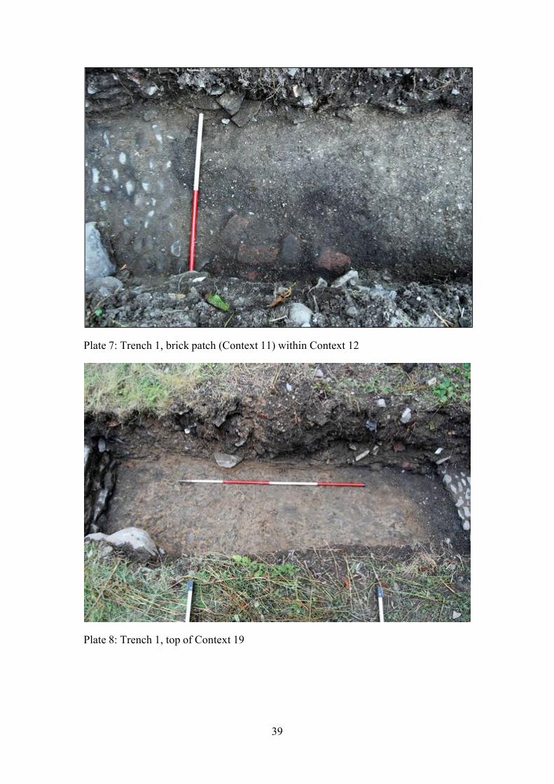
39
Plate 7: Trench 1, brick patch (Context 11) within Context 12
Plate 8: Trench 1, top of Context 19

40
Plate 9: Trench 1, hoof print in top of Context 19
Plate 10: Trench 1, hoof print in top of Context 19

41
Plate 11: Trench 1, Context 20
Plate 12: Trench 2, Context 25

42
Plate 13: Trench 2, Context 30, looking north
Plate 14: Trench 2, Context 28

43
Plate 15: Trench 2, Contexts 31, 32 and 33
Plate 16: Trench 2, Contexts 35 and 37

44
Plate 17: Trench 2, Context 36
Plate 18: Trench 2, Worn top surface of Context 34

45
Plate 19: Trench 2, Front face of Context 34
Plate 20: Trench 2, the well

46
Plate 21: Trench 2, Contexts 39, 41 and 43
Plate 22: Trench 2, Context 40

47
Plate 23: Trench 2, Context 43
Plate 24: Trench 2, Context 46

48
Plate 25: Trench 2, Contexts 48 and 49
Plate 26: Trench 2, Context 49

49
Plate 27: Trench 2, slates at the base of Context 49
Plate 28: Trench 2, Context 50

50
Plate 29: Trench 2, Contexts 51, 52, 53, 54, 55 and 56
Plate 30: Trench 2, Contexts 57, 58, 60, 61, 62, 63 and 65

APPENDIX 1: CONTEXT SUMMARY
11 Castle Street, Context Summary
Context Trench Description Relationships1 Tr1 Topsoil. Pale yellowish grey slightly humic sandy silt with many roots. The layer tends to merge with
layers 2, 5 and 7 below. [modern cultivated garden soil]. The layer also contains the occasional stone block and smaller pieces
Below:Above: 2, 4, 6, 7, 24CutsContainsWithinAbuts
2 Tr1 Layer of crushed lime mortar and coal fragments in a matrix of pale yellowish grey slightly humic sandy silt. The layer also includes the occasional fragment of modern, machine made, brick (up to 60 mm). The layer is up to 150 mm thick and tends to merge with both layer 1 above and layer 3 below. [Demolition debris within the building at the eastern end of the trench].
Below: 1Above: 3CutsContainsWithin: 14Abuts
3 Tr1 Tumble of loosely packed stones and bricks with a thin matrix of pale yellowish brown sandy silt. The layer contains stone blocks up to 200 mm in size, the majority of which are angular in shape; however a few fragments with more rounded profiles are present. The bricks tend to be well made, but do not have frogs. Their size would suggest a nineteenth or twentieth century date. The layer also contained fragments of corrugated plastic sheeting. [Modern collapse/destruction debris].
Below: 2Above: 8CutsContainsWithin: 14Abuts
4 Tr1 Layer of collapse/tumble similar to context 3, but outside building 14. Loosely packed stone blocks and bricks in a thin, pale yellowish brown matrix with many flecks of lime mortar. The stone blocks are generally angular and up to 170 mm in size, however one large block is partly rounded and is 400 x 380 x 350 mm in size. The brick are well made, but do not have frogs. They tend to be 70 mm thick and are probably nineteenth century in date. The layer tends to merge with layer 1 above. [Collapse/demolition debris from building 14]. The layer is 400 mm thick at its eastern end, but only 200 mm thick at the western end where it tends to merge with layer 5.
Below: 1Above: 10, 11, 12CutsContainsWithinAbuts

Context Trench Description Relationships5 Tr1 Tumbled layer similar to layers 3 and 4. Loosely packed stone block, slates and bricks in a thin pale
yellowish grey, sandy silt matrix with fragment of lime mortar. The stone blocks are up to 300 mm in size and tend to be angular in form. The bricks are well made, but lack frogs and are probably nineteenth century in date. The layer also contains fragments of plastic suggesting it is quite recent. It tends to form a wedge, being thicker adjacent to wall 6, but becoming thinner to the east. At its thinnest it tends to merge laterally with context 4. At its eastern end it is up to 400 mm thick, whilst at its western end it is only 150 mm thick. [Collapse/demolition debris from the eastern building].
Below: 1 Above: 12CutsContainsWithinAbuts: 4
6 Tr1 Well-made wall, 500 mm thick and standing to a height of 300 mm above context 12. Parallel stone facing block with loosely packed filling stones. The wall is constructed of roughly coursed blocks in a pale yellow lime mortar. The stone blocks are up to 350 x 350 x 60 mm in size giving a well faced wall. The central filling includes smaller stones and fragments of slates. These are fairly loosely packed. The wall forms the eastern boundary of Building 15.
Below: 1AboveCutsContainsWithin: 17 Abuts: 5, 7, 8Part of: 15
7 Tr1 Loosely packed stone blocks and the occasional brick in a thin, pale yellowish brown sandy silt with flecks of lime mortar. The stone blocks reach the size of 400 x 350 mm, although there are many smaller sizes represented. Particularly on the eastern side of the trench the stones appear to have been deliberately placed, resting on each other, possibly to fill the void formed by the lower section of Building 15 after demolition. The bricks were well made, but lacked frogs. Their size would suggest a nineteenth century date. [Debris from the demolition of Building 15, possible deliberately placed].
Below: 1Above: 13CutsContainsWithin: 15Abuts
8 Tr1 Floor of Building 14. Two large concrete slabs, each at least 600 mm wide and1000 mm long separated by a row of brick which forms a shallow gully 110 mm wide and approximately 150 mm deep. The western slab also has three diagonal groves carved into its surface, probably to aid drainage. [Floor of an animal house, possibly a stable]
Below: 3AboveCutsContainsWithinAbuts: 9Part of: 15
9 Tr1 Heavily robbed wall consisting of some stone blocks and fragments in a pale yellow/cream clayey mortar. The stones are up to 420 x 230 x 100 mm in size; however the majority are more typically 170 x 120 x 40 mm. The wall was originally 550 mm thick. [Robbed wall to Building 14].
Below: 4AboveCutsContainsWithinAbuts: 9Part of: 14

Context Trench Description Relationships10 Tr1 Probably a cobbled path running alongside Building 14. Rounded cobbles, typically 120 x 50 mm in size
laid in a sandy mortar base. Adjacent to Wall 9 there is a line of bricks, 170 mm wide, presumably acting as a drain along the side of Building 14. Each brick is up to 250 x 120 mm in size.
Below: 4Above:CutsContainsWithinAbuts: 9
11 Tr1 Small patch, 750 x 40 mm in size, roughly triangular in shape of very worn bricks. A total of six bricks or brick fragments make up this patch, the complete bricks being 240 x 110 mm in size. These bricks are pressed into the surface of context 12, presumably to act as a patch in the yard surface.
Below: 4AboveCutsContainsWithin: 12Abuts
12 Tr1 Gravel yard surface. Very compact layer of small stones (up to 30 mm in size) in a matrix of yellow/brown sandy silt with crushed lime mortar. The layer appears to be 20 to 30 mm thick, and has a hole worn in to the surface in one place.
Below: 4, 5Above: 16CutsContains: 11WithinAbuts: 10
13 Tr1 Concrete floor within Building 15. Probably two concrete slabs with parallel line engraved at approximately 130 mm intervals.
Below: 7AboveCutsContainsWithinAbuts: 6Part of: 15
14 Tr1 Building extending the line of the kitchen range comprising floor 8 and robbed wall 9. The function of this building may be suggested by the gully running along its length which suggests a possible stable. Other interpretations would suggest this building may have housed the pigs for the market
BelowAboveCutsContains: 8, 9WithinAbuts

Context Trench Description Relationships15 Tr1 Building probably, approximately 4 m wide on the western side of the plot. It appears on the deeds.
Comprising Wall 6 and Floor 13.BelowAboveCutsContains: 6 and 13WithinAbuts
16 Tr1 Layer of clean sand below the yard surface. Pale yellow sand with some mottling of ferrous orange/brown. Almost devoid of other materials. Layer is up to 100 mm thick at its western end, but thins to virtually nothing by the cobble path (Context 10).
Below: 11 and 12Above: 19Cut by: 17CutsContainsWithinAbuts
17 Tr1 Cut running parallel to the eastern side of Wall 6. [Foundation trench]. Feature is 100 mm wide and of unknown depth
Below: 12AboveCuts: 16Contains: 6, 18WithinAbuts
18 Tr1 Mid yellowish brown very sandy silt with few inclusions Below: 12AboveCutsContainsWithin: 17Abuts
19 Tr1 Compact pale greyish/brown sandy clay. Top surface appears to be poached with animal feet. The occasional hoof print can be determined. This appears to be from a small pony. Top surface very compact as if was a surface in regular use. The layer varies between 40 and 120 mm thick, tending to be thicker towards the east and north. Other inclusions within the layer include the occasional animal bone, oyster shell, coal fragment (up to 20 mm) and occasional small sub-angular stone (up to 40 mm). [Yard surface prior to the levelling for the gravel surface above. Multiple animals must have crossed this wet deposit before it was levelled with a bed of sand and a gravel surface].
Below: 6, 11, 12Above: 20, 21, 22CutsContainsWithinAbuts

Context Trench Description Relationships20 Tr1 Shallow scoop, possibly sub-rectangular in shape, but truncated by Wall 6 and extending into the western
baulk. The exposed section of this feature is 600 mm long, 380 mm wide and up to 60 mm deep. The feature has sloping sides and a flat base. [Feature of unknown function].
Below: 6, 19AboveCuts: 22Contains: 21WithinAbuts
21 Tr1 Mid yellowish brown clayey silt with flecks of coal and shell. There were a few small (up to 40 mm) sub-angular stone within the fill. The layer fills the shallow hollow of Context 20.
Below: 6, 19AboveCutsContainsWithin: 20Abuts
22 Tr1 Mid yellowish brown slightly clayey loam with the occasional small (up to 40 mm) sub-angular stones. Other inclusions include the rare fragment of marine shells, mainly mussel and whelk, fragment of coal and a few animal bones. The layer is up to 300 mm thick and relatively devoid of finds. [Garden soil].
Below: 19Above: 23Cut by: 21CutsContainsWithinAbuts
23 Tr1 Mid yellow/ brown slightly clayey silt with a moderate quantity of demolition debris in the form of purple slate fragments the occasional stone flake (up to 150 mm) and flecks and small fragments of lime mortar.
Below: 22AboveCutsContainsWithinAbuts
24 Tr1 Layer of weak concrete, approximately 50 mm thick covering the backfilling of Building 15. [Floor/hard standing].
Below: 1Above: 7CutsContainsWithinAbuts

Context Trench Description Relationships25 Tr2 Layer of red tiles, each tile is 150 mm square and 25 mm thick. The top surface has a red slip surface and
the underneath is stamped "Dennis", "Ruabon", "Made in Wales”. Various batch letters are also stamped on the bottom line including "M", "O" and "J". The tiles are clearly machine made and of no great age.
BelowAbove: 26CutsContainsWithinAbuts
26 Tr2 Cement base for tiles (25). Pale yellow/cream cement base for the tiles in the "New Kitchen". The layer is approximately 30 mm thick tending to merge with layer 27 below.
Below: 25Above: 27CutsContainsWithinAbuts
27 Tr2 Sub base for the tiles in the "New Kitchen". Fairly weak layer of fine, angular, stone chips up to 5 mm in size in a cement matrix. The layer is up to 100 mm thick filling the slight uneven surface below. The layer is thicker towards the east, indeed it is absent from the western end of the trench in the doorway.
Below: 26Above: 28, 29, 30CutsContainsWithinAbuts
28 Tr2 Compact (possibly tramped) surface. Dark grey/brown silt with the occasional chip of lime mortar and small (up to 50 mm) angular stone. The layer is up to 100 mm thick, although it is thinner (50 mm) over the wall (34) and tend to be thicker towards the eastern end of the trench. The layer also contained the rare flake of stone up to 100 mm in size together with the rare animal bone, marine shell glass bottle fragment and pottery sherd. [Trampled layer prior to the construction of the "New Kitchen"].
Below: 27Above: 31, 32, 33, 34, 35Cut by: 30CutsContainsWithinAbuts
29 Tr2 Loosely packed angular stone fragments, up to 200 mm in size and slate fragments (up to 150 mm) with a sparse yellowish brown silty matrix. There is an admixture of domestic rubbish including animal bones, china and clay pipe fragments. The fill became much deeper towards the western end of the feature where it corresponded with the cut for an investigation of the well. At this end the stone blocks tended to become bigger with a maximum size of 350 x 250 x 100 mm, although more typically the stones were up to 200 mm in size. There was also a few handmade bricks 230 x 110 x 70 mm. [Deliberate backfill from the last investigation of the well loosely packed back into the hole.
Below: 27AboveCutsContainsWithin: 30Abuts

Context Trench Description Relationships30 Tr2 This feature appeared to be a feature leading to the well, approximately 550 mm wide and extending for at
least 1.3 m. When first exposed. However on excavation it resolved into three elements which had the same fill and are therefore contemporary. At the western end is part of a large pit dug to investigate the top of the well in the last programme of restoration on the house. This pit was at least 900 mm wide and 600 mm long reaching a depth of 200 m. The pit has near vertical sides and a flat base. At the eastern end is part of a hollow extending out of the excavation area. The exposed section is 300 x 200 m in size and up to 180 mm deep. This feature has sloping sides and probably a flat or rounded base. Linking the two pits is a wide (at least 400 mm), shallow (80 mm) linear feature with shallow sloping sides and little or no base. [Investigations undertaken as part of the last restoration? The fill for this feature was very loose suggesting it had been dump in very quickly, possibly before the floor was laid].
Below: 27AboveCuts: 28Contains: 29WithinAbuts
31 Tr2 Dump of crushed lime mortar with the occasional fragment of slate. Pale yellow/cream lime mortar fragments, rarely larger than 10 mm, covering an area of 650 x 800 mm in the centre of the trench. Embedded on and within this layer are the broken fragments of roofing slates up to a maximum size of 120 x 100 mm, although the majority are less than 750 mm in size. The layer is very loose with little or no matrix except for plaster dust. [Dump of plaster and roof tiles from the re- organisation of the rear wall of the house]. The layer sits on, and tends to merge with layer 32 below which may be part of the same process. The layer was up to 50 mm thick.
Below: 28Above: 32CutsContainsWithinAbuts
32 Tr2 Slightly mixed, orange/brown clay with the occasional patch of lime mortar, slate fragment and rare angular stone up to 150 mm. the majority of the few stones in this layer are much smaller, (up to 50 mm) although they also tend to be sub-angular or angular in character. The mortar is very similar in appearance to that in Context 31 as are the slate fragments. [Although no diagnostic fragments were found it is possible that this represents the demolition of a wall with a daub element to its structure]. The layer was up to 90 mm thick with a tendency for some flakes of stone lying towards the base of the layer
Below: 28Above: 33, 35CutsContainsWithinAbuts
33 Tr2 Clean gingery orange silty clay. The layer is very thin, rarely exceeding 5 mm in thickness. Below: 32Above: 35, 36, 37CutsContainsWithinAbuts

Context Trench Description Relationships34 Tr2 Wall at western end of the trench [Possible rear wall of the property in the stone phase]. The top of this
structure has angular stone blocks up to 200 x 150 x 80 mm in size one of which appears to have remnants of lime wash on its surface. At this level there are also sheets of lime mortar up to 10 mm thick. At the lower level the wall appears to be made of large stone blocks up to 370 x 250 mm in size in an orange/brown clay. The top surface of one of the stones appears worn possibly suggesting a doorway. The full width of the wall is unknown, but it is at least 450 mm thick. The lower portion of the wall is possibly contemporary with the cobbles (36) and clay floor (37).
Below: 28AboveCutsContainsWithin: 44Abuts: 38
35 Tr2 Possible yard surface. Layer of large angular and sub-angular stone blocks and one large stone cobble in a matrix of yellowish brown clay which is hard packed. The stones are up to 350 x 200 mm in size and the cobble is 200 x 100 mm in size. The blocks appear to form a rough surface and although some of the blocks appear worn the surface is a little uneven. The layer tends to merge laterally with the hard packed clay floor (37). Part of the layer has the same packed clay and this appears to dip into the top of the well pit.
Below: 32Above: 36CutsContainsWithinAbuts: 37
36 Tr2 Cobbled surface consisting of a series of cobbles, typically 150 x 100 mm in size packed. At its western end it joins an area of large blocks with lime mortar bedding which runs up to the wall (34). The blocks in this area are typically 180 x 150 mm in size. The area of blocks is approximately 450 x 700 mm in size and abut wall 34 where there is a large block with a worn surface [possible doorway?]. The layer was below the hard packed floor (37) covering most of the trench to the east of the wall (34). At the eastern end the cobbles tend to dip, particularly in the NE corner, possibly sinking into the pit for the well. Embedded within the cracks between the cobbles were a few fragments of pottery, the stem for a clay pipe with a large diameter bore and a lead ball (SF 1). The cobbles were bedded in a gritty sand which varied in colour from a clean pale yellow to a dirty grey brown depending on the quantity of soil admixture in the matrix.
Below: 33 and 37Above: 38, 39, 40, 41, 42, 43CutsContainsWithinAbuts
37 Tr2 Very hard packed surface/floor consisting of rammed yellow and orange clay with the rare patch of lime mortar. The layer is probably contemporary with the area of cobbles (36) and tends to merge laterally with the possible surface (35). The surface seems too hard and clayey to have been a yard surface, being more like an internal floor. The layer is typically 50 mm thick although it tends to thin towards the west and thicken to the east where it merges laterally with layer 35
Below: 33Above: 36CutsContainsWithinAbuts BelowAboveCutsContainsWithinAbuts

Context Trench Description Relationships38 Tr2 Yellowish brown sandy silt, possibly the fill of the foundation trench to wall 34. The fill is remarkably
clean with few other inclusions except for the rare fragment of slate. [Top fill of the foundation trench for wall 34].
Below: 36AboveCutsContainsWithin: 44Abuts
39 Tr2 Yellowish orange sandy silt with charcoal flecks and small fragments other inclusions include the occasional fragment of slate, rare stone (up to 50 mm) and a few flecks of lime mortar. Of particular note is the top of a ceramic jar or bottle with a brown glaze.
Below: 36Above: 43CutsContainsWithinAbutsEquivalent to: 41
40 Tr2 Oval stake hole 110 x 89 mm in plan and 340 mm deep. This feature has no fill as it presented itself as a void. The feature appears to have near vertical sides.
Below: 36AboveCuts: 43ContainsWithinAbuts
41 Tr2 Dark grey layer with many flecks and small fragments of charcoal and fragments of crushed lime mortar in the south east corner of the trench. It is probably equivalent to 39, but only reached a depth of 50 mm
Below: 36Above: 43CutsContainsWithinAbutsEquivalent to: 39
42 Tr2 Mid yellowish brown sandy silt with the occasional large, angular stone block up to 330 x 250 mm in size. Possibly in the top of the well pit.
Below: 36AboveCutsContainsWithin: 45Abuts

Context Trench Description Relationships43 Tr2 Layer of sand, somewhat patchy in appearance with areas of clean yellow sand amongst a general ground
of mid grey/brown sand. Centrally within the trench was a patch of orange/purple sand which contained a cake of lead (SF2). Near to the lead cake was a patch of raw orange/brown clay approximately 50 x 70 x 30 mm in size. The layer was only 20 - 70 mm thick, but also contained a few fragments of slate and the occasional, sub-rounded stone, possibly derived from the layer below.
Below: 36Above: 46Cut by: 40 and 42CutsContainsWithinAbuts
44 Tr2 Foundation trench for wall 34. The feature is approximately 280 mm wide with a moderate slope done to near to the wall face (approximately 30 mm) where it plunges down, near vertically. The sloping area reaches a depth of 150 mm
Below: 37AboveCuts: 39Contains: 42WithinAbuts
45 Tr2 Probable cut for the pit in which the well sits. Only a small fraction of this feature is within the trench, forming an arc in the west east corner of the trench. The sides, where investigated are steep, probably becoming near vertical below the level of excavation.
Below: 36AboveCuts: 43Contains: 42WithinAbuts
46 Tr2 Yard surface. A series of irregular stones with worn upper surfaces embedded in a stony, grey brown gravely sand. Over much of the area the stones are in the range 100 to 200 mm, however towards the well they tend to become slabs up to 300 x250 mm in size. One of the blocks near to the edge of the well pit appears to have been whitewashed. The layer also includes the occasional marine shell (largely mussel) a few animal bone fragments and rare scrap of brown glazed pottery. There were also a small number of iron nails.
Below: 43Above: 47CutsContainsWithinAbuts
47 Tr2 Mid yellowish brown clay soil with the occasional fleck of charcoal and a moderate to low density of small (up to 50 mm) rounded and sub-rounded stones. The layer also has small quantities of marine shell, largely mussels and oysters. The layer was approximately 100 mm thick, although to tended to thin towards the east
Below: 46Above: 48CutsContainsWithinAbuts

Context Trench Description Relationships48 Tr2 Tumble of large, angular stone blocks up to 300 x 230 mm in size, but more typically 180 x 180 mm, in a
yellowish brown clayey silt matrix. The larger also contains a few purple slate fragments up to 170 x 130 mm in size.
Below: 47Above: 49CutsContainsWithinAbuts
49 Tr2 Mottled yellow clay with patches of yellowish brown clayey silt which becomes more prevalent in the lower part of the layer. The layer was up to 100 mm thick and towards the base at one point were two fragments of slate which appear to be related, possible part of a roof that has slid. One large stone block protruded through this layer and into the clay below. This block was 300 x 250 x at least150 mm in size
Below: 48Above: 50CutsContainsWithinAbuts
50 Tr2 Stiff brown clay with virtually no other inclusions. The clay had a good ped structure and was initially considered to be natural, however a sondage into the layer revealed archaeology below. The only inclusions in this layer were the rare fleck of charcoal. The layer was up to 150 mm thick
Below: 49Above: 51, 52, 53, 54, 55, 56CutsContainsWithinAbuts
51 Tr2 Possible hearth, only one quadrant of this layer is exposed in the south west corner of the trench, but it appeared to be part of a circular patch of orange/ pink clay with the occasional fleck of charcoal. The layer was up to 30 mm thick. Whilst the clay appears to be slightly discoloured through heat it remained relatively soft in texture.
Below: 50Above: 52CutsContainsWithinAbuts
52 Tr2 Mid grey/brown soils layer with a moderate quantity of charcoal flecks, and small (up to 50 mm), sub-angular stones
Below: 50, 51, 53, 54, 55AboveCutsContainsWithinAbuts

Context Trench Description Relationships53 Tr2 Mixed clay surface with some areas of fire reddening, but largely yellow and pale cream clay rammed to
produce a surface. Probable floor level which becomes harder towards the east, particularly where it is adjacent to the probable hearth 55 to which it is probably contemporary
Below: 50Above: 52, 56CutsContainsWithinAbuts
54 Tr2 Yellowish brown gravel on the western side of Tr2. Hard packed sandy gravel with many, small, (up to 30 mm) rounded, stone pebbles in a yellowish brown sandy matrix. The layer was up to 40 mm thick.
Below: 50Above: 52CutsContainsWithinAbuts
55 Tr2 Possible hearth, small (220 x 80 mm) patch of burnt clay extending into the eastern section of Tr2. Pinkish orange burnt clay, approximately 30 mm deep. Unfortunately this feature extends out of the excavated area and it's full extent is unknown. This feature would appear to be contemporary with the possible floor 53.
Below: 50Above: 52, 56CutsContainsWithinAbuts
56 Tr2 Mixed layer with pockets of dark grey brown slightly sandy silt and yellowish brown clayey silt. There appears to be flecks and small pieces of charcoal associated with both forms of this layer and the two forms mix in a complex pattern suggesting they are part of the same process. Probably equivalent to 52
Below: 50, 53, 55 AboveCutsContainsWithinAbuts
57 Tr2 Mid grey brown clayey silt with a moderate quantity of charcoal in the form of both flecks and small pieces. There are also fragments of marine shells, particularly oyster within the layer. This layer was not excavated being 950 mm below the level of the tiles and on the base of the excavated area. The full extent of this layer, even within the trench has not been determined.
Below: 58AboveCutsContainsWithinAbuts
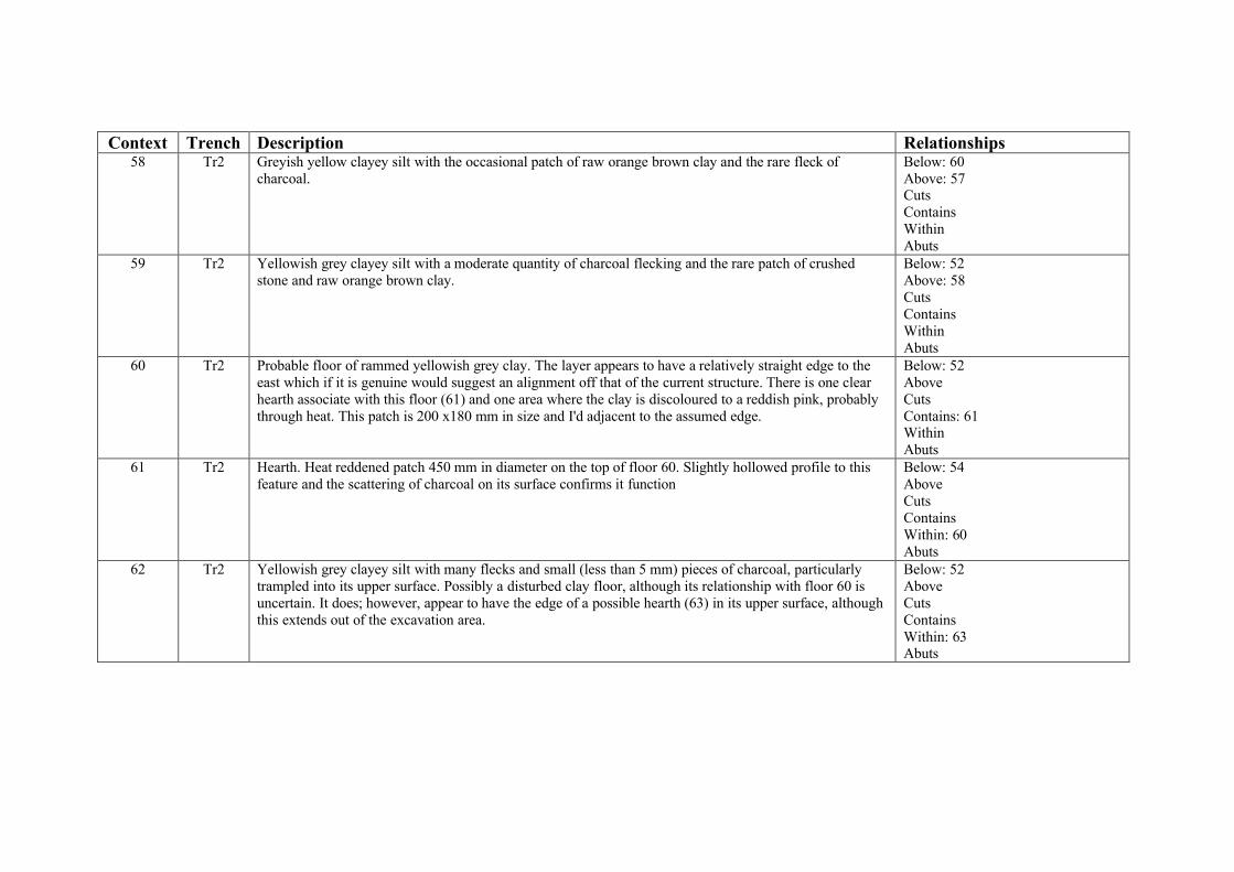
Context Trench Description Relationships58 Tr2 Greyish yellow clayey silt with the occasional patch of raw orange brown clay and the rare fleck of
charcoal.Below: 60Above: 57CutsContainsWithinAbuts
59 Tr2 Yellowish grey clayey silt with a moderate quantity of charcoal flecking and the rare patch of crushed stone and raw orange brown clay.
Below: 52Above: 58CutsContainsWithinAbuts
60 Tr2 Probable floor of rammed yellowish grey clay. The layer appears to have a relatively straight edge to the east which if it is genuine would suggest an alignment off that of the current structure. There is one clear hearth associate with this floor (61) and one area where the clay is discoloured to a reddish pink, probably through heat. This patch is 200 x180 mm in size and I'd adjacent to the assumed edge.
Below: 52AboveCutsContains: 61WithinAbuts
61 Tr2 Hearth. Heat reddened patch 450 mm in diameter on the top of floor 60. Slightly hollowed profile to this feature and the scattering of charcoal on its surface confirms it function
Below: 54AboveCutsContainsWithin: 60Abuts
62 Tr2 Yellowish grey clayey silt with many flecks and small (less than 5 mm) pieces of charcoal, particularly trampled into its upper surface. Possibly a disturbed clay floor, although its relationship with floor 60 is uncertain. It does; however, appear to have the edge of a possible hearth (63) in its upper surface, although this extends out of the excavation area.
Below: 52AboveCutsContainsWithin: 63Abuts

Context Trench Description Relationships63 Tr2 Possibly the edge of a hearth extending west out of the trench. A small patch of fire reddened clay with a
slightly dished upper surface which only extends into the trench by about 50 mm. A 150 mm length of this feature is exposed. If this is a hearth it is cut by the well shaft
Below: 52AboveCutsContainsWithin: 62Abuts
Appendix 2: Finds Summary
Trench Context Pot Clay PipeAnimal Bone
Oyster MusselOther shell
Fe ObjectCopper
AlloyLead Glass
Plaster/Mortar
Stone Slate Tile Other Total
1 4 1 3 1 1 3 91 12 5 3 1 4 131 19 5 14 3 1 231 21 1 1 1 31 22 5 1 1 71 us 5 6 5 1 2 4 1 242 22 2 22 23 5 52 28 12 3 5 3 1 3 1 1 1 302 29 11 5 20 1 2 1 1 412 31 1 1 22 32 1 6 2 1 1 2 1 2 162 35 1 1 1 4 1 82 36 18 2 12 3 1 1 2 392 37 1 2 32 38 2 1 1 42 39 4 7 3 3 1 182 41 1 12 42 1 12 43 1 1 2 1 52 46 4 9 1 3 2 1 202 47 8 2 1 2 1 142 48 5 3 82 49 1 17 2 5 252 52 4 42 53 5 52 us 1 1
71 14 133 16 9 8 25 2 2 12 8 4 18 4 5 331

Appendix 3: Specification
Specification for the Archaeological Evaluation 11 Castle Street (The Old Black Lion), Conwy.
1. Background
1.1. It is intended to restore 11 Castle Street, Conwy (also known as the “Old Black Lion”) and convert it back into a domestic residence.
1.2. As part of the archaeological recording of 11 Castle Street, Conwy it has been recommended by A. Batten (Gwynedd Archaeological Planning Service) that two evaluation trench be excavated in order to assess the archaeological record. This work follows the initial recording of the house in response to the brief D1178 prepared by A. Batten.
1.3. 11 Castle Street is a complex building which has been demonstrated to have an early timber phase which dated from AD 1441 – 1442. This house was modified into a stone storied house around AD 1589 when it was the home of John Brickdall, the vicar of Conwy, and his wife. Later phases of use include the conversion in the 18th century to a public house and the use of the building as an antique store and caf�.
1.4. A standing building report was completed in 2009 by Engineering Archaeological Services Ltd which detailed the extant features of the house including the internal timbers and the presence of a well partly under the wall of a kitchen extension thought to be of late 18th or early 19th century date.
1.5. The house is listed as Grade II* (Listed Building Ref. 3256) and is both within the Castles and Town Walls of Edward I in Gwynedd World Heritage Site and the Conwy Conservation Area.
1.6. This specification has been prepared following a site visit by Ashley Batten (Gwynedd Archaeological Planning Service) on 20th July 2012 and subsequent conversations. This work is additional to the work carried out in response to the brief D1178.
2. Aims
2.1.To evaluate the archaeological record associated with 11 Castle Street, Conwy, concentrating on the rear Garden and the relationship of the well to the standing remains.
3. Field work program
3.1. The programme of works shall include:
3.1.1.Excavation of two trenches
3.1.2.Analysis and report preparation
4.1.3.Trench 2 will be positioned to minimize the possibility of undermining of the wall of the kitchen.
4.2. For Trench 1: the preferred methodology will be to remove the topsoil and any modern overburden with a mini excavator (or equivalent) using a smooth faced ditching bucket.
4.2.1.All excavation after the removal of the overburden will be by hand.
4.2.2.All features revealed by the removal of topsoil will be investigated and the extent and form of all features will be recorded together with their relationships; the record will include:

4.1.1.1. Description of deposit: type, components etc.
4.1.1.2. All artefacts and ecofacts will be recorded by context.
4.1.1.3. Each deposit, feature or layer will be identified by a unique context number to which all other records will be related
4.1.1.4. Plan drawing showing extent of deposit.
4.1.1.5. Elevation drawing of the trench sides to record vertical stratigraphy.
4.1.1.6. Where possible, features will be sampled to obtain dating and functional evidence.
4.1.1.7. Where possible, elevation drawings of feature half sections to record vertical stratigraphy.
4.2.3.Where appropriate, deposits will be sampled for environmental, dating or technological evidence. Samples will be fully recorded and packed appropriately for future analysis.
4.1.2.Sampling will be carried out in accordance with the procedures outlined in ‘A guide to sampling archaeological deposits for environmental analysis’ - P Murphy and P Wiltshire 1994.
4.2.4.Where appropriate, photographs will be taken with a Nikon D80 digital SLR camera at a resolution of 10.2 mega pixels to enhance the written and drawn records.
4.2.5.All features revealed by the trenching will be recorded as above if safe working practices allow.
4.1.3.It is intended for the trench to be excavated down to the natural sub-soil in at least one point in the trench
4.1.4.This will only take place if it is safe to so do.
4.1.5.If the trench is deeper than 1.1 m then suitable shoring may be necessary and the width of the trench will be re-considered.
4.3. Trench 2 will be within the kitchen to the rear of the property and will be designed to investigate the relationship between the well, the rear of the original house and any associated deposits.
4.3.1.The floor of the kitchen is a series of red tiles. Work undertaken by a previous owner has left the edge of these tiles exposed where the top of the well has been exposed under the doorway in the North West corner of the kitchen. This exposed edge will be used so that a bolster can be used to lift the tiles. Care will be taken to cause as little damage to the tiles as possible.
4.3.2.Before lifting the tiles will be recorded in situ with a suitable photographs including a metric scale being taken.
4.3.3.Once lifted the tiles will be cleaned and stored in a safe location so that they can be re-used if necessary.
4.3.4.The bed of the tiles will be broken with a suitable electric breaker.
4.3.5.All excavation from the base of the tile bed will be by hand.4.3.6.The tiles in the rest of the kitchen will be protected with a layer of plastic during the
course of the excavation.
4.3.7.If there is any change in the methodology for lifting the tiles this will be agreed in advance with members of the CCBC Conservation Staff

4.1.6.All features revealed by the removal of topsoil will be investigated and the extent and form of all features will be recorded together with their relationships; the record will include:
4.1.6.1. Description of deposit: type, components etc.
4.1.6.2. All artefacts and ecofacts will be recorded by context.
4.1.6.3. Each deposit, feature or layer will be identified by a unique context number to which all other records will be related
4.1.6.4. Plan drawing showing extent of deposit.
4.1.6.5. Elevation drawing of the trench sides to record vertical stratigraphy.
4.1.6.6. Where possible, features will be sampled to obtain dating and functional evidence.
4.1.6.7. Where possible, elevation drawings of feature half sections to record vertical stratigraphy.
4.4. Where appropriate, deposits will be sampled for environmental, dating or technological evidence. Samples will be fully recorded and packed appropriately for future analysis.
4.2. Sampling will be carried out in accordance with the procedures outlined in ‘A guide to sampling archaeological deposits for environmental analysis’ - P Murphy and P Wiltshire 1994.
4.3. Where appropriate, photographs will be taken with a Nikon D80 digital SLR camera at a resolution of 10.2 mega pixels to enhance the written and drawn records.
4.4. All features revealed by the trenching will be recorded as above if safe working practices allow
4.5. It is intended for the trench to be excavated down to natural at at least one point in the trench
4.5.1.This will only take place if it is safe to so do.
4.5. If human remains are encountered all works will stop until the appropriate permissions have been obtained.
4.6. Trenches will be back-filled to make them safe at the end of the fieldwork, although full reinstatement will not be attempted.
4.7. Initial analysis of the results of the trenching will take place in order to compile the report. Further detailed study will not be undertaken without the express agreement of Miss A.E.M. Jones and in discussion with the curatorial archaeologist.
5.1. Any flint or chert artefacts will be studied by Dr. I.P. Brooks
5.2. Any pottery will be studied by J. Edwards
5.3. Any animal bones will be studied by a suitable specialist.
5.4. Any metal or other special finds will be studied by a suitable specialist
5.5. All ceramic, bone and stone artefacts will be cleaned and processed immediately following the watching brief.

5.6. Metal artefacts will be stored and managed on site according to the UK Institute of Conservation Guidelines.
6. Reporting
6.1. A summary report on the findings of the investigations will be prepared and completed within one month from completion of the fieldwork. This will summarise the results of the project including;
6.1.1. A site location plan
6.1.2. An outline methodology
6.1.3. The results of the trenching
6.1.4. An interpretation of the results placing them in a local and regional context.
6.1.5. Five bound copies of the report will be provided together with a digital copy to the owner
6.1.6. One bound and one digital copy of the report will be submitted to the Historic Environment Record held by the Gwynedd Archaeological Trust
6.2. A draft copy of the report will be submitted to the Gwynedd Archaeological Planning Service for comment.
6.3. Copies of the report will be deposited with the Historic Environment Record and National Monument Record held by RCAHM(W) at Aberystwyth
6.4. It is intended that the results of the evaluation will be published in a suitable journal, together with the results of the standing building analysis and any other results from the restoration of the house on completion of the project.
7. General
7.1. IFA Code of Conduct
7.1.1.All staff will abide by, and all procedures be carried out in accordance with the Institute of Field Archaeologists’ Code of Conduct.
7.2. Health and Safety
7.2.1.EAS Ltd adopt and adhere to safe working practices at all times. A copy of the company’s general statement of policy is available on request.

9. Staff
9.1. The project will be directed by Dr I.P. Brooks MIFA
9.2. Project Staff will include Dr I.P. Brooks MIFA
10. Timetable
10.1. The fieldwork is expected to take `10 days.
10.1.1. The date of the fieldwork will be agreed with Miss A.E.M Jones
10.2. Analysis and report preparation is expected to take 5 man days.
10.3. It is intended to start the excavation on 10/9/12, although if the pre-start meeting can be organized in time the machining of Trench 1 may take place towards the end of the week 3/9/12 – 8/9/12.
11. Monitoring
11.1. Procedures will put in place to allow the monitoring of the project.
11.1.1. No contact to the Gwynedd Archaeological Planning Service or the relevant conservation staff without the express permission of the owner.
11.2. A pre-start meeting will be arranged, ideally between 5/9/12 and 7/9/12 to include representatives of the Gwynedd Archaeological Planning Service and the relevant conservation staff, together with the excavator and the owner.
11.3. A monitoring meeting will be arranged in the second week of the excavation to discuss progress.
11.4. If required the staff of the CCBC Conservation section will be notified before the tiles are lifted so that the operation can be monitored.
11.5. If significant archaeological remains are discovered the Gwynedd Archaeological Planning Service will be notified by telephone.
12. Insurance
12.1.1. EAS Ltd carries all necessary Public and Employee Liability Insurances.
12.1.2. EAS Ltd carries Professional Indemnity Insurance.
13. Copyright
13.1. EAS Ltd shall assign the copyright of the reports to Miss A.E.M Jones.
13.1.1. EAS Ltd will retain an exclusive license for the use of such documents.14. Costs
14.1. The following costs are estimates as it is not possible to predict the results of the excavations in that depth of the deposits, their complexity and the number and type of finds are unpredictable.

16. Contingencies
16.1. Any specialist reports required, such as reports from finds specialist would be charged at cost.
16.2. Specialist reports would only be commissioned with the agreement of Miss A.E.M. Jones and after discussion with the Development Control Archaeologists.

Reproduced from the ExplorerTM OL17, 1:25,000 scaleby permission of the Ordnance Survey ® on behalf of
The Controller of Her Majesty's Stationary Office© Crown Copyright 2002
All Rights Reserved Licence Number AL 100014722
11 Castle Street
Figure 1: LocationScale 1:25,000

0 5 m
Figure 2: Location of the TrenchesScale 1:200
Trench 1
Tren
ch 2Wel
l
Conwy Town Wall

106
2021
13
6
12
11
10
9
816
0 2.0 m
Figure 3: Trench 1 PlansScale 1:50
Building 15 Building 14

15
14
12
3
8 94
1012
1619
2220
18
21
6
724
13
5
17
0 2.0 m
SE NW
Figure 4: Trench 1 SectionScale 1:35

2829
Plan 30.1 m below floor
30
Plan 40.1 m below floor
34 33
31
32
30
35
Plan 50.15 m below floor
0 1.0 m
Figure 5: Trench 2 PlansScale 1:200

34
36
37
35
30
Plan 60.24 m below the floor
34
1
36
Plan 70.25 - 0.30 m below the floow
34
38 3943
41
42
40
Plan 80.4 m below the floor
0 1.0 m
Figure 6: Trench 2 PlansScale 1:200

34
3943
41
42
40
44
Plan 90.4 m below the floor
3443
40
42
Plan100.48 m below floor
42
464734
40
Plan 110.53 m below the floor
0 1.0 m
46
Figure 7: Trench 2 PlansScale 1:200
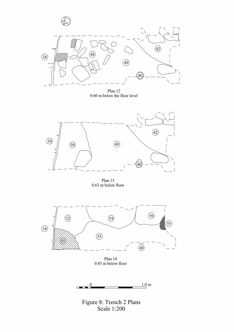
34 48
49
40
42
Plan 120.60 m below the floor level
3450 49
40
Plan 130.63 m below floor
42
34
52
53
54 56
55
4051
Plan 140.85 m below floor
0 1.0 m
Figure 8: Trench 2 PlansScale 1:200

58
57
65
60 6163
62
Plan 150.95 m below the floor
0 1.0 m
Figure 9: Trench 2 PlansScale 1:200

25
27 28
32
36
3438 43
50
60
61
39
##
####
##
##
##
25
2627 28
3031
38 3436
5040
6557
0 1.0 m
52 5456
0.6 m46 43
48
49
625153
37
39
49
S N
N S
Figure 10: Trench 2 sectionsScale 1:20

28 30
27
2526
29
30
29
Well cover
2526
27
W E
NS
W E N S
40
0 0.5 m
Figure 11: Trench 2 sectionsScale 1:10
Related Documents