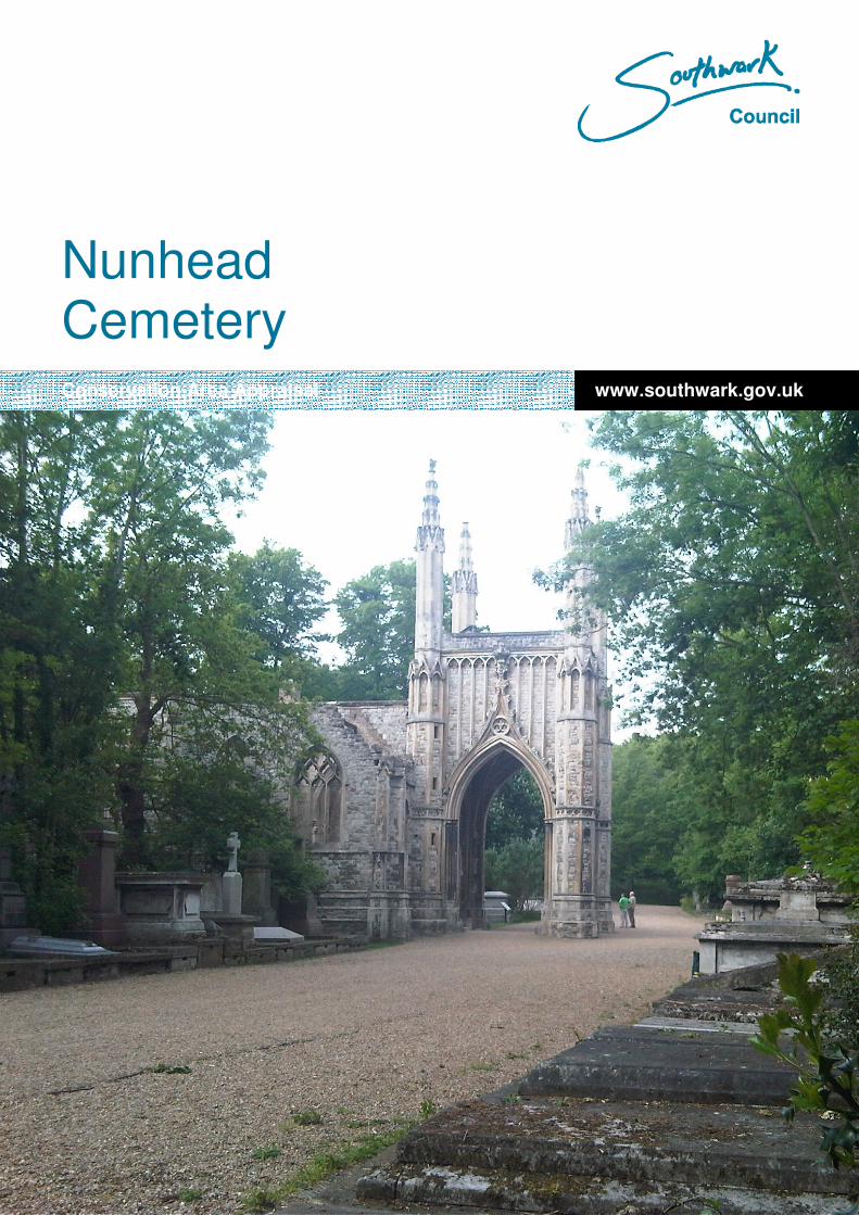
www.southwark.gov.uk Nunhead Cemetery Conservation Area Appraisal

Welcome message from author
This document is posted to help you gain knowledge. Please leave a comment to let me know what you think about it! Share it to your friends and learn new things together.
Transcript
www.southwark.gov.uk
Nunhead Cemetery Conservation Area Appraisal
1
www.southwark.gov.uk
Nunhead Cemetery
Conservation Area Appraisal

2
3
Table of Contents 1. Introduction.......................................................................................................................................5
1.1. The Conservation Area Appraisal: Purpose ..............................................................................5 1.2. Arrangement of this document ..................................................................................................5 1.3. Nunhead Cemetery Conservation Area.....................................................................................6 1.4. Location ....................................................................................................................................6 1.5. Topography...............................................................................................................................6 1.6. Planning History........................................................................................................................6 1.7. Development Plan Policies........................................................................................................6 1.8. Further Information ...................................................................................................................8
2. Historical Background.......................................................................................................................9 2.1. General .....................................................................................................................................9
3. The Character and Appearance of the Area....................................................................................14 3.1. Broad Context .........................................................................................................................14 3.2. Materials and Details...............................................................................................................14 3.3. Buildings – Anglican Chapel....................................................................................................15 3.4. Gates ......................................................................................................................................17 3.5. Lodges....................................................................................................................................17 3.6. Monuments .............................................................................................................................18 3.7. Catacombs..............................................................................................................................19 3.8. Pathways and Surfaces ..........................................................................................................19 3.9. Furniture .................................................................................................................................21 3.10. Approaches.........................................................................................................................21 3.11. Boundaries..........................................................................................................................21 3.12. Bordering Streets ................................................................................................................22 3.13. Views ..................................................................................................................................25 3.14. Key Spaces.........................................................................................................................25 3.15. Negative Elements ..............................................................................................................26
4. Audit ...............................................................................................................................................28 4.1. Listed Buildings and Features .................................................................................................28 4.2. Unlisted Features....................................................................................................................28 4.3. Archaeology............................................................................................................................29 4.4. Environmental Importance ......................................................................................................29
Further Reading .....................................................................................................................................30
4
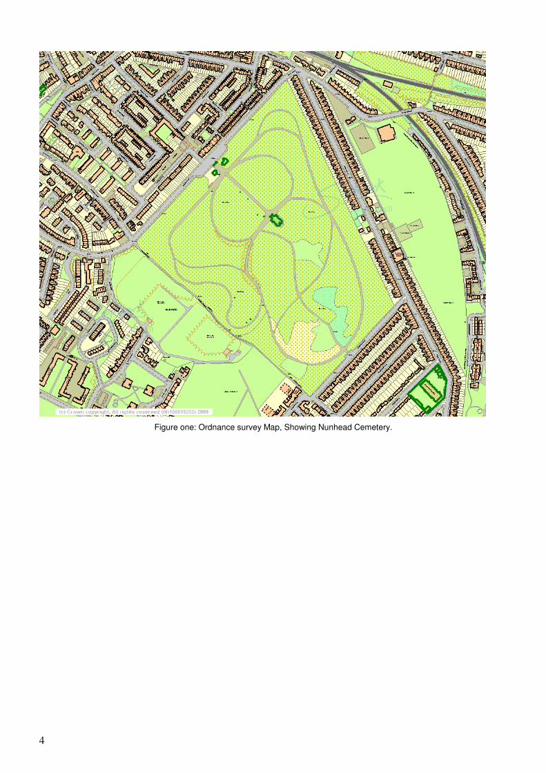
Figure one: Ordnance survey Map, Showing Nunhead Cemetery.
5
1. Introduction
1.1. The Conservation Area Appraisal: Purpose
1.1.1. The purpose of this statement is to provide both an account of Nunhead Cemetery
Conservation Area and a clear indication of the Borough Council’s approach to its
preservation and enhancement. It is intended to assist and guide all those involved in
development and change in the area, and will be used by the Council in assessing the
design of development proposals.
1.1.2. The statutory definition of a Conservation Area is an “area of special architectural or
historic interest, the character or appearance of which it is desirable to preserve or
enhance.” Conservation Areas are normally centred on listed buildings and pleasant groups
of other buildings, open space, or an historic street pattern. A town space or features of
archaeological interest may also contribute to the special character of an area. It is,
however, the character of an area, rather than individual buildings, that such a designation
seeks to preserve or enhance. The most recent legislation dealing with Conservation Areas
is the Planning (Listed Buildings and Conservation Areas) Act, 1990 (Sections 69 to 78).
Guidance to the legislation is given in Planning Policy Statement 5 ‘Planning for the Historic
Environment’ (PPS 5) and the related Historic Environment Planning Practice Guidance,
published by the Department of Communities and Local Government in March 2010.
1.1.3. Planning legislation requires that special attention shall be paid to the desirability of
preserving or enhancing the character or appearance of the Conservation Area. In doing
this the emphasis will be on control rather than prevention, to allow the area to remain alive
and prosperous but at the same time to ensure that any new development accords with its
special architectural and visual qualities.
1.1.4. This statement has been prepared following guidance given by English Heritage in their
note “Conservation Area Appraisals”.
1.2. Arrangement of this document
1.2.1. Following the Introduction, Section 2 provides a brief history of the area and its
development. Section 3 starts with a broad appraisal of its character and appearance, with
reference to the range of materials, details and building types to be found in the area.
Section 3 then goes on to describe the area with specific reference to architectural and
historic qualities, views and townscape, the character and relationship of public and green
spaces, and any elements that detract from the Conservation Area. Section 4 provides an
audit of the features of special interest of the area, including listed buildings, particular
groups of unlisted buildings, and trees, planting and other streetscape elements. Section 5
provides guidelines for future management and change in the conservation area.
6
1.3. Nunhead Cemetery Conservation Area
1.4. Location
1.4.1. The Cemetery is located at Nunhead, and the Conservation Area boundaries broadly
follow the edges of the cemetery. The roughly diamond shaped site is bordered by: Linden
Grove to the northwest, Ivydale Road to the northeast and Limesford Road to the southeast.
These are all essentially quiet residential streets, and the wider area contains more of the
same. The whole area is relatively peaceful, as it is enclosed and over-grown, and the
neighbouring streets are not filled with heavy traffic noise. The roadways of Linden Grove
and Limesford Road are within the conservation area. To the east the boundary runs behind
the gardens of houses on Ivydale road. Brockley Footpath forms the southwest boundary to
the cemetery as well as the conservation area boundary, climbing steeply up close to the
brow of West Hill. The footpath also separates the cemetery from two covered reservoirs
and a small area of allotments.
1.5. Topography
1.5.1. At about 50 metres above sea level, Nunhead Cemetery lies on the north eastern slope of
a conical hill. The 100 foot contour line runs parallel to the northwest edge of the site, from
which there is an obvious rise to the highest point of 200 foot at the summit of the West Hill
path. This path is part of the original layout, and curves up to the summit of the hill. The rest
of the cemetery is relatively flat, with only gentle rises and falls in the natural shape of the
land.
1.6. Planning History
1.6.1. In recognition of the historical importance and specialist character of the cemetery and its
ecological significance within the urban context, Nunhead Cemetery was designated as a
Conservation Area, by Southwark Council in 1986, under the Civic Amenities Act of 1967.
1.6.2. The designed landscape layout was added to the Register of Historic Parks and gardens
published by English Heritage, in 1987. The cemetery is a grade II* Historic Park, cited as
an excellent example of Victorian Municipal Park landscaping.
1.6.3. Both the East Gate Lodge and Anglican Chapel have previously been included in English
Heritage’s ‘At Risk’ register. The chapel has since been restored with money from the HLF
(2000). The East Gate Lodge continues to be on the register. This Grade II listed building is
owned by Southwark Council and leased to the Friends of Nunhead Cemetery.
1.6.4. In 1987, the London Ecology Unit registered the cemetery as a London-wide Site of
Nature Conservation Importance. Declaration as a Local Nature Reserve was awarded in
2003.
1.7. Development Plan Policies
1.7.1. The Development Plan for Southwark is the Southwark Plan (UDP) July 2007, which was
adopted by the Council on 28 July 2007, superseding the Unitary Development Plan
adopted in 1995. The new Plan contains the following policies relating to conservation
areas.
Policy 3.15 – Conservation of the Historic Environment
Development should preserve or enhance the special interest or historic character or appearance
of buildings or areas of historical or architectural significance. Planning proposals that will have
an adverse effect on the historic environment will not be permitted.
7
The character and appearance of Conservation Areas should be recognised and respected in
any new development within these areas. Article 4 directions may be imposed to limit permitted
development rights, particularly in residential areas.
In this policy the term historic environment includes Conservation Areas, listed buildings,
scheduled monuments, protected London Squares, historic parks and gardens and trees that are
protected by Tree Preservation Orders, trees that contribute to the character or appearance of a
Conservation Area and ancient hedgerows.
Policy 3.16 – Conservation Areas
Within Conservation Areas development should preserve or enhance the character or
appearance of the area.
New Development, including Alterations and Extensions
Planning permission will be granted for new development, including the extension or alteration of
existing buildings provided that the proposals:
• Respect the context of the Conservation Area, having regard to the content of Conservation Area Appraisals and other adopted Supplementary Planning Guidance / Documents; and
• Use high quality materials that complement and enhance the Conservation Area; and
• Do not involve the loss of existing traditional features of interest which make a positive contribution to the character or appearance of the Conservation Area; and
• Do not introduce design details or features that are out of character with the area, such as the use of widows and doors made of aluminium or uPVC or other non-traditional materials.
Where appropriate development in Conservation Areas may include the use of modern materials
or innovative techniques only where it can be demonstrated in a design and access statement
that this will preserve or enhance the character or appearance of the Conservation Area.
Demolition
Within Conservation Areas, there will be a general presumption in favour of retaining buildings
that contribute positively to the character or appearance of the Conservation Area. Planning
permission will not be granted for proposals that involve the demolition or substantial demolition
of a building that contributes positively to the character or appearance of the Conservation Area,
unless, in accordance with PPG 15 or any subsequent amendments, it can be demonstrated that:
• Costs of repairs and maintenance would not be justified, when assessed against the importance of the building and the value derived from its continued use, provided that the building has not been deliberately neglected; and
• Real efforts have been made to continue the current use or find a viable alternative use for the building; and
• There will be substantial planning benefits for the community from redevelopment which would decisively outweigh loss from the resulting demolition; and
• The replacement development will preserve or enhance the character or appearance of the conservation area and has been granted planning permission.
Implementation
Submission of details demonstrating that a contract for the construction of the replacement
development has been let will be required prior to implementation of the development.
Policy 3.18 – Setting of Listed Buildings, Conservation Areas and World Heritage Sites
8
Permission will not be granted for developments that would not preserve or enhance:
• The immediate or wider setting of a listed building; or
• An important view(s) of a listed building; or
• The setting of a Conservation Area; or
• Views into or out of a Conservation Area; or
• The setting of a World Heritage Site; or
• Important views of or from a World Heritage Site.
1.8. Further Information
1.8.1. This document is not exhaustive, and further advice and information can be obtained from
the Planning Department, London Borough of Southwark.
1.8.2. Information on the Southwark Plan, including electronic versions of the plan and
supplementary planning guidance, can be found on the Council’s web site at
www.southwark.gov.uk.
9
2. Historical Background
2.1. General
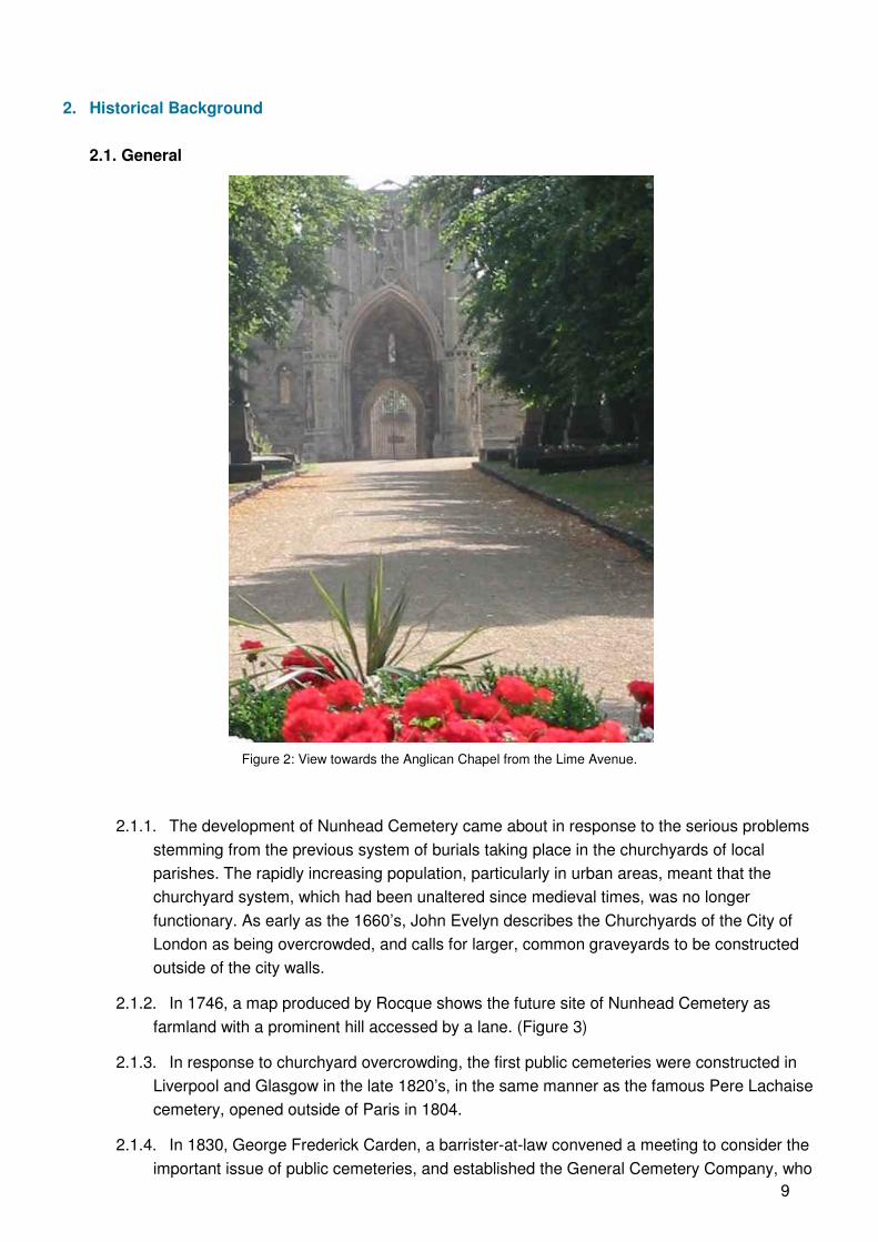
Figure 2: View towards the Anglican Chapel from the Lime Avenue.
2.1.1. The development of Nunhead Cemetery came about in response to the serious problems
stemming from the previous system of burials taking place in the churchyards of local
parishes. The rapidly increasing population, particularly in urban areas, meant that the
churchyard system, which had been unaltered since medieval times, was no longer
functionary. As early as the 1660’s, John Evelyn describes the Churchyards of the City of
London as being overcrowded, and calls for larger, common graveyards to be constructed
outside of the city walls.
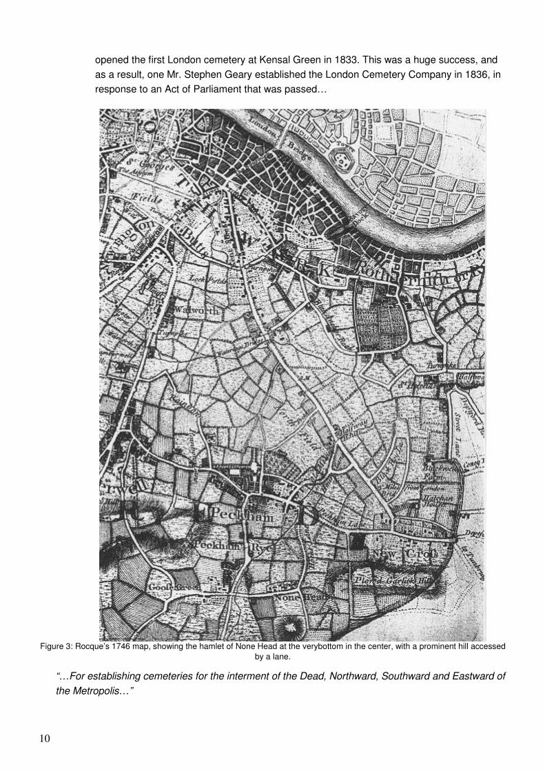
2.1.2. In 1746, a map produced by Rocque shows the future site of Nunhead Cemetery as
farmland with a prominent hill accessed by a lane. (Figure 3)
2.1.3. In response to churchyard overcrowding, the first public cemeteries were constructed in
Liverpool and Glasgow in the late 1820’s, in the same manner as the famous Pere Lachaise
cemetery, opened outside of Paris in 1804.
2.1.4. In 1830, George Frederick Carden, a barrister-at-law convened a meeting to consider the
important issue of public cemeteries, and established the General Cemetery Company, who
10
opened the first London cemetery at Kensal Green in 1833. This was a huge success, and
as a result, one Mr. Stephen Geary established the London Cemetery Company in 1836, in
response to an Act of Parliament that was passed…
Figure 3: Rocque’s 1746 map, showing the hamlet of None Head at the verybottom in the center, with a prominent hill accessed
by a lane.
“…For establishing cemeteries for the interment of the Dead, Northward, Southward and Eastward of
the Metropolis…”
11
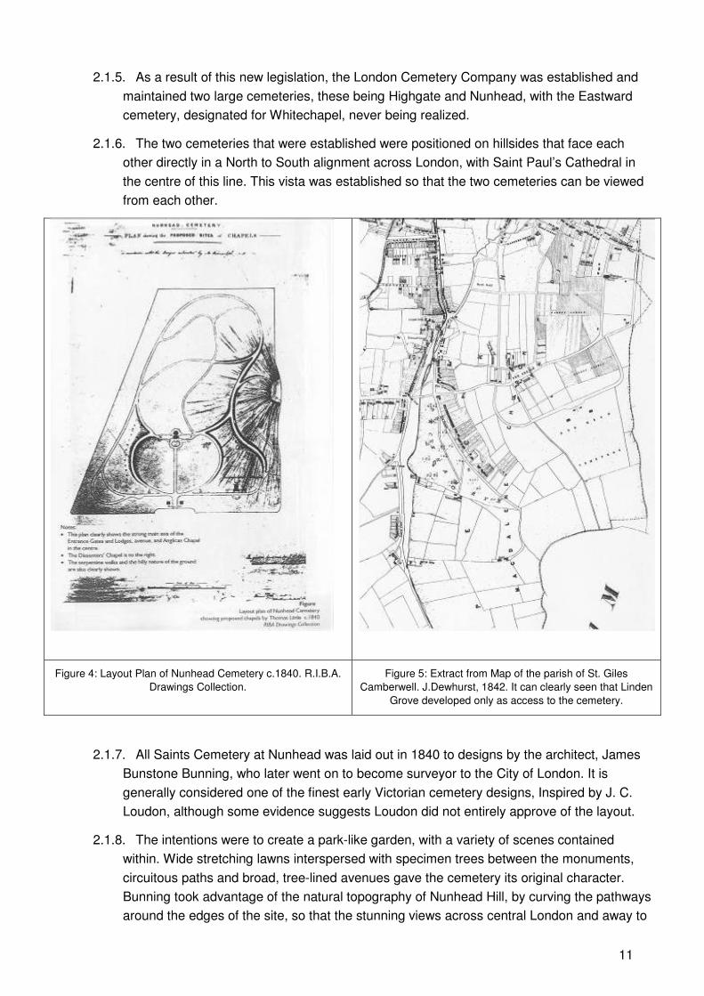
2.1.5. As a result of this new legislation, the London Cemetery Company was established and
maintained two large cemeteries, these being Highgate and Nunhead, with the Eastward
cemetery, designated for Whitechapel, never being realized.
2.1.6. The two cemeteries that were established were positioned on hillsides that face each
other directly in a North to South alignment across London, with Saint Paul’s Cathedral in
the centre of this line. This vista was established so that the two cemeteries can be viewed
from each other.
Figure 4: Layout Plan of Nunhead Cemetery c.1840. R.I.B.A.
Drawings Collection.
Figure 5: Extract from Map of the parish of St. Giles
Camberwell. J.Dewhurst, 1842. It can clearly seen that Linden
Grove developed only as access to the cemetery.
2.1.7. All Saints Cemetery at Nunhead was laid out in 1840 to designs by the architect, James
Bunstone Bunning, who later went on to become surveyor to the City of London. It is
generally considered one of the finest early Victorian cemetery designs, Inspired by J. C.
Loudon, although some evidence suggests Loudon did not entirely approve of the layout.
2.1.8. The intentions were to create a park-like garden, with a variety of scenes contained
within. Wide stretching lawns interspersed with specimen trees between the monuments,
circuitous paths and broad, tree-lined avenues gave the cemetery its original character.
Bunning took advantage of the natural topography of Nunhead Hill, by curving the pathways
around the edges of the site, so that the stunning views across central London and away to
12
the North Downs were reserved until one reached the very summit. Much of the original
planting survives in mature trees of Holm oak, lime, plane, yew and ginkgo.
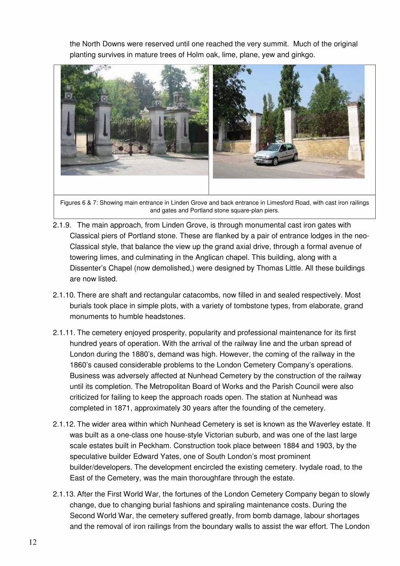
Figures 6 & 7: Showing main entrance in Linden Grove and back entrance in Limesford Road, with cast iron railings
and gates and Portland stone square-plan piers.
2.1.9. The main approach, from Linden Grove, is through monumental cast iron gates with
Classical piers of Portland stone. These are flanked by a pair of entrance lodges in the neo-
Classical style, that balance the view up the grand axial drive, through a formal avenue of
towering limes, and culminating in the Anglican chapel. This building, along with a
Dissenter’s Chapel (now demolished,) were designed by Thomas Little. All these buildings
are now listed.
2.1.10. There are shaft and rectangular catacombs, now filled in and sealed respectively. Most
burials took place in simple plots, with a variety of tombstone types, from elaborate, grand
monuments to humble headstones.
2.1.11. The cemetery enjoyed prosperity, popularity and professional maintenance for its first
hundred years of operation. With the arrival of the railway line and the urban spread of
London during the 1880’s, demand was high. However, the coming of the railway in the
1860’s caused considerable problems to the London Cemetery Company’s operations.
Business was adversely affected at Nunhead Cemetery by the construction of the railway
until its completion. The Metropolitan Board of Works and the Parish Council were also
criticized for failing to keep the approach roads open. The station at Nunhead was
completed in 1871, approximately 30 years after the founding of the cemetery.
2.1.12. The wider area within which Nunhead Cemetery is set is known as the Waverley estate. It
was built as a one-class one house-style Victorian suburb, and was one of the last large
scale estates built in Peckham. Construction took place between 1884 and 1903, by the
speculative builder Edward Yates, one of South London’s most prominent
builder/developers. The development encircled the existing cemetery. Ivydale road, to the
East of the Cemetery, was the main thoroughfare through the estate.
2.1.13. After the First World War, the fortunes of the London Cemetery Company began to slowly
change, due to changing burial fashions and spiraling maintenance costs. During the
Second World War, the cemetery suffered greatly, from bomb damage, labour shortages
and the removal of iron railings from the boundary walls to assist the war effort. The London
13
Cemetery Company retained shares on the stock exchange up until the 1960’s. In 1969 the
Company ceased trading at Nunhead and the gates of the Cemetery were locked.
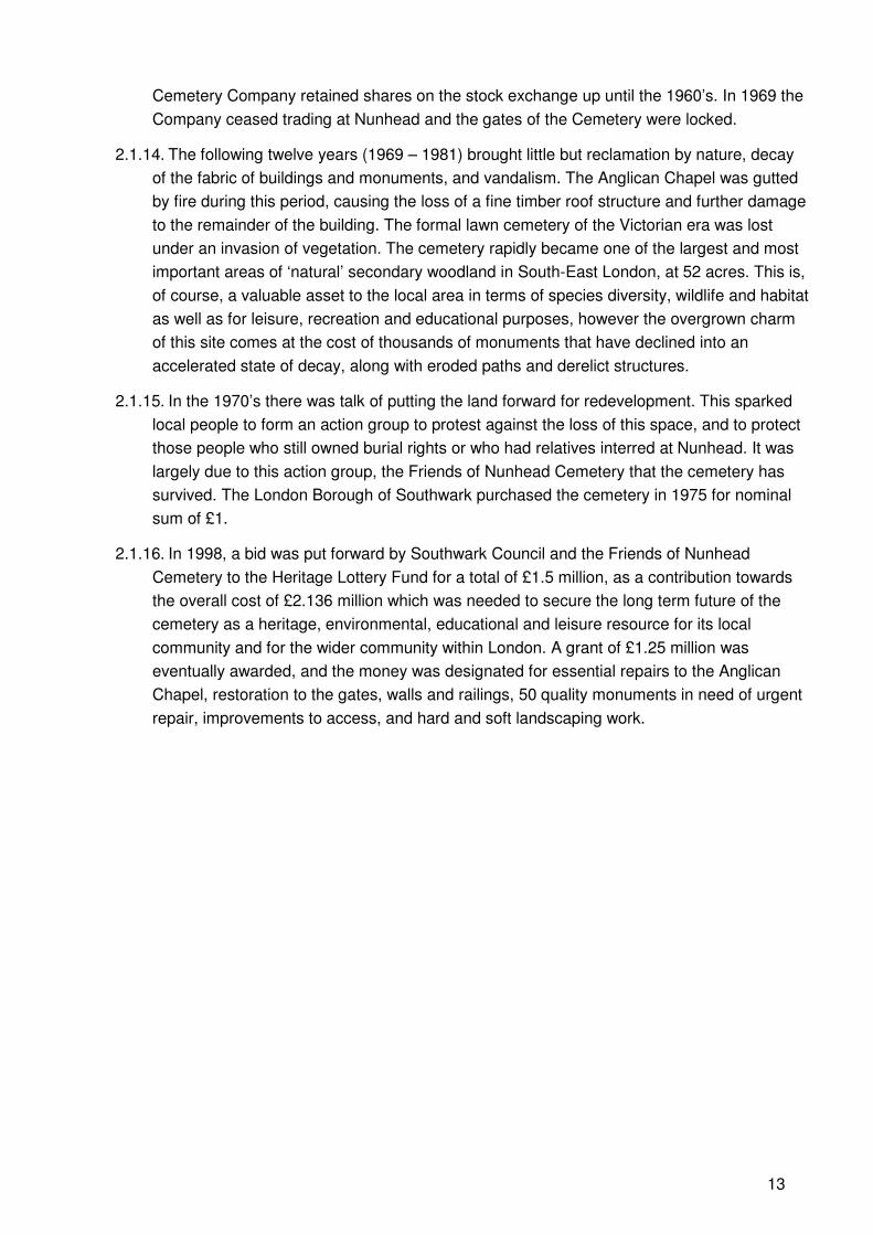
2.1.14. The following twelve years (1969 – 1981) brought little but reclamation by nature, decay
of the fabric of buildings and monuments, and vandalism. The Anglican Chapel was gutted
by fire during this period, causing the loss of a fine timber roof structure and further damage
to the remainder of the building. The formal lawn cemetery of the Victorian era was lost
under an invasion of vegetation. The cemetery rapidly became one of the largest and most
important areas of ‘natural’ secondary woodland in South-East London, at 52 acres. This is,
of course, a valuable asset to the local area in terms of species diversity, wildlife and habitat
as well as for leisure, recreation and educational purposes, however the overgrown charm
of this site comes at the cost of thousands of monuments that have declined into an
accelerated state of decay, along with eroded paths and derelict structures.
2.1.15. In the 1970’s there was talk of putting the land forward for redevelopment. This sparked
local people to form an action group to protest against the loss of this space, and to protect
those people who still owned burial rights or who had relatives interred at Nunhead. It was
largely due to this action group, the Friends of Nunhead Cemetery that the cemetery has
survived. The London Borough of Southwark purchased the cemetery in 1975 for nominal
sum of £1.
2.1.16. In 1998, a bid was put forward by Southwark Council and the Friends of Nunhead
Cemetery to the Heritage Lottery Fund for a total of £1.5 million, as a contribution towards
the overall cost of £2.136 million which was needed to secure the long term future of the
cemetery as a heritage, environmental, educational and leisure resource for its local
community and for the wider community within London. A grant of £1.25 million was
eventually awarded, and the money was designated for essential repairs to the Anglican
Chapel, restoration to the gates, walls and railings, 50 quality monuments in need of urgent
repair, improvements to access, and hard and soft landscaping work.
14
3. The Character and Appearance of the Area
3.1. Broad Context
3.1.1. The Built element of Nunhead Cemetery Conservation Area is characterized by three
typologies from different periods of its history. The first two are the Gothic splendor and
demure Classicism of the original intentions in Nunhead’s design. These come primarily
from the architectural features. The lodges, entrance gates and path layouts are typically
Classical. The Anglican chapel, cleverly set into the Classical composition, is indicative of
the Gothic style, which is also expressed through the wide variety of mausoleums,
memorials and monuments depicting weeping angels, lion’s heads and many other ornate
religious symbols.
3.1.2. A third, and now dominant element of the Area’s character comes from its sense of
wilderness. Decades of neglect has afforded the site a feeling of ramshackle, overgrown
mystery attributed to the natural reclamation of wild, indigenous species of plants and trees.
This has undoubtedly become a part of the experience and character of Nunhead.
3.1.3. The very special character of Nunhead is derived from the ramshackle quality of nature
reclaiming the ostentatious monuments that the Victorians erected as their lasting legacies.
These memorials were presumably intended to remain forever in neat trimmed lawns,
reminding the passer-by of the importance, (if not simply the existence) of the benefactor
long after their interment. Having been allowed to develop to such an overgrown state, the
idea of preserving those memories has been somewhat eroded, but out of the overgrowth
has emerged a much more interesting place. The stone angels, carved to mourn for eternity,
now lean to one side, chipped and half submerged by ivy, as a reminder that nothing lasts
forever, no matter how hard we try to defy this fact. Similarly the ruined Chapel, clearly once
magnificent, now roofless and weathered, slowly deteriorating and returning to the Earth.
Despite this change from the Cemetery’s original character, it is neither a depressing nor
mournful place. The overwhelming sense is that nature is reclaiming what is rightfully hers,
a kind of glorious and righteous decay. In the heart of the site, one has to look very hard to
actually notice the gravestones, and if passing through, it would be easy to think this site
has only ever been Woodland. Such is the extent of the natural reclamation. The more
recent character of overgrown decay, instead of destroying the original character of
Victorian pomposity, has added to it greatly. A visit to Nunhead today demonstrates not only
the hopes for life everlasting through the monumental memorials of our predecessors, but
also the continuation and everlasting dominance of nature, reclaiming a site that has been
unnaturally cultivated for the last 170 years, but which is finally reverting to its own true
origins.
3.2. Materials and Details
3.2.1. Although the dominant character of the Conservation Area is now derived from woodland
and foliage, the buildings and fabric, including the Anglican Chapel, the Gate Lodges and
monuments, particularly the Scottish Martyrs memorial, significantly add to the identity of the
Cemetery, having been and still remaining its ‘raison d’etre.’
3.2.2. The predominant architectural style on entering the Cemetery is Classical, due to the
gates, boundaries, lodges and the composition of axial pathways and symmetrical views.
15
The Chapel has fine Decorated Gothic detailing, but when considered in the overall layout,
the unifying style seems to be well-balanced Classicism. Once past the grand entrance way
and inside the main, overgrown majority of the cemetery, where views back toward the
Classical form of the entrance way are entirely obstructed, the prevailing character is of
Victorian Gothic, due to the ornate styling of the many tombs and monuments.
3.3. Buildings – Anglican Chapel
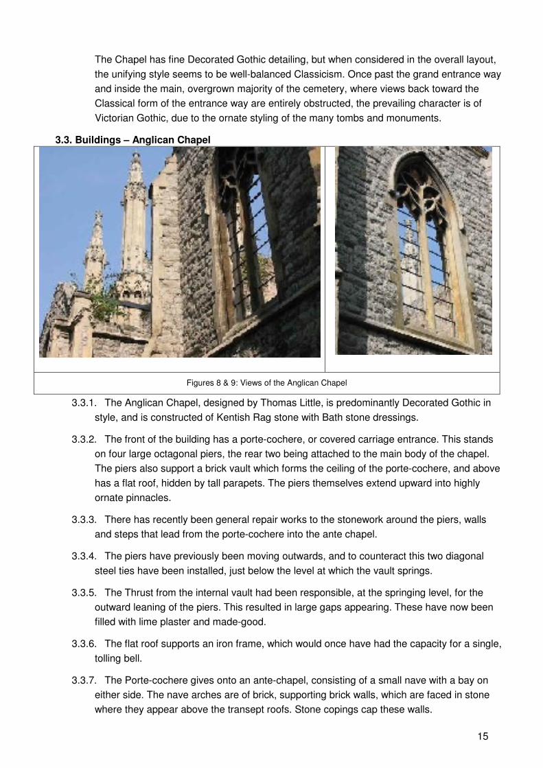
Figures 8 & 9: Views of the Anglican Chapel
3.3.1. The Anglican Chapel, designed by Thomas Little, is predominantly Decorated Gothic in
style, and is constructed of Kentish Rag stone with Bath stone dressings.
3.3.2. The front of the building has a porte-cochere, or covered carriage entrance. This stands
on four large octagonal piers, the rear two being attached to the main body of the chapel.
The piers also support a brick vault which forms the ceiling of the porte-cochere, and above
has a flat roof, hidden by tall parapets. The piers themselves extend upward into highly
ornate pinnacles.
3.3.3. There has recently been general repair works to the stonework around the piers, walls
and steps that lead from the porte-cochere into the ante chapel.
3.3.4. The piers have previously been moving outwards, and to counteract this two diagonal
steel ties have been installed, just below the level at which the vault springs.
3.3.5. The Thrust from the internal vault had been responsible, at the springing level, for the
outward leaning of the piers. This resulted in large gaps appearing. These have now been
filled with lime plaster and made-good.
3.3.6. The flat roof supports an iron frame, which would once have had the capacity for a single,
tolling bell.
3.3.7. The Porte-cochere gives onto an ante-chapel, consisting of a small nave with a bay on
either side. The nave arches are of brick, supporting brick walls, which are faced in stone
where they appear above the transept roofs. Stone copings cap these walls.
16
3.3.8. The transept walls are of brick with rag stone facing externally. The three external walls
each have a large window, with freestone mullions and tracery in the decorated style, which
is mostly in good condition.
3.3.9. Between the transepts and the chapel are two small spaces, one noted as ‘vestry’ on the
original plan drawing, and the other containing a staircase to the crypt.
3.3.10. The main chapel is entered through an arch. It is of octagonal plan, and the walls are
constructed in the same manner of those in the ante chapel. Each wall bay contains a
traceried window.
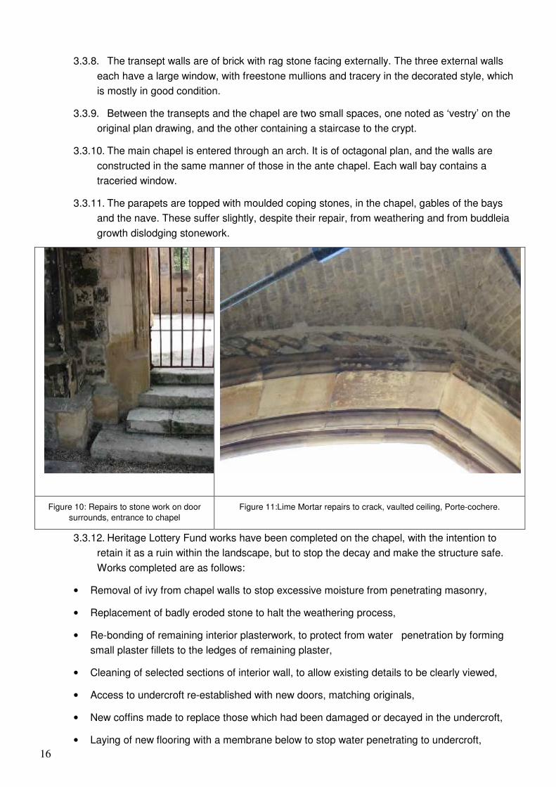
3.3.11. The parapets are topped with moulded coping stones, in the chapel, gables of the bays
and the nave. These suffer slightly, despite their repair, from weathering and from buddleia
growth dislodging stonework.
Figure 10: Repairs to stone work on door
surrounds, entrance to chapel
Figure 11:Lime Mortar repairs to crack, vaulted ceiling, Porte-cochere.
3.3.12. Heritage Lottery Fund works have been completed on the chapel, with the intention to
retain it as a ruin within the landscape, but to stop the decay and make the structure safe.
Works completed are as follows:
• Removal of ivy from chapel walls to stop excessive moisture from penetrating masonry,
• Replacement of badly eroded stone to halt the weathering process,
• Re-bonding of remaining interior plasterwork, to protect from water penetration by forming
small plaster fillets to the ledges of remaining plaster,
• Cleaning of selected sections of interior wall, to allow existing details to be clearly viewed,
• Access to undercroft re-established with new doors, matching originals,
• New coffins made to replace those which had been damaged or decayed in the undercroft,
• Laying of new flooring with a membrane below to stop water penetrating to undercroft,
17
• Re-asphalted flat roof to porte-cochere,
• New metal grilles fitted to windows,
• New artist-designed gates fitted to chapel entrance to allow the interior to be seen when the
chapel is locked.
3.4. Gates
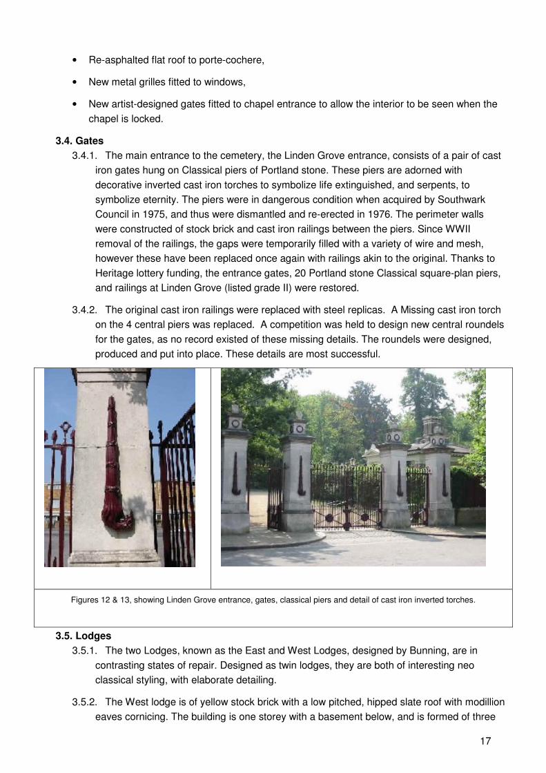
3.4.1. The main entrance to the cemetery, the Linden Grove entrance, consists of a pair of cast
iron gates hung on Classical piers of Portland stone. These piers are adorned with
decorative inverted cast iron torches to symbolize life extinguished, and serpents, to
symbolize eternity. The piers were in dangerous condition when acquired by Southwark
Council in 1975, and thus were dismantled and re-erected in 1976. The perimeter walls
were constructed of stock brick and cast iron railings between the piers. Since WWII
removal of the railings, the gaps were temporarily filled with a variety of wire and mesh,
however these have been replaced once again with railings akin to the original. Thanks to
Heritage lottery funding, the entrance gates, 20 Portland stone Classical square-plan piers,
and railings at Linden Grove (listed grade II) were restored.
3.4.2. The original cast iron railings were replaced with steel replicas. A Missing cast iron torch
on the 4 central piers was replaced. A competition was held to design new central roundels
for the gates, as no record existed of these missing details. The roundels were designed,
produced and put into place. These details are most successful.
Figures 12 & 13, showing Linden Grove entrance, gates, classical piers and detail of cast iron inverted torches.
3.5. Lodges
3.5.1. The two Lodges, known as the East and West Lodges, designed by Bunning, are in
contrasting states of repair. Designed as twin lodges, they are both of interesting neo
classical styling, with elaborate detailing.
3.5.2. The West lodge is of yellow stock brick with a low pitched, hipped slate roof with modillion
eaves cornicing. The building is one storey with a basement below, and is formed of three
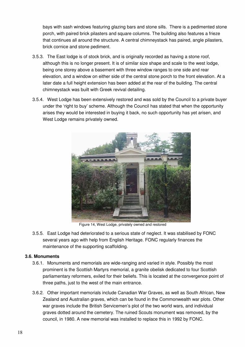
18
bays with sash windows featuring glazing bars and stone sills. There is a pedimented stone
porch, with paired brick pilasters and square columns. The building also features a frieze
that continues all around the structure. A central chimneystack has paired, angle pilasters,
brick cornice and stone pediment.
3.5.3. The East lodge is of stock brick, and is originally recorded as having a stone roof,
although this is no longer present. It is of similar size shape and scale to the west lodge,
being one storey above a basement with three window ranges to one side and rear
elevation, and a window on either side of the central stone porch to the front elevation. At a
later date a full height extension has been added at the rear of the building. The central
chimneystack was built with Greek revival detailing.
3.5.4. West Lodge has been extensively restored and was sold by the Council to a private buyer
under the ‘right to buy’ scheme. Although the Council has stated that when the opportunity
arises they would be interested in buying it back, no such opportunity has yet arisen, and
West Lodge remains privately owned.
Figure 14, West Lodge, privately owned and restored
3.5.5. East Lodge had deteriorated to a serious state of neglect. It was stabilised by FONC
several years ago with help from English Heritage. FONC regularly finances the
maintenance of the supporting scaffolding.
3.6. Monuments
3.6.1. Monuments and memorials are wide-ranging and varied in style. Possibly the most
prominent is the Scottish Martyrs memorial, a granite obelisk dedicated to four Scottish
parliamentary reformers, exiled for their beliefs. This is located at the convergence point of
three paths, just to the west of the main entrance.
3.6.2. Other important memorials include Canadian War Graves, as well as South African, New
Zealand and Australian graves, which can be found in the Commonwealth war plots. Other
war graves include the British Servicemen’s plot of the two world wars, and individual
graves dotted around the cemetery. The ruined Scouts monument was removed, by the
council, in 1980. A new memorial was installed to replace this in 1992 by FONC.
19
3.6.3. Many other fine monuments, tombs, family vaults and headstones remain. 50 of these
were identified as at serious risk of deterioration, and were scheduled for repairs during
Phase One of the Heritage Lottery Funding. The intention here was to make them stable
and clear back vegetation.
3.6.4. The majority of monuments are on brick lined graves, covered with a ledger stone or
ledger-stones, on top of which a monument can be placed. Repairs were typically carried
out as detailed below:
• Erection of hoardings around the monument to be worked on (Home Office requirement.)
• Dismantling of the monument down to brick lined grave level.
• Stabilization of grave lining, repairs to address structural collapse from tree roots.
• Repairs to minor damage on monuments; piecing new stone or making new sections to
replace missing sections.
• Rebuilding of monuments and re-assembling of those that had been partially dismantled by
vandals
• The documentation of an archive of these works, with record photographs before, during and
after restoration had taken place.
3.6.5. These works have been carried out and were highly successful. There are further, large
memorials, which would benefit from similar treatment.
3.7. Catacombs
3.7.1. The Cemetery originally contained five separate sets of catacombs, four located to the
east of the main entrance, and one in the Dissenters section. All but two of these were filled
in by the London Cemetery Company many years ago. Of the remaining two, the West
Catacomb was a bell shaft structure, narrowing slightly towards the base and accessed by
iron ladder, and the other was referred to as the main Eastern Catacomb. A structural
survey of both remaining Catacombs was undertaken on behalf of Southwark Council in
1976 by McDowell and Partners, it was considered that due to structural deficiencies
resulting in safety concerns, inaccessibility and a general state of decay, the most
appropriate option for this catacomb was to fill it in and remove the entrance, which had
projected a few feet from ground level. Coffins interred within were removed.
3.7.2. The East Catacomb is far more elaborate. Accessed by a set of stairs, it takes the form of
a long rectangular box with a crossed barrel vaulted roof in brickwork. It contains 144 loculi,
arranged in batches of 12 on each side, with 8 anterooms. Dates of interred coffins start in
1841. It is presumed that construction took place on or prior to this date.
3.7.3. A 1976 structural survey revealed that several deficiencies in the construction have
occurred over the course of this structures life. The policy resulting from this survey was to
make good the structural deficiencies and seal the chamber until such a time as it was
financially viable to fully attend to the needs of the structure, with the possibility of providing
access for educational and interest purposes at an undisclosed point in the future. This is
still recognized on a list of future works provided by the cemetery manager.
3.8. Pathways and Surfaces
20
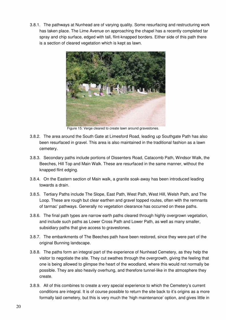
3.8.1. The pathways at Nunhead are of varying quality. Some resurfacing and restructuring work
has taken place. The Lime Avenue on approaching the chapel has a recently completed tar
spray and chip surface, edged with tall, flint-knapped borders. Either side of this path there
is a section of cleared vegetation which is kept as lawn.
Figure 15: Verge cleared to create lawn around gravestones.
3.8.2. The area around the South Gate at Limesford Road, leading up Southgate Path has also
been resurfaced in gravel. This area is also maintained in the traditional fashion as a lawn
cemetery.
3.8.3. Secondary paths include portions of Dissenters Road, Catacomb Path, Windsor Walk, the
Beeches, Hill Top and Main Walk. These are resurfaced in the same manner, without the
knapped flint edging.
3.8.4. On the Eastern section of Main walk, a granite soak-away has been introduced leading
towards a drain.
3.8.5. Tertiary Paths include The Slope, East Path, West Path, West Hill, Welsh Path, and The
Loop. These are rough but clear earthen and gravel topped routes, often with the remnants
of tarmac’ pathways. Generally no vegetation clearance has occurred on these paths.
3.8.6. The final path types are narrow earth paths cleared through highly overgrown vegetation,
and include such paths as Lower Cross Path and Lower Path, as well as many smaller,
subsidiary paths that give access to gravestones.
3.8.7. The embankments of The Beeches path have been restored, since they were part of the
original Bunning landscape.
3.8.8. The paths form an integral part of the experience of Nunhead Cemetery, as they help the
visitor to negotiate the site. They cut swathes through the overgrowth, giving the feeling that
one is being allowed to glimpse the heart of the woodland, where this would not normally be
possible. They are also heavily overhung, and therefore tunnel-like in the atmosphere they
create.
3.8.9. All of this combines to create a very special experience to which the Cemetery’s current
conditions are integral. It is of course possible to return the site back to it’s origins as a more
formally laid cemetery, but this is very much the ‘high maintenance’ option, and gives little in
21
return for the requirement in time and money. Ramshackle Nunhead is just as important to
this site as the more Formal Nunhead, envisioned as a Botanical garden.
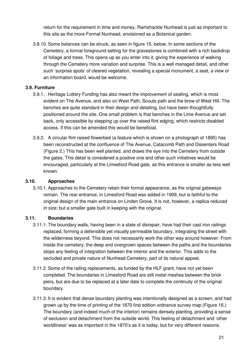
3.8.10. Some balances can be struck, as seen in figure 15, below. In some sections of the
Cemetery, a formal foreground setting for the gravestones is combined with a rich backdrop
of foliage and trees. This opens up as you enter into it, giving the experience of walking
through the Cemetery more variation and surprise. This is a well managed detail, and other
such ‘surprise spots’ of cleared vegetation, revealing a special monument, a seat, a view or
an information board, would be welcome.
3.9. Furniture
3.9.1. Heritage Lottery Funding has also meant the improvement of seating, which is most
evident on The Avenue, and also on West Path, Scouts path and the brow of West Hill. The
benches are quite standard in their design and detailing, but have been thoughtfully
positioned around the site. One small problem is that benches in the Lime Avenue are set
back, only accessible by stepping up over the raised flint edging, which restricts disabled
access. If this can be amended this would be beneficial.
3.9.2. A circular flint raised flowerbed (a feature which is shown on a photograph of 1895) has
been reconstructed at the confluence of The Avenue, Catacomb Path and Dissenters Road
(Figure 2.) This has been well planted, and draws the eye into the Cemetery from outside
the gates. This detail is considered a positive one and other such initiatives would be
encouraged, particularly at the Limesford Road gate, as this entrance is smaller as less well
known.
3.10. Approaches
3.10.1. Approaches to the Cemetery retain their formal appearance, as the original gateways
remain. The rear entrance, in Limesford Road was added in 1909, but is faithful to the
original design of the main entrance on Linden Grove. It is not, however, a replica reduced
in size; but a smaller gate built in keeping with the original.
3.11. Boundaries
3.11.1. The boundary walls, having been in a state of disrepair, have had their cast iron railings
replaced, forming a defensible yet visually permeable boundary, integrating the street with
the wilderness beyond. This does not necessarily work the other way around however. From
inside the cemetery, the deep and overgrown spaces between the paths and the boundaries
stops any feeling of integration between the interior and the exterior. This adds to the
secluded and private nature of Nunhead Cemetery, part of its natural appeal.
3.11.2. Some of the railing replacements, as funded by the HLF grant, have not yet been
completed. The boundaries in Limesford Road are still metal meshes between the brick
piers, but are due to be replaced at a later date to complete the continuity of the original
boundary.
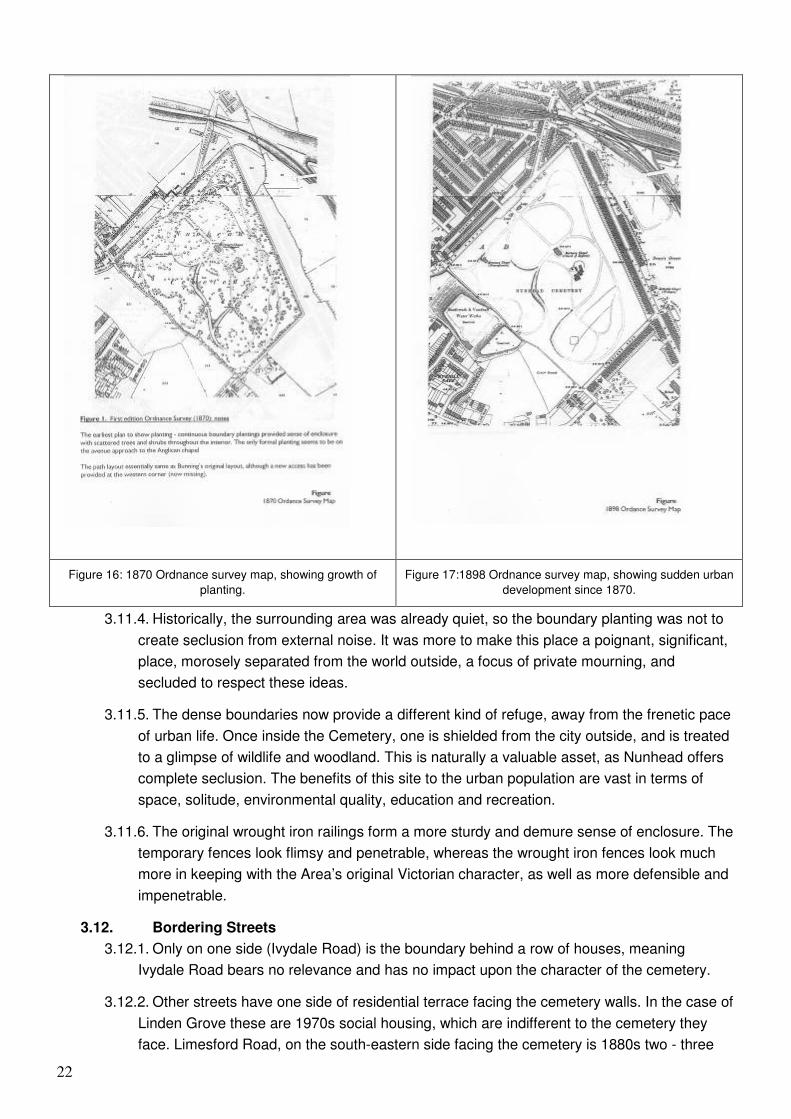
3.11.3. It is evident that dense boundary planting was intentionally designed as a screen, and had
grown up by the time of printing of the 1870 first edition ordnance survey map (Figure 16.)
The boundary (and indeed much of the interior) remains densely planting, providing a sense
of seclusion and detachment from the outside world. This feeling of detachment and ‘other
worldliness’ was as important in the 1870’s as it is today, but for very different reasons.
22
Figure 16: 1870 Ordnance survey map, showing growth of
planting.
Figure 17:1898 Ordnance survey map, showing sudden urban
development since 1870.
3.11.4. Historically, the surrounding area was already quiet, so the boundary planting was not to
create seclusion from external noise. It was more to make this place a poignant, significant,
place, morosely separated from the world outside, a focus of private mourning, and
secluded to respect these ideas.
3.11.5. The dense boundaries now provide a different kind of refuge, away from the frenetic pace
of urban life. Once inside the Cemetery, one is shielded from the city outside, and is treated
to a glimpse of wildlife and woodland. This is naturally a valuable asset, as Nunhead offers
complete seclusion. The benefits of this site to the urban population are vast in terms of
space, solitude, environmental quality, education and recreation.
3.11.6. The original wrought iron railings form a more sturdy and demure sense of enclosure. The
temporary fences look flimsy and penetrable, whereas the wrought iron fences look much
more in keeping with the Area’s original Victorian character, as well as more defensible and
impenetrable.
3.12. Bordering Streets
3.12.1. Only on one side (Ivydale Road) is the boundary behind a row of houses, meaning
Ivydale Road bears no relevance and has no impact upon the character of the cemetery.
3.12.2. Other streets have one side of residential terrace facing the cemetery walls. In the case of
Linden Grove these are 1970s social housing, which are indifferent to the cemetery they
face. Limesford Road, on the south-eastern side facing the cemetery is 1880s two - three
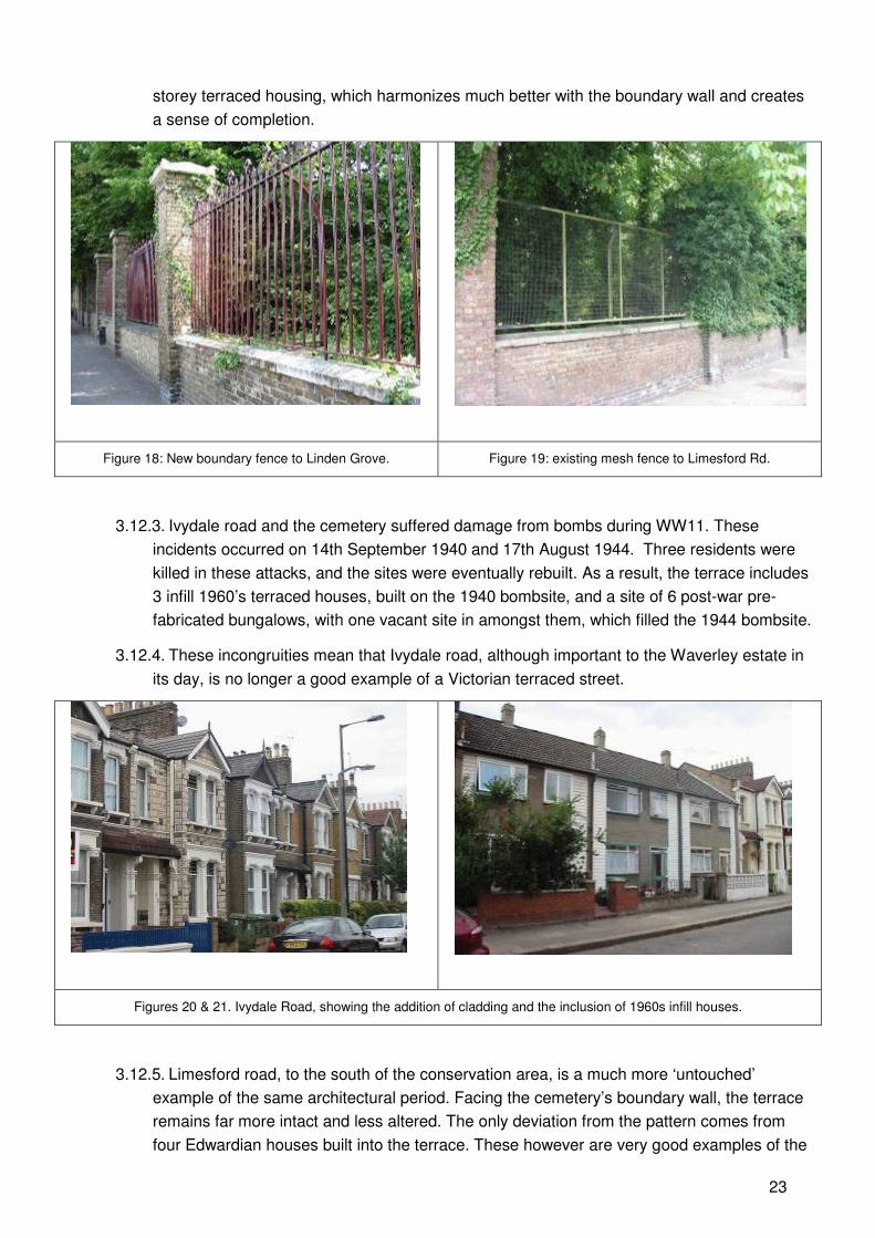
23
storey terraced housing, which harmonizes much better with the boundary wall and creates
a sense of completion.
Figure 18: New boundary fence to Linden Grove. Figure 19: existing mesh fence to Limesford Rd.
3.12.3. Ivydale road and the cemetery suffered damage from bombs during WW11. These
incidents occurred on 14th September 1940 and 17th August 1944. Three residents were
killed in these attacks, and the sites were eventually rebuilt. As a result, the terrace includes
3 infill 1960’s terraced houses, built on the 1940 bombsite, and a site of 6 post-war pre-
fabricated bungalows, with one vacant site in amongst them, which filled the 1944 bombsite.
3.12.4. These incongruities mean that Ivydale road, although important to the Waverley estate in
its day, is no longer a good example of a Victorian terraced street.
Figures 20 & 21. Ivydale Road, showing the addition of cladding and the inclusion of 1960s infill houses.
3.12.5. Limesford road, to the south of the conservation area, is a much more ‘untouched’
example of the same architectural period. Facing the cemetery’s boundary wall, the terrace
remains far more intact and less altered. The only deviation from the pattern comes from
four Edwardian houses built into the terrace. These however are very good examples of the
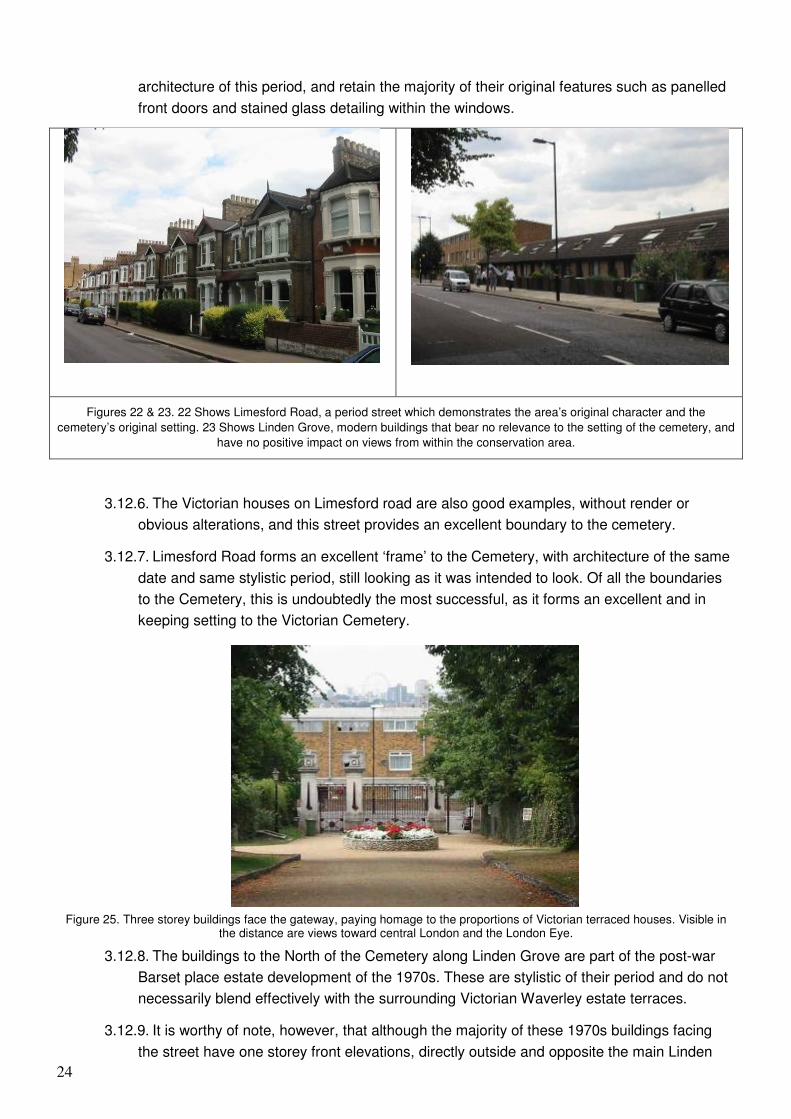
24
architecture of this period, and retain the majority of their original features such as panelled
front doors and stained glass detailing within the windows.
Figures 22 & 23. 22 Shows Limesford Road, a period street which demonstrates the area’s original character and the
cemetery’s original setting. 23 Shows Linden Grove, modern buildings that bear no relevance to the setting of the cemetery, and
have no positive impact on views from within the conservation area.
3.12.6. The Victorian houses on Limesford road are also good examples, without render or
obvious alterations, and this street provides an excellent boundary to the cemetery.
3.12.7. Limesford Road forms an excellent ‘frame’ to the Cemetery, with architecture of the same
date and same stylistic period, still looking as it was intended to look. Of all the boundaries
to the Cemetery, this is undoubtedly the most successful, as it forms an excellent and in
keeping setting to the Victorian Cemetery.
Figure 25. Three storey buildings face the gateway, paying homage to the proportions of Victorian terraced houses. Visible in the distance are views toward central London and the London Eye.
3.12.8. The buildings to the North of the Cemetery along Linden Grove are part of the post-war
Barset place estate development of the 1970s. These are stylistic of their period and do not
necessarily blend effectively with the surrounding Victorian Waverley estate terraces.
3.12.9. It is worthy of note, however, that although the majority of these 1970s buildings facing
the street have one storey front elevations, directly outside and opposite the main Linden
25
Grove entrance, there is a block of three storey buildings. This is the only point at which the
streetscape is visible from the interior of the Cemetery, and therefore the only point at which
the streetscape affects the views from within the conservation area. These three storey
buildings bear more relevance in their height and form to a Victorian terrace than the other
buildings in this street. Because of their impact upon views, and despite the negative
connotations of this architectural type, this subtlety shows an unexpected consideration and
understanding of the site and its wider context.
3.13. Views
3.13.1. The original layout of Nunhead was designed to maximize the views to the North of the
City of London and south over the Downs. Due to subsequent overgrowth of secondary
woodland, the majority of these views have become obscured.
3.13.2. There is one remaining open view, however, which is kept cleared. This offers a
tantalizing glimpse through the wilderness, to Saint Paul’s Cathedral, and directly behind
that Highgate Cemetery approximately 8 miles away on the brow of Highgate West Hill.
3.13.3. This is an important view, as the two cemeteries were designed as ‘twin’ cemeteries and
referred to as the North and South ‘Stations.’ This view is found at the summit of West Hill.
3.13.4. Both Northward and Southward views, which have been interrupted by the overgrowth,
have since been reinstated. The views reward the visitor to the Cemetery for climbing the
hill. Future vegetation management will be important in maintaining these views.
3.14. Key Spaces
3.14.1. The notion of key spaces within this conservation area is somewhat flawed as the majority
of the space here feels hemmed in by the overgrowth, and yet the entire site provides 52
acres of ‘open space’ for this densely populated part of South London. Despite the
overgrowth, there are still some significant spaces within the cemetery worthy of note.
3.14.2. The main entrance way on Linden Grove is set back slightly from the street, and provides
an important public space, linking the street to the monumental and formal entranceway,
and providing an appropriate setting for Bunning’s imposing gates.
3.14.3. Similarly, the space inside the gates is important, as a setting for the pair of Lodges, and
as an approach through the Lime Avenue to the Anglican Chapel. This space is wide and
open, with formal lawns to either side bordered by the avenue of Lime trees, which frame
the view of the Anglican Chapel. This is a key orientation space and node of reference as
well as a convergence point for several paths.
3.14.4. There is an appropriately scaled down space outside of the South Gate on Limesford
road, which provides the same benefit of creating a buffer between the street and the
Cemetery.
3.14.5. The space immediately inside the South gate is also maintained as lawn, which once
again provides a useful orientation space on arrival in the cemetery. This space is much
larger that that on the North side but has a less distinctive character and certainly less
formality when compared to the Lime Avenue with its grand sweeping views. This area is
retained for new burial sites, and is conjoined by an area set aside for woodland burials,
which has proved a popular feature.
26
3.14.6. The site of the former Dissenter’s Chapel, damaged in the war and demolished in 1952,
has been left as an open glade which provides a pleasant open yet secluded space, on
Dissenters Road, to the West of the main entrance. The glade leads uphill to a series of
smaller glades, the uppermost of which contains a small pond.
3.14.7. The final open space is located immediately behind the Anglican chapel, on Scouts Path,
and is the location of the most recent burials in the cemetery. This small section of lawn
cemetery has a very intimate feeling, as it is bounded on all sides by tall woodland. Half of
this area is devoted to Muslim burials with headstones facing East.
3.14.8. The pathways of Nunhead Cemetery are perhaps the most important of spaces, as they
are key to negotiating the site, and are the most commonly perceived experience of the
Cemetery. Tunnel like in appearance, and of varying surface quality, the paths have a
feeling of being almost carved out of the overgrowth. They have maze-like qualities of
seclusion, and offer access through the heart of mature woodland.
3.15. Negative Elements
3.15.1. The remainder of works scheduled to be completed after phase one of the HLF grant
money will remove some other negative elements. These include the remaining
improvements to boundary walls, including the replacement of railings to the southern walls
in accordance with the original design, and improvements and repairs to the East Lodge.
Both the unaltered walls and the derelict East Lodge currently detract from the overall
appearance of the conservation area, but both should be dealt with in the future.
3.15.2. The private ownership of West Lodge is not an ideal situation, as the building would be
more valuable if it could be used by and for the Cemetery. Also, the current state of the
derelict East lodge could be considered a negative element, particularly in conjunction with
the West Lodge. The two were clearly designed as a well-balanced pair, and until East
Lodge is restored, the balance of the entranceway, Lime Avenue and Anglican Chapel
remains compromised. This is not to say that the East Lodge itself is a negative element,
but its current state of disrepair is an issue that urgently needs addressing.
3.15.3. The Cemetery currently feels as if it is more a space to walk through than a space to
linger. As the majority of graves are old enough not to have frequent visitors any more, and
there are no public facilities as such within the Cemetery, the tunnel-like paths make the
visitor feel as though they must keep moving. Open spaces such as the site of the former
Dissenter’s Chapel, the Lime Avenue and the more modern gravestones area to the south
offer visitors more of a chance to spend time in the Cemetery, strolling, sitting or picnicking
for example. More small spaces opened up within the wilderness could create a network of
outside ‘rooms’, each with a focal point, such as a collection of impressive gravestones,
some good planting or a bench. This would give the visitor more opportunity to linger, and
may increase the amount of people using the space. There are no plans along these lines at
present.
3.15.4. Provision of a variety of seating in different places would be beneficial. This is not to say
that there is not enough seating, but that it could be positioned better. The cemetery would
also benefit from the provision of shelter from inclement weather, which is currently not
available at all. (Except underneath the chapel portico. The restored East Lodge will
potentially provide more.) Any provision of shelters should be constructed of durable
27
materials, and all efforts should be made when considering such structures to ‘design out’
the potential of vandalism.
3.15.5. Vandalism has been an important issue to Nunhead Cemetery over the years, best
illustrated by the arson attack on the Anglican Chapel. Many gravestones and tombs have
also been damaged through vandalism, and although steps are being taken to remedy this
situation, the site must safeguard against this in the future. Increased security provisions,
upgraded boundaries and even an involvement scheme for Linden Grove and Limesford
road residents, or for the friends of Nunhead Cemetery, along the lines of a neighbourhood
watch programme could help to minimise the threat of vandalism in the future. This would
contribute to the works of FONC and the on-site rangers, which have had a large impact on
reducing vandalism.
28
4. Audit
4.1. Listed Buildings and Features
4.1.1. The list of buildings of special architectural or historic interest for Southwark was updated
in September 1998. Detailed list descriptions are available from the Council. The majority of
buildings in the Conservation Area are listed.
4.1.2. Bunning’s landscape layout is preserved as Grade II* listed on English Heritage’s
Register of Historic Parks and Gardens. It is imperative that the landscape layout remains
intact. No portion of the site should be lost, redeveloped or significantly altered in terms of
layout of paths and proportions of natural areas, whether they are lawned or wooded. The
layout is particularly significant, to the site as a whole, to garden history and also to historic
Cemeteries. Loosing any part of the site would have a serious impact on the remainder of
the site, and such a loss should not be considered.
4.1.3. The principal listed building must be considered to be the ruined Anglican Chapel, which
is Grade II listed. This building is seen in conjunction with the listed entrance piers and
gates, also grade II listed, along with the railings and boundary walls.
4.1.4. The other listed buildings are the entrance lodges, both Grade II, the East Lodge being on
English Heritage’s Buildings at Risk Register, and the West Lodge being a private
residence.
4.1.5. Nine funerary monuments are Grade II listed. This is very few compared to other Victorian
London Cemeteries, and could be reviewed as many other fine examples are to be found at
Nunhead.
4.1.6. The Interrelationship between these buildings and structures, as well as the enclosure
from overgrowth and the open stretches of footpaths, form a very specific balance, and each
plays their role in the definition of the space and visual understanding of each other building
and the function of the site as a whole.
4.2. Unlisted Features
4.2.1. The majority of the gravestones, memorials and tombs as well as the catacombs are
unlisted, and are in varying states of disrepair. Many are entirely obscured and overgrown,
and many have been damaged by the reclamation of nature, particularly coverings of ivy
and displacement by tree roots. These elements add a great deal of quality to the character
of the conservation area, and define the cemetery. The mournful nature of ostentatious
memorials being reclaimed by the earth into which their benefactors have returned is key to
the demure and forlorn character that typifies Nunhead Cemetery, and indeed most
Victorian Cemeteries.
4.2.2. 50 important memorials have had repair work to them, and these are mostly bordering the
main paths and avenues. The remainder of the gravestones should be made safe and
secure, and, if possible, retained as an essential attribute to the conservation area’s
character. This does not mean that each gravestone must be cleaned and straightened and
restored to immaculate condition, as restoring and maintaining this condition would be
hugely expensive and impractical. Instead the slow process of vegetation reclaiming
gravestones should be allowed to continue, as it creates a very specific character. However,
29
gravestones should be made stable and secure where necessary to eliminate the risk of
danger to visitors.
4.2.3. The eastern catacomb remains largely intact, although sealed up without access and
greatly in need of restoration work. It is mentioned in the Register, but appears not to be
listed itself. It is invaluable as an additional element to understanding the choices available
in the original cemetery, and as a monument to the Victorian obsession with death and
mourning. Should an opportunity become available, the catacomb should be further restored
and maintained with limited access provided if possible.
4.3. Archaeology
4.3.1. Historical map evidence suggests that this site had been used only for agricultural
purposes prior to the development of the cemetery in the 19th century. The site is therefore
not included in the borough’s archaeological priority zone.
4.4. Environmental Importance
4.4.1. As a registered site of London-wide Nature Conservation Importance, Nunhead cemetery
should retain its environmental character. There has been much debate as to whether the
original, lawn cemetery should be reinstated, or whether the current state of overgrowth is
preferential, more authentically natural, or more beneficial to its users. The current situation
offers a small amount of compromise, with a heavy balance in favour of woodland, and only
small sections of lawn.
4.4.2. Bunning’s layout survives almost entirely intact, although in a much less formal manner.
Despite the changes in the cemetery, the layout of paths can be considered original and
therefore preserved, although the essential character of the site as a whole is vastly
different.
4.4.3. The woodland supports many rare species of plant life, wild life, birds, fungi, mosses and
lichens, and removal of large majorities of this habitat would result in detrimental effects to
all of these species.
4.4.4. The secondary woodland is of high nature conservation value, however in some areas;
total tree coverage has developed at the cost of other plant layers and types.
4.4.5. The habitat requires positive nature conservation management, in order to preserve the
ability of a variety of flora and fauna to thrive here. The cemetery’s ecological management
plan manages this, but should regularly be reviewed.
30
Further Reading
• Ashurst, J and N (1988) – Practical Building Conservation, Vols. 1 to 5.
• Beasley, John D (1999, London Borough of Southwark) – The Story of Peckham and
Nunhead.
• Brereton, C (English Heritage, 1991) – The Repair of Historic Buildings: Principles and
Methods.
• Cherry, B and Pevsner, N (1983) – The Buildings of England, London 2: South.
• Curl, J S (1980) – A Celebration of Death.
• Dyos, H J (1961) – Victorian Suburb.
• English Heritage – Register of Parks and Gardens of special historic interest: entry for
Nunhead Cemetery, Southwark, Greater London.
• Friends of Nunhead Cemetery (1987) – Illustrated Guide to Nunhead Cemetery.
• HMSO (1994) – Planning Policy Guidance Note 15 [PPG 15]: Planning and the Historic
Environment.
• Institute of Historic Building Conservation [IHBC] (2002) – A Stitch in Time: Maintaining your
Property Makes Good Sense and Saves Money.
• Miller, H (1981) – London Cemeteries.
• Reilly, L (1998, London Borough of Southwark) – Southwark: an Illustrated History.
• Woollacott, R (no date) – A Guide to the Graves of Nunhead Notables.
Related Documents


![100524 Naas Road Development Framework[1]](https://static.cupdf.com/doc/110x72/6234bad7a8a1f9679566e38c/100524-naas-road-development-framework1.jpg)