Definitive clarifications as to why Takeshima is Japan’s territory! 10 points to understand the Takeshima Dispute With Q&A Ministry of Foreign Affairs of Japan

Welcome message from author
This document is posted to help you gain knowledge. Please leave a comment to let me know what you think about it! Share it to your friends and learn new things together.
Transcript

Definitive clarifications as to why Takeshima is Japan’s territory!
10 points to understand the Takeshima Dispute
With
Q&A
Ministry of Foreign Affairs of Japan

1
Table of Contents
10 points to understand the Takeshima Dispute
◆ Japan’s Consistent Position on Territorial Sovereignty over Takeshima P. 2
◆ An Outline of the Japanese Position on Sovereignty over Takeshima and the Illegal Occupation by the Republic of Korea P. 3-P. 4
◆ Answering the questions regarding the Takeshima Dispute Q&A P. 18-P. 26
▲
Point 1Japan has long recognized the existence of “Takeshima.” P. 5-P. 6
▲
Point 2There is no evidence indicating that the ROK has long recognized the existence of Takeshima. P. 7
▲
Point 3Japan had established sovereignty over Takeshima by the mid-17th century at the latest. P. 8
▲
Point 4While Japan prohibited the passage to Utsuryo Island towards the end of the 17th century, the lack of a prohibition on passage to Takeshima continued. P. 9
▲
Point 5The ROK currently refers to the false statement made by Ahn Yong-bok as one of the foundations for its claim to sovereignty over Takeshima. P. 10
▲
Point 6In 1905, Japan reaffirmed its sovereignty over Takeshima through a Cabinet decision. P. 11-P. 12
▲
Point 7In the process of drafting the San Francisco Peace Treaty, the ROK requested that the United States add Takeshima to the territories to be renounced by Japan. However, the United States rejected that request. P. 13-P. 14
▲
Point 8Takeshima was designated as a bombing range for the U.S. Forces in Japan. P. 15
▲
Point 9The ROK delineated the so-called “Syngman Rhee Line” on the high seas in contravention of international law, and illegally occupied Takeshima as a unilateral act. P. 16
▲
Point 10Japan has been repeatedly proposing to the ROK that the dispute over the sovereignty of Takeshima should be referred to the International Court of Justice (ICJ). However, the ROK is refusing these proposals. P. 17
2
Japan’s Consistent Position on Territorial Sovereignty over
Takeshima Takeshima is indisputably an inherent part of the territory of Japan, in light of historical facts and based on international law.
The Republic of Korea has been occupying Takeshima with no basis in international law. Any measures the Republic of Korea takes regarding Takeshima based on such an illegal occupation have no legal justification.
Japan will continue to seek the settlement of the dispute over territorial sovereignty over Takeshima on the basis of international law in a calm and peaceful manner.
The Republic of Korea has never demonstrated any clear basis for its claims that it had taken effective control over Takeshima prior to Japan’s effective control over Takeshima and reaffirmation of its territorial sovereignty in 1905.
1
2
3
Sea of Japan
Republicof Korea Japan
Takeshima
Republicof Korea
UtsuryoIsland
Approx. 88 km
Approx. 217 km
Approx. 158 km
Approx.211 km
Approx. 67 km
Nishijima(Ojima)
Higashijima(Mejima)
OkiIslands
ShimanePrefecture
Takeshima
Doctor! Please tell us the reasons why Takeshima is Japan’s territory.
It shows a good attitude that you are trying to learn more about the Takeshima dispute.I am going to start by giving you an easy-to-understand explanation that organizes the dispute into “Ten Points” and a Q&A.
[Background to Takeshima]
❍ Takeshima is located in the Sea of Japan approximately 158 km northwest of the Oki Islands at 37°14’ north latitude and
131°52’ east longitude. It is part of Okinoshima Town, Shimane Prefecture.
❍ Takeshima is a group of two main islands (Higashijima (Mejima) and Nishijima (Ojima)) and several dozen smaller islands
surrounding them. Its total area is approximately 0.20 square kilometers.
❍ Both islands are precipitous volcanic islands, and cliffs abut the coastline on all sides. The islands have scarce vegetation
and drinking water resources.

3
An Outline of the Japanese Position on Sovereignty over Takeshima and the Illegal Occupation by the Republic of KoreaJapan seeks a peaceful resolution to the dispute based on international law and through dialogues.
Japan had established sovereignty over Takeshima in the middle of the 17th century
The fact that Japan has long recognized the existence
of Takeshima is made clear by a large number of early
documents and maps. In the early 17th century, the
Japanese Government formally granted its people
the right of passage to Utsuryo Island, and they used
Takeshima as a navigational port and an anchorage for
ships on their way to Utsuryo Island and as a ground
on which to hunt and gather marine resources such as
sea lions and abalone. Japan had established sover-
eignty over Takeshima by the mid-17th century.
In 1905, Japan reaffirmed its sovereignty over Takeshima by Cabinet decision
In the early 1900s, the residents of the Oki Islands of
Shimane Prefecture called for a stable environment to
conduct their sea lion hunting business, which had be-
come a full-scale industry by then. Against this back-
ground, the Cabinet decided to incorporate Takeshima
into Shimane Prefecture and reaffirmed its sovereignty
over Takeshima. The Cabinet added Takeshima to the
State Land Register, established a license system for
sea lion hunting, and charged a fee for use of the state
land. These exercises of sovereignty were carried out
by the Government of Japan peacefully and without
protest from other nations. Thus Japan’s sovereignty
over Takeshima, which by then had already been es-
tablished, became clearer to other countries in terms
of modern international law as well.
The San Francisco Peace Treaty confirmed that Takeshima was Japanese territory
In the process of drafting the San Francisco Peace
Treaty (signed on September 8, 1951, effective as of
April 28, 1952), which included the ultimate disposition
of Japanese territory after World War II, the Republic of
Korea requested that the United States add Takeshima
to the territories to be renounced by Japan. However,
the United States unequivocally rejected this re-
quest, noting that Takeshima was “...never treated
as part of Korea…” but was Japanese territory. This
is proven by diplomatic documents disclosed by the
United States government. In this context, the San
Francisco Peace Treaty lists “Korea, including the is-
lands of Quelpart, Port Hamilton and Dagelet” as ter-
ritories that Japan must renounce, while intentionally
excluding Takeshima. Thus the treaty, which estab-
lished the international order post-World War II, affirms
that Takeshima is Japanese territory. In addition, af-
ter the treaty came into force, the United States noti-
fied Japan that it would use Takeshima as a bombing
range. Based on the agreement with the United States,
Japan designated Takeshima as a bombing range, and
announced so to the public. Under the international
order after World War II, Takeshima was unequivocally
recognized as Japanese territory.
4
Has Takeshima been illegally occupied by the ROK despite the fact that it is a part of the territory of Japan, in light of historical facts and based on international law?
That is correct. The ROK illegally occupied Takeshima on a unilateral basis against international law. Japan, which has consistently followed the path of a peaceful nation since the end of World War II, has been seeking a peaceful solution in dealing with this situation. Japan has proposed to the ROK three times in the past that the dispute of territorial sover-eignty over Takeshima be referred to the International Court of Justice (ICJ) in order to settle the dispute fairly. However, the ROK has continued to reject all of these proposals.
Contrary to International Law, the ROK had begun its illegal occupation of Takeshima immediately prior to the San Francisco Peace Treaty coming into effect
However, in January 1952, immediately prior to the
coming into force of the San Francisco Peace Treaty,
the ROK unilaterally established what is known as the
“Syngman Rhee Line” and incorporated Takeshima
into the ROK side of the line. This action was clearly
inconsistent with international law, and the Japanese
Government promptly and strongly protested against
this act, stating that it did not recognize the line.
Nevertheless, the ROK later stationed permanent se-
curity personnel on the islands, constructing lodgings,
a monitoring facility, a lighthouse, and port and dock-
ing facilities. The ROK’s occupation of Takeshima by
force has no legal basis whatsoever, and Japan has
strongly protested against each of these acts, de-
manding Korea’s withdrawal. Any measures the ROK
takes regarding Takeshima based on this type of illegal
occupation have neither legal justification nor any legal
effect as grounds for its sovereignty claim.*
While Japan has proposed the ROK three times in the past that the dispute be referred to the International Court of Justice, the ROK has rejected all such proposals
Japan has consistently followed the path of a peace-
ful nation since the end of World War II, and in order
to seek a peaceful solution has proposed no less
than three times since 1954 that the dispute of ter-
ritorial sovereignty over Takeshima be referred to the
International Court of Justice. However, the ROK has
rejected all such proposals. It is extremely regrettable
that the ROK, which plays an important role in the in-
ternational arena, has turned its back on a solution
based on international law. Japan will continue to take
appropriate measures to resolve this dispute peace-
fully and calmly in accordance with international law.
* The series of actions carried out by the ROK lacks any evidential power in international law and has no effect on the determination of sovereignty because Japan has continuously protested against it since the very begin-ning of the territorial dispute triggered by the illegal uni-lateral establishment of the “Syngman Rhee Line.” In ad-dition, the ROK claims that the occupation of Takeshima is an act to restore its sovereignty. In order to justify its claim, the ROK needs to present proof that Korea had effective control over Takeshima prior to Japan’s effec-tive control over Takeshima and reaffirmation of its ter-ritorial sovereignty in 1905. However, the ROK has never demonstrated any such proof thus far.
5
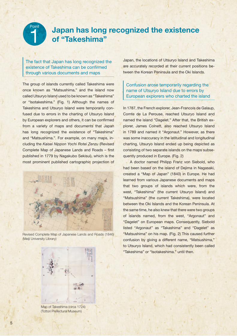
The fact that Japan has long recognized the existence of Takeshima can be confi rmed through various documents and maps
The group of islands currently called Takeshima were
once known as “Matsushima,” and the island now
called Utsuryo Island used to be known as “Takeshima”
or “Isotakeshima.” (Fig. 1) Although the names of
Takeshima and Utsuryo Island were temporarily con-
fused due to errors in the charting of Utsuryo Island
by European explorers and others, it can be confi rmed
from a variety of maps and documents that Japan
has long recognized the existence of “Takeshima”
and “Matsushima.”. For example, on many maps, in-
cluding the Kaisei Nippon Yochi Rotei Zenzu (Revised
Complete Map of Japanese Lands and Roads – fi rst
published in 1779 by Nagakubo Sekisui), which is the
most prominent published cartographic projection of
Japan, the locations of Utsuryo Island and Takeshima
are accurately recorded at their current positions be-
tween the Korean Peninsula and the Oki Islands.
Confusion arose temporarily regarding the name of Utsuryo Island due to errors by European explorers who charted the island
In 1787, the French explorer, Jean-Francois de Galaup,
Comte de La Perouse, reached Utsuryo Island and
named the island “Dagelet.” After that, the British ex-
plorer, James Colnett, also reached Utsuryo Island
in 1789 and named it “Argonaut.” However, as there
was some inaccuracy in the latitudinal and longitudinal
charting, Utsuryo Island ended up being depicted as
consisting of two separate islands on the maps subse-
quently produced in Europe. (Fig. 2)
A doctor named Philipp Franz von Siebold, who
had been based on the island of Dejima in Nagasaki,
created a “Map of Japan” (1840) in Europe. He had
learned from various Japanese documents and maps
that two groups of islands which were, from the
west, “Takeshima” (the current Utsuryo Island) and
“Matsushima” (the current Takeshima), were located
between the Oki Islands and the Korean Peninsula. At
the same time, he also knew that there were two groups
of islands named, from the west, “Argonaut” and
“Dagelet” on European maps. Consequently, Siebold
listed “Argonaut” as “Takashima” and “Dagelet” as
“Matsushima” on his map. (Fig. 2) This caused further
confusion by giving a different name, “Matsushima,”
to Utsuryo Island, which had consistently been called
“Takeshima” or “Isotakeshima.” until then.
Point
1 Japan has long recognized the existence of “Takeshima”
Revised Complete Map of Japanese Lands and Roads (1846) (Meiji University Library)
Map of Takeshima (circa 1724)(Tottori Prefectural Museum)

6
The current Takeshima was officially named “Takeshima” in 1905
Thus, the long-held knowledge of “Takeshima” and
“Matsushima” in Japan coexisted with the names that
subsequently came from the Western world. In this
confusion, Japanese who could see “Matsushima” in
the distance requested that the government develop
the island. The government implemented a field study
in 1880 in order to clarify the relationship among the
different names of the islands, and confirmed that the
island referred to as “Matsushima” in the request was
actually Utsuryo Island.
In this way, Utsuryo Island came to be called
“Matsushima,” which raised the question of what to
call the current Takeshima. To resolve this issue, the
Japanese Government, while taking into account the
opinion of Shimane Prefecture, changed the tradition-
al names, officially naming the current Takeshima as
such in 1905.
Republic of Korea
Shimane Prefecture
Oki Islands
Takeshima
Utsuryo Island
Republic of Korea
Shimane Prefecture
Oki Islands
Takeshima
Utsuryo Island
Argonaut Island (Colnett’s naming)
Takashima (Siebold)
Dagelet Island (La Perouse naming)
Matsushuma (Siebold) Takeshima or Isotakeshima
Matsushima
Fig. 1. Old names Fig. 2. Late 19th century names
Is it correct that in Japan Takeshima used to be called “Matsushima” and that the island had been known for a long period of time?
Yes. This can also be confirmed from a variety of maps and documents that show that Japan has long correctly recognized the existence of the current Takeshima and Utsuryo Island.During the latter half of the 19th century, Utsuryo Island also became known as “Matsushima,” which temporarily caused confusion. Therefore, the present Takeshima was officially named “Takeshima” in 1905.
Po
int 1P
oint 2
Po
int 3P
oint 4
Po
int 5P
oint 6
Po
int 7P
oint 8
Po
int 9P
oint 10
Q&
A

7
The ROK claims that “Usan Island” as described in old Korean texts and maps is the current “Takeshima”
For example, the ROK claims that, based on descrip-
tions in old Korean texts including the “Samguksagi”
(History of the Three Kingdoms: 1145), “Sejong Sillok,
Jiriji” (Geographical Appendix to the Veritable Records of
King Sejong: 1454), “Sinjeung Dongguk Yeoji Seungnam”
(Revised and Augmented Edition of the Survey of the
Geography of Korea: 1531), “Dongguk Munheon Bigo”
(Reference Compilation of Documents on Korea: 1770),
“Man’gi Yoram” (Manual of State Affairs for the Monarch:
1808) and “Jeungbo Munheon Bigo” (Revised and
Augmented Reference Compilation of Documents on
Korea: 1908), Koreans had long been aware of the ex-
istence of the two islands of Utsuryo and Usan, and that
this “Usan Island” is the current Takeshima.
It is described that there were bamboo plants cultivated and that many people were living on “Usan Island”
However, whereas the “History of the Three Kingdoms”
contains a description of Utsuryo Island, which belonged
to Usan Country, becoming a part of Silla in 512, there
is no mention of “Usan Island.” Meanwhile, in other an-
cient Korean documents, “Usan Island” is described as a
place where many people lived and large bamboo plants
were cultivated, which does not represent the realities of
Takeshima and sounds more like Utsuryo Island.
Literature based on less reliable statements by a person called Ahn Yong-bok
The ROK claims that “Usan Island” is Dokdo (the
Korean name for Takeshima) based on the description
that includes “Usan Island is what the Japanese called
Matsushima” in “Yeojiji” (Record of Geography: 1656)
cited in the “Reference Compilation of Documents
on Korea,” “Manual of State Affairs for the Monarch”
and “Revised and Augmented Reference Compilation
of Documents on Korea” On the other hand, there
are more critical studies pointing out that the origi-
nal text in the “Record of Geography” indicates that
“Usan Island” and “Utsuryo Island” refer to exactly the
same island and that the description in documents
such as the “Reference Compilation of Documents
on Korea” do not directly or accurately quote from the
“Record of Geography.” Such studies point out that
the descriptions in those documents were copied from
“Ganggyego” (Study of National Boundaries: 1756)
which had uncritically cited a less reliable statement
by a man called Ahn Yong-bok. (→See Point5, Q&A3)
The location and size of “Usan Island” on the map does not coincide with the actual location and size of “Takeshima,” indicating that this island does not exist
In the map attached to the “Revised and Augmented
Edition of the Survey of the Geography of Korea,”
“Utsuryo Island” and “Usan Island” are described as
two separate islands. If, as the ROK claims, “Usan
Island” is the current Takeshima, it should have been
described as a much smaller island than Utsuryo
Island and located east of Utsuryo Island. However,
the “Usan Island” on this map is illustrated as being
roughly of the same size as Utsuryo Island, and situ-
ated between the Korean Peninsula and Utsuryo Island
(west of Utsuryo Island), indicating that the island does
not exist. (→See Q&A2)
Point
2
Revised and Augmented Edition of the Survey of the Geographyof KoreaThe Map of Eight Provinces of Korea (Copy)
There is no evidence indicating that the ROK has long recognized the existence of Takeshima.
8
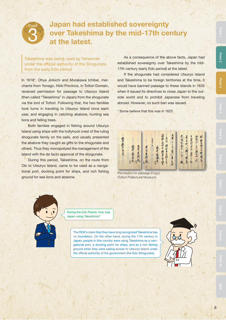
Takeshima was being used by fi shermen under the offi cial authority of the Shogunate from the early Edo period
In 1618*, Ohya Jinkichi and Murakawa Ichibei, mer-
chants from Yonago, Hoki Province, in Tottori Domain,
received permission for passage to Utsuryo Island
(then called “Takeshima” in Japan) from the shogunate
via the lord of Tottori. Following that, the two families
took turns in traveling to Utsuryo Island once each
year, and engaging in catching abalone, hunting sea
lions and felling trees.
Both families engaged in fi shing around Utsuryo
Island using ships with the hollyhock crest of the ruling
shogunate family on the sails, and usually presented
the abalone they caught as gifts to the shogunate and
others. Thus they monopolized the management of the
island with the de facto approval of the shogunate.
During this period, Takeshima, on the route from
Oki to Utsuryo Island, came to be used as a naviga-
tional port, docking point for ships, and rich fi shing
ground for sea lions and abalone.
As a consequence of the above facts, Japan had
established sovereignty over Takeshima by the mid-
17th century (early Edo period) at the latest.
If the shogunate had considered Utsuryo Island
and Takeshima to be foreign territories at the time, it
would have banned passage to these islands in 1635
when it issued its directives to close Japan to the out-
side world and to prohibit Japanese from traveling
abroad. However, no such ban was issued.
* Some believe that this was in 1625.
Point
3Japan had established sovereignty over Takeshima by the mid-17th century at the latest.
During the Edo Period, how was Japan using Takeshima?
The ROK’s claim that they have long recognized Takeshima has no foundation. On the other hand, during the 17th century in Japan, people in this country were using Takeshima as a navi-gational port, a docking point for ships, and as a rich fi shing ground when they were sailing across to Utsuryo Island under the offi cial authority of the government (the Edo Shogunate).
Po
int 1P
oint 2
Po
int 3P
oint 4
Po
int 5P
oint 6
Po
int 7P
oint 8
Po
int 9P
oint 10
Q&
A
Permission for passage (Copy)(Tottori Prefectural Museum)

9
Confl icting opinions over the attribution of Utsuryo Island between the Shogunate and the Korean dynasty
With the permission of the shogunate for passage to
Utsuryo Island, the Ohya and Murakawa families in
Yonago had carried out their monopolistic business
activities without intervention for approximately sev-
enty years.
When the Murakawa family traveled to Utsuryo
Island in 1692, they encountered many Koreans en-
gaging in fi shing on the island. The following year, the
Ohya family also encountered a number of Korean
people on the island, and brought two of them, Ahn
Yong-bok and Pak Eo-doon, back to Japan. At this
time, the Korean royal dynasty prohibited its people
from traveling to Utsuryo Island.
By order of the shogunate, which was now aware
of the situation, Tsushima Domain (which served as
the contact point with the Korean dynasty during the
Edo period) repatriated Ahn and Pak to Korea, and
initiated negotiations with Korea requesting that it
prohibit its people from traveling to Utsuryo Island.
However, there was a confl ict of opinion over the at-
tribution of Utsuryo Island and no agreement was
reached in these negotiations.
Although passage to Utsuryo Island was banned in order to take into consideration the friendship with the Korean dynasty, passage to Takeshima was not banned
Notifi ed of the failure of the negotiations by Tsushima
Domain, the shogunate decided to prohibit passage
to Utsuryo Island in January 1696, recognizing that as
no Japanese had settled on Utsuryo Island, and that
the distance from the Korean Peninsula was shorter
than that from Hoki Province, Tottori Domain, it was
not wise to ruin a good relationship with a neighboring
country for the sake of what was seen as a small un-
profi table island, and that it would be suffi cient to ban
passage to Utsuryo Island because it had not been
incorporated into Japan. The shogunate instructed
Tottori Domain that passage by Japanese to Utsuryo
Island was now prohibited, and ordered Tsushima
Domain to inform the Korean dynasty of this decision.
The series of the negotiations concerning the at-
tribution of Utsuryo Island is generally known as the
“Takeshima Ikken” (Takeshima Affair).
However, actually, passage to Takeshima was not
banned. This clearly shows that Japan already regard-
ed Takeshima as its territory at that time.
Point
4While Japan prohibited the passage to Utsuryo Island towards the end of the 17th century, the lack of a prohibition on passage to Takeshima continued.
Rojuhosho (information document issued by Roju) regarding the prohibition on passage to Utsuryo Island (copy) (included in “Offi cial document of Takeshima”) (Tottori Prefectural Museum)
Is it not true that passage to Takeshima was prohibited?
The Edo Shogunate only prohibited the passage to Utsuryo Island, not to Takeshima.This also clearly shows that the Shogunate regarded Takeshima as its territory at that time.
Rojuhosho (information document issued by Roju) regarding the prohibition on passage to Utsuryo Island (copy) (included in “Offi cial document of Takeshima”) (Tottori Prefectural Museum)

10
Statement by Ahn Yong-bok, which the ROK refers to and Questions Raised
Ahn Yong-bok returned to Japan after the shogu-
nate prohibited passage to Utsuryo Island, following
which he was repatriated to Korea and interrogated by
Korean offi cials for violating the prohibition of passage
to Utsuryo Island. The statement made by Ahn at that
time is cited by the ROK today as one of the founda-
tions for its claim to sovereignty over Takeshima.
According to documents held by the ROK, Ahn
Yong-bok stated that while in Japan in 1693 he had
received a document from the Tokugawa shogunate
acknowledging its recognition of Utsuryo Island and
Takeshima as territories of Korea, but that the lord of
Tsushima had seized this document. However, nego-
tiations between Japan and Korea over fi shing around
Utsuryo Island began in 1693, when Ahn was taken
to Japan then repatriated via Tsushima Domain. Thus,
the Tokugawa shogunate would never have given
him a memorandum saying that Utsuryo Island and
Takeshima were Korean territory when he came over in
1693, and in fact it did not.
Moreover, the documents held by the ROK show
that Ahn Yong-bok stated during his visit to Japan in
1696 that he saw many Japanese on Utsuryo Island.
However, his visit was after the shogunate had decid-
ed to ban passage to Utsuryo Island, and so neither
the Ohya nor the Murakawa family was traveling to the
island at that time.
The records related to Ahn Yong-bok in the docu-
ments held by the ROK are based on the statements
made during his interrogation upon his return to Korea
after traveling overseas in violation of the national pro-
hibition in 1696. There are numerous inconsistencies
with the facts in his statements, including those men-
tioned above, but they have been cited by the ROK
as one of its foundations for claiming sovereignty over
Takeshima. (→See Q&A3)
Point
5The ROK currently refers to the false statement made by Ahn Yong-bok as one of the foundations for its claim to sovereignty over Takeshima.
On what grounds is the credibility of the statement made by Ahn Yong-bok deemed to be low?
The statement by Ahn Yong-bok was made during his inter-rogation upon his return to Korea after travelling overseas in violation of the national prohibition. There are numerous inconsistencies with the facts in his statement.
Po
int 1P
oint 2
Po
int 3P
oint 4
Po
int 5P
oint 6
Po
int 7P
oint 8
Po
int 9P
oint 10
Q&
A

11
Clear reaffi rmation of Japan’s sovereignty over Takeshima
It was in the early years of the 20th century that full-
scale sea lion hunting started around Takeshima.
However, sea lion hunting soon led to problems of ex-
cessive competition; so, in order to stabilize the sea
lion hunting business, Nakai Yozaburo, a resident of
the Oki Islands in Shimane Prefecture, submitted a re-
quest in September 1904 to three government minis-
ters (the Home Minister, the Foreign Minister, and the
Agriculture and Commerce Minister) for the incorpo-
ration of the “Lyanko Islands”* into Japanese territory
and for a ten-year lease.
Upon this request from Nakai, and after hearing
the opinion of Shimane Prefecture, the government
confi rmed that there were no issues involved in bring-
ing Takeshima under the jurisdiction of the Oki Islands
branch offi ce of the Shimane Prefectural Government
and that “Takeshima” was an appropriate name for the
islands. Accordingly, in January 1905, the Government
stipulated, through a Cabinet decision, that the islands
would come under the jurisdiction of the Oki Islands
branch offi ce of the Shimane Prefectural Government
and that the islands would be offi cially named
“Takeshima.” This was communicated to the Governor
of Shimane Prefecture by the Minister of Home Affairs.
With this Cabinet decision, Japan reaffi rmed its sover-
eignty over Takeshima.
Based on the Cabinet decision and the ministe-
rial instruction from the Minister of Home Affairs,
the Governor of Shimane Prefecture announced in
February 1905 that Takeshima was offi cially named
“Takeshima” and that it was under the jurisdiction of
the Oki Islands branch of the Shimane Prefectural
Government, which was also informed of these mat-
ters. These measures were published in the newspa-
pers of the day and were widely publicized.
As the Cabinet Decision stipulated that Takeshima
came under the jurisdiction of the Oki Islands branch
offi ce of the Shimane Prefectural Government, the
governor added Takeshima to the State Land Register,
and introduced a license system for hunting sea lions,
the hunting of which continued until 1941.
* “Lyanko Islands” was the Japanese colloquial term for Takeshima derived from “Liancourt Islands,” the Western name given to Takeshima. Due to charting er-rors by European explorers, Utsuryo Island was also called “Matsushima,” and the present Takeshima was called the “Lyanko Islands.”
Point
6 In 1905, Japan reaffi rmed its sovereignty over Takeshima through a Cabinet decision.
Cabinet Decision of January 28, 1905 (National Archives of Japan)Cabinet Decision of January 28, 1905 (National Archives of Japan)

12
The poor interpretation by the ROK that claims “Ishi-jima” was “Dokdo”
The ROK maintains that, with Korean Imperial
Ordinance No. 41 of 1900, Utsuryo Island was re-
named Utsu Island and the island administrator be-
came the county magistrate. This ordinance stipulated
that the region under the jurisdiction of Utsu Island
County was “all of Utsuryo Island, Takeshima and Ishi-
jima,” and some researchers argue that, although this
“Takeshima” refers to a small island called “Jukdo“
near Utsuryo Island, “Ishi-jima” (Stone Island) actually
corresponds to the current “Dokdo,” because “Ishi”
(Dol) is also pronounced as “Dok” in Korean dialect
and “Ishi-jima” can be written as “Dokdo” in Chinese
characters based on the pronunciation.
However, if “Ishi-jima” corresponds to the current
“Takeshima” (“Dokdo”), then a number of questions
arise, including why the Imperial Ordinance of 1900
did not use “Dokdo” as the island’s name, why it used
“Ishijima,” and why the name “Usan Island” (or another
name), which the ROK claims to be the former name of
Takeshima, was not used.
Even if these questions are answered, there is still
no evidence that the ROK had control over Takeshima
when the imperial ordinance was promulgated.
Therefore it is considered that Korea had never estab-
lished sovereignty over Takeshima. (→See Q&A4)
Takeshima Fishery Company at the beginning of the 20th century (Kokon Shoin)
Sea lion hunting on Takeshima(Privately owned photograph courtesy of the Takeshima Archive of the Shimane Prefectural Government)
Po
int 1P
oint 2
Po
int 3P
oint 4
Po
int 5P
oint 6
Po
int 7P
oint 8
Po
int 9P
oint 10
Q&
A
The fact that Takeshima became incorporated into Shimane Prefecture through the Cabinet decision in 1905 clearly shows that Takeshima has been Japan’s territory.
That’s right. The ROK claims that the “Ishi-jima” mentioned in the Imperial Ordinance of 1900 corresponds to the current “Takeshima” (“Dokdo”). This claim is vague and raises questions. Unlike the ROK, Japan reaffirmed its sovereignty over Takeshima through the Cabinet decision of 1905, and continued to carry out the exercises of sovereignty peacefully by adding Takeshima to the State Land Register as well as establishing a license system for sea lion hunt-ing. In this way, Japan’s sovereignty over Takeshima, which had al-ready been established in the 17th century, became clearer to other countries in terms of modern international law as well.

13
In 1951, the ROK submitted a letter to the United States requesting sovereignty over Takeshima
The San Francisco Peace Treaty, signed in September
1951, stipulated that Japan should recognize the inde-
pendence of Korea, and that Japan should renounce
all rights, titles and claims to “Korea, including the is-
lands of Quelpart, Port Hamilton and Dagelet.”
Upon learning of this section drafted by the United
States and the United Kingdom, in July 1951 the ROK
submitted a letter to Dean G. Acheson, the Secretary
of State of the United States, from Yang Yu Chan, ROK
Ambassador to the United States. This letter contained
the following statement: “My Government requests that
the word ‘renounces’ in Paragraph A, Article Number
2, should be replaced by ‘confi rms that it renounced
on August 9, 1945, all rights, titles and claims to Korea
and the islands which were part of Korea prior to its an-
nexation by Japan, including the islands [of] Quelpart,
Port Hamilton, Dagelet, Dokdo and Parangdo’.” (Note 1)
San Francisco Peace Treaty
CHAPTER II
TERRITORY
Article 2
(a) Japan recognizing the independence of Korea, renounces all right, title and claim to Korea, including the islands of Quelpart, Port Hamilton and Dagelet.
(b) Japan renounces all right, title and claim to Formosa and the Pescadores.
(c) Japan renounces all right, title and claim to the Kurile Islands, and to that portion of Sakhalin and the islands adjacent to it over which Japan acquired sovereignty as a consequence of the Treaty of Portsmouth of 5 September 1905.
(d) Japan renounces all right, title and claim in connection with the League of Nations Mandate System, and accepts the action of the United Nations Security Council of 2 April 1947, extending the trusteeship system to the Paci� c Islands formerly under mandate to Japan.
(e) Japan renounces all claim to any right or title to or interest in connection with any part of the Antarctic area, whether deriving from the activities of Japanese nationals or otherwise.
(f) Japan renounces all right, title and claim to the Spratly Islands and to the Paracel Islands.
Point
7In the process of drafting the San Francisco Peace Treaty, the ROK requested that the United States add Takeshima to the territories to be renounced by Japan. However, the United States rejected that request.
Letter from ROK Ambassador to the United States, Yang You Chan, to the United States Secretary of State, Dean G. Acheson (Copy)
[(Note 1) See the underlined part]
Article 2, section (a)
Article 2 of the San Francisco Peace Treaty

14
Letter to ROK Ambassador to the United States, Yang Yu Chan, from the United States Assistant Secretary of State for Far Eastern Affairs, Dean Rusk (Copy)
[(Note 2) See the underlined part]
The United States clearly denied the claims of sovereignty made by the ROK
In response to this request from the ROK, in August
of the same year the United States submitted a letter
(an excerpt of which is shown below) from Dean Rusk,
United States Assistant Secretary of State for Far
Eastern Affairs, to Ambassador Yang, and in it clearly
denied the claims of the ROK.
“...the United States Government does not feel
that the Treaty [the San Francisco Peace Treaty] should
adopt the theory that Japan’s acceptance of the
Potsdam Declaration on August 9, 1945, constituted
a formal or fi nal renunciation of sovereignty by Japan
over the areas dealt with in the Declaration. As regards
to the island of Dokdo, otherwise known as Takeshima
or Liancourt Rocks, this normally uninhabited rock for-
mation was according to our information never treated
as part of Korea and, since about 1905, has been un-
der the jurisdiction of the Oki Islands Branch Offi ce of
Shimane Prefecture of Japan. The island does not ap-
pear ever before to have been claimed by Korea.” (Note 2)
Based on this correspondence, in the San
Francisco Peace Treaty, it is obvious that Takeshima
was affi rmed as a territory of Japan.
The report by Ambassador Van Fleet after visiting
the ROK in 1954 and returning to the United States also
states that the United States concluded that Takeshima
was a territory of Japan and the island was not included
among the islands that Japan released from its sover-
eignty under the San Francisco Peace Treaty.
Po
int 1P
oint 2
Po
int 3P
oint 4
Po
int 5P
oint 6
Po
int 7P
oint 8
Po
int 9P
oint 10
Q&
A
[(Note 2) See the underlined part]
Letter to ROK Ambassador to the

15
This proves further that Takeshima was recognized as Japanese territory within the international order of post-World War II
In July 1951, while Japan was still under Allied occu-
pation, the Supreme Commander for the Allied Powers
designated Takeshima as a bombing range for the U.S.
Forces by SCAPIN No. 2160.
In July 1952, right after the San Francisco Peace
Treaty came into effect, in response to the desire of the
U.S. Forces to continue to use Takeshima as a train-
ing area, the Japan-U.S. Joint Committee, established
as the consultative body for the implementation of the
Japan-U.S. Administrative Agreement (an agreement
based on the former Japan-U.S. Security Treaty, which
was later succeeded by the current Japan-U.S. Status
of Forces Agreement), designated Takeshima as a
bombing range for the U.S. Forces stationed in Japan.
The Ministry of Foreign Affairs published this fact in its
offi cial gazette.
However, because local residents wished to en-
gage in sea lion hunting, abalone fi shing and seaweed
harvesting in the waters around Takeshima, and the
U.S. Forces had stopped using Takeshima as a bomb-
ing range as of the winter of 1952, in March 1953 the
Joint Committee decided to release Takeshima from
the designation of a bombing range for the U.S. Forces.
The Japan-U.S. Administrative Agreement stipu-
lated that the Joint Committee should serve as the
means for consultation in making determinations
about facilities and areas in Japan. Therefore, the fact
that Takeshima was discussed by the Committee and
the fact that the island was designated as an area for
use by the U.S. Forces stationed in Japan clearly in-
dicate that Takeshima is part of the territory of Japan.
Point
8 Takeshima was designated as a bombing range for the U.S. Forces in Japan.
Offi cial gazette reporting that Takeshima has been designated as bombing range for the U.S. Forces (July 1952).
Is it correct that Takeshima was also recognized as Japanese territory under the international order after World War II?
That’s correct. The United States requested the use of Takeshima as a bombing range for the U.S. Forces in Japan because they recognized Takeshima as being Japan’s territory.

16
The “Syngman Rhee Line” was unilaterally established by ignoring international law
In January 1952, the President of the ROK, Syngman
Rhee, issued a declaration concerning maritime sover-
eignty, with which he established the “Syngman Rhee
Line.” Establishment of this line, encompassing the is-
land of Takeshima and a large area of water with fi sher-
ies jurisdiction, was a unilateral act in contravention of
international law.
In March 1953, the Japan-U.S. Joint Committee
decided to release Takeshima from the designation
of a bombing range for the U.S. Forces. This enabled
Japanese to resume fi shing around Takeshima, but
it was confi rmed that Koreans were also engaging in
fi shing around the island. In July of the same year, a
Japanese patrol vessel of the Maritime Safety Agency
(now the Japan Coast Guard) demanding that Koreans
engaged in illegal fi shing leave Takeshima was fi red
upon by Korean authorities who were protecting the
Korean fi shermen.
The ROK’s security personnel are stationed on Takeshima in order to continue its illegal occupation of the island
In June 1954, the ROK Ministry of Home Affairs an-
nounced that the ROK Coast Guard had dispatched
a permanent battalion to Takeshima. In August of the
same year, a vessel of the Maritime Safety Agency on
patrol near Takeshima was fi red on from the island,
and with this incident it was confi rmed that ROK secu-
rity personnel had been stationed on Takeshima.
Since then, the ROK has kept security personnel sta-
tioned on Takeshima and constructed lodgings, a moni-
toring facility, a lighthouse, and port and docking facilities.
The establishment of the Syngman Rhee Line con-
stitutes an illegal delineation of the high seas, and the
occupation of Takeshima by the ROK constitutes an
illegal occupation undertaken without basis in inter-
national law. No measures taken by the ROK during
its illegal occupation concerning Takeshima have any
legal justifi cation. Such acts can never be accepted
in light of Japan’s position regarding its sovereignty
over Takeshima. Japan has strongly protested against
each and every measure taken by the ROK and has
demanded the withdrawal of said measures each time.
Point
9The ROK delineated the so-called “Syngman Rhee Line” on the high seas in contravention of international law, and illegally occupied Takeshima as a unilateral act.
Syngman Rhee Line
Photo of the Japan Coast Guard patrol vessel that was fi red upon (1953) (Photograph courtesy of The Yomiuri Shimbun)
Po
int 1P
oint 2
Po
int 3P
oint 4
Po
int 5P
oint 6
Po
int 7P
oint 8
Po
int 9P
oint 10
Q&
A
Andong
Pyongyang
Seoul
YellowSea
KoreanPeninsula
UtsuryoIsland
Takeshima
Busan
Tsushima
Kyushu
Sea of Japan
SyngmanRhee Line
SaishuIsland

17
Aiming to realize a peaceful settlement of the dispute based on international law
Following the establishment of the Syngman Rhee
Line by the ROK, Japan has repeatedly protested
strongly against each action by the ROK; actions that
include the ROK’s own claims of sovereignty over
Takeshima, fi shing activities around Takeshima, fi ring
on patrol vessels, and the construction of structures
on the islands.
For the peaceful settlement of the dispute, Japan
proposed in September 1954 to the ROK with a
note verbale that this dispute over the sovereignty of
Takeshima be referred to the International Court of
Justice (ICJ). However, the ROK rejected the proposal
in October of the same year (Note 1) In addition, on
the occasion of the foreign ministerial talks in March
1962, Zentaro Kosaka, the then Minister of Foreign
Affairs of Japan, made a proposal to Choi Duk Shin,
the then Minister of Foreign Affairs of the ROK, to refer
the dispute to the ICJ, but this proposal was again not
accepted by the ROK.
In addition, in August 2012, Japan delivered an-
other note verbale to propose referring the dispute
on the sovereignty over Takeshima to the ICJ once
again, after Lee Myung-bak, the then President of the
ROK, became the fi rst ever Korean president to visit
Takeshima. However, the ROK rejected Japan’s pro-
posal in the same month (Note 2).
Note 2: The ICJ has jurisdiction over a dispute only when all parties to the dispute have agreed to seek its settle-ment in the Court. Since 1958, Japan has accepted the ICJ’s compulsory jurisdiction even when another coun-try brings a unilateral suit against it without Japan’s con-sent, as Japan respects the rule of law in the international community. However, the ROK does not take the same stance. As a result, even if Japan refers the case unilater-ally to the ICJ, it has no jurisdiction as long as the ROK does not accept it.
Point
10Japan has been repeatedly proposing to the ROK that the dispute over the sovereignty of Takeshima should be referred to the International Court of Justice (ICJ). However, the ROK is refusing these proposals.
Note 1: Referral to the ICJ was also suggested to the ROK by the US in 1954. In the report he made on his return home, Ambassador Van Fleet noted that “though the United States considers that the islands are Japanese territory our position has been that the dispute might properly be referred to the International Court of Justice and this suggestion has been informally conveyed to the Republic of Korea.”
Report by Ambassador Van Fleet (Copy)

18
The ROK alleges that the geographical proximity of
Takeshima to Utsuryo Island proves that Takeshima
is geographically part of Utsuryo Island. However, in
international law, geographical proximity itself has no
significance with regard to territorial sovereignty. This
understanding is apparent in precedents set by inter-
national courts.
For example, back in the 1920s, when the United
States and the Netherlands disputed sovereignty over
the Island of Palmas, the Arbitration court ruled: “The
title of contiguity, understood as a basis of territorial
sovereignty, has no foundation in international law….”
Furthermore, recently, in its Judgment in the case con-
cerning the Territorial and Maritime Dispute between
Nicaragua and Honduras in the Caribbean Sea (2007),
the ICJ did not recognize the geographical proximity
that Nicaragua claimed should be involved as an el-
ement in determining sovereignty over maritime fea-
tures of the disputed area. Additionally, in the case
concerning the dispute over the islands of Ligitan and
Sipadan between Indonesia and Malaysia (2002), the
ICJ rejected the contention of Indonesia that the two
islands, 40 nautical miles from an island in regard to
which sovereignty was not disputed, were islets be-
longing to it.
Po
int 1P
oint 2
Po
int 3P
oint 4
Po
int 5P
oint 6
Po
int 7P
oint 8
Po
int 9P
oint 10
Q&
A
Q&AAnswering the questions regarding
the Takeshima Dispute
Q1 In international law, does geographical proximity of an island to a nation’s territory have any significance with regard to sovereignty over that island?
Q2 Is Takeshima mentioned in Korean period documents or maps in the ROK?
Q3 What sort of person was Ahn Yong-bok?
Q4 Prior to the Japanese government’s incorporation of Takeshima in 1905, is there any proof that Korea owned the islands?
Q5 Was Takeshima included in the “territories which Japan has taken by violence and greed” in the Cairo Declaration?
Q6 Was Takeshima placed outside Japanese territory by SCAP after World War II?
Q1
A
In international law, does geographical proximity of an island to a nation’s territory have any significance with regard to sovereignty over that island?
No. Under international law sovereignty over a certain territory is not recognized solely due to its physical closeness to one’s own territory.

19
Period documents that the ROK claims as proof:
The ROK claims, using Korean period documents, that
it has been aware of the two islands of Utsuryo Island
and Usan Island for centuries, and that Usan Island
is none other than the current Takeshima. However,
no proof has been found for the ROK’s claim that the
Usan Island in Korean period documents is in fact the
current Takeshima.
For example, in Sejong Sillok, Jiriji (Geography
Section of the Annals of King Sejong’s Reign: 1454)
and Sinjeung Dongguk Yeoji Seungnam (Revised and
Augmented Edition of the Survey of the Geography
of Korea: 1531), the ROK claims that the two islands
of Usan and Utsuryo are listed as being in the sea to
the east of the prefecture of Uljin, which means that
this Usan Island is Takeshima. However, Sejong Sillok,
Jiriji notes that “In the Shilla Period, it was called Usan
Province. It was also called Utsuryo Island. The land
is a hundred square ri.” (新羅時称于山国一云欝陵島地方百里), and in Sinjeung Dongguk Yeoji Seungnam
it is referred to in the following: “In one theory, Usan
and Utsuryo are originally the same island. Its area
is a hundred square ri.” (一説于山欝陵本一島 地方百里). These documents do not contain anything spe-
cific regarding Usan Island; they contain only writ-
ings concerning Utsuryo Island. There are also Korean
documents that clearly show that Usan Island is not
the current Takeshima. For example, Volume 33 of the
Annals of King Taejong, covering February of the 17th
year of his reign (1417), contains the statement that
“Royal Inspector Kim In-u returned from Usan Island
and brought local products as tribute, including large
bamboos […]. He also brought back three residents
of the place. There were about fifteen families living
on the island for a total of 86 men and women.” (按撫使金麟雨還自于山島 獻土産大竹水牛皮生苧綿子撿撲木等物 且率居人三名以来 其島戸凡十五口男女并八十六)
However, there is no bamboo on Takeshima, nor could
86 people live there.
The ROK claims that the Dongguk Munheon Bigo
(Reference Compilation of Documents on Korea: 1770)
and other documents which state “Utsuryo and Usan
are all land belonging to Usan Province, and Usan is
called Matsushima in Japan,” but these documents
dating from the 18th century or later are based on an
unreliable statement by a man named Ahn Yong-bok
who had illegally entered Japan in 1696 (refer to Q&A
(3)). In addition, although editors of documents in the
18th and 19th centuries may have written “Usan is
called Matsushima in Japan,” this does not mean that
the “Usan” mentioned in the 15th century Sejong Sillok
Jiriji (Geographical Appendix to the Veritable Records
of King Sejong) or the 16th century Sinjeung Dongguk
Yeoji Seungnam (A Revised Edition of the Augmented
Survey of the Geography of Korea) is in fact Takeshima.
Period maps that the ROK claims as proof*:
The ROK also insists that Korean maps dating from
the 16th century show Takeshima as Usan Island, but
the Usan Island shown on Korean maps to date is not
Takeshima.
* Note that in terms of international law, maps that are not associated with treaties are not considered to be a basis for territorial claims, and even maps associated with treaties have only a supplementary meaning as the intent of the treaty signers is expressed in the main text.
Q2
A
Is Takeshima mentioned in Korean period documents or maps in the ROK?
No. While the ROK claims that the Usan Island listed in their period documents and maps is the current Takeshima, there are no grounds for this claim. (→See Point 2)

20
Po
int 1P
oint 2
Po
int 3P
oint 4
Po
int 5P
oint 6
Po
int 7P
oint 8
Po
int 9P
oint 10
Q&
A
For example, the map attached to Sinjeung
Dongguk Yeoji Seungnam (Revised and Augmented
Edition of the Survey of the Geography of Korea),
“The Map of Eight Provinces of Korea,” shows the
two islands of Utsuryo Island and “Usan Island.” If
“Usan Island” is assumed as Takeshima, as the ROK
claims, then this island should have been depicted as
an island far to the east of, and much smaller than,
Utsuryo Island. However, the “Usan Island” in this map
is between the Korean Peninsula and Utsuryo Island,
and is shown to be about the same size as Utsuryo
Island. Therefore, the “Usan Island” in the Map of Eight
Provinces of Korea is either Utsuryo Island shown
as two islands, or a non-existent island, and not
Takeshima, which is far to the east of Utsuryo Island.
In maps of Korea dating from the 18th century,
Usan Island appears to the east of Utsuryo Island.
However, this Usan Island is not the current Takeshima.
For example, in the Utsuryo Island Map connect-
ed with Bak Seok-chang’s inspection tour of Utsuryo
Island in 1711, “Usan Island” is shown to the east of
Utsuryo Island, but there is a note there that reads “the
so-called Usan Island, field(s) of haejang bamboo.”
This haejang bamboo or “Simon bamboo” is a type of
bamboo grass, but as the rocky islands of Takeshima
are unable to grow this sort of vegetation, this Usan
Island cannot be Takeshima. Note that haejang bam-
boo grows on Jukdo,* an island about 2 km to the east
of Utsuryo Island. This suggests that the “Usan Island”
shown in the Utsuryo Island Map is in fact Jukdo.
(Enlarged map)
Revised and Augmented Edition of the Survey of the Geography of KoreaThe Map of Eight Provinces of Korea (Copy)
Survey Map of Utsuryo Island by the Navy Hydrographic Department* Jukdo is a small island about 2 km east of Utsuryo Island
Jukdo
21
“Usan” in the “Cheonggudo” map (1834) is also JukdoUtsuryo Island Map from the Cheonggudo (1834) (Copyright
Tenri Library, Tenri University)
Daehanjeondo(Photograph courtesy of Toyo Bunko)
The current Jukdo
The noted Korean cartographer, Kim Jeong-ho,
created a map called the Cheonggudo in 1834, which
in the Utsuryo Island Map shows a long, narrow island
called “Usan” to the east of Utsuryo Island.
This map includes distance markings (one distance
marking is ten Korean ri, about 4 km) on all four sides,
so distances are clear. From the fact that the island is
only shown about 2 or 3 km from Utsuryo Island, and
from its shape, it is clearly Jukdo, which is about 2
km to the east of Utsuryo Island (and not Takeshima,
which is about 90 km away).
In other words, the “Usan” shown on maps of
Korea from the 18th century is probably Jukdo.
Maps which showed Jukdo, about 2 km to the east
of Utsuryo Island, as “Usan” were created in the mod-
ern era. The Daehanjeondo, printed by the Academic
Editorial Bureau of the Korean Empire in 1899, is a
modern map with lines of latitude and longitude, and it
too shows “Usan” right by Utsuryo Island. This “Usan”
is also Jukdo, and not the current Takeshima.
22
Po
int 1P
oint 2
Po
int 3P
oint 4
Po
int 5P
oint 6
Po
int 7P
oint 8
Po
int 9P
oint 10
Q&
A
Ahn Yong-bok was a Korean man who set out to go fi sh-
ing at Utsuryo Island (which was called “Takeshima” in
Japan at the time) in 1693, was taken to Japan by the
Ohya family, and who then returned to Japan of his own
volition in 1696 to sue Tottori Domain. However, after
that, he was arrested and interrogated by the Korean
authorities for leaving the country without permission.
Under interrogation, Ahn said that he met Japanese
on Utsuryo Island and accused them of infringing the
border, and that, having heard Japanese were living on
Matsushima, he considered Matsushima to be Jasan
Island, which was also Korean territory. This is how the
story later developed in Korean documents that Usan
Island and today’s Takeshima (or “Dokdo” in Korean)
were connected.
The ROK uses this statement by Ahn Yong-bok as
one of its proofs of sovereignty over Takeshima.
This statement by Ahn Yong-bok was recorded
in the Annals of King Sukjong in the 9th month of
the 22nd year of the reign of King Sukjong (1696).
However, the same document (for February of the fol-
lowing year) records the repudiation by the Korean dy-
nasty of Ahn’s actions, and so we can see that Korea
recognized that his actions did not represent Korea
(See Supplemental 1). In addition, there are a number
of aspects in his statement which do not match the
reality, so it lacks credibility (See Supplemental 2).
Supplemental 1: Ahn Yong-bok does not represent Korea.
It is clear from the following points that Ahn Yong-bok
did not represent Korea.
Ahn Yong-bok’s trip to Japan is evaluated as fol-
lows in the Annals of King Sukjong.
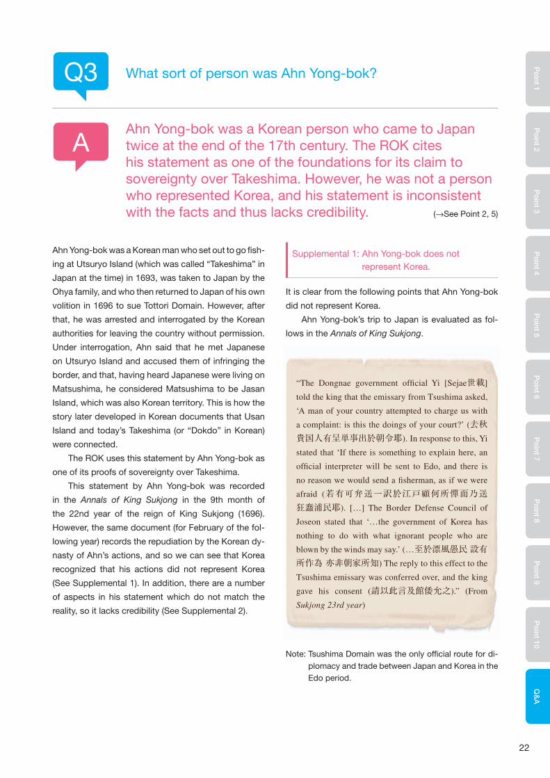
Note: Tsushima Domain was the only offi cial route for di-plomacy and trade between Japan and Korea in the Edo period.
Q3
A
What sort of person was Ahn Yong-bok?
Ahn Yong-bok was a Korean person who came to Japan twice at the end of the 17th century. The ROK cites his statement as one of the foundations for its claim to sovereignty over Takeshima. However, he was not a person who represented Korea, and his statement is inconsistent with the facts and thus lacks credibility. (→See Point 2, 5)
“The Dongnae government of� cial Yi [Sejae世載]
told the king that the emissary from Tsushima asked,
‘A man of your country attempted to charge us with
a complaint: is this the doings of your court?’ (去秋貴国人有呈単事出於朝令耶). In response to this, Yi
stated that ‘If there is something to explain here, an
of� cial interpreter will be sent to Edo, and there is
no reason we would send a � sherman, as if we were
afraid (若有可弁送一訳於江戸顧何所憚而乃送狂蠢浦民耶). […] The Border Defense Council of
Joseon stated that ‘…the government of Korea has
nothing to do with what ignorant people who are
blown by the winds may say.’ (…至於漂風愚民 設有所作為 亦非朝家所知) The reply to this effect to the
Tsushima emissary was conferred over, and the king
gave his consent (請以此言及館倭允之).” (From
Sukjong 23rd year)

23
The Korean dynasty’s repudiation was passed on
to Japan in a letter sent to the lord of Tsushima Domain
from Yi Seon-bak, Deputy Vice-Minister for Protocol:
Ahn Yong-bok’s boat was fl ying a fl ag which read,
“Taxation General of the Two Islands of Utsuryo Island,
Joseon. Vassal Ahn on Board,” and Ahn styled him-
self “Tax Inspector for the Two Islands of Utsuryo and
Usan.” This title was made up, and Ahn himself admit-
ted this identity fraud. The “Tax Inspector” or “Auditor-
General” that Ahn Yong-bok called himself referred to
a tax collector for the islands of Utsuryo and Usan. Ahn
apparently believed that Usan Island was a large popu-
lated island.
Supplemental 2: Credibility of Ahn Yong-bok’s statements
There are numerous discrepancies in Ahn Yong-bok’s
statements, making themunreliable.
Ahn Yong-bok came to Japan twice. The fi rst time
was in 1693, when he was taken to Japan as proof
that there was no fi shing to be had around Utsuryo
Island (called “Takeshima” in Japan at the time). The
second time was in 1696, when he smuggled himself
to Japan to lodge a protest with Tottori Domain, and
was expelled by the domain. Ahn’s statements record-
ed in the Annals of King Sukjong are a summary of the
written statements made when he was interrogated by
the Border Defense Council of Joseon on his return.
According to this summary, when Ahn fi rst came to
Japan, he obtained a letter from the shogunate stating
that Utsuryo Island and Usan Island were Korean terri-
tory, but Tsushima domain took it from him. However,
negotiations between Japan and Korea over fi shing
around Utsuryo Island began when Ahn was taken
back to Japan and repatriated via Tsushima Domain,
so the Tokugawa shogunate would never have given
him a letter saying that Utsuryo Island and Usan Island
were Korean territory when he came over in 1693, be-
fore such negotiations were started.
In addition, when Ahn Yong-bok came to Japan in
May 1696, he stated that there was a large number of
Japanese on Utsuryo Island. However, in January, the
sea travel licenses granted to the Ohya and Murakawa
families were repealed, because the shogunate had al-
ready decided to ban passage to Utsuryo Island and
passed the directive on to Tottori Domain. The ROK
claims that the shogunate decided to forbid travel to
Utsuryo Island as a result of Ahn’s visit to Japan in
1696, but Ahn arrived four months after the shogunate
forbade travel to the island.
Ahn Yong-bok was interrogated on his return to
Korea. It is recorded that he said to the Japanese,
“Matsushima is Jasan (Usan) Island and therefore also
our country’s land, why do you dare live there?” (松島即子山島、此亦我国地、汝敢住此耶). That year, there
were no Japanese travelling to Utsuryo Island, so this
story cannot be true. It seems that Ahn Yong-bok be-
lieved that people could live on Usan Island. When he
went fi shing at Utsuryo Island in 1693, he was told by
his companions that the island to the north-east of
Utsuryo Island was Usan Island (Takeshimakiji), and
when he was taken to Japan, he said that he saw
“a large island, much bigger than Utsuryo Island”
(Byeonrye Jibyo). Ahn said, “Matsushima is Jasan
(Usan) Island.” It is assumed that he learned the name
“Matsushima” (today’s Takeshima) during his stay in
Japan, and connected it with Usan Island which was
traditionally drawn in Korean picture maps. However,
saying that “Matsushima is Jasan Island” is, in terms
of names, not actually referring to today’s Takeshima.
“With regard to the man who drifted ashore last year,
those who live on the seaside make their living sail-
ing, and when caught in a storm, they are immediately
driven before the waves to arrive at your country (昨年漂氓事濱海之人率以舟楫為業颿風焱忽易及飄盪以至冒越重溟轉入貴国). [...] If there was a charge
laid by him, he committed crime of forging a letter
(…若其呈書誠有妄作之罪). Therefore we have al-
ready exiled him in accordance with the law (故已施幽殛之典以為懲戢之地).”

24
Po
int 1P
oint 2
Po
int 3P
oint 4
Po
int 5P
oint 6
Po
int 7P
oint 8
Po
int 9P
oint 10
Q&
A
For example, the ROK states that the Usan or Usan
Island appearing in Korean period documents from
the Joseon period such as the “Sejong Sillok Jiriji
(Geography Section of the Annals King Sejong’s Reign:
1454)” and the “Sinjeung Dongguk Yeoji Seungnam
(Revised and Augmented Edition of the Survey of the
Geography of Korea: 1531)” is Takeshima, and so it
has always been its territory.
However, “Usan” in Korean period documents and
maps is either another name for Utsuryo Island, or the
separate smaller island off the coast of Utsuryo Island
(Jukdo), and not Takeshima.
The ROK insists that it established a county in
Utsuryo Island by Korean Imperial Ordinance No.41
(1900) (Note), and established the area under the ju-
risdiction of Utsu Island County as “the entire island
of Utsuryo Island and the islands of Jukdo and Sokdo
(石島 ishi-jima),” and that this Sokdo is Dokdo (the
Korean name for Takeshima).
However, the ROK has yet to present any clear
proof that this Sokdo is in fact Takeshima. In addi-
tion, even if, hypothetically, the ordinance did refer to
Takeshima, the Korean Empire never exercised actual
control over Takeshima around the time of that or-
dinance, and so Korean territorial rights over it were
never established.
Note: In 1882, the Korean dynasty abolished its “Empty Island” policy regarding Utsuryo Island, which it had main-tained for 470 years, and started to develop the island. Later, in June 1900, Korea and Japan carried out a joint survey since there were a large number of Japanese resid-ing on Utsuryo Island. The Korean Empire (Korea changed its name from Joseon to Daehan Jeguk, the “Great Han Empire,” in October 1897) enacted the imperial ordi-nance No.41 to rename Utsuryo Island as “Utsu Island” and to make the Island Administrator County Magistrate, based on the report of this survey (U Yong-jeong’s Uldo-gi), having considered the necessity of “exchange with foreign travelers and traders”.In Article 2 of this or-dinance the jurisdiction of Utsu Island County was set as “the entire island of Utsuryo Island and the islands of Jukdo and Ishi-jima.” However, it is not certain where this suddenly appearing “Ishi-jima” actually was.
According to the report of the survey carried out prior to this ordinance, the length of Utsuryo Island was 70 ri (approx. 28 km), its width was 40 ri (approx. 16 km), and its circumference was 145 ri (…全島長可為七十里廣可為四十里 周廻亦可為一百四十五里). Also, it is stated, in the “Request for Cabinet Decision Regarding the Change of Name of Utsuryo Island to Utsu Island and the Change from Island Administrator to County Magistrate” (1900) by Yi Kon-ha, Minister of the Interior, that “…the area of the island concerned is 80 ri on the long axis (32 km*) and 50 ri across (20 km*).” From these facts, it is clear that Takeshima, about 90 km away, was outside the scope, and that Ishi-jima is not Takeshima. Given that relatively large islands exist in the area around Utsuryo Island (with-in a few kms of the island) called Jukdo and Gwannumdo, there is a possibility that “Ishi-jima” meant one of these islands.
* 1 ri (Japan) = about 10 ri (Korea) = about 4 km
Q4
A
Prior to the Japanese Government’s incorporation of Takeshima in 1905, is there any proof that Korea owned the islands?
No, the ROK has not shown any proof that they owned the islands of Takeshima. (→See Point 2 ,6, Q&A 2)

25
The ROK alleges that Takeshima falls under the “terri-
tories which Japan has taken by violence and greed” in
the Cairo Declaration (1943) announced by the leaders
of the United States, the United Kingdom and China
during World War II. However, Takeshima has never
been Korean territory, whereas Japan had established
sovereignty over the islands no later than the middle of
the 17th century, reaffirmed it with the islands’ incor-
poration into Shimane Prefecture by cabinet decision
in 1905, and has exercised its sovereignty peacefully
and continuously. This makes it clear that Takeshima
was not territory that Japan took from Korea.
The ultimate determination of territory following a
war is done by a peace treaty or other forms of inter-
national agreements. In the case of World War II, it was
the San Francisco Peace Treaty that legally determined
Japan’s territories, and the Cairo Declaration does not
have any ultimate legal effect on the determination of
Japanese territory. It is confirmed in the San Francisco
Peace Treaty that Takeshima is Japanese territory.
The ROK claims that SCAPIN (Supreme Commander
for the Allied Powers Instruction Note) No. 677 (See
Supplemental 1) and No. 1033 (See Supplemental 2)
place Takeshima outside Japanese territory. However,
both of the directives explicitly stipulate that it’s not an
expression of allied policy relative to ultimate determi-
nation of territory, although the ROK makes no men-
tion of this. The Korean position is therefore untenable.
It is the San Francisco Peace Treaty (effective in
1952) that decided the territory of Japan after the War.
Therefore it is clear both in terms of fact and in terms
of international law that the treatment of Takeshima by
SCAP before that Treaty came into force has no effect
on sovereignty over Takeshima.
Q5
Q6
A
A
Was Takeshima included in the “territories which Japan has taken by violence and greed” in the Cairo Declaration?
Was Takeshima placed outside Japanese territory by SCAP after World War II?
No, it was not. (→See Point 7)
No, it was not. SCAP had no authority regarding the disposition of territory.

26
Po
int 1P
oint 2
Po
int 3P
oint 4
Po
int 5P
oint 6
Po
int 7P
oint 8
Po
int 9P
oint 10
Q&
A
Supplemental 1: SCAPIN No. 677
In January 1946, the General Headquarters for the Supreme
Commander for the Allied Powers ordered the Japanese Government
to provisionally cease exercising or attempting to exercise politi-
cal or administrative authority over certain outlying areas based on
SCAPIN No.677. Paragraph 3 of the directive provides that “For the
purpose of this directive, Japan is defi ned to include the four main
islands of Japan (Hokkaido, Honshu, Kyushu and Shikoku) and the
approximately 1,000 smaller adjacent islands, including the Tsushima
Islands and the Ryukyu (Nansei) Islands north of 30° North Latitude
(excluding Kuchinoshima Island).”The directive then listed Takeshima
along with Utsuryo Island, Jeju Island, the Izu Islands, the Ogasawara
Islands, etc. as the areas “excluded.” (Note 1)
However, Paragraph 6 of the directive clearly states that “Nothing
in this directive shall be construed as an indication of Allied policy
relating to the ultimate determination of the minor islands referred to
in Article 8 of the Potsdam Declaration.” (Note 2) (Article 8 of the Potsdam
Declaration: “…Japanese sovereignty shall be limited to the islands of
Honshu, Hokkaido, Kyushu, Shikoku and such minor islands as we
determine.”) The claim of the ROK completely ignores this.
Supplemental 2: SCAPIN No. 1033
In June 1946, SCAP expanded the area authorized for Japan’s fi shing
and whaling (the so-called “MacArthur Line”) by SCAPIN No. 1033.
Paragraph 3 of the directive stipulates that “Japanese vessels or
personnel thereof will not approach closer than twelve (12) miles to
Takeshima (37°15’ North Latitude, 131°53’ East Longitude) nor have
any contact with said island.” (Note 3)
However, Paragraph 5 of the directive explicitly provides that
“The present authorization is not an expression of allied policy rela-
tive to ultimate determination of national jurisdiction, international
boundaries or fi shing rights in the area concerned or in any other
area.” (Note 4) The claim of the ROK completely ignores this as well.
The MacArthur Line was abolished on April 25th, 1952, and with
the San Francisco Peace Treaty coming into force three days later, on
the 28th of April, the directives for cessation of governmental author-
ity necessarily became invalid.
3. For the purpose of this directive, Japan is defi ned to include the four main islands of Japan (Hokkaido,
Honshu, Kyushu and Shikoku) and the approximately 1.000 smaller adjacent islands,
including the Tsushima Islands and the Ryukyu (Nansei) Islands north of 30° North Latitude (excluding
Kuchinoshima Island) ;
and excluding
(a) Utsuryo (Ullung) Island, Liancourt Rocks (Take Is- land) and Quelpart (Saishu or Cheju) Island,
(b) the Ryukyu (Nansei) Islands south of 30° North Latitude (including Kuchinoshima Island),
the lzu, Nanpo, Bonin (Ogasawara) and Volcano (Kazan or lwo) Island Groups, and
all other outlying Pacifi c Islands including the Daito (Ohigashi or Oagari) Island Group, and Parece Vela
(Okino-tori), Marcus (Minami-tori) and Ganges (Nakano-tori) Islands, and
(c) the Kurile (Chishima) Islands, the Habomai (Hapomaze) Island Group (including Suisho, Yuri, Akiyuri,
Shibotsu and Taraku Islands) and Shikotan Island.
[Outline: (Note 1) See the underlined part]
6. Nothing in this directive shall be construed as an indication of Allied policy relating to the ultimate deter-
mination of the minor islands referred to in Article 8 of the Potsdam Declaration.
[(Note 2) See the underlined part]
3.(b) Japanese vessels or personnel thereof will not approach closer than twelve (12) miles to Takeshima
(37°15’ North Latitude, 131°53’ East Longitude) nor have any contact with said island.
[(Note 3) See the underlined part]
5. The present authorization is not an expression of allied policy relative to ultimate determination of na-
tional jurisdiction, international boundaries or fi shing rights in the area concerned or in any other area.
[(Note 4) See the underlined part]
SCAPIN No. 1033
SCAPIN No. 677

Northeast Asia Division, Asian and Oceanian Affairs BureauMinistry of Foreign Affairs of Japan
2-2-1 Kasumigaseki, Chiyoda-ku, Tokyo 100-8919 JapanTel: 03-3580-3311 (Main switchboard)
Ministry of Foreign Affairs Webpagehttp://www.mofa.go.jp/mofaj/
Published in March 2014
[Photo credit and cooperation] Meiji University Library, Japan Center for Asian Historical Records, Kokon Shoin, Tottori Prefectural Museum, Shimane Prefectural Takeshima Archive, The Yomiuri Shimbun, Tenri Central Library, Toyo Bunko
Related Documents