1 Presenting Regional and Presenting Regional and Urban Statistics Urban Statistics Michal Peleg Israel Social Science Data Center The Hebrew University [email protected] IASSIST/IFDO Conference Amsterdam, May 2001

1 Presenting Regional and Urban Statistics Michal Peleg Israel Social Science Data Center The Hebrew University [email protected] IASSIST/IFDO Conference.
Dec 22, 2015
Welcome message from author
This document is posted to help you gain knowledge. Please leave a comment to let me know what you think about it! Share it to your friends and learn new things together.
Transcript

1
Presenting Regional Presenting Regional and Urban Statisticsand Urban Statistics
Michal PelegIsrael Social Science Data CenterThe Hebrew [email protected]
IASSIST/IFDO ConferenceAmsterdam, May 2001

2
Structure Structure of This Presentationof This PresentationStructure Structure of This Presentationof This Presentation
1. The need for comparable urban statistics
2. Main sources of regional and urban statistics
3. The main problems with regional statistics
4. Geobase objectives and contents5. Geobase web interface6. Future plans

The Growing Need for The Growing Need for
Regional InformationRegional Information
Rational and efficient political actions need the quantification of social and economic phenomena
Harmonised urban statistics are the base for well-founded urban policy at all levels
3

As more and more people live in dense cities, the development in cities should be monitored and analysed more rigorously
Monitoring urban and regional inequality :
Compare problems and chances in order to
invest more in deprived places
Compare problems and chances across
regions in order to learn from each other
The Need for Regional InformationThe Need for Regional Information ((Cont.)Cont.)
4

Typical users of regional Typical users of regional statisticsstatistics Urban and regional planning agencies Central government agencies Regional government Cities (municipalities) Public services planning agencies Academic research and instruction Business and market research
5

6
Sources of DataSources of Data
Harmonization and quality of data impose careful selection of data sources. Current GEOBASE sources are :
The Central Bureau of Statistics (Israel CBS) Cities’ statistical departments The National Insurance Institute Ministries of Health, Tourism and Education Israel Electricity Company

7
Main Problems in Main Problems in Management of Regional Management of Regional StatisticsStatistics
Different spatial divisions used by different data collectors
Different definitions of variables incompatible multi-layer statistics Partially available dataThese inconsistencies produce
difficulties in maintaining a harmonized and comparable database

8
GEOBASEGEOBASE objectives and contentsobjectives and contents
http://geobase.huji.ac.ilhttp://geobase.huji.ac.il
0
10
20
30
40
50
60
70
80
90
1st Qtr 2nd Qtr 3rd Qtr 4th Qtr
EastWestNorth
8
9
Our MissionOur Mission
To collect reliable, comparable and relevant statistics (quality charta)
To upgrade the data by building time-series, in collaboration with the CBS and other vendors
To make urban and regional statistics publicly available through the web
To encourage the use of regional statistics by decision makers in local authorities

10
Geographic Layers andGeographic Layers andLevels Levels (currently)(currently)
Regional layers: District Sub-district Regional council Road Sub-road
Urban layers: City (urban locality) Sub-quarter Statistical area
Future: metropolin areas, rural localities, neighbor countries (?)

11
Current DomainsCurrent Domains
Labour market Incomes and
wages Population Migration Socio-economic
status
Schooling system Housing and
construction Transportation Tourism Economic activity

12
Planned AdditionalPlanned AdditionalDomainsDomains
Health Crime Environment conditions Political behavior (elections) Land use

13
Geobase time Geobase time dimensiondimension
90% of the series are annual, 8% are quarterly and 2% are monthly or censusial.
Problem: few series change basis or definitions over time. Other end up;
The greater part of the series start in 1990 with few population and housing items that start as early as 1983. New data items start at the mid 1990’s.
Question: should non-periodic measures be incorporated into GEOBASE ?

14
DemonstrationDemonstration
of Geobase web-siteof Geobase web-site
http://geobase.huji.ac.il

15
Home page

16
Main menu

17
First search results
18
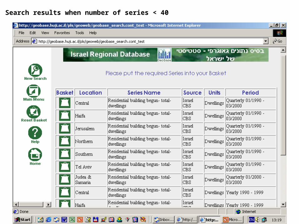
Search results when number of series < 40

19
Basket contents: Residential building begun by districts – quarterly series

20
Download basket into Excel

21
Show basket contents as line chart – quarterly construction series for districts

22
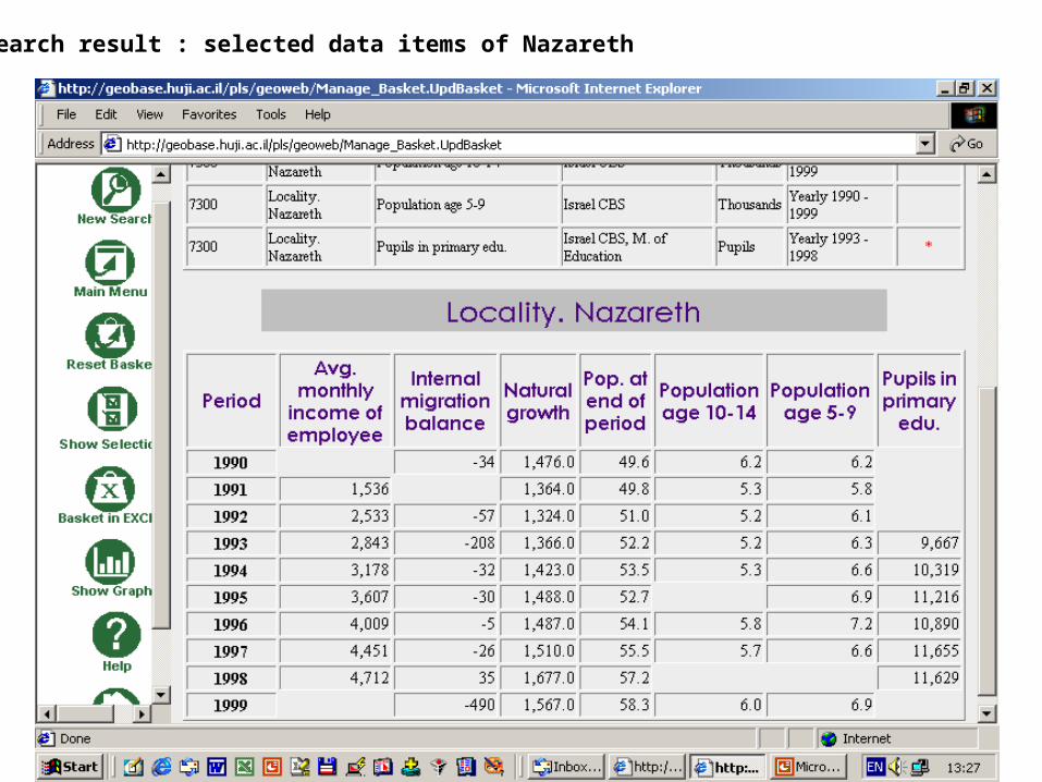
Starting a new search – profile of Nazareth (total 605 series)
23
Search result : selected data items of Nazareth

24
Bar chart – average monthly income per employee - multi-layer basket of)

25
Results of another search: population in Jerusalem sub-quarters

26
Technical commentsTechnical comments
Geobase already includes more than 500 different variables, each of them refer to one or more geographic layers.
Technologies: the database is running on Oracle 8i DBMS on NT servers. Oracle iAS 9 serves as the web application platform. The GIS module is based on ESRI ArcIMS 3.0
The thematic mapping option will be installed later this month.

27
Some Ideas for the Some Ideas for the FutureFuture
Evaluate results by monitoring usage and users’ evaluation
Include more geographic layers Include additional domains Add (soon) GIS capabilities for both
geographic menu and for displaying results
Colaborate with European agencies of regional statistics

Thanksfor
yourattention
Any questions ??Any questions ??
http://geobase.huji.ac.il
Related Documents


