UNCORRECTED PROOF 1 National-scale Assessment of Current and Future 2 Flood Risk in England and Wales 3 JIM W. HALLSNM 1w , PAUL B. SAYERS 2 and 4 RICHARD J. DAWSON 1 5 1 Department of Civil Engineering, University of Bristol, Queens Building, University Walk, 6 Bristol BS8 1TR, UK; 2 HR Wallingford, Howbery Park, Wallingford, Oxfordshire, 7 OX10 8BA, UK 8 (Received: 11 November 2003; accepted: 30 June 2004) 9 Abstract. In recent years, through the availability of remotely sensed data and other national 10 datasets, it has become possible to conduct national-scale flood risk assessment in the England 11 and Wales. The results of this type of risk analysis can be used to inform policy-making and 12 prioritisation of resources for flood management. It can form the starting point for more detailed 13 strategic and local-scale flood risk assessments. The national-scale risk assessment methodology 14 outlined in this paper makes use of information on the location, standard of protection and 15 condition of flood defences in England and Wales, together with datasets of floodplain extent, 16 topography, occupancy and asset values. The flood risk assessment was applied to all of England 17 and Wales in 2002 at which point the expected annual damage from flooding was estimated to be 18 approximately £1 billion. This figure is comparable with records of recent flood damage. The 19 methodology has subsequently been applied to examine the effects of climate and socio-eco- 20 nomic change 50 and 80 years in the future. The analysis predicts increasing flood risk unless 21 current flood management policies, practices and investment levels are changed – up to 20-fold 22 increase in real terms economic risk by the 2080s in the scenario with highest economic growth. 23 The increase is attributable primarily to a combination of climate change (in particular sea level 24 rise and increasing precipitation in parts of the UK) and increasing economic vulnerability. 25 Key words: flood risk, flood defence reliability, climate change, socio-economic scenarios 26 27 1. Introduction 28 Over 5% of the UK population live in the 12,200 km 2 that is at risk from 29 flooding by rivers and the sea (HR Wallingford, 2000). These people and 30 their property are protected by 34,000 km of flood defences. Traditionally, 31 this important and safety-critical infrastructure system has been managed 32 locally. It is now become increasingly apparent that flood risk can be man- 33 aged more effectively by adopting strategic approaches applied at catchment, 34 regional and national scales. These strategic approaches provide the oppor- 35 tunity to coordinate management of flood defence infrastructure with other w Author for correspondence. E-mail: [email protected] Natural Hazards 00: 1–18, 2004. Ó 2004 Kluwer Academic Publishers. Printed in the Netherlands. 1 Journal : NHAZ SPS Article No. : DO00004546 Dispatch : 8-11-2004 Pages : 18 PIPS No. : DO00004546 h LE h TYPESET MS Code : NHAZSB-09 h CP h DISK 4 4 AUTHOR’S PROOF! PDF-OUTPUT

Welcome message from author
This document is posted to help you gain knowledge. Please leave a comment to let me know what you think about it! Share it to your friends and learn new things together.
Transcript
UNCO
RRECTEDPROO
F
1 National-scale Assessment of Current and Future
2 Flood Risk in England and Wales
3 JIM W. HALLSNM1w, PAUL B. SAYERS2 and4 RICHARD J. DAWSON1
5 1Department of Civil Engineering, University of Bristol, Queens Building, University Walk,6 Bristol BS8 1TR, UK; 2HR Wallingford, Howbery Park, Wallingford, Oxfordshire,7 OX10 8BA, UK
8 (Received: 11 November 2003; accepted: 30 June 2004)
9 Abstract. In recent years, through the availability of remotely sensed data and other national
10 datasets, it has become possible to conduct national-scale flood risk assessment in the England11 and Wales. The results of this type of risk analysis can be used to inform policy-making and12 prioritisation of resources for floodmanagement. It can form the starting point formore detailed13 strategic and local-scale flood risk assessments. The national-scale risk assessment methodology
14 outlined in this paper makes use of information on the location, standard of protection and15 condition of flood defences in England and Wales, together with datasets of floodplain extent,16 topography, occupancy and asset values. The flood risk assessment was applied to all of England
17 andWales in 2002 at which point the expected annual damage from flooding was estimated to be18 approximately £1 billion. This figure is comparable with records of recent flood damage. The19 methodology has subsequently been applied to examine the effects of climate and socio-eco-
20 nomic change 50 and 80 years in the future. The analysis predicts increasing flood risk unless21 current flood management policies, practices and investment levels are changed – up to 20-fold22 increase in real terms economic risk by the 2080s in the scenario with highest economic growth.23 The increase is attributable primarily to a combination of climate change (in particular sea level
24 rise and increasing precipitation in parts of the UK) and increasing economic vulnerability.
25 Key words: flood risk, flood defence reliability, climate change, socio-economic scenarios26
27 1. Introduction
28 Over 5% of the UK population live in the 12,200 km2 that is at risk from29 flooding by rivers and the sea (HR Wallingford, 2000). These people and30 their property are protected by 34,000 km of flood defences. Traditionally,31 this important and safety-critical infrastructure system has been managed32 locally. It is now become increasingly apparent that flood risk can be man-33 aged more effectively by adopting strategic approaches applied at catchment,34 regional and national scales. These strategic approaches provide the oppor-35 tunity to coordinate management of flood defence infrastructure with other
w Author for correspondence. E-mail: [email protected]
Natural Hazards 00: 1–18, 2004.� 2004 Kluwer Academic Publishers. Printed in the Netherlands. 1
Journal : NHAZ SPS Article No. : DO00004546 Dispatch : 8-11-2004 Pages : 18
PIPS No. : DO00004546 h LE h TYPESET
MS Code : NHAZSB-09 h CP h DISK4 4
AUTHOR’S
PROOF!
PDF-OUTPUT
UNCO
RRECTEDPROO
F
36 measures, such as techniques to reduce runoff, control the urbanisation of37 floodplains and organisation of flood warning and evacuation. Strategic38 catchment-scale flood risk management coincides with the catchment-scale39 approach adopted in the EU Water Framework Directive.40 Broad-scale flood risk analysis is a prerequisite for strategic flood risk41 management. A risk-based approach to decision-making requires that the42 risks and costs of all decision options, including the status quo, are evaluated43 in quantified terms. Such an approach also has the potential to put flood44 management decisions on the same footing as risk-based decision-making in45 relation to other natural and man-made hazards that policy-makers are46 bound to address. However, it is important to recognise the contrasting47 nature of different risks (Royal Society, 1992) and the varying sources of48 uncertainty in the quantified risk analyses that are conducted in different49 fields, so considerable caution should be exercised in comparing risk esti-50 mates. Nonetheless, regional and national-scale risk analysis does potentially51 provide decision-makers with powerful tools to develop targeted and52 potentially synergistic mitigation strategies.53 National-scale risk assessment is by no means straightforward, because of54 the need to assemble national datasets and then carry out and verify very large55 numbers of calculations. Increasingly, however, national-scale datasets are56 becoming available. Aerial and satellite remote sensing technologies are pro-57 viding new topographic and land use data. Commercial organisations are58 generating and marketing increasingly sophisticated datasets of the location59 and nature of people and properties. In 2002 the Environment Agency, the60 organization responsible for operationof flooddefences inEngland andWales,61 introduced aNational Flood andCoastalDefenceDatabase (NFCDD), which62 for the first time provides in a digital database an inventory of flood defence63 structures and their overall condition. Together, these newdatasets now enable64 flood risk assessment that incorporates probabilistic analysis of flood defence65 structures and systems. Once the necessary datasets are held in a Geographical66 Information System (GIS) they can then bemanipulated in order to explore the67 impact of future flood management policy and scenarios of climate change.68 In the following section of this paper, an overview of the national-scale69 flood risk assessment methodology for flood risk analysis is provided.70 Section 3 summarises application of the methodology to all of England and71 Wales. In Section 4, the same methodology is used to predictions of flood risk72 under scenarios of climate and socio-economic change.
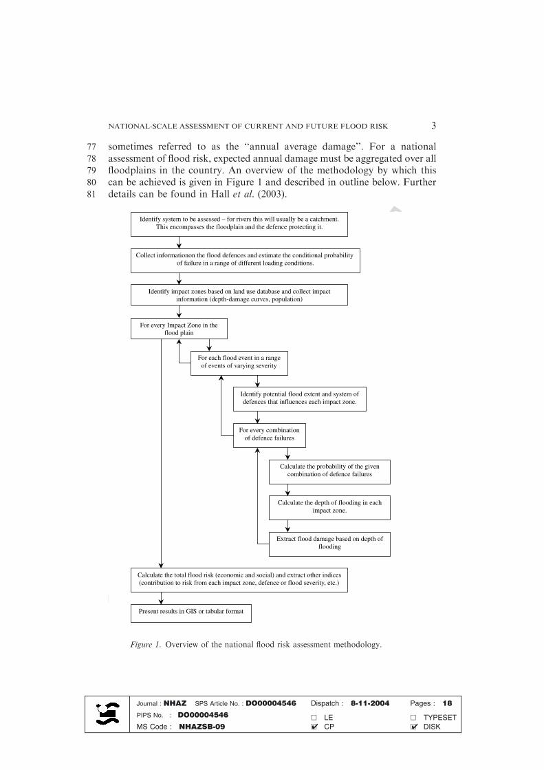
73 2. Overview of the Methodology
74 Flood risk is conventionally defined as the product of the probability of75 flooding and the consequential damage, summed over all possible flood76 events. It is often quoted in terms of an expected annual damage, which is
Journal : NHAZ SPS Article No. : DO00004546 Dispatch : 8-11-2004 Pages : 18
PIPS No. : DO00004546 h LE h TYPESET
MS Code : NHAZSB-09 h CP h DISK4 4
JIM W. HALLSNM ET AL.2
UNCO
RRECTEDPROO
F
77 sometimes referred to as the ‘‘annual average damage’’. For a national78 assessment of flood risk, expected annual damage must be aggregated over all79 floodplains in the country. An overview of the methodology by which this80 can be achieved is given in Figure 1 and described in outline below. Further81 details can be found in Hall et al. (2003).
Identify system to be assessed – for rivers this will usually be a catchment.This encompasses the floodplain and the defence protecting it.
Collect informationon the flood defences and estimate the conditional probabilityof failure in a range of different loading conditions.
Identify impact zones based on land use database and collect impactinformation (depth-damage curves, population)
Identify potential flood extent and system ofdefences that influences each impact zone.
Calculate the depth of flooding in each impact zone.
Extract flood damage based on depth offlooding
Calculate the total flood risk (economic and social) and extract other indices(contribution to risk from each impact zone, defence or flood severity, etc.)
For each flood event in a rangeof events of varying severity
Calculate the probability of the givencombination of defence failures
For every combinationof defence failures
For every Impact Zone in theflood plain
Present results in GIS or tabular format
Figure 1. Overview of the national flood risk assessment methodology.
Journal : NHAZ SPS Article No. : DO00004546 Dispatch : 8-11-2004 Pages : 18
PIPS No. : DO00004546 h LE h TYPESET
MS Code : NHAZSB-09 h CP h DISK4 4
NATIONAL-SCALE ASSESSMENT OF CURRENT AND FUTURE FLOOD RISK 3
UNCO
RRECTEDPROO
F
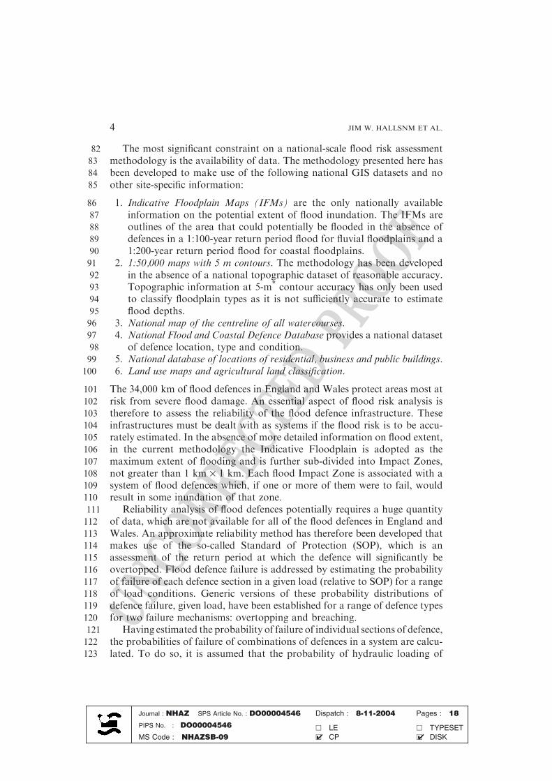
82 The most significant constraint on a national-scale flood risk assessment83 methodology is the availability of data. The methodology presented here has84 been developed to make use of the following national GIS datasets and no85 other site-specific information:
86 1. Indicative Floodplain Maps (IFMs) are the only nationally available87 information on the potential extent of flood inundation. The IFMs are88 outlines of the area that could potentially be flooded in the absence of89 defences in a 1:100-year return period flood for fluvial floodplains and a90 1:200-year return period flood for coastal floodplains.91 2. 1:50,000 maps with 5 m contours. The methodology has been developed92 in the absence of a national topographic dataset of reasonable accuracy.93 Topographic information at 5-m* contour accuracy has only been used94 to classify floodplain types as it is not sufficiently accurate to estimate95 flood depths.96 3. National map of the centreline of all watercourses.97 4. National Flood and Coastal Defence Database provides a national dataset98 of defence location, type and condition.99 5. National database of locations of residential, business and public buildings.
100 6. Land use maps and agricultural land classification.
101 The 34,000 km of flood defences in England and Wales protect areas most at102 risk from severe flood damage. An essential aspect of flood risk analysis is103 therefore to assess the reliability of the flood defence infrastructure. These104 infrastructures must be dealt with as systems if the flood risk is to be accu-105 rately estimated. In the absence of more detailed information on flood extent,106 in the current methodology the Indicative Floodplain is adopted as the107 maximum extent of flooding and is further sub-divided into Impact Zones,108 not greater than 1 km · 1 km. Each flood Impact Zone is associated with a109 system of flood defences which, if one or more of them were to fail, would110 result in some inundation of that zone.111 Reliability analysis of flood defences potentially requires a huge quantity112 of data, which are not available for all of the flood defences in England and113 Wales. An approximate reliability method has therefore been developed that114 makes use of the so-called Standard of Protection (SOP), which is an115 assessment of the return period at which the defence will significantly be116 overtopped. Flood defence failure is addressed by estimating the probability117 of failure of each defence section in a given load (relative to SOP) for a range118 of load conditions. Generic versions of these probability distributions of119 defence failure, given load, have been established for a range of defence types120 for two failure mechanisms: overtopping and breaching.121 Having estimated the probability of failure of individual sections of defence,122 the probabilities of failure of combinations of defences in a system are calcu-123 lated. To do so, it is assumed that the probability of hydraulic loading of
Journal : NHAZ SPS Article No. : DO00004546 Dispatch : 8-11-2004 Pages : 18
PIPS No. : DO00004546 h LE h TYPESET
MS Code : NHAZSB-09 h CP h DISK4 4
JIM W. HALLSNM ET AL.4
UNCO
RRECTEDPROO
F
124 individual defences in a given flood defence system is fully dependent. The125 probabilities of failure of each of the defences in the system, conditional upon a126 given load, are assumed to be independent. For each failure combination an127 approximate flood outline, which covers some proportion of the IFM, is gen-128 erated using approximate volumetric methods. These methods estimate dis-129 charge through or over the defence and inundation characteristics of the130 floodplain, based on an assessment of floodplain type.131 In the absence of water level and topographic data, estimation of flood132 depth has been based on statistical data. These data were assembled from 70133 real and simulated floods for a range of floodplain types and floods of dif-134 fering return periods. These data were used to estimate flood depth at points135 between a failed defence and the floodplain boundary, in events of a given136 severity. Flood depth estimates from a range of floods were used to construct137 an estimate of the probability distribution of the depth of flooding for each138 Impact Zone (Figure 1).139 The numbers of domestic and commercial properties and area of agri-140 cultural land in each Impact Zone were extracted from nationally available141 databases. These data were combined with relationships between flood depth142 and economic damage that have been developed from empirical analysis of143 past flooding events (Penning-Rowsell et al., 2003a). For a given Impact144 Zone the expected annual damage R is given by
R ¼Z ymax
0
pðyÞDðyÞ dy
146 where ymax is the greatest flood depth from all flooding cases, p(y) is the147 probability density function for flood depth and D(y) is the damage in the148 Impact Zone in a flood of depth y m. The total expected annual damage for a149 catchment or nationally is obtained by summing the expected annual dam-150 ages for each Impact Zone within the required area.151 The population at risk was estimated from the number of inhabitants within152 an Impact Zone using 2001 census data. The Social FloodVulnerability Indices153 (SFVI) (Tapsell et al., 2002) were used to identify communities vulnerable to154 the impacts of flooding. Social vulnerability is ranked from ‘‘very low’’ to ‘‘very155 high’’ and is based on a weighting of the number of lone parents, the popula156 tion over 75 years old, the long term sick, non-homeowners, unemployed, non-157 car owners and overcrowding, obtained from census returns. The risk of social158 impact is obtained as a product of probability of flooding to a given depth and159 the SFVI, providing a comparative measure for use in policy analysis.
160 3. Methods for Scenarios-based Future Flood Risk Assessment
161 There is increasing concern about the potential impacts of climate change on162 flood risk. Of equal, if not greater, potentially significance, are the impacts
Journal : NHAZ SPS Article No. : DO00004546 Dispatch : 8-11-2004 Pages : 18
PIPS No. : DO00004546 h LE h TYPESET
MS Code : NHAZSB-09 h CP h DISK4 4
NATIONAL-SCALE ASSESSMENT OF CURRENT AND FUTURE FLOOD RISK 5
UNCO
RRECTEDPROO
F
163 that socio-economic changes will have on vulnerability to flooding. Flood164 management decisions, such as the introduction of new land use planning165 policies or the construction of major new flood defence infrastructure can166 take decades to implement. For example studies are now under way to plan167 the upgrading of the Thames Barrier, even though it will continue to provide168 the required standard of flood protection until 2030. There is therefore a need169 to develop long term scenarios of flood risk in order to assist the development170 of robust long-term flood risk management policies.171 A scenarios-based approach explicitly acknowledges that the distant172 future is uncertain and that several plausible trajectories of societal change173 can be sketched out. Scenarios are not intended to predict the future. Rather174 they are tools for thinking about the future, recognising that the future is175 shaped by human choice and action, and is unlikely to be like the past.176 Scenarios development involves rational analysis and subjective judgement177 (DTI, 2003).178 Flood defence is an interesting application of the scenarios-based ap-179 proach because it involves integrated use of two different types of scenario:
180 � Climate change projections are based on emissions scenarios, used to181 establish the global emission of greenhouse gases to the atmosphere.182 � Socio-economic scenarios provide the context in which flood management183 policy and practice will be enacted and relate to the extent to which184 society may be impacted upon by flooding.
185 The UK Climate Impacts Programme scenarios for the UK published in 2002186 (usually referred to as UKCIP02) (Hulme et al., 2002) have been used. These187 scenarios are based on four emissions scenarios: Low emissions, Medium-low188 emissions, Medium-high emissions and High emissions corresponding to the189 Intergovernmental Panel on Climate Change’s Special Report on Emissions190 Scenarios (usually referred to as SRES) scenarios B1, B2, A2 and A1F1,191 respectively (IPCC, 2000). TheUKCIP02 scenarios predict that annual average192 precipitation across theUKmaydecrease slightly, bybetween0 and15%by the193 2080s depending on scenario. The seasonal distribution of precipitation will194 change,withwinters becomingwetter and summers becoming drier, the biggest195 relative changes being in the South and East. Under the High Emissions sce-196 nario winter precipitation in the South and East may increase by up to 30% by197 the 2080s. By the 2080s the daily precipitation intensities that are experienced198 once every 2 years on averagemaybecomeup to 20%heavier. By the 2080s and199 depending on scenario relative sea level may be between 2 cm below and 58 cm200 above the current level in western Scotland and between 26 and 86 cm above201 the current level in South East England. For some coastal locations a water202 level that at present has a 2% annual probability of occurrence may have an203 annual occurrence probability of 33% by the 2080s for Medium-High emis-204 sions. The climate change scenarios included within UKCIP02 do not include
Journal : NHAZ SPS Article No. : DO00004546 Dispatch : 8-11-2004 Pages : 18
PIPS No. : DO00004546 h LE h TYPESET
MS Code : NHAZSB-09 h CP h DISK4 4
JIM W. HALLSNM ET AL.6
UNCO
RRECTEDPROO
F
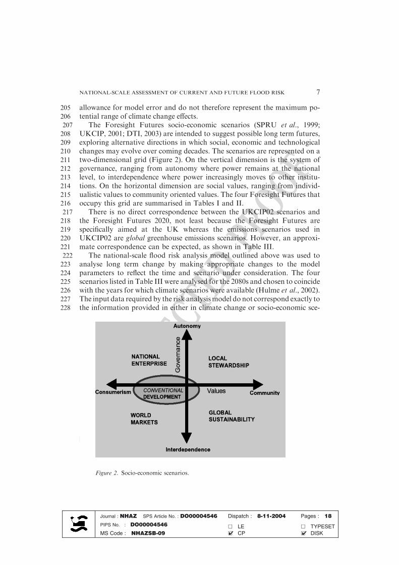
205 allowance for model error and do not therefore represent the maximum po-206 tential range of climate change effects.207 The Foresight Futures socio-economic scenarios (SPRU et al., 1999;208 UKCIP, 2001; DTI, 2003) are intended to suggest possible long term futures,209 exploring alternative directions in which social, economic and technological210 changes may evolve over coming decades. The scenarios are represented on a211 two-dimensional grid (Figure 2). On the vertical dimension is the system of212 governance, ranging from autonomy where power remains at the national213 level, to interdependence where power increasingly moves to other institu-214 tions. On the horizontal dimension are social values, ranging from individ-215 ualistic values to community oriented values. The four Foresight Futures that216 occupy this grid are summarised in Tables I and II.217 There is no direct correspondence between the UKCIP02 scenarios and218 the Foresight Futures 2020, not least because the Foresight Futures are219 specifically aimed at the UK whereas the emissions scenarios used in220 UKCIP02 are global greenhouse emissions scenarios. However, an approxi-221 mate correspondence can be expected, as shown in Table III.222 The national-scale flood risk analysis model outlined above was used to223 analyse long term change by making appropriate changes to the model224 parameters to reflect the time and scenario under consideration. The four225 scenarios listed in Table III were analysed for the 2080s and chosen to coincide226 with the years for which climate scenarios were available (Hulme et al., 2002).227 The input data required by the risk analysismodel do not correspond exactly to228 the information provided in either in climate change or socio-economic sce-
Figure 2. Socio-economic scenarios.
Journal : NHAZ SPS Article No. : DO00004546 Dispatch : 8-11-2004 Pages : 18
PIPS No. : DO00004546 h LE h TYPESET
MS Code : NHAZSB-09 h CP h DISK4 4
NATIONAL-SCALE ASSESSMENT OF CURRENT AND FUTURE FLOOD RISK 7
UNCO
RRECTEDPROO
F
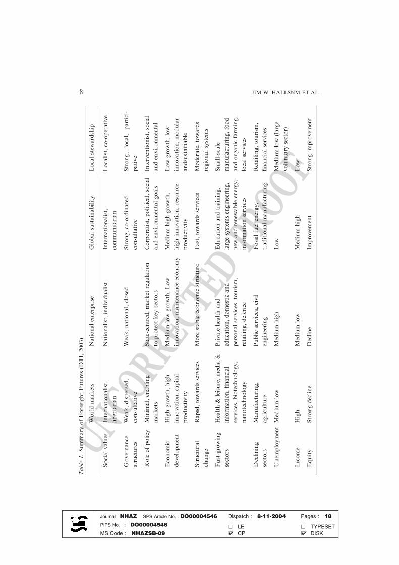
Table
I.Summary
ofForesightFutures(D
TI,2003)
Worldmarkets
Nationalenterprise
Globalsustainability
Localstew
ardship
Socialvalues
Internationalist,
libertarian
Nationalist,individualist
Internationalist,
communitarian
Localist,co-operative
Governance
structures
Weak,dispersed,
consultative
Weak,national,closed
Strong,co-ordinated,
consultative
Strong,
local,
partici-
pative
Role
ofpolicy
Minim
al,enabling
markets
State-centred,market
regulation
toprotect
key
sectors
Corporatist,political,social
andenvironmentalgoals
Interventionist,social
andenvironmental
Economic
development
Highgrowth,high
innovation,capital
productivity
Medium-low
growth,Low
innovation,maintenance
economy
Medium-highgrowth,
highinnovation,resource
productivity
Low
growth,low
innovation,modular
andsustainable
Structural
change
Rapid,towardsservices
More
stable
economic
structure
Fast,towardsservices
Moderate,towards
regionalsystem
s
Fast-growing
sectors
Health&
leisure,media
&
inform
ation,financial
services,biotechnology,
nanotechnology
Private
healthand
education,domesticand
personalservices,tourism
,
retailing,defence
Educationandtraining,
largesystem
sengineering,
new
andrenew
able
energy,
inform
ationservices
Small-scale
manufacturing,food
andorganic
farm
ing,
localservices
Declining
sectors
Manufacturing,
agriculture
Publicservices,civil
engineering
Fossilfuel
energy,
traditionalmanufacturing
Retailing,tourism
,
financialservices
Unem
ployment
Medium-low
Medium-high
Low
Medium-low
(large
voluntary
sector)
Income
High
Medium-low
Medium-high
Low
Equity
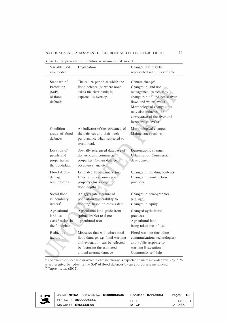
Strongdecline
Decline
Improvem
ent
Strongim
provem
ent
Journal : NHAZ SPS Article No. : DO00004546 Dispatch : 8-11-2004 Pages : 18
PIPS No. : DO00004546 h LE h TYPESET
MS Code : NHAZSB-09 h CP h DISK4 4
JIM W. HALLSNM ET AL.8
UNCO
RRECTEDPROO
FTable III. Correspondence between UKCIP02 scenarios and Foresight Futures
SRESa UKCIP02b Foresight Futures 2020c Commentary
B1 Low emissions Global Sustainability Medium-high growth, but low
primary energy consumption.
High emphasis on international
action for environmental goals
(e.g. greenhouse gas emissions
control). Innovation of new and
renewable energy sources.
B2 Medium-low
emissions
Local stewardship Low growth. Low consumption.
However, less effective interna-
tional action. Low innovation.
A2 Medium-high
emissions
National enterprise Medium-low growth, but with
no action to limit emissions.
Increasing and unregulated
emissions from newly
industrialised countries.
A1F1 High emissions World markets Highest national and global
growth. No action to limit
emissions. Price of fossil fuels
may drive development of
alternatives in the long term.
a Special Report on Emissions Scenarios (IPCC, 2000).b UK Climate Impacts Programme 2002 scenarios (Hulme et al., 2002).c DTI (2003).
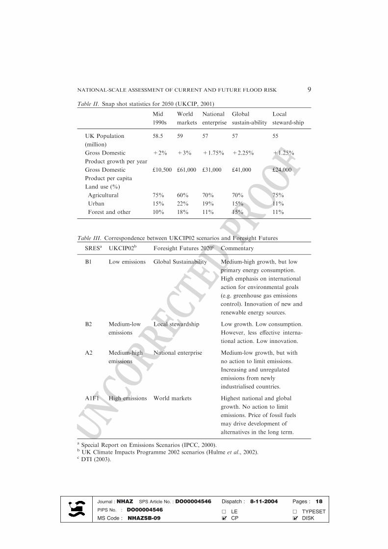
Table II. Snap shot statistics for 2050 (UKCIP, 2001)
Mid
1990s
World
markets
National
enterprise
Global
sustain-ability
Local
steward-ship
UK Population
(million)
58.5 59 57 57 55
Gross Domestic
Product growth per year
+2% +3% +1.75% +2.25% +1.25%
Gross Domestic
Product per capita
£10,500 £61,000 £31,000 £41,000 £24,000
Land use (%)
Agricultural 75% 60% 70% 70% 75%
Urban 15% 22% 19% 15% 11%
Forest and other 10% 18% 11% 15% 11%
Journal : NHAZ SPS Article No. : DO00004546 Dispatch : 8-11-2004 Pages : 18
PIPS No. : DO00004546 h LE h TYPESET
MS Code : NHAZSB-09 h CP h DISK4 4
NATIONAL-SCALE ASSESSMENT OF CURRENT AND FUTURE FLOOD RISK 9
UNCO
RRECTEDPROO
F
229 narios. It was therefore necessary to construct approximate relationships be-230 tween the variables for which scenarios information was available and the231 variables required for flood risk analysis. A summary of the relationships232 adopted in the analysis of risks from river and coastal flooding is provided in233 Table IV. A quantified estimate was made of the effect in each scenario that a234 given change, for example urbanisation,wouldhaveon the relevant variables in235 the risk model (Table IV). The cumulative effect of each of the changes in the236 given scenario was then calculated. Where feasible, regional variation was237 applied to these adjustments in order to take account of, for example, regional238 differences in climate or demographic projections. There is no uniquemapping239 between a scenario, which is an inherently vague entity, and a realization of the240 risk model. In other words, there is not a unique representation of the scenario241 in the riskmodel. The quantified analysis presented here is one ofmany equally242 plausible representations of the same four scenarios.Whilst no claim ismade to243 the uniqueness of these results, they do illustrate some striking contrasts be-244 tween different scenarios of change and provide the basis for exploring re-245 sponses to flood risk that are robust across plausible futures.246 Future flood risk is greatly influenced by flood management policy and247 practice, perhaps more so than it is by changes outside the control of the248 flood manager, such as climate change or economic growth. However, in the249 analysis described here current flood defence alignment and form, as well as250 the levels of investment in maintenance and renewal were kept the same251 across all scenarios. Clearly flood defence policy will change in the future and252 will tend to reflect the nature and public expectations of future society253 i.e. flood defence is scenario-dependent. However, the aim of the current254 study was to inform present-day policy makers and in order to do that, the255 present day flood defence policy was subjected to particular scrutiny, by256 analysing its effectiveness in a range of scenarios. Changing scenarios were257 super-imposed on this fixed flood defence policy (including the current pat-258 tern of expenditure and technical approach), in order to assess the capacity of259 the current policy to cope with long term changes.
260 3.1. RESULTS FOR THE PRESENT SITUATION
261 The national-scale risk assessment methodology described above was applied262 to all of England and Wales in 2002. The results are reported on a263 10 km · 10 km grid (though, as described above, the analysis was conducted264 on the basis of Impact Zones not greater than 1 km · 1 km). Figure 3 shows265 the proportion of each 10 km · 10 km grid cell that is occupied by floodplain.266 It indicates the very high proportions of floodplain around the Wash and the267 Humber estuary on the east coast of England and in several other coastal areas.268 Comparison of the extent of the Indicative Floodplain with residential,269 commercial and land use databases revealed that in England and Wales there
Journal : NHAZ SPS Article No. : DO00004546 Dispatch : 8-11-2004 Pages : 18
PIPS No. : DO00004546 h LE h TYPESET
MS Code : NHAZSB-09 h CP h DISK4 4
JIM W. HALLSNM ET AL.10
UNCO
RRECTEDPROO
F
Table IV. Representation of future scenarios in risk model
Variable used
risk model
Explanation Changes that may be
represented with this variable
Standard of
Protection
(SoP)
of flood
defences
The return period at which the
flood defence (or where none
exists the river bank) is
expected to overtop.
Climate changea
Changes in land use
management (which may
change run-off and hence river
flows and water levels)
Morphological change (that
may also influence the
conveyance of the river and
hence water levels)
Condition
grade of flood
defences
An indicator of the robustness of
the defences and their likely
performance when subjected to
storm load.
Morphological changes
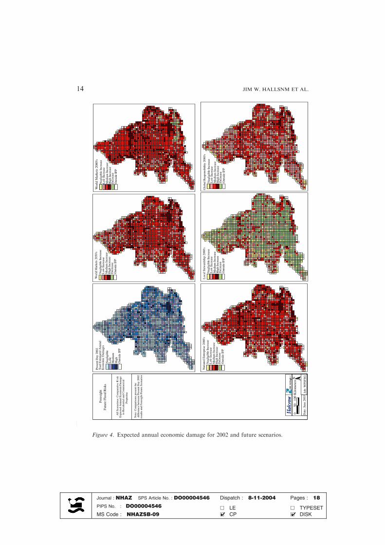
Maintenance regimes
Location of
people and
properties in
the floodplain
Spatially referenced database of
domestic and commercial
properties. Census data on
occupancy, age etc.
Demographic changes
Urbanisation Commercial
development
Flood depth-
damage
relationships
Estimated flood damage (in
£ per house or commercial
property) for a range of
flood depths
Changes in building contents
Changes in construction
practices
Social flood
vulnerability
indicesb
An aggregate measure of
population vulnerability to
flooding, based on census data
Changes in demographics
(e.g. age)
Changes in equity
Agricultural
land use
classification in
the floodplain
Agricultural land grade from 1
(prime arable) to 5 (no
agricultural use)
Changed agricultural
practices
Agricultural land
being taken out of use
Reduction
factors
Measures that will reduce total
flood damage, e.g. flood warning
and evacuation can be reflected
by factoring the estimated
annual average damage
Flood warning (including
communications technologies)
and public response to
warning Evacuation
Community self-help
a For example a scenario in which if climate change is expected to increase water levels by 20%
is represented by reducing the SoP of flood defences by an appropriate increment.b Tapsell et al. (2002).
Journal : NHAZ SPS Article No. : DO00004546 Dispatch : 8-11-2004 Pages : 18
PIPS No. : DO00004546 h LE h TYPESET
MS Code : NHAZSB-09 h CP h DISK4 4
NATIONAL-SCALE ASSESSMENT OF CURRENT AND FUTURE FLOOD RISK 11

UNCO
RRECTEDPROO
F
270 are 1.61 million residential properties and 131,000 commerical properties in271 the Indicative Floodplain, together with 1.43 million hectares of agricultural272 land. Comparison on census data with the Indicative Floodplain yields an273 estimated 4.47 million people resident within the Indicative Floodplain. The274 total value of residential property at risk is £208 billion.275 The national-scale risk analysis yielded an estimated Expected Annual276 Damage due to flooding of £1.0 billion, with an uncertainty range between277 £0.6 billion and £2.1 billion. The spatial distribution of economic risk from
Wales
Midlands
East Anglia
North-east
South-west
Thames
North-west
South-east
IFM as percentage of 10km x 10km grid cell<1%1 - 5%5 - 20%20 - 50%> 50%
Figure 3. Proportion of land in Indicative Floodplain.
Journal : NHAZ SPS Article No. : DO00004546 Dispatch : 8-11-2004 Pages : 18
PIPS No. : DO00004546 h LE h TYPESET
MS Code : NHAZSB-09 h CP h DISK4 4
JIM W. HALLSNM ET AL.12
UNCO
RRECTEDPROO
F
278 flooding is illustrated in Figure 4. Highest economic risk is located in279 floodplain areas of high economic value, notably Greater London despite280 very high standards of flood protection. A number of areas of high coastal281 flood risk are located along the South, East and North-West coasts of282 England. The expected annual damage to agriculture is estimated to be £5.9283 million, accounting for only about 0.5% of economic damage due to284 flooding. This loss is very small in economic terms, but can represent con-285 siderable impact on the rural economy.286 The risk analysis has been compared with recent flood events to assess287 the dependability and uncertainties in the methodology (HR Wallingford,288 2003). The annual average flood damage estimate of roughly £1 billion is of289 the same order to but somewhat larger than annual losses due to flooding290 experienced in recent years. For example, floods in Autumn 2002 resulted in291 economic losses of the order of £750 million (Penning-Rowsell et al.,292 2003b). Some of the inconsistency is explained by reporting of recent flood293 events and by assumptions in the model (particularly the exclusion of294 emergency repair works). Although a single event provides only limited295 basis for validation of annual average risk estimates, the reasonably good296 correspondence between model and observations indicates that the model297 does provide a sound basis for policy appraisal and comparative evaluation298 of future scenarios.
299 3.2. RESULTS FOR FUTURE SCENARIOS
300 The results of the flood risk scenarios analysis are summarised in Table V.301 No discounting or inflation is applied to economic risks. Risk is estimated at302 time points in the future using today’s prices.303 Large increases in the number of people occupying the floodplain in the304 UK are envisaged in the relatively loosely regulated World Markets and305 National Enterprise scenarios. Most of this increase is predicted to occur306 by the 2050s, representing predictions of very rapid growth in the first half307 of this century which is envisaged to approach a limit associated with a308 fairly stable population and spatial constraints. Floodplain occupancy is309 kept stable in the Global Sustainability and Local Stewardship scenarios.310 However, increasing flood frequency, primarily due to climate change311 means that even with stable numbers of people in the floodplain, the312 number of people at risk from flooding more frequently than 1:75 years313 will increase in all scenarios, assuming that current flood defence systems314 are continued into the future. Greater climate change by the 2080s,315 together with the increased floodplain occupancy noted above mean that316 the World Markets and National Enterprise scenarios will see more than317 doubling of the number of people at risk from flooding more frequently318 than 1:75 years.
Journal : NHAZ SPS Article No. : DO00004546 Dispatch : 8-11-2004 Pages : 18
PIPS No. : DO00004546 h LE h TYPESET
MS Code : NHAZSB-09 h CP h DISK4 4
NATIONAL-SCALE ASSESSMENT OF CURRENT AND FUTURE FLOOD RISK 13
UNCO
RRECTEDPROO
F
Fore
sigh
tFu
ture
Flo
od R
isks
All
Scen
ario
us: C
ompa
rativ
e R
isk
Exp
ecte
d A
nnua
l Eco
nom
icD
amag
eto
Res
iden
tial a
nd C
omm
erci
alPr
opre
tise
Out
side
IFP
Hig
hM
ediu
mL
owN
eglig
ible
Toat
l Est
imae
td A
nuna
lE
cono
mic
Dam
ages
Neg
ligib
le I
ncre
ase
Low
Inc
reas
eM
ediu
m I
ncre
ase
Hig
h In
crea
seD
ecre
ase
Out
side
IFP
Neg
ligib
le I
ncre
ase
Low
Inc
reas
eM
ediu
m I
ncre
ase
Hig
h In
crea
seD
ecre
ase
Out
side
IFP
Neg
ligib
le I
ncre
ase
Low
Inc
reas
eM
ediu
m I
ncre
ase
Hig
h In
crea
seD
ecre
ase
Out
side
IFP
Neg
ligib
le I
ncre
ase
Low
Inc
reas
eM
ediu
m I
ncre
ase
Hig
h In
crea
seD
ecre
ase
Out
side
IFP
Neg
ligib
le I
ncre
ase
Low
Inc
reas
eM
ediu
m I
ncre
ase
Hig
h In
crea
seD
ecre
ase
Out
side
IFP
Wor
ld M
arke
ts 2
050'
sW
orld
Mar
kets
208
0's
Loc
al S
tew
ards
hip
2080
'sN
atia
nol E
nter
pris
e 20
80's
Glo
bal R
espo
nsib
ility
208
0's
Pres
ent D
ay 2
002
Not
e: C
ompa
riso
ns p
rese
nt th
edi
ffer
ence
bet
wee
n Pr
esen
t Day
200
2re
sults
and
For
esig
ht F
utur
e Sc
enar
ios
Dat
e: J
une
2003
N0
5010
0 K
ilom
eter
s
Job:
WPS
FSG
Figure 4. Expected annual economic damage for 2002 and future scenarios.
Journal : NHAZ SPS Article No. : DO00004546 Dispatch : 8-11-2004 Pages : 18
PIPS No. : DO00004546 h LE h TYPESET
MS Code : NHAZSB-09 h CP h DISK4 4
JIM W. HALLSNM ET AL.14
UNCO
RRECTEDPROO
F
319 In all scenarios other than the low growth, environmentally/socially320 conscious Local Stewardship scenario, annual economic flood damage is321 expected to increase considerably over the next century assuming the current322 flood defence policies are continued in future. A roughly 20-fold increase by323 the 2080s is predicted in the World Markets scenario, which is attributable to324 a combination of much increased economic vulnerability (higher floodplain325 occupancy, increased value of household/industrial contents, increasing326 infrastructure vulnerability) together with increasing flood frequency.327 Change in the ratio of flood risk to per capita GDP provides an indication328 of how severe or harmful (in economic terms) flooding will be when329 compared with economic growth over the next century. In the World
Table V. Summary of flood risk scenarios
2002 World
Markets
2050s
World
Markets
2080s
National
Enterprise
2080s
Local
Stewardship
2080s
Global
Sustainability
2080s
Number of people
within the indicative
floodplain (millions)
4.5 6.2 6.9 6.3 4.5 4.6
Number of people
exposed to flooding
(depth > 0 m) with
a frequency >1:75
years (millions)
1.6 3.3 3.5 3.6 2.3 2.4
Expected annual
economic damage
(residential and
commercial
properties)
(£ billions)
1.0 14.5 20.5 15.0 1.5 4.9
Annual economic
damage relative to
Gross Domestic
Product per capita
0.10% 0.15% 0.14% 0.31% 0.05% 0.06%
Expected annual
economic damage
(agricultural
production)
(£ millions)
5.9 41.6 34.4 41.3 63.5 43.9
Journal : NHAZ SPS Article No. : DO00004546 Dispatch : 8-11-2004 Pages : 18
PIPS No. : DO00004546 h LE h TYPESET
MS Code : NHAZSB-09 h CP h DISK4 4
NATIONAL-SCALE ASSESSMENT OF CURRENT AND FUTURE FLOOD RISK 15
UNCO
RRECTEDPROO
F
330 Markets and National Enterprise scenarios flooding is expected to remove a331 greater proportion of national wealth than it currently does (and thus merit a332 greater investment to reduce risk). In the Local Stewardship and Global333 Sustainability scenarios flooding is predicted to remove a lesser proportion of334 national wealth since these scenarios will tend to be less vulnerable to flood335 damage and are expected to be subject to somewhat less climate change.336 The pattern for flood damage to agriculture is rather different to the337 pattern from economic damage as a whole. In the globalised World Markets338 scenario the contribution of agricultural damage to overall economic damage339 is projected to decrease, with a greater proportion of agricultural products340 being imported (though the effect of climate change on agriculture globally341 has not been considered) and low-grade agricultural land being taken out of342 production. Agricultural damage in the more self-sufficient National Enter-343 prise and Local Stewardship scenarios is expected to be more significant.344 Figure 4 shows the distribution of the increase in expected annual eco-345 nomic damage for the World Markets 2050s scenario and all four scenarios346 for the 2080s, relative to the estimated risk in 2002. Increasing risk is pre-347 dicted to be concentrated in broadly the same areas as where it is currently348 highest. Coastal flooding makes an increasing contribution to total flood risk,349 increasing from 26% in 2002 to 46% in the 2080s. The increasing probability350 of overtopping the Thames Barrier that protects central London makes a351 significant contribution to this increase in risk.352 Analysis of environmental and socio-economic phenomena over a time-353 scale of 30–100 years in the future involves formidable uncertainties. Model354 uncertainties in climate projections up to the 2050s exceed the differences355 between emissions scenarios. There is considerable disagreement about the356 spatial patterns of climate change down-scaled to the UK. Changes in some357 climate variables, for example extreme sea levels and short, high intensity358 rainfall events are particularly difficult to predict. Socio-economic change,359 which on a global scale leads to changing greenhouse gas emissions trajectories360 and on the UK scale also determines economic and social vulnerability to361 flooding, is even more difficult to predict and, it is argued, succumbs only to a362 scenarios-based approach which seeks to illustrate some of the potential range363 of variation between different futures. The flood risk scenarios presented here364 are therefore subject to very considerable uncertainties. They do, nonetheless,365 provide insights into the sources and impacts of future flood risk and the366 implications of continuing current flood defence policies into the future.
367 4. Conclusions
368 A national-scale flood risk assessment methodology, which includes the effect369 of flood defence systems, has been applied to all of England and Wales,
Journal : NHAZ SPS Article No. : DO00004546 Dispatch : 8-11-2004 Pages : 18
PIPS No. : DO00004546 h LE h TYPESET
MS Code : NHAZSB-09 h CP h DISK4 4
JIM W. HALLSNM ET AL.16
UNCO
RRECTEDPROO
F
370 making use of nationally available datasets. The analysis estimates expected371 annual damage due to flooding of roughly £1 billion, a figure that is slightly372 higher than, but comparable to economic damage due to flooding in England373 and Wales in recent years. The largest contribution to this risk is in the374 Greater London area, despite the very high standard of protection from375 flooding.376 Socio-economic and climate scenarios have been used in combination in377 order to generate self-consistent projections of potential future variation in378 flood risk, assuming stable flood defence policy. In all scenarios the frequency379 of flooding is projected to increase, more so on the coast than on rivers. The380 increase is greatest in high-emission scenarios. The risk of flooding is strongly381 modified by societal vulnerability and the scenarios analysis demonstrates382 how widely that vulnerability may vary according to the trajectory of socio-383 economic change. The risk that actually prevails in the future will be further384 modified by flood management activity, which will itself be a reflection of385 society’s values and expectations.
386 Acknowledgements
387 The research described in this paper formed part of a project entitled ‘‘RASP:388 Risk assessment for flood and coastal defence systems for strategic plan-389 ning’’, funded by the Environment Agency within the joint DEFRA/EA390 Flood and Coastal Defence R&D programme. The National Flood Risk391 Assessment 2002 was funded by the Environment Agency. The scenarios392 analysis was funded by the UK Office of Science and Technology as part of393 the Foresight Flood and Coastal Defence programme. The paper expresses394 the views of the authors and not the UK Government. Dr Hall’s research is395 funded by Royal Academy of Engineering post-doctoral research fellowship.
396 References
397 DTI: 2003, Foresight Futures 2020: Revised Scenarios and Guidance, Department of Trade and398 Industry.
399 Hall, J. W., Dawson, R. J., Sayers, P. B., Rosu, C., Chatterton, J. B., and Deakin, R.: 2003, A400 methodology for national-scale flood risk assessment. Water Maritime Eng. 156(3),401 235–247.
402 HR Wallingford: 2000, National appraisal of assets at risk from flooding and coastal erosion,
403 Technical Report volumes 1 and 2, HR Wallingford Report TR107.404 HRWallingford: 2003, National flood risk assessment 2002, HRWallingford Report EX4722.405 Hulme, M., Jenkins, G. J., Lu, X., Turnpenny, J. R., Mitchell, T. D., Jones, R. G., Lowe, J.,
406 Murphy, J. M., Hassell, D., Boorman, P., McDonald, R., and Hill, S.: 2002, Climate407 change scenarios for the United Kingdom: The UKCIP02 scientific report, Tyndall Centre408 for Climate Change Research, School of Environmental Sciences, University of East
409 Anglia, Norwich, UK.
Journal : NHAZ SPS Article No. : DO00004546 Dispatch : 8-11-2004 Pages : 18
PIPS No. : DO00004546 h LE h TYPESET
MS Code : NHAZSB-09 h CP h DISK4 4
NATIONAL-SCALE ASSESSMENT OF CURRENT AND FUTURE FLOOD RISK 17
UNCO
RRECTEDPROO
F
410 IPCC: 2000, Special report on emissions scenarios (SRES): A special report of working group411 III of the Intergovernmental Panel on Climate Change, Cambridge University Press,
412 Cambridge.413 Penning-Rowsell, E. C., Johnson, C., Tunstall, S. M., Tapsell, S. M., Morris, J., Chatterton, J.414 B., Coker, A., and Green, C.: 2003a, The Benefits of Flood and Coastal Defence: Techniques
415 and Data for 2003, Flood Hazard Research Centre, Middlesex University.416 Penning-Rowsell, E. C., Chatterton, J., Wilson, T., and Potter, E.: 2003b, Autumn 2000 Floods417 in England and Wales: Assessment of National Economic and Financial Losses, Flood418 Hazard Research Centre, Middlesex University.
419 Royal Society: 1992, Risk analysis, perception and management, Report of the Royal Society420 Study Group, The Royal Society, London.
421 SPRU, CSERGE, CRU, PSI: 1999, Socio-economic futures for climate impacts assessment,
422 Final Report, Science and Technology Research, University of Sussex.423 Tapsell, S. M., Penning-Rowsell, E. C., Tunstall, S.M., and Wilson, T. L.: 2002, Vulnerability424 to flooding: health and social dimensions, Phil. Trans. R. Soc. Lond. – Ser. A, Math., Phys.
425 Eng. Sci. 360(1796), 1511–1525.426 UKCIP: 2001, Socio-economic Scenarios for Climate Change Impact Assessment: A guide to427 Their use in the UK Climate Impacts Programme, UKCIP, Oxford.
428
Journal : NHAZ SPS Article No. : DO00004546 Dispatch : 8-11-2004 Pages : 18
PIPS No. : DO00004546 h LE h TYPESET
MS Code : NHAZSB-09 h CP h DISK4 4
JIM W. HALLSNM ET AL.18
Related Documents