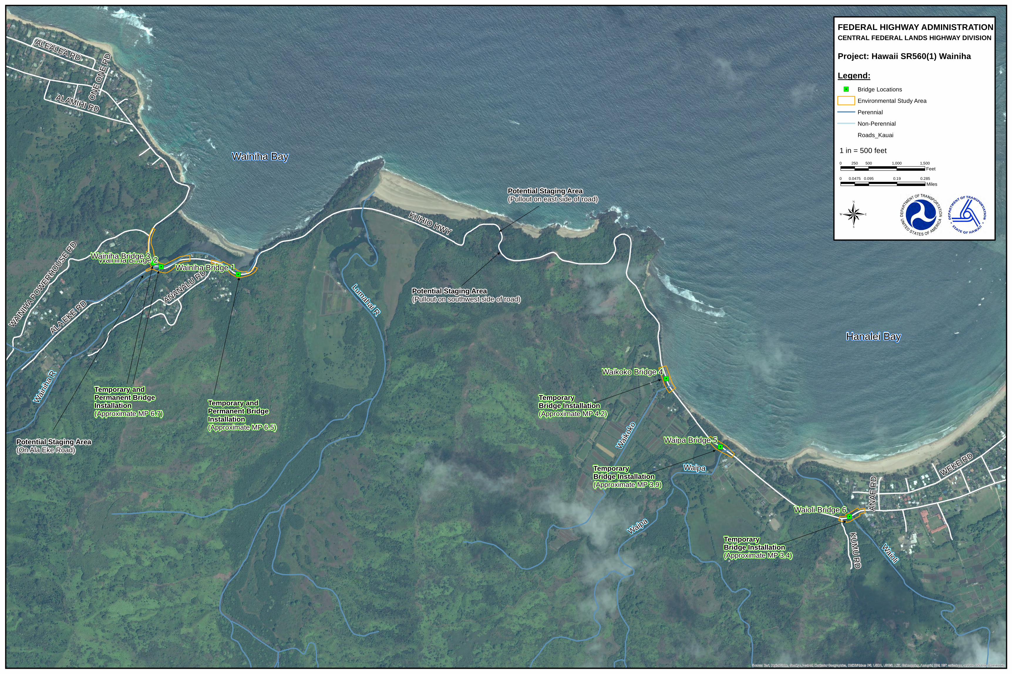
" / " / " / " / " / " / KUHIO HWY WEKE RD ALA EKE RD ANANALU RD ALEALEA RD ALAMIHI RD WAINIHA POWERHOUSE RD KUMU RD ANAE RD ONE ONE RD Waioli Lumahai R Waipa Wainiha R Waikoko Waipa Waipa Bridge 5 Waioli Bridge 6 Waikoko Bridge 4 Wainiha Bridge 1 Wainiha Bridge 2 Wainiha Bridge 3 Source: Esri, DigitalGlobe, GeoEye, i-cubed, Earthstar Geographics, CNES/Airbus DS, USDA, USGS, AEX, Getmapping, Aerogrid, IGN, IGP, swisstopo, and the GIS User Community Wainiha Bay Hanalei Bay Temporary and Permanent Bridge Installation (Approximate MP 6.7) Temporary and Permanent Bridge Installation (Approximate MP 6.5) Temporary Bridge Installation (Approximate MP 4.2) Temporary Bridge Installation (Approximate MP 3.9) Temporary Bridge Installation (Approximate MP 3.4) Potential Staging Area (Pullout on southwest side of road) Potential Staging Area (Pullout on east side of road) Potential Staging Area (On Ala Eke Road) ® FEDERAL HIGHWAY ADMINISTRATION CENTRAL FEDERAL LANDS HIGHWAY DIVISION Project: Hawaii SR560(1) Wainiha Legend: " / Bridge Locations Environmental Study Area Perennial Non-Perennial Roads_Kauai 0 0.095 0.19 0.285 0.0475 Miles 1 in = 500 feet 0 500 1,000 1,500 250 Feet

Welcome message from author
This document is posted to help you gain knowledge. Please leave a comment to let me know what you think about it! Share it to your friends and learn new things together.
Transcript
"/"/
"/
"/
"/
"/
KUHIO HWY
WEKE RD
ALA EKE RD ANANALU RD
ALEALEA RD
ALAMIHI RD
WAINIHA P
OWERHOUSE
RD
KUMU RD
ANAE
RD
ONE O
NE RD
Waioli
Lumahai R
Waipa
Wainiha
R
Waikoko
Waipa
Waipa Bridge 5
Waioli Bridge 6
Waikoko Bridge 4
Wainiha Bridge 1Wainiha Bridge 2Wainiha Bridge 3
Source: Esri, DigitalGlobe, GeoEye, i-cubed, Earthstar Geographics, CNES/Airbus DS, USDA, USGS, AEX, Getmapping, Aerogrid, IGN, IGP, swisstopo, and the GIS User Community
Wainiha Bay
Hanalei Bay
Temporary and Permanent Bridge Installation(Approximate MP 6.7)
Temporary and Permanent Bridge Installation(Approximate MP 6.5)
Temporary Bridge Installation(Approximate MP 4.2)
Temporary Bridge Installation(Approximate MP 3.9)
Temporary Bridge Installation(Approximate MP 3.4)
Potential Staging Area(Pullout on southwest side of road)
Potential Staging Area(Pullout on east side of road)
Potential Staging Area(On Ala Eke Road)
®
FEDERAL HIGHWAY ADMINISTRATIONCENTRAL FEDERAL LANDS HIGHWAY DIVISION
Project: Hawaii SR560(1) WainihaLegend:"/ Bridge Locations
Environmental Study AreaPerennialNon-PerennialRoads_Kauai
0 0.095 0.19 0.2850.0475Miles
1 in = 500 feet0 500 1,000 1,500250
Feet
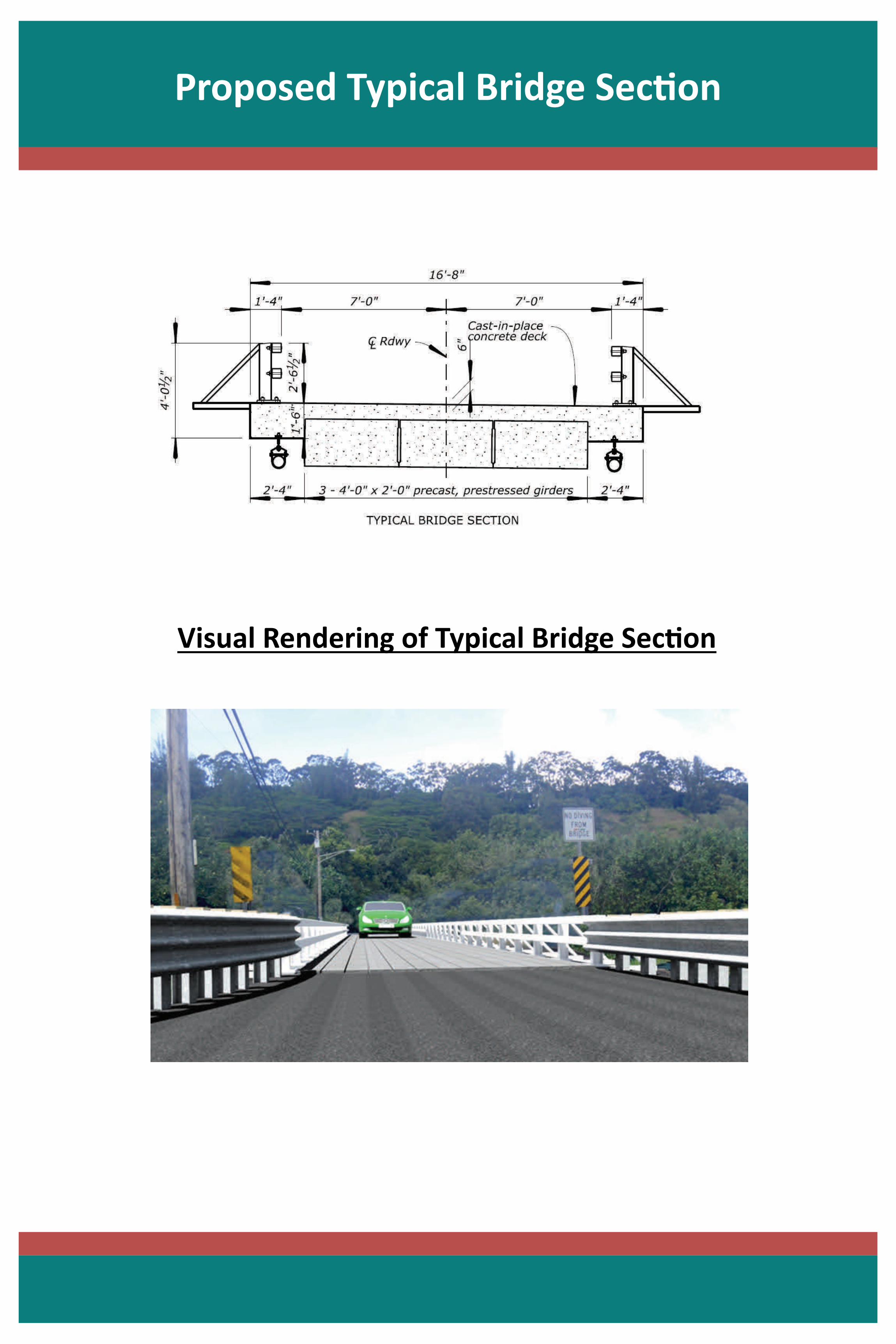
Proposed Typical Bridge Sec on
Visual Rendering of Typical Bridge Sec on

Exis ng and Proposed Bridges 2 and 3
Rendering of Proposed New Bridges
Exis ng Temporary Bridges 2 and 3
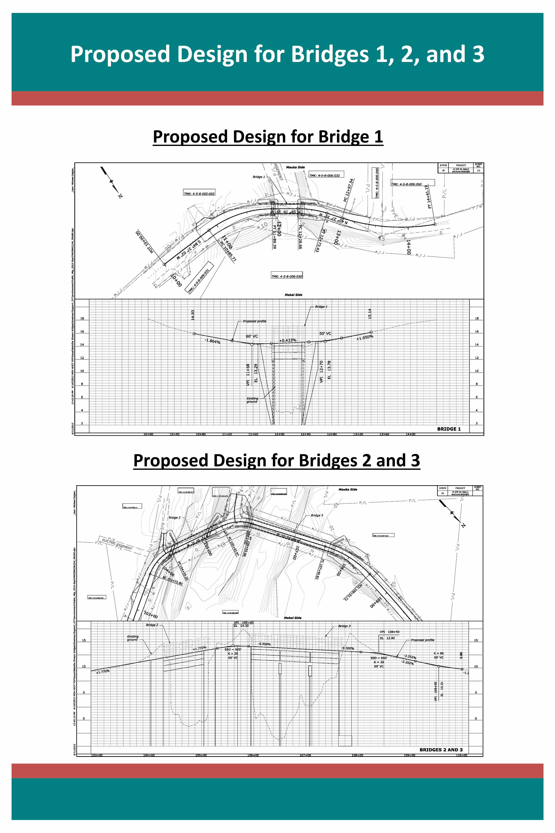
Proposed Design for Bridges 1, 2, and 3
Proposed Design for Bridges 2 and 3
Proposed Design for Bridge 1

TMK: 4-5-8-002:002
TMK: 4-5-8-006:032
TMK: 4-5-8-006:060
TMK: 4-5-8-006:046TMK: 4-5-8-006:034
TMK: 4-5-8-006:035
TMK: 4-5-8-006:021
TMK: 4-5-8-006:020
TMK: 4-5-8-006:030
TMK: 4-5-8-006:031
TMK: 4-5-8-006:025
TMK: 4-5-8-006:019
TMK: 4-5-8-006:018
TMK: 4-5-8-006:030
TMK: 4-5-8-006:17
TMK: 4-5-8-006:011
TMK: 4-5-8-006:009
TMK: 4-5-8-007:024
TMK: 4-5-8-007:023
TMK: 4-5-8-006:030
TMK: 4-5-8-007:031
2150
UTILI
TY EA
SEME
NT
UTIL
ITY E
ASEM
ENT
ELEC
TRIC
EASE
MENT
KUHIO
HWY
ANANALU RD
ALA EKE RD
WAINIHA POWERHOUSE RD
Wainiha R
Source: Esri, DigitalGlobe, GeoEye, i-cubed, Earthstar Geographics, CNES/Airbus DS, USDA, USGS, AEX, Getmapping, Aerogrid, IGN, IGP, swisstopo, and the GIS User Community
Wainiha Bay
Wainiha Bridge 1Permanent and Temporary Bridge Installation(Approximate MP 6.5)
Potential Staging Area(On Ala Eke Road)
®
FEDERAL HIGHWAY ADMINISTRATIONCENTRAL FEDERAL LANDS HIGHWAY DIVISION
Project: Hawaii SR560(1) WainihaLegend:
Temporary DetourGuardrailExisting BridgeRight-of-WayProperty LineTemporary Detour Abutments/PiersArea of Potential EffectPerennial StreamNon-Perennial StreamRoads_Kauai
0 0.01 0.02 0.030.005Miles
1 in = 60 feet0 60 120 18030
Feet
WAINIHA BRIDGES 1, 2, AND 3
Wainiha Bridge 2Permanent and Temporary Bridge Installation(Approximate MP 6.7)
Wainiha Bridge 3Permanent and Temporary Bridge Installation(Approximate MP 6.7)
TMK: 4-5-5-006:015
TMK: 4-5-5-006:014
TMK: 4-5-6-002:002
TMK: 4-5-6-002:004
TMK: 4-5-6-002:002TMK: 4-5-6-003:001
TMK: 4-5-6-004:025
TMK: 4-5-6-004:022
TMK: 4-5-6-002:003
TMK: 4-5-5-005:021
TMK: 4-5-5-005:007
TMK: 4-5-5-005:028
TMK: 4-5-5-005:005
TMK: 4-5-5-005:004
TMK:4-5-6-004:014TMK: 4-5-6-004:023
TMK: 4-5-6-004:022
TMK: 4-5-6-004:023
TMK: 4-5-6-003:002
TMK: 4-5-6-003:002
170
171
172
173
174
175
176
181
177
178
179
180
KUHIO HWY
KUMU RD
ANAE RD
WEKE RD
WaioliWaipa
Waiko
ko
Waipa
Source: Esri, DigitalGlobe, GeoEye, i-cubed, Earthstar Geographics, CNES/Airbus DS, USDA, USGS, AEX, Getmapping, Aerogrid, IGN, IGP, swisstopo, and the GIS User Community
Hanalei Bay
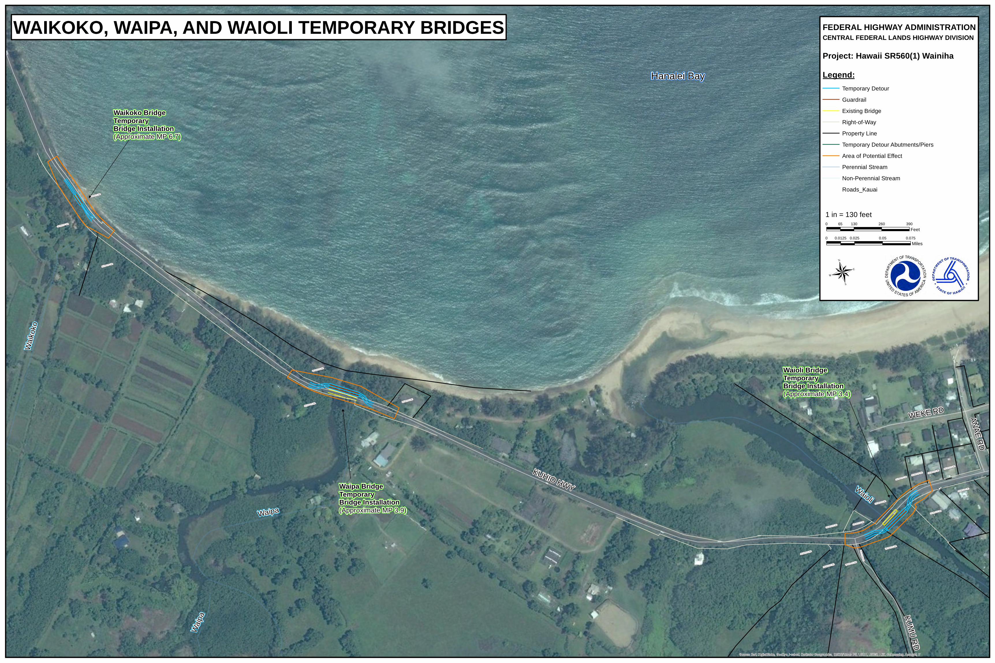
Waioli Bridge Temporary Bridge Installation(Approximate MP 3.4)
®
FEDERAL HIGHWAY ADMINISTRATIONCENTRAL FEDERAL LANDS HIGHWAY DIVISION
Project: Hawaii SR560(1) WainihaLegend:
Temporary DetourGuardrailExisting BridgeRight-of-WayProperty LineTemporary Detour Abutments/PiersArea of Potential EffectPerennial StreamNon-Perennial StreamRoads_Kauai
0 0.025 0.05 0.0750.0125Miles
1 in = 130 feet0 130 260 39065
Feet
WAIKOKO, WAIPA, AND WAIOLI TEMPORARY BRIDGES
Waipa BridgeTemporary Bridge Installation(Approximate MP 3.9)
Waikoko BridgeTemporary Bridge Installation(Approximate MP 6.7)
Related Documents