1 c 2018 IEEE Pre-print of: C. Henry, S. M. Azimi, N. Merkle, ”Road Segmentation in SAR Satellite Images with Deep Fully-Convolutional Neural Networks”, IEEE Geoscience and Remote Sensing Letters, 2018, accepted for publication. DOI: 10.1109/LGRS.2018.2864342 This material is posted here with permission of IEEE. Personal use of this material is permitted. Permission from IEEE must be obtained for all other uses, in any current or future media, including reprinting/republishing this material for advertising or promotional purposes, creating new collective works, for resale or redistribution to servers or lists, or reuse of any copyrighted component of this work in other works, by writing to: [email protected] By choosing to view this document, you agree to all. arXiv:1802.01445v2 [cs.CV] 16 Aug 2018

Welcome message from author
This document is posted to help you gain knowledge. Please leave a comment to let me know what you think about it! Share it to your friends and learn new things together.
Transcript
1
c©2018 IEEEPre-print of:
C. Henry, S. M. Azimi, N. Merkle, ”Road Segmentation in SAR Satellite Images with DeepFully-Convolutional Neural Networks”, IEEE Geoscience and Remote Sensing Letters, 2018, accepted
for publication.DOI: 10.1109/LGRS.2018.2864342
This material is posted here with permission of IEEE.
Personal use of this material is permitted.
Permission from IEEE must be obtained for all other uses, in any current or future media, includingreprinting/republishing this material for advertising or promotional purposes, creating new collectiveworks, for resale or redistribution to servers or lists, or reuse of any copyrighted component of this
work in other works, by writing to:[email protected]
By choosing to view this document, you agree to all.
arX
iv:1
802.
0144
5v2
[cs
.CV
] 1
6 A
ug 2
018
PRE-PRINT ACCEPTED FOR PUBLICATION IN IEEE GEOSCIENCE AND REMOTE SENSING LETTERS 2
Road Segmentation in SAR Satellite Images withDeep Fully-Convolutional Neural Networks
Corentin Henry, Seyed Majid Azimi and Nina Merkle
Abstract—Remote sensing is extensively used in cartography.As transportation networks grow and change, extracting roadsautomatically from satellite images is crucial to keep maps up-to-date. Synthetic Aperture Radar satellites can provide highresolution topographical maps. However roads are difficult toidentify in these data as they look visually similar to targetssuch as rivers and railways. Most road extraction methodson Synthetic Aperture Radar images still rely on a priorsegmentation performed by classical computer vision algorithms.Few works study the potential of deep learning techniques,despite their successful applications to optical imagery. This letterpresents an evaluation of Fully-Convolutional Neural Networksfor road segmentation in SAR images. We study the relativeperformance of early and state-of-the-art networks after carefullyenhancing their sensitivity towards thin objects by adding spatialtolerance rules. Our models shows promising results, successfullyextracting most of the roads in our test dataset. This showsthat, although Fully-Convolutional Neural Networks natively lackefficiency for road segmentation, they are capable of good resultsif properly tuned. As the segmentation quality does not scalewell with the increasing depth of the networks, the design ofspecialized architectures for roads extraction should yield betterperformances.
Index Terms—Road extraction, synthetic aperture radar, highresolution SAR data, TerraSAR-X, deep learning, semantic seg-mentation
I. INTRODUCTION
THE overall urban growth in the past two decades has ledto a considerable development of transportation networks.
Such constantly evolving infrastructure necessitates frequentupdates of existing road maps. A wide range of applicationsare depending on this information, such as city developmentmonitoring, automated data update for geolocalization systemsor support to disaster relief missions. A satellite equipped witha Synthetic Aperture Radar (SAR) can get information on anarea’s topography. The resulting information is more robust tochanges in illumination conditions and color fluctuation withrespect to optical imagery. Moreover, SAR sensors can operateindependently from weather conditions, and are therefore thesensor of choice to survey regions affected by weather-relateddisasters.
The extraction of roads in SAR satellite images has beenresearched for several decades [1] and is generally addressed inthe following manner: road candidates are extracted from SARimages using a feature detector. This initial segmentation isthen transformed into a topological graph, where each segmentrepresents a road section. The graph is finally optimized toform a coherent road network, often by applying a MarkovRandom Field (MRF) [1], [2] using contextual information
The authors are with the Remote Sensing Technology Institute ofthe German Aerospace Center (DLR), Wessling 82234, Germany (e-mail:[email protected]; [email protected]; [email protected])
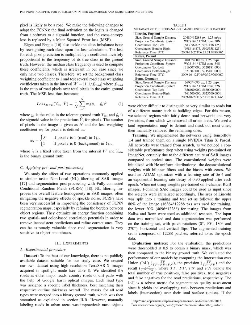
Fig. 1. SAR image sample showing that objects of different natures can lookvery similar. A segmentation model must learn to distinguish all kinds ofroads from railway tracks, tree hedges and rivers.
from the SAR image to reconnect loose segments and cor-rect the overall network structure. Recently, Xu et al. [3]proposed a Conditional Random Field (CRF) model capableof jointly extracting road candidates and applying topologicalconstraints. This end-to-end scheme reduced the inevitableperformance loss occurring when separately extracting roadpriors and constructing a road network graph. These methodsall rely on an efficient road candidate extraction algorithm andmost of them entrust this task to traditional computer visionalgorithms. To date, few works study the potential of the recentadvances in deep learning in the context of road segmentation.
Deep Convolutional Neural Networks (DCNNs) firstdemonstrated unmatched effectiveness in 2012 on the Im-ageNet classification challenge and their performance hasbeen improving at a fast pace ever since, receiving a lotof attention from the computer vision community. However,unlike the medium-sized images used in classification compe-titions, the aerial images used in remote sensing often coverhundreds of square kilometers. Today, Fully-ConvolutionalNeural Networks (FCNNs) are the most successful method toperform pixel-wise segmentation on large-scale images. Givenan input image, they produce an identically-sized predictionmap. Introduced in 2015 with FCN8s [4], FCNNs allowed theestablishment of new states-of-the-art in semantic segmenta-tion of aerial optical images [5] and were successfully appliedto satellite SAR images [6].
In [6], Yao et al. use off-the-shelf pre-trained FCNNs onSAR images to classify buildings, landuse, bodies of waterand other natural areas. They report good segmentation resultsfor the landuse and natural classes but unsatisfactory resultsfor buildings, showing a striking performance contrast betweenlarger and smaller objects. As roads are thin objects by nature,it becomes evident that FCNNs models must be specifically

PRE-PRINT ACCEPTED FOR PUBLICATION IN IEEE GEOSCIENCE AND REMOTE SENSING LETTERS 3
adjusted for our task. Starting from another perspective, Genget al. successively proposed two methods for land coverclassification, including roads. In [7], they emphasize low-level features in SAR images using traditional computer visiontechniques on top of which they train a stack of auto-encoders.In [8], they further improve their results by using Long-Short-Term Memory units (LSTM) to transform the 2-D informationcontained in the image into 1-D information fed to auto-encoders. They report around 95% overall accuracy acrossseveral areas totaling 21 km2, however the road class accuracyremains invariably behind the accuracy of all other classes by10% to 20%.
Roads are difficult to identify even in high resolution SARimages. They can often be confused with other targets such asrailway tracks, rivers or even tree hedges, as illustrated in Fig.1. Identifying roads often involves the opinion of an expert,but deep learning proved it could deal with such delicate studycases, motivating the thorough assessment of the potentialof some powerful FCNNs on the task at hand. The successof this initial experiment would open new prospects in thefuture, like semi-automated annotation of SAR images, whichcould prove much faster and more reliable than fully-manualannotation. Time-critical missions such as disaster relief wouldparticularly benefit from a steep increase in the speed ofsatellite data analysis.
This letter presents the evaluation of three FCNNs for roadsegmentation in high resolution SAR satellite images: FCN-8s [4], Deep Residual U-Net [5] and DeepLabv3+ [9]. Crucialadjustments are made in the training procedure to improve thebase performance of the FCNNs, with a class-weighted MeanSquared Error (MSE) loss and a control parameter over thespatial tolerance of the models. The evaluation is performedon several custom datasets, whose design is critical to thesuccess of the method and is therefore detailed. Unlike Yaoet al. in [6], we set aside the OpenStreetMap (OSM) datadue to the lower geo-localization accuracy compared to SARdata. Unlike previous works, we manually label every singleroad from the most visible highways to the less distinguishabledirt paths. We obtain good qualitative results and satisfyingquantitative results, thus demonstrating the effectiveness ofwell-fitted FCNNs as road candidate extractors in SAR images.
II. METHOD
A. Segmentation with Fully-Convolutional Neural Networks
FCNNs are currently the most successful methods for pixel-wise segmentation, and are especially convenient for largescale image processing. As they can deal with images of anysize, they can take into account a wider context when tryingto identify objects. They owe this flexibility property to theiradaptive bottleneck layers, connecting the two key componentsof the network. The first element, a DCNN encoder, analyzesthe images and outputs a cluster of predictions. The imagedata is gradually down-sampled, proportionately becomingmore meaningful. The second element, a decoder, applies up-sampling operations to restore the spatial properties of thepredictions until the predictions share the same size as theinput image. It is often done using bilinear interpolation or
fractionally strided convolutions, also called deconvolutions[10]. For classification tasks, the DCNN output is classifiedby fixed-size fully-connected layers, the network’s bottleneck,imposing a maximum input size upstream. For segmentationtasks, FCNNs remove this input size constraint by replacingthe fully-connected layers by convolutional layers.
We implement three substantially different FCNNs. Thefirst one is FCN-8s [4] with a VGG-19 backbone [11], thefirst of all FCNNs which was successfully applied to awide variety of computer vision tasks. In FCN-8s, two skipconnections fuse the high resolution information from earlyVGG19 layers into the up-sampling process, thus improv-ing the spatial accuracy of the resulting segmentation. Toincrease its training speed, we add a batch normalization stepbetween each convolutional layer and ReLU activation, aswell as after each deconvolutional layer. We use it to setthe baseline performance for comparison with more recentarchitectures. The second one is Deep Residual U-Net [5]which demonstrated a great segmentation performance onthe Massachusetts roads dataset [12]. Its overall architectureis similar to FCN-8s, although entirely symmetrical with askip connection fusing each block of the encoder into thecorresponding block of the decoder. Its backbone uses residualunits [13] which let the input image data flow through thewhole network. Propagating this information helps the networklearn complex patterns more efficiently, and its application onSAR imagery could help reduce the impact of the speckle.The third one is DeepLabv3+ [9], one of the most recentarchitecture for semantic segmentation. Its Xception backbonealso uses residual connections, but the network is much deeperwith 65 non-residual layers compared to Deep Residual U-Net’s 15. Using dilated convolutions, DeepLab can leverage alarger context and better recognize targets from cluster, whichshould prove valuable for applications to SAR imagery.
B. Adjusting the FCNNs for road segmentation
Roads appear as thin objects in SAR images and are likelyoutweighted by clutter, especially outside cities. We take somenecessary steps to limit the class imbalance during training. Asimilar problem in the case of sports field lines extraction isaddressed in [14] by tracing thick labels in the ground truth.In our case, it means that the labels must exactly cover theroad outlines and embankments, insofar as they are visible inthe SAR images. Pixels labeled as roads are set to a value of1 and background pixels to 0 in the ground truth. In addition,we introduce a spatial tolerance parameter tmax operating asfollows. The value of background pixels located at a distancet ≤ tmax to the nearest pixel labeled as road is redefinedas: 1− t
tmax+1 . The resulting ground truth is a smooth targetdistribution centered around the road labels, similar to whatLuo et al. proposed in [15]. Varying tmax allows controllingthe tolerance of the training towards spatially small mistakes.Note that when referring to a binary ground truth (2 classes)in the following parts, we assume tmax = 0.
As a consequence, the task changes from a binary classifica-tion to a binary regression: instead of predicting each pixel aseither road or background, the network weighs how much each
PRE-PRINT ACCEPTED FOR PUBLICATION IN IEEE GEOSCIENCE AND REMOTE SENSING LETTERS 4
pixel is likely to be a road. We make the following changes toadapt the FCNNs: the final activation on the logits is changedfrom a softmax to a sigmoid function, and the cross-entropyloss is replaced by a Mean Squared Error loss (MSE).
Eigen and Fergus [16] also tackle the class imbalance issueby reweighting each class upon the loss calculation. The lossfor each pixel prediction is multiplied by a coefficient inverselyproportional to the frequency of its true class in the groundtruth. However, the median class frequency is used to computethese coefficients, which is irrelevant in our case since weonly have two classes. Therefore, we set the background classweighting coefficient to 1 and test several road class weightingcoefficients taken in the interval W = [1, 1/froad] where froadis the ratio of road pixels over total pixels in the entire groundtruth. The MSE loss thus becomes:
LossMSE(Ytol, Y ) =1
N
N∑i=1
wi(yi − yi)2 (1)
where yi is the value in the tolerant ground truth Ytol and yi isthe sigmoid value in the predictions Y , for pixel i. The numberof pixels in the image is given as N and the loss weightingcoefficient wi for pixel i is defined as:
wi =
{λ if pixel i is 1 (road) in Ybin1 if pixel i is 0 (background) in Ybin
where λ is a fixed value taken from the interval W and Ybinis the binary ground truth.
C. Applying pre- and post-processing
We study the effect of two operations commonly appliedto similar tasks: Non-Local (NL) filtering of SAR images[17] and segmentation post-processing with Fully-connectedConditional Random Fields (FCRFs) [18]. NL filtering im-proves the overall feature homogeneity in SAR images, oftenmitigating the negative effects of speckle noise. FCRFs havebeen very successful in improving the consistency of FCNNsegmentation maps, especially by refining the borders betweenobject regions. They optimize an energy function combiningtwo spatial- and color-based correlation potentials in order toremove inconsistent predictions and refine correct ones. Theycan be extremely valuable since road segmentation is verysensitive to object smoothness.
III. EXPERIMENTS
A. Experimental procedure
Dataset: To the best of our knowledge, there is no publiclyavailable dataset suitable for our study case. We createdour own dataset using high resolution TerraSAR-X imagesacquired in spotlight mode (see table I). We identified theroads as either major roads, country roads or dirt paths withthe help of Google Earth optical images. Each road typewas assigned a specific label thickness, best matching theirrespective outline thickness overall. The masks for all roadtypes were merged into a binary ground truth, which was thensmoothed as explained in section II-B. However, manuallylabeling roads in urban areas was impractical: most objects
TABLE IMETADATA OF THE TERRASAR-X IMAGES USED IN OUR DATASET
Lincoln, EnglandSize, Ground Sample Distance 20480*12288 px, 1.25 m/pxProjection Coordinate System WGS 84 / UTM zone 30NCoordinates Top-Left [683056.875, 5931158.125]Coordinates Bottom-Right [698416.875, 5905558.125]Reference Time UTC 2009-12-27T06:25:21.938000ZKalisz, PolandSize, Ground Sample Distance 4000*4000 px, 1.25 m/pxProjection Coordinate System WGS 84 / UTM zone 34NCoordinates Top-Left [316607.000, 5720181.000]Coordinates Bottom-Right [321607.000, 5715181.000]Reference Time UTC 2009-04-12T04:59:32.920000ZBonn, GermanySize, Ground Sample Distance 3600*4080 px, 1.25 m/pxProjection Coordinate System WGS 84 / UTM zone 32NCoordinates Top-Left [356400.000, 5630000.000]Coordinates Bottom-Right [361500.000, 5625500.000]Reference Time UTC 2009-01-22T05:51:25.023344Z
were either difficult to distinguish or very similar to roads butof a different nature such as building edges. For this reason,we selected regions with fairly dense road networks and veryfew cities, from which we removed all urban areas. We used aland segmentation map1 to delimit and mask out most cities,then manually removed the remaining ones.
Training: We implemented the networks using Tensorflow1.4 and trained them on a single NVIDIA Titan X Pascal.All networks were trained from scratch, as we noticed a con-siderable performance drop when using weights pre-trained onImageNet, certainly due to the different nature of SAR imagescompared to optical ones. The convolutional weights wereinitialized with He uniform distributions2, the deconvolutionalweights with bilinear filters and the biases with zeros. Weused an ADAM optimizer with a learning rate of 5e-4 andan exponential learning rate decay of 0.90 applied after eachepoch. When not using weights pre-trained on 3-channel RGBimages, 1-channel SAR images could be used as input sincethe weights were initialized accordingly. The area of Lincolnwas split into a training and test set as follows: the upper80% of the image (16384*12288 px) was used for training,the lower 20% (4096*12288) for testing. The images fromKalisz and Bonn were used as additional test sets. The inputdata was normalized and data augmentation was performedon the training set, with patch rotations (0◦, 90◦, 180◦ and270◦), horizontal and vertical flips. The augmented trainingset is composed of 12288 patches, referred to as the epochdata.
Evaluation metrics: For the evaluation, the predictionswere thresholded at 0.5 to obtain a binary mask, which wasthen compared to the binary ground truth. We evaluated theperformance of our models by computing the Intersection overUnion (IoU) ( TP
TP+FP+FN ), the precision ( TPTP+FP ) and the
recall ( TPTP+FN ), where TP , FP , TN and FN denote the
total number of true positives, false positives, true negativesand false negatives for the road predictions, respectively. TheIoU is a robust metric for segmentation quality assessmentsince it yields the overlapping ratio between predictions andlabels (intersection) over their total surface (union). If the
1http://land.copernicus.eu/pan-european/corine-land-cover/clc-20122www.tensorflow.org/api docs/python/tf/keras/initializers/he uniform

PRE-PRINT ACCEPTED FOR PUBLICATION IN IEEE GEOSCIENCE AND REMOTE SENSING LETTERS 5
predictions match the labels well and do not extend outside ofthem, the IoU score will be high. Coupled with the precision(prediction correctness) and recall (prediction completeness),we can assess accurately the performance of a model. Al-though very common in computer vision, the accuracy metric( TP+TNTP+FP+FN+TN ) is unsuitable for our study case. Since
roads make up for around 5% of the pixels in our groundtruth, 95% of accuracy could mean that only background waspredicted.
B. Discussion
To setup a baseline performance, we optimize our hyper-parameters tmax and the loss weighting coefficient on FCN-8s and present the results on the test area from Lincoln (seetable II). We then train a Deep Residual U-Net model and aDeepLabv3+ model using the best parameters found for tmax
and the weighted loss function, and compare their results withthe corresponding FCN-8s model across all our test images.
Adapting the spatial tolerance tmax: We test the followingtolerance values: 0, 1, 2, 4 and 8 px. As anticipated, the greaterthe tolerance, the better the ground truth coverage (+13% recallbetween 0px and 8px of tolerance), at the cost of a larger lossin precision (–17%). The best model reaches 44.98% IoU fortmax = 4px. There is a compromise between precision andrecall, with a loss below 10% in precision for a gain of 8% inrecall compared to the model with tmax = 0px. We maintaintmax = 4px for the rest of the experiments.
Adjusting the loss weighting: Around 5% of the pixelsin the ground truth are roads (inverse frequency: 1/0.05 =20), therefore we experiment on the following loss weightingcoefficients: 1, 2, 4 and 8. Loss weighting induces a maximumgain of 0.48% IoU with a coefficient of 2, reaching a value of45.46%.
Applying NL-filtering: The results become worse whenusing NL-filtered SAR images, with a considerable decrease of8% in IoU. A plausible explanation is that FCNNs natively ap-ply spatial filtering through down-sampling and convolutionalfiltering, so NL-filtering discards meaningful information.
Applying FCRFs post-processing: Contrary to our expec-tations, FCRFs fail to improve the connectivity of severedpredicted road sections. In our case, the overall result is closeto that of an erosion operation, removing not only spuriouspredictions but also valid ones. Moreover the segmentation isalready smooth and regular, limiting the benefits of FCRFs.
Additional FCNNs and test images: We train a DeepResidual U-Net model and a DeepLabv3+ model with tmax =4px and a loss weighting coefficient of 2. We report theresults over the full test set in table III to compare theirperformance to FCN-8s and assess the generalization capacityof each architecture. On the one hand, Deep Residual U-Netshows surprisingly low performance compared to the othermodels. Like DeepLab, this network propagates the noisySAR data down to deep layers but, unlike DeepLab, doesnot have a sufficient depth to abstract from it. On the otherhand, DeepLabv3+ and FCN-8s achieve very close scoresfor all test images. Their performance is moderately reduced(max. –4.73% IoU) when applied to images from another
TABLE IIPERFORMANCE OF FCN-8S OVER THE TEST AREA IN LINCOLN
tmax Loss weight IoU Precision Recall0 px 1 43.79% 71.69% 52.94%1 px 1 44.44% 70.68% 54.48%2 px 1 44.93% 69.45% 56.00%4 px 1 44.98% 62.96% 61.16%8 px 1 42.92% 54.72% 66.56%4 px 2 45.46% 65.34% 59.91%4 px 4 45.21% 57.96% 67.27%4 px 8 43.73% 51.13% 75.17%
TABLE IIIIOU SCORES OF THE BEST MODELS OVER THREE TEST AREAS
Area FCN-8s Deep Res. U-Net DeepLabv3+Lincoln 45.46% 40.18% 45.64%Kalisz 43.85% 27.31% 44.66%Bonn 42.57% 35.90% 40.91%
region with respect to the training area. However, we findout that DeepLabv3+ converges 2.4 times faster than FCN-8sand produces far smoother and less noisy road predictions.A visualization of the segmentation of DeepLabv3+ over thearea of Bonn is shown in Fig. 2.
Limits of the method: Our models achieving the bestresults had difficulties generalizing over a wide variety ofpatterns, predicting unexpected objects like mounds and forestborders and missing many roads, mostly the less visible ones.A visual inspection of the results shows the limits of theproposed annotation scheme, as the label thickness basedon road types does not reflect the actual thickness of manyroads. Many prediction failures are due to this shortcoming.To improve the ground truth, a specific label thickness must beset for each individual road object. Besides, polygonal chainlabels do not capture perfectly irregular road borders, whichthe predictions match more closely. In this specific regard,the models outperform the ground truth in terms of pixel-wise correspondence to the roads, but are yet penalized in themetrics. Consequently, straightening the predicted roads wouldmake them coincide better with the labels. In parallel, becauseof the absence of object awareness in FCNNs, predicted roadsare sometimes disconnected at intersections. The next stepafter road candidate extraction is the construction of a roadgraph which can be optimized to reconnect loose segments toeach other. This is however outside the scope of this letter.
Strengths of the method: The proposed method overcomesthe major difficulty of isolating thin objects in a speckled en-vironment and detecting many road patterns despite significantvisual differences. The FCNNs were trained using a smalldataset, relatively to other datasets used for deep learning.They succeeded nonetheless, not only for the area they werefine-tuned on (Lincoln) but also for other completely unre-lated areas (Kalisz and Bonn). FCNNs show an encouragingpotential for adaptation given the complexity of the task athand, and would undoubtedly benefit from further training onadditional images. Moreover, the predictions are smooth, forthe most part continuous and almost entirely free of noise,showing that FCNNs successfully leverage the image widecontext to improve the consistency of local predictions. Theconstruction of a road graph can therefore be applied withoutany pre-processing on the road candidates, as they alreadyconstitute a solid baseline segmentation.

PRE-PRINT ACCEPTED FOR PUBLICATION IN IEEE GEOSCIENCE AND REMOTE SENSING LETTERS 6
IV. CONCLUSION
Fully Convolutional Neural Networks (FCNNs) prove tobe an effective solution to perform road extraction fromSAR images. We establish that off-the-shelf FCNNs can besubstantially enhanced specifically for road segmentation byadding a tolerance rule towards spatially small mistakes. Ourversion of Deeplabv3+ modified with a Mean Squared Errorregression loss, rebalanced towards the road class, achievesin average 44% intersection over union across our test sets.We also show that FCN-8s, no longer the state-of-the-art,reaches scores very close to those of DeepLabv3+, while beingfar shallower. However FCN-8s’ predictions are more noisyand less smooth, making DeepLabv3+ a more robust roadcandidate extractor. This narrow performance gap points outthe need to design new FCNN architectures specialized forroad segmentation. The use of FCNNs as highly adaptableroad candidate extractors should provide future works with areliable means to obtain prior segmentations, on which graphreconstruction can be applied to map entire road networks.
REFERENCES
[1] F. Tupin, H. Maitre, J.-F. Mangin, J.-M. Nicolas, and E. Pechersky,“Detection of linear features in SAR images: application to road networkextraction,” IEEE Trans. on Geosci. and Remote Sensing, vol. 36, pp.434–453, Mar. 1998.
[2] T. Perciano, F. Tupin, R. Hirata, and R. M. Cesar, “A hierarchicalMarkov random field for road network extraction and its applicationwith optical and SAR data,” in IEEE Int. Geosci. and Remote SensingSymp., Jul. 2011.
[3] R. Xu, C. He, X. Liu, D. Chen, and Q. Qin, “Bayesian Fusion of Multi-Scale Detectors for Road Extraction from SAR Images,” ISPRS Int. J.of Geo-Inform., vol. 6, Jan. 2017.
[4] J. Long, E. Shelhamer, and T. Darrell, “Fully Convolutional Networksfor Semantic Segmentation,” in CVPR, Boston, 2015.
[5] Z. Zhang, Q. Liu, and Y. Wang, “Road Extraction by Deep Residual U-Net,” IEEE Geosci. and Remote Sensing Letters, vol. 15, pp. 749–753,2018.
[6] W. Yao, D. Marmanis, and M. Datcu, “Semantic segmentation using thefully convolutional networks for SAR and optical image pairs,” in Proc.of the Conf. on Big Data from Space, Toulouse, France, 2017.
[7] J. Geng, H. Wang, J. Fan, and X. Ma, “Deep Supervised and ContractiveNeural Network for SAR Image Classification,” IEEE Trans. on Geosci.and Remote Sensing, vol. 55, pp. 2442–2459, 2017.
[8] ——, “SAR Image Classification via Deep Recurrent Encoding NeuralNetworks,” IEEE Trans. on Geosci. and Remote Sensing, vol. 56, pp.2255–2269, Apr. 2018.
[9] L.-C. Chen, Y. Zhu, G. Papandreou, F. Schroff, and H. Adam, “Encoder-Decoder with Atrous Separable Convolution for Semantic Image Seg-mentation,” CoRR, Feb. 2018.
[10] M. D. Zeiler, D. Krishnan, G. W. Taylor, and R. Fergus, “Deconvolu-tional networks,” in CVPR, San Francisco, 2010.
[11] K. Simonyan and A. Zisserman, “Very Deep Convolutional NetworksFor Large-Scale Image Recognition,” in ICLR, San Diego, 2015.
[12] V. Mnih, “Machine Learning for Aerial Image Labeling,” Ph.D. disser-tation, University of Toronto, 2013.
[13] K. He, X. Zhang, S. Ren, and J. Sun, “Deep Residual Learning forImage Recognition,” in CVPR, Las Vegas, 2016.
[14] N. Homayounfar, S. Fidler, and R. Urtasun, “Sports Field Localizationvia Deep Structured Models,” in CVPR, Honolulu, 2017.
[15] W. Luo, A. G. Schwing, and R. Urtasun, “Efficient Deep Learning forStereo Matching,” in CVPR, Las Vegas, 2016.
[16] D. Eigen and R. Fergus, “Predicting Depth, Surface Normals and Se-mantic Labels with a Common Multi-scale Convolutional Architecture,”in ICCV, Santiago, 2015.
[17] A. Buades, B. Coll, and J. M. Morel, “A non-local algorithm for imagedenoising,” in CVPR, San Diego, 2005.
[18] P. Krahenbuhl and V. Koltun, “Efficient Inference in Fully ConnectedCRFs with Gaussian Edge Potentials,” in NIPS, Granada, 2011.
Fig. 2. Segmentation results of FCN-8s and DeepLabv3+ over the area ofBonn. Top to bottom: SAR image with masked urban areas, DeepLabv3+predictions, zoomed samples. In the samples, top to bottom: SAR image,ground truth, FCN-8s predictions, DeepLabv3+ predictions.
Related Documents

![IEEE TRANSACTIONS ON INFORMATION THEORY, VOL ...arXiv:2003.12245v3 [cs.IT] 21 Oct 2020 IEEE TRANSACTIONS ON INFORMATION THEORY, VOL. , NO. , 1 Bayes-Optimal Convolutional AMP Keigo](https://static.cupdf.com/doc/110x72/60985e02238ad567473a645d/ieee-transactions-on-information-theory-vol-arxiv200312245v3-csit-21-oct.jpg)


![SUBMITTED TO IEEE TRANSACTIONS ON IMAGE ...arXiv:1612.06053v1 [cs.CV] 19 Dec 2016 2 SUBMITTED TO IEEE TRANSACTIONS ON IMAGE PROCESSING. training with online tracking, and previous](https://static.cupdf.com/doc/110x72/5fab50bdfd038a5ef76aee16/submitted-to-ieee-transactions-on-image-arxiv161206053v1-cscv-19-dec-2016.jpg)
![c arXiv:2005.07705v1 [physics.comp-ph] 15 May 2020](https://static.cupdf.com/doc/110x72/6218276f0502a932d21200d7/c-arxiv200507705v1-15-may-2020.jpg)
![c, a,b,e,c, arXiv:1704.01451v1 [physics.comp-ph] 5 Apr 2017](https://static.cupdf.com/doc/110x72/624c95e114eda00eaa6f807c/c-abec-arxiv170401451v1-5-apr-2017.jpg)


