Cootharaba.doc 1 Boreen Point, Kin Kin & Cootharaba

Welcome message from author
This document is posted to help you gain knowledge. Please leave a comment to let me know what you think about it! Share it to your friends and learn new things together.
Transcript

C:\Users\abryant\OneDrive - Noosa Shire Council\Desktop\HERITAGE WEBPAGE PDFS\Boreen Point Kin Kin Cootharaba.doc
1 Boreen Point, Kin Kin & Cootharaba

2
3
Contents 1.1 THE APOLLONIAN HOTEL........................................................................................................ 4 1.2 BORG PARK .............................................................................................................................. 6 1.3 LAKE COOTHARABA (INCLUDING BOREEN POINT, NORTH SHORE & COMO) .................................. 9 1.4 HARRY'S HUT ......................................................................................................................... 13 1.5 KILDEY’S ROAD RESIDENTIAL PRECINCT ........................................................................... 16 1.6 KIN KIN CREEK TRAMWAYS & MILL POINT SAWMILL SITE ................................................. 19 1.7 KIN KIN SAWMILL ................................................................................................................... 23 1.8 FORMER KIN KIN JUNCTION UNITING CHURCH ................................................................. 25 1.9 MEMORIAL SCHOOL OF ARTS .............................................................................................. 27 1.10 ST LUKE’S ANGLICAN CHURCH ............................................................................................ 29 1.11 FORMER KIN KIN JUNCTION STATE SCHOOL (SPORTS GROUND CLUBHOUSE) ...................... 31 1.12 FORMER FRANCIS HOUSE .................................................................................................... 33 1.13 FORMER ES&A BANK AND RESIDENCE .................................................................................. 37 1.14 KIN KIN STATE SCHOOL ........................................................................................................ 39 1.15 FORMER POST OFFICE ......................................................................................................... 40 1.16 COUNTRY LIFE HOTEL .......................................................................................................... 42
.
4
1.1 THE APOLLONIAN HOTEL
LOCATION Cnr Hector and Laguna Streets, Boreen Point
TENURE Freehold. 22RP839106
DATES Building Constructed 18791. Building moved to Boreen Point 19872 and first licensed in
1869.
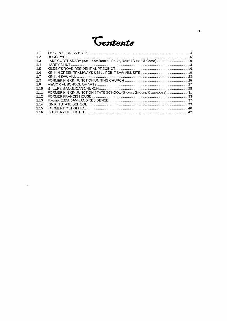
DESCRIPTION The hotel is set at ground level. It is of timber construction with a high-pitched corrugated iron roof and open verandahs on 3 sides. The interior has been extensively altered over time and no longer provides accommodation.
Apollonian Hotel
1.1.1 Brief History
Built in 1879, the Apollonian Hotel began its life as a `goldfields pub' in Gympie, where gold was discovered in 1867 by James Nash. It survived the decline of the gold-producing boom times of Gympie, but closed in 1951. It lay idle until it was relocated to its present site in 1988.
Adjacent to the original building, an outdoor eating area has been developed, featuring replicas of an old outhouse, post and rail fencing and rough-hewn trestles and stools.
1.1.2 HISTORICAL THEMES
This place illustrates the following historical theme in the Noosa Shire based on the Environmental Protection Agency’s Guidelines for Historical and Indigenous Cultural Heritage Management, dated 2001:-
2 (g) Developing rural economies - encouraging the growth of tourism: tourist accommodation (hotel)
1.1.3 POTENTIAL SIGNIFICANCE
The Apollonian Hotel is not an original local building. It has significance in its own right however as a example of a 19th Century rural hotel.
1 Leisuretime Magazine, 10 Feb. 1996, p.3. 2 Pers. comm., Mrs Irene Christie, 2001.

5
It is recommended that Noosa Council consider assessment criterion d under the Environmental Protection Agency’s Guidelines for Historical and Indigenous Cultural Heritage Management, dated 2001 as relevant to this place.
1.1.4 INTEGRITY
The building has undergone extensive alterations and rebuilding including new kitchens, toilets, refrigeration and cool rooms. The outbuildings and facilities are modern replicas of no cultural significance.
6
1.2 BORG PARK
LOCATION Corner of Orchard Avenue and Mango Lane, Boreen Point
TENURE State Land. 43RP59216
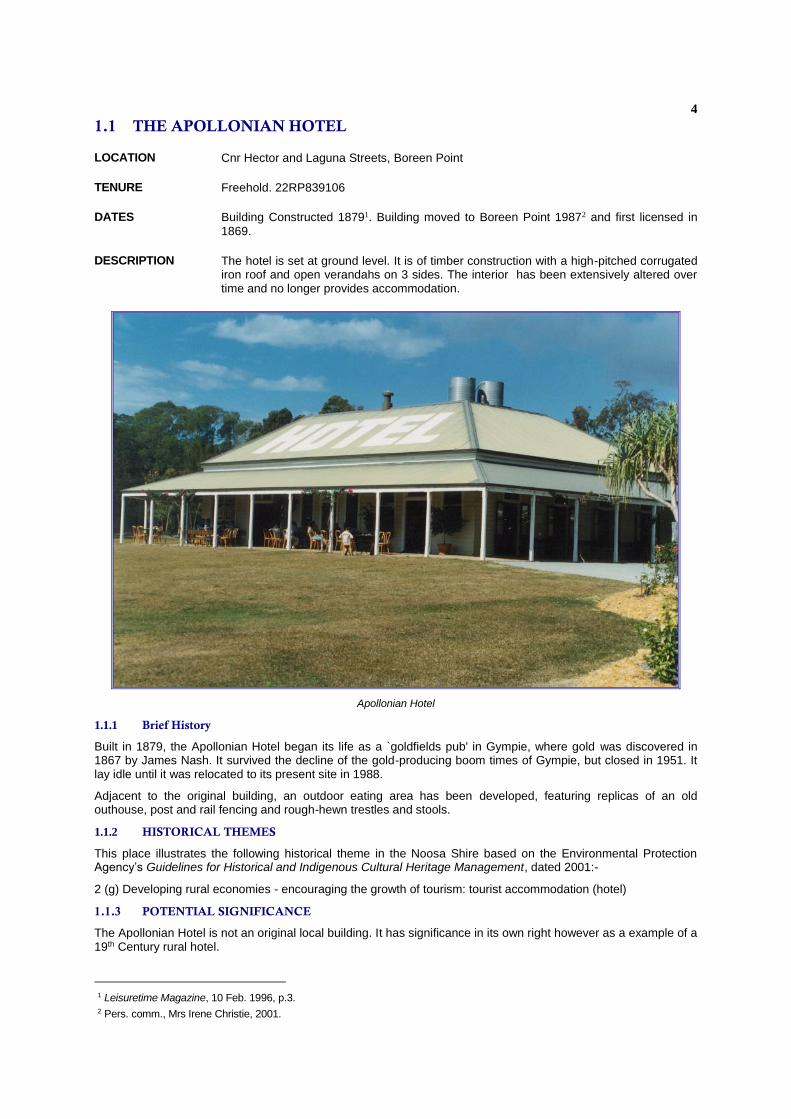
DESCRIPTION A public park containing remnant trees from a previous orchard. It contains several large trees, including two mango tree and rare Jackfruit tree, Artocarpus heterophyllus
1.2.1 BRIEF HISTORY
It is believed the trees growing on the park were planted in 1927 or 1928 by the then owner, Peter Wilhelm Pedersen. The trees are assumed to have been planted to provide fruit for the residents and visitors of Pedersen's guesthouse then located on the site. They formed part of an extensive orchard and market garden. Orchard Avenue acquired its name from this endeavour.
Boreen Point was first selected in 1871 by Frederick George Goodchap. He developed the nearby Mill Point sawmill with three other ex-miners from Gympie. His selection was bought by Horace Page and his sons, Herbert and John, in 1906.3 Herbert’s business, which still operates to in Pomona as Page Furnishers, began from the furniture he made at home.4 He also carted his fish catch to Pomona to sell.5
3 Gillespie, Aline “The Pages of Pomona”, Pomona - The Historical Centre of Noosa Shire, Historical Series Issue No. 2, Cooroora Historical Society Inc., Pomona, June 2000, p3. 4 Op cit, p.10 5 ibid, p.7
7
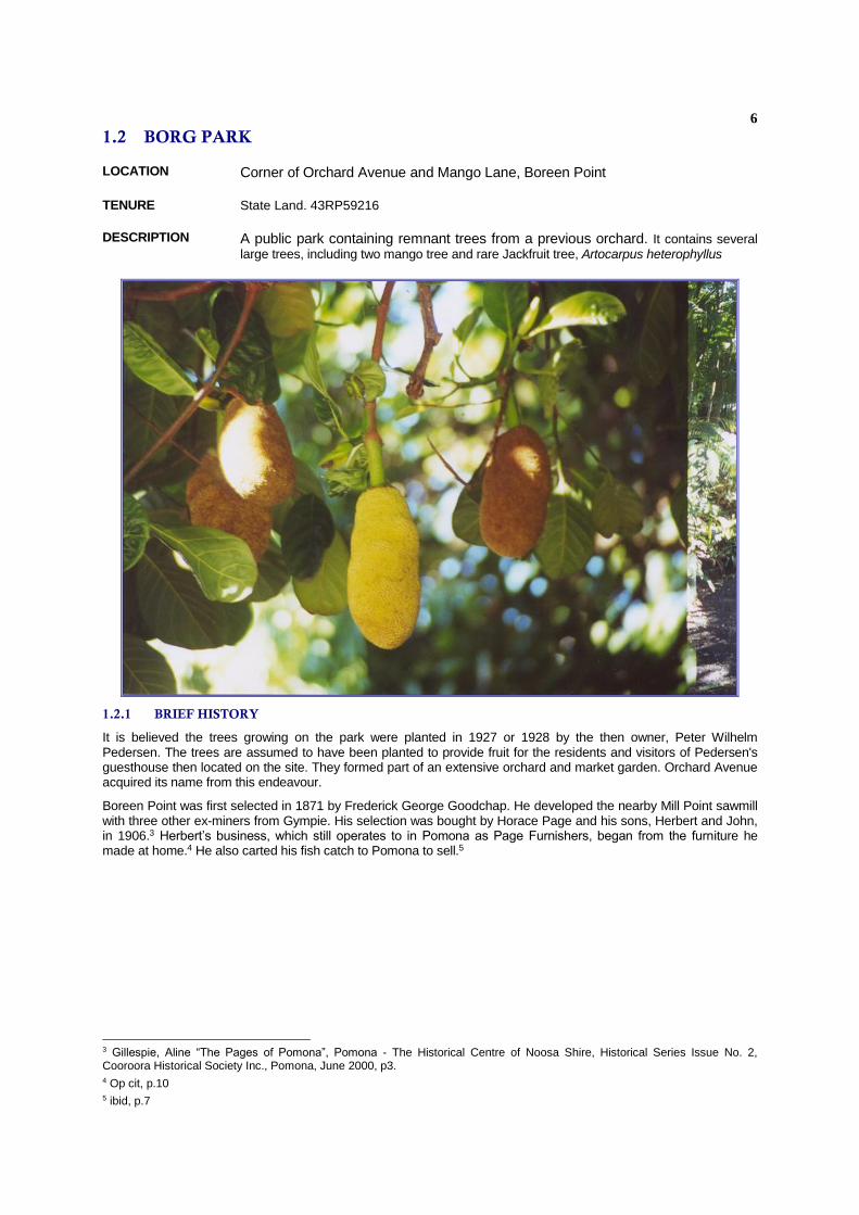
The Pages cleared bush to build a house and establish a garden. Herbert’s son, George, remembered that, when he was a child in the 1920’s, “the whole of Boreen Point was a big orchard. There were bees, cattle, pigs, bananas, papaws (sic) and all kinds of citrus fruits”.6 From around 1910, Boreen Point became popular with visitors from the Cooran and Gympie districts. The Page family built a jetty and several lakeside cottages for renting to holidaymakers. They also arranged boating trips on the lake and up the river.7
It is believe that the Page’s sold to Mr Robertson (who came from Scotland) and that the land passed then to a tailor from Gympie named Stewart, who sold to Arnold Borg, after whom the park is named.
1.2.2 HISTORICAL THEMES
This place illustrates the following historical themes in the Noosa Shire based on the Environmental Protection Agency’s Guidelines for Historical & Indigenous Cultural Heritage Management, 2001:-
2 (g) Developing rural economies - encouraging the growth of tourism: tourist accommodation (orchard for guest houses); and
4 (c) Establishing and developing towns - providing public services: public garden.
1.2.3 POTENTIAL SIGNIFICANCE
The significance of this park lies in the uniqueness of the jackfruit tree growing on it, and the general ambience this gives to the precinct.
6 ibid, p.5 7 ibid, p.6-7

8
It is recommended that Noosa Council consider assessment criterion a of the Environmental Protection Agency’s Guidelines for Historical and Indigenous Cultural Heritage Management, dated 2001 as relevant to this place.
1.2.4 INTEGRITY
The park is the remnant of what used to be a 1920’s guesthouse complex. The trees making up the park, although all introduced species, are mature specimens and are worthy of protection, particularly the rare Artocarpus heterophyllus.
9
1.3 LAKE COOTHARABA (INCLUDING BOREEN POINT, NORTH SHORE
& COMO)
LOCATION Lake Cootharaba's southernmost point of entry to the Noosa River is some twenty kilometres upstream from the river mouth, some seven kilometres to the north of Lake Cooroibah.
TENURE The surface area of the lake up to its high water mark is state controlled. The lands adjoining the lake are a mixture of privately owned, state- owned and Commonwealth-owned properties.
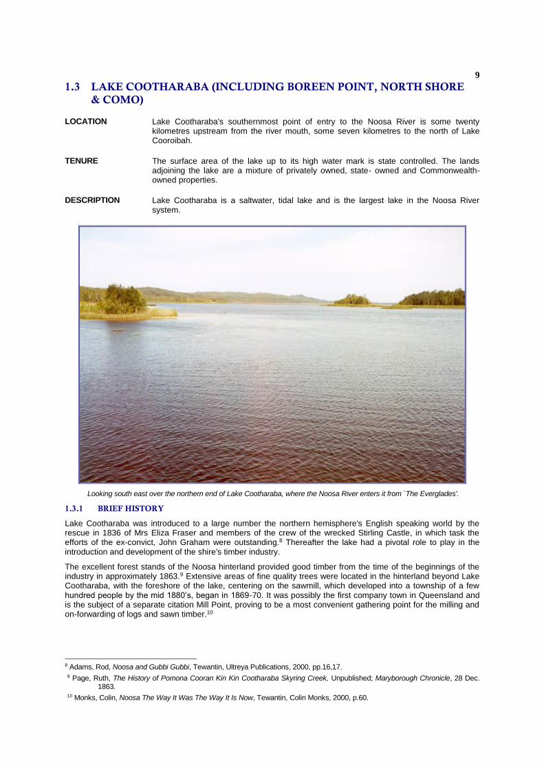
DESCRIPTION Lake Cootharaba is a saltwater, tidal lake and is the largest lake in the Noosa River system.
Looking south east over the northern end of Lake Cootharaba, where the Noosa River enters it from `The Everglades'.
1.3.1 BRIEF HISTORY
Lake Cootharaba was introduced to a large number the northern hemisphere's English speaking world by the rescue in 1836 of Mrs Eliza Fraser and members of the crew of the wrecked Stirling Castle, in which task the efforts of the ex-convict, John Graham were outstanding.8 Thereafter the lake had a pivotal role to play in the introduction and development of the shire's timber industry.
The excellent forest stands of the Noosa hinterland provided good timber from the time of the beginnings of the industry in approximately 1863.9 Extensive areas of fine quality trees were located in the hinterland beyond Lake Cootharaba, with the foreshore of the lake, centering on the sawmill, which developed into a township of a few hundred people by the mid 1880’s, began in 1869-70. It was possibly the first company town in Queensland and is the subject of a separate citation Mill Point, proving to be a most convenient gathering point for the milling and on-forwarding of logs and sawn timber.10
8 Adams, Rod, Noosa and Gubbi Gubbi, Tewantin, Ultreya Publications, 2000, pp.16,17. 9 Page, Ruth, The History of Pomona Cooran Kin Kin Cootharaba Skyring Creek, Unpublished; Maryborough Chronicle, 28 Dec.
1863. 10 Monks, Colin, Noosa The Way It Was The Way It Is Now, Tewantin, Colin Monks, 2000, p.60.
10
A successful method of transportation was introduced with the design by McGhie, Luya and Co. of shallow-draught paddle wheel vessels, capable of negotiating the shoals of the lakes and river passages, and which towed punts of timber, sawn from their Mill Point sawmill to their transshipping centre at Colloy opposite Tewantin11 for on-loading to Brisbane via their more substantial paddle wheelsteamer, Culgoa.12
With the closure of the Mill Point sawmill in 1892, Lake Cootharaba became less important as a transport link. It, however, was a prolific fish-producing source and commercial fishing dominated its usefulness for many years. Indeed, Nancy Cato states, with the rhetoric of the novelist, that, for the prawners, `... the last bonanza years were in 1968-69, when all day long the waters of the biggest lake [Cootharaba] were churned to mud by the circling trawlers.'13
In present times Lake Cootharaba's influence lies in recreational uses. Regattas have been held on the lake since the mid 1870’s, for example as part of Mill Point’s 1876 Christmas festivities.14 Predominantly it is the sport of sailing. The lake is in effect quite shallow, with virtually no recorded depths being beyond two metres.15 It is thus quite a safe environment for sailing and since it has a large surface area, it experiences challenging winds which make it a course on which sailors take interest in competing. The Sailing Club was formed in 1946
Canoeing is very popular while power boating is virtually non-existent on the lake's surface. Tourist launches traverse it regularly in small numbers on a daily basis, and houseboats, even less. The overall atmosphere on the lake is therefore one of activity, yet of peace.
Perhaps two-thirds of the way down the western coast of Lake Cootharaba is situated the small settlement of Boreen Point. This township was apparently named after one Jim Breen who was an agent appointed by the first selector in the area, Frederick Goodchap after he selected the whole of Boreen Point on 9 January 1871.16
Goodchap was one of the four ex-miners and mine investors from Gympie who founded Mill Point. In 1906, he sold Boreen Point to the Page family, who later established the Page Furnishers business in Pomona.
Boreen Point’s popularity as a holiday place began in the early part of the twentieth century, when in addition to building their family home and extensive gardens, the Page’s built a jetty and lakeside houses, which they let to visitors from Gympie and Cooran
Further to the north of Boreen Point, at Mill Point, lie the remains of the large sawmill that processed timber there in the latter stages of the nineteenth century.17 Now this area is utilised for camping, canoeing and other recreational pursuits.
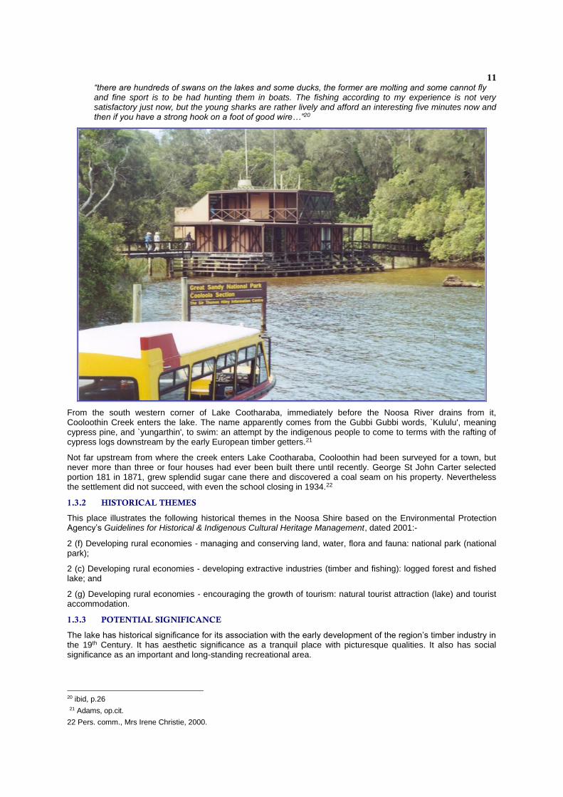
Further to the north, yet again, is situated the National Parks establishment, the Kinaba Information Centre. This building has been constructed completely over the water of Lake Cootharaba. It serves launch, private boating and hiking tourists as a learning centre for ecological aspects of the region. It was opened on 16 September 1978 and was built by Gympie contractors, Robertson Brothers.18
The lake and its margins is now popular with birdwatchers. However, in its early days birds were caught firstly for food and later for sport. In 1863, timber merchant William Pettigrew surveyed the lake and reported that”
“on a return down Lake Roo (Coothooraba) we caught two ‘Gneerings’ (black swans after which Pettigrew named his paddle steamer), one of which was easily caught and which we kept for the Acclinatisation society, but the other, which took to dodging, got hurt before we could catch it, so we ate it - but oh it was tough. Our black fellow could not be prevailed upon to jump into the water to make short work of the chase, as he declared there was ‘devil devil in the water’”.19
An account of Mill Point’s 1876 Christmas festivities noted that:
11 Pers. comm., Olive Donaldson, 2000; Kerr, J.D. & R.S., `More on Cootharaba', Light Railways, Autumn 1976, pp.11-15; Kerr,
J.D. & R.S., `Notes on the Gauge of Cootharaba Tramway', Light Railways, Apr. 1989, no. 104, p.21. 12 Brown, Elaine, Cooloola Coast Noosa to Fraser Island The Aboriginal and settler histories of a unique environment, St Lucia,
University of Queensland Press, 2000, pp.159-161. 13 Cato, Nancy, The Noosa Story A Study in Unplanned Development, Milton, Q., The Jacaranda Press, 1979, 1st ed., 3rd ed.,
1989, p.67. 14 Hibbard, A ajd Grosby, E. Mill Point Conservation Plan - Cooloola national Park, Vol 1 ‘Management Plan’, Qld Department of
Environment and Heritage, 199`, pp.25-26 15 Dennis Gittoes' Map of the Cooloola Coast, 1996. 16 Queensland Crown Land Purchase Deed No. 43 386. 17Adams, op.cit., p.110; An archaeological survey entitled, `Mill Point Conservation Plan has been done on the Elanda Point mill
site', was done by Eleanor Crosby and Anne Hibberd in 1994 for the then Department of Environment and Heritage. 18Pers. comm., Mrs Irene Christie, 2000. 19 Hibbard and Crosby, op cit, p. 20
11
“there are hundreds of swans on the lakes and some ducks, the former are molting and some cannot fly and fine sport is to be had hunting them in boats. The fishing according to my experience is not very satisfactory just now, but the young sharks are rather lively and afford an interesting five minutes now and then if you have a strong hook on a foot of good wire…”20
From the south western corner of Lake Cootharaba, immediately before the Noosa River drains from it, Cooloothin Creek enters the lake. The name apparently comes from the Gubbi Gubbi words, `Kululu', meaning cypress pine, and `yungarthin', to swim: an attempt by the indigenous people to come to terms with the rafting of cypress logs downstream by the early European timber getters.21
Not far upstream from where the creek enters Lake Cootharaba, Cooloothin had been surveyed for a town, but never more than three or four houses had ever been built there until recently. George St John Carter selected portion 181 in 1871, grew splendid sugar cane there and discovered a coal seam on his property. Nevertheless the settlement did not succeed, with even the school closing in 1934.22
1.3.2 HISTORICAL THEMES
This place illustrates the following historical themes in the Noosa Shire based on the Environmental Protection Agency’s Guidelines for Historical & Indigenous Cultural Heritage Management, dated 2001:-
2 (f) Developing rural economies - managing and conserving land, water, flora and fauna: national park (national park);
2 (c) Developing rural economies - developing extractive industries (timber and fishing): logged forest and fished lake; and
2 (g) Developing rural economies - encouraging the growth of tourism: natural tourist attraction (lake) and tourist accommodation.
1.3.3 POTENTIAL SIGNIFICANCE
The lake has historical significance for its association with the early development of the region’s timber industry in the 19th Century. It has aesthetic significance as a tranquil place with picturesque qualities. It also has social significance as an important and long-standing recreational area.
20 ibid, p.26 21 Adams, op.cit.
22 Pers. comm., Mrs Irene Christie, 2000.
12
It is recommended that Noosa Council consider assessment criteria a, e and g under the Environmental Protection Agency’s Guidelines for Historical & Indigenous Cultural Heritage Management, dated 2001 as relevant to this place.
1.3.4 INTEGRITY
The lake retains a basic environment of peacefulness and provides important habitat for birds and fish. Much of the Noosa River, including its lakes, was declared a Fish Habitat Reserve in 1993 and continues to retain this status.23
The ecological integrity of Lake Cootharaba remains very high, even though the water and surrounds are heavily used for a range of active and passive recreational pursuits, including Boreen Point’s popular sailing regattas.
It is flushed out by the Noosa River, which flows from north to south through its middle course. Nevertheless it is saline and it is also subject to tidal movement. This effect, it must be stated is not major, but it does assist in deterring stagnancy throughout the lake's area.
Evidence of the early timber transportation industry is present at the lake, enhancing its character and maintaining its historical connections. An example is the channel near the mouth of Kin Kin Creek, which was originally very shallow. To allow the passage of logs through it, the logs were dragged by bullock teams across this channel, the result being a deepening and widening of the channel, which provides even in current times, a passage for vessel to pass through.
23 Elaine K. Green & Associates, Historical and Cultural Heritage Survey of the Noosa, Maroochy and Mooloolah Rivers for The Maroochy-Mooloolah-Noosa Water Quality Strategy Management Committee as part of the South East Queensland Regional Water Quality Management Strategy, December 2000 p.38.
13
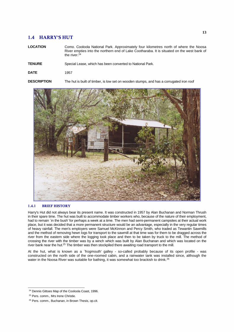
1.4 HARRY'S HUT
LOCATION Como. Cooloola National Park. Approximately four kilometres north of where the Noosa River empties into the northern end of Lake Cootharaba. It is situated on the west bank of the river.24
TENURE Special Lease, which has been converted to National Park.
DATE 1957
DESCRIPTION The hut is built of timber, is low set on wooden stumps, and has a corrugated iron roof
1.4.1 BRIEF HISTORY
Harry's Hut did not always bear its present name. It was constructed in 1957 by Alan Buchanan and Norman Thrush in their spare time. The hut was built to accommodate timber workers who, because of the nature of their employment, had to remain `in the bush' for perhaps a week at a time. The men had semi-permanent campsites at their actual work place, but it was decided that a more permanent structure would be an advantage, especially in the very regular times of heavy rainfall. The men's employers were Samuel McKinnon and Percy Smith, who traded as Tewantin Sawmills and the method of removing hewn logs for transport to the sawmill at that time was for them to be dragged across the river from the eastern side where the logging took place and then to be taken by truck to the mill. The method of crossing the river with the timber was by a winch which was built by Alan Buchanan and which was located on the river bank near the hut.25 The timber was then stockpiled there awaiting road transport to the mill.
At the hut, what is known as a `frogmouth' galley - so-called probably because of its open profile - was constructed on the north side of the one-roomed cabin, and a rainwater tank was installed since, although the water in the Noosa River was suitable for bathing, it was somewhat too brackish to drink.26
24 Dennis Gittoes Map of the Cooloola Coast, 1996. 25 Pers. comm., Mrs Irene Christie. 26 Pers. comm., Buchanan, in Brown Thesis, op.cit.

14
Harry Spring was a pharmacist, with shops in Cooroy and Pomona. He is remembered as a well-respected citizen particularly through his philanthropy, which included assisting needy school children with their education by way of offering bursaries. He, however, liked to escape from his professional responsibilities as often as he could, to fish for bass in the more northern reaches of the Noosa River.27 He and his friends were in the habit of pitching a tent adjacent to the hut which now bears his name and in the 1960s, after logging ceased, he purchased the hut from McKinnon and arranged a lease from the then Forestry Department.28
Harry Spring died at the age of 92 years in 1999 and the lease on `Harry's Hut' reverted to the National Parks administration at that time.29 Meanwhile, he had extended the simple one-roomed hut by connecting the galley to it by a roof made from iron taken from an old slaughterhouse and by flooring the connecting area. In this, he used the somewhat ingenious method of including beer bottles in the foundation. He also added a verandah, using local timber in its construction. Originally he used a simple kerosene lantern to light the hut but later purchased a small generator which supplied power to 70-watt electric bulbs.30
1.4.2 HISTORICAL THEMES
This place illustrates the following historical themes in Noosa Shire based on the Environmental Protection Agency's Guidelines for Historical & Indigenous Cultural Heritage Management, dated 2001:-
2(c) Developing rural economies - exploiting natural resources (timber): logged forest (timber cutters hut);
9(c) Developing social and cultural institutions and ways of life - recreating (going fishing): fishing spot (hut); and
2(g) Developing rural economies - encouraging the growth of tourism: rest stop (hut).
1.4.3 POTENTIAL SIGNIFICANCE
Harry's Hut is a well-known site for all who travel or spend time in the more northern reaches of the Noosa River. It was a favourite gathering place for keen amateur fishermen for many years before becoming a recent stopping place for river tours. It is a rare surviving example of a timber getters’ hut and has been adapted in an unusual form to a fisherman’s hut. The hut also demonstrates the sustained importance of the local timber industry into the mid-20th Century.
27 ibid. 28 ibid. 29 Christopher Ladd, Public Address commentary by tourist launch master, 20 Oct. 2000. 30 Mrs Irene Christie: interview with Alan Buchanan, Howard Parkyn, Keith Beckmann, Frank Bickle and others, 21 Sep. 1985.

15
It is recommended that Noosa Council consider assessment criteria a, b, d, and g under the Environmental Protection Agency’s Guidelines for Historical and Indigenous Cultural Heritage Management, dated 2001 as relevant to this place.
1.4.4 INTEGRITY
The building remains in very good condition and is in its original state, albeit with the additions added to it by Harry Spring.
There is evidence of graffiti but virtually no vandalism.
16
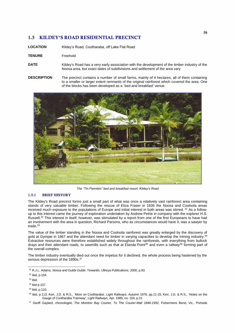
1.5 KILDEY’S ROAD RESIDENTIAL PRECINCT
LOCATION Kildey’s Road, Cootharaba, off Lake Flat Road
TENURE Freehold
DATE Kildey's Road has a very early association with the development of the timber industry of the Noosa area, but exact dates of subdivisions and settlement of the area vary
DESCRIPTION The precinct contains a number of small farms, mainly of 4 hectares, all of them containing to a smaller or larger extent remnants of the original rainforest which covered the area. One of the blocks has been developed as a `bed and breakfast' venue.
The “Tin Pannikin” bed and breakfast resort, Kildey’s Road
1.5.1 BRIEF HISTORY
The Kildey's Road precinct forms just a small part of what was once a relatively vast rainforest area containing stands of very valuable timber. Following the rescue of Eliza Fraser in 1836 the Noosa and Cooloola areas received much exposure to the populations of Europe and initial interest in both areas was stirred. 31 As a follow-up to this interest came the journey of exploration undertaken by Andrew Petrie in company with the explorer H.S. Russell.32 This interest in itself, however, was stimulated by a report from one of the first Europeans to have had an involvement with the area in question, Richard Parsons, who as circumstances would have it, was a sawyer by trade.33
The value of the timber standing in the Noosa and Cooloola rainforest was greatly enlarged by the discovery of gold at Gympie in 1867 and the attendant need for timber in varying capacities to develop the mining industry.34 Extractive resources were therefore established widely throughout the rainforests, with everything from bullock drays and their attendant roads, to sawmills such as that at Elanda Point35 and even a railway36 forming part of the overall complex.
The timber industry eventually died out once the impetus for it declined, the whole process being hastened by the serious depression of the 1890s.37
31 R.J.L. Adams, Noosa and Gubbi Gubbi, Tewantin, Ultreya Publications, 2000, p.93. 32 ibid, p.104. 33 ibid. 34 ibid p.107. 35 ibid, p.110. 36 ibid, p.113; Kerr, J.D. & R.S., `More on Cootharaba', Light Railways, Autumn 1976, pp.11-15; Kerr, J.D. & R.S., `Notes on the
Gauge of Cootharaba Tramway', Light Railways, Apr. 1989, no. 104, p.21. 37 Geoff Gaylard, chronologist, The Moreton Bay Courier, To The Courier-Mail 1846-1992, Fishermens Bend, Vic., Portside
17
Old workshed on the Nicholas’ former dairy farm
1.5.2 HISTORICAL THEMES
This place illustrates the following historical themes in Noosa Shire based on the Environmental Protection Agency's Guidelines for Historical & Indigenous Cultural Heritage Management, dated 2001:-
2(d) Developing rural economies - encouraging closer settlement and immigration: agricultural reserve (selections); and
2(e) Developing rural economies - encouraging agricultural expansion: dairy farm (shed and dairy).
1.5.3 POTENTIAL SIGNIFICANCE
In virtually each case, the settlement blocks have retained the original rainforest of the area to as great a degree as possible: clearing has been restricted to allow for erection of housing only, and very often, even the siting of the houses on each block has been done in such a way as to conceal buildings from roadside observation.38
Perhaps the most interesting development on Kildey's Road has been that of a `Bed and Breakfast' establishment, known as `The Tin Pannikin". The owners of this facility, Lyall and Trish Booth have attempted to retain the air of a pioneering establishment in presenting their accommodation, by using a house which is some eighty years old, and preparing meals in the traditional style, using camp ovens and open fires.39
The house on the retreat is low set on wooden stumps, is of timber construction and has a corrugated iron roof.40 Although its interior has been modernised to conform with contemporary tourist expectations, as much as the house's original atmosphere has been kept as possible, so that guests, including overseas tourists and children, are given an insight into the pioneering lifestyle of this local area.41
Editions, 1992, p.75.
38 R.J.L. Adams. personal inspection, 31 Jan. 2001. 39 ibid. 40 ibid. 41 ibid.
18
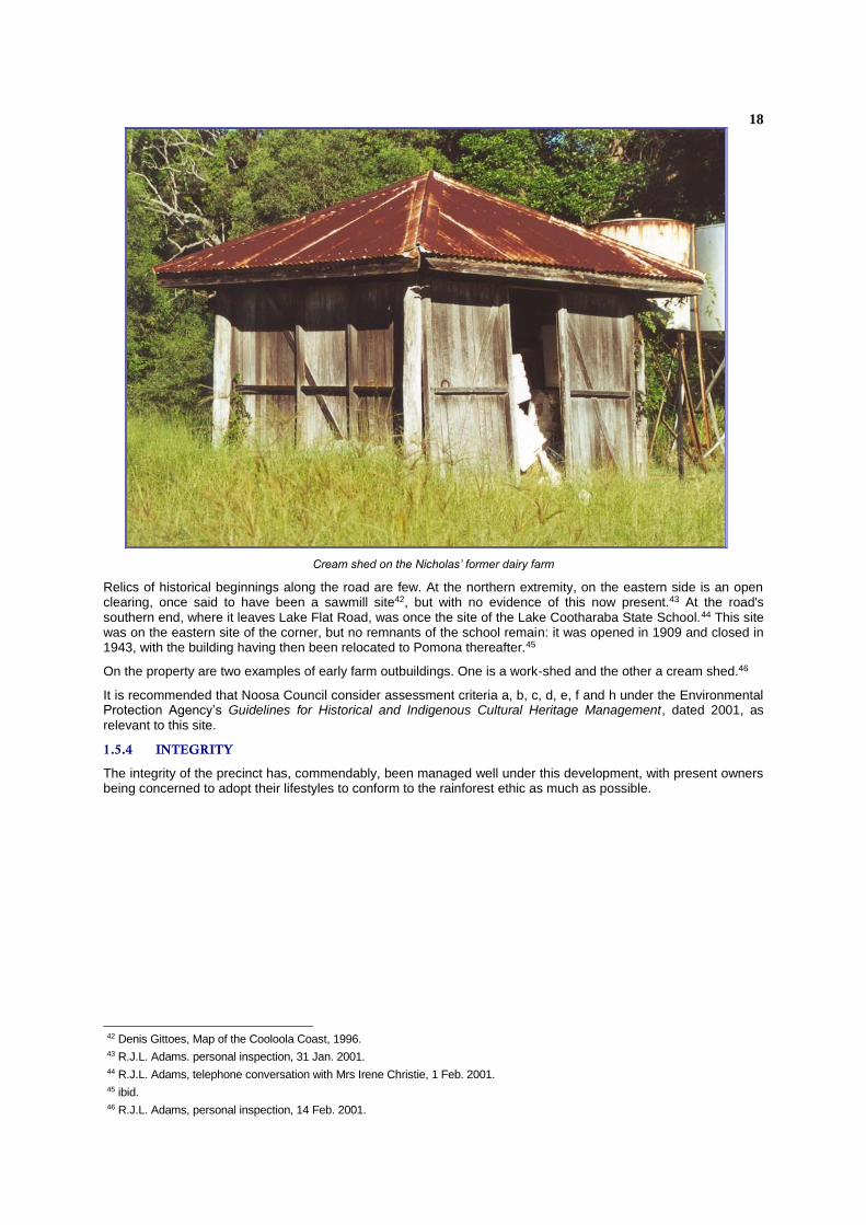
Cream shed on the Nicholas’ former dairy farm
Relics of historical beginnings along the road are few. At the northern extremity, on the eastern side is an open clearing, once said to have been a sawmill site42, but with no evidence of this now present.43 At the road's southern end, where it leaves Lake Flat Road, was once the site of the Lake Cootharaba State School.44 This site was on the eastern site of the corner, but no remnants of the school remain: it was opened in 1909 and closed in 1943, with the building having then been relocated to Pomona thereafter.45
On the property are two examples of early farm outbuildings. One is a work-shed and the other a cream shed.46
It is recommended that Noosa Council consider assessment criteria a, b, c, d, e, f and h under the Environmental Protection Agency’s Guidelines for Historical and Indigenous Cultural Heritage Management, dated 2001, as relevant to this site.
1.5.4 INTEGRITY
The integrity of the precinct has, commendably, been managed well under this development, with present owners being concerned to adopt their lifestyles to conform to the rainforest ethic as much as possible.
42 Denis Gittoes, Map of the Cooloola Coast, 1996. 43 R.J.L. Adams. personal inspection, 31 Jan. 2001. 44 R.J.L. Adams, telephone conversation with Mrs Irene Christie, 1 Feb. 2001. 45 ibid. 46 R.J.L. Adams, personal inspection, 14 Feb. 2001.
19
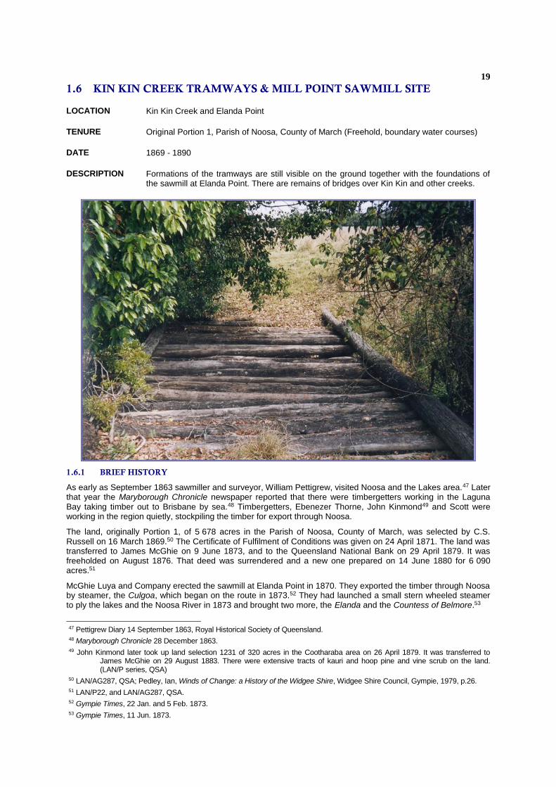
1.6 KIN KIN CREEK TRAMWAYS & MILL POINT SAWMILL SITE
LOCATION Kin Kin Creek and Elanda Point
TENURE Original Portion 1, Parish of Noosa, County of March (Freehold, boundary water courses)
DATE 1869 - 1890
DESCRIPTION Formations of the tramways are still visible on the ground together with the foundations of the sawmill at Elanda Point. There are remains of bridges over Kin Kin and other creeks.
1.6.1 BRIEF HISTORY
As early as September 1863 sawmiller and surveyor, William Pettigrew, visited Noosa and the Lakes area.47 Later that year the Maryborough Chronicle newspaper reported that there were timbergetters working in the Laguna Bay taking timber out to Brisbane by sea.48 Timbergetters, Ebenezer Thorne, John Kinmond49 and Scott were working in the region quietly, stockpiling the timber for export through Noosa.
The land, originally Portion 1, of 5 678 acres in the Parish of Noosa, County of March, was selected by C.S. Russell on 16 March 1869.50 The Certificate of Fulfilment of Conditions was given on 24 April 1871. The land was transferred to James McGhie on 9 June 1873, and to the Queensland National Bank on 29 April 1879. It was freeholded on August 1876. That deed was surrendered and a new one prepared on 14 June 1880 for 6 090 acres.51
McGhie Luya and Company erected the sawmill at Elanda Point in 1870. They exported the timber through Noosa by steamer, the Culgoa, which began on the route in 1873.52 They had launched a small stern wheeled steamer to ply the lakes and the Noosa River in 1873 and brought two more, the Elanda and the Countess of Belmore.53
47 Pettigrew Diary 14 September 1863, Royal Historical Society of Queensland. 48 Maryborough Chronicle 28 December 1863. 49 John Kinmond later took up land selection 1231 of 320 acres in the Cootharaba area on 26 April 1879. It was transferred to
James McGhie on 29 August 1883. There were extensive tracts of kauri and hoop pine and vine scrub on the land. (LAN/P series, QSA)
50 LAN/AG287, QSA; Pedley, Ian, Winds of Change: a History of the Widgee Shire, Widgee Shire Council, Gympie, 1979, p.26. 51 LAN/P22, and LAN/AG287, QSA. 52 Gympie Times, 22 Jan. and 5 Feb. 1873. 53 Gympie Times, 11 Jun. 1873.
20
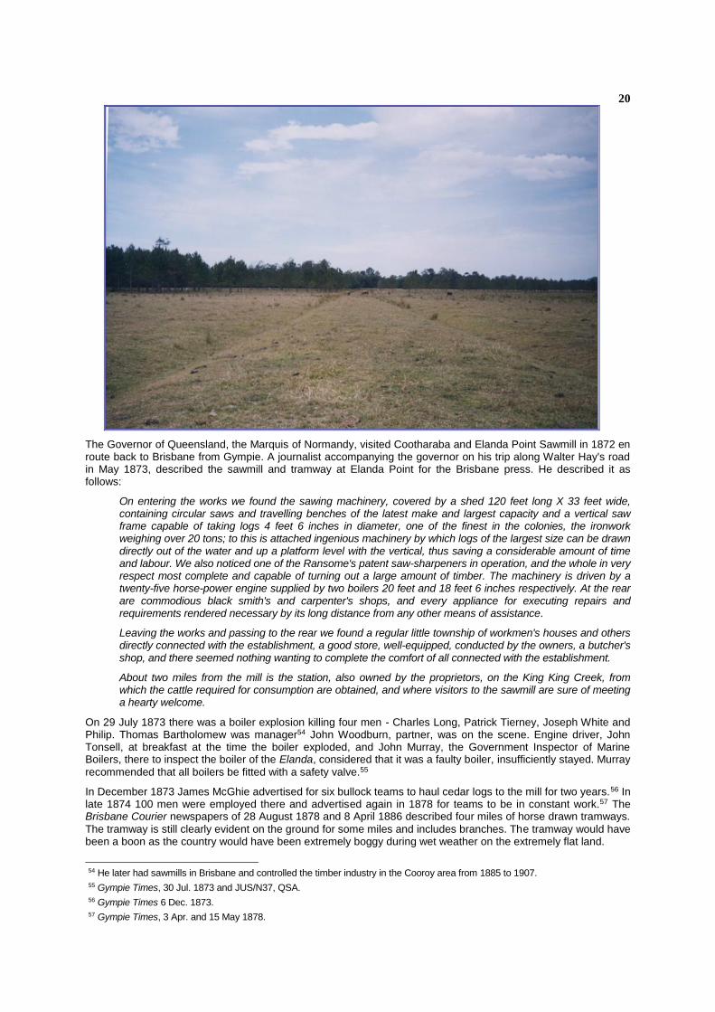
The Governor of Queensland, the Marquis of Normandy, visited Cootharaba and Elanda Point Sawmill in 1872 en route back to Brisbane from Gympie. A journalist accompanying the governor on his trip along Walter Hay's road in May 1873, described the sawmill and tramway at Elanda Point for the Brisbane press. He described it as follows:
On entering the works we found the sawing machinery, covered by a shed 120 feet long X 33 feet wide, containing circular saws and travelling benches of the latest make and largest capacity and a vertical saw frame capable of taking logs 4 feet 6 inches in diameter, one of the finest in the colonies, the ironwork weighing over 20 tons; to this is attached ingenious machinery by which logs of the largest size can be drawn directly out of the water and up a platform level with the vertical, thus saving a considerable amount of time and labour. We also noticed one of the Ransome's patent saw-sharpeners in operation, and the whole in very respect most complete and capable of turning out a large amount of timber. The machinery is driven by a twenty-five horse-power engine supplied by two boilers 20 feet and 18 feet 6 inches respectively. At the rear are commodious black smith's and carpenter's shops, and every appliance for executing repairs and requirements rendered necessary by its long distance from any other means of assistance.
Leaving the works and passing to the rear we found a regular little township of workmen's houses and others directly connected with the establishment, a good store, well-equipped, conducted by the owners, a butcher's shop, and there seemed nothing wanting to complete the comfort of all connected with the establishment.
About two miles from the mill is the station, also owned by the proprietors, on the King King Creek, from which the cattle required for consumption are obtained, and where visitors to the sawmill are sure of meeting a hearty welcome.
On 29 July 1873 there was a boiler explosion killing four men - Charles Long, Patrick Tierney, Joseph White and Philip. Thomas Bartholomew was manager54 John Woodburn, partner, was on the scene. Engine driver, John Tonsell, at breakfast at the time the boiler exploded, and John Murray, the Government Inspector of Marine Boilers, there to inspect the boiler of the Elanda, considered that it was a faulty boiler, insufficiently stayed. Murray
recommended that all boilers be fitted with a safety valve.55
In December 1873 James McGhie advertised for six bullock teams to haul cedar logs to the mill for two years.56 In late 1874 100 men were employed there and advertised again in 1878 for teams to be in constant work.57 The Brisbane Courier newspapers of 28 August 1878 and 8 April 1886 described four miles of horse drawn tramways.
The tramway is still clearly evident on the ground for some miles and includes branches. The tramway would have been a boon as the country would have been extremely boggy during wet weather on the extremely flat land.
54 He later had sawmills in Brisbane and controlled the timber industry in the Cooroy area from 1885 to 1907. 55 Gympie Times, 30 Jul. 1873 and JUS/N37, QSA. 56 Gympie Times 6 Dec. 1873. 57 Gympie Times, 3 Apr. and 15 May 1878.
21
There was a very detailed description of the tramway system in the Queenslander newspaper of 17 April 1886:
One of the chief and expensive accessories of the mill is an iron tramway, about four miles in length, which runs through the forest to the cleared space beyond where the logs are mostly brought from the outlying districts, and placed on skids ready for trans-shipment to the wagons. Our ride along the tramway was treat. The trees on either side were all more or less tall and stately, and the infinitude of shrubberies, which rose up to their fullest development, made the road a magnificent avenue, redolent of the scent of wildflowers and of gum ... The timber we passed comprised blue and flooded gums, kauri and hoop pine, box, beech and some others. As far as the line runs there are little signs of the axe or of the nine bullock teams and the horse team employed by the company. In fact, some of the logs, are dragged along ten or fifteen miles, or rafted along Clothen Creek for ten or twelve miles to the tram terminus.
The mill closed in 1892 during the depression. Three miles of tram rails were bought by Moreton Sugar Mill from the Noosa area in 1898 for their Paynter's Creek and Dulong tramways.58
The sawmill was right on the edge of Lake Cootharaba and sawdust was compacted in the swamp to form a timber yard. Remains of the jetties are visible. The tramway was a three feet tramway of steel rails from 1878 on wooden sleepers. Wooden rails were used for the first two years.59 Two tramway formations are visible diverging from the mill, one curving southwards, crossing a swampy area by a log culvert 349 yards long, removed long since. Descriptions of a visit there in July 1877 was published in the Brisbane Courier60 The trams were 12 tons - three wagons each carrying a four ton log. Strong girders were laid on transverse logs of tea tree and wooden sleepers were laid three feet apart to carry the rails across the first swamp out from the mill. The rails were infilled with ballast. The line was constructed at a cost of £300 per mile.61
This line from the mill ran directly to the Cootharaba homestead and beyond and is known as the "Billet" line. The main line ran westerly to the site of the old township and dairy. It was converted to a road after World War I and the metal used for the formation is clearly evident. From the swamp beyond, no ballast appears to have been used and its formation is much harder to discern in the paddock. A further two miles on the tramway cut through a ridge with a six feet cutting into Kin Kin Creek valley. However, bridge piles are evident in Kin Kin Creek where it crossed the main creek together with two Barlow section rails. Beyond the creek the land has been extensively ploughed. Beyond the ploughed ground the tramway is visible again, complete with side drains. The tramway then goes southwards towards the creek and is then parallel with it. The terminus is a distinctly raised area and quite wide.62 There were possibly a number of short branches radiating to the creeks, particularly Eulama Creek in the north.63 The terminus is quite close to higher ground to the north and west which was originally heavily timbered.64
The wooden rails were four by two inches of pender and ironwood. They were wedged in slots into the timber. The pender rails lasted longer, the ironwood wearing to a glass finish. The tramway overcame the difficulties of the bullock teams in the boggy ground.
There was a camping ground reserved for timber cutters at the mouth of Kin Kin Creek. In July 1912 the Noosa Shire Council agreed that 20 acres of it be retained and the rest thrown open to land selection.65
1.6.2 HISTORICAL THEMES
This place illustrates the following historical themes in Noosa Shire based on the Environmental Protection Agency’s Guidelines for Historical and Indigenous Cultural Heritage Management, dated 2001:-
2(c) Developing rural economies - extracting natural resources (timber): sawmill (machinery); and
3(e) Developing transport and communication networks and infrastructure - creating rail links: railway (track).
1.6.3 POTENTIAL SIGNIFICANCE
It is recommended that Noosa Shire Council consider assessment criteria a, d and h under the Environmental Protection Agency’s Guidelines for Historical and Indigenous Cultural Heritage Management dated 2001, as relevant to this place.
58 Sugar Journal and Tropical Cultivator, March 1898, p.201. 59 Brisbane Courier, 5,7 and 18 Jul. 1877. 60 5,7 and 18 Jul. 1877. 61 ibid. 62 This is on the property once owned by the late Sir Earl C.G. Page MHR, Australian Prime Minister from 7 April 1939 to 26 April
1939 and Member for Cowper (NSW) (Country Party) 13 December 1919 to 9 December 1961. 63 This is on the property owned by the Leader of the Country Party from 1920 in the House of Representatives, Sir Earle Page. 64 Stack Talk (Magazine of Australian Narrow Gauge Railway Museum Society Inc) Dec. 1971, 117-119. 65 Gympie Times, 20 Jul. 1912.
22
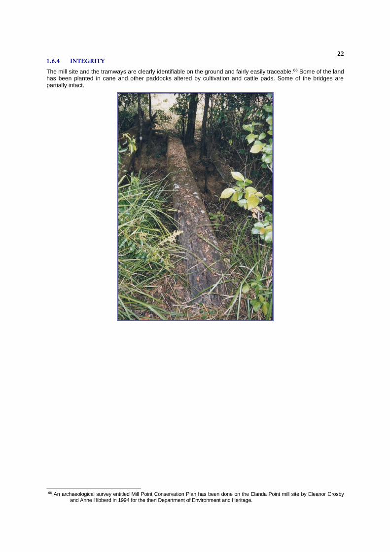
1.6.4 INTEGRITY
The mill site and the tramways are clearly identifiable on the ground and fairly easily traceable.66 Some of the land has been planted in cane and other paddocks altered by cultivation and cattle pads. Some of the bridges are partially intact.
66 An archaeological survey entitled Mill Point Conservation Plan has been done on the Elanda Point mill site by Eleanor Crosby
and Anne Hibberd in 1994 for the then Department of Environment and Heritage.
23
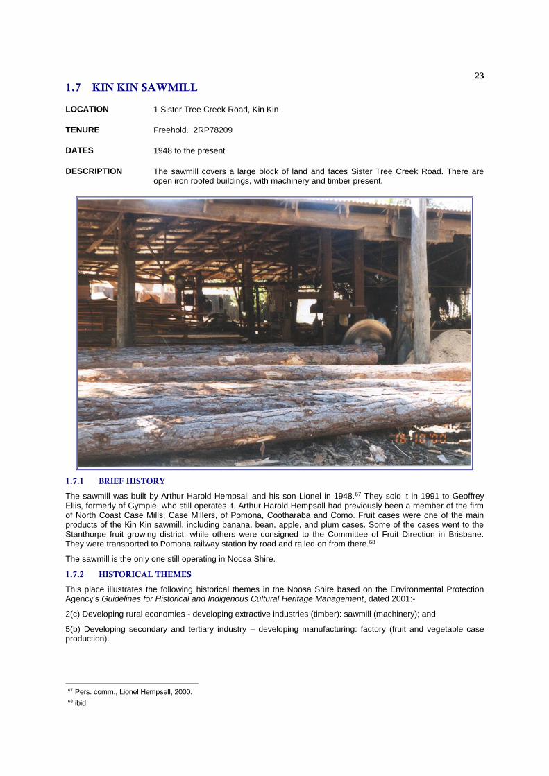
1.7 KIN KIN SAWMILL
LOCATION 1 Sister Tree Creek Road, Kin Kin
TENURE Freehold. 2RP78209
DATES 1948 to the present
DESCRIPTION The sawmill covers a large block of land and faces Sister Tree Creek Road. There are open iron roofed buildings, with machinery and timber present.
1.7.1 BRIEF HISTORY
The sawmill was built by Arthur Harold Hempsall and his son Lionel in 1948.67 They sold it in 1991 to Geoffrey Ellis, formerly of Gympie, who still operates it. Arthur Harold Hempsall had previously been a member of the firm of North Coast Case Mills, Case Millers, of Pomona, Cootharaba and Como. Fruit cases were one of the main products of the Kin Kin sawmill, including banana, bean, apple, and plum cases. Some of the cases went to the Stanthorpe fruit growing district, while others were consigned to the Committee of Fruit Direction in Brisbane. They were transported to Pomona railway station by road and railed on from there.68
The sawmill is the only one still operating in Noosa Shire.
1.7.2 HISTORICAL THEMES
This place illustrates the following historical themes in the Noosa Shire based on the Environmental Protection Agency’s Guidelines for Historical and Indigenous Cultural Heritage Management, dated 2001:-
2(c) Developing rural economies - developing extractive industries (timber): sawmill (machinery); and
5(b) Developing secondary and tertiary industry – developing manufacturing: factory (fruit and vegetable case production).
67 Pers. comm., Lionel Hempsell, 2000. 68 ibid.

24
1.7.3 POTENTIAL SIGNIFICANCE
The sawmill has been, and still is, of importance in the economic life of Kin Kin as it has provided employment to local workers for over fifty years, as well as using the timber of the area. As the only operating sawmill in Noosa Shire, it has rarity value.
It’s connection with the Hempsalls, a well-known family of sawmillers is also significant.
The earlier production of fruit and vegetable cases demonstrates an important aspect of the economy of the district.
It is recommended that Noosa Shire Council consider assessment criteria a, b and h under the Environmental Protection Agency’s Guidelines for Historical and Indigenous Cultural Heritage Management, dated 2001, as relevant to this place.
25
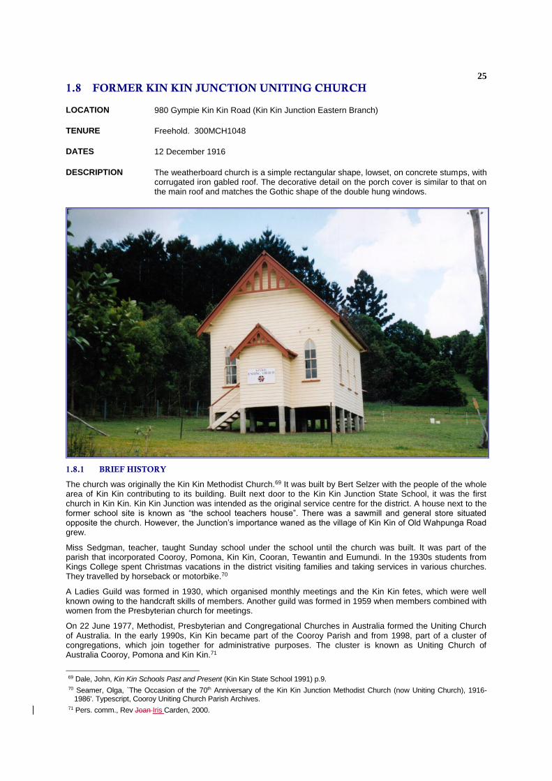
1.8 FORMER KIN KIN JUNCTION UNITING CHURCH
LOCATION 980 Gympie Kin Kin Road (Kin Kin Junction Eastern Branch)
TENURE Freehold. 300MCH1048
DATES 12 December 1916
DESCRIPTION The weatherboard church is a simple rectangular shape, lowset, on concrete stumps, with corrugated iron gabled roof. The decorative detail on the porch cover is similar to that on the main roof and matches the Gothic shape of the double hung windows.
1.8.1 BRIEF HISTORY
The church was originally the Kin Kin Methodist Church.69 It was built by Bert Selzer with the people of the whole area of Kin Kin contributing to its building. Built next door to the Kin Kin Junction State School, it was the first church in Kin Kin. Kin Kin Junction was intended as the original service centre for the district. A house next to the former school site is known as “the school teachers house”. There was a sawmill and general store situated opposite the church. However, the Junction’s importance waned as the village of Kin Kin of Old Wahpunga Road grew.
Miss Sedgman, teacher, taught Sunday school under the school until the church was built. It was part of the parish that incorporated Cooroy, Pomona, Kin Kin, Cooran, Tewantin and Eumundi. In the 1930s students from Kings College spent Christmas vacations in the district visiting families and taking services in various churches. They travelled by horseback or motorbike.70
A Ladies Guild was formed in 1930, which organised monthly meetings and the Kin Kin fetes, which were well known owing to the handcraft skills of members. Another guild was formed in 1959 when members combined with women from the Presbyterian church for meetings.
On 22 June 1977, Methodist, Presbyterian and Congregational Churches in Australia formed the Uniting Church of Australia. In the early 1990s, Kin Kin became part of the Cooroy Parish and from 1998, part of a cluster of congregations, which join together for administrative purposes. The cluster is known as Uniting Church of Australia Cooroy, Pomona and Kin Kin.71
69 Dale, John, Kin Kin Schools Past and Present (Kin Kin State School 1991) p.9. 70 Seamer, Olga, `The Occasion of the 70th Anniversary of the Kin Kin Junction Methodist Church (now Uniting Church), 1916-
1986'. Typescript, Cooroy Uniting Church Parish Archives. 71 Pers. comm., Rev Joan Iris Carden, 2000.

26
The church was decommissioned in April 2002 and has closed as a church.
1.8.2 HISTORICAL THEMES
This place illustrates the following historical themes in the Noosa Shire based on the Environmental Protection Agency’s Guidelines for Historical and Indigenous Cultural Heritage Management, dated 2001:-
9(a) Developing social and cultural institutions – establishing religious institutions: place of worship (church)
1.8.3 POTENTIAL SIGNIFICANCE
The former church is closely associated with the early development of the district and is a good representative example of a small rural timber church in the Gothic-Revival architectural style.
It is recommended that Noosa Shire Council consider assessment criteria a and d under the Environmental Protection Agency’s Guidelines for Historical and Indigenous Cultural Heritage Management, , dated 2001, as relevant to this place.
1.8.4 INTEGRITY
The building appears to have retained its original appearance.

27
1.9 MEMORIAL SCHOOL OF ARTS
LOCATION 50 Main Street, Kin Kin
TENURE Reserve. 214MCH4199
DATES 1911.
DESCRIPTION A large building with a complex arrangement of corrugated iron gable roofs and clad in weatherboards. It has been extended with a supper room and has a large modern kitchen. A mural painted on the wall behind the stage shows the local countryside.
1.9.1 BRIEF HISTORY
One acre of land was granted by the Department of Public Lands for the purpose of the building of a School of Arts on 8 August 1909. A School of Arts Committee was formed in June 1909 to raise funds for the hall and the building was opened on Friday, 14 July 1911.72
The building comprised a reading room, a library room and a hall, the size of the whole building being 50 feet by 28 feet with a small stage on which stood a new piano, supplied by Mr Sedgman of Gympie. The timber came from J Hetherington of Kin Kin sawmills. J Donnelly was the contractor and C Duffy of Pomona was the plumber.
Mr H F Walker MLA and Mrs Walker plus 200 people were present at the opening, heavy rain preventing more from attending. Dancing was enjoyed till midnight, when supper catered for by T Weaver of Cooran was served. Mr Walker then opened the building. Mr Charles Vines, Honorary Secretary, told those present the building cost about £217 and the piano £79. The committee raised £80, government subsidy was £40 and another £20 was to come in. Bank loan of £150 was obtained, with committee as bondsmen, and those present were asked to be subscribers to pay off the loan and raise money for improvements. Dancing continued until daylight, after which people left to go home and milk cows.
Committee members were Chairman, M McWilliams; Honorary Secretary, C Vines; F Bowman, Honorary Treasurer; and Committee J J Simpson, G Westbrook, W Rohan, E Palmer, W Kelly and C Gallan.73
72 Noosa Advocate, Christmas, 1912, p.16. 73 Gympie Times 19 Jul 1911.
28
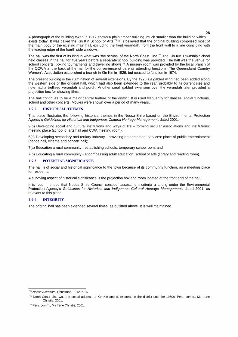
A photograph of the building taken in 1912 shows a plain timber building, much smaller than the building which exists today. It was called the Kin Kin School of Arts.74 It is believed that the original building comprised most of the main body of the existing main hall, excluding the front verandah, from the front wall to a line coinciding with the leading edge of the fourth side windows.
The hall was the first of its kind in what was ‘the scrubs’ of the North Coast Line.75 The Kin Kin Township School held classes in the hall for five years before a separate school building was provided. The hall was the venue for school concerts, boxing tournaments and travelling shows.76 A nursery room was provided by the local branch of the QCWA at the back of the hall for the convenience of parents attending functions. The Queensland Country Women’s Association established a branch in Kin Kin in 1925, but ceased to function in 1974.
The present building is the culmination of several extensions. By the 1920’s a gabled wing had been added along the western side of the original hall, which had also been extended to the rear, probably to its current size and now had a trellised verandah and porch. Another small gabled extension over the verandah later provided a projection box for showing films.
The hall continues to be a major central feature of the district. It is used frequently for dances, social functions, school and other concerts. Movies were shown over a period of many years.
1.9.2 HISTORICAL THEMES
This place illustrates the following historical themes in the Noosa Shire based on the Environmental Protection Agency’s Guidelines for Historical and Indigenous Cultural Heritage Management, dated 2001:-
9(b) Developing social and cultural institutions and ways of life – forming secular associations and institutions: meeting place (school of arts hall and CWA meeting room);
5(c) Developing secondary and tertiary industry - providing entertainment services: place of public entertainment (dance hall, cinema and concert hall);
7(a) Education a rural community - establishing schools: temporary schoolroom; and
7(b) Educating a rural community - encompassing adult education: school of arts (library and reading room).
1.9.3 POTENTIAL SIGNIFICANCE
The hall is of social and historical significance to the town because of its community function, as a meeting place for residents.
A surviving aspect of historical significance is the projection box and room located at the front end of the hall.
It is recommended that Noosa Shire Council consider assessment criteria a and g under the Environmental Protection Agency’s Guidelines for Historical and Indigenous Cultural Heritage Management, dated 2001, as
relevant to this place.
1.9.4 INTEGRITY
The original hall has been extended several times, as outlined above. It is well maintained.
74 Noosa Advocate, Christmas, 1912, p.16. 75 North Coast Line was the postal address of Kin Kin and other areas in the district until the 1960s; Pers. comm., Ms Irene
Christie, 2001. 76 Pers. comm., Ms Irene Christie, 2001.
29
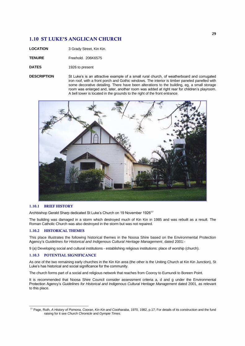
1.10 ST LUKE’S ANGLICAN CHURCH
LOCATION 3 Grady Street, Kin Kin.
TENURE Freehold. 206K6575
DATES 1926 to present
DESCRIPTION St Luke’s is an attractive example of a small rural church, of weatherboard and corrugated iron roof, with a front porch and Gothic windows. The interior is timber paneled panelled with some decorative detailing. There have been alterations to the building, eg, a small storage room was enlarged and, later, another room was added at right rear for children’s playroom. A bell tower is located in the grounds to the right of the front entrance.
1.10.1 BRIEF HISTORY
Archbishop Gerald Sharp dedicated St Luke’s Church on 19 November 192677
The building was damaged in a storm which destroyed much of Kin Kin in 1985 and was rebuilt as a result. The Roman Catholic Church was also destroyed in the storm but was not repaired.
1.10.2 HISTORICAL THEMES
This place illustrates the following historical themes in the Noosa Shire based on the Environmental Protection Agency’s Guidelines for Historical and Indigenous Cultural Heritage Management, dated 2001:-
9 (a) Developing social and cultural institutions - establishing religious institutions: place of worship (church).
1.10.3 POTENTIAL SIGNIFICANCE
As one of the two remaining early churches in the Kin Kin area (the other is the Uniting Church at Kin Kin Junction), St Luke’s has historical and social significance for the community.
The church forms part of a social and religious network that reaches from Cooroy to Eumundi to Boreen Point.
It is recommended that Noosa Shire Council consider assessment criteria a, d and g under the Environmental Protection Agency’s Guidelines for Historical and Indigenous Cultural Heritage Management dated 2001, as relevant to this place.
77 Page, Ruth, A History of Pomona, Cooran, Kin Kin and Cootharaba, 1970, 1982, p.17; For details of its construction and the fund
raising for it see Church Chronicle and Gympie Times.
30
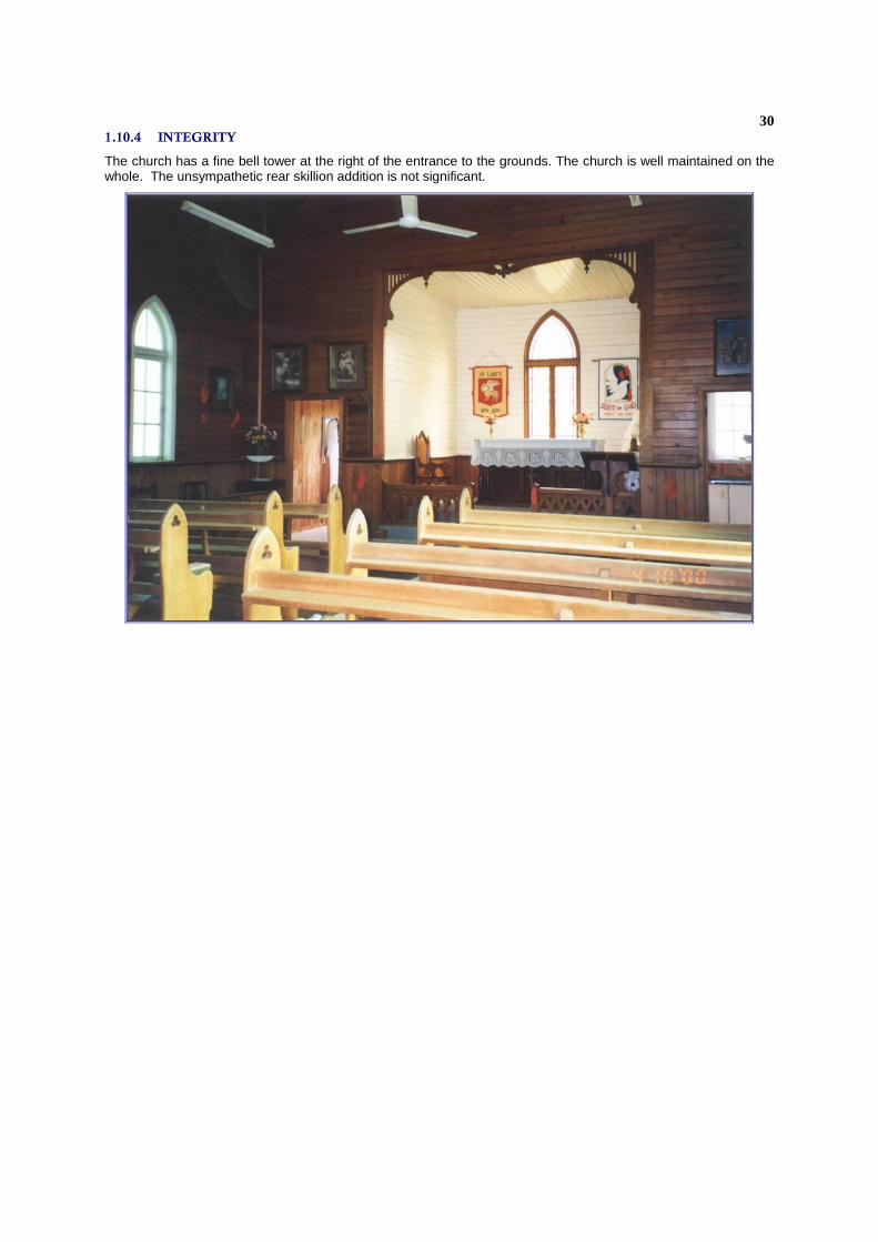
1.10.4 INTEGRITY
The church has a fine bell tower at the right of the entrance to the grounds. The church is well maintained on the whole. The unsympathetic rear skillion addition is not significant.

31
1.11 FORMER KIN KIN JUNCTION STATE SCHOOL (SPORTS GROUND
CLUBHOUSE)
LOCATION None Old Wahpunga Road, Kin Kin. Entry to the clubhouse is off Main Street. The sports ground behind the Country Life Hotel.
TENURE Reserve for Recreation. 1SP119738
DATES 26 May 1909 - 18 September 1981 to the present
DESCRIPTION The clubhouse is a two-storey building, timber on the upper floor, and concrete blocks underneath with a wood door painted cream. The downstairs section operates as a tuck shop. A front verandah has been partially enclosed and a set of stairs is located on the right hand side from the front. There are three sets of casement windows upstairs to the timber section, which is the former school.
1.11.1 BRIEF HISTORY
The clubhouse was the former Kin Kin Junction State School, school number 960, Class 10 School (formerly Kin Kin State School). It was established on three acres of Reserve at Kin Kin Creek, Main Kin Kin Road adjoining Selection 212, and a sawmill. Located about two kilometres from Kin Kin, the school was next door to the Methodist Church (now Uniting Church). It opened in 1909.78
The Kin Kin Junction State School was the first school to open in the district and remained open for 72 years. It closed in 1981 owing to the small number of pupils enrolled at the school.
1.11.2 HISTORICAL THEMES
This place illustrates the following historical theme in the Noosa Shire based on the Environmental Protection Agency’s Guidelines for Historical and Indigenous Cultural Heritage Management, dated 2001:-
9 (b) Developing social and cultural institutions and ways of life - forming secular associations: meeting place (clubhouse)
78 See School File (EDU/Z series) at Queensland State Archives for history of school and building.

32
1.11.3 POTENTIAL SIGNIFICANCE
The building has social and educational significance in its former role as the first school to be opened in the district.
It has continuing significance as a sports clubhouse for the local people and for the showground.
It is recommended that Noosa Shire Council consider assessment criteria a and h under the Environmental Protection Agency’s Guidelines for Historical and Indigenous Cultural Heritage Management, dated 2001, as relevant to this place.
1.11.4 INTEGRITY
The top level appears to be very similar to that of the building, which was used as a schoolhouse. The lower level has been enclosed with concrete blocks and is used for storage etc. It is well maintained. The enclosed sections upstairs are not sympathetic to the building’s original construction. Structural changes have included the removal of the wall of the supper room, allowing more open space.

33
1.12 FORMER FRANCIS HOUSE
LOCATION 497 Sister Tree Creek Road, Kin Kin
TENURE Freehold. 2RP8813344
DATES 1910, late 1950s
DESCRIPTION The house is located on a rise on acreage land and is weatherboard bungalow. The front verandah has been enclosed. Several bunya pines, hoop pines and fig trees are growing in the grounds.
1.12.1 BRIEF HISTORY
In 1906, Alfred Francis moved to Kin Kin with his sons William Douglas and Frederick, from Wollongong, New South Wales. WD Francis was aged seventeen when he arrived in Queensland and was educated at the Wollongong Superior Public School. His mother dies a few years before the family moved to Kin Kin. Alfred Francis selected Portions 160, 161 and 163 Parish of Woondum and WD Francis assisted with the clearing of the land to prepare it for dairy farming.79
WD Francis wrote later that, at the time the family arrived at Kin Kin, it was an unsettled area and ‘a locality of exceptional interest and rich rain forest’. He selected land, which he retained as freehold.80 In 1907, he was secretary of the Sister Tree Creek Progress Association.81
From books, which he purchased on Geology, Botany, Chemistry and Plant Physiology including the six volume Queensland Flora, Bill Francis educated himself in natural history, trees and flora. He dissected and identified flowering plants and trees of the Kin Kin district and made a special study of the trees, gaining the ability to identify species by their stems and bark. These studies were the basis of his book, Australian Rainforest Trees. He purchased a microscope and studied further on flowerless plants, Bacteriology, Fungi and Plant Histology.82
79 William Douglas Francis, typescript, undated, Queensland Herbarium Library, p 1 80 ibid 81 Queensland Parks and Wildlife Service Database, p 9 82 WD Francis, typescript, p 1
34
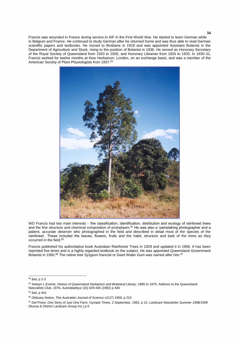
Francis was wounded in France during service in AIF in the First World War. He started to learn German while in Belgium and France. He continued to study German after he returned home and was thus able to read German scientific papers and textbooks. He moved to Brisbane in 1919 and was appointed Assistant Botanist in the Department of Agriculture and Stock, rising to the position of Botanist in 1936. He served as Honorary Secretary of the Royal Society of Queensland from 1920 to 1926, and Honorary Librarian from 1926 to 1933. In 1930-31, Francis worked for twelve months at Kew Herbarium, London, on an exchange basis, and was a member of the American Society of Plant Physiologists from 1937.83
WD Francis had two main interests - ‘the classification, identification, distribution and ecology of rainforest trees and the fine structure and chemical composition of protoplasm.84 He was also a ‘painstaking photographer and a patient, accurate observer who photographed in the field and described in detail most of the species of the rainforest’. These included the leaves, flowers, fruits and the habit, structure and bark of the trees as they occurred in the field.85
Francis published his authoritative book Australian Rainforest Trees in 1929 and updated it in 1956. It has been reprinted five times and is a highly regarded textbook on the subject. He was appointed Queensland Government Botanist in 1950.86 The native tree Syzgium francisii or Giant Water Gum was named after him.87
83 ibid, p 2-3 84 Selwyn L Everist, History of Queensland Herbarium and Botanical Library, 1885 to 1975. Address to the Queensland Naturalists Club, 1976, Austrabaileya 1(5) 429-445 (1982) p 440 85 ibid. p 441 86 Obituary Notice, The Australian Journal of Science v21(7) 1959, p 215 87 Del Priest. One Story of Just One Farm. Gympie Times, 2 September, 1992, p 12; Landcare Newsletter Summer 1998/1999 (Noosa & District Landcare Group Inc.) p 6
35
Bill Francis continued his studies throughout his life and also studied Russian in order to translate scientific papers. His life was not without controversy, as he published several papers through the Royal Society of Queensland on his theory of the connection between iron and the origin of life. These met with hostile reception in the 1920’s and 30’s and Francis relinquished his position as secretary of the Royal Society of Queensland as a result of this reaction. His last paper was published by himself.88 He retired as Government Botanist in 1954 and died in Brisbane on 2 January 1959. He left a widow and two daughters.89
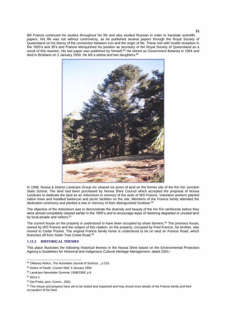
In 1998, Noosa & District Landcare Group Inc cleared six acres of land on the former site of the Kin Kin Junction State School. The land had been purchased by Noosa Shire Council which accepted the proposal of Noosa Landcare to dedicate the land as an Arboretum in memory of the work of WD Francis. Volunteer workers planted native trees and installed barbecue and picnic facilities on the site. Members of the Francis family attended the dedication ceremony and planted a tree in memory of their distinguished forebear.90
The objective of the Arboretum was to demonstrate the diversity and beauty of the Kin Kin rainforests before they were almost completely cleared earlier in the 1900’s and to encourage ways of restoring degraded or unused land by local people and visitors.91
The current house on the property is understood to have been occupied by share farmers.92 The previous house, owned by WD Francis and the subject of this citation, on the property, occupied by Fred Francis, his brother, was moved to Cedar Pocket. The original Francis family home is understood to be on land on Francis Road, which branches off from Sister Tree Creek Road.93
1.12.2 HISTORICAL THEMES
This place illustrates the following historical themes in the Noosa Shire based on the Environmental Protection Agency’s Guidelines for Historical and Indigenous Cultural Heritage Management, dated 2001:-
88 Obituary Notice, The Australian Journal of Science ,, p 215. 89 Notice of Death, Courier Mail, 5 January 1959 90 Landcare Newsletter Summer 1998/1999, p 6 91 ibid p 1 92 Del Preist, pers. Comm., 2001 93 This house and property have yet to be visited and inspected and may reveal more details of the Francis family and their occupation of the land.

36
1.12.3 POTENTIAL SIGNIFICANCE
It is recommended that Noosa Shire Council consider assessment criteria under the Environmental Protection Agency’s Guidelines for Historical and Indigenous Cultural Heritage Management, dated 2001, as relevant to this
place.
1.12.4 INTEGRITY
The house has been altered, such as the enclosure of a front verandah. It is in fairly good condition. The interior of the house has not been inspected.
37
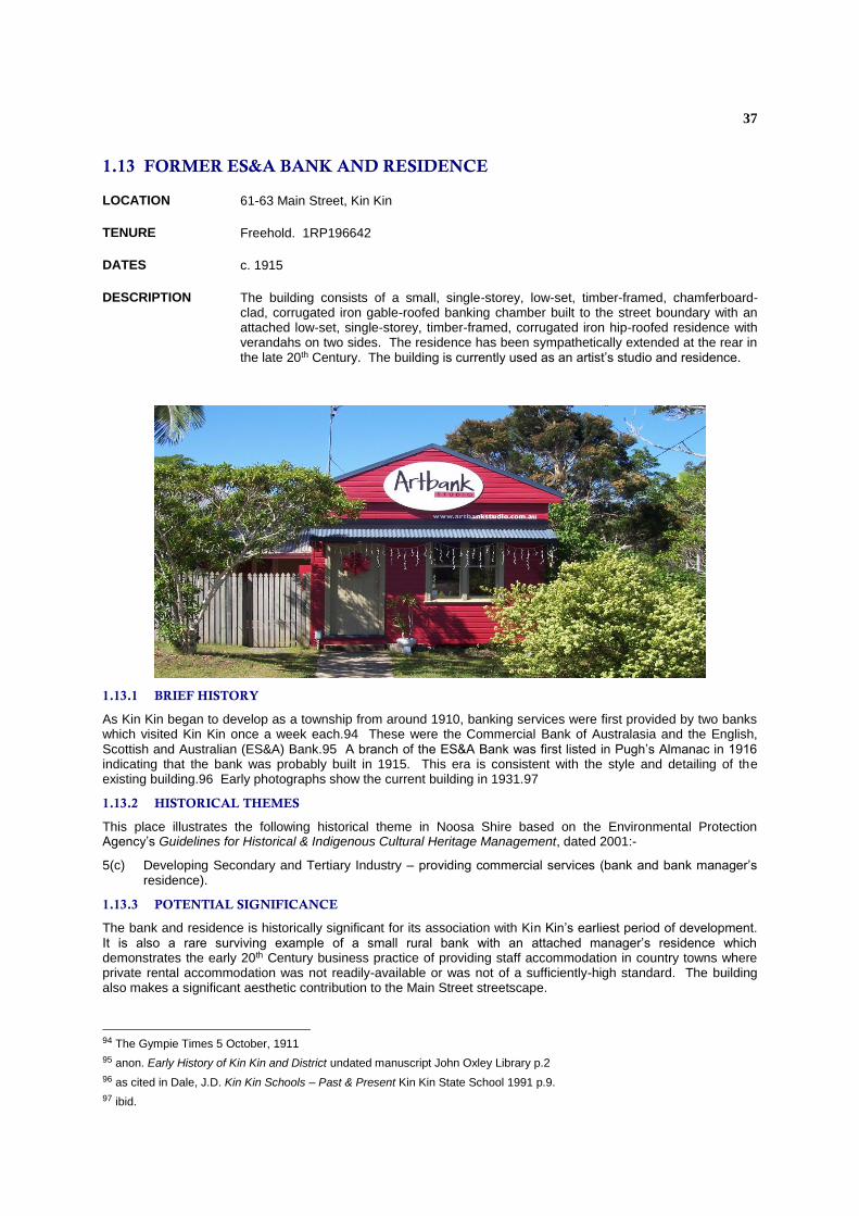
1.13 FORMER ES&A BANK AND RESIDENCE
LOCATION 61-63 Main Street, Kin Kin
TENURE Freehold. 1RP196642
DATES c. 1915
DESCRIPTION The building consists of a small, single-storey, low-set, timber-framed, chamferboard-clad, corrugated iron gable-roofed banking chamber built to the street boundary with an attached low-set, single-storey, timber-framed, corrugated iron hip-roofed residence with verandahs on two sides. The residence has been sympathetically extended at the rear in the late 20th Century. The building is currently used as an artist’s studio and residence.
1.13.1 BRIEF HISTORY
As Kin Kin began to develop as a township from around 1910, banking services were first provided by two banks which visited Kin Kin once a week each.94 These were the Commercial Bank of Australasia and the English, Scottish and Australian (ES&A) Bank.95 A branch of the ES&A Bank was first listed in Pugh’s Almanac in 1916 indicating that the bank was probably built in 1915. This era is consistent with the style and detailing of the existing building.96 Early photographs show the current building in 1931.97
1.13.2 HISTORICAL THEMES
This place illustrates the following historical theme in Noosa Shire based on the Environmental Protection Agency’s Guidelines for Historical & Indigenous Cultural Heritage Management, dated 2001:-
5(c) Developing Secondary and Tertiary Industry – providing commercial services (bank and bank manager’s residence).
1.13.3 POTENTIAL SIGNIFICANCE
The bank and residence is historically significant for its association with Kin Kin’s earliest period of development. It is also a rare surviving example of a small rural bank with an attached manager’s residence which demonstrates the early 20th Century business practice of providing staff accommodation in country towns where private rental accommodation was not readily-available or was not of a sufficiently-high standard. The building also makes a significant aesthetic contribution to the Main Street streetscape.
94 The Gympie Times 5 October, 1911
95 anon. Early History of Kin Kin and District undated manuscript John Oxley Library p.2
96 as cited in Dale, J.D. Kin Kin Schools – Past & Present Kin Kin State School 1991 p.9.
97 ibid.

38
It is recommended that Noosa Shire Council considers assessment criteria a, b and e under the Environmental Protection Agency’s Guidelines for Historical and Indigenous Cultural Heritage Management dated 2001, as relevant to this place.
1.13.4 INTEGRITY
The original form and materials of both the bank and residence are still clearly evident. The vault has been removed from the bank but its original location is evident by the concrete floor slab inside the building. The house retains much of its original layout and detailing but has been sympathetically altered by internal replanning and rear additions. The existing high front fence is an unsympathetic element.
39
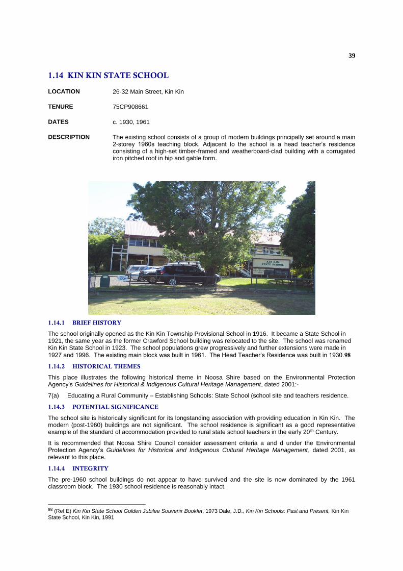
1.14 KIN KIN STATE SCHOOL
LOCATION 26-32 Main Street, Kin Kin
TENURE 75CP908661
DATES c. 1930, 1961
DESCRIPTION The existing school consists of a group of modern buildings principally set around a main 2-storey 1960s teaching block. Adjacent to the school is a head teacher’s residence consisting of a high-set timber-framed and weatherboard-clad building with a corrugated iron pitched roof in hip and gable form.
1.14.1 BRIEF HISTORY
The school originally opened as the Kin Kin Township Provisional School in 1916. It became a State School in 1921, the same year as the former Crawford School building was relocated to the site. The school was renamed Kin Kin State School in 1923. The school populations grew progressively and further extensions were made in
1927 and 1996. The existing main block was built in 1961. The Head Teacher’s Residence was built in 1930.98
1.14.2 HISTORICAL THEMES
This place illustrates the following historical theme in Noosa Shire based on the Environmental Protection Agency’s Guidelines for Historical & Indigenous Cultural Heritage Management, dated 2001:-
7(a) Educating a Rural Community – Establishing Schools: State School (school site and teachers residence.
1.14.3 POTENTIAL SIGNIFICANCE
The school site is historically significant for its longstanding association with providing education in Kin Kin. The modern (post-1960) buildings are not significant. The school residence is significant as a good representative example of the standard of accommodation provided to rural state school teachers in the early 20 th Century.
It is recommended that Noosa Shire Council consider assessment criteria a and d under the Environmental Protection Agency’s Guidelines for Historical and Indigenous Cultural Heritage Management, dated 2001, as relevant to this place.
1.14.4 INTEGRITY
The pre-1960 school buildings do not appear to have survived and the site is now dominated by the 1961 classroom block. The 1930 school residence is reasonably intact.
98 (Ref E) Kin Kin State School Golden Jubilee Souvenir Booklet, 1973 Dale, J.D., Kin Kin Schools: Past and Present, Kin Kin State School, Kin Kin, 1991
40
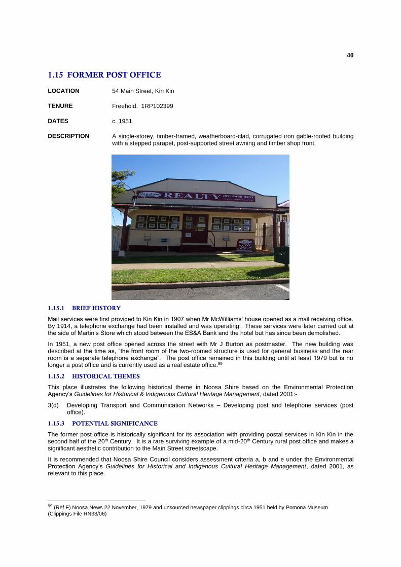
1.15 FORMER POST OFFICE
LOCATION 54 Main Street, Kin Kin
TENURE Freehold. 1RP102399
DATES c. 1951
DESCRIPTION A single-storey, timber-framed, weatherboard-clad, corrugated iron gable-roofed building with a stepped parapet, post-supported street awning and timber shop front.
1.15.1 BRIEF HISTORY
Mail services were first provided to Kin Kin in 1907 when Mr McWilliams’ house opened as a mail receiving office. By 1914, a telephone exchange had been installed and was operating. These services were later carried out at the side of Martin’s Store which stood between the ES&A Bank and the hotel but has since been demolished.
In 1951, a new post office opened across the street with Mr J Burton as postmaster. The new building was described at the time as, “the front room of the two-roomed structure is used for general business and the rear room is a separate telephone exchange”. The post office remained in this building until at least 1979 but is no longer a post office and is currently used as a real estate office.99
1.15.2 HISTORICAL THEMES
This place illustrates the following historical theme in Noosa Shire based on the Environmental Protection Agency’s Guidelines for Historical & Indigenous Cultural Heritage Management, dated 2001:-
3(d) Developing Transport and Communication Networks – Developing post and telephone services (post office).
1.15.3 POTENTIAL SIGNIFICANCE
The former post office is historically significant for its association with providing postal services in Kin Kin in the second half of the 20th Century. It is a rare surviving example of a mid-20th Century rural post office and makes a significant aesthetic contribution to the Main Street streetscape.
It is recommended that Noosa Shire Council considers assessment criteria a, b and e under the Environmental Protection Agency’s Guidelines for Historical and Indigenous Cultural Heritage Management, dated 2001, as relevant to this place.
99 (Ref F) Noosa News 22 November, 1979 and unsourced newspaper clippings circa 1951 held by Pomona Museum (Clippings File RN33/06)

41
1.15.4 INTEGRITY
The building form appears to be reasonably intact but the interiors have been altered to accommodate new uses.
42
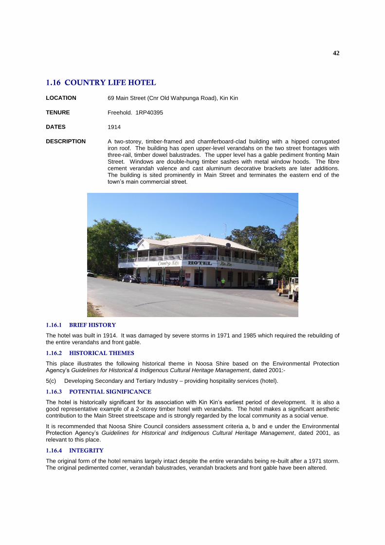
1.16 COUNTRY LIFE HOTEL
LOCATION 69 Main Street (Cnr Old Wahpunga Road), Kin Kin
TENURE Freehold. 1RP40395
DATES 1914
DESCRIPTION A two-storey, timber-framed and chamferboard-clad building with a hipped corrugated iron roof. The building has open upper-level verandahs on the two street frontages with three-rail, timber dowel balustrades. The upper level has a gable pediment fronting Main Street. Windows are double-hung timber sashes with metal window hoods. The fibre cement verandah valence and cast aluminum decorative brackets are later additions. The building is sited prominently in Main Street and terminates the eastern end of the town’s main commercial street.
1.16.1 BRIEF HISTORY
The hotel was built in 1914. It was damaged by severe storms in 1971 and 1985 which required the rebuilding of the entire verandahs and front gable.
1.16.2 HISTORICAL THEMES
This place illustrates the following historical theme in Noosa Shire based on the Environmental Protection Agency’s Guidelines for Historical & Indigenous Cultural Heritage Management, dated 2001:-
5(c) Developing Secondary and Tertiary Industry – providing hospitality services (hotel).
1.16.3 POTENTIAL SIGNIFICANCE
The hotel is historically significant for its association with Kin Kin’s earliest period of development. It is also a good representative example of a 2-storey timber hotel with verandahs. The hotel makes a significant aesthetic contribution to the Main Street streetscape and is strongly regarded by the local community as a social venue.
It is recommended that Noosa Shire Council considers assessment criteria a, b and e under the Environmental Protection Agency’s Guidelines for Historical and Indigenous Cultural Heritage Management, dated 2001, as relevant to this place.
1.16.4 INTEGRITY
The original form of the hotel remains largely intact despite the entire verandahs being re-built after a 1971 storm. The original pedimented corner, verandah balustrades, verandah brackets and front gable have been altered.
Related Documents