1 Parks Data Model Review 1 YorkInfo Partnership

1. 2 Steve Grisé Solution Architect, Vertex3 September 6, 2013.
Jan 02, 2016
Welcome message from author
This document is posted to help you gain knowledge. Please leave a comment to let me know what you think about it! Share it to your friends and learn new things together.
Transcript

1
Parks Data Model Review 1YorkInfo Partnership
2
Parks Data Model Review 1YorkInfo Partnership
Steve GriséSolution Architect, Vertex3September 6, 2013

3
Agenda
Introductions and background – DebData Model Overview – SteveNext Steps - Discussion
4
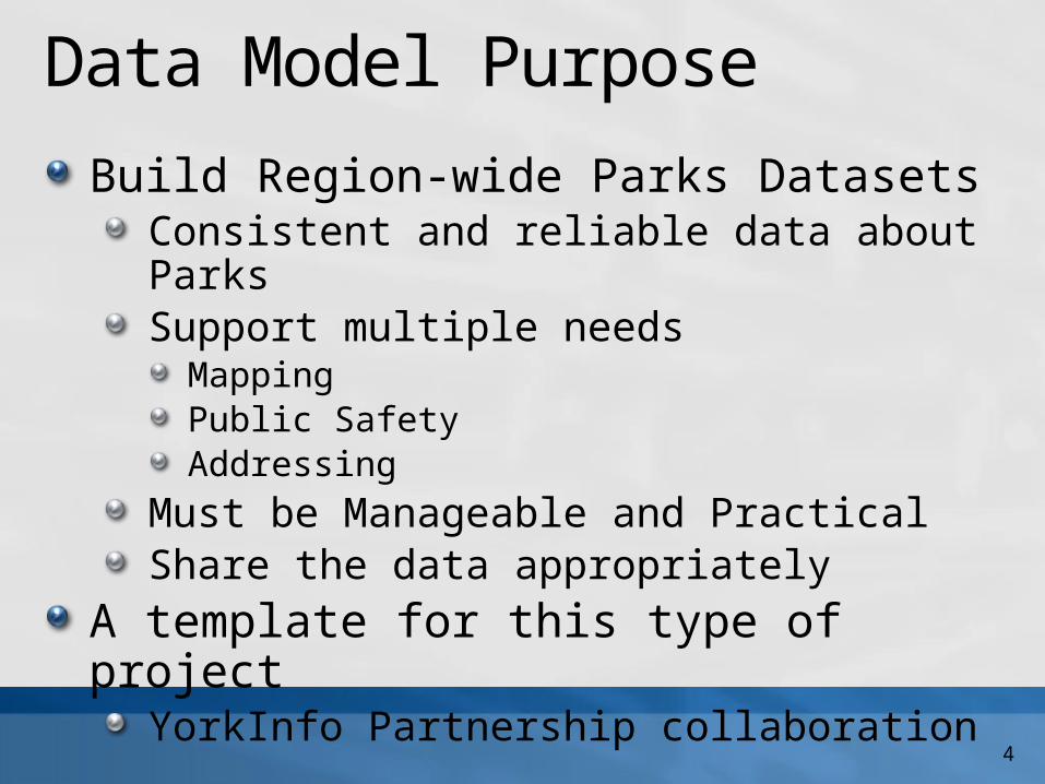
Data Model PurposeBuild Region-wide Parks Datasets
Consistent and reliable data about ParksSupport multiple needs
MappingPublic SafetyAddressing
Must be Manageable and PracticalShare the data appropriately
A template for this type of projectYorkInfo Partnership collaboration

5
Data Model Context
Addressing
Public Facilities
Recreation
Public Safety
Parks Data
Emergency Response

6
An Example Park
7
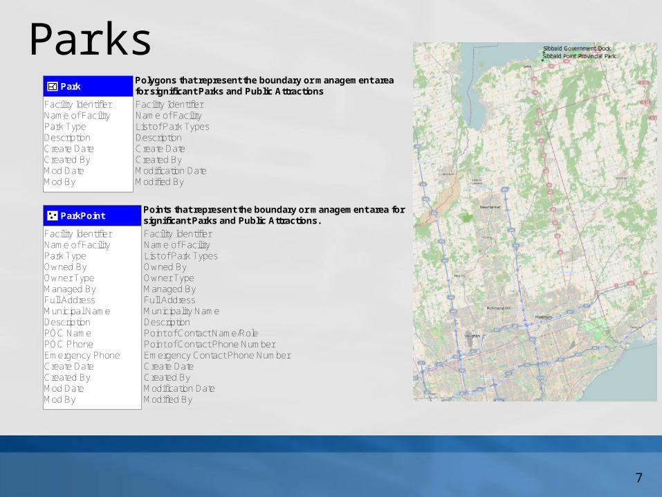
ParksPark
Polygons that represent the boundary or management area for significant Parks and Public Attractions
Facility IdentifierName of FacilityPark TypeDescriptionCreate DateCreated ByMod DateMod By
Facility IdentifierName of FacilityList of Park TypesDescriptionCreate DateCreated ByModification DateModified By
ParkPointPoints that represent the boundary or management area for significant Parks and Public Attractions.
Facility IdentifierName of FacilityPark TypeOwned ByOwner TypeManaged ByFull AddressMunicipal NameDescriptionPOC NamePOC PhoneEmergency PhoneCreate DateCreated ByMod DateMod By
Facility IdentifierName of FacilityList of Park TypesOwned ByOwner TypeManaged ByFull AddressMunicipality NameDescriptionPoint of Contact Name/RolePoint of Contact Phone NumberEmergency Contact Phone NumberCreate DateCreated ByModification DateModified By
8
Addresses
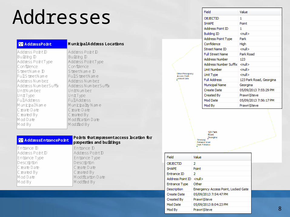
AddressEntrancePointPoints that represent access location for properties and buildings
Entrance IDAddress Point IDEntrance TypeDescriptionCreate DateCreated ByMod DateMod By
Entrance IDAddress Point IDEntrance TypeDescriptionCreate DateCreated ByModification DateModified By
AddressPoint Municipal Address Locations
Address Point IDBuilding IDAddress Point TypeConfidenceStreet Name IDFull Street NameAddress NumberAddress Number SuffixUnit NumberUnit TypeFull AddressMunicipal NameCreate DateCreated ByMod DateMod By
Address Point IDBuilding IDAddress Point TypeConfidenceStreet Name IDFull Street NameAddress NumberAddress Number SuffixUnit NumberUnit TypeFull AddressMunicipality NameCreate DateCreated ByModification DateModified By
9
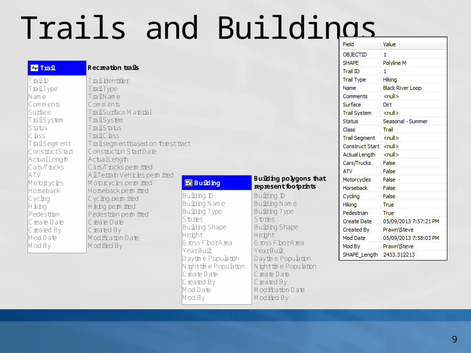
Trails and Buildings
BuildingBuilding polygons that represent footprints
Building IDBuilding NameBuilding TypeStoriesBuilding ShapeHeightGross Floor AreaYear BuiltDaytime PopulationNight time PopulationCreate DateCreated ByMod DateMod By
Building IDBuilding NameBuilding TypeStoriesBuilding ShapeHeightGross Floor AreaYear BuiltDaytime PopulationNight time PopulationCreate DateCreated ByModification DateModified By
Trail Recreation trails
Trail IDTrail TypeNameCommentsSurfaceTrail SystemStatusClassTrail SegmentConstruct StartActual LengthCars/TrucksATVMotorcyclesHorsebackCyclingHikingPedestrianCreate DateCreated ByMod DateMod By
Trail IdentifierTrail TypeTrail NameCommentsTrail Surface MaterialTrail SystemTrail StatusTrail ClassTrail segment based on forest tractConstruction Start DateActual LengthCars/Trucks permittedAll Terrain Vehicles permittedMotorcycles permittedHorseback permittedCycling permittedHiking permittedPedestrian permittedCreate DateCreated ByModification DateModified By

10
Process
Draft Model – 30 days (mid Sept.)Project work – 60-90 days +Final model - ~3-6 months
Draft Model
ProjectsFinal
Model

11
Next Steps
Coordinate follow up meetingInvolve Business users
Technical workUpdate materials and demos
Link to projects/activities in different orgsGet materials to groups working on projects Set up monthly (or so) review meetings

12

Related Documents


