Vancouver Island British Columbia Canada King County Lewis County Clallam County Whatcom County Skagit County Jefferson County Pierce County Snohomish County Grays Harbor County Skamania County Pacific County Cowlitz County Mason County Clark County Thurston County Kitsap County Island County San Juan County Wahkiakum County Clackamas County Tillamook County Clatsop County Yamhill County Columbia County Washington County Hood River County Multnomah County South Puget Sound

Welcome message from author
This document is posted to help you gain knowledge. Please leave a comment to let me know what you think about it! Share it to your friends and learn new things together.
Transcript

Vancouver Island
British Columbia
Canada
King County
Lewis County
Clallam County
Whatcom County
Skagit County
Jefferson County
Pierce County
Snohomish County
Grays Harbor County
Skamania County
Pacific County
Cowlitz County
Mason County
Clark County
Thurston County
Kitsap County
Island County
San Juan County
Wahkiakum County
Clackamas County
Tillamook County
Clatsop County
Yamhill County
Columbia County
WashingtonCounty Hood River
CountyMultnomah County
South Puget Sound
DALD461
Ecology is an equal opportunity agency. If you require this publication in an alternative format, please contact the Spills Program at (360) 407-7455 (voice) or (TTY) at 711 or 1-800-833-6388.
DALD461
Washington State Department of Ecology Publication No. 94-206 (Rev. 3/03)
DALD461
Geographic Response Plan (GRP)
DALD461
March 2003
DALD461
South Puget Sound
DALD461
Northwest Area Committee

TOC
* Boldface type are 24 hour numbers March 2003 i
SPILL RESPONSE CONTACT SHEET
Required Notifications For Hazardous Substance or Oil Spills USCG National Response Center...........................................................................................(800) 424-8802 In Oregon: Department of Emergency Management .......................................................................(800) 452-0311 In Washington: Emergency Management Division.................................................................................(800) 258-5990 Department of Ecology Northwest Regional Office......................................................(425) 649-7000 Department of Ecology Southwest Regional Office......................................................(360) 407-6300
U.S. Coast Guard National Response Center (800) 424-8802 Marine Safety Office Puget Sound: Watchstander (206) 217-6232 Safety Office (206) 217-6232 Marine Safety Office Portland: Watchstander (503) 240-9301 Safety Office (503) 240-9379 Pacific Strike Team (415) 883-3311 District 13: MEP/drat (206) 220-7210 Command Center (206) 220-7001 Public Affairs (206) 220-7237 Vessel Traffic Service (VTS) (206) 217-6050 Environmental Protection Agency (EPA) Region 10 Spill Response (206) 553-1263 Washington Ops Office (360) 753-9083 Oregon Ops Office (503) 326-3250 Idaho Ops Office (208) 334-1450 RCRA/ CERCLA Hotline (800) 424-9346 Public Affairs (206) 553-1203 National Oceanic Atmosphere Administration Scientific Support Coordination (206) 526-6829 Weather (206) 526-6087 Canadian Marine Emergency Ops/Vessel Traffic (604) 666-6011 Environmental Protection (604) 666-6100 B.C. Environment (604) 356-7721 Department of Interior Environmental Affairs (503) 231-6157 (503) 621-3682 U.S. Navy Naval Shipyard (360) 476-3466 Naval Base Seattle (360) 315-5440 Supervisor of Salvage (202) 695-0231
Army Corps of Engineers Hazards to Navigation (206) 764-3400 Muckleshoot Tribe Tribal Office (253) 939-3311 Tribal Police (253) 833-7616
Nisqually Tribe Tribal Office (360) 456-5221 After Hours Emergencies (360) 459-9603 Puyallup Tribe of Indians Tribal Office (253) 573-7800 After Hours Emergencies (253) 573-7911 Squaxin Island Tribe Tribal Office (360) 426-9781 After Hours Emergencies (360) 426-5222 Federal O.S.R.O./ State Approved Response Contractors All Out Indust. & Env. Services (360) 414-8655 Certified Cleaning Services, Inc. (253) 536-5500 Clean Sound Cooperative, Inc. (425) 783-0908 Cowlitz Clean Sweep, Inc. (360) 423-6316 FOSS Environmental (800) 337-7455 Global Diving and Salvage (206) 623-0621 Guardian Industrial Services, Inc. (253) 536-0455 MSRC (425) 252-1300 National Response Corporation (206) 340-2772
Washington State Department of Ecology Headquarters (360) 407-6900 Southwest Region (360) 407-6300 Northwest Region (425) 649-7000 Central Region (509) 575-2490 Eastern Region (509) 456-2926 Department of Fish and Wildlife (360) 534-8233 Emergency Management Division (360) 438-8639 (800) 258-5990 State Patrol Bellevue (425) 455-7700 Tacoma (253) 536-6210 Bremerton (360) 478-4646 Oregon State Department of Environmental Quality (503) 229-5733 Emergency Management (503) 378-6377 (800) 452-0311

TOC SOUTH PUGET SOUND GRP
ii March 2003
HOW TO USE THIS GEOGRAPHIC RESPONSE PLAN Purpose of Geographic Response Plan (GRP) This plan prioritizes resources to be protected and allows for immediate and proper action. By using this plan, the first responders to a spill can avoid the initial confusion that generally accompanies any spill. Geographic Response Plans are used during the emergent phase of a spill which lasts from the time a spill occurs until the Unified Command is operating and/or the spill has been contained and cleaned up. Generally this lasts no more than 24 hours. The GRPs constitute the federal on-scene coordinators’ and state on-scene coordinators’ (Incident Commanders) “orders” during the emergent phase of the spill. During the project phase, the GRP will continue to be used, and the planned operation for the day will be found in the Incident Action Plan's Assignment List (ICS Form 204). The Assignment List is prepared in the Planning Section with input from natural resource trustees, the Incident Objectives (ICS Form 202), Operations Planning Worksheet (ICS Form 215), and Operations Section Chief. Strategy Selection Chapter 4 contains complete strategy descriptions in matrix form, response priorities, and strategy maps. The strategies depicted in Chapter 4 should be implemented as soon as possible, following the priority table in Section 2 with the "Potential Spill Origin" closest to the actual spill origin. These strategy deployment priorities may be modified by the Incident Commander(s) after reviewing on scene information, including: tides, currents, weather conditions, oil type, initial trajectories, etc. It is assumed that control and containment at the source is the number one priority of any response. If, in the responder’s best judgment, this type of response is infeasible then the priorities laid out in Chapter 4, Section 2 take precedence over containment and control. It is important to note that strategies rely on the spill trajectory. A booming strategy listed as a high priority would not necessarily be implemented if the spill trajectory and booming location did not warrant action in that area. However, the priority tables should be followed until spill trajectory information becomes available, and modifications to the priority tables must be approved by the Incident Commander(s). The strategies discussed in this GRP have been designed for use with persistent oils and may not be suitable for other petroleum or hazardous substance products. For hazardous substance spills, refer to the Northwest Area Contingency Plan, Chapter 7000. Standardized Response Language In order to avoid confusion in response terminology, this GRP uses standard National Interagency Incident Management System, Incident Command System (NIIMS, ICS) terminology and strategy names, which are defined in Appendix A, Table A-1 (e.g. diversion, containment, exclusion).

TOC SOUTH PUGET SOUND GRP
March 2003 iii
SOUTH PUGET SOUND Geographic Response Plan
Record of Changes
Date
Change Number
Summary of Changes
Initials of person making
change July 27, 1994 Original Release N/A N/A
Dec. 7, 1994 1st Change Replacement of document - includes new chapters and revised Chapter 4 based on field verification.
March 2003 2nd Change Update of Chapter 4 using GIS based maps, and new priority tables based on trajectory modeling.
D Davis

TOC SOUTH PUGET SOUND GRP
March 2003 iv
South Puget Sound Geographic Response Plan Table of Contents
Spill Response Contact Sheet ........................................................................................................................ i How to Use This Geographic Response Plan ............................................................................................... ii Record of Changes....................................................................................................................................... iii 1. Introduction: Scope of this Project....................................................................................................1-1 2. Site Description
2.1. Physical Features.............................................................................................................................2-1 2.2. Hydrology .......................................................................................................................................2-1 2.3. Currents and Tides ..........................................................................................................................2-2 2.4. Winds ..............................................................................................................................................2-2 2.5. Climate ............................................................................................................................................2-2
3. Reference Maps Central Puget Sound Key Map - Strategy Locations .............................................................................3-1
4. General Protection/Collection Strategies 4.1. Chapter Overview ...........................................................................................................................4-1 4.2.1 Potential Spill Origins Map...........................................................................................................4-2 4.2.2 Booming Strategy Priority Tables.................................................................................................4-3 4.3.1 Proposed Booming and Collection Strategies: Maps...................................................................4-8 4.3.2 Proposed Booming and Collection Strategies: Matrices............................................................4-14
5. Shoreline Information (12/7/94 version) 5.1. Shoreline Types and Sensitivity......................................................................................................5-1 5.2. Shoreline Type Maps ......................................................................................................................5-2 5.3. Oil Countermeasure Matrix (March 2003 version) ........................................................................5-9
6. Sensitive Resource Description (12/7/94 version) 6.1. Marine Mammals ............................................................................................................................6-1 6.2. Birds................................................................................................................................................6-1 6.3. Flight Restriction Zones..................................................................................................................6-1 6.4. Hazing .............................................................................................................................................6-2 6.5. Flight Restriction Zones/ Sensitive Wildlife: Maps & Matrices....................................................6-3 6.6. Fish and Shellfish Data .................................................................................................................6-19
7. Logistical Information (12/7/94 version) 7.1. Logistical Support ...........................................................................................................................7-1
Appendices Appendix A: Summary of Protection Techniques ...............................................................................A-1 Appendix B: Original Geographic Response Plan Contributors.......................................................... B-1 Appendix C: Geographic Response Plan Comments/Corrections/Suggestions................................... C-1

TOC SOUTH PUGET SOUND GRP
March 2003 1-1
South Puget Sound, WA
GEOGRAPHIC RESPONSE PLAN
1. INTRODUCTION: SCOPE OF THIS PROJECT Geographic Response Plans are intended to help the first responders to a spill avoid the initial confusion that generally accompanies any spill. This document serves as the federal and state on-scene-coordinators “orders” during a spill in the area covered by this GRP (see Chapter 3 for area covered). As such, it has been approved by the U.S. Coast Guard Marine Safety Office and the Washington State Department of Ecology Spills Program. Changes to this document are expected as more testing is conducted through drills, site visits, and actual use in spill situations. To submit comments, corrections, or suggestions please refer to Appendix C. GRPs have been developed for the marine and inland waters of Washington, Oregon, and Idaho. They are prepared through the efforts and cooperation of the Washington Department of Ecology, Washington Department of Fish and Wildlife, Oregon Department of Environmental Quality, Idaho State Emergency Response Commission, the U.S. Coast Guard, the Environmental Protection Agency, tribes, other state and federal agencies, response organizations, and local emergency responders. GRPs were developed through workshops involving federal, state, and local oil spill emergency response experts, response contractors, and representatives from tribes, industry, ports, environmental organizations, and pilots. Workshop participants identified resources which require protection, developed operational strategies, and pinpointed logistical support. A similar process has been used for major updates. Following the workshops, the data gathered was processed and reproduced in the form of maps and matrices which appear in Chapters 4 through 6. The maps in Chapters 5 and 6 were generated using Canvas. Maps for Chapter 4 were generated using ArcView GIS. The matrices were created using MS Excel, and the balance of each GRP was produced using MS Word. The first goal of a GRP was to identify, with the assistance of the Washington State Natural Resource Damage Assessment Team, resources needing protection; response resources (boom, boat ramps, vessels, etc.) needed, site access and staging, tribal and local response community contacts, and local conditions (e.g. physical features, hydrology, currents and tides, winds and climate) that may affect response strategies. Note that GRPs only address protection of sensitive public resources. It is the responsibility of private resource owners and/or potentially liable parties to address protection of private resources (such as commercial marinas, private water intakes, and non-release aquaculture facilities). Secondly, response strategies were developed based on the sensitive resources noted, hydrology, and climatic considerations. Individual response strategies identify the amount of boom necessary for implementation. The response strategies are then applied to Potential Spill Origins and trajectory modeling, and prioritized, taking into account factors such as resource sensitivity, feasibility, wind, and tidal conditions. Draft strategy maps and matrices were sent out for review and consideration of strategy viability. Field verification was conducted for some strategies, and changes proposed by the participants were included in a semi-final draft, which was offered for final review to all interested parties and the participants of the field verification.

TOC SOUTH PUGET SOUND GRP
March 2003 1-2
Finally, the general text of the GRP was compiled along with the site description, reference maps, and logistical support. Items included in Logistical Support: Location of operations center for the central response organization; Local equipment and trained personnel; Local facilities and services and appropriate contacts for each; Site access & contacts; Staging areas; Helicopter and air support; Local experts; Volunteer organizations; Potential wildlife rehabilitation centers; Marinas, docks, piers, and boat ramps; Potential interim storage locations, permitting process; Damaged vessel safe-havens; Vessel repairs & cleaning; Response times for bringing equipment in from other areas.

TOC SOUTH PUGET SOUND GRP
March 2003 2-1
2. SITE DESCRIPTION South Puget Sound is comprised of numerous inlets and bays extending from Colvos Passage to Totten Inlet. The South Puget Sound area includes Case Inlet, Budd Inlet, Ed Inlet, Carr Inlet, Hammersly Inlet, Henderson Inlet and several other small areas. Oakland Bay, Pickering Passage, Hale Passage, Peale Passage, Dana Passage, Drayton Passage, Balch Passage, Nisqually Reach and North Bay are also covered. Refer to Chapter 6 for detailed resource information. 2.1. Physical Features South Puget Sound is comprised mostly of sand and gravel, and sand and cobble beaches. Much of the adjacent land is rural or conservancy, however, several population centers such as Shelton, Olympia and Tacoma have manmade features such as docks and marinas along the shore. Inlets, passages and small bays dominate the area. South Puget Sound includes the following shoreline habitats:1 Sand and cobble beaches Sand and gravel beaches Exposed tidal flats Sheltered tidal flats Marshes Squaxin Island, located at the head of Totten Inlet, is an Indian Reservation. McNeil Island houses a state prison. Ferry routes connect several of the peninsulas and islands, and may need to be considered when attempting to reach a spill by motor vehicle. 2.2 Hydrology Puget Sound is an estuary with a two-layer net flow. Surface waters are less saline due to freshwater inputs, and generally flow seaward. Deeper waters tend to flow landward. Vertical mixing takes place throughout the Sound in constricted or shallow areas, such as the Tacoma Narrows.2
2.3 Currents and Tides The mean tidal range (MHW - MLW) for South Puget Sound is 9.4 to 10.48 feet. The diurnal tidal range (MHHW - MLLW) is 13.1 to 15.0 feet. Tidal ranges increase further south.3 South Puget Sound is made up almost entirely of inlets and narrow passages. Generally, currents in inlets are weak and variable and the currents through passages are strong. The currents range from approximately 1 to 2.5 knots.4
1 National Oceanic and Atmospheric Administration, Environmental Sensitivity Index, Central & Southern Puget Sound (Seattle: 1984). 2 Evans Hamilton, Inc. and D.R. Systems, Inc., Puget Sound Environmental Atlas, vol. 1 (1987) 122-125. 3 National Oceanic and Atmospheric Administration, Tide Tables West Coast of North and South America (1994). 4 National Oceanic and Atmospheric Administration, Tidal Current Tables Pacific Coast of North America and Asia (1994).
TOC SOUTH PUGET SOUND GRP
March 2003 2-2
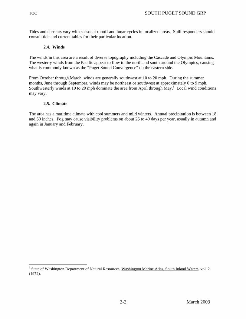
Tides and currents vary with seasonal runoff and lunar cycles in localized areas. Spill responders should consult tide and current tables for their particular location. 2.4. Winds The winds in this area are a result of diverse topography including the Cascade and Olympic Mountains. The westerly winds from the Pacific appear to flow to the north and south around the Olympics, causing what is commonly known as the “Puget Sound Convergence” on the eastern side. From October through March, winds are generally southwest at 10 to 20 mph. During the summer months, June through September, winds may be northeast or southwest at approximately 0 to 9 mph. Southwesterly winds at 10 to 20 mph dominate the area from April through May.5 Local wind conditions may vary. 2.5. Climate The area has a maritime climate with cool summers and mild winters. Annual precipitation is between 18 and 50 inches. Fog may cause visibility problems on about 25 to 40 days per year, usually in autumn and again in January and February.
5 State of Washington Department of Natural Resources, Washington Marine Atlas, South Inland Waters, vol. 2 (1972).

Shelton Map # SPS-5
Case Inlet Map # SPS-6
Carr Inlet Map # SPS-2
OlympiaMap # SPS-4
Nisqually ReachMap # SPS-3
Steilacoom Map # SPS-1
SPS-8
SPS-9 SPS-7
SPS-6
SPS-5
SPS-4
SPS-3
SPS-2
SPS-1
SPS-73
SPS-72
SPS-94
SPS-93
SPS-92
SPS-91
SPS-89
SPS-90
SPS-88
SPS-87
SPS-86
SPS-85
SPS-84
SPS-83
SPS-82
SPS-81
SPS-80
SPS-79
SPS-78
SPS-77
SPS-95
SPS-96SPS-74
SPS-20
SPS-19
SPS-10
SPS-12
SPS-13
SPS-15
SPS-18
SPS-17
SPS-16SPS-14
SPS-24
SPS-21
SPS-22SPS-39SPS-40
SPS-46
SPS-45
SPS-44
SPS-43
SPS-42
SPS-41
SPS-38
SPS-37
SPS-35
SPS-34
SPS-33
SPS-32
SPS-31SPS-29
SPS-30
SPS-27
SPS-26
SPS-25
SPS-23
SPS-47
SPS-71SPS-67
SPS-70
SPS-63SPS-65
SPS-69
SPS-68
SPS-56
SPS-55
SPS-57
SPS-61SPS-62
SPS-58SPS-59
SPS-54
SPS-53
SPS-51
SPS-50
SPS-49
SPS-48
SPS-75
SPS-76
SPS-11
SPS-36
SPS-28
SPS-64
SPS-66
SPS-60 SPS-52
South Puget Sound GRP Key Map
March, 2003
Booming Strategy Locations
Not included in GRPs
Not
incl
uded
in G
RP
sHood Canal GRP
Cen
tral
Pug
et S
ound
GR
P
Nisqually River GRP
DALD461
Outer Coast GRP
DALD461
SOUTH PUGET SOUND GRP
DALD461
3-1

TOC SOUTH PUGET SOUND GRP
March 2003 4-1
4. GENERAL PROTECTION/COLLECTION STRATEGIES
4.1. Chapter Overview This chapter details the specific response strategies and resources to protect as outlined by the participants of the GRP workshop for the South Puget Sound area. It describes the strategies determined for each area and the prioritization of those strategies. Note that GRPs only address protection of sensitive public resources. It is the responsibility of private resource owners and/or potentially liable parties to address protection of private resources (such as commercial marinas, private water intakes, and non-release aquaculture facilities). Maps & Matrices The maps in this chapter provide information on the specific location of booming strategies. They are designed to help the responder visualize response strategies. Details of each booming strategy are listed in corresponding matrix tables. Each matrix indicates the exact location, intent and implementation of the strategy indicated on the map. The “Status” column describes whether the strategy has been visited or tested in the field, and the date of the visit/test. Most strategies include a number for the corresponding shoreline photo, which is available on the Washington Department of Ecology's internet site at http://www.ecy.wa.gov/apps/shorephotos/. Major Protection Techniques All response strategies fall into one of three major techniques that may be utilized either individually or in combination. The strategies listed in Section 4.2 are based on the following techniques, and are explained in detail in Section 4.3: Dispersants: Washington State Policy currently does not allow use of dispersants in this area. Certain chemicals break up slicks on the water. Dispersants can decrease the severity of a spill by speeding the dissipation of certain oil types. Their use will require approval of the Unified Command. Dispersants will only be used in offshore situations under certain conditions, until further determinations are made by the Area Committee and published in the Area Contingency Plan. In Situ Burning: Approval to burn in this area is unlikely due to the proximity of population to a potential burn site. Burning requires the authorization of the Unified Command, who determine conformance of a request to burn with the guidelines set forth in the Area Plan. This option is preferable to allowing a slick to reach the shore provided that population areas are not exposed to excessive smoke. Under the right atmospheric conditions, a burn can be safely conducted in relative close proximity to human population. This method works on many types of oil, and requires special equipment including a fire boom and igniters. Mechanical Recovery and Protection Strategies: If a spill is too close to shore to use In Situ burning or dispersants, the key strategies are skimming and use of collection, diversion, or exclusion booming to contain and recover the oil, and prevent it from entering areas with sensitive wildlife and fisheries resources. These options are described in detail in Appendix A. Specific skimming strategies are not listed in the maps and matrices, but skimming should be used whenever possible and is often the primary means of recovering oil and protecting resources, especially when booming is not possible or feasible. Priorities: The strategy priority tables (Section 4.2.) were developed using specific locations where spills are likely to occur. Trajectory modeling was used for each of these "Potential Spill Origins" to identify sensitive resources that would likely be impacted within the initial hours of the spill. A booming strategy priority table was developed for each of the "Potential Spill Origins" based on the sensitivity of resources, feasibility, etc. Booming strategies should be deployed following the priority table for the "Potential Spill Origin" closest to the actual spill origin. The map on page 4-2 shows the locations of all Potential Spill Origins for the South Puget Sound GRP. The booming strategies indicated in the priority tables are explained in detail in the Maps & Matrices section (Section 4.3.). It is implied that control and containment at the source is the number one priority of any response. If in the responder’s best judgment this is not feasible, then the priorities laid out in the priority tables take precedence over containment and control.

Shelton Map # SPS-5
Case Inlet Map # SPS-6
Carr Inlet Map # SPS-2
OlympiaMap # SPS-4
Nisqually ReachMap # SPS-3
Steilacoom Map # SPS-1
SPS-F
SPS-E
SPS-D
SPS-C
SPS-B
SPS-A
Potential Spill Origin LocationsSouth Puget Sound GRP
March, 2003
Not included in GRPs
Not
incl
uded
in G
RP
sHood Canal GRP
Cen
tral
Pug
et S
ound
GR
P
Nisqually River GRP
DALD461
SOUTH PUGET SOUND GRP
DALD461
4-2

TOC SOUTH PUGET SOUND GRP
March 2003 4-3
4.2.2 Booming Strategy Priority Tables Table 4-1 Potential Spill Origin: SPS-A - Fox Island/Tacoma Narrows
BOOMING STRATEGY MAP PAGE COMMENTS PRIORITY NUMBER NUMBER
1 SPS-21 4-10 Refer to South Puget Sound GRP for SPS strategies
2 SPS-22 4-10
3 CPS-64 4-30 Refer to Central Puget Sound GRP for CPS strategies
4 CPS-63 4-29 5 CPS-62 4-29 6 CPS-56 4-28
7 SPS-1 4-8 Refer to South Puget Sound GRP for SPS strategies
8 SPS-7 4-9 9 SPS-6 4-9 10 SPS-4 4-9 11 SPS-5 4-9

TOC SOUTH PUGET SOUND GRP
March 2003 4-4
Table 4-2 Potential Spill Origin: SPS-B - Combined Balch Passage and McNeil Island
BOOMING STRATEGY MAP PAGE COMMENTS PRIORITY NUMBER NUMBER
1 SPS-21 4-10 2 SPS-22 4-10 3 SPS-23 4-10 4 SPS-24 4-10 5 SPS-25 4-10 6 SPS-39 4-10 7 SPS-26 4-10 8 SPS-27 4-10 9 SPS-1 4-8 10 SPS-28 4-10 11 SPS-29 4-10 12 SPS-30 4-10

TOC SOUTH PUGET SOUND GRP
March 2003 4-5
Table 4-3 Potential Spill Origin: SPS-C - Nisqually National Wildlife Refuge
BOOMING STRATEGY MAP PAGE COMMENTS PRIORITY NUMBER NUMBER
1 SPS-28 4-10 2 SPS-29 4-10 3 SPS-30 4-10 4 SPS-26 4-10 5 SPS-27 4-10 6 SPS-25 4-10 7 SPS-31 4-10 8 SPS-32 4-10 9 SPS-33 4-10 10 SPS-34 4-10 11 SPS-35 4-10 12 SPS-36 4-10 13 SPS-37 4-10 14 SPS-39 4-10 15 SPS-38 4-10 16 SPS-23 4-10 17 SPS-24 4-10

TOC SOUTH PUGET SOUND GRP
March 2003 4-6
Table 4-4 Potential Spill Origin: SPS-D – Johnson Point
BOOMING STRATEGY MAP PAGE COMMENTS PRIORITY NUMBER NUMBER
1 SPS-41 4-10 2 SPS-46 4-10 3 SPS-38 4-10 4 SPS-37 4-10 5 SPS-36 4-10 6 SPS-35 4-10 7 SPS-34 4-10 8 SPS-39 4-10 9 SPS-25 4-10 10 SPS-56 4-11 11 SPS-55 4-11 12 SPS-47 4-11
Table 4-5 Potential Spill Origin: SPS-E – Boston Harbor
BOOMING STRATEGY MAP PAGE COMMENTS PRIORITY NUMBER NUMBER
1 SPS-46 4-10 2 SPS-47 4-11 3 SPS-56 4-11 4 SPS-65 4-11 5 SPS-66 4-11 6 SPS-64 4-11 7 SPS-63 4-11 8 SPS-39 4-10 9 SPS-67 4-11 10 SPS-49 4-11 11 SPS-41 4-10 12 SPS-48 4-11 13 SPS-57 4-11 14 SPS-50 4-11

TOC SOUTH PUGET SOUND GRP
March 2003 4-7
Table 4-6 Potential Spill Origin: SPS-F - Budd Inlet
BOOMING STRATEGY MAP PAGE COMMENTS PRIORITY NUMBER NUMBER
1 SPS-53 4-11 2 SPS-52 4-11 3 SPS-48 4-11 4 SPS-51 4-11 5 SPS-50 4-11 6 SPS-49 4-11 7 SPS-47 4-11 8 SPS-46 4-10 9 SPS-55 4-11 10 SPS-56 4-11 11 SPS-65 4-11 12 SPS-66 4-11 13 SPS-64 4-11 14 SPS-63 4-11 15 SPS-67 4-11

The Narrows
Fox Island
City ofLakewood
City ofLakewoodCity of
SteilacoomCity of
Steilacoom
McNeil Island
Fort Lewis Army BaseFort Lewis Army Base
City ofDupontCity ofDupont
Fort Lewis Army BaseFort Lewis Army Base
Ferry Route
SPS-A
SPS-3
SPS-2
SPS-22
SPS-21
SPS-1
SPS-29
SPS-28
Cole Point
South TacomaSouth Tacoma
Gibson Point
Chambers BayChambers Bay
Still Harbor
Ketron Island
Gertrude IslandGertrude Island
February, 2003
Proposed Booming Strategies
South Puget Sound GRP
Are
a no
t inc
lude
d in
GR
Ps
Map belowMap below
22
33
55 66
0 1 20.5 Miles44
Area not included in GRPs
Tacoma - Central Puget Sound GRP - Map # 6 Carr Inlet - South Puget Sound GRP - Map # 2
Nis
qual
ly R
each
- S
outh
Pug
et S
ound
GR
P -
Map
# 3
STEILACOOM
MAP # 1
Legend
Public Lands
Tribal Lands
Military Installations
Potential Spill Origin
DALD461
4-8
DALD461
4.3.1 Proposed Booming and Collection Strategies: Maps
DALD461
TOC

The Narrows
Fox Island
McNeil Island
Burley LagoonBurley Lagoon
Minter Creek
SPS-A
SPS-8
SPS-9
SPS-7
SPS-6
SPS-5
SPS-4
SPS-93
SPS-92
SPS-91
SPS-89
SPS-90
SPS-88
SPS-87
SPS-86
SPS-20
SPS-19
SPS-11
SPS-12
SPS-13
SPS-15
SPS-18
SPS-16
SPS-14
CPS-75
CPS-74
SPS-40
SPS-21
SPS-10
SPS-17
WaunaWauna
PurdyPurdy
Victor
Rocky Bay
Glen CoveGlen Cove City ofGig Harbor
City ofGig HarborVaughn Bay
Fox Island
Carr Inlet
Raft Island
Hale Passage
Whitman CoveWhitman Cove
Pitt P
assa
ge
Key Peninsula
Coulter Creek
Wollochet BayWollochet Bay
Thompson Spit
Horsehead Bay
Henderson Bay
Richmond, Point
Von Geldern Cove
Kopachuck State ParkKopachuck State Park
Stretch PointState Park
Penrose Point State Park
Mayo Cove
Lay Inlet
Cutts Island State Park
February, 2003
Proposed Booming Strategies
South Puget Sound GRP Map belowMap below
33 11
55 66
0 1 20.5 Miles44
Area not included in GRPsBelfair - Hood Canal GRP - Map # 6
Tac
oma
- C
entr
al P
uget
Sou
nd G
RP
- M
ap #
6
Cas
e In
let -
Sou
th P
uget
Sou
nd G
RP
- M
ap #
6
Steilacoom - South Puget Sound GRP - Map # 1Nisqually Reach - South Puget Sound GRP - Map # 3
CARR INLET
MAP # 2
Legend
Public Lands
Tribal Lands
Military Installations
Potential Spill Origin
DALD461
4-9
DALD461
DALD461
TOC

Nisqually R
Case Inlet
Key Peninsula
City ofDupont
McNeil Island
Strategies in gray are covered by the Nisqually River GRP
Fort Lewis Army BaseMc
Allister Ck
Ferry Route
Ferry Route
SPS-D
SPS-C
SPS-B
NR-8NR-9
NR-10
NR-11NR-12
SPS-24
SPS-22
SPS-39
SPS-40
SPS-46
SPS-45
SPS-44
SPS-43SPS-42
SPS-41
SPS-38
SPS-37
SPS-36
SPS-35
SPS-34
SPS-33
SPS-32
SPS-31
SPS-30
SPS-27
SPS-26
SPS-25
SPS-21
SPS-23
SPS-47
SPS-67
SPS-52
SPS-51
SPS-48
SPS-29
SPS-28
City ofLaceyCity ofLacey
City ofOlympia
Taylor Bay
Lyle Point
Luhr Beach
LongbranchLongbranchFilucy
BayFilucy
Bay
Cole Point
Big Slough
Baird Cove
Woodard Bay
Poncin Cove
Cliff Point
Chapman Bay
Zangle Cove
Gull Harbor
Whitman CoveWhitman CoveStill Harbor
Pitt P
assa
ge
West Oro BayWest
Oro Bay
Dana Passage
Big FishtrapKetron Island
McNeil Island
Johnson PointBalch Passage
Amsterdam BayAmsterdam Bay
Boston Harbor
Harstine Island
Nisqually Reach
Henderson Inlet
Gertrude IslandGertrude Island
Drayton Passage
Butterball Cove
McAllister Springs
Squaxin Island State Park
Eagle Island State Marine Park
Nisqually National Wildlife Refuge
Hogum Bay
East Oro Bay
East Oro Bay
Mahnckes Point
Anderson Island
Tolmie State Park
Priest Point Park
Squaxin Island Indian Reservation
NISQUALLY REACH
February, 2003
Proposed Booming Strategies
South Puget Sound GRP
Map belowMap below
22
11
55 66
0 1 20.5 Miles44
Case Inlet - South Puget Sound GRP - Map # 6 Carr Inlet - South Puget Sound GRP - Map # 2
Ste
ilaco
om -
Sou
th P
uget
Sou
nd G
RP
- M
ap #
1
Oly
mpi
a -
Sou
th P
uget
Sou
nd G
RP
- M
ap #
4
McKenna - Nisqually River GRP - Map # 2
MAP # 3
Area not included in GRPs
Legend
Public Lands
Tribal Lands
Military Installations
Potential Spill Origin
Also see Nisqually River GRP - Map # 1 - Nisqually
DALD461
4-10
DALD461
TOC

Capitol Lake
P e r r y Ck
Harstine Island
H am m e r s l e y I n l e t
M i l l C r e e k
SPS-F
SPS-E
SPS-74
SPS-46
SPS-43
SPS-47
SPS-71
SPS-67SPS-70
SPS-63
SPS-64
SPS-66
SPS-65
SPS-69
SPS-68
SPS-56
SPS-55
SPS-57
SPS-61
SPS-62
SPS-58
SPS-59
SPS-60
SPS-54
SPS-53SPS-52
SPS-51
SPS-50
SPS-49
SPS-48
City ofSheltonCity ofShelton
City ofOlympia
West Bay
West Bay
East Bay
East Bay
Frye CoveFrye Cove
Eld Inlet
Young CoveYoung Cove
Oyster Bay
Green Cove
Ellis Cove
Budd Inlet
Tykel Cove
Oakland Bay
Chapman Bay
Zangle Cove
Hope Island
Gull HarborGull
Harbor
Butler Cove
Dana Passage
Totten Inlet
McLane CreekMcLane Creek
Cooper Point
Carlyon Beach
Boston Harbor
Potlatch Point
Kamilche PointGallagher Cove
Sanderson Harbor
Goldsborough Creek
Little Skookum
Inlet
Squaxin Island State Park
Palela Bay
Salmon Point
Peale Passage
Priest Point Park
Priest Point Park
Squaxin Island Indian Reservation
February, 2003
Proposed Booming Strategies
South Puget Sound GRP
Map belowMap below
22
33 11
55 66
0 1 20.5 Miles
Case Inlet - South Puget Sound GRP - Map # 6 Shelton - South Puget Sound GRP - Map # 5
Nis
qual
ly R
each
- S
outh
Pug
et S
ound
GR
P -
Map
# 3
Area not included in GRPs
Are
a no
t inc
lude
d in
GR
Ps
MAP # 4
OLYMPIA
Legend
Public Lands
Tribal Lands
Military Installations
Potential Spill Origin
DALD461
4-11
DALD461
TOC

Mill Creek
Hammersley I nlet
Skokomish Tribal LandsSkokomish Tribal Lands
HC-33
HC-32
SPS-73
SPS-72
SPS-71
SPS-70
Union
City ofSheltonCity ofShelton
Oakland Bay
Tahuya River
Chapman Cove
Skokomish River
Goldsborough Creek
Potlatch State Park
Shelton Bayshore Golf ClubShelton Bayshore Golf Club
February, 2003
Proposed Booming Strategies
South Puget Sound GRP Map belowMap below
22
33 11
66
0 1 20.5 Miles 44
MAP # 5
Legend
Public Lands
Tribal Lands
Military Installations
Potential Spill OriginUnion - Hood Canal GRP - Map # 5
SHELTONA
rea
not i
nclu
ded
in G
RP
s
Area not included in GRPs
Cas
e In
let -
Sou
th P
uget
Sou
nd G
RP
- M
ap #
6
Olympia - South Puget Sound GRP - Map # 4
DALD461
4-12
DALD461
TOC

Harstine Island
Case InletHarstine
Island
Herron Bay
Jones Ck
Sherwood
C k
HC-34
SPS-75
SPS-94
SPS-93
SPS-92
SPS-91
SPS-89
SPS-90
SPS-88
SPS-87
SPS-86
SPS-85
SPS-84
SPS-83
SPS-82
SPS-81
SPS-80SPS-79
SPS-78
SPS-77
SPS-95
SPS-96SPS-76
SPS-74
SPS-19
SPS-40
Victor
Sun Point
Rocky Bay
Vaughn Bay
Case Inlet
McLane Cove
Whitman CoveWhitman Cove
Key Peninsula
Herron Island
Coulter Creek
Stretch Island
Von Geldern Cove
Twanoh State Park
Pickering Passage
Jarrell Cove State Park
Jarrell Cove State Park
Stretch PointState Park
North Bay
Salmon Point
Allyn
McMicken Island
February, 2003
Proposed Booming Strategies
South Puget Sound GRP
Union - Hood Canal GRP - Map # 5
Map belowMap below 22
33 11
55
0 1 20.5 Miles 44
CASE INLET
Legend
Public Lands
Tribal Lands
Military Installations
Potential Spill Origin
Belfair - Hood Canal GRP - Map # 6
She
lton
- S
outh
Pug
et S
ound
GR
P -
Map
# 5
Car
r In
let -
Sou
th P
uget
Sou
nd G
RP
- M
ap #
2
Nisqually Reach - South Puget Sound GRP - Map # 3Olympia - South Puget Sound GRP - Map # 4
MAP # 6
DALD461
4-13
DALD461
TOC

TOC SOUTH PUGET SOUND GRP
4.3.2 Proposed Booming and Collection Strategies: MatricesSt
rate
gy
Status LocationResponse Strategy
Length of Boom Strategy Implementation Staging Area Site Access Resources Protected
SPS-1
Chambers Bay PIE0145 47º-11.25'N 122º-35.00'W
Exclusion booming - Keep oil out of Chambers Bay. 400'
Deploy boom in a chevron configuration on the west side of the railroad trestle to keep oil out of the bay. Boise Cascade
Chambers Creek Road.
Fish ladder, salmonids, creek estuary.
SPS-2
Chambers Bay PIE0145 47º-11.24'N 122º-34.97'W
Containment booming - Keep spill inside the bay. 400'
Deploy boom in a chevron configuration on the east side of the railroad trestle to keep oil in the bay. Steilacoom
Chambers Creek Road.
Fish ladder, salmonids, creek estuary.
SPS-3
Chambers Bay PIE0146 47º-11.44'N 122º-34.40'W
Exclusion booming - Keep oil out of the fish ladder. 200'
Deploy boom across the north end of the bay to keep oil out of the fish ladder and trap. Steilacoom
Chambers Creek Road.
Fish ladder, salmonids, creek estuary.
SPS-4
Wollochet Bay PIE0481 47º-16.01'N 122º-35.79'W
Deflection/ Collection - Keep oil out of bay. 2000'
Anchor to boat ramp near old ferry dock, tend end w/ boat (30" boom in high winds).
Wollochet close to Tacoma Narrows Airport.
Road access around entire bay. Private property access to boat ramp for (a).
Herring smelt and sandlance spawning, juvenile crab & geoduck.
SPS-5
Wollochet Bay PIE0460 47º-16.24'N 122º-36.69'W
Deflection/ Collection - Keep oil out of bay. 2000'
Anchor to cement bulkhead just around point near E Cromwell, tend end w/ boat (30" boom in high winds). same as above. same as above. same as above.
SPS-6
Sullivan Creek PIE0477 47º-16.80'N 122º-35.34'W
Exclusion booming - Keep oil out of creek. 400'
Deploy boom in a chevron configuration across the creek mouth. same as above. same as above. same as above.
SPS-7
Wollochet Bay PIE0474 47º-17.18'N 122º-36.17'W
Exclusion booming - Keep oil out of the head of the bay. 1500'
Exclude end of bay w/ chevron formation. same as above. same as above. same as above.
4-14 March 2003

TOC SOUTH PUGET SOUND GRP
4.3.2 Proposed Booming and Collection Strategies: MatricesSt
rate
gy
Status LocationResponse Strategy
Length of Boom Strategy Implementation Staging Area Site Access Resources Protected
SPS-8
Horse Head Bay PIE0436 47º-17.79'N 122º-41.02'W
Exclusion Booming - Keep oil out of bay. 2000' Deploy boom to close off bay.
Forest Beach or Kopachuck State Park. Boat ramp on SE end of Horse Head Bay. Boat
Fisheries and wildlife (uncertain about resources, may be low priority).
SPS-9
Cuts Island - South End PIE0423 47º-19.19'N 122º-41.27'W
Exclusion Booming - Keep oil off island. 1200'
Deploy boom in a chevron configuration to protect the south end of the island.
Purdy or Gig Harbor. Boat
Shellfish & State Park, Harbor seal haulout.
SPS-10
Cuts Island - North End PIE0423 47º-19.57'N 122º-41.81'W
Exclusion Booming - Keep oil off island. 1200'
Deploy boom in a chevron configuration to protect the north end of the island.
Purdy or Gig Harbor. Boat
Shellfish & State Park, Harbor seal haulout.
SPS-11
Raft Island PIE0415 47º-19.52'N 122º-40.03'W
Exclusion Booming - Keep oil off island. 800' Boom along bridge w/800' boom.
Purdy or Gig Harbor.
Road access from bridge, access via private property N. side of Is. and small bay on mainland, road access to E side of Lay Inlet.
Clams, harbor seal haulouts and shellfish.
SPS-12
Lay Inlet PIE0407 47º-20.04'N 122º-39.31'W
Exclusion Booming - Keep oil out of Lay Inlet. 600' Boom mouth of Lay Inlet.
Purdy or Gig Harbor. same as above.
Clams, harbor seal haulouts and shellfish.
SPS-13
Raft Island PIE0418 47º-20.15'N 122º-39.86'W
Exclusion Booming - Keep oil off island. 2000'
Boom north side of island w/ 2000' from large floating dock on island to shoreline directly to the north.
Purdy or Gig Harbor. same as above.
Clams, harbor seal haulouts and shellfish.
4-15 March 2003

TOC SOUTH PUGET SOUND GRP
4.3.2 Proposed Booming and Collection Strategies: MatricesSt
rate
gy
Status LocationResponse Strategy
Length of Boom Strategy Implementation Staging Area Site Access Resources Protected
SPS-14
Burley Lagoon PIE0387 47º-23.03'N 122º-37.60'W
Exclusion Booming - Keep oil out of lagoon. 2000'
Double chevron @ entrance to lagoon. Anchor both to powerline tower and NE bridge abutment. Need - (2) 100lb anchors @ apex. Purdy
Good road access from Hwy 302.
Wildlife, shellfish, juvenile salmon and waterfowl concentration.
SPS-15
Minter Creek PIE0354 47º-21.55'N 122º-41.50'W
Exclusion Booming - Keep oil out of creek. 1000'
Close off creek with chevron, can use trees on N side of creek as anchors.
Boat launch @ Wauna.
Land access to Sunrise and Minter Beaches.
Minter Creek Hatchery, archeological site and shellfish.
SPS-16
Minter Creek PIE0355 47º-21.85'N 122º-41.77'W
Exclusion Booming - Keep oil out of creek. 500'
Deploy boom running NE/SW along pilings about 1/8 mile upstream from Oyster Co.
Boat launch @ Wauna.
Land access to Sunrise and Minter Beaches.
Minter Creek Hatchery, archeological site and shellfish.
SPS-17
Glen Cove PIE0346 47º-20.38'N 122º-43.73'W
Exclusion Booming - Keep oil out of cove. 1000'
Deploy boom in a chevron configuration across the mouth of Glen Cove.
Glen Cove boat launch in Wauna. Boat
Cove, shoreline, fisheries.
SPS-18
Thompson Spit PIE0340 47º-20.04'N 122º-43.76'W
Exclusion Booming - Keep oil out of cove. 200'
Deploy boom in a chevron configuration across the mouth of the cove.
Glen Cove boat launch in Wauna. Boat
Cove, shoreline, fisheries.
SPS-19
Van Geldern Cove PIE0322 47º-16.44'N 122º-45.41'W
Exclusion Booming - Keep oil out of cove. 2000'
Place boom at launch ramp on north shore across to closest point on south shore. Anchor at middle. City of Home.
Road access on both sides of cove.
Salmon spawning creek, waterfowl, brant.
SPS-20
Mayo Cove (Penrose State Park) 47º-15.75'N 122º-44.81'W
Diversion Booming - Isolate small bay on south shore of cove. 2000'
Angle NE from spit (PIE0316) to wooden bulkhead at Penrose State Park (PIE0310).
Penrose State Park.
Boat launch and good roads; State Parks.
Sensitive nesting species, seabird concentrations, surf smelt, herring, & sandlance spawning.
4-16 March 2003

TOC SOUTH PUGET SOUND GRP
4.3.2 Proposed Booming and Collection Strategies: MatricesSt
rate
gy
Status LocationResponse Strategy
Length of Boom Strategy Implementation Staging Area Site Access Resources Protected
SPS-21
Still Harbor - SE McNeil PIE0596 47º-13.30'N 122º-39.68'W
Exclusion Booming - Prevent oil from entering harbor. 5000'
Double chevron from Baldwin Pt. to Gertrude Is.
Possible to stage from the penitentiary (security issue high priority on McNeil Island). Foss has access to island.
Boat access only. Road exists but security clearance necessary. Must clear any operations with prison staff.
Marine mammal haulout, 400 seals (one of largest). Shellfish, waterfowl, great blue heron.
SPS-22
Still Harbor - SE McNeil PIE0592 47º-13.08'N 122º-39.40'W
Exclusion Booming - Prevent oil from entering harbor. 2000'
Double chevron from Gertrude Is. to E shore. Need - (2) 100# anchors @ each apex = total of 100# anchors. same as above. same as above. same as above.
SPS-23
North Filucy Bay PIE0278 47º-12.43'N 122º-44.83'W
Exclusion Booming - Keep oil out of bay. 2000'
Deploy boom across the entrance to the north part of the bay from Mahnckes Point to the beach directly to the west. Longbranch
Limited road access. County boat launch outside bay to the south.
Protect archaeological and shellfish sites.
SPS-24
South Filucy Bay PIE0266 47º-11.86'N 122º-44.75'W
Exclusion Booming - Keep oil out of bay. 1500'
Deploy boom across the entrance to the south part of the bay. Longbranch
Limited road access. County boat launch outside bay to the south.
Protect archaeological and shellfish sites.
SPS-25
Amsterdam Bay (NW side of Anderson I.) PIE0675 47º-21.85'N 122º-41.77'W
Exclusion booming - Keep oil out of bay. 1000'
Boom off bay with chevron formation. Need shore anchors and 100# anchor at apex. Bay is shallow: 10'-20' at mouth. Steilacoom
Boat access on south shore.
Clams, herring and sandlance.
SPS-26
Anderson Island -West Oro Bay PIE0641 47º-08.29'N 122º-42.03'W
Exclusion booming - Keep oil out of bay. 2200'
Boom west bay with chevron. Attach intertidal boom to each shoreside leg end if available. Steilacoom
Some road access to Lyle and Cole Points. Strategy best implemented by water.
Birds, high value clam beds, Dungeness Crab.
4-17 March 2003

TOC SOUTH PUGET SOUND GRP
4.3.2 Proposed Booming and Collection Strategies: MatricesSt
rate
gy
Status LocationResponse Strategy
Length of Boom Strategy Implementation Staging Area Site Access Resources Protected
SPS-27
Anderson Island -East Oro Bay PIE0646 47º-08.64'N 122º-41.53'W
Exclusion booming - Keep oil out of bay 2800'
Boom east bay in a chevron configuration. Attach intertidal boom to each shoreside leg end. If the strategy cannot be deployed as described, or if winds are likely to drive oil past the boom, back up the strategy with 200' to prevent oil from entering the slough. Steilacoom
Some road access to Lyle and Cole Points. Strategy best implemented by water.
Birds, high value clam beds, Dungeness Crab.
SPS-28
Nisqually NWR/ Nisqually River Sloughs THU0006 47º-05.68'N 122º-41.26'W
Exclusion booming - Keep oil out of sloughs. 400'
Deploy boom across the entrance to the sloughs to the east of the Nisqually River.
Nisqually NWR -reach through Thurston Co. EMD. Barn could be command post & bird care center.
Dike behind refuge office. Very shallow area - may need to implement from Nisqually River side.
Waterfowl, fish, wetland area.
SPS-29
Nisqually NWR/ Nisqually River Sloughs THU0007 47º-05.23'N 122º-41.73'W
Exclusion booming - Keep oil out of sloughs. 400'
Deploy boom across the slough to the east of the Nisqually River at the foot bridge. same as above. same as above. same as above.
SPS-30
McAllister Creek THU0025 47º-05.55'N 122º-43.56'W
Exclusion booming - Keep oil out of creek. 1200'
Exclusion boom across McAllister Creek at Luhr Beach (move upstream if upstream spill from I-5).
Could be command post and bird care center.
Luhr Beach (busy); Zittel's or Martin Way access to McAllister.
Hatchery, bird and fish habitat, public use area.
SPS-31
Cove in Hogum Bay THU0029 47º-06.37'N 122º-44.37'W
Exclusion - Keep oil out of cove. 100'
Deploy boom across the mouth of the cove.
Zittel's Marina or Tolmie State Park. Access via boat.
Protect bird foraging area, crabs, clams, marsh habitat.
4-18 March 2003

TOC SOUTH PUGET SOUND GRP
4.3.2 Proposed Booming and Collection Strategies: MatricesSt
rate
gy
Status LocationResponse Strategy
Length of Boom Strategy Implementation Staging Area Site Access Resources Protected
SPS-32
Butterball Cove THU0032 47º-07.11'N 122º-45.62'W
Exclusion - Keep oil out of cove. 100'
Deploy boom across the mouth of the cove.
Zittel's Marina or Tolmie State Park. Access via boat.
Protect bird foraging area, crabs, clams, marsh habitat.
SPS-33
Big Slough THU0034 47º-07.31'N 122º-46.52'W
Exclusion - Keep oil out of slough. 300'
Deploy boom across the mouth of the slough.
Zittel's Marina or Tolmie State Park. Access via boat.
Protect bird foraging area, crabs, clams, marsh habitat.
SPS-34
Small cove south of Mill Bight THU0039 47º-08.63'N 122º-47.34'W
Exclusion - Keep oil out of cove. 100'
Deploy boom across the mouth of the cove.
Zittel's Marina or Tolmie State Park. Access via boat.
Protect bird foraging area, crabs, clams, marsh habitat.
SPS-35
Mill Bight THU0042 47º-09.21'N 122º-47.78'W
Exclusion - Keep oil out of cove. 300'
Deploy boom across the mouth of the cove.
Zittel's Marina or Tolmie State Park. Access via boat.
Protect bird foraging area, crabs, clams, marsh habitat.
SPS-36
Small cove south of Baird Cove THU0045 47º-09.57'N 122º-47.93'W
Exclusion - Keep oil out of cove. 100'
Deploy boom across the mouth of the cove.
Zittel's Marina or Tolmie State Park. Access via boat.
Protect bird foraging area, crabs, clams, marsh habitat.
SPS-37
Baird Cove THU0047 47º-09.82'N 122º-48.49'W
Exclusion - Keep oil out of cove. 500'
Deploy boom across the mouth of the cove.
Zittel's Marina or Tolmie State Park. Access via boat.
Protect bird foraging area, crabs, clams, marsh habitat.
SPS-38
Poncin Cove THU0052 47º-10.16'N 122º-48.68'W
Exclusion - Keep oil out of cove. 100'
Deploy boom across the mouth of the cove.
Zittel's Marina or Tolmie State Park. Access via boat.
Protect bird foraging area, crabs, clams, marsh habitat.
4-19 March 2003

TOC SOUTH PUGET SOUND GRP
4.3.2 Proposed Booming and Collection Strategies: MatricesSt
rate
gy
Status LocationResponse Strategy
Length of Boom Strategy Implementation Staging Area Site Access Resources Protected
SPS-39
Taylor Bay PIE0249 47º-11.12'N 122º-46.58'W
Exclusion booming - Keep oil out of bay. 1200'
Form chevron - anchor to pilings on north shore and private boat ramp on south shore.
RFK Park - DNR recreation area.
Road access via Whitman Road and Taylor Bay Road.
Shellfish (clams); waterfowl.
SPS-40
Whitman Cove PIE0239 47º-13.25'N 122º-48.33'W
Valve closure - Keep oil out of cove. 100'
Turn off valves to cut off sluice ways (talk to DNR about tide gates). Deploy boom if necessary.
RFK Park - DNR recreation area.
Road access via Bay Road.
Seabird concentrations.
SPS-41
Henderson Inlet THU0104 47º-09.08'N 122º-49.95'W
Exclusion booming - Keep oil out of lower bay and mudflats. 2800'
Deploy boom at an angle across bay, from Cliff Point to the opposite shore.
Boat ramp East shore of Henderson Inlet.
By Boat from Olympia or Tacoma or from I-5 take Sleater Kinney Road NE to Bay Road NE, turn right, proceed to Henderson Road until you see boat launch ramp sign, follow road to boat launch. Johnson Point community boat ramp/private beach, Dr. Gevorian, 822 Libby Road, 4-wheel drive beach access.
Sensitive nesting species; great blue heron; marine mammal haulout, waterfowl concentration.
SPS-42
Chapman Bay THU0093 47º-08.13'N 122º-50.58'W
Exclusion booming - Keep off mud flats and lower bay. 1000' Boom off mouth of the bay.
Woodard Bay Park; Private boat ramp on 86th (east side of Henderson) will rent out.
Same as above plus seabird concentrations.
4-20 March 2003

TOC SOUTH PUGET SOUND GRP
4.3.2 Proposed Booming and Collection Strategies: MatricesSt
rate
gy
Status LocationResponse Strategy
Length of Boom Strategy Implementation Staging Area Site Access Resources Protected
SPS-43
Woodard Bay THU0084 47º-07.89'N 122º-50.55'W
Exclusion booming. 400'
Boom off mouth of the bay at the bridge.
Woodard Bay Park; Private boat ramp on 86th (east side of Henderson) will rent out. Same as above.
SPS-44
Henderson Inlet THU0081 47º-07.20'N 122º-49.95'W
Exclusion - Keep oil out of lower bay and mudflats. 1800'
Deploy boom in a chevron configuration where bay begins to narrow down and get shallow.
Boat ramp East shore of Henderson Inlet. same as above. Same as above.
SPS-45
Henderson Inlet "neck" THU0079 47º-06.69'N 122º-49.54'W
Exclusion - Keep oil out of lower bay and mudflats. 900'
Deploy boom across the inlet just north of the portion that becomes a mudflat at low tide.
Zittel's Marina or Tolmie State Park. Access via boat. Same as above.
SPS-46
Big Fishtrap THU0111 47º-09.46'N 122º-51.79'W
Exclusion - Keep oil out of the lagoon. 800' Boom off Lagoon.
Boston Harbor Marina.
SPS-47
Zangel Cove THU0121 47º-08.64'N 122º-53.48'W
Exclusion booming - Keep oil out of cove. 500' Boom off cove. Port of Olympia.
Dirt road access - off Zangel Cove (get address from Don Schluter).
Sensitive nesting species, Great Ble Heron, Marine mammal haulout, waterfowl, and seabird concentrations.
4-21 March 2003

TOC SOUTH PUGET SOUND GRP
4.3.2 Proposed Booming and Collection Strategies: MatricesSt
rate
gy
Status LocationResponse Strategy
Length of Boom Strategy Implementation Staging Area Site Access Resources Protected
SPS-48
Gull Harbor THU0131 47º-06.75'N 122º-53.46'W
Exclusion booming - Keep oil out of harbor. 400' Boom off harbor mouth.
Boston Harbor Marina.
Boston Harbor Marina.
Sensitive nesting species, Great Blue Heron, marine mammal haulout, waterfowl, and seatbird concentraions, natural undeveloped smelt spawning beaches.
SPS-49
Tykel Cove THU0178 47º-06.01'N 122º-55.91'W
Exclusion booming - Keep oil out of cove. 1800' Boom off cove. Port of Olympia.
Port of Olympia boat ramp (East Bay Marina) or Gull Harbor.
Sensitive nesting species, Great Ble Heron, Marine mammal haulout, waterfowl, and seabird concentrations.
SPS-50
Butler Cove THU0172 47º-04.90'N 122º-56.06'W
Exclusion booming - Keep oil out of cove. 500' Boom off cove. Port of Olympia.
Port of Olympia boat ramp (East Bay Marina) or Gull Harbor.
Sensitive nesting species, Great Ble Heron, Marine mammal haulout, waterfowl, and seabird concentrations.
SPS-51
Priest Point Park THU0140 47º-04.27'N 122º-53.91'W
Exclusion from Ellis Cove. 400' Keep oil out of Ellis Cove.
East Bay Marina. East Bay Marina.
Sensitve cove waterfowl, Osprey nests, Salmon runs, and public recreation area, salt marsh.
SPS-52
East Bay - Budd Inlet THU0149 47º-03.55'N 122º-53.78'W
Containment Booming - Keep oil inside bay if spill at port or I-5. 1600' Boom off harbor mouth.
East Bay Marina. East Bay Marina.
Diving ducks, scoters, canvas back, Barrows Goldeneye.
4-22 March 2003

TOC SOUTH PUGET SOUND GRP
4.3.2 Proposed Booming and Collection Strategies: MatricesSt
rate
gy
Status LocationResponse Strategy
Length of Boom Strategy Implementation Staging Area Site Access Resources Protected
SPS-53
West Bay - Budd Inlet THU0147 47º-03.50'N 122º-54.47'W
Containment Booming - Keep oil inside bay if spill at port or I-5. 2000' Boom off harbor mouth.
East Bay Marina. East Bay Marina.
Concentration of diving ducks: scoters, canvasbacks, Barrows goldeneye.
SPS-54
Capitol Lake THU0163 47º-02.62'N 122º-54.48'W
Containment - Keep oil in lake if spill from I-5. 200'
Close dam and bring vac trucks to west shoreline (old swimming beach). Boom off area around tide gate to prevent entrainment.
Capitol Lake parking lot. 5th Avenue.
Puget Sound Resources.
SPS-55
Mouth of Eld Inlet THU0188 47º-08.95'N 122º-55.68'W
Deflection/ Collection - Keep oil out of inlet. 2200' Boom at 35 degree angle.
Port of Olympia; Frye Cove; Caroline beach.
Sanderson Harbor? shore? for vac trucks, recovery.
SPS-56
Sanderson Harbor THU0268 47º-08.99'N 122º-56.17'W
Exclusion - Keep oil out of harbor. 300'
Deploy boom across entrance to harbor.
Frye Cove Co. Park (restricted boat launch); Keys Ways Marina.
Frye Cove Co. Park (restricted boat launch); Keys Ways Marina.
SPS-57
Frye Cove THU0258 47º-06.86'N 122º-57.83'W
Exclusion - Keep oil out of cove. 500' Boom across cove.
Frye Cove Co. Park (restricted boat launch); Keys Ways Marina.
Frye Cove Co. Park (restricted boat launch); Keys Ways Marina.
SPS-58
Green Cove THU0201 47º-05.86'N 122º-56.93'W
Exclusion booming - Keep oil out of cove. 700' Boom off Green Cove.
Port of Olympia boat ramp East Bay.
Evergreen College boat ramp. Harbor seal haulout.
4-23 March 2003

TOC SOUTH PUGET SOUND GRP
4.3.2 Proposed Booming and Collection Strategies: MatricesSt
rate
gy
Status LocationResponse Strategy
Length of Boom Strategy Implementation Staging Area Site Access Resources Protected
SPS-59
Young Cove THU0249 47º-06.14'N 122º-58.82'W
Exclusion - Keep oil out of cove. 800' Boom across cove.
Frye Cove Co. Park (restricted boat launch); Keys Ways Marina.
Frye Cove Co. Park (restricted boat launch); Keys Ways Marina.
SPS-60
Perry Creek THU0229 47º-03.16'N 123º-00.02'W
Exclusion - Keep oil out of creek. 100'
Boom across mouth of creek at bridge on Madrona Beach Drive.
Park and ride lot south of bridge.
By land using a small skiff, or by boat from Taylor United and Ellison Oyster Co.
SPS-61
McLane Creek, ebb tide strategy THU0227 47º-02.82'N 122º-59.27'W
Exclusion/ Collection - Keep oil in inlet and out of creek if spill from Hwy 101. 300'
Angle boom from southwest corner of bridge over Mud Bay Road to shoreline northeast of bridge, access for vac trucks on northeast side.
Large parking lot at tavern near bridge, ask permission for use.
By land using a small skiff, or by boat from Taylor United and Ellison Oyster Co.
SPS-62
McLane Creek, flood tide strategy THU0220 47º-02.71'N 122º-59.35'W
Exclusion/ Collection - Keep oil in inlet and out of creek if spill from Hwy 101. 300'
Angle boom from northwest corner of bridges over highway 101 to shoreline southeast of bridges, access for vac trucks on southeast side.
Wide shoulder at highway 101, parking area at southeast corner of bridges.
By land using a small skiff, or by boat from Taylor United and Ellison Oyster Co.
SPS-63
Squaxin Island, cove south of Polela Bay MAS0280 47º-11.32'N 122º-54.90'W
Exclusion - Keep oil out of cove. 600' Deploy boom across mouth of cove.
Boston Harbor marina.
Boston Harbor Marina, Carlyon Beach boat ramp (private).
SPS-64
Squaxin Island, Polela Bay MAS0275 47º-11.65'N 122º-55.19'W
Exclusion - Keep oil out of bay. 1500' Deploy boom across mouth of bay.
Boston Harbor marina.
Boston Harbor Marina, Carlyon Beach boat ramp (private).
4-24 March 2003

TOC SOUTH PUGET SOUND GRP
4.3.2 Proposed Booming and Collection Strategies: MatricesSt
rate
gy
Status LocationResponse Strategy
Length of Boom Strategy Implementation Staging Area Site Access Resources Protected
SPS-65
Hope Island to Carlyon Beach 47º-10.95'N 122º-56.00'W Exclusion 1800'
Deploy boom from the south end of Hope Island (MAS0260) to Carlyon Beach (THU0279).
Boston Harbor marina.
Boston Harbor Marina, Carlyon Beach boat ramp (private).
Protect fish and wildlife resources in Hammerley and Totten Inlets.
SPS-66
Squaxin Island to Hope Island 47º-11.60'N 122º-55.43'W Exclusion 1500'
Deploy Boom from Potlatch Point on Squaxin Island (MAS0274) to the north end of Hope Island (MAS0263).
Boston Harbor marina.
Boston Harbor Marina, Carlyon Beach boat ramp (private).
Protect fish and wildlife resources in Hammerley and Totten Inlets.
SPS-67
Squaxin Island Net Pens MAS0299 47º-11.83'N 122º-54.21'W
Exclusion booming - Keep oil away from fish pens. 4800'
Diamond boom around net pens using floats to anchor (pens are comanaged by state and Squaxin Tribe).
Park at Squaxin Island.
Boston Harbor Marina, Carlyon Beach boat ramp (private) - no shoreline access.
Salmon stock. Note - location of high priority stocks changes. Need to get current layout when spill occurs.
SPS-68
Totten Inlet/Gallagher Cove THU0291 47º-08.57'N 122º-58.64'W
Deflection booming - Keep oil out of cove. 1000' Place boom acrooss mouth of cove.
Boston Harbor marina.
Boston Harbor marina.
Waterfowl, clams & oysters.
SPS-69
Little Skookum Inlet MAS0020 47º-09.22'N 123º-01.08'W
Containment booming - Keep spill out of inlet. 1000'
Boom mouth of inlet from Kamilche Point to Lynch Road.
Lynch Road launch at Arcadia.
SPS-70
Mill Creek in Hammersley Inlet MAS0068 47º-11.87'N 122º-59.53'W
Exclusion - Keep oil out of Mill Creek. 500' Boom across Miller Creek.
Small launch - possible.
Carlyon Beach Marina, Olympia or Arcadia launch - Arcadia Point.
Sensitive species nesting in area; fisheries.
4-25 March 2003

TOC SOUTH PUGET SOUND GRP
4.3.2 Proposed Booming and Collection Strategies: MatricesSt
rate
gy
Status LocationResponse Strategy
Length of Boom Strategy Implementation Staging Area Site Access Resources Protected
SPS-71
Goldsborough Creek MAS0086 47º-12.60'N 123º-05.48'W
Exclusion - Keep oil out of Goldsborough Creek. 100' Close off entrance to creek.
In Shelton at mill. In Shelton at Mill. Salmon Stream.
SPS-72
Chapman Cove MAS0120 47º-13.65'N 123º-02.57'W
Exclusion - Keep oil out of cove. 1800'
Boom off entrance to Chapman Cove. Sunset Road? Shelton Launch.
Clams, fish, and archaeological sites.
SPS-73
Oakland Bay MAS0113 47º-12.60'N 123º-03.00'W
Exclusion booming. 1500'
Close off inlet at Golf Course to Daniels Road.
Golf Course and Highway 3.
Boat launch at Shelton. Highway 3 near Bay Shore golf course.
Mudflats, marine mammal haulouts.
SPS-74
Cove west of Salmon Point on west shore of Pickering Passage MAS0156 47º-13.47'N 122º-56.28'W
Exclusion - Keep oil out of cove. 600' Deploy boom across mouth of cove.
Public boat ramp at bridge to Hartstene Island. Access via boat.
SPS-75
Small channel to cove in SPS-74 MAS0159 47º-14.01'N 122º-56.00'W
Exclusion - Keep oil out of cove. 100' Deploy boom across channel.
Public boat ramp at bridge to Hartstene Island. Access via boat.
4-26 March 2003

TOC SOUTH PUGET SOUND GRP
4.3.2 Proposed Booming and Collection Strategies: MatricesSt
rate
gy
Status LocationResponse Strategy
Length of Boom Strategy Implementation Staging Area Site Access Resources Protected
SPS-76
Cove just north and west of Salmon Point on west shore of Pickering Passage MAS0160 47º-14.13'N 122º-56.08'W
Exclusion - Keep oil out of cove. 200'
Deploy boom across cove at bridge to island.
Public boat ramp at bridge to Hartstene Island. Access via boat.
SPS-77
Jones Creek MAS0170 47º-16.03'N 122º-55.67'W
Exclusion - Keep oil out of creek and estuary. 500'
Boom off entrance to cove leading to estuary and creek.
Jarrell Cove State Park or boat ramp at bridge to Hartstene Is. Access via boat.
SPS-78
Cove inside Sun Point MAS0177 47º-17.05'N 122º-55.32'W
Exclusion - Keep oil out of cove. 400'
Deploy boom across entrance to cove.
Jarrell Cove State Park. Access via boat.
SPS-79
West cove across Pickering Passage from Jarrell Cove MAS0180 47º-17.59'N 122º-54.06'W
Exclusion - Keep oil out of cove. 1000'
West cove, anchor from bulkhead on west side to point, 100# anchor in middle.
Jarrell Cove State Park. Access via boat.
SPS-80
Center cove across Pickering Passage from Jarrell Cove MAS0181 47º-17.60'N 122º-53.72'W
Exclusion - Keep oil out of cove. 300'
Center cove, anchor to bluff on west side, 100# anchor in middle.
Jarrell Cove State Park. Access via boat.
4-27 March 2003

TOC SOUTH PUGET SOUND GRP
4.3.2 Proposed Booming and Collection Strategies: MatricesSt
rate
gy
Status LocationResponse Strategy
Length of Boom Strategy Implementation Staging Area Site Access Resources Protected
SPS-81
Jarrell Cove MAS0372 47º-17.15'N 122º-53.11'W
Exclusion - Keep oil out of cove, protect Jarrell Cove State Park. 1000'
Boom off cove with chevron configuration.
Jarrell Cove State Park.
Carlyon Beach boat ramp (private); full facilities at park. State Park.
SPS-82
McLane Cove MAS0191 47º-18.59'N 122º-51.76'W
Exclusion Booming - Keep oil out of cove. 2000'
Boom off cove with chevron formation.
Jarrell Cove State Park.
Grapeview Loop Rd./Jarrell Cove State Park.
SPS-83
Small slough just west of Stretch Island MAS0200 47º-19.40'N 122º-50.38'W
Exclusion - Keep oil out of slough. 200'
Deploy boom across entrance to slough, primarily to north.
Jarrell Cove State Park. Access via boat.
SPS-84
Sherwood Creek and estuary MAS0238 47º-22.53'N 122º-50.06'W
Exclusion - Keep oil out of bay/estuary. 500'
Deploy boom across bay at the bridge on Grapeview Loop Road.
Victor and/ or Allyn.
Access via Hwy 302 to both sides of bay. Need shallow draft boats.
Wetlands, mudflats, and Coulter Creek hatchery, winter concentrations of Grebes & Murres.
SPS-85
Case Inlet (North Bay) MAS0241 47º-23.09'N 122º-49.53'W
Deflection/ Collection - Keep oil out of bay. 1000'
Deploy deflection boom at Allyn (angled SE) Collect oil w/ vac trucks.
Victor and/ or Allyn.
Access via Hwy 302 to both sides of bay. Need shallow draft boats.
Wetlands, mudflats, and Coulter Creek hatchery, winter concentrations of Grebes & Murres.
SPS-86
Coulter Creek MAS0249 47º-23.43'N 122º-49.09'W
Exclusion Booming - Keep oil out of creek. 4000'
Deploy boom at the power lines, using the towers as anchor points.
Victor and/ or Allyn.
Access via Hwy 302 to both sides of bay. Need shallow draft boats.
Coho, Chinook & Chum. Winter concentrations of Grebes & Murres.
4-28 March 2003

TOC SOUTH PUGET SOUND GRP
4.3.2 Proposed Booming and Collection Strategies: MatricesSt
rate
gy
Status LocationResponse Strategy
Length of Boom Strategy Implementation Staging Area Site Access Resources Protected
SPS-87
Case Inlet (North Bay) MAS0254 47º-22.74'N 122º-48.97'W
Deflection/ Collection - Keep oil out of bay. 1000'
Deploy deflection boom at Victor (angled SW) Collect oil w/ vac trucks.
Victor and/ or Allyn.
Access via Hwy 302 to both sides of bay. Need shallow draft boats.
Wetlands, mudflats, and Coulter Creek hatchery, winter concentrations of Grebes & Murres.
SPS-88
Rocky Bay PIE0181 47º-21.67'N 122º-47.26'W
Exclusion Booming - Keep oil out of Bay. 1200'
Chevron from the sand spit to the north and the wooden bulkhead to the south.
Vaughn boat launch area.
Hwy. 302 & Bond Road.
Winter concentrations of Grebes & Murres.
SPS-89
Small creek to south of Rocky Bay PIE0184 47º-21.50'N 122º-47.12'W
Exclusion - Keep oil out of creek. 100'
Deploy boom across small creek to the south of Rocky Bay.
Vaughn boat launch area.
Hwy. 302 & Bond Road.
Winter concentrations of Grebes & Murres.
SPS-90
Vaughn Bay PIE0189 47º-20.58'N 122º-47.12'W
Exclusion Booming - Keep oil out of bay. 500'
Boom off bay by angling boom from pilings to shore.
Vaughn, boat ramp. Access via boat.
Seabird concentrations.
SPS-91
Dutcher Cove area PIE0206 47º-18.38'N 122º-47.32'W
Exclusion Booming - Keep oil out of stream. 1000'
Boom off cove with chevron formation.
Vaughn, boat ramp. Access via boat.
Seabird concentrations.
SPS-92
Small Cove South of Dutcher Cove PIE0211 47º-18.02'N 122º-47.18'W
Exclusion Booming - Keep oil out of stream. 100'
Place 100' section across small opening south of cove.
Vaughn, boat ramp. Access via boat.
Seabird concentrations.
4-29 March 2003

TOC SOUTH PUGET SOUND GRP
4.3.2 Proposed Booming and Collection Strategies: MatricesSt
rate
gy
Status LocationResponse Strategy
Length of Boom Strategy Implementation Staging Area Site Access Resources Protected
SPS-93
Herron Bay PIE0217 47º-16.51'N 122º-48.67'W
Exclusion - Keep oil out of bay. 100'
Deploy boom across mouth of bay at bridge.
Parking area at dock for Herron Island.
Road access via North Herron Rd, or via boat.
SPS-94
Cove north of Whitman Cove and due east of McMicken Is. PIE0232 47º-14.74'N 122º-49.71'W
Exclusion booming - Keep oil out of cove. 100' Boom off entrance to cove.
RFK Park - DNR recreation area.
Road access via Russell Road.
Salmon stream, wetland habitat, seabird concentrations.
SPS-95
McMicken Island MAS0347 47º-15.00'N 122º-51.89'W
Exclusion booming - Keep oil off island. 2500'
Deploy boom from the north end of the island to the beach to the west.
Zittel's Marina or Johnson Point.
Zittel's Marina or Johnson Point.
Marine mammal haulout; seabird concentrations.
SPS-96
McMicken Island MAS0346 47º-14.71'N 122º-51.92'W
Exclusion booming - Keep oil off island. 1700'
Deploy boom from the south end of the island to the beach to the southwest.
Zittel's Marina or Johnson Point.
Zittel's Marina or Johnson Point.
Marine mammal haulout; seabird concentrations.
4-30 March 2003


SOUTH PUGET SOUND GRP
March 20035-9
5.3 Shoreline Countermeasure Matrices
The matrices included here show which shoreline countermeasure techniques have been considered for thefourteen shoreline types described in Chapter 2 of the “Shoreline Countermeasures Manual & Matrices”,Northwest Area Plan, Chapter 9650, Page 9-37. Four matrices have been constructed for the major categoriesof oil (heavy, medium, light, very light).
Countermeasure methods are described in Chapters 3 and 4 of the manual. Countermeasures in Chapter 3 aretraditional or conventional techniques that the OSC can use without any additional concurrence. However, thecutting of vegetation countermeasure should be used only during specific seasonal windows under specificconditions and with landowner approval. Countermeasures in Chapter 4 are described under a separate sectioncalled “Shoreline Countermeasure Methods Using Alternative Technology” may be useful in certain situations.These methods are considered more experimental and controversial in their application and potential impactsand require more formal review and consultation before implementing. The exact requirements are spelled outin the National Contingency Plan and the Northwest Area Plan. The Shoreline Countermeasures Matrices are aparticularly dynamic component of the manual and should continue to be revised as the existing techniques areused and evaluated, and as both old and new techniques are refined.
Each matrix has a written explanation of how it is to be used as a countermeasure advisability matrix. Thematrices are only a general guide for removing oil from shoreline substrates. They must be used in conjunctionwith the entire “Shoreline Countermeasures Manual” plus field observations and scientific advice. Thecountermeasures listed are not necessarily the best under all circumstances, and any listed technique may needto be used in conjunction with other techniques (including ones not listed herein). The Federal On-SceneCoordinator (FOSC) or the State OSC operating with the FOSC's authorization has the responsibility for andauthority to determine which countermeasure(s) are appropriate for the various situations encountered.
Selection of countermeasure techniques to be used in each spill is based upon the degree of oil contamination,shoreline types, and the presence of sensitive resources. Extremely sensitive areas are generally limited tomanual cleanup methods. It is important to note that the primary goal of countermeasure implementation is theremoval of oil from the shoreline with no further injury or destruction to the environment. The three categoriesof guidance used in the matrices are defined as follows:
R Recommended May be the preferred method that best achieves the goal ofminimizing destruction or injury to the environment
C Conditional Viable and possibly useful but may result in limited adverse effectsto the environment
Shaded Not applicable or not generally recommended.
Dale Davis
TOC
DALD461

SHORELINE COUNTERMEASURES MATRIXHeavy Oil (Heavy Crude Oils, Intermediate Fuel Oils, Bunker C & Heavily Weathered Medium Crudes)• Heavy oils with little or no evaporation or dissolution• Water-soluble fraction likely to be <10ppm• Heavy contamination of intertidal areas likely• Severe impacts to waterfowl and fur-bearing mammals (coating and ingestion)• Long-term contamination to sediments possible• Weathers very slowly• Dispersion seldom effective• Shoreline cleanup difficult under all conditions
SHORELINE TYPES CODES1- Exposed rock shores and vertical, hard man-made structure (e.g. seawalls)2 - Exposed wave-cut platforms3 - Fine to medium grained sand beaches & steep
unvegetated river banks4 - Course grained sand beaches5 - Mixed sand and gravel beaches, including artificial fill containing a range of grain size and material6A - Gravel beaches - pebbles to cobble
6B - Gravel beaches - cobbles to boulders6C - Exposed rip rap7 - Exposed tidal flat8A- Sheltered vertical rock shores and vertical,
hard man-made structures (e.g. seawalls, docks,bulkheads)
8B - Sheltered rubble slope9A - Sheltered sand and mud flats9B - Sheltered vegetated low bank10 - Marshes
SHORELINE TYPESCOUNTERMEASURES 1 2 3 4 5 6A 6B 6C 7 8A 8B 9A 9B 10
CONVENTIONAL METHODSNo action C C C C C C C C R C C R C RManual removal of oil C R R R R C C C R R C CPassive collection of oil R R R R R R R R C R R C R ROiled debris removal C R R R R R R R C R R C R CTrenching/recoverywells
C C C
Oiled sediment removal C C C C C CAmbient water flooding(Deluge)
C C C R R R R R C C
Amb water flush <50 psi C C C R C R C C C CAmb water flush <100 psi C C C C C CWarm water flush <90°F C C C CHot water flush >90°F C CVacuum removal of oil C C C C C C C C C C C CSediment reworking C C C CSediment Removal-cleaning-replacement
C C C C C
Cutting oiled vegetation C C C C C CALTERNATIVE METHODS*In-situ burning onshoreChemical stabilization, protection, cleaningNutrient enhancement C C C C C C CMicrobial addition
R Recommend - May be Preferred AlternativeC Conditional (Refer to NW Shoreline Countermeasures Manual)
Shaded areas are Not Applicable or Not Generally Recommened* Follow approved process defined in NCP and NW Area Plan
This countermeasure advisability matrix is only a general guide for removal of oil from shoreline substrates. It must be used in conjunction with theentire Shoreline Countermeasures Manual plus field observations and scientific advice. The countermeasures listed are not necessarily the best underall circumstances, and any listed technique may need to be used in conjunction with other techniques (including ones not listed herein). The FederalOn-Scene Coordinator (FOSC) or the state OSC operating with the FOSC's authorization has the responsibility for and the authority to determine whichcountermeasure(s) are appropriate for various situations encountered. Selection of countermeasures is based on the degree of oil contamination, theshoreline type, and the presence of sensitive resources.
Ecology spills
Ecology spills
5-10
Ecology spills
March 2003
Dale Davis
TOC

SHORELINE COUNTERMEASURES MATRIXMedium Oil (Most Crude Oils & Some Heavily Weathered Light Crudes)• About 1/3 will evaporate within 24 hours• Maximum water-soluble fraction is 10-100ppm• Oil contamination of intertidal areas can be severe and long-term• Impact to waterfowl and fur-bearing mammals can be severe• Chemical dispersion is an option within 1-2 days• Cleanup most effective if conducted quickly
SHORELINE TYPES CODES1- Exposed rock shores and vertical, hard man-made structure (e.g. seawalls)2 - Exposed wave-cut platforms3 - Fine to medium grained sand beaches & steep
unvegetated river banks4 - Course grained sand beaches5 - Mixed sand and gravel beaches, including artificial fill containing a range of grain size and material6A - Gravel beaches - pebbles to cobble
6B - Gravel beaches - cobbles to boulders6C - Exposed rip rap7 - Exposed tidal flat8A- Sheltered vertical rock shores and vertical,
hard man-made structures (e.g. seawalls, docks,bulkheads)
8B - Sheltered rubble slope9A - Sheltered sand and mud flats9B - Sheltered vegetated low bank10 - Marshes
SHORELINE TYPESCOUNTERMEASURES 1 2 3 4 5 6A 6B 6C 7 8A 8B 9A 9B 10
CONVENTIONAL METHODSNo action C C C C C C C C R C C R C RManual removal of oil C R R R R C C C R R C CPassive collection of oil R R R R R R R R C R R R R ROiled debris removal C R R R R R R R C R R C R CTrenching/recoverywells
C C C
Oiled sediment removal C C C C CAmbient water flooding(Deluge)
C C C R R R R R C C
Amb water flush <50 psi C C C R C R R R C CAmb water flush <100 psi C C C C CWarm water flush <90°F C C C CHot water flush >90°F C CVacuum removal of oil C C R R C R R C C C CSediment reworking C C C CSediment Removal-cleaning-replacement
C C C C C C
Cutting oiled vegetation C C C C C CALTERNATIVE METHODS*In-situ burning onshoreChemical stabilization, protection, cleaningNutrient enhancement C C C C C C C CMicrobial addition
R Recommend - May be Preferred AlternativeC Conditional (Refer to NW Shoreline Countermeasures Manual)
Shaded areas are Not Applicable or Not Generally Recommened* Follow approved process defined in NCP and NW Area Plan
This countermeasure advisability matrix is only a general guide for removal of oil from shoreline substrates. It must be used in conjunction with theentire Shoreline Countermeasures Manual plus field observations and scientific advice. The countermeasures listed are not necessarily the best under allcircumstances, and any listed technique may need to be used in conjunction with other techniques (including ones not listed herein). The Federal On-Scene Coordinator (FOSC) or the state OSC operating with the FOSC's authorization has the responsibility for and the authority to determine whichcountermeasure(s) are appropriate for various situations encountered. Selection of countermeasures is based on the degree of oil contamination, theshoreline type, and the presence of sensitive resources.
Ecology spills
5-11
Ecology spills
March 2003
Dale Davis
TOC

SHORELINE COUNTERMEASURES MATRIXLight Oil (Diesel, No 2 Fuel Oils, Light Crudes)• Moderately volatile; will leave residue (up to 1/3 of spilled amount)• Moderate concentrations of toxic (soluble) compounds• Long-term contamination of intertidal resources possible• Potential for subtidal impacts (dissolution, mixing, sorption onto suspended sediments)• No dispersion necessary• Cleanup can be very effective
SHORELINE TYPES CODES1- Exposed rock shores and vertical, hard man-made structure (e.g. seawalls)2 - Exposed wave-cut platforms3 - Fine to medium grained sand beaches & steep
unvegetated river banks4 - Course grained sand beaches5 - Mixed sand and gravel beaches, including artificial fill containing a range of grain size and material6A - Gravel beaches - pebbles to cobble
6B - Gravel beaches - cobbles to boulders6C - Exposed rip rap7 - Exposed tidal flat8A- Sheltered vertical rock shores and vertical,
hard man-made structures (e.g. seawalls, docks,bulkheads)
8B - Sheltered rubble slope9A - Sheltered sand and mud flats9B - Sheltered vegetated low bank10 - Marshes
SHORELINE TYPESCOUNTERMEASURES 1 2 3 4 5 6A 6B 6C 7 8A 8B 9A 9B 10
CONVENTIONAL METHODSNo action R R C C C C C C R C C R C RManual removal of oil C C C C C C R R CPassive collection of oil C R R R R R R R C R R C R ROiled debris removal C C R R R R R R C R R C C CTrenching/recoverywells
C C C
Oiled sediment removal C C C CAmbient water flooding(Deluge)
C C C R R R C C
Amb water flush <50 psi C C C C C R C CAmb water flush <100 psiWarm water flush <90°FHot water flush >90°FVacuum removal of oil C C CSediment reworking C C C CSediment Removal-cleaning-replacement
C C C
Cutting oiled vegetation C C C C C CALTERNATIVE METHODS*In-situ burning ofshoreChemical stabilization, protection, cleaningNutrient enhancement C C C C C C CMicrobial addition
R Recommend - May be Preferred AlternativeC Conditional (Refer to NW Shoreline Countermeasures Manual)
Shaded areas are Not Applicable or Not Generally Recommened* Follow approved process defined in NCP and NW Area Plan
This countermeasure advisability matrix is only a general guide for removal of oil from shoreline substrates. It must be used in conjunction with theentire Shoreline Countermeasures Manual plus field observations and scientific advice. The countermeasures listed are not necessarily the best underall circumstances, and any listed technique may need to be used in conjunction with other techniques (including ones not listed herein). The FederalOn-Scene Coordinator (FOSC) or the state OSC operating with the FOSC's authorization has the responsibility for and the authority to determine whichcountermeasure(s) are appropriate for various situations encountered. Selection of countermeasures is based on the degree of oil contamination, theshoreline type, and the presence of sensitive resources.
Ecology spills
5-12
Ecology spills
March 2003
Dale Davis
TOC
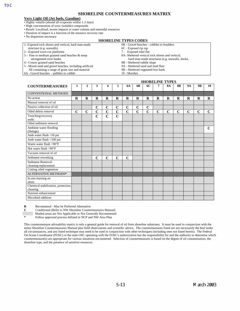
SHORELINE COUNTERMEASURES MATRIXVery Light Oil (Jet fuels, Gasoline)• Highly volatile (should all evaporate within 1-2 days)• High concentration of toxic (soluble) compounds• Result: Localized, severe impacts to water column and intertidal resources• Duration of impact is a function of the resource recovery rate• No dispersion necessary
SHORELINE TYPES CODES1- Exposed rock shores and vertical, hard man-made structure (e.g. seawalls)2 - Exposed wave-cut platforms3 - Fine to medium grained sand beaches & steep
unvegetated river banks4 - Course grained sand beaches5 - Mixed sand and gravel beaches, including artificial fill containing a range of grain size and material6A - Gravel beaches - pebbles to cobble
6B - Gravel beaches - cobbles to boulders6C - Exposed rip rap7 - Exposed tidal flat8A- Sheltered vertical rock shores and vertical,
hard man-made structures (e.g. seawalls, docks, 8B - Sheltered rubble slope9A - Sheltered sand and mud flats9B - Sheltered vegetated low bank10 - Marshes
SHORELINE TYPESCOUNTERMEASURES 1 2 3 4 5 6A 6B 6C 7 8A 8B 9A 9B 10
CONVENTIONAL METHODSNo action R R R R R R R R R R R R R RManual removal of oilPassive collection of oil C C C C C COiled debris removal C C C C C C C C C C C C C CTrenching/recoverywells
C C C
Oiled sediment removalAmbient water flooding(Deluge)
C
Amb water flush <50 psiAmb water flush <100 psiWarm water flush <90°FHot water flush >90°FVacuum removal of oilSediment reworking C C C CSediment Removal-cleaning-replacementCutting oiled vegetationALTERNATIVE METHODS*In-situ burning onshoreChemical stabilization, protection, cleaningNutrient enhancementMicrobial addition
R Recommend - May be Preferred AlternativeC Conditional (Refer to NW Shoreline Countermeasures Manual)
Shaded areas are Not Applicable or Not Generally Recommened* Follow approved process defined in NCP and NW Area Plan
This countermeasure advisability matrix is only a general guide for removal of oil from shoreline substrates. It must be used in conjunction with theentire Shoreline Countermeasures Manual plus field observations and scientific advice. The countermeasures listed are not necessarily the best underall circumstances, and any listed technique may need to be used in conjunction with other techniques (including ones not listed herein). The FederalOn-Scene Coordinator (FOSC) or the state OSC operating with the FOSC's authorization has the responsibility for and the authority to determine whichcountermeasure(s) are appropriate for various situations encountered. Selection of countermeasures is based on the degree of oil contamination, theshoreline type, and the presence of sensitive resources.
Ecology spills
5-13
Ecology spills
March 2003
Dale Davis
TOC

Purpose of Chapter 6 The information presented in this chapter highlights some of the more significant environmentally sensitive areas within the GRP region that could be impacted as a result of an oil spill. Consistent with the overall purpose of the GRP’s, this information is only intended to provide a level of detail required during the initial phase of spill response. During an actual event, additional resource information will be available from the resource trustee agencies supporting the Environmental Unit in the Planning Section. Specific resource concerns for areas that already have designated protection strategies in Chapter 4 of the GRP may be found in the “Resources Protected” column in the matrix describing the individual strategies. The information provided in Chapter 6 is intended for use in:
o Preparing an initial ICS 232 form (Resources-at-Risk summary) for Incident Command
o Identifying those sites where it may be necessary to implement Flight Restriction Zones in order to prevent disturbance/injury to sensitive wildlife species.
o Identifying sensitive shoreline habitats to assist SCAT teams in their initial assessments and
to help personnel in the Environmental Unit in developing appropriate cleanup strategies. Chapter 6 consists of two sets of maps and tables - one for wildlife and the other for fish, shellfish and selected sensitive marine habitats. These data are presented separately, both for ease of reading and because each of the two data sets has slightly different applications within the context of spill response. The wildlife maps and tables present information on the location and seasonal sensitivity of key wildlife resources. Types of data included here are concentration areas for waterfowl, marine birds and shorebirds; seabird colonies; nesting areas for sensitive species such as eagles, herons and falcons; and marine mammal haulout sites. This information is intended for the rapid identification of areas where significant wildlife oiling impacts could be anticipated and to denote areas where flight restriction zones may be required to protect sensitive wildlife. Each site depicted on these maps is identified by a unique number in order to facilitate the process of communicating Flight Restriction Zone recommendations to the Operations Section in ICS. The tables accompanying the wildlife maps present information on the season(s) during which sites may be particularly sensitive to disturbance. The fish/shellfish/marine habitat maps present general information on the location of baitfish spawning beaches, herring spawning areas, streams used by anadromous salmonids, hardshell clam concentrations, and kelp and eelgrass beds. This information will be most useful to personnel involved in assessing initial risks to fish and shellfish resources and to those conducting initial beach reconnaissance, pending availability of more detailed resource information and the formation of SCAT teams. Because the operational uses of this information differ from those of the wildlife data, individual site identification numbers have not been assigned. Tables associated with these maps will identify the seasonal sensitivity of each resource. In addition, notes accompanying each table will provide information on the general distribution and seasonal sensitivity of those resources that are not mapped but may occur anywhere in the GRP region (ex. juvenile salmonids in shallow nearshore waters).


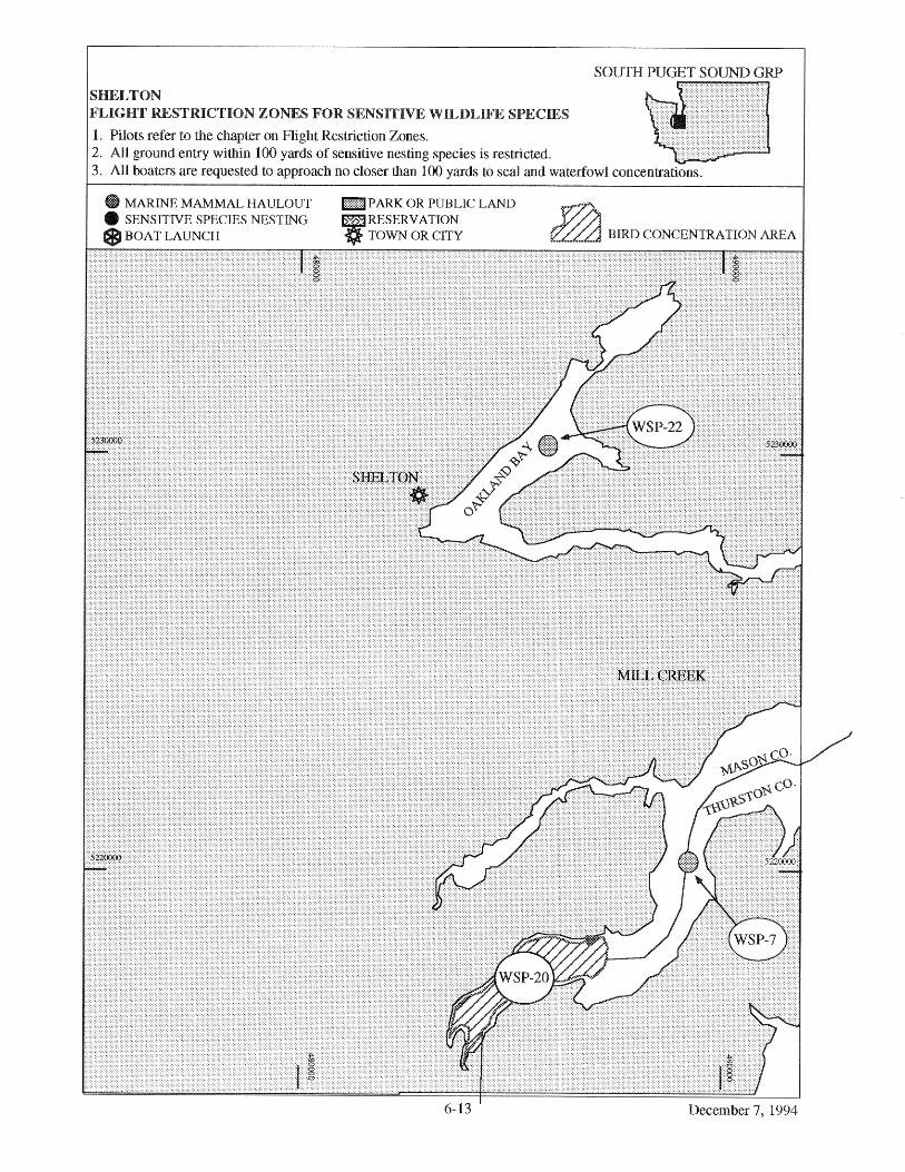

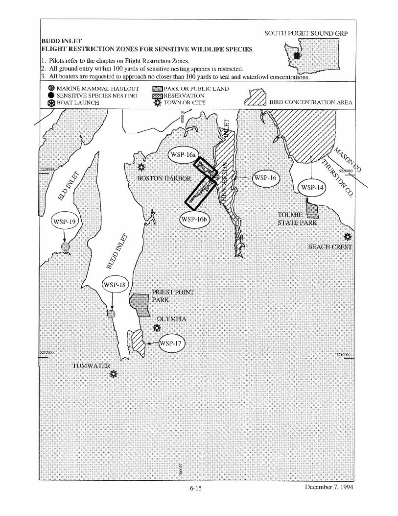


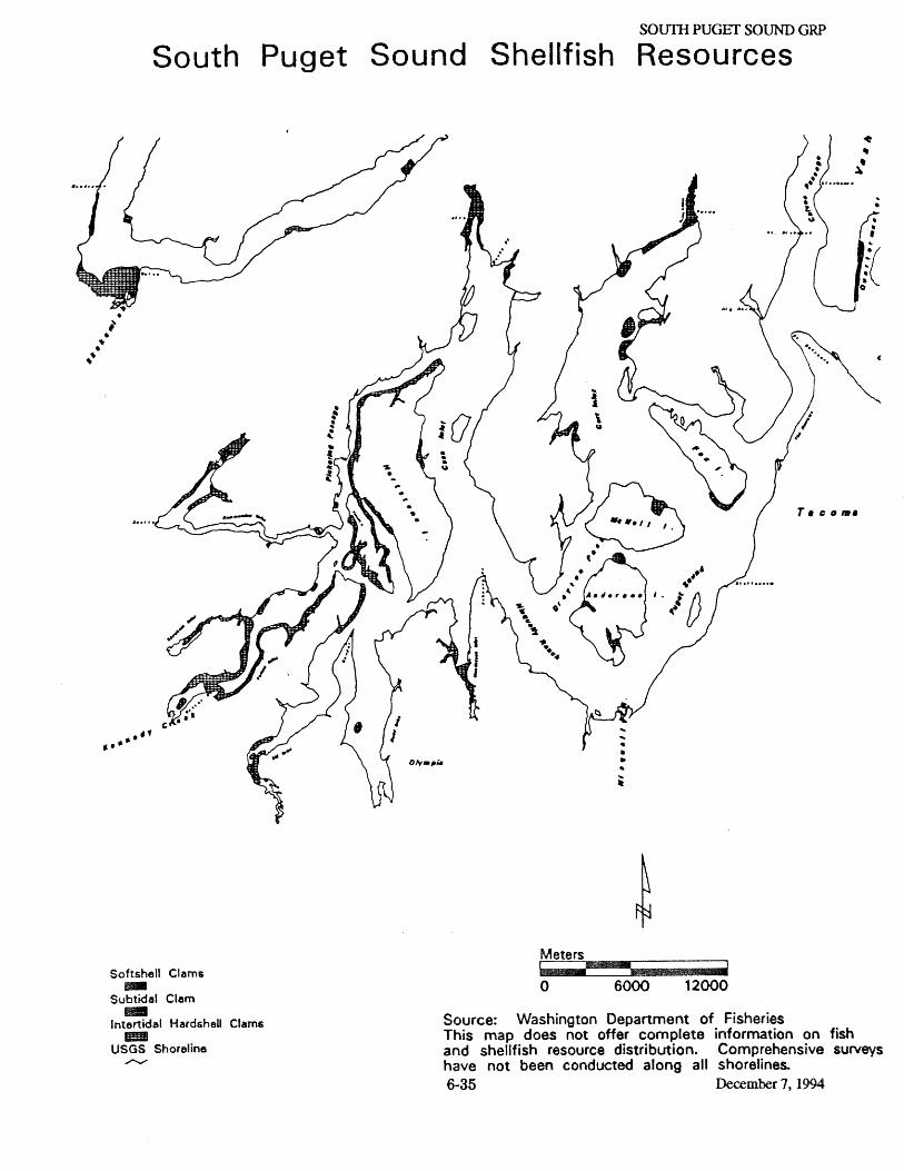


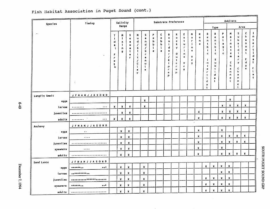


TOC SOUTH PUGET SOUND GRP
March 2003 A-1
APPENDICES
Appendix A: Summary of Protection Techniques
Protection Techniques Description Primary Logistical Requirements
Limitations
ONSHORE
Beach Berms A berm is constructed along the top of the mid-inter tidal zone from sediments ex-cavated along the downgradient side. The berm should be covered with plastic or geo-textile sheeting to minimize wave erosion.
• Bulldozer/Motor grader -1 • Personnel - equipment
operator & 1 worker • Misc. - plastic or geotextile
sheeting
• High wave energy • Large tidal range • Strong along shore
currents
Geotextiles A roll of geotextile, plastic sheeting, or other impermeable material is spread along the bottom of the supra-tidal zone & fastened to the underlying logs or stakes placed in the ground.
• Geotextile - 3 m wide rolls • Personnel - 5 • Misc. - stakes or tie-down
cord
• Low sloped
shoreline • High spring tides • Large storms
Sorbent Barriers A barrier is constructed by installing two parallel lines of stakes across a channel, fastening wire mesh to the stakes & filling the space between with loose sorbents.
Per 30 meters of barrier • Wire mesh - 70 m x 2 m • Stakes - 20 • Sorbents - 30 m2 • Personnel - 2 • Misc. - fasteners, support
lines, additional stakes, etc.
• Waves > 25 cm • Currents > 0.5 m/s • Tidal range > 2 m
Inlet Dams A dam is constructed across the channel using local soil or beach sediments to exclude oil from entering channel.
• Loader - 1 • Personnel - equipment
operator & 1 worker or several workers w/shovels
• Waves > 25 cm • Tidal range
exceeding dam height
• Freshwater outflow

TOC SOUTH PUGET SOUND GRP
March 2003 A-2
NEARSHORE
Containment Booming Boom is deployed in a "U" shape in front of the oncoming slick. The ends of the booms are anchored by work boats or drogues. The oil is contained within the "U" & prevented from reaching the shore.
For 150 meters Slick: • Boom - 280 m • Boats - 2 • Personnel - boat crews & 4
boom tenders • Misc. - tow lines, drogues,
connectors, etc.
• High winds • Swells > 2 m • Breaking waves >
50 cm • Currents > 1.0 m/s
Exclusion Booming Boom is deployed across or around sensitive areas & anchored in place. Approaching oil is deflected or contained by boom.
Per 300 meters of Boom • Boats - 1 • Personnel - boat crew & 3
boom tenders • Misc.- 6 anchors, anchor
line, buoys, etc.
• Currents > 0.5 m/s • Breaking waves >
50 cm • Water depth > 20 m
Deflection Booming Boom is deployed from the shoreline away from the approaching slick & anchored or held in place with a work boat. Oil is deflected away from shoreline.
Single Boom, 0.75 m/s knot current • Boom - 60 m • Boats - 1 • Personnel - boat crew + 3 • Misc. - 3 anchors, line,
buoys, recovery unit
• Currents > 1.0 m/s • Breaking waves >
50 cm
Diversion Booming Boom is deployed from the shoreline at an angle towards the approaching slick & anchored or held in place with a work boat. Oil is diverted towards the shoreline for recovery.
Single Boom, 0.75 m/s knot current • Boom - 60 m • boats - 1 • Personnel - boat crew + 3 • Misc. - 3 anchors, line,
buoys, recovery unit
• Currents > 1.0 m/s • Breaking waves >
50 cm
Skimming Self-propelled skimmers work back & forth along the leading edge of a windrow to recover the oil. Booms may be deployed from the front of a skimmer in a "V" configuration to increase sweep width. Portable skimmers are placed within containment booms in the area of heaviest oil concentration.
Self-propelled (None) Towed • Boom - 200 m • Boats - 2 • Personnel - boat crews & 4
boom tenders • Misc. - tow lines, bridles,
connectors, etc. Portable • Hoses - 30 m discharge • Oil storage - 2000 liters
• High winds • Swells > 2 m • Breaking waves >
50 cm • Currents > 1.0 m/s
Source is R. Miller of Clean Sound Cooperative.

TOC SOUTH PUGET SOUND GRP
March 2003 B-1
Appendix B: Original Geographic Response Plan Contributors
Local Representatives Byron Haley, Metro Park District Tacoma Ed Bruett, Kitsap Co. DEM Richard Lawson, Tacoma Fire Dept. John Komorita, King County Bill Lokey, Pierce County DEM Shad Burcham, King County DEM Industry and Response Contractors Ruel Harder, Seattle Steam Co. Bob Wiechert, Clean Sound Cooperative Mike Kelley, Clean Sound Cooperative Mac McCarthy, Clean Sound Cooperative John Waters, Clean Sound Cooperative Bob Bunton, ARCO Svenk Eklof, PWES John Murphy, GENWEST SYS. John Crawford, FOSS Steve Collar, Crowley Marine Greg Narum, Simpson Tacoma Kraft Co. Bill Park, MSRC Mike LaTorre, MSRC Dru Wojtanik, Ecology and Environment Tim Clark, Clean Sound Cooperative Thom Davis, Global Environmental Ron Larsen, Global Environmental Gary Putnam, Shell Oil Aaron Anderson, Olympus Enviro. Edward Traina, Shell Oil Co. Donald Johnson, Shell Oil Co. Karen Grein-Nagle, Olympic Pipeline Mike Mattingly, AIRO Services Ray Burke, Sound Refining Mike Brady, Riedel Environmental Services Trygve Enger, Foss Environmental Trip Ellison, Riedel Environmental Services Jim Riedel, Riedel Environmental Services Dick Shabro, Olympus Enviro Harold Haskins, U.S. Oil Harry Hutchins, Marine Exchange Mike Vomund, Chevron Global Diving and Salvage Federal Representatives U.S. Coast Guard Curtis Shaw Bill Edgar Environmental Protection Agency Carl Kitz
U.S. Navy Greg Conner Bob Cairns Donald Dodds NOAA Sharon Christopherson George Galasso U.S. Fish and Wildlife Service Curtis Shaw Jeff Momot State Representatives Office of Archeology & Historic Preservation Rob Whitlam Washington State Department of Ecology Paul O’Brien Dick Logan Paul Heimowitz Jeff Bash Dick Storey Elin Abramson Scott Zimmerman Karen Rennaker David Mora Bridget Hoover Shari Harris-Dunning Washington Department of Fish and Wildlife Brian Benson Bill Graeber Barry Troutman Jeff Skriletz Sara LaBorde Office of Marine Safety Roy Robertson Washington State Maritime Commission Bob Dorn Washington Department of Natural Resources Dave Jamison Parks and Recreation Commission Mike Ramsey Other Susan Berta, WSU Island Co. Beach Watchers Richard Shafer Shirley Flies, Puget Sound Alliance Ken Moser, Puget Soundkeeper

TOC SOUTH PUGET SOUND GRP
C-1 March 2003
Appendix C: Geographic Response Plan Comments/Corrections/Suggestions
If you have any questions regarding this document or find any errors, please notify one of the following agencies: or use tear out sheet (page C-3) • Washington Department of Ecology, SPPR program, Natural Resources Unit • USCG Marine Safety Office Puget Sound, Planning Department • USCG Marine Safety Office Portland • Oregon Department of Environmental Quality • Idaho Emergency Response Commission • Environmental Protection Agency Region 10 Phone Numbers: Washington DOE (360) 407-6972 USCG MSO Puget Sound (206) 217-6213 USCG MSO Portland (503) 240-9307 Oregon DEQ (503) 229-5774 Idaho ERC (208) 334-3263 EPA (206) 553-6901
Bulletin Board System (BBS): USCG MSO Puget Sound (206) 217-6216 USCG MSO Portland (503) 240-9308
Internet/E-mail Address: WADOE [email protected] OR DEQ [email protected] USCG MSO Puget Sound [email protected] USCG MSO Portland [email protected] USEPA [email protected] Address: Commanding Officer United States Coast Guard MSO Puget Sound Planning Department 1519 Alaskan Way South Seattle, WA 98134-1192 Commanding Officer United States Coast Guard Planning Department MSO Portland 6767 North Basin Ave Portland, OR 97217-3992
Washington Department Of Ecology SPPR Program Natural Resources Unit P.O. Box 47600 Olympia, WA 98504-7600 Oregon Department of Environmental Quality Water Quality Division 811 SW Sixth Avenue Portland, OR 97204
Office Of The Governor Idaho Emergency Response Commission 1109 Main Statehouse Boise, ID 83720-7000 Environmental Protection Agency Emergency Response Branch 1200 Sixth Avenue Seattle, WA 98101

TOC SOUTH PUGET SOUND GRP
C-2 March 2003
Geographic Response Plan
Comments/Corrections/Suggestions Directions: Fill in your name, address, agency, and phone number. Fill in the blanks regarding the location of information in the plan being commented on. Make comments in the space provided. Add extra sheets as necessary. Submit to: Dale Davis Department of Ecology Spills Program 300 Desmond Drive P.O. Box 47600 Olympia, WA 98504-7600 [email protected] Name: __________________________ Title:____________ Agency: Address: City: ___________________________ State/Province:______ Zip/Postal Code: Phone: (____) ____________________ E-Mail: GRP: ___________________________ Page Number: Location on page (chapter, section, paragraph) (e.g. 2.1, paragraph 3):_____________________________ Comments:

Northwest Area Committee
c/o Washington Department of Ecology Spills Program Natural Resources Unit - GRP Corrections P.O. Box 47600 Olympia, WA 98504-7600
Related Documents