Відкритий семінар «Застосування відкритих геоінформаційних систем для запобігання наслідкам повеней, землетрусів і зсувів» за результатами проекту «Формування наукової мережі для попередження ризиків землетрусів, зсувів і повеней» A Scientific Network for Earthquake, Landslide and Flood Hazard Prevention(«SciNetNatHaz») 13 жовтня 2015 р., ОНМА, Ізмаїл

Welcome message from author
This document is posted to help you gain knowledge. Please leave a comment to let me know what you think about it! Share it to your friends and learn new things together.
Transcript

Відкритий семінар
«Застосування відкритих геоінформаційних
систем для запобігання наслідкам повеней,
землетрусів і зсувів»
за результатами проекту
«Формування наукової мережі для
попередження ризиків землетрусів,
зсувів і повеней»
A Scientific Network for Earthquake,
Landslide and Flood Hazard
Prevention(«SciNetNatHaz»)
13 жовтня 2015 р., ОНМА, Ізмаїл

Natural Hazards – Natural Disasters

Natural Hazards – Natural Disasters Natural hazards can lead to Natural Disasters when
combined with vulnerability and insufficient capacity to
reduce the potential chances of risk

Natural Disaster Mitigation
Disaster mitigation is the ongoing effort to reduce the impact disasters
have on people and property. Because of the varying degree of each
natural disaster, there are different mitigation strategies for each.
Disaster Mitigation as a management process can be divided into:
pre-event measures,
actions during and immediately following an event, and
post-disaster measures.
Key elements for Natural Disaster mitigation are:
Hazard Identification and Risk assessment and
Applied Research and Technology transfer

Natural Disaster Mitigation as a Management Process Depends heavily on it’s first stage:
pre-event measures are the most cost effective, provided that
they are based on accurate and reliable Hazard Identification and
Risk Assessment
…. Which in turn, are based on:
Accurate and Reliable Data
Scientifically proven (after being adapted to local conditions,
tested and accepted) Methodologies
The necessity of the aforementioned is more evident considering
that Hazard Identification and Risk Assessment provide the
background needed for the effective planning of the rest of the
Disaster Mitigation stages (actions during and immediately following
an event, and post-disaster measures)

Problems & Drawbacks …in respect to the Scientific Community of the Black Sea wider area
Lack of RELIABLE information
The COST of required DATA
Lack of SYSTEMATIC hazard assessment
Lack of a “common ground” in terms of Methodologies and Procedures
adapted so that results can be comparable
Lack of a scientific body that will provide assistance, advice, support to
decision makers and will help COORDINATE joint actions
…and regarding the local administration
Not imposed LEGAL FRAMEWORK
Lack of PUBLIC AWARENESS

Problems & Drawbacks – are they recognized?

Problems & Drawbacks – are they recognized?

Scope of the SciNetNatHaz Project
To establish a strong regional (BS) cooperation by developing a
Scientific Network for Earthquake, Landslide and Flood Hazard
prevention that will set the basis for:
Systematic data acquisition, harmonization, management and
disposal to the scientific community
Standardization of Methodologies and Procedures adapted
A systematic Hazard assessment
The formation of a Scientific body that will provide assistance,
advice and support to decision makers, to local communities,
to public bodies and that will help coordinate JOINT ACTIONS

The Partnership
ENPI partners
Tech. Edu. Institute of Serres, Applicant & Lead Partner * Hellas
Earthquake Planning & Protection Organisation-EPPO /Thessaloniki branch.
The Institute of Engineering Seismology & Earthquake Design * Hellas
Civil Engineering Dept., Democritus University of Thrace * Hellas
Burgas Assen Zlatarov University , Burgas* Bulgaria
Ovidius University of Constanta, Constanta * Romania
“Dr. Ghitu” Institute of Electronic Engineering & Nanotechnology, Academy
of Sciences * Moldova
The Black Sea Branch of the Ukranian Environmental Academy of Sciences,
Odessa * Ukraine
IPA partner
Kandilli Observatory & Earthquake Research Institute, Bogazici University,
Istanbul * Turkey

Expected Results Closer scientific cooperation among the participants Data and meta-data harmonization provisions according to EU
directives/regulations Methodologies adapted to local conditions (tested and proven) Hazard assessment maps in various scales Pilot implementation of the proposed methodologies A geo-database & WebGIS that will provide reliable and accurate data
(as related to various scales implementing Natural Hazard assessment methodologies) tested through certified procedures
A Web-page that will provide information to scientists and to the public regarding Natural Hazards in the area
The formation of an initial scientific group that will be joined by others at a following stage

BSB Programme Structure
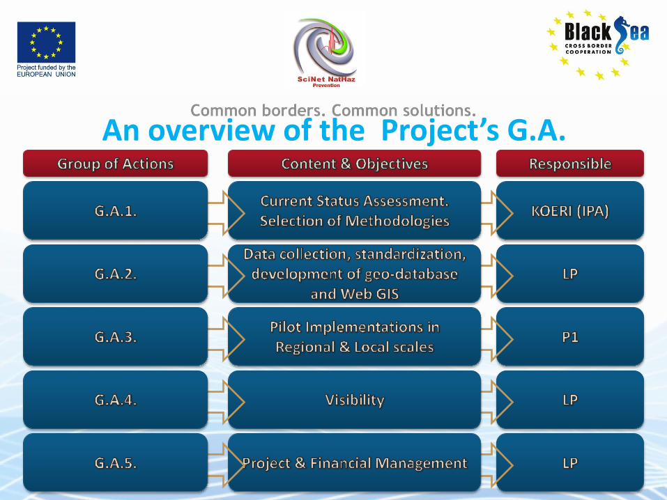
An overview of the Project’s G.A.

G.A. Implementation Structure

The Reason for proposing such a Structure
This Structure ensures that each partner will be responsible for at least on
Action. In this respect he will understand and get used to issues regarding:
Communication
Cooperation
Coordination
Timely provision of deliverables …and hopefully, we will all achieve a high level of cooperation
MAPPING THE FLASH FLOOD PRONE AREA IN THE TAITA WATERSHED (ROMANIA) USING TOPOGRAPHIC INDEXES AND HYDRAULIC MODEL
C. Maftei K. Papatheodorou
ICNAR 2014

Dobrogea region
• Location
• Geo-morphology
• Climate
• Temperature
• Precipitation
• Hydrology
33

Flood problem in the Dobrogea region No Town, village Date Characteristics Damages
1. Garlița 1963;1971 -
30 household teared down and animals taken away by the floods
2. Casian 24.09.1968 442mc/s*
Households and crops destroyed, human lives lost
3. Lumina 1967 - Flooded households and destroyed
4. Runcu 11.06.1985 h apa=1.60 m Households destroyed and 5 deaths
5. Baia 16.07.1967 - Households and gardens flooded
6. Constanța 01.07.1992;28
,29.08.2004 rainfall >200 mm/12 h
Households flooded in the Western area , 3 deaths
7. Nuntaşi/Nuntasi 01-11.09.1999 32.mc/s (fig. ) Households and gardens flooded, 1 death
8. Cheia 02.-
04.09.1999 -
Households and gardens flooded, school
9. Costineşti 22-23.09.2005
Flood coming from upstream, at Biruinta registeredt>300mm/2
4 h
Damages to the railway, access roads, restaurants, households in Schitu
10. Casimcea/Casimce
a Cheia/Casimcea
30 - 31 V 2002 8 - 9 VIII 2002
398mc/s* 384mc/s*
Households and gardens flooded, access bridge damaged
11 Cuza Voda/Agi
Cabul 2 - 4 IX 1999 57,8 *
no
12 Negureni, Valea
Marea 2-7 IX 1999 26,8 *
no
13 Albesti 30 - 31 V 2000 153 mc/s*
14 Sacele, raul Valea
Sacele 8 - 9 VIII 2002 45mc/s*
15 Saraiu, raul
Topolog 2 - 20 VII 2005 214 mc/s*
16 Biruinta,/ Valea
Biruinta
20 - 25 IX 2005
131 mc/s*
17 Urluia/V.Urluia 14-19 VI 1992 10.6mc/s*
18 Taita/Taita 3.03.1985 56.6mc/s
34

Study area and • Taita catchment
• area 591 km2
• elevation ranges 261m
• 10 tributaries
• part of North Dobrogea Plateau
• the main source of supply –precipitation 74%
• The hydrometric data are collected in two hydrometric stations: • Hamcearca • Satu Nou
• Vegetation • >33% forest
35

…data base
• In this study the series of annual maximum stream flow, covering the period 1968 (1965)-2010 have been used.
36

Mapping the flood prone area
37
Flood map hazard
Calibrate
Flooding mapping proposed
Topographic
DEM
Roughnes map flood
frequency
Geomorphological
model
gauged
basins?
yes
determining T-years
discharge
Hydraulic model
Flood parameters
WS profile
WS depth
no Observed data
Land use
roughness coeff.
Historical flood event
Historical map
river profiles
cross section

39
Topographic Wetness Index (TWI) & SAGA Wetness Index (SWI)
Calculation Model
Geomorphological Model
• Beven, K. and Kirkby, M. : A physical variable contributing area model of catchment hydology, Hydrolog. Sci. Bull., 24(1), 43– 69, (1979). • Moore, I. D., Burch, G. J., and Mackenzie, D. H.: 'Topographic effects on the distribution of surface soil water and the location of ephemeral gullies', Trans.
Am. Soc. Agr. Engrs., 31, 1098- 1107, (1988). • Sørensen R., U. Zinko, and J. Seibert: On the calculation of the topographic wetness index: evaluation of different methods based on field observations.
Hydrol. Earth Sys. Sci. Discuss., 2, 1807–1834, European Geosciences Union, (2005).
• Boehner, J., Koethe, R. Conrad, O., Gross, J., Ringeler, A., Selige, T.: Soil Regionalisation by Means of Terrain Analysis and Process Parameterisation. In: Micheli, E., Nachtergaele, F., Montanarella, L. [Ed.]: Soil Classification 2001. European Soil Bureau, Research Report No. 7, EUR 20398 EN, Luxembourg. pp.213-222, (2002)
Software Used
TWI
As: Accumulation per unit
contour length
β: slope

Geomorphological Model - Results
40
Geodetic Reference System: Dealul Piscului 1970/ Stereo 70
Software Used
Geodetic Reference System: Dealul Piscului 1970/ Stereo 70
Stream Power
Index
Terrain
Ruggedness
Index
Topographic Wetness Index (TWI)
SAGA T.W.I.

Results hydraulic model
41
50 years return period 1000 years return period

Comparison of Results
42
Geodetic Reference System:
Dealul Piscului 1970/ Stereo 70

Conclusions (3/3)
45
To demonstrate the broad applicability of the selected
methodologies, open source software was used to
store, process data and create maps.
As resulted, Quantum GIS (v.2.1), SAGA GIS (v.2.08)
and HEC-RAS can be effectively used to fully apply the
proposed methodological approach as they provide
very reliable platforms at no cost.
Acknowledgments: The research was partially funded by the EU within the context of the Black Sea Basin Joint Operational Programme 2007-2013

A Scientific Network for Earthquake, Landslide and Flood
Hazard Prevention
The Project
Thank You!
Related Documents