Top Banner
© David Last 14-15 November 2014 La Coruña, Spain Satellite Navigation – Where’s it Taking Us Now? Professor David Last Picture: earthobservatory.nasa. gov//ewsroom/ BlueMarble/ International Sail Training & Tall Ships Conference
37

© David Last 14-15 November 2014 La Coruña, Spain Satellite Navigation – Where’s it Taking Us Now? Professor David Last Picture: earthobservatory.nasa.

Dec 17, 2015

Download

Documents

Andra Sparks
Welcome message from author
This document is posted to help you gain knowledge. Please leave a comment to let me know what you think about it! Share it to your friends and learn new things together.
Transcript
Page 1: © David Last 14-15 November 2014 La Coruña, Spain Satellite Navigation – Where’s it Taking Us Now? Professor David Last Picture: earthobservatory.nasa.

© David Last

14-15 November 2014La Coruña, Spain

Satellite Navigation – Where’s it Taking Us Now?

Professor David Last

Picture: earthobservatory.nasa.gov//ewsroom/BlueMarble/

International Sail Training & Tall Ships Conference

Page 2: © David Last 14-15 November 2014 La Coruña, Spain Satellite Navigation – Where’s it Taking Us Now? Professor David Last Picture: earthobservatory.nasa.

© David Last

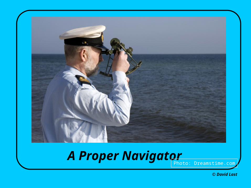
A Proper NavigatorPhoto: Dreamstime.com

Page 3: © David Last 14-15 November 2014 La Coruña, Spain Satellite Navigation – Where’s it Taking Us Now? Professor David Last Picture: earthobservatory.nasa.

From: May, V., ‘The first handheld aviation navigator’, Navigation News Nov/Dec 2001, pp8-9..

Page 4: © David Last 14-15 November 2014 La Coruña, Spain Satellite Navigation – Where’s it Taking Us Now? Professor David Last Picture: earthobservatory.nasa.

From: www.garmin.com/marine

Page 5: © David Last 14-15 November 2014 La Coruña, Spain Satellite Navigation – Where’s it Taking Us Now? Professor David Last Picture: earthobservatory.nasa.

Photo: Ashtech Inc., Optron Pty.

Page 6: © David Last 14-15 November 2014 La Coruña, Spain Satellite Navigation – Where’s it Taking Us Now? Professor David Last Picture: earthobservatory.nasa.

From: www.cellphonesforbusiness.com/ www.samsung.com

Page 7: © David Last 14-15 November 2014 La Coruña, Spain Satellite Navigation – Where’s it Taking Us Now? Professor David Last Picture: earthobservatory.nasa.

© David Last

Page 8: © David Last 14-15 November 2014 La Coruña, Spain Satellite Navigation – Where’s it Taking Us Now? Professor David Last Picture: earthobservatory.nasa.

© David Last

Pictures: https://itunes.apple.com/gb/app/nika-glonass/id668566712?mt=8, http://www.engadget.com/2011/10/20/iphone-4s-supports-glonass-satellite-system-much-to-the-delight/

Page 9: © David Last 14-15 November 2014 La Coruña, Spain Satellite Navigation – Where’s it Taking Us Now? Professor David Last Picture: earthobservatory.nasa.

© David Last

Pictures: www.readio.com/new-york-hotel/pictures/warwick-hotel-new-york-city-pictures.jpg, pantransit.reptiles.org/images/1996-07-28/washington-rain-forest.png, www.at-bristol.org.uk/open/carpark.htm

Page 10: © David Last 14-15 November 2014 La Coruña, Spain Satellite Navigation – Where’s it Taking Us Now? Professor David Last Picture: earthobservatory.nasa.

Picture: europa.eu.int/comm/dgs/energy_transport/galileo/intro/index_en.htm

Page 11: © David Last 14-15 November 2014 La Coruña, Spain Satellite Navigation – Where’s it Taking Us Now? Professor David Last Picture: earthobservatory.nasa.

© David Last, University of Wales, Bangor

GALILEOEuropean Satellite NavigationSystem

What’s new?

• Real-time integrity - warning of failure• Legal service guarantees• Multi-nation control• Commercial service-provider• Civil, not military

Page 12: © David Last 14-15 November 2014 La Coruña, Spain Satellite Navigation – Where’s it Taking Us Now? Professor David Last Picture: earthobservatory.nasa.

• Technically compatible • More satellites• Higher accuracy

… plus …?

Picture: europa.eu.int/comm/dgs/energy_transport/galileo/intro/index_en.htm

Galileo plus GPS

Page 13: © David Last 14-15 November 2014 La Coruña, Spain Satellite Navigation – Where’s it Taking Us Now? Professor David Last Picture: earthobservatory.nasa.

GPS plus …

GLONASS Galileo Compass-Beidou (Russia) (Europe) (China)

• More satellites• Technically compatible • Higher performance

QZSS IRNSS(Japan) (India)

Page 14: © David Last 14-15 November 2014 La Coruña, Spain Satellite Navigation – Where’s it Taking Us Now? Professor David Last Picture: earthobservatory.nasa.

© David Last

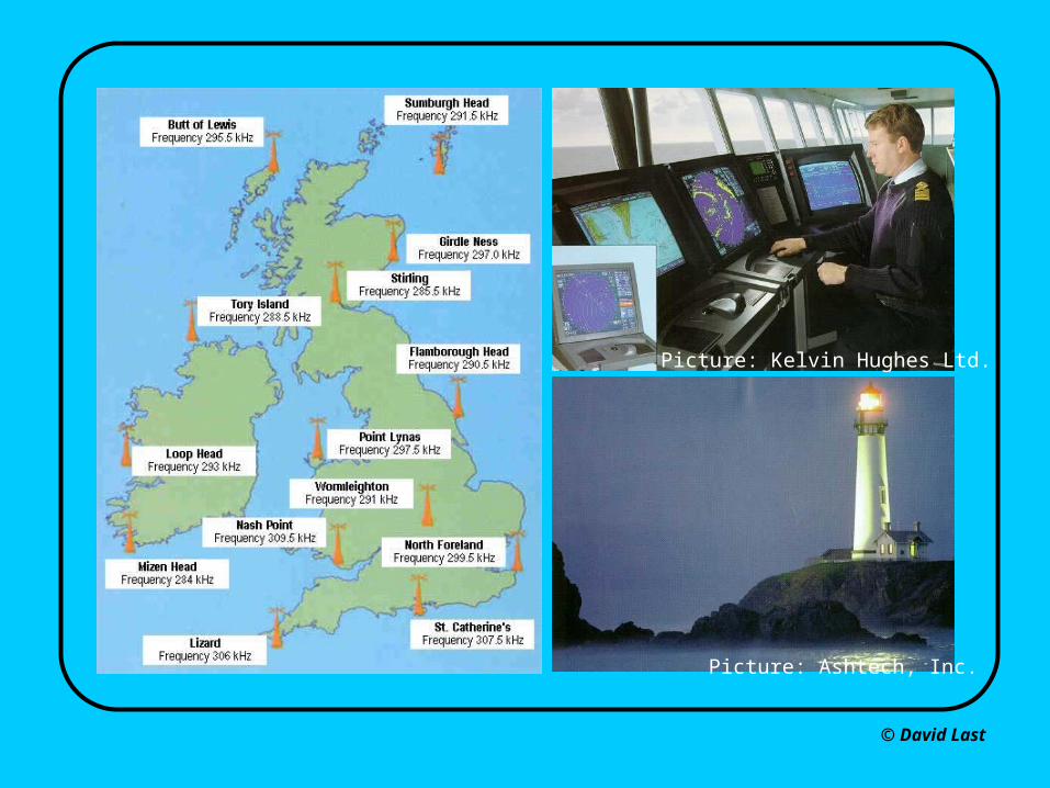
Picture: Ashtech, Inc.

Picture: Kelvin Hughes Ltd.

Page 15: © David Last 14-15 November 2014 La Coruña, Spain Satellite Navigation – Where’s it Taking Us Now? Professor David Last Picture: earthobservatory.nasa.

WAAS &EGNOS + RAIM Figure: European Space Agency

Figure: http://www.airrouting.com/gps-raim-prediction.html

Page 16: © David Last 14-15 November 2014 La Coruña, Spain Satellite Navigation – Where’s it Taking Us Now? Professor David Last Picture: earthobservatory.nasa.

andIRNSS (India)

GPS plus …

QZSS (Japan) GALILEO (Europe) IRNSS (India)

GLONASS (Russia) Compass-Beidou (China)

… and all the augmentations:

Page 17: © David Last 14-15 November 2014 La Coruña, Spain Satellite Navigation – Where’s it Taking Us Now? Professor David Last Picture: earthobservatory.nasa.

Dover Strait – 28 days’ traffic records

Page 18: © David Last 14-15 November 2014 La Coruña, Spain Satellite Navigation – Where’s it Taking Us Now? Professor David Last Picture: earthobservatory.nasa.

© David Last

Satellite and Control System Failures

Official announcement: "A significant GPS anomaly occurred on 1 Jan 04... (which) … resulted in the transmission of Hazardously Misleading Information."

Sources: Vogel, Macabiau & Suard, ‘Effect of a GPS Anomaly on Different GNSS Receivers’, ION GNSS 2005, Long Beach, CA, Sep 13-16, 2005, Hoppe & Walterfang, ‘Investigation of a GPS Satellite Problem with respect to DGPS and GPS users’, European Journal of Navigation, May 2004, www.lr.tudelft.nl/live/pagina.jsp?id=400f4487-ed8c-4274-95cb-ebc2afa7385e&lang=en

SVN23 clock failure

Page 19: © David Last 14-15 November 2014 La Coruña, Spain Satellite Navigation – Where’s it Taking Us Now? Professor David Last Picture: earthobservatory.nasa.

© David Last

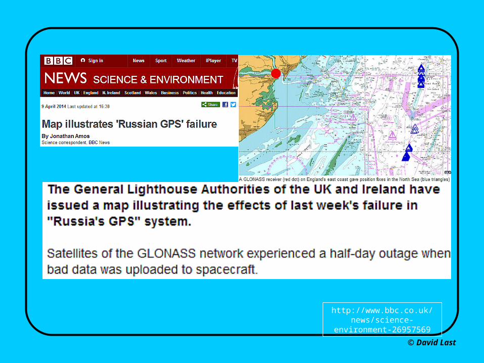
http://www.bbc.co.uk/news/science-environment-26957569

Page 20: © David Last 14-15 November 2014 La Coruña, Spain Satellite Navigation – Where’s it Taking Us Now? Professor David Last Picture: earthobservatory.nasa.

© David Last

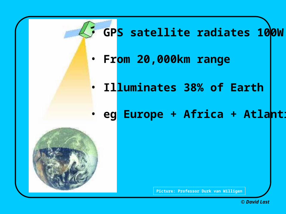
Picture: Professor Durk van Willigen

• GPS satellite radiates 100W

• From 20,000km range

• Illuminates 38% of Earth

• eg Europe + Africa + Atlantic

Page 21: © David Last 14-15 November 2014 La Coruña, Spain Satellite Navigation – Where’s it Taking Us Now? Professor David Last Picture: earthobservatory.nasa.

© David Last

Solar flares

“The burst produced 20,000 times more radio emissionthan the … rest of the sun … and swamped GPSreceivers over the entire sunlit side of the Earth.”

Page 22: © David Last 14-15 November 2014 La Coruña, Spain Satellite Navigation – Where’s it Taking Us Now? Professor David Last Picture: earthobservatory.nasa.

© David Last

Picture: www.flickr.com/photos/l23productions/1451697290/

Page 23: © David Last 14-15 November 2014 La Coruña, Spain Satellite Navigation – Where’s it Taking Us Now? Professor David Last Picture: earthobservatory.nasa.

A small jammer on this cliff-top disrupted GPS on vesselsout to ranges as wide as the Dover Strait

Page 24: © David Last 14-15 November 2014 La Coruña, Spain Satellite Navigation – Where’s it Taking Us Now? Professor David Last Picture: earthobservatory.nasa.

© David Last

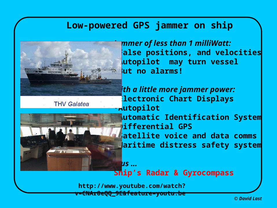
Low-powered GPS jammer on ship

Jammer of less than 1 milliWatt: •False positions, and velocities •Autopilot may turn vessel•But no alarms!

With a little more jammer power:•Electronic Chart Displays•Autopilot•Automatic Identification System•Differential GPS•Satellite voice and data comms•Maritime distress safety system

plus …Ship’s Radar & Gyrocompass

http://www.youtube.com/watch?v=CNAr8eQQ_9E&feature=youtu.be

Page 25: © David Last 14-15 November 2014 La Coruña, Spain Satellite Navigation – Where’s it Taking Us Now? Professor David Last Picture: earthobservatory.nasa.
Page 26: © David Last 14-15 November 2014 La Coruña, Spain Satellite Navigation – Where’s it Taking Us Now? Professor David Last Picture: earthobservatory.nasa.

© David Last

xx

Pictures: www.jammer-store.com/gj5-gps-l1-l2-l5-jammer-blocker.html

Jammers like this already on our streets can block all frequenciesof GPS and Galileo, Compass-Beidou & GLONASS, plus theEGNOS, WAAS, QZSS & GAGAN augmentation systems.

Page 27: © David Last 14-15 November 2014 La Coruña, Spain Satellite Navigation – Where’s it Taking Us Now? Professor David Last Picture: earthobservatory.nasa.

Pictures: wikipedia.org, dailymail.co.uk, insidegnss.com, youtube.com

Page 28: © David Last 14-15 November 2014 La Coruña, Spain Satellite Navigation – Where’s it Taking Us Now? Professor David Last Picture: earthobservatory.nasa.
Page 29: © David Last 14-15 November 2014 La Coruña, Spain Satellite Navigation – Where’s it Taking Us Now? Professor David Last Picture: earthobservatory.nasa.

Picture based on: http://www.amcsearch.com.au

Page 30: © David Last 14-15 November 2014 La Coruña, Spain Satellite Navigation – Where’s it Taking Us Now? Professor David Last Picture: earthobservatory.nasa.

© David Last

eNa

Picture: General Lighthouse Authorities of the UK & Ireland

eNavigation is coming!

Page 31: © David Last 14-15 November 2014 La Coruña, Spain Satellite Navigation – Where’s it Taking Us Now? Professor David Last Picture: earthobservatory.nasa.

© David Last

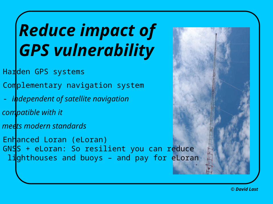
Reduce impact ofGPS vulnerability• Harden GPS systems

• Complementary navigation system

- independent of satellite navigation

- compatible with it

- meets modern standards

• Enhanced Loran (eLoran)• GNSS + eLoran: So resilient you can reduce lighthouses and buoys – and pay for eLoran

Page 32: © David Last 14-15 November 2014 La Coruña, Spain Satellite Navigation – Where’s it Taking Us Now? Professor David Last Picture: earthobservatory.nasa.

© David Last

Pictures: Mitchell Narins, Federal Aviation Administration; Reelektronika bv

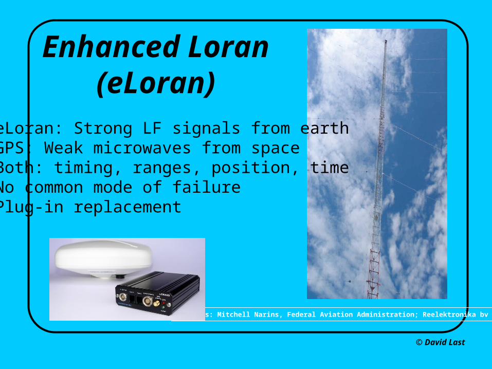
Enhanced Loran(eLoran)

• eLoran: Strong LF signals from earth • GPS: Weak microwaves from space• Both: timing, ranges, position, time• No common mode of failure • Plug-in replacement

Page 33: © David Last 14-15 November 2014 La Coruña, Spain Satellite Navigation – Where’s it Taking Us Now? Professor David Last Picture: earthobservatory.nasa.

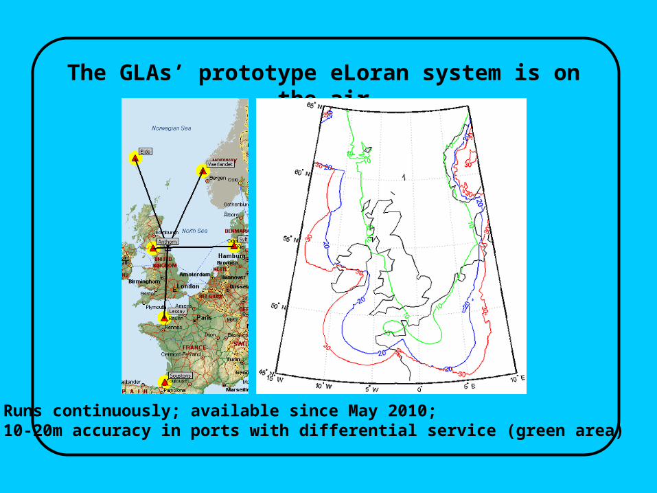
The GLAs’ prototype eLoran system is on the air

Runs continuously; available since May 2010; 10-20m accuracy in ports with differential service (green area)

Page 34: © David Last 14-15 November 2014 La Coruña, Spain Satellite Navigation – Where’s it Taking Us Now? Professor David Last Picture: earthobservatory.nasa.

Pictures: www.bbc.co.uk/news/science-environment, www.telegraph.co.uk/technology/news, www.dailymail.co.uk/sciencetech, www.ft.com

Page 35: © David Last 14-15 November 2014 La Coruña, Spain Satellite Navigation – Where’s it Taking Us Now? Professor David Last Picture: earthobservatory.nasa.

© David Last

Picture: General Lighthouse Authorities of the UK & Ireland

On 28 February 2013, the Trinity House Vessel Galatea reverted automatically to eLoran when GPS was jammed. Galatea

continued seamlessly on track, reporting eLoran positions to nearby ships and the Vessel Traffic Service ashore.

Page 36: © David Last 14-15 November 2014 La Coruña, Spain Satellite Navigation – Where’s it Taking Us Now? Professor David Last Picture: earthobservatory.nasa.

Picture: www.insidegnss.com

Page 37: © David Last 14-15 November 2014 La Coruña, Spain Satellite Navigation – Where’s it Taking Us Now? Professor David Last Picture: earthobservatory.nasa.

© David Last

14-15 November 2014La Coruña, Spain

Satellite Navigation – Where’s it Taking Us Now?

Professor David Last

Picture: earthobservatory.nasa.gov//ewsroom/BlueMarble/

International Sail Training & Tall Ships Conference