spatial planning in denmark
Spatial planning aims to create and maintain the qualities of urban
areas and the countryside. Spatial planning in Denmark provides a
rapid overview of the stipulations of and opportunities in Denmark’s
Planning Act and describes national planning, regional spatial develop-
ment planning, municipal planning and local planning.
This publication describes the principles of the Planning Act related to
decentralization of responsibility, framework management and public
participation in the planning process. The planning rules for coastal
areas, retail trade and large projects that may require environmental
impact assessment are described succinctly. Finally, the publication
explains the purpose of dividing Denmark’s territory into urban zones,
summer cottage areas and rural zones and the rules for development
in rural zones.
planning
spatial
in denmark

Spatial planning in Denmark
© 2007 by the Ministry of the Environment, Denmark.
All rights reserved. Published 2007.
Quotations may be made from this publication with appropriate
attribution.
Text: Ministry of the Environment
Niels Østergård and Helle Witt
Translation: David Breuer
Design: Tegnestuen Jens V. Nielsen
Maps: Ministry of the Environment
unless otherwise specified
Photos: Jens V. Nielsen
Photo p. 16: Jan Kofod Winther / C. F. Møller Architects
Printing: Vilhelm Jensen & Partners
ISBN print: 978-87-92256-01-0
ISBN web: 978-87-92256-00-3
Distribution
This publication is available from:
Frontlinien
Rentemestervej 8
DK-2400 Copenhagen NV
Telephone: +45 70 12 02 11
E-mail: [email protected]
The publication can also be downloaded at the web site of the Agency
for Spatial and Environmental Planning (www.blst.dk).
51st iFHp World Congress 2007
The Realdania Foundation has supported this publication in connection
with the 51st IFHP World Congress: Futures of Cities – Impacts: Indicators:
Implementations in Copenhagen, Denmark, 23–26 September 2007.
www.IFHP2007Copenhagen.dk
Plan09 is a partnership project between the Realdania
Foundation and the Ministry of the Environment on
developing and renewing the planning culture in
Denmark’s municipalities. The purpose is to contribute
to qualifying the future planning basis in Denmark’s 98
municipalities. Plan09 is being implemented from 2006
to 2009. Plan09 supports demonstration projects in
selected municipalities and is carrying out numerous
activities to share knowledge and spark debate:
presentations, reports, seminars, lectures, the web site
www.plan09.dk and an electronic network.
Centre for Corporate Management
Agency forSpatial and
Environmental Planning
Danish Environmental
Protection Agency
Danish Forest
and Nature Agency
Environmentcentres:
Minister’s
Department
Aalborg
National Survey
and Cadastre Denmark
GeologicalSurvey
of Denmarkand Greenland
Aarhus
Nykøbing F
Odense
Ribe
Ringkøbing
Roskilde
The Agency for Spatial and Environmental Planning takes responsibility for tasks related
to spatial planning. The centres in Odense, Roskilde and Aarhus:• carry out environmental impact assess-
ment tasks;• ensure national interests in municipal and local planning;
The Ministerministry of
the environmentOctober 2007
Nature and Environmental
Protection Boards of Appeal
Miljøministeriet | Realdania
Det åbne land
Debat i efteråret 2007
Miljøministeriet | Realdania
Regionale visioner og strategierKommunerne og den regionaleudviklingsplan
Miljøministeriet | Realdania
NABCEn idéudviklingsmetode
need
approach
benefitcompetition
Hvilke kommuner
vil være med til
at udvikle
plankulturen?
Hvad er | Plan09
Plan09 er et partnerskabsprojekt mellem Real
dania og Miljøministeriet ved Skov og Natursty
relsen. Projektet sætter fokus på innovation i plan
processer og planløsninger i de danske kommuner
efter kommunalreformen. Plan09 gennemføres i
perioden 20062009.
Fyrtårne i Plan09 er støttede eksempelprojekter i
udvalgte kommuner, samt opbygning af videnba
se og netværk med deltagelse fra alle 98 kom
muner og andre planfaglige miljøer.
Plan09 har et sekretariat med 45 medarbejdere,
og ledes af styregruppe med vicedirektør Niels
Østergård, SNS (formand), borgmester Mads Le
bech, Frederiksberg, kontorchef Peter Pouplier,
SNS og direktør Hans Peter Svendler, Realdania.
Sekretariatet
Haraldsgade 53
2100 København Ø
T +45 72 54 20 00
www.plan09.dk
Sekretariatsleder
Svend Erik Rolandsen
T +45 72 54 26 52
Miljøministeriet | Realdania
2007
Desi
gn: Te
gnest
uen Je
ns
V. N
iels
en
�
spatial planning in denmark
Foreword
Challenges in spatial planning
The Planning Act
National planning
Planning for retail trade
Planning of coastal areas
Planning in Greater Copenhagen
Regional spatial development planning
Municipal planning
Local planning
Rural zone administration
Environmental impact assessment
Digital plans
Legal protection and appeals
3
4
6
8
12
13
14
16
18
23
26
28
30
32
�
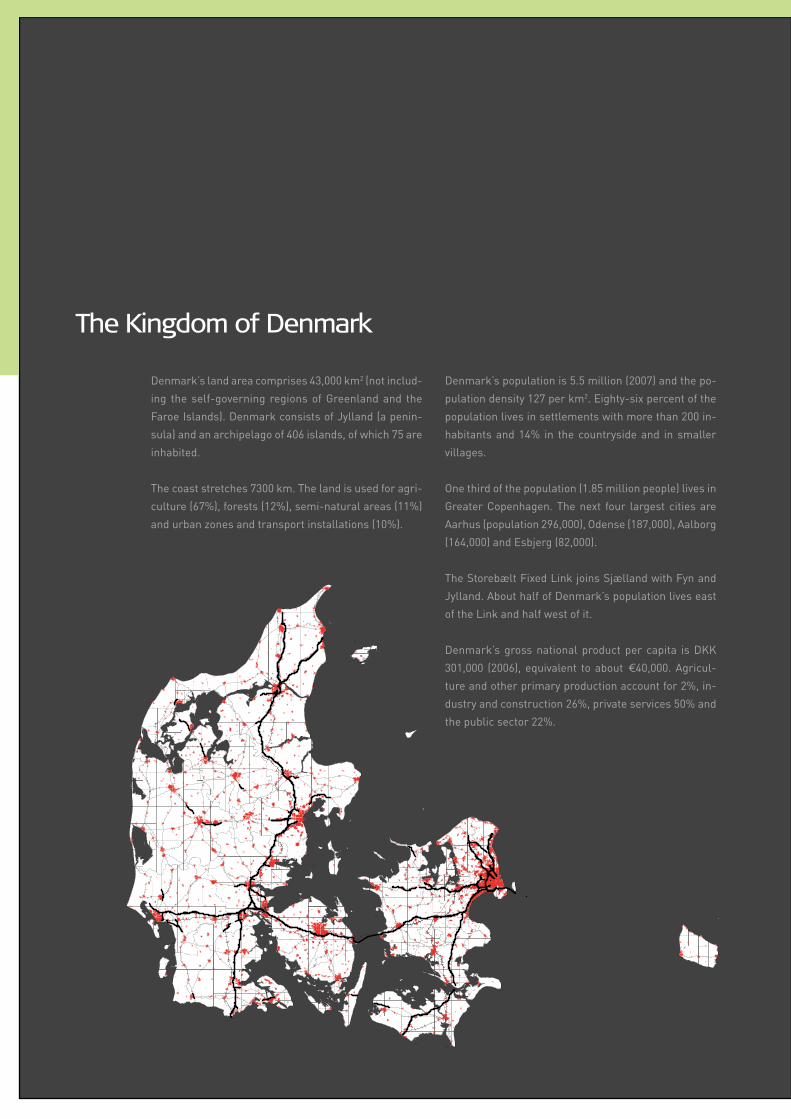
The Kingdom of Denmark
Denmark’s land area comprises 43,000 km2 (not includ
ing the selfgoverning regions of Greenland and the
Faroe Islands). Denmark consists of Jylland (a penin
sula) and an archipelago of 406 islands, of which 75 are
inhabited.
The coast stretches 7300 km. The land is used for agri
culture (67%), forests (12%), seminatural areas (11%)
and urban zones and transport installations (10%).
Denmark’s population is 5.5 million (2007) and the po
pulation density 127 per km2. Eightysix percent of the
population lives in settlements with more than 200 in
habitants and 14% in the countryside and in smaller
villages.
One third of the population (1.85 million people) lives in
Greater Copenhagen. The next four largest cities are
Aarhus (population 296,000), Odense (187,000), Aalborg
(164,000) and Esbjerg (82,000).
The Storebælt Fixed Link joins Sjælland with Fyn and
Jylland. About half of Denmark’s population lives east
of the Link and half west of it.
Denmark’s gross national product per capita is DKK
301,000 (2006), equivalent to about €40,000. Agricul
ture and other primary production account for 2%, in
dustry and construction 26%, private services 50% and
the public sector 22%.
�
spatial planning in denmark
Denmark will not become beautiful and wellplanned spontaneously.
Visions are required about what type of country, landscapes and
municipalities are desirable. This requires strategies and planning
to create and maintain highquality surroundings – in nature, in the
environment, in landscapes and in cities and towns.
Spatial planning creates the surroundings in which people will
be living their lives. Political decisionmaking processes with public
participation and balancing of various interests are therefore an impor
tant and exciting part of democracy. This also places great demands
on the quality and professional execution of planning documents and
processes.
Spatial planning is policy. Denmark’s new structure means that
local policy decisions are key: what may be built where, the transport
system and services in each town and city district, and protecting and
improving the quality of landscapes, nature and the environment.
Good planning requires appropriate rules and legislative instru
ments. Denmark’s reform of local government structure in 2007
delegated responsibility for comprehensive spatial planning for both
town and country to the municipalities. National planning was also
strengthened, and the new regional councils have been charged with
preparing regional spatial development plans. Thus, the reform of
local government also reformed spatial planning.
This publication aims to provide an illustrated overview of the
Planning Act and how it is implemented in practice. The rules, re
quirements and opportunities for regulation are presented without
citing sections of the Act.
I hope that the publication thereby provides this overview to
planners, researchers and policymakers who want a description of
Denmark’s Planning Act and spatial planning in practice.
Connie Hedegaard
Minister for the Environment
Denmark
�
Spatial planning aims to create and maintain quality in urban areas and in the countryside.
The challenges of planning change as society develops. Legislation and the instruments used
in planning are regularly revised and renewed. The reform of local government structure in Denmark
in 2007 has resulted in substantial changes in Denmark’s spatial planning system.
Spatial planning and development in society
Changes in society pose new requirements for develop
ing and transforming cities, creating new technical
and social infrastructure and protecting and using the
countryside. This has led to continual changes in spatial
planning legislation and instruments.
The recent modernization of the Planning Act has
focused on promoting strategic planning, reinforcing
public participation in planning, improving the oppor
tunities for regenerating disused industrial sites into
mixeduse urban districts, promoting environmentally
sound location policies, protecting attractive and vi
brant town centres and protecting the open stretches
of coast.
Denmark has developed systems to enable efficient
digital planning. The Danish Environmental Portal con
tains numerous public data on planning, nature and the
environment. PlansystemDK is Denmark’s central digital
portal for publishing and compiling plan proposals and
adopted plans.
The 2006 national planning report focused on the
role of spatial planning in maintaining Denmark’s ad
vantages: wellfunctioning towns that are attractive for
working and living, open landscapes and coherent natu
ral areas for activity at the human scale. The report’s five
goals for spatial planning restore the classical principle
of clearly demarcating between town and country.
Reforming local government structure
Denmark has thoroughly reformed the public sector in
recent years. A local government reform enacted in 2005
entered into force on 1 January 2007.
The reform abolished the counties and created five
popularly elected regional councils. The former 271
municipalities have amalgamated into 98 municipali
ties responsible for nearly all social welfare tasks as
the main gateway to the public sector for citizens and
companies.
This reform thoroughly changed Denmark’s spatial
planning system. The Planning Act now delegates re
sponsibility for spatial planning to the Minister for the
Environment, five regional councils and 98 municipal
councils. The Act is based on the principles of the refor
med planning legislation of the 1970s of decentralizing
decisionmaking authority and promoting public parti
cipation in the planning process.
The municipalities are now responsible for planning
both town and country. The municipal plans thus have a
new role as the key plan for development and land use.
Further, national planning has been strengthened. The
Challenges in spatial planning
Key amenDmenTS To The PLanning acT
The Planning Act entered into force on 1 January 1992 and
is based on decades of planning experience and legislation.
• Urban policy (2007)
• Reform of local government structure
(2005–2007)
• 8000 summer cottages in the coastal zone (2004)
• Urban regeneration (2002)
• Regulation of rural zones (2002)
• Special rules resulting from amalgamation of the five
municipalities in Bornholm (2002)
• Allotment gardens (2001)
• Strategy for municipal planning and opportunities
for revising plans (2000)
• Local Agenda 21 (2000)
• Environmental impact assessment (1999)
• Planning for retail trade (1997, 2002 and 2007)
• Planning in coastal areas (1994)
�
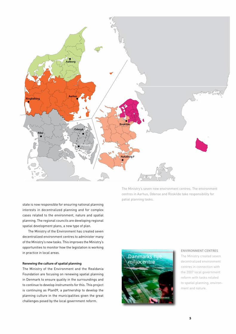
state is now responsible for ensuring national planning
interests in decentralized planning and for complex
cases related to the environment, nature and spatial
planning. The regional councils are developing regional
spatial development plans, a new type of plan.
The Ministry of the Environment has created seven
decentralized environment centres to administer many
of the Ministry’s new tasks. This improves the Ministry’s
opportunities to monitor how the legislation is working
in practice in local areas.
Renewing the culture of spatial planning
The Ministry of the Environment and the Realdania
Foundation are focusing on renewing spatial planning
in Denmark to ensure quality in the surroundings and
to continue to develop instruments for this. This project
is continuing as Plan09, a partnership to develop the
planning culture in the municipalities given the great
challenges posed by the local government reform.
The Ministry’s seven new environment centres. The environment
centres in Aarhus, Odense and Roskilde take responsibility for
patial planning tasks.
EnviRonmEnt cEntREs
The Ministry created seven
decentralized environment
centres in connection with
the 2007 local government
reform with tasks related
to spatial planning, environ-
ment and nature.
Roskilde
nykøbing F
odenseRibe
RingkøbingAarhus
Aalborg
Faaborg

�
the planning aCt
Purpose
The Act ensures that the overall planning synthesizes
the interests of society with respect to land use and
contributes to protecting the country’s nature and en
vironment, so that sustainable development of society
with respect for people’s living conditions and for the
conservation of wildlife and vegetation is secured.
Spatial planning especially aims towards:
• appropriate development in the whole country and
in the individual administrative regions and muni
cipalities, based on overall planning and economic
considerations;
• creating and conserving valuable buildings, settle
ments, urban environments and landscapes;
• the open coasts continuing to comprise an important
natural and landscape resource;
• preventing pollution of air, water and soil and noise
nuisance; and
• involving the public in the planning process as much
as possible.
Decentralized responsibility
Denmark’s 98 municipal councils have great respon
sibility for planning in towns and in the countryside. In
the first half of the 4year local election period, each
council adopts a political strategy for municipal planning
and decides how it will revise the municipal plan. The
municipal plan adopted then comprises the framework
for preparing local plans and processing cases, including
those based on other legislation.
Local plans are prepared regularly when needed.
The municipal council has to adopt a local plan before
initiating major development projects.
Public participation
The Planning Act involves the public in the planning
Denmark has a simple and clear spatial planning system with a strongly decentralized
division of tasks. The municipal councils are responsible for comprehensive land-use
regulation at the municipal and local levels with legally binding guidelines for property
owners. The regional councils prepare a strategic plan for spatial development in each
region. The minister for the environment is responsible for upholding national interests
through national planning.
process at the municipal, regional and national levels.
Before a municipal plan, a regional spatial development
plan, a national planning directive or a national planning
report may be adopted, a proposal and a report on the
premises of the proposal must be published. Property
owners, neighbours, nongovernmental organizations,
public authorities and others then have at least 8 weeks
to submit their objections, comments, proposals or
protests.
The Planning Act stipulates minimum rules on public
participation. The planning authority decides whether it
should distribute more material for discussion, arrange
citizens’ meetings, establish working groups, create
electronic citizens’ panels or the like. The municipalities
experiment with various ways of involving the public,
nongovernmental organizations and other organizations
in the planning process. For example, several municipa
lities have prepared a policy on community democracy.
Other municipalities are experimenting with discussing
strategy and development potential more informally
before the formal planning procedure begins.
Universal public access to plans and data
The Danish National Portal on the Environment provides
access to numerous data on land use, nature and the
environment. All plan proposals and plans are uploaded
onto a planning portal (www.PlansystemDK.dk) so that
anyone can investigate which plans govern a specific
property or district.
veto, dialogue and cooperation
The Minister for the Environment, on behalf of the
government, is required to veto municipal plan proposals
that contradict national interests. Regional councils
may veto municipal plan proposals that contradict the
regional spatial development plan. The municipalities
�
may object to the plan proposal of a neighbouring mu
nicipality if the proposal is important for the objecting
municipality’s development. Municipalities in Greater
Copenhagen may object to municipal plan proposals
from any other municipality. The aim is to coordinate
local, regional and national interests through dialogue
and partnership.
greater copenhagen, coastal areas and retail trade
The Planning Act includes special rules on planning in
Greater Copenhagen, coastal areas and retail trade:
• Planning in Greater Copenhagen is intended to main
tain the main principles of the finger city structure
(see pp. 14–15).
• Coastal areas are to remain free of development that
can be located elsewhere.
• Planning for retail trade is intended to promote a
varied supply of retail shops in town centres.
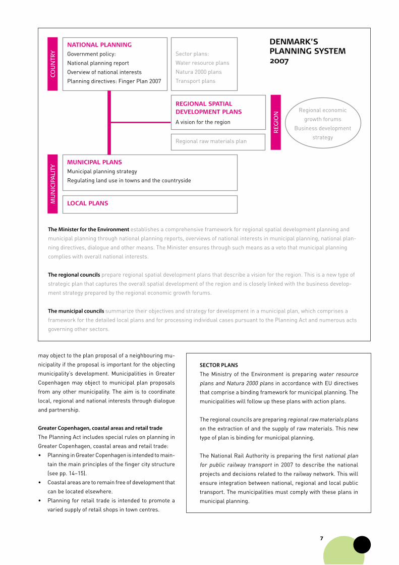
SecToR PLanS
The Ministry of the Environment is preparing water resource
plans and Natura 2000 plans in accordance with EU directives
that comprise a binding framework for municipal planning. The
municipalities will follow up these plans with action plans.
The regional councils are preparing regional raw materials plans
on the extraction of and the supply of raw materials. This new
type of plan is binding for municipal planning.
The National Rail Authority is preparing the first national plan
for public railway transport in 2007 to describe the national
projects and decisions related to the railway network. This will
ensure integration between national, regional and local public
transport. The municipalities must comply with these plans in
municipal planning.
The minister for the environment establishes a comprehensive framework for regional spatial development planning and
municipal planning through national planning reports, overviews of national interests in municipal planning, national plan
ning directives, dialogue and other means. The Minister ensures through such means as a veto that municipal planning
complies with overall national interests.
The regional councils prepare regional spatial development plans that describe a vision for the region. This is a new type of
strategic plan that captures the overall spatial development of the region and is closely linked with the business develop
ment strategy prepared by the regional economic growth forums.
The municipal councils summarize their objectives and strategy for development in a municipal plan, which comprises a
framework for the detailed local plans and for processing individual cases pursuant to the Planning Act and numerous acts
governing other sectors.
cou
nTr
y
Regional spatial development plans
A vision for the region
national planning
Government policy:
National planning report
Overview of national interests
Planning directives: Finger Plan 2007
Sector plans:
Water resource plans
Natura 2000 plans
Transport plans
muniCipal plans
Municipal planning strategy
Regulating land use in towns and the countryside
loCal plans
Regional raw materials plan
Regional economic
growth forums
Business development
strategy
reg
ion
mu
nic
ipa
liTy
denmaRk’splanning system 2007
�
national planning
national planning reports
After each election to the Folketing (parliament), the
Minister for the Environment submits a national plan
ning report to be used in regional spatial development
planning and municipal planning. The report further
covers the special planning considerations for Greater
Copenhagen.
The report is submitted as a proposal with potential
alternatives, and public debate is solicited before the
Minister publishes the report on behalf of the Govern
ment. The Folketing traditionally debates the national
planning report. The latest reports include visions and
perspectives for topical planning themes followed up
by an action plan, including projects with municipalities
and the private sector.
overview of national interests
Every 4 years the Minister publishes an overview of
national interests in municipal planning. This includes
the interests and considerations arising from politi
cally adopted decisions in the form of legislation, action
plans, sector plans, national planning decisions and
agreements between public authorities. The Minister
published the first overview in November 2006.
The rules on national planning were introduced in 1974 and
strengthened substantially by the 2007 local government
reform. national planning is expressed through reports, binding
instructions, guidelines and intervention in municipal planning
for themes and projects of international, national or regional
interest.
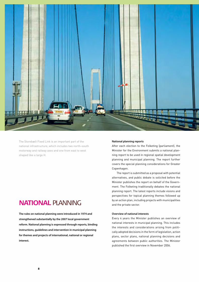
The Storebælt Fixed Link is an important part of the
national infrastructure, which includes two north–south
motorway and railway axes and one from east to west
shaped like a large H.
�
Greater Copenhagen and eastern Jylland
Small-town regions
Important transport corridors
>100,000 population
>20,000 population
Boundary for the national planningdirective for Greater Copenhagen
Reports on nature and environment policy
The Minister for the Environment publishes one or more
reports at least every 4 years that describe the state of
the environment in Denmark and Denmark’s policy on
nature and the environment. Nationwide environment,
business, labour market and consumer organizations
are involved in this process. The Minister also submits
a report on Local Agenda 21 work to the Folketing.
Reports on retail trade planning
The Minister submits a report on planning for retail trade
every 4 years to the Folketing.
National planning directives
The Minister may establish binding rules on the content
of planning. In this way, the Government may promote
both specific projects and a certain direction of de-
velopment. National planning directives may be used to
locate a specific activity crucial to society and thereby
supersede municipal and local planning. Examples of
national planning directives include designating new
summer cottage areas in the coastal zone, determining
the path for natural gas pipelines and electrical trans-
mission lines and locating national testing stations for
The Ministry of the Environment
publishes an overview of national
interests in municipal planning
every 4 years.
The 2006 NaTioNal plaNNiNg RepoRT
The 2006 national planning report categorizes Denmark into
five types of settlement region: Greater Copenhagen and the
Øresund Region; the rest of Sjælland; eastern Jylland; town
regions; and small-town regions. The categories summarize
the geographically differentiated main challenges facing spatial
planning in various parts of Denmark.
Denmark has two metropolitan regions and numerous small
cities and towns with their hinterlands. Eastern Jylland is
developing into a single urban corridor. Sjælland is already a
cohesive labour market with Copenhagen as the centre.
�0
wind turbines. Similarly, the Minister may establish
rules for the planning of specific activities by issuing a
circular. An example is planning for the erection of new
wind turbines.
The Planning Act requires the Minister to establish
specific rules for planning in Greater Copenhagen. This
is being done through a national planning directive on
the Finger Plan 2007 (see pp. 14–15).
veto and orders
The Minister must veto a municipal plan proposal on
behalf of all government ministers if the proposal con
tradicts national interests. This veto must be declared
during the period of public comment, and the municipal
council is prohibited from adopting the proposal until the
Minister agrees to the content of the proposal.
A committee of state civil servants assesses each
municipal plan proposal during the period of public
comment to coordinate the state’s viewpoints. The Mini
stry’s regional environmental centres in Aarhus, Odense
and Roskilde coordinate and declare any veto.
Any state authority may veto a local plan proposal
based on the special responsibilities of this authority.
The authority and the municipality must then reach
agreement or let the Ministry’s regional environmental
centre decide.
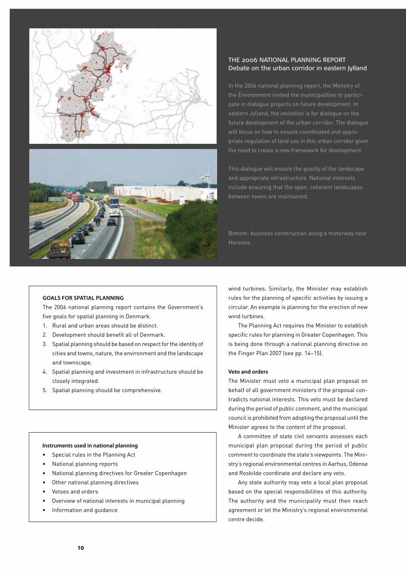
The 2006 naTional planning reporTDebate on the urban corridor in eastern Jylland
In the 2006 national planning report, the Ministry of
the Environment invited the municipalities to partici
pate in dialogue projects on future development. In
eastern Jylland, the invitation is for dialogue on the
future development of the urban corridor. The dialogue
will focus on how to ensure coordinated and appro
priate regulation of land use in this urban corridor given
the need to create a new framework for development.
This dialogue will ensure the quality of the landscape
and appropriate infrastructure. National interests
include ensuring that the open, coherent landscapes
between towns are maintained.
Bottom: business construction along a motorway near
Horsens.
instruments used in national planning
• Special rules in the Planning Act
• National planning reports
• National planning directives for Greater Copenhagen
• Other national planning directives
• Vetoes and orders
• Overview of national interests in municipal planning
• Information and guidance
goaLS FoR SPaTiaL PLanning
The 2006 national planning report contains the Government’s
five goals for spatial planning in Denmark.
1. Rural and urban areas should be distinct.
2. Development should benefit all of Denmark.
3. Spatial planning should be based on respect for the identity of
cities and towns, nature, the environment and the landscape
and townscape.
4. Spatial planning and investment in infrastructure should be
closely integrated.
5. Spatial planning should be comprehensive.
��
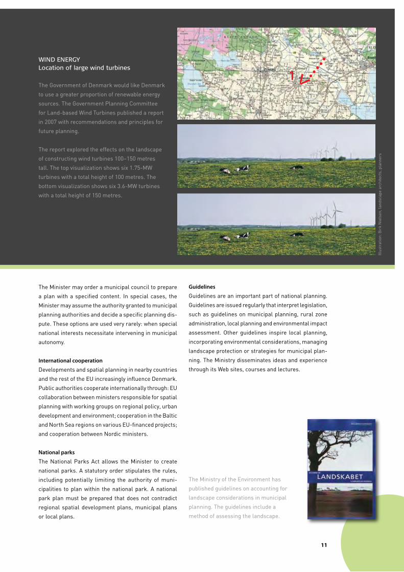
winD energylocation of large wind turbines
The Government of Denmark would like Denmark
to use a greater proportion of renewable energy
sources. The Government Planning Committee
for Landbased Wind Turbines published a report
in 2007 with recommendations and principles for
future planning.
The report explored the effects on the landscape
of constructing wind turbines 100–150 metres
tall. The top visualization shows six 1.75MW
turbines with a total height of 100 metres. The
bottom visualization shows six 3.6MW turbines
with a total height of 150 metres.
The Minister may order a municipal council to prepare
a plan with a specified content. In special cases, the
Minister may assume the authority granted to municipal
planning authorities and decide a specific planning dis
pute. These options are used very rarely: when special
national interests necessitate intervening in municipal
autonomy.
international cooperation
Developments and spatial planning in nearby countries
and the rest of the EU increasingly influence Denmark.
Public authorities cooperate internationally through: EU
collaboration between ministers responsible for spatial
planning with working groups on regional policy, urban
development and environment; cooperation in the Baltic
and North Sea regions on various EUfinanced projects;
and cooperation between Nordic ministers.
national parks
The National Parks Act allows the Minister to create
national parks. A statutory order stipulates the rules,
including potentially limiting the authority of muni
cipalities to plan within the national park. A national
park plan must be prepared that does not contradict
regional spatial development plans, municipal plans
or local plans.
FoTo samme anlæg
guidelines
Guidelines are an important part of national planning.
Guidelines are issued regularly that interpret legislation,
such as guidelines on municipal planning, rural zone
administration, local planning and environmental impact
assessment. Other guidelines inspire local planning,
incorporating environmental considerations, managing
landscape protection or strategies for municipal plan
ning. The Ministry disseminates ideas and experience
through its Web sites, courses and lectures.
The Ministry of the Environment has
published guidelines on accounting for
landscape considerations in municipal
planning. The guidelines include a
method of assessing the landscape.
Illus
trat
ion:
Bir
k N
iels
en, l
ands
cape
arc
hite
cts,
pla
nner
s
1V
��
planning for Retail tRade
The Planning act has special rules for planning for retail trade so that
investment in new shops supports the aim of renewing and regenerating
the existing commercial areas in town centres.
The Planning Act has special rules for planning for retail
trade. Surveys showed that many retail trade outlets
were being built on the periphery of the largest cities as
large shops and shopping centres. This trend weakens
retail trade in many smaller towns, impairing the local
business situation and reducing the potential to conserve
and modernize town centres.
The rules on retail trade in the Planning Act were
changed in 1997 to reverse these trends. In 2002 and
2007, these rules were simplified and made more spe
cific, but the aim has been maintained.
Spatial planning is intended to promote develop
ment in the centres of Denmark’s numerous small and
mediumsized towns and ensure that shops are easily
accessible by all means of transport, especially walking,
cycling and public transport.
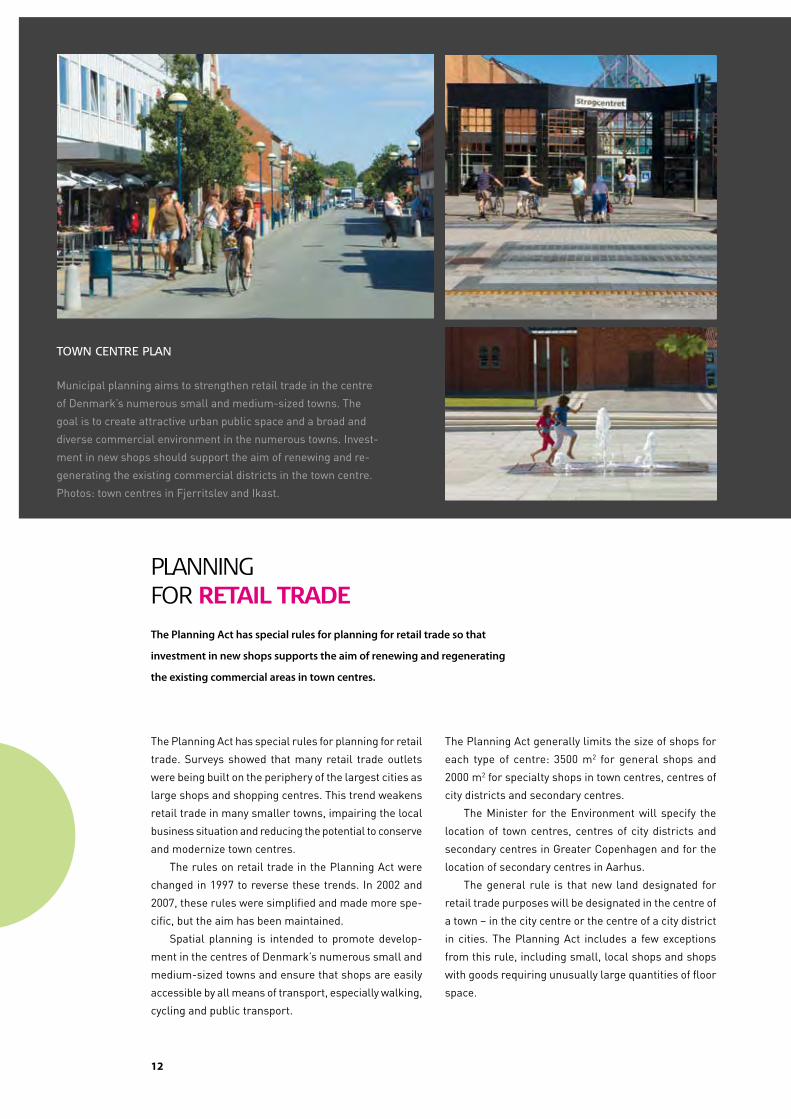
Town cenTre plan
Municipal planning aims to strengthen retail trade in the centre
of Denmark’s numerous small and mediumsized towns. The
goal is to create attractive urban public space and a broad and
diverse commercial environment in the numerous towns. Invest
ment in new shops should support the aim of renewing and re
generating the existing commercial districts in the town centre.
Photos: town centres in Fjerritslev and Ikast.
The Planning Act generally limits the size of shops for
each type of centre: 3500 m2 for general shops and
2000 m2 for specialty shops in town centres, centres of
city districts and secondary centres.
The Minister for the Environment will specify the
location of town centres, centres of city districts and
secondary centres in Greater Copenhagen and for the
location of secondary centres in Aarhus.
The general rule is that new land designated for
retail trade purposes will be designated in the centre of
a town – in the city centre or the centre of a city district
in cities. The Planning Act includes a few exceptions
from this rule, including small, local shops and shops
with goods requiring unusually large quantities of floor
space.
��
planning in Coastal aReas
The Planning act has special rules for planning in coastal areas to protect
Denmark’s long open stretches of coast.
Denmark has had rules on protecting the open coasts
since 1981 based on the trends in Denmark’s coastal
areas and experience in other countries with extensive
coastal construction.
Denmark’s coastal areas are to be kept as free as
possible of development and installations that do not
need to be located near the coast. Within a designated
coastal zone that is theoretically 3 km wide, land may
only be transferred to an urban zone or planning conduct
ed for development in a rural zone if there is a specific
planningrelated or functional justification for location
near the coast.
In addition, new summer cottage areas may not
be designated, and existing summer cottage areas
are to be maintained for holiday and leisure purposes.
Local plan proposals that permit development in the
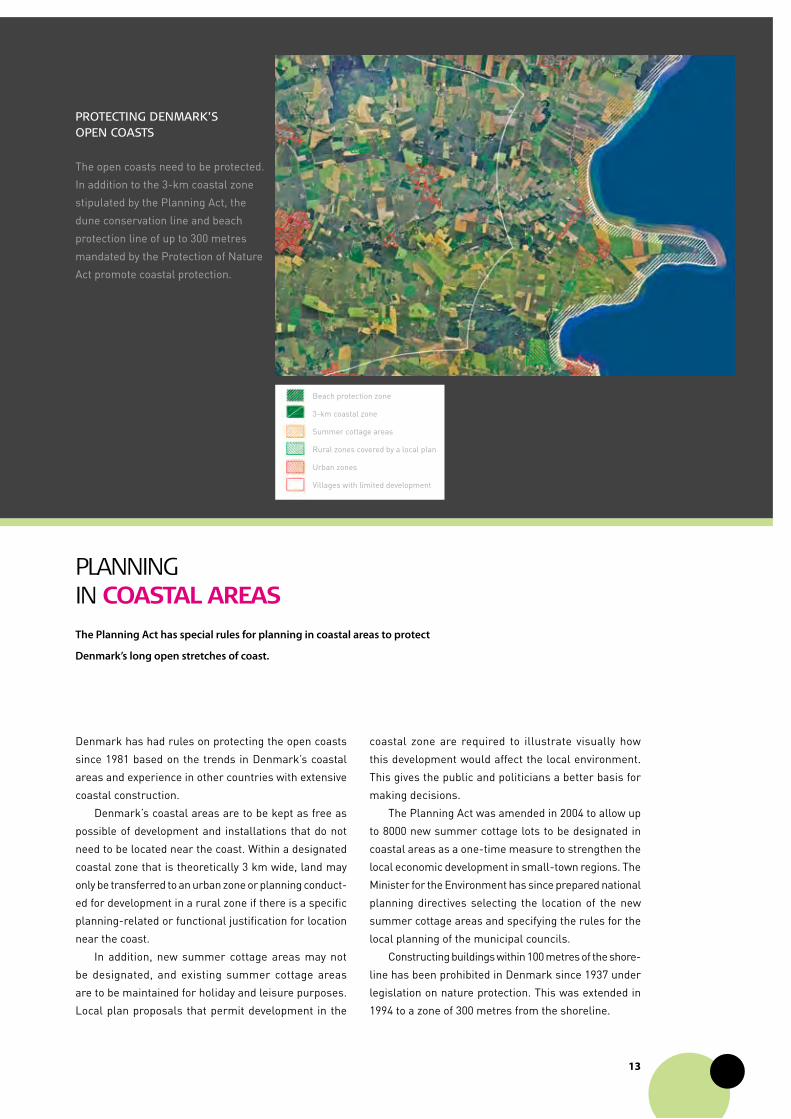
proTecTing DenmarK’s open coasTs
The open coasts need to be protected.
In addition to the 3km coastal zone
stipulated by the Planning Act, the
dune conservation line and beach
protection line of up to 300 metres
mandated by the Protection of Nature
Act promote coastal protection.
coastal zone are required to illustrate visually how
this development would affect the local environment.
This gives the public and politicians a better basis for
making decisions.
The Planning Act was amended in 2004 to allow up
to 8000 new summer cottage lots to be designated in
coastal areas as a onetime measure to strengthen the
local economic development in smalltown regions. The
Minister for the Environment has since prepared national
planning directives selecting the location of the new
summer cottage areas and specifying the rules for the
local planning of the municipal councils.
Constructing buildings within 100 metres of the shore
line has been prohibited in Denmark since 1937 under
legislation on nature protection. This was extended in
1994 to a zone of 300 metres from the shoreline.
Beach protection zone
3km coastal zone
Summer cottage areas
Rural zones covered by a local plan
Urban zones
Villages with limited development
��
planning in gReateR Copenhagen
The Finger Plan 2007
Since the first finger plan was adopted in 1947, the
aim has been to concentrate urban development in the
fingers created by the suburban railway network and
the radial road network and to keep the green wedges
between the fingers undeveloped.
Copenhagen’s profile as a green capital will be
further strengthened in the future through a national
planning directive on Finger Plan 2007, which will en
sure clear demarcation between urban and rural zones,
provide the best conditions for public transport and help
the 34 municipalities in Greater Copenhagen in creating
the urban planning of the future.
Regional responsibility
The Planning Act mandates that the municipalities take
regional responsibility and determine their regional role.
Municipal planning in Greater Copenhagen is imple
mented based on an assessment of development in the
region as a whole and must maintain the main principles
of the overall finger city structure. Urban development
of regional significance must be coordinated with the
extension of Greater Copenhagen’s overall infrastruc
ture, especially public transport services.
greater copenhagen comprises one cohesive housing and
labour market with common regional semi-natural areas and
green spaces that overlap between municipal borders.
Denmark therefore has special rules for planning in greater
copenhagen. The Planning act contains overall principles for
urban development, recreational considerations and other
matters, and the minister for the environment has prepared
a national planning directive that will be continually updated
to implement these principles.
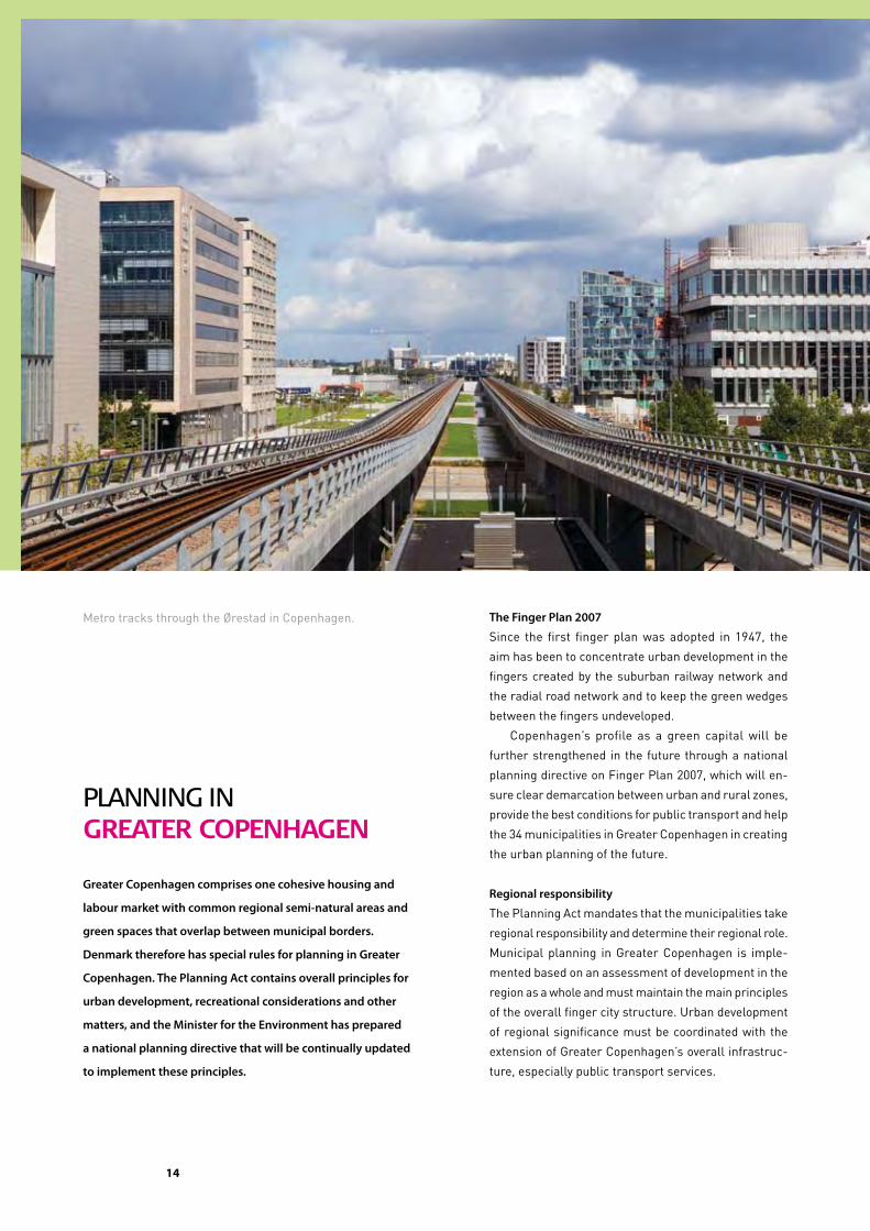
Metro tracks through the Ørestad in Copenhagen.
15
Greater CopenhaGen
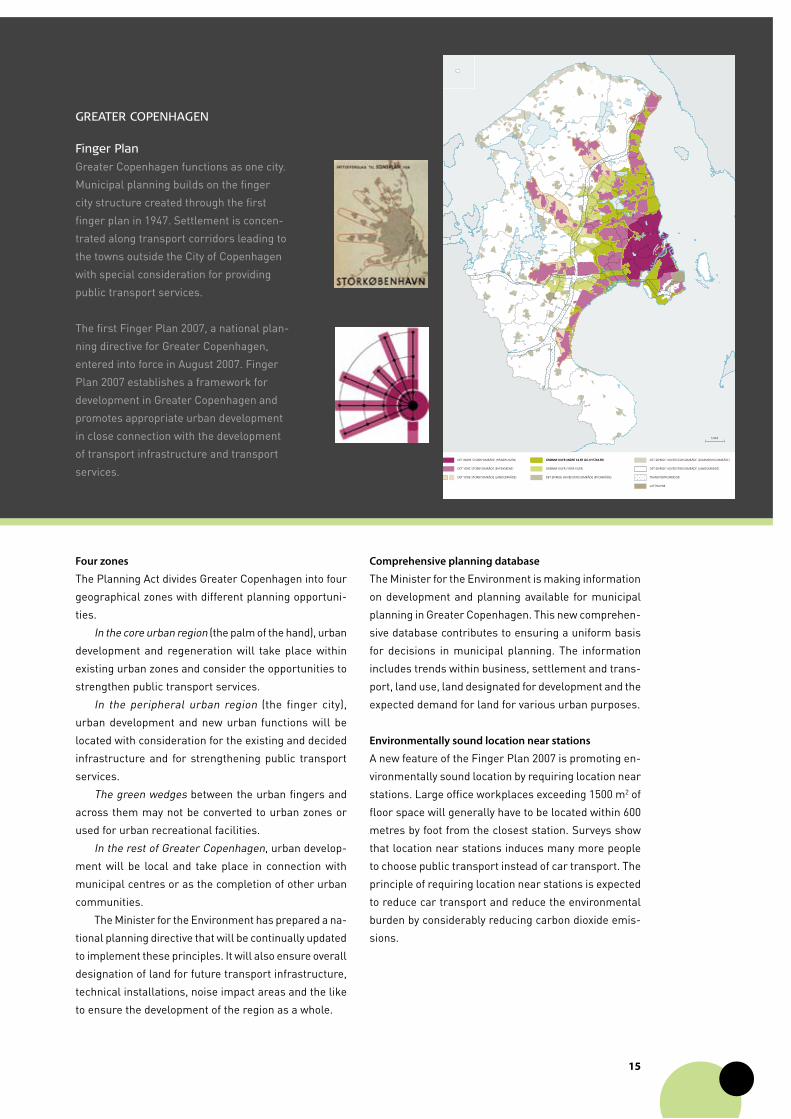
Finger plan
Greater Copenhagen functions as one city.
Municipal planning builds on the finger
city structure created through the first
finger plan in 1947. Settlement is concen
trated along transport corridors leading to
the towns outside the City of Copenhagen
with special consideration for providing
public transport services.
The first Finger Plan 2007, a national plan
ning directive for Greater Copenhagen,
entered into force in August 2007. Finger
Plan 2007 establishes a framework for
development in Greater Copenhagen and
promotes appropriate urban development
in close connection with the development
of transport infrastructure and transport
services.
Four zones
The Planning Act divides Greater Copenhagen into four
geographical zones with different planning opportuni
ties.
In the core urban region (the palm of the hand), urban
development and regeneration will take place within
existing urban zones and consider the opportunities to
strengthen public transport services.
In the peripheral urban region (the finger city),
urban development and new urban functions will be
located with consideration for the existing and decided
infrastructure and for strengthening public transport
services.
The green wedges between the urban fingers and
across them may not be converted to urban zones or
used for urban recreational facilities.
In the rest of Greater Copenhagen, urban develop
ment will be local and take place in connection with
municipal centres or as the completion of other urban
communities.
The Minister for the Environment has prepared a na
tional planning directive that will be continually updated
to implement these principles. It will also ensure overall
designation of land for future transport infrastructure,
technical installations, noise impact areas and the like
to ensure the development of the region as a whole.
Comprehensive planning database
The Minister for the Environment is making information
on development and planning available for municipal
planning in Greater Copenhagen. This new comprehen
sive database contributes to ensuring a uniform basis
for decisions in municipal planning. The information
includes trends within business, settlement and trans
port, land use, land designated for development and the
expected demand for land for various urban purposes.
Environmentally sound location near stations
A new feature of the Finger Plan 2007 is promoting en
vironmentally sound location by requiring location near
stations. Large office workplaces exceeding 1500 m2 of
floor space will generally have to be located within 600
metres by foot from the closest station. Surveys show
that location near stations induces many more people
to choose public transport instead of car transport. The
principle of requiring location near stations is expected
to reduce car transport and reduce the environmental
burden by considerably reducing carbon dioxide emis
sions.
DET INDRE STORBYOMRÅDE (HÅNDFLADEN)
DET YDRE STORBYOMRÅDE (BYFINGRENE)
GRØNNE KILER (INDRE KILER OG KYSTKILER) GRØNNE KILER (INDRE KILER OG KYSTKILER)
GRØNNE KILER (YDRE KILER)
TRANSPORTKORRIDOR
LUFTHAVNE
DET ØVRIGE HOVEDSTADSOMRÅDE (BYOMRÅDE)
DET ØVRIGE HOVEDSTADSOMRÅDE (SOMMERHUSOMRÅDE)
DET ØVRIGE HOVEDSTADSOMRÅDE (LANDOMRÅDE)
DET YDRE STORBYOMRÅDE (LANDOMRÅDE)
5 KM
��
Regional spatial developmentplanning
Regional plan for spatial development
A regional spatial development plan comprehensively
describes a desired future spatial development for each
administrative region’s cities and towns, rural districts
and smalltown (peripheral) regions and for:
• nature and the environment, including recreation;
• business, including tourism;
• employment;
• education and training; and
• culture.
A map will illustrate the general content of the plan. The
regional council may make proposals for municipal and
local planning in the administrative region. Municipal
plans must be in accordance with the regional spatial
development plan.
Regional councils publish a plan proposal during
the first half of the 4year regional and local election
period while the municipalities prepare their strategies
for municipal planning. These two processes are related,
and close dialogue can produce synergy.
The regional spatial development plan describes:
• the relationships between future spatial develop
ment and the state and municipal spatial planning
for infrastructure;
The 2007 reform of local government structure created a new
type of plan. The new regional councils are preparing regional
spatial development plans that will present strategic visions of
the development of each region. Regional spatial development
plans are a collective project between the municipal councils,
businesses, the regional council and the other actors in each
region.
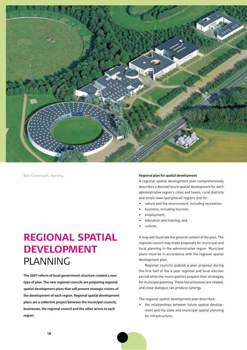
Birk Centerpark, Herning.

��
• the context for any cooperation between the admi
nistrative region and public authorities in adjacent
countries on spatial planning and spatial develop
ment; and
• the action the regional council will take to follow up
the plan.
cohesion with other plans
The regional spatial development plan should ensure
cohesion with:
• the business development strategy of the regional
economic growth forum;
• the employment strategy of the regional employment
council;
• the development strategies of local action groups
within the Rural Development Programme for
2007–2013;
• the Local Agenda 21 strategies of the administrative
region and the municipalities; and
• other regional strategies and plans, such as for
education, training and culture.
Funding
The regional councils may promote the implementation
of the regional spatial development plan by funding
specific projects. The regional budgets have earmarked
funds for regional development related to business
development, education, training and culture. Further,
EU funding under Objective 2 of regional policy (revita
lizing areas facing structural difficulties) is available if
cofinanced by public or private sources. Each regional
economic growth forum makes recommendations to the
regional council on support for business development
projects and to the state on the use of EU funds.
RegionaL economic gRowTh FoRUmS
The regional economic growth forums prepare
a regional business development strategy that
comprises part of the basis for the regional spatial
development plan.
The strategy is based on the strengths of the busi
nesses in the administrative region, including the
Government’s four drivers of economic growth:
innovation, entrepreneurs, education and training
and new technology. The forums prepare action
plans with numerous specific activities and priority
actions.
Denmark’s Sjælland Region has developed a model for
regional spatial development in partnership with Oxford
Research. The design incorporates such focus areas as
culture, nature and safety with about 50 indicators. The
model comprises the basis for the political dialogue on
the spatial development of the region.
moDel For regional spaTial DevelopmenT
a new visionary Type oF plan
“The focus is not what already exists; the focus is the arrows coming
in from the outside that represent new impulses. The regional spatial
development plan is a completely new type of plan – a visionary plan
and a common platform for both the administrative region and the
municipalities in the administrative region. It is also a springboard for
the efforts of municipalities and local communities to develop strate
gies for and between municipalities.”
Uffe Steiner Jensen, Chair, Municipal Liaison Council for the Southern
Denmark Region and Mayor, Municipality of Fredericia.
growThHuman resources, innovation, entrepreneurship
and new technology
sJællanD region
Framework for a good life
public secTorKey figures, employment,
health care and public services
seTTlemenTHousing quality, security, nature
and infrastructure
leisure anD learningEducation, training,
activities in associations, and experiences
worK seTTle
services live
Regional spatial
development plan
Existing plans
and strategies
��
muniCipal planning
Strategy for planning
The municipal council publishes a strategy for muni
cipal planning within the first 2 years of the municipal
election period. This includes the municipal council’s
political strategy for development and information on
the planning occurring since the last time the municipal
plan was revised.
The strategy for planning also concludes with a
decision on revising the municipal plan. The municipal
council may choose to revise the entire municipal plan
or to revise parts of the plan, such as for a theme or a
district, and adopting the rest of the plan as it is.
The requirement for preparing a strategy for planning
and the flexible approach to revision were adopted in
2000. Focusing on planning strategy has contributed
to revitalizing municipal planning. It allows municipal
councillors to organize planning that both looks forward
and is based on the current problems and opportunities
in the municipality.
Many municipalities link the process of preparing
the strategy with other policy areas, such as business
development, culture and health. This provides cohesion
and places more political impetus behind the strategy.
The strategy for planning is subject to public comment
for at least 8 weeks.
a municipal plan summarizes and concretizes the overall political
objectives for the development of a municipality. The municipal
council establishes a policy for the development of towns and cities
and for the countryside. The municipal plan links national planning
and the provisions of local plans on the use and development of
each district and between national planning and the specific
administration of rural zones. The rules on strategy for planning
have strengthened the strategic aspect of municipal planning and
the political interest of local communities in municipal planning.
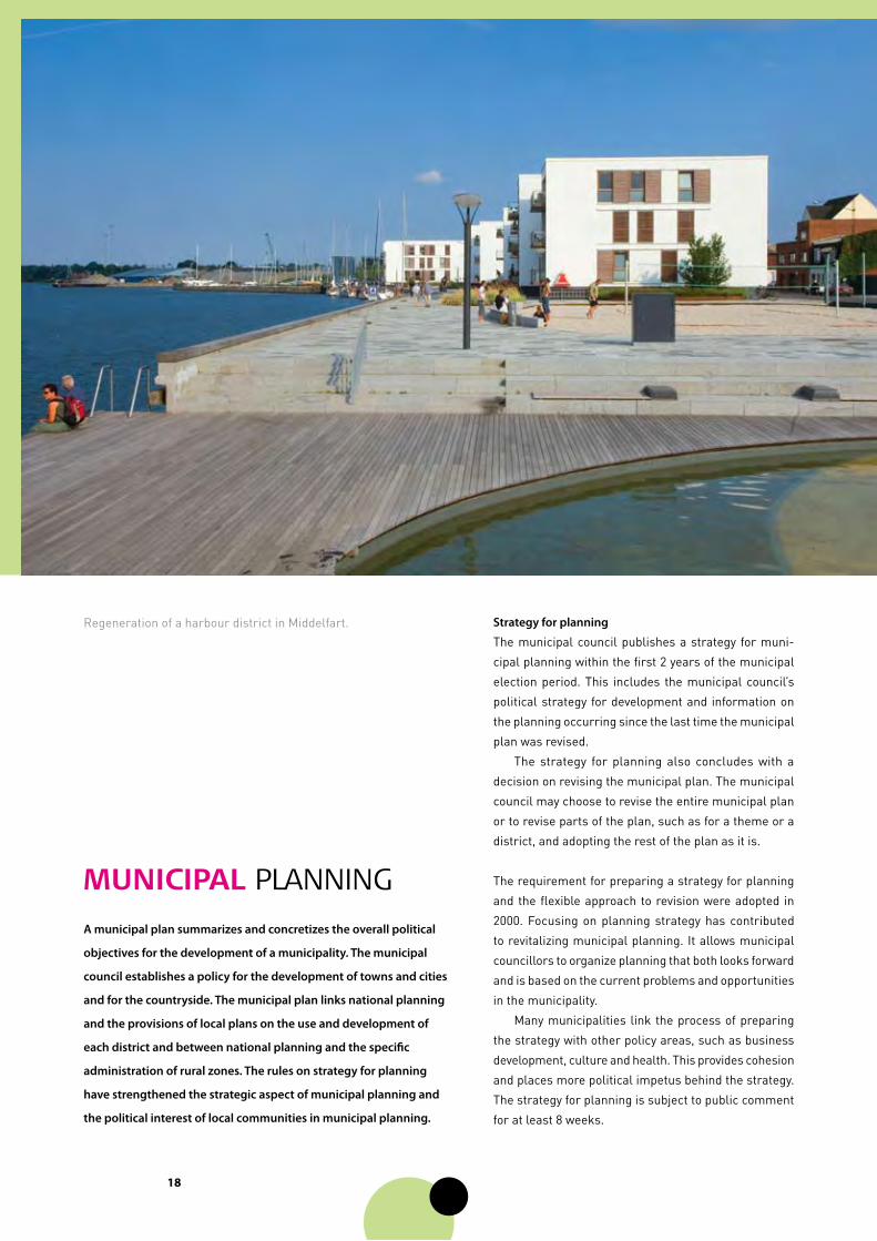
Regeneration of a harbour district in Middelfart.
��
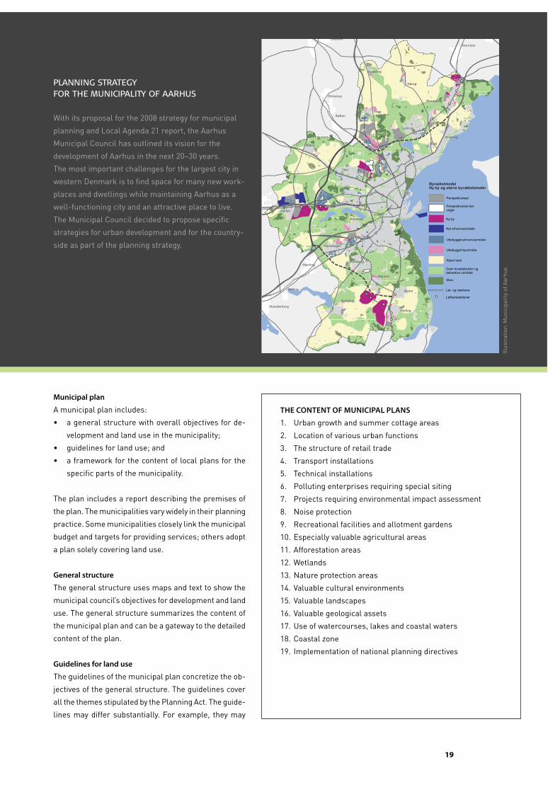
planning sTraTegy For The municipaliTy oF aarhus
With its proposal for the 2008 strategy for municipal
planning and Local Agenda 21 report, the Aarhus
Municipal Council has outlined its vision for the
development of Aarhus in the next 20–30 years.
The most important challenges for the largest city in
western Denmark is to find space for many new work
places and dwellings while maintaining Aarhus as a
wellfunctioning city and an attractive place to live.
The Municipal Council decided to propose specific
strategies for urban development and for the country
side as part of the planning strategy.
municipal plan
A municipal plan includes:
• a general structure with overall objectives for de
velopment and land use in the municipality;
• guidelines for land use; and
• a framework for the content of local plans for the
specific parts of the municipality.
The plan includes a report describing the premises of
the plan. The municipalities vary widely in their planning
practice. Some municipalities closely link the municipal
budget and targets for providing services; others adopt
a plan solely covering land use.
general structure
The general structure uses maps and text to show the
municipal council’s objectives for development and land
use. The general structure summarizes the content of
the municipal plan and can be a gateway to the detailed
content of the plan.
guidelines for land use
The guidelines of the municipal plan concretize the ob
jectives of the general structure. The guidelines cover
all the themes stipulated by the Planning Act. The guide
lines may differ substantially. For example, they may
The conTenT oF mUniciPaL PLanS
1. Urban growth and summer cottage areas
2. Location of various urban functions
3. The structure of retail trade
4. Transport installations
5. Technical installations
6. Polluting enterprises requiring special siting
7. Projects requiring environmental impact assessment
8. Noise protection
9. Recreational facilities and allotment gardens
10. Especially valuable agricultural areas
11. Afforestation areas
12. Wetlands
13. Nature protection areas
14. Valuable cultural environments
15. Valuable landscapes
16. Valuable geological assets
17. Use of watercourses, lakes and coastal waters
18. Coastal zone
19. Implementation of national planning directives
Egå
Stavtrup
Skødstrup
Løgten
Hårup
Spørring
Lystrup
Tranbjerg
Mårslet
Tilst
Hasselager
Harlev
Søften
Hinnerup
Hørning
Stilling Beder
Solbjerg
MallingSkanderborg
Sabro
Trige
Hornslet
Hadsten
Skæring
Ubebygget byområde
Ubebygget erhvervsområde
Letbanestationer
Perspektivareal der udgår
Ny by
Perspektivareal
Nyt erhvervsområde
Grøn hovedstruktur og rekreative områder
Let- og nærbane
ByvækstmodelNy by og større byvækstarealer
36 Forslag til Planstrategi 2008 og Agenda 21-Redegørelse
Illus
trat
ion:
Mun
icip
ality
of A
arhu
s
�0
designate types of land to be protected, such as special
habitats, or they may determine location principles or
criteria, such as principles for urban service delivery.
Framework for local planning
The framework for the content of local plans is the link to
local planning and is decisive for the municipal council’s
competence in preparing local plans. The framework
describes what a local plan can and should decide for
individual areas to promote a cohesive urban structure
and the overall municipal objectives. The framework
often illustrates future opportunities.
The municipal plan determines which areas in rural
zones may be transferred to urban zones or summer
cottage areas. The framework may determine the chro
nological order for converting land to urban functions
and to summer cottage areas.
municipal plan proposal
After publishing the strategy for planning, the muni
cipal council may prepare a proposal for revising the
municipal plan in accordance with the strategy. The
proposal may cover: the municipal plan for the entire
municipality; a special theme such as retail trade, urban
regeneration, business, transport or housing; or part of
the municipality, such as one or more urban districts or
villages, old harbour districts or the town centre.
Public participation
Proposals are published and debated for at least 8 weeks
before being adopted. Both proposals and adopted
plans are published on the municipality’s web site and
on PlansystemDK.
national and regional sector plans
The municipal plan may not contradict: the descrip
tion of the desired future spatial development in the
regional spatial development plan; national planning
directives; a water resource plan, a Natura 2000 plan
or action plans for implementing these plans; or a raw
materials plan.
national interests
The Minister for the Environment is obligated to veto
municipal plan proposals that contradict national in
terests.
municipal planning report
A plan proposal includes a report describing the pre
mises of the plan, covering the anticipated chronological
order for implementation and how the municipal plan
complies with the municipal strategy for planning, the
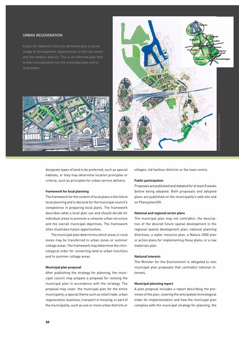
urban regeneraTion
A plan for Odense’s districts demonstrates a future
image of development opportunities in the city centre
and the harbour district. This is an informal plan that
is then incorporated into the municipal plan and in
local plans.
Illus
trat
ion:
Mun
icip
ality
of O
dens
e
��
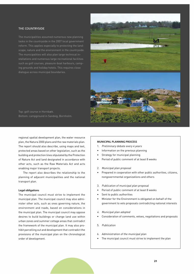
The counTrysiDe
The municipalities assumed numerous new planning
tasks in the countryside in the 2007 local government
reform. This applies especially to protecting the land
scape, nature and the environment in the countryside.
The municipalities will also plan large technical in
stallations and numerous large recreational facilities
such as golf courses, pleasureboat harbours, camp
ing grounds and holiday hotels. This requires close
dialogue across municipal boundaries.
Top: golf course in Hornbæk.
Bottom: campground in Sandvig, Bornholm.
regional spatial development plan, the water resource
plan, the Natura 2000 plans and the raw materials plan.
The report should also describe, using maps and text,
protected areas based on other legislation, such as the
building and protection lines stipulated by the Protection
of Nature Act and land designated in accordance with
other acts, such as the Raw Materials Act and acts
enabling major transport projects.
The report also describes the relationship to the
planning of adjacent municipalities and the national
transport plan.
Legal obligations
The municipal council must strive to implement the
municipal plan. The municipal council may also admi
nister other acts, such as ones governing nature, the
environment and roads, based on considerations in
the municipal plan. The municipal council may oppose
desires to build buildings or change land use within
urban zones and summer cottage areas that contradict
the framework of the municipal plan. It may also pro
hibit parcelling out and development that contradict the
provisions of the municipal plan on the chronological
order of development.
mUniciPaL PLanning PRoceSS
1. Preliminary debate every 4 years
• Information on the previous planning
• Strategy for municipal planning
• Period of public comment of at least 8 weeks
2. Municipal plan proposal
• Prepared in cooperation with other public authorities, citizens,
nongovernmental organizations and others
3. Publication of municipal plan proposal
• Period of public comment of at least 8 weeks
• Sent to public authorities
• Minister for the Environment is obligated on behalf of the
government to veto proposals contradicting national interests
4. Municipal plan adopted
• Consideration of comments, vetoes, negotiations and proposals
5. Publication
6. Administration of the municipal plan
• The municipal council must strive to implement the plan
��
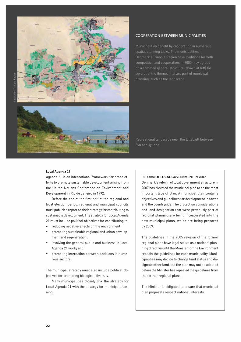
cooperaTion beTween municipaliTies
Municipalities benefit by cooperating in numerous
spatial planning tasks. The municipalities in
Denmark’s Triangle Region have traditions for both
competition and cooperation. In 2005 they agreed
on a common general structure (shown at left) for
several of the themes that are part of municipal
planning, such as the landscape.
Recreational landscape near the Lillebælt between
Fyn and Jylland
Local agenda 21
Agenda 21 is an international framework for broad ef
forts to promote sustainable development arising from
the United Nations Conference on Environment and
Development in Rio de Janeiro in 1992.
Before the end of the first half of the regional and
local election period, regional and municipal councils
must publish a report on their strategy for contributing to
sustainable development. The strategy for Local Agenda
21 must include political objectives for contributing to:
• reducing negative effects on the environment;
• promoting sustainable regional and urban develop
ment and regeneration;
• involving the general public and business in Local
Agenda 21 work; and
• promoting interaction between decisions in nume
rous sectors.
The municipal strategy must also include political ob
jectives for promoting biological diversity.
Many municipalities closely link the strategy for
Local Agenda 21 with the strategy for municipal plan
ning.
ReFoRm oF LocaL goveRnmenT in 2007
Denmark’s reform of local government structure in
2007 has elevated the municipal plan to be the most
important type of plan. A municipal plan contains
objectives and guidelines for development in towns
and the countryside. The protection considerations
and land designation that were previously part of
regional planning are being incorporated into the
new municipal plans, which are being prepared
by 2009.
The guidelines in the 2005 revision of the former
regional plans have legal status as a national plan
ning directive until the Minister for the Environment
repeals the guidelines for each municipality. Muni
cipalities may decide to change land status and de
signate other land, but the plan may not be adopted
before the Minister has repealed the guidelines from
the former regional plans.
The Minister is obligated to ensure that municipal
plan proposals respect national interests.
Illus
trat
ion:
Tri
angl
e R
egio
n
��
loCalplanning
The content of local plans
A local plan establishes rules on how land may be
developed and used. A local plan can ensure that the
many diverse interests in a local plan area are weighed
and discussed.
A local plan is flexible. It may regulate numerous
factors related to use, the size and location of buildings,
roads and paths and the architectural features of an
area. A local plan gives property owners the right to
develop and use property in accordance with the local
plan. Property owners are not generally entitled to com
pensation for any perceived loss of property rights.
A local plan solely regulates future conditions and
does not require that the property owner act. In special
cases, the municipal council may expropriate private
property to implement a local plan.
Property owners may not act in contradiction to a
local plan. After a public hearing including neighbours,
a municipal council may grant exemptions from a local
plan if this does not contradict the principles of the plan
as expressed in provisions related to purpose and use.
The matters a local plan regulates often involve
many contradictory interests. The interests of property
owners may differ from those of their neighbours, and
local and national interests may clash. Local planning
ensures that the various interests can be expressed
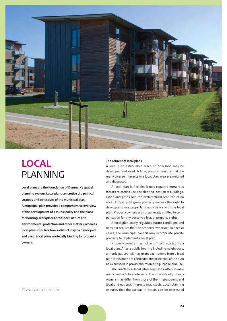
Local plans are the foundation of Denmark’s spatial
planning system. Local plans concretize the political
strategy and objectives of the municipal plan.
a municipal plan provides a comprehensive overview
of the development of a municipality and the plans
for housing, workplaces, transport, nature and
environmental protection and other matters, whereas
local plans stipulate how a district may be developed
and used. Local plans are legally binding for property
owners.
Photo: housing in Herning

��
before the final local plan determines how an area is
to be regulated.
The strength of local plans is that they state what
is permitted and what is not. The property owner and
others know how much latitude they have to act, and
neighbours know what to expect.
mandatory local plans
Implementing major development projects requires a
local plan. The concept of “major” is relative. A minor
project in Copenhagen may be major in another town.
A local plan is required if substantial changes are pro
posed to the existing environment.
Examples of major development projects include:
• new residential districts;
• a bypass road in an urban zone;
• construction of highrise buildings or large blocks
of flats;
• a hotel in a summer cottage area;
• major business construction; and
• buildings for public purposes.
The municipal council may adopt a local plan at any time
if it complies with the municipal planning framework
for local plans.
Types of local plans
Local plans differ considerably in content and extent.
Some local plans regulate land use or parcelling out and
development in a new urban district and others regulate
land use on a specific property. A local plan may also
regulate a single theme, such as signs and façades.
Local plans include a report, provisions and maps.
The report describes how the plan is related to the mu
nicipal plan and other planning for the area. The legally
binding provisions govern use, location and appearance
of buildings, transport conditions, undeveloped land and
other matters. Local plans may be adopted for any set of
properties. A local plan is required when a municipality
wants to transfer rural land designated for urban growth
to an urban zone or a summer cottage area.
involving the public and public authorities
A local plan may not contradict the municipal plan or na
tional planning directives. The municipal council provides
at least 8 weeks for public comment on local plan propo
sals before adopting them. State authorities may veto a
local plan proposal during the period of public comment
if the proposal contradicts national interests.
The council is required to publish the final plan when
adopted, including on PlansystemDK. All municipalities
publish their local plans on their web site.
local plan
A local plan for a new residential district near Kregme
in the Municipality of FrederiksværkHundested. The
local plan contains maps and drawings proposing how
the new district will be developed. The Ministry of the
Environment has prepared guidelines on local plans
to help and to inspire municipalities in preparing local
plans.
Illus
trat
ion:
Mun
icip
ality
of F
rede
riks
værk
Hun
dest
ed /
NIR
AS
��
maTTeRS LocaL PLanS may RegULaTe
• Zoning status
• Use of land and buildings
• Size and extent of properties
• Roads and paths
• Tracks, pipes and transmission lines
• Location and size of buildings
• Building density and design
• Design and use of undeveloped areas
• Landscape features
• Connection with common facilities
• Noiseabatement measures
• Creating landowners’ and allotment associations
• Conservation of buildings
• Bans on construction
• Cancellation of easements
• Combining existing flats
• Insulating against noise
• Banning major projects
• Requirements that new buildings be lowenergy buildings
• Installations on water in harbours
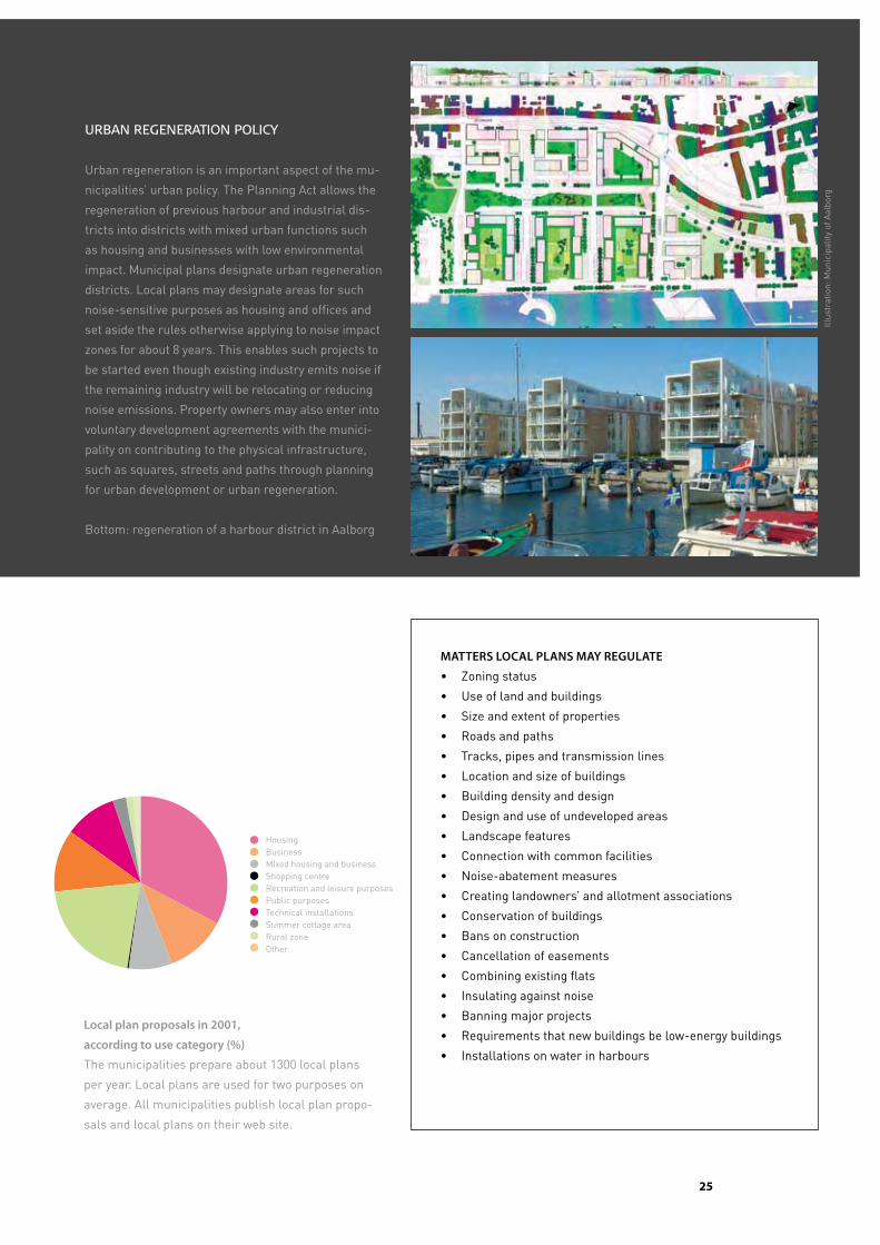
urban regeneraTion policy
Urban regeneration is an important aspect of the mu
nicipalities’ urban policy. The Planning Act allows the
regeneration of previous harbour and industrial dis
tricts into districts with mixed urban functions such
as housing and businesses with low environmental
impact. Municipal plans designate urban regeneration
districts. Local plans may designate areas for such
noisesensitive purposes as housing and offices and
set aside the rules otherwise applying to noise impact
zones for about 8 years. This enables such projects to
be started even though existing industry emits noise if
the remaining industry will be relocating or reducing
noise emissions. Property owners may also enter into
voluntary development agreements with the munici
pality on contributing to the physical infrastructure,
such as squares, streets and paths through planning
for urban development or urban regeneration.
Bottom: regeneration of a harbour district in Aalborg
Local plan proposals in 2001,
according to use category (%)
The municipalities prepare about 1300 local plans
per year. Local plans are used for two purposes on
average. All municipalities publish local plan propo
sals and local plans on their web site.
HousingBusinessMixed housing and businessShopping centreRecreation and leisure purposesPublic purposesTechnical installationsSummer cottage areaRural zoneOther
Illus
trat
ion:
Mun
icip
ality
of A
albo
rg
��
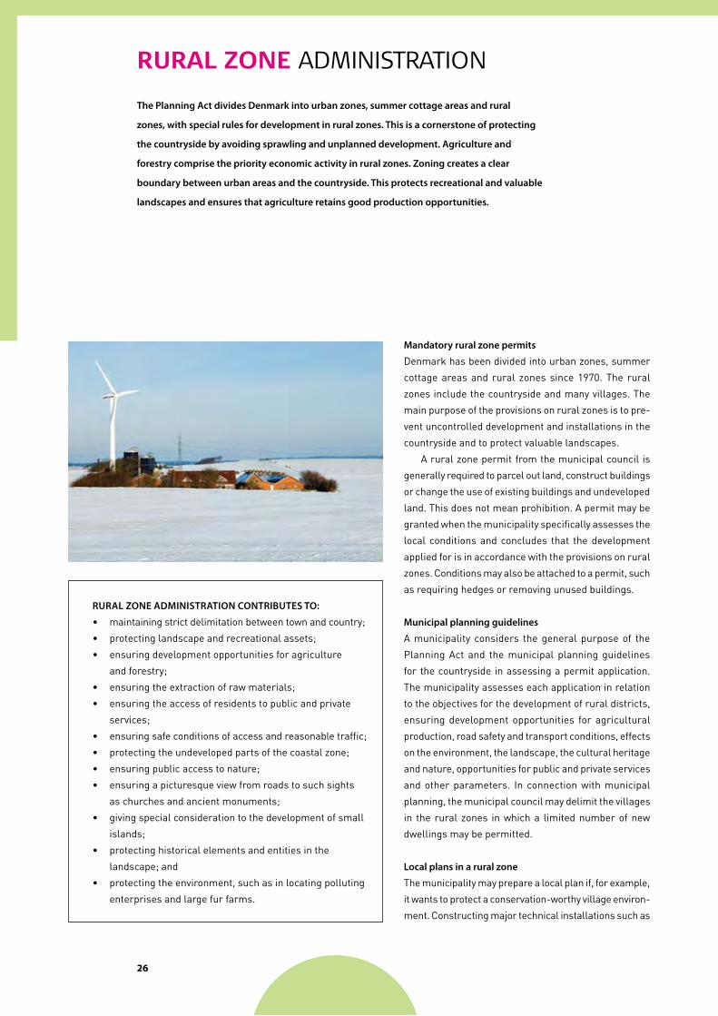
RuRal zone administration
The Planning act divides Denmark into urban zones, summer cottage areas and rural
zones, with special rules for development in rural zones. This is a cornerstone of protecting
the countryside by avoiding sprawling and unplanned development. agriculture and
forestry comprise the priority economic activity in rural zones. Zoning creates a clear
boundary between urban areas and the countryside. This protects recreational and valuable
landscapes and ensures that agriculture retains good production opportunities.
mandatory rural zone permits
Denmark has been divided into urban zones, summer
cottage areas and rural zones since 1970. The rural
zones include the countryside and many villages. The
main purpose of the provisions on rural zones is to pre
vent uncontrolled development and installations in the
countryside and to protect valuable landscapes.
A rural zone permit from the municipal council is
generally required to parcel out land, construct buildings
or change the use of existing buildings and undeveloped
land. This does not mean prohibition. A permit may be
granted when the municipality specifically assesses the
local conditions and concludes that the development
applied for is in accordance with the provisions on rural
zones. Conditions may also be attached to a permit, such
as requiring hedges or removing unused buildings.
municipal planning guidelines
A municipality considers the general purpose of the
Planning Act and the municipal planning guidelines
for the countryside in assessing a permit application.
The municipality assesses each application in relation
to the objectives for the development of rural districts,
ensuring development opportunities for agricultural
production, road safety and transport conditions, effects
on the environment, the landscape, the cultural heritage
and nature, opportunities for public and private services
and other parameters. In connection with municipal
planning, the municipal council may delimit the villages
in the rural zones in which a limited number of new
dwellings may be permitted.
Local plans in a rural zone
The municipality may prepare a local plan if, for example,
it wants to protect a conservationworthy village environ
ment. Constructing major technical installations such as
RURaL Zone aDminiSTRaTion conTRibUTeS To:
• maintaining strict delimitation between town and country;
• protecting landscape and recreational assets;
• ensuring development opportunities for agriculture
and forestry;
• ensuring the extraction of raw materials;
• ensuring the access of residents to public and private
services;
• ensuring safe conditions of access and reasonable traffic;
• protecting the undeveloped parts of the coastal zone;
• ensuring public access to nature;
• ensuring a picturesque view from roads to such sights
as churches and ancient monuments;
• giving special consideration to the development of small
islands;
• protecting historical elements and entities in the
landscape; and
• protecting the environment, such as in locating polluting
enterprises and large fur farms.
��
a wind turbine cluster may also require a local plan. The
local plan may replace the necessary permits.
construction without a rural zone permit
The Planning Act contains many exceptions from the
requirement for a rural zone permit. Examples include
construction required for agriculture, forestry and fishery
operations in connection with previous buildings.
Houses used yearround may be renovated without
a rural zone permit if the total floor space does not
exceed 250 m2. In addition, a new dwelling may be built
or arranged on farms larger than 30 ha in connection
with existing buildings when the dwelling is to be used
in connection with intergenerational succession or for
an employee.
Outside villages and areas covered by a local plan,
small businesses located in a previous farm building
may be expanded by up to 500 m2 without a rural zone
permit.
Former agricultural buildings
Farm buildings no longer required for agricultural ope
rations may be used for craft and industrial enterprises,
small shops and one dwelling as well as for storage and
offices without a rural zone permit.
Practice
Examples of applications normally approved include
appropriate construction in villages and using super
fluous farm buildings for holiday purposes. Examples of
applications normally rejected include the construction
of new dwellings, enterprises and summer cottages in
the countryside.
Publication and appeals
Rural zone permits must be published, typically in local
newspapers. Decisions on rural zone permits may be ap
pealed within 4 weeks to the Nature and Environmental
Protection Board of Appeal, which considers the munici
pality’s specific assessment as well as legal issues.
oTheR ReLevanT LegiSLaTion
Protection of Nature Act
The Protection of Nature Act governs building and protection lines
along beaches, lakes, watercourses, forests and ancient monu
ments. The Act also protects habitats.
Land Registration Act
Rights to real property, such as ownership, mortgages and ease
ments are registered in a land registry at the local court registry.
A local plan must be registered in the land registry for each
individual property.
Valuation Act
Real property is assessed and taxed based on the current and
planned use.
Parcelling Out Act
A property may be divided by being parcelled out. The Act ensures
that all properties are clearly identified and registered. A property
must be parcelled out if part of the property is to be sold or mort
gaged or is to be leased for more than 30 years.
Building Act
New buildings require a building permit. A permit may be granted
after the municipality has ensured that the application is in accor
dance with applicable plans and the provisions of other legislation
governing land use.
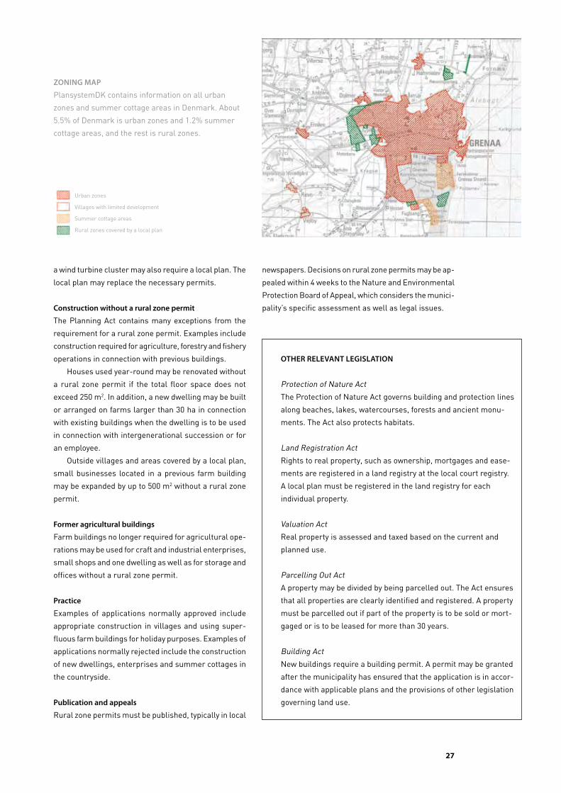
Zoning maP
PlansystemDK contains information on all urban
zones and summer cottage areas in Denmark. About
5.5% of Denmark is urban zones and 1.2% summer
cottage areas, and the rest is rural zones.
Urban zones
Villages with limited development
Summer cottage areas
Rural zones covered by a local plan
��
enviRonmental impact assessment
The rules on environmental impact assessment ensure that development projects that
are likely to have significant effects on the environment are assessed before the projects
are permitted. Denmark’s rules on environmental impact assessment are based on an
eU directive, and the other eU countries therefore have similar rules.
environmental impact assessment
is part of municipal planning
Environmental impact assessment of projects on land is
implemented as a municipal plan supplement. Combi
ned with the requirement for an environmental impact
statement, the public has a good opportunity to influence
proposed projects.
The municipal council generally carries out environ
mental impact assessment. The regional environmental
centres of the Ministry for the Environment in Aarhus,
Odense and Roskilde carry this out for certain projects,
such as projects for which the state is the developer;
enterprises likely to produce considerable pollution for
which the regional environmental centres also approve
permits in accordance with the Environmental Protection
Act; infrastructure installations requiring a municipal
plan supplement in more than two municipalities; and
wind turbines taller than 150 metres.
A statutory order requires developers to submit cer
tain proposed projects to the municipality for screening
to determine whether environmental impact assessment
is required. Projects subject to mandatory assessment
include wind turbine clusters, wastedisposal instal
lations, large shopping centres, large holiday villages
and hotel complexes and major roads.
For projects requiring a local plan, the municipality
may present a local plan proposal as part of the same
consultative process. For the builder, this means that
the process of assessing and approving the project is
more manageable.
The overall environmental assessment and the
results of the public debate give the municipal council
a good basis to decide about the project and any con
ditions to associate with approval. During this process,
many projects are changed in ways that benefit the
applicants, the neighbours and the environment. The
Process of environmental impact assessment
• Solicitation of ideas and proposals
• Proposal for municipal plan supplement and
environmental impact statement subject to
public comment for at least 8 weeks
• Municipal plan supplement adopted
• Environmental assessment permit – may be
replaced by environmental protection permit
or raw materials permit
content of an environmental impact statement
• Description of the project
• Overview of the main alternatives to the
project that have been studied
• Description of the likely effects of the project
on people, fauna, flora, soil, air, water, climate,
the landscape, material goods and the cultural
heritage
• Description of the project’s likely shortterm
and longterm effects on the environment
• Description of the measures envisaged to
improve the environment
• A nontechnical summary of the statement
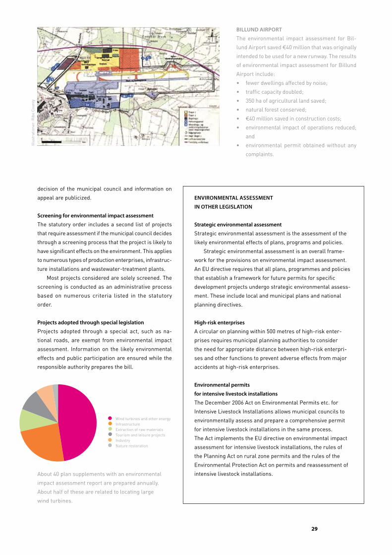
��
decision of the municipal council and information on
appeal are publicized.
Screening for environmental impact assessment
The statutory order includes a second list of projects
that require assessment if the municipal council decides
through a screening process that the project is likely to
have significant effects on the environment. This applies
to numerous types of production enterprises, infrastruc
ture installations and wastewatertreatment plants.
Most projects considered are solely screened. The
screening is conducted as an administrative process
based on numerous criteria listed in the statutory
order.
Projects adopted through special legislation
Projects adopted through a special act, such as na
tional roads, are exempt from environmental impact
assessment. Information on the likely environmental
effects and public participation are ensured while the
responsible authority prepares the bill.
biLLUnD aiRPoRT
The environmental impact assessment for Bil
lund Airport saved €40 million that was originally
intended to be used for a new runway. The results
of environmental impact assessment for Billund
Airport include:
• fewer dwellings affected by noise;
• traffic capacity doubled;
• 350 ha of agricultural land saved;
• natural forest conserved;
• €40 million saved in construction costs;
• environmental impact of operations reduced;
and
• environmental permit obtained without any
complaints.
enviRonmenTaL aSSeSSmenT
in oTheR LegiSLaTion
Strategic environmental assessment
Strategic environmental assessment is the assessment of the
likely environmental effects of plans, programs and policies.
Strategic environmental assessment is an overall frame
work for the provisions on environmental impact assessment.
An EU directive requires that all plans, programmes and policies
that establish a framework for future permits for specific
development projects undergo strategic environmental assess
ment. These include local and municipal plans and national
planning directives.
high-risk enterprises
A circular on planning within 500 metres of highrisk enter
prises requires municipal planning authorities to consider
the need for appropriate distance between highrisk enterpri
ses and other functions to prevent adverse effects from major
accidents at highrisk enterprises.
environmental permits
for intensive livestock installations
The December 2006 Act on Environmental Permits etc. for
Intensive Livestock Installations allows municipal councils to
environmentally assess and prepare a comprehensive permit
for intensive livestock installations in the same process.
The Act implements the EU directive on environmental impact
assessment for intensive livestock installations, the rules of
the Planning Act on rural zone permits and the rules of the
Environmental Protection Act on permits and reassessment of
intensive livestock installations.About 40 plan supplements with an environmental
impact assessment report are prepared annually.
About half of these are related to locating large
wind turbines.
I 2006 blev der udarbejdet 42 plantillæg med VVM. Hertil kommer de mange husdyrsager som fremover behandles efter husdyrloven.
lagkage af følgende tal:20 Vindmøller og energi 10 Infrastuktur 4 råstofindvinding4 turisme og fritid3 industri1 naturgenopretning
Wind turbines and other energyInfrastructureExtraction of raw materialsTourism and leisure projectsIndustryNature restoration
Illus
trat
ione
r: R
ibe
Cou
nty
�0
digital plans
Danish nature & environment Portal
The Danish Nature & Environment Portal is a gateway to
comprehensive public data. Citizens and environmental
professionals can download relevant and current data.
The vision is to create an efficient, digital environmental
administration.
Denmark’s Spatial Planning Database
Denmark’s Spatial Planning Database is a public data
base under the Portal that compiles data from the former
regional planning authorities and national data sets.
PlansystemDK
PlansystemDK is part of the Portal and contains plans
produced in accordance with the Planning Act. Plan
systemDK ensures that planning data are standardized
and universally accessible, including other systems such
as electronic caseprocessing systems. PlansystemDK
provides easy access to municipal and state spatial
plans and a simple way for the municipalities to report
their plan proposals and adopted plans to the national
public authorities.
The municipalities upload and are responsible for the
quality of:
• local plans (and other valid historical plans);
• municipal plans, strategies for planning and muni
cipal plan supplements; and
• zoning maps for urban and rural zones and summer
cottage areas.
Spatial planning in Denmark has become digital and publication is based on web solutions.
most municipalities have digital municipal and local plans. a common public system has
been developed called PlansystemDK that will gradually contain all plans produced in
accordance with the Planning act.
The state is responsible for:
• the coastal zone (about 3 km wide outside urban
zones);
• the beach protection line and dune protection line;
• national planning directives; and
• stateinitiated municipal plan supplements resulting
from environmental impact assessment.
All plans and plan proposals adopted since 15 Septem
ber 2006 are being uploaded to PlansystemDK. All valid
plans, including ones from before 2006, will be uploaded
to PlansystemDK before the land registry is converted
to an electronic system in about April 2008.
PlansystemDK allows each municipality to see its
own plans in the context of other municipalities’ plan
ning so that plans can be compiled across municipal
boundaries.
improving the data model for registration
PlansystemDK will initially contain municipalities’ local
plans (including other valid historical plans), munici
pal planning frameworks and zoning maps, including
data on the features of the plans and the geographical
extent.
A new data model is being developed and will include
standardized data for the new themes in municipal plan
ning that used to be part of the former regional planning.
The results will be incorporated into PlansystemDK.
contributing to the digital administration of the future
PlansystemDK was developed to be compatible with
other systems in the digital administration of the fu
ture and to supply planning data to the Danish Public
Information Server, which has information on all real
property in Denmark.
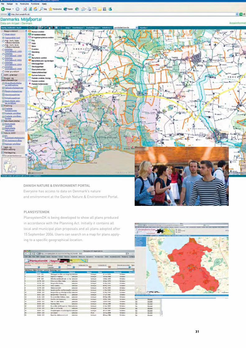
��
DaniSh naTURe & enviRonmenT PoRTaL
Everyone has access to data on Denmark’s nature
and environment at the Danish Nature & Environment Portal.
PLanSySTemDK
PlansystemDK is being developed to show all plans produced
in accordance with the Planning Act. Initially it contains all
local and municipal plan proposals and all plans adopted after
15 September 2006. Users can search on a map for plans apply
ing to a specific geographical location.
��
legal pRoteCtion and appeals
Rules for appeal
The Board’s authority to hear appeals of decisions
made pursuant to the Planning Act depends on the
type of decision. Decisions on rural zone permits or
expropriation and permits to begin a project requiring
environmental impact assessment may be appealed
to the Board, regardless of the reason. The Board may
decide all questions and may change such a decision
if it contradicts applicable law or if the Board finds the
decision unreasonable or inappropriate.
Other decisions made by municipal councils pursu
ant to the Planning Act may only be appealed for legal
questions. If the council has complied with the legal
rules and principles, the Board may not hear appeals
related to other questions and may not decide whether
the decision is appropriate or reasonable.
Legal questions include:
• whether the plan was produced in accordance with
the required procedure for public participation;
• whether the local and municipal plans contradict;
The independent nature Protection board of appeals under the ministry of the environment hears appeal
cases. in planning cases, only legal questions may be appealed. This means whether the municipal council
has complied with the rules of the Planning act and whether it has the legal authority to make the decision.
The policy content of the plan may not be appealed. The municipal council is responsible for the content of
plans. nevertheless, the municipality’s political balancing of various considerations related to rural zone
administration may be appealed to the board.
• whether the Planning Act and the municipal and
local plans have been interpreted correctly;
• whether a specific development project requires a
local plan;
• whether a specific development project requires
environmental impact assessment;
• whether an exemption from a local plan is legal;
and
• whether general administrative law rules have been
complied with such as those regarding competence
to act, hearing both parties to a dispute and equal
treatment under the law.
who has the right to appeal?
The Minister for the Environment and anyone else with
a legal interest in the outcome of a case has the right
to appeal. In addition, nationwide nongovernmental
organizations whose main purpose is protecting nature
and the environment or protecting important users’
interests within land use have the right to appeal. The
deadline for appeals is 4 weeks from the day the decision
is publicized.
effect of an appeal
A timely appeal of a rural zone permit or an expropriation
decision stays the effects of the decision. This means that
the decision may not be acted upon until the appeal is de
cided, unless the Board decides otherwise. Other appeals
do not normally stay the decision, but any action taken
based on the authority of an appealed decision may have
to be reversed if the Board overturns the decision.
court appeals
The decisions of the Board may be appealed to the
courts. Such legal proceedings must be initiated within
6 months after the Board renders a decision.
The naTURe PRoTecTion boaRD oF aPPeaL
The Nature Protection Board of Appeal is
an independent quasijudicial organ. It has
a chairperson, two Supreme Court justices
and one member appointed by each of the
political parties represented in the Finance
Committee of the Folketing.
The Board’s decisions may not be appealed
to the Minister for the Environment or other
administrative authorities and may only be
appealed to the courts.

Spatial planning in Denmark
© 2007 by the Ministry of the Environment, Denmark.
All rights reserved. Published 2007.
Quotations may be made from this publication with appropriate
attribution.
Text: Ministry of the Environment
Niels Østergård and Helle Witt
Translation: David Breuer
Design: Tegnestuen Jens V. Nielsen
Maps: Ministry of the Environment
unless otherwise specified
Photos: Jens V. Nielsen
Photo p. 16: Jan Kofod Winther / C. F. Møller Architects
Printing: Vilhelm Jensen & Partners
ISBN print: 978-87-92256-01-0
ISBN web: 978-87-92256-00-3
Distribution
This publication is available from:
Frontlinien
Rentemestervej 8
DK-2400 Copenhagen NV
Telephone: +45 70 12 02 11
E-mail: [email protected]
The publication can also be downloaded at the web site of the Agency
for Spatial and Environmental Planning (www.blst.dk).
51st iFHp World Congress 2007
The Realdania Foundation has supported this publication in connection
with the 51st IFHP World Congress: Futures of Cities – Impacts: Indicators:
Implementations in Copenhagen, Denmark, 23–26 September 2007.
www.IFHP2007Copenhagen.dk
Plan09 is a partnership project between the Realdania
Foundation and the Ministry of the Environment on
developing and renewing the planning culture in
Denmark’s municipalities. The purpose is to contribute
to qualifying the future planning basis in Denmark’s 98
municipalities. Plan09 is being implemented from 2006
to 2009. Plan09 supports demonstration projects in
selected municipalities and is carrying out numerous
activities to share knowledge and spark debate:
presentations, reports, seminars, lectures, the web site
www.plan09.dk and an electronic network.
Centre for Corporate Management
Agency forSpatial and
Environmental Planning
Danish Environmental
Protection Agency
Danish Forest
and Nature Agency
Environmentcentres:
Minister’s
Department
Aalborg
National Survey
and Cadastre Denmark
GeologicalSurvey
of Denmarkand Greenland
Aarhus
Nykøbing F
Odense
Ribe
Ringkøbing
Roskilde
The Agency for Spatial and Environmental Planning takes responsibility for tasks related
to spatial planning. The centres in Odense, Roskilde and Aarhus:• carry out environmental impact assess-
ment tasks;• ensure national interests in municipal and local planning;
The Ministerministry of
the environmentOctober 2007
Nature and Environmental
Protection Boards of Appeal
Miljøministeriet | Realdania
Det åbne land
Debat i efteråret 2007
Miljøministeriet | Realdania
Regionale visioner og strategierKommunerne og den regionaleudviklingsplan
Miljøministeriet | Realdania
NABCEn idéudviklingsmetode
need
approach
benefitcompetition
Hvilke kommuner
vil være med til
at udvikle
plankulturen?
Hvad er | Plan09
Plan09 er et partnerskabsprojekt mellem Real
dania og Miljøministeriet ved Skov og Natursty
relsen. Projektet sætter fokus på innovation i plan
processer og planløsninger i de danske kommuner
efter kommunalreformen. Plan09 gennemføres i
perioden 20062009.
Fyrtårne i Plan09 er støttede eksempelprojekter i
udvalgte kommuner, samt opbygning af videnba
se og netværk med deltagelse fra alle 98 kom
muner og andre planfaglige miljøer.
Plan09 har et sekretariat med 45 medarbejdere,
og ledes af styregruppe med vicedirektør Niels
Østergård, SNS (formand), borgmester Mads Le
bech, Frederiksberg, kontorchef Peter Pouplier,
SNS og direktør Hans Peter Svendler, Realdania.
Sekretariatet
Haraldsgade 53
2100 København Ø
T +45 72 54 20 00
www.plan09.dk
Sekretariatsleder
Svend Erik Rolandsen
T +45 72 54 26 52
Miljøministeriet | Realdania
2007
Desi
gn: Te
gnest
uen Je
ns
V. N
iels
en
spatial planning in denmark
Spatial planning aims to create and maintain the qualities of urban
areas and the countryside. Spatial planning in Denmark provides a
rapid overview of the stipulations of and opportunities in Denmark’s
Planning Act and describes national planning, regional spatial develop-
ment planning, municipal planning and local planning.
This publication describes the principles of the Planning Act related to
decentralization of responsibility, framework management and public
participation in the planning process. The planning rules for coastal
areas, retail trade and large projects that may require environmental
impact assessment are described succinctly. Finally, the publication
explains the purpose of dividing Denmark’s territory into urban zones,
summer cottage areas and rural zones and the rules for development
in rural zones.
planning
spatial
in denmark