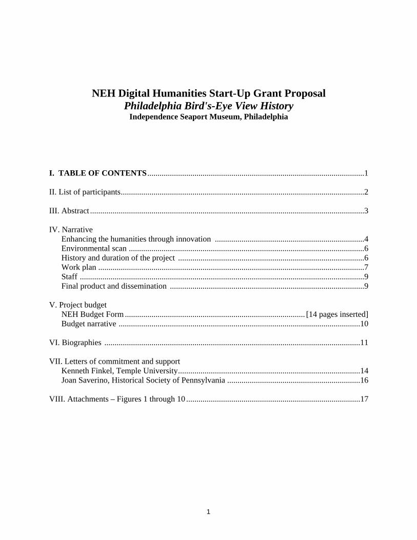
1
NEH Digital Humanities Start-Up Grant Proposal Philadelphia Bird's-Eye View History
Independence Seaport Museum, Philadelphia I. TABLE OF CONTENTS ..........................................................................................................1 II. List of participants.......................................................................................................................2 III. Abstract ......................................................................................................................................3 IV. Narrative
Enhancing the humanities through innovation .........................................................................4 Environmental scan ...................................................................................................................6 History and duration of the project ...........................................................................................6 Work plan ..................................................................................................................................7 Staff ...........................................................................................................................................9 Final product and dissemination ...............................................................................................9
V. Project budget
NEH Budget Form ........................................................................................ [14 pages inserted] Budget narrative ......................................................................................................................10
VI. Biographies .............................................................................................................................11 VII. Letters of commitment and support
Kenneth Finkel, Temple University.........................................................................................14 Joan Saverino, Historical Society of Pennsylvania .................................................................16
VIII. Attachments – Figures 1 through 10 .....................................................................................17
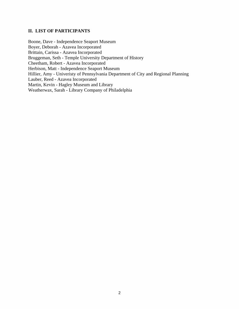
2
II. LIST OF PARTICIPANTS Boone, Dave - Independence Seaport Museum Boyer, Deborah - Azavea Incorporated Brittain, Carissa - Azavea Incorporated Bruggeman, Seth - Temple University Department of History Cheetham, Robert - Azavea Incorporated Herbison, Matt - Independence Seaport Museum Hillier, Amy - Univeristy of Pennsylvania Department of City and Regional Planning Lauber, Reed - Azavea Incorporated Martin, Kevin - Hagley Museum and Library Weatherwax, Sarah - Library Company of Philadelphia
3
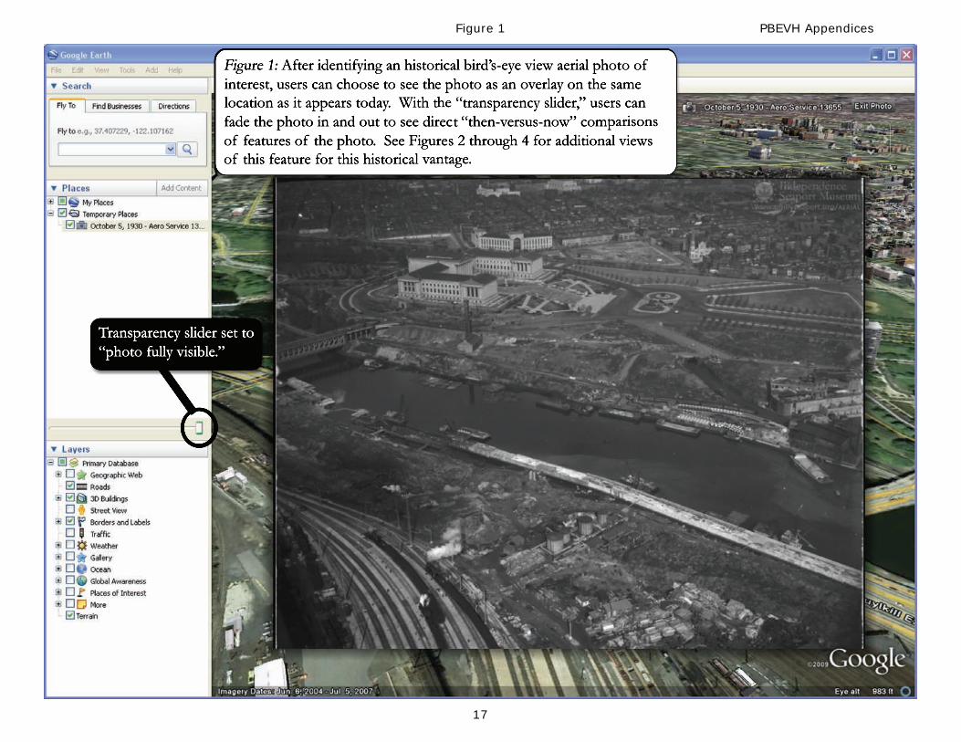
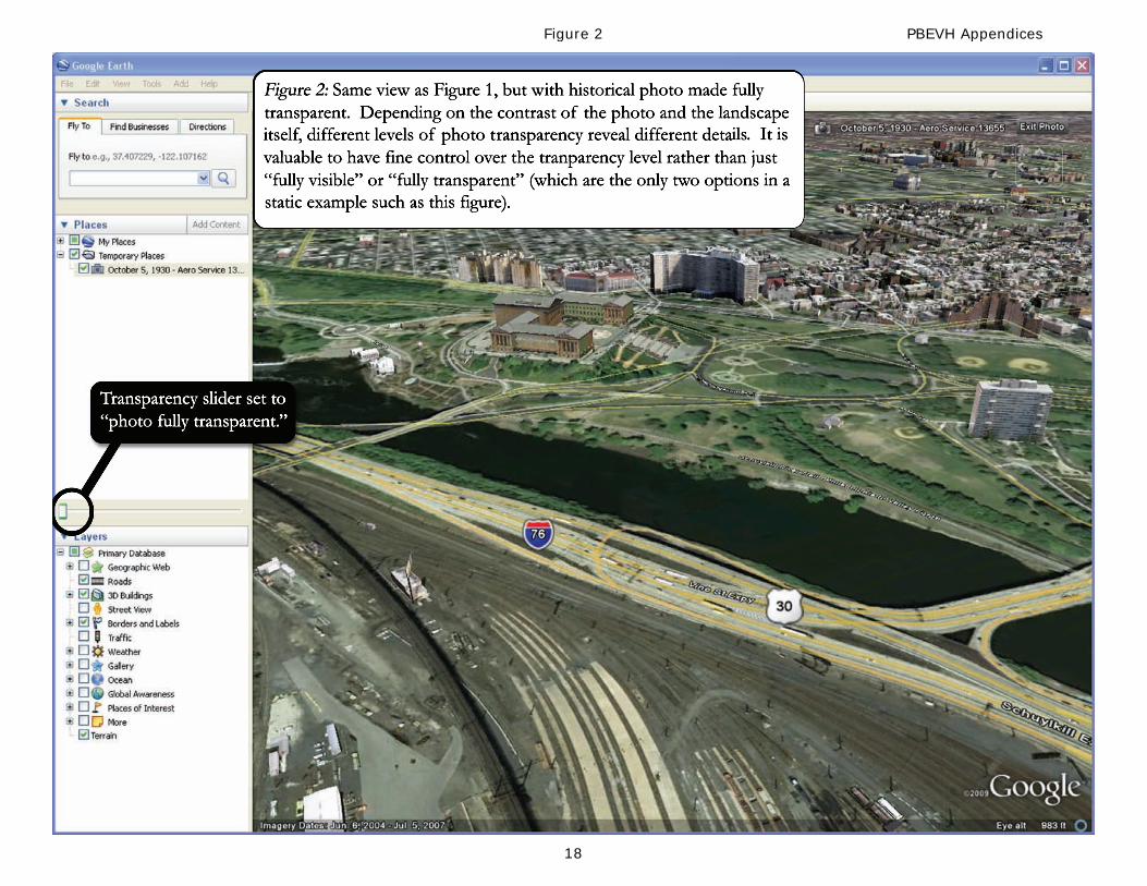
III. ABSTRACT Independence Seaport Museum ("ISM") is committed to developing the Philadelphia Bird's-Eye View History ("PBEVH") project as a resource of its J. Welles Henderson Archives and Library. PBEVH is a web-based historical photographic database which will enable users to: (1) search for historical aerial photographs of the Philadelphia region from ISM's archives; (2) view high-resolution image overlays that show each historical image over the present-day landscape using Google Earth, allowing direct “then-versus-now” comparisons; and (3) encourage user-generated content through augmenting photograph-specific descriptions and improvements to the placement of image overlays. PBEVH will serve as a valuable tool which will enable historians, students, and the public to explore the past through photographic imagery in order to study how the human, natural, and built environment of this region have evolved over the past 100 years.
4
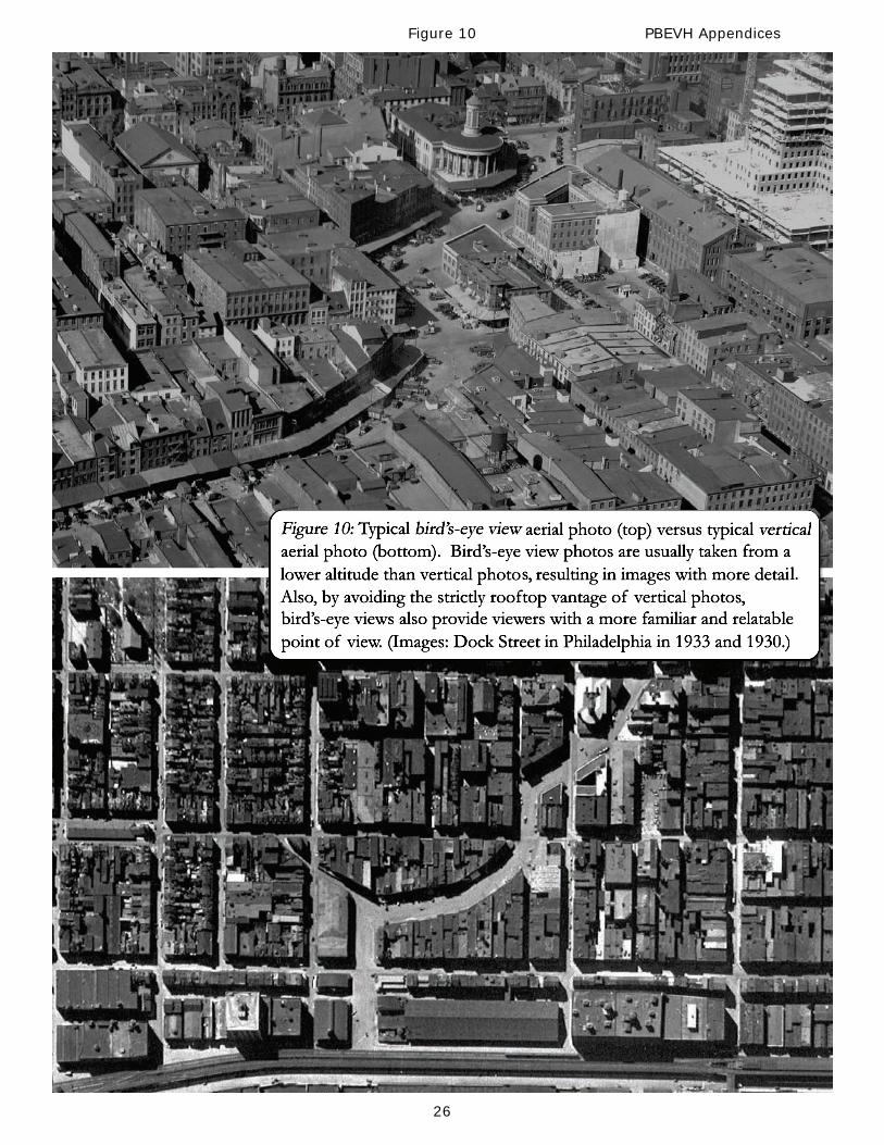
IV. NARRATIVE Enhancing the humanities through innovation The primary goal of the Philadelphia Bird's-Eye View History project is to use innovative technology to make the Aero Service Corporation Collection (“Collection”) of historical aerial photographs available to the public for the first time. The immediate goals of PBEVH are to: (1) allow people to locate areas featured in the Collection of aerial photographs (based on location, features, and date) and see a photo superimposed over a present-day view of the landscape; (2) encourage users on a global scale to improve image descriptions as well as the quality of image overlays and (3) serve as a means of engaging the region to explore and reflect on how the Philadelphia area has changed. PBEVH will serve as an interactive web-based database which will enable users to explore and understand images from the Collection and, through the images, study and learn how human activity has affected the built and natural environments of the Philadelphia region. In this endeavor, PBEVH will develop and implement a geographic image management system that, through a straightforward interface, encourages varied and interactive uses of these high-resolution, historical, aerial photographs. Once PBEVH goes live, it will allow users to view historical images overlaid on top of their present-day landscapes by utilizing the free Google Earth application in an innovative way. This direct-comparison capability is the most valuable feature of the PBEVH system, inviting uncomplicated historical and environmental analysis by showing areas that have been affected by both human activities and natural forces throughout the 20th century. PBEVH will comprise five distinct components: (1) Bird’s-eye view aerial image overlays; (2) historical bird’s-eye aerial images; (3) high-resolution database images; (4) geographic image management and access; and (5) crowdsourcing images overlays and descriptions. These components come together to create a unique, easy-to-use, and valuable public resource for exploring history. Five Components of the Philadelphia Bird's-Eye View History System: 1. Bird's-eye view aerial image overlays PBEVH will showcase a type of aerial image known as an “oblique aerial photograph,” often called a “bird's-eye view.” Oblique aerial photos are images of the landscape viewed from an angle rather than a vertical orientation (looking straight down onto rooftops, called “vertical aerial photos”). Bird's-eye views optimize the viewer experience by combining the panoramic scale of a vertical aerial photo with the more familiar and relatable vantage of a typical ground-level photo (see Figure 10 in the Attachments Section). PBEVH photos will be superimposed (or “overlaid”) on the present-day landscape within the popular and free Google Earth application, using the same vantage point of the original historical photo. Examples of these image overlays are found in Figures 1 through 5. 2. Historical bird’s-eye aerial images PBEVH will create a unique publicly accessible database containing geographically referenced historical bird’s-eye view aerial photographs. By overlaying historical images over their present-day landscapes, users can easily explore the “then-versus-now” changes in the built and natural landscapes over time. As part of the Phase I of this project, ISM will digitize 500 images which will be accessible to the public. As funding and collaborative partners develop, ISM’s entire collection of 1,200 aerial images will subsequently be digitized and made available through PBEVH. 3. Geographic image management and access ISM will develop the PBEVH system in partnership with Azavea (formerly Avencia), a Philadelphia-
5
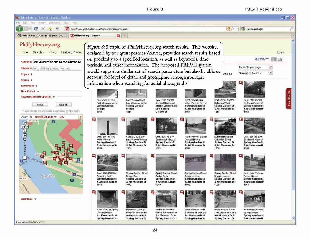
based GIS software development firm specializing in development of web-based geographic applications. Azavea has proven success in developing and managing large-scale image projects that allow users to connect with location-based historical resources (e.g., PhillyHistory.org). Screenshots and mock-ups of similar web platforms developed by Azavea are found in Figures 8 and 9 in the Attachments Section. 4. High-resolution image quality The original photographs from the Collection contain an extraordinary amount of detail. To ensure that these details are visible to users, the ISM library staff has conducted a number of scanning and image-formatting tests to develop a protocol that retains all of the detail available in the original images. Many online historical image repositories share images at lower resolution, but with aerial photographs, doing so would have a detrimental effect on use since so many of the landscape details are only visible at the image-pixel level. By sharing high-resolution digital images, PBEVH would make it possible to discern historical differences not only at the neighborhood level but also at the street, building, and smaller scales, all within a single photo. 5. Crowdsourcing image overlays and descriptions The PBEVH system will provide a user-contribution component which will enable users to improve upon the alignments in the aerial image overlays. By following steps laid out in a brief tutorial (created by ISM), users can quickly master the fun and challenging skill of accurately overlaying historical images by placing themselves in the same spot the original airplane pilots were in over 60 years ago. Improving image overlay placement is an ideal crowdsourcing activity – it is relatively easy to learn the basic technique but each image presents a unique challenge. PBEVH will also encourage users to contribute additional descriptive and anecdotal information and comments about the images. The funding requested from NEH Digital Humanities Start-Up Grant (Level II) will be used for Phase I of the PBEVH project, which includes development of the working website and digitization of 500 images from the Collection. Pending successful completion of Phase I, the remaining 700 images from the Collection will be digitized. The duration of this project is approximately six months in length. Please see “Work Plan” component of this narrative for a more detailed description. Azavea’s software is based on several open source components and can use both open source (Geoserver and MapServer) internet mapping servers, the OpenStreetMap database, commercial API's such as GoogleMaps, ArcGIS Online and Bing, and commercial map servers such as ESRI ArcGIS Server. In addition, Azavea’s proposed PBEVH platform incorporates the use of four open standards supported by the Open Geospatial Consortium (OGC) including: WMS, WFS, GeoRSS and KML. While the project team will use open source software wherever possible, the proposed project will rely on two commercial software tools for which solid and reliable open source equivalents do not exist at this point: Google Maps and Google Earth. Both systems are being incorporated into the project because of the seamless data sets they incorporate, the 3D capabilities of the Google Earth software and their support for the open standard KML. It is our firm belief that funding from NEH will enable ISM to not only assess this approach for historical aerial photo mapping but, also lead to further improvements of this type of web-based resource. Historical bird's-eye view images exist at many repositories throughout the United States and the world. Our eventual goal is to build a system that not only encourages multiple applications by diverse user groups, but also allows other repositories to readily contribute their own aerial
6
images to the system. Preliminary outreach to such repositories has met with very favorable responses; two of our PBEVH Advisory Board members come from institutions holding large collections of historical bird’s-eye view aerial photographs. Environmental scan Philadelphia Bird’s-Eye View History complements several ongoing geospatial/historical projects in the Philadelphia, the region, and United States, most notably the Greater Philadelphia GeoHistory Network (“GPGN”, www.philageohistory.org) and PhillyHistory.org. PhillyHistory.org makes it possible to locate tens of thousands of photographs from the City of Philadelphia Department of Records, which are searchable by proximity to an address, intersection, place name, or neighborhood (see Figure 8). The bulk of the images on PhillyHistory.org are ground-level photographs taken by city photographers beginning in the late 1800s. The creators of PhillyHistory.org’s geographic assett management system are Azavea Incorporated, who are serving as system developers for PBEVH project. By building upon their existing tools and expertise, Azavea will develop a system that can effectively deal with the unique needs of users searching for bird’s-eye view aerial photos images. GPGN is a rich resource that supports access to geographically organized historical information from Philadelphia and its region, including street maps, high-altitude aerial photographs, property and land use maps, and city directories. The GIS system underlying GPGN does not allow the type of searching capabilities that we plan to incorporate into the PBEVH system. PhilaPlace (www.philaplace.org) is an interactive website, created by the Historical Society of Pennsylvania, which links stories to places across time in Philadelphia’s neighborhoods, connecting audiences with personal stories and historical records by allowing users to access and share their own stories through interactive maps (both contemporary and historic), text, photographs, and audio and video clips. ISM staff met with PhilaPlace staff in 2009 to make them aware of ISM’s aerial photo project and both parties are excited to work together in later phases of the PBEVH system. PennPilot (www.pennpilot.psu.edu) is a project sponsored by the Pennsylvania Geological Survey that features historical aerial photography throughout Pennsylvania (but not within Philadelphia County). The images used in this resource come from higher-altitude vertical aerial photographs that do not provide the kind of street-level detail that is available in most bird’s-eye view aerial photographs. History and duration of the project ISM currently holds approximately 1,200 aerial photos from 1925-1945 from the Aero Service Corporation, which ran an aerial photo service beginning after World War I and continuing through World War II . When the Collection was donated in the 1980s, the corporation’s photographic negatives were distributed to ISM, the Pennsylvania State Archives, the Library Company of Philadelphia, and other repositories throughout the country. ISM’s Aero Service Collection contains photographs and negatives relating to the Philadelphia region, many of which focus on waterways in the area.
7
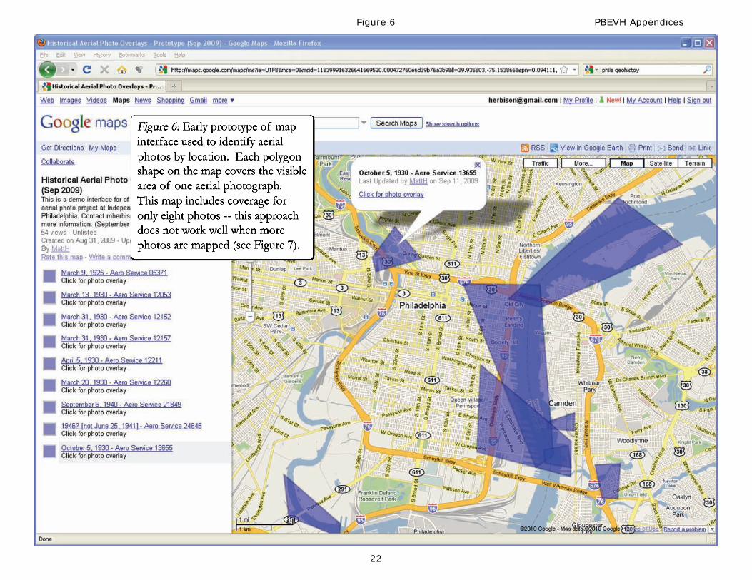
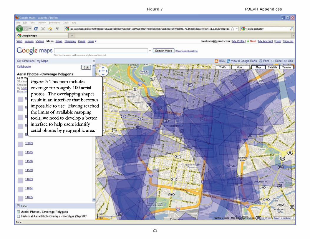
In 2008, during a large Philadelphia-area “hidden archival collections” assessment sponsored by the Andrew W. Mellon Foundation, the Collection earned a 9 out of 10 for “Research Value.” Despite its high research value, this currently “hidden collection” has seen very little use by researchers. Upon its donation to ISM, the Collection contained little information about each of the photographs. In 2008, a volunteer, Dave Boone, was recruited to develop more detailed descriptions. Mr. Boone was a tugboat dispatcher on the Delaware River for 30 years and, through his work and interests, has developed a unique knowledge of the geography and history of the Philadelphia region. As of March 2010, Mr. Boone has created comprehensive descriptive information for over 260 of the images, which will continue to grow and become the initial data source for the PBEVH system. In 2009, ISM Library staff began exploring options for performing location-specific searches for the aerial images. One approach involved using Google Maps to show “coverage polygons” that give an indication of areas featured in the aerial images. While this method seemed viable and straightforward to develop in-house, we found that for overlapping areas of image coverage, the results become too confusing to be of use (see Figures 6 and 7). In 2009, ISM Library staff met with Azavea (formerly Avencia), a Philadelphia-based GIS software development firm specializing in web-based geographic analysis, visualization and modeling applications, and began a discussion of how best to connect users with the Collection. After a demonstration by ISM staff of the proposed PBEVH project, Azavea agreed to partner with ISM to create a detailed work plan for the development of PBEVH. Pending securing of funding for and completion of Phase I, ISM is committed to further refining and developing the PBEVH project, with the ultimate goal of extending the tool beyond the Philadelphia Region by partnering with institutions maintaining collections of aerial photographs. ISM staff have met already with staff of such institutions to give demonstrations of the proposed PBEVH project. These demonstrations have been met very favorably and informal suggestions and questions have been addressed in this proposal. Future funding will be sought from the Andrew W. Mellon Foundation program in Research in Information Technology, Institute of Museum and Library Services National Leadership Grants, Google.org Geo Challenge Grants, or NEH Institutes for Advanced Topics in the Digital Humanities program. We foresee further funding to build a system that will scale to tens of thousands of images, facilitate contributions from multiple repositories and individuals, support improved and increased user-generated content, and to improve the currently challenging process of accurately overlaying bird’s-eye view aerial photos on their present-day locations. Work plan Task 1: Aerial Imagery Digitization and Description – ISM will digitize approximately 500 aerial images that will be included in the prototype web-based application. ISM will provide rough placement of each image in the Google Earth interface and provide related data (including keywords and narrative descriptions) about each image to facilitate search capabilities in the proposed web application.
Task 2: System Planning and Design – Azavea will develop a draft set of webpage designs that will demonstrate how users will interact with the finished web application. Slider bars will enable aerial selection by altitude, or designate an overall coverage area in square miles. Based on feedback from
8
ISM staff and project Advisory Board members, Azavea will prepare a final version of the design elements for use in the web application. ISM will also provide sample data and work with Azavea to design an effective database schema to store the image metadata.
Task 3: Graphic Design – Azavea will provide a basic graphic design that will include a home page design, a color palette for use in the application, CSS stylesheets and other visual elements.
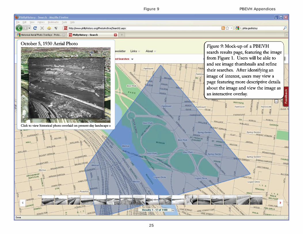
Task 4: Software Development – Azavea will develop a web-based application that will enable users to search for the ISM’s aerial imagery by keyword, date and geographic location (see Figure 8). Search results will appear on a map as flags or markers to denote location, with thumbnail images of each aerial across the bottom of the screen as reference. Users will be able to mouse over the thumbnail images for a more detailed look, or click on a location marker to open a particular image (see Figure 9). The prototype site will also have a downloadable set of instructions explaining how to adjust the placement of aerial images using Google Earth to enhance their accuracy and save the result as a KML file. Users will be able to upload the revised KML file and email it to ISM’s designated web application administrator, who will have the ability to replace or reject the revised KML file. ISM staff will have monthly opportunities to view and test the prototype application prior to launch. Azavea will integrate feedback from these meetings into the software development process.
Task 5: Installation and Configuration – Azavea will install the web application for ISM using the Amazon Web Services EC2 and S3 infrastructure. This will provide a cost-effective hosting environment without requiring purchase of additional hardware and software. ISM will develop a survey available on the PBEVH website to gather information about how people are using the website, interface, and resources.
Task 6: Preparation of White Paper – ISM staff will work with Azavea staff to prepare a white paper regarding the proposed application. The white paper will include a tutorial of the process used by ISM staff to overlay the aerial images in Google Earth.
Task 7: Project Management – ISM and Azavea staff will dedicate time to accommodate activities that may include responding to emails, attending meetings, and preparing the necessary status and timesheet reports.
Task 8: Advisory Board Involvement – The Advisory Board will meet with ISM and Azavea staff at the earliest stages of system design and planning as well as prior to the final website installation.
Task 9: Project Marketing – ISM staff will continue to contact individuals and organizations as indicated in the Final Product and Dissemination section of this proposal.
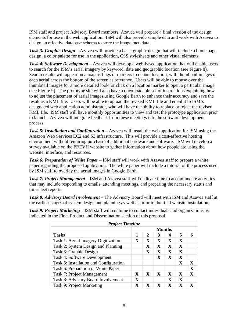
Project Timeline Months Tasks 1 2 3 4 5 6 Task 1: Aerial Imagery Digitization X X X X X Task 2: System Design and Planning X X X X Task 3: Graphic Design X X X X Task 4: Software Development X X X Task 5: Installation and Configuration X X Task 6: Preparation of White Paper X Task 7: Project Management X X X X X X Task 8: Advisory Board Involvement X X X Task 9: Project Marketing X X X X X X
9
Staff The PBEVH Project Director is Matt Herbison, Director of the Archives and Library at Independence Seaport Museum, who will contribute 25% of his time over the six month duration of the project. Mr. Herbison will work closely with Azavea staff, including Robert Cheetham, president of Azavea and their Senior Project Manager for the PBEVH project. The technical system development work will be performed by Azavea staff (see Biographies Section). Project Advisory Board members (see Biographies Section) have been selected to bring expertise and varied views in a number of areas including Public History, Digital Humanities, use of pictorial resources, and digital archives. They will also bring in representatives from archival repositories that would form collaborations to build on the PBEVH resource in subsequent phases of the system development and expansion. Board members will meet twice during the project. Final product and dissemination Upon successful completion of Phase I of the PBEVH project, ISM will promote PBEVH via the following means: (1) press and media releases; (2) inclusion on ISM’s website; (3) targeted mailings to universities, maritime museums and other nonprofit organizations; (4) announcements on social networking sites including Facebook, Twitter and blogs; and (5) reaching out to discussion forum moderators and bloggers such as those responsible for Carto Talk, Google Earth, Google Maps and Google Earthy Library, Bing Maps blogs, and other mapping and historical photo websites. The aerial images offered in Phase I of the PBEVH project will also be available on Flickr.com, the popular online photo-sharing service. This will provide the images with additional exposure and drive Internet traffic to the PBEVH website. During the six months of the project and subsequent year, ISM staff will also reach out to conference organizers to propose sessions at several archives or history conferences, ideally with a focus on digital archives or digital history. During 2009, ISM staff gave demonstrations of the aerial photo project to several dozens of Philadelphia-area individuals – we will contact these individuals to make them aware of the upcoming fully functional PBEVH system. During the six months following the completion of the project, ISM staff will monitor website usage statistics, the results of user comments (gathered through a built-in “feedback module”), and responses to the surveys available on the website. We will use these data to begin understanding the ways in which users are making use of PBEVH resources and how the interface itself is meeting users’ needs. The balance of scholarly, educational, and enthusiast users and uses to “casual” users and uses will help inform the direction of later phases of the project. In subsequent phases of the PBEVH project, with funding in place, ISM anticipates virtually reuniting large blocks of the Aero Service Collection which was disbursed to the Library Company of Philadelphia, Pennsylvania State Archives, and other institutions across the country. Beyond the Aero Service photos, ISM is already pursuing collaborative partnerships with other organizations and institutions including Hagley Museum and Library in Delaware. PBEVH will, in all likelihood, never be a totally complete project as it is organic and will continue to grow as additional historical aerial photographs and interface options become available.

NATIONAL ENDOWMENT FOR THE HUMANITIESTHREE-YEAR BUDGET FORM
Project Director: _______________________________________________________________________Applicant Organization: __________________________________________________________________Requested Grant Period From (mo/yr): ___________________ Thru (mo/yr): _____________________If this is a revised budget, indicate the NEH application/grant number: ________________________________
The three-column budget has been developed for the convenience of those applicants who wish to identifythe project costs that will be charged to NEH funds and those that will be cost shared. FOR NEHPURPOSES, THE ONLY COLUMN THAT NEEDS TO BE COMPLETED IS COLUMN C. Themethod of cost computation should clearly indicate how the total charge for each budget item wasdetermined. If more space is needed for any budget category, please follow the budget format on aseparate sheet of paper. Click HERE to see the detailed instructions.
1. Salaries and WagesProvide the names and titles of the principal project personnel. For support staff, include the title of eachposition and indicate in brackets the number of persons who will be employed in that capacity. For personsemployed on academic year basis, list separately any salary charge for work done outside the academic year.
___________________________ [ ] ____________________ $ ________ $ ________ $ ___________________________________ [ ] ____________________ $ ________ $ ________ $ ___________________________________ [ ] ____________________ $ ________ $ ________ $ ___________________________________ [ ] ____________________ $ ________ $ ________ $ ___________________________________ [ ] ____________________ $ ________ $ ________ $ ___________________________________ [ ] ____________________ $ ________ $ ________ $ ___________________________________ [ ] ____________________ $ ________ $ ________ $ ________
SUBTOTAL $ ________ $ ________ $ ________
Method of Cost Computation NEH Funds Cost Sharing TotalName/Title of Position No. (see sample) (a) (b) (c)
2. Fringe BenefitsIf more than one rate is used, list each rate and salary base.
_________% of $ ____________________ $ ________ $ ________ $ _________________% of $ ____________________ $ ________ $ ________ $ _________________% of $ ____________________ $ ________ $ ________ $ ________
SUBTOTAL $ ________ $ ________ $ ________
Rate Salary Base (a) (b) (c)
SECTION A -- Ye a r # 1Budget detail for the period FROM (mo/yr): _________________ THRU (mo/yr): ___________________
OMB No. 3136-0134Expires 6/30/12
When the proposed grant period is 18 months or longer, project expenses for each twelve-month periodare to be listed separately and totaled in the last column of the budget. For projects that will run less than 18 months, only the last column of the budget should be completed.
3. Consultant Fees Include payments for professional and technical consultants and honoraria.
_____________________________ ________ __________ $ ________ $ ________ $ _____________________________________ ________ __________ $ ________ $ ________ $ _____________________________________ ________ __________ $ ________ $ ________ $ _____________________________________ ________ __________ $ ________ $ ________ $ ________
SUBTOTAL $ ________ $ ________ $ ________
No. of days Daily rate of NEH Funds Cost Sharing TotalName or type of consultant on project compensation (a) (b) (c)
4. TravelFor each trip, indicate the number of persons traveling, the total days they will be in travel status, and the totalsubsistence and transportation costs for that trip. When a project will involve the travel of a number of peopleto a conference, institute, etc., these costs may be summarized on one line by indicating the point of origin as"various." All foreign travel must be listed separately.
______________________ [ ] [ ] $ ________ $ ________ $ ________ $ ________ $ ______________________________ [ ] [ ] $ ________ $ ________ $ ________ $ ________ $ ______________________________ [ ] [ ] $ ________ $ ________ $ ________ $ ________ $ ______________________________ [ ] [ ] $ ________ $ ________ $ ________ $ ________ $ ______________________________ [ ] [ ] $ ________ $ ________ $ ________ $ ________ $ ______________________________ [ ] [ ] $ ________ $ ________ $ ________ $ ________ $ ________
SUBTOTAL $ ________ $ ________ $ ________
Subsistence TransportationFrom/To # * Costs + Costs = (a) (b) (c)
# - Number of persons * - Total travel days
5. Supplies and MaterialsInclude consumable supplies, materials to be used in the project and items of expendable equipment (i.e.,equipment items costing less than $5,000 and with an estimated useful life of less than a year).
________________________ ________________________ $ ________ $ ________ $ ________________________________ ________________________ $ ________ $ ________ $ ________________________________ ________________________ $ ________ $ ________ $ ________________________________ ________________________ $ ________ $ ________ $ ________________________________ ________________________ $ ________ $ ________ $ ________________________________ ________________________ $ ________ $ ________ $ ________________________________ ________________________ $ ________ $ ________ $ ________
SUBTOTAL $ ________ $ ________ $ ________
Item Basis/Method of Cost Computation (a) (b) (c)
NEH Budget FormPage 2

________________________ _________________________ $ ________ $ ________ $ ________________________________ _________________________ $ ________ $ ________ $ ________________________________ _________________________ $ ________ $ ________ $ ________________________________ _________________________ $ ________ $ ________ $ ________________________________ _________________________ $ ________ $ ________ $ ________________________________ _________________________ $ ________ $ ________ $ ________________________________ _________________________ $ ________ $ ________ $ ________
SUBTOTAL $ ________ $ ________ $ ________
6. ServicesInclude the cost of duplication and printing, long distance telephone calls, equipment rental, postage, and otherservices related to project objectives that are not included under other budget categories or in the indirect costpool. For subcontracts, provide an itemization of subcontract costs as an attachment.
NEH Funds Cost Sharing TotalItem Basis/Method of Cost Computation (a) (b) (c)
________________________ _________________________ $ ________ $ ________ $ ________________________________ _________________________ $ ________ $ ________ $ ________________________________ _________________________ $ ________ $ ________ $ ________________________________ _________________________ $ ________ $ ________ $ ________________________________ _________________________ $ ________ $ ________ $ ________________________________ _________________________ $ ________ $ ________ $ ________________________________ _________________________ $ ________ $ ________ $ ________
SUBTOTAL $ ________ $ ________ $ ________
NEH Funds Cost Sharing TotalItem Basis/Method of Cost Computation (a) (b) (c)
7. Other CostsInclude participant stipends and room and board, equipment purchases, and other items not previously listed.Please note that “miscellaneous” and “contingency” are not acceptable budget categories. Refer to the budgetinstructions for the restriction on the purchase of permanent equipment.
8. Total Direct Costs (add subtotals of items 1 to 7) $ ________ $ ________ $ ________
NEH Budget FormPage 3
10
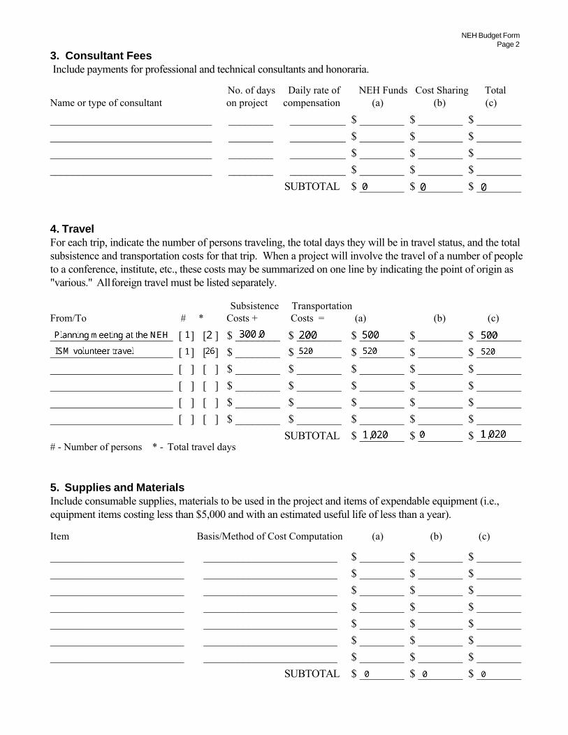
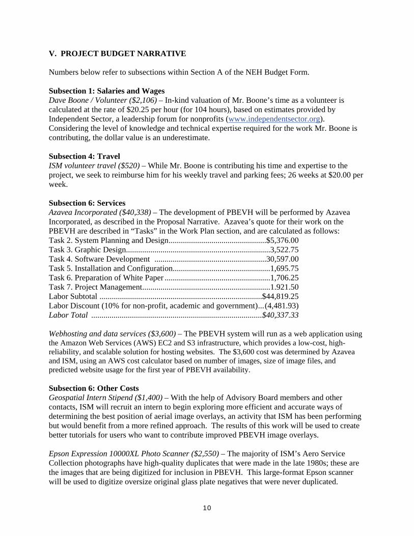
V. PROJECT BUDGET NARRATIVE Numbers below refer to subsections within Section A of the NEH Budget Form. Subsection 1: Salaries and Wages Dave Boone / Volunteer ($2,106) – In-kind valuation of Mr. Boone’s time as a volunteer is calculated at the rate of $20.25 per hour (for 104 hours), based on estimates provided by Independent Sector, a leadership forum for nonprofits (www.independentsector.org). Considering the level of knowledge and technical expertise required for the work Mr. Boone is contributing, the dollar value is an underestimate. Subsection 4: Travel ISM volunteer travel ($520) – While Mr. Boone is contributing his time and expertise to the project, we seek to reimburse him for his weekly travel and parking fees; 26 weeks at $20.00 per week. Subsection 6: Services Azavea Incorporated ($40,338) – The development of PBEVH will be performed by Azavea Incorporated, as described in the Proposal Narrative. Azavea’s quote for their work on the PBEVH are described in “Tasks” in the Work Plan section, and are calculated as follows: Task 2. System Planning and Design................................................$5,376.00 Task 3. Graphic Design.......................................................................3,522.75 Task 4. Software Development .......................................................30,597.00 Task 5. Installation and Configuration................................................1,695.75 Task 6. Preparation of White Paper ....................................................1,706.25 Task 7. Project Management...............................................................1.921.50 Labor Subtotal ................................................................................$44,819.25 Labor Discount (10% for non-profit, academic and government)...(4,481.93) Labor Total ....................................................................................$40,337.33 Webhosting and data services ($3,600) – The PBEVH system will run as a web application using the Amazon Web Services (AWS) EC2 and S3 infrastructure, which provides a low-cost, high-reliability, and scalable solution for hosting websites. The $3,600 cost was determined by Azavea and ISM, using an AWS cost calculator based on number of images, size of image files, and predicted website usage for the first year of PBEVH availability. Subsection 6: Other Costs Geospatial Intern Stipend ($1,400) – With the help of Advisory Board members and other contacts, ISM will recruit an intern to begin exploring more efficient and accurate ways of determining the best position of aerial image overlays, an activity that ISM has been performing but would benefit from a more refined approach. The results of this work will be used to create better tutorials for users who want to contribute improved PBEVH image overlays. Epson Expression 10000XL Photo Scanner ($2,550) – The majority of ISM’s Aero Service Collection photographs have high-quality duplicates that were made in the late 1980s; these are the images that are being digitized for inclusion in PBEVH. This large-format Epson scanner will be used to digitize oversize original glass plate negatives that were never duplicated.
11
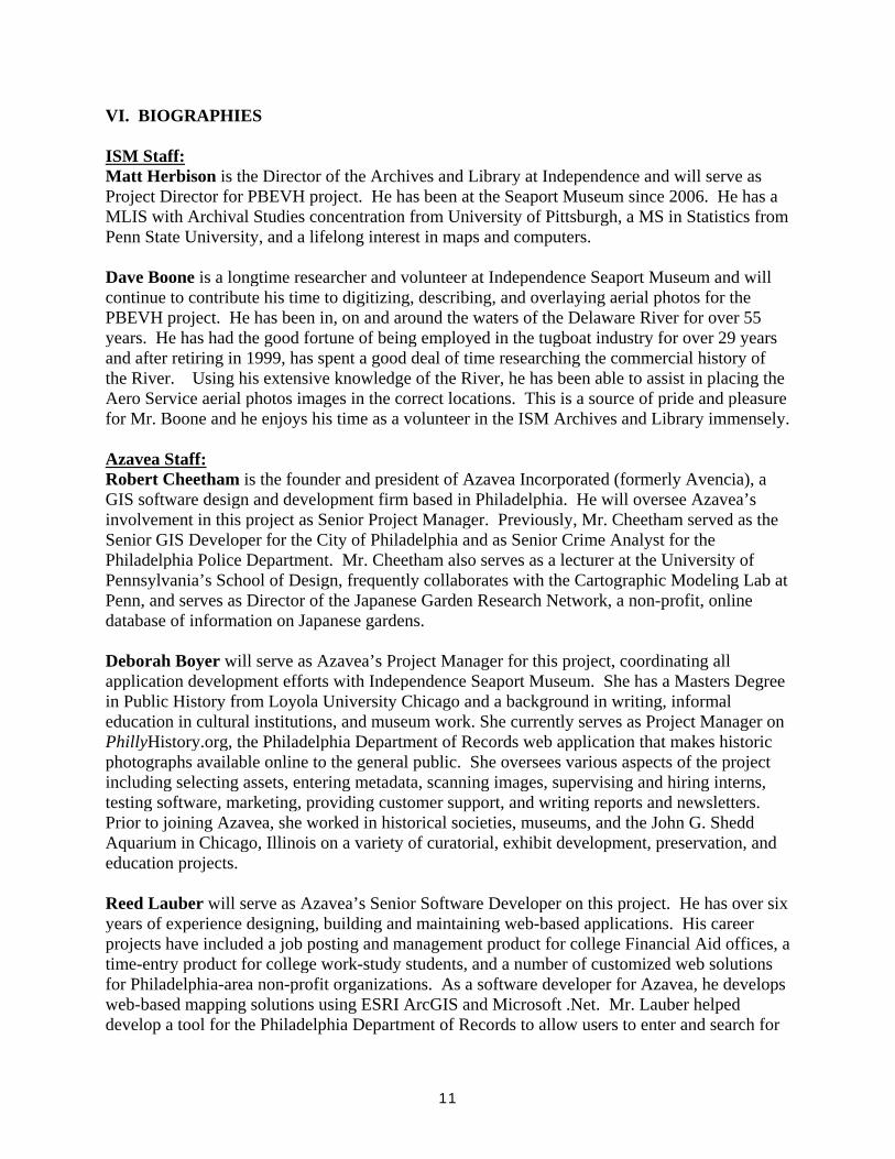
VI. BIOGRAPHIES ISM Staff: Matt Herbison is the Director of the Archives and Library at Independence and will serve as Project Director for PBEVH project. He has been at the Seaport Museum since 2006. He has a MLIS with Archival Studies concentration from University of Pittsburgh, a MS in Statistics from Penn State University, and a lifelong interest in maps and computers. Dave Boone is a longtime researcher and volunteer at Independence Seaport Museum and will continue to contribute his time to digitizing, describing, and overlaying aerial photos for the PBEVH project. He has been in, on and around the waters of the Delaware River for over 55 years. He has had the good fortune of being employed in the tugboat industry for over 29 years and after retiring in 1999, has spent a good deal of time researching the commercial history of the River. Using his extensive knowledge of the River, he has been able to assist in placing the Aero Service aerial photos images in the correct locations. This is a source of pride and pleasure for Mr. Boone and he enjoys his time as a volunteer in the ISM Archives and Library immensely. Azavea Staff: Robert Cheetham is the founder and president of Azavea Incorporated (formerly Avencia), a GIS software design and development firm based in Philadelphia. He will oversee Azavea’s involvement in this project as Senior Project Manager. Previously, Mr. Cheetham served as the Senior GIS Developer for the City of Philadelphia and as Senior Crime Analyst for the Philadelphia Police Department. Mr. Cheetham also serves as a lecturer at the University of Pennsylvania’s School of Design, frequently collaborates with the Cartographic Modeling Lab at Penn, and serves as Director of the Japanese Garden Research Network, a non-profit, online database of information on Japanese gardens. Deborah Boyer will serve as Azavea’s Project Manager for this project, coordinating all application development efforts with Independence Seaport Museum. She has a Masters Degree in Public History from Loyola University Chicago and a background in writing, informal education in cultural institutions, and museum work. She currently serves as Project Manager on PhillyHistory.org, the Philadelphia Department of Records web application that makes historic photographs available online to the general public. She oversees various aspects of the project including selecting assets, entering metadata, scanning images, supervising and hiring interns, testing software, marketing, providing customer support, and writing reports and newsletters. Prior to joining Azavea, she worked in historical societies, museums, and the John G. Shedd Aquarium in Chicago, Illinois on a variety of curatorial, exhibit development, preservation, and education projects. Reed Lauber will serve as Azavea’s Senior Software Developer on this project. He has over six years of experience designing, building and maintaining web-based applications. His career projects have included a job posting and management product for college Financial Aid offices, a time-entry product for college work-study students, and a number of customized web solutions for Philadelphia-area non-profit organizations. As a software developer for Azavea, he develops web-based mapping solutions using ESRI ArcGIS and Microsoft .Net. Mr. Lauber helped develop a tool for the Philadelphia Department of Records to allow users to enter and search for
12
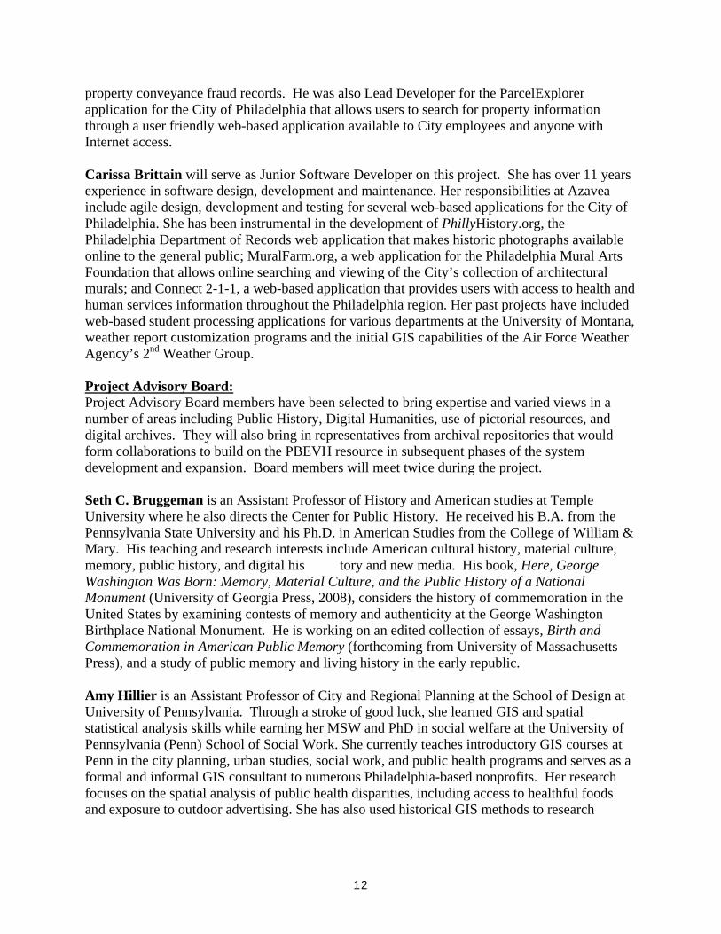
property conveyance fraud records. He was also Lead Developer for the ParcelExplorer application for the City of Philadelphia that allows users to search for property information through a user friendly web-based application available to City employees and anyone with Internet access. Carissa Brittain will serve as Junior Software Developer on this project. She has over 11 years experience in software design, development and maintenance. Her responsibilities at Azavea include agile design, development and testing for several web-based applications for the City of Philadelphia. She has been instrumental in the development of PhillyHistory.org, the Philadelphia Department of Records web application that makes historic photographs available online to the general public; MuralFarm.org, a web application for the Philadelphia Mural Arts Foundation that allows online searching and viewing of the City’s collection of architectural murals; and Connect 2-1-1, a web-based application that provides users with access to health and human services information throughout the Philadelphia region. Her past projects have included web-based student processing applications for various departments at the University of Montana, weather report customization programs and the initial GIS capabilities of the Air Force Weather Agency’s 2nd Weather Group. Project Advisory Board: Project Advisory Board members have been selected to bring expertise and varied views in a number of areas including Public History, Digital Humanities, use of pictorial resources, and digital archives. They will also bring in representatives from archival repositories that would form collaborations to build on the PBEVH resource in subsequent phases of the system development and expansion. Board members will meet twice during the project. Seth C. Bruggeman is an Assistant Professor of History and American studies at Temple University where he also directs the Center for Public History. He received his B.A. from the Pennsylvania State University and his Ph.D. in American Studies from the College of William & Mary. His teaching and research interests include American cultural history, material culture, memory, public history, and digital his tory and new media. His book, Here, George Washington Was Born: Memory, Material Culture, and the Public History of a National Monument (University of Georgia Press, 2008), considers the history of commemoration in the United States by examining contests of memory and authenticity at the George Washington Birthplace National Monument. He is working on an edited collection of essays, Birth and Commemoration in American Public Memory (forthcoming from University of Massachusetts Press), and a study of public memory and living history in the early republic. Amy Hillier is an Assistant Professor of City and Regional Planning at the School of Design at University of Pennsylvania. Through a stroke of good luck, she learned GIS and spatial statistical analysis skills while earning her MSW and PhD in social welfare at the University of Pennsylvania (Penn) School of Social Work. She currently teaches introductory GIS courses at Penn in the city planning, urban studies, social work, and public health programs and serves as a formal and informal GIS consultant to numerous Philadelphia-based nonprofits. Her research focuses on the spatial analysis of public health disparities, including access to healthful foods and exposure to outdoor advertising. She has also used historical GIS methods to research
13
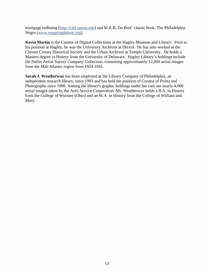
mortgage redlining (http://cml.upenn.edu) and W.E.B. Du Bois’ classic book, The Philadelphia Negro (www.mappingdubois.org). Kevin Martin is the Curator of Digital Collections at the Hagley Museum and Library. Prior to his position at Hagley, he was the University Archivist at Drexel. He has also worked at the Chester County Historical Society and the Urban Archives at Temple University. He holds a Masters degree in History from the University of Delaware. Hagley Library’s holdings include the Dallin Aerial Survey Company Collection, containing approximately 12,000 aerial images from the Mid-Atlantic region from 1924-1941. Sarah J. Weatherwax has been employed at the Library Company of Philadelphia, an independent research library, since 1993 and has held the position of Curator of Prints and Photographs since 1996. Among the library's graphic holdings under her care are nearly 4,000 aerial images taken by the Aero Service Corporation. Ms. Weatherwax holds a B.A. in History from the College of Wooster (Ohio) and an M.A. in History from the College of William and Mary.
Anderson Hall 1114 W. Berks Street
Philadelphia, PA 19122 - 6090 March 15, 2010 Matt Herbison Director of Archives and Library Independence Seaport Museum 211 South Columbus Blvd Philadelphia PA, 19106 Dear Matt, I am very pleased to write in support of Independence Seaport Museum’s proposal for the development of the Philadelphia Bird’s-Eye View History (PBEVH) project. This project is unique in its goal to support user interaction with historical aerial photographs. It will provide an important and direct visual understanding of the changes in the urban environment though the twentieth century. My own experience with aerial photography started in the late 1970s when, as curator of prints and photographs at the Library Company of Philadelphia I was able to acquire first William Nicholson Jennings’ experiments from balloons and then, in the 1980s, a significant collection of the Aero Service Corporation. I was fortunate to meet and interview pioneer aerial photographer Virgil Kauffman, who had saved the collection from destruction. In my opinion, these were among the most significant acquisitions during my 17-years at the Library Company. The tradition of oblique aerial views follows on the century-old graphic tradition of bird’s-eye views. These images, which Aero Service specialized in, are particularly rich in information about place. The vertical images (shot straight-down) were made for maps and are also quite useful documents. But the oblique images, especially shot at lower altitudes, comprise an important document of America in the first half of the 20th century. I am excited by the novel way in which the PBEVH project at the Independence Seaport Museum will allow users to identify aerial photos of interest by location, in addition to keywords and dates. But, without a doubt, the real innovation of this project comes by overlaying these historical images on the same locations as they appear today, allowing users to not only view the photos but to interact and understand features in the landscape with changes over time.
14

I have been very impressed by the work and demonstrations you have completed to date. It is a painstaking process with a truly impressive result. Your dedication and enthusiasm has brought this project to the point where it can, with additional support, result in a resource that will benefit a wide variety of users, both in the humanities and in other fields of study. Thank you for considering this important proposal. Sincerely,
Kenneth Finkel Distinguished Lecturer American Studies Program Temple University
15
16
17
Figure 1 PBEVH Appendices
18
Figure 2 PBEVH Appendices
19
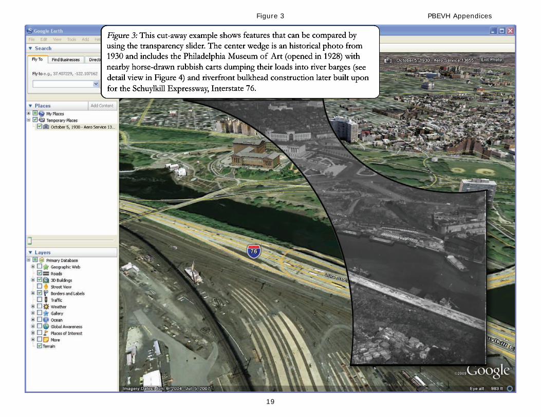
Figure 3 PBEVH Appendices
20
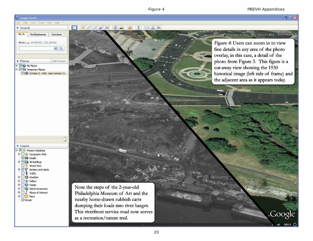
Figure 4 PBEVH Appendices
21
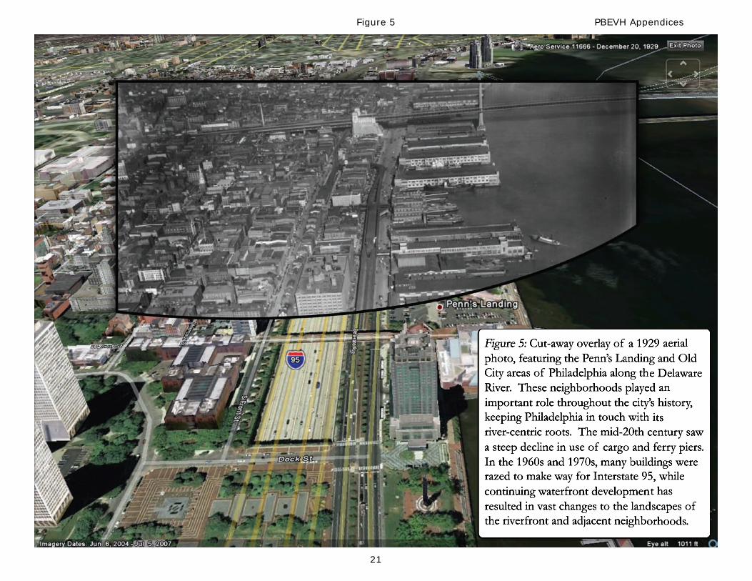
Figure 5 PBEVH Appendices
22
Figure 6 PBEVH Appendices
23
Figure 7 PBEVH Appendices
24
Figure 8 PBEVH Appendices
25
Figure 9 PBEVH Appendices
26
Figure 10 PBEVH Appendices