HolzworthRanch
P n
)
(11,424)
(12,274)
(13,153)
(12,324)
(10,319)
(10,508)
(12,121)
(12,649)
(11,938)
(11,754)
(10,587)
(9,681)
(11,773)
(10.671)
(10,351)
(11,584)
(12,804)
(11,850)
(13,294)
(13,250)(13,391)
(13,130)
(13,132)
(12,244)(11,315)
(12,068)
(12,652)
(12,245)(12,947)
(13,553)
(13,195)
(12,303)
)
Willia
Peak
Ute Pass
112
k
BillMiller
Buffa
lo
Creek
Elk
Mtn
EastTroublesom
e
Troublesome Access
LuluCity
Pa
s
kl
ra
h
T
nahu reek
Tonah
utu
Gr
Fairv Mtn
l
Will
owPa
ss Illinois
Pass
Bil
Gilsonite
Camway
Bull Mtn Loop
Raer
Meadow
s
a
I l
34
Grand Lake
a
o
Burn
Lo
op
Blizz
ras
s
So
daPass
120
34
34Windy GapWildlifeViewing
Area
Granby
Kinney
Creek
StrawberryLake Trail
Straw
berryCr k
Stra
wberry
Wes
tStrawberry
Bench
Cari
WatangaLake
bou
Buc
ha
nan
Pass
CascadeCreek
KingCreek
JonesPass
Jim Creek
Coro
na Pass
Broken Thumb
Middle Fork
HamiltonCreek
High
Lonesome
Trail
Hurd Cre
ek
Arapaho
Pass
4Bar 4
Road
Ba
ckScr
atch
Tipp
erar
y
Spruce
Creek
Bot
tlePa
ss
Lake
Evely
n
Keyser Ridge
Kinney
Creek
HorseshoeLake
Bye
rsPe
ak
Creekside
Flume
Zoom
Chainsaw
D-4
D-2
FoolCreek
Vas
quez
Cre
ek
Vas
qu
ezM
tn
Ic
Blue
Sky
eHill
MtN
ystro
m
Vasqu
ez
Pass
SouthFo
rkLoop
r
k
StL
ouis
St Louis
Pas
sSt
Loui
sL
ake
40
oodass
133
128
128
40
40
N.W.Passage
165
Tabernash
40
n
Green
s
Ho
s
La PoudrePass
n
kstrawMtn
n
rk
Mtn
TaylorPeak
TheCleaver
owMtn
Green
Ridge
Mt
TableM
ounta
in
MtAcoma
TwinPeaks
MtIrvingHale
WaMtn
Mtn
MaP
r
ThunderboltPeak
Hel
l
an
ePe
MtAchonee
Walden
Hollow
Doe Creek
Granby Mesa
MtChauncey
MtGeorge
WheelerBasin
ByersPeak
BottlePeak
PtarmiganPeak
BillsPeak
VASQ
UEZ
MO
UNTAIN
S
ParryPeak
JamesPeak
RogersPass
MtBancroft
in
Peak
MtFlora
MtEva
BerthoudPass
yn
VasquezPeak
MtNystrom
St LouisPeak
JonesPass
PettingellPeak
HagerMtn
MOUNTAINS
WIL
LIA
MS
FOR
KM
OU
INS
OlBaldy
Ute Peak
RubyMtn
Mtn
LonesomePeak
Ep h
MarkerHill
SheepMtn
NinemileMtn
MorseMtn
e
RANGE
V A S Q U E Z
P E A KF O R E S T
I N D I A N
P E A K S
FORKWILLIAMS
(12,498)
SouthFork Loop
Contin
enta
lDivide
Trail
Up
pEl
ker
D-2WTB
WinterPark
MoffatTunnel
139
50
50-S
50
84
152
159159
158
72
5
2751
73
8
ElkMtn
Lulu
Cit
yTr
ail
PIllinois Pass
123
55
83
SawmillGulchCampground
3
123
112
Big Meadows
53
149
Hig
hLo n
esom
e
ek
Denver CreekCampground
124
190
Jackson
125
4
491
120
TH
TH
TH
Jack
son
County
TH
TH
TH
TH
TH
TH
TH
Rocky Point
Crystal Climb
Fraser to GranbyTrail
60
5961
41
Jacques
ee
Coyte Valley
THTH
TH
Clear Cre
ek
Willow Creek Pass
A R A PA H O
N AT I O N A L
R E C R E AT I O N
A R E A
A R A PA H O
N AT I O N A L
R E C R E AT I O N
A R E AA.N.R.A.
RodeoArena
Fraser
Flying HeelsRodeo
112A
122
807
112E
Str
aw
berr
yC
reekR
d.
$$
$$
$$
$$
$$
$$
CDT
CDT
CDT
CDT
CDT
Mountain Bikes are prohibited on Trailsin Wilderness Areas
128
128
Scenic
$$$$
Selac Stage Stop
$$
SulphurRangerDistrict
MeadowCreek
Reservoir
$$
CozensRanch
S U M M E R
W I N T E R PA R K
S K I A R E A
S O LV I S TA
S K I B A S I N
D E V I L S T H U M B
R A N C H R E S O R T
Y M C A
O F T H E
R O C K I E S
B Y E R S
P E A K
W I L D E R N E S S
(12,521)
(12,541)
StanleyMt
P
Rollins
(12,304)
(13,088)
(12,979)
(11,837)
i
v
rt
Pa
PaiutePeak
thSawtooMtn
Buchananss
ak
Pe
e
Shoshonak
ajoPeak
Arikaree
hArapaho
ak
(12,814)
(11,747)
(11,671)
MtNeva
No
Na
Pe
Pe
PawnePeak(12,943)
(12,967)
(13,409)
(13,150)
(13,502)
MtToll
(12,489)
(10,758)
(12,129)
(13,310)
SpecimenMtn
MilnerPass
SpraguePass
NotchtopMtn
PtarmiganPoint
HallettPeak
AndrewsPass
PowellPeak
ChiefsHeadPeak
MtAlice
TanimaPeak
n
(13,118)
Isolatioeak
t
arshallStage Road
SpringsHot Sulphur20
40
CountyRifle Range
253
40
2755
2762
Morgan Gulch
m
s
TH
134
50
arkview MtLookout
Cree
2764
A R A PA H O
N AT I O N A L
F O R E S T
Sm
ih
MesaR
d
2759
Fox
Loop
l
n
GravelMtn
123
Cre
TH
(9,367)
TrailMtn
Da ling
Cree
253
CottonwP
139
Blu
Ridge
South Fork Sugarloaf
Mountain Bikes are prohibited on Trailsin Wilderness Areas
NTA
d
Ptarmigan Pass
PtarmiganPeak
Vasq
uez
Pass
Trail
W I L D E R N E S S
HorseshoeCampground
140
TH
139
3
TH
133
(11,769)
(9,620)
121
2756
(12,228)
Thunders
S eleton Gu ch
Ditc
LeadMtn
TepeeMtn
LuluMtn
MtRichthofen
(12,810)
(12,397)
Grand Ditc
iew
BakerMt
Knoll
wardMtn
MtCirru
Trail
Rid
geR
oad
Timber CreekCampground
Gra
nd
Ditch
Hitchens Gulch
StratuMt
Dutch Town
N E V E R
Red M
ounta
in
RedMtn(12,705)
MtCumulus
MtNimbus
TH
TH
(11,488)
WolverineBy-Pass
Bowen Gulch
Bowen
Pass
Blue
Ridge
oer
ine
Bker
BowenMtn
MineralPoint
hyryPeak
G U L C H s
Loop
BowenGulch
Po
TH
TH
TH
W I L D E R N E S S
Mountain Bikes are prohibited on Trailsin Wilderness Areas
B O W E N
rp
(10,951)
ad
P
Apiatan
123
Spruce 'emUp Jack
A R E A
CDT
P R O T E C T I O N
Wv
HeadwatersGolf Course
Grand ElkGolf Course
Grand LakeGolf Course
40
F R A S E R
E X P E R I M E N TA L
Eas
t Elk
TwCones
129
2765
Pole CreekGolf Course
Hurd PeakPhases
Mountain Bikes are prohibited on Trailsin Wilderness Areas
(10,155)
ng
Alva B. AdamTunnel
Shadow Mtn.Lookout
Shad
Ea
st Shore
TrailK
night Rid
ge
Trail
$$
(12,216)
(10,313)
Trail RidgeRoad
imber
Lake
O
C
eenMtn
Northn et
34
LongMeadows
NakaiPeak
GreenMtn
NisaMtn
MtPatterso
SummerlandPa
MtIda
R O C K Y
M O U N T
N A
KawuneecheVisitor Center
TH
THSce
nic
h
G
nd
ShiplerMt
(11,704)
(10,781)
stnlet
Jac
MtEnentah
SpragueMtn
SnowdriftPeak
A I N
T I O N A L
PA R K
(12,565)
(10,421)
(12,007)
EI
s
Dev ls Thumb Pass
Ptarmigan
AndrewsPeak
MtCraig
MtWescott
MtBryant
Adams
tanga
Hiamovi
rteneak
CoopePeak
Cyo
n
LoneEagl
ak
W I L D E R N E S SCrater Lake
Roaring Fork Tra
il
Caribou
Pass
Columbine
Lake
Hiking Only; Horses Prohibitedat Cascade Falls
(11,843)
CoronaLake
Rog
ersPass
Colorado Mines
Mtwort
Continental Divide Trail
ss
Buck Creek
Rollins PassWagon Road
Pa
CDT
i
Boulder-GrandPass
SENSITIVE AREA:Please stay on designatedroads and trails in theexperimental forest
No Mountain Biking
TH
TH
Fraser River Trail
Fraser River Trail
Chickadee
TwinBridges
TH
TH
SportsComplex
TH
TH
TH
TH
TH
TH
TH
CDT
CDT
CDT
CDT
CDT
CDT
CDT
CDT
CDT
CascadeMt
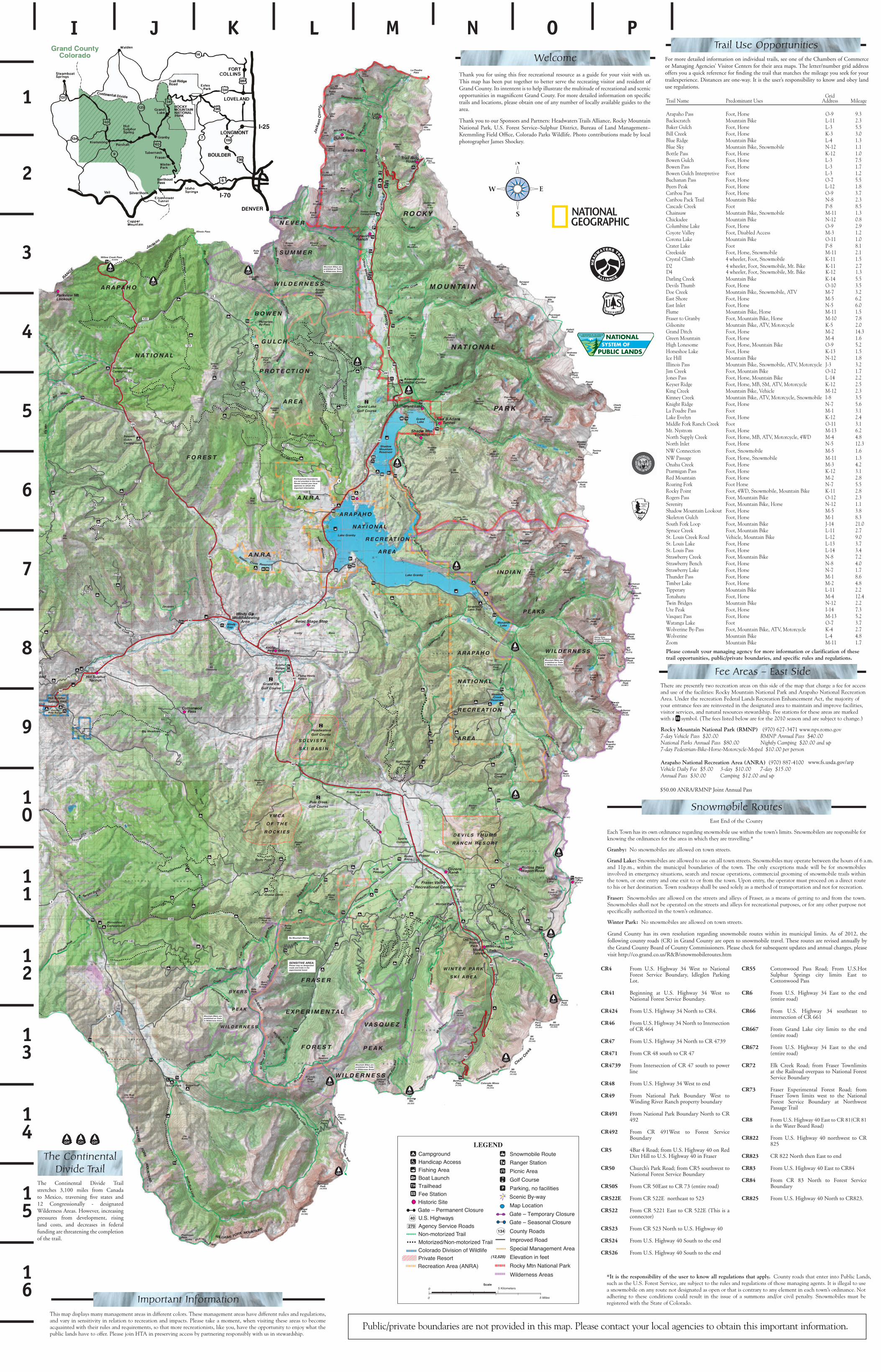
Public/private boundariesare not provided in this map.Please contact your local agencies to obtain this important information.
A.N.R.A.
Hot Sulphur Springs SWA
Sere
nity
North Supply Creek
MonarchLake
Lake Granby
Lake Granby
ShadowMountainReservoir
GrandLake
Willow
Creek Reservoir
WindyGap
125
HideawayPark
KaibabPark
Fraser Valley Recreational Center
121
1
2
3
4
5
6
7
8
9
10
11
12
13
14
15
16
I J K L M N O P
Grid egaeliM sserddAsesU tnanimoderPemaN liarT
3.99-OesroH ,tooFssaP ohaparA3.211-LekiB niatnuoMhctarcskcaB5.53-LesroH ,tooFhcluG rekaB0.33-KesroH ,tooFkeerC lliB3.14-LekiB niatnuoMegdiR eulB
Blue Sky Mountain Bike, Snowmobile N-12 1.10.121-KesroH ,tooFssaP elttoB5.73-LesroH ,tooFhcluG newoB7.13-LesroH ,tooFssaP newoB2.13-LtooFeviterpretnI hcluG newoB5.57-OesroH ,tooFssaP nanahcuB8.121-LesroH ,tooFkaeP sreyB7.39-OesroH ,tooFssaP uobiraC3.28-NekiB niatnuoMliarT kcaP uobiraC5.88-PtooFkeerC edacsaC
Chainsaw Mountain Bike, Snowmobile M-11 1.38.021-NekiB niatnuoMeedakcihC9.29-OesroH ,tooFekaL enibmuloC2.13-MsseccA delbasiD ,tooFyellaV etoyoC0.111-OekiB niatnuoMekaL anoroC1.88-PtooFekaL retarC
Creekside Foot, Horse, Snowmobile M-11 2.1Crystal Climb 4 wheeler, Foot, Snowmobile K-11 1.5
5.541-KekiB niatnuoMkeerC gnilraD5.301-OesroH ,tooFbmuhT sliveD
Doe Creek Mountain Bike, Snowmobile, ATV M-7 3.22.65-MesroH ,tooFerohS tsaE0.65-NesroH ,tooFtelnI tsaE5.111-MesroH ,ekiB niatnuoMemulF
Fraser to Granby Foot, Mountain Bike, Horse M-10 7.8Gilsonite Mountain Bike, ATV, Motorcycle K-5 2.0
3.412-MesroH ,tooFhctiD dnarG6.14-MesroH ,tooFniatnuoM neerG
High Lonesome Foot, Horse, Mountain Bike O-9 5.25.131-KesroH ,tooFekaL eohsesroH8.121-NekiB niatnuoMlliH ecI
Illinois Pass Mountain Bike, Snowmobile, ATV, Motorcycle J-3 3.27.121-OekiB niatnuoM ,tooFkeerC miJ
Jones Pass Foot, Horse, Mountain Bike L-14 2.2Keyser Ridge Foot, Horse, MB, SM, ATV, Motorcycle K-12 2.5
3.221-MelciheV ,ekiB niatnuoMkeerC gniKKinney Creek Mountain Bike, ATV, Motorcycle, Snowmobile I-8 3.5
6.57-NesroH ,tooFegdiR thginK1.31-MtooF ssaP erduoP aL4.221-KesroH ,tooFnylevE ekaL1.311-OtooF keerC hcnaR kroF elddiM2.631-MesroH ,tooFmortsyN .tM
North Supply Creek Foot, Horse, MB, ATV, Motorcycle, 4WD M-4 4.83.215-NesroH ,tooFtelnI htroN
NW Passage Foot, Horse, Snowmobile M-11 1.3NW Connection Foot, Snowmobile M-5 1.6
2.43-MesroH ,tooFkeerC uhanO1.321-KesroH ,tooFssaP nagimratP8.22-MesroH ,tooFniatnuoM deR5.57-NesroH tooFkroF gniraoR
Rocky Point Foot, 4WD, Snowmobile, Mountain Bike K-11 2.83.221-OekiB niatnuoM ,tooFssaP sregoR
Serenity Foot, Mountain Bike, Horse N-12 1.18.35-MesroH ,tooFtuokooL niatnuoM wodahS3.81-MesroH ,tooFhcluG notelekS
0.1241-JekiB niatnuoM ,tooFpooL kroF htuoS7.211-LekiB niatnuoM ,tooFkeerC ecurpS0.921-LekiB niatnuoM ,elciheVdaoR keerC siuoL .tS7.331-LesroH ,tooFekaL siuoL .tS4.341-LesroH ,tooFssaP siuoL .tS2.78-NekiB niatnuoM ,tooFkeerC yrrebwartS0.48-NesroH ,tooFhcneB yrrebwartS7.17-NesroH ,tooFekaL yrrebwartS6.81-MesroH ,tooFssaP rednuhT8.42-MesroH ,tooFekaL rebmiT2.211-LekiB niatnuoMyrareppiT
4.214-MesroH ,tooFutuhanoT2.221-NekiB niatnuoMsegdirB niwT3.741-IesroH ,tooFkaeP etU2.531-MesroH ,tooFssaP zeuqsaV7.37-OtooFekaL agnataW
Wolverine By-Pass Foot, Mountain Bike, ATV, Motorcycle K-4 2.78.44-LekiB niatnuoMenirevloW7.111-MekiB niatnuoMmooZ
Please consult your managing agency for more information or clarification of these trail opportunities, public/private boundaries, and specific rules and regulations.
For more detailed information on individual trails, see one of the Chambers of Commerce orManaging Agencies’ Visitor Centers for their area maps. Please remember that many of these trailsoffer wonderful winter recreation opportunities as well as summer. The letter/ number grid addressoffers you a quick reference for finding the trail that matches the mileage you seek for your trailexperience. Distances are one-way. It is the user’s responsibility to know and obey land useregulations.
*It is the responsibility of the user to know all regulations that apply. County roads that enter into Public Lands,such as the U.S. Forest Service, are subject to the rules and regulations of those managing agents. It is illegal to usea snowmobile on any route not designated as open or that is contrary to any element in each town’s ordinance. Notadhering to these conditions could result in the issue of a summons and/or civil penalty. Snowmobiles must beregistered with the State of Colorado.
Rocky Mountain National Park (RMNP) (970) 627-3471 www.nps.romo.gov7-day Vehicle Pass $20.00 RMNP Annual Pass $40.00National Parks Annual Pass $80.00 Nightly Camping $20.00 and up7-day Pedestrian-Bike-Horse-Motorcycle-Moped $10.00 per person
Arapaho National Recreation Area (ANRA)
$50.00 ANRA and RMNP Joint Pass Annual
(970) 887-4100 www.fs.fed.us/arnf/srd/vvcVehicle Daily Fee $5.00 3-day $10.00 7-day $15.00Annual Pass $30.00 Camping $12.00 and up
Public/private boundaries are not provided in this map. Please contact your local agencies to obtain this important information.
Fee Areas – East Side
Welcome
Snowmobile Routes
Trail Use Opportunities
This map displays many management areas in different colors. These management areas have different rules and regulations,and vary in sensitivity in relation to recreation and impacts. Please take a moment, when visiting these areas to becomeacquainted with their rules and requirements, so that more recreationists, like you, have the opportunity to enjoy what thepublic lands have to offer. Please join HTA in preserving access by partnering responsibly with us in stewardship.
Important Information
East End of the County
Each Town has its own ordinance regarding snowmobile use within the town’s limits. Snowmobilers are responsible forknowing the ordinances for the area in which they are travelling.*
Granby: No snowmobiles are allowed on town streets.
Grand Lake: Snowmobiles are allowed to use on all town streets. Snowmobiles may operate between the hours of 6 a.m.and 11p.m., within the municipal boundaries of the town. The only exceptions made will be for snowmobilesinvolved in emergency situations, search and rescue operations, commercial grooming of snowmobile trails withinthe town, or one entry and one exit to or from the town. Upon entry, the operator must proceed on a direct routeto his or her destination. Town roadways shall be used solely as a method of transportation and not for recreation.
Fraser: Snowmobiles are allowed on the streets and alleys of Fraser, as a means of getting to and from the town.Snowmobiles shall not be operated on the streets and alleys for recreational purposes, or for any other purpose notspecifically authorized in the town’s ordinance.
Winter Park: No snowmobiles are allowed on town streets.
Grand County has its own resolution regarding snowmobile routes within its municipal limits. As of 2003, thefollowing county roads (CR) in Grand County are open to snowmobile travel. These routes are revised annually bythe Grand County Board of County Commissioners. Please check for subsequent updates and annual changes withHeadwaters Trails Alliance:
CR4 From U.S. Highway 34 West to National Forest Service Boundary, Idleglen Parking Lot.
CR41 Beginning at U.S. Highway 34 West to National Forest Service Boundary.
CR424 From U.S. Highway 34 North to CR4.
CR46 From U.S. Highway 34 North to Intersection of CR 464
CR466 Grand Lake Dump Road fromShorewood Subdivision to RhoneRanch.
CR47 From U.S. Highway 34 North to CR 4739
CR471 From CR 48 south to CR 47
CR4739 From Intersection of CR 47 south to power line.
CR48 From U.S. Highway 34 West to end
CR49 From National Park Boundary Westto Winding River Ranch propertyboundary
CR491 From National Park BoundaryNorth to CR 492
CR492 From CR 491West to Forest Service Boundary.
CR5 4Bar 4 Road; from U.S. Highway 40on Red Dirt Hill to U.S. Highway 40in Fraser.
CR50 Church’s Park Road; from CR5 southwestto National Forest Service Boundary.
CR50S From CR 50East to CR 73 (entire road)
CR522E From CR 522E northeast to 523.
CR522 From CR 5221 East to CR 522E (This is a connector)
CR524 From U.S. Highway 40 South tothe end.
CR523 From CR 523 North to U.S. Highway40.
CR526 From U.S. Highway 40 South tothe end.
CR55 Cottonwood Pass Road; From U.S.Hot Sulphur Springs city limits Eastto Cottonwood Pass.
CR57 Barnard Road; from town limits ofGranby westerly to the west side of theColorado River Bridge.
CR6 From U.S. Highway 34 East tothe end (entire road)
CR603 From NE corner of Gustafson Tracts,north and east past CR608, thePickering Place on CR603 to the westend of the CR609 airport, thencenorth and east of CR608 north of theairport to CR609, thence on CR609 tothe Wrights.
CR66 From U.S. Highway 34 southeast tointersection of CR 661
CR667 From Grand Lake city limits tothe end (entire road)
the end (entire road)CR672 From U.S. Highway 34 East to
Tunnel Rd From Grand Lake town limits toTunnel Road. That portion of roadbelongs to the County.
CR72 Elk Creek Road; from Fraser Townlimits at the Railroad overpass toNational Forest Service Boundary.
CR73 Fraser Experimental Forest Road; fromFraser Town limits west to theNational Forest Service Boundary atNorthwest Passage Trail.
CR8 From U.S. Highway 40 East to CR 81(CR 81 is the Water Board Road)
CR822 From U.S. Highway 40 northwest to CR 825
CR823 CR 822 North then East to end
CR83 From U.S. Highway 40 East to CR84.
CR84 From CR 83 North to Forest ServiceBoundary.
CR825 From U.S. Highway 40 North to CR823.
The Continental Divide Trailstretches 3,100 miles from Canada toMexico, traversing five states and 12Congressionally - designated WildernessAreas. However, increasing pressures fromdevelopment, rising land costs, anddecreases in federal funding are threateningthe completion of the trail. The non-profitContinental Divide Trail Alliance (CDTA)assists federal land management agencies in thecompletion, management and protection of thetrail and works to increase the public’s awarenessand involvement in completing one of the mostunique backcountry routes in the world. To join theCDTA, call 888-909-2382 or visit www.cdtrail.org.
The ContinentalDivide Trail
LEGENDCampgroundHandicap AccessFishing AreaBoat Launch
Snowmobile RouteRanger StationPicnic Area
Historic Site Map Location
40 U.S. Highways270 Agency Service Roads
134 County RoadsNon-motorized TrailMotorized/Non-motorized Trail Improved Road
(12,525) Elevation in feet
Golf Course
Private Resort
TrailheadTH Parking, no facilitiesPFee Station$$ Scenic By-way
Special Management Area
Gate Ð Permanent ClosureGate Ð Temporary ClosureGate Ð Seasonal Closure
0
0
5 Miles
5 KilometersScale
Rocky Mtn National Park
Colorado Division of Wildlife
Wilderness AreasRecreation Area (ANRA)
Thank you for using this free recreational resource as a guide for your visit with us. This map has been put together to betterserve the recreating visitor and resident of Grand County. Its intent is to help illustrate the multitude of recreational and scenic opportunities in magnificent Grand County. For more detailed information on specific trails and locations, please obtain one of any number of locally available guides to the area.
Thank you to our Sponsors and Partners: Headwaters Trails Alliance, Rocky Mountain National Park, U.S. Forest Service–Sulphur District, Bureau of Land Management–Kremmling Resource Area, Colorado Division of Wildlife, McConnell Design & Printing Company. Photo contributions made by local photographer Susie Masterson.
There are presently two recreation areas on this side of the map that charge a fee for access and use of the facilities: Rocky Mountain National Park and Arapaho National Recreation Area. Under the recreation Federal Lands Recreation Enhancement Act, the majority of your entrance fees are reinvested in the designated area to maintain and improve facilities, visitor services, and natural resources stewardship. Fee stations for these areas are marked with a symbol. (The fees listed below are for the 2010 season and are subject to change.)
Hideaway Park
D2 4 wheeler, Foot, Snowmobile, Mt. Bike K-11 2.7D4 4 wheeler, Foot, Snowmobile, Mt. Bike K-12 1.3
Thank you for using this free recreational resource as a guide for your visit with us. This map has been put together to better serve the recreating visitor and resident of Grand County. Its intentent is to help illustrate the multitude of recreational and scenic opportunities in magnificent Grand Couty. For more detailed information on specific trails and locations, please obtain one of any number of locally available guides to the area.
Thank you to our Sponsors and Partners: Headwaters Trails Alliance, Rocky Mountain National Park, U.S. Forest Service–Sulphur District, Bureau of Land Management–Kremmling Field Office, Colorado Parks Wildlife. Photo contributions made by local photographer James Shockey.
For more detailed information on individual trails, see one of the Chambers of Commerce or Managing Agencies’ Visitor Centers for their area maps. The letter/number grid address offers you a quick reference for finding the trail that matches the mileage you seek for your trailexperience. Distances are one-way. It is the user’s responsibility to know and obey land use regulations.
www.fs.usda.gov/arp
$50.00 ANRA/RMNP Joint Annual Pass
Grand County has its own resolution regarding snowmobile routes within its municipal limits. As of 2012, the following county roads (CR) in Grand County are open to snowmobile travel. These routes are revised annually by the Grand County Board of County Commissioners. Please check for subsequent updates and annual changes, please visit http://co.grand.co.us/R&B/snowmobileroutes.htm
From U.S. Highway 34 West to National Forest Service Boundary, Idleglen Parking Lot.
Beginning at U.S. Highway 34 West to National Forest Service Boundary.
From U.S. Highway 34 North to CR4.
From U.S. Highway 34 North to Intersection of CR 464
From U.S. Highway 34 North to CR 4739
From CR 48 south to CR 47
From Intersection of CR 47 south to power line
From U.S. Highway 34 West to end
From National Park Boundary West to Winding River Ranch property boundary
From National Park Boundary North to CR 492
From CR 491West to Forest Service Boundary
4Bar 4 Road; from U.S. Highway 40 on Red Dirt Hill to U.S. Highway 40 in Fraser
Church’s Park Road; from CR5 southwest to National Forest Service Boundary
From CR 50East to CR 73 (entire road)
From CR 522E northeast to 523
From CR 5221 East to CR 522E (This is a connector)
From CR 523 North to U.S. Highway 40
From U.S. Highway 40 South to the end
From U.S. Highway 40 South to the end
CR4
CR41
CR424
CR46
CR47
CR471
CR4739
CR48
CR49
CR491
CR492
CR5
CR50
CR50S
CR522E
CR522
CR523
CR524
CR526
CR55
CR6
CR66
CR667
CR672
CR72
CR73
CR8
CR822
CR823
CR83
CR84
CR825
Cottonwood Pass Road; From U.S.Hot Sulphur Springs city limits East to Cottonwood Pass
From U.S. Highway 34 East to the end (entire road)
From U.S. Highway 34 southeast to intersection of CR 661
From Grand Lake city limits to the end (entire road)
From U.S. Highway 34 East to the end (entire road)
Elk Creek Road; from Fraser Townlimits at the Railroad overpass to National Forest Service Boundary
Fraser Experimental Forest Road; from Fraser Town limits west to the National Forest Service Boundary at Northwest Passage Trail
From U.S. Highway 40 East to CR 81(CR 81 is the Water Board Road)
From U.S. Highway 40 northwest to CR 825
CR 822 North then East to end
From U.S. Highway 40 East to CR84
From CR 83 North to Forest Service Boundary
From U.S. Highway 40 North to CR823.
The Continental Divide Trail stretches 3,100 miles from Canada to Mexico, traversing five states and 12 Congressionally - designated Wilderness Areas. However, increasing pressures from development, rising land costs, and decreases in federal funding are threatening the completion of the trail.
Old Town
Winter Park