ZONING ORDINANCE PLANNING AND LAND USE REGULATIONS Date of Printing: March 2009

Welcome message from author
This document is posted to help you gain knowledge. Please leave a comment to let me know what you think about it! Share it to your friends and learn new things together.
Transcript
ZONING ORDINANCE
PLANNING AND LAND USE
REGULATIONS
DDaattee ooff PPrriinnttiinngg:: MMaarrcchh 22000099
ZONING ORDINANCE
PLANNING AND LAND USE REGULATIONS
Date of Printing:
March 2009
TABLE OF CONTENTS
ZONING ORDINANCE PAGE# ARTICLE I: Preamble ..........................................................................................................Z1 ARTICLE II: Zoning Map and Interpretation .........................................................................Z2 ARTICLE III: Definitions.........................................................................................................Z3 ARTICLE IV: General Provisions .........................................................................................Z15 ARTICLE V: Zoning District Regulations.............................................................................Z37 ARTICLE VI: Rural Cluster Residential Development..........................................................Z44 ARTICLE VII: Nonconforming Uses......................................................................................Z62 ARTICLE VIII: Wireless Communication Facilities.................................................................Z64 ARTICLE IX: Enforcement ...................................................................................................Z66 ARTICLE X: Board of Adjustment ......................................................................................Z67 ARTICLE XI: Amendments ..................................................................................................Z67 ARTICLE XII: Penalty............................................................................................................Z68 ARTICLE XIII: Saving Clause ................................................................................................Z68 ARTICLE XIV: Effective Date .................................................................................................Z68 ARTICLE XV: Repeal of Prior Ordinances ............................................................................Z69 ARTICLE XVI: Public School Impact Fees .............................................................................Z70 GROWTH MANAGEMENT AND TIMING OF DEVELOPMENT ORDINANCE ..................... GM1 HISTORIC DISTRICT ORDINANCE .......................................................................................HD1 LAND SUBDIVISION CONTROL REGULATIONS SECTION 100 AUTHORITY...............................................................................................SD1 SECTION 200 DEFINITIONS.............................................................................................SD1 SECTION 300 GENERAL REQUIREMENTS ....................................................................SD3 SECTION 400 REGULATING SIZE OF LOTS IN SUBDIVISION ......................................SD7 SECTION 500 PROCEDURE FOR SUBDIVISION............................................................SD8 SECTION 600 PRELIMINARY LAYOUT..........................................................................SD10
SECTION 700 PLATS AND DATA FOR FINAL APPROVAL...........................................SD11 SECTION 800 FILING OF PLANS ...................................................................................SD14 SECTION 900 CHANGES IN APPROVED PLANS .........................................................SD15 SECTION 1000 RELATIONSHIP BETWEEN STATE AND LOCAL REGS .......................SD15 SECTION 1100 SAVING CLAUSE.....................................................................................SD15 SECTION 1200 AMENDMENTS ........................................................................................SD15 Minimum Lot Size By Soil Type .............................................................................................SD16 SITE DEVELOPMENT PLAN REGULATIONS SECTION 100 AUTHORITY............................................................................................... SP1 SECTION 200 ORDINANCE AND REGULATION REQUIREMENTS ............................... SP1 SECTION 300 DUTIES OF THE PLANNING BOARD ....................................................... SP1 SECTION 400 DEFINITIONS............................................................................................. SP2 SECTION 500 GENERAL REGULATIONS........................................................................ SP3 SECTION 600 REQUIREMENTS FOR SITE DEVELOPMENT PLAN APPROVAL .......... SP5 SECTION 700 PROCEDURE FOR SITE DEVELOPMENT PLAN APPROVAL .............. SP16 SECTION 800 PRELIMINARY LAYOUT.......................................................................... SP18 SECTION 900 PLAT AND DATA FOR FINAL APPROVAL ............................................. SP19 SECTION 1000 FILING OF PLANS ................................................................................... SP20 SECTION 1100 CHANGES IN APPROVED PLANS ......................................................... SP20 SECTION 1200 CONCURRENT AND JOINT HEARINGS ............................................... SP21 SECTION 1300 AMENDMENTS ........................................................................................ SP21 SECTION 1400 POWER TO REVIEW SITE PLANS ......................................................... SP21 SECTION 1500 SEPARABILITY ........................................................................................ SP21 Minimum Lot Size by Soil Type.............................................................................................. SP22 ROAD SPECIFICATIONS AND REGULATIONS SECTION 400 GENERAL PROVISIONS ...........................................................................RS1 SECTION 410 ROAD DESIGN REQUIREMENTS ............................................................RS1 SECTION 420 PREPARATION OF ROADS ......................................................................RS3 SECTION 430 INSPECTION PROGRAM ..........................................................................RS4 SECTION 440 DRIVEWAYS & OTHER ACCESSES TO THE PUBLIC WAY ...................RS5 SECTION 450 DESIGN SPECIFICATIONS REFERENCE................................................RS6 SECTION 460 RELATIONSHIP BETWEEN STATE & LOCAL REGULATIONS...............RS7 SECTION 470 SAVING CLAUSE.......................................................................................RS7 SECTION 480 EFFECTIVE DATE .....................................................................................RS7 SECTION 490 AMENDMENT ............................................................................................RS7 SECTION 4100 ENFORCEMENT........................................................................................RS7 Typical Road Section ...............................................................................................................RS8 BUILDING CODE ORDINANCE SECTION 100 BUILDING INSPECTOR.............................................................................BC1 SECTION 200 DUTIES OF BUILDING INSPECTOR ........................................................BC1 SECTION 300 DUTIES OF THE APPLICANT ...................................................................BC2 SECTION 400 FEE SCHEDULE FOR BUILDING INSPECTIONS ....................................BC3 SECTION 500 CERTIFICATE OF OCCUPANCY ..............................................................BC3 SECTION 600 STRUCTURAL REQUIREMENTS .............................................................BC4 SECTION 700 EXEMPTIONS ............................................................................................BC8
SECTION 800 AMENDMENT ............................................................................................BC8 SECTION 900 ENFORCEMENT........................................................................................BC8 SECTION 1000 EFFECTIVE DATE .....................................................................................BC8 SECTION 1100 SAVING CLAUSE.......................................................................................BC8 SECTION 1200 REPEAL OF PRIOR BUILDING CODE ORDINANCE ...............................BC8 SECTION 1300 ....................................................................................................................BC8 WATER SUPPLY AND SEWAGE DISPOSAL REGULATIONS SECTION 100 PURPOSE ................................................................................................. WS1 SECTION 200 DEFINITIONS............................................................................................ WS1 SECTION 300 WASTEWATER DISPOSAL SYSTEM ...................................................... WS2 APPENDIX EXPLANATORY NOTE .............................................................................................................A1 FEE SCHEDULE FOR BUILDING PERMITS & INSPECTION FEES ........................................A2 SAMPLE SUBDIVISION/SITE PLAN CHECKLIST.....................................................................A4 SAMPLE OF APPLICATION FOR SEWAGE DISPOSAL SYSTEM...........................................A9 SAMPLE OF SEWAGE DISPOSAL SYSTEM PERMIT/CERTIFICATE OF APPROVAL ........A10 SAMPLE OF APPLICATION FOR WATER SUPPLY SYSTEM ...............................................A11 SAMPLE OF WATER SUPPLY SYSTEM PERMIT/CERTIFICATE OF APPROVAL...............A12 SAMPLE CHECKLIST FOR SEWAGE DISPOSAL DESIGN (SUBDIVISION).........................A13 SAMPLE CHECKLIST FOR SEWAGE DISPOSAL DESIGN (INDIVIDUAL)............................A15 INDEX

Z-2
ZONING ORDINANCE
ARTICLES I-XVI: SECTIONS Z100 - Z1600
ARTICLE I: PREAMBLE Section 100 PREAMBLE 100:1 In pursuance of authority conferred by Chapter 674, Section 16 as amended, New
Hampshire Revised Statutes Annotated, 1984, and for the purpose of promoting the health, safety, morals, prosperity, convenience or general welfare, as well as efficiency and economy in the process of development of the incorporated Town of Atkinson, New Hampshire, by securing safety from fire, panic and other dangers, providing adequate areas between buildings and various rights of way, by preserving the rural charm now attached to our town, the promotion of good civic design and arrangements, wise and efficient expenditures of public requirements, and by other means, now therefore the following ordinance is hereby enacted by the voters of the Town of Atkinson, New Hampshire, in official meeting convened.
Z-1
ARTICLE II: ZONING MAP AND INTERPRETATION Section 200 ZONING MAP 200:1 For the purpose of this Ordinance, the Town of Atkinson is divided into districts as
shown on the Zoning Map filed with the Town Clerk and dated March, 1990, and includes the following: (RR-3) Rural Residential 3 acres; (RR-2) Rural Residential-2 acres; (TR-2) Town Residential; (C) Commercial; (C-I) Commercial-Industrial; (C-P) Commercial-Professional; and (TC) Town Center.
Section 210 DESIGNATION 210:1 The location and boundaries of zoning districts are established as shown on the
attached Zoning Map. The Zoning Map is hereby made part of these regulations and incorporated herein.
Section 220 COPIES OF ZONING MAP 220:1 Regardless of the existence of other printed copies of the Zoning Map, the Official
Zoning Map, which shall be located in the Office of Town Clerk, shall be the final authority as to the current zoning status of the land and water areas, buildings, and other structures in the town.
Section 230 INTERPRETATION OF ZONING DISTRICT BOUNDARIES 230:1 Where uncertainty exists in respect to the boundary of any zoning districts on the
Zoning Map, the Board of Adjustment shall determine the location of such boundary. Section 240 LOTS IN TWO ZONING DISTRICTS 240:1 Where a District boundary line divides a lot of record at the time such zone-boundary
line is adopted, the regulation for the less restricted part for such lot shall extend not more than 30 feet into the more restricted part provided the more restricted lot has frontage on a street in the less restricted district; otherwise no encroachment on a more restricted lot shall be permitted.
Where a district boundary line divides a lot of record at the time such zone boundary line is adopted, the more restricted zone may be extended throughout the lot of record (into the less restricted zone). (1990)
Section 250 APPLICATION OF REGULATIONS 250:1 Except as hereinafter provided, no building or structures shall be erected, moved,
altered, or expanded and no land, building or structure shall be occupied for use unless in conformity with these regulations herein specified for the district in which it is located or proposed to be located. Any use not specifically permitted by these regulations shall be deemed prohibited. (1982)
Z-2
ARTICLE III: DEFINITIONS Section 300 DEFINITIONS 300:1 For the purpose of this ordinance, certain terms are defined as provided in this section
(and appear in alphabetical order). 100-YEAR FLOOD – see “base flood”. (2008) A1 ABUTTER means any person whose property is located in New Hampshire and adjoins
or is directly across the street or stream from the land under consideration by the local land use board. For purposes of receiving testimony only, and not for purposes of notification, the term "abutter" shall include any person who is able to demonstrate that his/her land will be directly affected by a proposal under consideration. (1984)
A2 ACCESSORY BUILDING OR USE A building or use subordinate to the main building or
use and customarily incidental to the main purpose of such building or use. (1959) A3 AGRICULTURAL AND FOREST USES shall be such uses generally associated with
agriculture and forestry endeavors, specifically excluding the establishment of permanent sawmill operations, but including the keeping of livestock. (1982)
A4 AGRICULTURAL USE Land containing at least (5) acres which is used for raising
livestock or agricultural or forest products; including farm structures and the storage agricultural equipment; riding and boarding stables; and, as an accessory use, sale of agricultural products. Agricultural use shall not include permanent sawmill operations and non-residential uses shall meet the non-residential requirements of this ordinance. (1990)
A5 ALTERNATIVE FACILITIES and TECHNOLOGIES Innovative siting techniques for use
with WCF, such as clock towers, bell towers, steeples, light poles and similar alterative design mounting structures which conceal the presence of antennas; also utility pole and cable based technologies. (2000)
A5 AREA OF SPECIAL FLOOD HAZARD Is the land in the floodplain within the Town of
Atkinson subject to a one-percent or greater possibility of flooding in any given year. The area is designated on the FIRM as Zones A and AE. (2008)
B1 BASE FLOOD means the flood having a one-percent possibility of being equaled or
exceeded in any given year. (2008) B2 BASEMENT means any area of a building having its floor sub grade on all sides. (2008) B3 BEDROOM A room in a dwelling unit that can accommodate individuals for sleeping.
With the exception of single-family detached residences, any living space 80 square feet or larger in size which is not designed to be constructed as a living room, dining area, kitchen, bathroom, combination utility room/ laundry, or storage room shall be considered a potential bedroom in calculating the number of bedrooms present in a proposed residential building plan.
Z-3
B4 BUILIDNG – See structure. (2008) B5 BUILDING PERMIT A document issued by the Building Inspector signifying that all
approvals and prerequisite permits have been obtained. A building permit allows specified construction activity to commence. (1992)
C1 CARRIER A company that provides personal wireless services, also referred to as a
provider. (2000) C2 COLLECTOR ROAD A collector road is a street that penetrates neighborhoods,
collecting traffic from local streets in the neighborhoods and channeling it to and from an arterial road. It must be constructed to town specifications and may not be designed as a permanent "dead end" road.
C3 COLLOCATION The placement of more than one antenna on a supporting structure.
(2000) C4 CONVENTIONAL HOUSING means any and all forms of housing built in compliance
with the 1990 BOCA Codes. (1993) D1 DENSITY The number of dwelling units per acre of land. (Density is established by
zoning ordinance provisions contained in Article V and VI.) (1992) D2 DEVELOPMENT means any man-made change to improve or unimproved real estate,
including but not limited to buildings or other structure, mining, dredging, filling, grading, paving, excavating or drilling operation or storage of equipment or materials. (2008)
D3 DWELLING UNIT A self-contained living unit, either detached from or attached to other
living units. (1992) E1 ENCLOSED STORAGE Fully enclosed (all sides) with roof and ancillary to primary use.
(1997) E2 ESSENTIAL SERVICES All essential services shall be considered non-residential use
and shall be subject to Site Plan Review. This includes the erection, construction or major alteration by any governmental agency, public utility company or private owner of any underground and/or overhead utilities, including poles, commercial equipment and accessory equipment thereto. Essential on-site services shall include sewage disposal and services, water supply systems and such buildings necessary for the furnishing of essential services. (1990)
F1 FAIR SHARE AMOUNT A number representing the proportionate quantity of living units
to be accommodated by a municipality in order to provide adequate housing for individuals and families having a low-moderate income within a region.
F2 FAMILY Two (2) or more individuals living as a group and consisting of an adult male(s)
and/or adult female(s) and children, if any.
Z-4
F3 FAMILY DAY CARE HOME A residence occupied by the provider in which child care is regularly provided for any part of the day (but less than 24 hours except in emergencies) for 1 to 6 children from one or more unrelated families. The maximum of six children includes children under six years of age who are living in the home and children related to the applicant who are received for child care. (1990)
F4 FAMILY GROUP DAY-CARE HOME A residence occupied by the provider in which
care is regularly provided for any part of the day (but less than 24 hours except in emergencies) for 7 to 12 children from one or more unrelated families. The maximum of 12 children includes children under six years of age who are living in the home and children related to the applicant who are received for child care. (1990)
F5 FEMA means the Federal Emergency Management Agency. (2008) F 6 FLOOD OR FLOODING means a general and temporary condition of partial or complete
inundation of normally dry land areas from: (2008) 1) the overflow of inland or tidal waters, or 2) the unusual and rapid accumulation or runoff of surface waters from any source.
F7 FLOOD INSURANCE RATE MAP (FIRM) means the official map incorporated with this
ordinance, on which FEMA has delineated both the special flood hazard areas and the risk premium zones applicable to the Town of Atkinson. (2008)
F8 FLOOD INSURANCE SDTUDY (FIS) means an examination, evaluation and
determination of flood hazards and, if appropriate, corresponding water surface elevations, or an examination, evaluation and determination of mudslide (i.e., mudflow) and/or flood-related erosion hazards.
F9 FLOODPLAN OR FLOOD-PRONE AREA means any land area susceptible to being
inundated by water from any source (see definition of FLOODING). (2008) F10 FLOOD PROOFING means any combination of structural and non-structural additions,
changes, or adjustments to structures which reduce or eliminate flood damage to real estate or improved real property, water and sanitation facilities, structures and their contents. (2008)
F11 FLOODWAY – see Regulatory Floodway. (2008) F12 FRONTAGE The length of the front lot line. For a corner lot, frontage shall mean the
combined length of the contiguous lot lines bordering on right-of-ways. (2000) F13 FUNCTIONALLY DEPENDENT USE means a use that cannot perform its intended
purpose unless it is located or carried out in close proximity to water. The term includes only docking and port facilities that are necessary for the loading/unloading of cargo or passengers, and ship building/repair facilities but does not include long-term storage or related manufacturing facilities. (2008)
G1 GENERAL/CONVENIENCE STORE A commercial establishment providing incidental
household and personal items for purchase by the public and occupying a total retail and storage floor area of no more than 2,000 square feet.
Z-5
G2 GROSS FLOOR AREA Gross floor area is the total floor area designed for occupancy and use including basement and other storage areas provided, however, that stairways, elevator wells, rest rooms and lounge areas, common hallways and building service areas shall not be included in the computation of such floor area. (1990)
G3 GROUP CHILD-CARE CENTER. Either a full-day or half-day child-care facility (whether
or not the facility is known as day nursery, nursery school, kindergarten, cooperative, child-development center, day-care center, center for the developmentally disabled, progressive school or by any other name) by which services are regularly provided for any part of a day, but less than 24 hours, to 13 or more children. (1990)
G4 GUEST HOUSE shall mean any place consisting of a room or group of rooms located in
a residence where accommodations for sleeping purposes, with or without the privileges of using the kitchen, are provided for a price. No more than two bedrooms shall be used for such purposes. (1982)
H1 HISTORIC STRUCTURE means any structure that is:
1) Listed individually in the National Register of Historic Places ( a listing maintained by the Department of Interior) or preliminarily determined by the Secretary of the Interior as meeting the requirements for individual listing on the National Register;
2) Certified or preliminarily determined by the Secretary of the Interior as contributing to the historical significance of a registered historic district or a district preliminarily determined by the Secretary to qualify as a registered historic district;
3) Individually listed on a state inventory of historic places in states with historic preservation programs which have been approved by the Secretary of the Interior; or Individually listed on a local inventory or historic places in communities with historic preservation programs that have been certified either:
(i) by an approved state program as determined by the Secretary of the
Interior; or (ii) directly by the Secretary of the Interior in states without approved
programs. (2008) H2 HOME OCCUPATION is the accessory use of a dwelling for a business nature
conducted by the residents thereof which is clearly secondary to the dwelling use for living purposes and which does not change the character thereof or adversely affect adjacent properties or the neighborhood. Home Occupation includes Family Group Day-Care home facilities and professional, business office uses, such as a small office, doctor's, stockbroker's, bookkeeper's, designer's, manager's and other professional consultants' offices.
H3 HOME PRODUCE AND PRODUCTS means and includes everything of an agricultural
nature grown, produced or conditioned on the property of the resident, also such articles as are manufactured or altered by members of the household of the bona fide resident of any property (1959)
H4 HOUSEHOLD A family or group of individuals occupying one (1) living unit.
Z-6
H5 HOUSING ASSISTANCE PROGRAM Financial incentives offered by state or federal agencies to increase the number of affordable and available dwelling units for individuals, families, and elderly.
I1 INTERIOR WAREHOUSE STORAGE Storage that is ancillary to a commercial or
professional activity and does not occupy more than 45 percent of the gross floor area of each business . (1991)
J1 JUNK Any scrap, waste, reclaimable material or debris such as: unregistered vehicles,
inoperable vehicles, tires, vehicle parts, equipment, paper, metal, glass, building materials, household appliances, machinery, brush, wood, lumber, etc., whether or not stored, for sale or in the process of being dismantled, destroyed, processed, salvaged, stored, baled disposed or other use or disposition, the accumulation of which is detrimental or injuries to the neighborhood. (1999)
L1 LIGHT INDUSTRY/LIGHT MANUFACTURING The fabrication and/or development of
tangible goods by means of processes which are (a) neither obnoxious nor injurious by reason of the production or emission of odor, dust, smoke, refuse matter, fumes, noise vibration, or similar conditions, (b) nor dangerous to the comfort, peace, enjoyment, health, and safety of the community, (c) nor lending to its disturbance or annoyance.
L2 LIVING UNIT The structure and indoor space occupied by one or more individuals living
together as a single housekeeping unit with cooking, living, sleeping, and sanitary facilities. (See also dwelling unit and single family residence.)
L3 LOCAL ROAD A local road is a street that provides direct access to abutting land and
channels it to and from a collector road. L4 A LOT is a parcel of land having its principal frontage upon a right of way. (1982) L5 LOT CORNER A lot abutting two or more right-of-ways at their intersection or upon two
parts of the same right-of-way that forms an interior angle of less than one hundred thirty-five (135) degrees. For a corner lot in a residential zone, the minimum depth of yard from every lot line bordering a right-of-way shall be the depth of yard required for front yards along that right-of-way. (2000)
L6 LOT DEPTH The shortest distance measured from the front lot line to the rear lot line.
For lots where the front and rear lot lines are not parallel, the lot Depth shall be measured by drawing several evenly separated lines from the front to the rear lot line, at right angles to the front lot line, and averaging the length of these lines. (2000)
L7 A LOT OF RECORD is an individual lot lawfully recorded in the Registry of Deeds of
Rockingham County, New Hampshire, and/or Essex County, Massachusetts, which conformed with the Town zoning requirements in effect at the time of its recording. (1982)
L8 LOT LINE Any line which separates a lot from any other lot, land or right-of-way.
(2000)
Z-7
L9 LOT LINE FRONT The one lot line that divides a lot from a right-of-way. If the front lot line is not a straight line, then for the purpose of this ordinance, other lot dimensional requirements dependent on the front lot line shall be measured from a straight line located completely within the lot area and parallel to a line joining the two points where the side lot lines intersect the front lot line. (2000)
L10 LOT LINE REAR The lot line which most nearly qualifies as the line most distant and
opposite from the front lot line. If the rear lot line is not a straight line, then for the purpose of this ordinance, other lot dimensional requirements dependent on the rear lot line shall be measured from a straight line located completely within the lot area and parallel to a line joining the two points where the side lot lines intersect the rear lot line. (2000)
L11 LOT LINE SIDE Any lot line other than the front lot line or the rear lot line. (2000) L12 LOT THROUGH shall mean a lot bounded on two non-adjacent sides by right-of-ways,
provided, however; that is any lot qualifies as being both a “lot, corner”, and a “lot, through” as herein defined, such lot shall be deemed a “lot, corner” for the purpose of this ordinance. For a through lot in a residential zone, the minimum depth of yard from every lot line bordering a right-of-way shall be the depth of yard required for front yards along that right-of-way. (2000)
L13 LOW-MODERATE INCOME An income level that is no more than 80% of the median
household income of the Standard Metropolitan Statistical Area (SMSA) or county (if the municipality in which the individual or family resides is not located within an SMSA).
L14 LOWEST FLOOR means the lowest floor of the lowest enclosed area (including
basement). An unfinished or flood resistant enclosure, usable solely for parking of vehicles, building access or storage in an area other than a basement area is not considered a building’s lowest floor; provided, that such an enclosure is not built so as to render the structure in violation of the applicable non-elevation design requirements of this ordinance. (2008)
M1 MANUFACTURED HOME means for floodplain management purposes, a structure,
transportable in one or more sections, which is built on a permanent chassis and is designed for use with or without a permanent foundation when connected to the required utilities. For floodplain management purposes, the term “manufactured home” includes park trailers, travel trailers, and other similar vehicles placed on site for greater than 180 consecutive days. This includes manufactured homes located in a manufactured park or subdivision. (2008)
M2 MANUFACTURED HOME PARK OR SUBDIVISION means for floodplain management
purposes, a parcel (or contiguous parcels) of land divided into two or more manufactured home lots for rent or sale. (2008)
M3 MANUFACTURED HOUSING Pursuant to New Hampshire Revised Statutes
Annotated 674:31, manufactured housing shall mean a structure, transportable in one or more sections, which, in the traveling mode, is 8 body feet or more in width and 40 body feet or more in length, or when erected on site, is 320 square feet or more and which is built on a permanent chassis and designed to be used as a dwelling with or without a
Z-8
permanent foundation when connected to required utilities which include plumbing, heating, and electrical heating systems. Such housing, built in conformance with national codes, shall be almost indistinguishable from conventional site-built housing (See Legislative findings, 1986, 91:1).
M4 MANUFACTURED HOUSING PARK A parcel of land under single or common
ownership or control which contains, or is designed, laid out, or adapted to accommodate 2 or more manufactured houses. Premises used solely for storage or display of manufactured housing are excluded. (See RSA 205-A:II.]
M5 MEAN SEA LEVEL means the National Geodetic Vertical Datum (NGVD) of 1929 or
other datum, to which base flood elevations shown on a community’s Flood Insurance Rate Map are referred. (2008)
M6 MEDIAN INCOME The middle figure of an array of income derived from data provided
by the U.S. Bureau of the Census. M7 A MOBILE HOME is a home which is mobile, a unit similar to a trailer; it is equipped
with running water and sanitary facilities, bath facilities and toilet. This term shall apply to such vehicles, regardless of the removal of wheels, the placing of mobile home on a foundation, or the construction of accessory buildings. (1959)
M8 MULTI-FAMILY DWELLING A building containing three (3) or more living units. N1 NEW CONSTRUCTION means, for the purposes of determining insurance rates,
structures for which the “start of construction” commenced on or after the effective date of an initial FIRM or after December 31, 1974, whichever is later, and includes any subsequent improvements to such structures. For floodplain management purposes, new construction means structures for which the start of construction commenced on or after the effective date of a floodplain management regulation adopted by a community and includes any subsequent improvements to such structures. (2008)
N2 NONCONFORMING USE means a building, structure, or use of land lawfully existing
at the time of enactment of this ordinance and which does not conform to the regulations of the district in which it is situated. (1982)
O1 OFF-SITE SEWAGE SYSTEM A system of piped sewer and all its adjunct treatment
facilities which is located on land other than that allocated for development density and calculations as essential services and for which review and approval by the New Hampshire Water Supply and Pollution Control Commission has been received. (1990)
O2 OFF-SITE WATER SYSTEM A system of piped water for human consumption whose
source is located on land other than that allocated for development density calculations and for which review and approval by the New Hampshire Water Supply and Pollution Control Commission, Division of Water Supply, has been received.
O3 ON LOT On Lot means located on the same site as the building for which services or
facilities are provided. For purposes of a rural cluster development it shall mean as being located on the entire parcel for which a planned residential development permit is being sought. (1990)
Z-9
O4 OPEN SPACE Land areas devoid of manmade, enclosed structures. These areas are characterized as [a] agricultural (tilled cropland, pasture, hayland, orchards, nurseries, and any open area being cultivated, hayed or mowed); [b] forested (land supporting tree growth); [c] idle (land formerly in agriculture, now abandoned with woody plant growth beginning); [d] developed (such as recreational, including golf courses, riding rings, and ski areas, and parks; [e] water-related (wetlands excluding open water, but including swamps, marshes, bogs, and beaches); and [f] open sand areas and bare rocks.
P1 PERMANENT RESIDENTS A family shall be considered permanent residents when
they have used any buildings continuously as a residence for a period of six months or more. (1959)
P2 PERSONAL SERVICE ESTABLISHMENT A business enterprise whose primary
purpose is to accommodate the personal needs of an individual(s), such as banking, shoe repair, hair salon, and dressmaking/tailoring.
P3 A PRIMARY/PERMANENT RESIDENCE is a place of abode used by an individual who
has, through all of his actions, demonstrated a current intent to designate that place of abode as his principal place of physical presence for the indefinite future to the exclusion of all others. The status of primary/permanent residence is not lost or interrupted by a temporary absence if there is an intent to return to it as the principal place of physical presence. (1982)
P4 PRIME WETLANDS Prime wetlands are wetlands of significant value that are
designated because of their uniqueness, fragility and or unspoiled character pursuant to RSA 482-A:15 and as codified in New Hampshire Wetlands Bureau Code of Administrative Rules, Chapter Wt 700. (2003)
P5 PRIVATE OUTDOOR RECREATION means recreational activity taking place on private
property by consent of the owner(s) of said property and for which no admission or membership fees are required to participate. Such activity is considered an ancillary use to primary residential use. (1985)
P6 PRIVATE SCHOOL A commuter school operated by a non-governmental agency for the
purpose of providing an elementary or secondary academic education equivalent to that required in public schools in the state of New Hampshire. Any such school shall be approved by the state Department of Education and shall comply with all of its regulations.
P7 PROFESSIONAL OFFICE An enterprise conducted by an individual or group practice
characterized by a high level of training or proficiency in a particular pursuit, study, or science, such as medicine, dentistry, law, and engineering.
P8 PUBLIC OUTDOOR RECREATION shall include uses such as golf courses, boating
facilities, and any other participating recreation sport activities, but specifically excluding activities designed as commercial spectator sports. (1982)
Q1 QUALIFIED SOILS SCIENTIST is interpreted to mean a person qualified in soil
classification and who is recommended or approved by the Rockingham County Conservation District Supervisors. (1979)
Z-10
R1 RECREATIONAL VEHICLE is defined as: (2008)
1) built on a single chassis; 2) 400 square feet or less when measured at the largest horizontal projection; 3) designed to be self-propelled or permanently towable by a light duty truck; and 4) designed primarily not for use as a permanent dwelling but as temporary living
quarters for recreational, camping, travel or seasonal use. R2 REGULATORY FLOODWAY means the channel of a river or other watercourse and the
adjacent land areas that must be reserved in order to discharge the base flood without cumulatively increasing the water surface elevation more than a designated height. (2008)
R3 RETAIL ENTERPRISE An establishment engaged in selling goods or merchandise to
the general public for personal or household consumption and rendering services incidental to the sale of such goods. (1999)
R4 RIGHT OF WAY means Class I - Class V highways as defined in RSA 230 if such
highways are paved, or streets shown on subdivision plats approved by the Atkinson Planning Board. (1976)
S1 A SECONDARY/SEASONAL RESIDENCE is any place of abode that is not used by an
inhabitant as a primary/permanent residence. S2 SELF-SERVICE STORAGE FACILITY (MINI-WAREHOUSE) A one-story structure
containing separate, individual, and private storage spaces ranging in size between 30 and 400 square feet which are individually leased or rented for varying periods of time. Such facilities shall be enclosed by a fence and shall be used for dead storage only, i.e. individuals leasing or renting storage space may only pick-up and drop-off items for storage. Items prohibited from being stored include: flammable liquids, hazardous or toxic chemicals or explosives (including fireworks) and/ or items that would create noxious or offensive odors, dust, noise, or vibration. A business office will be allowed for conducting the business. (1997)
S3 SERVICE ROADS AND/OR PRIVATE ROADS are those facilities that are designed for
any slow and light traffic and shall be "dead end" roads as part of a rural cluster development. (1982)
S4 SINGLE FAMILY RESIDENCE A detached living unit occupied by one family unit only.
(See also dwelling unit and living unit.) S5 SPECIAL FLOOD HAZARD AREA – see “Area of Special Flood Hazard”. (2008) S6 START OF CONSTRUCTION includes substantial improvements, and means the date
the building permit was issued, provided the actual start of construction, repair, reconstruction, placement, or other improvement was within 180 days of the permit date. The actual start means either the first placement of permanent construction of a structure on site, such as the pouring of slab or footings, the installation of pipes, the construction of columns, or any work beyond the stage of excavation; or the placement of a manufactured home on a foundation. Permanent construction does not include land
Z-11
preparation, such as clearing, grading and filling; nor does it include the installation of streets and/or walkways; nor does it include excavation for a basement, footing, piers, or foundations or the erection of temporary forms; nor does it include the installation of the property of accessory buildings, such as garages or sheds not occupied as dwelling units or part of the main structure. (2008)
S7 STRUCTURE Anything constructed or erected on or in the ground, or in the water, or
an attachment to something having a fixed location on the ground, such as buildings, permanent or temporary; signs, carports, porches and other building features, including communications towers and antennas but not including sidewalks, fences, driveways, septic systems, boundary markers and field or garden walls or embankment retaining walls. (1999)
STRUCTURE means for flood plain management purposes, a walled and roofed
building, including a gas or liquid storage tank that is principally above ground, as well as a manufactured home. (2008)
S8 A SUBSTANDARD LOT is a lot which qualifies as a lot of record as of the effective
date of the adoption or amendment of this ordinance regarding area, frontage, depth, yards, and/or coverage applicable in the district where the lot is located. (1982)
S9 SUBSTANTIAL DAMAGE means damage of any origin sustained by a structure
whereby the cost of restoring the structure to its before damaged condition would equal or exceed 50 percent of the market value of the structure before the damage occurred. (2008)
S10 SUBSTANTIAL IMPROVEMENT means any combination of repairs, reconstruction,
alteration, or improvements to a structure in which the cumulative cost equals or exceeds fifty percent of the market value of the structure. The market value of the structure should equal: (2008)
1) the appraised value prior to the start of the initial repair or improvement, or 2) in the case of damage, the value of the structure prior to the damage occurring.
For the purposes of this definition substantial improvement is considered to occur when the first alteration of any wall, ceiling, floor or other structural part of the building commences, whether or not that alteration affects the external dimensions of the structure. This term includes structures that have incurred substantial damage, regardless of actual repair work performed. The term does not; however, include any project for improvement of a structure required to comply with existing health, sanitary, or safety code specifications which are solely necessary to assure safe living conditions or any alteration of a “historic structure”, provided that the alteration will not preclude the structure’s continued designation as a “historic structure”.
T1 TEAROOM/COFFEE SHOP A commercial eating establishment designed to
accommodate the community and offering its residents beverages and food served exclusively at tables and/or counters. Such service shall be limited to a seventy-five (75) seat capacity. Operating hours may be set by order of the Police Department upon approval by the Selectmen of the Town.
Z-12
T2 TOWER A structure which is designed and constructed to support one or more antennas used by commercial wireless telecommunications facilities, and includes all appurtenant devices attached to it. (2000)
T3 TOWNHOUSE A multi-family unit with 2, 3 or 4 dwelling units per building and no
dwelling unit to be located above another. (2001) T4 A TRAILER COACH means any vehicle or similar portable structure, having no
foundation other than wheels, jacks or skirting, and having none of the following: running water, sanitary facilities, bath facilities and toilet. This term shall apply to such vehicles regardless of the removal of wheels, the placing of a trailer coach on a foundation, or the construction of the accessory buildings.
V1 VIOLATION means the failure of a structure or other development to be fully compliant
with the community’s flood plain management regulations. A structure or other development without the elevation certificate, other certificates, or other evidence of compliance required in 44 CFR § 60.3(b)(5), (c)(4), (c)(10), (d)(3), (e)(2), (e)(4), or (e)(5) is presumed to be in violation until such time as that documentation is provided. (2008)
W1 WATER SURFACE ELEVATION means the height, in relation to the National Geodetic
Vertical Datum (NGVD) of 1929, (or other datum, where specified) of floods of various magnitudes and frequencies in the floodplains. (2008)
W2 WETLANDS Those areas of the Town that contain bodies of water (either man-made
or natural), fresh water marshes, perennial and intermittent streams, and soils classified as poorly or very poorly drained. Such areas are to be defined by the High Intensity Soil Map Standards developed by the Society of Soils Scientists of Northern New England in 1986, as amended, and by the on-site soils investigation of a New Hampshire certified soils scientist. [Effective 06/01/89.]
W3 WILDLIFE REFUGE shall be an area designated for the preservation of wildlife species. W4 WIRELESS COMMUNICATIONS FACILITY Any structure, antenna, tower or other
device used to provide a discrete commercial telecommunication service by a single provider to a broad base of unrelated users, generally including, but not limited to: cellular telephone, personal communications services, specialized mobile radio, and paging. (2000)
Y1 YARD FRONT shall mean a yard extending across the full width of a lot between the
front lot line and the nearest point of any building on the lot and the “Minimum” front yard means the minimum depth of a front yard on a lot between the front line and the nearest point of any building on the lot. (2000)
Y2 YARD REAR shall mean a yard extending across the full width of a lot between the
rear lot line and the nearest point of any building on the lot and the “Minimum” rear yard means the minimum depth of a rear yard on a lot between the rear lot line and the nearest point of any building on the lot. (2000)
Z-13

Y3 YARD SIDE shall mean a yard extending from the front yard to the rear yard of a lot between a side lot line and the nearest point of any building on the lot and the “Minimum” side yard means the minimum width of a side yard on a lot between a side lot line and the nearest point of any building on the lot. (2000)
Z-14
ARTICLE IV: GENERAL PROVISIONS Section 400 GENERAL PROVISIONS 400:1 No owner or occupant of land in any district shall permit fire or other ruins to be left,
but shall remove the same within one year. Said structure is to be boarded up and secured within 30 days to the satisfaction of the Police and Fire Departments, so as not to present any risk to the community. The Town will have the right to complete the securing process and to place liens against the property to cover the town's costs of so doing, pursuant to RSA 155-B. (1992)
400:2 Any uses that may be obnoxious or injurious by reason of the production or emission
of odor, dust, smoke, refuse matter, fumes, noise vibrations, or similar conditions, or that are dangerous to the comfort, peace, enjoyment, health, safety of the community or lending to its disturbance or annoyance are prohibited in any district. No privately-owned land in any district shall be used for the dumping of or storage of hazardous wastes or junk. (1982, 1984)
400:3 Contiguous Lots
a. Any building or use otherwise permitted in the district shall be permitted on a substandard lot, provided that such substandard lot is legally buildable in all other respects and is not adjacent to another lot(s) having the same ownership as of the effective date of this ordinance and amendments, or at any time thereafter.
b. Whenever the owner of a substandard lot owns or acquires an adjacent lot,
resulting in the combined lots' meeting or exceeding this ordinance's standard lot requirements, the adjacent lot(s) will be considered as being merged into one (1) lot for the purposes of this ordinance. Such merged lot will be required to conform thereafter to this ordinance's standards, including the area, frontage, depth, yard, and coverage requirements.
c. The Board of Adjustment may grant a special exception to the requirements of
subparagraphs "a" and "b" above provided the substandard lot meets all of the following criteria: 1) It is located in a subdivision which was approved by the Planning Board
and duly recorded in the Rockingham County Registry of Deeds prior to June 1978.
2) It is part of a subdivision in which at least 80% of the total number of lots therein have been previously improved.
3) It consists of one or more acres of buildable land. 4) It has road frontage of at least one hundred fifty feet (150'). 5) It is able to meet the requirements of Z400:4, Z410:7-9, Z530g, and
WS300. 6) Its improvement will not endanger the public health and welfare. (1989)
Z-15
400:4 On existing lots of record that are less than the required minimum in all residential zones, no building shall be located closer than thirty feet (30') to the right-of-way line, or closer than the average setback of the houses on the immediately adjacent lots, whichever shall be greater. In no case shall a building be located closer than fifteen feet (15') to the side lines or rear lot line. (1986)
400:5 In all circumstances where soils characteristics and/or soils boundaries must be
designated and utilized in order to comply with land use requirements in the Town of Atkinson, an on-site investigation conducted by a New Hampshire certified soils scientist shall be made using the High Intensity Soil Map Standards developed by the Society of Soil Scientists of Northern New England in 1986 as amended. Material developed by the U.S. Soil Conservation Service in 1978 may be utilized for general background and reference purposes. [Effective 06/01/89]
400:6 DELETED 1994 400:7 Land Application of Septage. The land application of septage containing disease-
causing bacteria and infectious viruses and protozoa; the stockpiling in any form, and the land spreading of Class B sewage sludge containing heavy metals, pathogens, parasites and hazardous organic chemicals, is not allowed in the Town of Atkinson, New Hampshire. This ordinance shall not apply to any facility owned and/or operated by the Town of Atkinson for the disposal of sewage/septage/sludge generated within the Town of Atkinson, New Hampshire. (1998)
400:8 Eminent Domain. Property acquired through “Eminent Domain” shall be restricted to
use to Local, State, or Federal governmental public sector uses, and only if said uses provide direct access and use to and by the public. Private or Public development of such land, solely for financial gain or revenue enhancement, is prohibited. (2006)
Section 410 WETLANDS ZONING 410:1 Purpose. In the interest of public health, convenience, safety, and welfare, the
regulation of wetlands areas is intended to guide the use of area of land with standing water or extended periods of high water table.
a. To protect persons and properties from the danger of floods by preserving
natural floodwater storage areas. b. To prevent the Town from incurring the costs of constructing sewer lines and
treatment facilities which will be necessitated by the unwise development of unsuitable areas.
c. To prevent development on soils which will contribute to the pollution of surface
and groundwater necessary to supply domestic water needs. d. To preserve recharge areas necessary to maintain adequate groundwater
supply and augment stream flow during dry periods. e. To protect existing water quality. f. To protect presently existing natural wetland wildlife habitats.
Z-16
g. To discourage chronic stress on wetland environments contributed by modification of water flow patterns and rates.
h. To encourage uses that can be safely and appropriately located in wetland
areas. (1978) 410:2 (Deleted: Town Meeting of March 1986. See Section Z300:1, W1.) 410:3 Wetland Boundaries
a. Wetland boundaries shall be determined by the on-site investigation of New Hampshire certified soils scientist using the High Intensity Soil Map Standards developed by the Society of Soil Scientists of Northern New England in 1986, as amended, and shall address the boundaries of all wetlands a defined in Section Z300: W1. In addition, the results of a visual inspection of the vegetation and natural features of property extending 100 feet beyond the boundaries of the on-site survey shall be provided in order to assure fulfillment of the purposes of this ordinance.
b. The results of an on-site soils investigation of the subject property and of any
visual inspection of property contiguous to the subject property shall be placed on file with the Planning Board. High Intensity Soil Map Standards shall be available from the U. S. Soil Conservation Service Office and shall be on file with the Planning Board, Town Clerk, and Conservation Commission.
410:4 Appeals. In the event that a wetland or wetland boundary is incorrectly designated,
any person so aggrieved by such a designation may present evidence of such incorrect designation to the Planning Board. (1979) [Effective 06/01/89]
410:5 Permitted Uses. Permitted uses in designated wetland areas are any uses that are
compatible with the purposes specified in Section 410:1 and do not involve significant alteration of the wetland. Such uses include:
a. Forestry and tree farming in accordance with the recommendation of the
Rockingham County Forester. b. Water sources. c. Wildlife habitat and habitat development. d. Conservation areas, nature trails, and passive recreational uses. e. Open space areas. f. Scientific study area-plant identification, wetland ecology, bird and wildlife
identification, outdoor laboratory studies, and establishment of self-guiding nature trails.
g. Agricultural uses except the keeping of livestock and farm buildings. (1982)
Z-17
410:6 Easements, Rights of Way. Streets, roads, and other access ways and utility rights of way or easements through wetlands which involve dredge and/or fill operations may be permitted provided that:
a. The street, road, access way or utility right of way or easement is located and
constructed in a manner which creates minimum detrimental impact on all designated wetlands areas.
b. The street, road, access way or utility right of way or easement is essential to
the productive use of land not zoned under the provisions of this ordinance. c. Such location and construction is compatible with the intent and purpose of this
ordinance. After permission for such uses has first been received from the New Hampshire Wetlands Board and the Atkinson Conservation Commission, approval for such uses shall be obtained as part of subdivision and/or site plan approval or, if not applicable, by special exception from the Board of Adjustment.
410:7 Minimum Lot Size. Areas designated as freshwater marshes, perennial or intermittent
streams, or soils which are poorly or very poorly drained may not be used to satisfy minimum lot size requirements except where Soils Based Lot Sizing Volume II is specifically allowed for minimum lot sizing (see Section 610:3). (1993)
410:8 Buffer Zones (1998)
a. No waste disposal system nor building from which human or animal waste is generated, shall be constructed within a 100' horizontal distance from a designated wetland boundary or from intermittent streams. (This does not apply to existing or replacement systems) (1993)
b. All attached and detached residential or commercial garages shall be minimum
of 100 feet from the edge of wetland. (This does not apply to existing construction.) (1998)
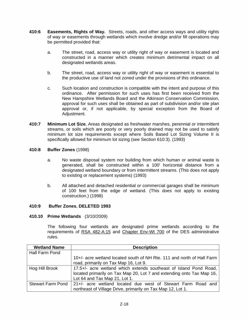
410:9 Buffer Zones. DELETED 1993 410.10 Prime Wetlands (3/10/2009)
The following four wetlands are designated prime wetlands according to the requirements of RSA 482-A:15 and Chapter Env-Wt 700 of the DES administrative rules.
Wetland Name Description
Hall Farm Pond 10+/- acre wetland located south of NH Rte. 111 and north of Hall Farm road, primarily on Tax Map 16, Lot 9.
Hog Hill Brook 17.5+/- acre wetland which extends southeast of Island Pond Road, located primarily on Tax Map 20, Lot 7 and extending onto Tax Map 16, Lot 64 and Tax Map 21, Lot 1.
Stewart Farm Pond 21+/- acre wetland located due west of Stewart Farm Road and northeast of Village Drive, primarily on Tax Map 12, Lot 1.
Z-18
Bryant Brook 69+/- acre wetland located on the southern border between Atkinson and Plaistow, primarily on Tax Map 10, Lot 7, and extending onto Tax Map 9, Lot 62-22 and Tax Map 5, Lot 48.
Note: The wetlands listed here were evaluated by procedures described in Method for the Comparative Evaluation of Non-Tidal Wetlands in New Hampshire, published by the New Hampshire Department of Environmental Services (1991). Details of the analysis may be found in Town of Atkinson Prime Wetlands Study, Natural Resource Consulting Services (December 2002). An undisturbed natural buffer area of at least 100 feet in width shall be maintained between any designated Prime Wetland, as defined in RSA 482-A:15 and adopted by Town Meeting, and any new development, including but not limited to structures, dwellings, septic systems, and roads. Exempted from this requirement are those uses permitted under §410.5. those lots separated from the Prime Wetlands by an existing public road, and variances allowing the construction of additions and extensions to residential buildings which existed prior to the effective date of this section. Nothing herein is intended to prohibit the rebuilding or redevelopment of any portion of a residential lot which has already been improved, or developed and regularly maintained as of the effective date of this section. Section 420 FLOODPLAIN MANAGEMENT ORDINANCE (03/11/2008) 420:1 Purpose
Certain areas of the Town of Atkinson, New Hampshire are subject to periodic flooding, causing serious damages to properties within these areas. Relief is available in the form of flood insurance as authorized by the National Flood Insurance Act of 1968. Therefore, the Town of Atkinson, New Hampshire has chosen to become a participating community in the National Flood Insurance Program, and agrees to comply with the requirements of the National Flood Insurance Act of 1968 (P.L. 90-488, as amended) as detailed in this Floodplain Management Ordinance.
420:2 Establishment
This ordinance, adopted pursuant to the authority of RSA 674:16, shall, be known as the town of Atkinson Floodplain Management Ordinance. The regulations in this ordinance shall overlay and supplement the regulations in the Town of Atkinson Zoning Ordinance, and shall be considered part of the Zoning Ordinance for purposes of administration and appeals under state law. If any provision of this ordinance differs or appears to conflict with any provision of the Zoning Ordinance or other ordinance or regulation, the provision imposing the greater restriction or more stringent standard shall be controlling. The following regulations in this ordinance shall apply to all lands designated as special flood hazard areas by the Federal Emergency Agency (FEMA) in its “Flood Insurance Study for the County of Rockingham, N.H.”, dated May 17, 2005, or as amended, together with the associated Flood Insurance Rate Maps dated May 17, 2005, or as amended, which are declared to be a part of this ordinance and are hereby incorporated by reference.
Z-19
420:3 Definitions
The following definitions shall apply only to this Floodplain Management Ordinance, and shall not be affected by the provisions of any other ordinance of the Town of Atkinson. a. “Area of Special Flood Hazard” is the land in the floodplain within the Town of
Atkinson subject to a one-percent or greater possibility of flooding in any given year. The area is designated on the FIRM as Zones A and AE.
b. “Base Flood” means the flood having a one-percent possibility of being equaled to exceeded in any given year.
c. “Basement” means any area of a building having its floor sub grade on all
sides.
d. “Building” – see “structure”.
e. “Development” means any man-made change to improved or unimproved real estate, including but not limited to buildings or other structures, mining, dredging, filling, grading, paving, excavating or drilling operation or storage of equipment or materials.
f. “FEMA” means the Federal Emergency Management Agency.
g. “Flood” or “Flooding” means a general and temporary condition of partial or
complete inundation of normally dry land areas from:
1) the overflow of inland or tidal waters, or 2) the unusual and rapid accumulation or runoff of surface waters from any
source.
h. “Flood Insurance Rate Map” (FIRM) means the official map incorporated with this ordinance, on which FEMA has delineated both the special flood hazard areas and the risk premium zones applicable to the Town of Atkinson.
i. “Flood Insurance Study” (FIS) means an examination, evaluation and determination of flood hazards and, if appropriate, corresponding water surface elevations, or an examination, evaluation and determination of mudslide (i.e., mudflow) and/or flood-related erosion hazards.
j. “Floodplain” or” Flood-prone area” means any land area susceptible to, being
inundated by water from any source (see definition of “Flooding”).
k. “Flood proofing” means any combination of structural and non-structural additions, changes, or adjustments to structures which reduce or eliminate flood damage to real estate or improved real property, water and sanitation facilities, structures and their contents.
l. “Floodway” see “Regulatory Floodway”.
Z-20
m. “Functionally dependent use” means a use that cannot perform its intended purpose unless it is located or carried out in close proximity to water. The term includes only docking and port facilities that are necessary for the loading/unloading of cargo or passengers, and ship building/repair facilities but does not include long-term storage or related manufacturing facilities.
n. “Highest adjacent grade” means the highest natural elevation of the ground
surface prior to construction next to the proposed walls of a structure.
o. “Historic Structure” means any structure that is:
1) Listed individually in the National Register of Historic Places (a listing maintained by the Department of Interior) or preliminarily determined by the Secretary of the Interior as meeting the requirements for individual listing on the National Register;
2) Certified or preliminarily determined by the Secretary of the Interior as contributing to the historical significance of a registered historic district or a district preliminarily determined by the Secretary to qualify as a registered historic district;
3) Individually listed on a state inventory of historic places in states with historic preservation programs which have been approved by the Secretary of the Interior; or Individually listed on a local inventory of historic places in communities with historic preservation programs that have been certified either: i) by an approved state program as determined by the Secretary of
the Interior; or ii) directly by the Secretary of the Interior in states without
approved programs.
p. “Lowest Floor” means the lowest floor of the lowest enclosed area (including basement). An unfinished or flood resistant enclosure, usable solely for parking of vehicles, building access or storage in an area other than a basement area is not considered a building’s lowest floor; provided, that such an enclosure is not built so as to render the structure in violation of the applicable non-elevation design requirements of this ordinance.
q. “Manufactured Home” means for floodplain management purposes, a structure, transportable in one or more sections, which is built on a permanent chassis and is designed for use with or without a permanent foundation when connected to the required utilities. For floodplain management purposes, the term “manufactured home” includes park trailers, travel trailers, and other similar vehicles placed on site for greater than 180 consecutive days. This includes manufactured homes located in a manufactured home park or subdivision.
r. “Manufactured Home Park or Subdivision” means for floodplain management
purposes, a parcel (or contiguous parcels) of land divided into two or more manufactured home lots for rent or sale.
Z-21
s. “Mean sea level” means the National Geodetic Vertical Datum (NGVD) of 1929 or other datum, to which base flood elevations shown on a community’s Flood Insurance Rate Map are referenced.
t. “New construction” means, for the purposes of determining insurance rates,
structures for which the “start of construction” commenced on or after the effective date of an initial FIRM or after December 31, 1974, whichever is later, and includes any subsequent improvements to such structures. For floodplain management purposes, new construction means structures for which the start of construction commenced on or after the effective date of a floodplain management regulation adopted by a community and includes any subsequent improvements to such structures.
u. “100-year flood” – see “base flood”.
v. “Recreational Vehicle” is defined as:
1) built on a single chassis; 2) 400 square feet or less when measured at the largest horizontal
projection; 3) designed to be self-propelled or permanently towable by a light duty
truck; and 4) designed primarily not for use as a permanent dwelling but as
temporary living quarters for recreational, camping, travel or seasonal use.
w. “Regulatory floodway” means the channel of a river or other watercourse and
the adjacent land areas that must be reserved in order to discharge the base flood without cumulatively increasing the water surface elevation more than a designated height.
x. “Special flood hazard area” – see “Area of Special Flood Hazard”
y. “Structure” means for floodplain management purposes, a walled and roofed building, including a gas or liquid storage tank that is principally above ground, as well as a manufactured home.
z. “Start of Construction” includes substantial improvements, and means the date
the building permit was issued, provided the actual start of construction, repair, reconstruction, placement, or other improvement was within 180 days of the permit date. The actual start means either the first placement of permanent construction of a structure on site, such as the pouring of slab or footings, the installation of piles, the construction of columns, or any work beyond the stage of excavation; or the placement of a manufactured home on a foundation. Permanent construction does not include land preparation, such as clearing, grading and filling; nor does it include the installation of streets and/or walkways; nor does it include excavation for a basement, footings, piers, or foundations or the erection of temporary forms; nor does it include the installation on the property of accessory buildings, such as garages or sheds not occupied as dwelling units or part of the main structure.
Z-22
aa. “Substantial damage’ means damage of any origin sustained by a structure whereby the cost of restoring the structure to its before damage condition would equal or exceed 50 percent of the market value of the structure before the damage occurred.
bb. “Substantial Improvement” means any combination of repairs, reconstruction,
alteration, or improvements to a structure in which the cumulative cost equals or exceeds fifty percent of the market value of the structure. The market value of the structure should equal:
1) the appraised value prior to the start of the initial repair or improvement;
or 2) in the case of damage, the value of the structure prior to the damage
occurring.
For the purposes of this definition, “substantial improvement” is considered to occur when the first alteration of any wall, ceiling, floor, or other structural part of the building commences, whether or not that alteration affects the external dimensions of the structure. This term includes structures that have incurred substantial damage, regardless of actual repair work performed. The term does not; however, include any project for improvement of a structure required to comply with existing health, sanitary, or safety code specifications which are solely necessary to assure safe living conditions or any alteration of a “historic structure”, provided that the alteration will not preclude the structure’s continued designation as a “historic structure”.
cc. “Violation” means the failure of a structure or other development to be fully
compliant with the community’s flood plain management regulations. A structure or other development without the elevation certificate, other certificates, or other evidence of compliance required in 44CFR § 60.3(b)(5), (c)(10), (d)(3), (e)(2), (e)(4), or (e)(5) is presumed to be in violation until such time as that documentation is provided.
dd. “Water surface elevation” means the height, in relation to the National Geodetic Vertical Datum (NGVD) of 1929, (or other datum, where specified) of floods of various magnitudes and frequencies in the floodplains.
420:4 Permits
All proposed development, as defined in this ordinance, in any special flood hazard area shall require all applicable permits.
420:5 Construction Requirements
The Building Inspector shall review all building permit applications for new construction or substantial improvements to determine whether proposed building sites will be reasonably safe from flooding. If a proposed building site is located in a special flood hazard area, all new construction or substantial improvements shall:
Z-23
a. be designed (or modified) and adequately anchored to prevent flotation, collapse, or lateral movements of the structure resulting from hydrodynamic and hydrostatic loads, including the effects of buoyancy;
b. be constructed with materials resistant to flood damage;
c. be constructed by methods and practices that minimize flood damages; and
d. be constructed with electrical, heating, ventilation, plumbing, and air conditioning equipment, and other service facilities that are designed and/or located so as to prevent water from entering or accumulating within the components during conditions of flooding.
420:6 Water and Sewer Systems
Where new or replacement water and sewer systems (including on-site systems) are proposed in a special flood hazard area the applicant shall provide the Building Inspector with assurance that these systems will be designed to minimize or eliminate infiltration of flood waters into the systems and discharges from the systems into flood waters, and on-site waste disposal systems will be located to avoid impairment to them or contamination from them during periods of flooding.
420:7 Certification
For all new or substantially improved structures located in Zones A and AE, the applicant shall furnish the following information to the Building Inspector:
a. the as-built elevation (in relation to NGVD) of the lowest floor (including
basement) and include whether or not such structures contain a basement.
b. if the structure has been flood proofed, the as-built elevation (in relation to NGVD) to which the structure was flood proofed.
c. any certification of food proofing. The Building Inspector shall maintain the aforementioned information for public inspection, and shall furnish such information upon request.
420:8 Other Permits
The Building Inspector shall not grant a building permit until the applicant certifies that all necessary permits have been received from those governmental agencies from which approval is required by federal or state law, including Section 404 of the Federal Water Pollution Control Act Amendments of 1972, 33 U.S.C. 1334.
420:9 Watercourses
a. In riverine situations, prior to the alteration or relocation of a watercourse the applicant for such authorization shall notify the Wetlands Bureau of the New Hampshire Department of Environmental Services and submit copies of such notification to the Building Inspector, in addition to the copies required by RSA
Z-24
482-A:3. Further, the applicant shall be required by submit copies of said notification to those adjacent communities as determined by the Building Inspector, including notice of all scheduled hearings before the Wetlands Bureau and/or the Planning Board in consideration of Section 410.
b. The applicant shall submit to the Building Inspector, certification provided by a registered professional engineer, assuring that the flood carrying capacity of an altered or relocated watercourse can and will be maintained.
c. Along watercourses with a designated Regulatory Floodway no
encroachments, including fill new construction, substantial improvements, and other development are allowed within the floodway unless it has been demonstrated through hydrologic and hydraulic analyses performed in accordance with standards engineering practices that the proposed encroachment would not result in any increase in flood levels within the community during the base flood discharge.
d. Until a Regulatory Floodway is designated along watercourses, no new
construction, substantial improvements, or other development (including fill) shall be permitted within Zone AE on the FIRM, unless it is demonstrated by the applicant that the cumulative effect of the proposed development, when combined with all existing and anticipated development, will not increase the water surface elevation of the base flood more than one foot at any point within the community.
e. The Building Inspector or the Planning Board when the development pertains
to subdivision or site plan review, shall obtain, review, and reasonably utilize any floodway data available from Federal, State, or other sources as criteria for requiring that all development located in Zone A meet the following floodway requirement:
f. “No encroachments, including fill, new construction, substantial improvements,
and other development are allowed within the floodway that would result in any increase in flood levels within the community during the base flood discharge”.
420:10 Special Flood Hazard Areas
In special flood hazard area the Building Inspector shall determine the 100-year flood elevation in the following order of precedence according to the data available:
a. In Zone AE, refer to the elevation data provided in the community’s Flood
Insurance Study and accompanying FIRM.
b. In Zone A, the Building Inspector shall, obtain, review, and reasonably utilize any 100-year flood elevation data available from any federal, state or other source including data submitted for development proposals submitted to the community (i.e., subdivisions, site approvals).
c. The Building Inspector’s 100-year flood elevation determination will be used as
criteria for requiring in Zones A and AE that:
Z-25
1) All new construction or substantial improvement of residential structures have the lowest floor (including basement) elevated to or above the 100-year flood elevation.
2) That all new construction or substantial improvements of non-residential structures have the lowest floor (including basement) elevated to or above the 100-year flood level; or together with attendant utility and sanitary facilities, shall:
i) be floodproofed so that below the 100-year flood elevation the
structure is watertight with walls substantially impermeable to the passage of water;
ii) have structural components capable of resisting hydrostatic and hydrodynamic loads and the effects of buoyancy; and
iii) meet all standards of Section 60.3 (b) (1) of the National Flood Insurance Program Regulations and the elevation and anchoring requirements for “manufactured homes” in Paragraph (c) (6) of Section 60.3.
iv) for all new construction and substantial improvements, fully enclosed areas below the lowest floor that are subject to flooding are permitted provided they meet the following requirements:
A) the enclosed area is unfinished or flood resistant, usable
solely for the parking of vehicles, building access or storage;
B) the area is not a basement; C) shall be designed to automatically equalize hydrostatic
flood forces on exterior walls by allowing for the entry and exit of floodwater. Designs for meeting this requirement must either be certified by a registered professional engineer or architect or must meet or exceed the following minimum criteria: A minimum of two openings having a total net area of not less than one square inch for every square foot of enclosed area subject to flooding shall be provided. The bottom of all openings shall be no higher than one foot above grade. Openings may be equipped with screens, louvers, or other coverings or devices provided that they permit the automatic entry and exist of floodwater.
420:11 Variances and Appeals
a. Any order, requirement, decision or determination of the Building Inspector made under this ordinance may be appealed to the Zoning Board of Adjustment as set forth in RSA 676:5.
b. If the applicant, upon appeal, requests a variance as authorized by RSA 674:33, I (b), the applicant shall have the burden of showing in addition to the usual variance standards under state law that:
Z-26
1) the variance will not result in increased flood heights, additional threats to public safety, or extraordinary public expense.
2) if the requested variance is for activity within a designated regulatory floodway, no increase in flood levels during the base flood discharge will result.
3) the variance is the minimum necessary, considering the flood hazard, to afford relief.
c. The Zoning Board of Adjustment shall notify the applicant in writing that:
1) the issuance of a variance to construct below the base flood level will
result in increased premium rates for flood insurance up to amounts as high as $25 for $100 of insurance coverage; and
2) such construction below the base flood level increases risks to life and property.
Such notification shall be maintained with a record of all variance actions.
d. The community shall:
1) maintain a record of all variance actions, including the justification for
their issuance; and 2) report such variances issued in its annual or biennial report submitted to
FEMA’s Federal Insurance Administrator. (3/11/2008) Section 430 REMOVAL OF NATURAL DEPOSITS 430:1 No gravel pit, or quarry, and no removal of sod or loam shall be permitted in a
residential district except as herein provided:
a. The Board of Adjustment shall approve the temporary operation of a pit or quarry which is incidental to the improvement of land provided that such operation will not create a traffic condition detrimental to the neighborhood or hazardous to the use of the highway, and provided that such operation will not create noise or dust to the extreme extent that it will be detrimental to the health or comfort of nearby residents. The Board of Adjustment shall determine the effective duration for which such a permit may be issued, and upon application may approve renewal of such permit upon re-determination of the conditions under which such permit may be allowed. After no more than two hundred and fifty (250) days after the last use of the pit or quarry as a source of supply, the area shall be re-graded and left in a sightly condition and protected against erosion.
b. The Board of Adjustment shall allow the removal of sod or loam provided that
all facilities for excavating, handling or storing shall be removed and the area shall be re-graded and re-seeded to assure the premises are left in a sightly condition and protected against erosion. Such removal and regrading shall be accomplished within (1) ninety (90) consecutive days after the depletion of the deposit or completion of the work for which the deposit was opened, or (2) two hundred and fifty (250) consecutive days after the last use of the deposit as a source of supply.
Z-27
c. Before the approval by the Board of Adjustment for the operation of a pit or quarry or the removal of sod or loam, there shall be a bond filed with the Town Clerk in amount sufficient to cover the cost of meeting the condition of items (1) and (2) above.
430:2 No processing of sand, gravel, stone, loam, or other natural deposits shall be
permitted in a residential district. (1959) 430:3 In applying the above standards and in reviewing application for the removal of natural
deposits, the Board of Adjustment shall apply, as appropriate, such sections of the New Hampshire Statutes, in particular Section 155E, dealing with the removal of deposits.
Section 440 GENERAL FARMING AND THE KEEPING OF ANIMALS 440:1 With the exception of mink raising, and fox raising, general farming activity and the
keeping of animals for other purposes shall be permitted provided the following criteria are met: (1999)
a. Large animals (horses, cattle, or sheep) shall be contained within the owner's
property. b. Large animals (horses, cattle, pigs, or sheep) shall not be kept on lots of less
than one acre. No more than one large animal shall be kept on a one-acre lot; no more than three (3) animals on a two-acre lot; and no more than five (5) animals on a three-acre lot. (1999)
c. The keeping of animals shall not create health or safety hazards to immediate
abutters or the community at large. d. In residential areas, stables or shelters for large animals shall be located a
minimum distance of fifteen feet (15') from any lot line; and corral fences shall be a minimum of five feet (5') from any lot line. (1999)
e. In all districts, owners shall be responsible for all damages and expenses
incurred in the capturing and holding of escaped animals by Town officials. In addition, a fine shall be levied under guidelines established by the Board of Selectmen whenever a Town official is called out to capture an animal. (1984)
Section 450 ACCESSORY USES: HOME OCCUPATIONS 450:1 All home occupations except those exempted under Section 450:4 shall be required to
apply for a Home Occupation Permit. (1992) 450:2 A permit for a home occupation shall be allowed in residential zones by special
exception from the Board of Adjustment if the occupation complies with the following:
a. A proposed occupation shall be incidental and secondary to the use of the property as a dwelling and shall not consume more than 20% of the gross residential building space, and not change the residential character of the premises thereof. (1992)
Z-28
b. Unless exempted by Section 450:4-a, no home occupation shall take place in a multi-family dwelling.
c. The occupation may be carried on by the occupant's immediate family residing
at that location and by one or more additional employees whose aggregate hours of work at that location do not exceed eighty hours per week (80 hours/week). The foregoing limitations on the aggregate hours of work per week by additional employees shall not apply in the case of medical, dental or veterinary home occupations. (2007)
d. There shall be no physical evidence of equipment or materials outside the
dwelling. e. Adequate off-street parking areas must be provided. Parking areas in excess of
those necessary for normal residential purposes may be allowed in side and rear yards only provided the residential character of the environment is preserved. (1992)
f. When necessary, further restrictions shall be placed on the occupation in order
to comply fully with Article IV, Section 400:2 of this ordinance. g. A permit to operate a home occupation shall be issued to the owner/occupant
only and is not transferable to a subsequent owner. A permit to operate a home occupation shall be issued to the owner/occupant only, and is transferable to a subsequent owner who will certify to the Zoning Board of Adjustment in writing that he or she will continue the home occupation on the same terms and conditions as the previous owner/occupant. (2007)
h. The applicant shall complete and sign a form that sets forth the nature of the
home occupation and provides details of the business and its scope of operation.
i. No home occupation that will result in heavy truck use in excess of 20,000 lbs.
gross vehicle weight shall be allowed. (1992) j. Vehicles registered to a home business or occupation must comply with the
provisions of Section 480:1. (1992)
450:3 Nature of the Permit
a. Permits shall be issued by the Board of Adjustment. b. Prior to the issuance of a permit, the Board of Adjustment shall hold a public
hearing. Abutters will be notified of the time and date of the hearing by certified mail, such letter to include a description of the home occupation applied for and its location.
Z-29
c. Before a permit is granted, mandatory building inspections shall be made by the Town if it is a Family Group Day-Care Home facility, or if the public is to be served or persons outside the family are to be employed at the proposed location or if hazardous materials are to be stored there. In addition, a formal site plan review may be required if deemed necessary.
d. No more than one business permit can be in effect for any one location. e. A permit is valid only for two (2) years and only for the owner/occupant and
location for which it is issued. A renewal permit shall be required after two (2) years.
f. Annual inspections of the home occupation/home business premises may be
required subsequent to the issuance of a permit in order to confirm compliance with the conditions of the original special exception granted. If, in the opinion of the Board of Selectmen, the business practices originally set forth and defined in the initial approval have changed, it shall revoke the permit that was issued. Permit holders whose permits are revoked may make application to the Board of Adjustment for a new permit based on the changed circumstances of the business.
450:4 Fees
a. There will be an initial permit fee as set by the Selectmen plus the cost of certified mail to each abutter including the applicant and the cost of all initial inspections deemed necessary.
b. Any inspection required by the Town subsequent to the issuance of a permit
shall be paid by the permit holder. Any renewal permit shall require a fee as determined by the Board of Selectmen.
450:5 Exemptions from permit application requirements
a. Home occupations in which neither customers nor vehicles come to the location where the business activity takes place and at which no sign is displayed and no outside person is to be employed and there is no outward appearance of business activity.
b. Agricultural activity, including farming and forestry, in which products are grown
on the premises and sold on or off the premises. c. Home occupations for which permits were officially issued by the Planning
Board and in effect on or before March 8, 1984, with such permits automatically becoming subject to Section 450:2-f. (1984)
450:6 The repair and/or sales of automobiles and other vehicles for business purposes is not
permitted in residential zones and Town Center. (1990)
Z-30
Section 460 ACCESSORY USES: EXTENDED FAMILY ACCESSORY LIVING UNIT 460:1 The objectives of this section are to:
a. Empower families with a tool to provide housing assistance to extended family members, who are in a personal hardship situation, while at the same time affording all parties the necessary privacy and living arrangements conducive to harmonious habitation in a single family residence;
b. Provide dwelling units to meet the needs of smaller households, both young
and old; c. Provide dwelling units in single-family neighborhoods that are appropriate for
different housing demands, thereby lessening fluctuations in the demand, thereby lessening fluctuations in the demand for Town services, e.g. education and elderly care;
d. Extend the strict definition of single-family housing to serve the narrow scope of
this particular housing need; e. Preserve the intent of single-family housing. This ordinance places strict
physical limitations on size and access to the accessory living unit. It is intended that the accessory living unit will not be a wholly separate and self-sufficient living unit and in fact the occupants of the accessory living unit will have access to and use space in the principal living unit;
f. Protect the single family residential character of a neighborhood by ensuring
that the accessory living unit is permitted only in an owner-occupied house and under such conditions as to protect the property values and the health, safety and welfare of the public.
460:2 An Extended Family Accessory Living Unit shall be allowed in residential zones by
special exception from the Board of Adjustment if the Extended Family Accessory Living Unit complies with the following:
a. The accessory living unit shall be subject to the standards and conditions for a
special exception as set forth in this Ordinance. b. No more than one accessory living unit shall be allowed per single-family
dwelling. The accessory living unit shall be included in said single-family dwelling and shall not be permitted within accessory structures located on the same lot as the single-family dwelling.
c. The single-family dwelling or the accessory living unit shall not be converted to
a condominium or any other form of legal ownership distinct from the ownership of the existing single-family dwelling. An accessory living unit shall be recorded by deed addendum at the Registry of Deeds, indicating the conditions and limitations of the approval granted.
d. The single-family dwelling to which an accessory living unit has been added
shall be owner-occupied.
Z-31
e. Accessory living units will be allowed only as part of single-family detached housing.
f. The accessory living unit, and any related changes to the property, shall be
designed so that the appearance remains that of a single family residence and is consistent with the single family character of other residences in the neighborhood. Any new entrances shall be located on the side or in the rear of the building.
g. The accessory living unit shall have convenient and direct access to the
principal dwelling unit. h. The accessory living unit shall be no more than 750 square feet in size, shall
be clearly accessory to the principal dwelling unit and shall consist of no more than one bedroom. (2007)
i. Any and all construction shall be in accordance with the building standards of
the Town of Atkinson in effect at the time of construction. j. In accordance with the standards of the Town and the standards of the New
Hampshire Water Supply and Pollution Control Division, the septic facilities shall be adequate to service both the existing single-family dwelling and the accessory living unit.
k. The occupancy shall be limited to a specific extended family member(s). For
the purposes of this ordinance, extended family is defined as parents (and their spouses), grandparents (and their spouses), children (and their spouses), grandchildren and persons under legal guardianship. In the event specific extended family member(s) vacate said unit, the special exception shall expire and any new occupancy shall require a new special permit exception application. (1995)
Section 470 SIGNS 470:1 Purpose. These regulations have been created to permit signage for the following uses:
Commercial, Commercial-Industrial, Commercial Professional, Municipal, Residential, reference, directional, temporary, and traffic. While recognizing that esthetics and design quality are difficult to legislate, it is the intent and purpose of this section to preserve the rural beauty of the town as well as the safety and well-being of the inhabitants and, at the same time, allow reasonable advertising and informational signs by regulating the type, number, location, color, illumination and size of such signs.
470:2 Definitions S1 Sign Any device, fixture, placard or structure that uses any color, form, graphic,
illumination, symbol or writing to advertise, announce the purpose of, or identify the purpose of a person or entity or to communicate information of any kind to the public.
T1 Temporary Sign Any sign that is used only for a limited time, and is not permanently
mounted.
Z-32
470:3 Permit required. No sign identifying or advertising a business shall be erected, hung, altered or replaced without a sign permit. Temporary signs are excluded from this provision. Permit approval is obtained from the Building Inspector. The applicant or his agent must submit a set of plans, to scale, showing the sign, its dimensions, location and method of illumination, as well as the materials and colors to be used in its construction. Upon approval, said permit shall be issued by the Building Inspector after the application fee is paid. Permit fee is determined by the Board of Selectmen. (1994)
470:4 Government exception. Provisions of this Ordinance shall not apply to conventional
directional and identification signs and markers erected by federal, state or local government agencies.
470:5 Compliance. DELETED 1993. 470:6 General Provisions
a. Only one sign advertising a business shall be permitted on the immediate
premises, except where specifically allowed within this Ordinance. b. No signs advertising a business shall be permitted off the premises.
c. No moving, reflective, inflating, noise producing, odor or vapor producing signs are allowed.
d. Banners and portable signs are not to be used as permanent signage. e. All signs may be illuminated by exterior light sources provided such lighting is
shielded to protect adjacent properties and vehicular traffic. Internally lit signs are permitted only in CI/CP zones.
f. No neon, flashing or moving lights are allowed to be visible from the exterior of
buildings. g. Commercial grade materials such as plexiglass, vinyl and redwood are preferred.
(1994) h. Colors are limited to a total of three per sign/structure, with one being the
background. Bright reflective colors are not allowed. White is not considered a color. (1994)
i. All signs may have a maximum of two faces with the exception of signs in the
CI/CP zones. j. Letters affixed to buildings are considered signs. k. DELETED 1994 l. No sign shall be placed within any public right-of-way.
Z-33
470:7 Temporary Signs. Temporary signs identifying an upcoming event are permitted to be displayed not more than four (4) weeks before the event and shall be remove within ten (10) days following the event. Temporary signs include but are not limited to flags, banners, portable signs, for rent, sale and yard sale signs. National, state and municipal flags are allowed.
470:8 Signs in Residential Zone. The following signs are permitted when located on the lot:
a. Home business signs no larger than five (5) square feet per face. b. Name plates. Non-commercial signs showing property numbers, names of
occupants of the premises, or other identification. c. Property-for-sale signs. Area of each face of the sign may not exceed five (5)
square feet. d. Permanent subdivision identification signs. One ground sign per main entrance
into a development with a maximum of two per development. Signs shall be set back from vehicle or pedestrian traffic and beyond the highway right-of-way. The area of each face of the sign shall not exceed twenty (20) square feet.
e. Non-residential signs. One sign identifying a non-residential use in a residential
zone is permitted by Special Exception from the Board of Adjustment. The sign shall be limited to the following square area:
1) five (5) square feet per face in a conventional residential development. 2) one (1) square foot per face in a rural cluster residential development of
detached single-family dwellings.
470:9 Signs in Commercial Zone & Commercial Area in Cluster Recreational Developments. Each business shall be allowed one identification sign. (1994)
a. In buildings that have more than one permitted business, the following signs
are allowed when located on the lot:
1) one building identification/directory sign with a maximum height of (12) feet not to exceed fifteen (15) square feet per face.
2) individual business signs which shall not exceed ten (10) square feet with a maximum of two surfaces.
b. In buildings that have one permitted business, the following signs are allowed
when located on the lot:
1) one sign not exceeding fifteen (15) square feet per face with a maximum of two faces and a maximum height of twelve (12) feet.
c. Non-residential signs. One sign identifying a non-residential use in a residential
zone is permitted by Special Exception from the Board of Adjustment. The sign shall be limited to five (5) square feet.
Z-34
470:10 Signs in Commercial Industrial and Commercial/Professional Zones. Every commercial park shall be allowed to have one identification sign to be located at or near the main entrance.
a. Maximum height of twenty (20) feet (15 feet if within 200 feet of a residential
zone) and maximum width of eight (8) feet. No single surface can be more than one hundred and twelve (112) square feet and the total square footage is not to exceed two hundred twenty four (224) square feet, no matter how many businesses occupy the lot.
b. One identification sign per business not to exceed fifteen (15) square feet per
face. c. Permanent subdivision identification signs. (see 470:8d)
470:11 Farmstand signs. Multiple signs advertising the location and items for sale are
allowed on the immediate premises. Signage shall not exceed a total of fifteen (15) square feet.
470:12 Existing signs. Removing or reconstructing signs. Grandfathered and/or non-conforming signs. Signs that exist at the time of passage of this ordinance may remain in use in the same location. If for any reason, replacement or reconstruction becomes necessary, a sign permit shall be required. Nothing in this ordinance shall prohibit the ordinary maintenance and repair of non-conforming signs. (1994) Relocating signs. Any sign that is moved to another location on the same or other premises shall be considered a new sign and a permit shall be secured for any work performed in connection therewith when required by this article. 470:13 Obsolete signs. Any sign now or hereafter existing which no longer advertises a
bona fide business conducted, product sold, or activity or campaign being conducted shall be removed by the owner, agent, or person having the beneficial use of the building, structure, or lot upon which such sign may be found within ten (10) days after written notification from the Code Enforcement Officer. Failure to comply with such notice constitutes a violation of terms of this Ordinance. (1992)
Section 480 STORAGE OF VEHICLES 480:1 In residential areas, with the exception of farm vehicles, commercial vehicles parked
on the premises must be wholly screened from the view of abutting property either by natural screening or by fencing at least equal in height to that of the vehicle itself. Commercial vehicles in excess of 20,000 pounds gross vehicle weight are not permitted to be routinely parked in Residential Districts. (1999)
Z-35
Section 490 REDUCTION OF FRONTAGE REQUIREMENTS 490:1 The Board of Adjustment may reduce frontage requirements by no more than 33 and
1/3% where street layouts and lot shapes may lend greater usage of the property under consideration, provided, however, that at the building line, a distance of the required frontage is being met. This means in an RR-3, 250' between lot lines; in an RR-2, 200' between lot lines; and in a TR-2 area, 200' between lot lines. (1982)
Z-36
ARTICLE V: ZONING DISTRICT REGULATIONS Section 500 ZONING DISTRICT OBJECTIVES AND GUIDELINES 500:1 The purpose and the designation of each of the districts listed in this Article follow. 500:2 (RR-3) Rural Residential-3. This area is limited to agricultural, forestry, and certain
other non-intensive uses as provided for in Section 510. Low density residential and related uses are permitted in this district where it is not inconsistent with the comprehensive Master Plan for the town. The purposes of this lot density designation are to prevent premature development of land, to retain certain areas for non-intensive uses, to protect the public health, and to prevent development which would be a burden on town services.
500:3 (RR-2) Rural Residential-2. This area is limited to agricultural, forestry, and low
density residential uses. Other related uses as provided for in Section 520 are permitted and must be consistent with the comprehensive Master Plan. These areas designated for Rural Residential-2 allow for development, but require adequate lots in order to minimize community services, protect the public health, and prevent premature development beyond the capability of soil conditions with moderate to severe limitations.
500:3.1 (RR2/SCR) Sports Complex/Residential Subdistrict. This area in town for
Recreational/Sports amenities and other public and common facilities that cannot otherwise by provided under conventional land development procedures, together with limited non-residential uses to support the same and the neighborhood. Such development must contain a minimum of 250 acres and be part of a rural residential cluster development, provided such development also meets the requirements contained in the RR-2 District. Such developments are hereinafter referred to as “Rural Residential and Recreational Cluster Developments” (RRRCD) and may contain alternative design housing. (2006)
500:4 (TR-2) Town Residential-2. This is the prime residential area in town and is
designated in land areas where soil limitations are less severe and accessibility to community services such as police, fire station, and schools are more readily available. Residential and other compatible and complementary uses as provided for in Section 530 are permitted in this district and detailed densities are dependent upon land suitability. This district is intended to have the majority of the community's permanent residents in the area, densities consistent with soil conditions, and lot sizes which protect the public health, provide ample open space, and maintain the present rural nature of the town.
500:5 (C) Commercial. This is a district designated in the town and is designed to
continue the New England character of providing services and shopping opportunities to the residents of the community and to visitors. It is a district that is designated to promote the pleasant residential characteristics and shopping environment of a neighborhood.
Z-37
500:6 (C-I) Commercial-Industrial. This district allows for the establishment of small-scale manufacturing opportunities along with shopping and service opportunity locations. It is an area that must take into consideration accessibility to truck and rail traffic and the availability of utilities or the lack thereof. The accommodations of present home occupations outgrowing present quarters are the purpose of creating and locating this district. Facilities need to be in harmony with abutting districts which may contain residential uses. To accomplish this harmony, all material or products outside of the building must be suitably screened from streets and residential abutters. (1999)
500:7 (C-P) Commercial-Professional. This district provides for commercial-
professional development and would serve as a transition zone between the commercially/industrially zoned area and any residentially zoned area. The district is intended to accommodate the outgrowth of present home businesses and to establish an area necessary to support the existing need for low impact services.
500:8 (TC) Town Center. This district is created to provide a community center for the
townspeople of Atkinson while observing and retaining the historic qualities which now exist in the area. Provision for professional services and public government and civic services is a major objective in this district designation.
500:9 (HD) Historic District. District dissolved - Ballot 6/13/92 Section 505 SCENIC VISTA AND PRONOUNCED LANDSCAPE REGULATION (1998) 505:1 Areas designated in the 1980 Master Plan as scenic vistas and pronounced
landscapes (see Scenic & Cultural Map, page 32 of the 1980 Master Plan) are needed to maintain the rural character of the community. The following Sections are aimed at preserving these valuable assets.
505:2 Preservation of scenic vistas and pronounced landscapes in residentially zoned
districts is encouraged by allowing an increase in the density of allowable units provided, however, that sufficient information has been provided to the Planning Board during subdivision review to document the adequate protection of the vista or pronounced landscape. (See Section 600:6c)
Z-38
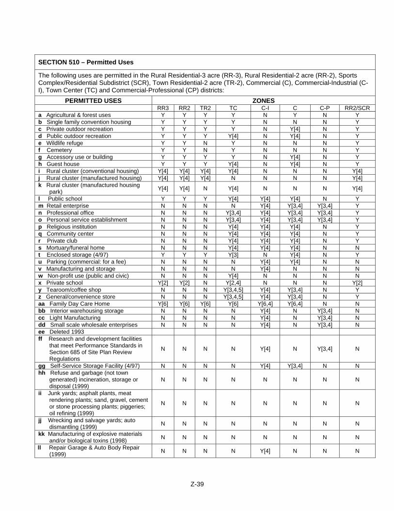
SECTION 510 – Permitted Uses
The following uses are permitted in the Rural Residential-3 acre (RR-3), Rural Residential-2 acre (RR-2), Sports Complex/Residential Subdistrict (SCR), Town Residential-2 acre (TR-2), Commercial (C), Commercial-Industrial (C-I), Town Center (TC) and Commercial-Professional (CP) districts:
PERMITTED USES ZONES RR3 RR2 TR2 TC C-I C C-P RR2/SCR a Agricultural & forest uses Y Y Y Y N Y N Y b Single family convention housing Y Y Y Y N N N Y c Private outdoor recreation Y Y Y Y N Y[4] N Y d Public outdoor recreation Y Y Y Y[4] N Y[4] N Y e Wildlife refuge Y Y N Y N N N Y f Cemetery Y Y N Y N N N Y g Accessory use or building Y Y Y Y N Y[4] N Y h Guest house Y Y Y Y[4] N Y[4] N Y i Rural cluster (conventional housing) Y[4] Y[4] Y[4] Y[4] N N N Y[4] j Rural cluster (manufactured housing) Y[4] Y[4] Y[4] N N N N Y[4] k Rural cluster (manufactured housing
park) Y[4] Y[4] N Y[4] N N N Y[4]
l Public school Y Y Y Y[4] Y[4] Y[4] N Y m Retail enterprise N N N N Y[4] Y[3,4] Y[3,4] Y n Professional office N N N Y[3,4] Y[4] Y[3,4] Y[3,4] Y o Personal service establishment N N N Y[3,4] Y[4] Y[3,4] Y[3,4] Y p Religious institution N N N Y[4] Y[4] Y[4] N Y q Community center N N N Y[4] Y[4] Y[4] N Y r Private club N N N Y[4] Y[4] Y[4] N Y s Mortuary/funeral home N N N Y[4] Y[4] Y[4] N N t Enclosed storage (4/97) Y Y Y Y[3] N Y[4] N Y u Parking (commercial: for a fee) N N N N Y[4] Y[4] N N v Manufacturing and storage N N N N Y[4] N N N w Non-profit use (public and civic) N N N Y[4] N N N N x Private school Y[2] Y[2] N Y[2,4] N N N Y[2] y Tearoom/coffee shop N N N Y[3,4,5] Y[4] Y[3,4] N Y z General/convenience store N N N Y[3,4,5] Y[4] Y[3,4] N Y aa Family Day Care Home Y[6] Y[6] Y[6] Y[6] Y[6,4] Y[6,4] N N bb Interior warehousing storage N N N N Y[4] N Y[3,4] N cc Light Manufacturing N N N N Y[4] N Y[3,4] N dd Small scale wholesale enterprises N N N N Y[4] N Y[3,4] N ee Deleted 1993 ff Research and development facilities
that meet Performance Standards in Section 685 of Site Plan Review Regulations
N N N N Y[4] N Y[3,4] N
gg Self-Service Storage Facility (4/97) N N N N Y[4] Y[3,4] N N hh Refuse and garbage (not town
generated) incineration, storage or disposal (1999)
N N N N N N N N
ii Junk yards; asphalt plants, meat rendering plants; sand, gravel, cement or stone processing plants; piggeries; oil refining (1999)
N N N N N N N N
jj Wrecking and salvage yards; auto dismantling (1999) N N N N N N N N
kk Manufacturing of explosive materials and/or biological toxins (1998) N N N N N N N N
ll Repair Garage & Auto Body Repair (1999) N N N N Y[4] N N N
Z-39
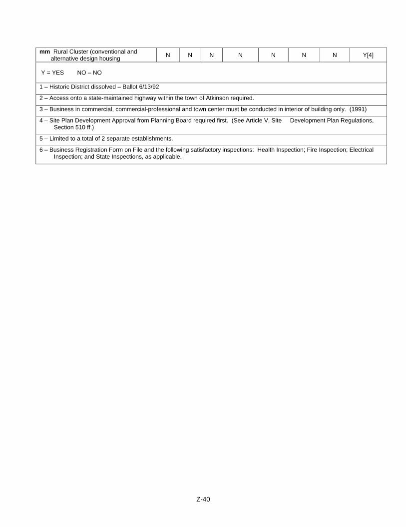
mm Rural Cluster (conventional and alternative design housing N N N N N N N Y[4]
Y = YES NO – NO 1 – Historic District dissolved – Ballot 6/13/92
2 – Access onto a state-maintained highway within the town of Atkinson required.
3 – Business in commercial, commercial-professional and town center must be conducted in interior of building only. (1991)
4 – Site Plan Development Approval from Planning Board required first. (See Article V, Site Development Plan Regulations, Section 510 ff.)
5 – Limited to a total of 2 separate establishments.
6 – Business Registration Form on File and the following satisfactory inspections: Health Inspection; Fire Inspection; Electrical Inspection; and State Inspections, as applicable.
Z-40
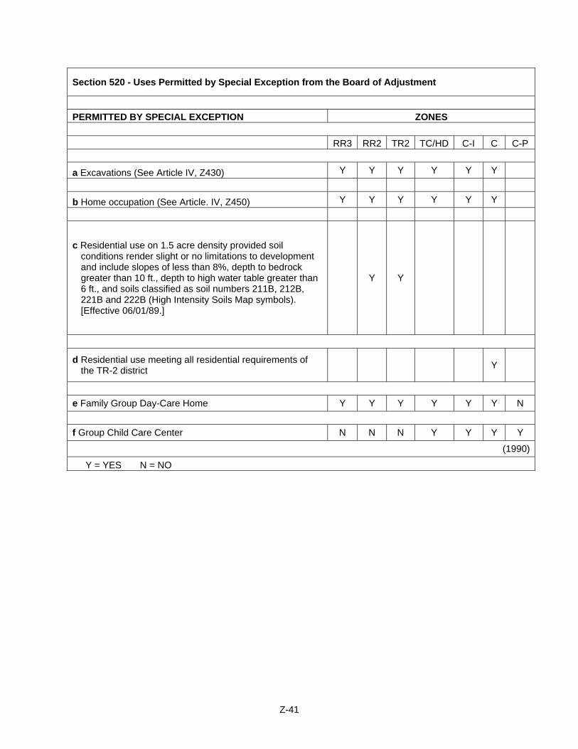
Z-41
Section 520 - Uses Permitted by Special Exception from the Board of Adjustment
PERMITTED BY SPECIAL EXCEPTION ZONES
RR3 RR2 TR2 TC/HD C-I C C-P
a Excavations (See Article IV, Z430) Y Y Y Y Y Y
b Home occupation (See Article. IV, Z450) Y Y Y Y Y Y
c Residential use on 1.5 acre density provided soil conditions render slight or no limitations to development and include slopes of less than 8%, depth to bedrock greater than 10 ft., depth to high water table greater than 6 ft., and soils classified as soil numbers 211B, 212B, 221B and 222B (High Intensity Soils Map symbols). [Effective 06/01/89.]
Y Y
d Residential use meeting all residential requirements of the TR-2 district Y
e Family Group Day-Care Home Y Y Y Y Y Y N
f Group Child Care Center N N N Y Y Y Y
(1990)
Y = YES N = NO
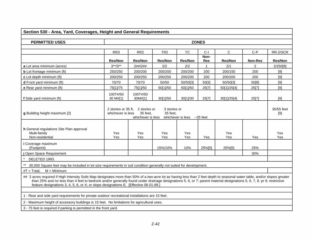
Section 530 - Area, Yard, Coverages, Height and General Requirements PERMITTED USES ZONES
RR3 RR2 TR2 TC C-I C C-P RR-2/SCR
Res/Non Res/Non Res/Non Res/Non Non-Res Res/Non Non-Res Res/Non
a Lot area minimum (acres) 3**/3** 2##/2## 2/2 2/2 1 2/1 2 2/250[9] b Lot frontage minimum (ft) 250/250 200/200 200/200 200/200 200 200/150 200 [9] c Lot depth minimum (ft) 200/250 200/250 200/250 200/200 200 200/200 200 [9] d Front yard minimum (ft) 70/70 70/70 50/50 50/50[3] 50[3] 50/50[3] 50[8] [9] e Rear yard minimum (ft) 75[1]/75 75[1]/50 50[1]/50 50[1]/50 25[7] 50[1]/25[4] 25[7] [9]
f Side yard minimum (ft) 100T#/50 30 M#[1]
100T#/50 30M#[1] 30[1]/50 30[1]/30 25[7] 30[1]/25[4] 25[7] [9]
g Building height maximum [2]
2 stories or 35 ft, 2 stories or 3 stories or whichever is less 35 feet, 35 feet, whichever is less whichever is less --35 feet
35/55 feet [9]
h General regulations Site Plan approval Multi-family Non-residential
Yes Yes
Yes Yes
Yes Yes
Yes Yes Yes
Yes Yes Yes
Yes Yes
i Coverage maximum (Footprint) 15%/10% 10% 25%[5] 25%[5] 25%
j Open Space Requirement 30% * DELETED 1993.
** 30,000 Square feet may be included in lot size requirements in soil condition generally not suited for development. #T = Total; M = Minimum
## 3 acres required if High Intensity Soils Map designates more than 50% of a two-acre lot as having less than 2 feet depth to seasonal water table, and/or slopes greater than 25% and /or less than 4 feet to bedrock and/or generally found under drainage designations 5, 6, or 7; parent material designations 5, 6, 7, 8. pr 9; restrictive feature designations 3, 4, 5, 6, or X; or slope designations E. [Effective 06-01-89.]
1 - Rear and side yard requirements for private outdoor recreational installations are 15 feet.
2 - Maximum height of accessory buildings is 15 feet. No limitations for agricultural uses. 3 - 75 feet is required if parking is permitted in the front yard.
Z-42
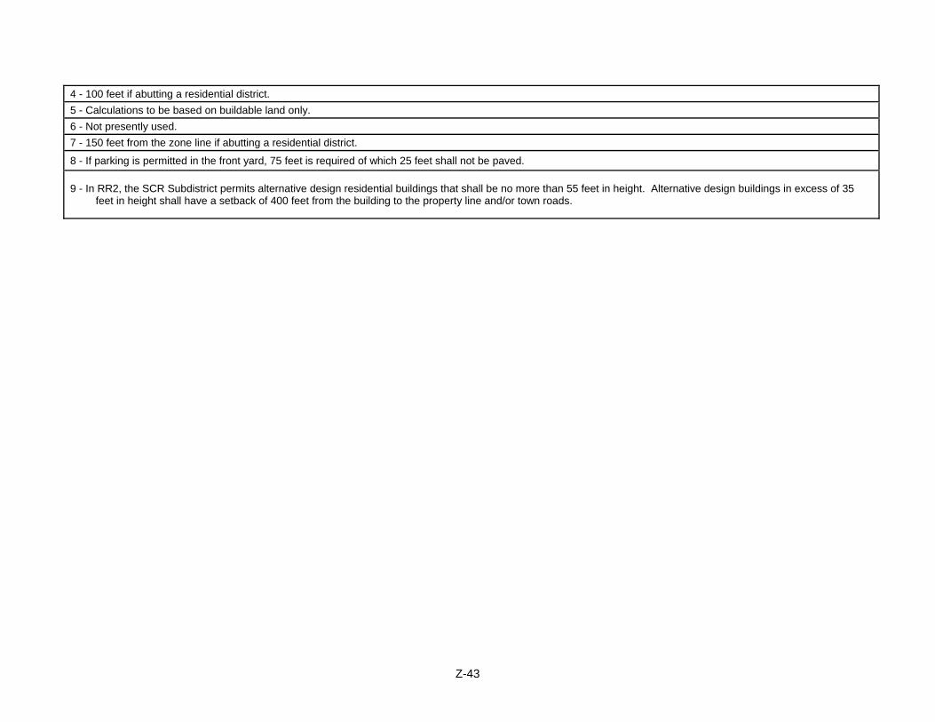
Z-43
4 - 100 feet if abutting a residential district. 5 - Calculations to be based on buildable land only. 6 - Not presently used. 7 - 150 feet from the zone line if abutting a residential district.
8 - If parking is permitted in the front yard, 75 feet is required of which 25 feet shall not be paved.
9 - In RR2, the SCR Subdistrict permits alternative design residential buildings that shall be no more than 55 feet in height. Alternative design buildings in excess of 35 feet in height shall have a setback of 400 feet from the building to the property line and/or town roads.
ARTICLE VI: RURAL CLUSTER RESIDENTIAL DEVELOPMENT Section 600 OVERVIEW AND PROVISIONS 600:1 Permitted Uses
a. Townhouse developments in a cluster concept with 2, 3 or 4 units per building are permitted in any district except the commercial, commercial professional and commercial-industrial district within the Town of Atkinson and may be exempt from the provisions of Lot and Yard Regulations Minimum Required, but subject to the conditions which follow.
b. Single Family residential cluster subdivisions that permit dwelling unites to be
grouped on lots or sites with dimensions, frontages and setbacks as defined in Section 600:8 b., and reduced from conventional requirements or on land under condominium ownership shall be permitted in any district except the commercial, commercial professional and commercial-industrial district within the Town of Atkinson and may be exempt from the provisions of Lot and Yard Regulations Minimum Required, but subject to the conditions which follow. (2001)
c. Rural Residential Recreational Cluster Development with the SCR Subdistrict,
as permitted in Section 620, which dimensions, height restrictions, and setbacks as provided therein, are subject to the conditions which follow, except where such provisions are in conflict with Section 620, in which cast those provisions of Section 620 shall prevail. (2006)
600:2 The purposes of rural cluster development and to which purposes any such
development must adhere, to the following:
a. To preserve the natural beauty of existing rural roads within the Town of Atkinson and to encourage less intensive residential development within areas not presently served by existing public water and sewer services.
b. To establish living areas within the Town that provide for a balance of
community needs, such as a diversity of housing opportunities, adequate recreation and open space areas, easy accessibility to those and other community facilities, and pedestrian and vehicular safety.
c. To provide for an efficient use of land, streets, and utility systems. d. To stimulate new approaches to land and community development.
600:3 Rural cluster development shall be permitted in any district in which conventional
residential development is permitted except in those areas where existing public and/or common water and sewer systems cannot provide adequate services to additional housing development. In such a case, rural cluster development shall be prohibited until such systems are improved, modified, or expanded to properly serve additional housing development.
Z-44
600:4 Manufactured housing may be permitted in a rural cluster development designed exclusively for such housing in any residential district, provided such housing meets all other requirements of this ordinance. Manufactured housing parks may be permitted in a rural cluster development in an RR-3 and TR-2 district provided such housing meets all other requirements of this ordinance.
600:5 The tract of single or consolidated ownership at the time of application shall be:
a. distant from the existing town road as follows:
1) Alternative Design Residential Buildings as permitted in the SCR Subdistrict under section 620 shall be four 400’ distant from the perimeter boundary and/or town roads. (2006)
2) the location of three and four Unit Townhouse structures shall be 300' distance from existing town roads.
3) single family detached and two family structures shall be 200' distance from existing town roads. (1993)
b. subject to approval by the Planning Board under the Planning Enabling
Legislation -- Regulation of Subdivision of Land -- whether or not land is to be subdivided.
600:6 The maximum number of dwellings permitted in any rural cluster development shall be
determined by utilizing the required density of land area per dwelling unit for that district. (1992)
a. In addition, each rural cluster development shall be entitled to one additional
dwelling unit for every 100 feet in depth added to the required landscaped buffer described in Section Z600:11 below. Such entitlement shall be based on a formula of 1 dwelling unit bonus/10 acre area. This does not apply to low-moderate developments.
b. For the purpose of this section the maximum buildable area to be used in
determining the maximum number of dwelling units permitted shall exclude all wetland soils, all lands with slopes greater than 25% and all proposed roads. (1993)
c. Cluster subdivisions which are specifically designed to preserve scenic vistas
and pronounced landscapes (as designated in the Towns Master Plan) by not disturbing them, shall be entitled to compute the number of allowed units utilizing soil based lot sizing as defined by Model Subdivision Regulations for Soil-Based Lot Size, Volume II, June 1991, as prepared by the Ad Hoc Committee for soil based lot size regulation. Preservation of said vistas and landscapes is to be accomplished by not allowing them to be built upon nor obstructed in view through protective or conservation easements. This does not apply to low-moderate developments, where the low-moderate incentive is utilized. (See Section 505:2) (1998)
Z-45
600:7 Development Density
a. Townhouse developments shall not exceed eight (8) dwelling units per any single acre within the area being developed, except for Alternative Design Residential Buildings in the SCR Subdistrict. (2006)
b. Single family cluster developments shall not exceed four (4) dwelling units per
any single acre within the area being developed. (2001)
600:8 Dimensional Requirements
a. Rural cluster development shall not be required to conform to the minimum frontage, setback, and lot sizes required in the zoning ordinance, but shall be so designed and constructed as to achieve the purposes of rural cluster development set forth in these regulations.
b. All dwellings within a single family residential cluster development shall conform to no less than the minimum dimensional requirements specified herein:
1) Lot Frontage 25' 2) Lot Depth 125' 3) Front Yard 30' 4) Rear Yard 50' 5) Side Yard 15'*
* if the sprinkler system requirement is waived for a subdivision, 25' side yards shall be required throughout the development. (2001)
c. Alternative Design Residential Buildings in excess of thirty-five (35’) feet in
height shall have a perimeter setback of 400’ to the property boundary line and/or town roads. (2006)
600:9 The following uses shall be permitted:
a. development of one-family structures on parcels of 10 acres or more; b. development of one- and/or two-family structures on parcels of 20 acres or
more; c. development of one-family, two-family, and/or three and four-unit town-house
dwellings on parcels of 30 acres or more; d. incidental private recreational uses. e. development of Rural Residential Recreational Cluster Developments on
parcels of 250 acres or more situated in the RR2-SCR District. (2006)
600:10 The development may be served by common water and septic systems, the design and construction of which must be approved by the state and local authorities.
Z-46
600:11 Buffers Requirements:
a. A multi-family townhouse cluster development shall have a one hundred (100) foot landscaped buffer around the entire parcel and along existing town roads to provide an adequate division of transition from abutting land uses and existing town roads.
b. Single family residential cluster shall be subject to the following landscaped buffer requirement: Fee simple lot ownership subdivision ..........50' Condominium ownership ...........................100'
The landscaped buffer shall extend around the perimeter of the entire parcel and along existing town roads to provide adequate transition between abutting land uses. Wherever possible, natural vegetation shall be retained. No construction, excepting primary access roads shall be permitted in the buffer. Septic systems, parking areas, and service roads shall be excluded from the landscaped buffer. No portion of the buffer area shall encroach onto any lot defined for construction of a dwelling within the single-family residential cluster development. (2001)
600:12 All parking within a rural cluster development shall be provided at a rate of not less
than two (2) spaces per single dwelling unit. 600:13 Emergency vehicle access shall be provided to all structures within the rural cluster
development. 600:14 At least fifty percent (50%) of the total area, exclusive of roads, public or private,
parking, and essential services, shall be set aside as common land covenanted to be maintained as "permanent open space." (1990)
600:15 Such common land shall be restricted to open space recreational uses such as tot lot,
park, swimming pool, tennis courts, playground, playfield, golf course, or conservation. 600:16 Such common land shall have suitable access to a road only within the development. 600:17 Open space, common areas, common facilities, private roadways, and other features
within the rural cluster development shall be protected by covenants running with the land and shall be conveyed by the property owners to a homeowners association so as to guarantee the following:
a. The continued use of land for the intended purposes. b. Continuity of proper maintenance for those portions of the development
requiring maintenance. c. The availability of funds required for such maintenance. Recovery for loss
sustained as a result of casualty, condemnation or otherwise.
Z-47
d. A homeowners association of tenancy-in-common or similar form of ownership, that the membership and obligation of the residents of the rural cluster development be automatic upon conveyance of title or lease to single dwelling units. Homeowners association, tenancy-in-common, or similar form of ownership shall include lien provisions and shall be subject to review and approval by the Planning Board.
e. The usage of all Open Space associated with a Cluster shall remain under the
direction and control of the Homeowners of that Cluster so that the homeowner’s access and usage of the land is protected. Said access and usage shall also be protected by the developer during the developer’s stewardship of the Open Space, until such time as it is transferred to the Homeowners Association. (2002)
600:18 The rural cluster development plan shall show the layout of all streets and roads.
a. All streets and roads shall be built to Town Subdivision requirements for new public roads whether or not they are offered to the Town for public acceptance.
b. Town road requirements may be modified by the Planning Board for roads
where deemed applicable. All roads shall be built as hard surface roads to standards approved by the Planning Board and the Road Agent and may remain in private ownership.
600:19 A site plan for the entire tract at a scale of 1"=100' and the developed portion at 1"-50'
shall be prepared by either a professional land planner, registered architect, registered professional engineer, or registered land surveyor. The site plan shall be submitted in accordance with the subdivision regulations for the Town of Atkinson, and the location of parks and open space shall be shown on the plan.
600:20 The review of any rural cluster development conducted by the Planning Board under
these regulations shall ascertain that adequate provisions have been made by the owner or his authorized agent for the following:
a. Traffic circulation and access including adequacy of adjacent streets, entrances
and exits, traffic flow, sight distances, curb cuts, turning lanes, and existing or recommended traffic signalization.
b. Pedestrian safety and access. c. Off-street parking and loading. d. Emergency vehicle access. e. Fire protection as it applies to the proximity of buildings to one another and to
the existence of firefighting water sources. f. Storm water drainage based upon a minimum of a ten (10) year storm
frequency, utilizing on-site absorption and/or positive outfall. g. Recreational facilities.
Z-48
h. Water supply and wastewater disposal approved by a civil or sanitary engineer registered in New Hampshire.
i. Environmental factors such as protection against pollution, noise, odor, and the
protection of natural features. j. Landscaping in keeping with the general character of the surrounding areas. k. Signing and exterior lighting. l. Submission of proposal along with abutting property owners' names and
addresses shall be in accordance with the Town of Atkinson Subdivision Regulations in order to provide for timely notification to abutters of public hearing to review said parcel.
m. In addition, the Planning Board shall review the plan to assure compliance with
the provisions of the standards set forth in these regulations and other town regulations and ordinances. The Planning Board shall also ascertain that the plan minimizes the encroachment of the rural cluster development upon neighborhood land uses.
600:21 A performance bond and other legal data shall be submitted as required by the
Planning Board to ensure the completion of streets, buffers, and amenities in accordance with the accepted plans and subdivision regulations of the Town of Atkinson as adopted or hereafter.
600:22 Amendments to an approved plan. The owner, his agent or his successors or assigns
will make no alterations or additions or deletions from the approved Rural Cluster Development Plan except as approved in advance by the Planning Board. All requests for changes to the approved plan shall be made in writing to the Board and shall be accompanied by such documents as the Planning Board shall deem necessary to explain the requested change. The Board shall determine if the requested change is minor or major in nature.
a. Minor changes. A minor change shall be one which respects the approved
plan's basic land allocations in terms of use and intensity, the type and variety of facilities and dwelling units being approved, and/or the timing for providing these facilities, but shall not include any increase in the overall density of the development. The Board may hold a public hearing on the proposed change with proper notification to all abutters, including those of the original proposed development as well as any additional ones which may have been created by development activity within the development itself. The Board shall then act to approve or disapprove with written notification to the owner of its action. Any approved changes involving changes in any lot boundaries shall be recorded as a subdivision change in the Registry of Deeds.
b. Major changes. Any requested change which the Board determines does not
qualify as a minor change shall be required to be submitted as a separate rural cluster development plan in accordance with these regulations and procedures.
Z-49
600:23 The Planning Board shall adopt such procedures as part of the subdivision regulations as it may deem necessary in order to insure sufficient public review of any cluster proposal and to insure compliance with these and other town ordinances and regulations. (1982)
Section 610 INCLUSIONARY HOUSING ACCOMMODATION INCENTIVE SYSTEM (3/10/2009) 610:1A Purpose Statement The purpose of this Article are as follows:
a. To encourage and provide for the development of affordable workforce housing;
b. To ensure the continued availability of a diverse supply of home ownership and
rental opportunities for low to moderate income households. c. To meet the goals related to affordable and workforce housing provisions set
forth in the town’s Master Plan; and d. To comply with the requirements of SB 342, An Act establishing a mechanism
for expediting relief from municipal actions which deny, impede, or delay qualified proposals for workforce housing (RSA 674:58-61).
In the course of implementing this ordinance, the Town of Atkinson has considered the region’s affordable housing needs as described in the Rockingham Planning Commission’s Housing Needs Assessment and the Rockingham Planning Commission’s Regional Fair Share Analysis. 610:1B Authority
This innovative land use control Article is adopted under the authority of RSA 674:21, and is intended as an “Inclusionary Zoning” provision as defined in RSA 674:21(I)(k) and 674:21 (IV)(a) as well as RSA 672:1, III-3, effective July 2009, which states: “All citizens on the state benefit from a balanced supply of housing which is affordable to persons and families of low and moderate income. Establishment of housing which is decent, safe, sanitary and affordable to low and moderate income persons and families is in the best interests of each community and the state of New Hampshire, and serves a vital public need. Opportunity for development of such housing shall not be prohibited or unreasonably discouraged by use of municipal planning and zoning powers or be unreasonable interpretation of such powers. 610:1C Definitions A. Affordable: Affordable means housing with combined rental and utility costs or
combined mortgage loan debt services, property taxes, and required insurance that do not exceed 30 percent of a household’s gross annual income.
Z-50
B. Multi-family housing: Multi-family housing for the purpose of workforce housing developments, means a building or structure containing 5 or more dwelling units, each designed for occupancy by an individual household. (Adopted 2009)
C. Reasonable and realistic opportunities for the development of workforce
housing: opportunities to develop economically viable workforce housing within the framework of a municipality’s ordinance and regulations adopted pursuant to this chapter and consistent with RSA 674:I, III-e.
D. Workforce housing/owner occupied: housing which is intended for sale and which
is affordable to a household with an income of no more than 100 percent of the median income for a 4-person household for the metropolitan area or county in which the housing is located as published annually by the United Stated Department of Housing and Urban Development.
E. Workforce housing/renter occupied: rental housing which is affordable to a
household with an income of no more than 60 percent of the median income for a 3-person household for the metropolitan area or county in which the housing is located as published annually by the United Stated Department of Housing and Urban Development. Housing developments that exclude minor children from more than 20 percent of the units, or in which more than 50 percent of the dwelling units have fewer than two bedrooms, shall not constitute workforce housing for the purposes of this subdivision.
F. Area Median Income (AMI): the medial income of the greater region, either the HUD
Metropolitan or Non-Metropolitan Fair Market Rent Area to which the community belongs, as is established and updated annually by the United Stated Department of Housing and Urban Development. Income considers both wage income and assets.
G. Market Rate Housing: any units within a development, whether the unit is to be
owner or renter occupied, that is intended to be available for sale or occupancy at the prevailing market value for the area similar to comparable real estate transaction.
610:2A Qualification for Higher Density A proposed development must meet the following pre-requisites in order to apply for incentive provisions of Section 610:3.
a. At least 20 percent of the total dwelling units within the parcel must be dedicated to low-moderate income dwellings;
b. The development must be eligible for review as a Rural Cluster Residential
Development as provided in Article VI, Section 600; and c. The development may include single family, duplex, or multi-family units with
up to eight units per building.
Z-51

610:2B Appeal Any person aggrieved by a Planning Board decision that constitutes a denial of a Conditional Use Permit due to noncompliance with one or more of the provisions of this ordinance may appeal that decision to the Superior Court, as provided for in RSA 677:15. A Planning Board decision on the issuance of a Conditional Use Permit cannot be appealed to the Zoning Board of Adjustment (RSA 676:5 III). 610:2C Procedural Requirements/Applicant
a. Notice of Intent to Build Workforce Housing. Any person who applies to the Planning Board for approval of a development that is intended to qualify as workforce housing under this subdivision shall file a written statement of such intent as part of the application.
b. Waiver. Failure to file such a statement shall constitute a waiver of the
applicant’s rights under RSA 674:61 (the builder’s remedy) but shall not preclude an appeal under other applicable laws.
c. In any appeal where the applicant has failed to file the statement required by
this section, the applicant shall not be entitled to a judgment by a court on appeal that allows construction of the proposed development, or otherwise permits the proposed workforce housing development to proceed despite its nonconformance with the municipality’s ordinance or regulations.
610:2D Procedural Requirements/Planning Board and Applicant
a. Notice of conditions. If the Planning Board approves an application to develop workforce housing subject to conditions or restrictions, it shall:
1) Notify the applicant in writing of such conditions and restrictions; and 2) Give the applicant an opportunity to establish the cost of complying with
the conditions and restrictions and the effect of compliance on the economic viability of the proposed development.
The Board’s notice to the applicant of the conditions and restrictions shall constitute a conditional approval solely for the purpose of complying with the requirements of RSA 676:4 I (i). It shall not constitute a final decision for any other purpose, including the commencement of any applicable appeal period. b. Submission of evidence to establish cost of complying with conditions.
Upon receiving notice of conditions and restrictions as described above, the applicant may submit evidence to establish the cost of complying with the conditions and restrictions and the effect on economic viability within the period directed by the board, which shall not be less than 30 days.
Z-52
c. Review of evidence.
1) Upon receipt of such evidence, the Board shall allow the applicant to review the evidence at the Board’s next meeting for which 10 days notice can be given, and shall give written notice of the meeting to the applicant at least 10 days in advance. At such meeting, the board may also review and consider evidence from other sources.
2) The Board may affirm, alter, or rescind any or all of the conditions or restrictions of approval after such meeting.
d. Final Decision.
1) The Board shall not issue its final decision on the application before such meeting, in C.2 above, unless the applicant fails to submit the required evidence within the period designated by the board, in which case it may issue its final decision any time after the expiration of the period.
2) If an applicant notifies the board in writing at any time that the applicant accepts the conditions and restrictions of approval, the board may issue its final decision without further action under this paragraph.
e. Appeals. Any person who has failed the written notice and whose application
to develop workforce housing is denied or is approved with conditions or restriction which have a substantial adverse effect of the viability of the proposed workforce housing development may appeal the municipal action to the Superior Court under RSA 677:4 or RSA 677:15 seeking permission to develop the proposed workforce housing.
610:3 Incentive System
a. The maximum number of living units permitted shall be determined by the Model Subdivision Regulations Incorporating Soil-based Lot Size Determination; as recorded in Model Subdivision Regulations Incorporating Soil-based Lot Size Determination, Volume II, June 1991, prepared by Ad Hoc Committee for Soil-based Lot Size Regulations for the N.H. Department of Environmental Services and Homebuilders Association of N.H., based on Environmental planning for on-site wastewater treatment in New Hampshire, Technical Report, Volume I, June 1991, and amendments if adopted after one public hearing.
b. Developments qualifying for consideration under Section 610:2 shall be
granted the following modifications in design specifications:
1) The requirement under 600:5-a (2) of 300 feet distance from town road for 3 to 8 townhouse structures shall be reduced to 200 feet.
2) The parcel size of 20 and 30 acres for multi-family structures (section 600:9) shall be reduced to 10 acres.
3) The requirement of 50% common land (Section 600:14) shall be reduced to 40% covenanted common land to be maintained as permanent open space (2001).
4) Each building may contain up to eight units.
Z-53
610:4 Structural Standards
a. Units designed and designed for the accommodation of workforce housing families shall meet the use provisions of the underlying zoning district.
b. Manufactured housing and multi-family dwellings are an acceptable structure
for workforce housing accommodation provided the units meet local, state, and federal codes and regulations.
c. Units designated for use by workforce housing families shall be designed to be
suitable for family needs. Design considerations shall include the floor area of rooms, the relationship and number of room types, sanitary facilities, cooking facilities, siting of structures and outdoor uses, as well as access and building code provisions.
d. A determination of the number of bedrooms in workforce housing structures
shall be reviewed by the Planning Board prior to approval of the development. In order to assure reasonable family accommodation, the following breakdown of workforce housing units shall be adhered to:
Bedrooms/Unit % of TotalOne bedroom/unit 25% or less Two or three bedrooms/units 65% or more Four or more bedrooms/units 10% or less The breakdown above may be varied only by requirements of a housing assistance program.
610:5 Applicable Provisions. All developments qualifying for review as workforce housing
must meet the provisions of the latest adopted local regulations and ordinances except as they are amended by Section 610 et. seq. inclusive.
610:6 General Requirements of Workforce Housing Units
a. Architectural compatibility. The dwellings qualifying as workforce housing shall be compatible in architectural style and exterior appearance with the market rate dwellings of similar size and type. The workforce housing units must be interspersed with market rate units of the same type.
b. Phasing. The phasing plan for the development shall provide for the
development of workforce housing units concurrently with the market-rate units.
610:7 Affordability
a. Certification of Income Levels.
1) To ensure that only eligible households purchase/rent the designated affordable housing units, the purchaser/renter of a workforce housing unit must submit copies of their last three years federal income tax
Z-54
returns and written certification, verifying that their annual income level, combined with household assets, does not exceed the maximum level as established by this ordinance.
2) The tax returns and written certification of income and assets must be submitted to the developer of the housing units, or the developer’s agent, prior to the transfer of title.
3) A copy of the tax return and written certification of income and assets must be submitted to all parties charged with administering and monitoring this ordinance, within 30 days following the transfer of title.
b. Assurance of continued affordability.
1) Workforce housing units offered for sale shall require a lien, granted to
the Town of Atkinson be placed on each workforce housing unit. 2) The value of the lien shall be equal to the difference between the fair
market value of the unit and its reduced affordable sale price, which is indexed according to the qualifying income standards.
3) The municipality’s lien is inflated over time at a rate equal to the Consumer Price Index (CPI).
4) Future maximum resale values shall be calculated as the fair market value minus the CPI adjusted lien value.
5) Subsequent sales are not limited based on income targets, but the combination of maintenance of the municipality’s lien and adherence to this Article’s definitions of affordable housing for a period of 30 years.
NOTE: The provisions above are established to be consistent with NHHFA’s Value Retention Model, which is required if the community wishes to have NHHFA administer their inclusionary housing ordinance. Alternate mechanisms of continued affordability could be utilized.
a. Workforce housing rental units shall limit annual rent increases to the
percentage increase in the are median income, except to the extent that further increases are made necessary by hardship or other unusual conditions.
b. Documentation of restrictions. Deed restrictions, restrictive covenants, or
contractual arrangements related to dwelling units established under this Article must be documented on all plans filed with the town’s Planning Board and with the Registry of Deeds.
610:8 Administration, Compliance and Monitoring
a. This Article shall be administered by the Planning Board. b. Certificate of Occupancy. No certificate of occupancy shall be issued for a
workforce housing unit without written confirmation of the income eligibility of the tenant or buyer of the workforce housing unit and confirmation of the rent or price of the workforce housing unit as documented by an executed lease or purchase and sale agreement.
Z-55
c. Ongoing responsibility for monitoring the compliance with resale and rental restrictions on workforce housing units shall be the responsibility of the New Hampshire Housing Finance Authority.
d. Annual report. The owner of a project containing workforce housing units for
rent shall prepare an annual report certifying that the gross rents of affordable units and the household income of tenants of workforce housing units have been maintained in accordance with this Article. Such reports shall be submitted to the New Hampshire Housing Finance Authority or their designee and shall list the contract rent and occupant household incomes of all workforce housing units for the calendar year.
610:9 Relationship to other ordinances and regulations. No portion of this ordinance
shall nullify the provisions of any other town ordinance provisions which relate to environmental protection, water supply, sanitary disposal traffic safety, and fire and life safety protection. Where workforce housing applicants propose a development of single family homes or mixed single family and multi-family homes, all provisions of the subdivision and site plan regulations shall apply unless waived by the Planning Board. Where workforce housing applicants propose a development of multi-family units or mixed commercial and multi-family units, the site plan regulations shall apply unless waived by the Planning Board.
610:10 Conflict. If any provision of this ordinance is in conflict with the provisions of other
ordinances, the more restrictive provision shall apply, except for any provision relating to lot size, setbacks, or density, in which case the provisions of this ordinance shall apply.
Section 620 GOLF AND SPORTS COMPLEX /RESIDENTIAL SUB-DISTRICT ("SCR
Subdistrict") (2006)
a. Within the existing RR-2 District in the southwestern corner of the Town there is created a Subdistrict known as a Sports Complex/Residential Sub-district (SRC).
Except as otherwise provided herein, all other restrictions and requirements applicable to the RR-2 District shall apply to all uses and structures within the SCR Subdistrict.
b. Except as to "RRRCD Developments" (defined below), all land lying within the SCR Subdistrict shall continue to have all of the benefits and to be subject all of the restrictions of and for the RR-2 District.
c. The SCR Subdistrict is composed of all the land bounded as follows:
Beginning on the southwest side of North Broadway at the Haverhill, Massachusetts State Line; thence running
1) Northwesterly by the southerly line of North Broadway and Providence
Hill Road to a point one hundred and twenty-five (125) feet easterly of the Salem Town Line; thence
2) Southwesterly by a line one hundred and twenty-five (125) feet easterly of the Salem Town Line to the easterly line of Shannon Road; thence
Z-56
3) Southerly by the easterly side of Shannon Road to a point one hundred and twenty-five (125) feet northerly of the Salem Town Line; thence
4) Easterly southerly and easterly again, by a line one hundred and twenty-five (125) feet northerly, and easterly of the Salem Town Line; and the Haverhill, Massachusetts State Line, to the southwestern side of Jericho Road; thence
5) Southeasterly by the southwestern side of Jericho Road to the Haverhill, Massachusetts State Line; thence
6) Easterly by the Haverhill, Massachusetts State Line to the point of beginning.
620:1 Recreational/sports amenities and other public and common facilities that cannot
otherwise be provided under conventional land development procedures and together with limited non-residential uses to support the same and the neighborhood shall be permitted in rural residential cluster developments located within the SCR Subdistrict. Such developments are hereinafter referred to as "Rural Residential and Recreational Cluster Developments" (RRRCD) and are subject to the following.
a. such developments must contain a minimum of 250 acres, b. such development are included as part of a rural residential cluster
development application, and c. such developments also meet the requirements contained in this Ordinance.
620:2 Tracts for non-residential use within a RRRCD, shall be delineated and legally
described by metes and bounds and shall be shown on a site plan to be recorded in the Rockingham County Registry of deeds upon approval by the Planning Board.
620:3 Non-residential uses within the RRRCD shall be limited to the following privately ow-
ned or publicly owned uses designed to serve the community at large with the following amenities:
a. Sports facilities such as golf courses, health clubs and recreational and related
facilities, (including a “Country club” banquet facility for not more than 650 people) but specifically excluding activities designed as spectator sports; the area of a RRRCD occupied by an outdoor sports facility, such as a golf course, may be used to fulfill certain minimum open space requirements of this ordinance.
b. Food service facilities; c. Bank (branch); d. One neighborhood convenience store (2,000 sq. ft. total area); e. Professional buildings; f. Small retail shops not exceeding 6,000 sq. ft. in total area. g. Such non-residential accessory uses as may be permitted by this Ordinance.
Z-57
620:4 Open Space
a. All designated open space areas which are submitted by the applicant as part of, or in conjunction with, a RRRCD development shall be included in calculations for meeting the requirements for open space, buffers, and dwelling unit density as specified in Section Z600.
b. Non-residential tracts within the RRRCD shall be exempted from the
requirements of Sections Z600:17 unless such tracts are transferred by legal title to parties described in Section 620:8a (1) and (2) below.
620:5 Within the SCR Subdistrict, and within a RRRCD whose occupancy is limited by
covenants to elderly, as defined hereinbelow, multi-family Alternative Design Residential Buildings, as defined below, shall be permitted subject to the following:
a. No such Alternative Design Residential Buildings shall exceed fifty-five (55)
feet in height as calculated under Sections 501 and 503 of the International Building Code.
b. Any Alternative Design Residential Buildings that exceed thirty-five (35) feet in height or that exceed four units per building shall be set back a minimum of four hundred (400) feet from the abutting property line and/or town roads.
c. The term “Alternative Design Residential Buildings” means any residential housing structures which meet a zoning district’s density and use requirements, but which do not necessarily meet requirements for size, height, minimum yard, or number of units per structure contained elsewhere in this Ordinance.
620:6
a. “Elderly” shall mean appropriately covenanted dwelling units which legally restrict, under the provisions of the Federal Fair Housing Act, and this ordinance occupancy to residents all of whom are fifty-five (55) years of age or older. To ensure the occupancy of elderly dwelling units by the elderly, the following covenants will be recorded on each Deed to a dwelling unit:”
- This covenant shall be enforced by the Homeowner’s Association and may be
enforced by the Selectmen of the Town of Atkinson; - This covenant shall run with the title to the dwelling unit and be binding on all
successors-in-interest; and - This dwelling unit has been approved by the Atkinson Planning Board, on the
basis that it shall be occupied as the residence for and by persons all of whom are fifty-five (55) years of age or older and as such, it shall be so occupied.
b. To this end, dwelling units shall only be sold to buyers who execute an affidavit
that:
1) The dwelling unit is to be occupied as the residence of persons all of whom are fifty-five (55) years or older;
Z-58
2) Such buyers will not acquire the dwelling unit for purposes of or with the intent to resell or lease such dwelling unit so that the dwelling unit will be occupied by persons under the age of fifty-five (55) years, and;
3) All occupants are or will be at the time of closing, fifty-five (55) years of age or older.
c. This covenant shall run for the benefit of the Town of Atkinson, a municipal
corporation, situated in the State of New Hampshire, and may be enforced by the Selectmen of the Town of Atkinson and further shall be enforced by the Homeowner’s Association.
620:7 Residential Density
a. Residential dwelling unit density shall conform to the requirements of the RR-2 District. However, in order to provide for private, non-subsidized elderly housing alternatives, and where public or community water systems, and municipal, public or community sewage treatment plants and services are available, the residential density within a RRRCD shall be calculated on the basis of four (4) bedrooms per one (1) acre lot.
b. Any Alternative Design Residential Building that is greater than four (4) dwelling units per building and which contains one (1) bedroom dwelling units shall have those one (1) bedroom dwelling units counted as if they were two (2) bedroom dwelling units for purposes of calculating the residential density.
c. Such Alternative Design Residential Buildings shall be allowed to exceed four (4) units per building, but no exceed more than forty (40) units per building.
620:8 All open space, outdoor recreational areas, including golf courses, and enclosed
recreational and sports facilities which are part of a RRRCD shall be held by the owners of the RRRCD and shall be subject to the following conditions:
a. All open space areas shall be held by the developer unless and/or until
ownership and obligatory management of a designated tract, or any defined increment of it, is transferred by legal title and held by one or more of the following entities:
1) In common, by all property owners within the tract, or portion of it to
tenancy-in-common requirements set forth in Section Z600:17 of this Ordinance.
2) In common, by all lot or unit owners which comprise the RRRCD in accordance with Section Z600:17 of this Ordinance.
3) By a non-profit organization whose members undertake the cost of maintaining or operating the outdoor recreational area or enclosed facility.
4) By a privately-held or publicly-held organization whose performance is guaranteed by recorded covenants running with the land to ensure operation and maintenance of the outdoor recreational areas and indoor facilities in accordance with the site plan. Such recorded covenants shall be enforceable by the Town of Atkinson.
Z-59
b. Land designated as non-residential open space and/or non-residential outdoor recreational area shall meet the following requirements:
1) It shall be covenanted in perpetuity as open space. 2) It shall be held by the owner(s) or successors in interest of the
enterprise(s) for which said land use is used. 3) It shall be permanently maintained for purposes of public or private
recreation, conservation, park or public easements, water and sewerage systems and/or agriculture.
4) It shall be integrated with the residential segment(s) of the RRRCD although residential units or lots need not front directly on such land.
c. All agreements, deed restrictions, and methods of management of the land
shall be approved by the Planning Board to ensure their compliance with the requirements of this Section.
620:9 Site requirements shall include, but not be limited to the following:
a. In order to limit the impact of the non-residential facilities within a RRRCD, no more than seven percent (7%) of the RRRCD shall be allotted to the siting of the non-residential buildings, and no more than twenty-five percent (25%) of said seven percent (7%) shall be occupied by the foundation footprints of the non-residential buildings themselves.
b. Non-residential buildings shall be architecturally compatible with residential
structures within the RRRCD. c. Non-residential uses shall have access from an interior road in the
developments, shall be separated from residential areas by adequate visual screening and landscaping buffers, and shall be set back as follows:
1) Front: No structure or parking area shall be closer than 30 feet from an
internal roadway. 2) Side and rear: No structure or parking area shall be closer than one
hundred (100) feet from residential structures.
d. Each non-residential use may have a maximum of one indirectly lighted sign not to exceed a sixteen (16) square-foot area. No sign shall be so illuminated as to cause a disturbance to neighboring residential units.
620:10 Approval for each non-residential use shall run with the use initially permitted. Any
changes in such use shall require Site Plan Review by the Planning Board for that building or use proposed to be change.
620:11 Except as otherwise provided herein, and except to the extend such would be in
conflict with the provisions of this Section 620, residential and non-residential uses shall be subject to all other applicable sections of this Ordinance as well as to all subdivision regulations, site plan development regulations, and other regulations and ordinances of the Town.
Z-60

Section 630 PLANNED RESIDENTIAL AND RECREATIONAL DEVELOPMENT (Deleted 4/97)
Z-61
ARTICLE VII: NONCONFORMING USES Section 700 NONCONFORMING USES 700:1 Any nonconforming use, as that term is defined in Article III, may be continued in its
present form except as provided herein:
a. No extension, expansion, enlargement, or alteration of a nonconforming use will be allowed without the granting of a Special Exception by the Board of Adjustment. This Special Exception shall be issued in the form of a special permit which shall expire within one (1) year unless acted upon by the permittee.
b. A nonconforming use of a building or premises which has been abandoned
shall not thereafter be returned to such nonconforming use. When any nonconforming use of a structure is abandoned for a period in excess of one year, the structure shall not thereafter be used except in conformance with the regulations of the district in which it is located.
c. A nonconforming use may not be changed subsequently to another non-
conforming use of the same premises. d. Nothing in this ordinance shall prevent the reconstruction, repairing, rebuilding,
and continued use of any nonconforming building or structure damaged by fire, collapse, explosion, or Acts of God, subsequent to the date of the ordinance, provided that the restoration activity commences within two (2) years of the damaged incident. Such restoration will not require a variance. (3/10/2009)
e. A Special Exception shall be granted by the Board of Adjustment provided the
following conditions are met for the non-conforming use:
1) There is no diminution of the value of surrounding properties. 2) It would be of benefit to the public interest. 3) It would result in substantial justice being done. 4) It would comply with Sections WS300 of the Atkinson Water Supply and
Sewage Disposal Regulations
f. OTHER NON-CONFORMING USES. Business uses, which have existed for at least 20 years under continuous common ownership shall be granted a Special Exception from the Zoning Board of Adjustment once the following procedures are met: The Applicant shall submit a sworn affidavit attesting and confirming that:
1) The applicant has owned and operated the business for at least 20
continuous years. 2) The uses of the property during that 20 year period were open and
discoverable.
Z-62
Once the special exception is granted, the applicant shall submit a present site plan depicting the present physical aspects of the property. This will be used as a guideline for any future changes, which must be approved by the Zoning Board of Adjustment. Also, the business must then comply with current annual town inspections. (2001)
700:2 A change in the status of a dwelling from a seasonal, recreational, or secondary home
to a home which is intended to be used as a primary or year-round dwelling shall be considered a change in the use of the existing building according to the building code of the Town of Atkinson and shall require upgrading to state and local water supply and sewage disposal regulations in effect at the time of such change in status. Before any permits for structural alteration or change in use are issued by the Building Inspector and the Health Officer, a special exception from the Board of Adjustment shall be obtained, the granting of which shall include, but not be limited to, compliance with the following requirements:
a. A review by the Health Officer. b. Compliance with Sections WS300 of Atkinson's Water Supply and Sewage
Disposal Regulations. c. Written consent by the New Hampshire Water Supply and Pollution Control
Commission (NHWSPCC).
700:3 Automobile and vehicle repair and or sales are not a home business within the intent of this ordinance and such businesses are to take place only in the commercial and commercial-industrial districts of the town. Existing non-conforming businesses of this type shall not be enlarged or expanded. Nothing in this article shall be construed as preventing a homeowner/resident from repairing his own vehicle on his own property or occasional sale of the homeowner's/residents private vehicle.
700:4 Any owner or resident of a home damaged due to fire, flood, or acts of God may place
a manufactured or mobile home or trailer on his/her property during a rebuilding of such residence. A two-year occupancy permit for residency in the temporary home or trailer is required and shall be issued by the Building Inspector after all utility connections are determined to be in compliance with electrical and sanitary codes. (1987 and 3/10/2009)
700:5 The Board of Selectmen may issue a six-month occupancy permit for residency in a
manufactured or mobile home or trailer on property where a new residence is under construction. Such permit shall be subject to renewal for a further six-month period provided there is substantial progress shown in the construction of the residence. (1987)
Z-63
ARTICLE VIII: WIRELESS COMMUNICATIONS FACILITIES (Adopted 2000)
800:1 Purpose
The purpose of this Article is to establish regulations for the siting of Wireless Communications Facilities (WCF), within the Town of Atkinson, while balancing the interest of Residents, Telecommunication Providers and their Customers, and ensuring coordinated development that minimizes adverse impacts.
800:2 Applicability
a. The terms of this article shall apply to WCF proposed to be located on Town property, on privately owner property, and on property owned by any other governmental entity.
b. WCF shall not be considered essential services, infrastructure, non-public
utilities as defined or used elsewhere in the Town’s ordinance and regulations. Siting for WCF is a use of land, and as such is subject to the Town’s zoning ordinance and other applicable regulation.
c. This Article shall not govern any tower or installation of any antenna that is
owned and operated by a federally licensed amateur radio operator when the tower or antenna is used for the exclusive purpose of amateur radio operations.
800:3 District Regulations and Siting Standards
a. All new WCF installations shall be subject to Planning Board Site Plan
Approval. Applications for collocation of antenna on existing facilities shall be expedited unless there is additional impact on the site. All WCF installations will require a Building Permit.
b. Antennas or towers located on property owned, leased, or otherwise controlled
by the Town are exempt from the siting requirements of Article VIII, Section 800:3 c through i, provided the facility will be at least partially available for public purpose. Such Town property must be at least 350 feet above sea level. (2007)
c. WCF which utilize towers, are a permitted use in the Industrial Zone. d. WCF which utilize Alternative Facilities and Technologies may be permitted in
all Zones. e. Collocation is encouraged. f. Height, tower facilities: must be less than 200 feet above the average existing
ground level adjoining the structure. g. Height, alternative facilities: May be permitted to increase the height of existing
structures no more than 20 feet. This increase shall only be permitted once for each structure.
Z-64
h. Setbacks, Tower facilities: All towers shall comply with the building setback provisions of the zoning district where located.
i. Fall Zone, Tower Facilities: The minimum distance from the base of a tower to
any property line, roadway, dwelling, business, institution, recreation area, parking area or other public area shall be at a minimum, the distance equal to the height of the facility.
j. All towers shall be self-supporting types. (2007)
k. To ensure the structural integrity of towers and antennas, the owner of a tower shall ensure that it is constructed and maintained in compliance with standards contained in local and state building codes. (2007)
l. When any WCF is proposed which may be visible from any other New Hampshire municipality within a 20 mile radius, there shall be a written notification of such application to all those municipalities. Notification shall be at the applicant’s expense as part of the abutter notification procedure of the application. (2007)
800:4 Lighting, Signage, Security
a. Lighting:
1) WCF shall be lighted only if the FAA requires for navigational purposes. 2) Lighting for equipment shelters shall be shielded from abutting
properties.
b. Signage: Signs shall be limited to those required for cautionary and advisory purposes. No logos, banners, flags or combinations of paint colors associated with corporate identification will be allowed.
c. Security: WCF Towers shall be surrounded by a security barrier.
800:5 Abandonment
Each commercial carrier who receives approval for a WCF shall post financial surety (bond, letter of credit, or case escrow account) to guarantee that the facility will be dismantled and removed, within 90 days of notice from the Town, when the facility is no longer being used (after 1 year of non use) for the wireless communications purpose for which is was originally permitted.
800:6 Severability
The invalidity of any subsection or provision of this Article shall not invalidate any other subsection or provision thereof.
Z-65
ARTICLE IX: ENFORCEMENT Section 900 ENFORCEMENT 900:1 It shall be the duty of the Board of Selectmen, and the Board is hereby given power
and authority, to enforce the provisions of this ordinance. (1959) 900:2 There shall be a Building Inspector who shall administer the provisions of this
ordinance and report violations to the Board of Selectmen. 900:3 The Board of Selectmen shall annually appoint a Building Inspector. In the event of
death, disability, resignation, or disqualification of the Building Inspector, the Selectmen shall appoint a Building Inspector to serve in his place. The Board of Selectmen may, for cause and majority vote, disqualify the Building Inspector at any time.
900:4 The Building Inspector shall issue any and all permits requested when such a permit is
in accordance with the provisions of this ordinance. Application for a permit shall be made on forms provided by the Building Inspector. (1959)
900:5 After passage of this ordinance, it shall be unlawful to erect any building or alter the
bulk of any building or relocate any building or change the use of any land or building without first obtaining a permit from the Building Inspector. (1959)
900:6 Deleted (1991) 900:7 Exteriors of a building shall be completed within two (2) years from the date of issue of
the foundation permit, regardless of yearly renewal. (1999) 900:8 In case any building or structure or part thereof is or is proposed to be erected,
constructed, altered, or reconstructed, or any land is or is proposed to be used in violation of this ordinance, the Building Inspector or Town Counsel, or the owner of any adjacent or neighboring property who would be specially damaged by such violation, may, in addition to other remedies provided by law, institute injunction, mandamus, abatement, or any other appropriate action or proceeding to prevent or enjoin or abate or remove such unlawful erection, construction, alteration, or reconstruction. (1984)
Z-66
ARTICLE X: BOARD OF ADJUSTMENT Section 1000 BOARD OF ADJUSTMENT 1000:1 Within thirty (30) days after the adoption of this ordinance and thereafter as terms
expire or vacancies occur, the Board of Selectmen shall make appointments to a Board of Adjustment of five members conforming in duties to the provisions of Chapters 673 and 674 of the New Hampshire Revised Statutes Annotated. Thereafter as terms expire or vacancies occur, the appointing authority shall be responsible for filling vacancies and maintaining full membership of the Board of Adjustment.
1000:2 The Board of Adjustment shall conform in membership and term of office to the
provisions of Chapter 673, New Hampshire Revised Statutes Annotated as amended, 1984.
1000:3 In addition to the general powers granted said Board by Chapter 673, it may, in
harmony with and subject to its provisions:
a. Permit in a Commercial district manufacturing which is incidental to a retail business where articles are sold at retail on the premises and where not more than five (5) operators are employed in such manufacturing. (1997)
ARTICLE XI: AMENDMENTS Section 1100 AMENDMENTS 1100:1 This ordinance may be amended pursuant to the Revised Statutes Annotated of the
State of New Hampshire as amended. (1981)
Z-67
ARTICLE XII: PENALTY Section 1200 PENALTIES AND REMEDIES 1200:1 Any violation of the zoning ordinance subdivision regulations, or site development plan
review regulations, shall be made punishable pursuant to RSA 676:17, as amended. (3/10/2009)
ARTICLE XIII: SAVING CLAUSE Section 1300 SAVING CLAUSE 1300:1 The invalidity of any provision of this ordinance shall not affect the validity of any other
provision. (1959)
ARTICLE XIV: EFFECTIVE DATE Section 1400 EFFECTIVE DATE 1400:1 This ordinance shall take effect upon its passage. (1959)
Z-68
ARTICLE XV: REPEAL OF PRIOR ORDINANCES Section 1500 REPEAL OF PRIOR ORDINANCES 1500:1 Any and all zoning ordinances heretofore enacted by the Town of Atkinson are hereby
repealed. 1500:2 Adopted October 20, 1959. 1500:3 Amended March 10, 1964; March 9, 1965; October 11, 1966; March 12, 1968; March
7, 1972; March 6, 1973; March 5, 1974; March 4, 1975; March 2, 1976; June 7, 1978; March 13, 1979; March 11, 1980; March 14, 1981; March 9, 1982; March 17, 1984; March 12, 1985; April 23, 1985; March 11, 1986; March 10, 1987; March 8, 1988; November 8, 1988; March 14, 1989; March 13, 1990; March 12, 1991; February 12, 1992; March 10, 1992; April 29, 1992; June 13, 1992; March 9, 1993; March 8, 1994; March 14, 1995; April 8, 1997; March 10, 1998; March 9, 1999; March 14, 2000, March 13, 2001, March 12, 2002, March 11, 2003, March 9, 2004, March 14, 2006, December 20, 2006, March 13, 2007, March 11, 2008, and March 10, 2009.
Z-69
ARTICLE XVI: PUBLIC SCHOOL IMPACT FEES (Adopted 3/10/98)
1600:1 Authority This Ordinance is established pursuant to NHRSA §674:21, I(m) as an innovative land use control. 1600:2 Purpose This Ordinance is intended to:
a. Provide adequate school system capacity to accommodate increasing public school enrollment generated by new residential development in the Town of Atkinson;
b. Assess an equitable proportion of growth-related capital facility costs of school
capacity to new residential development in proportion to the demands created by that development.
1600:3 Findings The voters of the Town of Atkinson have made the following findings:
a. This Ordinance is consistent with the Master Plan adopted by the Atkinson
Planning Board in 1990. b. This Ordinance is consistent with the Capital Improvements Program prepared
and adopted by the Atkinson Planning Board in 1990. c. The impact fee methodology and supporting study ("Methodology for the
Calculation of School Impact Fees in the Towns of the Timberlane Regional School District", dated September 22, 1997, prepared by Bruce C. Mayberry, Planning Consultant), hereafter referred to as "the methodology and supporting study" are reasonable, proportional, support this Article, and are consistent with NHRSA §674:21, V.;
d. Recent and projected growth rates necessitate an excessive expenditure of
public funds in order to maintain adequate facility standards and to promote and protect the public health, safety and welfare;
e. Each type of residential development described in the methodology and
supporting study will create a need for construction, equipping or expansion of public capital facilities of the District for education;
f. The imposition of public school impact fees is one of the methods of insuring
that public expenditures are not excessive and that new residential development supports a proportionate share of the cost of public capital facilities necessary to accommodate the development;
Z-70
g. The fees adopted are derived from and do not exceed the costs of:
1) Providing additional public capital facilities for education as necessitated by or benefitting the new residential development from which the fees were levied;
2) Compensating the Town of Atkinson for expenditures made for existing public education facilities that were constructed or financed in anticipation of future residential growth.
h. This Ordinance sets forth and is based upon a reasonable methodology and
analysis for determination of the impact of new residential development on the need for and costs of public capital educational facilities in the District and for Atkinson, and provides a rational nexus between the impacts of new residential development and the assessment of fees pursuant to this Ordinance;
i. The Timberlane School District provides an efficient and effective way for each
Town within the District to provide educational services for its citizens and that combining their resources in the District, pursuant to the intermunicipal agreement and the Ordinance, regardless of the location of a particular public educational facility, is a reasonable, efficient and effective way to provide public educational services to citizens of the District and is consistent with New Hampshire law and the Articles of Agreement of the Timberlane Regional School District as entered into (and amended) by the Town of Atkinson;
j. It is reasonable, equitable and consistent with the supporting methodology that
this Public School Impact Fee Ordinance apply to all unbuilt units in previously approved subdivisions;
k. Impact fees collected for recoupments meet the legal requirements for
collection, are supported by the methodology and supporting study, and the amount is reasonable.
1600:4 Definitions
a. Feepayer: The applicant named on the application for a building permit for any
activity which will result in new residential construction of any kind, or the alteration or conversion of any structure which results in a net increase of one or more residential dwelling units.
B. New Residential Development: Any activity which creates a net increase in
the number of residential dwelling units within the Town of Atkinson, whether through new construction or conversion of existing structures.
c. School Capital Facilities: Public educational facilities and equipment owned
by the Timberlane Regional School District.
Z-71
1600:5 Imposition of School Capital Facilities Impact Fee
a. Any applicant who, upon the adoption of this Ordinance, seeks a building permit for any activity which will create a net increase in residential dwelling units in the Town of Atkinson, is hereby required to pay a school impact fee in the manner and amount set forth in this Ordinance and the methodology and supporting study as referenced above.
b. An applicant may request from the Planning Board a partial or full waiver of
school impact fee payments in amounts equal to the value of land, facilities construction, or other contributions toward school capital facilities.
c. No building permit for new residential development requiring payment of a school impact fee shall be issued until the amount of the school impact fee has been determined by the Selectmen or their assigns.
d. An applicant undertaking the development of dwelling units for occupancy by
persons age 55 and over, and only where such occupancy shall be maintained through deed restrictions or through compliance with Federal Programs, may apply for a Waiver from the Planning Board to be exempted from School Impact Fees otherwise required by this article. Waiver Criteria to be met are: (2007)
1. Development shall not create an impact on education costs for the
School District. 2. Development shall have a Home Owners Association, with Bylaws and
Procedures to assure the over 55 status of all residents is maintained. 1600:6 Computation of School Impact Fee
a. The amount of the school impact fee shall be determined by the
Recommended Impact Fee Assessment Schedule contained in the Methodology for the Calculation of School Impact Fees in the Towns of the Timberlane Regional School District, September 22, 1997 (page 27) which is included by reference as part of this Ordinance.
b. The school impact fee methodology and supporting study including the
assessment schedule may be updated annually, subject to the adoption of such changes by the Planning Board. Such updates may provide for adjustments based upon the most recent data available from the U.S. Census, local school enrollment data, estimates of the number of housing units in Atkinson, property tax assessment data, interest and discount rates, and current construction cost information.
Z-72
c. In the case of residential units created by a change of use, redevelopment, or expansion or modification of an existing use, the school impact fee shall be based upon the net positive increase in the number of dwelling units resulting from the development.
1600:7 Payment of School Impact Fees No building permit shall be issued for new residential development until the feepayer has established an acceptable schedule for payment of such fee with the Town of Atkinson. No Certificate of Occupancy shall be issued for new residential development which is subject to a school impact fee assessment until such time as the fee is paid in full. 1600:8 Appeals
a. Disputes regarding the amount of the school impact fee may be submitted to the Planning Board, provided that an independent school impact fee calculation study for the new residential development is provided to the Board for consideration. The Planning Board shall review the submitted study and render its decision. Any and all costs incurred by the Town in the review of such a study shall be paid by the feepayer.
b. The decision of the Planning Board may be appealed to the Superior Court as
provided by NHRSA §677:15.
1600:9 Administration of Funds Collected
a. All school impact fees collected shall be properly identified and promptly transferred for deposit into a School Impact Fee Account. This account shall be considered a special revenue fund account, and under no circumstances shall school impact fee revenues or interest accrued thereto be transferred into the General Fund.
b. The Town Treasurer shall have custody of all school impact fee accounts, and
shall pay out the same only upon written orders of the Board of Selectmen. The Board of Selectmen shall annually order the release of school impact fee accounts to the Timberlane Regional School District, upon a demonstration by the District that programmed expenditures are eligible for reimbursement by school impact fees.
The Town Treasurer shall record and maintain the date, the person(s) making
payment, and the tax map and lot reference number of the property of all school impact fees which have been paid under this Ordinance for a period of no less than six years from the date of payment. At the end of each fiscal year, the Town Treasurer shall make a report to the Board of Selectmen and the Timberlane Regional School District, providing a detailed account of all school impact fee transactions made during the year.
Z-73
c. Funds withdrawn from the School Impact Fee Account shall be used solely for transfer to the Timberlane Regional School District for the purpose of funding the planning, design, construction, expansion, or equipping of public school facilities in the Timberlane Regional School District. Impact fees may be used to reimburse the Timberlane Regional School District for the value of public school capacity already constructed in anticipation of growth, or school capacity to be developed in the future to meet the growth demands. Impact fees may also be used by the Timberlane Regional School District to pay debt service on such bonds or similar debt instruments, to the extent that such expenditures are related to developing capacity within the Timberlane Regional School District.
1600:10 Refund of Fees
a. Feepayers may apply to the Board of Selectmen for a refund of the school impact fee, plus accrued interest, six (6) years from the date of collection of said fee. A refund will only be due if the Timberlane Regional School District has failed to appropriate said fee(s) on public school facility capacity improvements as defined herein.
b. The Board of Selectmen shall annually provide all feepayers of record who are due a refund of a school impact fee, a written notice of the amount due, including accrued interest.
1600:11 Scattered and Premature Development No provision of this Ordinance shall limit the authority of the Atkinson Planning Board to protect against development which is scattered and premature as provided in NHRSA §674:36 II; requires an excessive expenditure of public funds; or is otherwise contrary to the Town of Atkinson Zoning Ordinance, Subdivision Regulations, or Site Development Plan Regulations. 1600:12 Review of Fee Calculations The school impact fee assessment schedule contained in the Methodology for the Calculation of School Impact Fees in the Towns of the Timberlane School District, September 22, 1997, shall be reviewed by the Board of Selectmen and the Planning Board at least once every five years, and may be periodically amended after a public hearing of the Planning Board, although the schedule may be amended no more frequently than annually. ___________________________________
Z-74
REVISION HISTORY: 12/10/97 1500:3.A. 1990 added (date confirmed) 1500:3.B. 1990 added (date conformed) 1500:3.C. & 1500:6.A. & 1500:12. Amended date of document from 9/5/97 to 9/22/97. 1500:3.G. ......adopted are derived and from and.... deleted "and" 1500:5.C. Removed reference to Building Inspector. 1500:7*** Add the following bolded language to the end of the existing sentence as follows: ...as the fee is paid in full regardless of when the building permit was issued. 1500:10.A. Amended as follows: ORIGINAL LANGAUGE: A. Feepayers may apply to the Board of Selectmen for a refund of the school impact fee,
plus accrued interest, six (6) years from the date of collection of said fee. A refund will only be due if the Timberlane Regional School District has failed to appropriate the municipal share of the capital improvement costs required to provide school facility capacity improvements which are funded, in part, by school impact fees.
AMENDED LANGUAGE: A. Feepayers may apply to the Board of Selectmen for a refund of the school impact fee,
plus accrued interest, six (6) years from the date of collection of said fee. A refund will only be due if the Timberlane Regional School District has failed to appropriate said fee(s) on public school facility capacity improvements as defined herein.
12/18/97 1500:5.C. Added new section providing waivers for elderly housing. 12/23/97 A. Amend Section 1500:5.C. by adding "or through compliance with Federal Programs"; B. 1500:6.A. Delete "as amended" C. 1500:7 Delete "...regardless of when the building permit was issued." *** PRECAUTIONARY NOTE: The language as amended above (1500:7) was made at the request of the Atkinson Planning Board. The Rockingham Planning Commission has reservations regarding the legality of the proposed amended language, and strongly encourages review by Town Counsel prior to the Planning Board’s final vote on the Ordinance.
Z-75

GROWTH MANAGEMENT AND TIMING OF DEVELOPMENT ORDINANCE
ARTICLES I - II: SECTIONS GM110 - GM216
Section 128 Sunset Provisions 128:1 This ordinance shall terminate at the conclusion of Town Meeting in March, 1992,
unless appropriate action is taken to extend this ordinance.
This Ordinance was allowed to Sunset, March 10, 1992
GM-1

HISTORIC DISTRICT ORDINANCE
SECTION HD10 AND ARTICLES I - XI, SECTIONS HD100 - HD1100
SECTION DELETED March 9, 1993
HD-1
LAND SUBDIVISION CONTROL REGULATIONS SECTIONS SD100 - SD1200 Section 100 AUTHORITY 100:1 Pursuant to the authority vested in the Atkinson Planning Board by the voters of the
Town of Atkinson, NH, and in accordance with the provisions of Chapter 674:35 of the New Hampshire Revised Statutes Annotated, 1983, the Atkinson Planning Board adopts the following regulations governing the subdivision of land in the Town of Atkinson, New Hampshire.
Section 200 DEFINITIONS (in alphabetical order) B1 Board means the Planning Board of the Town of Atkinson, New Hampshire. C1 Community wastewater system A non-municipal wastewater collection, treatment and
disposal system that serves an average of at least twenty-five (25) individuals daily, year-round, or that has at least fifteen (15) service connections.
C3 Community water system A public water system which serves at least 15 service
connections used by year-round residents or regularly serves at least 25 year-round residents.
E1 Engineer means the duly designated engineer of the Town of Atkinson, or if there is no
such official, the planning consultant or official assigned by the Atkinson Planning Board. E2 Erosion The wearing away of the land surface by the action of wind, water or gravity. L1 Lake shore area Any area within one thousand feet (1000') of the average high water
level of a lake or pond; an area to be determined by extending a perpendicular line drawn in a horizontal direction from the average high water level of a lake or pond.
M1 Measure A specific procedure designed to control runoff, erosion or sediment. M2 Municipal wastewater system A wastewater collection, treatment and disposal
system that services an average of at least twenty-five (25) individuals daily year-round or that has at least fifteen (15) service connections and that is owned and operated by a municipal or regional government.
M3 Municipal water supply A water supply system that serves an average of at least
twenty-five (25) individuals daily year-round or that has at least fifteen (15) service connections and that is owned and operated by a municipal or regional government.
P1 Plat means the final map, drawing or chart on which the subdivider's plan of subdivision
is presented to the Atkinson Planning Board for approval and which, if approved, will be submitted to the Register of Deeds of Rockingham County for recording.
SD-1
R1 Runoff The portion of precipitation that makes its way overland toward stream channels or lakes.
S1 Sediment Solid material, both mineral and organic, that is in suspension, is being
transported, or has been moved from its site of origin by air, water or gravity as a product of erosion.
S2 Slope The steepness of the land surface. Slope is expressed in percent by dividing a
horizontal distance into the change in elevation that occurs within the distance. For the purpose of this regulation, the slope of a tract of land shall be determined by finding the average slope across each proposed lot, excluding wetlands, measured perpendicular to two foot contours. For lots with variable elevation, the composite average slope for each soil type, excluding wetlands, will be used to compute the minimum lot size.
S3 Soil scientist means the duly designated soil scientist of the Town of Atkinson or, if
there is no such official, the planning consultant or official approved by the Atkinson Planning Board.
S4 Soil type As defined by the National Cooperative Soil Survey. When a tract of land has
more than one soil type, all the soil types will be taken into consideration. S5 Soil Type determination The soil type as determined by a qualified soil scientist as
designated by the Rockingham County Conservation District using the standards of the National Cooperative Soil Survey.
S6 Street means and includes street, avenue, boulevard, road, alley, highway, and other
way exclusive of driveways serving not more than two adjacent lots. S7 Subdivision means the division of a lot, tract, or parcel of land into 2 or more lots, plats,
sites, or other divisions of land for the purpose, whether immediate or future, of sale, rent, lease, condominium conveyance or building development. It includes resubdivision and, when appropriate to the context, relates to the process of subdividing or to the land or territory subdivided. The division of a parcel of land held in common and subsequently divided into parts among the several owners shall be deemed a subdivision under these regulations.
W1 Wetlands The wetlands in Atkinson are those areas of the Town that contain fresh
water marshes, perennial and intermittent streams, and soils classified as poorly or very poorly drained. Such areas are to be defined by the National Cooperative Soil Survey conducted by the U. S. Department of Agriculture Soil Conservation Service and by the on-site soils investigation of a qualified soils scientist if such investigation is required by the Planning Board.
SD-2
Section 300 GENERAL REQUIREMENTS The subdivider shall observe the general requirements and principles of land subdivision which follow. Section 310 STREETS 310:1 The arrangement of streets in the subdivision shall provide for the continuation of the
principal streets in adjoining subdivisions or for their proper projection when adjoining property is not subdivided, and shall be of a width at least as great as that of such existing connecting streets.
310:2 All streets within the subdivision shall be built in accordance with the Town's Road
Specifications and Regulations (1990) Section 320 ADEQUACY OF LAND 320.1 Land of such character that it cannot be safely used for building purposes because of
exceptional danger to health or peril from fire, flood or other menace shall not be platted for residential occupancy, nor for such other uses as may increase danger to health, life or property or aggravate the flood hazard, until appropriate measures have been taken by the owner or his agent to lessen such hazards.
320:2 In areas not currently served by public sewer systems, it shall be the responsibility of
the subdivider or his agent to provide adequate information to prove that the area of each lot is adequate to permit the installation and operation of an individual sewage disposal system (septic tank and drain field). Such information shall consist of the report of the health officer regarding seepage and other tests he may require. The subdivider or his agent shall provide the required soil scientist, subsequent analyses, and all necessary equipment and labor for the making of those tests.
320:3 Subdivisions may be required to provide for recreational areas, open spaces, and
green spaces of adequate proportions, using New Hampshire state standards compiled by the Department of Resources and Economic Development and the Office of State Planning as minimum area guidelines.
320:4 In the case of industrial development, copies of state or federal permits for
pretreatment and discharge or subsurface disposal shall be required. Section 330 WATER SUPPLY FOR FIRE PROTECTION 330:1 Subdivision shall be reviewed by the Atkinson Fire Chief to determine the availability of
a water supply for fire protection under guidelines and standards set forth in the NFPA Pamphlet 1231 "Suburban and Rural Firefighting." The Chief's recommendations, in writing, will be considered by the Planning Board before final approval of the proposed subdivision plan. Any improvements required by the Planning Board shall be bonded.
SD-3
Section 340 EROSION CONTROL 340:1 No subdivision plan or site plan involving five (5) or more acres shall be granted
approval unless it includes plans for runoff, erosion and sediment control. 340:2 The developer shall bear the final responsibility for the design, installation and
construction of all required runoff, erosion and sediment control measures. 340:3 The developer shall control runoff, erosion and sediment during and after construction
through any measure(s) approved by the Rockingham County Conservation District and Atkinson Planning Board.
340:4 All runoff, erosion and sediment control measures shall meet the design standards and
specifications set forth in the current "Guide for Erosion and Sediment Control" as adopted by the Rockingham County Conservation District.
340:5 In no case shall a proposed development receive final approval until the site has been
inspected by the Planning Board or its authorized agent and until the Planning Board is assured that:
a. The proposed development will not cause any adverse offsite changes in
runoff. b. Measures will be taken to accommodate any increased runoff caused by
changed soil and surface conditions. c. Measures will be taken to minimize impermeable areas and provide for
adequate infiltration. d. Measures will be taken to control sediment and retain it within project areas. e. Whenever practical, natural vegetation will be retained, protected and
supplemented. The stripping of vegetation will be done in a manner that minimizes soil erosion.
f. The disturbed area will be kept to a minimum and be protected from erosion
during the winter months.
Section 350 PAVING /DRAINAGE /SIDEWALKS 350:1 Pavement and drainage facilities, curbs and sidewalks, when required, shall be
installed and constructed in accordance with the standard specifications of the Town of Atkinson, NH, and, in all cases, must be constructed under the supervision of the engineer.
SD-4
Section 360 PROHIBITIONS 360:1 Reserve strips of land which, in the opinion of the Planning Board, show an intent on
the part of the subdivider to control access to land dedicated or to be dedicated to public use shall not be permitted. (1960)
360:2 Subdivisions will not be allowed in cases where such scattered or premature subdivision
of land would involve danger or injury to health, safety, or prosperity by reason of the lack of water supply, drainage, transportation, schools, fire department, or other public services, or necessitate an excessive expenditure of public funds for the supply of such services.
360:3 Subdivisions on land acquired through “Eminent Domain” shall be restricted in use to
Local, State, or Federal governmental public sector uses, and only if said uses provide direct access and use to and by the public. Private or Public development of such land solely for financial gain or revenue enhancement, is prohibited. (2005)
Section 370 COMPLIANCE 370:1 The proposed subdivision shall conform to the Zoning Ordinance of the Town of
Atkinson, NH. Where strict conformity to the subdivision regulations would cause undue hardship or injustice to the owner of the land, a subdivision plan substantially in conformity with the regulations may be approved by the board provided that the spirit of the regulations and public convenience and welfare will not adversely be affected.
Section 380 BOND/SURETY 380:1 a. Before approval of a subdivision by the Planning Board, there shall be filed a
bond, cash, or sureties by the subdivider in an amount sufficient to cover the cost of the preparation of the streets and the construction of public or community water supply system improvements if proposed. This bond or sureties shall be approved as to form and surety by the legal Counsel of the Town of Atkinson, NH, and conditioned on the completion of such improvement and/or annual review of the bond's sufficiency. (2002)
b. The developer must provide and maintain appropriate escrow monies in an
amount determined by the Town Engineer for anticipated inspection and testing services to be rendered during execution of the work. (2006)
380:2 All bonds shall be made out in the name of:
Town of Atkinson: , Selectmen
If desired, a reference such as "Millpond Road Bond; John Doe, Owner" may be added. Three signatures are required for withdrawal, that of the Treasurer and two members of the Board of Selectmen, preferably one being the member serving Ex-Officio on the Planning Board. Signature cards should be presented with the bond. A set of withdrawal slips should be available in order to expedite the release of the bond.
SD-5
380:3 After receipt of conditional subdivision application approval from the Planning Board, an applicant may elect to commence work on construction of infrastructure related to said subdivision, in accordance with the conditionally approved plans and any conditions attached to said approval, but prior to final signature by the Board Chairman/Vice Chairman and recording of the subdivision plat at the Registry of Deeds, provided that: (1) all required State project permits necessary for the work have been issued and received by the Planning Board; (2) the full Performance Bond value has been determined and approved by the Town Engineer; (3) the Town of Atkinson has received a cash surety in an amount equal to ten-percent of the full value of the Performance Bond. Said cash surety will be held by the Town until such time as the full Performance Bond is accepted by the Town and/or all required project work is completed in accordance with the project plans. Said cash surety will serve as a guarantee that work completed prior to recording of the final plat will be done in a workman like manner and not become a threat to the public or adjoining landowners; and (4) the developer has provided appropriate escrow monies to compensate the Town Engineer for inspection and testing services rendered during execution of the work. In utilizing this option, the developer recognizes that no building permits will be issued until such time as all conditions of his approval have been fulfilled and the subdivision plat has been duly recorded at the Registry of Deeds. (1998)
380:4 No occupancy permits shall be granted for any structure accessed by any new street
within a subdivision until:
a. All utilities including water, storm drainage, electric and telephone have been installed and have been deemed fully operational by the appropriate authorities over the entire length of the frontage of the lot upon which such structure is located; and
b. All roadway construction has progressed to at least the point of installation of
the base course of hot bituminous pavement; and c. All on-site safety related improvements required by the Planning Board or
applicable State Agencies with competent jurisdiction must be completed to the Building Codes prior to issuance of certificates of occupancy. (2006)
Section 390 NATIONAL FLOOD INSURANCE PROGRAM (2008) For subdivisions and site plans that involve land designated as “Special Flood Hazard Areas” (SFHA) by the National Flood Insurance Program (NFIP): 390:1 The Planning Board shall review the proposed development to assure that all
necessary permits have been received from those governmental agencies from which approval is required by federal or state law, including Section 404 of the Federal Water Pollution Control Act Amendments of 1972, 33 U.S.C. 1334.
390:2 The Planning Board shall require that all proposals for development greater than 50
lots or 5 acres, whichever is the lesser, include Base Flood Elevation (BFE) data within such proposals (i.e., floodplain boundary and 100-year flood elevation).
SD-6
390:3 The Planning Board shall require the applicant to submit sufficient evidence (construction drawings, grading and land treatment plans) so as to allow a determination that:
a. all such proposals are consistent with the need to minimize flood damage; b. all public utilities and facilities, such as sewer, gas, electrical and water
systems are located and constructed to minimize or eliminate flood damage; and
c. adequate drainage is provided so as to reduce exposure to flood hazards.
Section 400 REGULATING SIZE OF LOTS IN A SUBDIVISION Section 410 PURPOSE
410:1 The Planning Board of the Town of Atkinson, NH hereby adopts these regulations in
accordance with the provisions of RSA 674:36-IIa in order to protect the Town against the danger to health, safety, and prosperity occasioned by the lack of municipal water and sewer and to prevent the excessive expenditure of public funds for the supply of such services.
Section 420 MINIMUM LOT SIZES 420:1 In addition to meeting the requirements of the zoning ordinance for the district wherein
the subdivision is located, each lot shall also be in conformance with Table 1 (page SD-13):
a. The table contains the required minimum lot sizes for specific soils for single-
family residences of not more than four bedrooms. b. Protection of water supplies (well water) from contamination by subsurface
wastewater disposal systems is factored into Table 1. c. In subdivisions where a community water supply system is to be provided,
minimum lot sizes may not be decreased by any factor on the minimum requirement as stated in Table 1.
d. Lot sizes for residential (5 or more bedrooms).
1) Minimum lot sizes shall be proportionally larger than the minimum lot
size given in Table 1 by the following formula: Lot size = N/4 x (lot size from Table 1) where N is the number of bedrooms
SD-7
Section 500 PROCEDURE FOR SUBDIVISION Section 510 APPLICATION FOR APPROVAL 510:1 Whenever any subdivision is proposed to be made and before a contract for the sale
of, or offer to sell, such subdivision or any part thereof shall have been negotiated, and before any application for a permit for the erection of a structure thereon shall be made, the owner thereof or his agent shall make application for approval of such subdivision to the Planning Board of the Town of Atkinson, NH. The application shall be considered a completed application at such time as it contains sufficient information to allow the board to proceed with a formal consideration of the proposal. The application shall conform to the specifications contained in these regulations.
Section 520 PRELIMINARY CONSULTATION 520:1 Preliminary consultations and review of a proposal shall be separate and apart from
formal consideration by the Board and shall not bind either the applicant or the Board. Time limits for acting upon a proposal shall not apply until preliminary review is concluded, the application is complete, and the subdivision has been accepted for formal consideration by the Board.
520:2 A preliminary consultation and review of the basic concept of the subdivision proposal
must be held at a regular meeting of the Board. No formal public notice shall be required. A required preliminary layout, which constitutes part of the completed application, as described in Section SD 600, may be filed by the applicant at this time.
520:3 A second preliminary consultation and review of the proposal, if required by the Board
or sought by the applicant, shall be held only after the Board has notified the applicant and abutters by certified mail at least 10 days prior to the consultation. A notice to the general public shall be given at the same time by posting or by publication, and it shall describe the proposal and identify the applicant and the location. All cost of such notice shall be paid by the applicant in advance of the consultation meeting. A required preliminary layout, which constitutes part of the completed application, as described in Section 600 may be filed by the applicant at this time.
520:4 Subsequent preliminary consultation may be required by the Board or sought by the
applicant in order to achieve a satisfactory preliminary layout and sufficient additional information to constitute a completed application for subdivision approval. The Board may hear and confer with parties whose interest may be affected by the proposed layout; may require a professional engineering review, the cost of which is to be borne by the subdivider; and may require specific changes in the preliminary plan which shall be communicated to the developer in writing. Should the Board disapprove of the preliminary layout in its entirety, it shall state its reasons for such disapproval in writing.
Section 530 FORMAL CONSIDERATION 530:1 Submission. The subdivider shall submit a completed application to the Board 15
days prior to a regular Planning Board meeting, at which time the completed application shall be accepted.
SD-8
530:2 Notification.
a. Of formal submission. The Planning Board shall notify the applicant and abutters by certified mail at least 10 days prior to the date on which the formal submission of the subdivision application will take place. A notice to the general public shall be given at the same time by posting or by publication, and it shall describe the proposal and identify the applicant and the location. All cost of such notice shall be paid by the applicant in advance of the formal submission.
b. Of public hearing. The Planning Board shall notify the applicant and abutters by certified mail at least 10 days prior to the date on which a public hearing on the subdivision application will take place. A notice to the general public shall be given at the same time by posting and by publication, and it shall describe the proposal and identify the applicant and the location. All cost of such notice shall be paid by the applicant in advance of the formal submission.
c. Simultaneous notice. If a notice of public hearing is included in the notice of
formal submission, additional notice of the public hearing shall not be required. 530:3 Time limitations.
a. Upon determination by the board that a submitted application is complete
according to the board’s regulations, the board shall begin formal consideration and shall act to approve, conditionally approve, or disapprove within 65 days, subject to extension as provided for in paragraph (c) below. (2002)
b. The applicant shall meet the requirements for filing final plats and data, as
outlined in Section SD700, within 60 days of submission of the completed application.
c. The Board may apply to the selectmen to extend the formal consideration
period for up to 90 additional days before acting to approve or disapprove the application.
d. A subdivision that has been granted a conditional approval shall have one (1)
year from the date of conditional approval to fulfill the conditions or the approval is revoked and the plan must come back for review. (1993; 1997)
530:4 Expedited review. Applications which conform to the following circumstances may be formally submitted and approved at one or more board meetings:
a. Applications which do not create lots for building purposes. b. With the exception of rural cluster residential developments, applications which
create no more than three (3) lots for building development purposes. Such applications, however, regardless of the circumstances, shall not be
approved without notice of formal submission to abutters and public as required in Section 530:2a above. In addition, a public hearing, with notice as provided
SD-9
in Section 530:2b above, shall be held if requested by the applicant or by abutters any time prior to approval or disapproval or if the Board determines to hold a hearing.
530:5 Offers of cession. The subdivider shall tender offers of cession, in a form certified as
satisfactory by the corporation counsel, of all land included in streets, highways or parks not specifically reserved by him; but approval of the plat by the Board shall not constitute an acceptance by the Town of the dedication of any street, highway, park or other public space.
530:6 Approval/disapproval. In case of disapproval of any application submitted to the
planning board, the ground for such disapproval shall be adequately stated upon the record of the Board.
Section 600 PRELIMINARY LAYOUT 600:1 The subdivider shall file with the Board four copies of a preliminary layout at a scale of
not more than 100 feet to the inch showing or accompanied by the following information:
a. Location at Town base map scale (1" = 1000') showing zoning classification,
precise area of site, major roads and intersections, community facilities, existing and proposed development and north arrow.
b. Proposed subdivision name; name and address of owner of record, subdivider and consultants and the seals; date, north point and bar scale; and street names and area of subdivision (in acres).
c. Names of owners of record abutting properties, abutting subdivision names,
street easements, building lines, alleys, parks, and public open spaces and similar facts regarding property within two hundred feet (200') of proposed subdivision.
d. Location of property lines and their dimensions, existing easements and buildings.
e. Location, name and widths of existing and proposed streets and highways.
f. Existing and proposed water mains, sewers, culverts, drains, water courses and ponds.
g. Where the topography is such as to make difficult the inclusion of any items mentioned above, the preliminary layout shall show the boundaries of proposed easements over and under private property. Such easements shall be not less than 20 feet in width and shall have satisfactory access to existing or public ways.
h. A topographic plan showing two-foot contour intervals. Slope will be indicated
for each lot as described in Section 200-S2.
SD-10
i. Bench marks will be properly located on a fixed object with a direct site to proposed leach fields and septic tanks.
j. Location of soil test pits and logs of all soil explorations in accordance with the
standards of the National Cooperative Soil Survey. Season high water table, depth to bedrock and depth to firm sub-layers (hardpan) should be specified.
k. Soil boundaries, soil symbols and slopes from most recent National
Cooperative Soil Survey. l. An estimate of the rate of runoff before and after development using the Soil
Conservation Service Method for a 25 year, 24-hour rainfall. (For subdivisions larger than five acres.)
m. Approximate location and plan for each proposed soil erosion and sediment
control measure approved by the Rockingham County Conservation District. (For subdivisions larger than five acres.)
n. Preliminary designs of any structures which may be required to control runoff. o. An estimate of stormwater drainage capacity and location of all storm sewers,
culverts and similar measures. The capacity of the stormwater facilities shall be based on the estimated rate of runoff after construction for a 10-year, 24-hour rainfall, using the Soil Conservation Service method.
p. Location of all parcels of land proposed to be dedicated to public use and the
conditions of such dedication and a copy of such private deed restrictions as are intended to cover part or all of the tract.
q. Location, size, and height of proposed street and/or subdivision signs. r. Location of any land proposed to be reserved as permanent recreational
space, open space, and/or green space. s. Where the preliminary layout submitted covers only a part of the subdivider's
entire holding, an informal sketch to show the prospective future street system of the unsubmitted part shall be furnished, and the street system of the submitted part shall be considered in the light of adjustments and connections with the street system of the part not submitted.
Section 700 PLATS AND DATA FOR FINAL APPROVAL 700:1 Final plat shall be drawn in ink on drawing cloth or mylar at a scale of not less than 50
feet to an inch. Where necessary, the plat may be on several sheets accompanied by an index showing the entire subdivision.
700:2 For larger subdivisions the final plat may be submitted for approval progressively in
contiguous sections satisfactory to the Board. Plat sizes shall conform to the requirements of the Rockingham Registry of Deeds.
SD-11
700:3 Final plat shall show the following:
a. Tract boundary lines, right-of-way lines of streets, easements, and other rights-of-way, and property lines of residential lots and other sites, with dimensions to one one-hundredths (1/100) of a foot, bearings to the nearest minute, and radii, arc, and central angles of all curves.
b. Name and right-of-way width of each street and other right-of-way.
c. Locations, dimensions, and purpose of any easements.
d. Lot number to identify each lot or site which shall be assigned by the Town of Atkinson.
e. Purpose for which sites, other than residential lots, are dedicated or reserved.
f. Location and description of monuments. Each change in direction in a line shall be marked by an iron bound or other permanent monument.
g. Names of record owners of adjoining land.
h. Reference to recorded subdivision plats of adjoining platted land by record name, date and number.
i. Certification by surveyor or engineer as to accuracy of survey and plat. (Minimum 1 to 10,000 field closure.)
j. Location of all land parcels including current book and page reference.
k. Statement of owner dedicating streets, right-of-way, and any sites for public use.
l. Title, scale, north arrow, and date.
m. Existing and proposed centerline profile of existing and proposed streets drawn at a scale of 1" = 50' horizontal and 1" = 10' vertical.
n. Drawings showing the natural drainage ways on the construction site and surrounding area.
o. Drawings showing the identification of and relative location of the proposed measures for runoff, erosion and sediment control.
p. Drawings showing changes in drainage ways and structures pertaining to overall water management.
q. Topographic plan showing two-foot contour intervals before development and after development for any change in natural water flow.
SD-12
r. Drawings and specifications and calculations for each proposed runoff, soil erosion, and sediment control measure. (For subdivisions larger than five acres.)
s. Approximate timing schedule indicating the anticipated starting and completion
dates of the development sequence and time of exposure of each area prior to the completion of effective runoff, erosion and sediment control measures. (For subdivisions larger than five acres.)
t. Actual locations and invert elevations of all storm water and sanitary sewage
systems and water supply and hydrant systems. Locations may be shown on the plan and elevations on the profile if so desired.
u. House numbers of each lot as assigned by the Town of Atkinson. v. Drainage calculations. (1997) w. All engineered plans to be stamped by a Certified Engineer. (1997) x. Applicants to provide a time-line for the completion of all off-site improvements.
(1997) y. Any additional information the Planning Board may deem necessary in order to
apply the regulations contained herein. (1997) z. A signed statement by the owner and applicant shall appear on all pages of a
subdivision plat which are intended to be recorded at the Registry of Deeds. This statement shall read we the undersigned owner and applicant acknowledge that the Subdivision Regulations, Road Specifications and Regulations and Zoning Ordinance of the Town of Atkinson are a part of this plat and understand that approval of this plat is contingent upon completion of all requirements of said Regulations and Ordinances, excepting only any requirements waived by the Planning Board in the approval of this plat or any variances granted by the Zoning Board of Adjustment affecting this plat. (2002)
aa. In the event the subdivision is to be served by a public or community water
supply system, the applicant shall submit complete design plans of all water supply system components, including water distribution lines and appurtenances, as well as supporting design calculations prepared by a Licensed Professional Engineer. The design calculations shall demonstrate that the proposed water system complies with all applicable requirements of the State of New Hampshire for potable water and in additional demonstrate that the system is capable of delivering water for fire fighting purposes, at a flow rate of 500 gallons a minute and 20 PSI static pressure if it is the intent of the system to do so. (2002)
SD-13
700:4 Dredge and fill operations a. Whenever a dredge and/or fill operation is inherent in the development of a
subdivision, and before the final plat shall be approved or disapproved, the subdivider shall submit to the Planning Board a copy of a dredge and fill permit for such operation officially approved by the New Hampshire Wetlands Board.
700:5 Alteration of Land (Site Specific ) Permit
a. Whenever an earth disturbance significantly alters more than 100,000 square feet of contiguous terrain, the subdivider shall submit to the Planning Board a copy of an Alteration of Land (Site Specific) Permit for such operation officially approved by the Water Supply and Pollution Control Commission.
Section 800 FILING OF PLANS 800:1 The Chairman or Secretary of the Planning Board shall transmit record of any changes
so authorized to the Register of Deeds of Rockingham County. 800:2 All plans submitted for recording in the registry of deeds shall be on suitable
reproducible tracing material other than paper with a thickness of not less than .002 of one inch, with all marking on the material to be with India or other permanent ink.
800:3 The size of all plans is limited to any of the following dimensions:
a. 8 1/2" x 11" b. 11" x 17" c. 17" x 22" d. 22" x 34" or such specifications and sizes of prints as may be required by the Register of Deeds in order to insure suitable, permanent records.
800:4 After the certificate or notice has been filed with the Register of Deeds of the county,
no plat will be filed or recorded in the offices of said Register of Deeds until it has been approved by the Planning Board, and such approval has been endorsed in writing on the plat in such manner as the Planning Board may designate.
800:5 After such plat is approved and filed, subject, however, to review by court as
hereinafter provided, the streets and parks shown on such plat shall be and become a part of the official map of the municipality.
800:6 The filing or recording of a plat of a subdivision without the approval of the Planning
Board as required hereby shall be void.
SD-14
Section 900 CHANGES IN APPROVED PLANS 900:1 Minor changes. A minor change shall be one which respects the approved plan's
basic land allocations in terms of use and intensity, the type and variety of facilities and buildings being approved, and/or the timing for providing these facilities, but shall not include any increase in the overall density of the development. The Board shall give proper notification of the proposed change to the public and to all abutters. If requested by the applicant or by an abutter, the Board shall hold a public hearing on the proposed change. The Board shall act to approve or disapprove the change with written notification to the owner of its action. Any approved changes involving changes in any lot boundaries shall be recorded in the Registry of Deeds.
900:2 Major changes. Any requested change which the Board determines does not qualify
as a minor change shall be required to be submitted as a separate plan in accordance with these regulations and procedures.
Section 1000 RELATIONSHIP BETWEEN STATE AND LOCAL REGULATIONS 1000:1 Where both state and local regulations are applicable, the more stringent regulation
shall take effect. If the state regulation addresses an issue not included in the local regulation or if the local regulation addresses an issue not included in the state regulations, that regulation shall automatically apply.
Section 1100 SAVING CLAUSE 1100:1 Where any provision included within these regulations is found to be unenforceable by
law, it shall be considered severable from the remainder of the regulation and shall not be construed to invalidate any other provision in these regulations.
Section 1200 AMENDMENTS 1200:1 These regulations may be amended or rescinded by the Planning Board, but only
following public hearing on the proposed change. 1200:2 Adopted 10/20/59.
SD-15

Table 1 MINIMUM LOT SIZE BY SOIL TYPE
(High Intensity Soil Map Symbols and Standards)
Soil Type Lot Size Soil Type Lot Size Soil Type Lot Size Soil Type Lot Size Soil Type Lot Size
111BH 40000 21XEH NA 254+H NA 32XDH 160000 36XCH 130000 111CH 45000 221BH 4000 25XBH 130000 32XEH NA 36XDH 170000 111DH 60000 221CH 45000 25XCH 190000 331BH 75000 36XEH NA 111EH NA 221DH 60000 25XDH 240000 331CH 100000 375+H NA 112BH 75000 221EH NA 25XEH NA 331DH 125000 411BH 90000 112CH 80000 222BH 75000 261BH 50000 331EH NA 411CH 135000 112DH 9500 222CH 80000 261CH 55000 333BH 75000 412BH 145000 112EH NA 222DH 95000 261DH 70000 333CH 100000 412CH 190000 114+H NA 222EH NA 261EH NA 333DH 125000 413BH 90000 11XBH 80000 223BH 50000 263BH 60000 333EH NA 413CH 135000 11XCH 100000 223CH 75000 263CH 85000 334+H NA 414+H NA 11XDH 14000 223DH 100000 263DH 110000 33XBH 115000 41XBH 150000 11XEH NA 223EH NA 263EH NA 33XCH 155000 41XCH 180000 121BH 4000 224+H NA 264+H NA 33XDH 205000 421BH 75000 121CH 45000 22XBH 80000 266+H NA 33XEH NA 421CH 115000 121DH 60000 22XCH 10000 26XBH 90000 341BH 75000 422BH 130000 121EH NA 22XDH 140000 26XCH 110000 341CH 100000 422CH 135000 122BH 75000 22XEH NA 26XDH 150000 341DH 125000 423BH 90000 122CH 80000 231BH 40000 26XEH NA 341EH NA 423CH 135000 122DH 95000 231CH 45000 275+H NA 343BH 75000 424+H NA 122EH NA 231DH 60000 311BH 60000 343CH 100000 42XBH 150000 124+H NA 231EH NA 311CH 90000 343DH 125000 42XCH 180000 12XBH 80000 233BH 5000 311DH 120000 343EH NA 431BH 115000 12XCH 100000 233CH 75000 311EH NA 344+H NA 431CH 150000 12XDH 140000 233DH 100000 312BH 95000 34XBH 115000 433BH 115000 12CEH NA 223EH NA 312CH 125000 34XCH 155000 433CH 150000 161BH 50000 234+H NA 312DH 155000 34XDH 205000 434+H NA 161CH 55000 23XBH 80000 312EH NA 34XEH NA 43XBH 175000 161DH 70000 23XCH 100000 313BH 60000 351BH 90000 43XCH 235000 161EH NA 23XDH 140000 313CH 90000 351CH 135000 442BH 115000 164+H NA 23XEH NA 313DH 120000 351DH 160000 441CH 150000 166+H NA 241BH 50000 313EH NA 351EH NA 443BH 115000 16XBH 90000 241CH 75000 314+H NA 353BH 90000 443CH 150000 16XCH 110000 241DH 100000 31XBH 100000 353CH 135000 444+H NA 16XDH 150000 241EH NA 31XCH 120000 353DH 160000 44XBH 175000 16XEH NA 243BH 50000 31XDH 160000 353EH NA 44XCH 235000 211BH 40000 243CH 75000 31XEH NA 354+H NA 451BH 135000 211CH 45000 243DH 100000 321BH 50000 35XBH 130000 451CH 205000 211DH 60000 243EH NA 321CH 75000 35XCH 190000 453BH 135000 211EH NA 244+H NA 312DH 100000 35XDH 240000 453CH 205000 212BH 75000 24XBH 90000 321EH NA 35XEH NA 454+H NA 212CH 80000 24XCH 130000 322BH 85000 361BH 70000 45XBH 195000 212DH 95000 24XDH 180000 322CH 100000 361CH 100000 45XCH 285000 212EH NA 24XEH NA 322DH 135000 361DH 130000 461BH 105000 213BH 50000 241BH 90000 322EH NA 361EH NA 461CH 150000 213CH 75000 251CH 135000 323BH 60000 363BH 70000 463BH 105000 213DH 100000 251DH 160000 323CH 90000 363CH 100000 463CH 150000 213EH NA 251EH NA 323DH 120000 363DH 130000 464+H NA 214+H NA 253BH 90000 323EH NA 363EH NA 466+H NA 21XBH 80000 253CH 135000 324+H NA 364+H NA 46XBH 165000 21XCH 100000 253DH 160000 32XBH 100000 366+H NA 46XCH 195000 21XDH 140000 253EH NA 32XCH 120000 36XBH 110000
SD-16
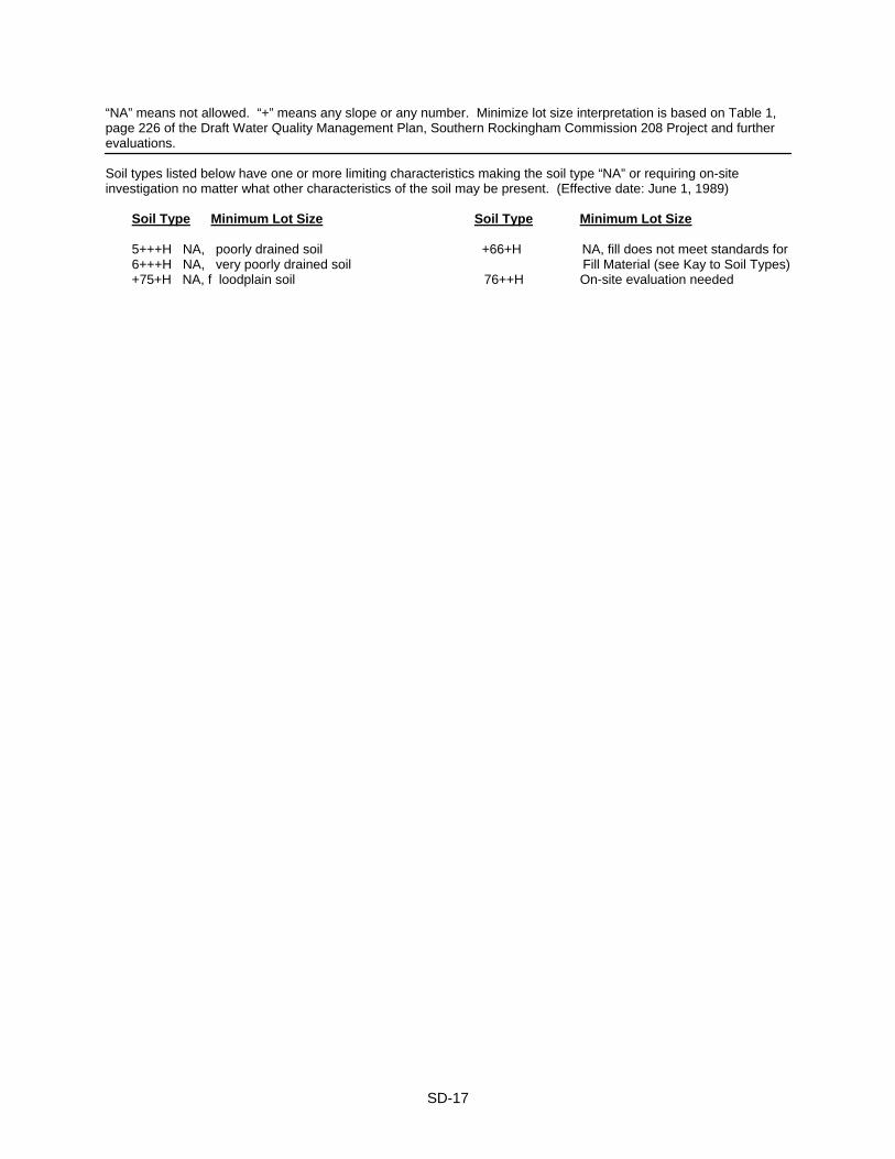
“NA” means not allowed. “+” means any slope or any number. Minimize lot size interpretation is based on Table 1, page 226 of the Draft Water Quality Management Plan, Southern Rockingham Commission 208 Project and further evaluations. Soil types listed below have one or more limiting characteristics making the soil type “NA” or requiring on-site investigation no matter what other characteristics of the soil may be present. (Effective date: June 1, 1989) Soil Type Minimum Lot Size Soil Type Minimum Lot Size
5+++H NA, poorly drained soil +66+H NA, fill does not meet standards for 6+++H NA, very poorly drained soil Fill Material (see Kay to Soil Types)
+75+H NA, f loodplain soil 76++H On-site evaluation needed
SD-17
NON-RESIDENTIAL AND MULTI-FAMILY SITE DEVELOPMENT PLAN REGULATIONS
SECTIONS SP100 - SP1500 Section 100 AUTHORITY 100:1 Pursuant to the authority vested in the Atkinson Planning Board by the voters of the
Town of Atkinson in accordance with the provisions of Chapter 674:43 of the New Hampshire Revised Statutes Annotated, 1983, the Atkinson Planning Board adopts the following rules governing the review of non-residential and multi-family site development plans in the Town of Atkinson, New Hampshire. These rules shall be entitled "Non-Residential and Multi-Family Site Development Plan Regulations, Town of Atkinson, New Hampshire."
Section 200 ORDINANCE AND REGULATION REQUIREMENTS 200:1 All developments shall meet the standards and requirements of the town zoning
ordinance and subdivision regulations including, but not limited to, parking, off-street loading, landscaping, signs, location of driveways, erosion, screened service areas, and exterior lighting.
Section 300 DUTIES OF THE PLANNING BOARD Section 310 GENERAL 310:1 The Planning Board shall review the plan, or any amendment to it, in the same manner
as is prescribed by state law for the review of subdivision plans. 310:2 In considering and approving the site development plan, the Planning Board shall take
into consideration the public health, safety and general welfare and the comfort and convenience of the public in general and the residents of the immediate neighborhood in particular. It shall make any appropriate conditions which:
a. Guard against
1) Inadequate drainage or conditions conducive to flooding of the property. 2) Inadequate protection for the quality of groundwater. 3) Undesirable and preventable elements of pollution which might prove
harmful to persons, structures, or adjacent properties. 4) Inadequate provision for fire safety, prevention, and control.
b. Provide for
1) Harmonious and aesthetically pleasing development of the municipality
and its environs. 2) Open spaces and green spaces of adequate proportions.
SP-1
3) Proper arrangement and coordination of streets within the site in relation to other existing or planned streets.
4) Suitably located roadways of sufficient width to accommodate existing and prospective traffic and to afford adequate light, air, and access for firefighting apparatus and equipment to buildings.
Section 320 PARTICULAR 320:1 In addition to the general considerations of Section 310:2 above, the Planning Board
shall also pay particular regard to:
a. Maximum safety of traffic access and egress and sufficient areas to ensure off-street parking.
b. A site layout which includes the location, power, direction and time of any
outdoor lighting of the area and which has no adverse effect on any adjoining residence districts by impairing the established character or potential use of properties in such districts.
c. Reasonable screening in all seasons of the year of all playgrounds, parking,
and service areas from the view of adjacent residential properties and streets. d. Conformance of the proposed site development plan with such portions of the
Master Plan of the town which are applicable. e. Installation of public improvements and amenities, at the expense of the
applicant, to assist in the establishment of a sound environment. Such improvements may include, but are not limited to, roadways, curbing, paved sidewalks, and street trees or shrubs.
Section 400 DEFINITIONS (in alphabetical order) (1998) 400:1 C1 Continuous Sound Sound the intensity of which remains essentially constant over
time. (1998) D1 Driveway A driveway is a single access to and from a public way with separate
entrance and exit lanes, except in the case of dwellings, in which case a driveway need not have separate entrance unless required as a condition of a special permit.
D2 Daytime The time period between the hours of 7 AM and 9 PM of the same day,
Monday through Friday and between 9AM and 9PM of the same day on Saturday, Sunday and all local legal holidays. (1998)
D3 dBA (Decibel-A weighted) A measure of sound pressure level which takes into account
the typical response of the human ear. (1998)
SP-2
E1 Exterior parking space An exterior parking space in an area having a width of not less than nine (9) feet and a length of not less than twenty (20) feet, exclusive of traffic and maneuvering space.
G1 Gross floor area Gross floor area is the total floor area designed for occupancy and
use including basement and other storage areas provided, however, that stairways, elevator wells, rest rooms and lounge areas, common hallways and building service areas shall not be included in the computation of such floor area.
I1 Impulsive Sound Sound of short duration, usually less than one second, with an
abrupt onset and rapid decay. Examples of sources of impulsive sound include explosions, discharge of firearms, riveting and hammering. (1998)
L1 Light industry The fabrication and/or development of tangible goods by means of
processes that are (a) neither obnoxious nor injurious by reason of the production or emission of odor, dust, smoke, refuse matter, fumes, noise vibration, or similar conditions; (b) nor dangerous to the comfort, peace, enjoyment, health, and safety of the community; (c) nor lending to its disturbance or annoyance.
L2 Loading or unloading bay. A loading or unloading bay is an area of not less than
twelve (12) feet in width and sixty-five (65) feet in length, exclusive of traffic lanes and maneuvering space. Loading bays shall be located at the sides or rear of the building with direct access to the building to be served.
N1 Nighttime Any time which does not meet the definition of Daytime. (1998) P1 Periodic Sound Sound the intensity of which cycles repeatedly from a low level to a
higher level and/or sound possessing a repetitive on and off characteristic. (1998) Section 500 GENERAL REGULATIONS 510 Non-residential and multi-family use. Planning Board approval of Site Development
Plans or any amendments to such plans shall be required for all non-residential and multi-family uses in the Town. Change of use may require a new site plan and Planning Board approval. (See also Section 540:2.)
520 Uses not permitted. No use shall be permitted which would be injurious, noxious,
offensive, hazardous, or otherwise objectionable to the neighborhood or the Town. This includes, but is not limited to, the emission of fumes, dust, noise, smoke, vibration, radiation, solid or liquid waste discharges, and long-term storage of hazardous substances.
530 Adequacy of land. Land of such character that it cannot be safely used for building
purposes because of exceptional danger to health or peril from fire, flood or other menace shall not be platted for residential occupancy, nor for such other uses as may increase danger to health, life or property or aggravate the flood hazard, until appropriate measures have been taken by the owner or his agent to lessen such hazards.
SP-3
Section 540 CERTIFICATION 540:1 Building permits. No building permit may be issued for any building within the
purview of this regulation until an approved site development plan or amendment of any such plan has been presented to the Building Inspector.
540:2 Certificates of use and occupancy.
a. No certificate of use and occupancy may be issued for any building or use of land within the purview of these regulations unless the Town's appointed engineer has certified that the building is constructed and usable, and that the land is developed and used in conformity with an approved site development plan or an amendment of any such plan.
b. In the case of developments qualifying for higher density under Section 610 of
the Zoning Ordinance, occupancy permits shall be issued at a minimum ratio of one low-moderate dwelling unit to every four market-value dwelling units, so that for every four fair market-value units built, one low moderate unit must be built and such that by the time a project is seventy-five percent (75%) complete, all of the low moderate units must be built. (1997)
c. In developments where multi-family dwelling unit buildings are to be
constructed for the purposes of providing low-moderate housing opportunities under Section 610 of the Zoning Ordinance, construction of said low-moderate dwelling units shall commence prior to or at such time that not more than one-third of the total number of dwelling units within the development have been granted a Certificates of Occupancy. After such time, one low-moderate unit must be granted a Certificate of Occupancy prior to or concurrent with each market value dwelling unit being granted a Certificate of Occupancy until such time as all low-moderate dwelling units shall have been granted Certificates of Occupancy at or before such time that 75-percent of the total number of dwelling units have received Certificates of Occupancy.
All low-moderate income housing can be constructed in the first phase, however, at the applicant's discretion. (1998)
Section 550 COMPLIANCE 550:1 The proposed site plan development shall conform to all standards and requirements
of the Town of Atkinson. 550:2 When a proposed site plan is submitted for approval with regard to a new use or to an
expansion of an existing use, the owner may submit a proposed site plan and request the Planning Board to waive specific requirements for the plan and supporting data. The Planning Board may agree to such a request provided that the Board has determined that such waiver of any requirements will not affect the purpose and intent of these regulations. This shall not apply to design, construction, health, safety, and flood plain standards.
SP-4
Section 560 BOND/SURETY 560:1 Before approval of a site development plan, the Planning Board may require a
performance bond, cash, or sureties by the applicant in an amount sufficient to cover the cost of work on that portion of the development which, if not properly completed, will have an adverse effect on adjoining property or a potential for erosion. This bond or sureties shall be approved as to form and surety by the legal Counsel of the Town of Atkinson, NH, and conditioned on the completion of such improvement and/or annual review of the bond's sufficiency.
560:2 All bonds shall be made out in the name of: Town of Atkinson: , Selectmen If desired, a reference such as "Millpond Road Bond; John Doe, Owner" may be added. Only one signature is required for withdrawal, either that of the Treasurer or one of the Board of Selectmen, preferably the member serving Ex-Officio on the Planning Board. Signature cards should be presented with the bond. A set of withdrawal slips should be available in order to expedite the release of the bond. Section 600 REQUIREMENTS FOR SITE DEVELOPMENT PLAN APPROVAL Section 610 OPERATIONAL CONSIDERATIONS 610:1 Any application for Non-Residential Site Development Plan approval within the
Commercial (C); Commercial-Industrial (C-I); Town Center (TC); or Commercial-Professional (C-P) Districts shall be accompanied by a written statement of Intent accurately describing the nature of the applicant’s planned non-residential operation(s). As a minimum, said Statement of Intent shall disclose the applicants intentions with regard to each of the following: (1998)
a. The general use or uses of the planned development; b. The magnitude of each planned use or uses (gross square footage of building
area to be assigned to each proposed use and/or estimated number of employees, on-site and transient to be assigned to each specific proposed use);
c. Intended hours of operation associated with each proposed use; d. Type and estimated quantity of goods and services stored and/or provided
relative to each proposed use; e. Description of activities to be undertaken inside and outside of proposed
buildings; f. Description and estimated number of vehicles and equipment to be housed on-
site (inside & out) during both business and non-business hours;
SP-5
g. Identification of shipping/receiving schedule (estimated number of trips per day, together with estimated time of arrival/departures and associated vehicle type); and
h. Identification of any regulated materials or equipment to be used or stored on-
site and means by which applicant intends to fulfill applicable local, state and federal requirements associated with use and storage of the same.
610:2 Given the specific duties of the Planning Board described in Section 310:2 of these
Regulations, or provided for elsewhere in these Regulations and/or within any and all other applicable local, state or federal regulations, ordinances, rules or laws, the Planning Board may, in its prudent and reasonable judgment, require an applicant to modify his/her Statement of Intent, when and if necessary to protect the public health, safety and general welfare as well as the comfort and convenience of the public in general and/or the residents of an immediate area.(1998)
610:3 It is understood that a written Statement of Intent, as submitted by an applicant, or as
modified by the Planning Board in its prudent and reasonable judgment for the reasons provided for under Section 605:2 of these Regulations, will become an integral part of any resulting approval granted by the Board. Any subsequent amendments serving to affect or alter said Statement of Intent must receive specific Planning Board approval, in the form of a change or expansion of use, as provided for under NH RSA 674:43. (1998)
Section 620 POLLUTION AND FLOOD HAZARD CONTROL 620:1 Whenever an earth disturbance significantly alters more than 100,000 square feet of
contiguous terrain, the subdivider shall submit to the Planning Board a copy of an Alteration of Land (Site Specific) Permit for such operation officially approved by the Water Supply and Pollution Control Commission.
620:2 Provisions shall be made to assure that the proposal is consistent with the need to
protect groundwater recharge areas from pollution and to minimize flood damage, that all public utilities and facilities, such as sewer, gas, electrical, and water systems, are constructed and that adequate drainage is provided so as to reduce exposure to flood hazards.
620:3 Storm drainage of the site shall be designed for a 25 year flood and if the existing
drainage system to which the site drainage system will be connected is inadequate, provisions shall be made for retention and gradual release of storm water in order to meet the 25 year flood demand.
620:4 Design provisions shall also be made to minimize or eliminate infiltration of flood
waters into new or replacement water supply systems and/or sanitary sewage systems and discharges from these systems into floodwaters.
620:5 On-site waste disposal systems shall be located so as to avoid impairment of them or
contamination from them.
SP-6
Section 630 SEWAGE SYSTEMS 630:1 Waste disposal systems shall be designed by a licensed sanitary engineer in
accordance with state specifications, and copies of all required state and federal permits shall be supplied to the town.
Section 640 EROSION CONTROL 640:1 No site plan involving five (5) or more acres shall be granted approval unless it
includes plans for runoff, erosion and sediment control. It shall be based on a high intensity soils survey and shall meet all state and federal requirements.
640:2 The developer shall bear the final responsibility for the design, installation and
construction of all required runoff, erosion and sediment control measures which may be required by the Planning Board.
Section 650 CONSTRUCTION 650:1 Road. Construction requirements shall be in accordance with Standard Specifications
for Road and Bridge Construction as published by the State of New Hampshire Department of Public Works and Highways provided that alternative provision may be considered by the Planning Board if submitted by the developer.
650:2 Paving/drainage/sidewalks. Pavement and drainage facilities, curbs and sidewalks,
when required, shall be installed and constructed in accordance with the standard specifications of the Town of Atkinson, NH, and, in all cases, must be constructed under the supervision of the Town's appointed engineer.
650:3 Underground utilities. Underground utilities shall be located outside the paved areas
wherever possible. 660 Snow storage. Provisions shall be made for snow storage during the winter months. Section 670 OFF-STREET PARKING AND LOADING REQUIREMENTS 670:1 In all districts, there shall be provided at such time as any building or structure is
erected, externally enlarged, or increased in capacity, off-street parking spaces and loading areas for vehicles in accordance with the requirements of this section.
670:2 All parking and off-street loading spaces required by this section shall be provided on
the same lot with the principal use. 670:3 Off-street parking existing at the effective date of these regulations in connection with
the operation of an existing building or use shall not be reduced to an amount less than hereinafter required for a similar new building or use.
670:4 The required off-street parking shall be for occupants, employees, visitors, and patrons
and shall be limited in use to motor vehicles and bicycles. The storage of merchandise, motor vehicles for sale or the repair of vehicles is prohibited except in the Commercial-Industrial area.
SP-7
670:5 In addition to all other space requirements, every car, truck, tractor, trailer or other vehicle normally stored at any site shall be provided with off-street parking space in an area reserved for no other use.
670:6 Where the computation of the off-street parking or loading bay space requirements
results in a fractional number, the fraction shall be counted as the next whole unit. 670:7 Where one building is used for more than one use, off-street parking space
requirements shall be computed for each use. 670:8 Required parking spaces. A minimum number of spaces in accordance with the
following table: a) Business and professional offices; One (1) space for each three hundred (300)
banks and financial institutions. . hundred (300) square feet of floor area plus one (1) space for every employee.
b) Barber shops and beauty parlors. . Two (2) per barber or three (3) per beautician
based on the design capacity of the structure or one (1) space for every two
hundred (200) square feet of floor area, whichever is greater.
c) Bowling alleys . . Four (4) per alley.
d) Church, chapel and funeral homes, One (1) space for every three seats plus one places of assembly or amusement.. (1) for every three employees.
e) Dwelling units (1 or 2) . . Two (2) spaces per dwelling unit plus one (1) for every three employees.
f) Dwelling unit (multi) . . Two (2) spaces per dwelling unit plus (1) additional space for each bedroom over two (2) per dwelling unit, to a maximum of three (3) spaces per dwelling unit.
g) Garages and gasoline stations One (1) space for each one thousand (1,000) with repair service . . square feet used for repairing vehicles
plus two (2) spaces for each lubrication pit or service bay.
h) Gasoline service stations . . One (1) parking space for each employee plus
two (2) for each service bay.
i) Hospitals, nursing homes, convalescent Two (2) spaces for each bed, plus one (1) home and extended care facilities.. space for every employee or staff
member.
SP-8
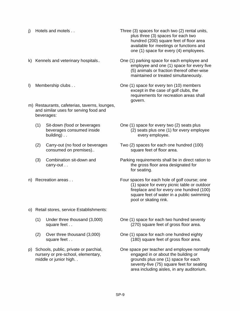
j) Hotels and motels . . Three (3) spaces for each two (2) rental units, plus three (3) spaces for each two hundred (200) square feet of floor area available for meetings or functions and one (1) space for every (4) employees.
k) Kennels and veterinary hospitals.. One (1) parking space for each employee and
employee and one (1) space for every five (5) animals or fraction thereof other-wise maintained or treated simultaneously.
l) Membership clubs . . One (1) space for every ten (10) members
except in the case of golf clubs, the requirements for recreation areas shall
govern. m) Restaurants, cafeterias, taverns, lounges,
and similar uses for serving food and beverages:
(1) Sit-down (food or beverages One (1) space for every two (2) seats plus
beverages consumed inside (2) seats plus one (1) for every employee building) . . every employee.
(2) Carry-out (no food or beverages Two (2) spaces for each one hundred (100)
consumed on premises).. square feet of floor area.
(3) Combination sit-down and Parking requirements shall be in direct ration to carry-out . . the gross floor area designated for for seating.
n) Recreation areas . . Four spaces for each hole of golf course; one (1) space for every picnic table or outdoor
fireplace and for every one hundred (100) square feet of water in a public swimming
pool or skating rink.
o) Retail stores, service Establishments:
(1) Under three thousand (3,000) One (1) space for each two hundred seventy square feet . . (270) square feet of gross floor area. (2) Over three thousand (3,000) One (1) space for each one hundred eighty square feet . . (180) square feet of gross floor area.
p) Schools, public, private or parchial, One space per teacher and employee normally nursery or pre-school, elementary, engaged in or about the building or middle or junior high. . grounds plus one (1) space for each
seventy-five (75) square feet for seating area including aisles, in any auditorium.
SP-9
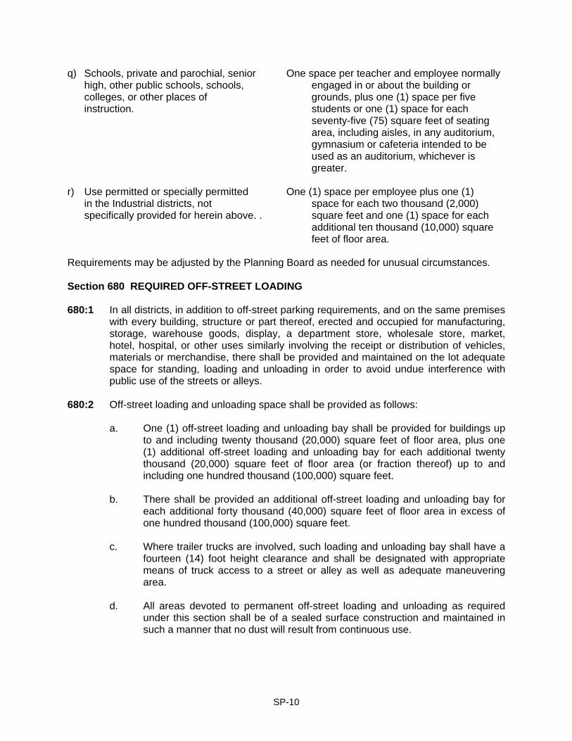
q) Schools, private and parochial, senior One space per teacher and employee normally high, other public schools, schools, engaged in or about the building or
colleges, or other places of grounds, plus one (1) space per five instruction. students or one (1) space for each
seventy-five (75) square feet of seating area, including aisles, in any auditorium, gymnasium or cafeteria intended to be
used as an auditorium, whichever is greater.
r) Use permitted or specially permitted One (1) space per employee plus one (1) in the Industrial districts, not space for each two thousand (2,000) specifically provided for herein above. . square feet and one (1) space for each
additional ten thousand (10,000) square feet of floor area.
Requirements may be adjusted by the Planning Board as needed for unusual circumstances. Section 680 REQUIRED OFF-STREET LOADING 680:1 In all districts, in addition to off-street parking requirements, and on the same premises
with every building, structure or part thereof, erected and occupied for manufacturing, storage, warehouse goods, display, a department store, wholesale store, market, hotel, hospital, or other uses similarly involving the receipt or distribution of vehicles, materials or merchandise, there shall be provided and maintained on the lot adequate space for standing, loading and unloading in order to avoid undue interference with public use of the streets or alleys.
680:2 Off-street loading and unloading space shall be provided as follows:
a. One (1) off-street loading and unloading bay shall be provided for buildings up
to and including twenty thousand (20,000) square feet of floor area, plus one (1) additional off-street loading and unloading bay for each additional twenty thousand (20,000) square feet of floor area (or fraction thereof) up to and including one hundred thousand (100,000) square feet.
b. There shall be provided an additional off-street loading and unloading bay for
each additional forty thousand (40,000) square feet of floor area in excess of one hundred thousand (100,000) square feet.
c. Where trailer trucks are involved, such loading and unloading bay shall have a
fourteen (14) foot height clearance and shall be designated with appropriate means of truck access to a street or alley as well as adequate maneuvering area.
d. All areas devoted to permanent off-street loading and unloading as required
under this section shall be of a sealed surface construction and maintained in such a manner that no dust will result from continuous use.
SP-10
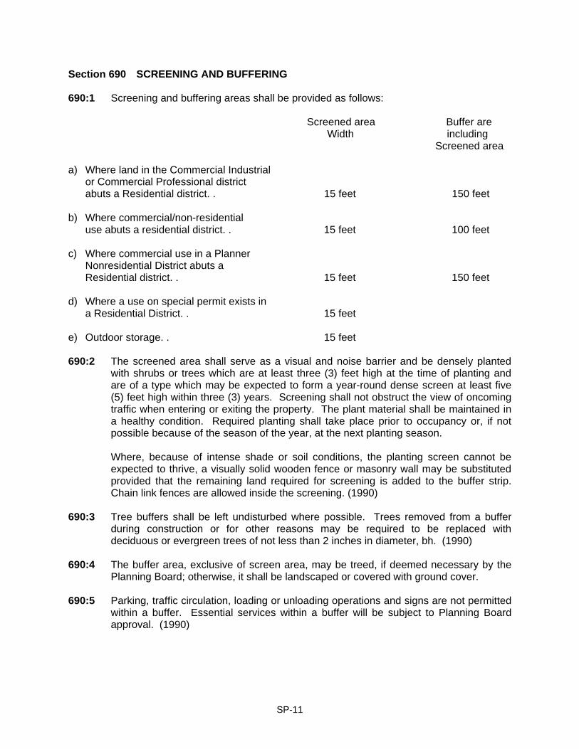
Section 690 SCREENING AND BUFFERING 690:1 Screening and buffering areas shall be provided as follows:
Screened area Buffer are Width including Screened area
a) Where land in the Commercial Industrial or Commercial Professional district abuts a Residential district. . 15 feet 150 feet
b) Where commercial/non-residential use abuts a residential district. . 15 feet 100 feet c) Where commercial use in a Planner Nonresidential District abuts a Residential district. . 15 feet 150 feet d) Where a use on special permit exists in a Residential District. . 15 feet e) Outdoor storage. . 15 feet 690:2 The screened area shall serve as a visual and noise barrier and be densely planted
with shrubs or trees which are at least three (3) feet high at the time of planting and are of a type which may be expected to form a year-round dense screen at least five (5) feet high within three (3) years. Screening shall not obstruct the view of oncoming traffic when entering or exiting the property. The plant material shall be maintained in a healthy condition. Required planting shall take place prior to occupancy or, if not possible because of the season of the year, at the next planting season.
Where, because of intense shade or soil conditions, the planting screen cannot be
expected to thrive, a visually solid wooden fence or masonry wall may be substituted provided that the remaining land required for screening is added to the buffer strip. Chain link fences are allowed inside the screening. (1990)
690:3 Tree buffers shall be left undisturbed where possible. Trees removed from a buffer
during construction or for other reasons may be required to be replaced with deciduous or evergreen trees of not less than 2 inches in diameter, bh. (1990)
690:4 The buffer area, exclusive of screen area, may be treed, if deemed necessary by the
Planning Board; otherwise, it shall be landscaped or covered with ground cover. 690:5 Parking, traffic circulation, loading or unloading operations and signs are not permitted
within a buffer. Essential services within a buffer will be subject to Planning Board approval. (1990)
SP-11
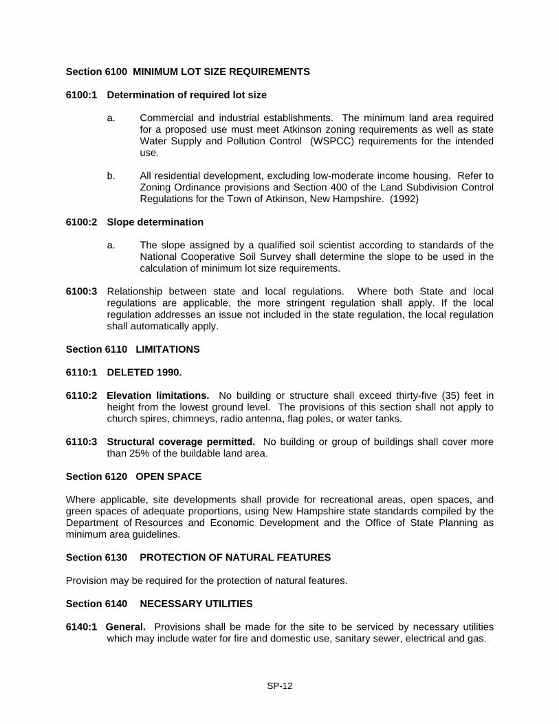
Section 6100 MINIMUM LOT SIZE REQUIREMENTS 6100:1 Determination of required lot size
a. Commercial and industrial establishments. The minimum land area required
for a proposed use must meet Atkinson zoning requirements as well as state Water Supply and Pollution Control (WSPCC) requirements for the intended use.
b. All residential development, excluding low-moderate income housing. Refer to
Zoning Ordinance provisions and Section 400 of the Land Subdivision Control Regulations for the Town of Atkinson, New Hampshire. (1992)
6100:2 Slope determination
a. The slope assigned by a qualified soil scientist according to standards of the
National Cooperative Soil Survey shall determine the slope to be used in the calculation of minimum lot size requirements.
6100:3 Relationship between state and local regulations. Where both State and local
regulations are applicable, the more stringent regulation shall apply. If the local regulation addresses an issue not included in the state regulation, the local regulation shall automatically apply.
Section 6110 LIMITATIONS 6110:1 DELETED 1990. 6110:2 Elevation limitations. No building or structure shall exceed thirty-five (35) feet in
height from the lowest ground level. The provisions of this section shall not apply to church spires, chimneys, radio antenna, flag poles, or water tanks.
6110:3 Structural coverage permitted. No building or group of buildings shall cover more
than 25% of the buildable land area. Section 6120 OPEN SPACE Where applicable, site developments shall provide for recreational areas, open spaces, and green spaces of adequate proportions, using New Hampshire state standards compiled by the Department of Resources and Economic Development and the Office of State Planning as minimum area guidelines. Section 6130 PROTECTION OF NATURAL FEATURES Provision may be required for the protection of natural features. Section 6140 NECESSARY UTILITIES 6140:1 General. Provisions shall be made for the site to be serviced by necessary utilities
which may include water for fire and domestic use, sanitary sewer, electrical and gas.
SP-12
6140:2 Outdoor lighting. Provision shall be made for outdoor lighting. Section 6150 SIGNS (See Zoning - Sign Regulations - Section 470) (1992) Section 6160 TRAFFIC 6160:1 Access to the site from town and state roads shall ensure safety of vehicles and
pedestrians. 6160:2 Improvement to existing streets shall include signal devices if necessary because of
increased traffic generated by the development. Section 6170 PERFORMANCE STANDARDS FOR NON-RESIDENTIAL USES 6170:1 In addition to meeting the provisions of Section 400:2 of the Atkinson Zoning
Ordinance, all non-residential uses shall be designed and operated to meet the perfor-mance standards set forth herein: (1998) a. A noise level which does not exceed 60 decibels. b. A smoke level which, at its source, does not exceed No. 2 on the Ringlemann
Chart. c. Vibration which creates displacement of no more than 0.002 of one inch.
6170:2 Maximum Permissible Sound Levels (1998)
a. No sound shall be projected beyond the property line within any zoning district
which exceeds the levels set forth in Table I and II or as otherwise provided herein. The maximum permissible sound level allowed in any zoning district shall be the sum of the level specified in Table I plus the correction factor from Table II. Sound projecting from one zoning district into another district shall not exceed the limits of the district into which the sound is projected.
I. TABLE I--Maximum Permissible Sound Levels in dBA Zoning District Daytime Level Nighttime level
All residential 65 55 Commercial 65 60 Commercial-Professional 65 55 Town Center 65 55 Commercial-Industrial 70 65
II. TABLE II--Correction Factors
Character of Sound Correction Factors (dBA)
Impulsive Sound Minus 5 Periodic Sound Minus 5
SP-13
b. All sound levels set forth herein shall be measured with a sound level meter meeting American National Standards Institute ANSI S1.4-1971, Type 1 or Type
1. The instrument shall be maintained in calibration and good working
order. A calibration check shall be made at the time any measurement is taken. The microphone, during measurement, shall be positioned so as not to create any unnatural enhancement or diminution of the measured sound. A windscreen for the microphone shall be used when required. Provision shall be made to discount traffic, aircraft and other background sound when any measurement is taken.
c. For the measurement of continuous or periodic sound, the slow response
setting of the meter shall be employed. For impulsive sound or for rapidly varying sound level, the fast response setting shall be employed.
6170:3 Exemptions. The following uses and activities shall be exempt from the sound level
regulations set for in 685:2: (1998)
a. The use of snowblowers and other types of private or commercial snow removal operations.
b. The use of lawnmowers, rototillers and other types of powered equipment
when used to maintain the site. c. The operation or use of construction vehicles, tools and equipment for the
purpose of constructing, altering, repairing, or maintaining facilities or buildings permanently located on the site.
d. Parades and public gatherings of a temporary duration as permitted by law. e. Bells, chimes or carillons when used in conjunction with religious purposes. f. The operation or use of agricultural or forestry equipment in conjunction with
farming or logging operations. g. Sound from safety signals and warning devices such as fire alarms. h. Any sound which does not exceed 50 dBA at a distance of twenty-five feet from
its source.
6170:4 No smoke emitted shall, at its source, exceed No. 2 on the Ringlemann Chart. (1998) 6170:5 No vibration shall create displacement or more than 0.002 inch at or beyond the
property line. (1998) 6170:6 Harmful wastes may not be discharged into the ground, streams, or other bodies of
water or local sewer systems. Effluent disposal shall comply with local and state standards. (1998)
SP-14
Section 6180 MINIMUM LANDSCAPING REQUIREMENTS (1998) 6180:1 Each application considered for approval under these Regulations must include a
landscape design plan. 6180:2 All landscape plantings required under this Section shall be furnished and installed in
accordance with accepted horticultural standards and shall be regularly maintained. All required plantings shall be replaced as necessary in order to maintain compliance with the minimum standards established in this Section.
6180:3 All areas disturbed by construction shall be covered with a minimum thickness of four-
inches of friable loan or mulch or appropriate landscape material and be subsequently planted with grass seed, sod, or vegetative ground cover or a combination thereof as appropriate.
6180:4 A Street Tree Strip, 15-feet in width, running parallel to the boundaries of a parcel
fronting on any public or private street, shall be planted with a minimum of one indigenous shade tree such as oak, maple, elm, ash, linden, etc., with a minimum caliper of 2.5 inches and branching height of not less than 7-feet at the time of planting. A minimum of one street tree shall be provided for each 50-feet of roadway frontage and shall be planted no closer than 25-feet on center. The requirements of this Section may be fulfilled by protecting and retaining healthy trees within the Street Tree Strip which fulfill the applicable requirements of this Section.
6180:5 In the C, TC & C-P and SCR Districts, a Front Landscape Strip of not less than 15-feet
in width shall be planted between the interior edge of the Street Tree Strip and the closest point of a building or impervious surface facing a public or private street. The Front Landscape Strip shall be planted with a minimum of one deciduous, evergreen or ornamental tree for every 30-feet of building or impervious surface facing a public or private street. Trees planted in the Front Landscape Strip shall be a minimum of six feet in height and have a caliper diameter of not less than 2-inches at the time of planting. In no case shall required trees within the Front Landscape Strip be planted closer than 15-feet on center. The requirements of this Section may be fulfilled by protecting and retaining existing healthy trees within the required Front Landscape Strip which fulfill the applicable requirements of this Section.
6180:6 A minimum of 15-feet of landscaped area shall be provided between the extreme
edges of any proposed pavement or buildings located to the interior of the Front Landscape Strip and the adjoining side or rear property line. Planting requirements within the Side and Rear Landscape Strip shall be identical to those specified in Section 690:5 for the Front Landscape Strip.
6180:7 Interior Green Space shall be required within paved or gravel surfaced areas
containing 20 or more parking spaces or more than 5,000 square feet of contiguous paved or gravel surfaced area. The total area of required Interior Green Space shall not be less than 5-percent of the total area of contiguous paved and/or gravel surfaced area.
Individual areas of the Interior Green Space set aside in order to fulfill the requirements of the Section shall not be less than 250-square feet in area and shall be planted with a minimum of one specimen tree pre 250 square feet of green space in
SP-15
accordance with the same requirements as those specified in Section 690:5 for the Front Landscape Strip. All interior green space shall be loamed and vegetated in accordance with the requirements of Section 690:3.
Section 6190 NATIONAL FLOOD INSURANCE PROGRAM (2008) For subdivisions and site plans that involve land designated as “Special Flood Hazard Areas” (SFHA) by the National Flood Insurance Program (NFIP): 6190:1 The Planning Board shall review the proposed development to assure that all
necessary permits have been received from those governmental agencies from which approval is required by federal or state law, including Section 404 of the Federal Water Pollution Control Act Amendments of 1972, 33 U.S.C. 1334.
6190:2 The Planning Board shall require that all proposals for development greater than 50
lots or 5 acres, whichever is the lesser, include Base Flood Elevation (BFE) data within such proposals (i.e., floodplain boundary and 100-year flood elevation).
6190:3 The Planning Board shall require the applicant to submit sufficient evidence
(construction drawings, grading and land treatment plans) so as to allow a determination that:
a. all such proposals are consistent with the need to minimize flood damage; b. all public utilities and facilities, such as sewer, gas, electrical and water
systems are located and constructed to minimize or eliminate flood damage; and
c. adequate drainage is provided so as to reduce exposure to flood hazards.
Section 700 PROCEDURE FOR SITE DEVELOPMENT PLAN APPROVAL Section 710 APPLICATION FOR APPROVAL 710:1 Whenever the development of a site is proposed to be made and before an application
for a permit for the erection of a structure thereon shall be made, the owner thereof or his agent shall make application for approval of such site plan development to the Planning Board of the Town of Atkinson, NH. The application shall be considered a completed application at such time as it contains sufficient information to allow the board to proceed with a formal consideration of the proposal. The application shall conform to the specifications contained in these regulations.
Section 720 PRELIMINARY CONSULTATION 720:1 Preliminary consultations and review of a proposal shall be separate and apart from
formal consideration by the Board and shall not bind either the applicant or the Board. Time limits for acting upon a proposal shall not apply until preliminary review is concluded, the application is complete, and the site development plan has been accepted for formal consideration by the Board.
SP-16
720:2 A preliminary consultation and review of the basic concept of the site development proposal must be held at a regular meeting of the Board. No formal public notice shall be required. A required preliminary layout, which constitutes part of the completed application, as described in Section SR 800, may be filed by the applicant at this time.
720:3 A second preliminary consultation and review of the proposal, if required by the Board
or sought by the applicant, shall be held only after the Board has notified the applicant and abutters by certified mail at least 10 days prior to the consultation. A notice to the general public shall be given at the same time by posting or by publication, and it shall describe the proposal and identify the applicant and the location. All cost of such notice shall be paid by the applicant in advance of the consultation meeting.
720:4 Subsequent preliminary consultations may be required by the Board or sought by the
applicant in order to achieve a satisfactory preliminary layout and sufficient additional information to constitute a completed application for site development plan approval. The Board may hear and confer with parties whose interest may be affected by the proposed layout; may require a professional engineering review, the cost of which is to be borne by the applicant; and may require specific changes in the preliminary plan which shall be communicated to the developer in writing. Should the Board disapprove of the preliminary layout in its entirety, it shall state its reasons for such disapproval in writing.
Section 730 FORMAL CONSIDERATION 730:1 Submission. The developer shall submit a completed application to the Board
15 days prior to a regular Planning Board meeting, at which time the completed application shall be accepted.
730:2 Notification.
a. Of formal submission. The Planning Board shall notify the applicant and abutters by certified mail at least 10 days prior to the date on which the formal submission of the subdivision application will take place. A notice to the general public shall be given at the same time by posting or by publication, and it shall describe the proposal and identify the applicant and the location. All cost of such notice shall be paid by the applicant in advance of the formal submission.
b. Of public hearing. The Planning Board shall notify the applicant and abutters
by certified mail at least 10 days prior to the date on which a public hearing on the site development plan application will take place. A notice to the general public shall be given at the same time by posting and by publication, and it shall describe the proposal and identify the applicant and the location. All cost of such notice shall be paid by the applicant in advance of the formal submission.
c. Simultaneous notice. If a notice of public hearing is included in the notice of
formal submission, additional notice of the public hearing shall not be required.
SP-17
730:3 Time limitations
a. Upon determination by the board that a submitted application is complete according to the board’s regulations, the board shall begin formal consideration and shall act to approve, conditionally approve, or disapprove within 65 days, subject to extension as provided for in paragraph (c) below. (2002)
b. The applicant shall meet the requirements for filing final plats and data, as outlined in Section SR900, within 60 days of submission of the completed application.
c. The Board may apply to the selectmen to extend the formal consideration period for up to 90 additional days before acting to approve or disapprove the application.
d. A site plan that has been granted a conditional approval shall have one (1) year from the date of conditional approval to fulfill the conditions or the approval is revoked and the plan must come back for review. (1997)
730:4 Offers of cession. The subdivider shall tender offers of cession, in a form certified as
satisfactory by the corporation counsel, of all land included in streets, highways or parks not specifically reserved by him; but approval of the plat by the Board shall not constitute an acceptance by the Town of the dedication of any street, highway, park or other public space.
730:5 Approval/disapproval. In case of disapproval of any application submitted to the
planning board, the ground for such disapproval shall be adequately stated upon the record of the Board.
Section 800 PRELIMINARY LAYOUT 810:1 Prior to the formal submission of the site development plan, the owner or his
authorized agent shall submit three sets of site plan maps and supporting data to the Planning Board which shall include the following information:
a. All data required for formal submission of a subdivision proposal as identified in
Sections 600 and 700 of the Land Subdivision Control Regulations chapter of the Atkinson Planning and Land Use Regulations book.
b. The proposed grades, drainage systems, structures and topographic contours
at intervals not exceeding 2 feet with spot elevations where grade is less than 5 percent.
c. The shape, size, height, and location of the proposed structures including expansion of existing buildings.
d. Proposed streets, driveways, parking spaces, sidewalks, with indication of direction of travel for one-way streets and drives and inside radii of all curves.
SP-18
e. The width of streets, driveways, and sidewalks and the total number of parking spaces to be provided.
f. Loading spaces and facilities associated with the structures on the site.
g. The size and location of all proposed wells, septic systems and other public and private utilities.
h. The location, type, and size of all proposed landscaping and screening, presented in the form of a detailed planting plan with annotated planting list. (1998)
i. Exterior lighting plan and proposed signs to be located on the site.
j. Plans for snow removal and storage.
k. A circulation plan of the interior of the lot showing provisions for both auto and pedestrian circulation.
l. An access plan showing means of access to the site and proposed changes to existing public streets including any traffic control devices necessary in conjunction with the site development plan.
m. Construction drawings including, but not limited to, pavements, walks, steps, curbing and drainage structures.
n. A copy of any covenants or deed restrictions that are intended to cover all or part of the tract and will become a part of any subsequent instruments of conveyance.
o. Any additional information the Planning Board may deem necessary in order to
apply the regulations contained herein.
p. A note on the plan stating the maximum daytime and nighttime continuous, periodic, and impulsive sound levels that apply to the site at applicable lot lines or zoning district boundaries. (1998)
q. A written Statement of Intent prepared and signed by the applicant, which fully addresses the requirements of Section 605 of these Regulations. (1998)
Section 900 PLAT AND DATA FOR FINAL APPROVAL 910:1 The final plat shall be drawn in ink on drawing cloth or mylar at a scale of not less than
50 feet to an inch. Where necessary, the plat may be on several sheets accompanied by an index showing the entire site development plan.
910:2 For larger site development plans, the final plat may be submitted for approval
progressively in contiguous sections satisfactory to the Board. Plat sizes shall conform to the requirements of the Rockingham Registry of Deeds.
SP-19
910:3 The final plat shall show or, when applicable, be accompanied by all data required in Section 810:1 above.
910:4 All engineered plans to be stamped by a Certified Engineer. (1997) 910:5 Applicants to provide a time-line for the completion of all off-site improvements. (1997) Section 1000 FILING OF PLANS 1010:1 The Chairman or Secretary of the Planning Board shall transmit a record of any
changes so authorized to the Register of Deeds of Rockingham County. 1010:2 All plans submitted for recording in the registry of deeds shall be on suitable
reproducible tracing material other than paper with a thickness of not less than .002 of one inch, with all marking on the material to be with India or other permanent ink.
1010:3 The size of all plans is limited to any of the following dimensions:
a. 8 1/2" x 11" b. 11" x 17" c. 17" x 22" d. 22" x 34" or such specifications and sizes of prints as may be required by the Register of Deeds in order to insure suitable, permanent records.
1010:4 After the certificate or notice has been filed with the Register of Deeds of the county,
no plat will be filed or recorded in the offices of said Register of Deeds until it has been approved by the Planning Board, and such approval has been endorsed in writing on the plat in such manner as the Planning Board may designate.
1010:5 After such plat is approved and filed, subject, however, to review by court as
hereinafter provided, the streets and parks shown on such plat shall be and become a part of the official map of the municipality.
1010:6 The filing or recording of a plat of a site development plan without the approval of the
Planning Board as required hereby shall be void. Section 1100 CHANGES IN APPROVED PLANS 1110.1 Minor changes. A minor change shall be one which respects the approved plan's
basic land allocations in terms of use and intensity, the type and variety of facilities and buildings being approved, and/or the timing for providing these facilities, but shall not include any increase in the overall density of the development. The Board shall give proper notification of the proposed change to the public and to all abutters. If requested by the applicant, abutter, or Board, a public hearing shall be held on the proposed change. The Board shall act to approve or disapprove the change with written notification to the owner of its action.
SP-20
1110.2 Major changes. Any requested change which the Board determines does not qualify as a minor change shall be required to be submitted as a separate plan in accordance with these regulations and procedures.
Section 1200 CONCURRENT AND JOINT HEARINGS 1200.1 The Planning Board may hold a hearing on site plan development review in
conjunction with a subdivision hearing if both are required for a project. 1200.2 When an applicant is seeking approval from an additional land use board which also
has jurisdiction over the project, the applicant may request a joint meeting or hearing over which the Planning Board shall preside. However, each land use board (Planning Board, Board of Adjustment, Historic District Commission) shall have discretion as to whether to hold such a meeting or hearing as requested.
Section 1300 AMENDMENTS 1300.1 These regulations may be amended or rescinded by the Planning Board only following
public hearing on the proposed change. 1300.2 The Chairman or Secretary of the Planning Board shall transmit copies of any such
regulations, revisions or amendments thereto, certified by a majority of the Planning Board members, to the municipal clerk and the New Hampshire Office of State Planning.
1300.3 Any site development which was given approval prior to the first posting for a site
development change hearing shall be exempt from any amendment to site development regulation subsequently adopted.
1300.4 In the event that any site development approval expires or otherwise becomes void, all
site development regulations in effect at the time of resubmission shall be adhered to. Section 1400 POWER TO REVIEW SITE PLANS 1400.1 Except as otherwise noted herein, the Atkinson Planning Board shall have final
approval and discretionary authority. Section 1500 SEPARABILITY 1500.1 If any provision herein shall be held to be invalid for any reason by a Court, such
holding shall not invalidate in any manner any other provision contained herein.
SP-21
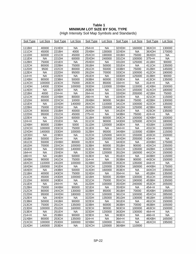
Table 1 MINIMUM LOT SIZE BY SOIL TYPE
(High Intensity Soil Map Symbols and Standards)
Soil Type Lot Size Soil Type Lot Size Soil Type Lot Size Soil Type Lot Size Soil Type Lot Size
111BH 40000 21XEH NA 254+H NA 32XDH 160000 36XCH 130000 111CH 45000 221BH 4000 25XBH 130000 32XEH NA 36XDH 170000 111DH 60000 221CH 45000 25XCH 190000 331BH 75000 36XEH NA 111EH NA 221DH 60000 25XDH 240000 331CH 100000 375+H NA 112BH 75000 221EH NA 25XEH NA 331DH 125000 411BH 90000 112CH 80000 222BH 75000 261BH 50000 331EH NA 411CH 135000 112DH 9500 222CH 80000 261CH 55000 333BH 75000 412BH 145000 112EH NA 222DH 95000 261DH 70000 333CH 100000 412CH 190000 114+H NA 222EH NA 261EH NA 333DH 125000 413BH 90000 11XBH 80000 223BH 50000 263BH 60000 333EH NA 413CH 135000 11XCH 100000 223CH 75000 263CH 85000 334+H NA 414+H NA 11XDH 14000 223DH 100000 263DH 110000 33XBH 115000 41XBH 150000 11XEH NA 223EH NA 263EH NA 33XCH 155000 41XCH 180000 121BH 4000 224+H NA 264+H NA 33XDH 205000 421BH 75000 121CH 45000 22XBH 80000 266+H NA 33XEH NA 421CH 115000 121DH 60000 22XCH 10000 26XBH 90000 341BH 75000 422BH 130000 121EH NA 22XDH 140000 26XCH 110000 341CH 100000 422CH 135000 122BH 75000 22XEH NA 26XDH 150000 341DH 125000 423BH 90000 122CH 80000 231BH 40000 26XEH NA 341EH NA 423CH 135000 122DH 95000 231CH 45000 275+H NA 343BH 75000 424+H NA 122EH NA 231DH 60000 311BH 60000 343CH 100000 42XBH 150000 124+H NA 231EH NA 311CH 90000 343DH 125000 42XCH 180000 12XBH 80000 233BH 5000 311DH 120000 343EH NA 431BH 115000 12XCH 100000 233CH 75000 311EH NA 344+H NA 431CH 150000 12XDH 140000 233DH 100000 312BH 95000 34XBH 115000 433BH 115000 12CEH NA 223EH NA 312CH 125000 34XCH 155000 433CH 150000 161BH 50000 234+H NA 312DH 155000 34XDH 205000 434+H NA 161CH 55000 23XBH 80000 312EH NA 34XEH NA 43XBH 175000 161DH 70000 23XCH 100000 313BH 60000 351BH 90000 43XCH 235000 161EH NA 23XDH 140000 313CH 90000 351CH 135000 442BH 115000 164+H NA 23XEH NA 313DH 120000 351DH 160000 441CH 150000 166+H NA 241BH 50000 313EH NA 351EH NA 443BH 115000 16XBH 90000 241CH 75000 314+H NA 353BH 90000 443CH 150000 16XCH 110000 241DH 100000 31XBH 100000 353CH 135000 444+H NA 16XDH 150000 241EH NA 31XCH 120000 353DH 160000 44XBH 175000 16XEH NA 243BH 50000 31XDH 160000 353EH NA 44XCH 235000 211BH 40000 243CH 75000 31XEH NA 354+H NA 451BH 135000 211CH 45000 243DH 100000 321BH 50000 35XBH 130000 451CH 205000 211DH 60000 243EH NA 321CH 75000 35XCH 190000 453BH 135000 211EH NA 244+H NA 312DH 100000 35XDH 240000 453CH 205000 212BH 75000 24XBH 90000 321EH NA 35XEH NA 454+H NA 212CH 80000 24XCH 130000 322BH 85000 361BH 70000 45XBH 195000 212DH 95000 24XDH 180000 322CH 100000 361CH 100000 45XCH 285000 212EH NA 24XEH NA 322DH 135000 361DH 130000 461BH 105000 213BH 50000 241BH 90000 322EH NA 361EH NA 461CH 150000 213CH 75000 251CH 135000 323BH 60000 363BH 70000 463BH 105000 213DH 100000 251DH 160000 323CH 90000 363CH 100000 463CH 150000 213EH NA 251EH NA 323DH 120000 363DH 130000 464+H NA 214+H NA 253BH 90000 323EH NA 363EH NA 466+H NA 21XBH 80000 253CH 135000 324+H NA 364+H NA 46XBH 165000 21XCH 100000 253DH 160000 32XBH 100000 366+H NA 46XCH 195000 21XDH 140000 253EH NA 32XCH 120000 36XBH 110000
SP-22

“NA” means not allowed. “+” means any slope or any number. Minimize lot size interpretation is based on Table 1, page 226 of the Draft Water Quality Management Plan, Southern Rockingham Commission 208 Project and further evaluations. Soil types listed below have one or more limiting characteristics making the soil type “NA” or requiring on-site investigation no matter what other characteristics of the soil may be present. (Effective date: June 1, 1989) Soil Type Minimum Lot Size Soil Type Minimum Lot Size
5+++H NA, poorly drained soil +66+H NA, fill does not meet standards for 6+++H NA, very poorly drained soil Fill Material (see Kay to Soil Types)
+75+H NA, f loodplain soil 76++H On-site evaluation needed
SP-23
ROAD SPECIFICATIONS AND REGULATIONS Section 400 GENERAL PURPOSE The purpose of the following specifications is to implement a roadway life of 15 to 20 years with normal maintenance. The life of a road surface is directly related to the adequacy of its drainage system and pavement section. Proper drainage is needed to insure driver safety, present erosion, reduce winter maintenance, and prolong pavement life. Proper pavement section must be designed to be compatible with its loading conditions and climatic effects. In New Hampshire, a structurally adequate pavement can undergo severe failure because of insufficient frost protection. 400:1 As far as practical, all proposed streets shall conform to Atkinson's Master Plan and/or
Road Study as may have been adopted in whole or in part by the Planning Board. 400:2 The Planning Board shall require:
a. the proper arrangement and coordination of streets in relation to other existing or planned streets;
b. suitably located streets of sufficient width to accommodate existing and prospective traffic.
c. adequate light, air, and access for fire-fighting apparatus and equipment to buildings.
d. coordination of streets so as to compose a convenient system (RSA 674:36). 400:3 Where applicable, road bonds shall be filed in accordance with Section 380 of the
Land Subdivision Control regulations. Section 410 ROAD DESIGN REQUIREMENTS 410:1 The developer shall
a. install street signs which meet the approval of the Planning Board and the Road Agent.
b. provide street lighting wherever necessary at the discretion of the Planning
Board. c. provide winter maintenance of roadways under construction and/or unaccepted
by the town.
410:2 No street or highway right-of-way shall be less than 50 feet in width, and may be required to be more if a greater street width is warranted in the opinion of the Planning Board. The apportioning of the street widths among roadway, sidewalks, and possible grass strips shall be subject to the approval of the Planning Board.
RS-1
410:3 Dead end or cul-de-sac streets shall be equipped with a turn-around roadway at the closed end with a minimum radius of seventy (70) feet from the center to the outside edge of the right-of-way, and a minimum outside radius of sixty (60) feet of pavement. (1997)
410:4 Cul-de-sac turn-arounds located on streets that could be continued shall show
provisions for reversion of the excess easement (right-of-way) to adjacent property owners upon extension of the street. Frontage requirements will be based on the reversion.
410:5 When land off an existing turn-around is subdivided, the developer shall remove the
turn-around and replace it with a normal road design. 410:6 The Town may require any new development to share in the costs of any immediately-
necessitated road improvements benefitting said development. Improvement of any access street to the subdivision shall be built in accordance with appropriate street standards if access would otherwise be inadequate, and provided the town owns or provides the right of way.
410:7 Streets which join or are in alignment with streets of abutting or neighboring properties
shall bear the same name. Names of new streets shall not duplicate nor bear phonetic resemblance to the names of existing streets. All street names must be approved by the Planning Board.
410:8 The roadway shall be graveled to a minimum width of 30 feet and paved to a minimum
width of 24 feet. The outside 3 foot shoulders on each side of the road shall be swaled, bermed, or guard-railed whenever necessary. (See typical pavement section.)
410:9 All intersections will be at 90 degrees whenever possible, but not less than 75
degrees, and no more than two accepted right-of-ways shall intersect at any one point. 410:10 Shrubs, trees, or other obstructions at street corners shall be subject to regulations
which insure proper visibility. 410:11 Intersecting property lines at street intersections shall be joined by a curve of at least
25 feet in radius. 410:12 Streets shall not be designed in such a manner as to provide frontage to land and
create buildable lot(s) in a neighboring municipality in which services to such areas require predominate access via Atkinson town streets or create undesirable traffic patterns.
410:13 As far as practical, no street grade shall be less than one percent (1%) nor greater
than eight percent (8%). 410:14 Less than a three percent (3%) grade shall be required for fifty (50) feet before
intersecting another street. 410:15 Horizontal curves shall not have a grade greater than six percent (6%).
RS-2
410:16 Where a street intersection occurs, the road design shall be such that water run-off from either street shall not flow onto the other.
410:17 Culvert size will be based on the acreage of watershed to be drained. Minimum culvert
size shall be twelve (12) inches in diameter and be long enough to preclude blockage. Adequate drainage easements for maintenance shall be designated.
410:18 All culverts shall be placed below subgrade, with a minimum of two (2) feet of gravel
cover at the highest point and a minimum pitch of 1/4 inch per foot. 410:19 Culverts with a diameter of a 4 feet or larger will be considered bridges, and approval
by the Planning Board will depend on the individual situation and materials involved. 410:20 All drainage facilities and culverts shown on the final subdivision map and profile shall
be properly installed to the satisfaction of the Town Engineer. 410:21 All drainage pipe shall be reinforced concrete or polypropylene smooth-lined that
meets NH standards or an equivalent substitute approved by the Town Engineer. (1997)
410:22 Road damage. Any time building takes place on any lot on any town road, the
developer and/or landowner shall be responsible for any damage to the road resulting from the development. No occupancy permit will be granted, and a lien may be placed against the property until such time as the road is repaired to the satisfaction of town officials. (RSA 236:11)
410:23 Underground utilities are recommended and shall be located outside the paved area
wherever possible. Section 420 PREPARATION OF ROADS 420:1 All topsoil, stumps, trees, brush, and other yielding materials shall be removed from
the limits of the road bed. 420:2 The roadbed depth shall be based on the frost susceptibility* of the subgrade (see
typical pavement section), and the high water table*, from the bottom of the pavement to the high water table shall be 30 inches. Minimum depth shall be 22 inches on non-frost susceptible subgrade. Depth of gravel shall be 18 inches and shall be placed in layers of 6 inches. The last 6 inches of gravel shall be crushed gravel, with no stones larger than two inches.
420:3 The roadbed shoulder width shall be based on roadbed depth and drainage
requirements (see typical pavement section.) 420:4 The subgrade shall be fine graded and compacted to the required grade and crown.** 420:5 At every 6 inch increment, the sand and gravel shall be fine graded and compacted to
the required grade and crown.** 420:6 Compaction shall be at 95% density.**
RS-3
420:7 Soft spots shall not be permitted.** 420:8 Crown of 1/4 to 3/8 inch per foot is required for all surfaces including pavement.** 420:9 Paved surface shall be a minimum of 3 inches of bituminous concrete after
compaction, a minimum of 2 inches of binder and a minimum of 1 inch of wearing course. Minimum requirements are: ***
a. local roads - 2 inches binder - 1 inch wearing course. b. collector roads - 2.5 inches binder - 1.5 inch wearing course. c. arterial roads - 2.5 inches binder - 1.5 inch wearing course. d. commercial and industrial areas that are proposing roads for town acceptance
will be based on proposed use and weight limits. Section 430 INSPECTION PROGRAM 430:1 Prior to the commencement of road construction or related work, the developer and/or
his agent shall contact the Town Engineer and arrange for a pre-construction conference. The agenda for the pre-construction conference shall be prepared by the Town Engineer and shall include items germane to the project such as an overview of inspection requirements, project schedule, coordination of work with utility companies and others, an overview of the final project plans and any related conditions of approval attached thereto, status of performance bonds and other items related to execution of the work and conformance with the requirements and expectations of the Town. (1998)
430:2 The following inspections shall be required on all new roads during construction or
alteration:
a. the right-of-way after clearing and stumping. b. all drainage, culvert s and underground utilities.** c. subgrade** d. sand (if necessary) and gravel.** e. pavement _ binder. f. pavement _ wearing before and after application. g. all other improvements within the right-of-way required by the Planning Board
or Board of Selectmen. (1997) h. post winter condition of each road still under bond; said inspection may be
performed in April by the Town Engineer along with the Town Road Agent. (1996)
______________________ * Certification is to be given by the developer's soil scientist. ** Certification by the developer's licensed engineer and/or land surveyor that these
items have been done according to approved plans must be available to the town's engineer before inspection with required information for said certification made available for town records as required.
*** See Typical Road Section
RS-4
430:3 It shall be the responsibility of the developer to have the town's engineer notified of all required inspections at least 48 hours in advance, excluding Saturdays, Sundays, and holidays, and to pay the town engineer for the cost of inspections at his customary rates. Rate schedule will be available at Town Hall.
430:4 On all inspections, the developer will make available on site any necessary equipment
to verify conformance to the town's regulations. 430:5 Unacceptable work, whether the result of poor workmanship, use of defective
materials, damage through carelessness, or any other cause, found to exist prior to the final acceptance of the road by the town shall be removed immediately and replaced or corrected in an acceptable manner.
430:6 Upon request from the developer, periodic bond reduction may be allowed pursuant to
the terms and conditions outlined in the Town’s standard Performance Bond Agreement form. (1998)
430:7 No street will be accepted until such time as all improvements have been carried out
as shown on the final plat or as-builts, in accordance with the requirements of these regulations, and subject to any condition established by the Planning Board at the time of final plat approval, and subject to certification by the Town Engineer.
Section 440 DRIVEWAYS AND OTHER ACCESSES TO THE PUBLIC WAY/
EXCAVATIONS 440:1 It shall be unlawful to excavate or disturb the shoulders, ditches, embankments or the
surface improved for travel of any town highway without written permission from the Selectmen (RSA 236:9). The excavation and restoration within the highway right-of-way shall require that a bond/surety satisfactory to the Selectmen be furnished to the town providing for the satisfactory restoration of the highway (RSA 236:10 and 236:11).
440:2 It shall be unlawful to construct, alter in any way that substantially affects the size or
grade of any driveway, entrance, exit, or approach within the limits of the right-of-way of any town highway without a written construction permit or driveway permit which will describe the location drainage and traffic control devices and will establish grades that adequately protect and promote highway drainage and permit a safe and controlled approach to the highway in all seasons of the year and will include any other terms and specifications necessary for the safety of the traveling public (RSA 236:13).
440:3 Driveways shall be constructed in the following manner:
The area adjacent to the highway shall be graded so the surface will slope from the edge of the pavement to a line 5 feet distant from and parallel to the pavement, and be a minimum of 3 inches below the edge of the pavement.
440:4 Driveway culverts within the right-of-way shall be a minimum of eight (8) inches in
diameter, long enough to preclude blockage by erosion, and of a town approved type. The driveway culverts must be installed so as to have a minimum of 18 inches of gravel on top and be at a depth so as not to dam runoff and must be at a minimum pitch of 1/4 inch per foot.
RS-5
440:5 All driveways will be shown on subdivision plans. 440:6 In all new subdivisions, all driveways shall be graveled and culverted, if necessary,
from the pavement a distance of 8 feet from and parallel to the pavement. 440:7 Service roads or private roads serving three or more units will be subject to road
specification regulations. If it is to remain private:
a. the plan will state: "The ways shown on this plan are intended by the subdivider (name) and the Planning Board to remain as private ways. The recording of this plan shall not be construed as an offer of dedication of those ways as public highways under the New Hampshire Law of Dedication and Acceptance."
b. the ownership and responsibility of the owners as to maintenance, plowing,
repairing and replacement, if necessary, are specifically stated in all ownership documents.
c. the owner and/or owners recognize in such documents that they assume all
liability for said roads that are normally assumed by the town on roads that have been approved and accepted by the town.
d. the owner and/or owners recognize that the roadways shall be open and
accessible at all times to emergency, police, and town officials and vehicles, in order to promote and maintain health and safety for all the occupants.
Section 450 DESIGN SPECIFICATIONS REFERENCE 450:1 All materials, workmanship, and requirements shall meet standard specifications of the
following, if not previously covered within these regulations:
a. "A Policy on Geometric Design of Highways and Streets 1984", Chapter V, Local Roads and Streets, by the American Association of State Highway and Transportation Officials.
b. "Recommended Guidelines for Subdivision Streets" by the Institute of Transportation Engineers.
c. The New Hampshire Water Supply and Pollution Control Commission 149:8a Permit Procedure.
d. "A Policy on Design of Urban Highways and Arterial Streets" by the American Society of State Highway Officials.
e. Latest edition "Standard Specifications for Road and Bridge Construction" of the State of New Hampshire Department of Public Works approved for general application and repetitive use.
f. "Highway Design Manual" of the State of New Hampshire, Volumes 1 and 2, including all addenda.
RS-6
g. All subdivision and/ or site plans must state clearly on the plans that any proposed roadway or driveway meets the State of NH requirements for proper site distance and that the site distance will be met prior to the construction of any roadway or structure. (1997)
450:2 All roads will go one winter in binder before the wearing coat is applied, with a
maximum of three winters of binder exposure. (2006) Section 460 RELATIONSHIP BETWEEN STATE AND LOCAL REGULATIONS 460:1 Where both state and local regulations are applicable, the more stringent regulations
shall take effect. If the state regulation addresses an issue not included in the local regulations, or if the local regulation addresses an issue not included in the state regulations, that regulation shall automatically apply.
Section 470 SAVINGS CLAUSE 470:1 Where any provision included within these regulations is found to be unenforceable by
law, it shall be considered severance from the remainder of the regulations and shall not be construed to invalidate any other provision in these regulations.
Section 480 EFFECTIVE DATE 480:1 These regulations shall take effect upon their passage. Section 490 AMENDMENT 490:1 These regulations may be amended or rescinded by the Planning Board, but only
following a public hearing on the proposed change. Section 4100 ENFORCEMENT 4100:1 It shall be the duty of the Board of Selectmen, and the Board of Selectmen is hereby
given power and authority to enforce the provisions of these regulations. (1990)
RS-7
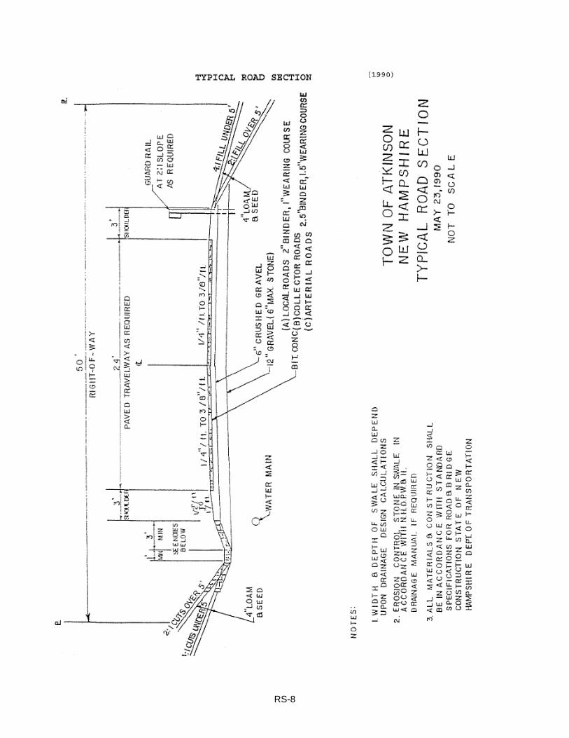
RS-8
BUILDING CODE ORDINANCE
SECTIONS BC100 - BC1200 Section 100 BUILDING INSPECTOR Section 100 APPOINTMENT 100:1 The Building Inspector shall be appointed annually by the Board of Selectmen. In the
event of death, disability, resignation or disqualification of the Building Inspector, the Selectmen shall appoint an Inspector to serve in his place. The Selectmen may, for cause and by majority vote, disqualify the Building Inspector at any time.
Section 200 DUTIES OF BUILDING INSPECTOR 200:1 The Building Inspector shall be the administrative officer of this ordinance. He shall:
a. Receive applications and fees for the erection and/or alteration of buildings and electrical wiring thereof as provided in this ordinance.
b. Make available applications in duplicate.
c. Keep complete records of his action on all applications along with duplicates of said application. The Building Inspector shall maintain a current status tabulation of building permits and site plan approvals associated with low-moderate income bedrooms/housing units.
d. Promptly inspect sites of proposed buildings or buildings to be altered and study proposed uses of said buildings.
e. Issue or deny residential permits within thirty (30) days of receipt of application, provided, however, that non-residential applications or residential applications encompassing more than 10 dwelling units shall be approved or denied within 60 days.
1) Before issuing permits for any development approved under Section
Z610 of the Zoning Ordinance, the Building Inspector shall receive written evidence of approval that housing assistance program funds are being utilized for low-moderate income dwelling units. Such written evidence shall be kept on file.
2) DELETED 1993.
f. Regularly inspect buildings during the process of erection or alterations. In new construction the following four inspections shall be made after the work has been completed:
1) Footings and foundations 2) Rough framing, plumbing, electrical wiring, and chimney erection
BC-1
3) Sewage system and waste disposal 4) Final inspection
g. Report any violations of this ordinance immediately to the Board of Selectmen. h. Take such action in the enforcement of this ordinance as may be directed by
the Selectmen. i. Accept and deposit with the Town Treasurer all fees collected by him under this
ordinance. j. Act in cooperation with fire authorities in any matter in which their duties as
prescribed by law may coincide or conflict.
Section 300 DUTIES OF THE APPLICANT 310 Any person, persons, partnership, or corporation shall obtain a permit before beginning
construction, alteration, or repairs, other than ordinary repairs, using application forms furnished by the Building Inspector.
310:1 DELETED 1991 310:2 Said application shall be accompanied by a sketch or plan of the proposed building or
alteration and by a sketch or plan showing the location of the building's foundation and its relationship in terms of distance to all lot lines. The Building Inspector may require a survey in order to assure compliance with all ordinance, subdivision, site plan, and building code regulations.
310:3 Said application shall be accompanied by a signed statement of the intended use of
the building upon completion of construction or alteration. 320 The applicant shall display prominently at the site of the construction or alteration a
card issued by the Building Inspector evidencing his permit. 330 The applicant shall make the premises accessible to the Building Inspector at
reasonable times for the performance of his duties. 340 Any person, persons, partnership or corporation intending to install a heating device,
regardless of value, shall first make application for a permit on application obtained from the Fire Inspector.
350 Before a building permit can be issued, any person, persons, partnership, or
corporation intending to dredge or fill wetland areas on the site of proposed buildings or buildings to be altered shall first receive an official permit of approval from the New Hampshire Wetlands Board and present a copy of same to the Building Inspector.
BC-2
Section 400 FEE SCHEDULE FOR BUILDING INSPECTIONS 410 The Board of Selectmen shall set the rates for the inspection of buildings. (See
Appendix for current rates.) 420 The Building Inspector and Health Officer shall be paid by the Town for issuing or
reissuing all permits. 430 The Building Inspector, Fire Inspector, and/or Health Officer may obtain expert
assistance for any inspection on a commercial and/or industrial building, and fees for this shall be assumed by the builder/ landowner.
Section 500 CERTIFICATE OF OCCUPANCY 510 The following shall be unlawful until a certificate of occupancy shall have been applied
for and issued by the Building Inspector: 510:1 Occupancy and use of a building hereafter erected, structurally altered or moved, or
any change in the use of the existing building. 510:2 No certificate of occupancy shall be issued for any special exception use of a building
unless use has been authorized by the Board of Adjustment. 510:3 Every certificate of occupancy for which a special exception use has been authorized,
or in connection with which a variance has been granted, by the Board of Adjustment shall contain a detailed statement of such special exception use or variance and of any conditions to which the same is subject.
510:4 Application for a certificate of occupancy for a new building or for an existing building
which has been altered shall be made on forms provided by the Building Inspector after the erection or alteration of such building or part thereof has been completed in conformity with the provisions of this ordinance or of any duly secured variance. Such certificate shall be issued within 10 days receipt of said application, but only if all requirements of this and all other applicable ordinances or codes are complied with.
510:5 Every certificate of occupancy shall state that the building or proposed use of a
building complies with all provisions of law and of this ordinance, of all other applicable codes or ordinances of the Town, and, if applicable, with all provisions of any variance or requirements set forth for the special exception use authorized by the Board of Adjustment.
510:6 Upon written request by the owner and upon payment of such fee as may be
prescribed from time to time, the Building Inspector shall, after inspection, issue a Certificate of Occupancy for any building or use thereof existing at the time of adoption of this ordinance, certifying the conformity of such use (including, if applicable, the number of employees) and of any structures or any lot with the provisions of this ordinance.
BC-3
Section 600 STRUCTURAL REQUIREMENTS No building shall be erected, altered, rebuilt, remodeled or substantially repaired unless in compliance with the following requirements: Section 610 GENERAL PROVISIONS 610:1 All conventionally constructed buildings shall conform to and comply with the New
Hampshire State Building Codes. (3/14/2006; 3/11/2008) 610:2 DELETED (3/11/2008) 610:3 DELETED (3/11/2008) Section 620 FIRE PROTECTION 620:1 All new construction or alterations shall conform to the National Fire Protection
Association (NFPA) Codes adopted by the Town by ballot and all associated updates to these codes as approved by the Planning Board at duly noticed Public Hearings. A list of all adopted codes and their updates are available at the Atkinson Town Hall. (1997)
620:2 Any building constructed for commercial or public use, or any building to be
reconstructed in excess of 50% and intended for any of the said uses, shall provide for non-combustible walls and partitions between its component parts. Any building of wood or other combustible material shall provide, when reconstructed, remodeled or altered, for fire stops in every combustible wall or partition, at every floor, and between floor joints at every partition.
620:3 Any building intended or designed for any public use or congregation of people shall
be constructed in accordance with the National Fire Protection Association Publication Number 101, entitled Life Safety Code.
620:4 No public garage for the storage of five or more motor vehicles, or no building having
automobile service or repair enterprises connected therewith, shall be erected, altered, enlarged, unless the building is constructed, either in its entirety or to the extent of the alteration, enlargement, or addition, of material commonly considered slow burning or non-combustible. The use of approved automatic sprinkler s may obviate this requirement.
620:5 No roof of any building may be covered or recovered in excess of twenty-five percent
(25%) unless non-combustible or fire-resistant materials are used. 620:6 Heating installations:
a. Chimneys and fireplaces constructed as parts of a new or existing building or altered within a new or existing building, shall be constructed in accordance with the Atkinson Fire Department Pamphlet Number 100 and its listed references.
BC-4
b. Oil burning furnaces shall be installed in accordance with the Atkinson Fire Department Pamphlet Number 100 and its listed references.
c. Gas burning furnaces shall be installed in accordance with the National Fire
Protection Association Publication Number 54 which the Atkinson Fire Department has adopted as its own.
d. Wood burning stoves shall be installed in accordance with the Atkinson Fire
Department Pamphlet Number 100 and its listed references.
620:7 No wallpaper or other combustible material shall be laid over any thimble hole in any chimney.
620:8 No smoke pipes shall be installed or erected which pass into or through partitions or
walls or combustible material except when guarded by a double collar or metal with air space of at least five inches, or by at least five inches of brick or other non-combustible material.
620:9 Fire alarms
a. Commercial buildings, industrial buildings, commercial/industrial buildings, and buildings used to accommodate public assembly of more than fifty (50) persons shall have fire alarm installations which:
1) Meet the alarm system standards for hard wiring as required in NFPA
13, 72, 75, 101 and 1221. 2) Are connected to a central alarm monitoring service with around-the-clock coverage (24 hours/day).
620.10 Sprinkler systems
a. Residential buildings.
1) DELETED 1994
b. Commercial or industrial buildings.
1) All commercial or industrial facilities shall have a sprinkler installation
which is in accordance with NFPA 13 standards and which consists of the following:
(a) A dry sprinkler system. "Dry sprinkler system" shall mean a
system employing automatic sprinklers attached to a piping system containing air under atmospheric or higher pressures, with loss of pressure from the opening of a sprinkler or detection of a fire condition allowing fire-suppression agents to be injected into the piping system and out the opened sprinkler.
BC-5
(b) Exterior connections to the dry sprinkler system which meet the approval of the Atkinson Fire Department for adequacy and accessibility and are equipped to connect with a public water system in the event it becomes available.
2) Storage buildings may or may not be required to have sprinkler system
installations. Determination shall be made by the Atkinson Fire Department.
c. Places of public assembly
1) Sprinklers shall be installed in all buildings used to accommodate public
assembly of more than fifty (50) persons. The Atkinson Fire Department shall determine the type of sprinkler system required by taking into account the largest potential number of persons who can safely assemble within the structure at one time and the relationship of that number to NFPA 13 and 13-D standards as applicable.
d. Occupancy and life-safety classifications
1) Buildings which are classified as occupancy hazards or life safety
concerns, as determined by NFPA Codes 101 and 1231, shall have a fully working fire suppression system on site, with extinguishing agent being either chemical compounds, CO2, halon, water, or any combination thereof, as required by the Atkinson Fire Department. (1988)
620:11 Attached private garage
a. Private garages attached to any building or portion of a building used for living purposes in Use Groups R-1, R-2, R-3, R-4, or I-1 shall be completely separated from any adjacent interior spaces, including the attic, by walls and/or partitions constructed of not less than one-hour fire resistance rating.
b. Door protectives shall be installed in all doorways constructed in fire-rated walls/partitions as specified in subparagraph "a" above and leading to any interior space used for living purposes. Door protectives may be made of 1 3/4" (one and 3/4 inch) solid core wood doors or equivalent. If 1 3/4" solid core wood is used, such door shall be solid from top to bottom with no panels cut into the door on either side. Any other type of fire door must be labeled with the appropriate one-hour fire rating label affixed.
c. Door protectives installed in remote areas may require self-closing capability if deemed necessary by the Fire Inspector.
d. Private garages having sprinkler installations conforming to NFPA standards
shall be exempt from the requirements of subparagraphs "a" and "b" above. (1989)
BC-6
Section 630 ELECTRICAL WIRING 630:1 DELETED (3/11/2008) Section 640 FOUNDATIONS 640:1 DELETED 1993. 640:2 DELETED 2003. Section 650 FLOOR AREA 650:1 Every building to be used as a residence shall have a minimum ground floor area of
eight hundred (800) square feet outside measurement, and a floor area, exclusive of cellar, of six hundred (600) square feet for each additional story.
Section 660 EXTERIOR 660:1 DELETED 1991. Section 670 PLUMBING 670:1 All dwelling and all commercial or public buildings shall be connected to the public
sewer system when available. When a public system is not available, a private sewage disposal system is required. The type, size, and construction of all septic tanks and drainage fields shall be approved by the town Health Officer.
670:2 DELETED 1993. 670:3 DELETED 1993. 670:4 DELETED 1993. Section 680 SWIMMING POOLS 680:1 A permit shall be obtained from the Building Inspector before installation of an
inground pool, above-ground pool, or storable pool of 30 or more inches deep.
a. DELETED 2003. b. DELETED 2003. c. DELETED 2003.
BC-7
Section 700 EXEMPTIONS 700:1 The construction of small accessory buildings not used for living purposes, together
with minor alterations, repairs and general upkeep of existing buildings shall be exempt from the provisions of this ordinance.
Section 800 AMENDMENT 800:1 This ordinance may be amended by a majority vote of any legal town meeting when
such amendment is published in the warrant calling for the meeting, except as allowed by RSA 674:52 VI. (1993)
Section 900 ENFORCEMENT 900:1 Any person, persons, firm or corporation violating any of the provisions of this
ordinance shall be subject to Penalties and Remedies pursuant to RSA 676:17, as amended. (3/10/2009)
Section 1000 EFFECTIVE DATE 1000:1 This ordinance shall take effect upon its passage. Section 1100 SAVING CLAUSE 1100:1 If any section, clause, provisions, portion or phrase of this ordinance shall be held to
be invalid or unconstitutional by any court of competent authority, such holding shall not affect, impair or invalidate any other section, clause, provision, portion or phrase of this ordinance.
Section 1200 REPEAL OF PRIOR BUILDING CODE ORDINANCE 1200:1 Any and all building regulations heretofore enacted by the Town of Atkinson are
hereby repealed. (1959) Section 1300 Under the provisions of RSA 674:51 & 674:34, the Zoning Board of Appeals shall act as the Atkinson Building Code of Appeals. (2004)
__________________________
BC-8
WATER SUPPLY AND SEWAGE DISPOSAL REGULATIONS
SECTIONS WS100 - WS300 A regulation governing the construction, alteration and maintenance of wells and subsurface wastewater disposal systems pursuant to RSA 147:1 Office of the Selectmen Section 100 PURPOSE. The Board of Health of the Town of Atkinson, New Hampshire hereby adopts this regulation in accordance with RSA 147:1 in order to protect the groundwater supplies of the Town from contamination and to provide for the safe disposal of wastewater and other putrescible materials. Section 200 DEFINITIONS. As used in this regulation, the following terms (appearing in alphabetical order) shall have the following meaning unless the context clearly indicates otherwise. A1 Absorption field. A system which distributes wastewater by the use of pipes over an
area of soil from which the wastewater percolates downward through the soil. A2 Aerobic tank. A tank that provides for the aeration of the wastewater and subsequent
settling of solids. B1 Bedrock. The solid rock that underlies soil or is exposed at the surface. It is often
referred to locally as ledge. C1 Commercial. As defined by the Town of Atkinson Zoning Ordinance. C2 Community water system. A public water system which serves at least 15 service
connections used by year-round residents or regularly serves at least 25 year-round residents.
D1 Domestic wastewater. Wastewater that originates from residential uses such as toilet, kitchen, and wash water wastes. Commercial and industrial wastewater that has similar characteristics as wastewater from residential uses shall be considered domestic wastewater.
D2 Dry wells. (See "Seepage pits".) E1 Designer. Any permitted septic designer from N.H. who, by experience and capability,
demonstrates the ability to perform all necessary tests to collect and properly disseminate all technical data and to design acceptable waste disposal systems as required by the provisions of this chapter including all other pertinent state regulations.
F1 Failure of subsurface wastewater disposal systems. When a system no longer functions effectively, creating health hazards and/or nuisance conditions, as demonstrated by backed-up toilets, surfacing waste-water, or by substantial pollutant movement away from the system.
G1 Grey water. Domestic wastewater that contains wash, laundry, and/or kitchen wastewater, but that does not contain any toilet wastes, i.e., feces or urine.
H1 Hard pan. A compact soil layer high in silt and very fine sand and generally low in clay. It is quite dense and has very little pore space. The hardpan retards the downward movement of water and roots. Permeability is moderately slow to slow.
I1 Inspector. The individual authorized by the Board of Selectmen to perform all administrative and inspection responsibilities of this chapter.
WS-1

I2 Internal elimination system. Toilets from which no wastewater is discharged to a sewer or subsurface wastewater disposal system. Internal elimination systems include composting or incinerator toilets.
N1 Non-community water system. A public water system that is not a community water system.
P1 Public water system. A system for the provision to the public of piped water for human consumption, if such system has at least 15 service connections or regularly serves and average of at least 25 individuals daily at least 60 days out of the year. A public water system is either a "community water system" or a "non-community water system."
R1 Raised absorption system. An absorption system which must be raised (built upon fill) in order to meet minimum distance requirements to groundwater, ledge, or impervious layers.
R2 Residential. As defined by the Town of Atkinson Zoning Ordinance. S1 Seepage pits. Covered underground chambers with open, jointed lining, generally
surrounded with crushed stone from which wastewater seeps into the surrounding soil. S2 Septic tank. A container through which wastewater passes before reaching the
absorption field, the purpose of which is to remove solids, greases, and scum and allow anaerobic processes to occur so that the waste-water does not clog the absorption field.
S3 Soil type. As defined by the National Cooperative Soil Survey. S4 Soil type determination. The soil type as determined by a qualified soil scientist as
designated by the Rockingham County Conservation District using the standards of the National Cooperative Soil Survey.
S5 Subsurface wastewater disposal system. A system which treats and disposes of wastewater by use of a septic tank, distribution box, and absorption field, excluding the use of seepage pits, dry wells and aerobic tanks.
Section 300 WASTEWATER DISPOSAL SYSTEMS Section 310 GENERAL REGULATIONS 310:1 No building permit for the construction of any building from which sewage or waste will
discharge within the Town of Atkinson, NH shall be issued without prior approval of plans and specifications by the Town of Atkinson and the New Hampshire Water Supply and Pollution Control Commission.
310:2 No waste disposal system shall be constructed, repaired, or altered within the Town of
Atkinson without prior approval of plans and specifications by the Town of Atkinson and the New Hampshire Water Supply and Pollution Control Commission.
310:3 No waste disposal system within the Town of Atkinson shall be replaced within the
confines of its original site without prior approval of plans and specifications by the Town of Atkinson.
310:4 Responsibility for accuracy of technical data and compliance with design criteria.
a. The designer shall be responsible for the accuracy of all technical data and compliance with all design criteria; in the event of any question or dispute, the W.S.P.C.D. shall make the final determination of the accuracy of such data.
WS-2
310:5 Design construction and capacity requirements for sewerage disposal system.
a. The system shall be designed, constructed and satisfy all requirements set forth in pertinent State of New Hampshire WSPCD Regulations as they exist, may be established or may be amended. These regulations currently include but may not in the future be limited and referred to as Chapter Env Ws 1000 - Subdivision and Individual Sewage Disposal System Design Rules.
b. The system shall be designed, constructed and satisfy all additional
requirements set forth in these Town of Atkinson Section 300 requirements that are more stringent than State regulations.
310:6 Additional local design, construction and capacity requirements for sewage disposal
systems.
a. Filter Fabric - An effective barrier of a minimum of 5 oz./square yard of non-woven, polyester filter fabric shall be placed over the filter material to prevent infiltration of the backfill.
b. Dry Wells - Dry wells shall be prohibited for use in new or replacement systems
for the disposal of domestic or commercial sanitary waste. Laundry washing machines shall be construed as discharging sanitary waste.
c. Holding Tanks - Holding Tanks shall be prohibited in all cases of new building
construction and expanded use.
1) Holding tanks may be permitted as a replacement system in cases of failure of an original system, but only when no other conventional system can be properly constructed.
2) The minimum size of a holding tank shall be 2500 gallons. 3) A suitable audio/visual alarm system shall be installed. The alarm shall
warn the residents when the liquid level in the holding tank reaches 80% of the tank's capacity. The alarm control panel shall be located within the living quarters of the home which it serves. The panel shall be unobstructed and remain within full view at all times.
4) All joints and concrete surfaces shall be properly sealed to maintain a 100% leak proof condition.
5) When installed, but prior to backfilling, the holding tank shall be filled with water twenty-four (24) hours prior to inspection by the Town Health Officer or his delegated representative. The alarm system shall be inspected at this time.
6) Following inspection and approval by the Town, the homeowner must register the system with the Town of Atkinson Health Department.
d. Percolation Test -
1) Percolation tests must be witnessed by an agent of the Town of
Atkinson. 2) A minimum notice of (24) hours shall be given prior to the start of work
and request for inspections.
WS-3
e. Pipe Specifications -
1) Pipe used for lines between the septic tank and the absorption field, shall comply with the PVC SDR (standard dimension ratio) #35 or equal. Pipes used under driveways or other areas subject to heavy loads shall be installed to withstand the imposed loads of H20 or equal.
2) Pipe used in the absorption field shall be perforated PVC pipe Schedule #35 or equal. All joints shall be tight and all ends connected.
f. Public Surface Water Supply -
1) The distance from a septic tank to a public surface water supply shall be
75'. 2) The distance from an absorption field or bed to a public water supply
shall be (reference Zoning Regulation Sections 410:8 & 420:5).
g. Seasonal Conversions -
1) All seasonal conversions to year-round use will be required to have a septic system design approved by the New Hampshire Water Supply and Pollution Control Division. There will be no exceptions.
310:7 Construction requirements for Wells -
a. The well shall be designed, constructed and satisfy all requirements set forth in pertinent State of New Hampshire WSPCD Regulations as they exist, may be established or may be amended in the future.
b. These NH WSPCD include but are not limited to:
1) New Hampshire Water Well Board Chapter We100-We-800 2) Well Siting Criteria Env-Ws378 3) Well Siting Criteria Env-Ws372 4) Any other applicable state and/or local requirements.
310:8 Compliance: Permits; Fees; Inspections
a. Wells -
1) No well or sewage disposal system shall be installed, altered, maintained in the Town of Atkinson unless it is in conformity with these regulations as well as the pertinent regulations of the State of New Hampshire, as may exist, be established or amended.
2) A permit for the installation of wells and/or alterations to sewage disposal system must be obtained from the local Health Officer prior to the commencement of any work on a system.
WS-4
b. Septic Systems -
1) A fee made payable to the Town of Atkinson shall accompany every application for a permit for the installation and/or alteration of a sewage disposal system. The applicant must also submit four sets of plans for the requested system permit (three for Water Supply and Pollution Control Division and one for the Town of Atkinson). Plans must be submitted for Town of Atkinson review prior to submission to WSPCD.
2) All local waivers if necessary, must be obtained prior to submitting the plans to WSPCD for approval.
3) The Town will require inspections during the course of work at the following intervals:
c. Bed bottom. d. Under course filter material. e. Final inspection and filter fabric in place before cover and grade. f. Loam & Seed
1) Minimum notice of twenty-four (24) hours shall be given prior to the
state of work and to request inspections of any listed stages.
g. Wells -
1) A permit must be obtained before any drinking well is installed, and must be accompanied by a diagram of the location. Diagram must show existing or proposed subsurface disposal system on that and adjacent lots. A fee shall accompany the application.
2) In a new construction, prior to issuance of a Certificate of Occupancy, a certified testing lab shall doe a well water analysis in accordance with the Federal Safe Drinking Water Act.
3) Wells currently in operation that may required replacement shall be tested according to the above.
310:9 Responsibilities -
a. NH Licensed Designer of Subsurface Disposal Systems -
1) responsible for the collection of all necessary technical data relative to any proposed system or alteration,
2) for the design and layout of said systems; 3) for the submitting of all prints and applications as required by the State
and Local authorities.
(a) obtain copies of applicable regulations from NHWDPCD and remain appraised of regulation changes.
WS-5
b. Property Owner -
1) to provide to the installer all approved plans and specifications necessary for the compliance of State and local requirements.
2) no disposal of system leach fields will be allowed by stockpiling above ground or by the subsurface disposal below the high water table.
c. Installer – NH Licensed Installer of Subsurface Disposal System -
1) to secure an installation permit; and 2) to construct the system or alter any existing system in accordance with
all regulations and laws; and 3) to notify the inspector for all inspections before backfilling.
d. Agent(s) -
1) to maintain files of all approvals issued by WSPCD; 2) to issue permits in accordance with the regulations; 3) to perform any inspections as may be deemed necessary in accordance
with same; 4) to return, within 10 working days, a copy of the application receipt; 5) to perform any other duties relative to individual waste disposal systems
as specified by the Board of Health; 6) to provide copies of Section WS100-300 to residents upon request; and 7) to provide a reference copy of State regulations in the Building
Department. Copies of State Regulations will not be available locally for individual use; must be obtained from NHWSPCD.
310:10 Licenses – a. All designers and installers must maintain current State of New Hampshire
licensure. 310:11 Fines and Penalties – a. A penalty of one hundred ($100) dollars per day shall be imposed on the
applicant for failure to comply with these regulations. Each day of continuing failure to comply, after written notice of the violation(s) shall constitute a new offense. Repeated violations of regulations may be cause for the agent(s) to refuse to issue further permits for a period of one (1) year.
Approved and adopted by Board of Health/Selectmen 10/25/93
WS-6
APPENDIX
EXPLANATORY NOTE Information which is the result of legal enactment will carry a note indicating the date on which the contents became effective. All other information contained in this section provides samples of administrative procedures currently being used to implement regulations found in the main body of this book. For full knowledge of regulations in order to comply with municipal requirements, the reader must refer to appropriate chapters in their entirety.
A-1
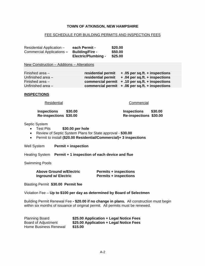
TOWN OF ATKINSON, NEW HAMPSHIRE
FEE SCHEDULE FOR BUILDING PERMITS AND INSPECTION FEES Residential Application – each Permit - $20.00 Commercial Applications – Building/Fire - $50.00 Electric/Plumbing - $25.00 New Construction – Additions – Alterations Finished area – residential permit + .05 per sq.ft. + inspections Unfinished area – residential permit + .04 per sq.ft. + inspections Finished area – commercial permit + .10 per sq.ft. + inspections Unfinished area – commercial permit + .06 per sq.ft. + inspections INSPECTIONS Residential Commercial Inspections $30.00 Inspections $30.00 Re-inspections $30.00 Re-inspections $30.00 Septic System
• Test Pits $30.00 per hole • Review of Septic System Plans for State approval - $30.00 • Permit to install ($20.00 Residential/Commercial)+ 3 inspections
Well System Permit + inspection Heating System Permit + 1 inspection of each device and flue Swimming Pools
Above Ground w/Electric Permits + inspections Inground w/ Electric Permits + inspections Blasting Permit $30.00 Permit fee Violation Fee – Up to $100 per day as determined by Board of Selectmen Building Permit Renewal Fee - $20.00 if no change in plans. All construction must begin within six months of issuance of original permit. All permits must be renewed. Planning Board $25.00 Application + Legal Notice Fees Board of Adjustment $25.00 Application + Legal Notice Fees Home Business Renewal $15.00
A-2

Violation Fee – Up to $100 per day as determined by the Board of Selectmen; Office of the Board of Selectmen: Effective – August 16, 2004 Office of the Board of Selectmen: Effective – August 2004
A-3
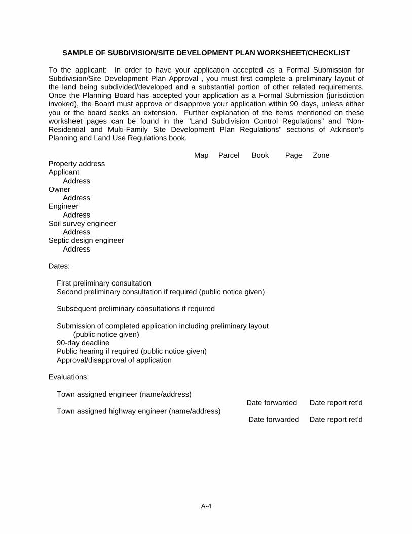
SAMPLE OF SUBDIVISION/SITE DEVELOPMENT PLAN WORKSHEET/CHECKLIST To the applicant: In order to have your application accepted as a Formal Submission for Subdivision/Site Development Plan Approval , you must first complete a preliminary layout of the land being subdivided/developed and a substantial portion of other related requirements. Once the Planning Board has accepted your application as a Formal Submission (jurisdiction invoked), the Board must approve or disapprove your application within 90 days, unless either you or the board seeks an extension. Further explanation of the items mentioned on these worksheet pages can be found in the "Land Subdivision Control Regulations" and "Non-Residential and Multi-Family Site Development Plan Regulations" sections of Atkinson's Planning and Land Use Regulations book. Map Parcel Book Page Zone Property address Applicant Address Owner Address Engineer Address Soil survey engineer Address Septic design engineer Address Dates: First preliminary consultation Second preliminary consultation if required (public notice given) Subsequent preliminary consultations if required Submission of completed application including preliminary layout (public notice given) 90-day deadline Public hearing if required (public notice given) Approval/disapproval of application Evaluations: Town assigned engineer (name/address) Date forwarded Date report ret'd Town assigned highway engineer (name/address) Date forwarded Date report ret'd
A-4
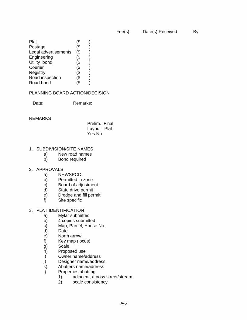
Fee(s) Date(s) Received By Plat ($ ) Postage ($ ) Legal advertisements ($ ) Engineering ($ ) Utility bond ($ ) Courier ($ ) Registry ($ ) Road inspection ($ ) Road bond ($ ) PLANNING BOARD ACTION/DECISION Date: Remarks: REMARKS Prelim. Final Layout Plat Yes No 1. SUBDIVISION/SITE NAMES a) New road names b) Bond required 2. APPROVALS a) NHWSPCC b) Permitted in zone c) Board of adjustment d) State drive permit e) Dredge and fill permit f) Site specific 3. PLAT IDENTIFICATION a) Mylar submitted b) 4 copies submitted c) Map, Parcel, House No. d) Date e) North arrow f) Key map (locus) g) Scale h) Proposed use i) Owner name/address j) Designer name/address k) Abutters name/address l) Properties abutting 1) adjacent, across street/stream 2) scale consistency
A-5
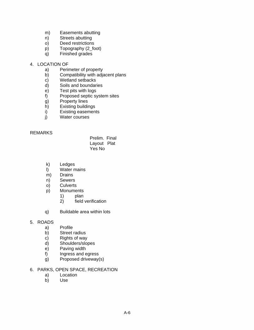
m) Easements abutting n) Streets abutting o) Deed restrictions p) Topography (2_foot) q) Finished grades 4. LOCATION OF a) Perimeter of property b) Compatibility with adjacent plans c) Wetland setbacks d) Soils and boundaries e) Test pits with logs f) Proposed septic system sites g) Property lines h) Existing buildings i) Existing easements j) Water courses REMARKS Prelim. Final Layout Plat Yes No
k) Ledges l) Water mains m) Drains n) Sewers o) Culverts p) Monuments 1) plan
2) field verification q) Buildable area within lots
5. ROADS a) Profile b) Street radius c) Rights of way d) Shoulders/slopes e) Paving width f) Ingress and egress g) Proposed driveway(s) 6. PARKS, OPEN SPACE, RECREATION a) Location b) Use
A-6
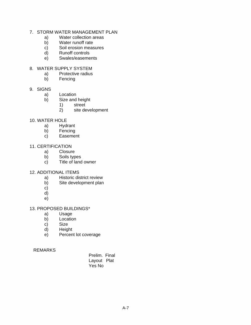
7. STORM WATER MANAGEMENT PLAN a) Water collection areas b) Water runoff rate c) Soil erosion measures d) Runoff controls e) Swales/easements 8. WATER SUPPLY SYSTEM a) Protective radius b) Fencing 9. SIGNS a) Location b) Size and height 1) street
2) site development 10. WATER HOLE a) Hydrant b) Fencing c) Easement 11. CERTIFICATION a) Closure b) Soils types c) Title of land owner 12. ADDITIONAL ITEMS a) Historic district review b) Site development plan c) d) e) 13. PROPOSED BUILDINGS* a) Usage b) Location c) Size d) Height e) Percent lot coverage REMARKS Prelim. Final Layout Plat Yes No
A-7
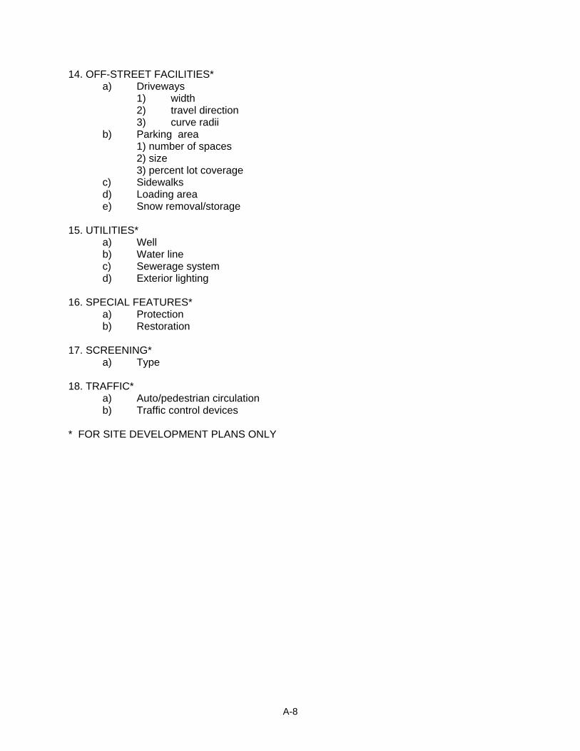
14. OFF-STREET FACILITIES* a) Driveways 1) width 2) travel direction 3) curve radii b) Parking area 1) number of spaces 2) size 3) percent lot coverage c) Sidewalks d) Loading area e) Snow removal/storage 15. UTILITIES* a) Well b) Water line c) Sewerage system d) Exterior lighting 16. SPECIAL FEATURES* a) Protection b) Restoration 17. SCREENING* a) Type 18. TRAFFIC* a) Auto/pedestrian circulation b) Traffic control devices * FOR SITE DEVELOPMENT PLANS ONLY
A-8
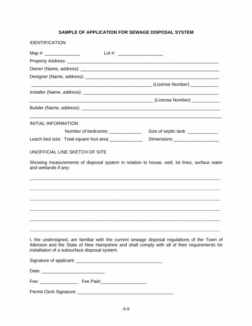
SAMPLE OF APPLICATION FOR SEWAGE DISPOSAL SYSTEM IDENTIFICATION Map #: ______________ Lot #: __________________
Property Address: ____________________________________________________________
Owner (Name, address): _______________________________________________________
Designer (Name, address): _____________________________________________________
________________________________________________ (License Number) ___________
Installer (Name, address): ______________________________________________________
_________________________________________________ (License Number) ___________
Builder (Name, address): _______________________________________________________
____________________________________________________________________________
INITIAL INFORMATION
Number of bedrooms _____________ Size of septic tank ____________
Leach bed size: Total square foot area _____________ Dimensions __________________
UNOFFICIAL LINE SKETCH OF SITE Showing measurements of disposal system in relation to house, well, lot lines, surface water and wetlands if any: ______________________________________________________________________ ______________________________________________________________________ ______________________________________________________________________ ______________________________________________________________________ ______________________________________________________________________ ______________________________________________________________________ I, the undersigned, am familiar with the current sewage disposal regulations of the Town of Atkinson and the State of New Hampshire and shall comply with all of their requirements for installation of a subsurface disposal system. Signature of applicant: __________________________________ Date: _________________________ Fee: _______________ Fee Paid:__________________ Permit Clerk Signature: ______________________________________
A-9
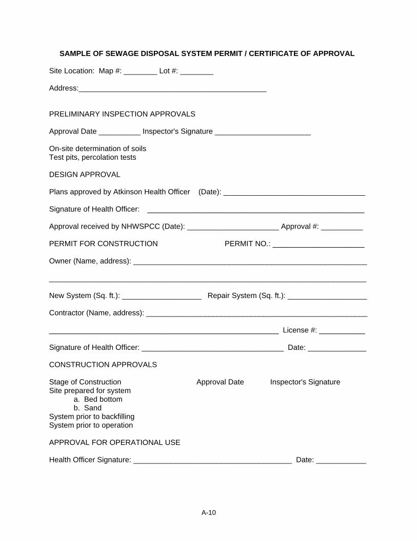
SAMPLE OF SEWAGE DISPOSAL SYSTEM PERMIT / CERTIFICATE OF APPROVAL Site Location: Map #: ________ Lot #: ________ Address:_____________________________________________ PRELIMINARY INSPECTION APPROVALS Approval Date __________ Inspector's Signature _______________________ On-site determination of soils Test pits, percolation tests DESIGN APPROVAL Plans approved by Atkinson Health Officer (Date): __________________________________ Signature of Health Officer: ____________________________________________________ Approval received by NHWSPCC (Date): ______________________ Approval #: __________ PERMIT FOR CONSTRUCTION PERMIT NO.: ______________________ Owner (Name, address): ________________________________________________________ ____________________________________________________________________________ New System (Sq. ft.): ___________________ Repair System (Sq. ft.): ___________________ Contractor (Name, address): _____________________________________________________ _______________________________________________________ License #: ___________ Signature of Health Officer: __________________________________ Date: ______________ CONSTRUCTION APPROVALS Stage of Construction Approval Date Inspector's Signature Site prepared for system a. Bed bottom b. Sand System prior to backfilling System prior to operation APPROVAL FOR OPERATIONAL USE Health Officer Signature: ______________________________________ Date: ____________
A-10
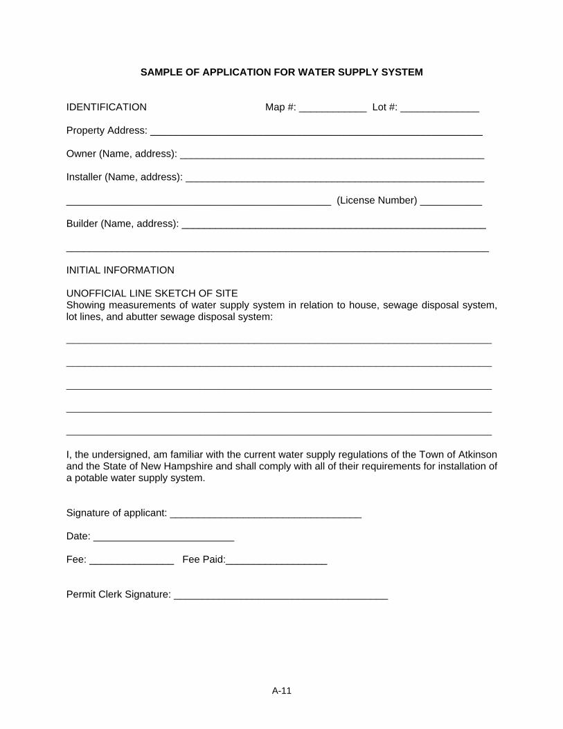
SAMPLE OF APPLICATION FOR WATER SUPPLY SYSTEM IDENTIFICATION Map #: ____________ Lot #: ______________ Property Address: ___________________________________________________________ Owner (Name, address): ______________________________________________________ Installer (Name, address): _____________________________________________________ _______________________________________________ (License Number) ___________ Builder (Name, address): ______________________________________________________ ___________________________________________________________________________ INITIAL INFORMATION UNOFFICIAL LINE SKETCH OF SITE Showing measurements of water supply system in relation to house, sewage disposal system, lot lines, and abutter sewage disposal system: ______________________________________________________________________ ______________________________________________________________________ ______________________________________________________________________ ______________________________________________________________________ ______________________________________________________________________ I, the undersigned, am familiar with the current water supply regulations of the Town of Atkinson and the State of New Hampshire and shall comply with all of their requirements for installation of a potable water supply system. Signature of applicant: __________________________________ Date: _________________________ Fee: _______________ Fee Paid:__________________ Permit Clerk Signature: ______________________________________
A-11
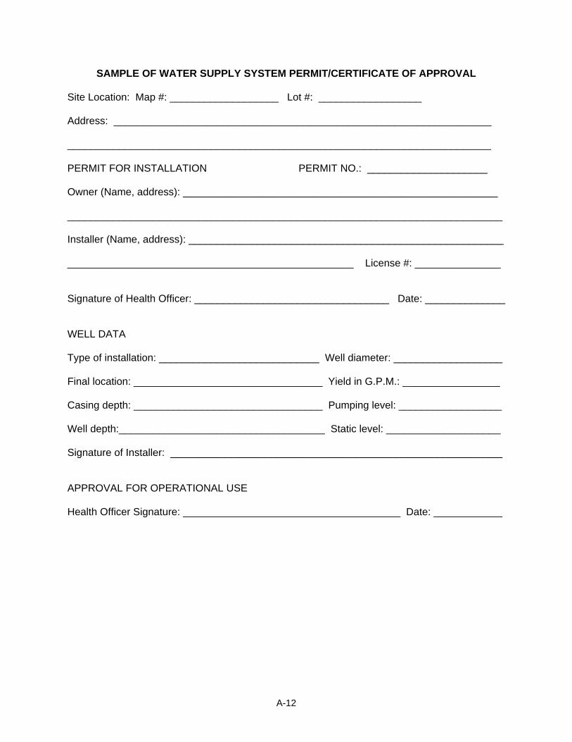
SAMPLE OF WATER SUPPLY SYSTEM PERMIT/CERTIFICATE OF APPROVAL Site Location: Map #: ___________________ Lot #: __________________ Address: __________________________________________________________________ __________________________________________________________________________ PERMIT FOR INSTALLATION PERMIT NO.: _____________________ Owner (Name, address): _______________________________________________________ ____________________________________________________________________________ Installer (Name, address): _______________________________________________________ __________________________________________________ License #: _______________ Signature of Health Officer: __________________________________ Date: ______________ WELL DATA Type of installation: ____________________________ Well diameter: ___________________ Final location: _________________________________ Yield in G.P.M.: _________________ Casing depth: _________________________________ Pumping level: __________________ Well depth:____________________________________ Static level: ____________________ Signature of Installer: __________________________________________________________ APPROVAL FOR OPERATIONAL USE Health Officer Signature: ______________________________________ Date: ____________
A-12
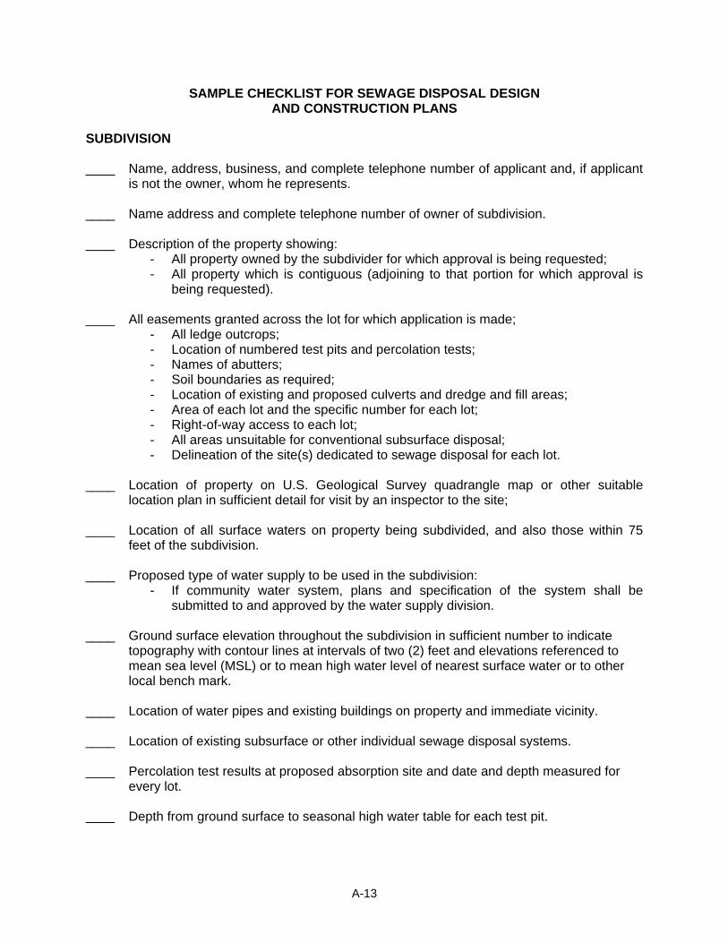
SAMPLE CHECKLIST FOR SEWAGE DISPOSAL DESIGN AND CONSTRUCTION PLANS
SUBDIVISION ____ Name, address, business, and complete telephone number of applicant and, if applicant
is not the owner, whom he represents. ____ Name address and complete telephone number of owner of subdivision. ____ Description of the property showing:
- All property owned by the subdivider for which approval is being requested; - All property which is contiguous (adjoining to that portion for which approval is
being requested). ____ All easements granted across the lot for which application is made;
- All ledge outcrops; - Location of numbered test pits and percolation tests; - Names of abutters; - Soil boundaries as required; - Location of existing and proposed culverts and dredge and fill areas; - Area of each lot and the specific number for each lot; - Right-of-way access to each lot; - All areas unsuitable for conventional subsurface disposal; - Delineation of the site(s) dedicated to sewage disposal for each lot.
____ Location of property on U.S. Geological Survey quadrangle map or other suitable
location plan in sufficient detail for visit by an inspector to the site; ____ Location of all surface waters on property being subdivided, and also those within 75
feet of the subdivision. ____ Proposed type of water supply to be used in the subdivision:
- If community water system, plans and specification of the system shall be submitted to and approved by the water supply division.
____ Ground surface elevation throughout the subdivision in sufficient number to indicate
topography with contour lines at intervals of two (2) feet and elevations referenced to mean sea level (MSL) or to mean high water level of nearest surface water or to other local bench mark.
____ Location of water pipes and existing buildings on property and immediate vicinity. ____ Location of existing subsurface or other individual sewage disposal systems. ____ Percolation test results at proposed absorption site and date and depth measured for
every lot. Depth from ground surface to seasonal high water table for each test pit.
A-13

____ Depth from ground surface to impermeable substratum and a description of each soil layer for each test pit.
____ Data for all pits dug. ____ Additional data:
A-14
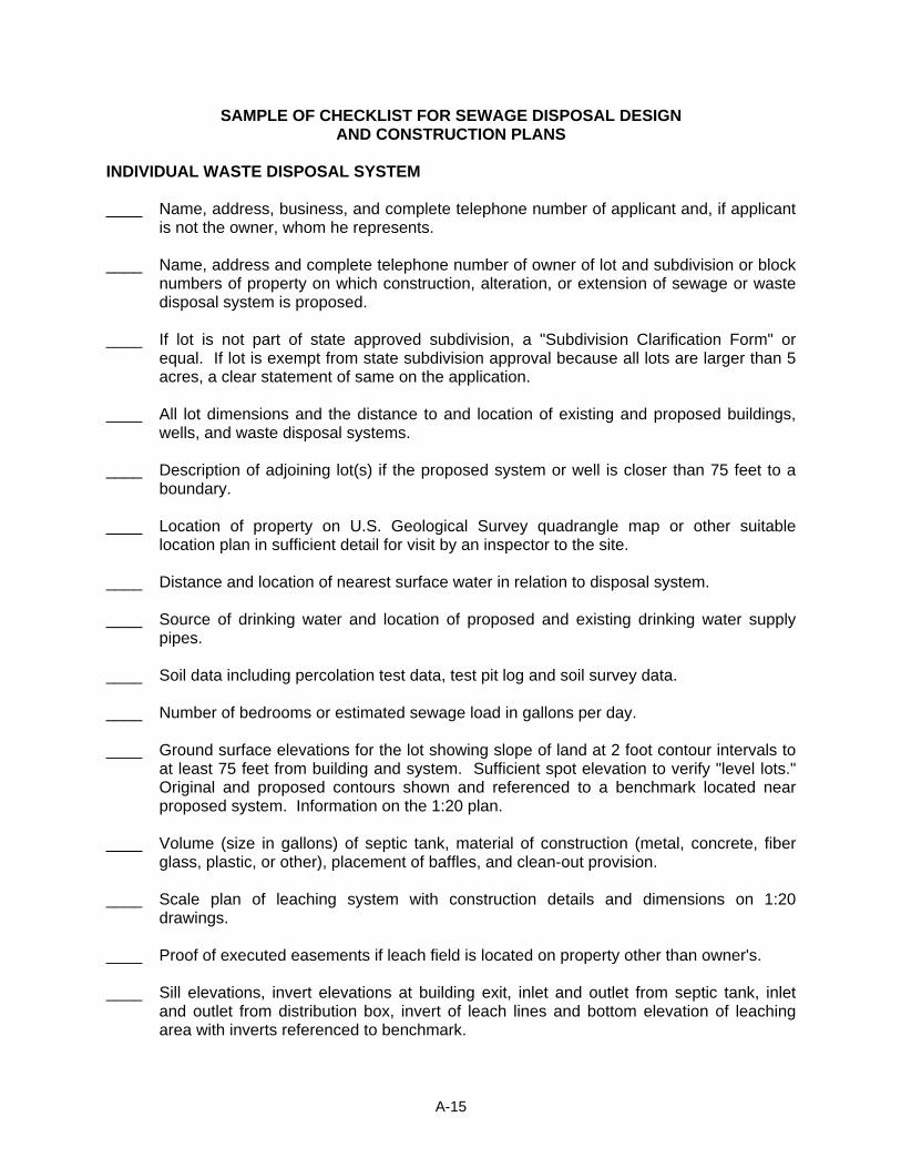
SAMPLE OF CHECKLIST FOR SEWAGE DISPOSAL DESIGN AND CONSTRUCTION PLANS
INDIVIDUAL WASTE DISPOSAL SYSTEM ____ Name, address, business, and complete telephone number of applicant and, if applicant
is not the owner, whom he represents. ____ Name, address and complete telephone number of owner of lot and subdivision or block
numbers of property on which construction, alteration, or extension of sewage or waste disposal system is proposed.
____ If lot is not part of state approved subdivision, a "Subdivision Clarification Form" or
equal. If lot is exempt from state subdivision approval because all lots are larger than 5 acres, a clear statement of same on the application.
____ All lot dimensions and the distance to and location of existing and proposed buildings,
wells, and waste disposal systems. ____ Description of adjoining lot(s) if the proposed system or well is closer than 75 feet to a
boundary. ____ Location of property on U.S. Geological Survey quadrangle map or other suitable
location plan in sufficient detail for visit by an inspector to the site. ____ Distance and location of nearest surface water in relation to disposal system. ____ Source of drinking water and location of proposed and existing drinking water supply
pipes. ____ Soil data including percolation test data, test pit log and soil survey data. ____ Number of bedrooms or estimated sewage load in gallons per day. ____ Ground surface elevations for the lot showing slope of land at 2 foot contour intervals to
at least 75 feet from building and system. Sufficient spot elevation to verify "level lots." Original and proposed contours shown and referenced to a benchmark located near proposed system. Information on the 1:20 plan.
____ Volume (size in gallons) of septic tank, material of construction (metal, concrete, fiber
glass, plastic, or other), placement of baffles, and clean-out provision. ____ Scale plan of leaching system with construction details and dimensions on 1:20
drawings. ____ Proof of executed easements if leach field is located on property other than owner's. ____ Sill elevations, invert elevations at building exit, inlet and outlet from septic tank, inlet
and outlet from distribution box, invert of leach lines and bottom elevation of leaching area with inverts referenced to benchmark.
A-15
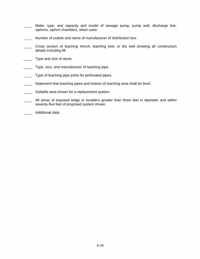
____ Make, type, and capacity and model of sewage pump, pump well, discharge line, siphons, siphon chambers, when used.
____ Number of outlets and name of manufacturer of distribution box. ____ Cross section of leaching trench, leaching bed, or dry well showing all construction
details including fill. ____ Type and size of stone. ____ Type, size, and manufacturer of leaching pipe. ____ Type of leaching pipe joints for perforated pipes. ____ Statement that leaching pipes and bottom of leaching area shall be level. ____ Suitable area shown for a replacement system. ____ All areas of exposed ledge or boulders greater than three feet in diameter and within
seventy-five feet of proposed system shown. ____ Additional data:
A-16
INDEX
Absorption field .............................................................................................................................1 Abutter
Abutters.................................................................................................................5, 7, 8, 13, 14 Accessory Building........................................................................................................................3 Accessory Living Unit............................................................................................................31, 32 Adequacy Of Land ........................................................................................................................3 Aerobic Tank.................................................................................................................................1 Agricultural ....................................................................................................................................3 Agricultural Uses.........................................................................................................................17 Alternative Facilities And Technologies ........................................................................................3 Amendments
rural cluster .............................................................................................................................49 Amendments
Site Development....................................................................................................................21 Subdivision..............................................................................................................................15 Zoning .....................................................................................................................................67
Animals Keeping Of ..............................................................................................................................28
Application Building Permit..........................................................................................................................3 Non-Conforming Uses ............................................................................................................66 Site Development....................................................................................................................16 Subdivision................................................................................................................................8 Zoning .......................................................................................................................................2
Application Sewage Disposal ......................................................................................................................9 Water Supply System .............................................................................................................11
Applications Subdivision................................................................................................................................9
Approval Sample Worksheet....................................................................................................................4 Subdivision................................................................................................................................8
Approval final plats.................................................................................................................................11 plat and data ...........................................................................................................................19 site development.......................................................................................................................5
Association American State Highway and Transportation Officials..............................................................6 National Fire Protection Codes .................................................................................................4
Bedroom .......................................................................................................................................3 Board of Adjustment
Certificate of Occupancy...........................................................................................................3 Frontage..................................................................................................................................36 Home occupations ..................................................................................................................28 Natural deposits ......................................................................................................................27 Nonconforming uses ...............................................................................................................62
Index
Non-residential signs ..............................................................................................................34 Permits....................................................................................................................................29 Powers ..............................................................................................................................67, 21 Special exception....................................................................................................................15 Water supply and sewage.......................................................................................................63 Zoning boundaries ....................................................................................................................2
Bond......................................................................................................................28, 49, 3, 5, 1, 5 Bond..........................................................................................................................................5, 6 Buffer Zone .................................................................................................................................18 Building Inspector ...................................................................................................................4, 33
Building Code............................................................................................................................1 Building Permits ........................................................................................................................4 Duties........................................................................................................................................1 Enforcement............................................................................................................................66 Non-conforming Uses .............................................................................................................63 Occupancy permit ...................................................................................................................63
Buildings Life Safety Class .......................................................................................................................6
Business Automobile ..............................................................................................................................30 Commercial/Professional ........................................................................................................38 Home Occupation .....................................................................................................................6 Permit......................................................................................................................................29 Personal Service.....................................................................................................................10 Sign.........................................................................................................................................33 Warehouse Storage ..................................................................................................................7
Carrier ...........................................................................................................................................4 Certificate Of Occupancy
Building Code Regs ..................................................................................................................3 Child Care
Family Day Care Home.............................................................................................................5 Cluster
Rural Cluster ...........................................................................................................................44 Collector Road ..............................................................................................................................4 Collocation ....................................................................................................................................4 Condominium..........................................................................................................................31, 2 Conservation District
Soil Type ...................................................................................................................................2 Soils Scientist..........................................................................................................................10
Culverts Culvert Installation ....................................................................................................................3 Culvert Size...............................................................................................................................3 Driveway ...................................................................................................................................5 Inspection..................................................................................................................................4
Day Care
Family .......................................................................................................................................5 deed addendum..........................................................................................................................31 Definitions
Building Code............................................................................................................................1
Index

Definitions Site Plan Review.......................................................................................................................2 Subdivision................................................................................................................................1 Zoning .......................................................................................................................................3
Density Zoning .......................................................................................................................................4
Drainage Paving/Drainage/Sidewalks ......................................................................................................4
Driveway Site Plan....................................................................................................................................2
Driveway Permit............................................................................................................................5 Driveways
Road Specifications ..................................................................................................................5 Dwelling
Multi-Family...............................................................................................................................9 Unit............................................................................................................................................4
Dwelling Unit Definition ...................................................................................................................................4
Enclosed Storage
Definition ...................................................................................................................................4 Enforcement
Building Inspector ...................................................................................................................33 Code Enforcement ..................................................................................................................35
Enforcement Board Of Selectmen............................................................................................................66, 7 Building Code............................................................................................................................8
Erosion Definition ...................................................................................................................................1 Site Plan....................................................................................................................................7
Erosion Subdivision................................................................................................................................4
Essential Services.........................................................................................................................4 Excavations
Driveways .................................................................................................................................5 Exception
Substandard Lot......................................................................................................................15 Exemptions
Permit Applications .................................................................................................................30 Exemptions
Accessory Buildings..................................................................................................................8 Extended Family ...................................................................................................................31, 32 Extended Family Accessory Living Unit ......................................................................................31 Farming
Animals ...................................................................................................................................28 Fees
Permit......................................................................................................................................30 Filing Of Plans.......................................................................................................................14, 20 Fire
Alarms.......................................................................................................................................5
Index
Building Inspection....................................................................................................................3 Permit........................................................................................................................................2 Protection..................................................................................................................................4 Ruins removal .........................................................................................................................15 Rural Cluster Development.....................................................................................................48
Fire Water Supply ............................................................................................................................3
Flood Plain ........................................................................................................................................19
Floor Area Gross ........................................................................................................................................6
Foundations Requirements............................................................................................................................7
Frontage Definition ...................................................................................................................................5 Requirements..........................................................................................................................36
Golf and Sports Complex............................................................................................................56 Growth Control
Growth Management ................................................................................................................1 Health Officer
Fees ..........................................................................................................................................3 Septic Tank Construction..........................................................................................................7 Sewage System Permit...........................................................................................................10 Water & Sewer........................................................................................................................63
Home Occupation Accessory Uses ......................................................................................................................28 Definition ...................................................................................................................................6
Housing Assistance Program..................................................................................................................7 Conventional .............................................................................................................................4 Manufactured ............................................................................................................................8
Impact Fee
Impact Fee ................................................................................................................................7 Impact Fees
Impact Fees ................................................................................................................70, 72, 57 Inadequate
Drainage ...................................................................................................................................1 Protection..................................................................................................................................1 Provision ...................................................................................................................................1
Interior Warehouse Storage Definition ...................................................................................................................................7
Junk
Definition ...................................................................................................................................7 Lot
Definition ...................................................................................................................................7 Minimum Size .........................................................................................................................18
Index
Lot Minimum Sizes..........................................................................................................................7 Of Record..................................................................................................................................7 On .............................................................................................................................................9 Substandard............................................................................................................................12
Lot Depth ....................................................................................................................................14 Lot Line Side .................................................................................................................................8 Lot Through...................................................................................................................................8 Lots
Zoning Boundaries....................................................................................................................2 Lots
Contiguous..............................................................................................................................15 Subdivision................................................................................................................................7
Master Plan.........................................................................................................................37, 2, 1 Natural Deposits
Removal of..............................................................................................................................27 Nonconforming Use
Definition ...................................................................................................................................9 Nonconforming Uses
Zoning Ordinance ...................................................................................................................62 Occupancy Permit
One year residency.................................................................................................................63 Six Month Residency ..............................................................................................................63
Open Space Definition .................................................................................................................................10
Parking
Checklist ...................................................................................................................................8 Off-street .................................................................................................................................29 Permitted Use table ................................................................................................................38 Required spaces .......................................................................................................................8 Screening & Buffering .............................................................................................................11
Paving Subdivision Regulations............................................................................................................4
Permit Alteration of Land....................................................................................................................14 Nature of .................................................................................................................................29
Permit Alteration of Land....................................................................................................................14 Water Supply & Pollution Control..............................................................................................6 Water Supply System .............................................................................................................12
Permits........................................................................................................................................29 Plat
Definition ...................................................................................................................................1 Plat
Site Plan Development ...........................................................................................................19 Plats
Subdivision Regulations..........................................................................................................11
Index
Plumbing .......................................................................................................................................7 Pollution Control
Alteration of Land....................................................................................................................14 Non-conforming uses..............................................................................................................63 Regulation.................................................................................................................................6 Required lot size .....................................................................................................................12 Review of off-site sewage systems...........................................................................................9 Site Development approval.......................................................................................................6 Wastewater Disposal ................................................................................................................2
Preliminary Consultation Subdivision Regulations............................................................................................................8
Preliminary Consultation .........................................................................................................8, 16 Preliminary Layout
Site Plan Regulations..............................................................................................................18 Subdivision Regulations..........................................................................................................10
principal living unit.......................................................................................................................31 Residence
Primary/Permanent .................................................................................................................10 Secondary/Seasonal...............................................................................................................11 Single Family ..........................................................................................................................11
Retail Business Permit......................................................................................................................................67
Right Of Way Definition .................................................................................................................................11
Road Agent Public Roads...........................................................................................................................48 Road Design .............................................................................................................................1
Roads Design Specifications................................................................................................................6
Roads Preparation of ...........................................................................................................................3 Service and/or private .............................................................................................................11
Rural Cluster Provisions ...............................................................................................................................44 Zoning Ordinance ...................................................................................................................44
Rural Cluster Residential Zoning Ordinance ...................................................................................................................44
Self-Service Storage Facility (Mini-Warehouse)
definition..................................................................................................................................11 Sewage
Change in status .....................................................................................................................63 Essential services .....................................................................................................................4 General Regulations .................................................................................................................2 Individual Disposal System .......................................................................................................3 Inspections................................................................................................................................2 Line Sketch .............................................................................................................................11 Locations of systems ..............................................................................................................13 Private system ..........................................................................................................................7 Special Exception ...................................................................................................................62
Index
State Regulations......................................................................................................................3 System design ..........................................................................................................................6
Sewage Disposal Regulations ................................................................................................................1 Off-site ......................................................................................................................................9 Permit Sample ........................................................................................................................10 Sample Application ...................................................................................................................9
Sewage System Off-Site......................................................................................................................................9
Signs Zoning Ordinance ...................................................................................................................32
Site Plans Final Approval .........................................................................................................................21
Special Exception Board of Adjustment ...............................................................................................................18 Certificate of Occupancy...........................................................................................................3 Home Occupation ...................................................................................................................28 Non-conforming Use ...............................................................................................................62 Non-residential signs ..............................................................................................................34
Sprinkler Commercial or industrial buildings ............................................................................................5 Private garages.........................................................................................................................6
Sprinklers Public Assembly........................................................................................................................6 sprinklers...................................................................................................................................4
Storage Enclosed Storage......................................................................................................................4 Interior Warehouse Storage......................................................................................................7 Self-Service Storage Facility (Mini-Warehouse) .....................................................................11 Vehicles ..................................................................................................................................35
Streets Specifications............................................................................................................................6 Subdivision Arrangement..........................................................................................................3 Zoning Ordinance ...................................................................................................................18
Subdivision Abutters...................................................................................................................................49 Definition ...................................................................................................................................2 Road Specifications ..................................................................................................................1 Rural Cluster ...........................................................................................................................48 Sewage Disposal Systems .......................................................................................................3 Site Plan..................................................................................................................................18 Zoning Ordinance ...................................................................................................................45
Subdivision Checklist ...................................................................................................................................4 Subdivision Regulations............................................................................................................1
Subdivisions Prohibition .................................................................................................................................5 Wate..........................................................................................................................................3 Water Supply ............................................................................................................................3
Subsurface Wastewater Definition ...................................................................................................................................2
Index
Tower ..........................................................................................................................................13 Town Engineer
Drainage Facilities ....................................................................................................................3 Inspections................................................................................................................................5
Uses
Not Permitted ............................................................................................................................3 Permitted, Zoning Ordinance ..................................................................................................17
Uses Accessory ...............................................................................................................................28 Agricultural & Forest .................................................................................................................3 Nonconforming........................................................................................................................62
Water supply ...........................................................................................................49, 63, 1, 13, 6
Community................................................................................................................................7 Water Supply ............................................................................................5, 4, 9, 16, 62, 63, 5, 14
Public ........................................................................................................................................4 Water Supply
Application ..............................................................................................................................11 Fire Protection...........................................................................................................................3
Wells Construction Requirements ......................................................................................................4 Dry ............................................................................................................................................3
Wetlands Prime.......................................................................................................................................10 Subdivision Regulations............................................................................................................2
Wetlands .....................................................................................................................................13 Zoning .....................................................................................................................................16
Wireless Communications Facility ..............................................................................................13 Yard Front ...................................................................................................................................13 Yard Rear....................................................................................................................................13 Yard Side ....................................................................................................................................14 Zoning Ordinance
Compliance ...............................................................................................................................5
Index
Related Documents