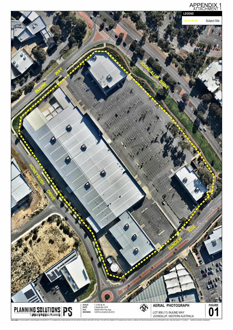
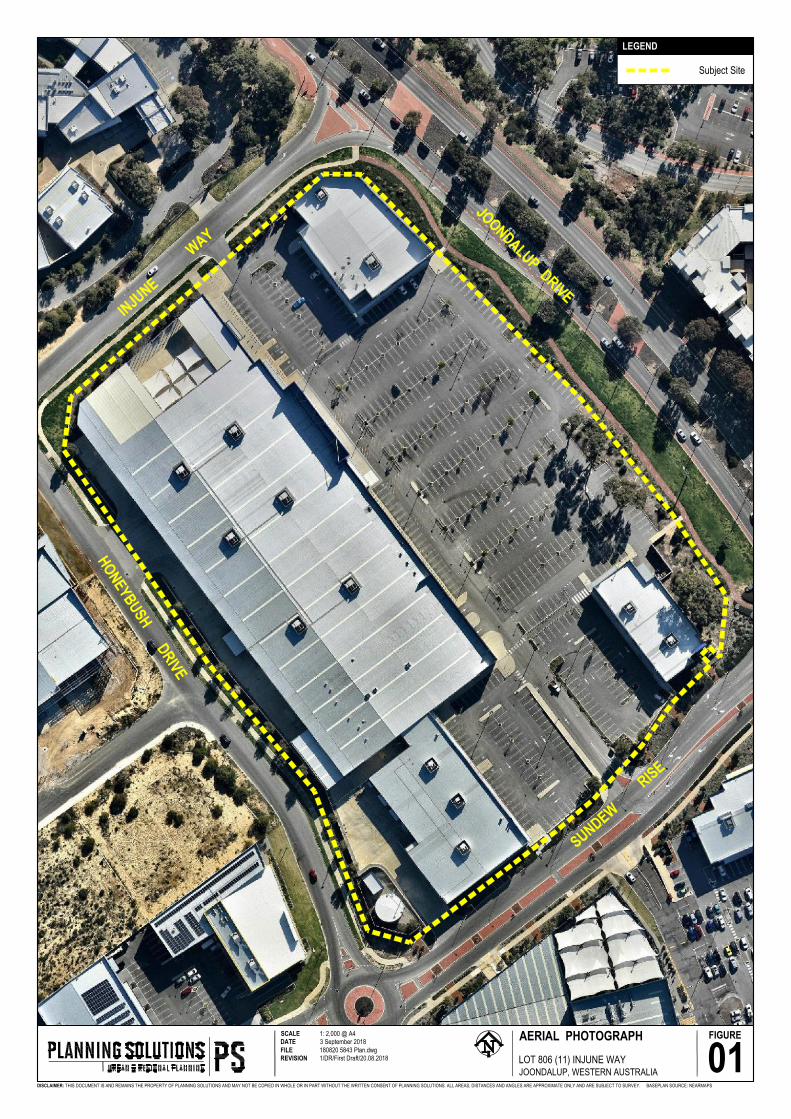
AERIAL PHOTOGRAPH SCALE 1: 2,000 @ A4 DATE 3 September 2018 FILE 180820 5843 Plan.dwg REVISION 1/DR/First Draft/20.08.2018 01 DISCLAIMER: THIS DOCUMENT IS AND REMAINS THE PROPERTY OF PLANNING SOLUTIONS AND MAY NOT BE COPIED IN WHOLE OR IN PART WITHOUT THE WRITTEN CONSENT OF PLANNING SOLUTIONS. ALL AREAS, DISTANCES AND ANGLES ARE APPROXIMATE ONLY AND ARE SUBJECT TO SURVEY. FIGURE LOT 806 (11) INJUNE WAY JOONDALUP, WESTERN AUSTRALIA BASEPLAN SOURCE: NEARMAPS Subject Site LEGEND JOONDALUP DRIVE INJUNE WAY HONEYBUSH DRIVE SUNDEW RISE APPENDIX 1

Welcome message from author
This document is posted to help you gain knowledge. Please leave a comment to let me know what you think about it! Share it to your friends and learn new things together.
Transcript
AERIAL PHOTOGRAPHSCALE 1: 2,000 @ A4DATE 3 September 2018FILE 180820 5843 Plan.dwgREVISION 1/DR/First Draft/20.08.2018 01
DISCLAIMER: THIS DOCUMENT IS AND REMAINS THE PROPERTY OF PLANNING SOLUTIONS AND MAY NOT BE COPIED IN WHOLE OR IN PART WITHOUT THE WRITTEN CONSENT OF PLANNING SOLUTIONS. ALL AREAS, DISTANCES AND ANGLES ARE APPROXIMATE ONLY AND ARE SUBJECT TO SURVEY.
FIGURE
LOT 806 (11) INJUNE WAYJOONDALUP, WESTERN AUSTRALIA
BASEPLAN SOURCE: NEARMAPS
Subject Site
LEGEND
JOONDALUP DRIVEINJUNE
WAY
HONEYBUSH DRIVE
SUNDEW
RISE
APPENDIX 1
1 1
8 8
A
A
E
E
Q
Q
6 6
2 2
D
D
C
C
B
B
F
F
G
G
H
H
J
J
L
L
K
K
M
M
N
N
P
P
R
R
S
S
U
U
3
4
5
7
EX. COL.
EX. COL.
EX. COL.
EX. COL.
EX. COL.
EX. COL.
EX. COL.
EX. COL.
EX. COL.
EX. COL.EX. COL.
EX. COL.EX. COL.
EX. COL.EX. COL.
EX. COL.
EX. COL.
EX. COL.
TENANCY 1EX. C
OL.
FEMALESTAFF
MALESTAFF
EX. COL.
EX. COL.
EX. COL.
EX. COL.
EX. COL.
EX. COL.
EX. COL.
FEMALEWC
MALEWCB
AB
YC
HAN
GEUNI.
DIS
DBTD
GEN.ROOM
ELEC.ROOM
EX 150
Dia. DP
EX 150
Dia. DP
EX 150
Dia. DP
EX 150
Dia. DP
EX 150
Dia. DP
EX 150
Dia. DPEX 150Dia. DPEX 1
50Dia. D
P
EX 150Dia. DPEX 150
Dia. DP
EX 150
Dia. DP
EX 150
Dia. DP
EX 150
Dia. DP EX 150Dia. DP
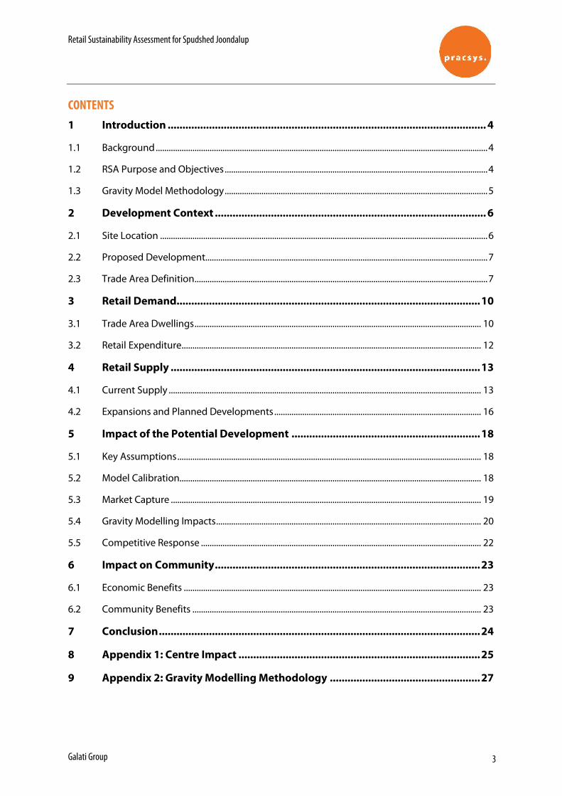
TOTAL GLAR: 4,025m²GLAR: 2280m²
EXTENT OF EXISTING WALLS TO BE DEMOLISHED SHOWN DASHED.
105m²
EX. PROJOFFICE
EX. CASHROOM
EX. MNGR
EX. COMMS
GLAR: 1,990m²
MALL
EX. COL.
TENANCY 2
TENANCY 7
B.O.H / TROLLEY STORE
TENANCY 6
GLAR: 508m²
GLAR: 287m²
OFFICE/STORE/
CLEANER
NEW WALL & DOOR FOR STAFF AMENITIES ACCESS
EXTENT OF EXISTING WALLS & DOORS TO BE REMOVED SHOWN DASHED.
EXISTING AUTO SLIDING DOORS TO BE REMOVED & REPLACED WITH SOLID WALL INFILL FOR NEW OFFICE/STORE/CLEANER.
NEW DOORS FOR CENTER MANAGEMENT ACCESS.
EXISTING FIRE INDICATOR PANEL TO BE RETAINED.
176
1066
010
176
9000
176
TENANCY 3
GLAR: 190m²
9000
EXISTING ROLLER SHUTTER TO BE REMOVED AND REPLACED WITH NEW ESCAPE DOOR
GLAR: 60m²
TENANCY 5
ENTRANCE AIRLOCK
NEW ESCAPE DOOR.
NEW R/SHUTTER
NEW ESCAPE DOOR.
175
TEN
A NCY
737
392
176
MAL
L90
0017
6TE
NA N
CY 1
116
355
176
TEN
A NCY
1292
2525
5BO
H /
TRO
LLEY
4875
175
1925
264
175
175
TEN
A NCY
250
0017
6TE
NA N
CY 1
7022
917
5
175TENANCY 1
32962 176 176TENANCY 3
17606 176MALL9000 176
TENANCY 99055 176
TENANCY 1010788 176
TENANCY 1115606 344
TENANCY 1233770 196
175
7540
517
5
175
6958
010
0
5050
150
TEN
A NCY
10
2586
117
60M
ALL
9000
176
TEN
A NCY
737
392
175
175TENANCY 1
32962 176TENANCY 2
54758 176MALL
62759 344TENANCY 12
33959
NEW DOOR TO BE CUT INTO EXISTING CONCRETE PANEL. POSITION TO BE CONFIRMED
TOTAL GLAR: 2,000m²TRADE AREA: 1,830m²
BACK OF HOUSE: 170m²
175TENANCY 2
87896 176TENANCY 6
13615 176 65377 175 12985
175
TEN
A NCY
7 B
.O.H
.10
600
175
TEN
A NCY
12
5930
517
525
0050
50
ENTRANCE AIRLOCK
32962
5000
176
6804
0
54758
NEW 3x3m R/SHUTTER
NEW 6x5m R/SHUTTER
TROLLEY BAY
FULL HEIGHT WALL
TENANCYTENANCY 9
TENANCY 10
GLAR: 418m²
GLAR: 88m²
PROPOSED PRIVATE RECREATION
PROPOSED FRESH PRODUCE MARKET
PROPOSED COMMERCIAL
PROPOSED BULKY GOOD SHOWROOM
PROPOSED CHILDCARE
TENANCY 12
PROPOSED COMMERCIAL
PROPOSED COMMERCIAL
PROPOSED COMMERCIAL
PROPOSED COMMERCIAL
PROPOSED COMMERCIAL
T7 B.O.H
NEW R/SHUTTER
TENANCY 7 GAS REFILL POSITION. OPTION 1
TENANCY 7 GAS REFILL POSITION. OPTION 2
TENANCY 254758
TENANCY 4
TENANCY 8 TENANCY 11
GLAR: 93m²
PROPOSED COMMERCIAL
GLAR: 125m²
PROPOSED COMMERCIAL
Gross Floor Area : GLARA. All Floor Areas on this plan are shown as GROSS FLOOR AREA. Unless otherwise noted as Nett Floor AreaB. Definition of Gross Floor Area is defined as: i/ GROSS FLOOR AREA OF TENANCY: Gross Floor Area of an individual Tenancy is defined as the area contained between the centre line of common tenancywalls and the outside edge of external walls.
ii/ GROSS FLOOR AREA OF A BUILDING: Gross Floor Area of a Building is defined as the total area contained between the outside edge of external walls
Gross Lettable Area - Retail : GLAR (Property Council of Australia Method of Measurement Definition)
Defined as the aggregate floor space contained within a tenancy at each floor level using the following rules:
i/ In the case of external building walls, fire passage walls, service passage walls, standard and service facility walls and the like, measuring from the internal finished surface of the dominant surface of the the dominant portion of those walls;
ii/ In the case of inter-tenancy walls, measuring from the centre line of those walls;
iii/ In the case of shopfronts on or inside the mall line, measuring from the mall line as shown on appropriate floor plans of the tenancy regardless of whether or not the shop front is set back, in whole or part from the mall line; and
iv/ In the case of shopfronts outside the mall line, measuring from the external finished surface of the dominant portion of those walls.
As indicated @ B1 A202
MAY 2018SK030PROPOSED LARGE FORMAT RETAIL REDEVELOPMENT
FOR:FOR: HOME CONSORTIUMLOCATION:11 INJUNE WAY, JOONDALUP
SCALE:1 : 250GROUND FLOOR PLAN
N
TENANCY
176©
AutoCAD SHX Text
EX. COL.
AutoCAD SHX Text
EX. COL.
AutoCAD SHX Text
EX. COL.
AutoCAD SHX Text
EX. COL.
AutoCAD SHX Text
EX. COL.
AutoCAD SHX Text
EX. COL.
AutoCAD SHX Text
EX. COL.
AutoCAD SHX Text
EX. COL.
AutoCAD SHX Text
EX. COL.
AutoCAD SHX Text
FEMALE
AutoCAD SHX Text
STAFF
AutoCAD SHX Text
MALE
AutoCAD SHX Text
STAFF
AutoCAD SHX Text
FEMALE
AutoCAD SHX Text
WC
AutoCAD SHX Text
MALE
AutoCAD SHX Text
WC
AutoCAD SHX Text
BABY
AutoCAD SHX Text
CHANGE
AutoCAD SHX Text
UNI.
AutoCAD SHX Text
DIS
AutoCAD SHX Text
EX 150Dia. DP
AutoCAD SHX Text
EX 150Dia. DP
AutoCAD SHX Text
EX 150Dia. DP
AutoCAD SHX Text
TOTAL RETAIL 2768m²
AutoCAD SHX Text
EX. COL.
AutoCAD SHX Text
OFFICE/
AutoCAD SHX Text
STORE/
AutoCAD SHX Text
CLEANER
AutoCAD SHX Text
NEW 3
AutoCAD SHX Text
R/SHUTTER
AutoCAD SHX Text
TROLLEY BAY
AutoCAD SHX Text
MEAT 1°C
AutoCAD SHX Text
3750
AutoCAD SHX Text
3750
AutoCAD SHX Text
3750
AutoCAD SHX Text
3750
AutoCAD SHX Text
3750
AutoCAD SHX Text
3750
AutoCAD SHX Text
3750
AutoCAD SHX Text
DAIRY 1°C
AutoCAD SHX Text
232M
AutoCAD SHX Text
F&V 5°C
AutoCAD SHX Text
133M
AutoCAD SHX Text
164M
AutoCAD SHX Text
4.5M AFFL
AutoCAD SHX Text
4.5M AFFL
AutoCAD SHX Text
4.5M AFFL
AutoCAD SHX Text
LUNCH ROOM
AutoCAD SHX Text
BAKERY
AutoCAD SHX Text
RACK SYSTEM
AutoCAD SHX Text
RACK SYSTEM
AutoCAD SHX Text
PREP
AutoCAD SHX Text
NEW EM EXIT
AutoCAD SHX Text
SERVER ROOM
AutoCAD SHX Text
CASH ROOM
AutoCAD SHX Text
1606
AutoCAD SHX Text
3750
AutoCAD SHX Text
3750
AutoCAD SHX Text
1606
AutoCAD SHX Text
3750
AutoCAD SHX Text
3750
AutoCAD SHX Text
1606
AutoCAD SHX Text
3750
AutoCAD SHX Text
3750
AutoCAD SHX Text
1606
AutoCAD SHX Text
3750
AutoCAD SHX Text
3750
AutoCAD SHX Text
1606
AutoCAD SHX Text
3750
AutoCAD SHX Text
3750
AutoCAD SHX Text
1606
AutoCAD SHX Text
3750
AutoCAD SHX Text
3750
AutoCAD SHX Text
28M
AutoCAD SHX Text
45M
AutoCAD SHX Text
DRY STORE 165M 46 PALLETS IN 1 ROW
AutoCAD SHX Text
74M
AutoCAD SHX Text
GROCERY 324M
AutoCAD SHX Text
GROCERY 959m²
AutoCAD SHX Text
FREEZER 373m²
AutoCAD SHX Text
F&V 627m²
AutoCAD SHX Text
3750
AutoCAD SHX Text
3750
AutoCAD SHX Text
3750
AutoCAD SHX Text
8 DOOR
AutoCAD SHX Text
8 DOOR
AutoCAD SHX Text
8 DOOR
AutoCAD SHX Text
6 DOOR
AutoCAD SHX Text
8 DOOR
AutoCAD SHX Text
6 DOOR
AutoCAD SHX Text
FREEZER
AutoCAD SHX Text
7.0M AFFL
AutoCAD SHX Text
80M
AutoCAD SHX Text
OFFICE
AutoCAD SHX Text
CASH
AutoCAD SHX Text
SERVER
AutoCAD SHX Text
1606
AutoCAD SHX Text
3750
AutoCAD SHX Text
3750
AutoCAD SHX Text
1606
AutoCAD SHX Text
3750
AutoCAD SHX Text
3750
AutoCAD SHX Text
TITLE
AutoCAD SHX Text
SCALE
AutoCAD SHX Text
DATE
AutoCAD SHX Text
DRAWN
AutoCAD SHX Text
CHECKED
AutoCAD SHX Text
DWG No
AutoCAD SHX Text
REV
AutoCAD SHX Text
1:250
AutoCAD SHX Text
J.A.
AutoCAD SHX Text
GENERAL ARRANGEMENT
AutoCAD SHX Text
SS-JOON-001
AutoCAD SHX Text
COPYRIGHT 2003 © - Copyright for these drawings and the design remain the property of DAC(WA)Pty Ltd t/a DAC Refrigeration Services and may not be - Copyright for these drawings and the design remain the property of DAC(WA)Pty Ltd t/a DAC Refrigeration Services and may not be reproduced in any part or form without their written permission.
AutoCAD SHX Text
H.C.
AutoCAD SHX Text
JOB No
AutoCAD SHX Text
Sheet Size
AutoCAD SHX Text
A3
AutoCAD SHX Text
DAC (WA) Pty Ltd (ACN166 825 476) The Trustee for the DAC Unit Trust (ABN 55 438 126 296) T/A DAC Refrigeration Services
AutoCAD SHX Text
C
AutoCAD SHX Text
13-8-2018
AutoCAD SHX Text
PROPOSED WAREHOUSE AND RETAIL LAYOUT FOR SPUD SHED AT 11 INJUNE WAY JOONDALUP COMPLEX
AutoCAD SHX Text
OPTION C
Lot 806 (11) Injune Way,Joondalup
Development Application Report
Prepared forGalati Group
September 2018

Development Application Lot 806 (11) Injune Way, Joondalup
Copyright Statement 2018 © Planning Solutions (Aust) Pty Ltd All rights reserved. Other than for the purposes of and subject to the conditions prescribed under the Copyright Act 1968 (Cth), no part of this report may be reproduced, stored in a retrieval system or transmitted in any form or by any means, electronic or otherwise, without the prior written permission of Planning Solutions (Aust) Pty Ltd. No express or implied warranties are made by Planning Solutions (Aust) Pty Ltd regarding the information and analysis contained in this report. In particular, but without limiting the preceding exclusion, Planning Solutions (Aust) Pty Ltd will not verify, and will not assume responsibility for, the accuracy and completeness of information provided to us. This report has been prepared with particular attention to our Client’s instructions and the relevant features of the subject site. Planning Solutions (Aust) Pty Ltd accepts no liability whatsoever for: 1. a third party’s use of, or reliance upon, this report; 2. use of, or reliance upon, this report in relation to any land other than the subject site; or 3. the Client’s implementation, or application, of the strategies recommended in this report. Direct all inquiries to: Planning Solutions 251 St Georges Terrace Perth WA 6000 All correspondence to: GPO Box 2709 Cloisters Square PO 6850 Phone: 08 9227 7970 Email: [email protected] Web: www.planningsolutions.com.au
Development Application Lot 806 (11) Injune Way, Joondalup
Project details
Job number 5863
Client Galati Group Pty Ltd
Prepared by Planning Solutions
Consultant Team Town Planning Drafting and Design Economics
Planning Solutions Meyer Shircore & Galati Group Pracsys
Document control
Revision number File name Document date
Rev 0 180904 5863 DA Report (final) 4 September 2018
Development Application Lot 806 (11) Injune Way, Joondalup
Contents
1 Preliminary .............................................................................................................................. 1 1.1 Introduction .............................................................................................................................. 1
1.2 Background .............................................................................................................................. 1 1.2.1 Previous Development Approvals ............................................................................................ 1 1.2.2 Engagement with the City ........................................................................................................ 2 1.2.3 Current development applications with City ............................................................................. 2
2 Site details .............................................................................................................................. 3 2.1 Land description ....................................................................................................................... 3
2.1.1 Notifications .............................................................................................................................. 3 2.2 Existing development ............................................................................................................... 3 2.3 Location.................................................................................................................................... 3 2.3.1 Regional context ...................................................................................................................... 3
2.3.2 Local context, land use and topography ................................................................................... 4
3 Proposed development .......................................................................................................... 8 3.1 Development overview ............................................................................................................. 8
3.1.1 Retail Sustainability Assessment ............................................................................................. 9
4 Statutory planning framework ............................................................................................ 10 4.1 Metropolitan Region Scheme ................................................................................................. 10 4.2 City of Joondalup District Planning Scheme No.2 .................................................................. 10 4.2.1 Zoning .................................................................................................................................... 10 4.2.2 Land use classification and permissibility ............................................................................... 12
4.2.3 Development Assessment ...................................................................................................... 12 4.3 Joondalup City Centre Development Manual ......................................................................... 14
4.4 City of Joondalup Draft Activity Centre Plan ........................................................................... 14
4.4.1 Car parking ............................................................................................................................. 15
5 Matters to be considered ..................................................................................................... 16
6 Conclusion ............................................................................................................................ 19
Figures
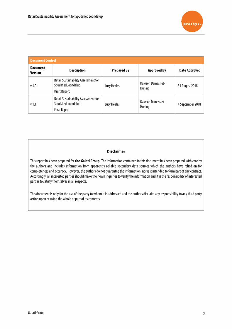
Figure 1: Aerial Photograph Figure 2: District Planning Scheme No. 2 Zoning Map
Appendices
Appendix 1: Existing Development Approvals Appendix 2: Certificate of Title and Deposited Plan Appendix 3: Restrictive Covenant Document K665867 Appendix 4: Development Plans Appendix 5: Retail Sustainability Assessment Appendix 6: 2016 Traffic Impact Assessment
Development Application Lot 806 (11) Injune Way, Joondalup
1
1 Preliminary
1.1 Introduction Planning Solutions acts on behalf of Galati Group, the proponent of the proposed Spudshed development at Lot 806 (11) Injune Way, Joondalup (subject site). Planning Solutions has prepared the following report in support of an Application for Development Approval to Commence Development within an existing building on the subject site. This report will address various issues pertinent to the proposal, including:
o Background
o Site details.
o Proposed development.
o Town planning considerations. The proposal seeks approval to utilise a portion of the former Masters Home Improvement building on the subject site as a Spudshed Fresh Produce Market, to services the immediate vicinity and residents that surround it. We respectfully request the City grant approval to the proposed development under delegated authority.
1.2 Background
1.2.1 Previous Development Approvals Various development approvals have been obtained for the subject site since the approval of the former Masters Home Improvement store and various large format retail developments at the subject site, granted by the Metropolitan North-West Joint Development Assessment Panel (JDAP) in 2012. Following the JDAP’s 2012 approval, the following development approvals have been obtained for the subject site:
o 2013 JDAP form 2 approval for a range of minor design changes and an additional ‘Take Away Food Outlet’ on the subject site.
o 25 January 2017 (DA16/1407) development approval for a change of use from Hardware Store, additions and signage to Bulky Goods Showroom, Take Away Food Outlet and Market (retail).
o 20 October 2017 (DA17/0960) development approval for a change of use from Bulky Goods Showroom to Bulky Goods Showroom and Recreation Centre (for tenancy 7 as depicted on approved plans).
Currently, the approved plans depict eleven (11) tenancies comprising bulky Goods Showroom, Recreation Centre and Take Away Food Outlet land uses. Refer Appendix 1 – Existing Development Approvals.
Development Application Lot 806 (11) Injune Way, Joondalup
2
Various tenants have now been secured to occupy the large format retail building. This application seeks approval to use a central portion of the building for the purposes of Spudshed Fresh Produce Market. 1.2.2 Engagement with the City Detailed discussions were held in March and April 2018 with senior officers of the City, to discuss the proposed Spudshed development and appropriate land use classification. Following a meeting on 9 April 2018, at which the operational aspects of the Spudshed model were discussed, further information on activities and land use classifications was provided to the City. After reviewing the information, and considering the planning framework, the City’s officers advised as follows:
[T]he City does not consider that the ‘Bulky goods showroom’ land use currently approved for the intended tenancy is the most appropriate land use for the activities and operation of Spudshed. This, in brief, is due to the following:
o The specific nature of the Spudshed business model (in terms of its operations) was not considered under the current ‘bulky goods showroom’ approval and as such, appropriate conditions were not implemented on the current approval.
o Even in the event that the City considered the ‘Bulky goods showroom’ land use as appropriate for Spudshed, conditions would need to be imposed to ensure the business continues to operate in line with the ‘bulky goods showroom’ land use definition. I believe such conditions, that are likely to be linked to detailed operating conditions would be both difficult for the City to monitor and enforce, and equally difficult for the operator to comply with and maintain sufficient flexibility to operate as intended. Also, it is questionable whether these type of conditions begin to ‘shift’ the activities of the business away from the standard definition (and operation) of a typical ‘Bulky goods showroom’.
o Equally, based on the information set out in your correspondence, the City recognises that the Spudshed business model does not readily align with the standard ‘Shop’ land use definition outlined in the City’s District Planning Scheme No. 2 (or any other land use defined under the City’s Scheme).
Based on the above, the City is therefore of the opinion that the operation of Spudshed, as described in your correspondence, would best be treated as an ‘unlisted use’ (as defined under the City’s District Planning Scheme No. 2). Therefore, a change of use application would need to be lodged with the City for determination.
On a ‘without prejudice’ basis, Planning Solutions accepts the characterisation of the use as described by the City’s officers. Accordingly, the subject application is for an ‘unlisted use’ as recommended by the City’s officers, nominally described as a Fresh Produce Market. 1.2.3 Current development applications with City A separate signage application (DA08/0439) was lodged with the City on 24 April 2018, and a separate change of use application (DA18/0801) was lodged with the City on 2 August 2018 for the subject site. These applications are to be treated separately to the proposed Spudshed and do not overlap in any way.
Development Application Lot 806 (11) Injune Way, Joondalup
3
2 Site details
2.1 Land description
Refer to Table 1 below for a description of the land subject to this development application. Table 1 – Lot details
Lot Deposited Plan Volume Folio Area (ha)
806 71347 2790 976 4.4260
2.1.1 Notifications The following notifications exist on the Certificate of Title:
o Easement burden for drainage purposes to the City of Joondalup.
o Restrictive Covenant to the City of Joondalup, restricting access to Joondalup Drive.
o Notification under section 165 of the Planning and Development Act 2005. None of the above encumbrances/notifications affect this application. Refer to Appendix 2 for a copy of the Certificate of Title and Deposited Plan, and Appendix 3 for the Restrictive Covenant document K665867.
2.2 Existing development
The existing development comprises the following elements:
o Four separate buildings with a total floorspace exceeding 18,000m².
o 578 car parking bays throughout the site, with internal accessways and pedestrian crossings.
o 6 bicycle u-rails.
o 9,229m² landscaped areas throughout the site and offsite verge.
o Four crossovers to the site via Injune Way, Honeybush Drive and Sundew Rise.
2.3 Location
2.3.1 Regional context
The subject site is located within the Joondalup strategic metropolitan centre, and is located approximately 24 kilometres north-west of the Perth city centre. The subject site fronts Joondalup Drive, classified as an ‘Other Regional Road’ under the Metropolitan Region Scheme (MRS) and providing a key north-south link through the Joondalup strategic metropolitan centre. Joondalup Drive provides further connections to other strategic metropolitan road links including Ocean Reef Road, Mitchell Freeway and Burns Beach Road.
Development Application Lot 806 (11) Injune Way, Joondalup
4
The subject site is within the municipality of the City of Joondalup (City). 2.3.2 Local context, land use and topography
The subject site is located within the southernmost portion of the Joondalup City Centre, and is widely surrounded by a range of complementary commercial, retail and mixed use activities offering a mixture of goods for sale (eg. JB Hi Fi, Kitchen Warehouse, and Golf Box). The subject site is bounded by Joondalup Drive to the east, Injune Way to the north, Sundew Rise to the south and Honeybush Drive to the west. The following uses surround the subject site:
o A Bunnings Warehouse and other large format retail premises to the south.
o Edith Cowan College to the north.
o Vacant land and partially completed commercial development under construction to the west.
o Multiple dwellings and residential development beyond Joondalup Drive to the east, within the Edgewater locality.
The subject site contains the former ‘Masters Home Improvement’ building and various large format retail and ancillary tenancies including Baby Bunting, RSEA Safety, PETstock, Relax, Winning Appliances, and Caffissimo. Joondalup train station is located approximately 1.1 kilometres north of the subject site, and Edgewater train station is located approximately 1.6 kilometres south-east of the subject site. The subject site is located within walkable distance of bus services located along Joondalup Drive. Bus route 465 provides access to various locations including:
o Edgewater
o Whitfords
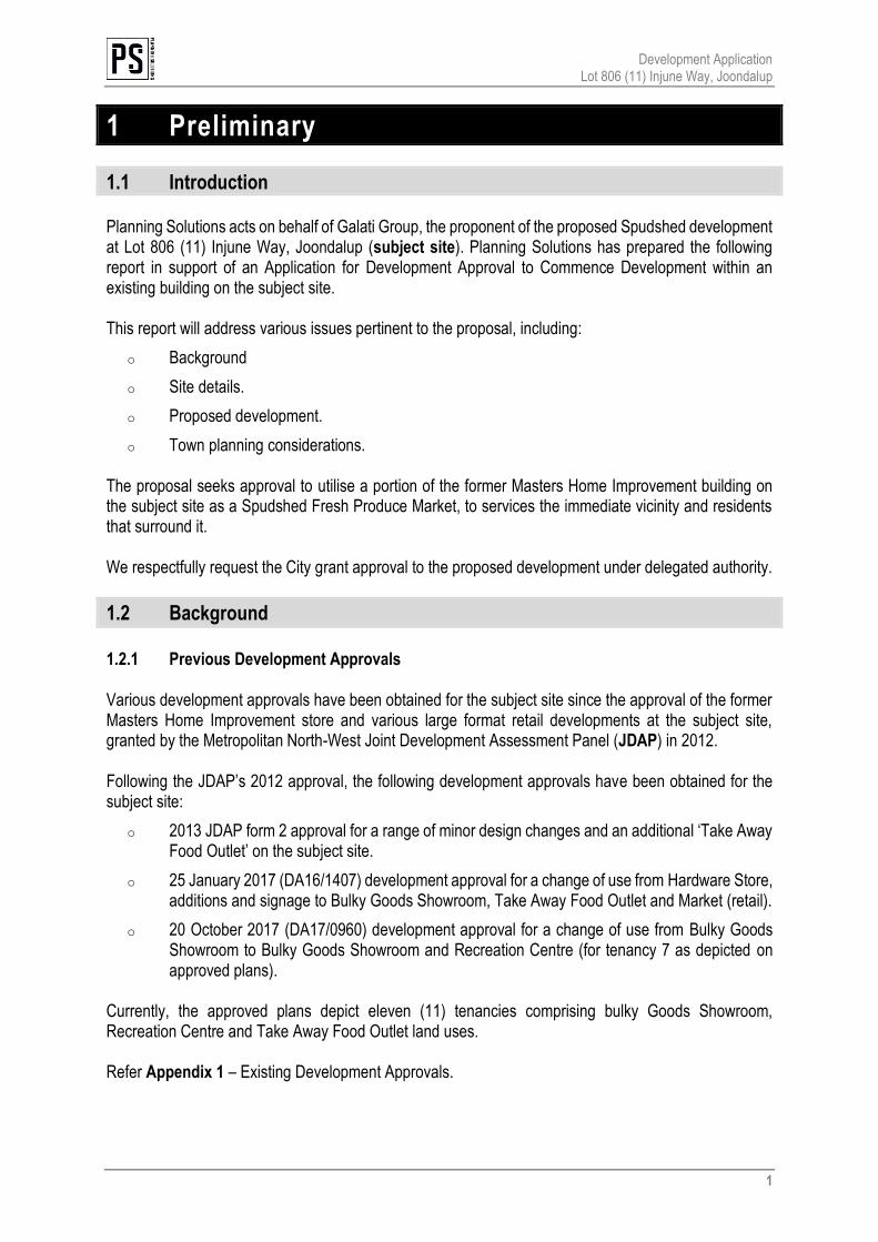
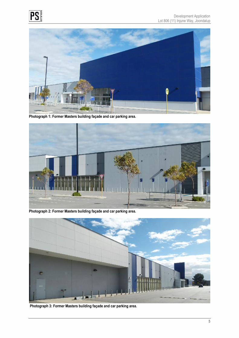
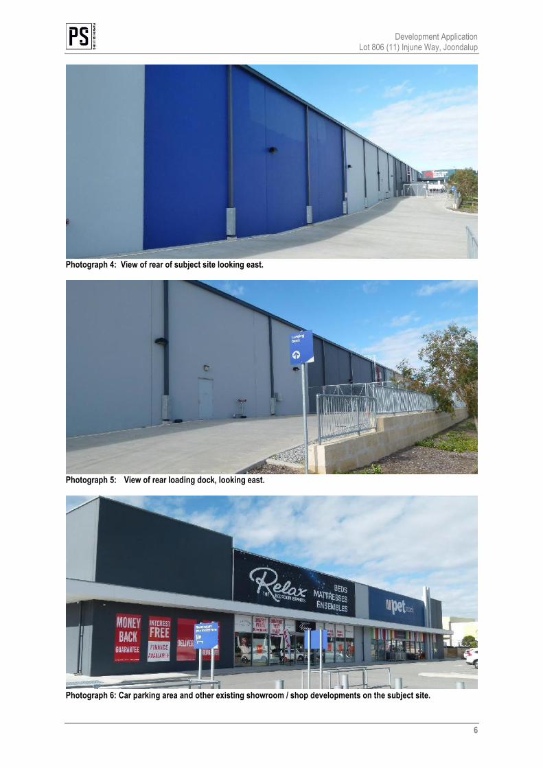
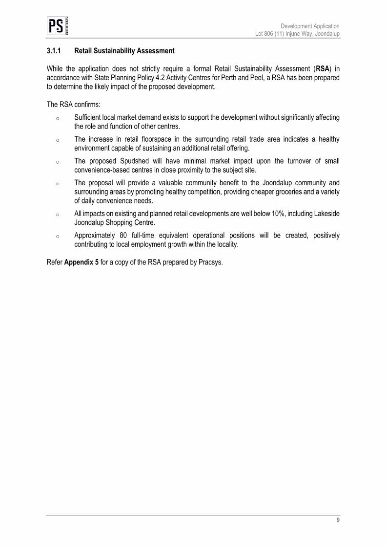
o Woodvale The subject site gently slopes southward from the northern portion of the subject site. Refer Figure 1, aerial photograph. Photographs 1 to 6 depict the subject site and surrounds.
Development Application Lot 806 (11) Injune Way, Joondalup
5
Photograph 1: Former Masters building façade and car parking area.
Photograph 2: Former Masters building façade and car parking area.
Photograph 3: Former Masters building façade and car parking area.
Development Application Lot 806 (11) Injune Way, Joondalup
6
Photograph 4: View of rear of subject site looking east.
Photograph 5: View of rear loading dock, looking east.
Photograph 6: Car parking area and other existing showroom / shop developments on the subject site.
AERIAL PHOTOGRAPHSCALE 1: 2,000 @ A4DATE 3 September 2018FILE 180820 5843 Plan.dwgREVISION 1/DR/First Draft/20.08.2018 01
DISCLAIMER: THIS DOCUMENT IS AND REMAINS THE PROPERTY OF PLANNING SOLUTIONS AND MAY NOT BE COPIED IN WHOLE OR IN PART WITHOUT THE WRITTEN CONSENT OF PLANNING SOLUTIONS. ALL AREAS, DISTANCES AND ANGLES ARE APPROXIMATE ONLY AND ARE SUBJECT TO SURVEY.
FIGURE
LOT 806 (11) INJUNE WAYJOONDALUP, WESTERN AUSTRALIA
BASEPLAN SOURCE: NEARMAPS
Subject Site
LEGEND
JOONDALUP DRIVEINJUNE
WAY
HONEYBUSH DRIVE
SUNDEW
RISE
Development Application Lot 806 (11) Injune Way, Joondalup
8
3 Proposed development
3.1 Development overview
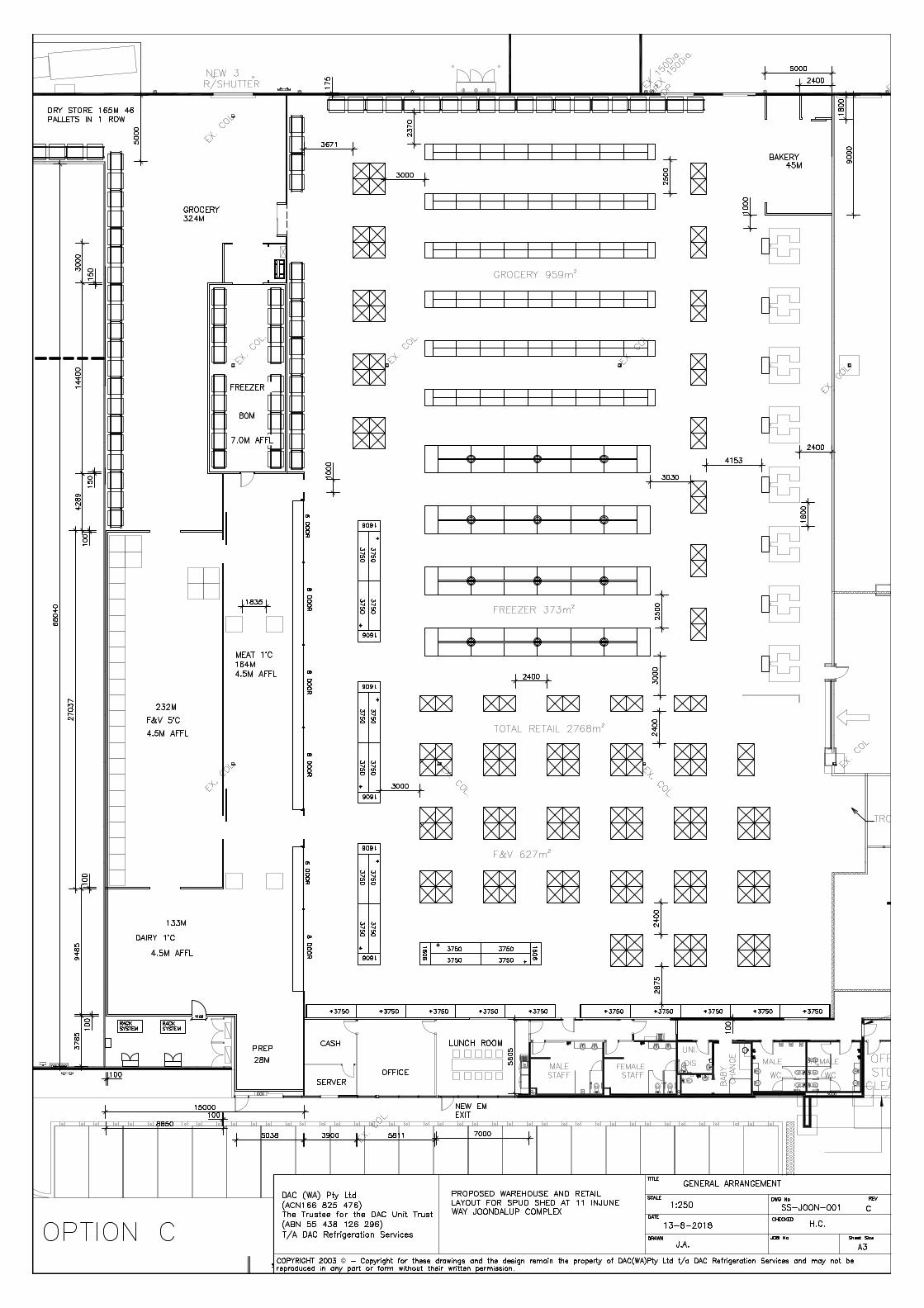
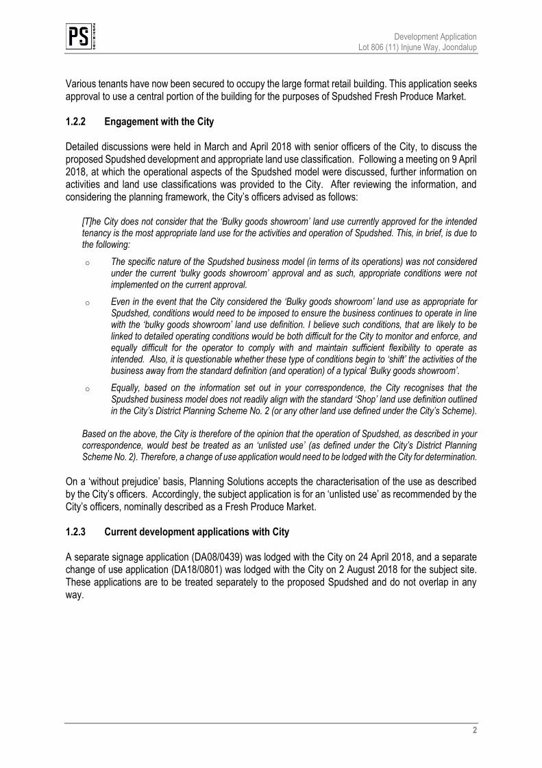
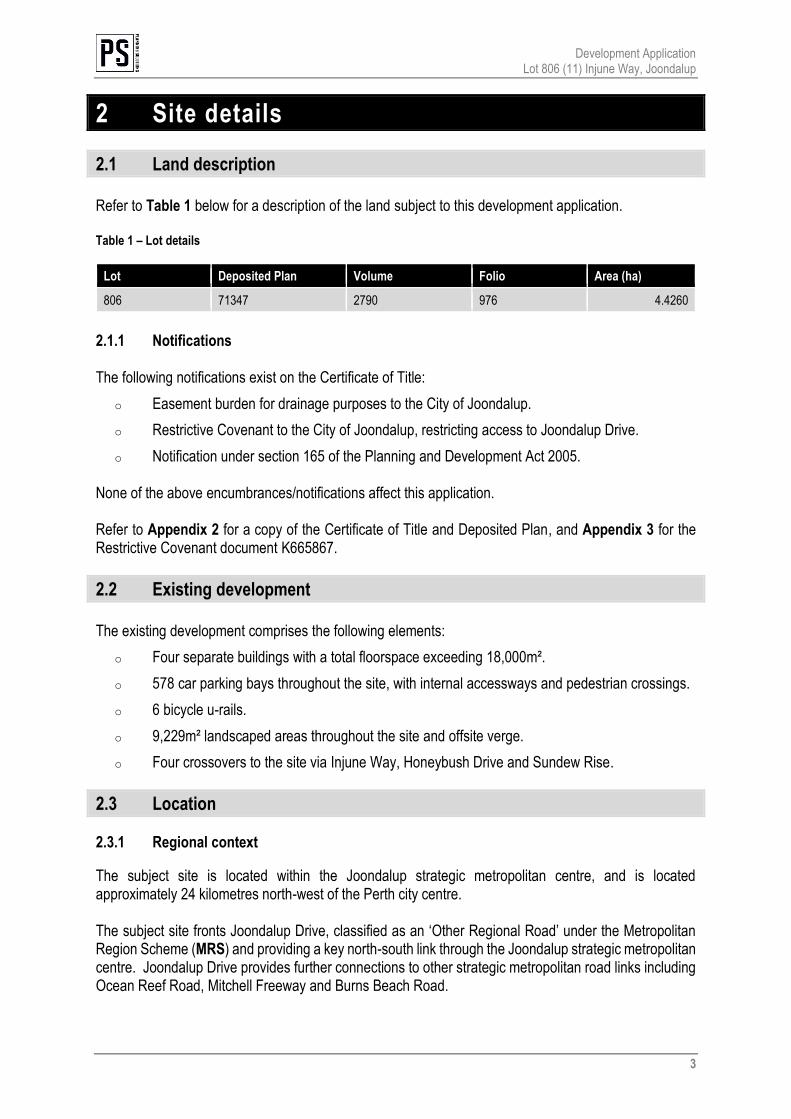
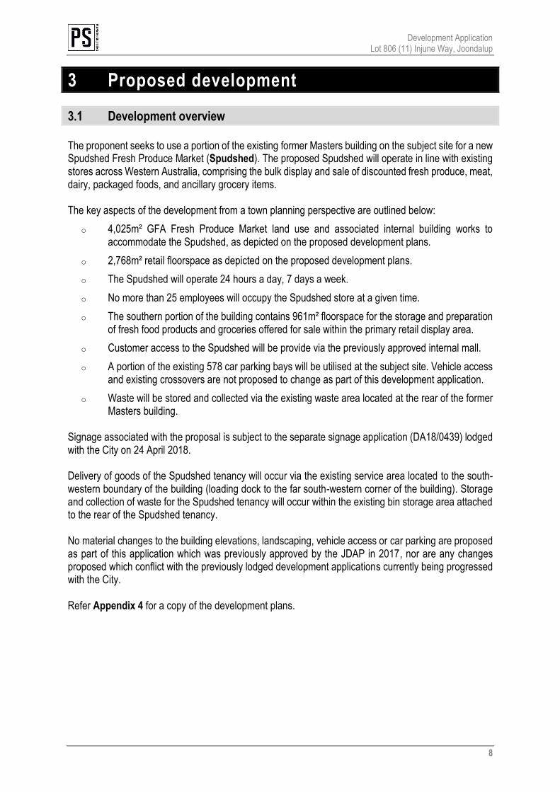
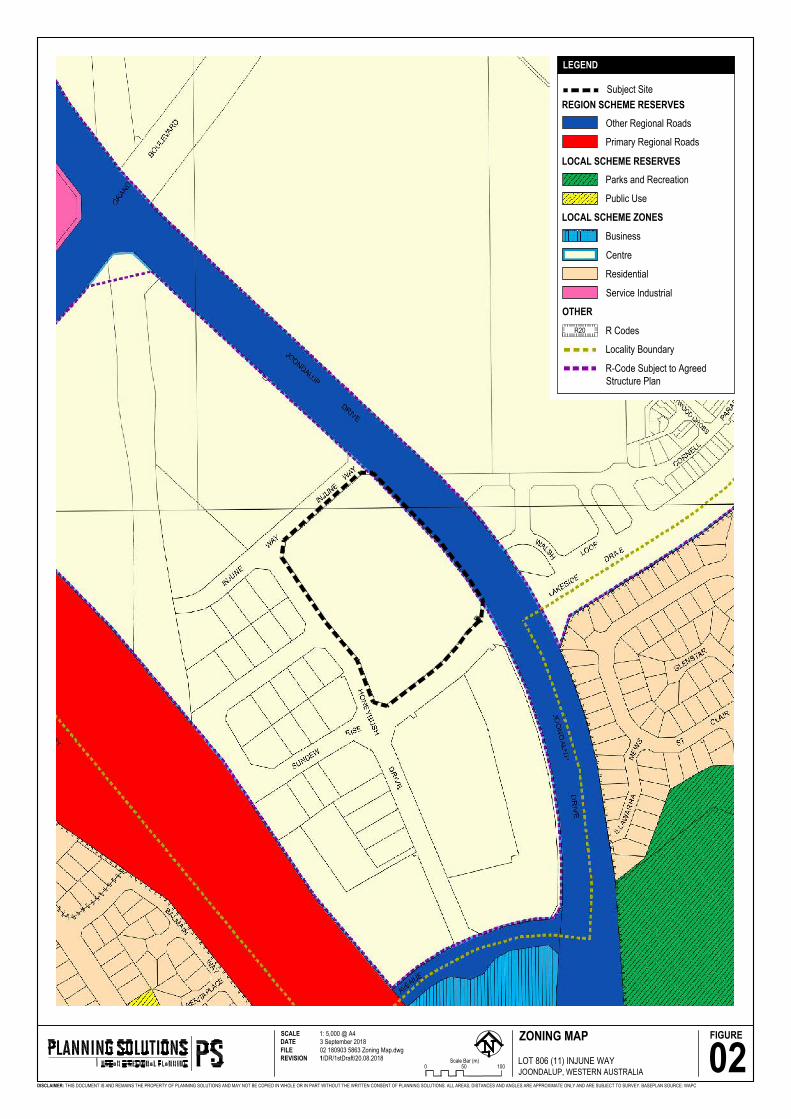
The proponent seeks to use a portion of the existing former Masters building on the subject site for a new Spudshed Fresh Produce Market (Spudshed). The proposed Spudshed will operate in line with existing stores across Western Australia, comprising the bulk display and sale of discounted fresh produce, meat, dairy, packaged foods, and ancillary grocery items. The key aspects of the development from a town planning perspective are outlined below:
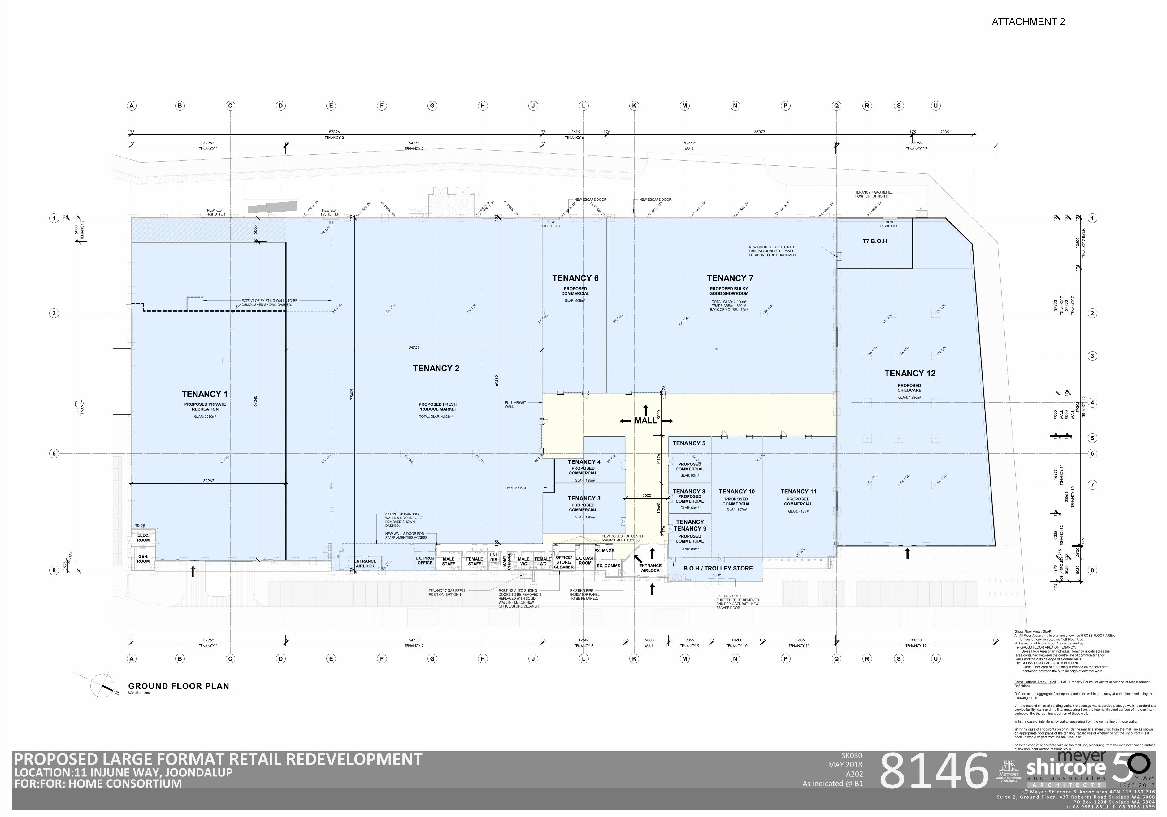
o 4,025m² GFA Fresh Produce Market land use and associated internal building works to accommodate the Spudshed, as depicted on the proposed development plans.
o 2,768m² retail floorspace as depicted on the proposed development plans.
o The Spudshed will operate 24 hours a day, 7 days a week.
o No more than 25 employees will occupy the Spudshed store at a given time.
o The southern portion of the building contains 961m² floorspace for the storage and preparation of fresh food products and groceries offered for sale within the primary retail display area.
o Customer access to the Spudshed will be provide via the previously approved internal mall.
o A portion of the existing 578 car parking bays will be utilised at the subject site. Vehicle access and existing crossovers are not proposed to change as part of this development application.
o Waste will be stored and collected via the existing waste area located at the rear of the former Masters building.
Signage associated with the proposal is subject to the separate signage application (DA18/0439) lodged with the City on 24 April 2018. Delivery of goods of the Spudshed tenancy will occur via the existing service area located to the south-western boundary of the building (loading dock to the far south-western corner of the building). Storage and collection of waste for the Spudshed tenancy will occur within the existing bin storage area attached to the rear of the Spudshed tenancy. No material changes to the building elevations, landscaping, vehicle access or car parking are proposed as part of this application which was previously approved by the JDAP in 2017, nor are any changes proposed which conflict with the previously lodged development applications currently being progressed with the City. Refer Appendix 4 for a copy of the development plans.
Development Application Lot 806 (11) Injune Way, Joondalup
9
3.1.1 Retail Sustainability Assessment While the application does not strictly require a formal Retail Sustainability Assessment (RSA) in accordance with State Planning Policy 4.2 Activity Centres for Perth and Peel, a RSA has been prepared to determine the likely impact of the proposed development. The RSA confirms:
o Sufficient local market demand exists to support the development without significantly affecting the role and function of other centres.
o The increase in retail floorspace in the surrounding retail trade area indicates a healthy environment capable of sustaining an additional retail offering.
o The proposed Spudshed will have minimal market impact upon the turnover of small convenience-based centres in close proximity to the subject site.
o The proposal will provide a valuable community benefit to the Joondalup community and surrounding areas by promoting healthy competition, providing cheaper groceries and a variety of daily convenience needs.
o All impacts on existing and planned retail developments are well below 10%, including Lakeside Joondalup Shopping Centre.
o Approximately 80 full-time equivalent operational positions will be created, positively contributing to local employment growth within the locality.
Refer Appendix 5 for a copy of the RSA prepared by Pracsys.
Development Application Lot 806 (11) Injune Way, Joondalup
10
4 Statutory planning framework
4.1 Metropolitan Region Scheme
The subject site is zoned ‘Central City Area’ under the Metropolitan Region Scheme (MRS). The proposed development is consistent with the zone and may be approved accordingly.
4.2 City of Joondalup District Planning Scheme No.2
4.2.1 Zoning The subject site is zoned Centre pursuant to the provisions of the City of Joondalup District Planning Scheme No.2 (DPS2). Specifically, Clause 3.11.1 The Centre Zone of DPS2 provides the following objectives.
a) provide for a hierarchy of centres from local centres to strategic metropolitan centres, catering for the diverse needs of the community for goods and services;
b) ensure that the city’s commercial centres are integrated and complement one another in the range of retail, commercial, entertainment and community services and activities they provide for residents, workers and visitors;
c) encourage development within centres to create an attractive urban environment;
d) provide the opportunity for the coordinated and comprehensive planning and development of centres through a Structure Plan process.
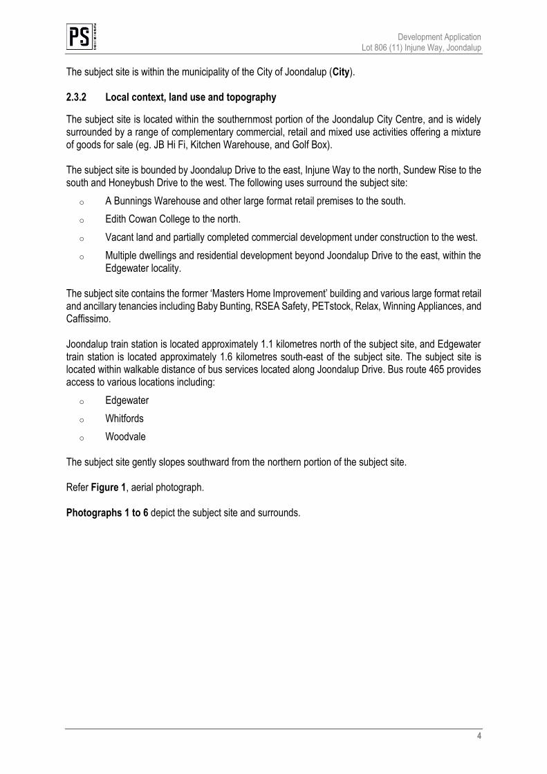
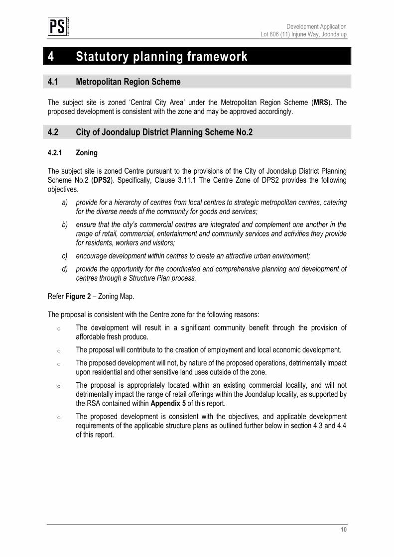
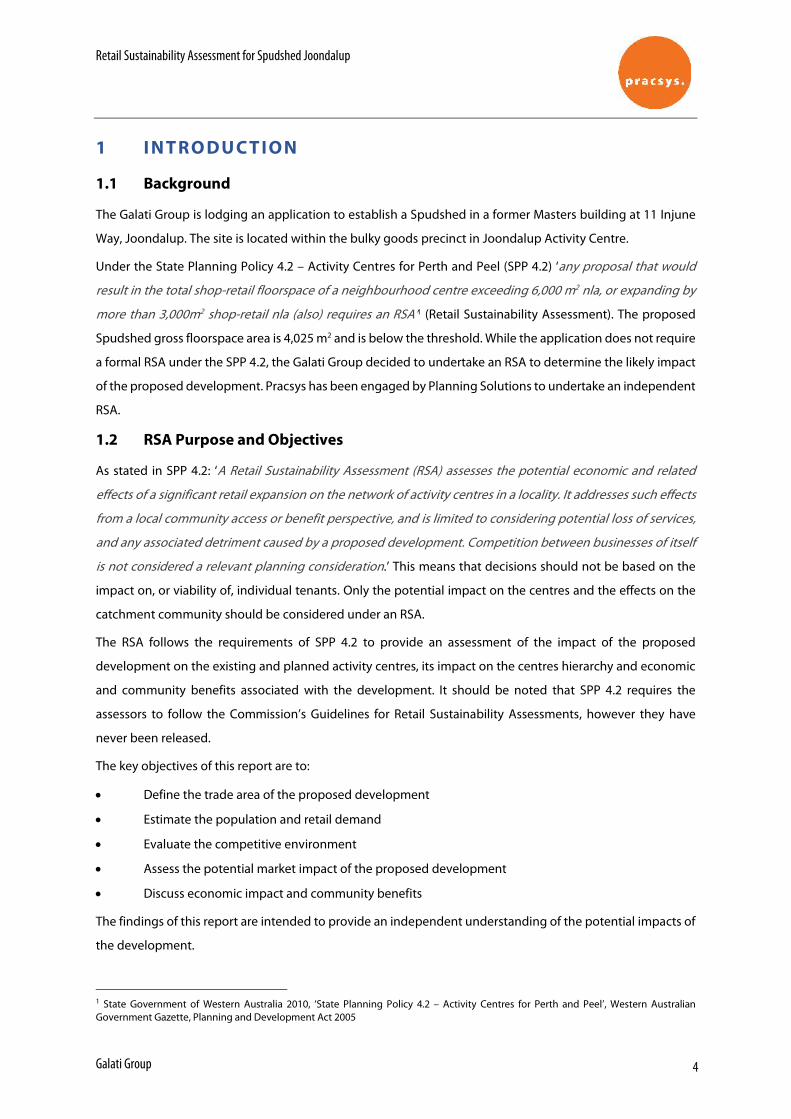
Refer Figure 2 – Zoning Map. The proposal is consistent with the Centre zone for the following reasons:
o The development will result in a significant community benefit through the provision of affordable fresh produce.
o The proposal will contribute to the creation of employment and local economic development.
o The proposed development will not, by nature of the proposed operations, detrimentally impact upon residential and other sensitive land uses outside of the zone.
o The proposal is appropriately located within an existing commercial locality, and will not detrimentally impact the range of retail offerings within the Joondalup locality, as supported by the RSA contained within Appendix 5 of this report.
o The proposed development is consistent with the objectives, and applicable development requirements of the applicable structure plans as outlined further below in section 4.3 and 4.4 of this report.
ZONING MAP
02DISCLAIMER: THIS DOCUMENT IS AND REMAINS THE PROPERTY OF PLANNING SOLUTIONS AND MAY NOT BE COPIED IN WHOLE OR IN PART WITHOUT THE WRITTEN CONSENT OF PLANNING SOLUTIONS. ALL AREAS, DISTANCES AND ANGLES ARE APPROXIMATE ONLY AND ARE SUBJECT TO SURVEY.
FIGURE
BASEPLAN SOURCE: WAPC
Subject Site
SCALE 1: 5,000 @ A4DATE 3 September 2018FILE 02 180903 5863 Zoning Map.dwgREVISION 1/DR/1stDraft/20.08.2018
Business
OTHER
R CodesR20
Locality Boundary
LEGEND
REGION SCHEME RESERVES
LOCAL SCHEME RESERVES
LOCAL SCHEME ZONES
Parks and Recreation
0 50 100Scale Bar (m)
Other Regional Roads
LOT 806 (11) INJUNE WAYJOONDALUP, WESTERN AUSTRALIA
Centre
Public Use
Primary Regional Roads
Residential
Service Industrial
R-Code Subject to AgreedStructure Plan
Development Application Lot 806 (11) Injune Way, Joondalup
12
The proposed development will not undermine current of future development within the Joondalup locality as it is simply repurposing a portion of the existing building at the subject site. The proposal is consistent with the objectives of the Centre zone and warrants approval accordingly. In accordance with clause 3.11.1, the following structure plans apply to the subject site:
o Joondalup City Centre Development Plan Manual
o City of Joondalup Draft Activity Centre Plan An assessment against the abovementioned instruments is provided in sections 4.3 and 4.4 of this report. 4.2.2 Land use classification and permissibility The proposed Spudshed will operate in line with existing stores across Western Australia, comprising the display and retail sale of discounted fresh produces, meat, dairy, packaged food, and ancillary grocery items. The proposed Spudshed comprises 4,025m² gross floor area (GFA). As outlined above within section 1.2.2 of this report, the City’s officers have advised the proposed Spudshed Fresh Produce Market is characterised as an ‘unlisted use’ under DPS2. Clause 3.3 of DPS2 outlines:
[I]f the use of the land for a particular purpose is not specifically mentioned in the Zoning Table and cannot reasonably be determined as falling within the interpretation of one of the use categories the local government may:
a) determine that the use is consistent with the objectives and purposes of the particular zone and is therefore permitted; or
b) determine that the proposed use may be consistent with the objectives and purpose of the zone and thereafter follow the procedures set down for an ‘A’ use in Clause 6.6.3 in considering an application for planning approval; …
As outlined above in section 4.2.1 of this report, the proposed development is consistent with the ‘Centre’ objectives. Further, an assessment against the applicable objectives of the relevant structure plans are addressed further below in section 4.3 and 4.4 of this report. The proposed Spudshed Fresh Produce Market is capable of approval at the subject site and warrants the City’s approval accordingly. 4.2.3 Development Assessment
Part 4 of DPS2 stipulates general development requirements that apply to all development not controlled by the Residential Design Codes. Having regard to Clause 3.11 of DPS2, an assessment is only provided against those development requirements not already set out by the relevant structure plan. Table 2 below provides an assessment against the requirements relevant to the proposal.
Development Application Lot 806 (11) Injune Way, Joondalup
13
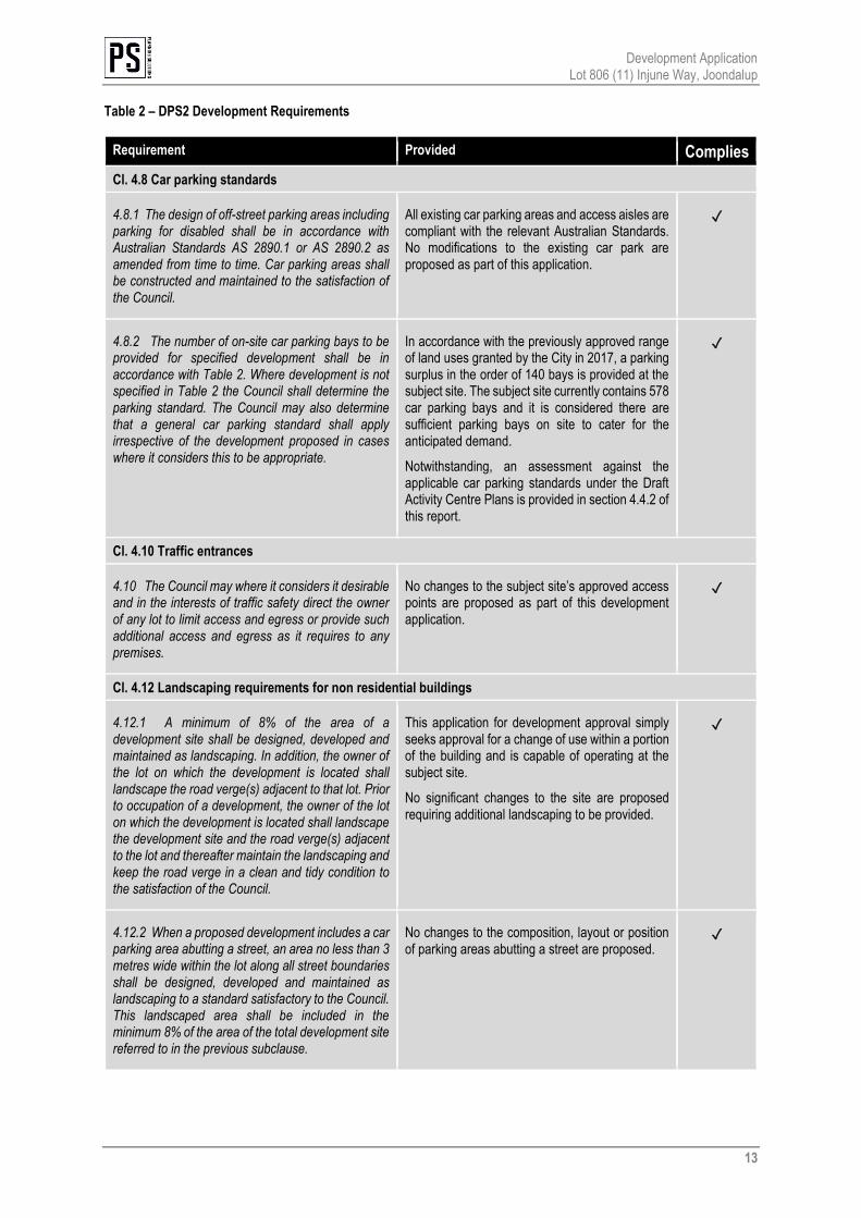
Table 2 – DPS2 Development Requirements
Requirement Provided Complies
Cl. 4.8 Car parking standards
4.8.1 The design of off-street parking areas including parking for disabled shall be in accordance with Australian Standards AS 2890.1 or AS 2890.2 as amended from time to time. Car parking areas shall be constructed and maintained to the satisfaction of the Council.
All existing car parking areas and access aisles are compliant with the relevant Australian Standards. No modifications to the existing car park are proposed as part of this application.
✓
4.8.2 The number of on-site car parking bays to be provided for specified development shall be in accordance with Table 2. Where development is not specified in Table 2 the Council shall determine the parking standard. The Council may also determine that a general car parking standard shall apply irrespective of the development proposed in cases where it considers this to be appropriate.
In accordance with the previously approved range of land uses granted by the City in 2017, a parking surplus in the order of 140 bays is provided at the subject site. The subject site currently contains 578 car parking bays and it is considered there are sufficient parking bays on site to cater for the anticipated demand.
Notwithstanding, an assessment against the applicable car parking standards under the Draft Activity Centre Plans is provided in section 4.4.2 of this report.
✓
Cl. 4.10 Traffic entrances
4.10 The Council may where it considers it desirable and in the interests of traffic safety direct the owner of any lot to limit access and egress or provide such additional access and egress as it requires to any premises.
No changes to the subject site’s approved access points are proposed as part of this development application.
✓
Cl. 4.12 Landscaping requirements for non residential buildings
4.12.1 A minimum of 8% of the area of a development site shall be designed, developed and maintained as landscaping. In addition, the owner of the lot on which the development is located shall landscape the road verge(s) adjacent to that lot. Prior to occupation of a development, the owner of the lot on which the development is located shall landscape the development site and the road verge(s) adjacent to the lot and thereafter maintain the landscaping and keep the road verge in a clean and tidy condition to the satisfaction of the Council.
This application for development approval simply seeks approval for a change of use within a portion of the building and is capable of operating at the subject site.
No significant changes to the site are proposed requiring additional landscaping to be provided.
✓
4.12.2 When a proposed development includes a car parking area abutting a street, an area no less than 3 metres wide within the lot along all street boundaries shall be designed, developed and maintained as landscaping to a standard satisfactory to the Council. This landscaped area shall be included in the minimum 8% of the area of the total development site referred to in the previous subclause.
No changes to the composition, layout or position of parking areas abutting a street are proposed.
✓
Development Application Lot 806 (11) Injune Way, Joondalup
14
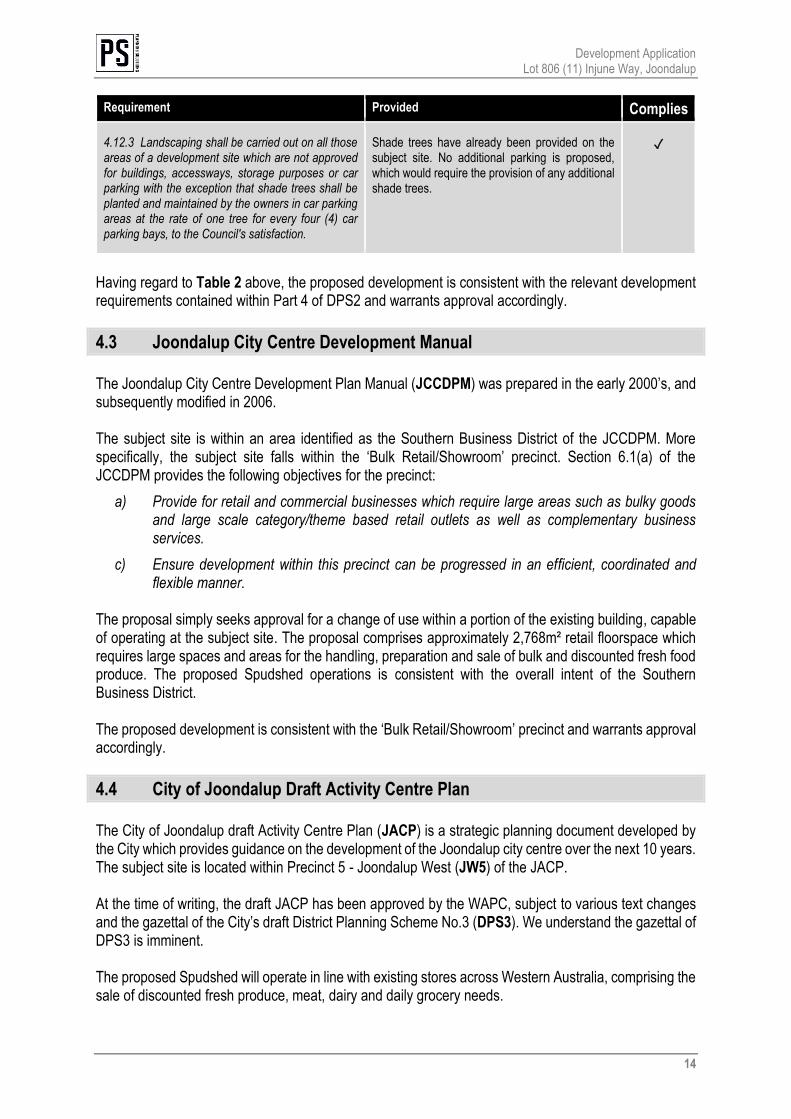
Requirement Provided Complies
4.12.3 Landscaping shall be carried out on all those areas of a development site which are not approved for buildings, accessways, storage purposes or car parking with the exception that shade trees shall be planted and maintained by the owners in car parking areas at the rate of one tree for every four (4) car parking bays, to the Council's satisfaction.
Shade trees have already been provided on the subject site. No additional parking is proposed, which would require the provision of any additional shade trees.
✓
Having regard to Table 2 above, the proposed development is consistent with the relevant development requirements contained within Part 4 of DPS2 and warrants approval accordingly.
4.3 Joondalup City Centre Development Manual
The Joondalup City Centre Development Plan Manual (JCCDPM) was prepared in the early 2000’s, and subsequently modified in 2006. The subject site is within an area identified as the Southern Business District of the JCCDPM. More specifically, the subject site falls within the ‘Bulk Retail/Showroom’ precinct. Section 6.1(a) of the JCCDPM provides the following objectives for the precinct:
a) Provide for retail and commercial businesses which require large areas such as bulky goods and large scale category/theme based retail outlets as well as complementary business services.
c) Ensure development within this precinct can be progressed in an efficient, coordinated and flexible manner.
The proposal simply seeks approval for a change of use within a portion of the existing building, capable of operating at the subject site. The proposal comprises approximately 2,768m² retail floorspace which requires large spaces and areas for the handling, preparation and sale of bulk and discounted fresh food produce. The proposed Spudshed operations is consistent with the overall intent of the Southern Business District. The proposed development is consistent with the ‘Bulk Retail/Showroom’ precinct and warrants approval accordingly.
4.4 City of Joondalup Draft Activity Centre Plan
The City of Joondalup draft Activity Centre Plan (JACP) is a strategic planning document developed by the City which provides guidance on the development of the Joondalup city centre over the next 10 years. The subject site is located within Precinct 5 - Joondalup West (JW5) of the JACP. At the time of writing, the draft JACP has been approved by the WAPC, subject to various text changes and the gazettal of the City’s draft District Planning Scheme No.3 (DPS3). We understand the gazettal of DPS3 is imminent. The proposed Spudshed will operate in line with existing stores across Western Australia, comprising the sale of discounted fresh produce, meat, dairy and daily grocery needs.
Development Application Lot 806 (11) Injune Way, Joondalup
15
The proposed Spudshed is consistent with various objectives outlined within the draft JACP for the following reasons:
o The proposal would result in providing a greater variety of offerings conveniently to customers at the subject site.
o The proposal would contribute to providing a diverse mix of compatible uses at the site that will not conflict with surrounding developments.
o The proposal would encourage workers and visitors to improve local employment within the City.
o The use would be located within an existing adaptable building, responding to market demand. The proposal is consistent with the objectives of the draft JACP and warrants approval accordingly. 4.4.1 Car parking As demonstrated in the most recent application for planning approval (20 October 2017 DA17/0960), a large surplus of car parking is provided on site, having regard for the parking standards established under DPS2, in the order of 140 bays. With consideration to the draft JACP as a ‘seriously entertained’ instrument and the imminent gazettal of LPS3, Section 1.5.5.1 Joondalup West Precinct Development Standards stipulates the applicable car parking requirement for the JW5 Precinct. JW5 – Car Parking and Access requires 1 bay per 1 bay per 75m² net lettable area (NLA) of non-residential development. As this application for development approval is simply a change of use application within a portion of the existing building, no material change to the overall footprint of development previously approved on site is proposed. The existing development comprises four separate buildings with a total floorspace exceeding 18,000m². The subject tenancy comprises 4,025m² GFA. In accordance with the development requirements of the JW5 precinct, a parking demand of approximately 240 bays would be required. Accordingly, the existing 578 car parking bays available at the subject site are more than capable of accommodating the proposed Spudshed tenancy and warrants the City’s support accordingly.
Development Application Lot 806 (11) Injune Way, Joondalup
16
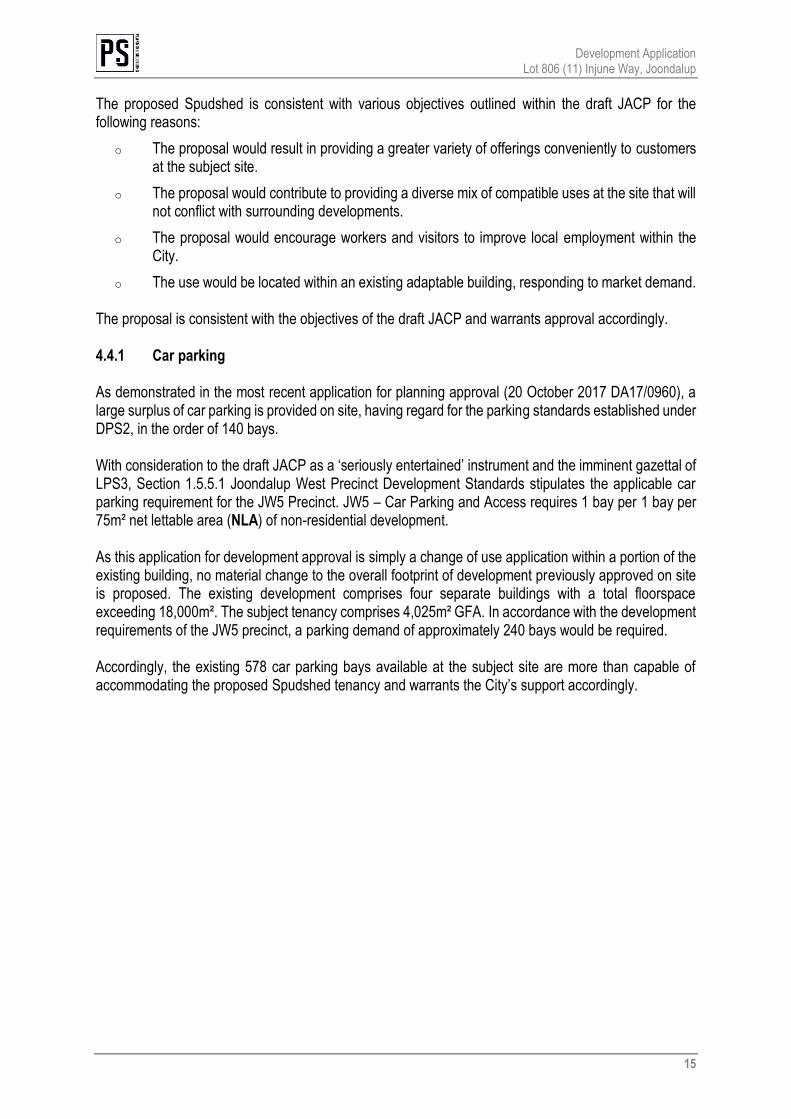
5 Matters to be considered Clause 67-Part 9-Schedule 2 (deemed provisions) of the Planning and Development (Local Planning Schemes) Regulations 2015 (LPS Regulations) stipulates matters to be given due regard by local government when considering development applications. Table 3 below provides an assessment against matters relevant to this proposal.
Table 3 - Matters to be considered by local government
Relevant matters to be considered Comment
(a) the aims and provisions of this Scheme and any other local planning scheme operating within the Scheme area;
The aims and provisions of DPS2 are considered in section 4.2.1 of this report.
(b) the requirements of orderly and proper planning including any proposed local planning scheme or amendment to this Scheme that has been advertised under the Planning and Development (Local Planning Schemes) Regulations 2015 or any other proposed planning instrument that the local government is seriously considering adopting or approving;
There is no know amendment to DPS2 affecting the proposed development. As addressed within section 4.4 of this report, the City’s draft LPS3 is near gazettal and will not affect the proposed development.
(h) any structure plan, activity centre plan or local development plan that relates to the development;
The subject site is located within the Joondalup City Centre Development Plan and draft Joondalup Activity Centre Plan area. This report demonstrates the proposed development complies with the relevant development requirements, objectives and overall long-term prospects of the applicable structure plans. Also note that the RSA contained within Appendix 5 of this report confirms the proposed development will not undermine planned or other retail centres.
Development Application Lot 806 (11) Injune Way, Joondalup
17
Relevant matters to be considered Comment
n) the amenity of the locality including the following: (i) environmental impacts of the development; (ii) the character of the locality; (iii) social impacts of the development;
Environmental Impacts The proposed development will not result in any adverse environmental impacts. Character of the Locality The locality is characterised by large format retail and other similar commercial uses within the Joondalup West Precinct. The subject site contains the former Masters Home Improvement store which has been previously approved to accommodate a large format retail development at the site, consistent with existing activities within the locality. The proposal seeks approval to change the use of a portion of the existing building as a Fresh Produce Market, including internal building works associated with the internal fit out of the premises. The use is consistent with the objectives of the applicable planning framework and is appropriate in the context of the wider Joondalup locality. Social Impacts The proposed development will have a positive social impact, providing access to affordable fresh produce and other food and grocery items. The Spudshed will provide local employment, including for young people, and contribution to economic growth. Considerable anecdotal evidence indicates businesses on the site and immediate area have struggled to remain viable since the Masters store closed. This has seriously affected the livelihoods of local small business owners. The proposed Spudshed will bring much-needed customers back to the area, supporting the existing businesses.
(s) the adequacy of — (i) the proposed means of access to and egress
from the site; and (ii) arrangements for the loading, unloading,
manoeuvring and parking of vehicles
The proposal is simply to change the use of a portion of an existing building and to carry out associated internal building works for the fit out of the premises. No changes are proposed to the existing access arrangements which are comprised of four existing access points into the site via Injune Way, Honeybush Drive and Sundew Rise. The proposed Spudshed tenancy will be services by the existing service area located to the south-western boundary of the subject tenancy,
Development Application Lot 806 (11) Injune Way, Joondalup
18
Relevant matters to be considered Comment
(t) the amount of traffic likely to be generated by the development, particularly in relation to the capacity of the road system in the locality and the probable effect on traffic flow and safety;
A Traffic Impact Statement (TIS) was prepared in 2016 for the conversion of the building as a multi-tenant large format retail development. This application simply seeks approval for a change of use within a portion of the existing building. The Traffic Impact Statement demonstrated the existing internal access arrangements are sufficient to accommodate a variety of land uses at the subject site. Refer Appendix 6 for a copy of the 2016 TIS. Traffic surveys carried out in relation to other Spudshed applications have indicated a Spudshed may be expected to generate approximately 14 vehicle trips per hour per 100m² of sales/display area, equating to 395 peak hour trips. It should be noted that the Spudshed is likely to trade 24 hours per day, 7 days per week, and traffic will therefore be distributed across a wider period. No alterations to the existing car parking, crossovers or internal access is proposed as part of this application.
(x) the impact of the development on the community as a whole notwithstanding the impact of the development on particular individuals;
The proposed development allows for the provision of stable and secure work for a number of staff. Additionally, the proposal will enable the sale of fresh, healthy food and associated grocery products to the surrounding community, including wholesale to local food businesses.
Having regard to Table 3 above, the proposal appropriately addresses matters to be given due regard as set out in the deemed provisions. The proposal therefore warrants approval accordingly.
Development Application Lot 806 (11) Injune Way, Joondalup
19
6 Conclusion This proposal seeks to develop a portion of the former Masters Home Improvement store to ‘Fresh Produce Market’ facilitating the development of a new Spudshed in line with Galati Group’s Spudshed stores across Western Australia. The development will allow for the sale of discounted fresh produce, meat, dairy, packaged food, and ancillary grocery items, servicing the wider Joondalup locality. The proposal is consistent with the statutory planning framework provided for the subject site. The proposed Spudshed warrants support and approval as it:
1. Is consistent with the relevant standards and requirements of the City of Joondalup District Planning Scheme No.2 and applicable structure plans.
2. Will enable the sale of affordable, fresh, healthy food and associated grocery products to the
surrounding communities.
3. Will support local food businesses by offering an alternative source of fresh ingredients, where currently many businesses are required to attend the Canning Vale markets.
4. Will support surrounding businesses which have been adversely affected by the collapse of the
Masters chain. 5. Is entirely compatible with the approved activities on the subject site.
6. The proposed development will not adversely impact nearby centres and the surrounding retail
trade network. The proposed development is compliant with the prescribed planning and development standards as stipulated throughout this development application report and warrants the City’s approval accordingly.
GALATI GROUP
Retail Sustainability Assessment for Spudshed Joondalup
SEPTEMBER 2018
Retail Sustainability Assessment for Spudshed Joondalup
Galati Group 2
Document Control
Document Version Description Prepared By Approved By Date Approved
v 1.0 Retail Sustainability Assessment for Spudshed Joondalup Draft Report
Lucy Heales Dawson Demassiet-Huning 31 August 2018
v 1.1 Retail Sustainability Assessment for Spudshed Joondalup Final Report
Lucy Heales Dawson Demassiet-Huning 4 September 2018
Disclaimer
This report has been prepared for the Galati Group. The information contained in this document has been prepared with care by the authors and includes information from apparently reliable secondary data sources which the authors have relied on for completeness and accuracy. However, the authors do not guarantee the information, nor is it intended to form part of any contract. Accordingly, all interested parties should make their own inquiries to verify the information and it is the responsibility of interested parties to satisfy themselves in all respects. This document is only for the use of the party to whom it is addressed and the authors disclaim any responsibility to any third party acting upon or using the whole or part of its contents.
Retail Sustainability Assessment for Spudshed Joondalup
Galati Group 3
CONTENTS 1 Introduction ............................................................................................................ 4
1.1 Background .......................................................................................................................................................... 4
1.2 RSA Purpose and Objectives .......................................................................................................................... 4
1.3 Gravity Model Methodology .......................................................................................................................... 5
2 Development Context ............................................................................................ 6
2.1 Site Location ........................................................................................................................................................ 6
2.2 Proposed Development................................................................................................................................... 7
2.3 Trade Area Definition ........................................................................................................................................ 7
3 Retail Demand....................................................................................................... 10
3.1 Trade Area Dwellings ..................................................................................................................................... 10
3.2 Retail Expenditure ........................................................................................................................................... 12
4 Retail Supply ......................................................................................................... 13
4.1 Current Supply ................................................................................................................................................. 13
4.2 Expansions and Planned Developments ................................................................................................ 16
5 Impact of the Potential Development ................................................................ 18
5.1 Key Assumptions ............................................................................................................................................. 18
5.2 Model Calibration............................................................................................................................................ 18
5.3 Market Capture ................................................................................................................................................ 19
5.4 Gravity Modelling Impacts ........................................................................................................................... 20
5.5 Competitive Response .................................................................................................................................. 22
6 Impact on Community .......................................................................................... 23
6.1 Economic Benefits .......................................................................................................................................... 23
6.2 Community Benefits ...................................................................................................................................... 23
7 Conclusion ............................................................................................................. 24
8 Appendix 1: Centre Impact .................................................................................. 25
9 Appendix 2: Gravity Modelling Methodology ................................................... 27
Retail Sustainability Assessment for Spudshed Joondalup
Galati Group 4
1 I N T RO DU C T IO N
1.1 Background
The Galati Group is lodging an application to establish a Spudshed in a former Masters building at 11 Injune
Way, Joondalup. The site is located within the bulky goods precinct in Joondalup Activity Centre.
Under the State Planning Policy 4.2 – Activity Centres for Perth and Peel (SPP 4.2) ‘any proposal that would
result in the total shop-retail floorspace of a neighbourhood centre exceeding 6,000 m2 nla, or expanding by
more than 3,000m2 shop-retail nla (also) requires an RSA’1 (Retail Sustainability Assessment). The proposed
Spudshed gross floorspace area is 4,025 m2 and is below the threshold. While the application does not require
a formal RSA under the SPP 4.2, the Galati Group decided to undertake an RSA to determine the likely impact
of the proposed development. Pracsys has been engaged by Planning Solutions to undertake an independent
RSA.
1.2 RSA Purpose and Objectives
As stated in SPP 4.2: ‘A Retail Sustainability Assessment (RSA) assesses the potential economic and related
effects of a significant retail expansion on the network of activity centres in a locality. It addresses such effects
from a local community access or benefit perspective, and is limited to considering potential loss of services,
and any associated detriment caused by a proposed development. Competition between businesses of itself
is not considered a relevant planning consideration.’ This means that decisions should not be based on the
impact on, or viability of, individual tenants. Only the potential impact on the centres and the effects on the
catchment community should be considered under an RSA.
The RSA follows the requirements of SPP 4.2 to provide an assessment of the impact of the proposed
development on the existing and planned activity centres, its impact on the centres hierarchy and economic
and community benefits associated with the development. It should be noted that SPP 4.2 requires the
assessors to follow the Commission’s Guidelines for Retail Sustainability Assessments, however they have
never been released.
The key objectives of this report are to:
• Define the trade area of the proposed development
• Estimate the population and retail demand
• Evaluate the competitive environment
• Assess the potential market impact of the proposed development
• Discuss economic impact and community benefits
The findings of this report are intended to provide an independent understanding of the potential impacts of
the development.
1 State Government of Western Australia 2010, ‘State Planning Policy 4.2 – Activity Centres for Perth and Peel’, Western Australian Government Gazette, Planning and Development Act 2005
Retail Sustainability Assessment for Spudshed Joondalup
Galati Group 5
1.3 Gravity Model Methodology
Pracsys uses a proven retail gravity model methodology to examine the supply of and demand for retail
floorspace within a defined catchment and estimate the potential impact of proposed retail developments.
The Retail Gravity Model (also known as Huff’s Gravity Model) is a modified version of Sir Issac Newton’s Law
of Gravitation. Gravity Model is a popular model, widely used in international trade modelling, transport
modelling, regional planning and retail assessments. Department of Planning and Western Australian
Planning Commission (WAPC) recommend the gravity model for transport impact assessments2 and many
local governments use the gravity model approach to prepare their local commercial strategies and activity
centres planning strategies (for example, the City of Rockingham3, the City of Gosnells4, the City of Greater
Geraldton5, the City of Armadale6).
Retail Gravity modelling studies retail supply, and the probability of a customer (demand) visiting a particular
centre (supply). The model accounts for the distribution and attractiveness of competing centres, along with
the distance a customer will have to travel to each centre. Floorspace quantum is used to represent the
attractiveness of retail centres. Customers are willing to travel farther to shop at large centres, representing a
higher level of attraction (they can generally satisfy multiple needs in one trip to a larger centre where there
is a greater variety of convenience and comparison goods/services).
The model provides an objective method of distributing expenditure among centres. Calibration is used to
match the calculated distribution of expenditure to actual published turnover levels, optimising the model
outputs. Having established a benchmarked current distribution of expenditure, new floorspace can be
introduced and changes in expenditure distribution across time can be examined, allowing for various retail
centre transformations such as planned expansions and new developments.
This comprehensive approach creates a distribution of expenditure that is fundamentally unbiased as it is
based on mathematical rules. It is a widely-used approach that has been accepted by the Department of
Planning and Western Australian Planning Commission (WAPC) through the review of a wide range of
Structure Plans, Local Commercial Strategies and Retail Sustainability Assessments both prior to, and post, the
implementation of SPP4.2 in 2010.7
For more information on the gravity model methodology, please see Appendix 2.
2 Department of Planning, Transport Impact Assessment Guidelines, August 2016 3 City of Rockingham, Local Commercial Strategy, 2013 4 City of Gosnells, Activity Centres Planning Strategy, 2012 5 City of Greater Geraldton, Commercial Activity Centres Strategy, 2012 6 City of Armadale, Local Planning Strategy – Town Planning Scheme No. 4, 2016 7 For example, in April 2014 the West Australian Planning Commission approved the Melville City Centre Structure Plan, which proposed the expansion of the Garden City shopping centre. The RSA prepared by Pracsys in support of the application was based on the gravity modelling. Please see Melville City Structure Plan 2015
Retail Sustainability Assessment for Spudshed Joondalup
Galati Group 6
2 D E V EL O P M EN T C O N T EX T
2.1 Site Location
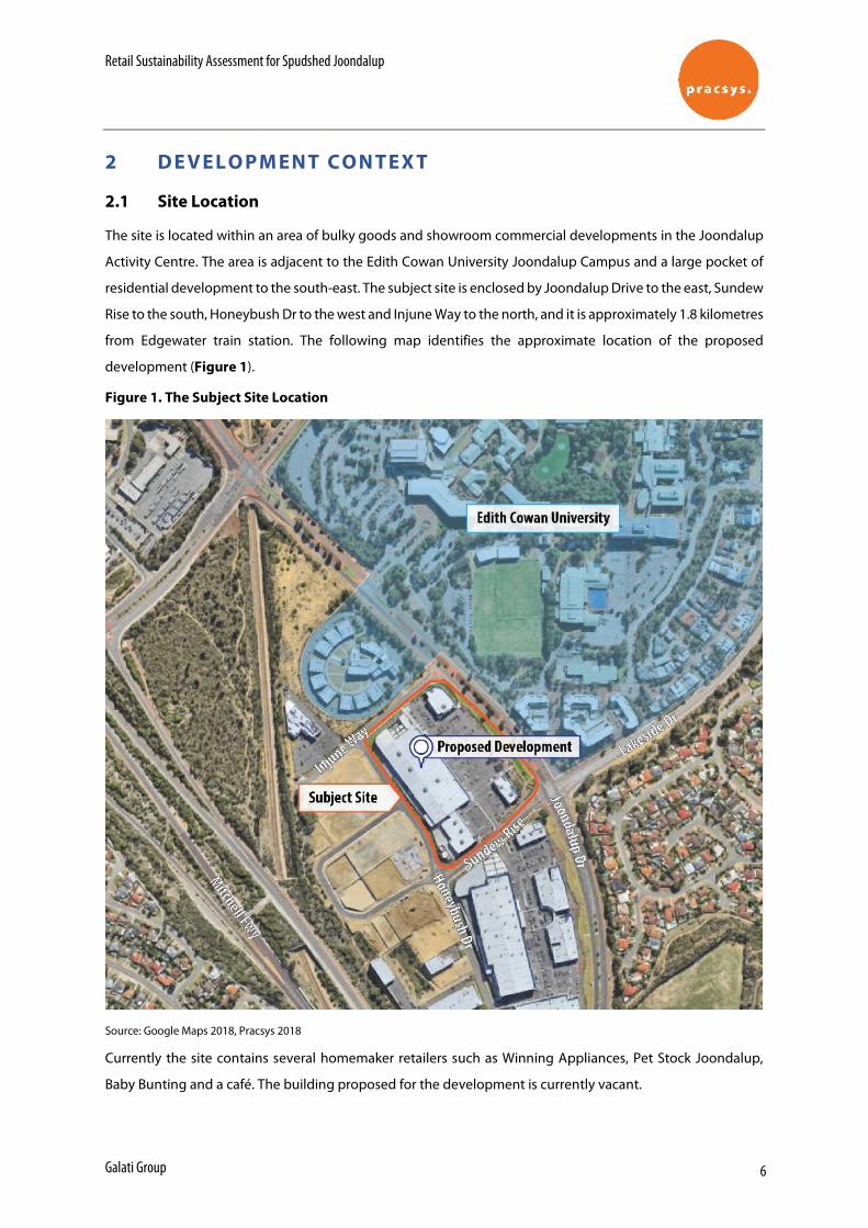
The site is located within an area of bulky goods and showroom commercial developments in the Joondalup
Activity Centre. The area is adjacent to the Edith Cowan University Joondalup Campus and a large pocket of
residential development to the south-east. The subject site is enclosed by Joondalup Drive to the east, Sundew
Rise to the south, Honeybush Dr to the west and Injune Way to the north, and it is approximately 1.8 kilometres
from Edgewater train station. The following map identifies the approximate location of the proposed
development (Figure 1).
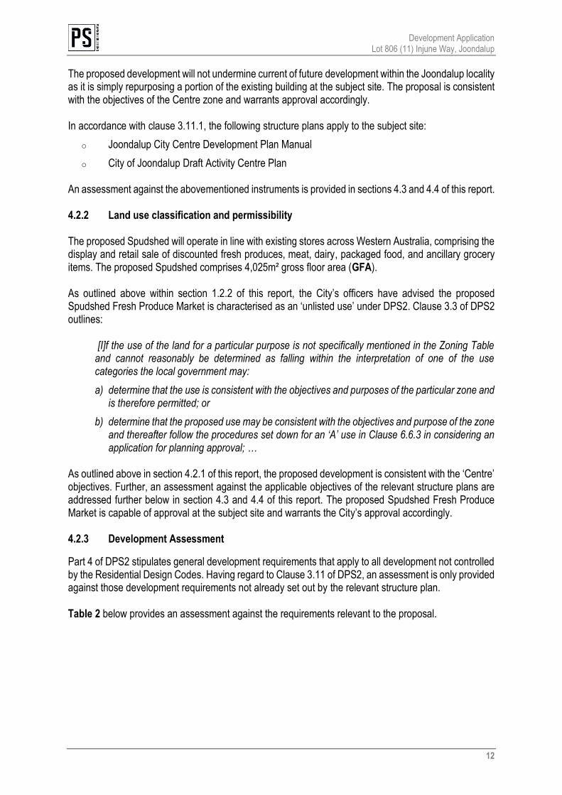
Figure 1. The Subject Site Location
Source: Google Maps 2018, Pracsys 2018
Currently the site contains several homemaker retailers such as Winning Appliances, Pet Stock Joondalup,
Baby Bunting and a café. The building proposed for the development is currently vacant.
Retail Sustainability Assessment for Spudshed Joondalup
Galati Group 7
2.2 Proposed Development
The proposed development will consist of Spudshed and associated back of the house areas for servicing and
storage of goods. The development will have a total floorspace of 4,025 m2.8
Spudshed is a vendor that grows some of its produce and tends to sell it cheaper than other supermarkets.
Spudshed will operate on a 24-hour basis. Whilst the amount of convenience retail floorspace may
approximate that of a small neighbourhood centre, Spudshed has many distinct characteristics. Its operations
are clearly different from that of a typical convenience-based centre:
• As opposed to neighbourhood centres, Spudshed does not have a wide range of convenience goods,
its focus is almost exclusively on fresh produce;
• Spudshed products are sourced directly from growers and not via a distribution centre;
• Spudshed requires larger display areas and greater aisle widths;
• Produce is marketed for bulk quantity purchases such as wholesale to restaurants and cafes, reducing
dependence on ‘basket shoppers’;
• The nature of the bulk quantity sales requires vehicular access to the premises for the collection of
goods;
• A typical Spudshed catchment is approximately 15 km and much larger than that of a standard
neighbourhood centre9, indicating that customers are prepared to travel further to shop at the store.
The Spudshed business model shares many similar characteristics with bulky goods retail operators as defined
in State Planning Policy and the Model Provisions for local planning schemes10, such as the requirement of a
large areas for handling, display and storage and direct vehicle access to the site. As with bulky goods retailers,
Spudshed has a wholesale bulky retail element and a much wider catchment than a regular neighbourhood
supermarket.
This unique Spudshed business model guides trade area definition, model calibration and impact analysis.
For the purposes of this analysis it is assumed that the centre will be open in 2019.
2.3 Trade Area Definition
Trade area is the spatial boundary from which a development generates the majority of its customers. The
trade area definition allows for measurement of the number of potential customers, their demographics and
expenditure potential as well as potential competition.
As per SPP 4.2, the trade area of a typical neighbourhood centre is approximately one km radius from the
activity centre. As discussed above, the Spudshed trade area is much wider, reflecting the higher willingness
of customers to travel. The Galati Group have estimated that the typical trade area for a Spudshed is around
8 Meyer Shircore and Associates Architects, Proposed Large Format Retail Redevelopment 11 Injune Way Joondalup 9 Galati Group has estimated that at least 25% of the Baldivis Spudshed turnover is made up from bulky sales to restaurants, cafes, schools etc 10 Planning and Development (Local Planning Schemes) Regulations 2015
Retail Sustainability Assessment for Spudshed Joondalup
Galati Group 8
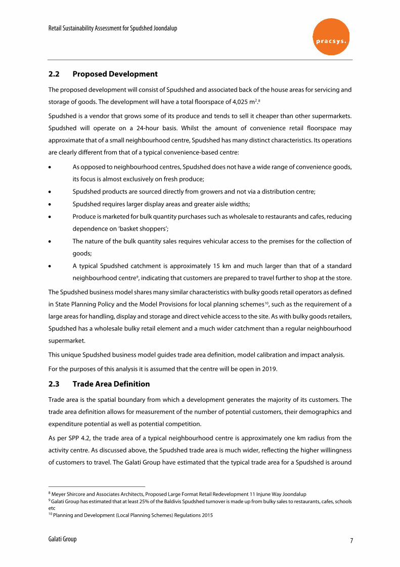
15 km, representing up to 20 minutes’ drive time. The modelled Spudshed Joondalup trade area is shown in
Figure 2.
Figure 2. Potential Development Trade Area
Source: Pracsys 2018
The trade area includes suburbs within rapidly expanding areas of Wanneroo and Joondalup. The expected
catchment stretches from Quinns Rocks to the north, to Balcatta to the south, all the way to the ocean border
to the west and Jandabup to the east.

Retail Sustainability Assessment for Spudshed Joondalup
Galati Group 9
The primary trade area, from which the majority of the expenditure is drawn, extends up to 10 km to the north-
west due a comparatively limited competition to the north. The primary catchment is restricted to 1km to the
east by Lake Joondalup and around 4.5km to the west by the ocean. To the south the primary catchment
includes the suburbs of Craigie and Woodvale.
Retail Sustainability Assessment for Spudshed Joondalup
Galati Group 10
3 R E T A IL DE M A N D
Understanding the local demographics and expected market growth is key in the assessment of the market
impact of Spudshed Joondalup. This section provides an overview of the current and future dwellings and the
expenditure patterns in the trade area.
3.1 Trade Area Dwellings
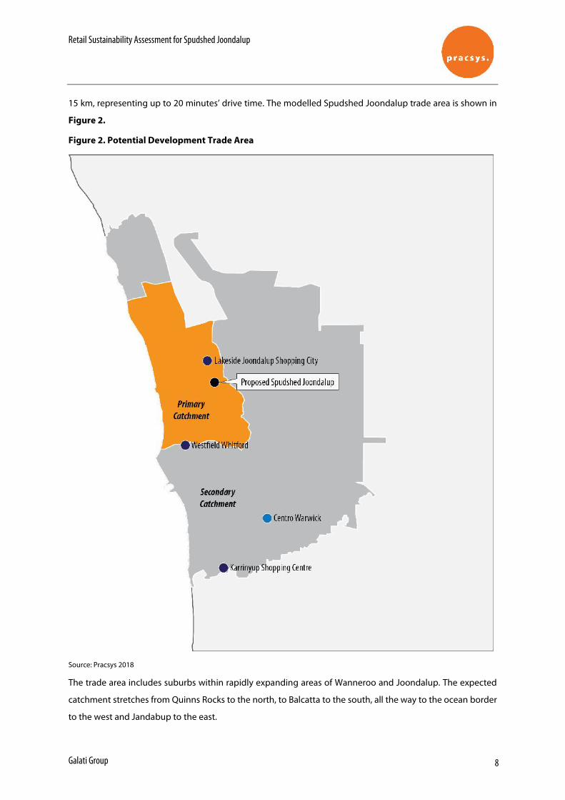
The trade area includes some of the fastest growing suburbs in Western Australia. The total trade area is
estimated to contain approximately 119,590 dwellings in 2018 (Figure 3).11 Based on the dwelling growth
forecasts provided by the Department of Planning, the number of dwellings is expected to grow to 130,829
by 2028. This represents an increase of 9%, or 11,239 households. The dwellings are projected to grow at
slightly faster rate between 2018 and 2023 with slower growth predicted after 2023. This indicates that a high
proportion of suburbs in the catchment will almost be fully developed by 2023.
This strong growth in the number of households and local population will continue to foster and support a
competitive and healthy retail network. It will also serve to dilute the potential impact of new expansions and
developments and increases the likelihood that they can be sustainably supported by the trade area.
Figure 3. Trade Area Dwelling Growth Forecast
Source: ABS 2016, WA Tomorrow Band C 2015, Pracsys 2018
11 The ABS Census 2016 dwelling count by SA1 areas was used to estimate the 2016 number of dwellings in the catchment. Department of Planning 2015 WA Tomorrow population projections, Band C were used to forecast dwellings.
28,816 30,047 30,648
90,773 96,576 100,181
-
20,000
40,000
60,000
80,000
100,000
120,000
140,000
2018 2023 2028
Num
ber o
f Dw
ellin
gs
Prim ary Catchmen t Secondary Catchment
Retail Sustainability Assessment for Spudshed Joondalup
Galati Group 11
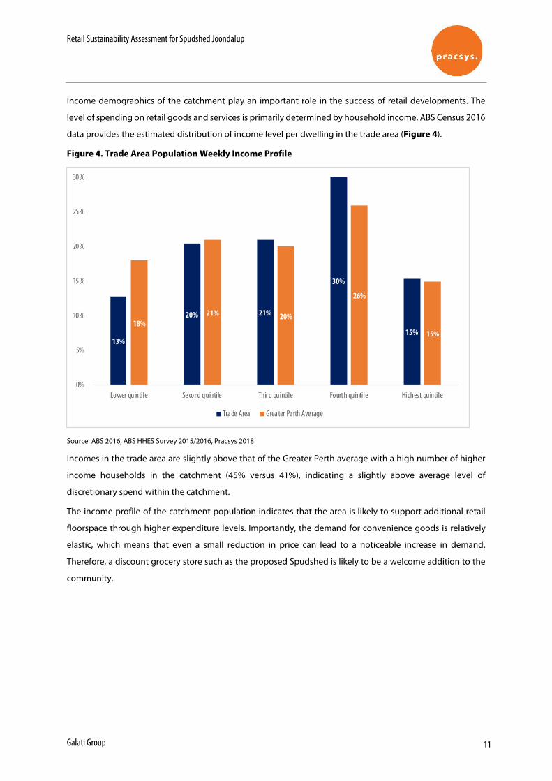
Income demographics of the catchment play an important role in the success of retail developments. The
level of spending on retail goods and services is primarily determined by household income. ABS Census 2016
data provides the estimated distribution of income level per dwelling in the trade area (Figure 4).
Figure 4. Trade Area Population Weekly Income Profile
Source: ABS 2016, ABS HHES Survey 2015/2016, Pracsys 2018
Incomes in the trade area are slightly above that of the Greater Perth average with a high number of higher
income households in the catchment (45% versus 41%), indicating a slightly above average level of
discretionary spend within the catchment.
The income profile of the catchment population indicates that the area is likely to support additional retail
floorspace through higher expenditure levels. Importantly, the demand for convenience goods is relatively
elastic, which means that even a small reduction in price can lead to a noticeable increase in demand.
Therefore, a discount grocery store such as the proposed Spudshed is likely to be a welcome addition to the
community.
13%
20% 21%
30%
15%18%
21% 20%
26%
15%
0%
5%
10%
15%
20%
25%
30%
Lower quintile Se cond quintile Thir d quintile Fourth quintile Highest quintile
Tra de Area Grea ter Pe rth Ave rage
Retail Sustainability Assessment for Spudshed Joondalup
Galati Group 12
3.2 Retail Expenditure
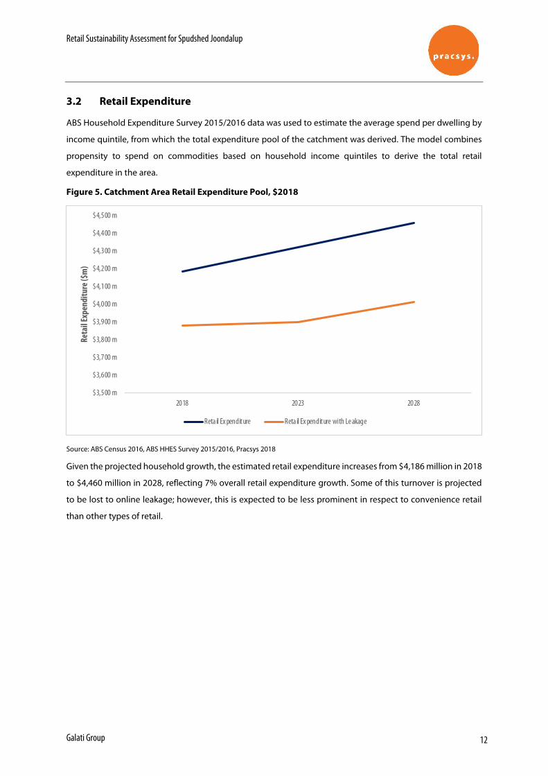
ABS Household Expenditure Survey 2015/2016 data was used to estimate the average spend per dwelling by
income quintile, from which the total expenditure pool of the catchment was derived. The model combines
propensity to spend on commodities based on household income quintiles to derive the total retail
expenditure in the area.
Figure 5. Catchment Area Retail Expenditure Pool, $2018
Source: ABS Census 2016, ABS HHES Survey 2015/2016, Pracsys 2018
Given the projected household growth, the estimated retail expenditure increases from $4,186 million in 2018
to $4,460 million in 2028, reflecting 7% overall retail expenditure growth. Some of this turnover is projected
to be lost to online leakage; however, this is expected to be less prominent in respect to convenience retail
than other types of retail.
$3,500 m
$3,600 m
$3,700 m
$3,800 m
$3,900 m
$4,000 m
$4,100 m
$4,200 m
$4,300 m
$4,400 m
$4,500 m
2018 2023 2028
Reta
il Ex
pend
iture
($m
)
Reta il Ex penditure Reta il Ex penditure with Le akage
Retail Sustainability Assessment for Spudshed Joondalup
Galati Group 13
4 R E T A IL SU P P L Y
4.1 Current Supply
This section provides an overview of the competitive environment facing the proposed Spudshed Joondalup.
As Spudshed sells fresh produce, the proposed development is likely to compete with activity centres in close
proximity containing a significant convenience element. The majority of activity centres within the catchment
offer some form of convenience shopping. As such, the proposed centre is expected to compete with centres
ranging from local to strategic metropolitan.
The floorspace for the catchment was estimated through data from multiple sources:
• The Department of Planning Land Use Survey, PLUC 5 SHP category floorspace (2015/17)
• Property Council Shopping Centre Directory (2015)
• Secondary Research (Various Structure Plans, Vicinity Centres website etc)
A total of 78 developments containing retail floorspace within 15 km from Spudshed Joondalup were included
in the analysis. Some of the developments are very small and will not directly compete with the proposed
development. 47 of the developments contain some form of supermarket / convenience offering and may
compete for the same expenditure.
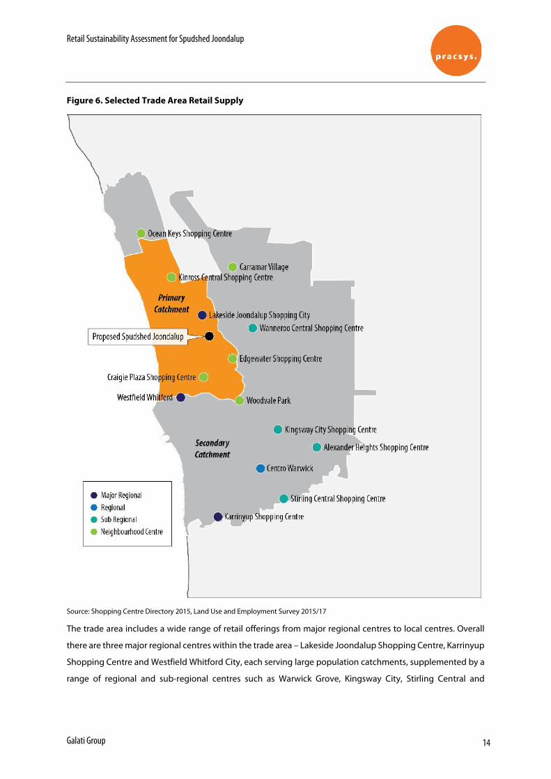
Some of the competitors for the proposed centre are shown in Figure 6.
Retail Sustainability Assessment for Spudshed Joondalup
Galati Group 14
Figure 6. Selected Trade Area Retail Supply
Source: Shopping Centre Directory 2015, Land Use and Employment Survey 2015/17
The trade area includes a wide range of retail offerings from major regional centres to local centres. Overall
there are three major regional centres within the trade area – Lakeside Joondalup Shopping Centre, Karrinyup
Shopping Centre and Westfield Whitford City, each serving large population catchments, supplemented by a
range of regional and sub-regional centres such as Warwick Grove, Kingsway City, Stirling Central and
Retail Sustainability Assessment for Spudshed Joondalup
Galati Group 15
Wanneroo Central. The majority of centres within the catchment are neighbourhood and local centres,
providing for daily and weekly household shopping needs.
Smaller activity centres located near the proposed development and with a higher proportion of
convenience-based retailing are likely to be more impacted than larger centres. Large centres are much more
attractive to potential customers than small ones as they can cater for multi-purpose visits.
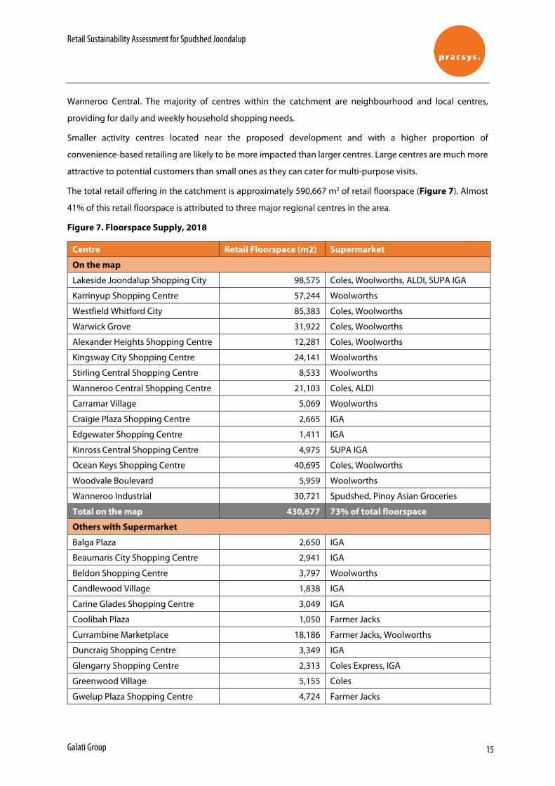
The total retail offering in the catchment is approximately 590,667 m2 of retail floorspace (Figure 7). Almost
41% of this retail floorspace is attributed to three major regional centres in the area.
Figure 7. Floorspace Supply, 2018
Centre Retail Floorspace (m2) Supermarket
On the map
Lakeside Joondalup Shopping City 98,575 Coles, Woolworths, ALDI, SUPA IGA
Karrinyup Shopping Centre 57,244 Woolworths
Westfield Whitford City 85,383 Coles, Woolworths
Warwick Grove 31,922 Coles, Woolworths
Alexander Heights Shopping Centre 12,281 Coles, Woolworths
Kingsway City Shopping Centre 24,141 Woolworths
Stirling Central Shopping Centre 8,533 Woolworths
Wanneroo Central Shopping Centre 21,103 Coles, ALDI
Carramar Village 5,069 Woolworths
Craigie Plaza Shopping Centre 2,665 IGA
Edgewater Shopping Centre 1,411 IGA
Kinross Central Shopping Centre 4,975 SUPA IGA
Ocean Keys Shopping Centre 40,695 Coles, Woolworths
Woodvale Boulevard 5,959 Woolworths
Wanneroo Industrial 30,721 Spudshed, Pinoy Asian Groceries
Total on the map 430,677 73% of total floorspace
Others with Supermarket
Balga Plaza 2,650 IGA
Beaumaris City Shopping Centre 2,941 IGA
Beldon Shopping Centre 3,797 Woolworths
Candlewood Village 1,838 IGA
Carine Glades Shopping Centre 3,049 IGA
Coolibah Plaza 1,050 Farmer Jacks
Currambine Marketplace 18,186 Farmer Jacks, Woolworths
Duncraig Shopping Centre 3,349 IGA
Glengarry Shopping Centre 2,313 Coles Express, IGA
Greenwood Village 5,155 Coles
Gwelup Plaza Shopping Centre 4,724 Farmer Jacks
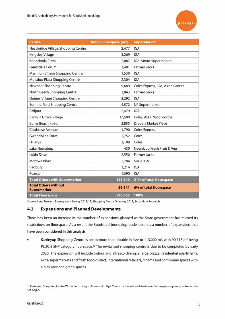
Retail Sustainability Assessment for Spudshed Joondalup
Galati Group 16
Centre Retail Floorspace (m2) Supermarket
Heathridge Village Shopping Centre 2,477 IGA
Kingsley Village 3,269 IGA
Koondoola Plaza 2,087 IGA, Smart Supermarket
Landsdale Forum 3,401 Farmer Jacks
Marmion Village Shopping Centre 1,530 IGA
Mullaloo Plaza Shopping Centre 2,304 IGA
Newpark Shopping Centre 9,689 Coles Express, IGA, Asian Grocer
North Beach Shopping Centre 3,043 Farmer Jacks
Quinns Village Shopping Centre 2,292 IGA
Summerfield Shopping Centre 4,572 NP Supermarket
Balljura 2,479 IGA
Banksia Grove Village 17,580 Coles, ALDI, Woolworths
Burns Beach Road 3,855 Drovers Market Place
Calabrese Avenue 1,790 Coles Express
Gwendoline Drive 2,752 Coles
Hillarys 3,109 Coles
Lake Neerabup 430 Neerabup Fresh Fruit & Veg
Lukin Drive 2,550 Farmer Jacks
Merriwa Plaza 2,784 SUPA IGA
Padbury 1,214 IGA
Pearsall 1,590 IGA
Total Others with Supermarket 123,849 21% of total floorspace Total Others without Supermarket 36,141 6% of total floorspace
Total Floorspace 590,667 100%
Source: Land Use and Employment Survey 2015/17, Shopping Centre Directory 2015, Secondary Research
4.2 Expansions and Planned Developments
There has been an increase in the number of expansions planned as the State government has relaxed its
restrictions on floorspace. As a result, the Spudshed Joondalup trade area has a number of expansions that
have been considered in this analysis:
• Karrinyup Shopping Centre is set to more than double in size to 113,000 m2, with 90,717 m2 being
PLUC 5 SHP category floorspace.12 The revitalised shopping centre is due to be completed by early
2020. The expansion will include indoor and alfresco dining, a large piazza, residential apartments,
extra supermarkets and fresh food district, international retailers, cinema and communal spaces with
a play area and green spaces.
12 Karrinyup Shopping Centre Works Set to Begin. As seen at: https://constructive.net.au/latest-news/karrinyup-shopping-centre-works-set-begin/
Retail Sustainability Assessment for Spudshed Joondalup
Galati Group 17
• Stirling Central was revitalised in 2017 with a new look Woolworths supermarket, new BWS and
improved speciality shops.13 The redevelopment has resulted in 159 m2 reduction in floorspace.14
• An $80 million redevelopment of Westfield Whitford City was completed in September 2017 with the
opening of a new dining, lifestyle and entertainment precinct.15
• Banksia Grove Village went through a second stage of its development earlier this year.16 The
expansion has increased the total retail floorspace to 17,580 m2.17
The expansion and redevelopments that happened in 2018 or earlier have been included in the Figure 7.
Floorspace Supply, 2018. Karrinyup Shopping Centre expansion will see the total retail floorspace in the
trade area increase by 33,473 m2 or 6% by 2022.
Recent and future expansions in the trade area indicate a healthy environment that is able to sustain
additional retail offering. Significant population growth will result in additional retail expenditure, further
supporting these future expansions (Section 3 Retail Expenditure).
13 https://www.stirlingcentral.com.au/your-centre-is-changing/ 14 Department of Planning, 2016. As seen at: https://www.planning.wa.gov.au/daps/data/metropolitan%20daps/metro%20north-west%20jdap/meeting%20agendas%20and%20papers/[s]f3f660f1/20160620%20-%20Agenda%20-%20No%20133%20-%20City%20of%20Stirling000061-000080.pdf 15 As seen at: https://www.scentregroup.com/our-portfolio/Centres/westfield-whitford-city 16 As seen at: https://www.pfeng.com.au/gallery/civil-engineering/retail-1/banksia-grove-village--1/ 17 As seen at: https://www.wanneroo.wa.gov.au/consultations/downloads/5ab9bc9eac3d2.pdf
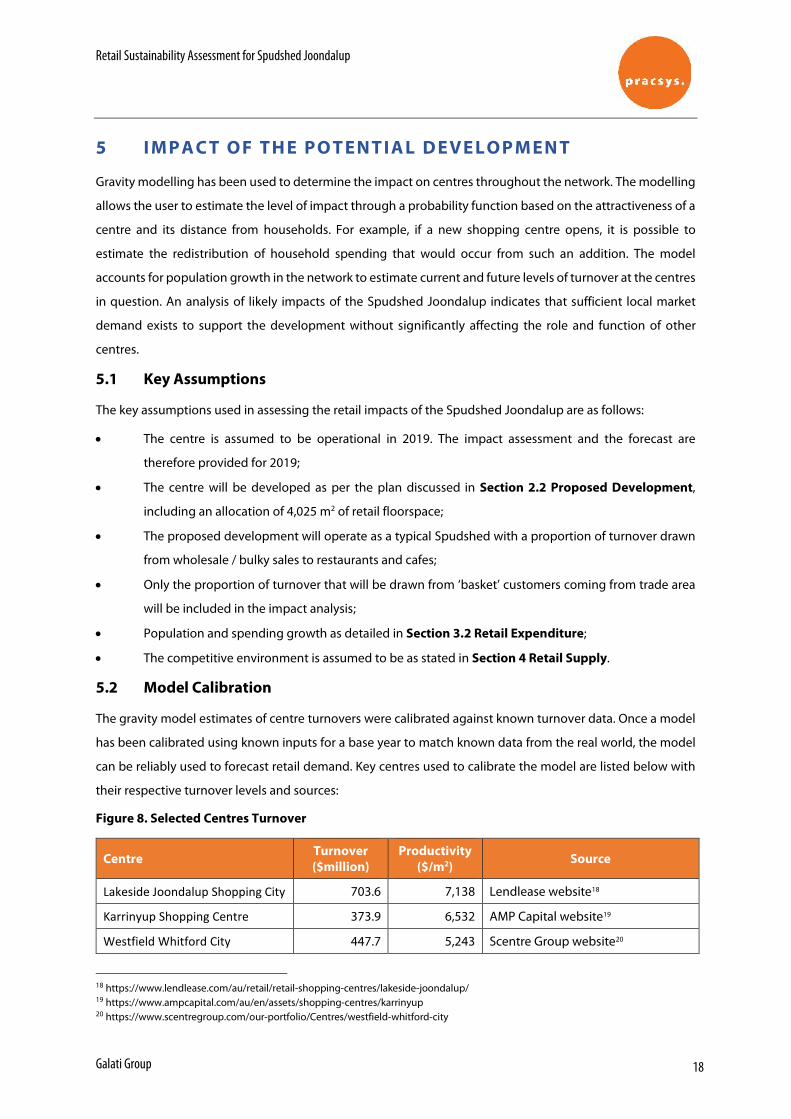
Retail Sustainability Assessment for Spudshed Joondalup
Galati Group 18
5 I M P A C T O F T H E P O T EN T IA L D EVE L O P M EN T
Gravity modelling has been used to determine the impact on centres throughout the network. The modelling
allows the user to estimate the level of impact through a probability function based on the attractiveness of a
centre and its distance from households. For example, if a new shopping centre opens, it is possible to
estimate the redistribution of household spending that would occur from such an addition. The model
accounts for population growth in the network to estimate current and future levels of turnover at the centres
in question. An analysis of likely impacts of the Spudshed Joondalup indicates that sufficient local market
demand exists to support the development without significantly affecting the role and function of other
centres.
5.1 Key Assumptions
The key assumptions used in assessing the retail impacts of the Spudshed Joondalup are as follows:
• The centre is assumed to be operational in 2019. The impact assessment and the forecast are
therefore provided for 2019;
• The centre will be developed as per the plan discussed in Section 2.2 Proposed Development,
including an allocation of 4,025 m2 of retail floorspace;
• The proposed development will operate as a typical Spudshed with a proportion of turnover drawn
from wholesale / bulky sales to restaurants and cafes;
• Only the proportion of turnover that will be drawn from ‘basket’ customers coming from trade area
will be included in the impact analysis;
• Population and spending growth as detailed in Section 3.2 Retail Expenditure;
• The competitive environment is assumed to be as stated in Section 4 Retail Supply.
5.2 Model Calibration
The gravity model estimates of centre turnovers were calibrated against known turnover data. Once a model
has been calibrated using known inputs for a base year to match known data from the real world, the model
can be reliably used to forecast retail demand. Key centres used to calibrate the model are listed below with
their respective turnover levels and sources:
Figure 8. Selected Centres Turnover
Centre Turnover ($million)
Productivity ($/m2) Source
Lakeside Joondalup Shopping City 703.6 7,138 Lendlease website18
Karrinyup Shopping Centre 373.9 6,532 AMP Capital website19
Westfield Whitford City 447.7 5,243 Scentre Group website20
18 https://www.lendlease.com/au/retail/retail-shopping-centres/lakeside-joondalup/ 19 https://www.ampcapital.com/au/en/assets/shopping-centres/karrinyup 20 https://www.scentregroup.com/our-portfolio/Centres/westfield-whitford-city
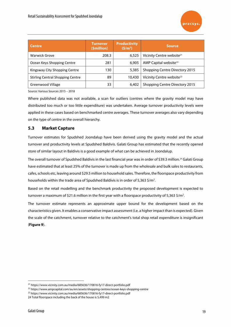
Retail Sustainability Assessment for Spudshed Joondalup
Galati Group 19
Centre Turnover ($million)
Productivity ($/m2) Source
Warwick Grove 208.3 6,525 Vicinity Centre website21
Ocean Keys Shopping Centre 281 6,905 AMP Capital website22
Kingsway City Shopping Centre 130 5,385 Shopping Centre Directory 2015
Stirling Central Shopping Centre 89 10,430 Vicinity Centre website23
Greenwood Village 33 6,402 Shopping Centre Directory 2015
Source: Various Sources 2015 – 2018
Where published data was not available, a scan for outliers (centres where the gravity model may have
distributed too much or too little expenditure) was undertaken. Average turnover productivity levels were
applied in these cases based on benchmarked centre averages. These turnover averages also vary depending
on the type of centre in the overall hierarchy.
5.3 Market Capture
Turnover estimates for Spudshed Joondalup have been derived using the gravity model and the actual
turnover and productivity levels at Spudshed Baldivis. Galati Group has estimated that the recently opened
store of similar layout in Baldivis is a good example of what can be achieved in Joondalup.
The overall turnover of Spudshed Baldivis in the last financial year was in order of $39.3 million.24 Galati Group
have estimated that at least 25% of the turnover is made up from the wholesale and bulk sales to restaurants,
cafes, schools etc, leaving around $29.5 million to household sales. Therefore, the floorspace productivity from
households within the trade area of Spudshed Baldivis is in order of 5,363 $/m2.
Based on the retail modelling and the benchmark productivity the proposed development is expected to
turnover a maximum of $21.6 million in the first year with a floorspace productivity of 5,363 $/m2.
The turnover estimate represents an approximate upper bound for the development based on the
characteristics given. It enables a conservative impact assessment (i.e. a higher impact than is expected). Given
the scale of the catchment, turnover relative to the catchment’s total shop retail expenditure is insignificant
(Figure 9).
21 https://www.vicinity.com.au/media/685636/170816-fy17-direct-portfolio.pdf 22 https://www.ampcapital.com/au/en/assets/shopping-centres/ocean-keys-shopping-centre 23 https://www.vicinity.com.au/media/685636/170816-fy17-direct-portfolio.pdf 24 Total floorspace including the back of the house is 5,499 m2
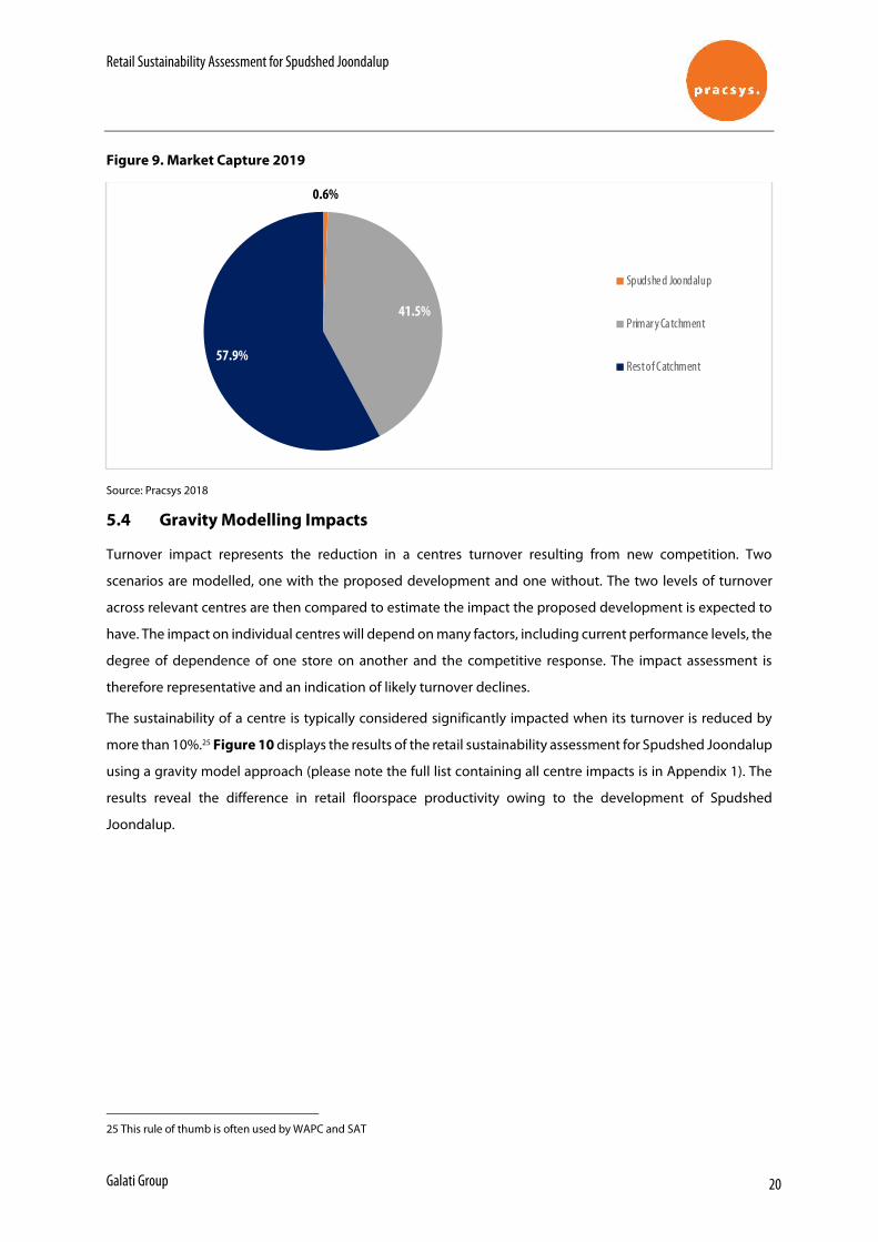
Retail Sustainability Assessment for Spudshed Joondalup
Galati Group 20
Figure 9. Market Capture 2019
Source: Pracsys 2018
5.4 Gravity Modelling Impacts
Turnover impact represents the reduction in a centres turnover resulting from new competition. Two
scenarios are modelled, one with the proposed development and one without. The two levels of turnover
across relevant centres are then compared to estimate the impact the proposed development is expected to
have. The impact on individual centres will depend on many factors, including current performance levels, the
degree of dependence of one store on another and the competitive response. The impact assessment is
therefore representative and an indication of likely turnover declines.
The sustainability of a centre is typically considered significantly impacted when its turnover is reduced by
more than 10%.25 Figure 10 displays the results of the retail sustainability assessment for Spudshed Joondalup
using a gravity model approach (please note the full list containing all centre impacts is in Appendix 1). The
results reveal the difference in retail floorspace productivity owing to the development of Spudshed
Joondalup.
25 This rule of thumb is often used by WAPC and SAT
0.6%
41.5%
57.9%
Spudshe d Joondalup
Primar y Ca tchment
Rest of Catchment
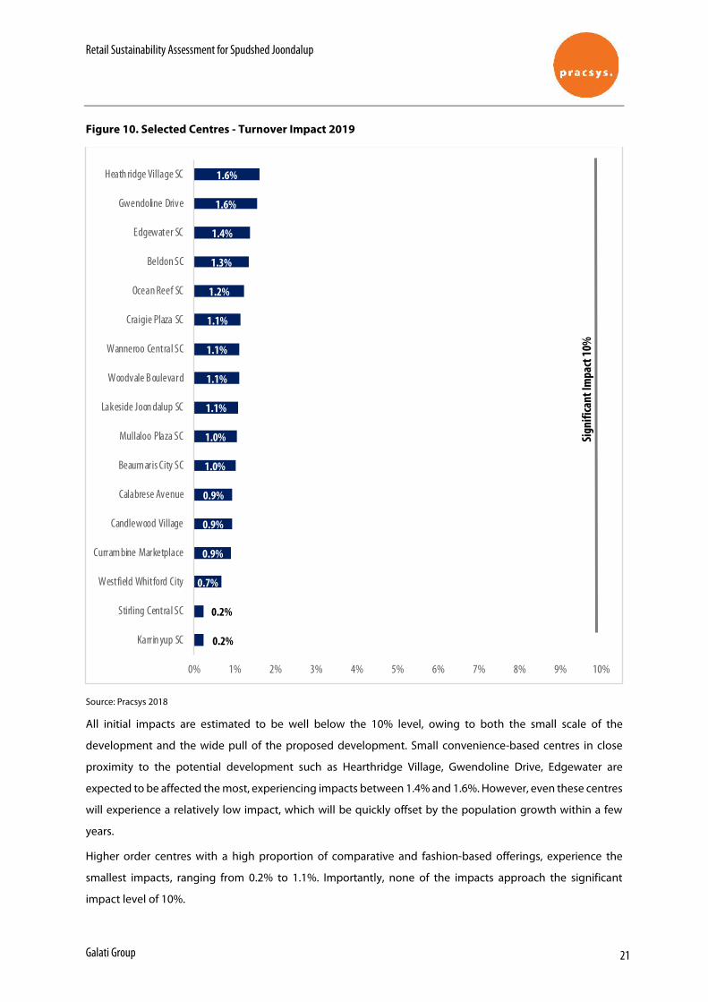
Retail Sustainability Assessment for Spudshed Joondalup
Galati Group 21
Figure 10. Selected Centres - Turnover Impact 2019
Source: Pracsys 2018
All initial impacts are estimated to be well below the 10% level, owing to both the small scale of the
development and the wide pull of the proposed development. Small convenience-based centres in close
proximity to the potential development such as Hearthridge Village, Gwendoline Drive, Edgewater are
expected to be affected the most, experiencing impacts between 1.4% and 1.6%. However, even these centres
will experience a relatively low impact, which will be quickly offset by the population growth within a few
years.
Higher order centres with a high proportion of comparative and fashion-based offerings, experience the
smallest impacts, ranging from 0.2% to 1.1%. Importantly, none of the impacts approach the significant
impact level of 10%.
0.2%
0.2%
0.7%
0.9%
0.9%
0.9%
1.0%
1.0%
1.1%
1.1%
1.1%
1.1%
1.2%
1.3%
1.4%
1.6%
1.6%
0% 1% 2% 3% 4% 5% 6% 7% 8% 9% 10%
Karrin yup SC
Stirling Central SC
Westfield Whitford City
Curram bine Marketplace
Candlewood Village
Calabrese Avenue
Beaum aris City SC
Mullaloo Plaza SC
Lakeside Joon dalup SC
Woodvale B oulevard
Wanneroo Central SC
Craigie Plaza SC
Ocean Reef SC
Beldon SC
Edgewater SC
Gwendoline Drive
Heath ridge Village SC
Sign
ifica
nt Im
pact
10%
Retail Sustainability Assessment for Spudshed Joondalup
Galati Group 22
The estimated reduction in turnover of the selected centres does not significantly affect their floorspace
productivity. All centres have sustainable floorspace productivity levels after the development takes place. As
such, the impact from this development is expected to have no effect on the viability of any nearby centres
and as such it will not affect the sustainability of the centre hierarchy.
It is important to note that as the catchment is in a fast growing area with high population growth forecast by
the Department of Planning, any initial impact will be quickly absorbed by future growth. This strong growth
not only limits and absorbs any impact but necessitates new retail developments to provide satisfactory levels
of retail offering for current and future populations and to reduce the likelihood that there will be leakage
from the area. Recently completed and planned expansions within the area confirm the hypothesis of a
healthy retail environment in the trade area.
5.5 Competitive Response
Whether actual impacts on retail centres is similar to estimated impacts largely depends on the competitive
response. The competitive response is usually targeted at improving the foot traffic and therefore turnover of
a centre and can be affected at a centre level or an individual tenant level. At the centre level, the response
can include but is not limited to: centre refurbishment and redevelopment, tenancy re-mixing and marketing
events. At the tenant level, the response may involve store refurbishment, improving the level of customer
service, improving in-store management, advertising and pricing. How competitors respond will naturally
affect the level of impact that is experienced as a result of the proposed development. All these factors have
a potential to significantly reduce the impact of the Spudshed Joondalup.
Retail Sustainability Assessment for Spudshed Joondalup
Galati Group 23
6 I M P A C T O N C O M M U N I T Y
6.1 Economic Benefits
Potential annual employment benefits resulting from the ongoing operation of the new Spudshed at 11
Injune Way have been estimated. The number of direct jobs for the proposed development was estimated by
Galati Group. Overall it is expected that Spudshed Joondalup will create 120 direct retail jobs (full-time, part-
time and casual), equivalent to 80 FTE (full-time equivalent). This is consistent with staffing requirements for
shop land uses, based on metropolitan averages derived from the Land Use and Employment Survey.
ABS Input - Output tables were used at an Industry Input-Output Industry Group level to estimate the total
indirect employment. The direct jobs are expected to induce a further 146 FTE indirect jobs in the broader
economy.
Overall, the total employment impact from the operation of Spudshed Joondalup is expected to be in the
order of 226 FTE jobs.
There will be an estimated $6 million per annum in direct Gross Value Added (GVA) contribution to the
economy generated from the Spudshed Joondalup operation. ABS Input - Output tables were used to
estimate the GVA arising from retail activity. The number of direct jobs is multiplied by the GVA per employee
in retail industry to estimate the total direct GVA.
6.2 Community Benefits
Development of the Spudshed in Joondalup will not only benefit the Joondalup residents, but also the
population in the surrounding areas, such as Carramar, Currambine, Clarkson, Heathridge etc by creating a
greater access to retail goods and reducing the travel time for the population to the north of the City to access
these goods. Spudshed will offer variety, different shopping options and encourage healthy competition, all
of which benefits the customers. This creates balance and equity of access as larger numbers of people are
able to access the goods and services they desire in a timelier fashion.
These benefits indicate that the proposed Spudshed is likely to be a welcome addition from a community
benefit perspective reducing travel time, providing variety, encouraging healthy competition and creating a
case for equity of access.
Retail Sustainability Assessment for Spudshed Joondalup
Galati Group 24
7 C O N C L U SI O N
This report assesses the proposed Spudshed Joondalup, its trade area and competition to estimate the
potential impacts of the development on the retail network.
Modelling has shown that the estimated impacts are well below the 10% threshold and the sustainability of
the centre hierarchy will be preserved. A number of factors contribute to this finding, including:
• Relatively small development, particularly in the context of other recent and planned expansions
• Strong population growth projections
• A profitable competitive environment
• Wide catchment of up to 15 km
Overall the development is expected to be a positive contribution to the retail network as it will create
significant net economic and community benefit. It is expected that approximately 80 FTE operational
positions will be created following the Spudshed Joondalup development, that will contribute around $6
million per annum in GVA to the economy. Local communities will also benefit through reduced travel times,
increased variety and healthy competition that will not undermine the activity centre hierarchy. This benefits
all households and allows a larger share of income to be directed to other activities.
Given the above, it is suggested that the retail development be recommended for approval.
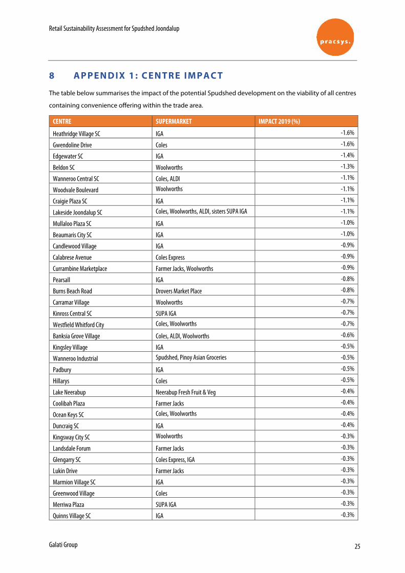
Retail Sustainability Assessment for Spudshed Joondalup
Galati Group 25
8 A P P EN D IX 1 : C EN T R E IM P A C T
The table below summarises the impact of the potential Spudshed development on the viability of all centres
containing convenience offering within the trade area.
CENTRE SUPERMARKET IMPACT 2019 (%)
Heathridge Village SC IGA -1.6%
Gwendoline Drive Coles -1.6%
Edgewater SC IGA -1.4%
Beldon SC Woolworths -1.3%
Wanneroo Central SC Coles, ALDI -1.1%
Woodvale Boulevard Woolworths -1.1%
Craigie Plaza SC IGA -1.1%
Lakeside Joondalup SC Coles, Woolworths, ALDI, sisters SUPA IGA -1.1%
Mullaloo Plaza SC IGA -1.0%
Beaumaris City SC IGA -1.0%
Candlewood Village IGA -0.9%
Calabrese Avenue Coles Express -0.9%
Currambine Marketplace Farmer Jacks, Woolworths -0.9%
Pearsall IGA -0.8%
Burns Beach Road Drovers Market Place -0.8%
Carramar Village Woolworths -0.7%
Kinross Central SC SUPA IGA -0.7%
Westfield Whitford City Coles, Woolworths -0.7%
Banksia Grove Village Coles, ALDI, Woolworths -0.6%
Kingsley Village IGA -0.5%
Wanneroo Industrial Spudshed, Pinoy Asian Groceries -0.5%
Padbury IGA -0.5%
Hillarys Coles -0.5%
Lake Neerabup Neerabup Fresh Fruit & Veg -0.4%
Coolibah Plaza Farmer Jacks -0.4%
Ocean Keys SC Coles, Woolworths -0.4%
Duncraig SC IGA -0.4%
Kingsway City SC Woolworths -0.3%
Landsdale Forum Farmer Jacks -0.3%
Glengarry SC Coles Express, IGA -0.3%
Lukin Drive Farmer Jacks -0.3%
Marmion Village SC IGA -0.3%
Greenwood Village Coles -0.3%
Merriwa Plaza SUPA IGA -0.3%
Quinns Village SC IGA -0.3%
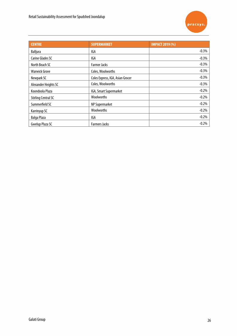
Retail Sustainability Assessment for Spudshed Joondalup
Galati Group 26
CENTRE SUPERMARKET IMPACT 2019 (%)
Balljura IGA -0.3%
Carine Glades SC IGA -0.3%
North Beach SC Farmer Jacks -0.3%
Warwick Grove Coles, Woolworths -0.3%
Newpark SC Coles Express, IGA, Asian Grocer -0.3%
Alexander Heights SC Coles, Woolworths -0.3%
Koondoola Plaza IGA, Smart Supermarket -0.2%
Stirling Central SC Woolworths -0.2%
Summerfield SC NP Supermarket -0.2%
Karrinyup SC Woolworths -0.2%
Balga Plaza IGA -0.2%
Gwelup Plaza SC Farmers Jacks -0.2%
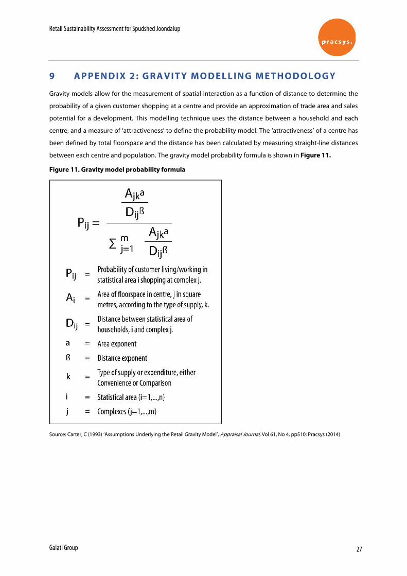
Retail Sustainability Assessment for Spudshed Joondalup
Galati Group 27
9 A P P EN D IX 2 : G RA VI T Y M O D EL L IN G M E T H O D O L O G Y
Gravity models allow for the measurement of spatial interaction as a function of distance to determine the
probability of a given customer shopping at a centre and provide an approximation of trade area and sales
potential for a development. This modelling technique uses the distance between a household and each
centre, and a measure of ‘attractiveness’ to define the probability model. The ‘attractiveness’ of a centre has
been defined by total floorspace and the distance has been calculated by measuring straight-line distances
between each centre and population. The gravity model probability formula is shown in Figure 11.
Figure 11. Gravity model probability formula
Source: Carter, C (1993) ‘Assumptions Underlying the Retail Gravity Model’, Appraisal Journal, Vol 61, No 4, pp510; Pracsys (2014)
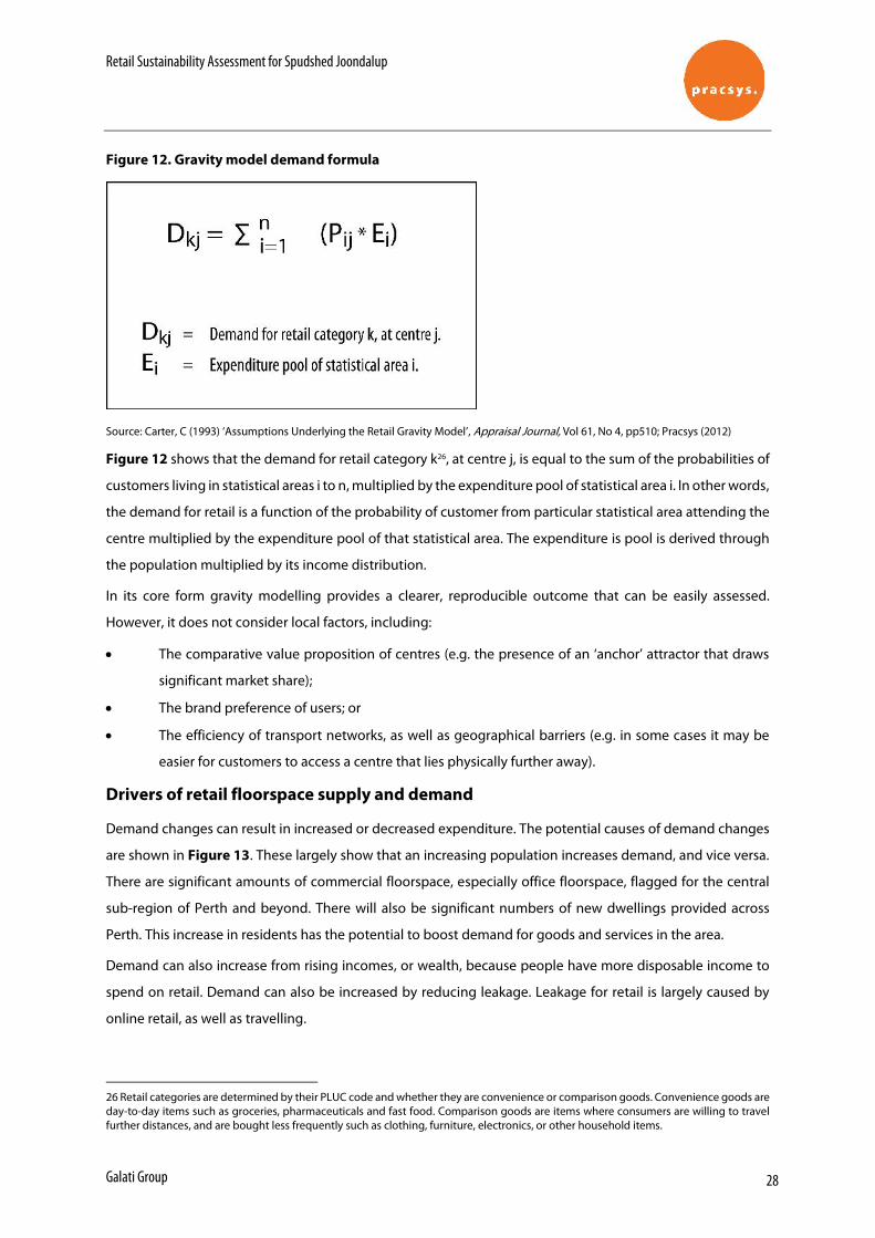
Retail Sustainability Assessment for Spudshed Joondalup
Galati Group 28
Figure 12. Gravity model demand formula
Source: Carter, C (1993) ‘Assumptions Underlying the Retail Gravity Model’, Appraisal Journal, Vol 61, No 4, pp510; Pracsys (2012)
Figure 12 shows that the demand for retail category k26, at centre j, is equal to the sum of the probabilities of
customers living in statistical areas i to n, multiplied by the expenditure pool of statistical area i. In other words,
the demand for retail is a function of the probability of customer from particular statistical area attending the
centre multiplied by the expenditure pool of that statistical area. The expenditure is pool is derived through
the population multiplied by its income distribution.
In its core form gravity modelling provides a clearer, reproducible outcome that can be easily assessed.
However, it does not consider local factors, including:
• The comparative value proposition of centres (e.g. the presence of an ‘anchor’ attractor that draws
significant market share);
• The brand preference of users; or
• The efficiency of transport networks, as well as geographical barriers (e.g. in some cases it may be
easier for customers to access a centre that lies physically further away).
Drivers of retail floorspace supply and demand
Demand changes can result in increased or decreased expenditure. The potential causes of demand changes
are shown in Figure 13. These largely show that an increasing population increases demand, and vice versa.
There are significant amounts of commercial floorspace, especially office floorspace, flagged for the central
sub-region of Perth and beyond. There will also be significant numbers of new dwellings provided across
Perth. This increase in residents has the potential to boost demand for goods and services in the area.
Demand can also increase from rising incomes, or wealth, because people have more disposable income to
spend on retail. Demand can also be increased by reducing leakage. Leakage for retail is largely caused by
online retail, as well as travelling.
26 Retail categories are determined by their PLUC code and whether they are convenience or comparison goods. Convenience goods are day-to-day items such as groceries, pharmaceuticals and fast food. Comparison goods are items where consumers are willing to travel further distances, and are bought less frequently such as clothing, furniture, electronics, or other household items.
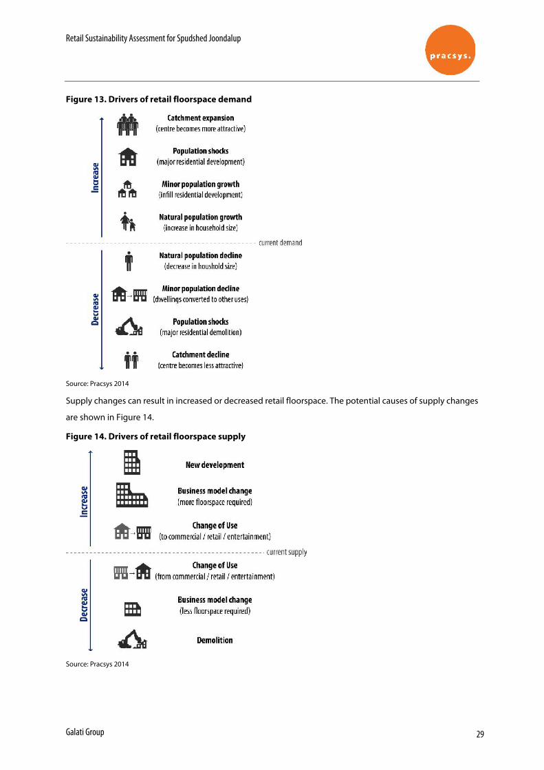
Retail Sustainability Assessment for Spudshed Joondalup
Galati Group 29
Figure 13. Drivers of retail floorspace demand
Source: Pracsys 2014
Supply changes can result in increased or decreased retail floorspace. The potential causes of supply changes
are shown in Figure 14.
Figure 14. Drivers of retail floorspace supply
Source: Pracsys 2014
Proposed Commercial Conversion
Lot 806 (11) Injune Way,
Joondalup
Transport Impact Statement
PREPARED FOR: Aurrum Holdings Pty Ltd November 2016
Document history and status
Author Revision Approved by Date
approved Revision type
Paul Ghantous r01 R White 25/11/16 Paul Ghantous r01a P Ghantous 30/11/16 Final
File name: t16301pgr01a.docx
Author: Paul Ghantous
Project manager: Behnam Bordbar
Client: Aurrum Holdings Pty Ltd
Project: Masters Joondalup Redevelopment
Document revision: r01a
Project number: t16.301
Copyright in all drawings, reports, specifications, calculations and other documents provided by the Consultant in connection with the Project shall remain the property of the Consultant. The Client alone shall have a license to use the documents referred to above for the purpose of completing the Project, but the Client shall not use, or make copies of, such documents in connection with any work not included in the Project, unless written approval is obtained from the Consultant or otherwise agreed through a separate contract.
TABLE OF CONTENTS
1.0 INTRODUCTION ........................................................................................ 1
2.0 PROPOSED DEVELOPMENT ................................................................... 3
3.0 VEHICLE ACCESS AND PARKING .......................................................... 4
3.1 ACCESS ............................................................................................................................. 4 3.2 PARKING ............................................................................................................................ 5
4.0 PROVISION FOR SERVICE VEHICLES ................................................... 6
5.0 HOURS OF OPERATION .......................................................................... 7
6.0 DAILY TRAFFIC VOLUMES AND VEHICLE TYPES ................................ 8
6.1 TRIP GENERATION AND DISTRIBUTION ................................................................................. 8 6.1.1 PREVIOUS USE (MASTERS) TRAFFIC GENERATION ....................................................... 8 6.1.2 PROPOSED CONVERSION TRAFFIC GENERATION ......................................................... 9
6.2 IMPACT ON SURROUNDING ROADS .................................................................................... 10
7.0 TRAFFIC MANAGEMENT ON THE FRONTAGE STREETS .................. 11
8.0 PUBLIC TRANSPORT ACCESS ............................................................. 12
9.0 PEDESTRIAN ACCESS .......................................................................... 13
10.0 CYCLE ACCESS ..................................................................................... 14
11.0 SITE SPECIFIC ISSUES .......................................................................... 15
12.0 SAFETY ISSUES ..................................................................................... 16
13.0 CONCLUSIONS ....................................................................................... 17
APPENDIX A – PROPOSED DEVELOPMENT SITE PLANS
REPORT FIGURES
Figure 1: Location of the subject site and Masters tenancy ..................................................... 2 Figure 2: Subject site .................................................................................................................... 2 Figure 3: Existing access arrangements ..................................................................................... 4 Figure 4: Public transport services (Transperth Bus Timetable 66) ...................................... 12 Figure 5: Extract from Perth Bicycle Network (Department of Transport) ............................ 14
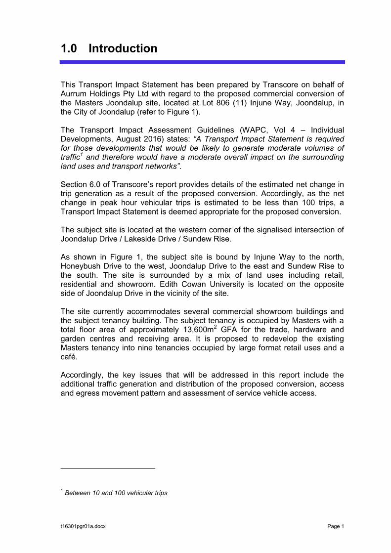
t16301pgr01a.docx Page 1
1.0 Introduction
This Transport Impact Statement has been prepared by Transcore on behalf of Aurrum Holdings Pty Ltd with regard to the proposed commercial conversion of the Masters Joondalup site, located at Lot 806 (11) Injune Way, Joondalup, in the City of Joondalup (refer to Figure 1). The Transport Impact Assessment Guidelines (WAPC, Vol 4 – Individual Developments, August 2016) states: “A Transport Impact Statement is required for those developments that would be likely to generate moderate volumes of traffic1 and therefore would have a moderate overall impact on the surrounding land uses and transport networks”. Section 6.0 of Transcore’s report provides details of the estimated net change in trip generation as a result of the proposed conversion. Accordingly, as the net change in peak hour vehicular trips is estimated to be less than 100 trips, a Transport Impact Statement is deemed appropriate for the proposed conversion. The subject site is located at the western corner of the signalised intersection of Joondalup Drive / Lakeside Drive / Sundew Rise. As shown in Figure 1, the subject site is bound by Injune Way to the north, Honeybush Drive to the west, Joondalup Drive to the east and Sundew Rise to the south. The site is surrounded by a mix of land uses including retail, residential and showroom. Edith Cowan University is located on the opposite side of Joondalup Drive in the vicinity of the site. The site currently accommodates several commercial showroom buildings and the subject tenancy building. The subject tenancy is occupied by Masters with a total floor area of approximately 13,600m2 GFA for the trade, hardware and garden centres and receiving area. It is proposed to redevelop the existing Masters tenancy into nine tenancies occupied by large format retail uses and a café. Accordingly, the key issues that will be addressed in this report include the additional traffic generation and distribution of the proposed conversion, access and egress movement pattern and assessment of service vehicle access.
1 Between 10 and 100 vehicular trips
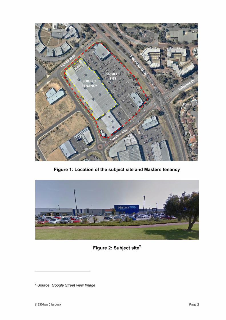
t16301pgr01a.docx Page 2
Figure 1: Location of the subject site and Masters tenancy
Figure 2: Subject site2
2 Source: Google Street view Image
SUBJECT SITE
SUBJECT TENANCY
t16301pgr01a.docx Page 3
2.0 Proposed Development
The proposal for the subject site is for the conversion of the existing Masters building into a commercial development comprising:
Eight ‘large format’ retail / showroom tenancies (11,643m2 total GFA); One café tenancy (163m2 GFA); and, Internal mall walking area (1,294m2), with approximately 80m2 in retail
‘pop-up’ space.
There are currently around 551 car parking bays provided on-site which are shared between the existing land uses. Vehicular access to the car park is currently provided via a left-in/right-in/left-out crossover on Sundew Rise and via a full movement crossover on Injune Way. The rear service area is accessed via a single wide crossover on Honeybush Drive at the rear of the site. No changes to the existing car parking, road access and service vehicle arrangements are proposed as part of the conversion. Waste collection, delivery and other service vehicle activity will be accommodated within the site in the existing service area at the rear of the site. Pedestrians will continue to access the development from the external footpath network abutting the site, and the existing internal car park walkways. Detailed development plans are included for reference in Appendix A.
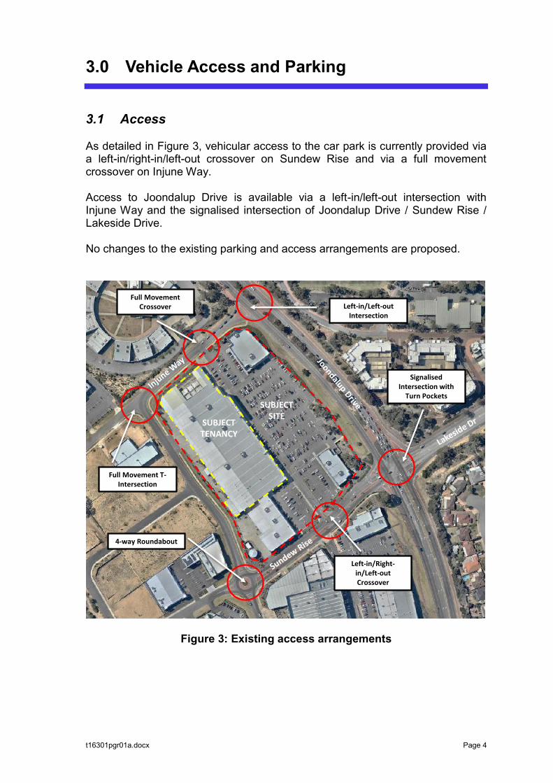
t16301pgr01a.docx Page 4
3.0 Vehicle Access and Parking
3.1 Access
As detailed in Figure 3, vehicular access to the car park is currently provided via a left-in/right-in/left-out crossover on Sundew Rise and via a full movement crossover on Injune Way. Access to Joondalup Drive is available via a left-in/left-out intersection with Injune Way and the signalised intersection of Joondalup Drive / Sundew Rise / Lakeside Drive. No changes to the existing parking and access arrangements are proposed.
Figure 3: Existing access arrangements
Full Movement Crossover
Full Movement T-Intersection
Left-in/Right-in/Left-out Crossover
Signalised Intersection with
Turn PocketsSUBJECT
SITESUBJECT TENANCY
Left-in/Left-out Intersection
4-way Roundabout
t16301pgr01a.docx Page 5
3.2 Parking
There are currently around 551 car parking bays provided on-site including approximately 6 ACROD bays, which are shared between the existing land uses. Based on the advice provided to Transcore, the relevant car parking requirements for the City of Joondalup have been reduced since the subject site was originally constructed. Therefore, there is a surplus of car parking provided on site in comparison to the current applicable parking requirements.

t16301pgr01a.docx Page 6
4.0 Provision for Service Vehicles
Waste collection, delivery and other service vehicles will be accommodated at the rear of the site in the existing service area. The service area is accessed from Honeybush Drive and has been in operation for a number of years as part of the previous Masters use. Therefore, no issues are anticipated in the post-development situation.
t16301pgr01a.docx Page 7
5.0 Hours of Operation
The proposed development will be predominantly retail-oriented and will generate heaviest traffic movements during the weekday afternoons and Saturday midday periods. The highest period of traffic generation to and from the site will be the Saturday midday period but the adjacent road network traffic peak will occur during weekday AM and PM peak periods. Overall, the combined peak period of site traffic and road network traffic will be the weekday PM peak hour, typically 5-6pm.
t16301pgr01a.docx Page 8
6.0 Daily Traffic Volumes and Vehicle Types
6.1 Trip Generation and Distribution
The traffic volumes likely to be generated by the existing land use and proposed commercial conversion have been estimated in accordance with the RTA NSW “Guide to Traffic Generating Developments” and the RTA Technical Direction TDT 2013/ 04a, which provide daily and peak hour trip rates for relevant land uses.
6.1.1 Previous Use (Masters) Traffic Generation
The traffic volume generated by the existing Masters use has been estimated based on the trip rate for major hardware and building supplies stores as detailed in TDT 2013/04a: Weekday Trip Rates
Daily vehicle trips = 33 per 100m2 gross floor area Peak hour vehicle trips = 4.2 per 100m2 gross floor area.
Weekend Trip Rates
Daily vehicle trips = 35 per 100m2 gross floor area Peak hour vehicle trips = 5.6 per 100m2 gross floor area.
Based on the existing Masters GFA of 13,600m2, the existing Masters use is estimated to generate the following traffic volumes: Weekday Traffic Generation
Daily vehicle trips = 4,488 vpd Peak hour vehicle trips = 571 vph
Weekend Traffic Generation
Daily vehicle trips = 4,760 vpd Peak hour vehicle trips = 761 vph
t16301pgr01a.docx Page 9
6.1.2 Proposed Conversion Traffic Generation
The traffic volume generated by the proposed conversion has been estimated based on retail trip rates derived from the RTA NSW “Guide to Traffic Generating Developments”. It was assumed that the proposed conversion will generate 75% ‘slow trade’ retail A(S) and 25% ‘specialty shop’ retail A(SS) traffic. Accordingly the derived trip rates based on the above percentage split are detailed as follows: Weekday Trip Rates
Daily vehicle trips = 37.4 per 100m2 gross leasable floor area Peak hour vehicle trips = 2.65 per 100m2 gross leasable floor area.
Weekend Trip Rates
Assume same as weekday. Peak hour vehicle trips = 5.5 per 100m2 gross leasable floor area.
Based on the proposed total tenancy floor area of 11,806m2 (excluding mall floor area but including pop-ups), the proposed conversion is estimated to generate the following traffic volumes: Weekday Traffic Generation
Daily vehicle trips = 4,415 vpd Peak hour vehicle trips = 313 vph
Weekend Traffic Generation
Daily vehicle trips = assumed to be similar to weekday traffic Peak hour vehicle trips = 650 vph
The proposed development traffic will be distributed to the external road network via the existing access crossovers and intersections detailed in Section 3.1 of this report. Based on the above calculations and assumptions, traffic analysis indicates that there will be a net decrease in traffic on the surrounding road network as a result of the proposed conversion.
t16301pgr01a.docx Page 10
6.2 Impact on Surrounding Roads
The WAPC Transport Impact Assessment Guidelines (2016) provides guidance on the assessment of traffic impacts: “As a general guide, an increase in traffic of less than 10 percent of capacity would not normally be likely to have a material impact on any particular section of road, but increases over 10 percent may. All sections of road with an increase greater than 10 percent of capacity should therefore be included in the analysis. For ease of assessment, an increase of 100 vehicles per hour for any lane can be considered as equating to around 10 percent of capacity. Therefore any section of road where the development traffic would increase flows by more than 100 vehicles per hour for any lane should be included in the analysis.” The proposed conversion will not increase traffic flows anywhere near the quoted WAPC threshold to warrant further analysis. The proposed conversion will not increase traffic on any lanes on the surrounding road network by more than 100vph. In fact, it is anticipated to result in a decrease in traffic. Therefore, a positive impact on the surrounding road network is anticipated.
t16301pgr01a.docx Page 11
7.0 Traffic Management on the Frontage Streets
Joondalup Drive in the vicinity of the subject site is a 24m wide, dual carriageway, four-lane road with a 70km/h speed limit. It features on-street cycle lanes and wide pedestrian footpaths on both sides of the road. Pedestrian crossing facilities are currently in place at the signalised intersection of Sundew Rise / Lakeside Drive. It is classified as a Distributor A road in the Main Roads WA Metropolitan Functional Road Hierarchy. This road is covered by an Other Regional Roads reservation in the MRS. SCATS intersection data provided by Main Roads WA indicates that Joondalup Drive carried average weekday traffic flows of 30,719 vehicles per day (vpd) south of Hodges Drive in November 2014. Honeybush Drive is a two lane undivided road forming a four-way roundabout with Sundew Rise to the south and a give-way T-intersection with Injune Way to the north. A footpath is in place on the eastern side of the road. Three pedestrian crossing points are provided along Honeybush Drive adjacent to the subject site. Sundew Rise connects halfway along Honeybush Drive at a roundabout intersection. Sundew Rise also provides access for the local area. It is a two lane, boulevard style road with a wide, red-asphalt median. It forms a four-way signalised intersection with Joondalup Drive and Lakeside Drive to the east. A footpath is in place on the southern side of the road. Injune Way is a two lane undivided road. A footpath is in place on the southern side of the road and a pedestrian crossing facility with refuge island is provided at the intersection of Joondalup Drive. Honeybush Drive, Sundew Rise and Injune Way are local access roads and operate under a default built up area speed limit of 50km/h.
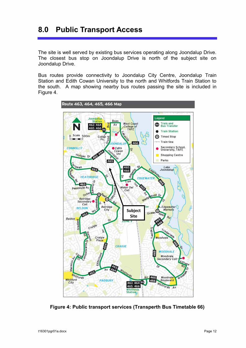
t16301pgr01a.docx Page 12
8.0 Public Transport Access
The site is well served by existing bus services operating along Joondalup Drive. The closest bus stop on Joondalup Drive is north of the subject site on Joondalup Drive. Bus routes provide connectivity to Joondalup City Centre, Joondalup Train Station and Edith Cowan University to the north and Whitfords Train Station to the south. A map showing nearby bus routes passing the site is included in Figure 4.
Figure 4: Public transport services (Transperth Bus Timetable 66)
Subject Site
t16301pgr01a.docx Page 13
9.0 Pedestrian Access
Pedestrian access to the proposed development is via the existing external footpath network comprising paved footpaths on roads adjacent to the subject site. Pedestrian crossing facilities including drop kerbs and median refuges are currently provided at the signalised intersection of Joondalup Drive / Sundew Rise. Several pedestrian crossing points are also provided on Sundew Rise, Honeybush Drive and Injune Way. Pedestrian walkways are currently provided within the site to link the existing Masters building with other internal buildings and car parking areas.
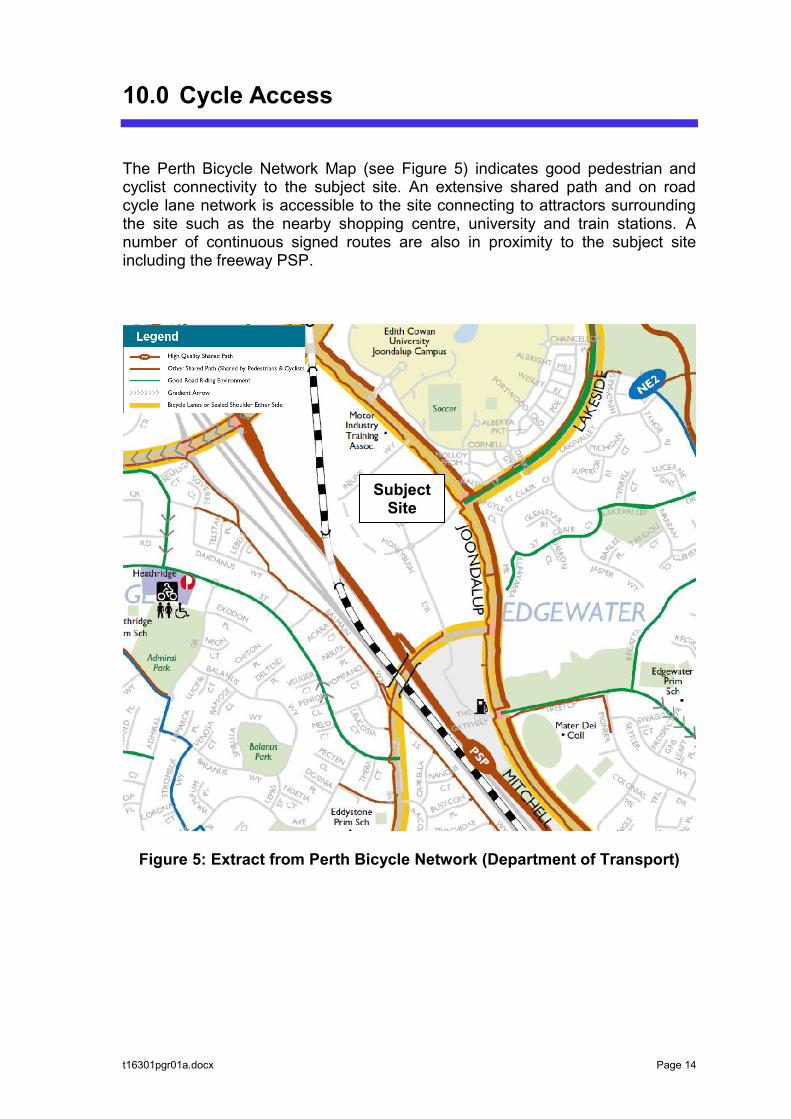
t16301pgr01a.docx Page 14
10.0 Cycle Access
The Perth Bicycle Network Map (see Figure 5) indicates good pedestrian and cyclist connectivity to the subject site. An extensive shared path and on road cycle lane network is accessible to the site connecting to attractors surrounding the site such as the nearby shopping centre, university and train stations. A number of continuous signed routes are also in proximity to the subject site including the freeway PSP.
Figure 5: Extract from Perth Bicycle Network (Department of Transport)
Subject Site

t16301pgr01a.docx Page 15
11.0 Site Specific Issues
No site specific issues were identified within the scope of this assessment.

t16301pgr01a.docx Page 16
12.0 Safety Issues
No safety issues were identified within the scope of this assessment.
t16301pgr01a.docx Page 17
13.0 Conclusions
This Transport Impact Statement has been prepared by Transcore on behalf of Aurrum Holdings Pty Ltd with regard to the proposed commercial conversion of the Masters Joondalup site, located at Lot 806 (11) Injune Way, Joondalup, in the City of Joondalup. The site features good connectivity with the existing road, cyclist and pedestrian network and public transport coverage through bus services. The proposed conversion will entail reconfiguration of the existing Masters building into separate showroom / retail tenancies. Some floor area will be set aside to provide an internal mall for pedestrian movements between the different tenancies. The traffic analysis undertaken in this report shows that the anticipated traffic generation of the proposed conversion uses is lower than the estimated traffic generation of Masters. Therefore, it is anticipated that there will be a net positive impact on the surrounding road network. It is also anticipated that the impact on the existing operation of nearby intersections would be positive with reduced traffic volumes during peak periods. No changes are proposed to the existing parking supply, access and vehicle circulation arrangements. Service vehicles will access the site via the existing crossover on Honeybush Drive and will use the existing rear loading area. In conclusion, the findings of this Transport Impact Statement are supportive of the conversion proposal.
Related Documents