Salinity Rising salinity levels in water resources and dryland salinity are the biggest environmental problems facing Western Australia. Salinity is also affecting our natural environment, rural towns, heritage buildings and infrastructure such as roads and railways. This Water Facts sheet explains why stream salinity has increased, the impacts on our surface water resources, and what is being done to tackle the problem. Salinisation Most people are aware that the crusty white deposit they sometimes see on bare patches of cleared agricultural land is salt. This is a visible sign of increasing salinity in our landscape, and is sometimes called ‘dryland salinity’. Less visible, but still a huge problem, are rising salinity levels in our water resources. Some lakes are naturally saline (for example, the salt lakes in the eastern Avon catchment) but where previously fresh lakes have become salty, the dead vegetation and salt encrustations indicate rising salinity levels. Increasing salt levels are being observed in many south west rivers. Salinity in the Avon catchment. (Photo courtesy of Avon Ascent) Salt in the soil and groundwater Salt is a problem when it dissolves in rising groundwater and comes to the ground surface or flows into streams. But a huge amount of salt is stored deep in our soils, and as long as it stays there, it poses no problem. Western Australia’s soils have accumulated massive amounts of salt brought in by rain from the sea over tens to hundreds of thousands of years. Salt has been deposited on south-west Western Australia at a rate of 20 to 200 kilograms per hectare per year. Depending on the location and soil type, soils now store between 300 and 10 000 tonnes of salt per hectare deep in the soil profile. In the wheatbelt, for example, the soil holds about 3000 tonnes of salt per hectare. Rising watertables bring salt to the surface Groundwater is water that occupies the pores or crevices in soil or rock. Stream salinisation happens in two ways: (i) When rising groundwater carries salt to the land surface where it can be washed away into streams and lakes. Salinity problems arise when the watertable (the level at which the soil is saturated with groundwater) rises, dissolving salt stored in the soil profile as it does so, and bringing very salty water to or near the ground surface. The water cycle. Water facts 15 W ATER AND RIVERS COMMISSION JUNE 2000 Evaporation Transpiration Rainfall Groundwater flows to wetlands, streams or ocean Runoff Groundwater recharge Confined groundwater Shallow groundwater Watertable

Welcome message from author
This document is posted to help you gain knowledge. Please leave a comment to let me know what you think about it! Share it to your friends and learn new things together.
Transcript
Salinity Rising salinity levels in water resourcesand dryland salinity are the biggestenvironmental problems facing WesternAustralia. Salinity is also affecting ournatural environment, rural towns, heritagebuildings and infrastructure such as roadsand railways. This Water Facts sheetexplains why stream salinity hasincreased, the impacts on our surfacewater resources, and what is being doneto tackle the problem.
Salinisation
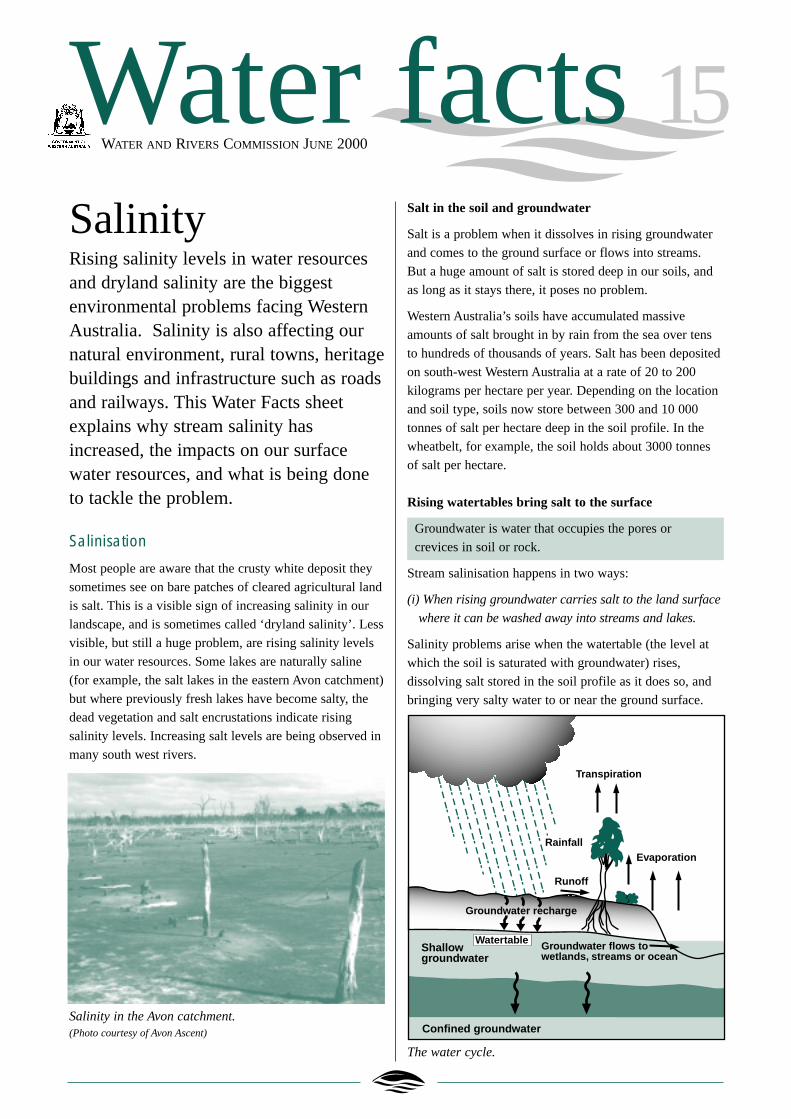
Most people are aware that the crusty white deposit they
sometimes see on bare patches of cleared agricultural land
is salt. This is a visible sign of increasing salinity in our
landscape, and is sometimes called ‘dryland salinity’. Less
visible, but still a huge problem, are rising salinity levels
in our water resources. Some lakes are naturally saline
(for example, the salt lakes in the eastern Avon catchment)
but where previously fresh lakes have become salty, the
dead vegetation and salt encrustations indicate rising
salinity levels. Increasing salt levels are being observed in
many south west rivers.
Salinity in the Avon catchment.(Photo courtesy of Avon Ascent)
Salt in the soil and groundwater
Salt is a problem when it dissolves in rising groundwater
and comes to the ground surface or flows into streams.
But a huge amount of salt is stored deep in our soils, and
as long as it stays there, it poses no problem.
Western Australia’s soils have accumulated massive
amounts of salt brought in by rain from the sea over tens
to hundreds of thousands of years. Salt has been deposited
on south-west Western Australia at a rate of 20 to 200
kilograms per hectare per year. Depending on the location
and soil type, soils now store between 300 and 10 000
tonnes of salt per hectare deep in the soil profile. In the
wheatbelt, for example, the soil holds about 3000 tonnes
of salt per hectare.
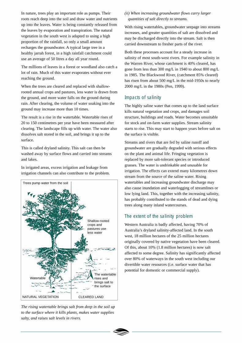
Rising watertables bring salt to the surface
Groundwater is water that occupies the pores or
crevices in soil or rock.
Stream salinisation happens in two ways:
(i) When rising groundwater carries salt to the land surface
where it can be washed away into streams and lakes.
Salinity problems arise when the watertable (the level at
which the soil is saturated with groundwater) rises,
dissolving salt stored in the soil profile as it does so, and
bringing very salty water to or near the ground surface.
The water cycle.
Water facts 15WATER AND RIVERS COMMISSION JUNE 2000
Evaporation
Transpiration
Rainfall
Groundwater flows to wetlands, streams or ocean
Runoff
Groundwater recharge
Confined groundwater
Shallowgroundwater
Watertable
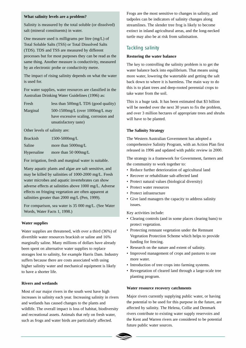
In nature, trees play an important role as pumps. Their
roots reach deep into the soil and draw water and nutrients
up into the leaves. Water is being constantly released from
the leaves by evaporation and transpiration. The natural
vegetation in the south west is adapted to using a high
proportion of the rainfall, so only a small amount
recharges the groundwater. A typical large tree in a
healthy jarrah forest, in a high rainfall catchment could
use an average of 50 litres a day all year round.
The millions of leaves in a forest or woodland also catch a
lot of rain. Much of this water evaporates without ever
reaching the ground.
When the trees are cleared and replaced with shallow-
rooted annual crops and pastures, less water is drawn from
the ground, and more water falls on the ground during
rain. After clearing, the volume of water soaking into the
ground may increase more than 10 times.
The result is a rise in the watertable. Watertable rises of
20 to 150 centimetres per year have been measured after
clearing. The landscape fills up with water. The water also
dissolves salt stored in the soil, and brings it up to the
surface.
This is called dryland salinity. This salt can then be
washed away by surface flows and carried into streams
and lakes.
In irrigated areas, excess irrigation and leakage from
irrigation channels can also contribute to the problem.
The rising watertable brings salt from deep in the soil up
to the surface where it kills plants, makes water supplies
salty, and raises salt levels in rivers.
(ii) When increasing groundwater flows carry larger
quantities of salt directly to streams.
With rising watertables, groundwater seepage into streams
increases, and greater quantities of salt are dissolved and
may be discharged directly into the stream. Salt is then
carried downstream to fresher parts of the river.
Both these processes account for a steady increase in
salinity of most south-west rivers. For example salinity in
the Warren River, whose catchment is 40% cleared, has
gone from less than 300 mg/L in 1940 to about 800 mg/L
in 1985. The Blackwood River, (catchment 85% cleared)
has risen from about 500 mg/L in the mid-1950s to nearly
2000 mg/L in the 1980s (Pen, 1999).
Impacts of salinity
The highly saline water that comes up to the land surface
kills natural vegetation and crops, and damages soil
structure, buildings and roads. Water becomes unsuitable
for stock and on-farm water supplies. Stream salinity
starts to rise. This may start to happen years before salt on
the surface is visible.
Streams and rivers that are fed by saline runoff and
groundwater are gradually degraded with serious effects
on the plant and animal life. Fringing vegetation is
replaced by more salt-tolerant species or introduced
grasses. The water is undrinkable and unusable for
irrigation. The effects can extend many kilometres down
stream from the source of the saline water. Rising
watertables and increasing groundwater discharge may
also cause inundation and waterlogging of streamlines or
low lying land. This, together with the increasing salinity,
has probably contributed to the stands of dead and dying
trees along many inland watercourses.
The extent of the salinity problem
Western Australia is badly affected, having 70% of
Australia’s dryland salinity-affected land. In the south
west, 18 million hectares of the 25 million hectares
originally covered by native vegetation have been cleared.
Of this, about 10% (1.8 million hectares) is now salt
affected to some degree. Salinity has significantly affected
over 80% of waterways in the south west including our
divertible water resources (i.e. surface water that has
potential for domestic or commercial supply).
Trees pump water from the soil
Shallow-rootedcrops andpastures use less water
The watertablerises andbrings salt tothe surface
NATURAL VEGETATION CLEARED LAND
Watertable
What salinity levels are a problem?
Salinity is measured by the total soluble (or dissolved)
salt (mineral constituents) in water.
One measure used is milligrams per litre (mg/L) of
Total Soluble Salts (TSS) or Total Dissolved Salts
(TDS). TDS and TSS are measured by different
processes but for most purposes they can be read as the
same thing. Another measure is conductivity, measured
by an electronic probe or conductivity metre.
The impact of rising salinity depends on what the water
is used for.
For water supplies, water resources are classified in the
Australian Drinking Water Guidelines (1996) as:
Fresh less than 500mg/L TDS (good quality)
Marginal 500-1500mg/L (over 1000mg/L may
have excessive scaling, corrosion and
unsatisfactory taste)
Other levels of salinity are:
Brackish 1500-5000mg/L
Saline more than 5000mg/L
Hypersaline more than 50 000mg/L
For irrigation, fresh and marginal water is suitable.
Many aquatic plants and algae are salt sensitive, and
may be killed by salinities of 1000-2000 mg/L. Fresh
water microbes and aquatic invertebrates can show
adverse effects at salinities above 1000 mg/L. Adverse
effects on fringing vegetation are often apparent at
salinities greater than 2000 mg/L (Pen, 1999).
For comparison, sea water is 35 000 mg/L. (See Water
Words, Water Facts 1, 1998.)
Water supplies
Water supplies are threatened, with over a third (36%) of
divertible water resources brackish or saline and 16%
marginally saline. Many millions of dollars have already
been spent on alternative water supplies to replace
storages lost to salinity, for example Harris Dam. Industry
suffers because there are costs associated with using
higher salinity water and mechanical equipment is likely
to have a shorter life.
Rivers and wetlands
Most of our major rivers in the south west have high
increases in salinity each year. Increasing salinity in rivers
and wetlands has caused changes to the plants and
wildlife. The overall impact is loss of habitat, biodiversity
and recreational assets. Animals that rely on fresh water,
such as frogs and water birds are particularly affected.
Frogs are the most sensitive to changes in salinity, and
tadpoles can be indicators of salinity changes along
streamlines. The slender tree frog is likely to become
extinct in inland agricultural areas, and the long-necked
turtle may also be at risk from salinisation.
Tackling salinity
Restoring the water balance
The key to controlling the salinity problem is to get the
water balance back into equilibrium. That means using
more water, lowering the watertable and getting the salt
back down to where it is harmless. The main way to do
this is to plant trees and deep-rooted perennial crops to
take water from the soil.
This is a huge task. It has been estimated that $3 billion
will be needed over the next 30 years to fix the problem,
and over 3 million hectares of appropriate trees and shrubs
will have to be planted.
The Salinity Strategy
The Western Australian Government has adopted a
comprehensive Salinity Program, with an Action Plan first
released in 1996 and updated with public review in 2000.
The strategy is a framework for Government, farmers and
the community to work together to:
• Reduce further deterioration of agricultural land
• Recover or rehabilitate salt-affected land
• Protect natural values (biological diversity)
• Protect water resources
• Protect infrastructure
• Give land managers the capacity to address salinity
issues.
Key activities include:
• Clearing controls (and in some places clearing bans) to
protect vegetation.
• Protecting remnant vegetation under the Remnant
Vegetation Protection Scheme which helps to provide
funding for fencing.
• Research on the nature and extent of salinity.
• Improved management of crops and pastures to use
more water.
• Introduction of tree crops into farming systems.
• Revegetation of cleared land through a large-scale tree
planting program.
Water resource recovery catchments
Major rivers currently supplying public water, or having
the potential to be used for this purpose in the future, are
affected by salinity. The Helena, Collie and Denmark
rivers contribute to existing water supply reservoirs and
the Kent and Warren rivers are considered to be potential
future public water sources.

Concern about salinity led to statutory control of clearing
in catchments of these rivers during the late 1970s. The
State Salinity Strategy identifies these catchments as
requiring priority management. They are termed Recovery
Catchments. Recovery Teams of local community and
government representatives have been formed. They are
working on catchment planning based on salinity risk
assessments, and using ‘best practices’ in land management.
The aim is to achieve potable water quality in each of the
Recovery Catchment rivers within 20-30 years.
Recovery catchments
The role of the Water and Rivers Commission
The Water and Rivers Commission manages Western
Australia’s water resources to enable sustainable
development and maintain environmental and social
values.
The Commission plays an important role in the State
Salinity Strategy 2000 and coordinates salinity
management in Water Resource Recovery Catchments.
The Commission has established Salinity Management
Teams in the South West and South Coast regions. These
teams are working with landowners to undertake on-the-
ground work, in accordance with local Recovery Team
strategies.
Further reading
Managing our Rivers — a guide to the nature and
management of streams in Western Australia, by
Dr Luke Pen. Water and Rivers Commission, 1999.
National Water Quality Management Strategy, Australian
Drinking Water Guidelines. National Health and Medical
Research Council and Agricultural and Resource
Management Council of Australia and New Zealand, 1996.
Salinity: a guide for land managers. State Salinity
Council, 2000.
Salinity Action Plan. Government of Western Australia,
1996.
Salinity Strategy. Government of Western Australia, 2000.
Salinity – a situation statement for Western Australia.
Report to the Minister for Primary Industry and Minister
for the Environment, 1996.
Water words. Water Facts 1, Water and Rivers
Commission 1998.
For more information contact
Level 2 Hyatt Centre, 3 Plain Street
East Perth Western Australia 6004
Telephone: (08) 9278 0300
Facsimile: (08) 9278 0301
Website: http://www.wrc.wa.gov.au
or your regional office.
This Fact Sheet is one in a series providing information
on water issues of interest to the community.
Printed on recycled paper June 2000
ISSN: 1328-2042 ISBN: 0-7309-7468-5
Tell us what you think of our publications athttp://www.wrc.wa.gov.au/public/feedback
WATER AND RIVERS COMMISSION
Warren and Collie River Recovery Team members visit a
tree trial established by CALM.
Related Documents