Journal of Environmental Protection, 2012, 3, 1010-1019 http://dx.doi.org/10.4236/jep.2012.39117 Published Online September 2012 (http://www.SciRP.org/journal/jep) Urban Sprawl and the Challenges for Urban Planning Maurício Polidoro 1,2 , José Augusto de Lollo 3 , Mirian Vizintim Fernandes Barros 4 1 Federal University of Sao Carlos, Sao Carlos, Brazil; 2 Federal University of Parana, Curitiba, Brazil; 3 Universidade Estadual Paulista Júlio de Mesquita Filho, São Paulo, Brazil; 4 Londrina State University, Londrina, Brazil. Email: [email protected], [email protected], [email protected] Received April 20 th , 2012; revised May 25 th , 2012; accepted June 27 th , 2012 ABSTRACT Dispersed urbanization, urban planning and management instruments such as zoning, and urban expansion zones, have become increasingly consistent in leading cities toward an uncertain and chaotic future. The urban perimeters of mu- nicipalities have been used increasingly in favor agents of the reproduction of unequal urban space, aggravating the process of socio-spatial segregation, the formation of urban gaps and real estate speculation. Inherent to this process, infrastructure, one of the most important components of urban land and one of the most costly for local governments, has become increasingly dispersed and obsolete in the midst of the disordered occupation of the city’s land. Based on the above, this paper aims to analyze the phenomenon of urban sprawl in the city of Londrina by means of geotech- nologies and to identify the impacts that the form of land occupation the city has employed may cause on the current and future scenario of the municipality in general. To this end, thematic maps were drawn up from multiple sources, which, allied to a review of the literature, indicate that the municipality of Londrina exhibits intense characteristics of the phenomenon of urban sprawl, leading to consequences for territorial ordering and the egalitarian spatial distribution of essential services to the population. Keywords: Urbanization; Geotechnologies; Urban Planning; Urban Gaps 1. Introduction Brazilian urbanization has specific dual characteristics: on the one hand is the formal city and on the other, the informal one, both of which result from the lack of terri- torial planning and ordering. The formal city is the one composed of areas equipped with infrastructure in which public investments are con- centrated, while the “informal city” is characterized as the region where growth is disordered and unplanned, and where the lack of infrastructure and the socio envi- ronmental differences are alarming. Rolnik (2001) [1] stated that institutionalized urban planning in Brazil dates back to the 1970s. This is the period when the chasm in the evolution of the urban landscape in medium-sized and large cities became ob- vious. On the one hand there was “urbanity”, the attempt to install territorial ordering and infrastructure, while on the other was the illegal installation of homes, lack of organization and social vulnerability, with urban gaps scattered throughout the territory. Those model of urban occupation commonly found in Brazilian citiesis the conspicuous materialization of the hegemonic interests of the agents that produce urban space, such as real estate agents. Despite major advances achieved in urban legislation as a result of the Federal Constitution of 1988, and later, through the City Statute and numerous instruments avail- able for effective and coherent urban planning and man- agement, some of these instruments are widely used in detriment to others. Urban expansion zones and the urban perimeter, for example, are important instruments that, in theory, can control the city’s encroachment into rural areas, preserv- ing the latter and making the best possible use of the in- frastructure installed in already occupied areas. However, these instruments are notoriously used to create urban gaps for the valuation of land, which has become one of the major producers of value and accumulation of capital in cities. In Brazil, it is common to use the expansion of urban zones to allocate social interest housing and middle and low-cost housing projects in locations far removed from the consolidated city center. Thus, the infrastructure in- stalled in certain regions serves as a factor for land val- uation, while the city outskirts suffer for the lack of or poor quality infrastructure, as well as difficulties in trans- portation due to the precarious system of public transport to the regions where jobs are concentrated. All these characteristics, resulting primarily from the form of urban occupation, define what many American researchers (especially urban engineers) call urban sprawl, Copyright © 2012 SciRes. JEP

Welcome message from author
This document is posted to help you gain knowledge. Please leave a comment to let me know what you think about it! Share it to your friends and learn new things together.
Transcript

Journal of Environmental Protection, 2012, 3, 1010-1019 http://dx.doi.org/10.4236/jep.2012.39117 Published Online September 2012 (http://www.SciRP.org/journal/jep)
Urban Sprawl and the Challenges for Urban Planning
Maurício Polidoro1,2, José Augusto de Lollo3, Mirian Vizintim Fernandes Barros4
1Federal University of Sao Carlos, Sao Carlos, Brazil; 2Federal University of Parana, Curitiba, Brazil; 3Universidade Estadual Paulista Júlio de Mesquita Filho, São Paulo, Brazil; 4Londrina State University, Londrina, Brazil. Email: [email protected], [email protected], [email protected] Received April 20th, 2012; revised May 25th, 2012; accepted June 27th, 2012
ABSTRACT
Dispersed urbanization, urban planning and management instruments such as zoning, and urban expansion zones, have become increasingly consistent in leading cities toward an uncertain and chaotic future. The urban perimeters of mu- nicipalities have been used increasingly in favor agents of the reproduction of unequal urban space, aggravating the process of socio-spatial segregation, the formation of urban gaps and real estate speculation. Inherent to this process, infrastructure, one of the most important components of urban land and one of the most costly for local governments, has become increasingly dispersed and obsolete in the midst of the disordered occupation of the city’s land. Based on the above, this paper aims to analyze the phenomenon of urban sprawl in the city of Londrina by means of geotech-nologies and to identify the impacts that the form of land occupation the city has employed may cause on the current and future scenario of the municipality in general. To this end, thematic maps were drawn up from multiple sources, which, allied to a review of the literature, indicate that the municipality of Londrina exhibits intense characteristics of the phenomenon of urban sprawl, leading to consequences for territorial ordering and the egalitarian spatial distribution of essential services to the population. Keywords: Urbanization; Geotechnologies; Urban Planning; Urban Gaps
1. Introduction
Brazilian urbanization has specific dual characteristics: on the one hand is the formal city and on the other, the informal one, both of which result from the lack of terri- torial planning and ordering.
The formal city is the one composed of areas equipped with infrastructure in which public investments are con- centrated, while the “informal city” is characterized as the region where growth is disordered and unplanned, and where the lack of infrastructure and the socio envi- ronmental differences are alarming.
Rolnik (2001) [1] stated that institutionalized urban planning in Brazil dates back to the 1970s. This is the period when the chasm in the evolution of the urban landscape in medium-sized and large cities became ob- vious. On the one hand there was “urbanity”, the attempt to install territorial ordering and infrastructure, while on the other was the illegal installation of homes, lack of organization and social vulnerability, with urban gaps scattered throughout the territory.
Those model of urban occupation commonly found in Brazilian citiesis the conspicuous materialization of the hegemonic interests of the agents that produce urban space, such as real estate agents.
Despite major advances achieved in urban legislation
as a result of the Federal Constitution of 1988, and later, through the City Statute and numerous instruments avail- able for effective and coherent urban planning and man-agement, some of these instruments are widely used in detriment to others.
Urban expansion zones and the urban perimeter, for example, are important instruments that, in theory, can control the city’s encroachment into rural areas, preserv- ing the latter and making the best possible use of the in- frastructure installed in already occupied areas. However, these instruments are notoriously used to create urban gaps for the valuation of land, which has become one of the major producers of value and accumulation of capital in cities.
In Brazil, it is common to use the expansion of urban zones to allocate social interest housing and middle and low-cost housing projects in locations far removed from the consolidated city center. Thus, the infrastructure in-stalled in certain regions serves as a factor for land val- uation, while the city outskirts suffer for the lack of or poor quality infrastructure, as well as difficulties in trans- portation due to the precarious system of public transport to the regions where jobs are concentrated.
All these characteristics, resulting primarily from the form of urban occupation, define what many American researchers (especially urban engineers) call urban sprawl,
Copyright © 2012 SciRes. JEP
Urban Sprawl and the Challenges for Urban Planning 1011
i.e., urban scattering or a physical dilution of urban space that occurs discontinuously (leapfrogging) over space, aggravating social segregation and generating countless environmental impacts.
This paper reports on a study of the concept of urban sprawl as it applies to the city of Londrina in the state of Paraná, Brazil, comparing it to American urbanization in terms of its spatial establishment. In addition, the conse- quences of the current model of land occupation and the instruments that govern it are discussed, indicating how they can exacerbate a dual city model with intense social segregation.
2. Concepts of Urban Sprawl
Burchell (2003) [2] defines sprawl as low density occu- pation, leapfrog development characterized by unlimited expanses. In other words, expansion develops in signifi- cantly residential or non-residential forms in relatively untouched environments. In almost every case, this de- velopment is of low density, leapfrogging over the devel- opment of another region (such as farmland, or at borders with other municipalities) and becoming established in a peripheral area, whose location indicates it is unlimited (BURCHELL, 2003: p. 2) [2].
For Burchell (2003) [2], urban sprawl is character- ized by the dispersion of urban occupation, which rapidly reaches rural areas and is qualified mainly by the low population density of these areas, which extend beyond the consolidated city center.
The phenomenon of urban sprawl usually occurs out- side of the center of services and available jobs, thus separating the places where people shop and work, and even where they study, from the place where they live.
One of the principal indicators of the phenomenon of urban sprawl is the creation of large urban gaps; as well as the decentralization of public lands and the lack and/or inability of local governments to control the value of real estate for fiscal purposes. This precludes equitable prop- erty taxing, i.e., it enhances social inequalities since the levying of property taxes (such as the Brazilian IPTU) does not accurately reflect the socio-spatial and econo- mic situation of the population.
3. Characteristics of Urban Sprawl
The main characteristics of urban sprawl in Brazilian cities originate from the creation of new housing lots by the municipal administration or by public and private companies for low-cost housing projects and from the establishment of high-end suburbs—high-end gated com- munities, all distant from the consolidated city center.
This urbanization model far removed from the con- solidated city center not only divides social classes but also generates some specific characteristics of occupation.
Low-cost housing projects or areas of unregulated occu-pation, like in several American cities, according to Car-bonell (2005) [3], have concentrated in the surroundings or proximities of perimeter roads (a phenomenon also observed in small municipalities).
The impacts of this occupation model affect both the rich and the poor. However, the effects on low-income populations are more marked, since they live far removed from the consolidated city center where shopping, ser- vices and job opportunities are concentrated. In addition to socio-spatial segregation, this model causes restricted access to public infrastructure, such as public transport, which is essential for the daily commute of this popula- tion to their places of work—which are often located in central areas.
In the case of higher income populations, although they own cars and transportation between locations is facili- tated because streets and roads are usually better struc- tured, they face not only highway congestions but also high levels of CO2 emissions, directly impairing the en- vironmental quality of cities.
Limonad (2007) [4] states that the form of occupa- tion of the different social classes along urban fringes is characterized by low density peripheral areas and is a world wide phenomenon, except for a few agglomera-tions in the United States.
In this mode of occupation, urban gaps, which are common to all these situations, are characterized by areas not divided into lots. These gaps occur frequently and are mainly under the control of real estate agents. Although they are located in areas with complete infrastructure, they are used for land speculation and valuing. With re- gard to this, Aurand (2007) [5] states that:
“[...] Landowners with speculative vocation wait for their unexploited land to increase in value while their surroundings are occupied (Clawson, 1962; Mills, 1981). This pattern of development leads to noncontiguous occupation which ends up covering a much larger area than necessary.” (AURAND, 2007: p. 42) (Our translation)
Lowdensity areas, which are characterized mainly by buildings for people living alone (singles), for couples or small families (couples with an only child, for example), are usually located far from commercial centers, such as shopping malls (AURAND, 2007: p. 42) [5] and are where the social class that most uses such services re- sides.
From the standpoint of commercial use, the low den- sity of regions that concentrate “retail corridors,” usually around expressways within the urban perimeter or on streets specializing in services, also generates strong im- pacts since, to reach such services, the population must travel by car or public transport, as indicated by Ojima
Copyright © 2012 SciRes. JEP
Urban Sprawl and the Challenges for Urban Planning
Copyright © 2012 SciRes. JEP
1012
(2008) [6]:
“[...] the aspects that are considered as negative ef-fects of the models of dispersed urbanization in-clude the intensive use of private cars, especially for individual use. Although this characteristic can be defined as both a cause and a consequence, the truth is that the lower the population density, the greater the tendency for the population’s spatial movement for everyday activities (OJIMA, 2008: p. 4) [6]”.
In addition to low density areas, the diffusion of the boundaries of urban expansion are also effects of sprawl, characterizing a phenomenon of peri-urbanization that extends the urban area towards its outer boundaries (OJIMA, 2008) [7]. In other words, land occupation ex-tends towards urban fringes, thus reducing agricultural areas and often harming areas of environmental preser-vation, where it is practically impossible to determine whether the region is urban or rural. These areas,
“[...] which were traditionally dedicated to farming activities, are now being used for industrial activi-ties (especially for industrial agriculture), or for low density residential occupation. Thus, the borders that heretofore relatively clearly divided urban from rural areas are becoming increasingly blurred. In this context, the debate about the criteria that define urban areas and rural areasis intensified as these boundaries become blurred by new forms of land use and occupation in peri-urban areas.” (OJIMA, 2008, p. 6) [7]
In metropolitan areas, the advance of occupation into areas bordering other municipalities, for example, may cause major impacts if instruments of urban planning, such as zoning, are not used jointly.
According to Ojima (2008) [7], border areas usually concentrate both industrial and residential occupations, usually low-cost, and in most cases do not respect the instruments of urban policy of the neighboring munici-
pality, leading to major environmental and especially neigh- borhood impacts.
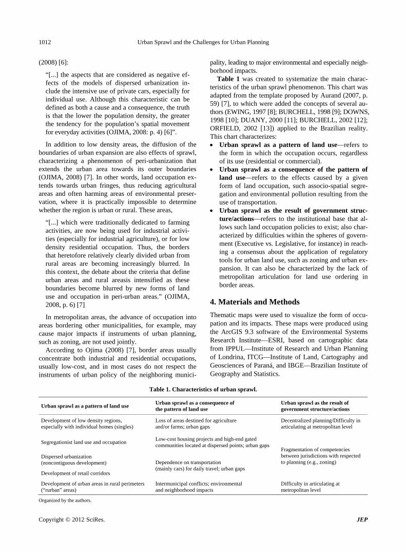
Table 1 was created to systematize the main charac- teristics of the urban sprawl phenomenon. This chart was adapted from the template proposed by Aurand (2007, p. 59) [7], to which were added the concepts of several au- thors (EWING, 1997 [8]; BURCHELL, 1998 [9]; DOWNS, 1998 [10]; DUANY, 2000 [11]; BURCHELL, 2002 [12]; ORFIELD, 2002 [13]) applied to the Brazilian reality. This chart characterizes: Urban sprawl as a pattern of land use—refers to
the form in which the occupation occurs, regardless of its use (residential or commercial).
Urban sprawl as a consequence of the pattern of land use—refers to the effects caused by a given form of land occupation, such associo-spatial segre-gation and environmental pollution resulting from the use of transportation.
Urban sprawl as the result of government struc- ture/actions—refers to the institutional base that al- lows such land occupation policies to exist; also char- acterized by difficulties within the spheres of govern- ment (Executive vs. Legislative, for instance) in reach- ing a consensus about the application of regulatory tools for urban land use, such as zoning and urban ex- pansion. It can also be characterized by the lack of metropolitan articulation for land use ordering in border areas.
4. Materials and Methods
Thematic maps were used to visualize the form of occu- pation and its impacts. These maps were produced using the ArcGIS 9.3 software of the Environmental Systems Research Institute—ESRI, based on cartographic data from IPPUL—Institute of Research and Urban Planning of Londrina, ITCG—Institute of Land, Cartography and Geosciences of Paraná, and IBGE—Brazilian Institute of Geography and Statistics.
Table 1. Characteristics of urban sprawl.
Urban sprawl as a pattern of land use Urban sprawl as a consequence of the pattern of land use
Urban sprawl as the result of government structure/actions
Development of low density regions, especially with individual homes (singles)
Loss of areas destined for agriculture and/or farms; urban gaps
Decentralized planning/Difficulty in articulating at metropolitan level
Segregationist land use and occupation Low-cost housing projects and high-end gated communities located at dispersed points; urban gaps
Dispersed urbanization (noncontiguous development)
Development of retail corridors
Dependence on transportation (mainly cars) for daily travel; urban gaps
Fragmentation of competencies between jurisdictions with respected to planning (e.g., zoning)
Development of urban areas in rural perimeters (“rurban” areas)
Intermunicipal conflicts; environmental and neighborhood impacts
Difficulty in articulating at metropolitan level
Organized by the authors.
Urban Sprawl and the Challenges for Urban Planning 1013
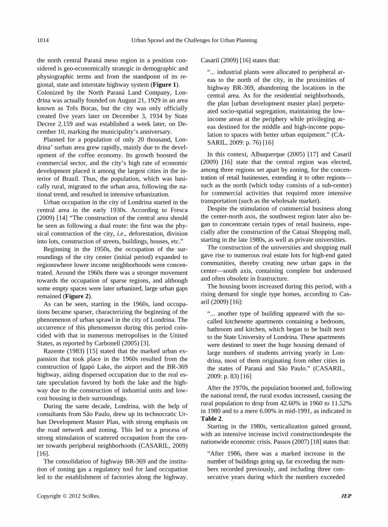
The urban expansion map was created from data pro-
vided by IPPUL based on the evolution of housing lot developments by decade, from when it started (approxi- mately in the 1930s) up to the years following 2000. To- gether with the layers of urban expansion were added the urban gaps, which were also provided by the same insti- tute in order to demonstrate the predominance of lands- not utilized along the period of land occupation.
The data of the demographic density map were spati- alized according to the IBGE’s sectors of the year 2000 census. The database of the sectors themselves added
demographic density data processed by IPPUL (2006), which had to be converted into inhabitants per hectare.
The cartographic projections of all the databases were adjusted to the Transverse Mercator Projection and the- map datum utilized was SIRGAS 2000, Zone 22S since this is the one used by the Londrina Municipal Admini-stration.
5. Urban Sprawlin Londrina, Parana, Brazil
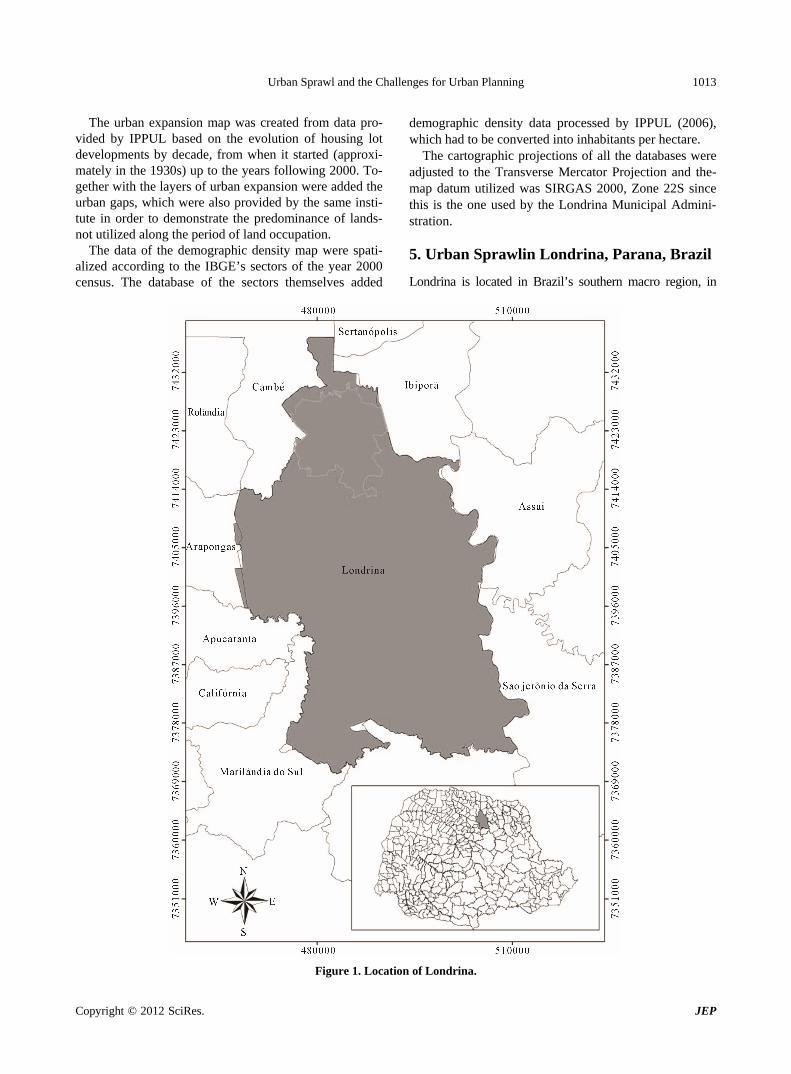
Londrina is located in Brazil’s southern macro region, in
Figure 1. Location of Londrina.
Copyright © 2012 SciRes. JEP
Urban Sprawl and the Challenges for Urban Planning 1014
the north central Paraná meso region in a position con- sidered is geo-economically strategic in demographic and physiographic terms and from the standpoint of its re- gional, state and interstate highway system (Figure 1). Colonized by the North Paraná Land Company, Lon- drina was actually founded on August 21, 1929 in an area known as Três Bocas, but the city was only officially created five years later on December 3, 1934 by State Decree 2.159 and was established a week later, on De- cember 10, marking the municipality’s anniversary.
Planned for a population of only 20 thousand, Lon- drina’ surban area grew rapidly, mainly due to the devel- opment of the coffee economy. Its growth boosted the commercial sector, and the city’s high rate of economic development placed it among the largest cities in the in- terior of Brazil. Thus, the population, which was basi- cally rural, migrated to the urban area, following the na- tional trend, and resulted in intensive urbanization.
Urban occupation in the city of Londrina started in the central area in the early 1930s. According to Fresca (2009) [14] “The construction of the central area should be seen as following a dual route: the first was the phy- sical construction of the city, i.e., deforestation, division into lots, construction of streets, buildings, houses, etc.”
Beginning in the 1950s, the occupation of the sur- roundings of the city center (initial period) expanded to regionswhere lower income neighborhoods were concen- trated. Around the 1960s there was a stronger movement towards the occupation of sparse regions, and although some empty spaces were later urbanized, large urban gaps remained (Figure 2).
As can be seen, starting in the 1960s, land occupa- tions became sparser, characterizing the beginning of the phenomenon of urban sprawl in the city of Londrina. The occurrence of this phenomenon during this period coin- cided with that in numerous metropolises in the United States, as reported by Carbonell (2005) [3].
Razente (1983) [15] stated that the marked urban ex- pansion that took place in the 1960s resulted from the construction of Igapó Lake, the airport and the BR-369 highway, aiding dispersed occupation due to the real es- tate speculation favored by both the lake and the high- way due to the construction of industrial units and low- cost housing in their surroundings.
During the same decade, Londrina, with the help of consultants from São Paulo, drew up its technocratic Ur- ban Development Master Plan, with strong emphasis on the road network and zoning. This led to a process of strong stimulation of scattered occupation from the cen-ter towards peripheral neighborhoods (CASARIL, 2009) [16].
The consolidation of highway BR-369 and the institu- tion of zoning gas a regulatory tool for land occupation led to the establishment of factories along the highway.
Casaril (2009) [16] states that:
“... industrial plants were allocated to peripheral ar-eas to the north of the city, in the proximities of highway BR-369, abandoning the locations in the central area. As for the residential neighborhoods, the plan [urban development master plan] perpetu-ated socio-spatial segregation, maintaining the low- income areas at the periphery while privileging ar-eas destined for the middle and high-income popu-lation to spaces with better urban equipment.” (CA- SARIL, 2009: p. 76) [16]
In this context, Albuquerque (2005) [17] and Casaril (2009) [16] state that the central region was elected, among three regions set apart by zoning, for the concen- tration of retail businesses, extending it to other regions— such as the north (which today consists of a sub-center) for commercial activities that required more intensive transportation (such as the wholesale market).
Despite the stimulation of commercial business along the center-north axis, the southwest region later also be- gan to concentrate certain types of retail business, espe- cially after the construction of the Catuaí Shopping mall, starting in the late 1980s, as well as private universities.
The construction of the universities and shopping mall gave rise to numerous real estate lots for high-end gated communities, thereby creating new urban gaps in the center—south axis, containing complete but underused and often obsolete in frastructure.
The housing boom increased during this period, with a rising demand for single type homes, according to Cas- aril (2009) [16]:
“... another type of building appeared with the so- called kitchenette apartments containing a bedroom, bathroom and kitchen, which began to be built next to the State University of Londrina. These apartments were destined to meet the huge housing demand of large numbers of students arriving yearly in Lon-drina, most of them originating from other cities in the states of Paraná and São Paulo.” (CASARIL, 2009: p. 83) [16]
After the 1970s, the population boomed and, following the national trend, the rural exodus increased, causing the rural population to drop from 42.60% in 1960 to 11.52% in 1980 and to a mere 6.00% in mid-1991, as indicated in Table 2.
Starting in the 1980s, verticalization gained ground, with an intensive increase incivil constructiondespite the nationwide economic crisis. Passos (2007) [18] states that:
“After 1986, there was a marked increase in the number of buildings going up, far exceeding the num- bers recorded previously, and including three con-secutive years during which the numbers exceeded
Copyright © 2012 SciRes. JEP
Urban Sprawl and the Challenges for Urban Planning 1015
Figure 2. Urban expansionin Londrina, state of Paraná, Brazil.
Copyright © 2012 SciRes. JEP

Urban Sprawl and the Challenges for Urban Planning 1016
Table 2. Demographic data of Londrina, Paraná.
RESIDENT POPULATION
Urban Rural Total YEAR
Number % Number % Number %
GEOMETRIC GROWTH RATE(1)
1950 34,230 47.93 37,182 52.07 71,412 100.00 -
1960 77,382 57.40 57,439 42.60 134,821 100.00 6.60
1970 163,528 71.69 64,573 28.31 228,101 100.00 5.40
1980 266,940 88.48 34,771 11.52 301,711 100.00 2.82
1991 366,676 94.00 23,424 6.00 390,100 100.00 2.36
1996 396,121* 96.19 15,679* 3.81 411,800* 100.00 -
2000 433,369 96.94 13,696 3.06 447,065 100.00 2.02
SOURCE: IBGE—Demographic Censuses of 1950, 1960, 1970, 1980, 1991 and 2000; 1996 Population Count; *extracted the population of Tamarana. Former district that has been separated from Londrina.
the entire previous decade, with 147, 136 and 177 buildings erected in 1987, 1988 and 1989, respec-tively.” (PASSOS, 2007) [18]
Starting at this time, an unequal urban configuration began to be established, with the city center and the low- cost housing projects in the north region containing the highest demographic density to the detriment of numer-ous regionsdevoid of any occupationor with low to me-dium density occupation contiguous to the central area, equipped with public infrastructure, constituting urban gaps in the interstices, as indicated in Figure 3.
The establishment of unregulated land occupations scattered around the periphery of the city, as in the south- region (steeply sloped) and areas of permanent preserva- tion in the east and north regions, gradually marked a cityof unequal density. Thus, the infrastructure installed in neighborhoods adjacent to the central are a began to serve regions with little demand due to the low number or even the absence of inhabitants resulting from the lar-ge urban gaps. In contrast, the peripheral regions contain- ing a high population density ended up with incomplete or nonexistent public infrastructure.
6. Challenges for Urban Planning
Numerous attempts have been made to define sprawl in urban settings. While some authors attribute the pheno- menon only to metropolitan areas, others prefer broader definitions.
A common thread in the various approaches, accord- ing to Frumkim & Frank (2004) [19], is that sprawl is characterized as a form of occupation incorporated to the pattern of land use and occupation and to urban transport. In addition to these, other authors include in this defini- tion the high activity in central areas; accessibility to the
public transport network; residential density; and the variety of residences, jobs and services at the neighbor- hood level.
Each of these categories influence the urban shape, which may be compact (according to density); of mixed use (residential, commercial, etc.); the perception of the place (the strength and vibrancy of activity in the central areas) and connectivity (access between one region and another).
These characteristics of the phenomenon of urban sprawl, which initially concentrated in American citie- sand later spread to the compact cities of Europe, also occur in Brazil and bring up pertinent questions: Why does sprawl matter? How can it be controlled?
In addition to the impacts described earlier herein, the European Environment Agency (2006) states that sprawl matters principally due to the high cost of electricity and land, as well as high greenhouse gas emissions, which may, above all, cause public health problems, especially in urban agglomerations.
The question is: how can dispersed urbanization be controlled? How can one control the spatial fluidity of social groups that are not aligned with the spatial fluidity of the capital and seek their reproduction and survival? What mechanisms should be employed to develop effec- tive urban environmental management?
Notwithstanding the similarity of Brazil’s urban shapes with others around the world, the search for solutions to control urban sprawl in Brazil based on international cases would obviously be misguided, considering the numerous differences in the organization of federal and finance systems and the availability of resources for ur- ban policies.
While the United States has programs such as Smart Growth, which allocate millions of dollars for the acqui- ition of land for environmental preservation and fiscal s
Copyright © 2012 SciRes. JEP

Urban Sprawl and the Challenges for Urban Planning 1017
Figure 3. Demographic density, by IBGE sector, in Londrina, Paraná.
Copyright © 2012 SciRes. JEP
Urban Sprawl and the Challenges for Urban Planning 1018
incentives for the purchase of homes, Brazil faces prob- lems at the very foundations of urban planning and its policies.
Hence, planning in Brazil, whatever the proposed pub- lic policy may be, automatically involves the drawing up of Master Plans, as discussed by Oliveira (2006) [21]:
“In Brazil, planning has always involved the elabo- ration of plans and controls. Historically, one finds that numerous plans have been drawn up and con-tinue to be drawn up: triennial, decennial, economic, pluriannual, for development, regional, master plans, etc. We have a culture of planning, which is aimed at foreseeing and organizing the future, as if this were possible to achieve in a rational and predict-able manner.” (OLIVEIRA, 2006: p. 282) [21]
Specifically in the urban environment, planning takes place mainly through Master Plans, which should be the main mechanism of control of urban sprawl, based on the indices and quotas specified in zoning laws.
However, notwithstanding the thousands of Master Plans that exist in Brazilian cities, why does this mecha- nism continue to fail to control urban expansion?
This problem can be attributed to various causes, as was broadly discussed by Villaça (2000, 2005) [22,23]. One of them is the extreme unpreparedness of municipal technicians in the development of their Master Plans, which often (almost always) end up being outsourced to consulting firms that allocate the development of these plans to a single professional—usually an urban archi- tect.
And the problem begins precisely at this point. How can a city be zoned so as to control dispersed urbaniza- tion if the technical staff has a single point of view and is unprepared for this complex task?
The same zoning formula is found in numerous mu-nicipalities: the concentration of central retail corridors, with zoning becoming increasingly inflexible for retail and services the further removed it is from the center. And it is precisely at this point that one of the problems of sprawl occurs: the extensive use of transport.
The use of mixed zoning is becoming increasingly rate in Brazilian cities, unlike cities such as Montreal, Canada or several cities in the state of Maryland, US, which have vertical enterprises containing services, retail business and residences.
Thus, flexible zoning, which is understood here as zoning that encompasses different types that do not cause urban environmental impacts, is one of the challenges to be overcome by planners, as well as their autonomy in executing projects without political interventions.
At this point it is worth pointing out another challenge for the Brazilian case: the housing problem. The large- scale construction of low-cost housing, which usually
follows a pattern (far away from the city center, all of them at the outer edges of the urban area), is also condu- cive to urban sprawl and poses a challenge for urban planning.
In the search to solve the housing problem, techno- logical innovations should be investigated, such as the use of recyclable wastes for construction and the reuse of buildings and/or empty lots in central and boundary areas, doing away with the notion of large housing lot projects destined for low-cost housing, which is promoted princi- pally by government programs aimed at stimulating the construction of “owned” homes.
Lastly, the greatest challenge for all Brazilian urban planners is to attempt to monitor and control the imple- mentation of urban policies originating from our famous and “perfect” plans and projects, to prevent corruption from becoming the main actor in the process of planning our cities.
7. Acknowledgements
The authors acknowledge FAPESP (Fundação de Am- paro à Pesquisa do Estado de São Paulo—Brazil) for its support of the project “Urban Environmental Impacts in Areas of Expansion: Challenges of Metropolitan Plan- ning”, Process no. 2009/11086-8.
REFERENCES [1] R. Rolnik, “Planejamento e Gestão: Um Diálogo de Sur-
dos?” In: Fundação Prefeito Faria Lima—CEPAM, Esta- tuto da Cidade, Coordenado por Mariana Moreira, São Paulo, 2001, 482 p.
[2] R. Burchell and S. Mukhjerji, “Conventional Develop- ment versus Managed Growth: The Costs of Sprawl,” American Journal of Public Health, Vol. 93, No. 9, 2003, pp. 1534-1540. doi:10.2105/AJPH.93.9.1534
[3] A. Carbonell and R. Yaro, “American Spatial Develop- ment and the New Megalopolis,” Lincoln Institute of Land Policy, Cambridge, 2005.
[4] E. Limonad, “Urbanização Dispersa: Mais uma Forma de Expressão Urbana?” Revista Formação (Presidente Pru- dente), Vol. 1, No. 14, 2007, pp. 31-45.
[5] A. G. Aurand, “Is Smart Growth for Low-Income House- holds: A Study of the Impact of Four Smart Growth Prin- ciples on the Supply of Affordable Housing,” Doctoral Thesis, University of Pittsburgh, Pittsburgh, 2007, 451 p.
[6] R. Ojima and D. J. Hogan, “Crescimento Urbano e Peri- Urbanização: Redistribuição Espacial da População em Novas Fronteiras da Mudança Ambiental,” Anais do IV Encontro da Associação Nacional de Pós-Graduação e Pesquisa em Ambiente e Sociedade, Brasília, 2008.
[7] R. Ojima and D. J. Hogan, “População, Urbanização e Am- biente no Cenário das Mudanças Ambientais Globais: Debates e Desafios Para a Demografia Brasileira. Anais do XVI Encontro Nacional de Estudos Populacionais, Brasília, 2008, 13 p.
Copyright © 2012 SciRes. JEP

Urban Sprawl and the Challenges for Urban Planning 1019
[8] R. Ewing, “Is Los Angeles-Style Sprawl Desirable?” Jour- nal of the American Planning Association, Vol. 63, No. 1, 1997, pp. 107-125.
[9] R. Burchell, “The Costs of Sprawl,” Transportation Co-op- erative Research Program Report 39, National Acad-emy Press, Washington DC, 1998.
[10] A. Downs, “How America’s Cities Are Growing,” Brook- ings Review, Vol. 16, No. 4, 1998, pp. 8-12. doi:10.2307/20080808
[11] A. Duany, E. Plater-Zyberk and J. Speck, “Suburban Na- tion: The Rise of Sprawl and the Decline of the American Dream,” North Point Press, New York, 2000.
[12] R. Burchell, “Costs of Sprawl,” Transportation Coopera- tive Research Program Report 74, National Academy Press, Washington DC, 2002.
[13] M. Orfield, “American Metropolitics: The New Suburban Reality,” Brookings Institution Press, Washington DC, 2002.
[14] T. M. Fresca, “A Área Central de Londrina: Uma Análise Geográfica,” Revista Geografia (Londrina), Vol. 16, No. 2, 2007, pp. 143-166.
[15] N. Razente, “Ocupação do Espaço Urbano de Londrina,” Dissertação de Mestrado, Universidade Federal de Per- nambuco, Pernambuco, 1983, 393 p.
[16] C. C. Casaril, “A Expansão Físico-Territorial da Cidade de Londrina e seu Processo de Verticalização: 1950-2000,” Revista Geografia (Londrina), Vol. 18, No. 1, 2009, pp.
65-94.
[17] V. B. P. Albuquerque, “Especulação e Valorização Imob- iliária na Palhano em Londrina: Rítmicas pelo Espaço e Tempo da Produção Condominial,” Dissertação de Mes- trado, Universidade Federal de Santa Catarina, Floria- nópolis, 2005, 384 p.
[18] V. R. L. Passos, “A Verticalização de Londrina: 1970/ 2000,” Dissertação de Mestrado, Universidade Estadual de Londrina, Londrina, 2007.
[19] H. Frumkim, L. Frank and R. Jackson, “Urban Sprawl and Public Health: Designing, Planning and Building for Health Communities,” Island Press, Washington DC, 2004, 279 p.
[20] European Environmental Agency, “Urban Sprawl in Eur- ope: The Ignored Challenge,” Office for Official Publica-tions of the European Communities, Luxembourg, 2006, 60 p.
[21] J. A. P. Oliveira, “Desafios Do Planejamento em Políticas Públicas: Diferentes Visões e Práticas,” RAP (Rio de Jan- eiro), Vol. 40, No. 1, 2006, pp. 273-287.
[22] F. Villaça, “Perspectivas Do Planejamento Urbano No Brasil de Hoje,” Anais Do II Seminário Cidades Brasil- eiras—Desejos e Possibilidades, Campo Grande, 2000, pp. 31-47.
[23] F. Villaça, “As Ilusões do Plano Diretor,” 2005. http://www.usp.br/fau/fau/galeria/paginas/index.html
Copyright © 2012 SciRes. JEP
Related Documents