Trail Builder’s Companion March 2001 For the planning and development of recreation trails in Alberta. COMMUNITY DEVELOPMENT

Welcome message from author
This document is posted to help you gain knowledge. Please leave a comment to let me know what you think about it! Share it to your friends and learn new things together.
Transcript
Trail Builder’sCompanionMarch 2001
For the planning and development of recreation trailsin Alberta.
COMMUNITY DEVELOPMENT

Trail Builder’sCompanionMarch 2001
For the planning and development of recreation trailsin Alberta.
Disclaimer• Alberta Community Development and Alberta TrailNet
disclaim liability for any injuries, damages, or claimswhich may arise by any person relying on the informa-tion contained in this document. Specifically, AlbertaCommunity Development and Alberta TrailNet are notresponsible for determining the suitability of the information provided here for a particular project.
• This document provides you with a variety of recre-ation facility ideas. In some cases, particular compa-nies are named if they are the only known supplier ofa product. This does not constitute an endorsement.The user takes all responsibility for determining if anyconcept, service, or procedure is appropriate for theparticular application. The drawings are not intendedfor construction purposes.
Acknowledgements
Primary Information Sources
• Alberta TrailNet
• Alberta Environment
• Environment Canada
Sponsors
• Alberta Community Development
• Alberta TrailNet
• Alberta Sport, Recreation, Parks and Wildlife Foundation
Additional copies
• Alberta TrailNet, Toll Free 1-877-987-2457(see order from at back)
RITE telephone line
• You can telephone any provincial government officein Alberta toll-free. Just dial 310-0000 and wait for theelectronic operator to give instructions.
COMMUNITY DEVELOPMENT

SECTION PAGE
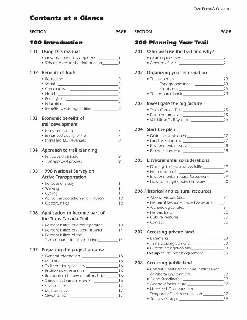
100 Introduction
101 Using this manual• How the manual is organized __________1• Where to get further information________1
102 Benefits of trails• Recreation __________________________3• Social ______________________________3• Community ________________________3• Health ______________________________4• Ecological __________________________4• Educational__________________________4• Benefits to existing facilities ____________5
103 Economic benefits of trail development• Increased tourism ____________________7• Enhanced quality of life________________7• Increased Tax Revenues________________8
104 Approach to trail planning• Image and attitude __________________9• Trail approval process__________________9
105 1998 National Survey on Active Transportation• Purpose of study ____________________11• Walking ____________________________11• Cycling______________________________11• Active transportation and children ______12• Opportunities ________________________12
106 Application to become part of the Trans Canada Trail• Responsibilities of a trail operator________13• Responsibilities of Alberta TrailNet ______14• Responsibilities of the
Trans Canada Trail Foundation __________14
107 Preparing the project proposal• General information __________________15• Mapping ____________________________15• Trail corridor guidelines ________________16• Positive users experience ______________16• Relationship between trail and site ______16• Safety and human aspects ____________16• Construction ________________________17• Maintenance ________________________17• Stewardship ________________________17
SECTION PAGE
200 Planning Your Trail
201 Who will use the trail and why?• Defining the user ____________________21• Amount of use ______________________21
202 Organizing your information• The strip map ________________________23
Topographic maps ______________23Air photos ______________________23
• The resource book ____________________23
203 Investigate the big picture• Trans Canada Trail ____________________25• Planning process ____________________25• Wild Rose Trail System ________________26
204 Start the plan• Define your objective__________________27• Land-use planning ____________________27• Environmental reserve ________________28• Project statement ____________________28
205 Environmental considerations• Damage to landscape/wildlife __________29• Human impact ______________________29• Environmental Impact Assessment ______29• How to mitigate potential issues ________30
206 Historical and cultural resources• Alberta Historic Sites __________________31• Historical Resource Impact Assessment __31• Archaeological sites __________________31• Historic trails ________________________32• Cultural features ______________________32• Contact ____________________________32
207 Accessing private land• Easements __________________________33• Trail access agreement ________________33• Purchasing right-of-way________________33Example: Trail Access Agreement __________35
208 Accessing public land• Consult Alberta Agriculture Public Lands
or Alberta Environment ________________37• “Land Standing” ____________________37• Alberta Infrastructure __________________37• License of Occupation or
Temporary Field Authorization __________37• Suggested steps ______________________38
Contents at a Glance
TRAIL BUILDER’S COMPANION
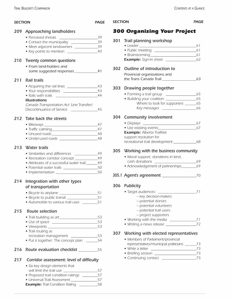
SECTION PAGE
209 Approaching landholders• Perceived threats ____________________39• Contact the municipality ______________39• Meet adjacent landowners ____________39• Key points to mention ________________40
210 Twenty common questions • From land-holders and
some suggested responses ____________41
211 Rail trails• Acquiring the rail lines ________________43• Your responsibilities __________________43• Rails with trails ______________________44Illustrations Canada Transportation Act: Line Transfer/Discontinuance of Service ______________45
212 Take back the streets• Bikeways ____________________________47• Traffic calming________________________47• Unused roads ________________________48• Under-used roads ____________________48
213 Water trails• Similarities and differences ____________49• Recreation corridor concept ____________49• Attributes of a successful water trail ______49• Potential water trails __________________50• Implementation ______________________50
214 Integration with other types of transportation• Bicycle to airplane ____________________51• Bicycle to public transit ________________51• Automobile to various trail uses ________51
215 Route selection• Trail building as art____________________53• Use of space ________________________53• Viewpoints __________________________53• Trail routing as
recreation management ______________53• Put it together: The concept plan ______54
216 Route evaluation checklist __________55
217 Corridor assessment: level of difficulty• Six key design elements that
will limit the trail use __________________57• Proposed trail condition ratings ________57• Universal Trail Assessment ______________57Example: Trail Condition Rating __________58
SECTION PAGE
300 Organizing Your Project
301 Trail planning workshop• Leader ______________________________61• Public meeting ______________________61• Brainstorming ________________________61Example: Sign-in sheet ________________62
302 Outline of introduction to Provincial organizations and the Trans Canada Trail __________________63
303 Drawing people together• Forming a trail group ________________65• Building your coalition ________________65
Where to look for supporters ______65Key messages __________________66
304 Community involvement• Displays ____________________________67• Use existing events____________________67Example: Alberta TrailNet support resolution for recreational trail development ____________68
305 Working with the business community• Moral support, donations in kind,
cash donations ______________________69• Acknowledgement of partnerships________69
305.1 Agent’s agreement __________________70
306 Publicity• Target audiences: ____________________71
– key decision-makers– potential donors– potential volunteers– potential trail users– project supporters
• Working with the media ______________71• Writing a news release ________________72
307 Working with elected representatives• Members of Parliament/provincial
representatives/municipal politicians ______73• Write a letter ________________________73• Briefing session ______________________73• Continuing contact __________________73
CONTENTS AT A GLANCETRAIL BUILDER’S COMPANION
SECTION PAGE
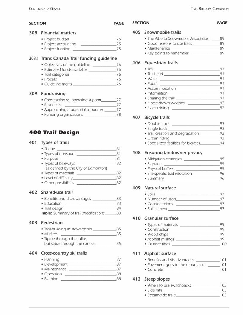
308 Financial matters• Project budget ______________________75• Project accounting __________________75• Project funding ______________________75
308.1 Trans Canada Trail funding guideline• Objectives of the guideline ____________76• Estimated funds available ______________76• Trail categories ______________________76• Process______________________________76• Guideline merits ______________________76
309 Fundraising• Construction vs. operating support________77• Resources __________________________77• Approaching a potential supporter ______77• Funding organizations ________________78
400 Trail Design
401 Types of trails• Shape ______________________________81• Types of transport ____________________81• Purpose ____________________________81• Types of bikeways ____________________82
(as defined by the City of Edmonton)• Types of materials ____________________82• Level of difficulty______________________82• Other possibilities ____________________82
402 Shared-use trail• Benefits and disadvantages ____________83• Education __________________________83• Trail design __________________________84Table: Summary of trail specifications______83
403 Pedestrian• Trail-building as stewardship ____________85• Markers ____________________________85• Tiptoe through the tulips,
but stride through the canola __________85
404 Cross-country ski trails• Planning ____________________________87• Development ________________________87• Maintenance ________________________87• Operation __________________________88• Biathlon ____________________________88
SECTION PAGE
405 Snowmobile trails• The Alberta Snowmobile Association ____89• Good reasons to use trails______________89• Maintenance ________________________89• Key points to remember ______________89
406 Equestrian trails• Trail ______________________________91• Trailhead ____________________________91• Water ______________________________91• Food ______________________________91• Accommodation______________________91• Information __________________________91• Sharing the trail ______________________91• Horse-drawn wagons ________________92• Llama riding ________________________92
407 Bicycle trails• Double track ________________________93• Single track __________________________93• Trail creation and degradation __________93• Urban riding ________________________93• Specialized facilities for bicycles__________94
408 Ensuring landowner privacy• Mitigation strategies __________________95• Signage ____________________________95• Physical buffers ______________________95• Site-specific trail relocation______________96• Summary____________________________96
409 Natural surface• Soils ______________________________97• Number of users______________________97• Considerations ______________________97• Soil cement __________________________97
410 Granular surface• Types of materials ____________________99• Construction ________________________99• Wood chips__________________________99• Asphalt millings ______________________99• Crusher fines ________________________100
411 Asphalt surface• Benefits and disadvantages ____________101• Pavement goes to the mountains ______101• Concrete ____________________________101
412 Steep slopes• When to use switchbacks ______________103• Side hills ____________________________103• Stream-side trails______________________103
CONTENTS AT A GLANCE TRAIL BUILDER’S COMPANION
SECTION PAGE
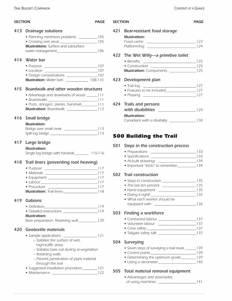
413 Drainage solutions• Planning minimizes problems __________105• Crossing wet areas____________________105Illustrations: Surface and subsurface water management______________________106
414 Water bar• Purpose ____________________________107• Location ____________________________107• Design considerations ________________107Illustration: Water bars ____________ 108-110
415 Boardwalk and other wooden structures• Advantage and drawbacks of wood ______111• Boardwalks __________________________111• Posts, stringers, planks, handrails ________111Illustration: Boardwalk ________________112
416 Small bridgeIllustration: Bridge over small creek __________________113Split log bridge __________________________113
417 Large bridgeIllustration: Single log bridge with handrail________ 115-116
418 Trail liners (preventing root heaving)• Purpose ____________________________117• Materials ____________________________117• Equipment __________________________117• Labour ______________________________117• Procedure __________________________117Illustration: Trail liners__________________118
419 Gabions• Definition____________________________119• Detailed instructions __________________119Illustration: Base preparation: Retaining wall __________120
420 Geotextile materials• Sample applications __________________121
– Stabilize the surface of wet, high-traffic areas
– Stabilize bare soil during re-vegetation– Retaining walls– Prevent penetration of plant material
through the trail• Suggested installation procedure ________121• Maintenance ________________________122
SECTION PAGE
421 Bear-resistant food storageIllustration: Food cache __________________________123 Platform/log __________________________124
422 The Wet Willy—a primitive toilet• Benefits ____________________________125• Construction ________________________125Illustration: Components ______________125
423 Development plan• Trail log ____________________________127• Features to be included________________127• Phasing ____________________________127
424 Trails and persons with disabilities ____________________129
Illustration: Canadians with a disability ______________130
500 Building the Trail
501 Steps in the construction process• Preparations ________________________133• Specifications ________________________133• As-built drawings ____________________134• Important “tricks” to remember__________134
502 Trail construction• Steps in construction __________________135• The last ten percent __________________135• Hand equipment ____________________135• Doing it right! ________________________135• What each worker should be
equipped with ______________________136
503 Finding a workforce • Contracted labour ____________________137• Volunteer labour ____________________137• Crew safety __________________________137• Tailgate safety talk ____________________137
504 Surveying• Seven steps of surveying a trail route ______139• Control points________________________139• Determining the optimum grade________139• Using a clinometer____________________140
505 Total material removal equipment• Advantages and downsides
of using machines ____________________141
CONTENTS AT A GLANCETRAIL BUILDER’S COMPANION
SECTION PAGE
506 Trail Tailor equipment• The equipment and its benefits ________143
507 Digital mapping• Global Positioning System (GPS) ________145• Geographic Information System (GIS)______146
508 Re-vegetation and landscaping• Realistic standards ____________________147• Landscaping as a management tool ______147• Re-vegetation ________________________147• Closing trails ________________________148
509 Final report• Major sections________________________149 • Materials to include __________________149• Distribution __________________________150
600 Operation
601 What “operation” means• Physical maintenance ________________153• Trail operation or programming ________153• Who should manage the trail?__________153
Government agency ____________154Trail group ______________________154Contractors ____________________154
602 Preventing user conflictsTrail management ______________________155Example: Use Respect! ________________156
603 Public safety• Conditions and dangers/hazards of the trail____________________________157
• Emergency services __________________157• Insurance __________________________157
604 Fire Control • Prevention __________________________159• Readiness __________________________159• Action ______________________________159• Equipment __________________________159
605 Programming• Trailhead maps and brochures __________161• Use by community groups ____________161• Trail security/emergencies ______________161• Special events ________________________161• Grand opening ______________________162
SECTION PAGE
606 Signs• Important functions __________________163• Unnecessary signs ____________________163• Signage standards ____________________163• Pavement markings __________________164• Suppliers ____________________________164
607 Symbols ____________________________165
608 Interpretation• The field of interpretation ______________167• Media types__________________________167• Features of interpretive map sheets ______167Illustration: Interpretive map sheets ______________168-169
609 Evaluation• Estimate number of people using trail ____171• Guest books ________________________171• Trail inspections ______________________171• Signs of poor design __________________171• Signs of over-use ____________________171• Signs of under-use ____________________171
610 Maintenance• Overall goals ________________________173• Maintenance reports __________________173• Maintenance activities ________________173• Vandalism __________________________174Illustrations:Cycle of events in track degradation ______175Trail Assessment Form __________________176Trans Canada Trail in Alberta ____________177
700 Reference Material
701 References __________________________181
702 Trail and recreation organizations in Alberta __________________________183
703 Order form __________________________185
CONTENTS AT A GLANCE TRAIL BUILDER’S COMPANION

Section 100 Introduction

101 Using this manualThis manual presents information needed for the plan-
ning and development of most types of recreation trails.Specifications included here are generally useful for condi-tions typically found in Alberta. To keep the manual as help-ful as possible, easily accessible information has not beenreproduced. New ideas and products, sometimes fromobscure sources, are offered for your consideration.
The intended users are people directly involved in plan-ning and operating trails. The manual should be of interest toboth volunteers with smaller organizations which cannotafford to hire professionals, and trail professionals looking fornew solutions. The information has been drawn from a widerange of trail manuals, references, and individuals. All majoraspects of trail construction are mentioned: design, trail mate-rials, visitor services features, construction techniques, andoperation.
The development process outlined in the first section willbe especially useful for groups working on the Trans CanadaTrail. The resulting proposals will likely have the informationrequired for a quick and accurate appraisal, which could leadto partial funding.
Trails bring together many skills and disciplines whichare beyond the scope of this manual. Some of the topicswith an extensive body of literature include fundraising,volunteer management, engineering of bridges, and vegetation restoration.
Organization of this manualThe Trail Builder’s Companion has two components:
the Trail Planning Workbook and this reference manual.The workbook will lead the beginner through the varioussteps involved in trail development and the manual willprovide details for consideration. Use the workbook! It ismeant to be written in! If this bothers you, use a photocopyto record your notes.
The manual is meant as a reference, and is not intendedto be read “cover to cover.” Alberta TrailNet anticipatesadding pages as new products or techniques are developed.The title “Companion” was chosen intentionally. Keep itclose at hand and refer to it frequently. Each page or section isfree-standing and can be removed and studied without losingcontext. Feel free to add additional references or notes.
Most pages begin with an abstract description of theproblem or situation. The general response is given, withlocal examples where practical. These ideas are not intend-ed to be a recipe, but a starting point for discussion. Trailshave lots of room for creative solutions!
Feedback on this manualResponse from readers is essential for this manual to be
totally functional. If you have an interesting trail feature,please send details to Alberta TrailNet for possible inclusion
in this manual. It may be the use of innovative materials ora clear specification for a common product. Line drawingsare preferred for illustration as photos do not reproduce well.
If you feel advice included in this manual could lead to anunsafe situation, please advise us immediately so appro-priate action can be taken.
In keeping with modern construction practices, all dimen-sions given in this manual are in millimetres (mm), metres(m), or kilometres (km). Imperial units may be given as well.
Further information
Wild Rose Trail System: This proposal provides a provin-cial perspective on trail development. It shows how local andregional trails can take advantage of existing transportationcorridors to improve recreation. The background and broadpicture presented here can be used to substantiate a local pro-posal. This resource is available from Alberta TrailNet at a costof $15, including shipping.
Guide to Alberta Trails: This report provides the mostcomprehensive listing of recreation trails in Alberta. Itincludes over 11,000 km of mapped routes open to the pub-lic. Use it to get in touch with local trail managers who maybe able to offer support or advice. Or use it to generate freshideas for vacations.
Trail Talk Conference: This annual gathering of trailactivists can provide a lot of information and motivation ina short time. Bring a friend and be prepared to show offyour local trail or proposed route. The proceedings of pre-vious conferences are available at a cost of $15 each.
Bookshop: Several important references are available atnominal cost from Alberta TrailNet. Please refer to the fulllist in the Appendix. These can be ordered by calling tollfree 1-877-987-2457.
Trent Fleming Trail Studies Unit: Under the directionof Dr. John Marsh, this office gathers and distributes awide range of trail-related material. Use their web site (seebelow) to find out exactly what they have in their collec-tion, and to access a variety of other sites.
Internet Sites: Internet addresses constantly change andmove. However, these should put you in touch with othertrail enthusiasts and managers:
• Alberta TrailNetwww.albertatrailnet.com
• Trans Canada Trail Foundationwww.tctrail.ca/
• Active Living-Go For Green!www.goforgreen.ca
• Rails to Trails Conservancywww.railtrails.org/
• TrailPAQwww.trailpaq.com
1
SECTION 100—INTRODUCTION TRAIL BUILDER’S COMPANION
• American Hiking Societyamericanhiking.org/
• Trent Fleming Trail Studies Unittrentu.ca/academic/trailstudies/
• Canadian Pacific Railway 3-Year Planwww.cpr.ca(choose “corporate”)
Case Studies: You can learn a lot from other trail man-agers. Try using trails yourself and consciously notewhat did and didn’t work for you. Keep an inexpen-sive camera handy and take pictures to show otherswhat you saw. Take a few moments to ask staff howthey feel about the trails and what they wouldchange. The field staff may give you a different per-spective from the “office” people.
Notes:
2
SECTION 100—INTRODUCTIONTRAIL BUILDER’S COMPANION
102 Benefits of trailsToday’s recreation professionals are faced with a substan-
tial need to document the specific benefits of recreation facil-ities. Take a minute to consider what your community wouldbe like with no recreation facilities. No swimming pools,skating rinks, theatres, golf courses, tennis courts, bowlingalleys, or community centres. No parks, picnic sites, or play-grounds.
Obviously, there would be little point in living in such adismal place. Just a little reflection has shown us that recre-ation does not deserve to be labeled as a “frill” or dispens-able extra expense. However, our society today has a strongmotivation to spend public money in the wisest mannerpossible. This trend to efficiency clearly favours the devel-opment of trails which provide many benefits to nearly allsegments of our society. You are encouraged to study thefollowing list and use the most appropriate benefits to helpsubstantiate your proposed trail. Be as specific as you can.
Alberta TrailNet and Alberta Community Developmentbelieve that by listening to all interested parties and actingin an open and supportive manner, the needs of the entiretrails community can be met. Remember to demonstratethat all aspects of a trail program are positive. The bene-fits from these trails should flow to all stakeholders,including the landowners.
Recreation benefitsTrails, because of their linear nature, pass close to many
homes, providing easy access for many people. The heavyuse of our urban trail systems and our national parks illus-trates the popularity of these “community” facilities. Infact, many of these trails are stressed due to a high level ofuse. Exactly how high is this use? Research conducted bythe Rails-to-Trails Conservancy found that in 1994 alone,American railtrails were used 85 million times. A surveyconducted for the 1997 Growth Summit also confirms theimportance of access to the natural environment. Twenty-six percent of those questioned identified “nature” as whatthey valued most about Alberta. This ranked ahead of allother categories.
Recreation surveys by the Alberta government indicatethat walking for pleasure and cycling are among the top recre-ation activities. To a high degree, this is because trails circum-vent several barriers to participation. The cost of equipmentcan be very low, especially when compared to motor sportsand downhill skiing. There are no admission fees, and, withtrails reaching into many communities, the access is easy. Inparticular, the typically gentle grades of abandoned rail linesallow a wide variety of uses. Having fun together buildsstrong families and a foundation for a stronger society.
As a demonstration of the popularity of cycling,Statistics Canada reported that Alberta leads the way inbicycle ownership. In 1989, 58% of Alberta households
had at least one adult bicycle, an increase of 8% since 1980. It should not come as any surprise that we also lead the
way in the use of horses. According to the AlbertaEquestrian Federation, about one-third of all Canadianhorses live in the Calgary region, amounting to over 30,000head. Just in the Calgary area, 79 equestrian associationsand 25 clubs have been formed. Together, these peopleinject $220 million annually into the economy.
Social benefitsTrails, by their very nature, are a perfect multi-genera-
tional facility. Parents, children, and grandchildren can allenjoy themselves together. This support of family values isvery hard to measure, but a visit to any trail will showmany families having fun together.
Who can argue with the desire to provide a safe placefor children to play? Whether they use bikes or horses,children deserve a place protected from vehicle traffic.This is especially true in the rural areas, where trafficmoves faster and industrial vehicles are common.
On a broader scale, the trail-building process builds astronger social fabric. Community participation is a solidway of providing trail services, because it yields benefitsfrom the process as well as the product. By stimulating newpartnerships and relationships, trail development results ina stronger and more dynamic community. Trail develop-ment is a human-scale project which requires close experi-ence with the environment. Trails create pride in theirbuilders in a way that more expensive projects can not. Thiswill, in turn, bring a sense of empowerment to the personand the community.
We must not forget that Alberta was built by settlerswho arrived, in many cases, on trails. Now, trails provide asuitable place to commemorate our pioneers and celebratetheir contributions. In fact, trails can maintain the tradi-tions of horse travel. The traditional activity of drivinghorse-drawn wagons is experiencing a revival.
In today’s context of concern for the environment, thetrail network can provide a medium for individuals andgroups to channel their energies into a “green” project bylearning to work together to improve their community.
Alberta TrailNet and Alberta Community Developmentrecognize the social benefit of many people joining togetherto achieve a common goal. We know that the finished trailsalready encourage group outings which provide a positiveaspect of community involvement for many trail users.
Community benefitsParticipation in a trail project provides an opportunity
for greater ties and involvement, whether it is between neigh-bours or neighbouring municipalities. Through cooperationin a worthwhile project, a sense of community will be gener-ated by the increased communication. Already some townshave been drawn together by a joint trail. Black Diamond
3
SECTION 100—INTRODUCTION TRAIL BUILDER’S COMPANION
and Turner Valley, Elk Point and Heinsburg, and the townswithin the Crowsnest Pass provide three excellent examples.Further opportunities abound for towns to be connected bythese increasingly popular activities.
The development process stimulates leadership oppor-tunities which build strong communities. Each trail facilitycontains elements of local character and regional influence,and reflects the hard work, enthusiasm, and commitmentof individuals, organizations, elected officials, and agencies.All are able to take pride in having worked together to suc-cessfully complete the project.
Health benefitsPay now or pay more later! Investment in outdoor
recreation as a preventive health service makes dollars andsense. The Alberta Active Living Task Force has document-ed a financial return of 50:1 on money spent to increasephysical activity. Trails provide this important public serviceto our citizens by encouraging wellness through variousrecreation activities. For this reason, recreation trails forman important means of implementing the government’sActive Living mandate.
Trail activities are especially valuable as aerobic exercise.According to recreation and health professionals, peoplewho are physically active enjoy life more fully, are less proneto injury, and are more productive at work and in the com-munity. In fact, Americans who exercise regularly have 14%fewer claims against their health insurance and spend 30%fewer days in the hospital. Trails provide each person anopportunity to exercise at their own level.
Active living:
• helps prevent stroke, colon cancer, and psychological problems
• manages heart disease, stroke, diabetes, osteoporosis, and other health problems
• helps reduce the stress of everyday life
• helps maintain functional independence in later years of life
• helps release the build-up of negative tension, anger, and adrenaline
• helps individuals build confidence, self-esteem, and feelings of success
School children have been identified as particularly atrisk due to a sedentary lifestyle. Increased obesity amongyoung people indicates an increased chance of heart diseaseand other serious health problems. Go For Green hasembarked on a national program called Active and SafeRoutes to School which encourages children to walk orride bicycles to school. Obviously, trails can play an impor-
tant part in this program. Various materials can be orderedthrough their web site at: www.goforgreen.ca
Ecological benefitsGreenways are linear corridors of vegetation which con-
nect natural areas. These often make use of land which hasbeen considered unsuitable for development or intensiveagriculture. By connecting larger parcels of habitat, thegreenways enable larger and more diverse wildlife popula-tions to flourish. At the same time, greenways can oftenaccommodate unobtrusive human use such as trails.
A trail generally occupies only a small portion of the right-of-way, leaving the remainder for green space. This becomesvaluable habitat for plants and small animals. Larger animalswill use the same route for transportation, moving from one“island” of habitat to another along the connecting naturalcorridor. The narrow strip of natural ecosystem is valuablefar beyond what its small area would suggest.
In come cases, this human use of a sensitive area givessufficient rationale for its protection. The preservation oftrail corridors for recreation provides a lower impact onecosystems than most other uses. Without a trail, the landcould be perceived to have little value, and might be subjectto development. Areas subject to flooding, slumping, orsimilar hazards often can be protected in this way. The cre-ation of local trails is a concrete action that average peoplecan take, which will benefit both the natural environmentand other people.
Climate change has become a global problem. Toreverse this, our governments have pledged to make sub-stantial reductions in the amount of carbon dioxide andother greenhouse gases which we produce. With passengertransportation consuming 16% of Canada’s total energybudget, alternate modes of travel can make important con-tributions to this goal. Calgary’s Bow River Pathway showsthat significant numbers of Albertans do commute by bicy-cle if trails are safe, attractive, and available. The recentstart of commercial trading in carbon credits may offer ameans of financing new trails while helping with a seriousglobal problem.
Other environmental benefits can include: serving as abuffer around watersheds and wetlands, providing benignaccess to rivers and lakes, protecting ecosystems, and pro-viding green spaces for the enjoyment of current and futuregenerations.
Educational benefitsThe diverse natural and cultural features of the province
provide an excellent setting for educational activities bybringing students closer to Alberta’s environment. Manysubjects can be taught best in an outdoor setting becausethis is the real world in which all students will live. Natureis stimulating, nature is exciting, and all students can relateto nature at their own level. Trails enable students to access
4
SECTION 100—INTRODUCTIONTRAIL BUILDER’S COMPANION
these resources. As our educational system moves towardsan emphasis on informal learning, interpretive centres,museums, and similar institutions will use trails as impor-tant local learning resources.
In addition, trails themselves are an important educa-tional resource. Historic trails define the settlement andtrading patterns connecting many historic sites. Our mod-ern trails will, in many cases, re-create these routes as theusers re-enact the travels of early Albertans.
Benefits for existing facilitiesTrails will tie together a wide range of existing tourism
facilities and attractions, making them accessible for awhole new clientele. Alberta’s trail network will provideimproved access to many existing trails, and heightenedawareness of their existence. The widespread availability oftrails across Alberta will increase the overall demand forthem, as people come to expect to find them everywhere.
Other facilities not specifically associated with trails willreceive increased use. These include bed and breakfasts(B&Bs), and rural museums and recreation sites. The gen-eral atmosphere will encourage visits by people who havecome to expect trails as a pleasurable way to travel. In par-ticular, Germans are used to an extremely well-developedtrail network, and will feel more at home spending theirholidays on trails.
The winter use of trails, particularly for snowmobiling,can extend the tourist season. In Ontario, lodges andrestaurants in popular areas now stay open all winter.Facilities may even find this to be their busy season, asthere is reduced competition from campgrounds.
5
SECTION 100—INTRODUCTION TRAIL BUILDER’S COMPANION

6
SECTION 100—INTRODUCTIONTRAIL BUILDER’S COMPANION
Notes:
103 Economic benefits oftrail development
The economic benefits of trails are quite substantial andwell-documented. The advantages of a provincial trail sys-tem are widespread, with trails often acting as major draw-ing points for an entire area. Spending by local residentsand visitors can help support recreation-oriented businessesand employment.
Increased tourismTourism has become Alberta’s second largest industry,
but the benefits have been focused in the mountainparks, Calgary, and Edmonton due to a lack of facilitiesin other parts of the province. A provincial trail systemwill attract a small but significant number of visitors toAlberta’s smaller communities. Our parkland and grass-land scenery has great potential which has not beenexplored yet.
New businesses such as bicycle shops and snack barsoften appear in response to the needs of trail users. Othereconomic spinoffs from trail use occur in businesses suchas lodging and food establishments, shops, and other ser-vices (National Park Service, 1990). A dramatic exampleof this is the town of Dunedin, Florida. The downtownarea suffered from a 35% storefront vacancy rate untilthe Pinellas Trail came into town. Now, storefront occu-pancy is 100% and business is booming!
Furthermore, trails help improve the overall appeal ofa community to visitors, and increase tourism. There isno better way to hold a tourist in town for one moremeal than to send them out on a trail!
But tourism is not limited to towns. Modern touristsare interested in learning about their surroundings,including our farms. Urban people are eager to learnmore about the “country,” and they have little opportuni-ty while speeding down highways. In meeting this need,agri-tourism has become one of Alberta’s fastest-growingbusinesses. Rural trails can showcase modern agriculturewhile generating some welcome income. The small scaleof these enterprises enables them to supplement the tra-ditional farm income. Landowners can start up relativelyeasily, with little capital outlay. The steady traffic alongthe more popular trails can bring visitors to the farmgate!
Alberta TrailNet and Alberta CommunityDevelopment recognize that not all people want theircommunity to become a tourist destination. There can bepositive and negative impacts as a result of tourism devel-opment and this must be taken into consideration.
Quality of lifeQuality of life is clearly an important factor when busi-
nesses are relocating. The presence of trails and other recre-ation facilities has been credited with attracting many headoffices to Alberta.
Economists have measured the amount of money spentby trail users. In the United States, it varies from $3.97 perday for a suburban trail to $25.85 for longer, more distanttrails (Moore et al, 1992). Given the large number of users,this adds up to substantial totals. Along the Trans CanadaTrail from Cabana, Quebec, to Edmundston, NewBrunswick, a noticeable increase in commercial activityoccurred, even before the trail was finished.
Snowmobilers generated an economic impact to Albertaof approximately $162.6 million during the 1994/95 sea-son (AB Economic Development & Tourism EconomicAnalysis & Planning Unit, Sept. 1995). In addition to the$74 million in sales of new machines, this includes the costof other equipment, clothing, fuel, food, and accommoda-tion. Taxes to all levels of government are significant, with$30.9 million going to the federal government, $9.8 mil-lion to the province, and $4 million to local jurisdictions.For example, the Crowsnest Pass hosted a weekend jam-boree attended by 700 snowmobilers. A local impact of$300,000 was estimated by the Crowsnest Pass EconomicDevelopment Board.
A recent study of the economic impact of the BruceTrail (Schutt, 1998) showed that this 800 km trail also gen-erates substantial business, both in the immediate vicinityof the trail and in the region. With each hiker spending anaverage of $20, about 200 jobs were generated within 10km of the trail. An additional 800 jobs were estimated tobe supported in the general region.
At present, significant amounts of money are takenfrom Alberta by local residents travelling to otherprovinces or states for recreation. What a waste! Many ofthese people would spend their money here if comparablefacilities existed.
Alberta has spectacular scenery! Lets show it off to bestadvantage! The provincial trail system will provide abun-dant opportunities to enjoy this natural beauty! Individualsand companies are investing in leisure industries and recre-ation-related activities as never before. Trails will complementthe more traditional tourist facilities already found here.
Although the direct economic benefit generated by thespending of trail users is the most evident effect, the quali-tative and indirect benefits are significant. Trails can affectthe health, productivity, and happiness of trail users whichwill, in turn, lead to the avoidance of health care costs forall Albertans. A fit workforce has been demonstrated to bea productive workforce. Meaningful leisure activity canreduce the high cost of vandalism. Parks and recreation
7
SECTION 100—INTRODUCTION TRAIL BUILDER’S COMPANION
services often motivate the relocation of businesses to anarea, and act as a catalyst for tourism.
Increased tax revenuesTrails also contribute to an improved quality of life in
the community. Property values of nearby suburban prop-erties rise due to the creation of a trail. Boulder, Colorado,has documented a 32% increase in land values adjacent to anew greenway. Increased tax revenue from these homes wasexpected to pay for the development costs within threeyears. And people were eager to live there!
Finally, municipal, provincial, and federal tax revenueswill increase due to the increased economic activity createdby the Wild Rose Trail System.
Notes:
8
SECTION 100—INTRODUCTIONTRAIL BUILDER’S COMPANION
104 Approach to trail planning
Image and attitudeAlberta TrailNet and Alberta Community Development
aim to project a particular image: professional, positive, andhigh quality. We encourage all trail developers to also strivefor these traits.
“Professional” simply means that the group operates ina systematic and organized manner. All operations areplanned to reduce future operational costs while not over-building for the present demand. Simple but well main-tained facilities and personal service will be appreciated farmore than fancy architecture.
The quality of a trail has often been equated with theexpense of the contract or the width of the pavement.These are narrow interpretations. Remember that the finaljudge will be the user. What makes a great visit? The user’sexperience begins when they first hear of the trail and con-tinues until they leave it. The cheerful greeting at a trail-side shop is as important as the trail’s hardware. Aim for atotal experience by involving all the people along the trail.
Well-designed trails allow smooth transitions betweendifferent segments, and always seem to have the supportfacility right where it is needed. A master trail builder oncesaid that a person should be able to walk a trail blindfolded;it should flow across the topography effortlessly. (Test thiswith caution in mountainous areas!)
The trail is not the main attraction, but the facility thatgives access to the attraction. A good trail is invisible. Thereshould be no sign of the construction, and the facilitiesshould complement the surroundings. Any vegetationcleared during construction should be moved to a site whereit can decompose without observation.
This is not to say that trails should be boring. Qualitytrails have a sparkle that can only be described as “pizzaz”or “joie de vivre.” Their combination of style and attitudesuits the environment. Make trails flowing, interesting, anddynamic. Excellent trails have a sense of drama with newvistas springing up at every turn. Urban trails should bringa narrow strip of nature to the city, while embracing thelively interplay of the cultural environment. Consider hav-ing an artist on the planning team, and let them have aloose rein. For example, many trails through unremarkableurban locations in Britain have been invigorated withsculptures along the route.
Trail approval processEvery trail requires a sponsor that will plan, construct,
and maintain the route. Permission from the landholder ormanaging agency is also required. Partnerships between thegovernment and not-for-profit sectors are one way of man-
aging projects with limited resources. These arrangementsare becoming more common, although they require exten-sive communication and a clear explanation of the trailgroup’s objectives. Before approaching an agency to suggestthis, put yourself in their position - what would you wantto know if someone suggested inviting the unsupervisedpublic onto your property? Section 107 indicates the man-agement concerns that your proposal must address.
The draft proposal must be discussed with the owner toreceive feedback. When the project is approved in princi-ple, it must be brought to potential funding organizationsif the managing agency is not prepared to pay for the trail.
If the proponent hopes the trail will become part of theTrans Canada Trail, please refer to Section 106.
It must be stressed that the TCTF will only provide par-tial funding, and other sources must be sought. A later sec-tion deals with sources of funding for Alberta trails. Theentire approval process will take at least two months. Startearly, to establish a workable timetable for your project.
9
SECTION 100—INTRODUCTION TRAIL BUILDER’S COMPANION

10
SECTION 100—INTRODUCTIONTRAIL BUILDER’S COMPANION
Notes:
105 1998 National Survey onActive Transportation
This study was conducted by Environics Internationalon behalf of Go for Green. Technical and financial sup-port was provided by Health Canada. The following mater-ial has been taken from the 17-page Summary Report.For further information, please contact Go for Green at(613) 562-5313, or you may order this publication at theirweb site: www.goforgreen.ca
Purpose of StudyThe major objective of the 1998 National Survey on
Active Transportation is to establish a baseline of participa-tion in active transportation (walking and cycling) amongadults and school-aged children.
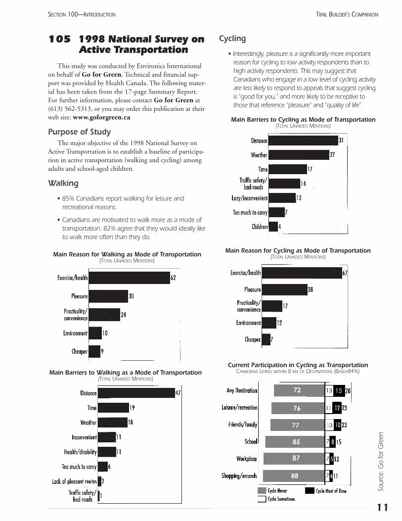
Walking
• 85% Canadians report walking for leisure and recreational reasons.
• Canadians are motivated to walk more as a mode oftransportation. 82% agree that they would ideally liketo walk more often than they do.
Cycling
• Interestingly, pleasure is a significantly more importantreason for cycling to low activity respondents than tohigh activity respondents. This may suggest thatCanadians who engage in a low level of cycling activityare less likely to respond to appeals that suggest cyclingis “good for you,” and more likely to be receptive tothose that reference “pleasure” and “quality of life”.
11
SECTION 100—INTRODUCTION TRAIL BUILDER’S COMPANION
Main Reason for Walking as Mode of Transportation(TOTAL UNAIDED MENTIONS)
Main Barriers to Walking as a Mode of Transportation(TOTAL UNAIDED MENTIONS)
Main Barriers to Cycling as Mode of Transportation(TOTAL UNAIDED MENTIONS)
Current Participation in Cycling as TransportationCANADIANS LIVING WITHIN 8 KM OF DESTINATIONS (BASE=84%)
Main Reason for Cycling as Mode of Transportation(TOTAL UNAIDED MENTIONS)
Sour
ce: G
o fo
r Gre
en
• As with walking, Canadians do not point to the envi-ronment as a main reason for their cycling activity.
• Safety is perceived as a major obstacle to cycling.When asked directly, 45% of Albertans believe thatcycling is dangerous because of vehicle traffic.
Active transportation and children
• Just over one in three (36%) Canadian children walksto school most of the time. However, among those liv-ing within one kilometre of school, over eight in ten(86%) walk most of the time, and among those livingone to three kilometres of school, half (50%) walkmost of the time. Only five percent of those livingbeyond three kilometres walk.
• While nine in ten Canadian children own a bike,only five percent take a bicycle most of the time.While six percent of those living less than one kilo-metre from school cycle most of the time, a slightlyhigher proportion (9%) living one to three kilometresfrom school, cycle.
• For children, distance is the major barrier to walking,mentioned by 53% of parents, followed by weather,mentioned by 11%.
Opportunities
• The survey finding that the vast majority of Canadiansnot only can, but want to, participate more in activetransportation is a very positive sign.
• It is clear, however, the key issues are barriers relatedto perception of “convenience” and “safety.” Peoplealready want to participate, but feel they cannot. Inthis context, it should be noted that “calls to action”without efforts to address barriers may just lead tofeelings of guilt and resentment.
• Study results suggest that both walking and cyclingmay be encouraged by focusing on quality of life andquality of “time” benefits. As many Canadians alreadycycle for leisure and recreation, it is not a major leapto recognize the added “quality time” benefits of inte-grating these activities into our lives as active trans-portation.
• Efforts to increase walking as a mode of transporta-tion would be particularly positively received by peo-ple over 55. Similarly, efforts to increase cycling as amode of transportation should be well received byboomers with families living in major urban centresand medium sized cities.
12
SECTION 100—INTRODUCTIONTRAIL BUILDER’S COMPANION
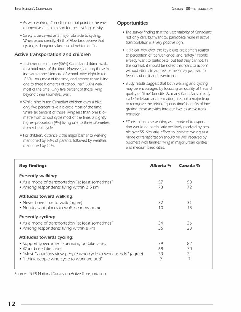
Key findings Alberta % Canada %
Presently walking:
• As a mode of transportation “at least sometimes” 57 58• Among respondents living within 2.5 km 73 72
Attitudes toward walking:
• Never have time to walk (agree) 32 31• No pleasant places to walk near my home 10 15
Presently cycling:
• As a mode of transportation “at least sometimes” 34 26• Among respondents living within 8 km 36 28
Attitudes towards cycling:
• Support government spending on bike lanes 79 82• Would use bike lane 68 70• “Most Canadians view people who cycle to work as odd” (agree) 33 24• “I think people who cycle to work are odd” 9 7
Source: 1998 National Survey on Active Transportation
106 Application tobecome part of theTrans Canada Trail
In 1994, Alberta TrailNet was named the provincialtrails council that would represent the Trans Canada Trail(TCT) in Alberta. Since that time, TrailNet has encour-aged communities to apply to become part of this newnational dream. Although TrailNet has identified a pre-ferred route, which it believes to be feasible, TrailNetdoes not designate where the trail will go. Instead,TrailNet receives proposals and allocates partial fundingfor construction based mainly on;
• the landholder’s approval for the long-term designation of the route for recreation, and
• connection with existing segments of TCT, or proximity to the “preferred corridor”.
Individuals, organizations, or communities interested inhosting part of the TCT are encouraged to contact AlbertaTrailNet as early as possible. Much of the route is now con-firmed, and the rest will be determined soon. The map (onpage 161) indicates the corridor that TrailNet believesoffers the greatest probability of being completed by 2000.Other communities not close to this route may be connect-ed by joining the Wild Rose Trail System (see Section 203).
Potential trail operators are invited to submit an applica-tion for admission. This should include a letter of permissionfrom the landowner(s), if different from the operator, and amap indicating the trail’s proposed route. An explanation ofhow it will connect with existing TCT segments should beincluded if the route is not close to the preferred corridor.Alberta TrailNet’s Trail Development Committee will consid-er this proposal and advise its Board of Directors.
If the proposal is approved in principle, the route willbe registered as part of the TCT, and the operator will beasked for a more detailed development plan, including abudget and provisions to accommodate the five core activi-ties (hiking, cycling, equestrian, nordic skiing, and snow-mobiling, where locally desired and practical). The outlineof a project proposal, found in Section 107, will guide theoperator in providing a complete proposal.
The TCTF only provides partial funding for these trails.The amount received can be used to lever more fundsthrough matching grants or supporting employment pro-grams. The exact size of the grant will depend on the levelof donations, the cost of previous projects, and the difficul-ty of the construction (see chart below).
TrailNet’s Board of Directors will recommend theamount of TCT funding for ratification by the TCTF’sBuilders Committee. The funding will be paid in install-ments as the project progresses. A final report documentingthe costs of the project, as well as the end results, will berequired.
The TCT is very much a grassroots program dependingon local groups to take the initiative. However, AlbertaTrailNet will make every effort to support the operators.
Responsibilities of a Trail OperatorA trail operator is the group or organization which for-
mally sponsors a segment of the Trans Canada Trail. Theresponsibilities of the operator can be summarized as:
• contact all adjacent landowners, resource industries, and other local stakeholders to explainthe concept and seek their support
• request and receive permission from the landowner/manager to use the right-of-way for a trail
• plan the trail so as to accommodate two core recreation uses in each season
• request partial funding from the TCTF through AlbertaTrailNet, and secure all required additional funding
• manage the construction of the trail
13
SECTION 100—INTRODUCTION TRAIL BUILDER’S COMPANION
Level of difficulty (AS OF JANUARY 2000) Amount of support/km
Registration of existing trails: little or no construction needed $ 150
Easy: existing service roads, railway right-of-way (r-o-w) with bridges $ 400
Medium: some structures, or new r-o-w through easy terrain $ 975
Hard: new r-o-w through challenging terrain; some structures $ 1,800
Source: Alberta TraiNet
• promote and maintain the trail to ensure safe public access for the indefinite future
• maintain liability insurance coverage of at least $5 million to protect the trail operator, AlbertaTrailNet, and the TCTF from lawsuits
At first, this list may appear a little overwhelming. Notto worry! Taken one step at a time, the trail-buildingprocess will move ahead smoothly. The rest of this manualexplains how this can be done. The trail operator will gen-erally be a government agency or a registered not-for-profitsociety. Any organization seeking funding must be a mem-ber of Alberta TrailNet.
Responsibilities of Alberta TrailNetAlberta TrailNet has taken on a variety of tasks which
can be grouped into two main roles:
1 removing barriers to trail construction and use in Alberta by:
• ensuring that the many benefits of trail use are widely known
• providing technical assistance and advice to local trail committees
• gathering and distributing information relevant to trail planning and construction
• working to change the Occupiers Liability Act
• presenting workshops and other educationalevents for trail managers
2 representing the Trans Canada Trail Foundation in Alberta by:
• consulting with local groups to determine the bestroute for the TCT
• advising the TCTF of what policies would best promote the TCT in Alberta
• assisting local groups in planning sections of the TCT
• soliciting donations from companies with local or provincial profile
• recommending the allocation of donated money to specific trail projects
Responsibilities of the Trans Canada Trail Foundation
At this time, the TCTF has focused its efforts entirelyon encouraging the development of the TCT. This singleroute is the basis of a rapidly-growing national trail net-work, that may lead to an expanded role for the TCTF. Atthis time, however, the tasks of the Foundation are:
• promoting the TCT nationally
• soliciting donations from individuals across the coun-try, and from national corporations
• ensuring provincial trail councils are in place to repre-sent the TCTF in each province
• setting such national standards and guidelines as maybe considered necessary
Responsibilities of Alberta Community Development
• facilitate the development of the provincial trail net-work
• provide one-time funding in the amount of $1.1 million towards the design, implementation andconstruction of trails in Alberta.
• Examine and modify existing legislation or proposenew legislation to enable orderly and comprehensivedevelopment of the TCT.
14
SECTION 100—INTRODUCTIONTRAIL BUILDER’S COMPANION
107 Preparing the project proposal
Every trail becomes a long-term community resource. Assuch, it must be well-designed, planned, and constructed tobest serve the public, while still meeting the goals of the WildRose Trail System. Each trail should be unique and well-fittedto its site and users. Following is an outline for a trail develop-ment proposal to help you through this task.
This process works with you. It walks you through thedesign of your trail, mentions things you didn’t think of, andactually helps you to design a good trail. Taking into accountthe site, users, purpose of the trail, and your goals, theprocess helps you develop a unique trail. The processimproves the quality of trails while they are still in the con-ceptual stage. The rewards are excellent community trailsthat will be used and enjoyed for decades.
If you are proposing a trail project, you need to addressall the issues in this section. By the time you complete theoutline, you will know a great deal about how to create agood trail. Every proposed trail will likely have less thanoptimal factors, and the presence of these will not necessar-ily affect the approval of your trail. Keep in mind that all ofthese issues have to be considered at some stage in the birthand life of a trail. Completing the outline now helps you tothink in advance of what you have to address.
When applying for TCT funding, the items printedin bold type are essential and will be scrutinized byTrailNet’s Board. The Board may also use this outlinewhen it periodically reviews the management of existingtrails. In your written proposal, you may use any format youchoose as long as you address all the issues in this outline.
A clear and simple project proposal will ensure that allinvolved parties know exactly what is being suggested, andwho will be doing which task. This is not an attempt tobring in unnecessary bureaucracy. Trails are not difficult tobuild, but they are quite complex to plan. The process mustbe clear and consistent to be successful.
A. General Information
1 Include information about the proponent: con-tact names, address, phone and fax numbers.A brief history of the group, or a review of the generalsituation with regard to trails in the area, might helpthe Board appreciate the regional setting.
2 Briefly describe the location of the trail and why a trail isdesirable here. Include the purpose of the trail (destination,recreational, connector). Explain how the trail connectswith existing TCT or potential TCT corridors.
3 Who are the expected users? In broad terms, howmany of each user type can be expected now and inthe future? When will the operating season beginand end for each user type?
4 Is the trail clearly suited for some users more than oth-ers? Which of the core TCT user groups will beaccommodated? Bicycle, snowmobile, horse,nordic ski, pedestrian? Can this trail be used byphysically challenged recreationists?
5 What user conflicts can be expected and how do thetrail design and operation mitigate or avoid them?What trail user groups are interested in this trail?
6 Which surface should this trail have: asphalt,gravel, shale, natural, other? Why is this thebest choice?
B. Mapping
1 Prepare a site map, using a 1:50,000 scale topo-graphic map as a base. (Expand to a larger scale ifnecessary to show the details.) Indicate all propertiesthat the trail crosses, as well as the adjacent proper-ties. Show the owners’ names.
2 Transcribe to the site map all environmentally sensitiveareas, including:
• geological hazards: unstable soil, avalanche hazard, rockfall, steep slopes
• wildfire hazard
• wildlife habitat: rare or sensitive species, fragile habitats
• floodplain
• scenic overlay: viewpoints and vistas
• historic and archaeological sites
3 On the mapped trail alignment, note the locations ofexisting structures or facilities, and where new facilitieswill be added, i.e., campsites, water source, trailheads,bridges, underpasses, large cuts or fills, large retainingwalls, etc.
15
SECTION 100—INTRODUCTION TRAIL BUILDER’S COMPANION
4 Indicate all intersections with roads and railroads.
C. Trail Corridor Guidelines
1 Briefly describe the desirable and undesirable featuresof the proposed trail corridor. Explain what can bedone to mitigate any undesirable features.
2 Does the proposed route preserve, enhance, or createa corridor with many desirable open space values?
3 What present or future linkages or access would thistrail create or preserve? Will it contribute to alternateurban transportation?
4 Are any branch trails proposed that would increaseaccess, and if so, where?
5 What are the potential impacts of the projectedlevels of trail use (both now and in the future) onadjoining private property owners, agriculturaloperations, public lands, and communities?
6 If the proposed alignment follows property lines, high-way rights-of-way, utility corridors, or other man-madecorridors, what are the positive and negative features ofthis alignment? How does this proposal improve theusers’ experience if the alignment is less than ideal?
7 Has permission been received to use all parcels ofland? If not, what process will be followed toachieve this?
D. Positive Users’ Experience
1 What design features are planned that will help thetrail achieve respect and appreciation of the land, asense of belonging on its site, and a fresh userexperience each time?
2 Briefly describe some of the ways in which a “limitedunpredictability” will be built into the trail. How willthe experience change from one visit to the next?
3 What aspects of the trail will make it enjoyable andfun to use?
4 Describe the sequence of ecosystems and environ-ments the trail will pass through and how this will cre-ate an interesting experience for the user.
E. Relationship Between Trail and Site
1 Will the trail follow landforms and cross slopes in sucha way that the trail seems to belong there? If not,why? How will the trail be designed and constructedin an unobtrusive way such that the trail seems like ithas always been there?
2 How will trail structures blend with or enhance the landscape?
3 Describe the site preservation and revegetationtechniques that will be used to protect trailside vegetation.
4 What site features will be highlighted and how willthis be done?
5 How will the environmentally-sensitive areas be handled?
6 What are the possible impacts of adjacent landownersand agricultural operations on trail users?
7 Is the trail subject to flooding? What is the estimatedfrequency? What can be done about it?
8 Are there alternate alignments that could eliminate ormitigate any problems revealed elsewhere in the proposal? If so, why weren’t these proposed?
F. Safety and Human Aspects
1 In what ways will safety be designed into the trail?
2 How will the width(s) of the trail and other design features accommodate the expected number andtype of users?
3 If the trail crosses any driveways, roads, or railways,how will these intersections be handled?
4 How will the privacy of neighbours along the trail cor-ridor be preserved?
5 If this trail is to be used in the winter, what featureswill be incorporated for winter use?
16
SECTION 100—INTRODUCTIONTRAIL BUILDER’S COMPANION
G. Construction
1 Who will build the trail (contractor, volunteers,agency staff)? Who will coordinate this project?
2 List all construction features and indicate the standardto be used, as well as the unit cost of each feature.Include each special feature, such as bridge, retainingwall, boardwalk, and trailhead.
3 Summarize the total costs and revenues in abudget. Indicate what amount each partner willcontribute. How much is being requested fromthe TCTF?
4 In what season will the trail be built? What role willweather play in the scheduling?
5 Are parts of the trail difficult or unusual to build?What special precautions have been taken to preventproblems?
6 Will construction require a special short-term construction easement for access, or other special considerations?
H. Maintenance
1 Who will have maintenance responsibility for thisproject? Has this organization agreed? Is thegroup a member of Alberta TrailNet, and does ithave at least $5 million in liability insurance forboth itself and adjacent owners?
2 What aspects of the design give the trail the minimummaintenance requirements?
3 Estimate the expected maintenance requirementsfor the trail at four months, one year, five years, and20 years.
4 Have arrangements been made with the trail contrac-tors, trail operator, landowners, and other stakehold-ers for formal design and maintenance review at fourto six months and one year after completion?
5 What is the proposed maintenance schedule?
I. Stewardship
1 What group will have jurisdiction over this trail for theenforcement of regulations?
2 Describe the proposed management plan.Include the rules to be applied to trail users. Ifthere are any difficult management issues, howmight the issues be addressed?
3 Have all level emergency services been involved indeveloping the management plan: police service, firedepartment, ambulance, rural crime watch, search andrescue?
4 How will wildfire be prevented and controlled if it occurs?
5 Who will be accountable for implementation of themanagement plan? Are there partners who can assist inthe management of this trail, and if so, in what ways?
6 Will seasonal trail closures be needed due to sensitivewildlife, fire hazard, or other reasons? How willthese be handled?
7 How will this trail be promoted, and by whom?
17
SECTION 100—INTRODUCTION TRAIL BUILDER’S COMPANION

18
SECTION 100—INTRODUCTIONTRAIL BUILDER’S COMPANION
Notes:
Section 200 Planning Your Trail

201 Who will use the trailand why?
You already have answers to these questions, or elseyou would not be considering building a trail. Writethem down. Talk to some of your friends. Do they agreewith you? If you are finding general support for yourideas, you must be on to something!
Remember that good ideas are easy to produce, butgetting action takes a lot of hard work. This meansresearch, documentation, study, writing, and publicspeaking. Be ready for the long haul. But the rewards areworth the effort. You will not find a more fulfilling task,and the work invested by the entire group will build astronger community as well as a valuable recreation facility.
If you have a particular route or destination in mind,you may be able to skip this step. If you simply wanttrails to enjoy, take a look at your district through neweyes. As a child, look at the access from residential areasto schools and corner stores. As a cyclist, how safe is it toride on the streets? Can visitors find the trails? Do thetrails lead to interesting places, as well as the hotels andrestaurants? Your idea of interesting may not be typical:factories are interesting to workers; shopping centres arevery interesting to many people in the area.
Through this simple exercise, you have gone a longway to defining your target audience. Each of these willhave a preferred type of trail. Just as roads vary fromwinding neighbourhood streets to divided highways,trails also vary in their design. At the same time, all trailswill ideally connect into a network, just as all roads do.And all trail users will behave in a manner that allows alltypes of users to enjoy all parts of the network. Listedbelow are a few examples of different styles of trail.
Amount of useThe number of people who will use a proposed trail is
very difficult to estimate. In most cases, a year or two willbe needed for the trail to achieve most of its potential. It issafe to say that trails are very popular, and that all organiza-tions developing them have felt that the effort was easilyjustified by the level of use. A few trends are evident thatwill help justify developing certain types of trails, or man-aging the trail in particular ways.
• With the general aging of our population, less strenuousrecreational activities are gaining popularity, especiallywalking and the related observation of nature, andcasual cycling.
• Overall, participation in physical activities has beenincreasing at the rate of 1% per year. This may seemsmall, but adds up to a substantial 25% over the periodof the surveys.
• Urban trails were once feared as a source of criminalbehaviour. Now, they are recognized as positive commu-nity facilities, and houses adjacent to trails receive a sub-stantial (up to 15%) premium when being sold.
• Some trails in Alberta’s recreation and wilderness areas areused less due to a decrease in the popularity of hunting,and a lack of maintenance. At the same time, similartrails in the national parks are used more as a result ofbroad media coverage.
• Nearly all Alberta towns and cities have urban trail sys-tems. People now actively participate in outdoor recre-ation, but are looking for a somewhat wilder experience.
• Off-road cycling is rapidly gaining in popularity. Thedemographic structure of our population suggests thatthe more sedate double-track riding will grow even fasterthan the single-track style. (Can you believe that the firstcommercial mountain bike was sold as recently as 1981?)
21
SECTION 200—PLANNING YOUR TRAIL TRAIL BUILDER’S COMPANION
Trail Characteristics
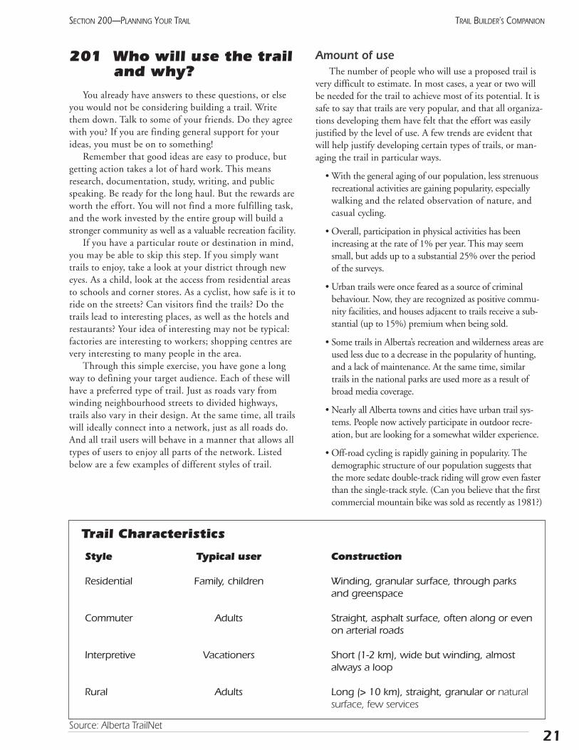
Style Typical user Construction
Residential Family, children Winding, granular surface, through parks and greenspace
Commuter Adults Straight, asphalt surface, often along or evenon arterial roads
Interpretive Vacationers Short (1-2 km), wide but winding, almost always a loop
Rural Adults Long (> 10 km), straight, granular or natural surface, few services
Source: Alberta TrailNet
22
SECTION 200—PLANNING YOUR TRAILTRAIL BUILDER’S COMPANION
• Snowmobiles have become very reliable, allowingmulti-day trips of several hundred kilometres tobecome popular, wherever support facilities allow.
• The improved organization of provincial recreationassociations has led to better cooperation between usergroups, and greater tolerance of shared-use trails.Members of recreation groups behave better than non-members, because they have received some instructionand are subject to positive peer influence.
• The “parcours” or exercise track, with equipmentspaced along a formal trail, has been very poorlyreceived, although it seems like a good idea to recreation professionals.
• Two of the most common reasons for not participatingin physical activity are the cost of equipment (21%)and the cost of admission (17%). Trails avoid both ofthese problems.
• Trails are used less by the very poorest of our population.The cost of a bicycle can be a significant barrier, andthese people often do not have the time, energy, or moti-vation to use trails.
Notes:
Source: Alberta Recreation Survey, 1996
202 Organizing your information
The strip mapTrail development means a change in the existing land-
use of a particular area. You want to become the manager ofthis land. Like other land managers, you will find maps arean essential part of your project. Maps organize and sum-marize information related to land. You will need many dif-ferent types before you are finished: vegetation, land own-ership, topographic, political, roads, and others. Air photoscan be thought of as a special type of map.
As the project proceeds, you will gradually determinethe important data which you will need to summarize this.Pipeline engineers, professionals in the linear developmentbusiness, use a special technique called a strip map. Becausethe pipelines (and trails) are narrow corridors, the map alsocan be quite narrow.
Ideally, the strip map is a photocopy of a topographicmap, 1:50,000 or more detailed. It will have a blank bandalong the top where resource information can be summa-rized. This includes landowners’ names and telephonenumbers, vegetation types, sensitive habitats, historic infor-mation, locations of reference photographs, and any signifi-cant existing development. Especially good views can beindicated with large arrows showing the direction. Identifyhuman developments such as residences, abandoned build-ings, and utility lines of all kinds. Access points and proposeddevelopments should be highlighted. Along the bottom ofeach page is another band where construction notes can beplaced at the appropriate points. This becomes the Trail Logas all the developments are recorded. (See DevelopmentPlan, Section 423.)
During the exploratory stage, the map may be up to 10km wide. As the corridor becomes more definite, the mapcan focus on a narrower strip. Remember that this is aworking document, so mark it up! Transfer the data to amaster copy, and take out a copy of the most recent versionon the next trip. This is a remarkable way of organizing avast range of data.
The strip map’s use will not stop with the trail opening,though. The points of interest and other resource detailsshown on it will be a basic source of details for people writ-ing interpretive brochures or leading guided walks. If keptup-to-date, it will become a priceless aid in maintaining thetrail.
Those with access to computer-assisted drafting canscan the map or air photo, and then superimpose varioustypes of data in different colours. Beyond the efficiency ofnot having handwritten comments, this gives the project anorganized and professional image. Often, high school orcollege drafting classes are looking for projects. Many
municipalities will already have much of this data enteredin a computerized Geographic Information System (GIS),and can make it available to the trail group at little cost.(See Section 508.)
Topographic maps can be obtained from stores thatspecialize in maps in both Calgary and Edmonton.
Air photographs provide an excellent map of vegeta-tion, and they are generally more current than maps. Asheet of plastic or tracing paper will allow you to makenotes without wrecking the photo. These photos can give astereo image if you buy them in pairs; just specify thiswhen you order them. It is not much more expensive if youhave a larger area to cover, since you will need many ofthese anyway. To order, call the Alberta Government at310-0000, and ask for the Air Photo Library. You will needto provide the legal description of the land and a credit cardnumber for purchasing photos.
The resource bookMuch of the information that you acquire will not be
site specific, but will still relate to the project. This couldinclude summaries of regional history, natural history, orother resources. Photos taken on exploratory trips or initialconstruction bees should be reproduced and labelled.Collect all press clippings related to your project. A copy ofyour most recent proposal will be useful. (Leave out thecost figures. These should not be released until they arefinalized, and then only in the context of exactly what isbeing built.)
Gather all these materials together into a three-ringbinder. Separating the topics with dividers will help findthe needed information. This book makes an excellentresource book and can be easily taken to public meetings,or private discussions with landowners, potential funders,and decision-makers.
23
SECTION 200—PLANNING YOUR TRAIL TRAIL BUILDER’S COMPANION

24
SECTION 200—PLANNING YOUR TRAILTRAIL BUILDER’S COMPANION
Notes:
203 Investigate the big picture
Before plunging into the details of the planning process,we must remember that trails support several types of trans-portation. By definition, transportation means movingfrom one place to another. This requires that the local trailfit into a larger framework, and that the trail be constructedand operated in a manner compatible with the adjacentportions of the network. Let’s look at the larger picture toset the stage.
Trans Canada TrailCanadians have always been a nation of trail builders.
Now this great tradition continues in the form of the TransCanada Trail (TCT). This national endeavor is managed bythe Trans Canada Trail Foundation (TCTF), a registeredcharitable organization solely dedicated to making this traila reality.
The TCT will wind its way through every province andterritory, linking thousands of communities along its route. Itwill be a shared-use trail, accommodating walking, cycling,horseback riding, cross-country skiing, and snowmobiling(where possible/desired).
25
SECTION 200—PLANNING YOUR TRAIL TRAIL BUILDER’S COMPANION
Planning ProcessPlanning is simply a process of identifying your objective, then determining the best way of reaching it. This process
involves many smaller steps. At some point, however, the vibram hits the trail, and the managing organization is asked forapproval. The document reviewed by this group is often referred to as “The Plan,” although it will be revised and changedmany times before the project is completed.
Developing a plan can be thought of as a spiral path gradually approaching the ideal product. The attached workbook willhelp you get started in this process. First, the target must be defined. Out of necessity, this plan will be general, because youwill not have much information to base it on. But the goal will get you started in the right direction. As more details are gath-ered, the project will become more definite. Each step will point to more information that is needed. As an example, considerthe following hypothetical project. Notice how the goals become more specific as the project proceeds. Also notice that at everystage of the planning process, some type of decision must be made before the project proceeds to the next phase.
Example Goal Information needed
1. Trail from A to B Existing trails in areaType and amount of use they receiveWhat type of trail (if any) is needed here?
2. Bicycle & pedestrian trail from A to B General support in communityPossible corridors or other locationsWhere should it be located?
3. Shared-use trail through Estimated cost of trail, including amenitiesenviromental reserve, >2 m wide, Draft managing agreementsuitable for commuting Formal feedback from public
Formal approval from managing authority.
4. Asphalt path, Which contractor will produce the best 2.4 m wide x 5.7 km long possible product within the budget x 10 cm thick, with 15 cm of and time available?gravel subgrade
The planner, whether a professional or an interested volunteer, must ensure that all the options are considered, and that allthe relevant people are fully involved. Documenting the process is just as important as the actual planning. This can be as sim-ple as keeping a file of your correspondence, as well as any advertisements or press clippings. Important or potentially contro-versial telephone calls can be summarized with a memo to file, and a copy to the other party.
Source: Alberta TrailNet
26
SECTION 200—PLANNING YOUR TRAILTRAIL BUILDER’S COMPANION
To ensure the trail is being planned and built accordingto local needs, a Trails Council has been established in eachprovince or territory. These councils work with local trailand community groups to coordinate the planning, con-struction, and maintenance of the trail. In this province,Alberta TrailNet represents the Trans Canada TrailFoundation.
We must admit that trails are not just a Canadian phe-nomenon. At several places, the TCT will connect with thegrowing system of historic and recreational trails in theUnited States. A continental system is on its way! InEurope, a multi-national trail system is one of the less-known innovations brought about by unification of theEuropean Economic Community.
At the same time, it must be observed that shared bikeand pedestrian pathways are largely North American. Inmuch of Europe, the rural roads are very narrow, with slowmoving vehicle traffic. Bicycles fit in well with these roads,leaving the pedestrians to use the numerous natural surfacepathways. Trail developers should remember this option ofsharing the roads. This can be accomplished either byreducing the vehicle speed through traffic-calming meth-ods, or by choosing existing little-used roads.
Wild Rose Trail SystemThe Wild Rose Trail System aims to connect most
towns and cities in Alberta with major recreation areas andparks. The Trans Canada Trail provides the trunk for thisnetwork, with many branches leading from it. When com-plete, the trail system will give immediate trail access to thelarge majority of trail users. The proposed routes are largelybased on existing rights-of-way, which could also be usedfor recreation.
Trail proponents can refer to this document to find outwhat opportunities have been identified in their area. Youare encouraged to expand on this report, providing moredetail for your area. The maps are available in digital formatfrom Alberta TrailNet, so you can add your own informa-tion. Please send updated versions back to Alberta TrailNet,to improve their database.
Notes:
27
SECTION 200—PLANNING YOUR TRAIL TRAIL BUILDER’S COMPANION
204 Start the planHaving reviewed the regional picture, it is now impor-
tant to focus on your particular community. What do youand your neighbours want and need? Is there a possibleplace for the trail? Define your first objective in terms ofwhat problems this trail will overcome or solve. (For exam-ple: We need to give children a safer way to get to school.)
Write down this information in the workbook or on acomputer, if you haven’t already started. Your ideas are tooimportant to forget!
Most groups have a fairly general objective, such as“Provide a place for recreational biking in the Town ofFairfield.” If this is the case, begin identifying opportunitiesand constraints on the map. Show tourist attractions, malls,schools, all parks and recreation sites, as well as environ-mental reserves, with a bold pen. Include the full extent ofall the sites; even if they are of secondary interest, they maywell provide a connection to other sites. On the otherhand, you will have some sites or areas that are not practicalor even possible to cross with a trail. These constraintsinclude major highways, rivers, high speed railways, andheavy industrial areas; show them with a contrasting colour.
Bridges are critical transition points. Highway bridgesoften make provision for pedestrians, and so become a linkin the trail. Railway bridges can provide a grade separationfrom pedestrians and bicycles, enabling them to cross therailway safely. If bridges need to be built or if existingbridges require major renovations, the expense can be enor-mous. Try to have these changes included in the regularmaintenance program, even if it means waiting a few years.
Now, how many linear features already exist in your areaof interest? Start a list, then put them on your map. Othergroups have made use of the following linear features:
• river banks
• abandoned or little-used rail lines
• dikes along rivers
• berms along primary highways
• environmental reserves
• highway rights-of-way
• irrigation canal service roads
• power line or pipeline corridors
• abandoned, seasonal, or little used roads
• unused road allowances
Urban areas have some under-used features with excel-lent potential. First, watch for large parking lots. These seasof asphalt are rarely, if ever, full of cars. The pavement hasbeen installed in an effort to reduce or simplify mainte-nance. A right-of-way can be created by planting a narrowgreenstrip, giving both pedestrian and bicycle access to themall or office building. Even a row of parking wheel stopswill give some protection. School yards, while they arealready green, are rarely used after school hours. Makingthis space part of a local trail system will give safe access tothe school for the children, while linking the school to therest of the community.
Long-distance trails will have places where a trail doesnot make sense. Minor roads can be considered for use asconnectors in these cases. Paved highways should have ashoulder at least one metre wide before they are promotedfor cycling. Gravel roads should not have regular industrialtraffic (logging, mining, oil field service).
By this point, you will find that some of the points ofinterest can be connected with the existing linear features.Look carefully at the remaining objectives. Would a minorpurchase of land make a significant difference? Could newdevelopments be adapted to include trails? And finally, isthe potentially available route worth the effort? In somecases, you will have to prioritize the routes to keep the pro-ject manageable.
Land-use planningRecreational trails use part of our land base. In this
respect, they compete with many other land uses. In allof Canada, every square metre of land is already allocatedfor some purpose, and administered by some agency.Your committee must demonstrate that recreational trailsare either compatible with the existing use, or more valu-able to the owner than the existing use. The first alterna-tive may meet with less resistance than the second.
Grade Separation:
When two modes of transportation are keptapart by a difference in elevation. Overpassesare an excellent example of this, but bermsand ditches also achieve the same purpose.Railway level crossings show how dangerousthe lack of a grade separation can be.
Word ofthe day
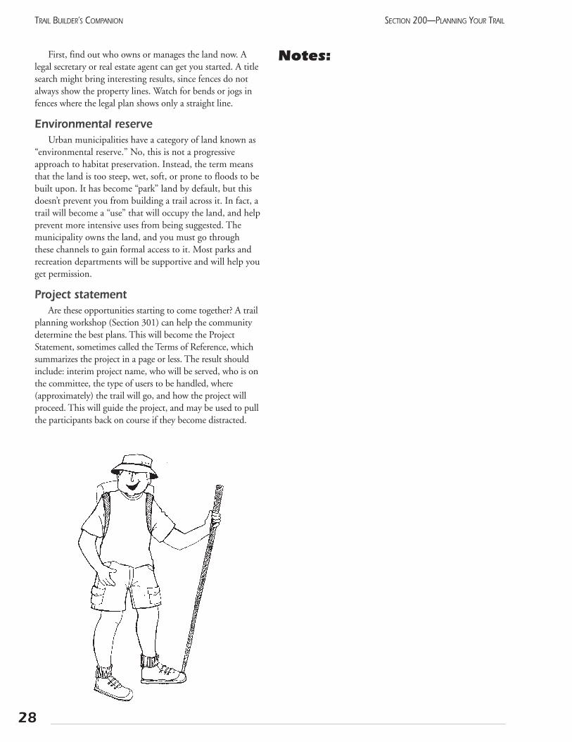
First, find out who owns or manages the land now. Alegal secretary or real estate agent can get you started. A titlesearch might bring interesting results, since fences do notalways show the property lines. Watch for bends or jogs infences where the legal plan shows only a straight line.
Environmental reserveUrban municipalities have a category of land known as
“environmental reserve.” No, this is not a progressiveapproach to habitat preservation. Instead, the term meansthat the land is too steep, wet, soft, or prone to floods to bebuilt upon. It has become “park” land by default, but thisdoesn’t prevent you from building a trail across it. In fact, atrail will become a “use” that will occupy the land, and helpprevent more intensive uses from being suggested. Themunicipality owns the land, and you must go throughthese channels to gain formal access to it. Most parks andrecreation departments will be supportive and will help youget permission.
Project statementAre these opportunities starting to come together? A trail
planning workshop (Section 301) can help the communitydetermine the best plans. This will become the ProjectStatement, sometimes called the Terms of Reference, whichsummarizes the project in a page or less. The result shouldinclude: interim project name, who will be served, who is onthe committee, the type of users to be handled, where(approximately) the trail will go, and how the project willproceed. This will guide the project, and may be used to pullthe participants back on course if they become distracted.
Notes:
28
SECTION 200—PLANNING YOUR TRAILTRAIL BUILDER’S COMPANION
205 Environmental considerations
Damage to landscape/wildlifeSince the earliest days of Banff National Park, trail devel-
opment and environmental protection have proceededtogether. An initial desire to access the scenic and wildlifeattractions has led to a need to protect these for future genera-tions. More recently, the Western Canada Wilderness Societyhas used “witness trails” to bring the beauty of endangeredlandscapes to the attention of the broader public.
Trails can focus existing use in a narrow corridor. OneWisconsin trail accommodates over 50,000 users, mainlymountain bikers, each season. The reported environmentaldegradation is not significantly different than when “only”a couple of thousand people used these same trails.Without a designated trail, these people would impact a fargreater area with random riding.
At the same time, increased access may cause increasedpressure on the natural environment. The types of impactvary widely, from the pounding of alpine meadows, to thechanging of grizzly bear behaviour. New impacts are stillbeing identified as we gain a better understanding of howour ecosystem operates. For example, the balance betweencaribou and wolves in northwestern Alberta has been unin-tentionally jeopardized by recreationists. Snowmobile tracksgive the wolves an unnatural advantage, enabling them totravel farther and hunt more effectively. One response tothis has been to designate and maintain specific snowmo-bile routes, thereby limiting the impact.
The authors of this document encourage the thoughtfuland thorough evaluation of all environmental impacts of aproposed development, even when not legally required.The trail must have an environmentally positive impact onthe region. If all stakeholders cooperate, this need not be along or onerous task.
Many municipalities have conducted studies of environ-mentally sensitive areas within their jurisdiction. The stud-ies provide a good idea of what types of problems mayoccur. Talk to the local planning agency to find these docu-ments. Any threatened or endangered species will requirespecial consideration as well.
Negative environmental impacts fall into two generalclasses: damage to the landscape or wildlife due to the con-struction, and impact due to increased human access.
The first type can be greatly reduced by following exist-ing rights-of-way, where the damage has largely been done.We assume that the road, railway, or power line will providea stable base for a trail, with little modification to the land-scape being needed.
Overuse of trails can and does adversely affect Alberta’senvironment. In general, this means that more, not fewer,
trails should be built. However, many people would behappy spending their time closer to home in the moredurable rural areas. Trail proponents should not assume thatthe users will demand to see the most sensitive sites.
Human impactHuman impact can also be greatly reduced through
proper behaviour. For example, problems with bears wereonce common in mountain campgrounds. These con-frontations have been greatly reduced through firm, or evenrigid, enforcement of regulations.
In some cases, existing trails are deteriorating due toover-use. This could also be described as under-mainte-nance. Can user fees be applied to directly pay for bettermaintenance or “hardening” of the trail? If this is not con-ducive to the desired experience (i.e., wilderness adven-ture), then limiting the numbers of users may be the bestsolution. In some cases, people can be redirected to moreappropriate routes, but a quota system may be required.Formal research on the relative effects of different types oftravel, summarized in Cessford (1995), indicates no signifi-cant difference in the impact of bicycles and pedestrians.More important factors in trail degradation are the slope,intensity of rain, and the soil type. In the absence of site-specific studies, trail managers are encouraged to imple-ment visitation limits equally, where required, for all typesof users.
Local environmental organizations should be involvedwith the trail committee from an early stage. They will beable to point out potential problems and may even havesome solutions. In any case, they will be commenting onthe project eventually. The earlier they get involved, themore likely that a better plan will be created. To findenvironmental groups, contact the Federation of AlbertaNaturalists at (780) 427-8124, or consult the Directoryof Environmental Organizations published by thePembina Institute.
Environmental Impact Assessment (EIA)Initial EIAs can be done by local organizations, prefer-
ably in conjunction with the local environmental group. Ifserious potential impacts are identified, then professionalhelp should be sought. Once the project proposal has beenfirmed up, three steps must be taken:
• identify the issues as precisely as possible
• study the cause and effect of these impacts
• implement mitigation measures to reduce the impact
Your strip map should indicate where the proposedroute passes through natural habitat. Environmentallysensitive areas and other potential concerns should alsobe added. This map will be a critical resource when talk-
29
SECTION 200—PLANNING YOUR TRAIL TRAIL BUILDER’S COMPANION
ing to professionals about possible concerns.A single meeting with stakeholders should help to iden-
tify most potential problems. Some are obvious: bears andalpine meadows in the mountains, fire hazard in the grass-lands, and sensitive wetlands across northern Alberta.Threatened species are usually well-known locally, butcheck the most recent listing. Don’t forget the aquatic envi-ronment: bridges may need federal approval due to possibledisturbance of fish habitat.
Chances are that similar problems have been researchedsomewhere else in Alberta. Have a committee member,preferably someone with a science background, interviewenvironmental specialists. These include Fish & Wildlife staff,college or university professors, and prominent amateur natu-ralists. Document each interview and send a copy of the notesto the person for confirmation.
How to mitigate potential issuesWith the extent of the problems determined, your
group is ready for solutions. Again, keep the environmentalgroups involved. You will find that naturalists and recre-ationists have many common interests, and they will besupportive of the project. Together, you can search for waysto reduce the environmental impact while maintaining theessential recreation experience. The following list indicatesways to mitigate potential issues:
• move the route to the edge of a sensitive area,instead of going through the middle
• do the construction during a less sensitive season
• “harden” the trail surface to ensure users stay on the trail (boardwalk)
• keep the trail to a low standard to discourage casual use
• restrict the size of the parking lot to reduce physicalimpact and to limit use
• stress potential problems and the proper behaviour atthe trailhead and/or in brochures
• limit the number of users or the period of use (hoursper day or seasonally)
• recommend or require specific equipment (gas stoves,no lug soles)
• involve all user-groups in joint maintenance projects
• focus the recreational use on fewer trails, whichwould be of a higher standard
Notes:
30
SECTION 200—PLANNING YOUR TRAILTRAIL BUILDER’S COMPANION
206 Historical and cultural resources
Many people find the history of their area interesting.The remains of previous times can remind us of our ances-tors, and emphasize our own mortality. People have livedin Alberta for hundreds of years and by understandingtheir lives, we are better able to understand our land-scape, which they have helped to shape.
Trail builders should be aware of this value and makeevery effort to avoid destroying the remaining evidence.Proposed trail routes following historic routes are obviouscandidates for serious study, but all parts of our provincehave signs of ancient residents. Respecting this heritage isnot only considerate and good marketing, it is the law!
Alberta Historic Site Service should be consulted inthe preliminary stages of every trail project. Depending ontheir information on your site they may require an HistoricResource Impact Assessment.
Impact assessmentA concise presentation of some basic information will
enable them to quickly assess your case and recommend theproper action.
They will need to know:
• where you propose to put the trail
• what type of development you intend, particularly todo with disturbance of the soil
• what historic sites already are known, and what you intend to do with them, how you intend to protect them.
Questions Alberta Historic Site Service will ask are:
• Do these sites or structures provide significant evi-dence to further the understanding of Alberta history?
• Do these remains constitute a historic landmark thatshould be preserved in their original location?
In the meantime, do not “tidy up” the site. Only themost recent of litter should be removed. Piles of tin cans,old machinery, and derelict buildings can give preciousinsight into the region’s past. These will become part of thestory which visitors love to learn.
Historic transportation routes are only now being appre-ciated as historical resources. Partly shaping the settlementpattern, and partly determined by settlement, trails recordevidence of a poorly understood aspect of our history. Ourmodern tourist, travelling rapidly across the country, canappreciate the challenges of early transportation.
Alberta Historic Site Service may decide that the site war-rants a Historical Resource Impact Assessment (HRIA).
The factors studied are:
• Age: in general, older sites or artifacts are more valu-able than younger ones
• Merit: the quality of the site or building, relative tosimilar features
• Context: how the site relates to the major themes ofprovincial or regional history
• Events: relationship to significant historic events
• People or institutions: whether the site documents thelives and/or actions of significant people or organiza-tions in our past.
This research must be carried out by a qualified profes-sional, who will determine the significance of the site andwhat development will be suitable. That person can alsorecommend mitigation actions. The trail sponsor mustremember that a significant site will bring considerableinterest to the trail, even if it means more complex plan-ning. Once the plan is confirmed, some removal of certifiedjunk may be in order!
Archaeological sitesAboriginal people lived in all parts of this region, but
evidence of their lives is particularly visible in the grass-lands. A brief survey by a trained professional will enabletrail planners to avoid disturbing the important sites whileproviding good data for interpretation. Alberta HistoricSite Service will advise you if the entire route, or perhapsjust the campsites, should be studied.
31
SECTION 200—PLANNING YOUR TRAIL TRAIL BUILDER’S COMPANION
Historic trailsHistory buffs eagerly participate in the reopening of
historic travel routes. This is particularly exciting whenthe original ruts of the wagons are still visible. Thisbrings up a philosophical question: Which is moreimportant to preserve, the historic ruts or the historicroute? Some trails have been developed a few metresaway from the actual route, while protecting the old ruts.Many historic trails moved many kilometres over theyears, and a short detour does not detract from the con-cept. In cases where more recent travel has already alteredthe evidence, it may be acceptable to put the new trailright on top of the old, perhaps with some levelling first.The approach may vary from place to place, even alongthe same trail.
Cultural featuresIn this manual, the term “culture” refers to the sum
total of a region’s architecture, industry, lifestyle, art, andhistory. This often reflects the ethnic origin of the resi-dents, enriched by their adaptation to the physical condi-tions and resources found there. Any artifacts should beconserved, as described above. But beyond this, the livingculture itself can be fostered through sensitive develop-ment. Facility design can draw on the local style forinspiration. Interpretive messages should stress whatmakes the local area unique. The local community canuse the trail as a link between important sites, restoringthe continuity that may have been lost. A full experiencecan be created with cooperation between the museum,art gallery, trail sponsor, and ethnic associations.
Contact:Historic Site Service
Alberta Community Development
Old St. Stephen’s College
8820 - 112 Street
Edmonton, AB
T6G 2P8
Telephone (780) 431-2327
FAX (780) 427-5598
Notes:
32
SECTION 200—PLANNING YOUR TRAILTRAIL BUILDER’S COMPANION
33
SECTION 200—PLANNING YOUR TRAIL TRAIL BUILDER’S COMPANION
207 Accessing private landBuying land is more complex than buying a bicycle. When
you buy a bicycle, you have the rights to do anything you wantto it: ride it, rent it, paint it, or even destroy it. When a person“buys” land, they only acquire some of these rights. For example,you may not be allowed to build certain types of buildings on it,build close to the perimeter, or pump the oil from it.
This can work to your advantage, though. Your trail groupcan acquire the right to operate a trail across the land withoutactually purchasing the land. This is called an easement, and isa permanent, legal right that will continue even if the “owner” ofthe land sells to someone else. The sale of this right by the owneris entirely voluntary, and the price can be up to one-third of thetotal value of the land. This can be a good way for the owner toget part of the value of the land immediately without having tosell it. The owner must realize that the value of the land maydecrease because this right has been removed. On the otherhand, the value may go up if a future buyer is a trail enthusiast.Revenue Canada has recently changed the Income Tax Act (BillC-28) to make provision for landowners to donate an easementto a charitable organization, in exchange for a tax receipt.Contact the Environmental Law Centre at (780) 424-5099 formore details on conservation easements in Alberta.
Trail access agreementThe landowner may not want to sell the land or give an
easement, but may still be willing to have the trail cross theproperty. This can be a good option, especially in rural areas,although most groups will be reluctant to invest much moneywithout having title to the land. If your group decides to gothis route, work with the owner to draw up an agreement thatclearly outlines the responsibilities of each party. (Refer to theexample attached.) Even with the cancellation clause, it willencourage both parties to take the situation more seriously,and the trail will have a better chance of surviving. It will alsodirect any possible litigation toward the trail group and away
from the landowner. This is good, assuming that you haveadequate insurance.
Several private utilities in Alberta own land, although itmay appear to be public. Owners of power line rights-of-way,railway lines, and irrigation canals must all be dealt with asprivate owners, just on a larger scale. It is useful to note thatrailways have a legal obligation to facilitate any “reasonable”request to cross their line. The definition of reasonable is openfor discussion. In the past, power companies have allowed traildevelopment within their right-of-way, with appropriate con-sultation beforehand.
In terms of gaining access, trail sponsors should treat publicland which is leased to private individuals or companies as if itwere private property. Of course, when permission has beenreceived, the government’s approval will also be needed.
Purchasing right-of-wayThe trail group may feel that purchasing the right-of-way
is the best option for ensuring permanent access to the route.The cost is really quite minor, compared to the cost of build-ing the trail. Even a short distance of land acquisition canmake a large difference in the character of a trail. For example,the village of Milo bought a 15-foot wide strip along the edgeof a pasture. The fence was moved, leaving the trail and roadright-of-way together.
On a larger scale, the Bruce Trail Association in Ontario,with a membership of tens of thousands, was forced to con-stantly reroute their trail as ownership of the right-of-waychanged. Eventually, they began a policy of buying the routewhenever the owner wished to sell. The association then legal-ly sub-divided the right-of-way from the bulk of the parcel,and resold the remainder. The prestige of living next to theBruce Trail is such that the land sale more than covers thelegal fees required.
These two case studies highlight the main advantage of buy-ing the land: security of tenure. The trail group must weigh thisagainst the potential drawbacks: responsibility for taxes, weedcontrol, and perhaps fencing. If the group should dissolve, thisland will be passed on to whatever organization is designated asreceiving the assets of the association. In summary, this approachwill likely be advantageous for a stable association with an activemembership and a popular trail.

34
SECTION 200—PLANNING YOUR TRAILTRAIL BUILDER’S COMPANION
Notes:

35
SECTION 200—PLANNING YOUR TRAIL TRAIL BUILDER’S COMPANION
AlbertaTRAILNET11759 Groat RoadEdmonton, AB T5M 3K6Tel: 780-422-7150 Fax: 780-422-2663 Trail Access Agreement
This agreement is made as of the ________________day of _________________, 20_______
between: ____________________________________________(the Owner/Occupier)
and ____________________________________________(the Trail Group)
Whereas the Owner/Occupier is the registered owner or the authorized occupier of the lands legally described as:
________1/4 Section(s)_________________Township__________Range________West of_______Meridian,
in the county or municipal district of:____________________________________(referred to as “the Lands”)
And whereas the Trail Group is a member of Alberta TrailNet Society, the authorized representative of the Trans Canada Trail Foundation in Alberta;
And whereas this Trail Group has requested the right to use the Lands of this Owner/Occupier for the Trans Canada Trail; the parties agree to the following conditions to ensure that these activities occur in a mutually beneficial manner:
1. The Owner/Occupier will:• grant the Trail Group permission to operate a recreation trail for the purposes of:
hiking bicycling horseback riding snowmobiling cross-country skiing (strike out and initial any modes of travel not allowed)
Upon that portion of the Lands as designated on the attached Schedule “A” (the Trails). Schedule “A” will include a map, of 1:50,000 scale, or a photocopy of the municipal land ownership map.
• grant access to the Lands for the purpose of establishing, opening, closing, upgrading, and maintaining the Trails, provided the Trail Group receives prior verbal consent before accessing the Lands; and
• charge no fee to either the Trail Group or the individual users for the use of these trails.
2. The Trail Group will:• ensure that the Owner/Occupier is consulted regarding the design, construction,
and operation of the trail; carry out all construction and maintenance at its own expense;
PROMOTING A TRAIL NETWORK, INCLUDING THE TRANS CANADA TRAIL, WHICH CONNECTS ALL ALBERTANS
SAMPLE

36
SECTION 200—PLANNING YOUR TRAILTRAIL BUILDER’S COMPANION
• Indemnify the Owner/Occupier from claims or damage arising from trail users by maintaining third party liability insurance with a limit of at least $5,000,000 to cover trail uses specified herein. A Certificate of Insurance should be attached to this Agreement as Schedule “B”;
• maintain the Trails in a suitable condition for the uses allowed above;• post appropriate signs regarding safety, appropriate behaviour, and use; and• remove, on at least an annual basis, any litter accumulating along the trail.
3. The Trail Group hereby indemnifies the Owner/Occupier against all liability claims, damages, or expensesarising out of any act or neglect by the Trail Group, its employees, agents, or volunteers in or about theLands, or arising out of any breach by the Trail Group of any provision of this Agreement.
4. This Agreement may be terminated by either party, without cause, by giving 60 days written notice to theother party at the address designated below.
5. If any term of this Agreement is determined to be invalid or unenforceable by any court, such determina-tion will not invalidate the rest of the Agreement, which will remain in full force as if the invalid term hadnot been made part of this Agreement.
6. The Owner/Occupier and the Trail Group acknowledge that they do not rely upon any information orstatement, oral or written, express or implied, given to each other.
7. This Agreement constitutes the entire agreement between the Owner/Occupier and the Trail Group, andany previous agreements, written or oral, express or implied, between the parties or on their behalf relatingto the use of the Lands are hereby terminated and cancelled. Any modification to this Agreement must be inwriting and signed by the parties or it will have no effect and will be void.
8. In the Agreement, words importing the singular number will include the plural, and vice versa, andwords importing persons will include organizations and vice versa.
9. Each party will, at the request and expense of any other party, sign and deliver such further or additionaldocuments as may be reasonably considered necessary or desirable by the respective parties to properlyreflect and carry out the true intention and meaning of this Agreement.
10. This Agreement will be construed and enforced in accordance with, and the rights of the parties will begoverned by, the laws of the Province of Alberta.
Owner/Occupier Trail Group
______________________________________ ______________________________________Signature Signature of President
______________________________________ ______________________________________Name Name______________________________________ ______________________________________Address Address______________________________________ ______________________________________Town Town(________) __________–________________ (________) __________–________________Telephone Telephone
SAMPLE
37
SECTION 200—PLANNING YOUR TRAIL TRAIL BUILDER’S COMPANION
208 Accessing public landThe provincial government administers most land in
what is known as the Green Area: the non-settled region tothe north and west of the province. In addition, the provinceadministers provincial parks, grazing reserves, grazing leases,some irrigation canals, transportation and utility corridorsaround Edmonton and Calgary, and other public lands. Avisit to Alberta Agriculture, Food and RuralDevelopment, Public Lands or Alberta Environmentin your local provincial building will inform you of wherethe public land is in your area.
Land StandingOnce you have found land that seems suitable for trail
purposes, you may wish to follow two paths simultaneous-ly. First, speak with the local field person with the particu-lar department that handles the land in question. Ask themto do a “Land Standing” on the parcel of land you’re inter-ested in to find out if the land is occupied and by whom.Find out what their concerns may be and whether thedepartment will be likely to support recreational use of theland. This will give you the background to write a formalletter to the minister involved. In this, you can outline thegeneral project and how your group will deal with the con-cerns. Keep this very general because you will almost cer-tainly be referred to the local field representative for specificarrangements. This letter serves the purpose of keeping theminister posted, while showing the local staff that you arewilling to follow the proper procedures.
Alberta InfrastructureSome trail operators may wish to develop a trail near
or within the right-of-way of a numbered highway. Theseroads are the domain of Alberta Infrastructure, and areintended for transportation. If a trail is proposed in thearea, several valid concerns will arise and this depart-ment’s regional office should be approached to examinealternatives. Will the increased separation lead to greatersafety for existing pedestrians and bicyclists? Does theright-of-way have room for a trail as well as the existingroad and future expansion? Does your trail group haveinsurance and sufficient public support to be a viableorganization? How will the trail cross driveways andother road access points? Several trails have been devel-oped along highways for safety reasons. The best exam-ples are from Bentley to Gull Lake and from BlackDiamond to Turner Valley.
Most public land has already been leased to some orga-nization, such as a forestry company. Your trail group, if it isa registered society, may be able to acquire an additional dis-position on this land. This additional license will require a“consent to occupy” or “consent to withdraw” from the
existing disposition holder. (See Sections 207 and 209.) Thepresent organization may be more comfortable being a part-ner with a recreation group and leaving the lease as it is.
License of Occupation or Temporary Field Authorization
Regardless of which department administers the land,the government will want to formalize the existence of thetrail through a formal disposition. The most flexiblemethod is called a License of Occupation (LOC). This cre-ates a legal right-of-access, and transfers the obligation formaintenance to the trail group. A single LOC can cross sev-eral pieces of property, which is important because eachlicense requires an annual fee. An alternative is theTemporary Field Authorization (TFA), which may be easierto get but offers less permanence. With either of these, theuser group does not have exclusive rights to the land. Thatis, the group may not restrict access to other user groups.
To receive an LOC, the group must submit a proposalwhich includes the length and width of the trail and a sur-vey or descriptive plan. All planned infrastructure, such asbridges and access points, must be disclosed at the time ofthe application. “Blanket” LOCs are not permitted.Although road allowances are administered either byAlberta Infrastructure or by the municipality, any activityplanned for those lands must be described in the proposaland shown on the map.
If applying for a TFA, a survey is not required.However, a general description is needed, preferably shownon an air photo or a map which includes the township andrange. TFAs may be issued from the local district (field)office and are best suited for seasonal (non-multiple use)activities such as hiking, cross-country skiing, snowmobil-ing, dogsledding, etc. These are temporary in nature andtherefore must be applied for annually. The authority maybe supplemented with a departmental Protective orConsultative Notation (PNT or CNT), which ensuresother departments will be aware of the new land use.
Both the TFA and LOC may require security depositswhen the letter of authority is issued. The amount for aTFA is discretionary, and the amount for an LOC is underreview (currently $50 per year).
For an LOC to be registered, the route must be sur-veyed. This is easy along roads, but surveying woodedareas may be impossible without first cutting a linethrough the forest. (A GPS survey may be acceptable,depending on the location, and will avoid the need forany cutting. Ask first!) To avoid extensive clearing, dis-cuss the following process with the local manager. Thishas worked well in several locations, and in fact, is howthe railways were originally surveyed.
Suggested steps are:
• receive approval in principle for the route. A tempo-rary permit may be issued.
• flag the route carefully, paying particular attention toany adjacent leases or properties.
• clear trees and brush from the trail alignment.
• survey the route. The license will extend a specifieddistance on either side of the trail.
• receive the LOC, and undertake trail construction
Notes:
38
SECTION 200—PLANNING YOUR TRAILTRAIL BUILDER’S COMPANION
Interdepartmental Committee on RecreationCorridors (ICRC)
This group of government employees meets regu-larly to discuss the government’s response to trailissues. The intention is to provide positive and con-sistent response from all departments to requests forassistance from trail operators while facilitating theprovincial trail network. If your project seems tohave unreasonable problems with provincial depart-ments, contact a member of Alberta TrailNet’s exec-utive, and the matter can be brought forward tothe committee.
The ICRC distributes a series of fact sheets whichdescribe the interests of each provincial department.These can be obtained by calling 415-0267 on theRITE line or from your Regional Provincial offices.
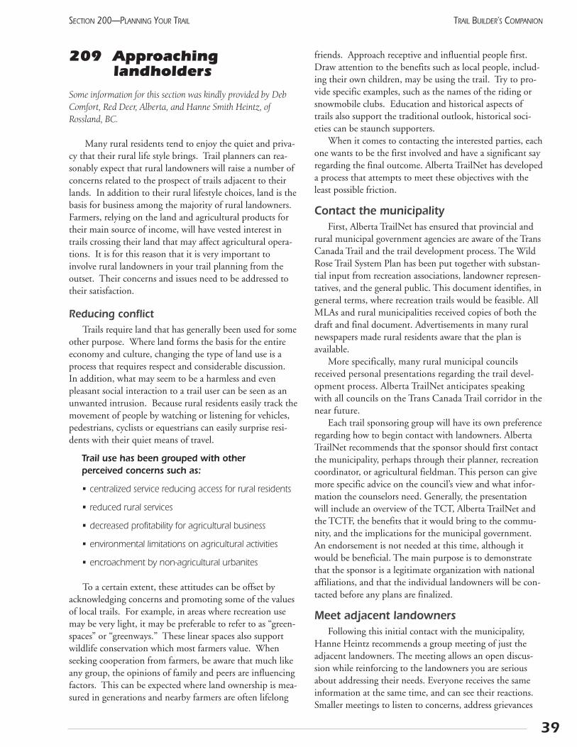
209 Approaching landholders
Some information for this section was kindly provided by DebComfort, Red Deer, Alberta, and Hanne Smith Heintz, ofRossland, BC.
Many rural residents tend to enjoy the quiet and priva-cy that their rural life style brings. Trail planners can rea-sonably expect that rural landowners will raise a number ofconcerns related to the prospect of trails adjacent to theirlands. In addition to their rural lifestyle choices, land is thebasis for business among the majority of rural landowners.Farmers, relying on the land and agricultural products fortheir main source of income, will have vested interest intrails crossing their land that may affect agricultural opera-tions. It is for this reason that it is very important toinvolve rural landowners in your trail planning from theoutset. Their concerns and issues need to be addressed totheir satisfaction.
Reducing conflictTrails require land that has generally been used for some
other purpose. Where land forms the basis for the entireeconomy and culture, changing the type of land use is aprocess that requires respect and considerable discussion.In addition, what may seem to be a harmless and evenpleasant social interaction to a trail user can be seen as anunwanted intrusion. Because rural residents easily track themovement of people by watching or listening for vehicles,pedestrians, cyclists or equestrians can easily surprise resi-dents with their quiet means of travel.
Trail use has been grouped with other perceived concerns such as:
• centralized service reducing access for rural residents
• reduced rural services
• decreased profitability for agricultural business
• environmental limitations on agricultural activities
• encroachment by non-agricultural urbanites
To a certain extent, these attitudes can be offset byacknowledging concerns and promoting some of the valuesof local trails. For example, in areas where recreation usemay be very light, it may be preferable to refer to as “green-spaces” or “greenways.” These linear spaces also supportwildlife conservation which most farmers value. Whenseeking cooperation from farmers, be aware that much likeany group, the opinions of family and peers are influencingfactors. This can be expected where land ownership is mea-sured in generations and nearby farmers are often lifelong
friends. Approach receptive and influential people first.Draw attention to the benefits such as local people, includ-ing their own children, may be using the trail. Try to pro-vide specific examples, such as the names of the riding orsnowmobile clubs. Education and historical aspects oftrails also support the traditional outlook, historical soci-eties can be staunch supporters.
When it comes to contacting the interested parties, eachone wants to be the first involved and have a significant sayregarding the final outcome. Alberta TrailNet has developeda process that attempts to meet these objectives with theleast possible friction.
Contact the municipalityFirst, Alberta TrailNet has ensured that provincial and
rural municipal government agencies are aware of the TransCanada Trail and the trail development process. The WildRose Trail System Plan has been put together with substan-tial input from recreation associations, landowner represen-tatives, and the general public. This document identifies, ingeneral terms, where recreation trails would be feasible. AllMLAs and rural municipalities received copies of both thedraft and final document. Advertisements in many ruralnewspapers made rural residents aware that the plan isavailable.
More specifically, many rural municipal councilsreceived personal presentations regarding the trail devel-opment process. Alberta TrailNet anticipates speakingwith all councils on the Trans Canada Trail corridor in thenear future.
Each trail sponsoring group will have its own preferenceregarding how to begin contact with landowners. AlbertaTrailNet recommends that the sponsor should first contactthe municipality, perhaps through their planner, recreationcoordinator, or agricultural fieldman. This person can givemore specific advice on the council’s view and what infor-mation the counselors need. Generally, the presentationwill include an overview of the TCT, Alberta TrailNet andthe TCTF, the benefits that it would bring to the commu-nity, and the implications for the municipal government.An endorsement is not needed at this time, although itwould be beneficial. The main purpose is to demonstratethat the sponsor is a legitimate organization with nationalaffiliations, and that the individual landowners will be con-tacted before any plans are finalized.
Meet adjacent landownersFollowing this initial contact with the municipality,
Hanne Heintz recommends a group meeting of just theadjacent landowners. The meeting allows an open discus-sion while reinforcing to the landowners you are seriousabout addressing their needs. Everyone receives the sameinformation at the same time, and can see their reactions.Smaller meetings to listen to concerns, address grievances
39
SECTION 200—PLANNING YOUR TRAIL TRAIL BUILDER’S COMPANION
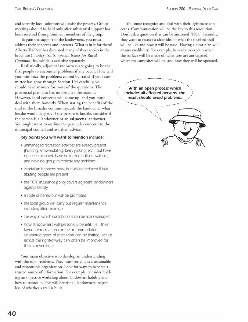
and identify local solutions will assist the process. Groupmeetings should be held only after substantial support hasbeen received from prominent members of the group.
To gain the support of the landowners, you mustaddress their concerns and interests. What is in it for them?Alberta TrailNet has discussed many of these topics in thebrochure Country Trails: Special Issues for RuralCommunities, which is available separately.
Realistically, adjacent landowners are going to be thefirst people to encounter problems if any occur. How willyou minimize the problems caused by trails? If your com-mittee has gone through Section 104 carefully, youshould have answers for most of the questions. Theprovincial plan also has important information.However, local concerns will come up, and you mustdeal with them honestly. When stating the benefits of thetrail to the broader community, ask the landowner whathe/she would suggest. If the person is hostile, consider ifthe person is a landowner or an adjacent landowner.You might want to outline the particular concern to themunicipal council and ask their advice.
Key points you will want to mention include:
• unmanaged recreation activities are already present(hunting, snowmobiling, berry picking, etc.), but havenot been planned, have no formal facilities available,and have no group to remedy any problems
• vandalism happens now, but will be reduced if law-abiding people are present
• the TCTF insurance policy covers adjacent landownersagainst liability
• a code of behaviour will be promoted
• the local group will carry out regular maintenance,including litter clean-up
• the way in which contributions can be acknowledged
• how landowners will personally benefit, i.e., theirfavourite recreation can be accommodated,unwanted types of recreation can be limited, accessacross the right-of-way can often be improved fortheir convenience
Your main objective is to develop an understandingwith the rural residents. They must see you as a reasonableand responsible organization. Look for ways to become atrusted source of information. For example, consider hold-ing an objective workshop about landowner liability andhow to reduce it. This will benefit all landowners, regard-less of whether a trail is built.
You must recognize and deal with their legitimate con-cerns. Communication will be the key to this resolution.Don’t ask a question that can be answered “NO.” Secondly,they want to receive a clear idea of what the finished trailwill be like and how it will be used. Having a clear plan willensure credibility. For example, be ready to explain whatthe surface will be made of, what uses are anticipated,where the campsites will be, and how they will be operated.
40
SECTION 200—PLANNING YOUR TRAILTRAIL BUILDER’S COMPANION
With an open process which includes all affected persons, the
result should avoid problems.
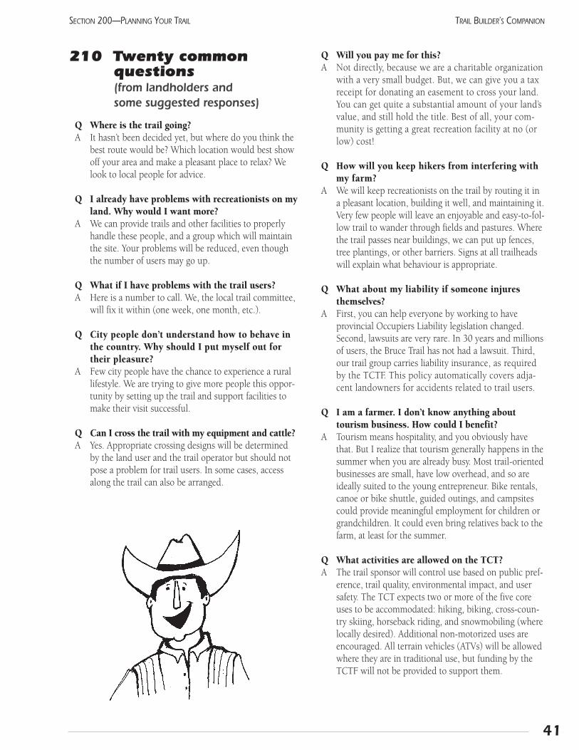
41
SECTION 200—PLANNING YOUR TRAIL TRAIL BUILDER’S COMPANION
210 Twenty common questions (from landholders and some suggested responses)
Q Where is the trail going?A It hasn’t been decided yet, but where do you think the
best route would be? Which location would best showoff your area and make a pleasant place to relax? Welook to local people for advice.
Q I already have problems with recreationists on myland. Why would I want more?
A We can provide trails and other facilities to properlyhandle these people, and a group which will maintainthe site. Your problems will be reduced, even thoughthe number of users may go up.
Q What if I have problems with the trail users?A Here is a number to call. We, the local trail committee,
will fix it within (one week, one month, etc.).
Q City people don’t understand how to behave inthe country. Why should I put myself out fortheir pleasure?
A Few city people have the chance to experience a rurallifestyle. We are trying to give more people this oppor-tunity by setting up the trail and support facilities tomake their visit successful.
Q Can I cross the trail with my equipment and cattle?A Yes. Appropriate crossing designs will be determined
by the land user and the trail operator but should notpose a problem for trail users. In some cases, accessalong the trail can also be arranged.
Q Will you pay me for this?A Not directly, because we are a charitable organization
with a very small budget. But, we can give you a taxreceipt for donating an easement to cross your land.You can get quite a substantial amount of your land’svalue, and still hold the title. Best of all, your com-munity is getting a great recreation facility at no (orlow) cost!
Q How will you keep hikers from interfering withmy farm?
A We will keep recreationists on the trail by routing it ina pleasant location, building it well, and maintaining it.Very few people will leave an enjoyable and easy-to-fol-low trail to wander through fields and pastures. Wherethe trail passes near buildings, we can put up fences,tree plantings, or other barriers. Signs at all trailheadswill explain what behaviour is appropriate.
Q What about my liability if someone injuresthemselves?
A First, you can help everyone by working to haveprovincial Occupiers Liability legislation changed.Second, lawsuits are very rare. In 30 years and millionsof users, the Bruce Trail has not had a lawsuit. Third,our trail group carries liability insurance, as requiredby the TCTF. This policy automatically covers adja-cent landowners for accidents related to trail users.
Q I am a farmer. I don’t know anything abouttourism business. How could I benefit?
A Tourism means hospitality, and you obviously havethat. But I realize that tourism generally happens in thesummer when you are already busy. Most trail-orientedbusinesses are small, have low overhead, and so areideally suited to the young entrepreneur. Bike rentals,canoe or bike shuttle, guided outings, and campsitescould provide meaningful employment for children orgrandchildren. It could even bring relatives back to thefarm, at least for the summer.
Q What activities are allowed on the TCT?A The trail sponsor will control use based on public pref-
erence, trail quality, environmental impact, and usersafety. The TCT expects two or more of the five coreuses to be accommodated: hiking, biking, cross-coun-try skiing, horseback riding, and snowmobiling (wherelocally desired). Additional non-motorized uses areencouraged. All terrain vehicles (ATVs) will be allowedwhere they are in traditional use, but funding by theTCTF will not be provided to support them.
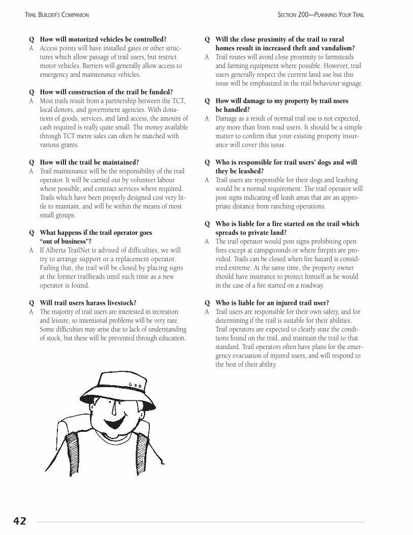
Q How will motorized vehicles be controlled?A Access points will have installed gates or other struc-
tures which allow passage of trail users, but restrictmotor vehicles. Barriers will generally allow access toemergency and maintenance vehicles.
Q How will construction of the trail be funded?A Most trails result from a partnership between the TCT,
local donors, and government agencies. With dona-tions of goods, services, and land access, the amount ofcash required is really quite small. The money availablethrough TCT metre sales can often be matched withvarious grants.
Q How will the trail be maintained?A Trail maintenance will be the responsibility of the trail
operator. It will be carried out by volunteer labourwhere possible, and contract services where required.Trails which have been properly designed cost very lit-tle to maintain, and will be within the means of mostsmall groups.
Q What happens if the trail operator goes “out of business”?
A If Alberta TrailNet is advised of difficulties, we willtry to arrange support or a replacement operator.Failing that, the trail will be closed by placing signsat the former trailheads until such time as a newoperator is found.
Q Will trail users harass livestock?A The majority of trail users are interested in recreation
and leisure, so intentional problems will be very rare.Some difficulties may arise due to lack of understandingof stock, but these will be prevented through education.
Q Will the close proximity of the trail to ruralhomes result in increased theft and vandalism?
A Trail routes will avoid close proximity to farmsteadsand farming equipment where possible. However, trailusers generally respect the current land use but thisissue will be emphasized in the trail behaviour signage.
Q How will damage to my property by trail users be handled?
A Damage as a result of normal trail use is not expected,any more than from road users. It should be a simplematter to confirm that your existing property insur-ance will cover this issue.
Q Who is responsible for trail users’ dogs and willthey be leashed?
A Trail users are responsible for their dogs and leashingwould be a normal requirement. The trail operator willpost signs indicating off leash areas that are an appro-priate distance from ranching operations.
Q Who is liable for a fire started on the trail whichspreads to private land?
A The trail operator would post signs prohibiting openfires except at campgrounds or where firepits are pro-vided. Trails can be closed when fire hazard is consid-ered extreme. At the same time, the property ownershould have insurance to protect himself as he wouldin the case of a fire started on a roadway.
Q Who is liable for an injured trail user?A Trail users are responsible for their own safety, and for
determining if the trail is suitable for their abilities.Trail operators are expected to clearly state the condi-tions found on the trail, and maintain the trail to thatstandard. Trail operators often have plans for the emer-gency evacuation of injured users, and will respond tothe best of their ability.
42
SECTION 200—PLANNING YOUR TRAILTRAIL BUILDER’S COMPANION
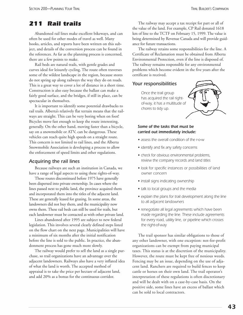
43
SECTION 200—PLANNING YOUR TRAIL TRAIL BUILDER’S COMPANION
211 Rail trailsAbandoned rail lines make excellent bikeways, and can
often be used for other modes of travel as well. Manybooks, articles, and reports have been written on this sub-ject, and details of the conversion process can be found inthe references. As far as the planning process is concerned,there are a few points to make.
Rail beds are natural trails, with gentle grades andcurves ideal for leisurely cycling. The route often traversessome of the wildest landscape in the region, because storesdo not spring up along railways the way they do on roads.This is a great way to cover a lot of distance in a short time.Construction is also easy because the ballast can make afairly good surface, and the bridges, if still in place, can bespectacular in themselves.
It is important to identify some potential drawbacks torail trails. Alberta’s relatively flat terrain means that the rail-ways are straight. This can be very boring when on foot!Bicycles move fast enough to keep the route interesting,generally. On the other hand, moving faster than a bicycle,say on a snowmobile or ATV, can be dangerous. Thesevehicles can reach quite high speeds on a straight route.This concern is not limited to rail lines, and the AlbertaSnowmobile Association is developing a process to allowthe enforcement of speed limits and other regulations.
Acquiring the rail linesBecause railways are such an institution in Canada, we
have a range of legal aspects to using these rights-of-way. Those routes discontinued before 1975 have generally
been dispersed into private ownership. In cases where thelines passed next to public land, the province acquired themand incorporated them into the titles of the adjacent land.These are generally leased for grazing. In some areas, thelandowners did not buy them, and the municipality nowowns them. These rail beds can still be used for trails, buteach landowner must be contacted as with other private land.
Lines abandoned after 1995 are subject to new federallegislation. This involves several clearly defined steps listedon the flow chart on the next page. Municipalities will havea minimum of six months after the initial notificationbefore the line is sold to the public. In practice, the aban-donment process has gone much more slowly.
The railway would prefer to sell the land as a single pur-chase, so trail organizations have an advantage over theadjacent landowners. Railways also have a very inflated ideaof what the land is worth. The accepted method ofappraisal is to take the price per hectare of adjacent land,and add 20% as a bonus for the continuous corridor.
The railway may accept a tax receipt for part or all ofthe value of the land. For example, CP Rail donated 1618km of line to the TCTF on February 15, 1999. The value isbeing determined by Revenue Canada and will provide guid-ance for future transactions.
The railway retains some responsibilities for the line. ACertificate of Reclamation must be obtained from AlbertaEnvironmental Protection, even if the line is disposed of.The railway remains responsible for any environmentalproblems which become evident in the five years after thecertificate is received.
Your responsibilities
Once the trail group has acquired the rail right-of-way, it has a multitude ofchores to tidy up.
Some of the tasks that must be carried out immediately include:
• assess the overall condition of the r-o-w
• identify and fix any safety concerns
• check for obvious environmental problems, review the company records and land titles
• look for specific instances or possibilities of landowner concern
• install signs indicating ownership
• talk to local groups and the media
• explain the plans for trail development along the lineto all adjacent landowners
• renegotiate all legal agreements which have beenmade regarding the line. These include agreementsfor every road, utility line, or pipeline which crossesthe right-of-way
The trail sponsor has similar obligations to those ofany other landowner, with one exception: not-for-profitorganizations can be exempt from paying municipaltaxes. This status is at the discretion of the municipality.However, the route must be kept free of noxious weeds.Fencing may be an issue, depending on the use of adja-cent land. Ranchers are required to build fences to keepcattle or horses on their own land. The trail operator’sinterpretation of these regulations is often discretionaryand will be dealt with on a case-by-case basis. On thepositive side, some lines have an excess of ballast whichcan be sold to local contractors.
Rails with trailsThe high demand for trails in some locations has result-
ed in trails being built within active rail rights-of-way. TheUnited States already has 54 rails-with-trails, with over 70more on the way. With proper planning, this can result in asafe recreation facility. The key factor is the speed of thetrains: the faster the trains, the more secure the separationmust be. In some urban areas, trails pass within a fewmetres of little-used spurs with little or no physical separa-tion. In Calgary, the Bow River Pathway crosses the CPRmainline three times. These crossings are a simple gap in achain-link fence, with warning signs. The fences end ashort distance away, but serve to keep people crossing atspecific points. In Medicine Hat, a major trail crosses a lit-tle-used spur with an unmarked level crossing. An Ontariotrail group is working with a local short-line company andtheir insurance company to determine what adequate sepa-ration means for that situation. They plan to use earthberms and bushes to keep the people on the trail. A fencemay be required in only a few places.
A high-speed coastal commuter train near San Diegowill soon have a bikeway within the same right-of-way. Alow fence will separate the two, with a taller fence beinginstalled near the crossings. Stormwater culverts will likelybe used for underpasses to give beach access. Most peoplefeel that this will result in safer conditions because the pathwill draw away those pedestrians who now walk on thetracks. The better crossings will also be safer than the ran-dom crossings now encountered.
Notes:
44
SECTION 200—PLANNING YOUR TRAILTRAIL BUILDER’S COMPANION
The key point to remember:
The trail must be more attractiveto use than the railbed.
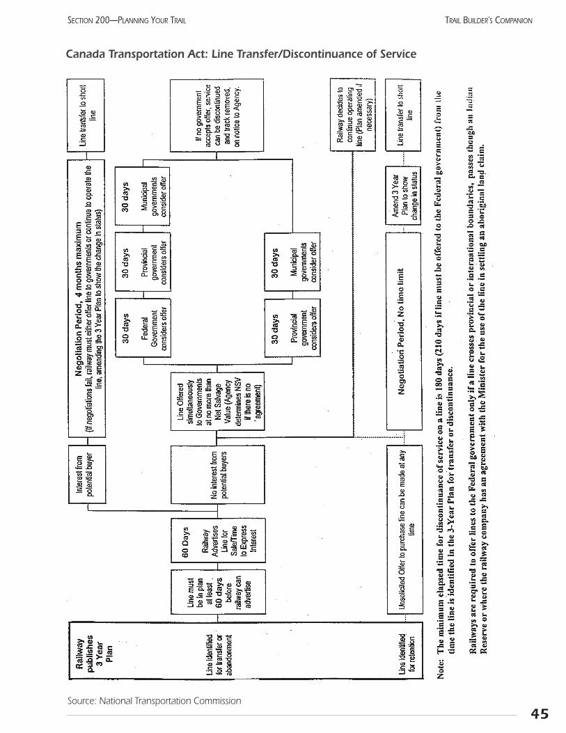
45
SECTION 200—PLANNING YOUR TRAIL TRAIL BUILDER’S COMPANION
Canada Transportation Act: Line Transfer/Discontinuance of Service
Source: National Transportation Commission

Notes:
46
SECTION 200—PLANNING YOUR TRAILTRAIL BUILDER’S COMPANION
212 Take back the streetsFor a hundred years, Canada’s transportation budgets
have gone to developing the road system. Some people sug-gest this has led to an impersonal society which views thelandscape at 100 km per hour, if at all. On the brighter side,this investment has also dedicated vast amounts of linearspace solely for transportation. This is a resource that can beadapted for more human-friendly movement.
As traffic slows down due to the volume of vehicles tobe moved, other modes of transportation become attractiveas potential options. Ensure that your traffic departmentrecognizes the important role that bicyclists and pedestrianscan play in alleviating traffic problems, especially whenmixed with public transit (excellent case studies are present-ed in Rails to Trails Conservancy 1998).
Benefits for riders:
• better physical and mental health
• more consistent (and perhaps shorter) commuting times
• substantial financial savings
• increased safety
Transportation infrastructure makes up a substantial pro-portion of the total area within large cities. More effectiveuse of bicycles will allow a saving in space, with more effi-cient use of land for residential or commercial purposes.
BikewaysOur streets are theoretically available for bicycle use, but
may presently be impractical and dangerous. A little carewill help alleviate this. Hope and Yachuk (1990) describe acomplete process for ensuring a bicycle-friendly city, butinitial steps could include:
• orienting the grids on storm sewer grates perpendicu-lar to the traffic flow
• making good bicycle racks as easy to find as car park-ing spaces
• ensuring the curb lane is wide enough to accommo-date bicycles as well as cars
Simply painting a bike lane (1.2-2.5 m wide) on theright side of the road has been a successful method used ina number of cities to encourage riders. The lane should bemarked with a bike symbol and the words “bike lane.”Some European countries use blue paint for these mark-ings, creating greater visibility. The bicycle traffic goes thesame way as the adjacent cars.
Palo Alto, California, retrofitted existing streets in thecity core to facilitate bicycle traffic. A quiet residentialstreet parallel to an arterial road was chosen to become a“bicycle boulevard.” Automobile barriers were erected atthe mid-point of each block, preventing through-vehicletraffic, but allowing bicycles. This can be supported withsigns, maps, and special traffic controls, all giving the priorityto bicycles. Local residents support this change, as it reducesthe spill-over traffic from the adjacent commercial district.
All methods of encouraging bicycles to use streets mustbe well-signed. Motorists must expect to see cyclists. Somenew features will be unfamiliar, and must be given exten-sive publicity to ensure accidents do not happen.
Traffic calming“Traffic calming” is a process that slows traffic by design
changes to roads, reducing vehicle speed by means otherthan regulations. This approach is rapidly gaining populari-ty, and a search for this term on the Internet will providemany good examples and even design manuals. Some fea-tures will restrict bicycle traffic as well as motor vehicles,and should be avoided. Barriers and “no left turn” signs areexamples. Other features will reduce fast traffic to bicyclespeed, making cycling more pleasant and safer.
Raising the crosswalk to sidewalk height and creatingwhat traffic engineers call speed bumps, will ensure thatcars slow down, while reducing the barriers for the dis-abled. Painting the crossing will further emphasize the site.Reducing the curvature radius of sidewalks at street cornerswill slow motor vehicles while reducing the distance whichpedestrians must walk to cross the street.
Seattle has installed over 600 small traffic circles atintersections. These slow the traffic without causing con-gestion. Vehicle counts remain the same after installation;they do not move to a new route. Since pedestrianinjuries have been virtually eliminated at these locations,the city now receives over 100 requests per year to havethem placed in local neighbourhoods. All of these trafficcalming designs can be tried on an interim basis withmovable traffic barriers. Remember, though, that bothmotorists and cyclists will take a while to get used to thenew arrangement.
Public transit vehicles can be adapted to hold bicycles.This allows bikes to be used for the start and end of a trip,with the bus or light-rail transit used for the major part ofthe distance. Another alternative is bike lockers at the ter-minals, allowing bicycles to be stored until the returntrip. These boxes offer greater security because the bike’saccessories cannot be removed. In fact, the potential thiefcannot even see if there is a bicycle in the locker. Sincethey only take up one-fifth of the space of a parkingspace, they are an efficient way to accommodate addi-tional passengers.
47
SECTION 200—PLANNING YOUR TRAIL TRAIL BUILDER’S COMPANION
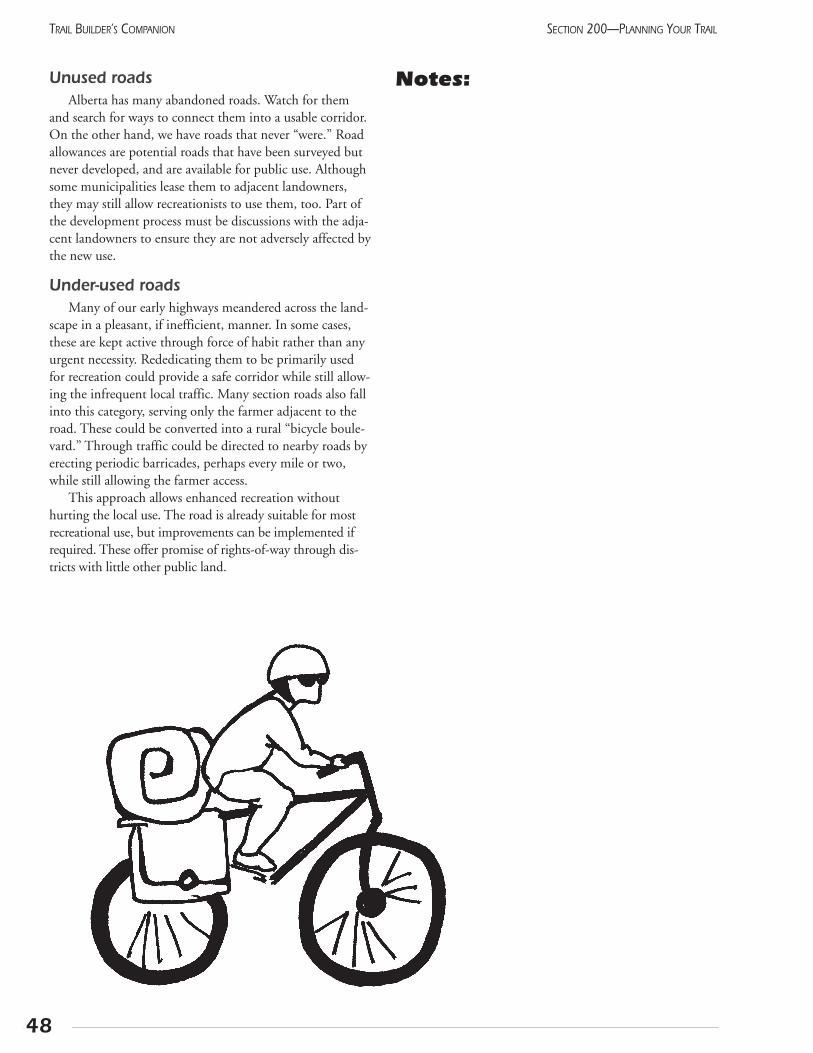
Unused roadsAlberta has many abandoned roads. Watch for them
and search for ways to connect them into a usable corridor.On the other hand, we have roads that never “were.” Roadallowances are potential roads that have been surveyed butnever developed, and are available for public use. Althoughsome municipalities lease them to adjacent landowners,they may still allow recreationists to use them, too. Part ofthe development process must be discussions with the adja-cent landowners to ensure they are not adversely affected bythe new use.
Under-used roadsMany of our early highways meandered across the land-
scape in a pleasant, if inefficient, manner. In some cases,these are kept active through force of habit rather than anyurgent necessity. Rededicating them to be primarily usedfor recreation could provide a safe corridor while still allow-ing the infrequent local traffic. Many section roads also fallinto this category, serving only the farmer adjacent to theroad. These could be converted into a rural “bicycle boule-vard.” Through traffic could be directed to nearby roads byerecting periodic barricades, perhaps every mile or two,while still allowing the farmer access.
This approach allows enhanced recreation withouthurting the local use. The road is already suitable for mostrecreational use, but improvements can be implemented ifrequired. These offer promise of rights-of-way through dis-tricts with little other public land.
Notes:
48
SECTION 200—PLANNING YOUR TRAILTRAIL BUILDER’S COMPANION
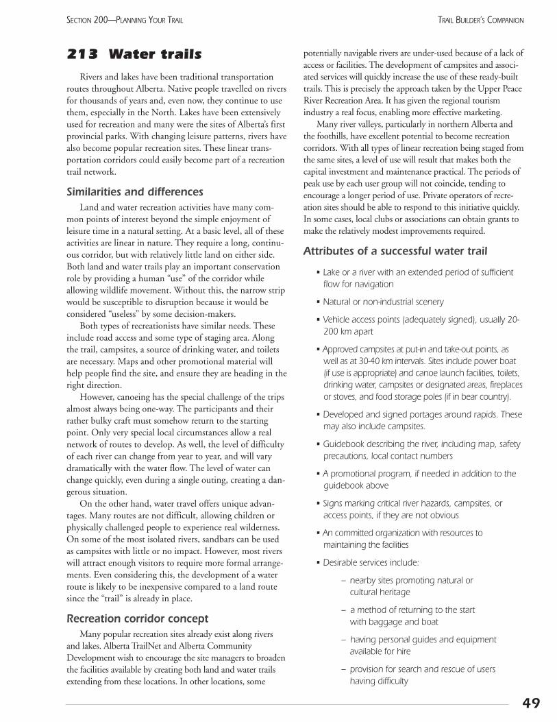
213 Water trailsRivers and lakes have been traditional transportation
routes throughout Alberta. Native people travelled on riversfor thousands of years and, even now, they continue to usethem, especially in the North. Lakes have been extensivelyused for recreation and many were the sites of Alberta’s firstprovincial parks. With changing leisure patterns, rivers havealso become popular recreation sites. These linear trans-portation corridors could easily become part of a recreationtrail network.
Similarities and differencesLand and water recreation activities have many com-
mon points of interest beyond the simple enjoyment ofleisure time in a natural setting. At a basic level, all of theseactivities are linear in nature. They require a long, continu-ous corridor, but with relatively little land on either side.Both land and water trails play an important conservationrole by providing a human “use” of the corridor whileallowing wildlife movement. Without this, the narrow stripwould be susceptible to disruption because it would beconsidered “useless” by some decision-makers.
Both types of recreationists have similar needs. Theseinclude road access and some type of staging area. Alongthe trail, campsites, a source of drinking water, and toiletsare necessary. Maps and other promotional material willhelp people find the site, and ensure they are heading in theright direction.
However, canoeing has the special challenge of the tripsalmost always being one-way. The participants and theirrather bulky craft must somehow return to the startingpoint. Only very special local circumstances allow a realnetwork of routes to develop. As well, the level of difficultyof each river can change from year to year, and will varydramatically with the water flow. The level of water canchange quickly, even during a single outing, creating a dan-gerous situation.
On the other hand, water travel offers unique advan-tages. Many routes are not difficult, allowing children orphysically challenged people to experience real wilderness.On some of the most isolated rivers, sandbars can be usedas campsites with little or no impact. However, most riverswill attract enough visitors to require more formal arrange-ments. Even considering this, the development of a waterroute is likely to be inexpensive compared to a land routesince the “trail” is already in place.
Recreation corridor conceptMany popular recreation sites already exist along rivers
and lakes. Alberta TrailNet and Alberta CommunityDevelopment wish to encourage the site managers to broadenthe facilities available by creating both land and water trailsextending from these locations. In other locations, some
potentially navigable rivers are under-used because of a lack ofaccess or facilities. The development of campsites and associ-ated services will quickly increase the use of these ready-builttrails. This is precisely the approach taken by the Upper PeaceRiver Recreation Area. It has given the regional tourismindustry a real focus, enabling more effective marketing.
Many river valleys, particularly in northern Alberta andthe foothills, have excellent potential to become recreationcorridors. With all types of linear recreation being staged fromthe same sites, a level of use will result that makes both thecapital investment and maintenance practical. The periods ofpeak use by each user group will not coincide, tending toencourage a longer period of use. Private operators of recre-ation sites should be able to respond to this initiative quickly.In some cases, local clubs or associations can obtain grants tomake the relatively modest improvements required.
Attributes of a successful water trail
• Lake or a river with an extended period of sufficientflow for navigation
• Natural or non-industrial scenery
• Vehicle access points (adequately signed), usually 20-200 km apart
• Approved campsites at put-in and take-out points, aswell as at 30-40 km intervals. Sites include power boat(if use is appropriate) and canoe launch facilities, toilets,drinking water, campsites or designated areas, fireplacesor stoves, and food storage poles (if in bear country).
• Developed and signed portages around rapids. Thesemay also include campsites.
• Guidebook describing the river, including map, safetyprecautions, local contact numbers
• A promotional program, if needed in addition to theguidebook above
• Signs marking critical river hazards, campsites, oraccess points, if they are not obvious
• An committed organization with resources to maintaining the facilities
• Desirable services include:
– nearby sites promoting natural or cultural heritage
– a method of returning to the start with baggage and boat
– having personal guides and equipment available for hire
– provision for search and rescue of users having difficulty
49
SECTION 200—PLANNING YOUR TRAIL TRAIL BUILDER’S COMPANION
Routes with these features already exist on the PeaceRiver from the BC boundary to the town of Peace River,and on the Bow River from Calgary to the Carseland weir.
Potential water trailsThis list includes rivers and lakes with strong recreation
potential that could be developed as water trails. In mostcases, these would complement existing or planned landrecreation. The list is not exhaustive, but illustrates therange of possibilities.
• Athabasca River—Athabasca to Fort McMurray, Fort McMurray to Fort Fitzgerald
• Clearwater River
• Peace River—BC boundary to town of Peace River
• Lakeland Provincial Park & Recreation Area
• North Saskatchewan River—Devon to Saskatchewan border
• North Saskatchewan River—upstream of RockyMountain House
• Red Deer River—Red Deer to Drumheller
• South Saskatchewan River—Medicine Hat to Empress
• Lesser Slave Lake (north shore)
• Foothills streams
ImplementationAlberta TrailNet encourages all organizations that man-
age outdoor recreation facilities to assess whether providingfacilities for water-based recreation will benefit their site.Sometimes adding a simple launch site or mentioning theopportunity in a park brochure will result in more use.
Recreation groups and local agencies are encouraged towork together to develop multi-use facilities that meet com-munity needs.
Notes:
50
SECTION 200—PLANNING YOUR TRAILTRAIL BUILDER’S COMPANION
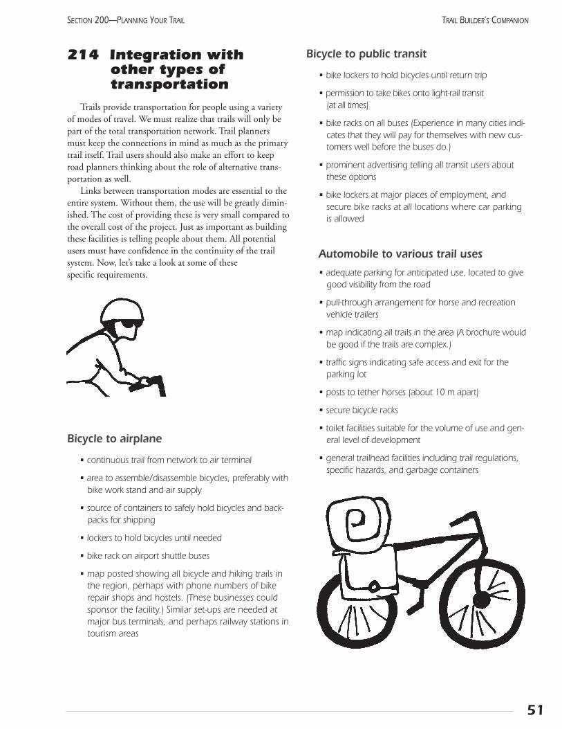
214 Integration withother types of transportation
Trails provide transportation for people using a varietyof modes of travel. We must realize that trails will only bepart of the total transportation network. Trail plannersmust keep the connections in mind as much as the primarytrail itself. Trail users should also make an effort to keeproad planners thinking about the role of alternative trans-portation as well.
Links between transportation modes are essential to theentire system. Without them, the use will be greatly dimin-ished. The cost of providing these is very small compared tothe overall cost of the project. Just as important as buildingthese facilities is telling people about them. All potentialusers must have confidence in the continuity of the trailsystem. Now, let’s take a look at some of these specific requirements.
Bicycle to airplane
• continuous trail from network to air terminal
• area to assemble/disassemble bicycles, preferably withbike work stand and air supply
• source of containers to safely hold bicycles and back-packs for shipping
• lockers to hold bicycles until needed
• bike rack on airport shuttle buses
• map posted showing all bicycle and hiking trails inthe region, perhaps with phone numbers of bikerepair shops and hostels. (These businesses couldsponsor the facility.) Similar set-ups are needed atmajor bus terminals, and perhaps railway stations intourism areas
Bicycle to public transit
• bike lockers to hold bicycles until return trip
• permission to take bikes onto light-rail transit (at all times)
• bike racks on all buses (Experience in many cities indi-cates that they will pay for themselves with new cus-tomers well before the buses do.)
• prominent advertising telling all transit users aboutthese options
• bike lockers at major places of employment, andsecure bike racks at all locations where car parkingis allowed
Automobile to various trail uses
• adequate parking for anticipated use, located to givegood visibility from the road
• pull-through arrangement for horse and recreationvehicle trailers
• map indicating all trails in the area (A brochure wouldbe good if the trails are complex.)
• traffic signs indicating safe access and exit for theparking lot
• posts to tether horses (about 10 m apart)
• secure bicycle racks
• toilet facilities suitable for the volume of use and gen-eral level of development
• general trailhead facilities including trail regulations,specific hazards, and garbage containers
51
SECTION 200—PLANNING YOUR TRAIL TRAIL BUILDER’S COMPANION

Notes:
52
SECTION 200—PLANNING YOUR TRAILTRAIL BUILDER’S COMPANION
215 Route selectionHaving waded through the administrative and public
input process, you are now ready to start choosing the actu-al route. This is the fun part!
Trail designers take on the dual roles of a landscapearchitect and travel guide as they create an experience forthe recreationists who follow. Ideally, it becomes a part ofthe landscape. The users, rather than wearing it out, shouldwear it in. The track should gradually settle into, andbecome part of, the natural features. At the same time, thedesigner must remember that trail use goes beyond func-tion to embrace the travelling itself. Trail builders have aresponsibility to produce positive and even exciting experi-ences.
Trail building as artIn some ways, this process can be compared to sculp-
ture. The land parcels form the “stone,” which will becomethe final product. The designated end points begin todefine the route. Sites where the route is restricted, such asmountain passes and river crossings, further limit the route.As the work of art takes shape, the nuances of the stonebegin to influence the final result. The flow of the landacross valleys and ridges, along fields and behind hills, willsuggest an attitude that will gradually become the personal-ity of the trail.
This sounds pretty New Age, doesn’t it? How can abeginner actually achieve this? Keep walking the route, buttry to view it as if it is your first visit. Where do you tend towalk? Where are the views? Can you add drama by putting acorner just in front of the view, so it comes as a surprise?
Use of spaceThe manipulation of space along a trail influences the
user’s experience. Variations of space can set differentmoods and feelings. Changing spaces entice the trail user toexplore further, whereas a visually uniform trail over a longdistance can become stagnant. Consider using combina-tions for both subtle and abrupt changes. The main tool isthe amount of enclosure experienced by the trail user.
The main spacial arrangements are:
• Closed top and sides: trees arch overhead, and vege-tation or landforms enclose the sides
• Closed top with open sides: trees overhead, but goodviews to the sides
• Closed sides: short vegetation or a water featureopens one or both sides
• Open: good view to the sides and above
These experiences can be developed to ensure a variedexperience for the recreationists. For example, aspens canbe allowed to grow right to the edge of a rail-trail in someareas, giving relief from the long straight views. In thegrassland region, a few poplars planted next to the trail willprovide welcome shade.
ViewpointsYour earlier inventory should have identified the best
viewpoints and located them on the strip map. Ensure thetrail takes full advantage of them. In some cases, trees mayneed to be removed. In other places, a short side-trail canlead to the best vantage point. In high-use areas, building asmall platform out over a cliff will give a spectacular viewwithout having to remove much vegetation. Get an engi-neer’s approval for the design and construction, though!
Trail routing as recreation managementPaying attention to the technical details of selecting a
route can greatly reduce future management problems. InAlberta, this boils down to dealing with the two destruc-tive elements: running water and roving feet. Trail rout-ing focuses on getting water off the trail and keeping itoff. Users, on the other hand, should be kept on the trailwhere their effect can be controlled. All too often, theyexchange places when water drains into the shallowdepression of the trail. The muddy route then drives theusers onto the natural vegetation where the destructionbegins immediately.
Drainage and water management are dealt with inSections 412 and 413. At this time, let’s discuss the situa-tion from the perspective of average users. If the trailappears to be clear, dry, and direct, very few people willleave it. Only when users see a short-cut will they move offthe trail. So keep any changes in direction very gradual andwithout short-cuts. Regular maintenance will also ensurethat the trail stays more attractive than the adjacent areas.Restore any short-cuts by placing deadfall across them andplanting new shrubs if required.
When an existing right-of-way such as a canal serviceroad or abandoned rail line becomes a trail, the routingoptions are more limited. The trail’s message is conveyedthrough the theme and is supported by the style of the fur-nishings, signs, and brochures. These can still have a power-ful impact if they reinforce each other for a defined sectionof trail. A few well-chosen interpretive signs will explainthe significance of the objects seen along the trail. The pre-sentation of these signs in a creative manner with consistentstyle and colour, will transform a previously unremarkabletrail into a memorable experience.
53
SECTION 200—PLANNING YOUR TRAIL TRAIL BUILDER’S COMPANION
Put it together: The concept planNow that you have come this far, you’ll be well supplied
with information . How does it all fit into the originalobjectives of the trail? At this stage, you may want to re-evaluate some of your first ideas to keep the trail withinbudget or to include features you hadn’t thought of.
All the research you’ve done will enable you to makesound decisions on where your trail should and shouldn’t go.You’ll know which areas to avoid and which areas to include.
Start drawing up a working design or a concept planthat includes route options. More than one concept planmay be developed. It should indicate approximately wherethe trail will be routed, noting the area’s best features, andindicating points of interpretive or visual interest as well asany structures that will be required. It is not a final designand probably will be altered several times before you make afinal decision. The concept plan will help the designer andyour group evaluate and select the final route.
At this point, your trail-planning group will haveselected a preferred route for your trail. The route select-ed will require review by various government agencies, aswell as Alberta TrailNet if it is to be part of the TransCanada Trail. These groups will have valuable commentswhich will help fine tune the proposal. After this, youcan begin addressing more details with landholders andpotential funders.
54
SECTION 200—PLANNING YOUR TRAILTRAIL BUILDER’S COMPANION
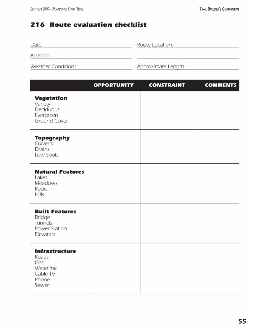
55
SECTION 200—PLANNING YOUR TRAIL TRAIL BUILDER’S COMPANIONTRAIL BUILDER’S COMPANION
216 Route evaluation checklist
VegetationVarietyDeciduousEvergreenGround Cover
TopographyCulvertsDrainsLow Spots
Natural FeaturesLakesMeadowsRocksHills
Built FeaturesBridgeTunnelsPower StationElevators
InfrastructureRoadsGasWaterlineCable TVPhoneSewer
OPPORTUNITY CONSTRAINT COMMENTS
Date:
Assessor:
Weather Conditions:
Route Location:
Approximate Length:

56
SECTION 200—PLANNING YOUR TRAILTRAIL BUILDER’S COMPANION
Route evaluation checklist: page 2
Rating Notes
WildlifeNestingBreedingHarmfulEndangered
Domestic AnimalCrossingLocationFrequencySmell
SlopesConvexFlatConcaveTerraced
ViewsSafeCanopyWindows Out
IntersectionsRoadsRailDrivewaysOther trails
Access PointsEntry locationsDistance apartNew required
OPPORTUNITY CONSTRAINT COMMENTS
217 Corridor assessment:level of difficulty
Six key design elements have been identified that will limit the trail’s use:
• overall effort: distance to significant features and total elevation change
• grade: average, maximum, and the length of severe grade
• trail width: minimum and average
• cross slope: average and maximum
• surface obstructions: stones, roots, soft or wet areas,water bars, and steps
• surface type: soil, grass, soft granular (wood chips or sand), hard granular, paved
All trail users have different interests, abilities, skills,and expertise. What they do have in common is a need foraccurate and objective description of the expected trail con-ditions, so they can make their own decision regarding thetrail’s suitability. Trails should be described in terms of theabove limiting factors. The trail planner should ensure thatthe trail is consistent throughout its length and meets theneeds of the intended users. Even a single lapse in standardscan prevent use or endanger the recreationist.
The more diverse the expected clientele or the allowedactivities, the more difficult the trail description becomes.It seems obvious that high-use trails would benefit mostfrom providing all this information. However, urban trails,while heavily used by a diverse population, have the advan-tage of a stable market. Users can easily learn which routessuit their needs.
A more urgent need is for popular resorts or parks toassess their trails and post the information at the trailhead.In these tourist-oriented places, most people do not knowthe area and have only a limited time to learn about it. Thelack of consistent information has led to overcrowding on afew, well-marked trails. Ideally, all staffed informationkiosks would have a table of the assessments of the park’strails. This would give an inexperienced attendant somedetailed information for the user.
As a starting point, trail managers are encouraged toindicate the length of trails to popular destinations, withthe total elevation gain and an indication of any legally pro-hibited activities. More information, especially the averagetrail width, can be added as it is acquired.
Proposed trail condition ratingsEach user has individual needs, so a broad classification
system will not identify the specific problems that may berelevant to that person. Any grading system will excludesome potential users needlessly (i.e., some athletic wheel-chair-users can negotiate very steep trails). The UniversalTrail Assessment Program, while giving detailed and consis-tent information, seems complex to understand and verytime-consuming to implement. By contrast, the colour skitrail classification seems to be well-accepted and useful.
For discussion purposes, Alberta TrailNet is introduc-ing a simplified approach to rating trail conditions. Thefollowing definitions recognize the limiting factors forvarious types of recreational travel while seeking factorsof common interest.
Trails with several destinations would have a differentsymbol for each location (generally, these would go fromeasy to hard, as the trail gets smaller). The coloured shapescould be produced in quantity on adhesive stickers andadded to existing signs. The symbols could be added tomaps and brochures quite easily. (See following chart)
57
SECTION 200—PLANNING YOUR TRAIL TRAIL BUILDER’S COMPANION
Universal Trail AssessmentA American Firm has developed a process to accu-
rately describe the physical nature of trails in terms thatare easily understood by various users. This process usesonly simple equipment, and can be carried out by ateam of two to four persons. It also distributes a systemof symbols and trail signage layouts to visually conveythe information. Courses are available to learn how tocarry out the process, and specialized tool kits can bepurchased. Several Albertans have taken this course, andcan be contacted for more details:
Jeff GruttzCity of Calgary,Parks & Recreation Department (403) 268-5221
Doug FrostCity of Edmonton,Community Services Department (780) 496-2980

Trail Condition Rating
Notes:
58
SECTION 200—PLANNING YOUR TRAILTRAIL BUILDER’S COMPANION
Symbol Definition Comments
Black diamond single track too narrow for wheelchair or snowmobile(<1 m wide) any surface, length, slopedistance indicated;
elevation gain optional
Blue square wide track theoretically accessible to wheelchairs and (>1 m wide) snowmobiles may have steps, steep slopes or
natural obstacles distance and elevation gain to be indicated
Green circle double track, distance to major destinations to be indicatedfirm surface, & little, if any, vegetation on trailmoderate grade
Beaver Flats Pleasant Valley Pristine Lake2 km 7 km < 130 m 12 km < 345 m

Section 300 Organizing Your Project

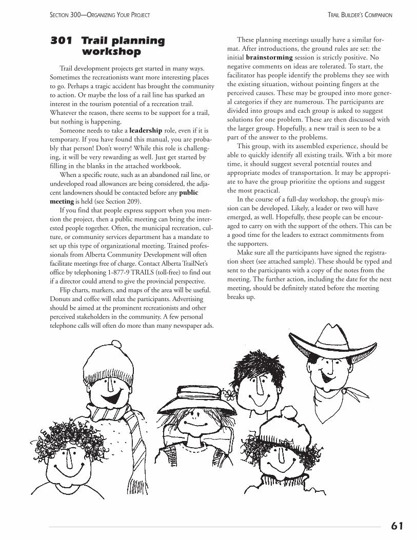
61
SECTION 300—ORGANIZING YOUR PROJECT TRAIL BUILDER’S COMPANION
301 Trail planning workshop
Trail development projects get started in many ways.Sometimes the recreationists want more interesting placesto go. Perhaps a tragic accident has brought the communityto action. Or maybe the loss of a rail line has sparked aninterest in the tourism potential of a recreation trail.Whatever the reason, there seems to be support for a trail,but nothing is happening.
Someone needs to take a leadership role, even if it istemporary. If you have found this manual, you are proba-bly that person! Don’t worry! While this role is challeng-ing, it will be very rewarding as well. Just get started byfilling in the blanks in the attached workbook.
When a specific route, such as an abandoned rail line, orundeveloped road allowances are being considered, the adja-cent landowners should be contacted before any publicmeeting is held (see Section 209).
If you find that people express support when you men-tion the project, then a public meeting can bring the inter-ested people together. Often, the municipal recreation, cul-ture, or community services department has a mandate toset up this type of organizational meeting. Trained profes-sionals from Alberta Community Development will oftenfacilitate meetings free of charge. Contact Alberta TrailNet’soffice by telephoning 1-877-9 TRAILS (toll-free) to find outif a director could attend to give the provincial perspective.
Flip charts, markers, and maps of the area will be useful.Donuts and coffee will relax the participants. Advertisingshould be aimed at the prominent recreationists and otherperceived stakeholders in the community. A few personaltelephone calls will often do more than many newspaper ads.
These planning meetings usually have a similar for-mat. After introductions, the ground rules are set: theinitial brainstorming session is strictly positive. Nonegative comments on ideas are tolerated. To start, thefacilitator has people identify the problems they see withthe existing situation, without pointing fingers at theperceived causes. These may be grouped into more gener-al categories if they are numerous. The participants aredivided into groups and each group is asked to suggestsolutions for one problem. These are then discussed withthe larger group. Hopefully, a new trail is seen to be apart of the answer to the problems.
This group, with its assembled experience, should beable to quickly identify all existing trails. With a bit moretime, it should suggest several potential routes andappropriate modes of transportation. It may be appropri-ate to have the group prioritize the options and suggestthe most practical.
In the course of a full-day workshop, the group’s mis-sion can be developed. Likely, a leader or two will haveemerged, as well. Hopefully, these people can be encour-aged to carry on with the support of the others. This can bea good time for the leaders to extract commitments fromthe supporters.
Make sure all the participants have signed the registra-tion sheet (see attached sample). These should be typed andsent to the participants with a copy of the notes from themeeting. The further action, including the date for the nextmeeting, should be definitely stated before the meetingbreaks up.

62
SECTION 300—ORGANIZING YOUR PROJECTTRAIL BUILDER’S COMPANION
Public Meeting Sign-In Sheet
Name/Organization Mailing Address/Postal Code Phone/Fax ✔
1.
2.
3.
4.
5.
6.
7.
8.
9.
10.
11.
12.
Please indicate with a check mark if you would like to receive a copy of the results.
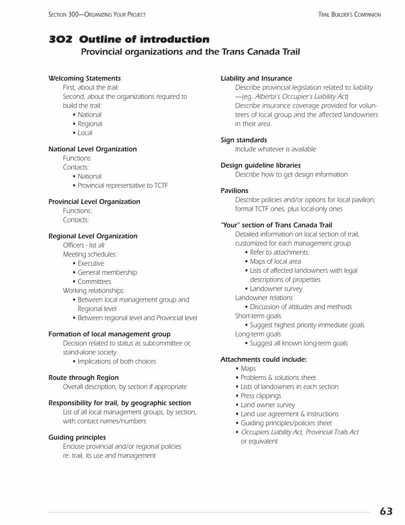
Welcoming StatementsFirst, about the trail:Second, about the organizations required to build the trail:
• National• Regional• Local
National Level OrganizationFunctions:Contacts:
• National• Provincial representative to TCTF
Provincial Level OrganizationFunctions:Contacts:
Regional Level OrganizationOfficers - list allMeeting schedules:
• Executive• General membership• Committees
Working relationships:• Between local management group and
Regional level• Between regional level and Provincial level
Formation of local management groupDecision related to status as subcommittee or, stand-alone society
• Implications of both choices
Route through RegionOverall description, by section if appropriate
Responsibility for trail, by geographic sectionList of all local management groups, by section, with contact names/numbers
Guiding principlesEnclose provincial and/or regional policies re: trail, its use and management
Liability and InsuranceDescribe provincial legislation related to liability —(eg. Alberta’s Occupier’s Liability Act)Describe insurance coverage provided for volun-teers of local group and the affected landownersin their area.
Sign standardsInclude whatever is available
Design guideline librariesDescribe how to get design information
PavilionsDescribe policies and/or options for local pavilion,formal TCTF ones, plus local-only ones
“Your” section of Trans Canada TrailDetailed information on local section of trail, customized for each management group
• Refer to attachments:• Maps of local area• Lists of affected landowners with legal
descriptions of properties• Landowner survey
Landowner relations• Discussion of attitudes and methods
Short-term goals• Suggest highest priority immediate goals
Long-term goals• Suggest all known long-term goals
Attachments could include:• Maps• Problems & solutions sheet• Lists of landowners in each section• Press clippings• Land owner survey• Land use agreement & instructions• Guiding principles/policies sheet• Occupiers Liability Act, Provincial Trails Act
or equivalent
63
SECTION 300—ORGANIZING YOUR PROJECT TRAIL BUILDER’S COMPANION
3O2 Outline of introduction Provincial organizations and the Trans Canada Trail

64
SECTION 300—ORGANIZING YOUR PROJECTTRAIL BUILDER’S COMPANION
Notes:
65
SECTION 300—ORGANIZING YOUR PROJECT TRAIL BUILDER’S COMPANION
303 Drawing people together
Forming a trail groupYour project will need a sponsoring group to get things
rolling. The planning and building of a trail are big tasksand you will need help to get them done. To start with, thiscan be an informal committee. At some time, however, itshould be incorporated to facilitate applying for grants andsigning legal documents such as leases. Of course, incorpo-ration also gives legal protection against lawsuits to thedirectors of the group if something goes wrong.
In addition, other benefits will become apparent:
• motivation: other colleagues will make the project more fun
• credibility: more members will demonstrate more support
• resources: each person brings knowledge, contacts,and skills to the project
If the idea of setting up a society seems too forbidding,don’t worry. Alberta Government Services has a packagedesigned for groups just like yours! [Use the governmentRITE line to call the Corporate Registry office, (780) 427-2311. Forms are also accessible through the website.] It willtake you through the process, step by step. It even includesa sample constitution. Pay particular attention to the objec-tive, because these define what your group intends toachieve. If the key members are not in agreement, youshould describe the project in more detail until everyonehas the same picture. All other aspects of the incorporationare quite simple and you should not spend a lot of time onthem. Keep it simple!
Another step in becoming organized is the basic bankaccount. Without this, how can you expect to receive anymoney? A mailing list of your supporters and contacts shouldgrow weekly. A sub-set of this list should be the media con-tacts in your region, with the key persons listed. Keep yourentire mailing list informed regularly. Do you have a perma-nent mailing address, not to mention fax and e-mail? Youwill be more credible if you do.
At a certain point, the total organization makes theproject almost inevitable! Engineers are the masters ofthis approach, with concepts leading to feasibility studies,which in turn move on to preliminary plans. By the timethe environmental impact study is underway, the publicis so familiar with the project that it is considered a“done deal”.
So, if planning is simply a case of deciding what youwant to do, and then doing it, why do people have such aproblem with it? Partly, it has to do with the nature oftrails. They connect communities and neighbourhoods,but they also bring together different kinds of recreation-ists, urban and rural residents, and all levels of govern-ment. In short, most segments of your community will beinvolved. Each group has its own objectives and brings itsown baggage. Sorting this out will take time. In fact, theplanning traditionally takes about ten times as long as theconstruction period. Don’t rush it! Everybody needs to beheard, and their concerns and wishes must become part ofthe project.
So how will all this work help the trail get built? First, allthe partners will have a common view of both the eventualgoal and the present status. Second, the structure is in placeto use resources efficiently and to quickly absorb new part-ners or resources.
Building your coalitionYour area may have only a few dedicated people to join
the trail committee. Don’t worry! Many others supportyour efforts because trails are among the most popularrecreation facilities that can be built. Part of your commit-tee’s challenge is to demonstrate to decision-makers thatthis support actually exists.
Where should you look for trail supporters?
• Recreation organizations: snowmobile, equestrian,ATV, cycling, walking, or ski clubs; youth or seniorsgroups; naturalist groups
• Social organizations: service clubs, agricultural societies, 4-H clubs, schools, museums and historical societies
• Businesses that stand to profit from trails: sportinggoods stores, road construction or resource compa-nies, Chambers of Commerce, tourism agencies,bed & breakfasts
• Individual trail users or potential users
A member of your group will need to speak to eachgroup, describing the project and how it will fit into theprovincial Wild Rose Trail System, as well as the benefitsit will bring to the community. After a bit of practice,this presentation will roll off your tongue. The first fewtimes, though, you will want some detailed notes andperhaps a friend for support. The text for a sample pre-sentation used by Alberta TrailNet is available by callingthe Edmonton office at 1-877-987-2457.

66
SECTION 300—ORGANIZING YOUR PROJECTTRAIL BUILDER’S COMPANION
The key messages of the presentation at this step are:
• trails bring benefits to your community
• the trail committee is open and responsive to yourideas and concerns
• your group is competent to manage the project
• the leaders are responsible and trustworthy
Keep the content general; the details will come later asthe project grows. This may be a good time to remind theaudience of important endorsements the project hasreceived. The final point in your presentation should be arequest for the group to give a resolution of support, simi-lar to that enclosed in this publication. Many organizationswill want to send a letter on their own letterhead. This iseven better. The main point is to show others that the par-ticular organization supports your trail.
Sometimes, you will contact a group so excited aboutthe trail that they want to become a sponsor. This is not thetime for your group to be possessive. Having an existing
organization take the lead can bring many benefits. It willlikely have approval from Revenue Canada to issue taxreceipts for donations. The group will certainly have a bankaccount and treasurer, allowing you to focus your energy onthe trail instead of organizing. If this seems to be a possibil-ity, ensure that all the duties and benefits of the arrange-ment are written down, and agreed to by all parties.Everyone will be clear as to what they should be doing, andwhat recognition will be received.
With such a positive project to promote, you and yourgroup will soon become opinion leaders within the com-munity. Remember that others have dreams and you canhelp them. Build partnerships where you share endorse-ments, volunteers, and ideas. Adapt the trail design or routeto accommodate different users. For example, the sectionnear the Senior Citizens Lodge should be wheelchair acces-sible. Taking the trail past the high school will bring sup-port and use from the physical education classes.
As you promote your trail project, keep in mind thattrails connect many parts of your community. Many peopleand organizations will find good reasons to join this venture.
67
SECTION 300—ORGANIZING YOUR PROJECT TRAIL BUILDER’S COMPANION
304 Community involvement
Your challenge is to show how the trail will benefit everyperson in the community. Surveys have shown that the largemajority of Albertans participate in trail-related activities likewalking or cycling. Those who don’t will benefit indirectly byhaving a healthier community. Now, how can you show this?
DisplaysIn some ways, the general public is a harder group to
contact than trail enthusiasts because it does not gather atregular meetings. However, large numbers of people passthrough certain locations, and a simple display will explainwhat the project involves. Your local museum or photo fin-ishing store can give advice on how to produce a simpleand attractive display. Installing this display in a new loca-tion every two or three weeks can be a well-defined volun-teer project. Key locations include: Town Hall, schools,recreation centres, ice rink lobby, county hall, library,museum, shopping malls. See how the list grows. After theexhibit spends two weeks in each of these locations, theentire community will know about it.
An expanded exhibit can be taken to large gatheringssuch as fairs, parades, and festivals. By adding actual recre-ational equipment such as a bicycle and snowmobile toyour display, it becomes even more impressive. Giving freerides on a dog sled or horse-drawn wagon will bring crowdsto your area, too.
Using existing eventsMany communities already have walkathons, fun runs,
and loppets that can promote the trail project. Existingevents may be associated with local festivals or be part of abroader event, such as National Trails Day on June 5.Involve the organizers so they are aware of the new trail.Often, they will prefer the new venue for their event. Forexample, a safer route for the Terry Fox Run was a key factorin one village’s decision to build a trail. Take the local natu-ralist group for a discovery walk along the proposed routeand make notes on what they find!
Increasing awareness of the project is the first step inbuilding support. Having these people demonstrate theirsupport forms an essential second step. This could takethe form of a letter to an agency or elected representative.Petitions are effective in smaller communities where themunicipal officials recognize many of the names.
A key method of demonstrating support involvesdonating to the project. The value of the donation isalmost secondary; the act of donating sends a strong mes-sage to the decision-makers that the community is sup-portive. Of course, the money can generally be used toget matching grants. This will double or even triple theinitial value. Everyone likes to be on a bandwagon, so,when the project is clearly popular, many others willflock to join in.
Notes:
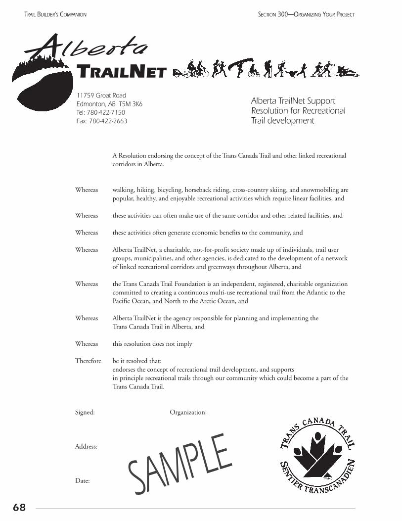
68
SECTION 300—ORGANIZING YOUR PROJECTTRAIL BUILDER’S COMPANION
AlbertaTRAILNET11759 Groat RoadEdmonton, AB T5M 3K6Tel: 780-422-7150 Fax: 780-422-2663
Alberta TrailNet SupportResolution for Recreational Trail development
A Resolution endorsing the concept of the Trans Canada Trail and other linked recreational corridors in Alberta.
Whereas walking, hiking, bicycling, horseback riding, cross-country skiing, and snowmobiling are popular, healthy, and enjoyable recreational activities which require linear facilities, and
Whereas these activities can often make use of the same corridor and other related facilities, and
Whereas these activities often generate economic benefits to the community, and
Whereas Alberta TrailNet, a charitable, not-for-profit society made up of individuals, trail user groups, municipalities, and other agencies, is dedicated to the development of a network of linked recreational corridors and greenways throughout Alberta, and
Whereas the Trans Canada Trail Foundation is an independent, registered, charitable organizationcommitted to creating a continuous multi-use recreational trail from the Atlantic to the Pacific Ocean, and North to the Arctic Ocean, and
Whereas Alberta TrailNet is the agency responsible for planning and implementing the Trans Canada Trail in Alberta, and
Whereas this resolution does not imply
Therefore be it resolved that: endorses the concept of recreational trail development, and supports in principle recreational trails through our community which could become a part of the Trans Canada Trail.
Signed: Organization:
Address:
Date: SAMPLE
69
SECTION 300—ORGANIZING YOUR PROJECT TRAIL BUILDER’S COMPANION
305 Working with the business community
Your committee wants three things frombusiness people.
These can be summarized as:
• moral support
• donations in kind
• cash donations
In exchange, be ready to prominently acknowledgethese partnerships. Remember that these companies arecounting on your positive image!
Business people are opinion leaders in every communi-ty. Find out which people are especially influential and talkto them informally. Ask them which of their friends wouldbe receptive, and perhaps ask them to introduce you.
Look for ways that the company can support your pro-ject without spending much money. This will get theminvolved and may lead to bigger things as you get to knoweach other. Some examples that spring to mind includeputting a display in the front window and advertising thetrail as part of the business’s regular advertising. This rela-tionship might lead to a forum for your ideas, such as aninvitation to a Chamber of Commerce meeting, or space ina company newsletter.
Many companies do not have a budget for donations,but are willing to provide services or materials free or atreduced cost. This often occurs during slow seasons orbetween big jobs. Some industries have regularly scheduledslow periods when the workers or equipment will be avail-able. Ask around and be ready to adapt your schedule.
Some businesses will want to be associated with yourproject, but do not have any relevant skills or materials todonate. In this case, there is nothing wrong with sendingcash! Retail stores and professional offices could well be inthis situation. Have a summary of the budget with you andknow where the money and materials are coming from.
Acknowledgement of partnershipsMost businesses will request acknowledgement for
their contributions beyond a simple letter of thanks. Dowhat you can to accommodate them. Professionalfundraisers set up a scale, indicating the recognition to bereceived for each level of donation. Test this with a fewfriendly managers, then stick to it. Any exceptions cancause ill feeling within the community.
The easiest way to help the donors is to give them a taxreceipt. To do this, though, your group must become a reg-istered charity, a process which can take several years.Municipalities, service clubs, and Alberta TrailNet may beable to write receipts on your behalf. This is covered inmore detail in a sample agreement included on the follow-ing page. Donations given through the Trans Canada TrailFoundation are acknowledged in the Trail Pavilions. A sim-ilar arrangement can be made for local trails. Often, theproject will place an advertisement thanking all sponsors atone time. A variation on this is a special advertisementwhich the newspaper can put together. Contractors whoworked on the project take out ads in which they congratu-late the organization on setting up such a fine trail. Thiscan be especially effective if there are a number of contrac-tors involved.

305.1 Agent’s agreement
70
SECTION 300—ORGANIZING YOUR PROJECTTRAIL BUILDER’S COMPANION
AGREEMENT BETWEEN ALBERTA TRAILNET SOCIETY
AND ___________________________________
DATE:
By way of this agreement, Alberta TrailNet appoints____________________ as its agent to help promote alocal trail network. This project falls under the mandate of Alberta TrailNet which is to support local groupsin their trail-building activities and is subject to approval of the TrailNet Board of Directors and the TrailDevelopment Committee.
Under this agreement,__________________________ may conduct fundraising activities as an agent ofAlberta TrailNet to build a trail system. TrailNet support of this project will be indicated in a conspicuousmanner on promotional and donor request documents. Donations will be made payable to Alberta TrailNetSociety. Alberta TrailNet agrees to maintain direction, control, and supervision over the application of itsfunds to ensure that funds remain separate so Alberta TrailNet’s role will be identifiable.
____________________ will provide budget information for the project consistent with TrailNet’s ThreeYear Plan. TrailNet will open a bank account and establish signing authorities specifically for this project._______________________will arrange bookkeeping, submit financial statements, and reconcile bank state-ments on a monthly basis including a detailed breakdown of revenues (funds raised) and expenditures.TrailNet will keep adequate accounting records to show the relationship between the two organizations. Theseaccounting statements will adhere to policies and procedures set out by the TrailNet Board of Directors andFinancial Planning Committee and the requirements of Revenue Canada, Charities Division.
This agreement may be changed by written agreement of both parties. The agreement may be terminated byeither party serving 30 days written notice and with due consideration given to handling of the funds deposit-ed in TrailNet’s bank account within existing legislation and regulations.
The agreement will be effective ________________ and will remain in effect for a period of one year atwhich time performance will be reviewed and a new term established. Signing authorities for this agreementwill be two representatives of each organization who have authority from the governing body of the respectiveorganization.
Acceptance of the terms and conditions of the agreement is acknowledged by the signatures hereunder.
Signature Name, Address Date
SAMPLE
71
SECTION 300—ORGANIZING YOUR PROJECT TRAIL BUILDER’S COMPANION
306 PublicityA Hollywood manager once said that no publicity is
bad. Perhaps, but for trail proponents, this is not quitethe case. Bad publicity occurs before key stakeholders areinformed of the project and have had time to understandand support it. Be open and honest in all communica-tions.
To avoid untimely publicity, keep initial project dis-cussions with other proponents or stakeholders until theconcept is refined and acceptable to interested parties.These include major resource industries, any landownerswhose property will be needed, senior staff or politicianswith the rural municipality, and the local MLA. Whileabsolute secrecy is not needed, it is not recommendedthat your half-developed proposal grace the front page ofthe local paper.
You need to build trust and garner support withstakeholders. This should be developed as part of anoverall communication strategy. The timely distributionof information in materials is important. Identify keystakeholders, media, government representatives, andother potential audiences.
Any communication effort requires your group toidentify the specific persons or groups that should receiveyour messages. Make sure the method of communicatingis suitable for the intended receiver. For example, if thetarget is the county council, don’t put an ad in the weeklynewspaper. A personal letter to the individual councilorswill be more effective. Some specific target audiences,in the approximate order in which they should be con-tacted, include:
Key decision-makers (POLITICIANS, GOVERNMENT STAFF, PRESIDENTS OF SERVICE CLUBS)
• Use personal communication: letter, telephone,personal visit, lunch
Landowners (ADJACENT FARMERS, ACREAGE OWNERS, MUNICIPALITIES)
• Use personal contact with follow up letter
Potential donors (LOCAL BUSINESS LEADERS, ADMINISTRATORS OF FOUNDATIONS)
• Targeted form letter, followed with a personal contact
Potential volunteers (RECREATION GROUPS, RECREATION PROFESSIONALS, SERVICE CLUBS)
• Notice in club newsletters, personal presentation attheir meetings, poster in outdoor stores
Potential trail users (ACTIVE GENERAL PUBLIC)
• Detailed feature stories in the newspaper or magazines; be a guest on a phone-in radio show.
• Temporary displays in library, high schools, recreation centres
Project supporters (ALL THE CITIZENS OF THE AREA)
• “Soft” news stories on radio and television;photos in newspaper.
• Posters, leaflets, mall display
It is important to periodically review your strategy. Askyourself why you are contacting these people? You must wantthem to do something to help move the trail project ahead.Have you clearly stated what you want them to do? Reviewall public statements from your group with this immediateobjective in mind. Every public awareness piece should havethis “call to action.”
Now is the time to initiate your media relations. Presentthe elements that have general support, while you continuedeveloping the other aspects. Positive media coverage encour-ages the support that allows your organization to grow. Yourcommunication strategy also involves your whole image, notjust the stories carried by the news media. Let this aspect ofyour project grow gradually; a sudden increase in your publicawareness will draw in more resources than the other volun-teers can accommodate.
Throughout this entire program, your group must displaya consistent and professional image. This starts with gettingletterhead, and an answering machine on your group’s ownphone number. (Check for messages daily and answer them!)All letters should be typed; only in very exceptional cases dohandwritten letters have greater impact. Using a computerwill allow easier editing and the ability to personalize formletters. Printed return address labels or a rubber stamp cangive your envelopes a neat appearance at little cost. At the riskof being repetitive, record keeping is important! Make a list ofwhat groups are contacted and the result. This avoids repeatvisits, which can be embarrassing, and gives any person doingfollow-up an idea of what has happened already. Start a set offiles, even if it is just a drawer in someone’s office.
Working with the mediaReporters respond to the same personable approach you
use with your volunteers. Find out and use their name, give
72
SECTION 300—ORGANIZING YOUR PROJECTTRAIL BUILDER’S COMPANION
them a clear idea of what is happening and what you wantthem to do, and give them enough time to fit it into theirschedule. The key when approaching them is to relate totheir mandate for NEWS. Planning a trail is not newsbecause it happens over a long time. Holding a meetingwhere a decision was made is news. Word every request forcoverage in terms of a specific event or happening. The newsthat you generate keeps them in business, so they are willingto help out.
Writing a news releaseEach news release has a few key parts. (This term is
more acceptable to the electronic media than “pressrelease.”) Remember that the purpose is to convey theessence of the announcement as briefly as possible. This isyour chance to distribute key information quickly and easi-ly to all news media in a fair manner. Each release shouldhave a lead with the basic information, and a hook to catchthe reader’s attention.
How to write a dynamic news release:
• Use the organization’s letterhead paper, with name,address, telephone, and FAX numbers
• Start with a descriptive title and the date of release
• Lead off with your name (Acme Trail Club announcesthat on ...)
• Have a brief (five line) description of the event, includ-ing who is doing it, where it is happening, when it
happens, and what people should do
• Follow with a paragraph explaining why this is important
• Include a direct quotation from the most newsworthyperson involved with the event. (Mayor MonicaDickson stated, “This trail will be even better thansliced bread; it won’t go stale.”) If you know the per-son well, you can write the quotation, then checkthat they will “say” this for you. This ensures that thequote fits into the overall release
• Conclude with a background paragraph describingthe mission of the organization. This can, and per-haps should, be the same for all releases
• A contact person for further information or clarifica-tion should be given, with telephone and fax number,and e-mail if possible. This may be different from theperson listed in the body of the release for the gener-al public to contact. Make sure the person will beavailable and knows about the event!
To denote the end of your news release, put “30” cen-tered below the body of the release. The release should beone page in length, or two pages in exceptional cases.Attach any supporting letters, speeches, or advertising, butmake sure they are relevant to the news. Everything impor-tant should be in the body of the release. Many program-mers find it very effective to follow up with a telephone calla couple of days before the event, to jog the reporter’smemory or help set up a photo opportunity.
Notes:
307 Working with electedrepresentatives
When developing a public project such as trails, garneringsupport of elected representatives will be critical. The thought-ful presentation of your ideas could lead to their support inthe long run.
There are three levels of elected officials. They includeMembers of Parliament at the federal level, Members of theLegislative Assembly at the provincial level, and CityCouncillors or Reeves at the municipal level. It is helpful tokeep elected officials updated and even offer personal tours.When communicating with them, keep the trail issue non-partisan and focus on the benefits of trails.
Members of Parliament are responsible for very largeconstituencies. The majority of trail issues do not fall underfederal jurisdictions. For these reasons, MPs may be morepatrons than active supporters. However, you may wish tokeep them informed and invite them to any events that youhave.
Provincial representatives are important to the successof the trail. Trail issues including recreation, health, and landuse are provincial jurisdiction. It may be beneficial to promotethe benefits of trails, the importance of direct investment intrails and mentioning the relatively low cost. (For example, ata cost of $3,000 to $7,000 per kilometre, over 1000 km oftrails can be built for the cost of a single highway overpass.)
Municipal representatives are close to the action andmay be the first to feel the variety of reactions within the com-munity and may act cautiously. A slow and methodicalapproach is best. Municipalities are responsible for roads andparks, and often have equipment and expertise for the projectthat can be valuable non-monetary contributions.
Write a letterHow many times have you been asked to write a letter
for some good cause? Maybe there is something to it.Letters can have a profound effect, especially where there isno policy. For full effect, state your personal opinion sincethis can not be disputed. Ask what is being done to addressthe particular issue. Identify that you are sending a copyto your government representatives and any oppositionmembers responsible for that issue.
Although opinion is the prime ingredient, backgroundinformation is also useful. Talk to employees whose respon-sibilities are related to your situation. They can explain whythe situation is the way it is.
If necessary, contact the organizations or offices of elect-ed officials or for the correct spelling and address of theperson to whom you are writing. Talk to office staff andgauge the interest of the executive assistant.
Briefing sessionChoose a quiet time in the political calendar to give
your elected representative a briefing on the trail. Thiscould be tied in with a milestone or a news item, but doesnot have to be. It is a time to get to know each other andstart to develop a relationship. A simple outline of the pro-ject scope, benefits, and the process for development will besufficient. You can conclude by asking their advice on howbest to proceed and what further information they want.
Don’t be intimidated about asking for an appointment.Elected officials want to understand and stay in touch withthe perspectives of their constituents.
Continuing contactHaving introduced yourself, you have to maintain the
relationship. A follow-up letter of thanks, with a bit ofadditional information you may have promised is a goodidea. Send them copies of letters of endorsement fromother local groups, and any news releases you produce.
73
SECTION 300—ORGANIZING YOUR PROJECT TRAIL BUILDER’S COMPANION
RITE telephone lineYou can telephone any provincial government
office in Alberta toll-free. Just dial 310-0000 and wait for the electronic
operator to give instructions.

74
SECTION 300—ORGANIZING YOUR PROJECTTRAIL BUILDER’S COMPANION
Notes:
308 Financial matters
Project budgetA trail project will require outlays of engineering,
design, land, permitting, material, labour, and equipment.Some or part of these items could be donated or accom-plished by volunteers while the balance will require fundingto cover the cost. A budget should be drafted to account forall of the outlays and their corresponding source. The bud-get should be realistic and all items identified. It will be thekey element of the plan against which the project scope,cost, and schedule can be measured and controlled. Thebudget will also be necessary to support applications formonetary and in-kind donations.
Project accountingThe trail sponsor should set up a bank account for
the project to handle revenues and expenditures. Thesponsor should appoint a treasurer or financial person tomanage the bank account. The treasurer should accountfor all revenues and expenditures and keep a running bal-ance that can be reconciled with the bank statement peri-odically. The treasurer should be part of the approvalprocess for work orders for all project outlays to ensureadequate funds are available. When invoices are submit-ted for work on the trail, it is good practice to first havethese approved by the person authorizing the work, thenpay with a cheque that requires two signatures. The trea-surer should submit an accounting statement, comparingactual transactions with the budget, to the trail sponsorcommittee on a regular basis. This report will allow thedirectors to understand the financial health of the projectand will allow informed participation in any decisions tocontrol and prioritize spending.
Arranging fundingThis section deals with the role that Alberta TrailNet
can take in acknowledging local donations and administer-ing funds requested from the Trans Canada TrailFoundation. Fundraising sources and techniques are dis-cussed in Section 309.
Obtaining donations for trail projects may be facilitatedif the support provided, whether the support is monetaryor in-kind services, is acknowledged with a receipt for thepurposes of obtaining an income tax credit. If the trailsponsor is a registered charity, it should familiarize itselfwith the proper Revenue Canada procedures for handlingincome tax receipts. If it is not a registered charity, anarrangement may be made with Alberta TrailNet Societywhereby it administers the activities of the sponsor as anappointed agent or representative. Such an arrangementwould be established under a formal agreement. A typicalagreement is included in Section 305.1.
If the trail project is to be dedicated as part of the TransCanada Trail, partial funding may be provided upon appli-cation to, and approval by, Alberta TrailNet. These fundsoriginate from Albertans who support the TCT through itsmetre sales promotion or matching provincial lottery dol-lars. The trail sponsor would submit its proposal to AlbertaTrailNet as outlined in Section 103. In order to ensure afair distribution of available funds to all TCT projectsthroughout Alberta, a guideline has been developed thatwould allocate these based on construction complexity.This guideline is outlined in Section 308.1.
75
SECTION 300—ORGANIZING YOUR PROJECT TRAIL BUILDER’S COMPANION
308.1 Trans Canada Trail funding guideline
Objectives of the guideline
• To provide an equitable distribution of TCTF fundingto all Trans Canada Trail land trail projects in Alberta.
• To establish a maximum level of funding appropriateto construction complexity and within the limits ofexpected contributions to the TCTF
Estimated funds availableThe amount of available funding is estimated by
extrapolating the current contributions to the end of theyear 2000. A trend factor would be applied to future esti-mates to reflect any changes observed in current contri-butions over those of prior years. Funds available will beadjusted quarterly, based on TCTF updates on donationsand provincial lottery dollars. The total will be calculatedby subtracting TCTF administrative costs, to-date pro-ject expenditures, and trail registration advances fromcontributions.
Trail categoriesFour categories of trail are used to reflect construction
complexity and cost. These are existing but unregisteredtrails, and three types of new trails reflecting easy, medium,and difficult construction requirements. The amountsbeing recommended as of April 2000 are included inSection 106.
ProcessA funding factor would be calculated by dividing the
projected available funds by total length of trail, each seg-ment of which would be weighted according to its con-struction complexity.
When a trail proposal is presented for approval to theTrail Development Committee, it would be evaluated andcategorized. Maximum allowable funding would be calcu-lated by multiplying the length of trail by its categoryweighting.
Guideline merits
• Each project will receive a share of the total revenue.The “early bird getting the worm” scenario is reduced,and later applications will be assured of receivingsome funding.
• The amount received will be proportional to the pro-ject’s complexity.
• The funding factor may be easily adjusted in theevent available fund estimates or category weightingschange or another weighting factor is introduced.
• The process is self-correcting, gradually leading to aclosing of the account as the trail is completed
Submitted by Trail Development Committee andResolved by the Alberta TrailNet Board of DirectorsSeptember 12, 1998
76
SECTION 300—ORGANIZING YOUR PROJECTTRAIL BUILDER’S COMPANION
309 FundraisingThe trail will require resources for both construc-
tion and operation. The word “resources” is usedintentionally because donations of materials, equipment,time, and labour can all have a significant impact onyour budget. In fact, many projects proceed with justdonations “in-kind.”
Some of this must be found before construction begins,although phasing will allow the project to begin before allthe resources are in place. Construction money will be theeasiest to find because everyone likes to attend openingsand have their photo taken with the dignitaries. The ongo-ing expenses of running a trail are less glamourous, and willbe harder to acquire. Go to dependable organizations forthis, such as service clubs and municipalities. Even largecorporations will change policies from time to time, andyour trail may get dropped.
When looking for support, you have severalresources of your own which will make the job easier.
• provincial and national commitments which give yourproject some context and credibility
• letters of endorsement from local groups and individuals
• well thought out plan outlining the project (whatever stage it is at)
• detailed list of materials and services which you require
Knowing exactly what you need and how it will beused is the first requirement, but there is more. Anypotential donor needs to be assured that your project willmake them look good. Demonstrate credibility any wayyou can. This is through professional brochures, endorse-ments from prominent citizens, and showing how otherimportant donors have already joined the project.
If your project will be part of the Trans Canada Trail,this is easier. With national sponsors such as ChryslerCanada, Canada Trust, TSN, and Macleans, it hasbecome a recognized organization. Show how your trailwill connect to the TCT.
Approaching a potential supporterWhen approaching a company, try to show how the
trail fits into their corporate goals or image. This will beeasy with recreation or construction companies. Otherbusinesses may prove more difficult, so be ready withyour ideas for recognizing their contributions. Warm,fuzzy feelings don’t go far these days; companies want tosee newspaper articles, television stories, and prominent,
permanent signs. At the same time, keep the size of thedonation in perspective. You need the money for con-struction, not just recognition.
If you focus on local companies, you will find manyimportant contacts within your committee. Ask committeemembers to approach friends of friends, and you will bewell on your way.
Establish relationships with the various levels of gov-ernment departments whose mandates touch on yourinterests. Your project can help to move forward some oftheir interests such as promoting healthy and active liv-ing, to increasing access to recreational trails.
Agricultural societies provide recreation in rural areas.This usually means fairs and curling rinks, but could beextended to local trails. The tourism industry, in particu-lar the restaurant and hotel segment, benefits from facili-ties managed by not-for-profit societies. Trails are includ-ed in the “attractions” which tourists visit. To date, thesecompanies have not contributed to the costs of supplyingthese attractions. Talk to them, and perhaps the localtourist association or Chamber of Commerce will sponsorthe trail.
Often, your project can be tied in with existing agencyprojects, and both groups can gain. Highway renovation con-tracts can be extended to include a nearby pathway, and thehighway will become safer, too. Alberta TrailNet believes thatnew highway bridges should provide for pedestrian and bicy-cle traffic both next to the roadway and under both ends ofthe bridge. Often the municipal planners can alert you toupcoming projects, so your plans can be ready.
77
SECTION 300—ORGANIZING YOUR PROJECT TRAIL BUILDER’S COMPANION
In-kind Donatons
Providing materials and/or services instead of money.
eg. use of equipment; equipment operators time
Wordof theday
General fundraising has some special values beyond the actual dollar value:
• enables people to personally “buy into” the project
• can be leveraged by matching it with other grants
• gives increased independence from a major sponsor’s pressure
• demonstrates the broad public support
Funding organizationsThe Business Information Guide is a full listing of all
organizations that provide funding and grants. The infor-mation is presented in electronic format, and may beavailable through some municipal community servicesdepartments or at major libraries.
Each donor has a specific mandate. Read theirbrochures and emphasize the aspects of your project thatmatch them. Follow the application form directions!Each organization is used to a particular format.However, all of them share some characteristics. Theylike to see that other groups are involved, so show whichorganizations are being asked to contribute. (List them as“applied for” in the proposal, then up-date to “commit-ted” when they approve the request.) They prefer projectsrather than on going expenses, but they are often recep-tive to contributing to each of several well-defined phas-es. They have grown accustomed to receiving poorrecognition and final reports. Give them a pleasant sur-prise and they may well remember your project whenPhase II comes along.
Funding organization suggestions:
• Action 21
• Local Lottery Boards
• Local community foundations
• Alberta Sport, Recreation, Parks and Wildlife Foundation
• Wild Rose Foundation
• Trans Canada Trail Foundation
• Canada Trust Friends of the Environment
• Shell Environmental Fund
• Eco Trust
• Federal and provincial employment programs
Notes:
78
SECTION 300—ORGANIZING YOUR PROJECTTRAIL BUILDER’S COMPANION
Section 400 Trail Design

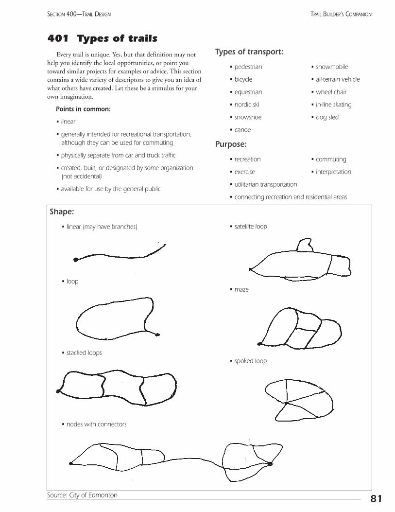
401 Types of trailsEvery trail is unique. Yes, but that definition may not
help you identify the local opportunities, or point youtoward similar projects for examples or advice. This sectioncontains a wide variety of descriptors to give you an idea ofwhat others have created. Let these be a stimulus for yourown imagination.
Points in common:
• linear
• generally intended for recreational transportation,although they can be used for commuting
• physically separate from car and truck traffic
• created, built, or designated by some organization(not accidental)
• available for use by the general public
Shape:
• linear (may have branches)
• loop
• stacked loops
• nodes with connectors
Types of transport:
• pedestrian • snowmobile
• bicycle • all-terrain vehicle
• equestrian • wheel chair
• nordic ski • in-line skating
• snowshoe • dog sled
• canoe
Purpose:
• recreation • commuting
• exercise • interpretation
• utilitarian transportation
• connecting recreation and residential areas
• satellite loop
• maze
• spoked loop
81
SECTION 400—TRAIL DESIGN TRAIL BUILDER’S COMPANION
Source: City of Edmonton
Types of bikeways(as defined by the City of Edmonton)
Class I Path with its own right-of-way, specificallydesigned for cyclists and pedestrians.
Class II Physically delineated (by paint or physical barrier) portion of an existing roadway, designed for the exclusive or preferential use of bicycles.
Class III Signed cycling routes utilizing existing roadways, where cyclists share the roadway with other types of traffic.
Types of materials
• asphalt • concrete
• shale • crusher fines
• earth • earth with stabilizing chemical
• wood chips • snow
• corduroy • boardwalk or planks
• asphalt millings • water
• gravel • parallel soft and hard surface trails
Level of Difficulty
• Sidewalk
• Urban pathway
• Rural trail (along existing road or former rail line)
• Natural park trail
• Backcountry trail
• Wilderness route
Other possibilities
(no known local examples)
• Skating trails on frozen waterways, popular on theRideau Canal in Ottawa, and in Holland
• Temporary trails, similar to car rallies or orienteering courses
Notes:
82
SECTION 400—TRAIL DESIGNTRAIL BUILDER’S COMPANION
Source: City of Edmonton
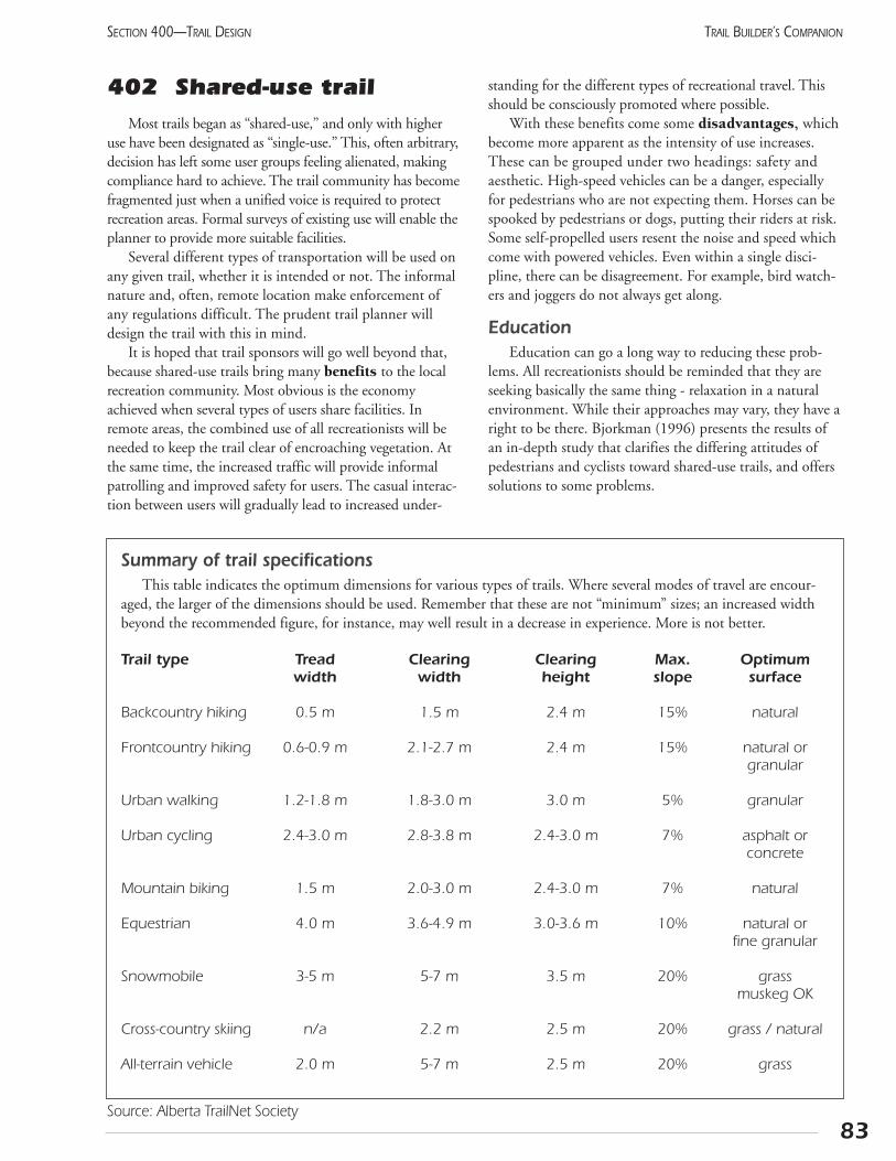
402 Shared-use trailMost trails began as “shared-use,” and only with higher
use have been designated as “single-use.” This, often arbitrary,decision has left some user groups feeling alienated, makingcompliance hard to achieve. The trail community has becomefragmented just when a unified voice is required to protectrecreation areas. Formal surveys of existing use will enable theplanner to provide more suitable facilities.
Several different types of transportation will be used onany given trail, whether it is intended or not. The informalnature and, often, remote location make enforcement ofany regulations difficult. The prudent trail planner willdesign the trail with this in mind.
It is hoped that trail sponsors will go well beyond that,because shared-use trails bring many benefits to the localrecreation community. Most obvious is the economyachieved when several types of users share facilities. Inremote areas, the combined use of all recreationists will beneeded to keep the trail clear of encroaching vegetation. Atthe same time, the increased traffic will provide informalpatrolling and improved safety for users. The casual interac-tion between users will gradually lead to increased under-
standing for the different types of recreational travel. Thisshould be consciously promoted where possible.
With these benefits come some disadvantages, whichbecome more apparent as the intensity of use increases.These can be grouped under two headings: safety andaesthetic. High-speed vehicles can be a danger, especiallyfor pedestrians who are not expecting them. Horses can bespooked by pedestrians or dogs, putting their riders at risk.Some self-propelled users resent the noise and speed whichcome with powered vehicles. Even within a single disci-pline, there can be disagreement. For example, bird watch-ers and joggers do not always get along.
EducationEducation can go a long way to reducing these prob-
lems. All recreationists should be reminded that they areseeking basically the same thing - relaxation in a naturalenvironment. While their approaches may vary, they have aright to be there. Bjorkman (1996) presents the results ofan in-depth study that clarifies the differing attitudes ofpedestrians and cyclists toward shared-use trails, and offerssolutions to some problems.
83
SECTION 400—TRAIL DESIGN TRAIL BUILDER’S COMPANION
Summary of trail specificationsThis table indicates the optimum dimensions for various types of trails. Where several modes of travel are encour-
aged, the larger of the dimensions should be used. Remember that these are not “minimum” sizes; an increased widthbeyond the recommended figure, for instance, may well result in a decrease in experience. More is not better.
Trail type Tread Clearing Clearing Max. Optimumwidth width height slope surface
Backcountry hiking 0.5 m 1.5 m 2.4 m 15% natural
Frontcountry hiking 0.6-0.9 m 2.1-2.7 m 2.4 m 15% natural orgranular
Urban walking 1.2-1.8 m 1.8-3.0 m 3.0 m 5% granular
Urban cycling 2.4-3.0 m 2.8-3.8 m 2.4-3.0 m 7% asphalt orconcrete
Mountain biking 1.5 m 2.0-3.0 m 2.4-3.0 m 7% natural
Equestrian 4.0 m 3.6-4.9 m 3.0-3.6 m 10% natural orfine granular
Snowmobile 3-5 m 5-7 m 3.5 m 20% grassmuskeg OK
Cross-country skiing n/a 2.2 m 2.5 m 20% grass / natural
All-terrain vehicle 2.0 m 5-7 m 2.5 m 20% grass
Source: Alberta TrailNet Society
84
SECTION 400—TRAIL DESIGNTRAIL BUILDER’S COMPANION
Shared-use trails should always be identified as such,with the approved types of travel listed. These signsshould also indicate the preferred action when meetingothers on the trail. If some modes are not allowed, thelocations of suitable nearby trails should be shown. Apositive name should stress the multi-use aspect, i.e.,pathway not bikeway.
Trail design can really reduce problems. People usingfaster modes of travel prefer straighter trails, with fewerhills and smoother tread. At the same time, these condi-tions encourage speed, with the resulting hazard for fellowrecreationists. Where possible, use broad curves to keep thespeed down. Try reducing the clearing width before a curveto slow the vehicles, while increasing the clearing in thecurve to improve the sight lines. Traffic signs will be neededif vehicles are allowed.
Many new designs look good on paper, but don’t workquite the way the planner expected. Consider installing atemporary version, perhaps using just signs and movablebarriers, before committing to a full installation.
Have destinations or rest areas along the trail locatedwithin an easy distance of each other, so fast travel willnot be needed. Loops should not be longer than a relaxedday’s travel.
Where certain modes of travel are not allowed, ensurethat portions of the trail cannot physically allow them.Frequent stairs will limit traffic to pedestrians, narrowwinding trails will not allow powered recreation vehicles,and long straight trails with no services will discouragepedestrians.
Areas with low recreational use will have few prob-lems. The users are glad to see someone else on the trail.On the other hand, areas of high use will generally havesingle-use trails for each user group. It is mainly the areaswith intermediate levels of use that encounter problems.Trails may be widened to meet increased demand whilenot significantly increasing the maintenance costs.Separate trails should be considered when wide trails willnot provide the desired experience, or when incompatibleuses occur frequently.
Even within congested sites, the difficulties may well beconcentrated near the trailhead where the slower users aremore likely to be. Where this occurs, the trail manager isencouraged to develop shorter loops intended for pedestri-ans, cross-country skiers, and perhaps mountain bikers.These should connect to the longer trail about 5-10 kmfrom the trailhead, giving the stronger hikers and skiersaccess to the full network.
Notes:
403 PedestrianFootpaths have led travellers around the world for
thousands of years. They imply a level of social structure,which involves repeated journeys between the sameplaces. Whether developed for trade, seasonal move-ments, or other purposes, every culture has used foot-paths. They connect destinations and are not created byrandom wandering.
Pedestrians have rather modest requirements. The right-of-way can be as narrow as one or two metres, although sixto ten metres is more common. The slope can be substan-tial, even involving stairs. The construction standard tendsto be fairly basic. For example, bridges can be as simple asstepping stones or logs with flattened tops. This down-to-earth process puts the trail in close harmony with the earthand the user in touch with the environment, as perhaps noother mode of travel can.
Trail-building as stewardshipOne definitive work on the hand-building of trails has
been written by the Student Conservation Association.This book, titled Lightly on the Land, brings together thecollective experience of dozens of trail builders working inall terrains found in the United States. It discusses everyaspect of construction and maintenance, from how to lift arock, to the finer points of sharpening tools. Every serioustrail person will want a copy, and will find themselvesbrowsing through it regularly.
Pervading this book is a sense that building trails is partof stewardship. More than allowing access, it controlsaccess. It determines where the visitor will go, how far theywill go, and indeed, which visitors will have any access atall. Beyond the trail itself is the surrounding landscape, andthis book reminds the workers of their responsibility to gobeyond the right-of-way to remedy nearby problems. Thisis not presented as a mandate to “tame the wilderness.”Rather, it encourages a restoration of natural conditionswhere they have been disrupted.
The narrow tread required for foot traffic allows theroute to wind between trees and other possible obstruc-tions. For much of the distance, the only work required isto clear deadfall and smooth the tread.
MarkersBecause of their relatively small “footprint,” walking
paths often need markers to confirm the route. Officialmarkers can be attached to metal or fibreglass posts everykilometre or so. If metal or plastic tags are attached to trees,screws should be used rather than nails. Never hack a blazeinto a tree with an axe! This has not been acceptable prac-tice for many years.
The Appalachian Trail has developed a time-testedmethod that has been adopted by the Bruce Trail inOntario. White bars, or blazes, are painted on tree trunksor other features at regular intervals. These are vertical rec-tangles, 5 cm wide and 20 cm high. A template can be usedto ensure the size stays consistent. Care must be taken tohave them visible when using the trail in either direction.Two blazes, one above the other, indicates a sharp change indirection. The next blaze must be visible from that point.The marks must be touched up every year or two as treesfall down and bark flakes off. Alternate routes and sidetrails use the same system, but with light blue paint. Thismethod is both efficient and inexpensive. If the routemoves, cover the marks with bark-coloured paint.
Tiptoe through the tulips,but stride through the canola
Many European footpaths continue right through thecultivated fields. The right-of-way, whether determinedthrough long tradition or by agreement with the farmer, isre-established each spring. The farmer plants the entirefield as usual.
Shortly after the crop has germinated, a narrow stripis cultivated, leading to the trail heads on each side of thefield. All summer, hikers pass through a growing greentunnel. In the fall, the crop is harvested as usual. Thisnon-traditional trail offers opportunities for agriculturalinterpretation, as well as cooperation between recreation-ists and farmers.
Keep this option in mind when speaking with farmers.It could be used, for example, where a public roadallowance or abandoned rail right-of-way is already beingfarmed. This style of trail would allow the farmer to contin-ue to use the right-of-way, while allowing recreationistsaccess as well.
A variation of this became popular as farmers cut mazesinto their fields of maize. The admission that they chargepeople exceeds the return from the crop itself.
85
SECTION 400—TRAIL DESIGN TRAIL BUILDER’S COMPANION

86
SECTION 400—TRAIL DESIGNTRAIL BUILDER’S COMPANION
Notes:
404 Cross-country ski trailsCross-country skiing, or nordic skiing, first came to the
attention of Alberta’s outdoors crowd in the late sixties. Thesteady rhythm, albeit with rather heart-pounding exercise,and non-commercial atmosphere was welcomed by manyAlbertans. Over the next 30 years, the numbers have growndramatically with a corresponding broadening of the partici-pants’ interests. Once, a simple track through the forest,slightly drifted over, was all anyone could wish for. Now,nordic ski centres provide daily track-setting as well as thebroader “skating” tracks. Those skiers still sporting three-pin bindings are paternalistically known as “granolas.”
PlanningTouring skiers are probably as numerous as they ever
have been, but they can be overshadowed by people withracing skis. So, this brings up the first questions to askwhen planning ski trails. Which style (or combination)would be most appropriate for your site, and which wouldthe clients want to use most?
Natural areas, with few nearby residents, would find thetraditional nordic trail with only a minimum of track-set-ting to be suitable. This is in keeping with the restrictedoperations budget for most Alberta parks. Resort managers,who need to attract more affluent customers, may choosemore intensive track-setting and the skating mode. On theother hand, some winter resorts have lengthened their sea-son by catering to mountain bikers in the summer.
Those trail groups which hope to attract cross-countryski races are advised to seek professional designers. The skiracing associations specify the distance, grade, and totalchange in elevation that can be allowed. Skating tracks willbe essential and viewing areas will be recommended.
Less formal trails can easily be developed by local peo-ple. In many cases, existing trails can be adapted to ski-usesimply by putting up trail markers and setting a track. Ingeneral, abandoned roads will have suitable grades and turnradius for skiers, but may lack interest. Single-track trailsused by intermediate cyclists may also be suitable, butremember that bicycles have brakes. Even a modest slopecan be terrifying if it is too long.
Ski centres traditionally have trail layouts based on the“stacked loop” geometry (Section 401). In some areas, theski centres are becoming close enough to develop a “nodeand connector” approach. The installation of a small con-nector gives the stronger skiers access to a much widerrange of trails with only a small investment. Thoughtfuldesign of the trailhead will ensure that the majority of userswill travel in the same direction, reducing the chance ofcollision. Preferably, the steeper downhills will occur wherethe trail is widest.
Regardless of the style of skiing, the increased numberof participants means the facilities must be more profes-
sional. Parking lots, toilets, and warm-up areas should beconsidered essential. Access to electricity will be a real asset.Maps and brochures will be needed for all but the simplestof trail systems.
DevelopmentThe type and intensity of development will depend on
the proposed clientele. “Skaters” need significantly widertracks, while telemark skiers enjoy long, open, and steepslopes. Snowmaking is used in some resorts, and snow caneven be imported and spread on isolated bare spots.Banking turns can improve safety. Vegetation managementplays a critical role in areas with marginal snowfall. Refer toSection 508 for details.
Install trail markers as high as possible to improve theirvisibility when snow “raises” the ground, and to reducevandalism. If markers will be left out year-round, attachthem to trees with screws, not nails. Every year or two,loosen the screws a bit to allow the tree room to grow.(Aside from helping the tree, this prevents the markersfrom being crushed by the tree.)
Keep in mind the possibility of future expansion. A larg-er parking lot may be needed in a few years. The opportuni-ty to eventually connect with other ski areas is also a goodoption.
Maintenance
• Pre-season grooming, with removal of fallen trees andany exposed stumps.
• Mowing the track will enable earlier skiing, and maybe essential in areas with marginal snow cover.
• Track-setting: Generally, it will be best to have some-one familiar with snowmobiles do the track-setting. Itis easier and safer to teach a snowmobile rider whatskiers want to use than it is to teach a skier how tocontrol a machine that they don’t enjoy.
• For intensive ski areas, night grooming gives betterresults because the snow has a chance to bond in thenew position, and few skiers will be encountered bythe grooming machine. Smaller centres, where theuse is focused on the weekends, do not need toworry about this. Even so, they may wish to formallyclose each trail as it is being groomed.
• Some means of receiving feedback from users is essential to enable quick response to trail problems. A fallen tree is just a nuisance to a hiker, but can be alife-threatening problem for a skier. Ensure that all staffand volunteers can access the maintenance crewquickly. If this is not possible, they should have theauthority to close the trail until the problem is resolved.
87
SECTION 400—TRAIL DESIGN TRAIL BUILDER’S COMPANION
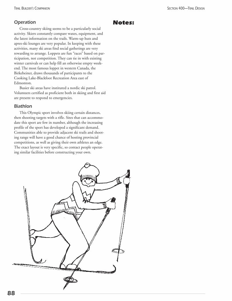
OperationCross-country skiing seems to be a particularly social
activity. Skiers constantly compare waxes, equipment, andthe latest information on the trails. Warm-up huts andapres-ski lounges are very popular. In keeping with theseactivities, many ski areas find social gatherings are veryrewarding to arrange. Loppets are fun “races” based on par-ticipation, not competition. They can tie in with existingwinter carnivals or can help fill an otherwise empty week-end. The most famous loppet in western Canada, theBirkebeiner, draws thousands of participants to theCooking Lake-Blackfoot Recreation Area east ofEdmonton.
Busier ski areas have instituted a nordic ski patrol.Volunteers certified as proficient both in skiing and first aidare present to respond to emergencies.
BiathlonThis Olympic sport involves skiing certain distances,
then shooting targets with a rifle. Sites that can accommo-date this sport are few in number, although the increasingprofile of the sport has developed a significant demand.Communities able to provide adjacent ski trails and shoot-ing range will have a good chance of hosting provincialcompetitions, as well as giving their own athletes an edge.The exact layout is very specific, so contact people operat-ing similar facilities before constructing your own.
Notes:
88
SECTION 400—TRAIL DESIGNTRAIL BUILDER’S COMPANION
405 Snowmobile trailsNew snowmobiles are more reliable than the older mod-
els. Riders are taking advantage of this by going on longerexcursions. Day trips of 100-200 km are common, and multi-day trips are rapidly growing in popularity. To meet thisdemand, northern Alberta clubs are developing an intercon-nected network of trails between most major communities.
The Alberta Snowmobile Association is the majorplayer in this program, and should be consulted if you areconsidering this type of trail. This organization has pub-lished a manual dealing specifically with snowmobile trails,and you are encouraged to study this as well.
The large number of cutlines makes it possible to travelalmost anywhere in northern Alberta during the winter.Why would anyone bother with organized trails?
Good reasons for snowmobilers to use trails:
• safety: other users can lend assistance; trails avoidfences and water crossings
• socializing: interaction with others is an important partof this sport
• comfort: grooming makes a better trail
• long distance experience: clearing, signs, and groomingmake touring possible
• reduced impact on wildlife, compared to random travel
Perhaps more than other types of trails, the snowmobiletrail depends on the level of maintenance available. Theclub can put a lot of work into clearing, stump removal, andsigning, but if the trail is not groomed regularly, the riders willhead off the trail into the forest. Grooming equipment mustbe large to deal with the distances and rough work involved inkeeping the track smooth. The capital investment needed forthis machine is comparable to that of the trail construction.In some ways, the grooming is actually creating the trail, justas putting down shale creates a bicycle trail.
The endless cutlines provide a base for a trail system,but these need careful consideration before being designat-ed. These often pass over muskeg or water bodies, which
are impassable in the summer. Alberta TrailNet encouragessnowmobile clubs to involve other recreationists in the traildevelopment, so as to build a year-round facility. A littleplanning can often allow all-terrain vehicles, horseback rid-ers, and hikers to enjoy the route as well. Make your trails areal community project.
Key points to remember:
• the parking lot at staging area should use a pull-through parking arrangement and have room for expansion
• have winterized toilet facilities at trailhead, as well asalong the route
• designate a nearby open area of about 100-160 acresfor random “playing”
• have a short warm-up trail of about 5 km to test themachines. Medium length trails (15-50 km) will bewelcomed by some users
• put bridges over streams to allow a longer season, aswell as summer use
• choose the route to give a variety of experiences:don’t use the shortest line
• design trails to encourage one-way traffic, but do notpost this requirement. Riders should be alert formachines coming the other way
• keep trails wide enough for two-way traffic (>5 m),especially near the tops of hills
• groups with sites in low-snow areas must take particu-lar care in removing stumps and stones. Summer-onlyroads may be especially useful in these areas
• check the trail for deadfall or other problems in latesummer, well before snowfall
• avoid intersections with roads. Where these are neces-sary, ensure that they meet at 90 degrees, visibility isgood for both riders and motorists, and the intersec-tion is well signed
Ensure that the cleared portion of the right-of-way iseasily distinguished from the adjacent tree-less but stumpyland. You may need to flag some places until the wintertrail is worn in. In a few years, saplings will have grown upnext to the trail, and it will be obvious.
Right now, the growth of touring as a viable activity islimited by access to food and lodging when travelling witha snowmobile. Many towns prohibit snow machine usewithin the urban area, so the riders cannot reach the facili-ties. Whitecourt has designated corridors to allow touringriders to reach the services, and business is booming!
89
SECTION 400—TRAIL DESIGN TRAIL BUILDER’S COMPANION
Contact: Executive Director, ASA
(780) 453-8668.

90
SECTION 400—TRAIL DESIGNTRAIL BUILDER’S COMPANION
Notes:
406 Equestrian trailsTrails intended for equestrian use must have certain
facilities or they will not be used. The following featureshave been recommended by the Alberta EquestrianFederation (see reference list). People interested in develop-ing equestrian trails or shared-use trails welcoming horseuse, are encouraged to visit Little Elbow District ofKananaskis Country, which presents an excellent exampleof coordinated equestrian facilities. When your project iscomplete, be sure to register it with the Federation. Thiswill ensure your trail gets well advertised.
Trail:
• Horses can travel 20-50 km per day, so allow plenty ofdistance. Overnight riders should be encouraged tohead directly to the backcountry where they will notencounter many hikers or cyclists. The shorter day-usetrails will be used more intensively, making single-usemore practical.
• The surface should be regular, without holes.Pavement is dangerously slippery for horses. Shortgrass and dirt are ideal materials. Long grass can hideholes or irregularities. Wood chips are nice, but diffi-cult to maintain as they blow away.
• Clearing width should be 2.5 m, with a tread of 0.5-1.0m. Branches should be cleared to a height of 3.0 m.
• The grade should be up to 10%. Maximum sustainedgrade is 15% with short pitches of up to 20%.
• Snowmobile trails have similar lengths and clearingwidths. Talk with your local snowmobile club to see iftheir trails can be adapted for summer use. Perhapsrerouting around some muskeg or a small lake willmake it horse-friendly.
Trailhead:
• Parking lot large enough to turn a truck and horsetrailer (or a pull-through arrangement).
• Several tie rails at least 10 metres apart
• Separate waste receptacles for horse manure, or asign asking riders to remove it.
• If the trail has shared-use, a sign indicating howcyclists and pedestrians should behave near horses.
• Loading ramps are optional; most horses are used todoing without.
• Agricultural grounds often make excellent trail-heads, especially when they already have a devel-oped campsite.
Water:
• Should be located every 15-20 km (not necessarilyright at the trailhead).
• Public troughs are not good. All riders should watertheir horses from their own pail.
Food:
• Horses on trail rides are usually fed at the campsite.Grazing is not needed, either along the trail or at thecampsite, if riders are required to pack in all their ownfood. Compressed cubes of hay are widely available,and should be purchased prior to a trip.
• Many organizations managing equestrian trailsthrough natural landscapes are requiring certifiedweed-free fodder be used throughout the trip, andfor 36 hours before beginning.
Accommodation:
• Campsite similar to that used by hikers and cyclists.
• Shelter for horses: windbreak, trees, valley.
• Several tie rails, separated by 10 m and located 50 mdownwind from people camping spaces.
• Compost bins near tie rails, with fork and rake forclean-up.
Information:
• Map of trails
• General management practices on the trail (Code of Conduct).
• Details about any nearby “Bales and Breakfast” opportunities.
• Location and phone number of nearest farrier and veterinarian.
• Recommended equipment specific to location (horse boots, fly spray, etc.).
• Address of Alberta Equestrian Federation to get more general backcountry tips.
Sharing the trail:Trail riders almost always use their own horses and
can control them. The horse’s behaviour can be predict-ed, so they can share the trails with other users if a fewsimple points are kept in mind. All users must be respect-ful of each other. This includes explaining what behav-iour is appropriate when dealing with horses. Respectalso means cleaning up after your animal around the
91
SECTION 400—TRAIL DESIGN TRAIL BUILDER’S COMPANION
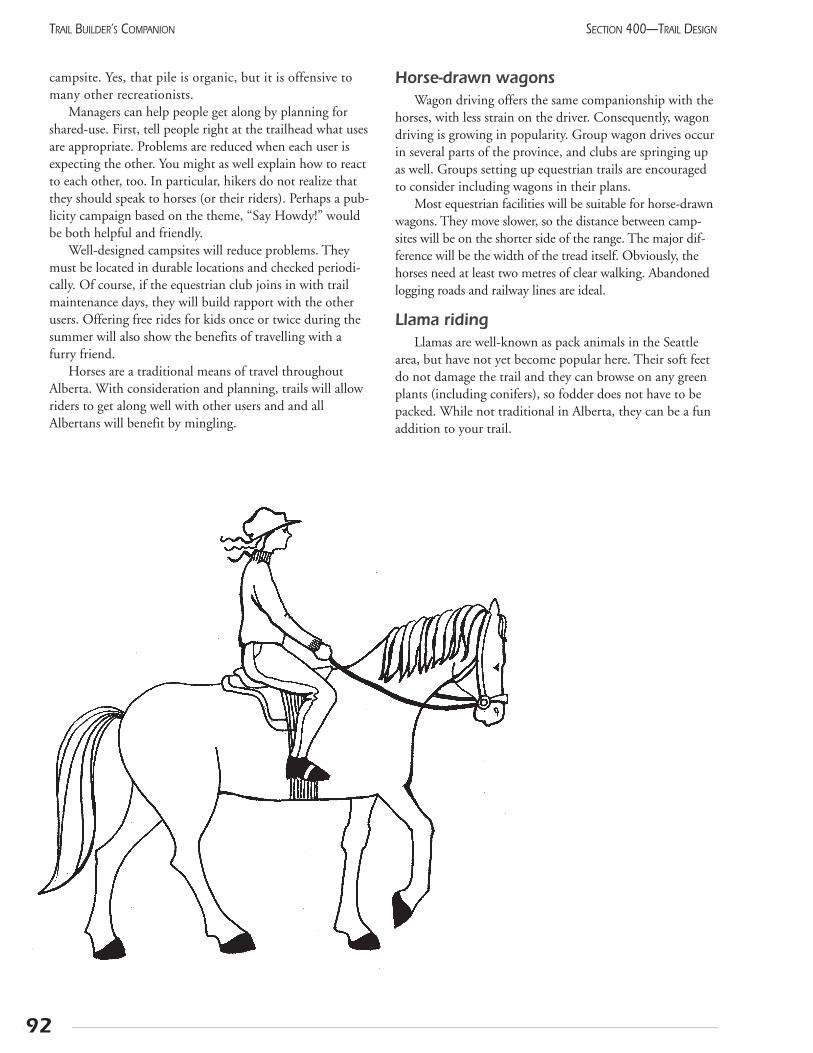
campsite. Yes, that pile is organic, but it is offensive tomany other recreationists.
Managers can help people get along by planning forshared-use. First, tell people right at the trailhead what usesare appropriate. Problems are reduced when each user isexpecting the other. You might as well explain how to reactto each other, too. In particular, hikers do not realize thatthey should speak to horses (or their riders). Perhaps a pub-licity campaign based on the theme, “Say Howdy!” wouldbe both helpful and friendly.
Well-designed campsites will reduce problems. Theymust be located in durable locations and checked periodi-cally. Of course, if the equestrian club joins in with trailmaintenance days, they will build rapport with the otherusers. Offering free rides for kids once or twice during thesummer will also show the benefits of travelling with afurry friend.
Horses are a traditional means of travel throughoutAlberta. With consideration and planning, trails will allowriders to get along well with other users and and allAlbertans will benefit by mingling.
Horse-drawn wagonsWagon driving offers the same companionship with the
horses, with less strain on the driver. Consequently, wagondriving is growing in popularity. Group wagon drives occurin several parts of the province, and clubs are springing upas well. Groups setting up equestrian trails are encouragedto consider including wagons in their plans.
Most equestrian facilities will be suitable for horse-drawnwagons. They move slower, so the distance between camp-sites will be on the shorter side of the range. The major dif-ference will be the width of the tread itself. Obviously, thehorses need at least two metres of clear walking. Abandonedlogging roads and railway lines are ideal.
Llama ridingLlamas are well-known as pack animals in the Seattle
area, but have not yet become popular here. Their soft feetdo not damage the trail and they can browse on any greenplants (including conifers), so fodder does not have to bepacked. While not traditional in Alberta, they can be a funaddition to your trail.
92
SECTION 400—TRAIL DESIGNTRAIL BUILDER’S COMPANION
407 Bicycle trailsRecreational cycling covers a wide range of interests,
from long-distance road riding to what appears to be rockclimbing on wheels. This manual deals with the less techni-cal types of off-road cycling. Within this field, two generaltypes of trails are recognized: double track and single track.These terms can be used to describe the trails and will helpprevent inappropriate use.
Double-track routes consist mainly of abandonedroads, and have gentle grades, good visibility, and a widetread. Rail trails, although somewhat narrower, are general-ly in this category. These provide interesting opportunitiesfor novices, with the main challenge being the distanceinvolved. On the other hand, single-track bike routes gen-erally resemble hiking trails and can present substantialchallenges for the cyclist. Even what appears to a pedestrianto be relatively minor rutting can cause pedals to catch withawkward results.
The principles that guide the development of bicycletrails are the same as for other trails, but the particularcharacteristics of bicycles require special considerations.Broad and straight trails that might be boring for pedes-trians are often suitable for cyclists interested in touring.This brings an appropriate use for informal roads that areno longer needed, and may significantly reduce the recla-mation costs for the resource company. The bicycle’slonger range gives it access to more distant locations,enabling cyclists to access developed hostel or B&B net-works.
A growing number of cyclists are interested in theexcitement of single-track riding. These riders enjoy morerugged trails, which can put them in competition with hik-ers. At low frequency, the two types of users co-exist well,especially if signs at the trailhead mention that both groupsare welcome. At higher levels of use, the hikers will be dis-placed from the trail, perhaps leading to hard feelings.Managers should monitor the level of use by each type ofuser, and be ready to implement positive changes beforeproblems become serious.
Recent studies on heavily used multi-use trails(Bjorkman, 1996) show that both hikers and cyclists preferparallel, single-use trails. Of course, this assumes that thehabitat can absorb the cumulative damage caused by twotrails. Ideally, these would be laid out in concentric loops,with shorter, mainly pedestrian trails in the centre, thenbeginner cycle trails, which would also have relatively gen-tle grades to reduce skidding. On the outside would be thelonger, more advanced cycle routes. All heavily used routeswill experience reduced congestion if travel in a singledirection is encouraged (not required).
Bjorkman (1996) studied trail creation and degradation processes on routes with over 1,000 usersper day. With this extreme traffic, he was able to docu-
ment both the cause of erosion and some possible solu-tions. In particular, he suggested matching the difficultyof the terrain with the length of the trail. A large amountof the damage is produced by riders on trails beyondtheir skill level.
Difficulties on bicycling trails can generally be attrib-uted to excess speed. Obviously, speed will increase thechances of injury due to a collision. A more subtle problemoccurs when a fast trail suddenly turns or becomes rough.Riders brake suddenly, and the resulting skid can initiateserious erosion. The quality of the tread should be consis-tent rather than patchy. Narrow trails should have frequentdips, turns, and bumps, with similar sight distancethroughout. In this way, riders will maintain a speed suit-able for the overall terrain. Similarly, managers of shared-use trails (not used for commuting) may prefer a granularsurface because it will reduce the speed of cyclists.
Trails being promoted for bicycles must ensure thatwater bars across the trail are suitable for bike traffic. Thepreferable solution is to place a broader drainage dip in thetrail. Some managers embed boards in the trail with a flexi-ble rubber “bar” or water deflector projecting above thetrail surface.
Urban ridingBicycles make use of both the road and trail systems,
giving them great flexibility and surprising speed in anurban environment. Experience in bicycle-friendly citieslike Davis, CA, and Eugene, OR, has shown that, withproper encouragement and facilities, up to 10% of alltrips will be done with bicycles. Hope and Yachuk (1990)present a comprehensive survey of all bicycle-orientedinfrastructure, specifications, and programs suitable foruse in Canada. This includes bike trails as well as variousways that bikes can be integrated into the vehicle traffic.They stress the need for a total program before cyclingwill become a significant transportation mode in ourcities. The components include:
• Engineering: The planning, design, installation, andmaintenance of suitable facilities. Use existing standardsfor both on-street and off-street bicycle routes.
• Education: Ensure that cyclists are aware of how touse facilities safely, and motorists are aware of how todeal with cyclists.
• Enforcement: Providing realistic legislation and fairenforcement to promote safe cycling.
• Encouragement: This goes beyond the awarenessfunction to include positive motivation for cycling.Recognition, preferential treatment, and even mone-tary compensation have all been used.
93
SECTION 400—TRAIL DESIGN TRAIL BUILDER’S COMPANION
Specialized facilities for bicyclesDrainage away from the trail is particularly important
on asphalt trails, where melting snow can refreeze intotreacherous black ice.
Urban bicycle trails should have suitable bike racks attrailheads, as well as other nodes along the route. A goodbike rack will support the frame of the bike in two places,be strong but thin enough for a U-lock to fit around boththe rack and the bike, and be located out of the main trafficflow. (Wheel racks frequently result in bent rims.)
Keep benches, garbage cans, and other furniture wellback from the edge of the trail. Avoid using posts at thestart of trails. These become serious obstacles for bicycles,especially those pulling child trailers. If considered essen-tial to keep vehicles out, put a post on each side about1.8 m apart. Ensure that one of these can be removed formaintenance and emergency vehicle access.
When a trail, particularly a commuting route, is dis-rupted by construction, a detour must be arranged and wellsigned. A road would never be torn up without providingalternatives for the travellers. Why would bicycle trails beany different?
A difficulty rating system is more important for biketrails than for pedestrian routes because the novice can getinto trouble faster. Bicycles are more susceptible to roadhazards than cars and warning signs should be installedwhere these problems occur (i.e., railway tracks, sewergrates, road construction). If a trail is very difficult, a warn-ing sign advising “Not recommended for bicycles” caneffectively reduce bicycle traffic without the negative feel-ings of a total ban, especially if alternate routes are men-tioned.
The intersection of roads and bike routes should havegood visibility and the bike’s speed should be reducedthrough design. Bicycles should cross where pedestrians arealready crossing.
Bicycle routes don’t ask for much maintenance, but theyshould receive regular sweeping to remove grit, leaves, andsnow.
Notes:
94
SECTION 400—TRAIL DESIGNTRAIL BUILDER’S COMPANION
408 Ensuring landowner privacy
Trails enable more people to access our landscape.Recreationists feel that walking or riding along a trail areinnocuous activities, but these simple actions can result in asignificant lifestyle change for nearby rural residents. Forexample, farmers are very sensitive to vehicle trafficannouncing visitors. A stranger appearing at the door with-out any preceding vehicle noise can give anyone quite astart. You should acknowledge the various privacy issuesand consider ways to address them.
Mitigation strategies
Reducing the loss of privacy requires action in three areas:
• providing users with the required facilities on the trail
• educating users
• providing physical barriers between the trail and residences
Public facilities should be installed to ensure that activi-ties take place in appropriate places, away from farmland(unless, of course, there is a private facility designed forsuch purposes). Infrastructure, which should be installed asa matter of course, includes toilet, parking area, source ofwater, rest area or campsite, map of the area, and routemarkers. In particular, the importance of trail markers isoften underestimated. Without the usual roads and villagesto navigate by, inexperienced travellers can become disori-ented. The intent is to reduce the possible reasons for usersto approach the local residents. When the trail is operating,monitor comments from residents to determine if addition-al facilities are needed.
Education has several components. This begins athome, when the user should receive a good idea of the con-ditions to be expected on the trail and the skills requiredfor a successful outing. The standard of behaviour shouldbe clearly stated at the trailhead and on brochures.(Consider adopting the Use Respect! code included inthis manual.) Written material should include what con-stitutes an emergency, i.e., actual physical injury.
SignageSigns can be used to protect both farmers and trail
users. Signs must be installed to reduce uncertainty whileconveying the essential information. At the same time,they must not litter the landscape or people will “tunethem out.” Refer to Section 606 for suggestions regard-ing construction and locating, especially those for trailsafety. Signs relating to adjacent landowners can include thefollowing messages:
• highlight the types of operations they may encounter
• warn of livestock-at-large, anddescribe suitable behaviour
• remind users that livestock is private property and representthe farmer’s livelihood
• identify opportunities for agri-tourism (eg., farm tours)where appropriate
• make users aware of weedsand how to prevent their spread
• delimit private property boundaries, including “No Trespassing” warnings if requested
• warn users about potential hazards found off the trail(i.e., operating farm machinery)
• remind owners to keep dogs under control
• remind users not to litter and to use designated sanitary facilities (or to pack it in and pack it out)
• identify the location and distance to next staging and public facilities areas
Physical buffersIn some cases, adjacent agricultural operations may
require physical separation from the trail. Depending onthe nature of the situation, a buffer may be:
• open ground/fire break
• ditch
• berm
• thorny and/or tall vegetation
• fencing
• river/watercourse
• road
• topographic features (steep slope)
95
SECTION 400—TRAIL DESIGN TRAIL BUILDER’S COMPANION
96
SECTION 400—TRAIL DESIGNTRAIL BUILDER’S COMPANION
Refer to Section 508 to review the use of vegetation inproviding privacy. A few well-placed shrubs can deflect theuser’s attention away from a site. On the other hand, if thefarmer does not want to see the trail users, work with himor her to modify the landscaping to obscure the view of thetrail. A fence, trellis, or hedge can do the job quickly.
A shallow, water-filled ditch effectively confines peopleto the trail. Generally, standing water is not good for a trailssub-base so use this only when necessary.
Site-specific trail relocation Trail relocation can be used as a last resort and will be
undertaken only when a problem cannot be mitigated usingother strategies. This is particularly relevant where the trail isprimarily to be located on an abandoned rail right-of-way.The relocated alignment should have the same constructionstandards and land tenure as the remainder of the trail. Thiswill generally mean a formal land exchange with the titlesbeing transferred. While obviously a lot of work, this cansatisfy certain owners. The diversion might even be a wel-come change from a long stretch of straight trail.
SummaryPrivacy remains the most
difficult aspect of trail man-agement. The target is elusivebecause it means somethingdifferent to each person, and evento the same person at different times.To achieve privacy requires honestand open communicationbetween the trail planner andthe landowners. Persevereuntil all parties are satisfiedthat everything possible has been done.
Notes:
409 Natural surfaceA trail is simply a designated route. Nothing requires
the installation of special surface material. In fact, well-con-structed “natural” trails over suitable soils can accommo-date substantial numbers of users without problems.
The design and construction of the tread itself is cov-ered in the following pages, particularly Sections 412 SteepSlopes and 413 Drainage Solutions.
SoilsAll dirt is not created equal! If you pay attention as you
explore trails, you will notice a tremendous variationbetween the soils in different areas. The soil most peopleare familiar with, and that which most farmers use, is amixture of sand, finer particles, and organic matter. As ithappens, this combination makes for good trails, too. Thesand allows drainage, while the finer clays help hold thetread together. As the composition moves to the extreme ineither of these three directions, the trail develops problemsand remedial work may be needed.
Soils with very high organic content are common inalpine areas as well as the northern forests. In both cases,traffic will break up the vegetation and encourage it torot. A trench will quickly form and runoff will flow in.On the other hand, very sandy soil will blow away afterthe vegetation is worn off. The stony areas of the moun-tainous high country and the clay-rich badlands of theprairies both have obvious shortcomings, and requireextensive work.
So, how good is your soil? First, is it spongy to walk on?This is a sign of too much organic matter. Avoid muskeg byrouting the trail along nearby pine ridges. In alpine areas,try to stay on the edge of the meadow, where the talusmeets the organic soil. In less extreme areas, you are stilladvised to dig a hole 30-50 cm deep to see exactly what thesoil looks like. Squeeze a handful; it should stay as a ballafter you release it. It should feel gritty between your fin-gers while still having plenty of finer material.
Number of usersLet’s follow the development of a new trail across natur-
al vegetation as the level of use increases. A few people canwalk along a track, and the plants will recover. At low levelsof use such as this, the trail sponsor is more concerned withkeeping the vegetation from obscuring the trail. As useincreases, the vegetation gets trampled faster than it cangrow. The increased exposure of the soil to the elements,coupled with the compaction of the soil, creates a hard sur-face which further restricts plant regrowth. In this way, asfew as a couple of hundred passes during a season can cre-ate a distinct path. It should be mentioned that pedestriansand cyclists seem to have the same impact, and horses areonly slightly more damaging.
Luckily, if the soil is moderate and drainage issues havebeen dealt with, the hard-packed trail will be able to handlemany more users with no additional damage. Only whenthe use reaches extreme numbers, perhaps hundreds ofusers per day, will the trail broaden and become braided.This level of use is found only in urban areas, at view-points, and at campsites.
ConsiderationsNatural trails are easy and cheap to develop because lit-
tle material needs to be moved. Construction and mainte-nance can often be done by volunteers with hand tools.The surface is always somewhat uneven, which can causeproblems for people with poor mobility.
Trail construction assumes that enough people will usethe route to create a path themselves. Since the vegetationwill be destroyed anyway, the builder begins by grubbingout all the plants, including roots, to allow proper gradingof the tread. Stones and stumps are removed and theremaining soil is raked to remove depressions. The wastematerial should be scattered in the vicinity, but out of sightof people on the trail.
Over time, grass and other plants may encroach on thetread but the smooth and firm surface still remains. This isa natural adjustment, and spraying with a herbicide or re-grubbing the tread is not needed.
Soil cementThis process stabilizes the natural soil by adding ordi-
nary cement. It is suitable for moderate use trails, and canaccommodate in-line skating. The colour matches the nat-ural soil, but the surface is very strong. It can be subject tofrost heaving so it should be used only in well-drained(sandy) soils. No trails of this material are known inAlberta, but they seem to offer an economical alternative toasphalt for longer distances in rural areas.
To install this, first loosen the soil on the route to adepth of 10-15 cm with a mechanical cultivator. Spreadcement across the trail to a depth of 1 cm (to give a finalcomposition of 10%). Use a rototiller to mix in the cementto the full depth. Continue to mix the material as water isspread on top. When the entire mixture is wet, compact itthoroughly. Ensure the trail has a slight crown.
The proportion of cement seems to be flexible. Even asmall amount is reported to give significant resistance toerosion. This process seems to be worth investigating.
97
SECTION 400—TRAIL DESIGN TRAIL BUILDER’S COMPANION

98
SECTION 400—TRAIL DESIGNTRAIL BUILDER’S COMPANION
Notes:
99
SECTION 400—TRAIL DESIGN TRAIL BUILDER’S COMPANION
410 Granular surfaceGranular materials provide greater durability than most
natural soils, so are suitable for trails with higher anticipat-ed traffic. The cohesive qualities of the materials enablethem to be shaped and compacted. The resulting trail issuitable for most users, including wheelchairs, babystrollers, and horses. It provides excellent durability at mod-erate cost.
The common materials are gravel, crusher fines, andred shale. Less common is compacted ballast on rail-trails. This can be effective if the ballast has a goodamount of finer material. Better ballast, which is coarser,must be partially removed and the remainder supple-mented with finer material.
Most types of granular material are less expensive thanasphalt and can be installed similarly. The materials blend inwith the environment, and can be repaired easily with handtools. Crusher dust, crushed limestone, and shale all weatherinto a firm, almost concrete-like surface.
Some of the problems identified by trail managers resultfrom expecting too much from these materials. Vegetationwill creep into them, but this is not necessarily bad. Use willkeep the plants down. If it doesn’t, the trail was overbuilt inthe first place. Generally, granular paths should be narrowerthan asphalt paths. Rather than the traditional 1.8-2.0 mtrail, try using only 1.0 m. It will give a clear and easily fol-lowed route, with solid footing in all weather. And it willallow you to build much more trail for the same budget.
A narrower tread allows a more interesting route, as wellas reducing the runoff from the trail. This can become asignificant benefit during a thunderstorm when heavyrunoff can strip off the shale in a few minutes. With this inmind, don’t use granular materials on steep slopes. Instead,use a short stretch of asphalt or soil cement before return-ing to granular on the flat areas.
ConstructionRemove the surface vegetation, then the soil, until min-
eral soil is reached. Compact the sub-base, then spread andcompact at least 9 cm of coarse gravel. Add 5 cm ofcrushed gravel, shale, or crushed limestone to the surface,and compact. Ideally, the area excavated will be the samewidth as the finished trail. In this way, the restoration workwill be minimized.
If the available equipment requires a wider excavationto accommodate the equipment, backfill the side of thetrail with the same material which was removed. Seeds androots already in the soil should naturally regenerate the vege-tation within a year or two.
In grassland, just the very top vegetated layer (about 10cm deep) can be graded to the side. After the trail materialis installed, the surface will be raised about the surrounding
terrain. Just backfill the soil against the trail. The rootsshould start growing after the next rain and the trail willdrain well.
The soil below the trail can be sterilized to preventplants from sprouting. Most herbicides will only kill livingplants, not prevent new ones from growing. Instead, spreadcalcium chloride over the soil. This is very similar to roadsalt, and is often used as a dust-suppressant on gravel roadsbecause it absorbs moisture. It will prevent plants fromgrowing through the trail. Soil sterilants can also be used,with caution, to avoid leaching into adjacent vegetation.
Asphalt millingsSome cities grind asphalt from the road while preparing
a smooth surface for the new pavement. This material canbe put back into the asphalt plant, but often it isn’t. It canbe used in place of the crushed gravel surface layer in agranular trail. If a layer of chip seal oil is spread over it, theresulting trail is even smoother than pavement, and at sub-stantially lower cost. This is not widely used simply becauseit does not stand the weight of heavy vehicles. Root pene-tration may be greater, too, but the repair is very easy.
Wood chipsWood Chips are often suggested for trails because they
can be acquired at little cost and are easily spread. Polesalong the side of the trail may attempt to keep them con-fined, but in Alberta, the wood chips quickly blow away.They do not compact, leaving the trail very loose. Thismaterial is only appropriate where cyclists and wheelchairsare being intentionally excluded, such as on single-use bri-dle paths. Even in these situations, an unpleasant andmucky surface soon results as the decaying wood absorbswater.
Lift (n.)
A layer of asphalt is called a “lift.” Contractors usethis term, so be ready. The road is “lifted” up about5 cm with each pass of the paving machine. Mostroads have two lifts, but one is fine for trails if youhave a good base.
Word ofthe day
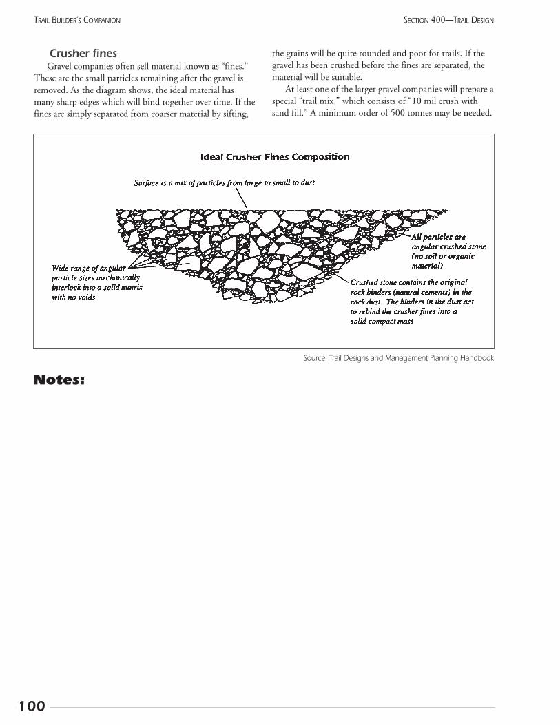
100
SECTION 400—TRAIL DESIGNTRAIL BUILDER’S COMPANION
Crusher finesGravel companies often sell material known as “fines.”
These are the small particles remaining after the gravel isremoved. As the diagram shows, the ideal material hasmany sharp edges which will bind together over time. If thefines are simply separated from coarser material by sifting,
the grains will be quite rounded and poor for trails. If thegravel has been crushed before the fines are separated, thematerial will be suitable.
At least one of the larger gravel companies will prepare aspecial “trail mix,” which consists of “10 mil crush withsand fill.” A minimum order of 500 tonnes may be needed.
Source: Trail Designs and Management Planning Handbook
Notes:
411 Asphalt surfaceAsphalt makes a hard and smooth surface suitable for a
wide range of urban activities. These include cycling andin-line skating, as well as using wheelchairs and babystrollers. It resists erosion, making it popular with managersof steep trails that would otherwise be prone to washout. Ifuse is high, as it is in many cities, then asphalt’s higher costcan be justified.
The dark colour causes snow to melt relatively quickly,making it a poor base for a ski trail. On the other hand,this snow-resistant quality can allow year-round joggingand cycling when supported by a modest plowing program.
The seasonal maintenance is easy: a periodic sweepingkeeps the trail free of grit and leaves, which can cause skids.However, plant roots can produce dangerous lumps in thepavement. These can be reduced by simply rolling theasphalt flat again on a hot summer day. (Maybe help thisalong with a propane tiger torch first, to make the materialmore flexible.) Full repair can be quite expensive because itrequires heavy equipment and skilled workers. Removal ofoffending plant species, especially poplars, Canada thistles,and roses, or using root barriers (see Section 418) will helpprevent problems.
Your municipality’s Public Works or Roads departmentis familiar with pavement and the contractors who install it.They will be able to advise you on the best way to do thejob. Realize that the equipment cannot make a trail nar-rower than 2 m and it cannot make sharp turns.
Steep slopes also create problems for the installationcrew. Too bad, since erosion resistance is one of the mainbenefits of asphalt. What happens is this: The pavertends to slide forward faster than it can push the materialinto place. This shows up as stretch marks or cracksacross the trail, which will soak up rainwater and enlargequite quickly. Talk to your contractor before acceptinghis bid and insist that cracks are not acceptable and willresult in replacing the section. Some contractors havereduced this problem by supporting the paver with acable from above to keep it moving slowly. Prompt andthorough compaction with a vibrating roller can alsoreduce the problem. A sealant should be applied eachspring to all cracks to keep water out.
Installation of pavement requires the removal of topsoil,then the compaction of coarse gravel as a sub-base. Finergravel is often packed on top, before finally adding theasphalt. This is a large task and will require major supportfrom the community. How much does it cost? Prices arequickly out of date, but you can count on at least $50,000per km. This can be reduced by donations of materials andlabour, of course, and the low maintenance costs should beremembered.
Larger cities could consider using granular materials forthe recreational trails because of the more aesthetic appear-ance and because bicycles will travel more slowly. Save theasphalt for high speed commuter bicycle routes, perhaps inconjunction with roads. This approach reduces problemsbetween walkers and fast bicycles.
In other situations, a gravel trail can be installed andused for several years. If the use increases and money can beraised, then a layer of asphalt can be put over it.
Pavement goes to the mountainsWhile asphalt is generally considered a “city” thing, it
can be valuable in certain natural trail situations. Cold Mixis a special type of asphalt that can be carried in smallquantities (5 gal. buckets), stored, and then applied withhand tools. This has been used effectively at campsites,viewpoints, or on short but very steep sections of naturalsurface trails. The asphalt is spread across the surface, oftenbetween protruding boulders, and then packed into placewith a hand tamper.
ConcreteConcrete provides a harder and more durable surface
than asphalt. It resists penetration of roots, although it canstill be heaved by large tree roots. Of course, it is even moreexpensive than asphalt. However, concrete’s widespread usefor sidewalks demonstrates that it will withstand the elementswithout adverse effects.
Several new processes allow concrete to be placedcheaper than previously. First, a stiffer mix can be poureddirectly onto the base, much like asphalt, without theexpense of installing forms. Expansion gaps, which can beannoying for bicyclists, are not made with the usual insertsof fibreboard. Instead, they are cut with a diamond sawdirectly into the continuous concrete strip. Wheels passover the cuts without any bumping. This process is worthlooking into.
101
SECTION 400—TRAIL DESIGN TRAIL BUILDER’S COMPANION

102
SECTION 400—TRAIL DESIGNTRAIL BUILDER’S COMPANION
Notes:
412 Steep slopesSteep trails develop erosion problems for two reasons.
First, any water channeled into the trail will gain speed atan alarming rate, with even a small volume causing damagefar beyond what might be expected. Second, tires, hoofs,and feet tend to skid on steep slopes, loosening the soil andpreparing it for erosion.
Informal trails are subject to this problem because mostpeople will head straight up a steep incline. The resultinggully will focus the water and the soil is soon gone. Thisprocess has led to the most popular mountain trails becom-ing informal staircases, with roots and rocks providing thesteps. It must be emphasized that this problem is not just fortrails with a natural surface; asphalt trails are subject to ero-sion and eventual undercutting along their edges where thewater tends to channel. Now, what can be done about it?
The solution has two aspects: reducing the slope andremoving the water. A longer but gentler trail will havefewer problems. Route it in wide sweeping curves, keepingin mind that if the users can see the trail too far ahead, theywill short-cut. These climbing curves are good until theslope reaches 15%, then switchbacks are needed. Avoidlong and steady inclines; periodic dips will force the wateroff the trail. Using frequent water bars is another way toencourage this. Well-defined stream crossings will not allowthe water from flowing onto the trail.
If the trail is strictly for pedestrian use, consider using aflight of steps to reduce the grade of the remaining distance.A flight of ten steps, each 30 cm high, will reduce the gradeof 60 m of trail from a strenuous 10% to an easy 4%.
When to use switchbacksSwitchbacks are the traditional method of gaining eleva-
tion in areas where space is restricted. However, they areunpopular with most trail users. Switchbacks are virtuallyimpassable for nordic skiers and cause problems for cyclists.They are relentlessly abused by casual hikers, and theresulting damage presents severe restoration difficulties.
Few areas outside the Rockies have enough elevationgain to require switchbacks, and few areas inside the moun-tains need new trails. Certainly, some overused trails wouldbenefit from a rerouting. So, if you really feel that your trailneeds switchbacks, here are some pointers:
• keep each leg as long as possible
• anchor each turn with a large feature, such as a viewpoint, boulder, or small cliff
• try to reduce the visibility of lower sections from above
• ensure that all the rainwater is directed off the trail atevery turn
• watch where this water goes; don’t just dump it
onto a lower section of trail. This can mean puttingthe turns near a small creek to receive the water, ormaking the legs longer as you go up
Side hillsTraversing steep slopes also calls for some special con-
sideration. First, consider what may fall from above. Rocksfall with surprising frequency from high cliffs, so keep trailsaway when possible. Avalanches can also cause problems -not just for skiers, but can reduce the season for summerrecreationists as well.
Second, the vegetation can play an important role inkeeping the trail in good repair. However, the relationshipis a bit complex. Where you put the trail will depend onthe season and type of use. The general rules are that a drytrail and a well vegetated trail will both be stable. A southfacing slope generally has fewer trees, and so will lose itssnow early and be dry for spring hiking. However, it will beexposed to the full impact of thunderstorms. On the otherhand, a shady forest may not be dry until well into sum-mer, but will have excellent protection from both rain andsun. Consider what use can be expected in each season andthe interaction of weather and vegetation.
Finally, consider the stability of the trail itself. Narrowthe tread as much as possible while still accommodating therequired traffic. Pass on the uphill side of natural featureslike trees and boulders so they can support the trail.Beyond this, a combination of excavation on the uphill sideand filling on the downhill side will give a stable tread.Compact the material right away to prevent erosion beforethe vegetation stabilizes it. When hand-building footpaths,attention to detail will pay off. Make sure each stone is sta-ble then packed with finer material.
Stream-side trailsAvoid having a trail continue close to a stream. Aside
from the problem of floods, watercourses generally containvery sensitive wildlife habitat. Many species are confined toa very narrow space and could be significantly affected.Bears are one of those species who prefer the cool vegeta-tion along creeks. The babbling brook can hide the noise ofapproaching people, causing the bear to be surprised.
Stream crossings are great but make sure the approacheshave good visibility. Gravel-bottomed creeks can be forded,especially in wilderness areas. Cut back the bank to allowbicycle and snowmobile traffic. Then, have the trail headback into the forest.
103
SECTION 400—TRAIL DESIGN TRAIL BUILDER’S COMPANION

104
SECTION 400—TRAIL DESIGNTRAIL BUILDER’S COMPANION
Notes:
105
SECTION 400—TRAIL DESIGN TRAIL BUILDER’S COMPANION
413 Drainage solutionsWater and trails should not mix. Water softens the tread
until the users sink into a brown soup. In larger quantities,the water will erode the surface of granular trails or evenundercut asphalt surfaces. Make every effort to maintainthe stable existing drainage pattern. This means keepingwater from collecting and helping it on its way to theocean. Of course, trail routing is made more difficult by theintense desire of most recreationists to pass near lakes,rivers, and streams.
Minimize problemsProper planning will minimize the problems encoun-
tered. Route the trail away from moist areas and exposedslopes with light soils. In some areas, seasonal closures willavoid the wettest time of year without undo hardship to theusers. When designing the trail, keep both the tread andclearing width as narrow as possible to reduce the surfacearea which will accumulate water. Natural vegetation willboth absorb the rain and stabilize the trail with roots. Onlyuse drains and culverts when essential because they needfrequent cleaning. Instead, ensure that the trail has frequentdips, which will shed the water, and that the tread has a 2%slope to the downhill side. Switchbacks attract problemsbecause the water from one section often flows directlydownhill onto the next section. An unorthodox approachinvolves routing the trail straight up the ridgeline where lit-tle water can accumulate. And, as in so many aspects of life,do it right the first time. Time and energy spent buildingcarefully will be repaid in savings and enjoyment over manyyears of use.
Crossing wet areasWhere the trail must cross boggy terrain, do not try to
drain the area as this will likely cause severe disruption tothe vegetation far beyond the trail. Instead, lift the trail upout of the water. Where there is soil, such as in moistmeadows, dig small ditches and pile the soil on the tread(called a turnpike). Periodic drainage pipes under the trailwill allow the water levels on both sides to equalize. Inforested areas, build a corduroy surface by placing a layer ofshort, evenly-sized logs across the tread. Ideally, these willbe covered with soil. If air is kept away from the wood, itwill not rot! Duckboard, simply planks supported by peri-odic sleepers, can give secure footing at an economical cost.For shorter distances or in very intensively used sites, youcan construct a full boardwalk.
Water flowing across the trail causes more difficultproblems, which quickly get out of hand if neglected. Takethe time to put a cross slope to the trail - just enough to bevisible. Don’t let any depressions remain on the uphill sideof the trail. Check after a rain to see where the water isaccumulating and rework the surface to eliminate it.However, in some very moist regions, just the water flow-ing across the trail can cause problems. It must be collectedin a ditch on the uphill side, then transferred over the trailwith a water bar or other depression. In flat terrain, put aslight crown in the centre.
When crossing a water course, expect the worst. Eventhough it may be dry now, it will eventually fill. Right aftera torrential downpour is a good time to check to see howhigh the water can rise. The overall objective is to avoidblocking the natural drainage while still providing securefooting for the recreationists.
To cross a seasonally wet channel, consider armouringpart of the channel with flat stones or asphalt in moreurban areas. Stream crossings may be fine with steppingstones. Where bicycles are expected or if the stream isdeeper than a few centimetres, take the time to build areal bridge.
In areas guaranteed free of beaver, such as above the treeline, culverts can be a useful way of crossing tiny creeks.Install them with a slope of at least 10%, to allow gravel towash through. Even with this precaution, avoid culverts lessthan 300 mm in diameter, as they will clog too easily.Armour both sides of the trail around the culvert to preventerosion in case the water flows over top.
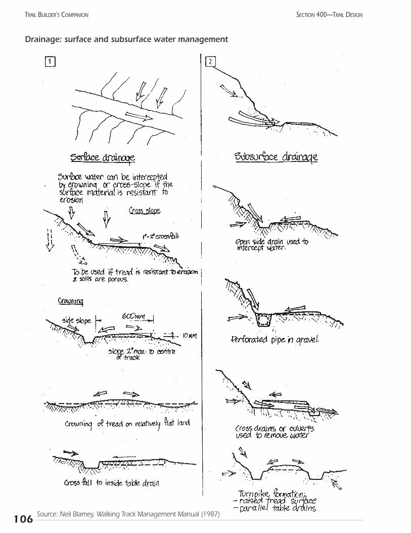
106
SECTION 400—TRAIL DESIGNTRAIL BUILDER’S COMPANION
Drainage: surface and subsurface water management
Source: Neil Blamey, Walking Track Management Manual (1987)
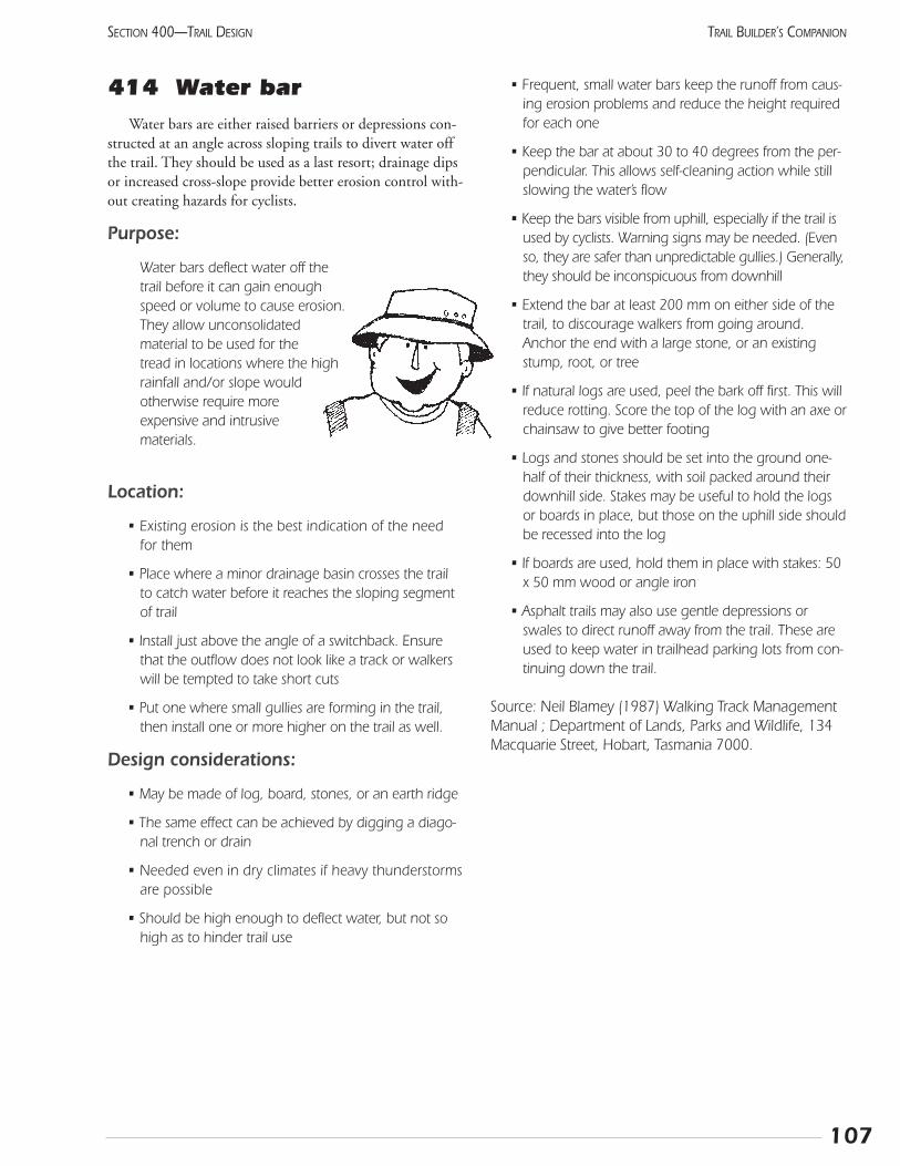
107
SECTION 400—TRAIL DESIGN TRAIL BUILDER’S COMPANION
414 Water barWater bars are either raised barriers or depressions con-
structed at an angle across sloping trails to divert water offthe trail. They should be used as a last resort; drainage dipsor increased cross-slope provide better erosion control with-out creating hazards for cyclists.
Purpose:
Water bars deflect water off thetrail before it can gain enoughspeed or volume to cause erosion.They allow unconsolidatedmaterial to be used for thetread in locations where the highrainfall and/or slope wouldotherwise require moreexpensive and intrusivematerials.
Location:
• Existing erosion is the best indication of the needfor them
• Place where a minor drainage basin crosses the trailto catch water before it reaches the sloping segmentof trail
• Install just above the angle of a switchback. Ensurethat the outflow does not look like a track or walkerswill be tempted to take short cuts
• Put one where small gullies are forming in the trail,then install one or more higher on the trail as well.
Design considerations:
• May be made of log, board, stones, or an earth ridge
• The same effect can be achieved by digging a diago-nal trench or drain
• Needed even in dry climates if heavy thunderstormsare possible
• Should be high enough to deflect water, but not sohigh as to hinder trail use
• Frequent, small water bars keep the runoff from caus-ing erosion problems and reduce the height requiredfor each one
• Keep the bar at about 30 to 40 degrees from the per-pendicular. This allows self-cleaning action while stillslowing the water’s flow
• Keep the bars visible from uphill, especially if the trail isused by cyclists. Warning signs may be needed. (Evenso, they are safer than unpredictable gullies.) Generally,they should be inconspicuous from downhill
• Extend the bar at least 200 mm on either side of thetrail, to discourage walkers from going around.Anchor the end with a large stone, or an existingstump, root, or tree
• If natural logs are used, peel the bark off first. This willreduce rotting. Score the top of the log with an axe orchainsaw to give better footing
• Logs and stones should be set into the ground one-half of their thickness, with soil packed around theirdownhill side. Stakes may be useful to hold the logsor boards in place, but those on the uphill side shouldbe recessed into the log
• If boards are used, hold them in place with stakes: 50x 50 mm wood or angle iron
• Asphalt trails may also use gentle depressions orswales to direct runoff away from the trail. These areused to keep water in trailhead parking lots from con-tinuing down the trail.
Source: Neil Blamey (1987) Walking Track ManagementManual ; Department of Lands, Parks and Wildlife, 134Macquarie Street, Hobart, Tasmania 7000.
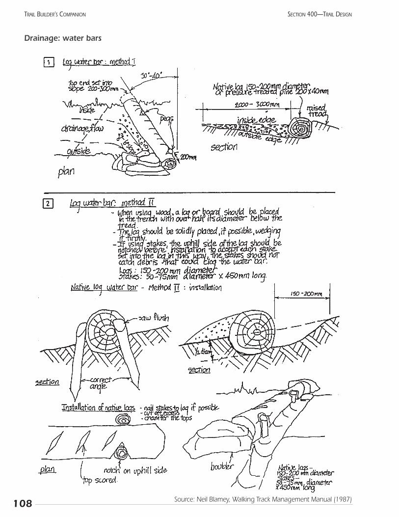
108
SECTION 400—TRAIL DESIGNTRAIL BUILDER’S COMPANION
Drainage: water bars
Source: Neil Blamey, Walking Track Management Manual (1987)
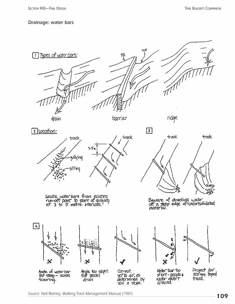
109
SECTION 400—TRAIL DESIGN TRAIL BUILDER’S COMPANION
Drainage: water bars
Source: Neil Blamey, Walking Track Management Manual (1987)
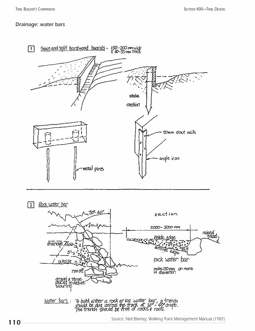
110
SECTION 400—TRAIL DESIGNTRAIL BUILDER’S COMPANION
Drainage: water bars
Source: Neil Blamey, Walking Track Management Manual (1987)
415 Boardwalk and otherwooden structures
Wood offers many advantages as a trail constructionmaterial. It is easily worked with common tools and withrelatively little specialized knowledge. It is widely availableat a reasonable cost, and can often be acquired on-site bycutting down a tree. The soft and natural appearanceallows it to blend in with the natural environment.
Its main drawback relates to durability. Being softer, itis subject to vandalism including carving and burning. Itwill also rot over the course of 10 to 25 years. Thisinevitable problem has been alleviated to a great extent bythe pressure-treating process. However, remember that thechemical used in this process contains arsenic. This can be asignificant contaminant and the hazard may outweigh itsfungicidal properties, particularly in the drier parts of ourprovince. For example, it should not be used where thewood will come in direct contact with the user’s skin, i.e.,picnic table, bench, handrail. Where the chemical couldleach into streams, the amount of pressure-treated timbershould be restricted. You might consider using it for abridge’s structural components, but not for the deckingwhich can be easily replaced.
When pressure-treated wood is cut, the untreated endsare exposed to the elements. Unless these ends are treatedby painting on a similar fungicide, the value of the pressuretreating will be negated. The chemical soaks into the end-grain quite well, providing effective protection. All thesame, try to arrange for the cut ends to be in dry locations.For example, put the cut end of the post in the air and thetreated end in the ground.
BoardwalksBoardwalks bring excitement and variety to a trail, and
are especially popular with the younger (under 12) set.Boardwalks also enable visitors to experience a habitatwhich is difficult to see any other way. Although marshesare the usual location, other sensitive and soft sites can alsobenefit from this style of trail.
Remember that the boards will get slippery in wet orfrosty conditions so avoid having steep downwardapproaches. Boardwalks should be used with caution alonglarge lakes, as major ice pans drifting about during breakupcan easily shear off posts of any size.
Many different plans, ranging from casual to magnifi-cent, can be found for boardwalk construction. Keep inmind the essential components and adjust the dimensionsto fit the number of users and the budget.
Posts:
• rot-resistant or pressure-treated wood
• trimmed off at the highest anticipated water level
• pounded well (at least 1 m) into the mud (they willstabilize with time)
• consider installing them through the ice during winter
• set them in pairs, slightly closer than the width of theboardwalk
• each pair generally just less than 8’ apart
Stringers connect the posts:
• minimum 50x200 mm (2x8”)
• attached with lag bolts
Planks are placed across the stringers:
• attached with galvanized screws
• minimum dimensions should be 50x150 mm (2x6”)
• should extend only a short distance (about 150 mm)outside of the stringers
• space planks no more than 10 mm to allow dryingbut not enough to catch shoes
• taper the planks with a table saw to go around gentlecurves
• galvanized chicken wire can be stapled across the fin-ished deck to prevent slipping (especially if the board-walk slopes, such as at a floating dock)
Install handrails:(If the deck is over open water or more than 600 mm from the surface)
• brace the posts by having every tenth deck plankextend out 200 mm farther
• place the handrail flat against the inside of the posts
• adjust the height to suit the audience: unfortunately, thebest height for bikes is eye-level for wheelchair users.
111
SECTION 400—TRAIL DESIGN TRAIL BUILDER’S COMPANION
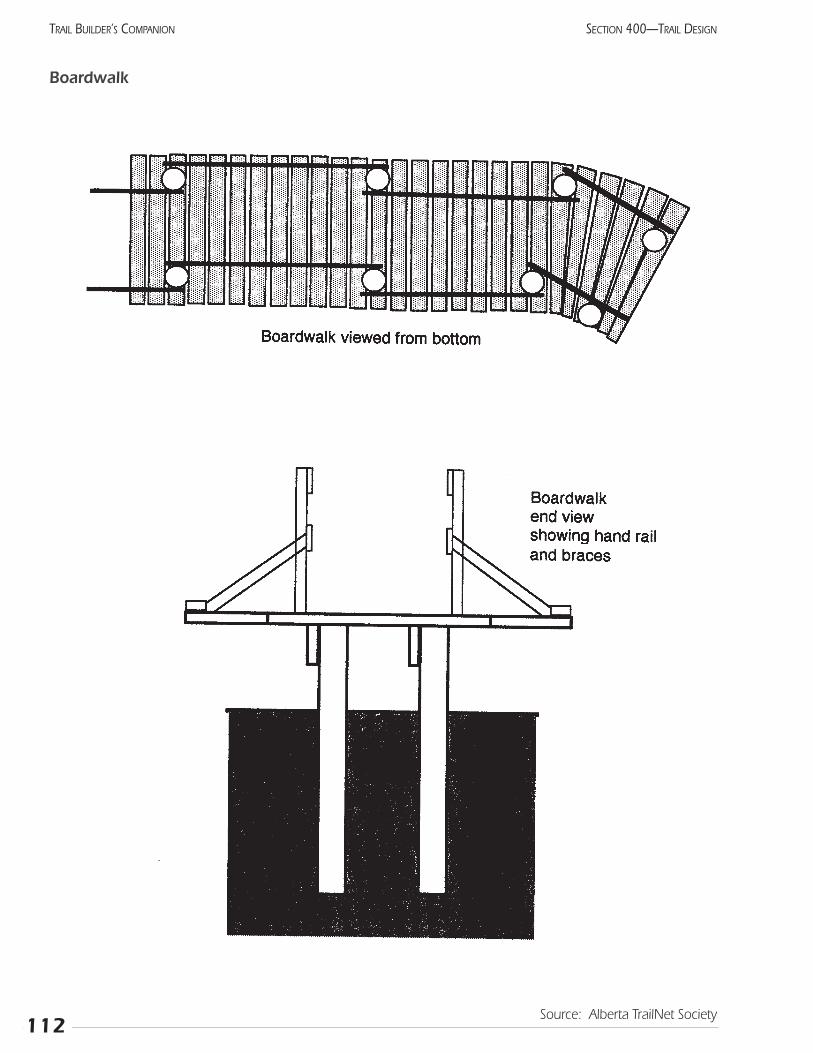
112
SECTION 400—TRAIL DESIGNTRAIL BUILDER’S COMPANION
Boardwalk
Source: Alberta TrailNet Society
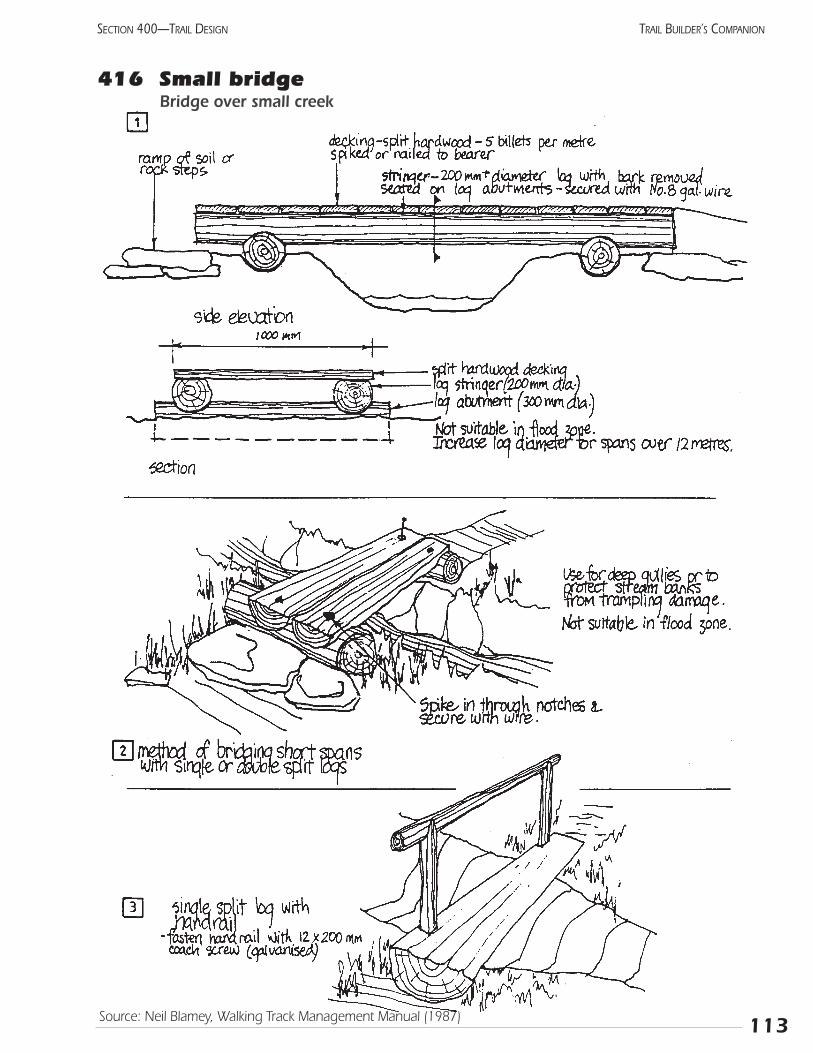
113
SECTION 400—TRAIL DESIGN TRAIL BUILDER’S COMPANION
416 Small bridge Bridge over small creek
Source: Neil Blamey, Walking Track Management Manual (1987)
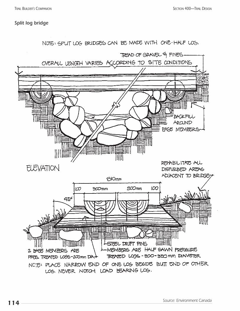
114
SECTION 400—TRAIL DESIGNTRAIL BUILDER’S COMPANION
Split log bridge
Source: Environment Canada
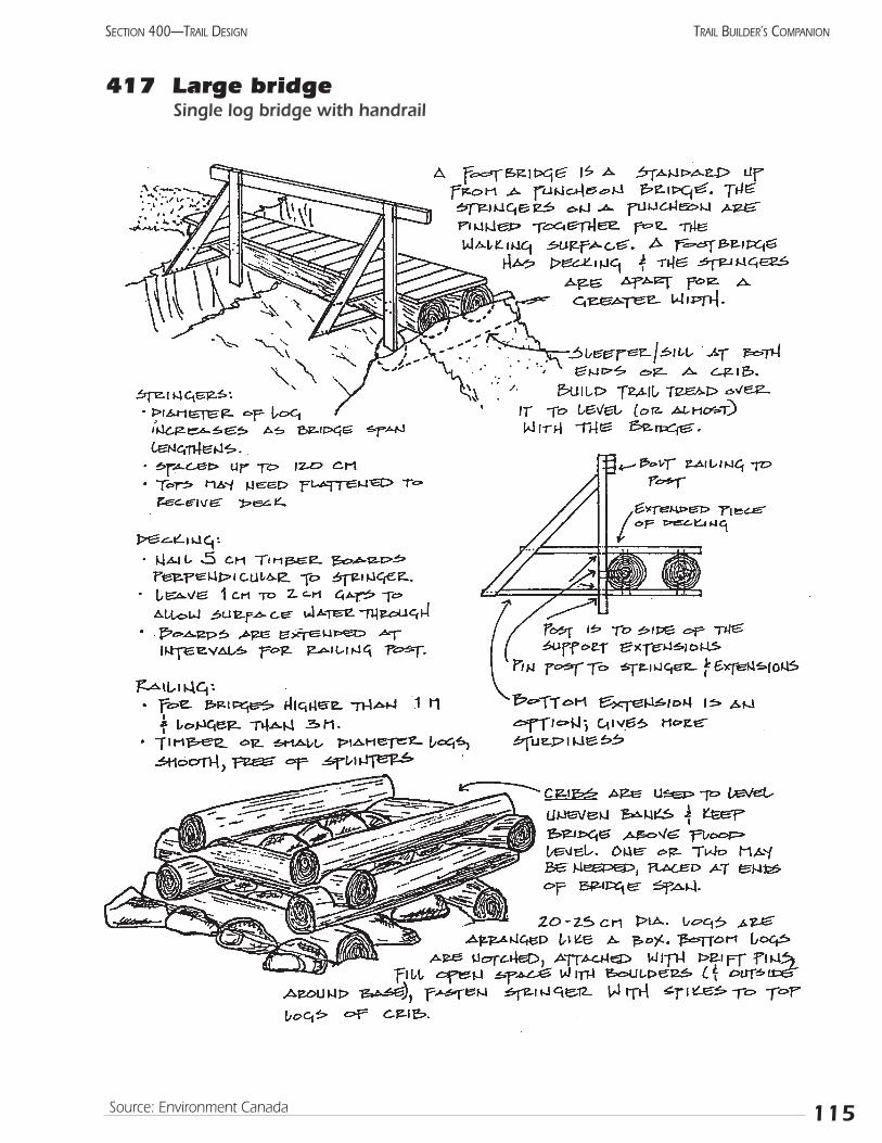
115
SECTION 400—TRAIL DESIGN TRAIL BUILDER’S COMPANION
417 Large bridgeSingle log bridge with handrail
Source: Environment Canada
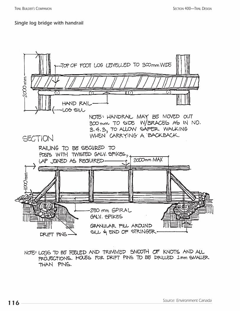
116
SECTION 400—TRAIL DESIGNTRAIL BUILDER’S COMPANION
Single log bridge with handrail
Source: Environment Canada
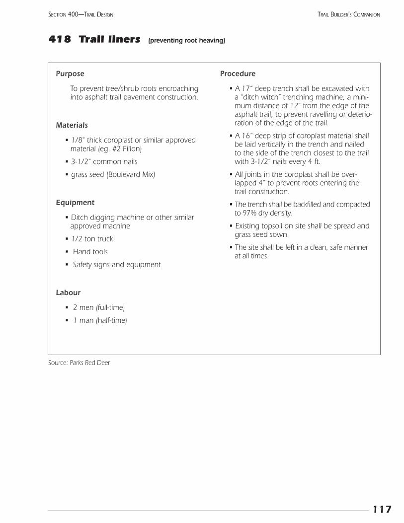
117
SECTION 400—TRAIL DESIGN TRAIL BUILDER’S COMPANION
Purpose
To prevent tree/shrub roots encroaching into asphalt trail pavement construction.
Materials
• 1/8" thick coroplast or similar approvedmaterial (eg. #2 Fillon)
• 3-1/2" common nails
• grass seed (Boulevard Mix)
Equipment
• Ditch digging machine or other similarapproved machine
• 1/2 ton truck
• Hand tools
• Safety signs and equipment
Labour
• 2 men (full-time)
• 1 man (half-time)
Procedure
• A 17“ deep trench shall be excavated with a “ditch witch” trenching machine, a mini-mum distance of 12” from the edge of theasphalt trail, to prevent ravelling or deterio-ration of the edge of the trail.
• A 16“ deep strip of coroplast material shall be laid vertically in the trench and nailedto the side of the trench closest to the trail with 3-1/2” nails every 4 ft.
• All joints in the coroplast shall be over-lapped 4” to prevent roots entering thetrail construction.
• The trench shall be backfilled and compactedto 97% dry density.
• Existing topsoil on site shall be spread and grass seed sown.
• The site shall be left in a clean, safe mannerat all times.
Source: Parks Red Deer
418 Trail liners (preventing root heaving)
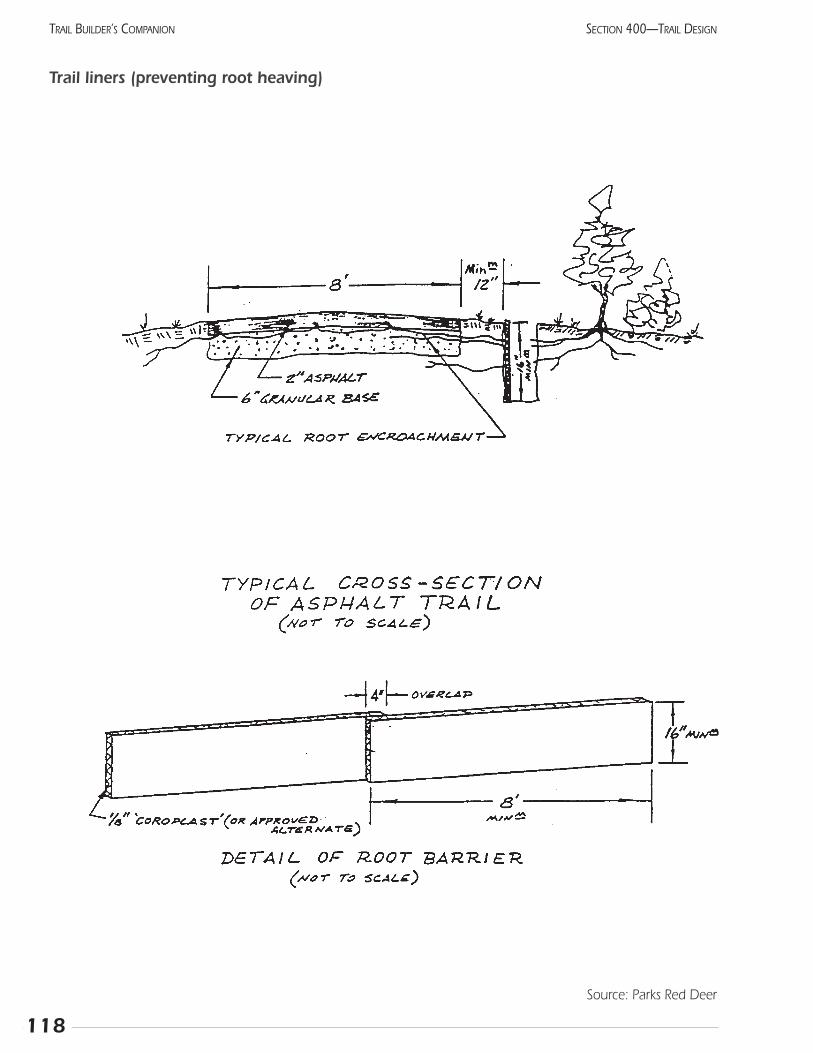
118
SECTION 400—TRAIL DESIGNTRAIL BUILDER’S COMPANION
Trail liners (preventing root heaving)
Source: Parks Red Deer
119
SECTION 400—TRAIL DESIGN TRAIL BUILDER’S COMPANION
419 GabionsThese features, often called gabion baskets, are wire
boxes filled with local stones. Some managers use them tohelp stabilize slopes and river banks. Gabions can be aneconomical retaining wall requiring relatively little skilledlabour. They can work well in alpine or riverbank sites,especially where equipment cannot gain access. On theother hand, without careful mitigation they can look artifi-cial and intrusive in a natural setting. High-use trails withsevere erosion may warrant building a long series of gabionsas a base for the trail.
The overall approach is to build boxes of wire mesh,install them where the wall is to be, then fill them withstones from the local area. Try to incorporate large bouldersor bedrock with the new wall.
More detailed instructions include:
1 Excavate material down to stable material and rough-ly level the surface. Ensure that the base is armouredso it will not erode.
2 Build baskets from wire, preferably galvanized or coat-ed with plastic. Maximum recommended size for eachbasket is 500 x 500 x 2000 mm. These can be anirregular shape to fit the site.
3 Position the basket and fill with stones, taking sometime to have the stones settled down. Secure thebracing wires when the baskets are one-third andtwo-thirds full.
4 Tie the top shut with galvanized wire.
5 Offset each level of baskets and set them back slightly.Tilting them into the slope may be advantageous onsteep hills.
6 Cover the gabions with loose stones or soil and vege-tation to disguise the wire.
Notes:
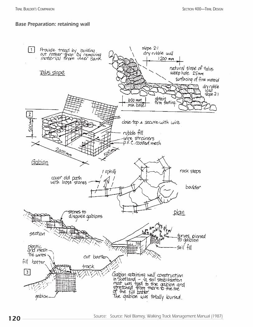
120
SECTION 400—TRAIL DESIGNTRAIL BUILDER’S COMPANION
Base Preparation: retaining wall
Source: Source: Neil Blamey, Walking Track Management Manual (1987)
121
SECTION 400—TRAIL DESIGN TRAIL BUILDER’S COMPANION
420 Geotextile materials“Geotextile” refers to the various types of synthetic
cloth used to stabilize soil. The main attribute is the abilityto restrict the movement of soil while allowing water toreadily pass through. Beyond this, though, they have awide range of characteristics, which enable them to be usedin many different applications. The entire field is veryyoung and new uses are being discovered frequently. Asearch on “geotextile” on the Internet gave a number ofinformative and imaginative sites, some of which were usedto prepare this section.
Woven cloth generally provides considerable strength.Non-woven fabric may be felted or bonded through heat,chemical, or mechanical means. The strength can vary enor-mously. Other variables include pore size, thickness, andweight. Most styles have been treated to resist ultra-violetdegradation but still must be covered to ensure optimum life.
Sample applications
Stabilize the surface of wet, high-traffic areas:
• Place fabric on top of unstable soil or muskeg, thencover with gravel or similar sub-base material. Thewater drains though the gravel and fabric quickly.
• The weight of the load is distributed evenly over a largearea by the cloth, allowing a stable surface to beachieved with much less gravel than otherwise needed.
• Stream beds receiving traffic from ATVs or 4WDs (andthe adjacent banks) can be armoured with this process.Ensure that the final grade is the same as the initial level.(Don’t proceed with any stream bed modifications with-out explicit approval from the land manager.).
Stabilize bare soil during re-vegetation:
• Fabric with a very loose weave and intentional photo-degradation ability can prevent erosion while disap-pearing in a year or two. This material is more consis-tent than the more common organic mats often used,and has much higher erosion resistance than thehydro-mulch presently in use.
Retaining walls:
• Walls can be made by filling long “loops” of this clothwith soil, similar to giant sand bags but with greaterstability. The high friction of the cloth keeps the “bags”from sliding out, allowing very steep walls to be built.
• Cloth with an extremely coarse weave, but usingstrong materials, can be used for a type of gabionbasket. In this case, the bags are filled with relativelyfine material (compared to a gabion basket) with theintention that vegetation will grow through the bagand help it blend in with the terrain.
Prevent penetration of plant material through the trail:
• Place a layer of this material under the sub-grade toreduce root heaving by roses, aspen, grass, or othervegetation.
• Put under boardwalks to prevent grass from growingup between the boards.
Suggested installation procedureProper installation of geotextile fabric with gravel, soil,
or other earthen material as a topcoat is best accomplishedwhen the soil at the site is dry. The following is a series oftips to ensure proper site preparation, geotextile fabricinstallation, and cover material application at the site. Thefirst step, however, is to select the proper geotextile fabricfor the application. (These directions are for industrial sizeapplications. Smaller equipment may be more suitable fortrail applications.)
• Clear the area of any sharp objects, stumps, and debris.
• Grade the existing soil surface to provide adequate,but not excessive, surface drainage.
• Unroll the geotextile fabric over the application area.On a windy day, the fabric will need to be securedwith pins, sod, stones, etc.
• Place the gravel on the fabric. It is best to back dumpwhen unloading and spreading the gravel on the fab-ric with a truck. Then complete the final spreadingand smoothing with earthmoving equipment like abulldozer, front-end loader, skid loader, or scraper.
• Care should be taken when backfilling and compact-ing the gravel. Geotextile fabric is tough, so it can bedriven on. However, truck tires may pull the fabric,causing it to wrinkle. This condition may affect theproper installation and performance of the systemsince less area may actually be covered by the fabric.
• If it is necessary to overlap the fabric in order to covera larger area, a minimum of a one-foot overlap isrequired for proper use. In order to ensure a mini-mum of one foot of overlay after the placement of thegravel or other topcoat, it is recommended that thefabric be laid out with a two-foot overlap before plac-ing the gravel on the fabric. Once placed, the gravelshould be spread in the same direction as the geotex-tile fabric overlap to avoid separation between thetwo pieces of fabric. Staples are available to help holdthe fabric in place.
• Compact the gravel using earthmoving equipment, atractor, or farm trucks.
MaintenanceSince geotextile fabric provides separation between soil
and gravel, or other earthen materials, the annual additionof gravel is usually not necessary as with conventionalroads. The original depth of gravel should be maintainedthroughout the life of the system..
Notes:
122
SECTION 400—TRAIL DESIGNTRAIL BUILDER’S COMPANION
Repairs should be made on an asneeded, but timely, basis.
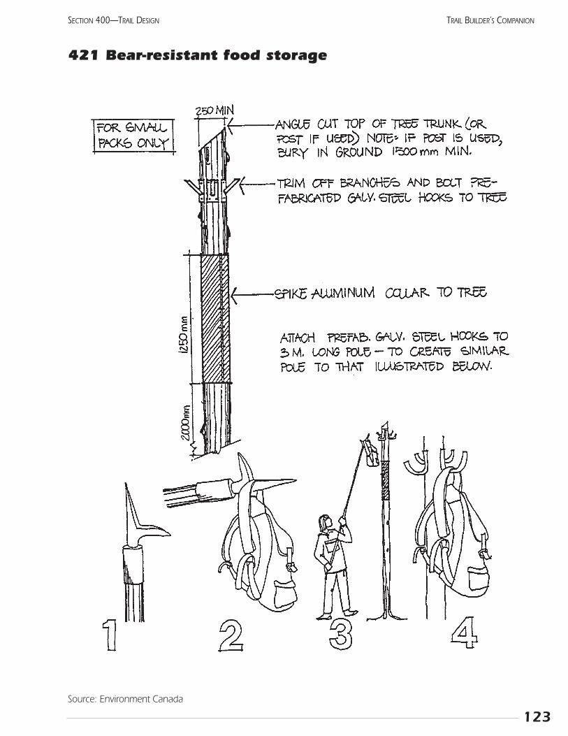
123
SECTION 400—TRAIL DESIGN TRAIL BUILDER’S COMPANION
421 Bear-resistant food storage
Source: Environment Canada
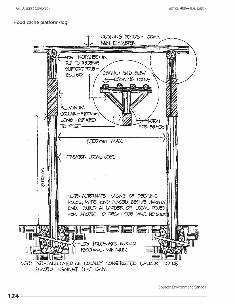
124
SECTION 400—TRAIL DESIGNTRAIL BUILDER’S COMPANION
Food cache platform/log
Source: Environment Canada
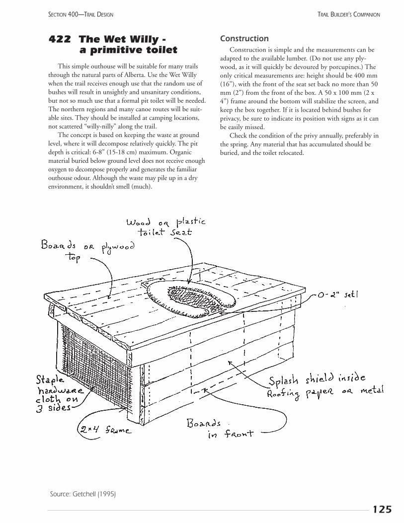
125
SECTION 400—TRAIL DESIGN TRAIL BUILDER’S COMPANION
Source: Getchell (1995)
422 The Wet Willy - a primitive toilet
This simple outhouse will be suitable for many trailsthrough the natural parts of Alberta. Use the Wet Willywhen the trail receives enough use that the random use ofbushes will result in unsightly and unsanitary conditions,but not so much use that a formal pit toilet will be needed.The northern regions and many canoe routes will be suit-able sites. They should be installed at camping locations,not scattered “willy-nilly” along the trail.
The concept is based on keeping the waste at groundlevel, where it will decompose relatively quickly. The pitdepth is critical: 6-8” (15-18 cm) maximum. Organicmaterial buried below ground level does not receive enoughoxygen to decompose properly and generates the familiarouthouse odour. Although the waste may pile up in a dryenvironment, it shouldn’t smell (much).
ConstructionConstruction is simple and the measurements can be
adapted to the available lumber. (Do not use any ply-wood, as it will quickly be devoured by porcupines.) Theonly critical measurements are: height should be 400 mm(16”), with the front of the seat set back no more than 50mm (2”) from the front of the box. A 50 x 100 mm (2 x4”) frame around the bottom will stabilize the screen, andkeep the box together. If it is located behind bushes forprivacy, be sure to indicate its position with signs as it canbe easily missed.
Check the condition of the privy annually, preferably inthe spring. Any material that has accumulated should beburied, and the toilet relocated.

126
SECTION 400—TRAIL DESIGNTRAIL BUILDER’S COMPANION
Notes:
423 Development planWow! What a lot of great ideas! Have they got you
excited about building trails? Now, this section is where theVibram hits the trail, and we get down to business.
The development plan lays out exactly what your com-mittee will be building and what it will look like. Start byreviewing the first objective in the Workbook and makingsure that it is still relevant. Are the proposed uses appropri-ate for the site and desired by the people you expect to usethe trails?
This plan summarizes the decisions made by your trailcommittee, including the desired trail standards (i.e., thewidth and surface material) and types of support facilities.You should also have an idea of whether you will be usingvolunteers, contractors, or a combination. These are themain factors that will affect the price. Your fundraising peo-ple should be confident that the money will be available.
A trail project can be quite complex and perhaps a bitintimidating for inexperienced people. Where do we start?How much will it cost? How can we guess the price forsomething as uneven as a trail?
Trail logStart by getting out your strip map and making sure all
the information is on it. The construction manager shouldgo through it from one end to the other, confirming thatevery construction item is listed and the location where theconditions change is marked. This will become the TrailLog and will be used for many years as the basis for themaintenance program. As a partial list of items to beincluded, consider these features:
• type of terrain • retaining wall
• intersection • fence
• ground cover • boardwalk
• bridge • sign
• % of side slope • drainage dip
• cairn • furniture
• track tread width • rock section
• water bar • gate
• grade • drainage ditch
• culvert • vista
• surfacing and depth • barricade
• stream ford • stile
• switchback • sub-soil drain
• shelter • steps
• road and rail crossings • other special features
Now, just add up how much of each kind of construc-tion is needed, like a giant shopping list. Leave space toinclude cost of materials, the time required (if using volun-teers), or cost of paid labour. For example:
Clear to 2.5 m through aspen 750 m
Remove deadfall through spruce 550 m
Hand grub aspen stumps 1 m wide 750 m
Mow trail through pasture 1 m wide 950 m
Culvert, 500 mm diameter 4
Gate, steel 2
Park bench 5
Depending on the complexity of the project, you maywant to have drawings or specifications done for eachfeature. This will ensure that the contractors understandwhat is expected and allow them to provide a more accu-rate estimate.
Now, the fundraising committee will take the proposalaround to see what each part will cost and if anyone willprovide it for free. Your group may have already asked forballpark figures to help the budget process, but now theywill ask for firm prices. These will help update the budget,and any special donations will be promoted by the publicrelations person. Decide how much of the budget is neededto get started. Generally, a project already underway is easi-er to get supported than a dream.
PhasingMaybe you can’t raise all the money that you need.
Maybe you aren’t sure of some important costs. Maybe youneed to show some success before others will join yourparade. These considerations lead to dividing the projectinto phases.
Phasing will avoid the frustration of a communitygroup overextending its capabilities and resources. It willalso establish an ongoing community commitment to theproject from the beginning. Constructing the project over anumber of years can actually be considered a benefit. Itallows a more thorough evaluation of the planning anddesign for each phase of construction and avoids wastingmoney and material on equipment or features that do notsatisfy the needs of the community.
A phased project is still the same, but it is separatedinto several smaller segments. Each phase must be able tostand alone until the next phase happens, but all must fittogether to produce the original project.
127
SECTION 400—TRAIL DESIGN TRAIL BUILDER’S COMPANION
A few ways to divide a big project into smaller pieces:
• completely finish one section, then do the next
• clear the whole length for snowmobiles then addbridges for summer use
• proceed slowly with volunteers instead of contractors
• put a gravel trail in now then upgrade with asphalton top later
• stop the trail wherever you run out of money(this must be a safe place. It puts pressure on everyone, especially the funding sources)
Whichever approach you choose, ensure that the sub-projects do not stand unfinished for extended periods.Unfinished equipment or facilities are frustrating to usersand are prone to vandalism.
When the Development Plan is final, have it approvedby the trail sponsor and the landowners. This could wellmean one more public meeting, with comments from allconcerned. The plan now becomes the guiding documentfor all future construction. In case significant changes areever proposed, there should be a clear process for approv-ing these.
Notes:
128
SECTION 400—TRAIL DESIGNTRAIL BUILDER’S COMPANION
129
SECTION 400—TRAIL DESIGN TRAIL BUILDER’S COMPANION
424 Trails and personswith disabilities
All recreationists should have access to our trail networkto the maximum extent possible. Trail planners shouldmake strong efforts to accommodate people with disabili-ties. In many cases, a little forethought can make the trailmore accessible. On this page, you will find some sugges-tions specific to trail operation. The following page givessuggestions for including people with disabilities in themore general recreation community.
Use “inclusive” language in all promotions, signs, andbrochures. Remember that your customers are people first,and may or may not be disabled. So, for example, say “per-son with a disability” instead of “disabled person.” Simplyuse the name of the disease or condition, rather than adescription which may be considered derogatory, i.e., say“person who has ...” rather than “person crippled by orafflicted with ...”
There should be no need to refer to disabilities; justdescribe the trail conditions and let people decide forthemselves if it is suitable for their abilities. However,your maintenance should ensure that these standards areconsistently met throughout the trail.
Many communities have “access committees” whichprovide advice on making facilities more accessible. A tourof your trail with these people might point out a fewthings which would increase the ease of use. Be sure toconsider the entire experience, from parking lot to desti-nation. Many wheelchair-accessible toilets have stepsleading to them! Is the parking lot surrounded by a curb?
If your trail is particularly suitable for people with cer-tain disabilities, contact social agencies to see if any recre-ation groups would like a guided tour. Often, these groupswelcome such opportunities. Trails, more than most recre-ation facilities, can bring benefits to all people. Each personcan go at their own pace and achieve their personal goals.
Many urban trails have cut-away curbs at intersectionswith roads. This helps cyclists, but can allow people withvisual difficulty to get onto the road without realizing it.Prevent this by making the approach sloped, with a distincttexture on the surface.
Loose sand presents a serious barrier to many peoplewith movement disabilities. To overcome this problem, laya wooden snow fence across the beach, from the access pathto the water and even farther if possible. The fence can berolled up when the sand needs to be groomed.
Notes:
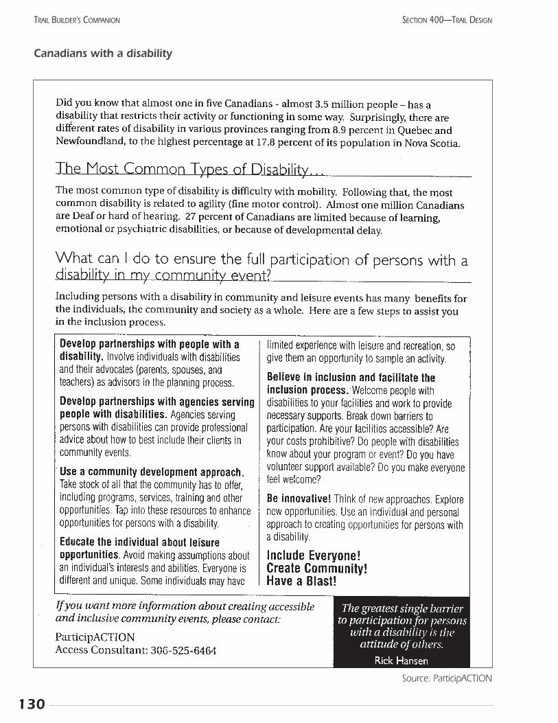
130
SECTION 400—TRAIL DESIGNTRAIL BUILDER’S COMPANION
Canadians with a disability
Source: ParticipACTION
Section 500 Building the Trail

133
SECTION 500—BUILDING THE TRAIL TRAIL BUILDER’S COMPANION
501 Steps in the construction process
PreparationsConstruction is a classic example of where getting your
“ducks in a row” will really pay off. The “ducks” to be linedup can be summarized as:
• confirm who owns the land: do title searches on all parcels
• confirm that the land is where you think it is: surveythe entire route at a level of detail that ensures youare on the parcel that you should be
• locate all buried utilities by calling the “Call Before YouDig” line at 1-800-242-3447
• confirm what is to be built: have detailed drawingsand specifications gathered into a single boundreport. Ensure that clean-up and disposal of waste,environmental protection and restoration, and safe-ty are included in the specifications
• include letters of permission from landowners, gov-ernments, and other agencies
• determine which components can be built with vol-unteer labour or donated expertise
• set out a timeline, indicating critical times such asfreeze-up and the order in which the sub-projectsmust be done
• tender the contract work
• conduct a site tour with all prospective contractors toensure they understand the conditions and standards
• get the volunteers working
• review the bids and make a short list by determiningwhich companies can do the work
• award the tender to the company that will do thebest job in the required time
• ensure a project manager oversees all aspects of theproject and has authority to make changes based onnew information
• ensure the manager reports to the Board orCommittee regularly
• inspect the trail and identify any remaining problemsor deficiencies
• hold back 5-10% of the contract until the deficienciesare remedied
• formally survey the final trail. This may be needed forland titles (License of Occupation, etc.) and as a basefor your as-built drawing or plan.
• conduct a final inspection with the contractor, projectmanager, and perhaps the chair of the trail committee.
• send the final payment, with a letter of thanks, to thecontractor formally ending the contract. A predeter-mined amount may be retained until the re-vegeta-tion is complete, which may be several years later.
Specifications Specifications are a detailed description of everything
which must be produced, including size, material, grade,colour, and finish. Do not specify how the work is to bedone (process or equipment) unless this influences the finalquality. For things difficult to describe, state “to the satisfac-tion of the project manager.” Detailed specifications shouldbe done for all projects, whether they are going to be ten-dered or completed by volunteers. The trail committee willlikely want to approve these before they are finalized.
Tender Documents go beyond the specifications toinclude all other aspects of a contract, thus ensuring thatall bidders have the same information. Of course, thecore of the package will be the specifications. However,the Tender Document includes several other importantsections that give general direction while ensuring certainlegal obligations are carried out. Your local municipalitywill have a standard tender document that you can fol-low. If expensive blueprints are included, most organiza-tions charge $50 for the tender packages to reduce frivo-lous requests. The main sections are:
• general description or scope of the project
• specifications including all working drawings
• requirement to maintain all applicable licenses and permits, including a Workers CompensationBoard account, liability insurance, and a performance bond
• schedule indicating at what stage of the project eachpayment will be made, including any performance orearly completion bonus or late completion penalty
• reporting structure: name of your contract supervisorand details of any coordination with other contractorswhich may be needed
• safety for workers and the general public
• requirement to meet all federal, provincial, and localhiring practices
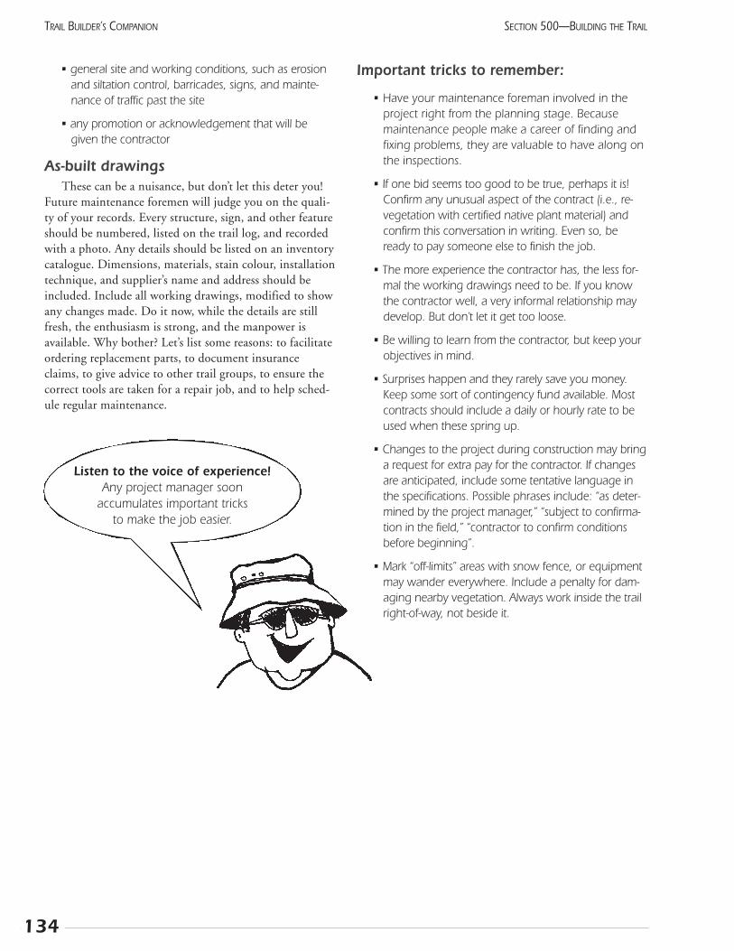
• general site and working conditions, such as erosionand siltation control, barricades, signs, and mainte-nance of traffic past the site
• any promotion or acknowledgement that will begiven the contractor
As-built drawings These can be a nuisance, but don’t let this deter you!
Future maintenance foremen will judge you on the quali-ty of your records. Every structure, sign, and other featureshould be numbered, listed on the trail log, and recordedwith a photo. Any details should be listed on an inventorycatalogue. Dimensions, materials, stain colour, installationtechnique, and supplier’s name and address should beincluded. Include all working drawings, modified to showany changes made. Do it now, while the details are stillfresh, the enthusiasm is strong, and the manpower isavailable. Why bother? Let’s list some reasons: to facilitateordering replacement parts, to document insuranceclaims, to give advice to other trail groups, to ensure thecorrect tools are taken for a repair job, and to help sched-ule regular maintenance.
Important tricks to remember:
• Have your maintenance foreman involved in theproject right from the planning stage. Becausemaintenance people make a career of finding andfixing problems, they are valuable to have along onthe inspections.
• If one bid seems too good to be true, perhaps it is!Confirm any unusual aspect of the contract (i.e., re-vegetation with certified native plant material) andconfirm this conversation in writing. Even so, beready to pay someone else to finish the job.
• The more experience the contractor has, the less for-mal the working drawings need to be. If you knowthe contractor well, a very informal relationship maydevelop. But don’t let it get too loose.
• Be willing to learn from the contractor, but keep yourobjectives in mind.
• Surprises happen and they rarely save you money.Keep some sort of contingency fund available. Mostcontracts should include a daily or hourly rate to beused when these spring up.
• Changes to the project during construction may bringa request for extra pay for the contractor. If changesare anticipated, include some tentative language inthe specifications. Possible phrases include: “as deter-mined by the project manager,” “subject to confirma-tion in the field,” “contractor to confirm conditionsbefore beginning”.
• Mark “off-limits” areas with snow fence, or equipmentmay wander everywhere. Include a penalty for dam-aging nearby vegetation. Always work inside the trailright-of-way, not beside it.
134
SECTION 500—BUILDING THE TRAILTRAIL BUILDER’S COMPANION
Listen to the voice of experience!Any project manager soon
accumulates important tricks to make the job easier.
502 Trail construction
Steps in construction
The main differences are the types of material and equipment used.
• flag the route with survey tape and/or stakes
• build the parking lot if one is needed. Use this to storeany equipment or materials
• install any utilities needed (septic field, toilet vault,electricity, etc.)
• remove deadfall from the route
• do rough clearing of largest trees, salvaging timberwhere practical
• ensure the full clearing width is achieved
• remove stumps, roots and large rocks
• install bridges and other structures (these may havebeen prefabricated elsewhere)
• grub the soil to remove rocks and vegetation, and tosmooth the surface
• remove topsoil, then add and compact the subgradeif gravel or asphalt is to be used
• install surface material and replace topsoil as requiredalong edge of trail
• ensure crowning on level trails, or a slight cross slopeon trails with a grade. To test, roll an orange downthe trail, it should curve slightly to the downhill side
• clean up the area and re-vegetate any disturbed ground
• install signs, furniture, and trailheads
The last ten percentAttention to final details and the cleanup of a site make
a great difference in the ultimate appearance and quality ofa project. Unfortunately, that final ten percent of effort isoften neglected. Crew leaders should include time in theirwork schedule for this and motivate their crews to takepride in giving their work the polish it deserves.
Hand equipmentConstruction in the backcountry requires a wide range
of tools and equipment. However, a few basic tools willhandle the majority of situations when hand-building atrail. Most of these tools are readily available at hardware orfarm supply stores. Some of the more specialized itemscan be purchased from forestry supply stores, which oftenhave mail-order departments.
• compass • clinometer *
• measuring wheel • flagging tape
• stakes • axe
• pulaski • rock bar
• pruning saw • frame saw (2 or 3 ft)
• loppers • mattock
• spade • rope
• chain saw • first aid kit
• drinking water • hammers (regular and large)
• tool box with handtools: pliers, file, wire cutters, and screw drivers
* The clinometer is described in Section 504, Surveying.
135
SECTION 500—BUILDING THE TRAIL TRAIL BUILDER’S COMPANION
Doing it right
Sometimes volunteers will say, “Enough of this planning! Let’s get out and build”!
The drawings, specifications, meetings, surveying, and contracts can seem to go on forever. No, theyaren’t compulsory. Yes, you can get away without some of them, most of the time.
Some groups will save time by having an experienced project manager do most of this work, either oncontract or as a volunteer. With a high level of trust and honesty between all parties, this can work verywell. If your funding agency doesn’t mind the informal nature of the arrangement, this person can godirectly to people who have the skills and get the work done quickly.
If this arrangement goes wrong, it can go very wrong. The Development Plan is the statement of whatyou expect to be built. Without it to fall back on, you have no way to criticize what the contractor hasgiven you. You may be back at the beginning, but with a lot less credibility.
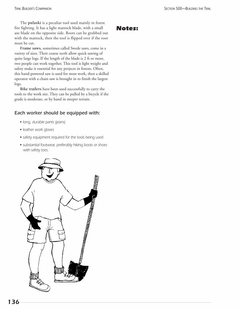
The pulaski is a peculiar tool used mainly in forestfire fighting. It has a light mattock blade, with a smallaxe blade on the opposite side. Roots can be grubbed outwith the mattock, then the tool is flipped over if the rootmust be cut.
Frame saws, sometimes called Swede saws, come in avariety of sizes. Their coarse teeth allow quick sawing ofquite large logs. If the length of the blade is 2 ft or more,two people can work together. This tool is light weight andsafety make it essential for any projects in forests. Often,this hand-powered saw is used for most work, then a skilledoperator with a chain saw is brought in to finish the largestlogs.
Bike trailers have been used successfully to carry thetools to the work site. They can be pulled by a bicycle if thegrade is moderate, or by hand in steeper terrain.
Each worker should be equipped with:
• long, durable pants (jeans)
• leather work gloves
• safety equipment required for the tools being used
• substantial footwear, preferably hiking boots or shoeswith safety toes.
Notes:
136
SECTION 500—BUILDING THE TRAILTRAIL BUILDER’S COMPANION
137
SECTION 500—BUILDING THE TRAIL TRAIL BUILDER’S COMPANION
503 Finding a workforceOnce approval has been given and funds raised, it is
time to organize an implementation plan. Decide what partof the project to build first and who will do the actual con-struction. The choice of using volunteer labour or hiredlabour will depend on both the complexity of the job andfinancial resources. A professional landscape architect orproject manager will be able to assist you in determiningthe most appropriate route for your project. The options toconsider are:
• hire a contractor to do all the work
• use volunteer labour under the direction of a construction foreman
• use strictly volunteer labour from the community.
This last option is recommended only if you have some-one experienced in coordinating and supervising construc-tion on your planning committee.
Contracted labourIf you choose to hire someone for any part of the pro-
ject, investigate the previous projects that the candidateshave managed. Are they similar in scope and approach toyour project? Are the present managers happy with theresults?
When you have chosen a person or company, you willrequire a contract to set out the terms of your agreement. Itis important to have professional help in developing thecontract to avoid legal and quality control problems. Mostof the items which should be included are mentioned inthe description of Tender Document in Section 501.
Volunteer labourIt takes a great deal of patience and skill to manage con-
struction and to manage people, especially communitylabour. If you choose to use volunteer labour for any part ofyour project, make sure your construction manager canbring out the best from people with unique abilities.
Perhaps the ideal situation is to find “professional vol-unteers.” These people do similar tasks as part of their reg-ular employment, but have been loaned to the project.They often bring their equipment with them. For exam-ple, a municipality or large company may loan a truck,loader, and bobcat with their operators to build the trailif the project pays for the materials. This work can bescheduled during a slow period. Flexibility and coopera-tion are essential to match the needs of the employer andthe project.
Once leadership for the project has been established,construction dates should be set, material ordered, equip-ment secured, volunteers contacted and committed, and
task leaders assigned to supervise specific aspects.Planning sessions in advance of construction should beheld. The project construction manager and task leadersshould review construction drawings and confirm allarrangements. A first aid kit and refreshments should beavailable at all times during construction.
Crew safetyIn any situation where the supervisor and the crew are
not familiar with each other, there exists the possibility ofmisunderstanding directions or abilities which could leadto accidents. One of the very first statements from the pro-ject manager during the initial orientation should be, “Ifyou are asked to do anything that you feel is not safe foryou, another worker, or your equipment, do not do it.Instead, bring your concerns to my attention.”
Full safety equipment, as required by the WorkersCompensation Board (WCB), should be worn at all timeswhen using power tools. Chainsaw operators must weargoggles and chainsaw pants and ensure the saw’s safety fea-tures are operational. These points are especially importantif workers are volunteers, who may not be as skilled withthe equipment as regular workers. Workers should wearlong, durable pants and long-sleeved shirts. Hard hats andsafety boots should be worn if they are available.
Volunteers can be covered by the WCB if they are regis-tered in advance through Alberta TrailNet’s Edmontonoffice. Ask volunteers to sign up for work parties to ensuretheir names can be passed on to WCB. This will also enablethe foreman to gather sufficient tools and materials.
Tailgate safety talkAgency crews often start each workday and
each new task with a brief review of safety issues. Devoting a few minutes to talk-ing over safety concerns is time verywell spent, allowing workers toshift into a safe-work mentalitybefore starting the job.

138
SECTION 500—BUILDING THE TRAILTRAIL BUILDER’S COMPANION
Notes:
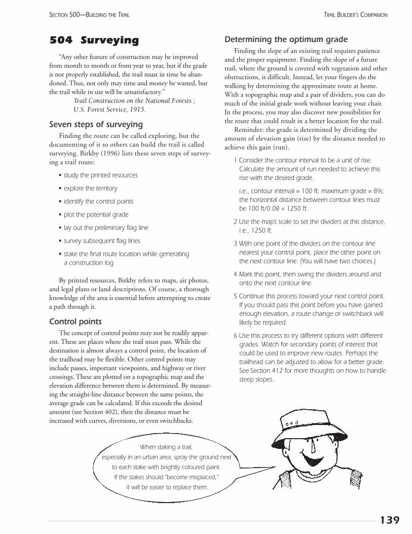
504 Surveying“Any other feature of construction may be improved
from month to month or from year to year, but if the gradeis not properly established, the trail must in time be aban-doned. Thus, not only may time and money be wasted, butthe trail while in use will be unsatisfactory.”
Trail Construction on the National Forests ; U.S. Forest Service, 1915.
Seven steps of surveyingFinding the route can be called exploring, but the
documenting of it so others can build the trail is calledsurveying. Birkby (1996) lists these seven steps of survey-ing a trail route:
• study the printed resources
• explore the territory
• identify the control points
• plot the potential grade
• lay out the preliminary flag line
• survey subsequent flag lines
• stake the final route location while generating a construction log
By printed resources, Birkby refers to maps, air photos,and legal plans or land descriptions. Of course, a thoroughknowledge of the area is essential before attempting to createa path through it.
Control pointsThe concept of control points may not be readily appar-
ent. These are places where the trail must pass. While thedestination is almost always a control point, the location ofthe trailhead may be flexible. Other control points mayinclude passes, important viewpoints, and highway or rivercrossings. These are plotted on a topographic map and theelevation difference between them is determined. By measur-ing the straight-line distance between the same points, theaverage grade can be calculated. If this exceeds the desiredamount (see Section 402), then the distance must beincreased with curves, diversions, or even switchbacks.
Determining the optimum gradeFinding the slope of an existing trail requires patience
and the proper equipment. Finding the slope of a futuretrail, where the ground is covered with vegetation and otherobstructions, is difficult. Instead, let your fingers do thewalking by determining the approximate route at home.With a topographic map and a pair of dividers, you can domuch of the initial grade work without leaving your chair.In the process, you may also discover new possibilities forthe route that could result in a better location for the trail.
Reminder: the grade is determined by dividing theamount of elevation gain (rise) by the distance needed toachieve this gain (run).
1 Consider the contour interval to be a unit of rise.Calculate the amount of run needed to achieve thisrise with the desired grade.
i.e., contour interval = 100 ft; maximum grade = 8%;the horizontal distance between contour lines mustbe 100 ft/0.08 = 1250 ft.
2 Use the map’s scale to set the dividers at this distance,i.e., 1250 ft.
3 With one point of the dividers on the contour linenearest your control point, place the other point onthe next contour line. (You will have two choices.)
4 Mark this point, then swing the dividers around andonto the next contour line.
5 Continue this process toward your next control point.If you should pass this point before you have gainedenough elevation, a route change or switchback willlikely be required.
6 Use this process to try different options with differentgrades. Watch for secondary points of interest thatcould be used to improve new routes. Perhaps thetrailhead can be adjusted to allow for a better grade.See Section 412 for more thoughts on how to handlesteep slopes.
139
SECTION 500—BUILDING THE TRAIL TRAIL BUILDER’S COMPANION
When staking a trail,
especially in an urban area, spray the ground next
to each stake with brightly coloured paint.
If the stakes should “become misplaced,”
it will be easier to replace them.
Using a clinometerA clinometer measures the slope of the land between
the surveyor and a point which is being sighted. (Most cli-nometers have two scales. Make sure you are using the per-centage scale, not the degrees or chains.) Look through theinstrument with one eye, and look beyond the instrumentto your target with the other. Tilt your head and the instru-ment until a horizontal line appears to pass through yourtarget. The number on the line should be the gradebetween your eye and the target.
Unless the target is the same height as your eye, errorswill occur. The most convenient target is another survey-or. Conduct a test on a level surface to find out what partof the “target’s” body is the same level as your eyes. Outin the field, the target should adjust their position untilthe appropriate grade is indicated. The person will thenmark the position with a piece of flagging tape and movefarther along.
By following this procedure, the approximate routedetermined on the map can be transferred to the ground.This preliminary flag line can then be adjusted to take localfeatures such as large trees and rocks into account.
The surveyor’s final task will be to stake the route andprepare a detailed log of what work must be done at eachlocation. (Ensure that the construction workers know if thestakes identify the centre line, or the uphill or downhilledge of the trail.) Use a surveyor’s wheel to measure the dis-tance, and a labeled stake every 100 m becomes a “station.”Each point needing special attention is labeled in the notesas “station number + metres,” eg., 09+45 will be 945 mfrom the start of the trail. This log should be transferred tothe Trail Strip Map described in Section 202.
Notes:
140
SECTION 500—BUILDING THE TRAILTRAIL BUILDER’S COMPANION
141
SECTION 500—BUILDING THE TRAIL TRAIL BUILDER’S COMPANION
505 Total materialremoval equipment
Godzilla meets the Boreal Forest!Total material removal machines have been developed
by logging equipment companies. Imagine a large bulldozerwith a giant grinder mounted on the back. The blade push-es down the trees, the treads flatten it, and the grindershreds everything into coarse wood chips. It creates asmooth path as it rolls through the forest.
These gargantuan machines can make trail building asnap and save money at the same time. The concept grewout of the need to cut thousands of kilometres of seismiclines through the northern forest. This is extremely labourintensive and has led to problems with the trees beingpushed up into giant windrows, which become barriersfor wildlife.
The advantages of this system are:
• speed of construction - about 2 km per hour
• thorough removal of roots and stumps to a depth ofabout 40 cm
• little labour required
• can be cheaper on a finished, per km basis, thanhand-clearing
What is the downside?
• leaves too much organic material, making the trailmucky in moister areas
• machine must be booked well ahead of the season
• requires substantial cash outlay - no chance for volun-teer labour
• reduces the economic benefits of trail building to thelocal community
• hard to adjust the route at the last moment
Several people who have reviewed the system have cometo the consensus that it will work well in certain situations.Ideally, the route will be planned like any other, using themethods described earlier in this manual. The larger treeswill be felled and the trunks removed or burned. The equip-ment will then be hired to shred the smaller branches andthe stumps to leave a pleasant trail surface.
Manufacturers suggest removing the mulch and replac-ing it with gravel for a firm tread. In some areas, this mulchis valuable for restoring other disturbed sites. If the woodhas been removed, the residue can just be plowed to thesides, the soil packed, and gravel laid.
So, if you are planning quite a long trail through fairlydry level terrain, consider using this equipment. It can bean important cost-saving tool.
If you have trees to clear, you may have a local loggingequipment dealer. Ask them about these machines. Mostmanufacturers have something along this line and will beable to tell you who they have sold to in the past.
Removal Crew!

142
SECTION 500—BUILDING THE TRAILTRAIL BUILDER’S COMPANION
Notes:
Notes:
143
SECTION 500—BUILDING THE TRAIL TRAIL BUILDER’S COMPANION
506 Trail Tailor equipmentMany urban and suburban trails are built wider than
necessary just because contractors do not have any smallerequipment. A Peace River contractor recognized this spe-cialized market for small construction equipment and setout to fill it.
Equipment and their benefitsUntil now, the small skid-steer tractor, widely known by
the trade name Bobcat, has been used for this work but it isheavy, expensive, and slow. The new design bases it’s systemon the ordinary all-terrain vehicle. Both the ATV and itsreplacement parts are easily available, and it has plenty ofpulling power. Fully loaded, it can maintain a speed of 20km per hour.
The first new piece of equipment was the belly-dumphopper trailer. It holds almost a cubic yard of gravel, at leasttwice what a bobcat will handle. With just a bit of practice,the chute can be opened on the move and the gravel isspread out well. In some cases, the excess soil is carried outon the return trip. The final width can be adjusted but isgenerally between one and two metres.
A small grader has an adjustable blade mounted onwheels. This cuts into the sidehill, then spreads the gravelevenly. A tanker, with a built-in sprayer, can spread water, her-bicides, sealants like MC-30, and even calcium chloride. Bothof these can be towed behind the hopper trailer. The finalpiece of equipment is a roller to pack the gravel. Together, thisequipment provides all that is needed to build an aggregatetrail.
Now, how well does it work? “Great!” according to theproject manager for the 29-km Friendship Trail betweenPeace River and Grimshaw. The Trail Tailor is the bestthing since sliced bread. “Even better than sliced bread. Youcan slice your own bread, but try moving a thousandtonnes of gravel in a wheelbarrow. This equipment let usbuild 25% more trail than planned, and still come in atleast 25% under the budget!”
If you expect a fairly low use, say under ten peopleper hour, but still want a granular surface, then this is foryou. The benefits of a narrow clearing width - less dis-ruption, less material, more flexibility in routing - can beyours at a reasonable cost.
For details contact Alberta TrailNet at 1-877-9-TRAILS

144
SECTION 500—BUILDING THE TRAILTRAIL BUILDER’S COMPANION
Notes:
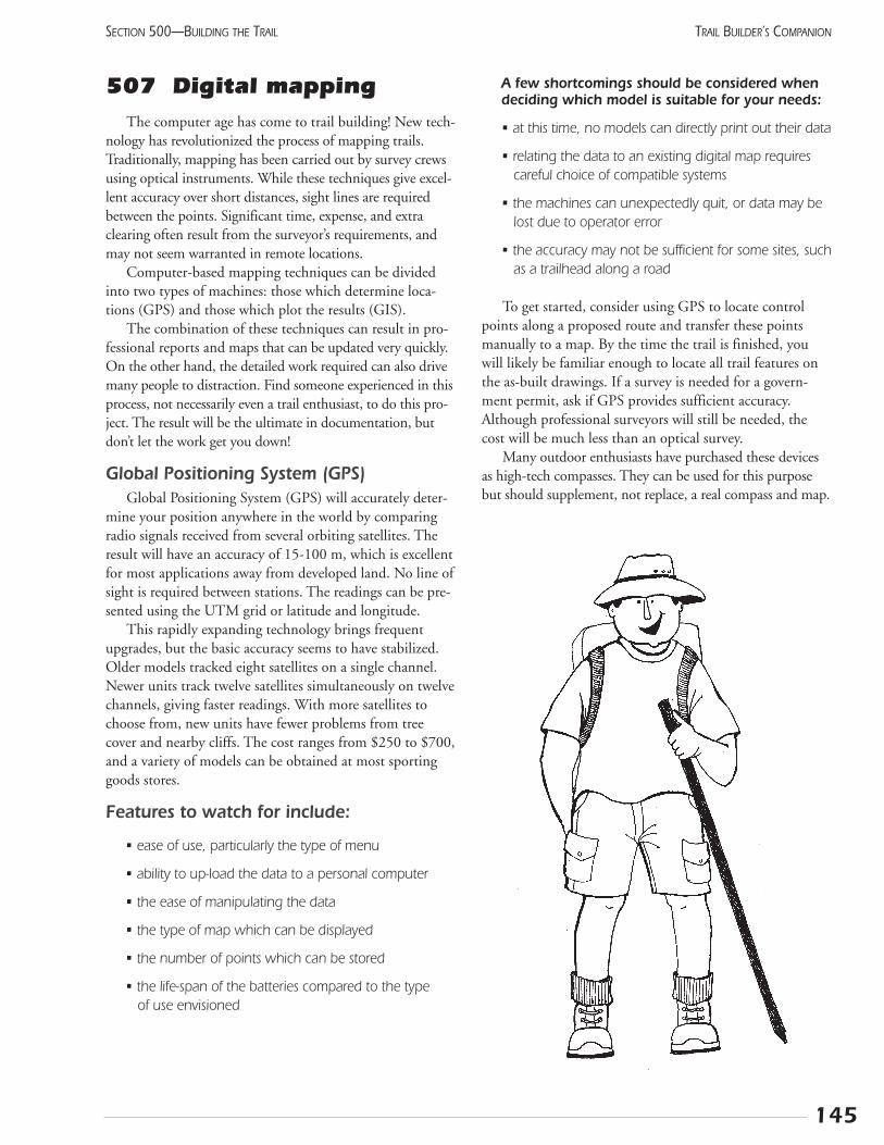
507 Digital mappingThe computer age has come to trail building! New tech-
nology has revolutionized the process of mapping trails.Traditionally, mapping has been carried out by survey crewsusing optical instruments. While these techniques give excel-lent accuracy over short distances, sight lines are requiredbetween the points. Significant time, expense, and extraclearing often result from the surveyor’s requirements, andmay not seem warranted in remote locations.
Computer-based mapping techniques can be dividedinto two types of machines: those which determine loca-tions (GPS) and those which plot the results (GIS).
The combination of these techniques can result in pro-fessional reports and maps that can be updated very quickly.On the other hand, the detailed work required can also drivemany people to distraction. Find someone experienced in thisprocess, not necessarily even a trail enthusiast, to do this pro-ject. The result will be the ultimate in documentation, butdon’t let the work get you down!
Global Positioning System (GPS)Global Positioning System (GPS) will accurately deter-
mine your position anywhere in the world by comparingradio signals received from several orbiting satellites. Theresult will have an accuracy of 15-100 m, which is excellentfor most applications away from developed land. No line ofsight is required between stations. The readings can be pre-sented using the UTM grid or latitude and longitude.
This rapidly expanding technology brings frequentupgrades, but the basic accuracy seems to have stabilized.Older models tracked eight satellites on a single channel.Newer units track twelve satellites simultaneously on twelvechannels, giving faster readings. With more satellites tochoose from, new units have fewer problems from treecover and nearby cliffs. The cost ranges from $250 to $700,and a variety of models can be obtained at most sportinggoods stores.
Features to watch for include:
• ease of use, particularly the type of menu
• ability to up-load the data to a personal computer
• the ease of manipulating the data
• the type of map which can be displayed
• the number of points which can be stored
• the life-span of the batteries compared to the type of use envisioned
A few shortcomings should be considered whendeciding which model is suitable for your needs:
• at this time, no models can directly print out their data
• relating the data to an existing digital map requirescareful choice of compatible systems
• the machines can unexpectedly quit, or data may belost due to operator error
• the accuracy may not be sufficient for some sites, suchas a trailhead along a road
To get started, consider using GPS to locate controlpoints along a proposed route and transfer these pointsmanually to a map. By the time the trail is finished, youwill likely be familiar enough to locate all trail features onthe as-built drawings. If a survey is needed for a govern-ment permit, ask if GPS provides sufficient accuracy.Although professional surveyors will still be needed, thecost will be much less than an optical survey.
Many outdoor enthusiasts have purchased these devicesas high-tech compasses. They can be used for this purposebut should supplement, not replace, a real compass and map.
145
SECTION 500—BUILDING THE TRAIL TRAIL BUILDER’S COMPANION
Geographic Information System (GIS)Geographic Information System (GIS) will plot a
comprehensive map by integrating digital location datafrom various sources. The resulting map shows relation-ships between different land uses, enabling the trail plan-ner to better understand the competing claims in thestudy area. GIS makes good use of existing data, reducingthe time and expense required to accumulate the infor-mation.
Sources of data include GPS measurements and digi-tized topographic maps. With suitable facilities, maps,blueprints, and air photos can be electronically scanned.The operator will identify several locations found on bothdata set, and the computer merges the data together. In the“olden days,” draftsmen put layers of tracing paper over amap then photographed the total picture. This is simply anelectronic version of this process.
Many resource agencies and companies use these sys-tems, so you may be able to access their data, i.e., locationsof cut blocks, forest types, access roads, pipelines. Check tosee if the relevant organizations are willing to make thisdata available to you. Some companies are already doingthis mapping as a public service for local trail groups. Inother cases, technicians familiar with computer-assisteddrafting may be willing to work for reduced rates.
The computer, software, and printer requirements aresubstantial and increasing quickly. Operators requireyears of detailed training. It is not feasible for trail com-mittees to attempt this type of project without depend-able technical support.
Future applications for this technology will increase asmore organizations develop the capacity to use it. A nation-al sponsor will provide digital base maps of the TransCanada Trail so the local trails can tie into the bigger pic-ture. At some point, the computer database will be directlylinked to on-line information centres for remote access. Asimple version of this can be found in Nova Scotia tourismoffices right now.
Notes:
146
SECTION 500—BUILDING THE TRAILTRAIL BUILDER’S COMPANION
Trail builders can use the printed output for construction plans, maintenance work, and
promotional brochures. The information that has been gathered throughout the planning and
construction phases can be easily updated and used again.
508 Re-vegetation and landscaping
Plants are the trail builder’s friends! Millions of leavessoften the effect of rain and wind, while millions of tiny roothairs tie together the soil particles. Together, the natural vege-tation stabilizes the ground’s surface in a way we cannot hopeto duplicate. It’s too bad that a natural forest is so hard toride a bicycle through!
The trail builder’s challenge is to provide access for thetrail users with the minimum disturbance to the vegeta-tion. In some cases, the vegetation has already been dis-rupted and we should repair this as best we can. At thesame time, the thoughtful use of planted vegetation canenhance almost every aspect of the trail experience.
Realistic standardsThe first step is to determine what level of development
is really needed. Sometimes trails get “overbuilt.” The plan-ner must take into account the trend to increasing usewithout simply trying to meet arbitrary standards fromanother jurisdiction.
The type of trail must match both the type of trans-portation proposed for the route and the type of experi-ence. If wilderness is the experience desired, maybe the trailshould be grass-covered with bridges only over the largeststreams. Don’t build a wide trail just because someoneoffers the use of a bulldozer! The less vegetation removed,the less erosion will occur.
In remote areas, the encroachment of vegetation on thetrail can be a problem. This should be addressed with a reg-ular maintenance program of mowing or pruning ratherthan creating an overly wide right-of-way to start with.
Landscaping as a management toolPlants can effectively direct people to the appropriate
location without the expense or intrusive appearance of afence. For example, a large tree will mark the turn in aswitchback and prevent people from taking a short cut. Itwill also physically support the upper trail. Shrubberywill prevent people from wandering off the trail. You mayhave to plant shrubs in certain areas to achieve this. If areal hazard would result from leaving the trail, use thornyvegetation. (Roses grow well, but will create a problem bysuckering into the trail, especially if the surface is asphalt.Instead, use buffalo berry in the grassland region, orhawthorn in the moister regions. Neither of these willsucker.)
Sometimes a visual barrier is wanted to screen the trailusers from the nearby residents, or vice versa. Planting afew native trees and shrubs will provide this, while focusingthe trail user’s attention ahead. On the other hand, treescan frame a view and give it real impact. In some areas, afew trees may need to be removed to allow viewpoints outof the “green tunnel” surrounding the trail.
If a physical barrier is needed right away, considerbuilding a berm. This is an earth bank separating the trailfrom potential problems, such as a railway or highway. Thisshould be planted with shrubs that will soften the appear-ance. The cost is high to produce this but it may be usefulfor short distances.
When a trail intersects with a road or railway, a fencemay be needed to ensure that everyone crosses at the sameplace. This is especially important if the trail follows thesame right-of-way before crossing. A fence is preferable toshrubs in this situation because of the better visibility.
Skiers and snowmobilers become extremely sensitive tothe surrounding vegetation as it affects their activity. Denseevergreens catch and hold the snow leaving a bare patchbelow. Aspens, on the other hand, shade the trail from thesun while still allowing the snow to reach the ground. In theregion south of Highway 16, where the snow can be uncer-tain, keep the winter trail on the north side of evergreenswhere it will be shaded. Farther north, it may be moreimportant to gain protection from the wind by staying onthe south side where possible. When passing through aspenskeep the trail narrow to maximize the shelter.
Re-vegetationAny land disturbed during trail construction must be
replanted as soon as possible. Linear features like trails canallow weeds to gain access to previously weed-free fields. Theobjective is to create an extension of the existing vegetationpatterns. Keep maintenance needs in mind by avoiding treesand shrubs that send out suckers.
147
SECTION 500—BUILDING THE TRAIL TRAIL BUILDER’S COMPANION
The most appropriate species to plant are those thatalready grow adjacent to the disturbed area. Collectingseeds from nearby areas and planting them next to thetrail is a labour-intensive activity suitable for a volunteerouting. Any commercially available seed mixes are likelyto contain weed seeds. Use them with caution even if thespecies are suitable.
Pipeline companies are leading the field in vegetationrestoration techniques. Some new products can be used incritical areas where the extra expense will be justified byreduced erosion problems. These include hydro-mulch anderosion control blanket, both of which are weed-free.
All developers considering plant restoration are encour-aged to consult Gerling et al (1996).
Closing TrailsSome trails should be taken out of use and restored to
a natural state. These may be ad hoc routes that havebeen replaced by planned trails. In other cases, a densenetwork of trails may have been developed before theirimpact on wildlife was appreciated. The habitat can bepartly returned to the animals by focusing human use onfewer trails. Whatever the history, trail managers shouldtake every opportunity to reduce their impact on the nat-ural environment.
When trails are closed, the users must be informed ofboth the reason and the process. Signs should be postedbefore the site is reached as well as at the closed trail. Themain idea is to keep people off the old trail until it canrestore itself. A little effort in hiding the start of theclosed section will go a long way to achieving this. Even asingle tree planted in the middle of the former trail canchange the flow pattern.
If sufficient labour is available and the slope is not toosteep, cultivate the trail surface to allow quicker infiltrationof rain. Place deadfall across the slope to slow runoff.Sometimes soil can be brought from a nearby area. Don’tcreate a new scar or bring in soil from another site. Wherethe trail has eroded into a trench, dig logs or stones into thesides of the trail to create small check dams. These will trapsediment and help the runoff sink in. Finally, cover the trailwith leaves, dead vegetation, and stones to break up theoutline.
Shrubs should be the focus of restoration programs.This type of plant has become adapted to disturbance,whether that be fire, flood, or trampling. They can be easilytransplanted, and can often be grown in bulk from cuttingsbefore being planted.
Notes:
148
SECTION 500—BUILDING THE TRAILTRAIL BUILDER’S COMPANION
149
SECTION 500—BUILDING THE TRAIL TRAIL BUILDER’S COMPANION
509 Final reportThe final report brings closure to your committee’s work.
It formally passes responsibility from the Trail DevelopmentCommittee to the trail operating group which will maintainthe route. It documents the results, and explains the processwhich you followed to achieve them. It also provides inspira-tion for others embarking on similar tasks.
If you have faithfully recorded each step of your trail’sdevelopment, you will have done most of the work already.The final report will mainly be a collection of other reports,bound together with a letter of transmittal from the chairof the development committee to the trail sponsor. Majordonors will want copies of the report, as will your locallibrary, some government agencies, and other trail groups.
The major sections will include:
• letter of transmittal
• goal and objectives of the project
• development plan
• narrative summary of the development process
• committee members and list of volunteers
• financial arrangements:–initial budget with actual expenditures and revenues added as new column
–sources of funding for capital and operational expenses, especially major sponsors
• management plan and recommendations for future operation including waste garbage disposal, trailrepair, policing, weed control and insurance etc.
The files that have accumulated should be consolidatedand put in order. These should be placed in a single box or fil-ing cabinet, preferably in the possession of the Trail Operator.
Materials that should be included:
• strip map
• resource book (review Section 202)
• all clippings and media coverage
• endorsements received
• landowner agreements
• other permits and documents
• contracts which were awarded
• all financial records: bank statements, cheques, invoices, receipts
• all specifications of the trail, materials, furniture, andother work
• sample copies of all promotional material, includingmaps and brochures
Distribution
150
SECTION 500—BUILDING THE TRAILTRAIL BUILDER’S COMPANION
Trail Resource Catalogue
The resources listed below are now available, for the cost of printing and shipping.
To order, send cheque or money order to: Alberta TrailNet, 11759 Groat Road Edmonton, AB T5M 3K6.
For more information, please call 422-7150 or toll-free 1-877-9-TRAILS.
Publications: Prices
30 Years in the Making: A comprehensive economic impact and user study of the $ 5.00Bruce Trail, Ontario, Canada. 9 pages.
Conflicts on Multiple-Use Trails: Synthesis of the literature and state of the practice. $12.0038 pages plus appendices.
Economic and Social Benefits of Off-Road Bicycle and Pedestrian Facilities. 4 pages. $ 3.00
Economic Impacts of Protecting Rivers, Trails and Greenway Corridors: A resource $15.00book. 135 pages plus appendices.
An Economic Impact Analysis of the Proposed Alignment of the Trans Canada Trail $25.00in East-Central Alberta
Grass Routes Legacy Project: A proposal for trail development in Alberta. 21 pages $ 8.00plus appendices.
Guide to Alberta’s Trails. 16 pages. $ 5.00
Multi-Use Trails in Canada: An analysis of some successful cases. 45 pages. $ 8.00
Rails-Trails and Safe Communities: The experience on 372 trails. 15 pages plus appendices. $ 5.00
Retrofitting Communities for Sustainable and Healthy Active Transportation. 41 pages. $10.00
Trail Builder's Companion. 185 pages. $20.00
Developing Your Wildlife Viewing Site: 79 pages. $6.00
Cross Country Ski Trails: 69 pages. $6.00
Alberta TrailNet Conference Proceedings: 1993 & 1994. $12.00
Trail Talk Conference Proceedings: 1995 & 1996. $12.00
Trail Talk Conference Proceedings: 1997. $12.00
Trans Canada Trail Calgary Pavilion. Approximately 95 pages. $15.00
Trans Canada Trail: Public Presentation. 17 pages. $ 5.00
Wild Rose Trail System: A plan for the development of recreation trails across Alberta.52 pages plus maps & addendum. $15.00
Videos:
“Rails to Greenways,” Enhancing our Communities & Trans Canada Trail. 27 min. $12.00
End of the Line: The Uhthoff Trail. 12 min. $12.00
Trans Canada Trail Foundation: “Countdown to a Dream.” 47 min. $12.00
Section 600 Operation

601 What “operation”means
Recreation activities require two types of on goingattention: the physical maintenance of the facility and thepeople-oriented operation. Of course, both are needed for asuccessful experience. Most of these topics are treated insome detail in other sections. This listing summarizes theoverall program.
Physical maintenance:
• regularly inspect all trails to ensure safety and good repair
• remove deadfall and hazardous trees
• remove litter and empty garbage cans
• clean toilets and other structures
• keep woody vegetation from encroaching on trail
• repair or replace trail surface
• stain and repair trail furniture
• check and replace signs
• control erosion of trail surface or nearby areas
• ensure water drains away quickly
• set tracks for ski and snowmobile trails
Trail operation or programming:
• arrange appropriate advertising or promotion
• continue fundraising activities, as required, to ensurelong-term viability
• produce and distribute maps, interpretive materials,and other brochures
• provide information to users, either with informationattendants or with bulletin boards
• arrange special events and other programs
• set up volunteer programs
• operate trail patrols or other security programs whereconsidered beneficial
• provide for the rescue of injured or lost people
• maintain contact with landowners, recreation groups,and other stakeholders
• provide commercial activities related to the trail
• ensure the operation is administered properly and thefinancial records are accurate
• evaluate and document the trail’s impact
Who should manage the trail?Building a trail requires a long-term commitment to
maintaining it. Regardless of the size of the project, it willneed repair, cleaning, and promotion. Eventually, in per-haps ten or 15 years, a substantial rebuilding may berequired. An organization of some sort must be in place tohandle this. The trail committee must address this issueearly in the planning process. If the group does not expectto grow to fill this role, partners must be sought that canprovide long-term support. The choices include govern-ment departments or agencies, not-for-profit organizations,and companies. Each type of organization has advantagesand restraints.
Volunteer organizations, including service clubs andrecreation associations, have increased in number and influ-ence in recent years. Often growing out of special interestgroups, they may go one step farther and provide the ser-vices they promote. Members bring a strong motivationand detailed knowledge of requirements for their particulararea of interest. Their diverse backgrounds ensure a widerange of contacts and experience. A high profile and clearlydefined project will keep interest high.
But volunteers can only carry on for so long before theirenthusiasm wanes. Many groups handle this “burnout” byhiring staff to do the most demanding part of the work-load. The Bruce Trail Association, for example, has staffwho carry out most of the technical or administrative tasks.The staff support hundreds of volunteers who do much ofthe field work. Together, volunteers and staff provide anexceptional experience for hundreds of thousands of recre-ationists at no cost to the public.
Contractors are increasingly being used for specializedmaintenance operations. They can bring expertise andequipment suitable for certain tasks with little overhead oradministration charges. They can generally achieveeconomies by doing the same task for similar facilities inthe same region. Custom track-setting for snowmobiles isone service now available in Alberta, but other servicescould be initiated by the private sector as well.
So what is the best approach to managing a trail?Obviously, there is no single “best” answer. Increasingly,recreation facilities are moving towards partnershipswhere several organizations have meaningful roles. Eachwill bring strengths to the table and each will contributeto the overall project. Look at the following example ofhow this could work:
153
SECTION 600—OPERATION TRAIL BUILDER’S COMPANION

Government agency:
• Provides the land base in cooperation with theforestry company
• Provides some capital funding through granting foun-dations
Trail group:
• Advises the government staff on what facilities are needed
• Raises money to pay for their operation and somecapital development
• Carries out most ongoing maintenance, especiallyweekly trail checks
• Staffs the visitor centre and sales counter with volunteers
• Hires the trail grooming contractor
Contractors:
• Groom the winter trails as per schedule
• Provide firewood
• Produce brochures or books for sale based on research by volunteers
Financial security is an essential aspect of long-term sta-bility for the trail. Some of the funding sources used inAlberta and other places include:
• Annual permit: province-wide or local; just local users, or all users
• User fee: requires staff for collection and enforcement; creates high liability, potential security problems
• Donations: most effective away from the trail; users don’t bring wallets
• Sponsors: a service club, agency, or company may pay some or all of the costs
• Services: selling food, supplies, or souvenirs can bring substantial revenue
• Events: races, loppets, and fun runs etc., generally bring in profits
Notes:
154
SECTION 600—OPERATIONTRAIL BUILDER’S COMPANION
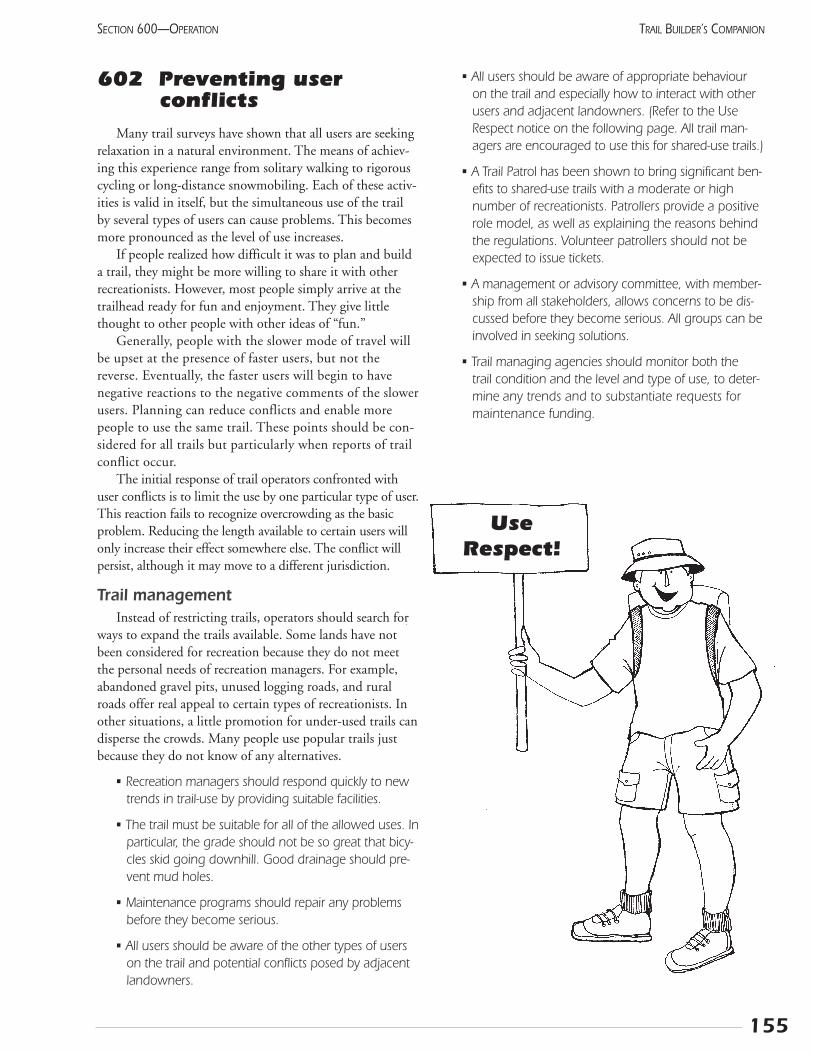
155
SECTION 600—OPERATION TRAIL BUILDER’S COMPANION
602 Preventing user conflicts
Many trail surveys have shown that all users are seekingrelaxation in a natural environment. The means of achiev-ing this experience range from solitary walking to rigorouscycling or long-distance snowmobiling. Each of these activ-ities is valid in itself, but the simultaneous use of the trailby several types of users can cause problems. This becomesmore pronounced as the level of use increases.
If people realized how difficult it was to plan and builda trail, they might be more willing to share it with otherrecreationists. However, most people simply arrive at thetrailhead ready for fun and enjoyment. They give littlethought to other people with other ideas of “fun.”
Generally, people with the slower mode of travel willbe upset at the presence of faster users, but not thereverse. Eventually, the faster users will begin to havenegative reactions to the negative comments of the slowerusers. Planning can reduce conflicts and enable morepeople to use the same trail. These points should be con-sidered for all trails but particularly when reports of trailconflict occur.
The initial response of trail operators confronted withuser conflicts is to limit the use by one particular type of user.This reaction fails to recognize overcrowding as the basicproblem. Reducing the length available to certain users willonly increase their effect somewhere else. The conflict willpersist, although it may move to a different jurisdiction.
Trail managementInstead of restricting trails, operators should search for
ways to expand the trails available. Some lands have notbeen considered for recreation because they do not meetthe personal needs of recreation managers. For example,abandoned gravel pits, unused logging roads, and ruralroads offer real appeal to certain types of recreationists. Inother situations, a little promotion for under-used trails candisperse the crowds. Many people use popular trails justbecause they do not know of any alternatives.
• Recreation managers should respond quickly to newtrends in trail-use by providing suitable facilities.
• The trail must be suitable for all of the allowed uses. Inparticular, the grade should not be so great that bicy-cles skid going downhill. Good drainage should pre-vent mud holes.
• Maintenance programs should repair any problemsbefore they become serious.
• All users should be aware of the other types of userson the trail and potential conflicts posed by adjacentlandowners.
• All users should be aware of appropriate behaviouron the trail and especially how to interact with otherusers and adjacent landowners. (Refer to the UseRespect notice on the following page. All trail man-agers are encouraged to use this for shared-use trails.)
• A Trail Patrol has been shown to bring significant ben-efits to shared-use trails with a moderate or highnumber of recreationists. Patrollers provide a positiverole model, as well as explaining the reasons behindthe regulations. Volunteer patrollers should not beexpected to issue tickets.
• A management or advisory committee, with member-ship from all stakeholders, allows concerns to be dis-cussed before they become serious. All groups can beinvolved in seeking solutions.
• Trail managing agencies should monitor both the trail condition and the level and type of use, to deter-mine any trends and to substantiate requests for maintenance funding.
UseRespect!
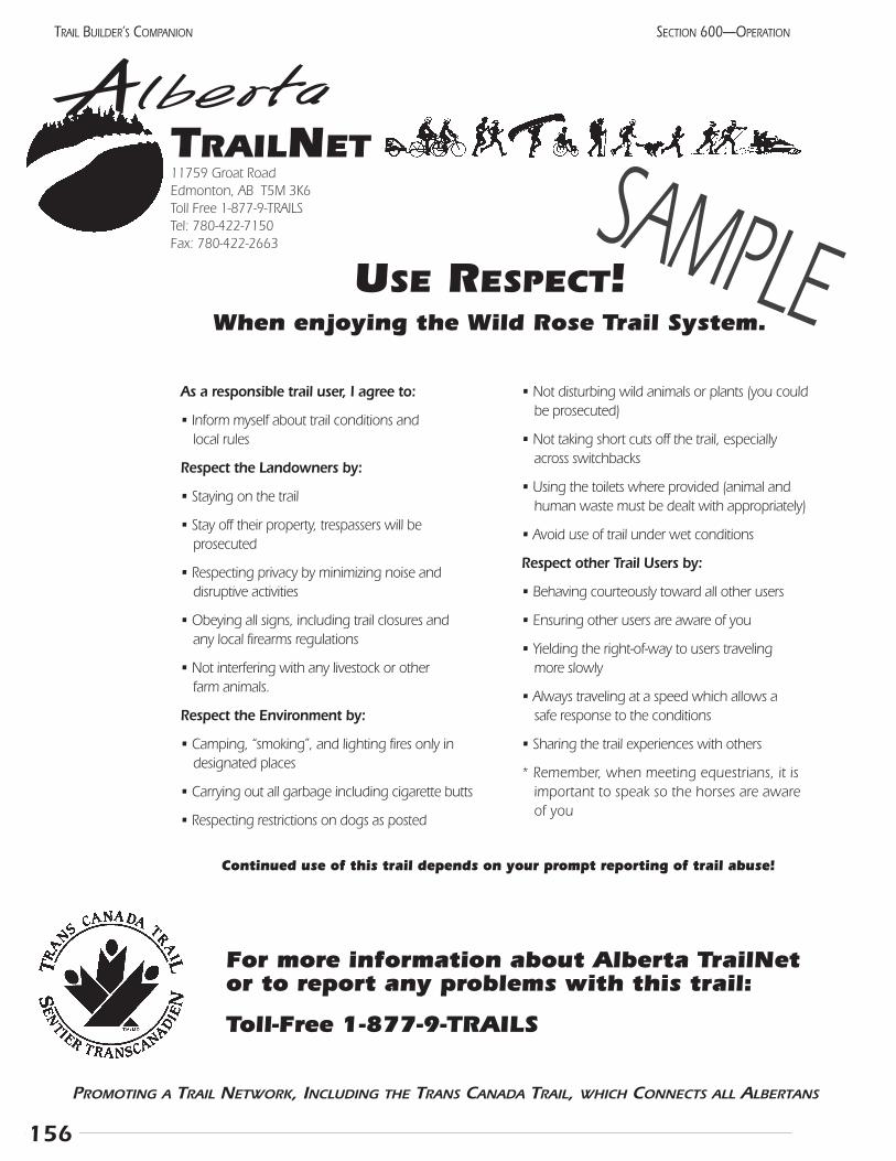
156
SECTION 600—OPERATIONTRAIL BUILDER’S COMPANION
As a responsible trail user, I agree to:
• Inform myself about trail conditions and local rules
Respect the Landowners by:
• Staying on the trail
• Stay off their property, trespassers will be prosecuted
• Respecting privacy by minimizing noise and disruptive activities
• Obeying all signs, including trail closures and any local firearms regulations
• Not interfering with any livestock or other farm animals.
Respect the Environment by:
• Camping, “smoking”, and lighting fires only in designated places
• Carrying out all garbage including cigarette butts
• Respecting restrictions on dogs as posted
• Not disturbing wild animals or plants (you couldbe prosecuted)
• Not taking short cuts off the trail, especially across switchbacks
• Using the toilets where provided (animal andhuman waste must be dealt with appropriately)
• Avoid use of trail under wet conditions
Respect other Trail Users by:
• Behaving courteously toward all other users
• Ensuring other users are aware of you
• Yielding the right-of-way to users traveling more slowly
• Always traveling at a speed which allows a safe response to the conditions
• Sharing the trail experiences with others
* Remember, when meeting equestrians, it isimportant to speak so the horses are awareof you
AlbertaTRAILNET11759 Groat RoadEdmonton, AB T5M 3K6Toll Free 1-877-9-TRAILSTel: 780-422-7150 Fax: 780-422-2663
PROMOTING A TRAIL NETWORK, INCLUDING THE TRANS CANADA TRAIL, WHICH CONNECTS ALL ALBERTANS
USE RESPECT!When enjoying the Wild Rose Trail System.
For more information about Alberta TrailNet or to report any problems with this trail:
Toll-Free 1-877-9-TRAILS
Continued use of this trail depends on your prompt reporting of trail abuse!
SAMPLE
157
SECTION 600—OPERATION TRAIL BUILDER’S COMPANION
603 Public safetyManaging a trail involves providing a safe and enjoyable
experience. This seems straightforward at first, but chal-lenges arise when the provision of safety begins to infringeon some people’s enjoyment. How can these be balanced?
Legally, the responsibility (and required level of service)is based on the expectations of an average person. A nation-al park trail, cared for by many professional staff, wouldlead to a higher level of expectation than a local nature trailobviously created by volunteers. Regardless of experience,though, all trail managers should do their best to provide asafe trail.
Conditions of the trailThe other important task is to ensure that the user is
aware of what conditions will be present, and that they takeresponsibility for their own actions while on the trail.Promotional material and trailhead signs must accuratelydescribe the conditions. A regular maintenance program mustensure that these conditions are met. The particular level ofmaintenance is not as important as its dependability.
Some trails have inherent dangers, and without them,the trail would be pointless. For example, nearly everyviewpoint has a sharp drop-off in front of it. A handrail is areasonable expectation. A waist-high chain link fence couldbe expected if families often use the trail and the drop issubstantial. A higher fence with barbed wire would likelybe over-reacting. Choosing the appropriate level of protec-tion must be done in consultation with others on the com-mittee, perhaps after talking with other trail managers.
Other dangers do not significantly improve the user’sexperience. A trail along the edge of the cliff could bespectacular, but would a more protected route with a fewviewpoints give the same effect with less opportunity for accidents?
The users must be made aware of the specific hazardsthat may be encountered on the trail. This must be obvi-ous; don’t try to downplay the danger. If the problem isworth mentioning, the warning should be firm enough tocause a few people to turn back. Some of the hazards thatshould be mentioned include: bears (specify grizzly and/orblack), cliffs, falling rock, ice across trail, rattlesnakes,impure stream water (or lack of drinking water in hotareas), potential for hypothermia or heat stroke, or danger-ous domestic animals on the trail (bulls).
A formal waiver is one way of documenting that theuser has been told of the hazards. Few trails have the degreeof risk or sufficient manpower to make this feasible. Someagencies have put warnings on each page of sign-in booksto ensure maximum visibility. A waiver may be warrantedfor specific guided activities, but must be carefully wordedto be valid.
The trail development itself must not introduce haz-ards. Ensure the trail is wide enough for the anticipatedvolume and type of use. Good sight lines will allow usersto avoid each other. Trailheads should provide a smoothand safe transition from one mode of travel to another.Remember that in many cases, trails greatly increase over-all safety by allowing recreationists to get off roads andfollow a managed route.
Emergency servicesThe public expects the trail managers to respond effi-
ciently in the event of an accident. A process must be inplace to ensure this. The most common problems shouldbe considered and preparations made for quick reactions. Ifemergency services cannot be provided, this should be clearon the brochures and trail guides. Users should beinformed of the location of the nearest telephone and theemergency telephone numbers. This can be on the trailguide or at the trailhead.
Emergency services should have the names of experiencedcontact persons. These may be the trail managers but couldbe others. The local RCMP detachment may respond to thesecalls, or perhaps nearby provincial parks will take on this role.These arrangements must be made in advance and all partiesmust know their responsibilities. All incidents should berecorded and filed, filed by the trail operator with regularreview to determine if safety could be improved.
InsuranceThe final step is acquiring insurance. One can hope
that with a proper risk management program, no acci-dents will occur and insurance will be unnecessary.However, accidents do happen and insurance will protectthe volunteers on the sponsoring group. The most eco-nomical practice is to have the municipality co-sponsorthe trail and include the trail in their policy. This can bedone with little or no extra expense as the trail hasinsignificant risk compared to the roads, recreation cen-tres, and other facilities already covered.
The Trans Canada Trail has secured a broad insurancepolicy that organizational members of Alberta TrailNet canjoin. Trail groups operating parts of the Trans Canada Trailmust have coverage under this or a similar policy; for othertrails, it is an option. Specific questions may be directed toJohnston Meier Insurance Ltd. at 1-888-664-4544. It should be stressed that this does not cover any trail usersif they sustain injuries. Generally speaking, the policyincludes these aspects:
• liability coverage for the trail managing organization
• liability coverage for adjacent landowners for claimsbrought by trail users
• property insurance for the trail itself (i.e., damage to bridges or the surface material)
• optional Directors and Officers insurance. This is usual-ly needed only if the group has employees, contracts,and fairly broad business interests
The current Alberta Occupiers Liability Act places ahigh level of duty on landowners, making liability insur-ance a prudent precaution. This provincial legislationspecifies that landholders are liable for the safety of recre-ationists on their land. This is true whether the land isprimarily used for recreation or if it is agricultural innature. Similar legislation in many states and severalother provinces has been amended to reduce the obliga-tion when there is no entry fee. For further information,please consult the recent report by the EnvironmentalLaw Centre at 1-800-661-4238 Occupier’s Liability orMcCarthy Tetrault (1995).
Another type of hazard frequently mentioned whennew trails are discussed is the chance that trail users couldbe criminals seeking to commit a crime. Both other trailusers and adjacent residents are potentially at risk. Tracyand Morris (1998) have conducted a comprehensive studyof 372 existing trails to determine the actual frequency ofreported crime along trails. They separated responses fromurban, suburban, and rural trail managers. The incidence ofcrime was correlated with the number of users. Overall, thecrime varied from very low in the urban area, to virtuallynon-existent on rural trails.
Trail design is an effective way of promoting trail safe-ty. Overgrown shrubbery should be pruned back, securitylighting may be placed at trail intersections where feasibleand parking lots, and emergency access accommodated.Vandalism or worn features must be repaired immediate-ly because a run-down facility receives much more van-dalism than a well-kept one. Many trail managers haveset up special trail patrols. These range from maintenancecrews on regular safety checks to police or bylaw officerpatrols, either on bicycle or motor vehicle.
To summarize, risk management involves carefullyconsidering all possible risks which may be present, thenremoving those which are not essential for the experience.The user must be aware of those that remain and take per-sonal responsibility for using the trail. Emergency proce-dures must be in place to deal with accidents and criminalactivity. An insurance policy is considered a worthwhileinvestment to protect the trail managers and the adjacentlandholders. Regular and planned reviews of the entireprogram will indicate if changes should be made.
Notes:
158
SECTION 600—OPERATIONTRAIL BUILDER’S COMPANION
604 Fire controlWildfire presents a serious risk to adjacent landholders
and trail users. All trail operators must have a well-consid-ered fire management plan which has been developed incooperation with existing emergency services. All prepara-tions, including maps, radios, and other equipment, mustbe compatible with those used by the local fire department.The fire suppression plan should be presented to all adja-cent landowners and the municipality for their informationand comments. Other important stakeholders includeprovincial departments (forestry, mining, public lands,parks and protected areas, fish & wildlife) and the principalindustrial companies (forestry, pipeline, oil and gas). Themain points to include in the plan are indicated below,along with suggested standards.
PreventionUncontrolled fires can be prevented through many
practical means which will vary with the location and evenwith the season. Each of the following points should be dis-cussed with all stakeholders and applied if they seem appro-priate for your situation:
• include on your strip map an inventory of fuel loads,vegetation breaks (cultivated areas, roads, etc.) andsources of water (summer and year-round)
• ensure signs clearly state the required behaviour, andinclude emergency information
• restrict smoking to campsites, or ask people to smokeonly when stopped at designated spots
• restrict campfires to designated fireplaces
• prohibit all open fires (when fire hazard is high or per-haps at all times)
• temporarily close the trail to all use (when fire hazardis extreme)
• keep grass mowed along trail
• keep brush mowed two metres back from trail
• arrange grazing of the right-of-way to reduce fuel levels
• consider building a fire break between the trail’s r-o-wand any cultivated or hay fields
• with the close cooperation of the adjacent landhold-ers, isolated areas with high fuel load can be selective-ly burned. Refer to How to Manage Small Prairie Fires,by Wayne Ruby, for practical advice (available fromthe TrailNet office)
• clearly post the name of each feature (campsite, river,viewpoint, road) and post kilometre markers to facili-tate the clear reporting of all problems
ReadinessAll people associated with the trail must always be alert
and ready to decisively extinguish any fires. This requiresthe cooperation of all parties. Fire control must be builtinto all maintenance operations, enabling the entire opera-tion to be constantly ready. Remember that in the grasslandregion, the peak fire season is in fall and early spring, so firesuppression equipment must be available at all times.
• Review the Fire Management Plan at least annuallyand amend as required.
• Have all volunteers and staff firmly enforce the preven-tive measures listed previously.
• Where the terrain allows, ensure that fire trucks can access the trail (i.e., along road allowances or abandoned rail lines). Have keys to any gates clearly labeled and kept with the fire fighting equipment.
• If the trail is not accessible to vehicles, arrange withadjacent landholders to access through their land.Keep their telephone numbers handy.
• Have a map which clearly shows the best accessroutes in every fire vehicle.
• Ensure all brochures and signs indicate a 24-hour tele-phone number to call to report fires. Post this at allcampsites and trailheads, along with the location ofthe nearest phone.
• Consider placing simple fire fighting equipment at keylocations, for use by trail users.
• Consider having one fire drill each spring to ensurethe system is ready.
• Have a formal method of determining the fire hazard, and a specific person and an alternate named to make this decision. This person may also be the “fire boss” who supervises the suppression actions.
• Have a formal method of letting the public know whatthe hazard is and what behaviour is appropriate.
• Acquire any specialized equipment required to fightwild fires in your region.
• Find and train volunteers to fight wild fires. These people may be in addition to an existing localfire department.
159
SECTION 600—OPERATION TRAIL BUILDER’S COMPANION
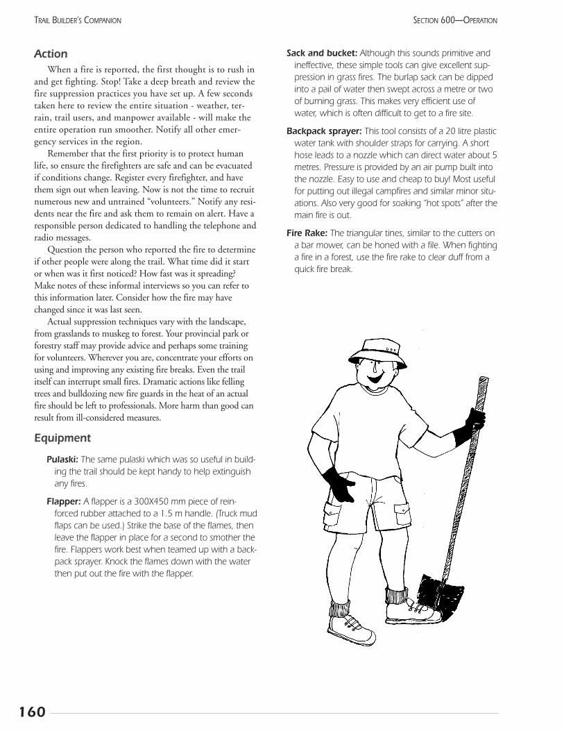
ActionWhen a fire is reported, the first thought is to rush in
and get fighting. Stop! Take a deep breath and review thefire suppression practices you have set up. A few secondstaken here to review the entire situation - weather, ter-rain, trail users, and manpower available - will make theentire operation run smoother. Notify all other emer-gency services in the region.
Remember that the first priority is to protect humanlife, so ensure the firefighters are safe and can be evacuatedif conditions change. Register every firefighter, and havethem sign out when leaving. Now is not the time to recruitnumerous new and untrained “volunteers.” Notify any resi-dents near the fire and ask them to remain on alert. Have aresponsible person dedicated to handling the telephone andradio messages.
Question the person who reported the fire to determineif other people were along the trail. What time did it startor when was it first noticed? How fast was it spreading?Make notes of these informal interviews so you can refer tothis information later. Consider how the fire may havechanged since it was last seen.
Actual suppression techniques vary with the landscape,from grasslands to muskeg to forest. Your provincial park orforestry staff may provide advice and perhaps some trainingfor volunteers. Wherever you are, concentrate your efforts onusing and improving any existing fire breaks. Even the trailitself can interrupt small fires. Dramatic actions like fellingtrees and bulldozing new fire guards in the heat of an actualfire should be left to professionals. More harm than good canresult from ill-considered measures.
Equipment
Pulaski: The same pulaski which was so useful in build-ing the trail should be kept handy to help extinguishany fires.
Flapper: A flapper is a 300X450 mm piece of rein-forced rubber attached to a 1.5 m handle. (Truck mudflaps can be used.) Strike the base of the flames, thenleave the flapper in place for a second to smother thefire. Flappers work best when teamed up with a back-pack sprayer. Knock the flames down with the waterthen put out the fire with the flapper.
Sack and bucket: Although this sounds primitive andineffective, these simple tools can give excellent sup-pression in grass fires. The burlap sack can be dippedinto a pail of water then swept across a metre or twoof burning grass. This makes very efficient use ofwater, which is often difficult to get to a fire site.
Backpack sprayer: This tool consists of a 20 litre plasticwater tank with shoulder straps for carrying. A shorthose leads to a nozzle which can direct water about 5metres. Pressure is provided by an air pump built intothe nozzle. Easy to use and cheap to buy! Most usefulfor putting out illegal campfires and similar minor situ-ations. Also very good for soaking “hot spots” after themain fire is out.
Fire Rake: The triangular tines, similar to the cutters ona bar mower, can be honed with a file. When fightinga fire in a forest, use the fire rake to clear duff from aquick fire break.
160
SECTION 600—OPERATIONTRAIL BUILDER’S COMPANION
161
SECTION 600—OPERATION TRAIL BUILDER’S COMPANION
605 ProgrammingLet’s look a year or two into the future. Planning the
trail involved meetings and hard work. Building the trailwas challenging and hard work. Using the trail is a lot offun, but still some hard work, too. It will take a few years forthe trail to become part of the community. Until then, some-one should help it get established.
Unlike most facilities, trails benefit from being used.The surface gets tougher and the weeds are trampled. Anyproblems get reported promptly and can be repaired beforethey get worse. Vandalism will be reduced to a minimum iffolks are using the trail frequently. The bottom line is a lit-tle time spent getting people on the trail will be a goodinvestment.
Luckily, trails are easy to “sell.” The citizens arealready looking forward to seeing what the route lookslike. Your volunteers have probably brought their friendsout to see it even before completion.
Trailhead maps and brochuresKeep in mind that the trail users have two simple ques-
tions: where does the trail go and what behaviour is accept-able? You should make the answers clear and consistentfrom the first time you promote the trail. Trailhead mapswill be needed for most systems. Perhaps a simple brochurewith a map and the code of behaviour can be distributed toall households to promote the official opening.
If your trail has a significant tourism objective, you willneed to work with your local and regional informationoffice or Chamber of Commerce. Have them distributeyour brochures and tell visitors about the trail. Make surethe trail is included on the general map given out at theseoffices. Ideally, this group will give monetary support forthe trail’s maintenance. After all, visitors are coming, inpart, to see the trail. Very few people come to town just tosee the motel! A trail is the best way to keep tourists intown for another meal. The companies making the profitcan be expected to help pay for the attraction.
Many people will find the trail on their own if youhave sited it properly and it goes to and from places ofinterest for the user. Others will need some inducement totake the first step. As with other parts of your organizing,it will make more efficient use of your time to focus onexisting groups at first. For example, every organization inthe community should receive an invitation to visit.Members of your committee can give guided tours togroups, especially those who helped with the fundraisingor construction.
Use by community groupsCommunity development means getting more and dif-
ferent people involved. Show other community leaders howthe trail can help meet their goals. Naturalists can be asked
to offer regular nature walks along the trail. Fitness centrescan distribute maps and include the trail as part of theirroutine. School physical education classes may need to havethe trail pointed out to them, but will soon become firmsupporters. Contact organizers of existing fun runs, loppets,and walking clubs. They will want to move their activitiesto the trail, where safer and more enjoyable conditions willenhance their projects.
Trail security and emergenciesTrail security is an important program. Ensure your
police or bylaw officer knows the trails and visit them reg-ularly. Patrolling the trail can be an excellent opportunityfor the police to develop positive rapport with theyounger citizens. A group of trail stewards, perhaps with adistinctive vest or other identification, can keep an eye onbehaviour while removing litter and checking for mainte-nance problems. These people can notify the manager if aparty spot seems to be developing. Volunteers can adviseother users of the correct behaviour, but should never beasked to reprimand offenders or give tickets. This requiresprofessional training.
A plan for dealing with emergencies should be writtendown and practiced to ensure it works. Possible problemsinclude injuries, wildfires and floods.
Hunting while on trails has raised considerable discus-sion. The hazard to other trail users must be balanced withthe desire for better off-road access to hunting areas. Insome areas, hunters will be the largest group of users. Theprovincial government has set a precedent by allowing anannual hunting season in Cypress Hills Provincial Park. Thefinal decision will be up to each trail operator, in consulta-tion with the adjacent landowners. If hunting is allowed,signs must be posted at all trailheads advising users.
Special eventsMany trail operators find that a special event will raise
awareness and generate fresh enthusiasm for the trail. Andthese activities are just plain fun! Excellent suggestions areincluded in ParticipACTION’s Handbook forCommunity Events. (See References.) When planning theevent, keep in mind that people often take a couple ofweeks to get adjusted to the changing seasons. An eventscheduled for early in the season may help make the tran-sition easier. Mother’s Day is a good time and can behelped by the many wildflowers generally found then.(But leave them for other mothers to enjoy!) On the otherhand, if conditions could be uncertain, aim for the bestpossible time. Winter-oriented events in the grasslandregion should be held in February to reduce problemsfrom extreme cold.
Generally, only a small committee is needed to organizethis event. Don’t try to do everything for everyone.Maximize community spirit by inviting other groups to
162
SECTION 600—OPERATIONTRAIL BUILDER’S COMPANION
take part. Keep the formal speech-making to a minimumand just let people mingle. Most event programmers com-mit to having a venue or site prepared. This would includeelectricity and portable toilets. The general promotionwould also be handled by the committee. Beyond that, theparticipating groups or companies are responsible for theirown arrangements.
Some sort of a theme helps promote the event, but youcan’t stick too closely to this. Food booths, the high schoolband, and the dog obedience class are always popular, nomatter what the event. “Hang loose” and let people have agood time.
Grand openingThe official opening of the trail is one type of special
event. Of course, in addition to the activities alreadymentioned, this event should have some messages frompoliticians. Let them share in your glory now. Remindthem of the support they professed when your trail nextneeds upgrading!
Every opening tries to find some unique feature beyondthe ribbon-cutting. Trails connecting communities haveopened by tying two ribbons together. Others have anunveiling of a trail sign or the ceremonial mounting of thefinal trail marker. Have the leading politicians do some-
thing! Most openings end with the group travelling at leastpart of the route, perhaps accompanied by a well-known“patron.”
The invitation list to this event is critical. If someone isleft out, they will be disappointed. Get your letters out wellin advance to ensure attendance. Check with the essentialpoliticians before setting the date, to ensure they are avail-able. If your MLA is not able to attend, ask for a personalmessage to be read by the master of ceremonies. Personalinvitations should be mailed to the mayor or reeve and allcounsellors for all jurisdictions that the trail crosses, as well asall volunteers, contractors, suppliers, and donors.
Review Section 306 to ensure you have the news mediafully involved. Give them enough notice, but not so muchthat they forget about the event. Take some pictures forthem, just in case.
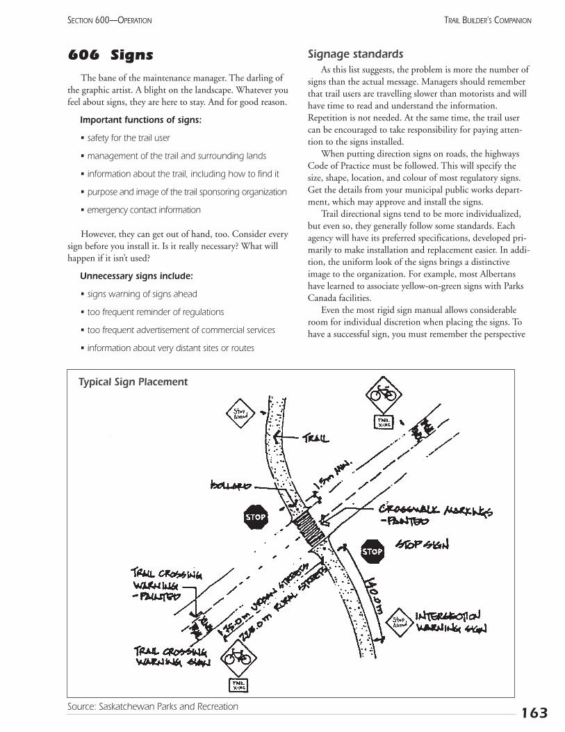
606 SignsThe bane of the maintenance manager. The darling of
the graphic artist. A blight on the landscape. Whatever youfeel about signs, they are here to stay. And for good reason.
Important functions of signs:
• safety for the trail user
• management of the trail and surrounding lands
• information about the trail, including how to find it
• purpose and image of the trail sponsoring organization
• emergency contact information
However, they can get out of hand, too. Consider everysign before you install it. Is it really necessary? What willhappen if it isn’t used?
Unnecessary signs include:
• signs warning of signs ahead
• too frequent reminder of regulations
• too frequent advertisement of commercial services
• information about very distant sites or routes
Signage standardsAs this list suggests, the problem is more the number of
signs than the actual message. Managers should rememberthat trail users are travelling slower than motorists and willhave time to read and understand the information.Repetition is not needed. At the same time, the trail usercan be encouraged to take responsibility for paying atten-tion to the signs installed.
When putting direction signs on roads, the highwaysCode of Practice must be followed. This will specify thesize, shape, location, and colour of most regulatory signs.Get the details from your municipal public works depart-ment, which may approve and install the signs.
Trail directional signs tend to be more individualized,but even so, they generally follow some standards. Eachagency will have its preferred specifications, developed pri-marily to make installation and replacement easier. In addi-tion, the uniform look of the signs brings a distinctiveimage to the organization. For example, most Albertanshave learned to associate yellow-on-green signs with ParksCanada facilities.
Even the most rigid sign manual allows considerableroom for individual discretion when placing the signs. Tohave a successful sign, you must remember the perspective
163
SECTION 600—OPERATION TRAIL BUILDER’S COMPANION
Typical Sign Placement
Source: Saskatchewan Parks and Recreation
164
SECTION 600—OPERATIONTRAIL BUILDER’S COMPANION
of the trail user. The location and style of each sign mustreflect its purpose. In this way, the user will be expectingthe appropriate message and will be more receptive.
Suggestions for sign standards:
• keep the size proportional to the speed: small for non-motorized users, medium for snowmobiles and ATVs
• site any warnings well before the actual hazard toallow time for response
• ensure the signs do not become a hazard themselves
• remember that most trails are two-way; have signsfacing both directions
• use standard pictographs wherever possible
• avoid using plywood, as porcupines will eat it quickly
• signs are expensive, but are a good investment
Pavement markingsThe growing number of asphalt trails in urban and sub-
urban areas has led to direct marking of the trail. Thisapproach has great potential since the facility itself can beidentified instead of just having a sign pointing to it.Pavement markings supplement, but do not replace, themore traditional signs.
As an example, consider a typical crosswalk. Most haveboth a sign warning of it and a sign marking it, for bothdirections of vehicle traffic. Still, traffic roars by as children
and the elderly wait. What if the crosswalk was paintedbright blue, like some disabled parking spaces are?
Physical structures can reinforce signs while offering apositive design feature as well. The previously mentionedcrosswalk can be raised to curb height, making a giant butfairly gentle speed bump. The pedestrians clearly haveprecedence at these locations. In other places, bike lanes areseparated from motor vehicles by decorative stones orpavers. These allow cars to cross them, but provide a con-tinual reminder of the bicycles.
Some asphalt trails have a yellow centre line. Even ifthis is not generally considered necessary in your circum-stances, it is recommended for the 50 m leading up to anintersection. This alerts cyclists of the approaching hazard.
Pavement markings can be painted on the asphaltwith regular street paint using a stencil for the more com-plex shapes. Paint is now available in a variety of colours.One reference mentioned decals that can be glued ontothe pavement.
SuppliersAlberta Snowmobile Association distributes traffic-
style signs suitable for motorized recreational trails. Theycan be contacted at (780) 453-8668 for a catalogue andspecifications.
Signs directing people to your site should be installedwith the cooperation of your Alberta Infrastructure office.This department can advise you of the appropriate designand supplier. Their Edmonton number is (780) 415-1381.
Notes:
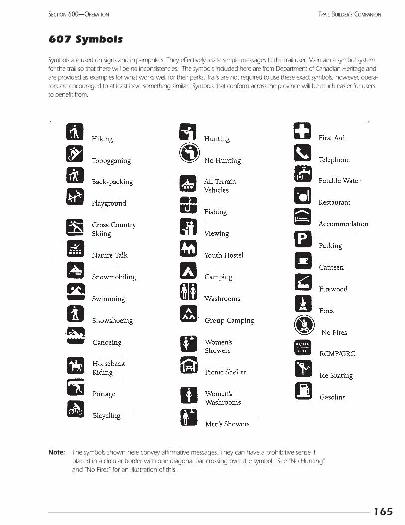
165
SECTION 600—OPERATION TRAIL BUILDER’S COMPANION
607 Symbols
Symbols are used on signs and in pamphlets. They effectively relate simple messages to the trail user. Maintain a symbol systemfor the trail so that there will be no inconsistencies. The symbols included here are from Department of Canadian Heritage andare provided as examples for what works well for their parks. Trails are not required to use these exact symbols, however, opera-tors are encouraged to at least have something similar. Symbols that conform across the province will be much easier for usersto benefit from.
Note: The symbols shown here convey affirmative messages. They can have a prohibitive sense if placed in a circular border with one diagonal bar crossing over the symbol. See “No Hunting” and “No Fires” for an illustration of this.

166
SECTION 600—OPERATIONTRAIL BUILDER’S COMPANION
Notes:
167
SECTION 600—OPERATION
608 InterpretationInterpretation stimulates an understanding and apprecia-
tion of our natural and cultural heritage through first-handexperience. Trails are a major tool in this process, enablingpeople to gain access to both historic and natural points ofinterest.
Many trails are built to support the managing agency’smandate to provide interpretation, while other trails respondto the public’s desire to learn. In either case, it makes sense tohelp trail users understand the landscape through which theyare travelling.
Interpretation is a well-established field, with several asso-ciations that can give you advice. Contact your local museumor nature centre to get advice regarding the best method topresent your information. You may well find that these orga-nizations want to get involved, too:
Interpretation Canada - Alberta Sectionc/o Kerry Wood Nature Centre6300 - 45 AvenueRed Deer, AB T4N 3M4
Museums Alberta9829 - 103 Street Edmonton, AB T5K 0X9Telephone (780) 424-2626
Media typesTrails bring excitement to an excursion because they con-
nect so many different experiences. Parks are joined to the adja-cent agricultural scene, and the residential neighbourhoods areconnected to nearby industrial sites. Each area provides anenriching experience. Trail use becomes a casual form of learn-ing that can be made a bit more explicit with help from thetrail operator. Several different media are available for thesemessages and each has its strong points.
Signs work well in areas with high tourism, but becomestale where the users return many times. Save them formajor viewpoints where people bring their out-of-town relatives. Spend the extra money to make themvandal resistant.
Brochures can hold a lot of information (often toomuch!), which can be read later. They act as an inexpen-sive souvenir. A good method of distribution is needed,such as souvenir shops, tourist information offices, oroutdoor equipment stores.
Audio cassettes can be sold at a reasonable price at sou-venir shops. They allow the visitor to learn about the sitesin a region before they arrive, or to review what theyhave learned as they drive on. Professionally producedscripts can have impressive sound effects, such as birdsongs and historic reenactments.
CD-ROMs & videos must be used at home, but are popular souvenirs. Videos have also become dramaticintroductions to a recreation area. Some tourist regionswill distribute the introductory video free upon request;others will charge a nominal fee which may be refund-able upon registration at the resort.
Books, including regional guidebooks, histories, and nature field guides spring up quickly, usually as a labour of love by the author. The overhead of printing is high, so the time spent writing the book is generally donated tokeep the cost reasonable. Even so, the audience is limitedto those who are both seriously interested and able toafford the price. Only a small fraction of the trail users(<1%) will buy a book about the area.
Interpretive map sheetsMaps form an important or even essential component of a
trail. They enable users to find their way while gaining someunderstanding of the surrounding landscape. It makes sense toinclude interpretation of local points of interest on the samepage. The format suggested here is inexpensive to produce, yetthe consistency gives a professional appearance. When a numberof sheets have been written for an area, they could be combinedinto a guidebook if preferred.
Main features of map sheets:
• topographic map (scale 1:50,000, copied on an 8.5 x 11” page)
• all trails in map area are shown regardless of jurisdiction or sponsor
• other recreation facilities and points of interest are included
• reverse side has contacts for all trail operating agencies
• general review of the scenery and conditions in the area as well as main modes of travel
• instructions for following the trail, if needed
• recommended safety precautions, seasons of use andother restrictions
• more detail regarding points of interest
• detailed interpretation of one feature typical of the area
• trail code of conduct
These maps can be collected in a binder, with only thoseneeded for a particular trip being taken out and carried in aplastic sleeve. In this way, the weight carried will be reduced, aswell as the damage to the other maps. Your group can distributean economical brochure which can be updated easily. It can beconsidered an interim map as the trail system is growing. If thesponsor wishes, coloured ink on contrasting paper and designby someone with artistic sense will give a very credible product.
TRAIL BUILDER’S COMPANION
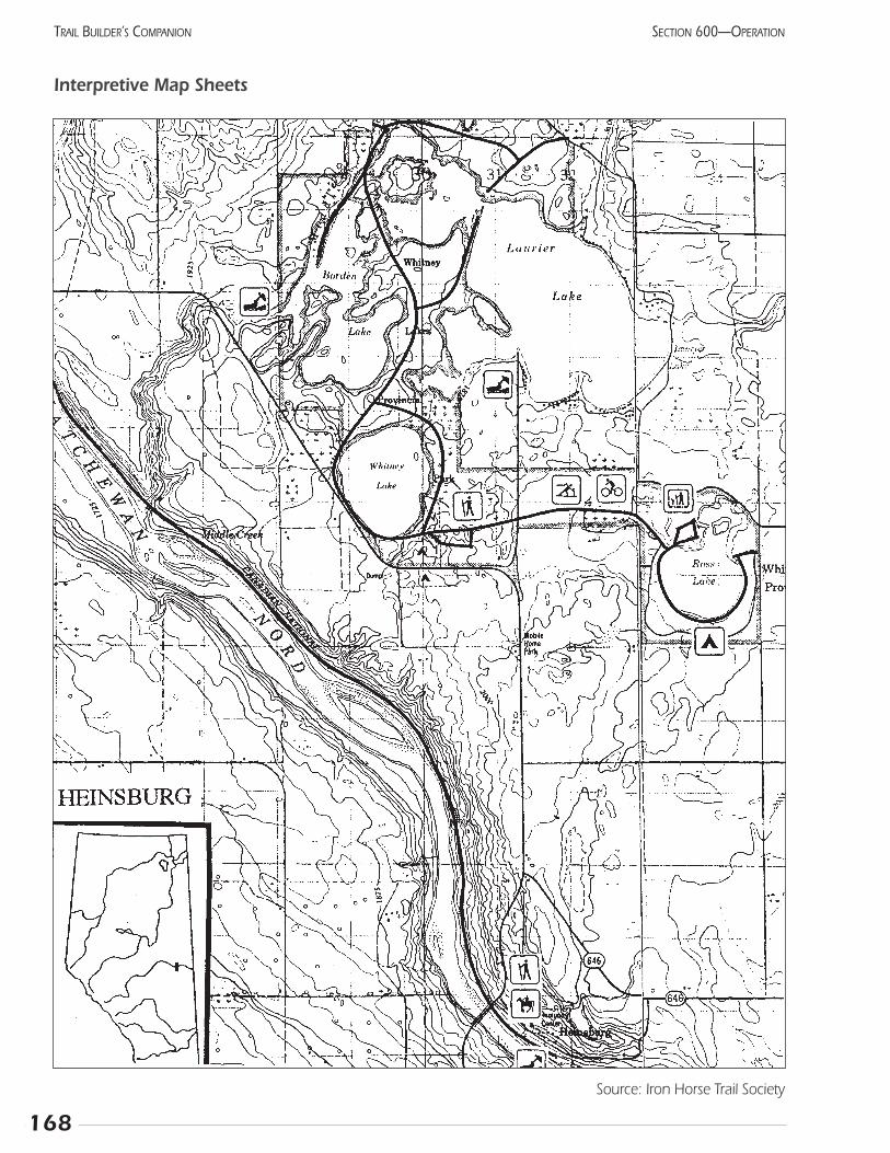
168
SECTION 600—OPERATIONTRAIL BUILDER’S COMPANION
Source: Iron Horse Trail Society
Interpretive Map Sheets
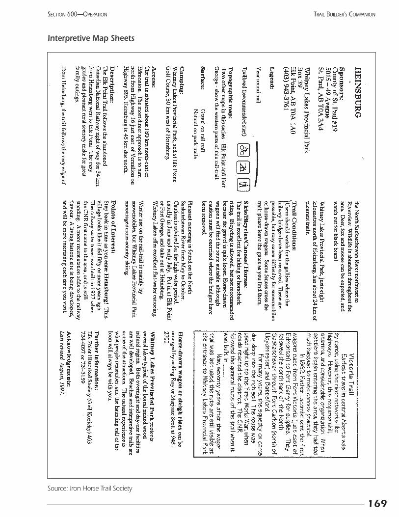
169
SECTION 600—OPERATION TRAIL BUILDER’S COMPANION
Interpretive Map Sheets
Source: Iron Horse Trail Society

170
SECTION 600—OPERATIONTRAIL BUILDER’S COMPANION
Notes:
609 EvaluationEvaluation means finding out if your hard work has
achieved the objectives you first set out to achieve. Themore specifically you were able to state them, the easier theassessment will be (eg., to build a trail which will be usedby at least 30 people per week). Review these objectives fre-quently to keep your group on track.
Evaluation soon after the opening will enable you tofind minor problems and correct them before they growlarger. Later, you may notice changing trends in the users,such as an increasing number of joggers. Indications ofcrowding or user conflict can substantiate a plan forextending the trail network. The trends may also suggestwhether advertising or other promotion is required toensure people remember the trails.
You might wait a couple of weeks for the initial novel-ty to wear off, then begin counting people. If volunteersare available and the volume of use seems to warrant it,try to count people and cars in the parking lot from dawnto dusk for one week. Later, a regular count of just a four-hour period, preferably the time of highest use, willenable you to track the attendance trends. Of course,weather will be a factor. Note if the weather was eitherexceptionally good or bad.
Trail use estimationTo estimate how many people use the trail, you may
have to rely on indirect measures. Spend a day countingpeople, and compare this number to the number of vehiclesthey used or the number of signatures in the registrationbook. This ratio will remain fairly constant for each site. Inthe future, you can estimate the total use by counting sig-natures or vehicles, and multiplying by the value previouslydetermined.
RegistrationRegistration or guest books offer an important opportu-
nity for feedback from the visitor. Realize that many peoplewill not sign in and that most will limit their comments to“nice” or “had a good time.” However, the occasional elo-quent phrase of thanks will make your work worthwhileand it can even be quoted in an annual report or brochure.The suggestions or meaningful comments should be treatedseriously because many others likely agree but are too shyto say so. You can help the visitor give useful informationby replacing the “Comments” section with “What was yourfavourite experience here”? or “How did you hear aboutthis trail”? Each page could have a different question, creat-ing a simple ongoing survey.
Trail inspectionsThe people responsible for the trail maintenance will be
inspecting the trail regularly. They should ensure that anydesign deficiencies that appear are communicated to theplanners. This is not to point fingers, but to help the plan-ner avoid similar mistakes in the future. Any innovative fea-tures of the trail should be particularly studied. If theyachieve their objective, they could be written up and sub-mitted to TrailNet News for publication. In this way, thegeneral expertise of the trails community will increase.
Signs of poor design:
• short cuts worn into vegetation
• premature degradation of trail surface
• mud holes or water pooling
• loose or broken furniture
• severe erosion and gullying
Signs of over-use:
• crowded parking lot or parking on adjacent road
• complaints about other users or litter
• widening trail and trampling of adjacent vegetation
• multiple trails developing in open areas
Signs of under-use:
• weeds growing in trail or parking area
• graffiti and other vandalism
• vegitation encroaching on trail
171
SECTION 600—OPERATION TRAIL BUILDER’S COMPANION

172
SECTION 600—OPERATIONTRAIL BUILDER’S COMPANION
Notes:
173
SECTION 600—OPERATION TRAIL BUILDER’S COMPANION
610 MaintenanceTrail maintenance ensures the continued operation of the
trail and the many benefits that come from its initial con-struction.
Overall goals:
• the enjoyable use of the trail by recreationists
• the reduction of safety and liability issues
• the reassurance of the adjacent landowners
The cost of maintenance is difficult to estimate, but onesource suggests that an annual cost of 6% of the capital costwould be good. Unlike other facilities, trails become cheaperto maintain as they age and trouble spots are fixed (see flowchart “Cycle of events in trail track degradation”).
Each trail or identifiable group of trails should have amaintenance file including the Trail Log, maintenancereports, and notes about any work done on the route.
The Trail Log includes both the natural features aroundthe trail and the constructed features developed to date. Theregular updating of this list is essential for planning the trailmaintenance. For example, it is embarrassing how often amaintenance person will say “Didn’t we have a sign here”?Without a proper inventory, no one will be able to answer forsure, and a slow degradation of the entire facility is inevitable.An accurate and well-prepared trail log will pay dividendsworth far more than the original cost of gathering the data.
Maintenance reportsThese should include the general condition of the trail
and any work that has been done. A sample “TrailAssessment Form” is included. Each trail system will havecertain features that must be checked and should be listed.
Before maintenance can be done, the optimum conditionmust be defined. This should reflect the experience the trail ispresenting; smoother is not necessarily better. Some peoplewill have a tendency to continually upgrade a trail, creating apattern of use not originally intended. The original construc-tion drawings will be a good guideline for most aspects. Thefrequency of some tasks, such as staining or litter removal,must be determined by the manager.
The sponsoring organization has several options withregards to who actually does the work. Staff can be hired,although this can be expensive even for government agencies.Paid people may spend a considerable amount of time justsearching for problems, compared to doing the actual workthat requires their skills. Volunteer trail stewards can takeresponsibility for a certain section and check it whenever con-venient. While the price is right, the results can vary consider-ably unless there is some sort of supervision and feedback.Volunteer’s strong feeling of ownership makes them vigoroussupporters of the trail. A volunteer trail crew can do a lot ofwork and will generate a strong feeling of camaraderie.
Many organizations use a combination of volunteers,staff, and contractors to gain the maximum benefits withminimum cost. For example, volunteer stewards provideregular checks and carry out simple tasks like picking litterand removing small deadfalls. Mainly, they identify largertasks that require professional attention or even the effortsof an entire crew. Washouts, major deadfall and restorationwork fall into this category. An experienced trail manager,either volunteer or staff, should check the trail twice annu-ally to ensure that the maintenance is meeting the correctstandards.
The trail manager will probably want to develop achecklist for field workers that includes instruction on eachmaintenance activity and its frequency. These can be groupedinto weekly, monthly, and seasonal tasks, depending on yourtrail’s characteristics.
Maintenance activities
Consider this partial list of maintenance activities a starting point as you develop your maintenance budget and plan:
• patch holes in asphalt, fill cracks, and feather edges
• sweep to remove leaves, mud, gravel, and other debris
• mow trail shoulders 1 m back from trail
• pick up litter and empty garbage cans
• clean out ditches, culverts, and other drainagestructures, correct drainage problems or trail surface
• inspect structures for deterioration
• remove fallen trees
• remove snow and ice
• replace missing and damaged signs
• repaint worn pavement markings
• trim trees, shrubs, and grass to maintain sight distances
• maintain furniture and other support facilities
• remove graffiti from restrooms, retaining walls, rocks, and other surfaces
• repair gates and fences
• clean and replace lights, trailhead facilities
• groom snowmobile and nordic trails
• clear and clean parking lots
• spray or remove weeds, especially those listed as “noxious” by the municipality
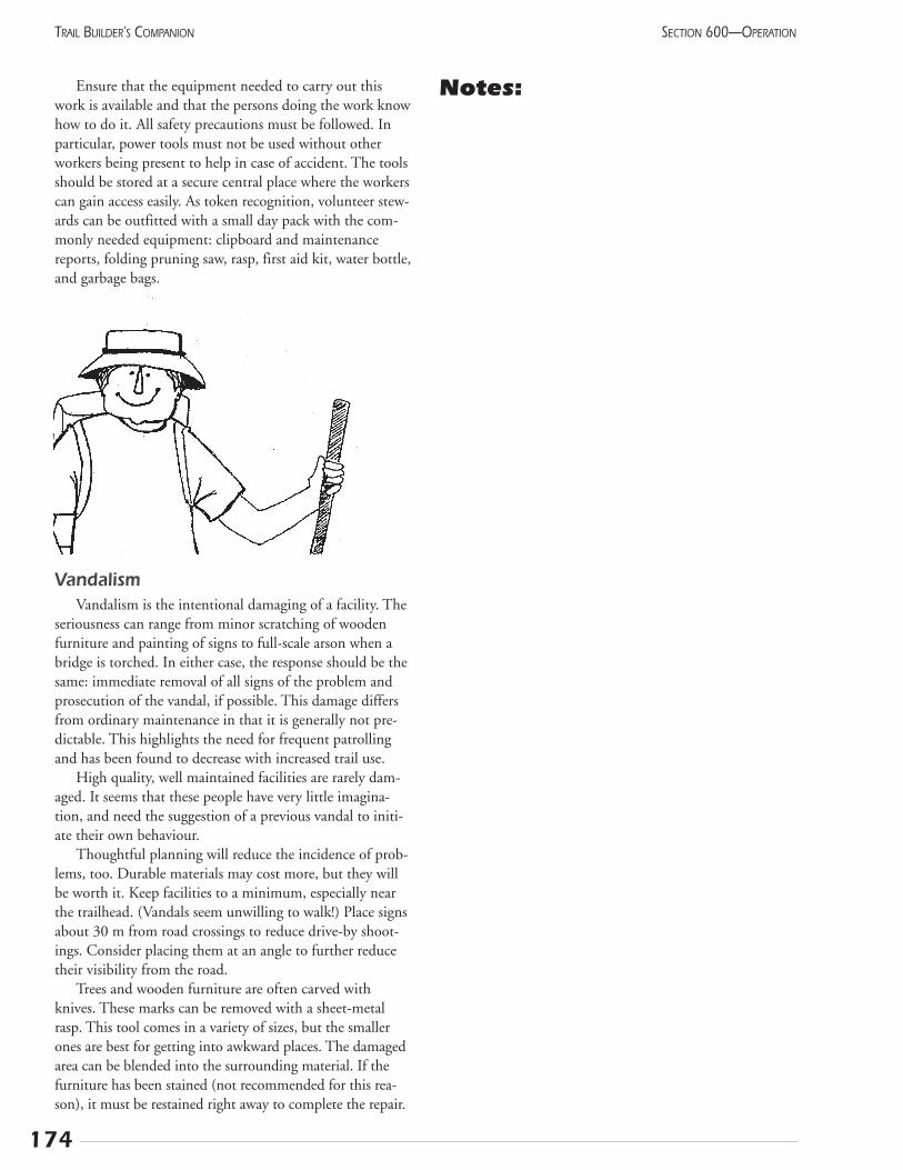
Ensure that the equipment needed to carry out thiswork is available and that the persons doing the work knowhow to do it. All safety precautions must be followed. Inparticular, power tools must not be used without otherworkers being present to help in case of accident. The toolsshould be stored at a secure central place where the workerscan gain access easily. As token recognition, volunteer stew-ards can be outfitted with a small day pack with the com-monly needed equipment: clipboard and maintenancereports, folding pruning saw, rasp, first aid kit, water bottle,and garbage bags.
VandalismVandalism is the intentional damaging of a facility. The
seriousness can range from minor scratching of woodenfurniture and painting of signs to full-scale arson when abridge is torched. In either case, the response should be thesame: immediate removal of all signs of the problem andprosecution of the vandal, if possible. This damage differsfrom ordinary maintenance in that it is generally not pre-dictable. This highlights the need for frequent patrollingand has been found to decrease with increased trail use.
High quality, well maintained facilities are rarely dam-aged. It seems that these people have very little imagina-tion, and need the suggestion of a previous vandal to initi-ate their own behaviour.
Thoughtful planning will reduce the incidence of prob-lems, too. Durable materials may cost more, but they willbe worth it. Keep facilities to a minimum, especially nearthe trailhead. (Vandals seem unwilling to walk!) Place signsabout 30 m from road crossings to reduce drive-by shoot-ings. Consider placing them at an angle to further reducetheir visibility from the road.
Trees and wooden furniture are often carved withknives. These marks can be removed with a sheet-metalrasp. This tool comes in a variety of sizes, but the smallerones are best for getting into awkward places. The damagedarea can be blended into the surrounding material. If thefurniture has been stained (not recommended for this rea-son), it must be restained right away to complete the repair.
Notes:
174
SECTION 600—OPERATIONTRAIL BUILDER’S COMPANION
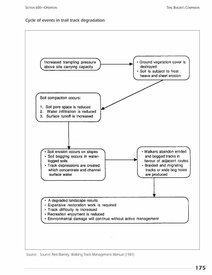
175
SECTION 600—OPERATION TRAIL BUILDER’S COMPANION
Cycle of events in trail track degradation
Source: Source: Neil Blamey, Walking Track Management Manual (1987)
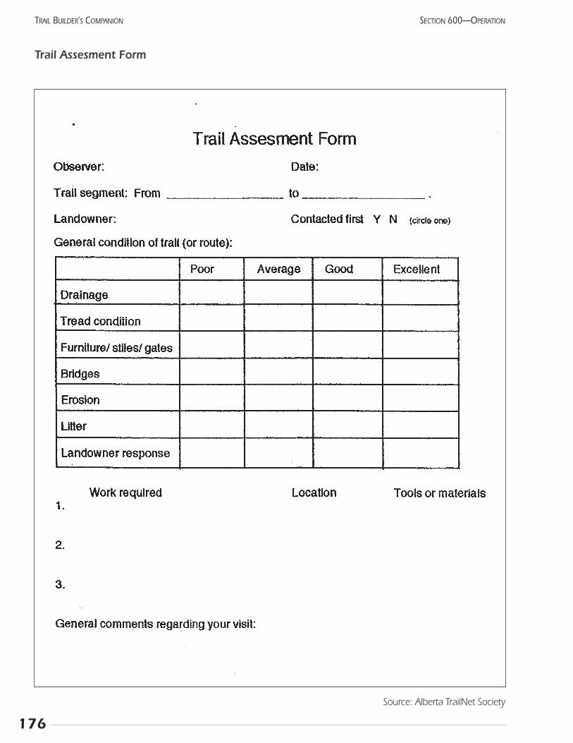
176
SECTION 600—OPERATIONTRAIL BUILDER’S COMPANION
Source: Alberta TrailNet Society
Trail Assesment Form

177
SECTION 600—OPERATION TRAIL BUILDER’S COMPANION
Trans Canada Trail in Alberta
Source: Alberta TrailNet
Registered Trail
ProposedTrail
Water Trail
Fort Smith
Fort McMurray
Athabasca
Peace River
Edmonton
Camrose
StettlerRed Deer
Drumheller
Canmore
Calgary
MedicineHat
FairviewGrimshaw
Slave Lake
Leduc
Innisfail
Didsbury
Vauxhall
Banff
Gibbons
Redcliff
Worsley
Pigeon Lake
Cleardale
Grouard
Coronado
Meeting CreekDonalda
Big Valley
Rowley

178
SECTION 600—OPERATIONTRAIL BUILDER’S COMPANION
Notes:
Section 700 Reference Material

181
SECTION 700—REFERENCE MATERIAL TRAIL BUILDER’S COMPANION
701 ReferencesAlberta Active Living Task Force (February 1998) Towards an Active and Prosperous Alberta: the health and well-being advan-tage ; manuscript report available through Alberta Community Development.
Alberta Community Development (1996) Park Operations and Maintenance Manual ; 70 pp., available from ARPA, 11759Groat Road, Edmonton, AB T5M 3K6.
Alberta Community Development and Alberta Recreation & Parks Association (1996) Park Development Manual ; 96 pp.,available from ARPA at 11759 Groat Road, Edmonton, AB T5M 3K6
Alberta Recreation and Parks (1988) Cross Country Ski Trails ; 69 pp.
Alberta Snowmobile Association (1993) Trail Development Manual ; available from the author at 11759 Groat Road,Edmonton, AB T5M 3K6, 88 pp.
Alberta Tourism, Parks and Recreation (1989) Recreation Trails ; 65 pp.
Bay Area Ridge Trail Council (1991) Community Trail Planning Workshops ; 60 pp., available from the author at: 116 NewMontgomery, Suite 640, San Francisco, CA 94105
Birkby, Robert (1996) Lightly on the Land: the SCA trail-building and maintenance manual ; The Mountaineers, Seattle, WA,267 pp.
Bjorkman, Alan W. (1996) Off-Road Bicycle and Hiking Trail User Interactions ; Wisconsin Department of Natural Resources,Bureau of Research.
Blamey, Neil (1987) Walking Track Management Manual ; Tasmania Department of Lands, Parks and Wildlife, about 200 pp.
Canadian Rails to Greenways Network (1996) The Canadian Rails & Trails Annotated Bibliography ; 51 pp., available fromauthor at 5430 Riverside Crescent, Manotick, ON K4M 1G9.
Cessford, Gordon R. (1995) Off-Road Impacts of Mountain Bikes: a review and discussion ; Department of Conservation,Wellington, New Zealand (available on-line at http://www.wcc.govt.nz/~kennett/mtnbike/politics/doc/impacts/index.htm).
Doherty, Susan (1998) Rail-trails and Community Sentiment: a study of opposition to rail-trails and strategies for success ;Rails-to-Trails Conservancy, 1100 Seventeenth Street NW, Washington, DC 20036, (202) 331-9696, 16 pp.
Environment Canada Parks (1986) Trail and Backcountry Facility Designs ; approx. 150 pp.
Gardner, Rob and George Gordon (1998) Wild Rose Trail System ; Alberta TrailNet, 52 pp.
Gerling, Heather, Willoughby, M., Schoepf, A., Tannas, C., and Tannas, S. (1996) A Guide to Using Native Plants on DisturbedLands ; ISBN 0-7732-6125-7, 247 pp. Available from Publishing Branch, Alberta Agriculture, Food and Rural Development,7000 - 113 Street, Edmonton, AB T6H 5T6; Toll-free 1-800-292-5697.
Getchell, David R. (1995) Modern Water Trails ; published by, and available from, North American Water Trails Conference,RR 1, Box 3355, Appleton, ME 04862, 75 pp.
Hope, Daphne and Yachuk, D. (1990) Community Cycling Manual - A planning and design guide; Can. Institute of Planners,541 Sussex Drive, 2 Floor, Ottawa, ON K1N 6Z6, approx. 150 pp.
Johnson & Associates (1997) A-STEP: Alberta Snowmobile Trails Enhancement Program ; developed for Alberta SnowmobileAssociation, 286 pp. + appendices.
Kwasniak, Arlene (1997) Conservation Easement Guide for Alberta ; Environmental Law Centre, #204, 10709 Jasper Avenue,Edmonton, AB T5J 3N3, 72 pp.
Lanarc Consultants Ltd. (1996) Community Greenways ; Co-published by British Columbia Ministry of Environment, Landsand Forests, and Canada Dept. of Fisheries and Oceans, 72 pp.
National Capital Commission (1986) Recreational Pathways ; 99 pp.
National Round Table on the Environment and the Economy (1996) Sustainable Transportation in Canada: Backgrounder ;available at 1 Nicholas Street, Ottawa, ON K1N 7B7, 83 pp.
182
SECTION 700—REFERENCE MATERIALTRAIL BUILDER’S COMPANION
McCarthy Tetrault Barristers & Solicitors (1995) The Waterfront Trail: Liability and Risk Management Issues ; prepared for,and available from, the Waterfront Regeneration Trust, Box 129, Toronto, ON M5J 1A7, 33 pp.
McCoy, Michael and Stoner, MaryAlice (1992) Mountain Bike Trails: Techniques for design, construction and maintenance ;Adventure Cycling Association, 150 E. Pine Street, Missoula, MT 59807, 19 pp.
Moore, Roger L. (1994) Conflicts on Multiple-Use Trails: Synthesis of the Literature and State of the Practice ; FederalHighway Administration, Washington, D.C. 70 pp.
Moore, Roger L., Graefe, Alan R., Gitelson, Richard J., and Porter, Elizabeth (1992) The Impacts of Rail-Trails: A study of theusers and property owners from three trails ; Rivers, Trails and Conservation Assistance Program, National Park Service,Washington, D.C.
National Parks Service (1995) Economic Impacts of Protecting Rivers, Trails, and Greenway Corridors ; 161 pp.
Parker, Troy Scott (1994) Trails Design and Management Handbook ; prepared for Open Space and Trails Program, PitkinCounty, Colorado, 207 pp.
ParticipACTION (1999) A Handbook for Community Events ; approx. 50 pp., available from the regional office in Regina bytelephoning (306) 525-5066.
Rails to Trails Conservancy (1990) Converting Rails to Trails: A citizens’ manual for transforming abandoned rail corridorsinto multipurpose public paths ; available from author at Suite 300, 1400 16 Street NW, Washington, DC 20036, 50 pp.
Rails to Trails Conservancy and the Association of Pedestrian and Bicycle Professionals (1998) Improving Conditions forBicycling and Walking: A best practices report ; Prepared for the Federal Highway Administration (USA).
Ruby, Wayne (1988) How to Manage Small Prairie Fires ; Dane County Park Commission, 4318 Robertson Road, Madison,WI 53714 USA . 30 pp. (available through Alberta TrailNet office)
Ryan, Karen-Lee (1993) Trails for the Twenty-first Century ; Rails-to-Trails Conservancy, Washington, D.C., 213 pp.
Ryan, Karen-Lee & Winterich, Julie (1993) Secrets of Successful Rail-Trails ; Rails-to-Trails Conservancy, Washington, D.C.,178 pp.
Schutt, Alicia M. (February 1997) 30 years in the making: a comprehensive economic impact and user study of the BruceTrail, Ontario, Canada ; 9 page summary of a thesis available from the Bruce Trail Association, Hamilton, ON.
Tracy, Tammy, and Morris, Hugh (January 1998) Rail-trails and safe communities: the experience on 372 trails ; Rails-to-TrailsConservancy, Washington, D.C., 27 pp.
Trail Planning Manual (1996) available from Saskatchewan Parks and Recreation #210 - 3303 Hillsdale St, Regina, SK S4S 6W9
Velo Quebec (1995) Multi-use Trails in Canada: an analysis of some successful cases ; available from Velo Quebec at 1251 rueRachel Est, Montreal, Quebec H2J 2J9, 45 pp.
(1996) Technical Handbook of Bikeway design ; published by, and available from, Velo Quebec for $55.00 + $16.50 handling.
Ward, Paula (ed.) (1994) Tools of the Trail Bibliography ; published by American Hiking Society, P.O. Box 20160, Washington,DC 20041-216034 pp.
Yates, Thorn and Associates (1997) A Business and Strategic Plan for Trails BC; 73 pp.
Warren, Natasha Maria (1998) Developing Recreation Trails in Nova Scotia ; Nova Scotia Trails Federation, P.O. Box 3010,South, Halifax, NS B3J 3G6, approx. 250 pp.
183
SECTION 700—REFERENCE MATERIAL TRAIL BUILDER’S COMPANION
702 Trail and recreation organizations in Alberta
Alberta Bicycle Association 780 427-635211759 Groat Rd. Edmonton T5M 3K6
Alberta Camping Association 780 427-660511759 Groat Rd. Edmonton T5M 3K6
Alberta Canoe Association 780 427-671711759 Groat Rd. Edmonton T5M 3K6
Alberta Centre for Well Being 780 427-694911759 Groat Rd. Edmonton T5M 3K6
Alberta Equestrian Federation 403 253-4411#210, 8989 Macleod Trail SW
Calgary T2H 0M2
Alberta Fish & Game Association 780 437-23426924 - 104 St. Edmonton T6H 2L7
Alberta Orienteering Association 780 427-813811759 Groat Rd. Edmonton T5M 3K6
Alberta Recreation and Parks Assoc. 780 415-174511759 Groat Rd. Edmonton T5M 3K6Contact: Steve Allan
Alberta Snowmobile Association 780 427-2695 11759 Groat Rd. Edmonton T5M 3K6Contact: Louise Sherren
Alberta Triathlon Association 780 427-861611759 Groat Rd. Edmonton T5M 3K6
Alberta United Recreationists Society 403 258-0211(off-road vehicles)
#2, 6025 - 12 Street SE Calgary T2H 2K1
Alberta Wilderness Association 403 283-2025Box 6398, Station DCalgary T2P 2E1
Alpine Club of Canada 403 678-3200Box 8040Canmore T1W 2T8
Athletics Alberta 780 427-8792(Cross-Country Road Running)11759 Groat Rd. Edmonton T5M 3K6
Calgary Area Outdoor Council (CAOC) 403 270-22621111 Memorial Drive SWCalgary T2N 3E4
Canadian Motorcycle Association, 780 475-0943Alberta Region 2908 - 150 Avenue Edmonton T5Y 2B5
Canadian Parks & Wilderness Society 780 422-598811759 Groat Rd. Edmonton T5M 3K6
Canadian Wheelchair Sports Assoc. 780 427-869911759 Groat Rd. Edmonton T5M 3K6
Cross Country Alberta (skiing) 780 415-173811759 Groat Rd. Edmonton T5M 3K6
Disabled Skiers of Alberta 780 427-810411759 Groat Rd. Edmonton T5M 3K6
Edmonton Bicycle and Touring Club 780 424-245310125 -97 Ave. Edmonton T5K 0B3
Federation of Alberta Naturalists 780 427-812411759 Groat Rd. Edmonton T5M 3K6
National Trail Association of Canada 403 678-5551Box 8063Canmore T1W 2T8
Ski & Snowboard Association 780 427-858111759 Groat Rd. Edmonton T5M 3K6
Sport & Recreation Assoc. for the Blind 780 415-018411759 Groat Rd. Edmonton T5M 3K6
Volksport Association of Alberta 780 458-2592Box 131, 3-11 Bellrose DriveSt. Albert, AB T8N 5C9Contact: Grace Newman
Waskahegan Trail Association 780 483-4838P.O. Box 131Edmonton T5J 2G9

184
SECTION 700—REFERENCE MATERIALTRAIL BUILDER’S COMPANION
Notes:
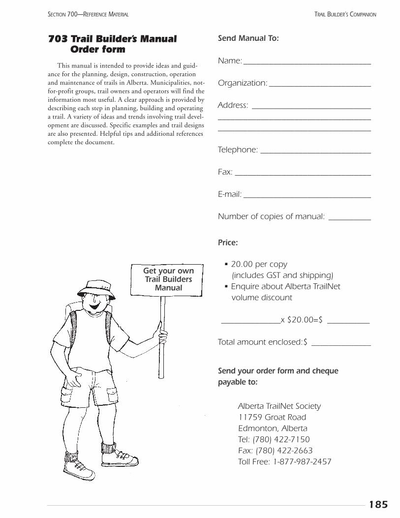
185
SECTION 700—REFERENCE MATERIAL TRAIL BUILDER’S COMPANION
703 Trail Builder’s ManualOrder form
This manual is intended to provide ideas and guid-ance for the planning, design, construction, operationand maintenance of trails in Alberta. Municipalities, not-for-profit groups, trail owners and operators will find theinformation most useful. A clear approach is provided bydescribing each step in planning, building and operatinga trail. A variety of ideas and trends involving trail devel-opment are discussed. Specific examples and trail designsare also presented. Helpful tips and additional referencescomplete the document.
Send Manual To:
Name:______________________________
Organization: ________________________
Address: ____________________________________________________________________________________________________
Telephone: __________________________
Fax: ________________________________
E-mail: ______________________________
Number of copies of manual: __________
Price:
• 20.00 per copy (includes GST and shipping)
• Enquire about Alberta TrailNet volume discount
______________x $20.00=$ __________
Total amount enclosed:$ ______________
Send your order form and cheque payable to:
Alberta TrailNet Society11759 Groat RoadEdmonton, AlbertaTel: (780) 422-7150Fax: (780) 422-2663Toll Free: 1-877-987-2457
Get your ownTrail Builders
Manual
Call us Toll-free at
1-877-9 TRAILSfor more information.
Related Documents