TOPOGRAPHIC MAP INTERPRETATION, CONSTRUCTION & WATERERSHED DELINEATION In this laboratory exercise techniques of map preparation will be presented. First, a simple exercise will review map reading skills. Next contouring exercises will prepare you for the final exercise. Finally, you will delineate a river system watershed. You have multiple exercises that require you to learn how topographic maps work. Each individual is required to hand in their data products. You might not finish with this lab today, so you’ll be expected to complete it during the week. EXERCISE 1 Contour lines illustrate topography by connecting points of equal elevation on a map. Below is a simplified presentation of the meaning of contours. Rules of Contours 1. Every point on a contour line is of the exact same elevation. That is, contour lines connect points of equal elevation. The contour interval between the contours is 5 meters. It’s critical to know what the contour interval is when you read a map.. look for the units of measurements used to report elevation.

Welcome message from author
This document is posted to help you gain knowledge. Please leave a comment to let me know what you think about it! Share it to your friends and learn new things together.
Transcript
TOPOGRAPHIC MAP INTERPRETATION, CONSTRUCTION &
WATERERSHED DELINEATION In this laboratory exercise techniques of map preparation will be presented. First, a simple exercise will review map reading skills. Next contouring exercises will prepare you for the final exercise. Finally, you will delineate a river system watershed. You have multiple exercises that require you to learn how topographic maps work. Each individual is required to hand in their data products. You might not finish with this lab today, so you’ll be expected to complete it during the week. EXERCISE 1 Contour lines illustrate topography by connecting points of equal elevation on a map. Below is a simplified presentation of the meaning of contours.
Rules of Contours 1. Every point on a contour line is of the exact same elevation. That is, contour lines connect points of equal elevation. The contour interval between the contours is 5 meters. It’s critical to know what the contour interval is when you read a map.. look for the units of measurements used to report elevation.
2
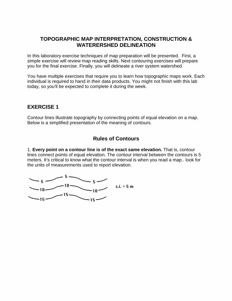
2. Contour lines always separate points of higher elevation (uphill) from points of lower elevation (downhill). One must determine which direction on the map is higher or lower relative to a single contour line.
3. Contour lines never split
5. The elevation difference between any two contour lines is the contour interval. If a line above another is 5m higher, then the contour interval is 5m.
3
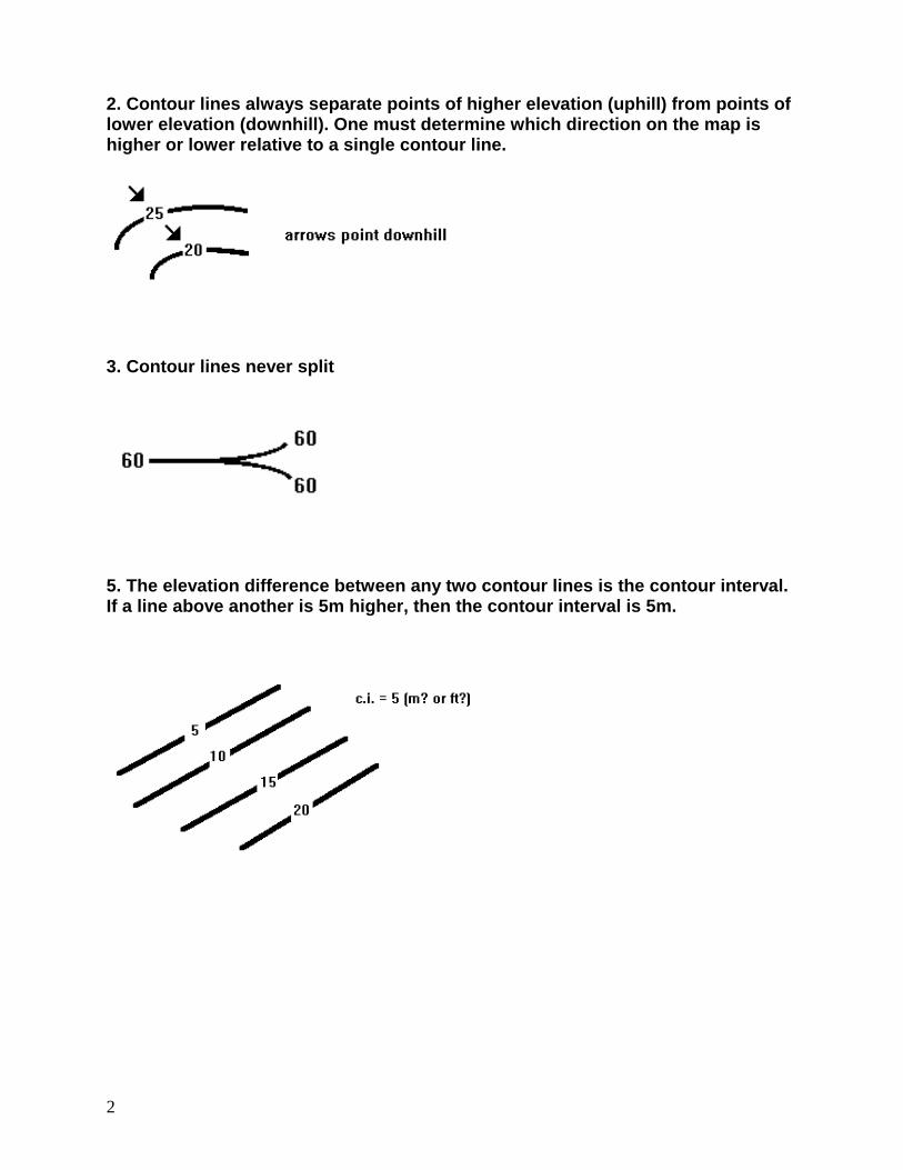
4. Contour lines can close to form an irregular circle. However, if the circle of closure is larger than the mapped area some contour lines may end abruptly at the map border.
6. Contour lines never cross each other.
4
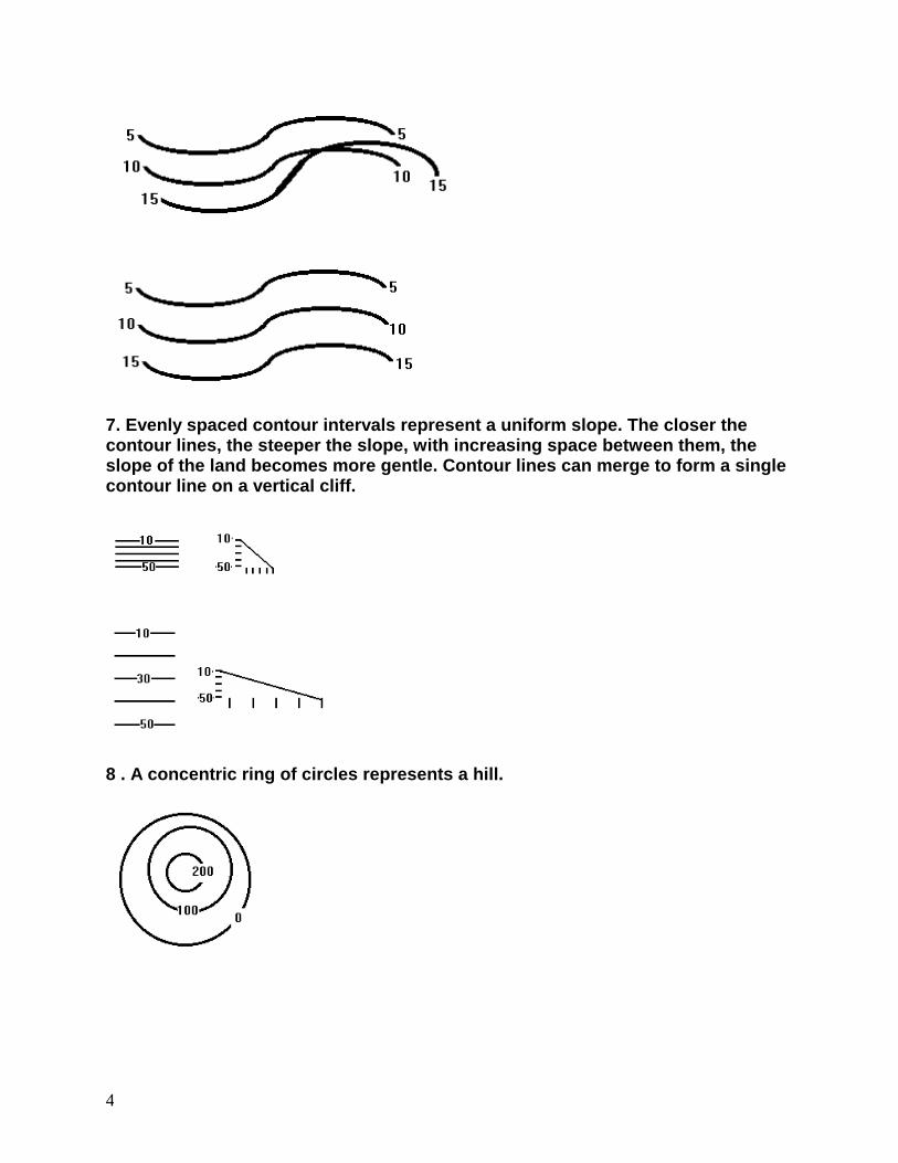
7. Evenly spaced contour intervals represent a uniform slope. The closer the contour lines, the steeper the slope, with increasing space between them, the slope of the land becomes more gentle. Contour lines can merge to form a single contour line on a vertical cliff.
8 . A concentric ring of circles represents a hill.
5
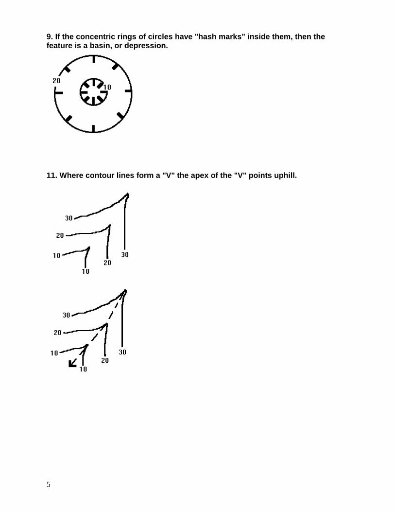
9. If the concentric rings of circles have "hash marks" inside them, then the feature is a basin, or depression.
11. Where contour lines form a "V" the apex of the "V" points uphill.
6
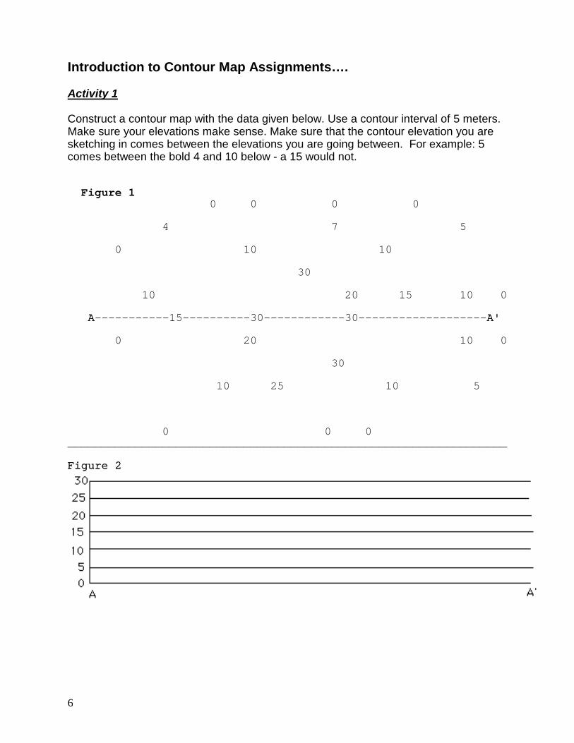
Introduction to Contour Map Assignments…. Activity 1 Construct a contour map with the data given below. Use a contour interval of 5 meters. Make sure your elevations make sense. Make sure that the contour elevation you are sketching in comes between the elevations you are going between. For example: 5 comes between the bold 4 and 10 below - a 15 would not. Figure 1 0 0 0 0 4 7 5 0 10 10 30 10 20 15 10 0 A-----------15----------30------------30-------------------A' 0 20 10 0 30 10 25 10 5 0 0 0 _________________________________________________________________ Figure 2
7
Activity 2 Does this structure (Figure 1) represent a dome or a basin? Prove it by constructing a topographic profile. A topographic profile is a side view of topography as it would appear along some line on a map. Using the grid provided above (Figure 2) draw the topographic profile from A to A'. Plot the elevation from the contour map on the profile cross-section. Do this across the profile. When you have finished, connect the dots. The relief of the contour map will be illustrated.
8
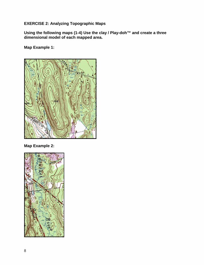
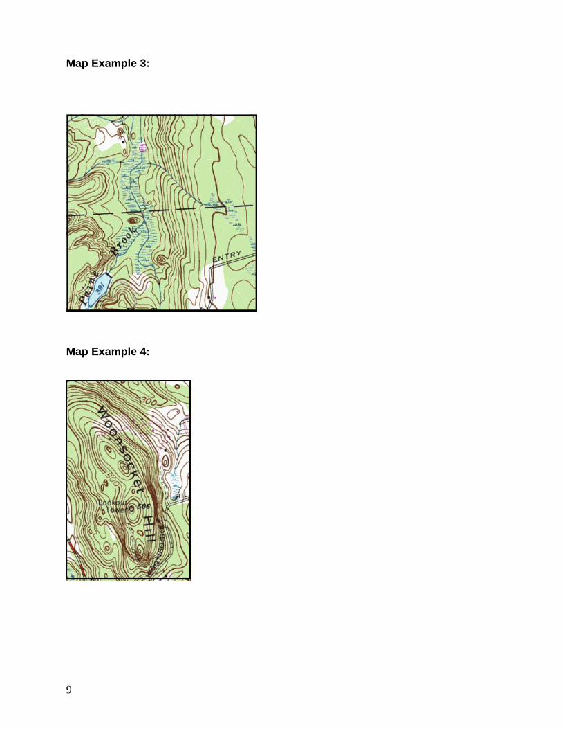
EXERCISE 2: Analyzing Topographic Maps Using the following maps (1-4) Use the clay / Play-doh™ and create a three dimensional model of each mapped area. Map Example 1:
Map Example 2:
9
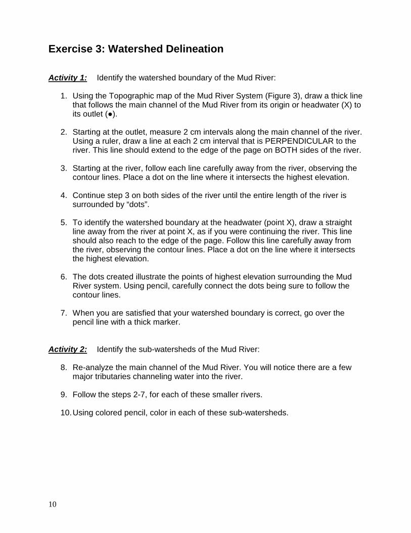
Map Example 3:
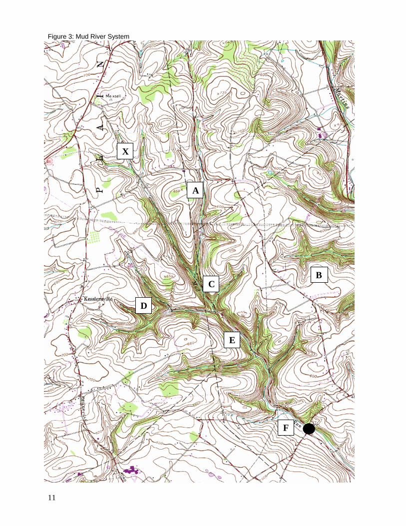
Map Example 4:
10
Exercise 3: Watershed Delineation Activity 1: Identify the watershed boundary of the Mud River:
1. Using the Topographic map of the Mud River System (Figure 3), draw a thick line that follows the main channel of the Mud River from its origin or headwater (X) to its outlet (●).
2. Starting at the outlet, measure 2 cm intervals along the main channel of the river. Using a ruler, draw a line at each 2 cm interval that is PERPENDICULAR to the river. This line should extend to the edge of the page on BOTH sides of the river.
3. Starting at the river, follow each line carefully away from the river, observing the contour lines. Place a dot on the line where it intersects the highest elevation.
4. Continue step 3 on both sides of the river until the entire length of the river is surrounded by “dots”.
5. To identify the watershed boundary at the headwater (point X), draw a straight line away from the river at point X, as if you were continuing the river. This line should also reach to the edge of the page. Follow this line carefully away from the river, observing the contour lines. Place a dot on the line where it intersects the highest elevation.
6. The dots created illustrate the points of highest elevation surrounding the Mud River system. Using pencil, carefully connect the dots being sure to follow the contour lines.
7. When you are satisfied that your watershed boundary is correct, go over the pencil line with a thick marker.
Activity 2: Identify the sub-watersheds of the Mud River:
8. Re-analyze the main channel of the Mud River. You will notice there are a few
major tributaries channeling water into the river.
9. Follow the steps 2-7, for each of these smaller rivers.
10. Using colored pencil, color in each of these sub-watersheds.
11
X
B
A
E
D
C
F
Figure 3: Mud River System
12
Analysis Questions: Exercise 1
1. What is a contour interval and how can you determine this on your map?
2. If contour lines are close together, what kind of feature are you observing?
3. What map feature or contour pattern could illustrate a stream / river?
4. Briefly explain how a topographic profile is constructed using a topographic map and provide two practical applications of producing one.
Exercise 2
1. How well did your model match the topography represented by the map?
2. What features are depicted in:
Map Example 1_________________________________ Map Example 2_________________________________ Map Example 3_________________________________ Map Example 4_________________________________
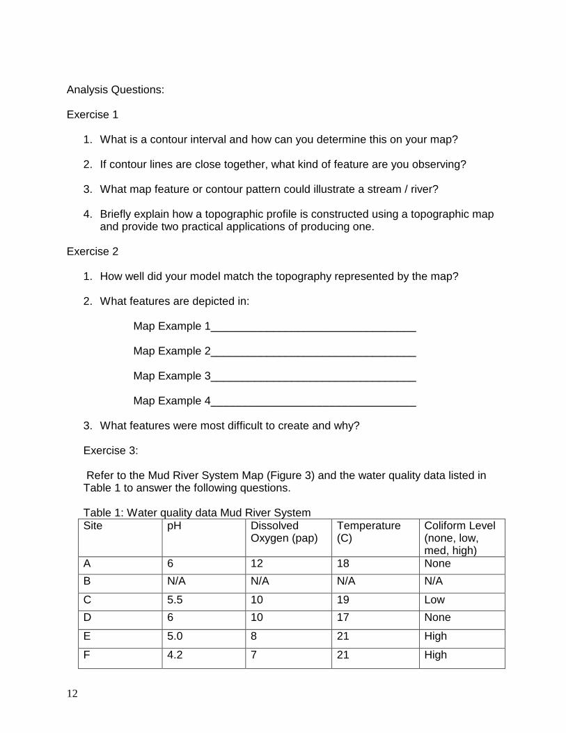
3. What features were most difficult to create and why? Exercise 3: Refer to the Mud River System Map (Figure 3) and the water quality data listed in Table 1 to answer the following questions. Table 1: Water quality data Mud River System Site pH Dissolved
Oxygen (pap) Temperature (C)
Coliform Level (none, low, med, high)
A 6 12 18 None B N/A N/A N/A N/A
C 5.5 10 19 Low D 6 10 17 None
E 5.0 8 21 High
F 4.2 7 21 High
13
1. A pig farm is being constructed on property at Site B on the. What potential
threats are there to the Mud River? Why?
2. Analyze the coliform bacteria data at Sites E and F. As an aquatic biologist, indicate where on the map you would begin your investigation. Explain why these locations would be areas of concern?
3. What are some factors that account for the pH changes along the river?
4. What are some factors that account for the dissolved oxygen changes along the river?
5. What are some factors that account for the temperature changes along the river?
Related Documents