The Ocean GIS Initiative Esri’s Commitment to Understanding Our Oceans By Dr. Dawn J. Wright, Esri Chief Scientist July 2013, Second Edition

Welcome message from author
This document is posted to help you gain knowledge. Please leave a comment to let me know what you think about it! Share it to your friends and learn new things together.
Transcript
The Ocean GIS Initiative Esri’s Commitment to Understanding Our Oceans
By Dr. Dawn J. Wright, Esri Chief Scientist
July 2013, Second Edition

2The Ocean GIS Initiative July 2013, Second Edition
Table of Contents
3 Introduction3 Understanding Our Oceans
4 The Ocean GIS Initiative
5 Areas of Focus
7 Projects7 The Ocean Basemap
8 SeaSketch
9 Ocean Health Index
10 ArcGIS for Maritime
11 Benthic Terrain Modeler
12 Oceans and Maritime Resource Centers
13 Esri Oceans Summit and Ocean GIS Conference
13 NOAA Projects
16 Partnerships16 Quality Positioning Services
17 University of New Hampshire Center for Coastal and
Ocean Mapping
17 Duke University Marine Geospatial Ecology Lab
17 Restore America’s Estuaries
17 Algalita Marine Research Institute
17 West Coast Governors Alliance on Ocean Health
18 World Ocean Council
18 Consortium for Ocean Leadership
18 Changjiang (Yangtze) Waterway Bureau
19 OneOcean
19 Clearwater Seafoods
21 Strategic Goals21 Grow the Ocean Basemap
21 Build a More Integrated Elevation Service
22 Provide Intelligent Bathymetry in the Cloud
22 Grow Ocean Content
22 Update and Support the Arc Marine Data Model
23 Develop Vertical, Time-Dependent Data Transformations
23 Improve Support for Multidimensional Data and
Analyses
24 Support Ocean Numerical Models

3IntroductionThe Ocean GIS Initiative July 2013, Second Edition
On a planet where 71 percent of the surface is covered by water,
the oceans are critical for life itself. They feed us, regulate our
weather patterns, provide over half the oxygen that we breathe,
and contribute to our energy and economy.
An estimated 350 million jobs globally are linked to the oceans.
One billion people living in developing countries depend on fish
as their primary source of protein. The oceans are also critical to
national defense and military security.
There is five times more carbon stored by coastal habitats than by
tropical forests. But there is also five times more pollution in the
oceans now due to agricultural runoff than there was in 1960.
Eighty-five percent of the world’s fisheries are categorized as
either “fully exploited,” “overexploited,” or “depleted.” Ninety
percent of the big fish in the oceans are gone.
Climate change threatens coastal communities worldwide.
Less than 2 percent of the oceans is legally protected in parks
and reserves, compared to 12 percent of land areas globally.
Only 5 to 10 percent of the ocean floor and the waters beneath
the surface have been explored and mapped in a level of detail
similar to what already exists for the dark side of the moon, for
Mars, and for Venus.
Understanding Our Oceans
Geographic information system (GIS) technology, which has long
provided effective solutions to the integration, visualization, and
analysis of information about land, is now being similarly applied
to oceans. In recent years, our ability to measure change in the
oceans (including open ocean, nearshore, and coast) is increasing,
not only because of improved measuring devices and scientific
techniques but also because new GIS technology is aiding us in
better understanding this dynamic environment. This domain has
progressed from applications that merely collect and display data
to complex simulation, modeling, and the development of new
research methods and concepts.
Introduction

The Ocean GIS Initiative July 2013, Second Edition 4Introduction
The Ocean GIS Initiative
The news is replete with stories of the hazards of hurricanes,
tsunamis, sea-level rise and coastal flooding, shark attacks, toxic
spills, oxygen-poor “dead zones,” and even modern-day pirates.
The oceans can be a dangerous place, and mitigating these
dangers requires a commitment to science-based understanding.
As an organization with the mission to inspire and enable
people to positively impact their future through a deeper,
geographic understanding of the changing world around them,
Esri recognizes that this understanding must involve a strong
commitment to the oceans. In 2012, Esri launched an Ocean
GIS initiative across the entire organization to enhance our
capabilities to support GIS in both coastal and open ocean
applications. The team supporting this initiative is composed of
project managers, GIS software engineers, product engineers,
account managers, industry solutions (marketing) managers,
distributors, and our federal science team.
The amount of data being collected about the oceans presents a grand challenge.
The Esri ocean GIS team.
The Ocean GIS Initiative July 2013, Second Edition 5Introduction
The Ocean GIS initiative has also been motivated in great part
by the need to provide effective mapping tools and techniques
to respond to recent disasters such as the Deepwater Horizon
oil spill in the Gulf of Mexico and the Tohoku-Oki earthquake
and tsunami in Japan. Further, it is motivated by a sincere desire
to assist in the implementation of the US National Ocean Policy,
particularly in the area of coastal and marine spatial planning
(CMSP), for which GIS provides a crucial decision support engine.
As part of this initiative, Esri is expanding from an initial emphasis
on nautical chart production and applications for commercial
shipping, maritime defense/intelligence, and offshore energy
(e.g., oil and gas, wind energy) to ocean science and resource
management. Esri is pursuing a greater engagement with the
ocean science community, as complex ocean data is increasingly
used to inform the responsible use and governance of the oceans,
as well as effective management and conservation.
Although Esri’s engagement with coastal and ocean resource
managers and conservationists is deep and will continue,
inconsistencies in ocean data models, formats, standards, tools,
services, and terminology exist and will be addressed by the
initiative. In addition, a paradigm shift is driving an evolution
from desktop and server enterprise solutions into a Software as
a Service (SaaS) model in the cloud, and the Ocean GIS initiative
builds on this important shift.
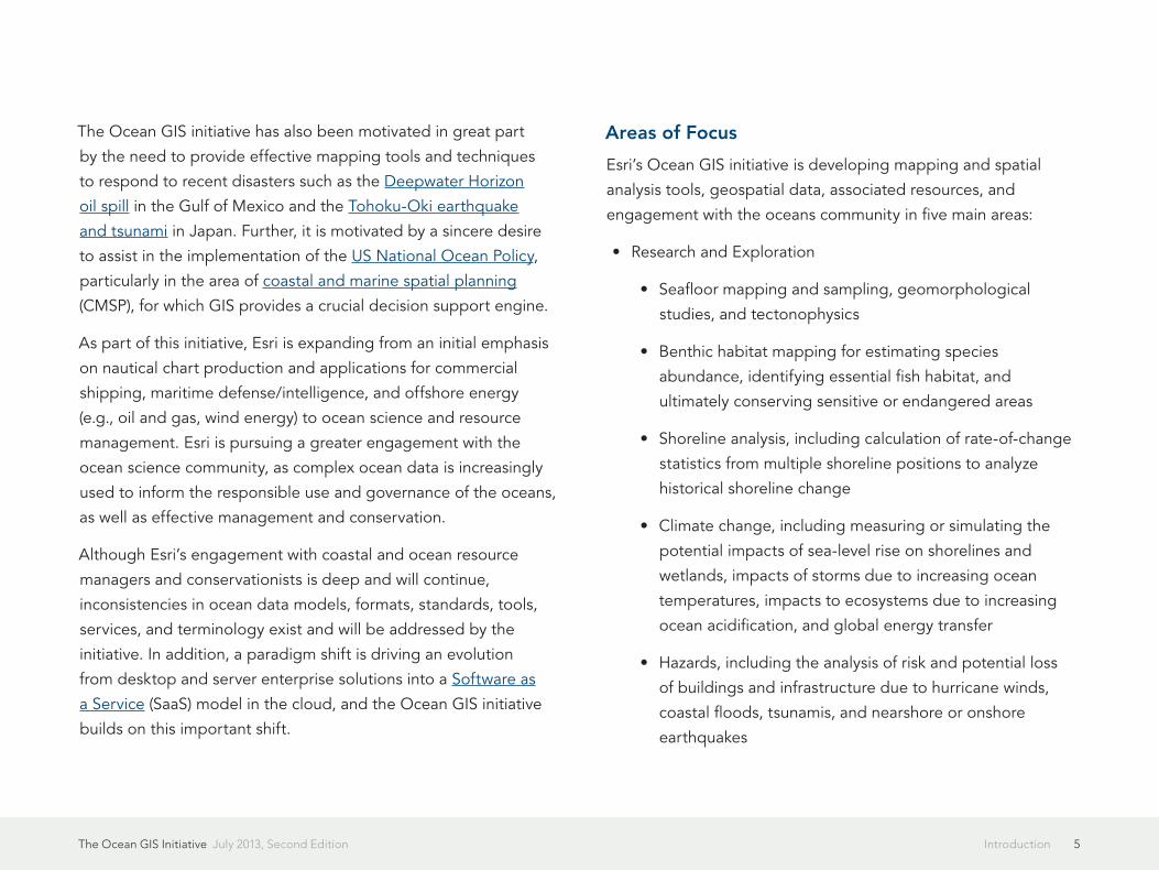
Areas of Focus
Esri’s Ocean GIS initiative is developing mapping and spatial
analysis tools, geospatial data, associated resources, and
engagement with the oceans community in five main areas:
• Research and Exploration
• Seafloor mapping and sampling, geomorphological
studies, and tectonophysics
• Benthic habitat mapping for estimating species
abundance, identifying essential fish habitat, and
ultimately conserving sensitive or endangered areas
• Shoreline analysis, including calculation of rate-of-change
statistics from multiple shoreline positions to analyze
historical shoreline change
• Climate change, including measuring or simulating the
potential impacts of sea-level rise on shorelines and
wetlands, impacts of storms due to increasing ocean
temperatures, impacts to ecosystems due to increasing
ocean acidification, and global energy transfer
• Hazards, including the analysis of risk and potential loss
of buildings and infrastructure due to hurricane winds,
coastal floods, tsunamis, and nearshore or onshore
earthquakes

The Ocean GIS Initiative July 2013, Second Edition 6Introduction
• Ecosystems and Environment
• Coral reef health and structure, mangrove assessment,
estuary restoration, interaction of coastal ecosystem
services, and management of seascape to optimize
services
• Coastal and pelagic animal tracking and marine mammal
genomics
• Marine debris mapping and tracking, especially in situ, as
small plastics are not detectable with satellite imagery
• Coastal Protection and Marine Spatial Planning
• National Ocean Policy Regional Ocean Partnership
mandates
• Marine protected area design and designation
• Offshore wind, wave, and tidal energy development
• Beach and recreational fisheries access
• Fisheries and Aquaculture Management
• Mapping of US fishery management plans and boundaries
of groundfish essential fish habitat
• Analysis of trends in nearshore and estuarine capture of
fisheries globally
• Aquaculture optimization and permitting
• Fish habitat and distribution for quote-based
management systems
• Aquaculture-related disease and value tracking
• Analysis of fishery closure areas, protected resources, Gulf
Coast Environmental Sensitivity indexes, at-risk species,
and federal status to illustrate some of the environmental
impact of the 2010 Deepwater Horizon oil spill
• Recreation and Adventure
• Professional and amateur boat racing, voyages for various
causes, and ocean-based sporting events that can benefit
from live, map-based tracking of assets and participants
• Crowdsourced data from recreational vessels
7ProjectsThe Ocean GIS Initiative July 2013, Second Edition
Esri is already engaged in a wide variety of projects supporting
the Ocean GIS initiative. Some of these are highlighted below.
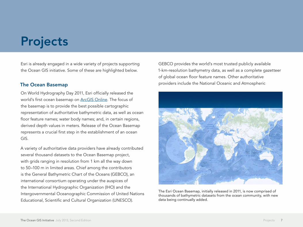
The Ocean Basemap
On World Hydrography Day 2011, Esri officially released the
world’s first ocean basemap on ArcGIS Online. The focus of
the basemap is to provide the best possible cartographic
representation of authoritative bathymetric data, as well as ocean
floor feature names; water body names; and, in certain regions,
derived depth values in meters. Release of the Ocean Basemap
represents a crucial first step in the establishment of an ocean
GIS.
A variety of authoritative data providers have already contributed
several thousand datasets to the Ocean Basemap project,
with grids ranging in resolution from 1 km all the way down
to 50–100 m in limited areas. Chief among the contributors
is the General Bathymetric Chart of the Oceans (GEBCO), an
international consortium operating under the auspices of
the International Hydrographic Organization (IHO) and the
Intergovernmental Oceanographic Commission of United Nations
Educational, Scientific and Cultural Organization (UNESCO).
GEBCO provides the world’s most trusted publicly available
1-km-resolution bathymetry data, as well as a complete gazetteer
of global ocean floor feature names. Other authoritative
providers include the National Oceanic and Atmospheric
Projects
The Esri Ocean Basemap, initially released in 2011, is now comprised of thousands of bathymetric datasets from the ocean community, with new data being continually added.
The Ocean GIS Initiative July 2013, Second Edition 8Projects
Administration (NOAA); the Canadian Hydrographic Service; the
Seafloor Mapping Lab of California State University, Monterey
Bay; the University of New Hampshire Center for Coastal and
Ocean Mapping (UNH-CCOM); Oregon State University; the
National Geographic Society; the Khaled bin Sultan Living
Oceans Foundation; the National Institute of Water and
Atmospheric Research (NIWA) of New Zealand; the Government
of Ireland (Marine Institute and Geological Survey of Ireland);
DeLorme; NAVTEQ; and Esri.
The Ocean Basemap is the clear foundation for an ocean GIS, as
any individual or organization involved in maritime operations,
ocean science, ocean conservation, or ocean management
can deploy feature overlays or web services, such as maritime
boundaries, energy infrastructure, shipping activity, subsurface
geology, ocean surface and water-column observations, and
nautical charts, to dynamically mash up with the bathymetry. GIS
specialists focused on land problems are also expressing great
interest in the Ocean Basemap as an important step toward an
integrated terrain model for the entire planet. New contributions
to the Ocean Basemap are always welcome (contact
[email protected] for more information).
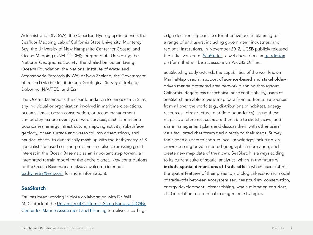
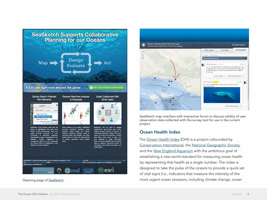
SeaSketch
Esri has been working in close collaboration with Dr. Will
McClintock of the University of California, Santa Barbara (UCSB),
Center for Marine Assessment and Planning to deliver a cutting-
edge decision support tool for effective ocean planning for
a range of end users, including government, industries, and
regional institutions. In November 2012, UCSB publicly released
the initial version of SeaSketch, a web-based ocean geodesign
platform that will be accessible via ArcGIS Online.
SeaSketch greatly extends the capabilities of the well-known
MarineMap used in support of science-based and stakeholder-
driven marine protected area network planning throughout
California. Regardless of technical or scientific ability, users of
SeaSketch are able to view map data from authoritative sources
from all over the world (e.g., distributions of habitats, energy
resources, infrastructure, maritime boundaries). Using these
maps as a reference, users are then able to sketch, save, and
share management plans and discuss them with other users
via a facilitated chat forum tied directly to their maps. Survey
tools enable users to capture local knowledge, including via
crowdsourcing or volunteered geographic information, and
create new map data of their own. SeaSketch is always adding
to its current suite of spatial analytics, which in the future will
include spatial dimensions of trade-offs in which users submit
the spatial features of their plans to a biological-economic model
of trade-offs between ecosystem services (tourism, conservation,
energy development, lobster fishing, whale migration corridors,
etc.) in relation to potential management strategies.
The Ocean GIS Initiative July 2013, Second Edition 9Projects
Ocean Health Index
The Ocean Health Index (OHI) is a project cofounded by
Conservation International, the National Geographic Society,
and the New England Aquarium with the ambitious goal of
establishing a new world standard for measuring ocean health
by representing that health as a single number. The index is
designed to take the pulse of the oceans to provide a quick set
of vital signs (i.e., indicators that measure the intensity of the
most urgent ocean stressors, including climate change, ocean Opening page of SeaSketch.
SeaSketch map interface with interactive forum to discuss validity of user observation data collected with the survey tool for use in the current project.

The Ocean GIS Initiative July 2013, Second Edition 10Projects
acidification, overfishing, habitat degradation, invasive species,
loss of biodiversity, pollution, and eutrophication). This will aid
managers, policy makers, and the public in quickly diagnosing
where problems lie and identifying possible solutions. The
project therefore seeks to bridge that important science/policy
maker divide and is thus featured prominently in a series of
informative articles within the society, policy, and economy
journal Pacific Standard. A scientific overview of the project was
published in 2012 by Dr. Ben Halpern et al. in the journal Nature.
Esri has been working with Halpern and colleagues at UCSB,
Conservation International, and Radical Media on the best
methods for “spatializing” this information and presenting it in an
web interface that literally maps out the OHI for each country of
the world. With these maps, people in every country of the world
will soon have detailed information about how they benefit from
and impact the environmental and economic health of the oceans
around them. A second phase will involve recalculating the OHI
globally or regionally using alternative weights, equations, and
data layers, especially where there is the richest and most reliable
data. Esri will assist with web-enabling certain geoprocessing
functions from a new GIS toolbox for OHI and cumulative impacts
in development at UCSB.
ArcGIS for Maritime
ArcGIS for Maritime is a comprehensive geospatial platform for
chart production and nautical and bathymetric data management.
The package enables professional-grade product and service
support for the management of ocean GIS. As a result, it can
be used to efficiently generate a variety of navigational and
nonnavigational products in compliance with industry and
organizational standards and requirements. This package
supports a wide variety of users in port management, maritime
transport, ocean science, coastal resource management, nautical
chart production, and maritime defense. Some of the tasks
supported include building, maintaining, and creating standard
nautical charts; managing, visualizing, and sharing bathymetric
ArcGIS for Maritime concept. Both the bathymetry and the charting products can work either independently or together as needed.
The Ocean GIS Initiative July 2013, Second Edition 11Projects
data; and managing multiuser discovery and access to massive
collections of ocean and coastal information.
ArcGIS for Maritime includes workflows for nautical chart viewing
and converting among International Hydrographic Organization
data transfer standards; quality control/quality assurance; for
management of bathymetric data (load into a Bathymetric
Information System [BIS]; interact with grids, collections, and
metadata; create surfaces, features, and queries; share in various
modes); and for integration with data models such as Arc Marine,
various map services such as the Ocean Basemap, and new tools
as they are developed by the community. An excellent overview
video shows an example as implemented by the Swedish marine
survey company MMT.
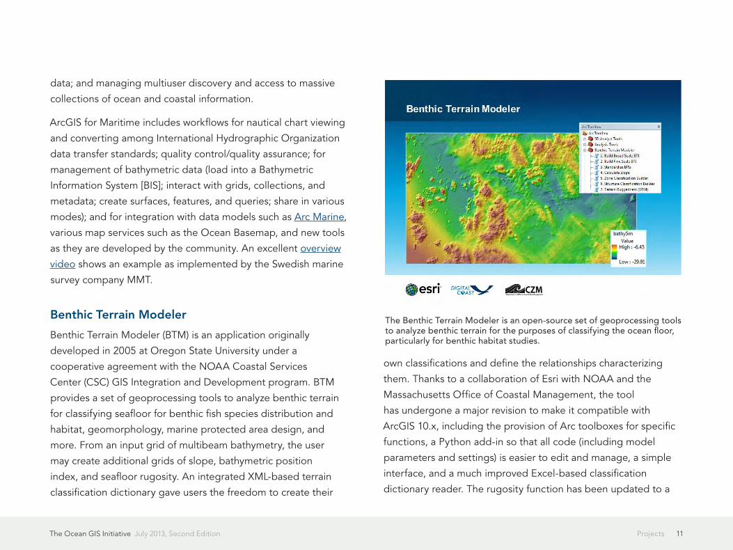
Benthic Terrain Modeler
Benthic Terrain Modeler (BTM) is an application originally
developed in 2005 at Oregon State University under a
cooperative agreement with the NOAA Coastal Services
Center (CSC) GIS Integration and Development program. BTM
provides a set of geoprocessing tools to analyze benthic terrain
for classifying seafloor for benthic fish species distribution and
habitat, geomorphology, marine protected area design, and
more. From an input grid of multibeam bathymetry, the user
may create additional grids of slope, bathymetric position
index, and seafloor rugosity. An integrated XML-based terrain
classification dictionary gave users the freedom to create their
own classifications and define the relationships characterizing
them. Thanks to a collaboration of Esri with NOAA and the
Massachusetts Office of Coastal Management, the tool
has undergone a major revision to make it compatible with
ArcGIS 10.x, including the provision of Arc toolboxes for specific
functions, a Python add-in so that all code (including model
parameters and settings) is easier to edit and manage, a simple
interface, and a much improved Excel-based classification
dictionary reader. The rugosity function has been updated to a
The Benthic Terrain Modeler is an open-source set of geoprocessing tools to analyze benthic terrain for the purposes of classifying the ocean floor, particularly for benthic habitat studies.

The Ocean GIS Initiative July 2013, Second Edition 12Projects
new vector ruggedness measure of terrain. Certain functions are
also being ported to web geoprocessing services deployed as
REST endpoints.
A tutorial that accompanies BTM takes users through a
ModelBuilder run of all its major functions including broad- and
fine-scale bathymetric position index calculations, zone and
structure classification builds, depth statistics, curvature (slope
of slope), and vector ruggedness measures of terrain. A new
Python toolbox with all code (including model parameters and
settings) stored in plain-text Python files enables easier editing
and managing of the code, removing the need for .tbx files. A
simple graphical user interface wraps around all BTM tools and
re-creates the full “wizard” experience available in the previous
release. And a much improved classification dictionary reader
works with .CSV files, as well as XML data from the prior release.
Download BTM for free at
esriurl.com/btm.
Oceans and Maritime Resource Centers
The ArcGIS Resources site is organized by various communities
to provide a prefiltered set of information specifically for a
particular community. As such, both the Oceans and Maritime
resource centers provide blog posts, Twitter feeds, discussion
forums, videos, case studies, maps, apps, data, code snippets,
documentation, and associated Esri events and news items,
preselected to help you complete your work. The idea is to save
The ArcGIS Oceans resource center.

The Ocean GIS Initiative July 2013, Second Edition 13Projects
you from having to search through large volumes of content in an
effort to find what applies to you. The Oceans resource center is
focused on the general ocean science and resource management
community. The ArcGIS for Maritime and ArcGIS for the Military:
Maritime Operations resource centers provide resources specific
to those software products. These resource centers, where
updates are posted all the time, are among the very best ways
to stay abreast of ocean developments at Esri. Please feel free to
bookmark them or subscribe to their RSS feeds.
Esri Oceans Summit and Ocean GIS Conference
On November 7–8, 2012, Esri held a historic, one-time-only
Oceans Summit. This was a high-level, strategic workshop with
an eye toward helping Esri to move forward in its approaches
to software, associated data formats, tools, workflows, and
computing platforms where the oceans are concerned. Day
one identified barriers to the use of GIS in ocean science and
management, along with associated functional requirements and
additional implications for atmospheric and climate science. Day
two focused on removal of barriers; bridging of gaps via technical
solutions in multidimensional and sensor data formats; and tools,
workflows, computing platforms, and issues of accuracy and
uncertainty. The summit has paved the way for the first open, all-
comers Esri Ocean GIS Conference, scheduled for November 5–7,
2013, at our headquarters in Redlands, California. Results of the
2012 Oceans Summit and information on the 2013 Esri Ocean GIS
Conference are available at the ArcGIS Oceans resource center.
NOAA Projects
Esri is supporting a wide variety of demonstration projects and
service-based contracts with NOAA line offices, including the
National Ocean Service (NOS); the National Marine Fisheries
Service (NMFS); the National Weather Service (NWS); the
On November 7–8, 2012, Esri held the first and only Oceans Summit attended by 50 power users from the ocean science community and 40 Esri staffers.
The Ocean GIS Initiative July 2013, Second Edition 14Projects
National Environmental Satellite, Data & Information Service
(NESDIS); and the Office of Oceanic and Atmospheric Research
(OAR). Representative projects include the following:
• NOAA Coastal Services Center and Bureau of Ocean Energy
Management: Multipurpose Marine Cadastre
• NOAA CSC: Development of story maps for coastal county
planners
• NMFS Northeast Regional Office: Development of a
groundfish observation web map application
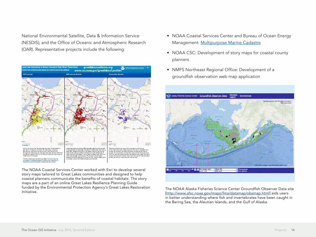
The NOAA Alaska Fisheries Science Center Groundfish Observer Data site [http://www.afsc.noaa.gov/maps/fma/datamap/obsmap.html] aids users in better understanding where fish and invertebrates have been caught in the Bering Sea, the Aleutian Islands, and the Gulf of Alaska.
The NOAA Coastal Services Center worked with Esri to develop several story maps tailored to Great Lakes communities and designed to help coastal planners communicate the benefits of coastal habitats. The story maps are a part of an online Great Lakes Resilience Planning Guide funded by the Environmental Protection Agency’s Great Lakes Restoration Initiative.
The Ocean GIS Initiative July 2013, Second Edition 15Projects
• NOAA NOS Office of Coast Survey Marine Chart Division:
Ongoing implementation and production conversion of the
NOAA Nautical Chart System II to ArcGIS for Maritime
• NOAA Coast Survey Development Laboratory: Development
of a new ArcGIS for Server software-based version of NOAA’s
ENC Direct to GIS
• NOAA NMFS Pacific Islands Fisheries Science Center: Support
for the development and implementation of various desktop
applications and web-based viewers, including the various
programs within the Coral Reef Ecosystem Division
• National Ice Center: Continued development of the Sea Ice
Prediction and Analysis System (SIPAS) based on ArcGIS for
Server

16PartnershipsThe Ocean GIS Initiative July 2013, Second Edition
Esri is leveraging a number of important partner relationships
to advance the Ocean GIS initiative. A small sample of these
relationships is presented below.
Quality Positioning Services
Esri partner Quality Positioning Services (QPS) is a maritime
technology and services provider with headquarters in
the Netherlands, with US-based operations in Portsmouth,
New Hampshire, and Houston, Texas. It is a highly specialized
company well-known in the hydrographic, petroleum, and
oceanography communities for its domain knowledge and
excellent software. QPS recently acquired Esri partner IVS 3D,
maker of the Fledermaus scientific visualization system, and is
consolidating product lines. Fledermaus is heavily used at the
world-famous Scripps Institution of Oceanography Visualization
Center and is a de facto scientific visualization standard
throughout the marine geology and geophysics arm of the ocean
science community, including the large international National
Science Foundation (NSF)-sponsored programs Ridge 2000,
Margins, and the Ocean Observatories Initiative. It is also used
at many national hydrographic and naval agencies. Esri and QPS
are now working together to integrate Fledermaus tools into the
geoprocessing framework of the ArcGIS for Maritime solution for
10.1.
Partnerships
Fledermaus 3D visualization of the North Atlantic Ocean.
The Ocean GIS Initiative July 2013, Second Edition 17Partnerships
University of New Hampshire Center for Coastal and Ocean Mapping
Esri is a member of the Industrial Consortium of UNH-CCOM.
This is a consortium for collaborating and developing new
approaches to ocean and coastal mapping challenges. A
recognized global leader in technology, testing, and training
in hydrographic tools, UNH-CCOM is a cooperative institute
funded via a NOAA line item, as well as by competitive grants, to
perform a broad spectrum of work ranging from Law of the Sea
surveying (soon to be incorporated into the Ocean Basemap) to
multibeam acoustic backscatter analysis.
Duke University Marine Geospatial Ecology Lab
Esri will be working more closely with the Marine Geospatial
Ecology Lab of Dr. Pat Halpin and his colleagues at Duke
University. A major focus will be deeper integration between the
ArcGIS system and MGET (Marine Geospatial Ecology Tools), with
its growing suite of over 250 open-source geoprocessing tools
for solving a wide variety of problems in ocean science research,
conservation, and coastal and marine spatial planning.
Restore America’s Estuaries
Restore America’s Estuaries (RAE) is a national nonprofit
organization that seeks to preserve and restore America’s
estuaries, marine ecosystems, and wetlands. Esri has been
working with RAE on developing support for a national estuary
GIS while also fostering an RAE pilot project at People for Puget
Sound.
Algalita Marine Research Institute
The Algalita Marine Research Institute (AMRI) is a national
nonprofit marine research and education organization seeking
to understand the distribution, abundance, and fate of marine
plastic pollution and to ultimately eliminate its harmful effects
on the ocean. AMRI has been engaged in a project with Esri
Professional Services to make multiple years of their marine
debris research available for the first time to scientists, scholars,
and the general public via the Algalita Marine Research Institute
Trip Explorer. This simple, easy-to-use web map provides an
interactive view into the marine debris samples taken by AMRI
during their expeditions throughout the Pacific Ocean in 1999,
2000, and 2009.
West Coast Governors Alliance on Ocean Health
The West Coast Governors Alliance on Ocean Health (WCGA)
is a proactive regional collaboration between the governors of
California, Oregon, and Washington and their natural resources
policy staff to more effectively manage “human activities and
their impact on ocean resources in a way that accounts for the
relationships among all ecosystem components, including
people and other species and the environment in which we all

The Ocean GIS Initiative July 2013, Second Edition 18Partnerships
live.” This is also a key recommendation of the bipartisan Joint
Ocean Commission Initiative. WCGA is one of 10 official regional
ocean partnerships (ROPs) nationwide that explicitly advance the
objectives detailed in the US National Ocean Policy.
Esri has played a key role in helping to establish a new Regional
Data Framework action coordination team (ACT). This ACT
supports the information needs of the existing WCGA ACTs
(Climate Change, Integrated Ecosystem Assessment, Marine
Debris, Ocean Awareness and Literacy, Polluted Runoff,
Renewable Ocean Energy, Seafloor Mapping, Sediment
Management, Spartina Eradication, and Sustainable Coastal
Communities). The ACT is coordinating the activities of three
technical working groups (Data, Information Technology, and
Outreach) and consulting with a broader West Coast network
of data experts and users in shaping regional geospatial data
coordination activities to inform regional ocean issues.
World Ocean Council
Esri is a member of the World Ocean Council, a global,
multisectoral industry leadership alliance for ocean sustainability.
Of the five working groups of the council (Policy & Governance,
CMSP, Operational and Technical, Regions, and Science), Esri will
be most involved in the Science and CMSP groups to “coordinate
cross-sectoral ocean industry efforts to call for, and participate in,
expanded, improved and better coordinated ocean science [and
CMSP], especially in relation to climate change.”
Consortium for Ocean Leadership
Esri holds affiliate membership in the Consortium for Ocean
Leadership, a nonprofit organization that represents more
than 100 of the world’s premier oceanographic research and
educational institutions, aquaria, and industry partners. With its
headquarters in Washington, DC, it is a unified, powerful, and
widely respected voice on Capitol Hill for the entire US ocean
research and education community. The consortium shapes the
future of ocean science, technology, and education by managing
and coordinating wide-ranging programs such as the Census of
Marine Life, the Ocean Observatories Initiative, the International
Ocean Drilling Program, and the National Ocean Sciences Bowl.
It is also the program office for the National Oceanographic
Partnership Program; the Interagency Working Group on Ocean
Observations; and the Ocean Research and Resources Advisory
Panel, which provides independent advice and guidance to the
US president’s National Ocean Council.
Changjiang (Yangtze) Waterway Bureau
The Changjiang (or Yangtze) Waterway Bureau is responsible for
waterway planning, construction, management, conservation,
and waterway administration on the Yangtze, which is the
longest river in Asia and the third longest river in the world.
They are collaborating with Esri Professional Services and the
Esri China Information Technology Co. Ltd. to modernize their
paper nautical chart production system. The bureau has recently
The Ocean GIS Initiative July 2013, Second Edition 19Partnerships
accomplished their first major milestone, with 400 electronic
nautical charts now maintained in an enterprise database, with
a goal of maintaining an additional 350 in the near future.
Recent improvements in ArcGIS for Maritime: Charting are more
fully automating and streamlining this workflow, reducing the
production time for charts from 3-5 days to a matter of hours.
They have also worked closely with Esri China to extend their
nautical charting data model to accommodate the national
standard, CJ-57.
OneOcean
Esri is entering into a new partnership with OneOcean
Corporation, a new startup that provides a robust cloud-based
platform for storage and distribution of big data sets without
the need for hardware, software, or specialized services. As
the company continues to evolve, the complement of Esri’s GIS
products, particularly ArcGIS for Maritime and ArcGIS Online,
will be an important set of tools that OneOcean is excited about
leveraging on behalf of stewards of ocean data in government,
industry, and research. In turn, Esri is very interested in the
integration of OneOcean’s ClipCard technology for providing rich
abstracts of data to facilitate management, access and exchange.
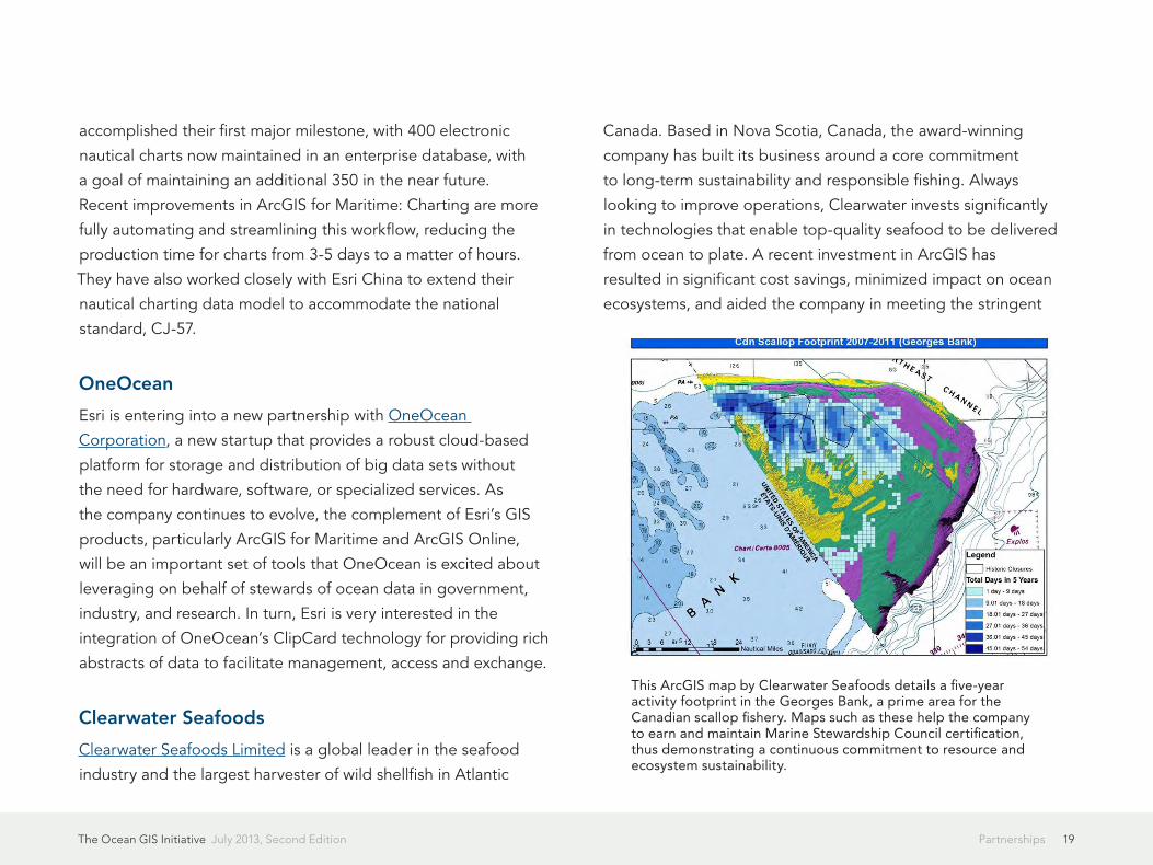
Clearwater Seafoods
Clearwater Seafoods Limited is a global leader in the seafood
industry and the largest harvester of wild shellfish in Atlantic
Canada. Based in Nova Scotia, Canada, the award-winning
company has built its business around a core commitment
to long-term sustainability and responsible fishing. Always
looking to improve operations, Clearwater invests significantly
in technologies that enable top-quality seafood to be delivered
from ocean to plate. A recent investment in ArcGIS has
resulted in significant cost savings, minimized impact on ocean
ecosystems, and aided the company in meeting the stringent
This ArcGIS map by Clearwater Seafoods details a five-year activity footprint in the Georges Bank, a prime area for the Canadian scallop fishery. Maps such as these help the company to earn and maintain Marine Stewardship Council certification, thus demonstrating a continuous commitment to resource and ecosystem sustainability.
The Ocean GIS Initiative July 2013, Second Edition 20Partnerships
requirements for Marine Stewardship Council certification of
sustainable seafood. Specifically, it uses ArcGIS to study fish
resources and population dynamics and overlay spatial and
temporal fishing data with sediment types, survey data, harvest
areas, and benthic habitat. Clearwater Seafoods is looking to
expand the use of GIS, including using it on the bridge of its
commercial fishing vessels to manage real-time positioning of
the vessels as well as manage dataflow from ship to shore, and
the organization has partnered with Esri and Esri Canada Limited
toward this end.

21Strategic GoalsThe Ocean GIS Initiative July 2013, Second Edition
To support a better understanding of our oceans, Esri is
focused on improving and expanding its products, tools,
services, partnerships, and connections with the broader ocean
community. Some of the initiatives being pursued toward this
goal are outlined below.
Grow the Ocean Basemap
Esri will continue to build the bathymetry data asset in the
Ocean Basemap via crowdsourcing, with a continued strong
emphasis on authoritative contributions from international
hydrographic offices and scientific institutions. It will also explore
and implement the provision of additional public domain content
layers, such as existing nautical chart services with IHO S-57
symbology, and global maritime boundaries, offshore energy
infrastructure, sea surface temperature, salinity, sediment
classifications, and more.
Build a More Integrated Elevation Service
Esri will expose the Ocean Basemap as part of the World
Elevation Service, making it a truly integrated “land and ocean”
elevation service, including visualization services (e.g., profiling)
and data download.
Strategic Goals
Esri’s vision for bathymetry in the cloud for a multitude of applications, expanding capabilities beyond the desktop.
The Ocean GIS Initiative July 2013, Second Edition 22Strategic Goals
Provide Intelligent Bathymetry in the Cloud
Esri’s goal is to provide intelligent bathymetric services in the
cloud by underpinning the Ocean Basemap with the power
of ArcGIS for Maritime—Bathymetry and the Bathymetric
Information System therein. A BIS server would push out
additional management functions for bathymetry, such as
database rules to sequence and display data by highest
resolution, acquisition date, and so forth, as well as have the
benefit of faster performance. This capability will allow the Ocean
Basemap to deploy in the cloud a truly worldwide model of
bathymetry. There are also important implications for expanding
ArcGIS for Maritime to other parts of the ArcGIS platform, such
as ArcGIS Online or ArcGIS for Server.
Grow Ocean Content
In terms of business drivers and business partnerships, our
current focus is in hydrography, offshore energy, ports, defense,
commercial fisheries, ocean science, and ocean regulatory/
policy administration (national, regional, and local). Along these
lines, we are developing a strategy to provide a wide range of
ocean content, leveraging the business needs/solutions process
to define the specific content needs of these sectors. Esri
ocean content is currently focused on foundational data (e.g.,
bathymetry/bathymetric elevation services, support for a polar
basemap projection, charting services), as well as support of our
public (e.g., NOAA) and private partners in making their data
available as free or premium content in ArcGIS Online. Over time,
we wish to move into geoenrichment and other analytic services.
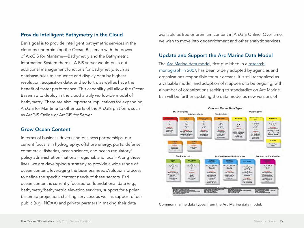
Update and Support the Arc Marine Data Model
The Arc Marine data model, first published in a research
monograph in 2007, has been widely adopted by agencies and
organizations responsible for our oceans. It is still recognized as
a valuable model, and adoption of it appears to be ongoing, with
a number of organizations seeking to standardize on Arc Marine.
Esri will be further updating the data model as new versions of
Common marine data types, from the Arc Marine data model.

The Ocean GIS Initiative July 2013, Second Edition 23Strategic Goals
ArcGIS are released, while noting that there are now a variety
of standards efforts ongoing for communities, data formats,
metadata, etc., that we could leverage. For more information on
the evolution of Arc Marine, see this blog post.
Develop Vertical, Time-Dependent Data Transformations
In collaboration with the USGS and Scripps Institution of
Oceanography, Esri is developing a series of vertical, time-
dependent datum transformations to help researchers transform
data between ellipsoidal, orthometric, and tidally referenced
elevation data at the shoreline. This is absolutely critical for
coastal surveying, coastal geomorphology, and coastal terrain
models that connect nearshore bathymetry for terrestrial digital
elevation models (DEM) that are used for storm surge, hurricane,
and tsunami inundation modeling.
Improve Support for Multidimensional Data and Analyses
Satellites can clearly map the ocean surface, and acoustic
sensors can map the ocean floor, but ocean scientists currently
have a limited view of the water column between the ocean
surface and the ocean floor. There is a critical need to study
the internal structure of features in the water column such as
plumes (hydrothermal vent plumes, oil well plumes as in the Gulf
of Mexico spill) or schools of fish to obtain fish stock dynamics,
spawning grounds, seasonal habitats, and the impact of climate
change on these. To exploit water column data, an efficient
means of reading, processing, and analyzing the data is required.
Esri is continually improving support for scientific spatial
and temporal data formats such as the climate forecast (CF)
The importance of visualizing the water column (aka "midwater" above the ocean floor), as shown by this screen capture of an output of the Fledermaus midwater mapping tool over the source of the Deepwater Horizon oil spill in the Gulf of Mexico. The visualization was produced by UNH-CCOM, courtesy of http://ccom.unh.edu/project/deepwater-horizon. It shows acoustic backscatter data over the wellhead collected after it was successfully capped in mid-July 2010. Although the wellhead was indeed capped, the visualization suggests a small amount of natural gas was still escaping.
The Ocean GIS Initiative July 2013, Second Edition 24Strategic Goals
convention of the Network Common Data Form-4 data model
(netCDF-4) and the closely related Hierarchical Data Format
(HDF). In addition, Esri seeks to better articulate to users the
rich palette of 3D representation that ArcGIS already contains,
such as features, TINs, vectors, multipatches, arrays, and the like;
consideration of the voxel data structure; and continued work on
handling point clouds and associated functions on them.
Esri will be adding more 3D analytics in ArcGIS 10.2, enhancing
all 3D representations to deal with the visualization and
interpretation of scientific data, imagery features, point clouds,
and arrays. This is particularly important in Esri’s quest to improve
software functionality for ocean and atmospheric GIS.
Support Ocean Numerical Models
Building a GIS platform that various kinds of numerical modelers
could use to associate their efforts would provide a kind of
geospatial fabric to interrelate the models. One of the most
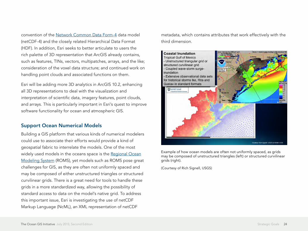
widely used models in the oceans space is the Regional Ocean
Modeling System (ROMS), yet models such as ROMS pose great
challenges for GIS, as they are often not uniformly spaced and
may be composed of either unstructured triangles or structured
curvilinear grids. There is a great need for tools to handle these
grids in a more standardized way, allowing the possibility of
standard access to data on the model’s native grid. To address
this important issue, Esri is investigating the use of netCDF
Markup Language (NcML), an XML representation of netCDF
metadata, which contains attributes that work effectively with the
third dimension.
Example of how ocean models are often not uniformly spaced, as grids may be composed of unstructured triangles (left) or structured curvilinear grids (right).
(Courtesy of Rich Signell, USGS)

Copyright © 2013 EsriAll rights reserved.Printed in the United States of America.
The information contained in this document is the exclusive property of Esri. This work is protected under United States copyright law and other international copyright treaties and conventions. No part of this work may be reproduced or transmitted in any form or by any means, electronic or mechanical, including photocopying and recording, or by any information storage or retrieval system, except as expressly permitted in writing by Esri. All requests should be sent to Attention: Contracts and Legal Services Manager, Esri, 380 New York Street, Redlands, CA 92373-8100, USA.
The information contained in this document is subject to change without notice.
US Government Restricted/Limited RightsAny software, documentation, and/or data delivered hereunder is subject to the terms of the License Agreement. The commercial license rights in the License Agreement strictly govern Licensee’s use, reproduction, or disclosure of the software, data, and documentation. In no event shall the US Government acquire greater than RESTRICTED/LIMITED RIGHTS. At a minimum, use, duplication, or disclosure by the US Government is subject to restrictions as set forth in FAR §52.227-14 Alternates I, II, and III (DEC 2007); FAR §52.227-19(b) (DEC 2007) and/or FAR §12.211/12.212 (Commercial Technical Data/Computer Software); and DFARS §252.227-7015 (DEC 2011) (Technical Data – Commercial Items) and/or DFARS §227.7202 (Commercial Computer Software and Commercial Computer Software Documentation), as applicable. Contractor/Manufacturer is Esri, 380 New York Street, Redlands, CA 92373-8100, USA.
Esri Trademarks and Service Marks: @esri.com, 3D Analyst, ACORN, Address Coder, ADF, AML, ArcAtlas, ArcCAD, ArcCatalog, ArcCOGO, ArcData, ArcDoc, ArcEdit, ArcEditor, ArcEurope, ArcExplorer, ArcExpress, ArcGIS, ArcGlobe, ArcGrid, ArcIMS, ARC/INFO, ArcInfo, ArcInfo Librarian, ArcLessons, ArcLocation, ArcLogistics, ArcMap, ArcNetwork, ArcNews, ArcObjects, ArcOpen, ArcPad, ArcPlot, ArcPress, ArcPy, ArcReader, ArcScan, ArcScene, ArcSchool, ArcScripts, ArcSDE, ArcSdl, ArcSketch, ArcStorm, ArcSurvey, ArcTIN, ArcToolbox, ArcTools, ArcUSA, ArcUser, ArcView, ArcVoyager, ArcWatch, ArcWeb, ArcWorld, ArcXML, Atlas GIS, AtlasWare, Avenue, BAO, Business Analyst, Business Analyst Online, BusinessMAP, CommunityInfo, Database Integrator, DBI Kit, EDN, Esri, Esri—Team GIS, Esri—The GIS Company, Esri—The GIS People, Esri—The GIS Software Leader, FormEdit, GeoCollector, Geographic Design System, Geography Matters, Geography Network, GIS by Esri, GIS Day, GIS for Everyone, GISData Server, JTX, MapIt, Maplex, MapObjects, MapStudio, ModelBuilder, MOLE, MPS—Atlas, PLTS, Rent-a-Tech, SDE, SML, Sourcebook·America, SpatiaLABS, Spatial Database Engine, StreetMap, Tapestry, the ARC/INFO logo, the ArcGIS logo, the ArcGIS Explorer logo, the ArcPad logo, the Esri globe logo, the Esri Press logo, the GIS Day logo, the MapIt logo, The Geographic Advantage, The Geographic Approach, The World’s Leading Desktop GIS, Water Writes, arcgis.com, esri.com, geographynetwork.com, gis.com, gisday.com, and Your Personal Geographic Information System are trademarks, service marks, or registered trademarks or service marks of Esri in the United States, the European Community, or certain other jurisdictions.
Other companies and products mentioned herein may be trademarks or registered trademarks of their respective trademark owners.

Printed in USA
Contact Esri
380 New York Street Redlands, California 92373-8100 usa
1 800 447 9778 t 909 793 2853 f 909 793 5953 [email protected] esri.com
Offices worldwide esri.com/locations
Esri inspires and enables people to positively impact their future through a deeper, geographic understanding of the changing world around them.
Governments, industry leaders, academics, and nongovernmental
organizations trust us to connect them with the analytic knowledge they
need to make the critical decisions that shape the planet. For more than
40 years, Esri has cultivated collaborative relationships with partners
who share our commitment to solving earth’s most pressing challenges
with geographic expertise and rational resolve. Today, we believe that
geography is at the heart of a more resilient and sustainable future.
Creating responsible products and solutions drives our passion for
improving quality of life everywhere.
esri.com/ebooks
G59645 ESRI7/13ek
Related Documents