United Nations University Press is the publishing arm of United Nations University. UNU Press publishes scholarly and policy-oriented books and periodicals on the issues facing the United Nations and its people and member states, with particular emphasis upon international, regional, and transboundary policies. United Nations University is an organ of the United Nations estab- lished by the General Assembly in 1972 to be an international community of scholars engaged in research, advanced training, and the dissemination of knowledge related to the pressing global problems of human survi- val, development, and welfare. Its activities focus mainly on the areas of peace and governance, environment and sustainable development, and science and technology in relation to human welfare. The University op- erates through a worldwide network of research and postgraduate train- ing centres, with its planning and coordinating headquarters in Tokyo.

Welcome message from author
This document is posted to help you gain knowledge. Please leave a comment to let me know what you think about it! Share it to your friends and learn new things together.
Transcript
United Nations University Press is the publishing arm of United NationsUniversity. UNU Press publishes scholarly and policy-oriented booksand periodicals on the issues facing the United Nations and its people andmember states, with particular emphasis upon international, regional, andtransboundary policies.
United Nations University is an organ of the United Nations estab-lished by the General Assembly in 1972 to be an international communityof scholars engaged in research, advanced training, and the disseminationof knowledge related to the pressing global problems of human survi-val, development, and welfare. Its activities focus mainly on the areas ofpeace and governance, environment and sustainable development, andscience and technology in relation to human welfare. The University op-erates through a worldwide network of research and postgraduate train-ing centres, with its planning and coordinating headquarters in Tokyo.

The Danube

The Danube: Environmentalmonitoring of an international river
By Libor Jansky, Masahiro Murakami, andNevelina I. Pachova
a United NationsUniversity PressTOKYO u NEW YORK u PARIS
( The United Nations University, 2004
The views expressed in this publication are those of the authors and do notnecessarily reflect the views of the United Nations University.
United Nations University PressThe United Nations University, 53-70, Jingumae 5-chome,Shibuya-ku, Tokyo, 150-8925, JapanTel: þ81-3-3499-2811 Fax: þ81-3-3406-7345E-mail: [email protected] enquiries: [email protected]://www.unu.edu
United Nations University Office in North America2 United Nations Plaza, Room DC2-2062, New York,NY 10017, USATel: þ1-212-963-6387 Fax: þ1-212-371-9454E-mail: [email protected]
United Nations University Press is the publishing division of theUnited Nations University.
Cover design by Rebecca S. Neimark, Twenty-Six Letters
Printed in Hong Kong
UNUP-1061ISBN 92-808-1061-8
Library of Congress Cataloging-in-Publication Data
The Danube : environmental monitoring of an international river / By LiborJansky, Masahiro Murakami, and Nevelina I. Pachova.p. cm.Includes bibliographical references and index.ISBN 9280810618 (pbk.)1. Water resources development—Political aspects—Danube River Region.2. Water resources development—Environmental aspects—Danube RiverRegion. 3. Environmental monitoring—Danube River Region. 4. Gabcıkovo-Nagymaros Project. Title. I. Jansky, Libor. II. Murakami, Masahiro III.Pachova, Nevelina I.HD1697.5.D358J36 2004333.91062 009496—dc22 2004004570
Contents
List of tables . . . . . . . . . . . . . . . . . . . . . . . . . . . . . . . . . . . . . . . . . . . . . . . . . . . . . . . . . . . viii
List of figures . . . . . . . . . . . . . . . . . . . . . . . . . . . . . . . . . . . . . . . . . . . . . . . . . . . . . . . . . . ix
List of appendices . . . . . . . . . . . . . . . . . . . . . . . . . . . . . . . . . . . . . . . . . . . . . . . . . . . . . xi
Acknowledgement. . . . . . . . . . . . . . . . . . . . . . . . . . . . . . . . . . . . . . . . . . . . . . . . . . . . . xii
Preface . . . . . . . . . . . . . . . . . . . . . . . . . . . . . . . . . . . . . . . . . . . . . . . . . . . . . . . . . . . . . . . . . xiii
Chronology of events. . . . . . . . . . . . . . . . . . . . . . . . . . . . . . . . . . . . . . . . . . . . . . . . . . xvi
1 Introduction . . . . . . . . . . . . . . . . . . . . . . . . . . . . . . . . . . . . . . . . . . . . . . . . . . . . . . . . . 1Water – a blessing or a curse . . . . . . . . . . . . . . . . . . . . . . . . . . . . . . . . . . . . 1International freshwater management: Conflicts andresolution mechanisms . . . . . . . . . . . . . . . . . . . . . . . . . . . . . . . . . . . . . . . . . . . 2The Gabcıkovo-Nagymaros Project (GNP) . . . . . . . . . . . . . . . . . . . . . 4Environmental monitoring: A possible solution? . . . . . . . . . . . . . . . 5Why and what? . . . . . . . . . . . . . . . . . . . . . . . . . . . . . . . . . . . . . . . . . . . . . . . . . . . 6
2 Transboundary river problems . . . . . . . . . . . . . . . . . . . . . . . . . . . . . . . . . . . . . 9
3 The Gabcıkovo-Nagymaros Project . . . . . . . . . . . . . . . . . . . . . . . . . . . . . . . 12Legal setting . . . . . . . . . . . . . . . . . . . . . . . . . . . . . . . . . . . . . . . . . . . . . . . . . . . . . . 12
v
Physical setting . . . . . . . . . . . . . . . . . . . . . . . . . . . . . . . . . . . . . . . . . . . . . . . . . . 16Water management in the Danube River basin . . . . . . . . . . . . . 16Physical characteristics of the middle Danube . . . . . . . . . . . . . . 23History of regulation works in the middle reaches of theDanube . . . . . . . . . . . . . . . . . . . . . . . . . . . . . . . . . . . . . . . . . . . . . . . . . . . . . . . . 25Physical impacts of early regulation works . . . . . . . . . . . . . . . . . . 26
Geopolitical setting . . . . . . . . . . . . . . . . . . . . . . . . . . . . . . . . . . . . . . . . . . . . . . 27Technical characteristics . . . . . . . . . . . . . . . . . . . . . . . . . . . . . . . . . . . . . . . . 29Environmental Impacts of GNP: conflicting claims. . . . . . . . . . . . 32
4 Environmental monitoring of an international river . . . . . . . . . . . . . 34Principles of environmental monitoring . . . . . . . . . . . . . . . . . . . . . . . . 34Joint environmental monitoring on areas affected by theGabcıkovo Part of the Gabcıkovo-Nagymaros Project . . . . . . . . 39
Legal and institutional framework and objectives. . . . . . . . . . . 39Technical and scientific information bases for assessmentof the environmental impacts of the GNP . . . . . . . . . . . . . . . . . . . 43
Hydrological regime of surface water . . . . . . . . . . . . . . . . . . . . . 48Surface water quality . . . . . . . . . . . . . . . . . . . . . . . . . . . . . . . . . . . . . . . 50Hydrological regime of groundwater . . . . . . . . . . . . . . . . . . . . . . 53Groundwater quality . . . . . . . . . . . . . . . . . . . . . . . . . . . . . . . . . . . . . . . 59Soil monitoring . . . . . . . . . . . . . . . . . . . . . . . . . . . . . . . . . . . . . . . . . . . . . 62Forest monitoring. . . . . . . . . . . . . . . . . . . . . . . . . . . . . . . . . . . . . . . . . . . 68Biota monitoring. . . . . . . . . . . . . . . . . . . . . . . . . . . . . . . . . . . . . . . . . . . . 77Other monitored components. . . . . . . . . . . . . . . . . . . . . . . . . . . . . . 91
Joint monitoring results. . . . . . . . . . . . . . . . . . . . . . . . . . . . . . . . . . . . . . . 96Hydrological regime of surface water . . . . . . . . . . . . . . . . . . . . . 96Surface water quality . . . . . . . . . . . . . . . . . . . . . . . . . . . . . . . . . . . . . . . 97Hydrological regime of groundwater . . . . . . . . . . . . . . . . . . . . . . 98Groundwater quality . . . . . . . . . . . . . . . . . . . . . . . . . . . . . . . . . . . . . . . 100Soil monitoring . . . . . . . . . . . . . . . . . . . . . . . . . . . . . . . . . . . . . . . . . . . . . 100Forest monitoring. . . . . . . . . . . . . . . . . . . . . . . . . . . . . . . . . . . . . . . . . . . 101Biota monitoring. . . . . . . . . . . . . . . . . . . . . . . . . . . . . . . . . . . . . . . . . . . . 102
Evaluation and recommendations. . . . . . . . . . . . . . . . . . . . . . . . . . . . 103
5 Managing international waters: Concluding remarks . . . . . . . . . . . . 110
Acronyms and abbreviations. . . . . . . . . . . . . . . . . . . . . . . . . . . . . . . . . . . . . . . . . 113
References . . . . . . . . . . . . . . . . . . . . . . . . . . . . . . . . . . . . . . . . . . . . . . . . . . . . . . . . . . . . 115
vi CONTENTS

Glossary . . . . . . . . . . . . . . . . . . . . . . . . . . . . . . . . . . . . . . . . . . . . . . . . . . . . . . . . . . . . . . . . 129
Appendices . . . . . . . . . . . . . . . . . . . . . . . . . . . . . . . . . . . . . . . . . . . . . . . . . . . . . . . . . . . . 135
Index . . . . . . . . . . . . . . . . . . . . . . . . . . . . . . . . . . . . . . . . . . . . . . . . . . . . . . . . . . . . . . . . . . . 166
CONTENTS vii
List of tables
Table 1 Functions of rivers and related water quantity andquality problems . . . . . . . . . . . . . . . . . . . . . . . . . . . . . . . . . . . . . . . . . 37
Table 2 Indicative variables related to water quality issues . . . . 38Table 3 List of stations for surface water level and discharge
monitoring . . . . . . . . . . . . . . . . . . . . . . . . . . . . . . . . . . . . . . . . . . . . . . . 51Table 4 List of stations for surface water quality monitoring . . 54Table 5 Jointly agreed limits for surface water quality
classification. . . . . . . . . . . . . . . . . . . . . . . . . . . . . . . . . . . . . . . . . . . . . . 55Table 6 List of stations for groundwater quality monitoring . . . 63Table 7 Groundwater quality limits for drinking water. . . . . . . . . 64Table 8 List of stations for soil moisture monitoring . . . . . . . . . . . 69Table 9 List of stations for forest monitoring . . . . . . . . . . . . . . . . . . . 78
viii
List of figures
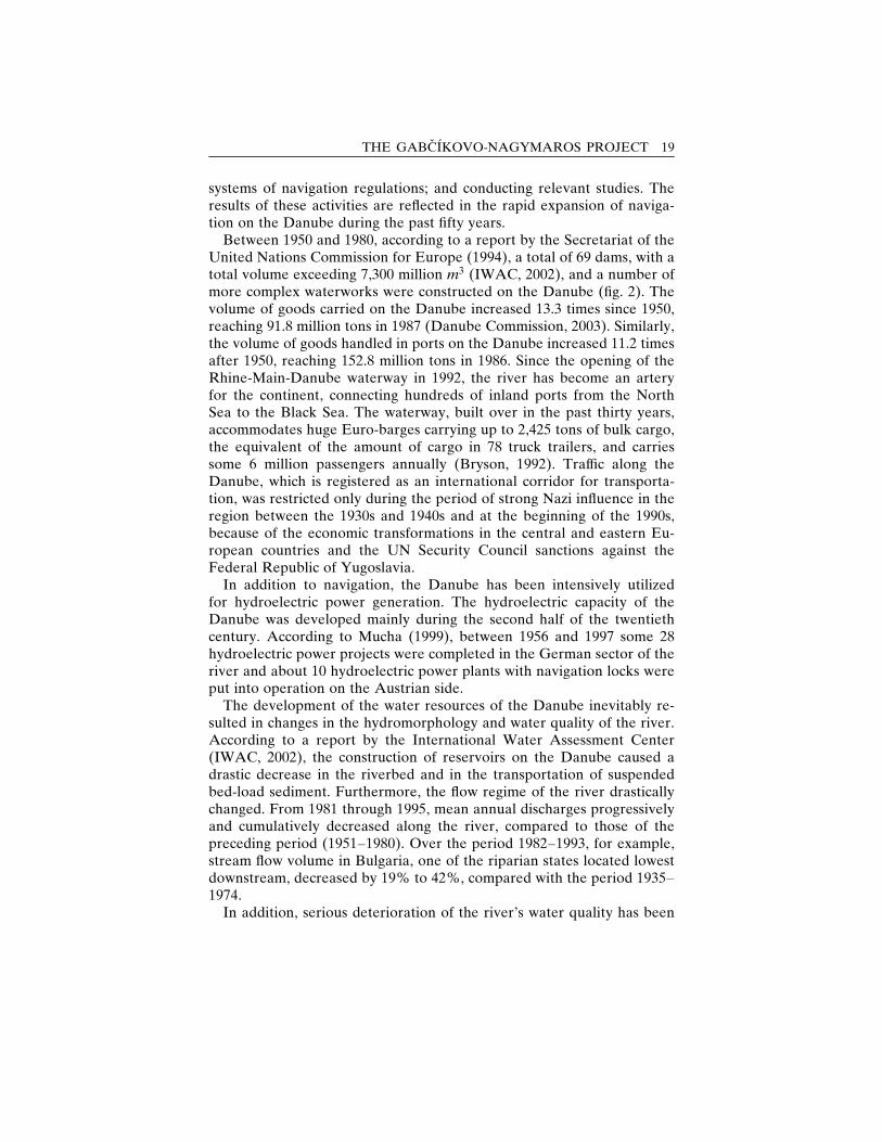
Figures followed by (c) are in color, grouped together in the centerpagesFigure 1 The Danube River Basin. . . . . . . . . . . . . . . . . . . . . . . . . . . . . . . . . 17Figure 2 Danube river profile: Dams along the river . . . . . . . . . . . . . 20Figure 3 Longitudinal cross section of the middle Danube . . . . . . 24Figure 4 The Gabcıkovo-Nagymaros system of locks as
originally designed. . . . . . . . . . . . . . . . . . . . . . . . . . . . . . . . . . . . . . . . 30Figure 5 Gabcıkovo Part of the Project . . . . . . . . . . . . . . . . . . . . . . . . . . . (c)Figure 6 Surface water discharge at the Bratislava-Devın
profile 1993–1997 . . . . . . . . . . . . . . . . . . . . . . . . . . . . . . . . . . . . . . . . . (c)Figure 7 Surface water quantity: Joint monitoring network. . . . . . (c)Figure 8 Surface water quality: Joint monitoring network . . . . . . . (c)Figure 9 Surface water and groundwater levels: Monitoring
network in Slovakia . . . . . . . . . . . . . . . . . . . . . . . . . . . . . . . . . . . . . . (c)Figure 10 Groundwater level differences between 1992 and 1962 (c)Figure 11 Groundwater level differences between 1995 and 1992 (c)Figure 12 Groundwater regime: Joint monitoring network . . . . . . . (c)Figure 13 Groundwater quality: Joint monitoring network . . . . . . . (c)Figure 14 Soil moisture monitoring: Joint monitoring network . . . (c)Figure 15 Soil moisture monitoring: Changes in the upper part
of Zitny Ostrov . . . . . . . . . . . . . . . . . . . . . . . . . . . . . . . . . . . . . . . . . . . (c)Figure 16 Forest monitoring: Joint monitoring network. . . . . . . . . . . (c)Figure 17 Monitoring of Biota: Joint monitoring network . . . . . . . . (c)
ix
Figure 18 Groundwater level differences between 1997 and 1993(for Q ¼ 1000 m3=s) . . . . . . . . . . . . . . . . . . . . . . . . . . . . . . . . . . . . . (c)
Figure 19 Groundwater level differences between 1997 and 1993(for Q ¼ 2000 m3=s) . . . . . . . . . . . . . . . . . . . . . . . . . . . . . . . . . . . . . (c)
Figure 20 Groundwater level differences between 1997 and 1993(for Q ¼ 3000 m3=s) . . . . . . . . . . . . . . . . . . . . . . . . . . . . . . . . . . . . . (c)
x LIST OF FIGURES
List of appendices
Appendix No. 1. . . . . . . . . . . . . . . . . . . . . . . . . . . . . . . . . . . . . . . . . . . . . . . . . . . . . . . . 136Treaty Concerning the Construction and Operation of the Gab-cıkovo-Nagymaros System of Locks (Hungary/Czechoslovakia),signed in Budapest on 16 September 1977. [Reproduced fromthe text provided by the United Nations Treaty Series.]
Appendix No. 2. . . . . . . . . . . . . . . . . . . . . . . . . . . . . . . . . . . . . . . . . . . . . . . . . . . . . . . . 150Special Agreement for Submission to the International Court ofJustice of the Differences between the Republic of Hungary andthe Slovak Republic Concerning the Gabcıkovo-NagymarosProject – jointly notified to the Court on 2 July 1993. [Repro-duced from the text provided by the Plenipotentiary of theSlovak Republic for the Construction and Operation of theGabcıkovo-Nagymaros Hydropower Scheme.]
Appendix No. 3. . . . . . . . . . . . . . . . . . . . . . . . . . . . . . . . . . . . . . . . . . . . . . . . . . . . . . . . 153Agreement between the Government of the Slovak Republicand the Government of Hungary about Certain TemporaryMeasures and Discharges to the Danube and Mosoni Danube,signed on 19 April 1995. [Reproduced from the text providedby the Plenipotentiary of the Slovak Republic for the Construc-tion and Operation of the Gabcıkovo-Nagymaros HydropowerScheme.]
xi
Acknowledgement
This study was based on the research programme on sustainable resourcesmanagement with regard to international water issues at the UnitedNations University (UNU) in Tokyo. The authors highly appreciate themomentum given by Dr. Juha I. Uitto, presently with UNDP-GEF, andby Professor Iwao Kobori, UNU, who jointly initiated the research onthe Danube case in 1995. Our appreciation goes to the ministries andagencies of Hungary and Slovakia which supported our research. Wewould also like to thank the Faculty of Natural Science at ComeniusUniversity in Slovakia, and, in particular, Dr. Pavel Dlapa, of the SoilScience Department, for his valuable comments with regard to the soil-and-water-chemistry-related aspects of our research, as well as theDepartment of Civil Engineering at the Technical University of Budapestin Hungary and the Department of Infrastructure Systems Engineeringat Kochi University of Technology in Japan for their kind support andassistance. Special thanks are due to GROUND WATER Consulting,Ltd., in Bratislava, Slovak Republic, for their courtesy to publish theoriginal figures from the joint environmental monitoring. Let us stateclearly that the views expressed in this work are the personal opinionsof the authors and do not necessarily represent the views of the UnitedNations University or of the United Nations.
xii
Preface
Building upon the United Nations University research project on themanagement of transboundary water resources, this work examines theopportunities and constraints related to the use of environmental mon-itoring as a tool for providing scientific data and information to supportdecision making for the sustainable management of shared freshwaterresources in a conflictual international environment. Based on originaldocuments and research, the study presents an overview of the devel-opment of the environmental monitoring in the middle reaches of theDanube, which was established in the course of the escalation of an inter-national dispute over a water management project on the section of theriver that flows as a border between Hungary and the Slovak Republic.The work also examines the results from the monitoring and proposespossibilities for its optimization.
The original Gabcıkovo-Nagymaros Project (GNP), the key provisionof a treaty signed by the governments of Hungary and Czechoslovakia in1977 (see Appendix No. 1) was a joint endeavor for the construction of asystem of locks for flood control, navigation, and hydropower generationin the middle Danube. The sociopolitical and economic transformationsin Hungary and Czechoslovakia, which began in the late 1980s, and thechanges of the respective goals and priorities of both countries turned theGNP into a subject of a heated debate on the environmental implicationsof the water regulations and at the same time into a political dispute.Currently, only the upper ‘‘Gabcıkovo’’ part of the original twin-dam
xiii
project is in operation. It was launched as an alternative to the original in1992, following the freeze on the construction of the lower ‘‘Nagymaros’’part of the project in 1989.
The joint system for monitoring the environmental impacts of the con-struction and operation of the GNP was developed alongside the politicaldebate between Hungary and the Slovak Republic, which inherited thecase after the disintegration of Czechoslovakia in 1993. The legal basis ofthe joint monitoring was provided by the Agreement on Certain Techni-cal Measures and Discharges to the Danube and Mosoni Danube, signedby the Governments of the Slovak Republic and the Republic of Hun-gary in 1995. The agreement created an obligation for the two parties tomonitor the environmental impacts of the measures implemented in 1995to mitigate the environmental damages from the construction of theproject and to exchange data and information from the monitoring re-sults. While the joint environmental monitoring began officially in 1995,the technical and human capital foundations for the programme wererooted in earlier joint and independent monitoring of the Danube Riverand of the GNP section of the basin in particular. While seemingly para-doxical, the joint monitoring between the two countries in the midst ofthe ongoing political and legal dispute between them – a situation whichis not uncommon in the history of international water management –draws attention to the possible role of shared water as an agent of coop-eration rather than dispute – an issue raised by Jansky (1994), with re-gard to the GNP before the signing of the technical agreement and thestart of the joint monitoring activities, and reiterated by Murakami andJansky (2002).
The technical agreement between Hungary and Slovakia for themanagement of the water border between them could be related to thegeopolitical history and basis for cooperation between the two countries.Recent historiographic studies on the region, for example, argue for theexistence of a common east central European identity shaped by com-mon geopolitical forces and the many centuries of interactions betweenthe Hungarians and Slovaks living on the two sides of the river. The goalof EU membership that has dominated the politics of the two countriesover the past decade reflects that argument. To that common goal is as-cribed the two nations’ agreement in 1993 to submit the GNP case forjudgment to the International Court of Justice (Appendix No. 2) – anagreement without precedent in the history of transboundary watermanagement conflicts.
In the past, conflicts over the harmful use of international water sys-tems have been resolved through negotiations exclusively between tworiparian states, through mediation by a third party, or within the frame-work of river basin organizations – intergovernmental bodies created
xiv PREFACE
by riparian states. The mediatory role of the International Court of Jus-tice concerning disputes over international watercourses had not beenpreviously tested. Neither had been tested the possible role of joint en-vironmental monitoring as a tool for implementing the data-and-benefit-sharing approaches to managing shared river basins promoted by theUnited Nations Convention on the Law of the Non-Navigational Uses ofInternational Watercourses.
By presenting an overview of the current status of the GNP case and byintegrating it with the history of and the results from the joint environ-mental monitoring programme in the middle Danubian basin, this studyattempts to draw attention to and to illustrate the outcome of the coopera-tive efforts of the two countries, as well as the associated constraints, andthus to show the realistic possibilities offered by joint environmental moni-toring for water management in conflictual international environments.
At the same time, the study hopes to enhance the practical value of themonitoring and the results (which have hitherto remained confined totechnical specialists and political authorities within the two states) bymaking them accessible to the public and drawing attention to possiblestrategies for optimizing the programme. An updated basis for decisionmaking can facilitate public involvement in the ongoing search for a so-lution regarding the GNP case that is sustainable and acceptable to theshareholders in the two countries. In this sense, our research can be seenas an input in the process of implementing the European Union WaterFramework Directive (EU WFD) – a part of the ongoing EU accessionprocesses in the two countries – and therefore aiming at increasing envi-ronmental awareness and encouraging public participation in the DanubeRiver basin management plans at the national and international levels.Public participation in water management, especially in internationalwatercourses, is also an important element of the holistic approach inmanaging water resources, which is increasingly promoted by regulationsat the global level. Studying the development and operation of the localenvironmental monitoring system in the middle Danube can complementthe ongoing efforts to support and integrate developments in regionalenvironmental monitoring, evaluation, and information systems withinthe framework of the UNDP/GEF Danube Regional Project and the ac-tivities of the Monitoring, Laboratory, and Information ManagementExpert Groups of the International Commission for the Protection of theDanube River (ICPDR).
The study’s goals have determined its target audience, namely, non-governmental, professional, and decision-making stakeholders involvedin international freshwater resources management in general, and thosewith a shared interest in the Danube River, particularly in the part of itsbasin affected by the GNP.
PREFACE xv
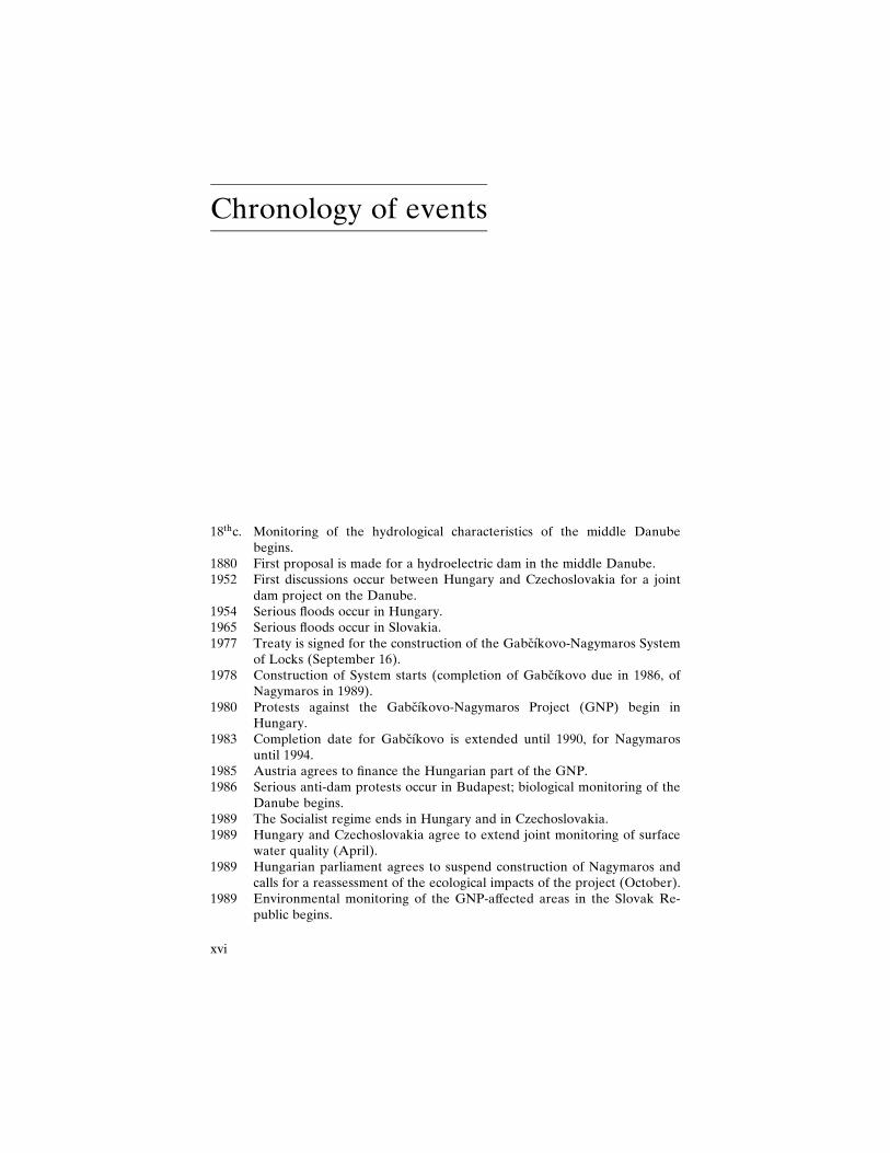
Chronology of events
18thc. Monitoring of the hydrological characteristics of the middle Danubebegins.
1880 First proposal is made for a hydroelectric dam in the middle Danube.1952 First discussions occur between Hungary and Czechoslovakia for a joint
dam project on the Danube.1954 Serious floods occur in Hungary.1965 Serious floods occur in Slovakia.1977 Treaty is signed for the construction of the Gabcıkovo-Nagymaros System
of Locks (September 16).1978 Construction of System starts (completion of Gabcıkovo due in 1986, of
Nagymaros in 1989).1980 Protests against the Gabcıkovo-Nagymaros Project (GNP) begin in
Hungary.1983 Completion date for Gabcıkovo is extended until 1990, for Nagymaros
until 1994.1985 Austria agrees to finance the Hungarian part of the GNP.1986 Serious anti-dam protests occur in Budapest; biological monitoring of the
Danube begins.1989 The Socialist regime ends in Hungary and in Czechoslovakia.1989 Hungary and Czechoslovakia agree to extend joint monitoring of surface
water quality (April).1989 Hungarian parliament agrees to suspend construction of Nagymaros and
calls for a reassessment of the ecological impacts of the project (October).1989 Environmental monitoring of the GNP-affected areas in the Slovak Re-
public begins.
xvi
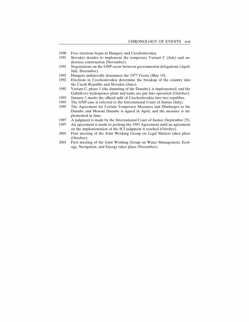
1990 Free elections begin in Hungary and Czechoslovakia.1991 Slovakio decides to implement the temporary Variant C (July) and au-
thorizes construction (November).1991 Negotiations on the GNP occur between governmental delegations (April,
July, December).1992 Hungary unilaterally denounces the 1977 Treaty (May 19).1992 Elections in Czechoslovakia determine the breakup of the country into
the Czech Republic and Slovakia (June).1992 Variant C, phase 1 (the damming of the Danube), is implemented, and the
Gabcıkovo hydropower plant and locks are put into operation (October).1993 January 1 marks the official split of Czechoslovakia into two republics.1993 The GNP case is referred to the International Court of Justice (July).1995 The Agreement for Certain Temporary Measures and Discharges to the
Danube and Mosoni Danube is signed in April, and the measure is im-plemented in June.
1997 A judgment is made by the International Court of Justice (September 25).1997 An agreement is made to prolong the 1995 Agreement until an agreement
on the implementation of the ICJ judgment is reached (October).2001 First meeting of the Joint Working Group on Legal Matters takes place
(October).2001 First meeting of the Joint Working Group on Water Management, Ecol-
ogy, Navigation, and Energy takes place (November).
CHRONOLOGY OF EVENTS xvii

1
Introduction
Water – a blessing or a curse
Spilling water before starting an enterprise is an old Slavonic traditionthat symbolizes the hope that the endeavor will flow as smoothly as waterin a river. However, that old metaphor may losing its force, not onlybecause the free flow of water in nearly all the world’s major rivers isnow restricted by artificial barriers. The fates of waters both harnessedand still freely flowing seem to depend on the resolutions of two ongoingheated debates: Are existing dams to be or not to be demolished? Arerivers to be or not to be dammed? An illustration of these global debatescan be seen in the Gabcıkovo-Nagymaros case, which has been the sub-ject of a continuing dispute in an either-or framework over the past de-cade. A closer look at the complexity of the issues involved, however,raises the question: Is an either-or framework appropriate for even be-ginning to address water management issues?
Throughout the course of human history and, in particular, during therecent centuries of intensive development of natural resources for theadvancement of human well-being, the natural power of water in riversand streams has been harnessed through numerous artificial lake con-structions, also called reservoirs, impoundments, or dams. These waterregulation works were originally designed to provide water for humansand agriculture, to control floods, and to provide waterways for naviga-tion. In more recent times, they have been designed for hydropower
1

generation, for commercial fisheries, and for water-based sports and rec-reation. An estimated 800,000 reservoirs were in operation worldwide in1997, and approximately 1,700 more large reservoirs are currently underconstruction, mainly in developing countries (World Lake Vision Com-mittee, 2003).
The development of water regulation works has been both aided andconstructed by the transboundary nature of water. Water crosses variousborders: social, political, economic, cultural, scientific. Thus, it requirescommunication and cooperation among riparian interest groups overlong periods of coexistence. Very often, however, the diverging views ofstakeholders on allocation, objectives, standards, and methods to beconsidered and/or applied in the course of implementing various stagesof water resources management turn water into an agent of conflictrather than cooperation (UNESCO, 2001). The transboundary nature offreshwater resources, which are usually shared by multiple groups withdifferent values and needs in regard to water, has long determined theconflictual nature of river management and water exploitation. Thatwater has long been a cause of conflict is suggested by the English wordrival, which comes from the Latin rivalis, meaning ‘‘one who uses a river[rivus] in common with another.’’ While water-related conflicts haverarely led to violence in the past 4,500 years, acute tensions have esca-lated on numerous occasions (Uitto and Wolf, 2002) and are expected toturn into the major causes of wars in the future unless a sustainableapproach to water resources management is developed and employed(Serageldin, 1995).
International freshwater management: Conflicts andresolution mechanisms
International freshwater management is a particular case of trans-boundary water management, which is complicated by usually largerdisparities and communication barriers among the riparian parties, bylimited existing legal frameworks, and by international security consider-ations. These constraints have led to a much greater use of domestic asopposed to international freshwater resources. Increasing demands andcompetition for water, due not only to the scarcity and degraded qualityof domestic water resources but even more to the poor management andutilization of these resources for growing populations and economic de-velopment needs (WEHAB Working Group, 2002; UNESCO, 2001),suggest a possible rise in domestic, social, and political tensions, as wellas increased pressure for the development of international waters in thefuture (Biswas, 1999).
2 THE DANUBE
The redrawing of the political maps of Central and Eastern Europeand of Central Asia at the beginning of the 1990s, which led to the inter-nationalization of a number of previously domestic water resources (e.g.,the Dnieper, the Don, and the Volga Rivers), and the changes in the po-litical composition of existing international basins (e.g., those of theDanube, the Ob, and the Aral Sea) also suggest a greater potential fortensions over international water management issues that had previouslybeen accommodated domestically or within the relevant Socialist-blocinstitutional frameworks which disintegrated together with the regime.
In the past, conflicts concerning international freshwater systems havearisen mainly in developing regions, where water stress, defined inGlobal Environmental Outlook (UNEP, 2002) as water consumption ex-ceeding 10% of renewable freshwater resources, is manifested at thecrossroads of socioeconomic, cultural, and political borders and dis-parities. Notable examples are the conflicts in the Ganges-Brahmaputra-Meghna and the Indus river basins in South Asia, in the Jordan riverbasin in the Middle East (Murakami, 1996), the Nile river basin in Africa,and, most recently, in the Aral Sea basin in Central Asia. In most cases,conflicts have arisen from accusations by downstream riparian statesof harmful uses of shared water resources by upstream ones. Given thenature of these conflicts, they have been resolved by negotiation at theinternational level, by negotiation exclusively between two riparianstates, or through mediation by a third party. River basin organizations –intergovernmental bodies created by riparian states – have also beeninstrumental in resolving conflicts among basin countries (Nakayama,1998a).
Historically, international negotiations and institutional frameworkshave been successful in resolving disputes over the navigable uses of in-ternational rivers. Claims over nonnavigable uses, however, have proveddifficult to settle (Biswas, 1999). The constraints to resolving issues of al-location have been aggravated by the increasing legitimization of waterneeds for ecosystem and habitat preservation. The lack of reliable infor-mation about the environmental impacts of different water managementpolicy options and the scientific uncertainty about them has left addi-tional space for value-based judgments. That uncertainty has madetransboundary water management and, as Deets (1998) argues, environ-mental disputes in general particularly prone to politicization and hasraised the need for incorporating appropriate tools for limiting uncer-tainty in the existing mechanisms for resolutions of international waterconflicts.
The major framework for sustainable freshwater resources manage-ment – Integrated River Basin Management (IRBM) – promotes the co-ordinated planning and management of all environmental components on
INTRODUCTION 3
the geographical basis of a river basin. Concrete tools for promoting andensuring long-term, holistic water management, however, are lacking inmost of the cooperation management agreements currently existing in106 of the world’s 263 international basins (Wolf, 2002). In an attempt tofill that lack, the 1997 United Nations Convention on the Law of theNon-Navigational Uses of International Watercourses, the developmentof which can be traced back to the 1966 Helsinki Rules that laid thefoundation for the international principles for shared watercourses(UNEP, 2002), established a legal framework promoting the equitableand reasonable utilization and the protection and preservation of sharedwater bodies by, among other policies, sharing relevant data and infor-mation. The practical value of the Convention, however, has been ques-tioned on the basis of its vague, sometimes contradictory language, andthe slow progress toward its legal framework’s ratification (Giordano andWolf, 2002). At the same time, the usefulness of the framework’s datadevelopment and data-sharing approach can be seen as constrained bythe lack of appropriate mechanisms for incorporating the relevant stake-holders and the broader public in data-sharing arrangements and in thedecision making about and the implementation of water managementpolicies. Although donors have given lip service to and, in some cases,funded elements of public participation projects, mostly in awarenessraising and other public relations efforts, it has been argued that many ofthose actions have been insufficient or misguided (Bell, Stewart, andNagy, 2002).
The case of the Gabcıkovo-Nagymaros Project provides insight intothe effectiveness of the Convention, both legally and in terms of one ofthe mechanisms the Convention proposes for the prevention and resolu-tion of disputes over nonnavigable and, in particular, environmental usesof international waters. The GNP case was the first international waterdispute taken to the International Court of Justice (ICJ) and addressedwithin the framework offered by the United Nations Convention on theLaw of the Non-Navigational Uses of International Watercourses –legally, through the Court’s reference to the Convention and, in practice,through the system for joint environmental monitoring and exchange ofrelevant data and information which was established even before thecreation of the UN Convention.
The Gabcıkovo-Nagymaros Project (GNP)
Situated on the borderline of changing institutional structures and publicperceptions, the Gabcıkovo-Nagymaros case, born from a half-century-old idea for constructing a system of locks in the middle section of the
4 THE DANUBE
Danube flowing between Bratislava and Budapest, the capitals of Slova-kia and Hungary, respectively, constitutes a test case of the ability of theexisting and potential tools for transboundary water management to re-spond to the challenges of the rising pressure for the utilization of inter-national water resources. Initially conceived as a joint hydroengineeringproject, the GNP escalated into a war of words over the environmentalconsequences of the regulation works on the water resources shared byHungary and Slovakia. The lack of reliable scientific information in thecontext of the political and economic transitions progressing at differentpaces in the two countries allowed for the utilization of the water man-agement debate for political legitimization and led to its transformationinto a potentially explosive international security issue (Sukosd, 1998).
International institutions, such as the European Union, with its strongpolitical leverage over the two countries aspiring to membership in theorganization, and the International Court of Justice, which examined thecase and gave a judgment in 1997, provided the institutional basis forresolution to the dispute. Thus, they filled the post-Socialist institutionalvacuum in which the two countries found themselves after the disinte-gration at the beginning of the 1990s of the formerly existing structuresfor regional political security and economic cooperation. Ultimately,however, the EU and the ICJ left the water management issues and theiractual and potential environmental threats for Hungary and Slovakia toresolve.
A step in the direction of reaching such a resolution on the technicalaspects of the water management debate was undertaken by the twocountries in 1995 (i.e., before the pronouncement of the ICJ judgment)through an agreement on some temporary technical measures for ad-dressing the most critical environmental consequences of constructingand putting into operation the Gabcıkovo part of the GNP and throughthe establishment of a system for joint environmental monitoring andexchange of information on the affected areas.
Environmental monitoring: A possible solution?
Environmental monitoring, an integral part of the Environmental ImpactAssessment System, is a costly tool for evaluating the environmental im-pacts of development projects. In conflict-prone environments, however,its cost may be a justifiable and reasonable price to pay to limit oppor-tunities for the much more costly politicization and internationalizationof environmental debates. For monitoring to prove a useful tool for sus-tainable water management in conflictual environments, however, it has
INTRODUCTION 5
to be conducted or coordinated jointly. A joint endeavor could providethe following:� a basis for decision making that limits the scientific uncertainty whichmakes environmental debates prone to distortions;
� an alternative, i.e., nonpolitical, perspective for water management en-couraging a benefit-sharing approach by looking at the examined waterbasin as an ecosystem unity;
� an institutional framework for addressing the technical and practicalaspects of water management debates.
Environmental monitoring, however, is hardly a flawless solution. Twomajor concerns, its scientific and political functions in conflictual envi-ronments, need to be taken into account. Limiting factors in the case ofthe former constitute methodological uncertainties related to the follow-ing:� difficulties in selecting proper indicators because of the complexity ofthe interlinkages of different factors in the physical environment;
� data interpretation concerns arising from the difficulty in isolating thecauses of observed changes in the complexity of the time- and spatialecosystem dynamics;
� scientific constraints in making future predictions;� the subjectivity of determining the value of one plant or animal speciesas opposed to another and thus of policy-relevant data interpretation.
In addition to these scientific limitations, the effectiveness of monitoringprogrammes is subject to the inevitable dependency on politics of the useof the monitoring results in conflictual environments. Closely related tothat dependency is the danger of an unnecessary continual extension ofthe monitoring programme itself, driven by the prolonged justifiability ofsuch programmes during a continuing political debate or by the vestedinterests of lobbying scientists involved in a monitoring programme. Anexample of the extent to which these limitations are surmountable is of-fered by the GNP case and the joint monitoring programme associatedwith it on the affected areas.
Why and what?
To sum up, our research was driven by practical considerations related tothe current state of international watercourses management and the pe-culiarities and status of the GNP case itself. The former are related to thepotential growth of tension in international watercourses and the possibleopportunities for dealing with that tension offered by joint environmentalmonitoring and data sharing, which have been increasingly promoted astools for transboundary water management in the context of the inter-
6 THE DANUBE
national debate on the socioeconomic and environmental implications ofwater regulations. The latter are associated with the ongoing efforts to-ward reaching an agreement on the implementation of the 1997 judgmentof the International Court of Justice regarding the GNP case and with theaccumulated results from the joint monitoring and earlier independentmonitoring of the affected areas that could provide a reasonable basisboth for an interim, policy-oriented evaluation of the environmental im-pact of the GNP and for informed public input in support of it.
The mandate of our work with respect to the broader implications ofenvironmental monitoring for managing shared water resources in con-flictual environments is determined by the few existing cases of joint en-vironmental monitoring on international rivers and by the limited atten-tion paid to the opportunities and constraints such programmes offer fordealing with potentially disruptive water management disputes. At thesame time, the GNP-specific concerns our work attempts to address arerelated to the fact that, despite the considerable attention that the GNPcase has attracted in the region and among political scientists abroad,scientifically backed, systematic, and comprehensive evaluations of theenvironmental consequences of the operation of the dam are limited.
The available literature focusing on the environmental aspects of theGNP case offers a fragmented picture. Comprehensive environmentalstudies based on the independent monitoring conducted in Hungary andthe Slovak Republic before 1995 are subject to the political divide be-tween the two countries and inevitably to the respective viewpoints onthe case. Results from the pre-1995 monitoring in the Slovak Republicare compiled in Gabcıkovo Part of the Hydroelectric Power Project:Environmental Impact Review Based on Two Year Monitoring, publishedin 1995 by the Faculty of Natural Sciences of Comenius University inBratislava, which was in charge of coordinating the GNP-related monitor-ing activities at the time, and the Plenipotentiary of the Slovak Republicfor the Construction and Operation of the Gabcıkovo-Nagymaros Hydro-power Scheme. A similar report, based on six years of monitoring, waspublished in 1999. The edited volumes (Mucha, 1995; 1999) constitutecompilations of reports by different specialists involved in the monitoringof individual environmental elements on the GNP-affected territories inthe Slovak Republic. On the Hungarian side, results from the independentpre-1995 monitoring are compiled in Studies on the Environmental State ofthe Szigetkoz after the Diversion of the Danube. Similar to the Slovakpublications, the volume edited by Lang, Banczerowski, and Berczik(1997) includes reports based on the results of environmental studies onthe affected area and of the monitoring of different environmental in-dicators presented by the respective specialists involved. As a basis forevaluating the reliability of the independent monitoring practices and
INTRODUCTION 7
methodology employed by the Hungarian and Slovak specialists, relevantliterature from independent sources on the theoretical and practical as-pects of the monitoring of the respective components discussed is pre-sented when available.
For the period after 1995, the main sources of the results from themonitoring of the GNP-affected areas and of the environmental impactsof the technical measures jointly agreed and implemented by Hungaryand Slovakia in 1995 are the Joint Annual Reports for the years 1996–2001. The reports present information focusing on the short-termchanges observed in the environment and are intended for use by theauthorities in the two countries who are involved in and well acquaintedwith the GNP case.
Based on the above main sources, this study presents a history of thedevelopment and an overview of the results from the environmentalmonitoring on the GNP-affected areas. It also provides a synopsis of thelegal, technical, as well as hydrogeological and geopolitical aspects of theGNP case, along with relevant original documents, tables, and figures, inorder to enable authentic, in-depth studies of specific aspects of the casethat are deemed relevant by the individual readers. Such a comprehensiveapproach is considered necessary in order to provide a reasonable back-ground for understanding the fragmented pieces of the independent andjoint environmental monitoring activities and results. The study attemptsto put the fragments together with the goal of providing the following:1) Insight into the practical opportunities and challenges in using joint
environmental monitoring and relevant data and information ex-change as bases for sustainable management of international water-courses in conflictual environments.
2) An updated basis, accessible to the public, for decision making tosupport the evaluation of the environmental impact of the GNP andto encourage public participation in the ongoing search for sustainablesolutions and for an agreement on the implementation of the 1997 ICJjudgment on the GNP case.The text is organized as follows. First, a theoretical overview of trans-
boundary river problems synthesizes the major potentially conflictualissues in the management of international rivers. The second sectionpresents an overview of the Gabcıkovo-Nagymaros project, focusing onthe current legal status of the case, the history of the project in the con-text of the changing geophysical and politico-economic characteristics ofthe region, and a technical description of the GNP. The third sectionsummarizes the genesis and development of the joint environmentalmonitoring and the relevant results. Finally, the study draws policy-oriented conclusions both in regard to the GNP case and environmentalmonitoring in the context of transboundary river conflicts in general.
8 THE DANUBE
2
Transboundary river problems
The long history of transboundary water conflicts has brought to theforefront the realization of the need for an institutional framework thatwill regulate the most critical causes of disputes over water. According toCaponera (1996), such a framework should define the principles of free-dom of navigation, the criteria commercial establishments must follow inorder to operate near rivers, the criteria that will govern joint programmesfor the development of ways of communication and relations amongthose living by a river, the criteria governing joint regulations for utilizingthe river or its water, and the criteria governing rights concerning fishingand other river-based activities.
In addition to these major issues, the following frequently occurringbut inadequately addressed problems related to local and regional rivermanagement need to be taken into account (Beckett, 1997):� the division of fishing rights (or rights for remaining on the riverbed),� the adjustment of a country’s boundaries when river channels naturally
move or are diverted,� the rights to charge tolls for navigation of the river and to collect duties
from those crossing the river,� the rights to build bridges and charge tolls for the uses of the bridges,� escaped animals, prisoners, or debtors on or near a river,� the right to raise the river for mills and the right to build weirs for this
purpose,� not to have the water level lowered,
9
� the right to draw water for drinking (by animals or humans) or fornonriparian uses (e.g., felling, panning for gold by machine, etc.),
� the right to hunt game from river banks,� the right not to have water spoiled by sewage or other effluents.
At the national level, these problems are inevitably aggravated by:the rights of noncontiguous lands to use the river for navigation, as wellas for the passage of migrating fish, and to exploit the river (e.g., bedsediments). River pollution, the large-scale removal of river water, thediversion of a river (e.g., into an older channel, A, that reaches B and Cin a different place from the present channel), as well as rights of transitand refuge or repair in wartime, add to conventional river problems.Various combinations of issues can affect the land, the water, or otherinterests of riparian parties differently. Many river problems (e.g., flowcontrol and conservation measures) have impacts on the territoriesdownstream, but some problems affect territories upstream as well (e.g.,migrating fish and navigation).
Disputes can arise from the above problems, exacerbated by theirsuperimposition on nonriver issues, such as religion, politics, recentaggression, as well as different paces and levels of economic and socialdevelopment of the parties involved. Different communities are more orless touchy about such matters, depending on their traditions or theirperceptions of unequal treatment concerning previous problems. More orless successful ways of solving disputes within communities have beendeveloped. It is interesting, however, to note how such disputes are re-solved between villages within the same country or between countrieswithin the same region, with and without a river between them.
Based on examples from the Rhine basin, Wessel (1993) claims thatcooperation among basin states can result in a more sustainable devel-opment within the basin and in higher water quality. A certain balance,however, is needed in order to reach cooperation between the parties forsustainable development. Such cooperation should involve not only abalance between the interests of upstream and downstream parties andbetween riparian and nonriparian states but also the integration of con-flicting water uses, as well as balances between economy and ecology intransforming societies and between equitable centralization and decen-tralization tendencies in river basin management – among other balances.These principles currently support the framework of Integrated RiverBasin Management (IRBM), which has been increasingly promoted as themain approach to the sustainable development of freshwater resources.
Successful approaches to the resolution of transboundary water man-agement conflicts that have arisen from imbalances in some of the aboveinclude the following: (a) negotiation exclusively between two riparianstates – as in the Ganges River conflict between Bangladesh and India
10 THE DANUBE
(Biswas and Uitto, 2001); (b) mediation by a third party – as in the IndusRiver conflict between India and Pakistan (Nakayama, 1996) and in theMekong River conflict between Thailand and Vietnam; (c) collaborationof riparian states for establishing river basin intergovernmental bodiesand collaboration between riparian states within the established bodies –as within the Mekong River Commission, a successor of the MekongRiver Committee (1957) and the subsequent Interim Mekong Committee(1987), since 1995 (Nakayama, 1998a).
The first case in which the International Court of Justice played therole of a mediator in an international freshwater management debate wasthe Gabcıkovo-Nagymaros dispute between Hungary and Slovakia. Theimbalances associated with the conflictual history, the different politicaland economic situations in the two countries, and the different paces andstages of the transition reforms prevented a bilateral resolution of thedispute over the environmental implications of the water managementproject raised by public concerns. The limited objective data and thelimited public access to relevant information allowed polarization andpoliticization of the debate. At the same time, the lack of a region-widemechanism for jurisdiction over matters related to the nonnavigable usesof the Danube (Shmueli, 1999), combined with pressure from the Euro-pean Union for a peaceful resolution of the GNP dispute, forced thesearch for an alternative mediation mechanism in the form of the Inter-national Court of Justice.
TRANSBOUNDARY RIVER PROBLEMS 11
3
The Gabcıkovo-Nagymaros Project
Legal setting
On 25 September 1997 the International Court of Justice heard argu-ments concerning the protracted dispute between Hungary and Slovakiaover the construction and operation of the Gabcıkovo-Nagymaros systemof locks on the Danube. The legal issues which the court considered dealtwith claims of breaches of the treaty for the construction and operationof the joint project signed by Czechoslovakia and Hungary in 1977 (Ap-pendix No. 1). The GNP aimed for the joint utilization of the waterresources of the Bratislava-Budapest section of the river for energy,transport, agriculture, and other sectors of the national economies of thetwo countries. In 1989, Hungary suspended and subsequently abandonedcompletion of the project, alleging that it entailed grave risks to theHungarian environment and in particular to biodiversity in the floodplainand to water quality. Slovakia (which inherited the GNP case after thebreakup of Czechoslovakia in 1993) denied these allegations and insistedthat Hungary carry out its treaty obligations. Slovakia planned and, inOctober 1992, put into operation an alternative solution based on theoriginal project and known as Variant C. Although the Variant C systemof locks was constructed on the territory of Slovakia, its operation af-fected Hungary’s access to the water of the Danube. Thus, in response,Hungary terminated the 1977 Treaty, which had been used by Slovakia tojustify constructing and operating Variant C. In 1993 the two countries
12
agreed to submit the GNP case for judgment to the ICJ and to use thecourt’s ruling as a basis for solving the dispute (Appendix No. 2).
The agreement between Hungary and Slovakia to use the InternationalCourt of Justice as a tool for legal mediation of the GNP case constitutesa precedent in the history of international water management disputes.The ICJ had been suggested as a mechanism for conflict resolution insome cases in the past. The Gabcıkovo-Nagymaros case, however, wasthe first hearing by the ICJ of an issue involving the non-navigationaluses of an international water system. The ICJ, which is, by definition, acourt established for the judgment of legal issues among nations, mayrender a judgment only if all the nations concerned agree to abide by itsjudgment. In no earlier dispute over international water managementissues had the parties agreed to do so. In a conflict over the use of thewater resources of the Indus river, for example, India refused Pakistan’sproposal to submit the conflict for judgment to the ICJ (Nakayama,1996). In the GNP case, the European Union, which both Hungary andSlovakia aspired to join, employed its leverage to encourage the two dis-puting states to refer the case to the ICJ.
The Court’s judgment of the GNP case found both states in breach oftheir legal obligations. It called on both countries to carry out their rele-vant treaty obligations while taking into account the political and eco-nomic changes that had occurred since 1989.
In its judgment, in operative paragraph §155, the Court found as fol-lows (ICJ, 1997):1. A. By fourteen votes to one, that Hungary was not entitled to sus-
pend and subsequently abandon, in 1989, the works on the Nagy-maros Project and on the part of the Gabcıkovo Project for whichthe Treaty of 16 September 1977 and related instruments attrib-uted responsibility to it;
B. by nine votes to six, that Czechoslovakia was entitled to proceed,in November 1991, to the ‘‘provisional solution’’ known as ‘‘Vari-ant C,’’ as described in the terms of the Special Agreement;
C. by ten votes to five, that Czechoslovakia was not entitled to putinto operation, from October 1992, this ‘‘provisional solution’’;
D. by eleven votes to four, that the notification, on 19 May 1992, ofthe termination of the Treaty of 16 September 1977 and relatedinstruments by Hungary did not have the legal effect of terminat-ing them;
2. A. by twelve votes to three, that Slovakia, as successor to Czechoslo-vakia, became a party to the Treaty of 16 September 1977 as from1 January 1993;
B. by thirteen votes to two, that Hungary and Slovakia must negotiatein good faith in the light of the prevailing situation and must take
THE GABCIKOVO-NAGYMAROS PROJECT 13
all necessary measures to ensure the achievement of the objectivesof the Treaty of 16 September 1977, in accordance with such mo-dalities as they may agree upon;
C. by thirteen votes to two, that, unless the Parties otherwise agree, ajoint operational regime must be established in accordance withthe Treaty of 16 September 1977;
D. by twelve votes to three, that unless the Parties otherwise agree,Hungary shall compensate Slovakia for the damage sustained byCzechoslovakia and by Slovakia on account of the suspension andabandonment by Hungary of works for which it was responsible;and Slovakia shall compensate Hungary for the damage it has sus-tained on account of the putting into operation of the ‘‘provisionalsolution’’ by Czechoslovakia and its maintenance in service bySlovakia;
E. by thirteen votes to two, that the settlement of accounts for theconstruction and operation of the works must be effected in accor-dance with the relevant provisions of the Treaty of 16 September1977 and related instruments, taking due account of such measuresas will have been taken by the Parties in application of points 2Band 2C of the present operative paragraph.
The judgment of the ICJ indicates its usefulness as a tool for legalmediation in disputes over the nonnavigable use of international water-courses. Before the pronouncement of the Court, Margesson (1997)warned that a narrow legal ruling that failed to take into account broaderissues of equitable utilization as they related to sustainable developmentwould not satisfactorily address the long-term questions at stake betweenthe parties. According to Sands (1998), the Court’s ruling did take thoseissues into account and thus provided important implications both for thelaw on international watercourses and for international environmentallaw. The ruling confirmed the principle of equitable and reasonable useof international watercourses, ‘‘underscoring the importance of obtain-ing agreement between riparian states having an interest in the non-navigable use of an international watercourse’’ (Sands, 1998). Further-more, the Court confirmed (but with a conservative stance) the principleof ecological necessity by invoking the law of state responsibility, whichrequires a state to ensure that activities within its jurisdiction or controldo not cause damage to the environments of other states. The Court thusunderscored the importance of taking environmental concerns into con-sideration while limiting the legal basis for the politicization of environ-mental issues.
The court’s ruling, however, left a lot of uncertainty and plenty ofroom for interpretation of the legality of possibly conflictual actions re-lated to the environmental aspects of transboundary water management
14 THE DANUBE
decisions. While invoking the concept of sustainable development, forexample, possibly implying that it has a legal component, the court failedto indicate what the concept meant in practical terms. In regard to theGNP case, the ICJ recognized the relevance of the newly developednorms of environmental law for the implementation of the 1977 Treatyand encouraged their incorporation through the application of several ofits articles. The Court, however, chose not to rely on those norms for itsjudgment and failed to define standards to be applied in the recom-mended reexamination of the environmental implications of the GNP(Sands, 1998). Ultimately, the ICJ did not accept Hungary’s environ-mental claims, which were supported by a memorandum submitted to theICJ by a consortium of NGOs – a precedent in international environ-mental law – and suggested the preservation of the status quo.
While the ICJ judgment obliged the two parties to reach an agreementon resolving the GNP case within six months, i.e., by March 1998, theyfailed to reach not only a formal agreement about bilateral actions buteven a joint interpretation of the Court’s decision by the specified dead-line. Thus, on 3 September 1998, Slovakia filed a request with the ICJ foran additional judgment regarding the modalities for executing the origi-nal judgment. According to Slovakia, the additional judgment was ne-cessitated by Hungary’s alleged postponement of and its unwillingnessto approve a draft framework agreement for implementing the Court’sjudgment that had been delivered on 25 September 1997 (ICJ, 1998a).Hungary was to file a written statement of its positions on Slovakia’srequest for an additional judgment by 7 December 1998 (ICJ, 1998b).Meetings of the government delegations between the two countries wererenewed in November 1998. Following an exchange between the dele-gations of the two countries of their viewpoints and of the environmentalimpact assessments prepared by their respective experts, an alleged dis-crepancy concerning the technical aspects of the debate led to the sepa-ration of the legal from the technical issues and the establishment offorums for joint discussion of the respective issues within the frameworkof the Joint Working Groups on Legal Matters and on Water Manage-ment, Ecology, Navigation, and Energy. These two working groups heldtheir first meetings in October and November 2001, respectively (Pleni-potentiary of the Slovak Republic, 2003). Joint discussions on the legalaspects of the GNP case, however, have been suspended since the sum-mer of 2002 because of the dissolution of the Hungarian GovernmentDelegation following the 2002 elections in the country.
Thus, while the ICJ judgment failed to provide a practical mechanismfor resolving the GNP dispute, it confirmed the legal basis of the obliga-tions of states to take into account the nonnavigable uses of water and, inparticular, the environmental implications of water management deci-
THE GABCIKOVO-NAGYMAROS PROJECT 15
sions in the context of international watercourses. The failure of coun-tries to consider these issues during the long history of water regulationson the Danube River is a major reason for the current water problems inthe international river basin and for the undertaking of the GNP itself.To understand the water management issues that Hungary and Slovakiaare currently searching for a way to resolve, we next look at the historyof water management in the Danube and the middle Danubian basin andat the genesis and the technical features of the GNP itself.
Physical setting
The Gabcıkovo-Nagymaros project for the management of the water re-sources of the middle section of the Danube is intimately intertwinedwith the water management history and practices in the broader Danu-bian basin. This connection is related to the incongruity between the po-litical and the ecosystem borders, which forced the Hungarians and theSlovaks to respond to the physical changes in the middle Danube result-ing from the unaccounted-for environmental impacts of earlier waterregulation works and economic activities of the riparian states upstreamand in the middle reaches of the river.
Water management in the Danube River basin
The Danube is one of the three major European rivers together draininga quarter of the continent. It constitutes a journey through the old andnew states of post-Cold War Europe – a 2,778-kilometer trip throughGermany, Austria, the Slovak Republic, Hungary, Croatia, Serbia, Ro-mania, Bulgaria, and the Ukraine. Before emptying into the Black Sea,the river also drains the catchment areas of Switzerland, Italy, Poland,the Czech Republic, Slovenia, Bosnia-Herzegovina, Albania, Moldova,and Macedonia, thus forming the largest international river basin on thecontinent that covers an area of 817,000 square kilometers (fig. 1).
The natural topography along the river is as varied as the social andpolitical characteristics of the river basin. The Danube passes throughmountain gateways, agricultural plains, wetlands, and deltaic interlacingsof inland and water near the river’s terminus. From a hydrological per-spective, it is characterized by a fluctuating volume and movement ofgravel and fine sand, a deepening in sections of it, an increasing and me-andering riverbed, sedimentation and erosion, and frequent floods.
The current physical characteristics of the river and its ecosystemshave been largely shaped by the centuries of human intervention, guidedby different political interests and priorities. For centuries, human settlers
16 THE DANUBE
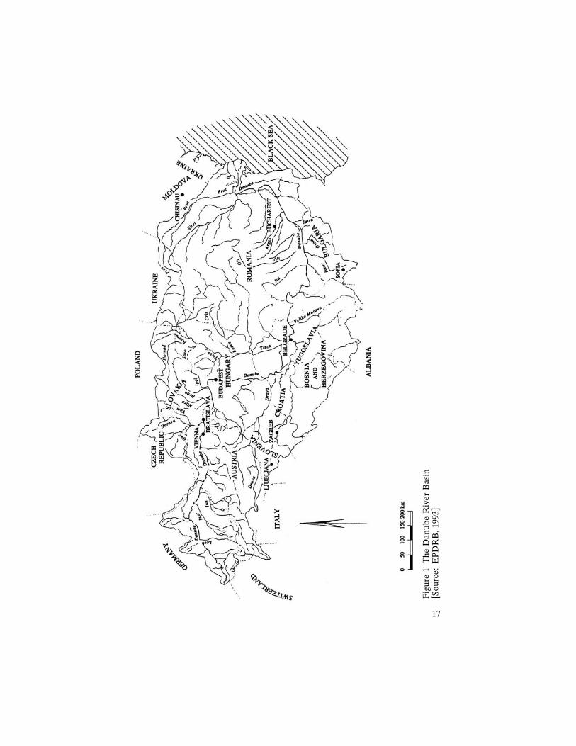
Figure
1TheDanubeRiverBasin
[Source:EPDRB,19
93]
17
along its banks have used the river for fishing, navigation, drinking, anagricultural and industrial water supply, and the disposal of purified waste-water. Population growth, urbanization, industrialization, and the relatedfelling of forests, draining of wetlands, construction of irrigation systemsand river dikes, as well as the advent of modern agriculture based onchemicals and the development of transportation and communicationsystems, have inevitably affected the natural processes and characteristicsof the Danube basin. At present the river basin, which hosts about 83million inhabitants and 60 large cities, is growing at an estimated rate of0.5%. Currently 67% of the basin constitutes cropland, 11% makes updeveloped land, 20% is covered by forests, whereas 18% of the basin isclassified as eroded (Revenga, Murray, and Hammonds, 1998). The factthat at present forests in the basin constitute only 37% of the originalforest cover (Revenga, Murray, and Hammonds, 1998) is in line withforest management trends in Europe, where, according to the ‘‘GlobalForest Resources Assessment 2000’’ (FAO, 2001), only 5% of the forests,the smallest proportion in the world, are protected, and those are pre-dominantly located on poor soils in inaccessible mountainous areas, asnoted in a World Wildlife Fund report (Hakka and Lappalainen, 2001).
Waterworks, directly modifying the physical environment of the Dan-ube, were initially carried out with the primary purpose of flood control.Later, flood control measures were combined with training of the riverfor the extension of navigation and for hydropower generation. The for-mer has been carried out largely within the framework of the DanubeConvention regulating the regime of navigation, which was signed by theDanubian states in Belgrade in 1948 and came into force in 1964. Theearliest predecessor of the Convention was the 1856 Danube Convention,which established, in the aftermath of the Crimean War, the first inter-national regime for safeguarding free navigation on the Danube. Ac-cording to the 1948 Convention, the implementation of which has beensupervised by the Danube Commission established for that purpose, thesignatories ‘‘undertake to maintain their sections of the Danube in anavigable condition for river-going, and, on the appropriate sections, forsea-going vessels and to carry out the works necessary for the mainte-nance and improvement of navigation conditions and not to obstruct orhinder navigation on the navigable channels of the Danube’’ (DanubeCommission, 2003). The Commission holds annual meetings and extra-ordinary sessions if necessary. Its tasks and activities, which are carriedout in accordance with European Union regulations and in close cooper-ation with numerous international organizations, involve regular con-sultations with the member states on economic, technical, and legal issues(among others); coordination of hydrometeorological services and publi-cation of hydrological forecasts for the Danube; establishment of uniform
18 THE DANUBE
systems of navigation regulations; and conducting relevant studies. Theresults of these activities are reflected in the rapid expansion of naviga-tion on the Danube during the past fifty years.
Between 1950 and 1980, according to a report by the Secretariat of theUnited Nations Commission for Europe (1994), a total of 69 dams, with atotal volume exceeding 7,300 million m3 (IWAC, 2002), and a number ofmore complex waterworks were constructed on the Danube (fig. 2). Thevolume of goods carried on the Danube increased 13.3 times since 1950,reaching 91.8 million tons in 1987 (Danube Commission, 2003). Similarly,the volume of goods handled in ports on the Danube increased 11.2 timesafter 1950, reaching 152.8 million tons in 1986. Since the opening of theRhine-Main-Danube waterway in 1992, the river has become an arteryfor the continent, connecting hundreds of inland ports from the NorthSea to the Black Sea. The waterway, built over in the past thirty years,accommodates huge Euro-barges carrying up to 2,425 tons of bulk cargo,the equivalent of the amount of cargo in 78 truck trailers, and carriessome 6 million passengers annually (Bryson, 1992). Traffic along theDanube, which is registered as an international corridor for transporta-tion, was restricted only during the period of strong Nazi influence in theregion between the 1930s and 1940s and at the beginning of the 1990s,because of the economic transformations in the central and eastern Eu-ropean countries and the UN Security Council sanctions against theFederal Republic of Yugoslavia.
In addition to navigation, the Danube has been intensively utilizedfor hydroelectric power generation. The hydroelectric capacity of theDanube was developed mainly during the second half of the twentiethcentury. According to Mucha (1999), between 1956 and 1997 some 28hydroelectric power projects were completed in the German sector of theriver and about 10 hydroelectric power plants with navigation locks wereput into operation on the Austrian side.
The development of the water resources of the Danube inevitably re-sulted in changes in the hydromorphology and water quality of the river.According to a report by the International Water Assessment Center(IWAC, 2002), the construction of reservoirs on the Danube caused adrastic decrease in the riverbed and in the transportation of suspendedbed-load sediment. Furthermore, the flow regime of the river drasticallychanged. From 1981 through 1995, mean annual discharges progressivelyand cumulatively decreased along the river, compared to those of thepreceding period (1951–1980). Over the period 1982–1993, for example,stream flow volume in Bulgaria, one of the riparian states located lowestdownstream, decreased by 19% to 42%, compared with the period 1935–1974.
In addition, serious deterioration of the river’s water quality has been
THE GABCIKOVO-NAGYMAROS PROJECT 19
Figure
2Danuberive
rprofile:Damsalongtheriver
[Source:
PlenipotentiaryoftheSlovak
Rep
ublicfortheConstruction
and
Operation
oftheGabcıkovo
-Nag
ymaros
Hydropower
Sch
eme
20
recorded over the last twenty years. Monthly mean water temperature ofthe river has increased by 0.8 C as a result of human activities along itsbanks, thus affecting the chemical and biological characteristics of Danubewater (IWAC, 2002). Reports and studies conducted by the United Na-tions Economic Commission for Europe (UNECE) (1994), the EuropeanEnvironment Agency (EEA) (Kristensen and Hansen, 1994), and theEnvironmental Programme for the Danube River Basin (EPDRB)(Somlyody et al., 1997) point out the high levels of organic pollutants,bacteria, gamma-hexachlorocyclohexane, and cadmium as significant ex-amples of the degraded water quality of Europe’s largest internationalriver. Rising nutrient and pesticide loads have resulted in increasing eu-trophication (depletion of dissolved oxygen) in the Danube, as well as inthe Black Sea into which it flows. The four- to five-fold increase of ni-trates recorded over the past thirty years is also reported to have led toa serious contamination of groundwater, posing a threat to the drinkingwater supply in certain regions. In addition, pollutants in sedimentstrapped in reservoirs and in reaches downstream from industrial concen-trations have been pointed out as causes for concern. Although the situ-ation differs in different parts of the river, deteriorated water quality andlack of oxygen threaten the biodiversity of the Danube basin, which pro-vides a habitat for more than 100 species of fish from the total of 227found in Europe, as well as the biodiversity of the Black Sea, where theassociated decline of the recreational value of the basin has resulted inthe impoverishment of the coastal populace. Estimates of the economiccosts of water quality degradation in central and eastern Europe (CEE)alone point to a reduction of 5% to 10% of the gross domestic product,according to a consultative report on water issues in CEE (GWP, 2000).The water quality problems of the Danube are attributed to govern-ments’ limited consideration of the complex interrelationships and de-velopments among people, water, land, and the environment in the pro-cesses of planning and executing many water resource developmentprojects on the international river (Jansky, 2001).
The increasing anthropogenic stress on the physical environment of theDanube River basin and the public pressure to deal with it resulted in thedevelopment of a growing number of projects and activities aiming atcontrolling and mitigating the human impact on the environment in theregion (Regional Environmental Center for Central and Eastern Europe,2003). Those activities have been recently integrated under the legalframework of the Danube River Protection Convention (DRPC), whichwas signed in June 1994 in Sofia by eleven of the thirteen riparian statesand came into force in October 1998, following ratification by the major-ity of the signatories (ICPDR, 2003). The Convention, the history ofwhich dates back to the 1985 Bucharest Declaration for the Protection of
THE GABCIKOVO-NAGYMAROS PROJECT 21
the Danube River, is implemented by the International Commission forthe Protection of the Danube River (ICPDR), which coordinates a set ofrelated activities within its expert groups on River Basin Management,Emissions, Ecology, Monitoring, Laboratory, and Information Manage-ment. A large number of the activities were initiated under the frame-work of the Danube Pollution Reduction Programme (UNDP/GEF,1999) and have been supported by relevant activities of the NATOScience Programme (Murphy, 1997), the Accident Emergency Preven-tion and Warning System for the automatic monitoring of transboundarywater quality (Gilyen-Hofer and Pinter, 2002), and other regional andinternational initiatives. A ‘‘Joint Action Programme for the DanubeRiver Basin: January 2001–December 2005’’ defines the goals and focusof ICPDR activities (ICPDR, 2000). Complementary to and integratedwithin them is the UNDP/GEF Danube Regional Project (DRP), an ini-tiative with the aim of contributing to the long-term sustainable develop-ment of the Danube River basin and the Black Sea area by supporting aregional approach to the development of relevant national policies andthe definition of priority actions.
At the same time, GEF, UNDP, and the World Bank have undertakenthe cofunding of a Strategic Partnership for the Danube and the BlackSea Basin, which aims to help countries address top priorities, thus com-plementing actions funded by the European Union (GEF, 2002). Theactivities of the International Commission for the Protection of theDanube and of the related partnerships and initiatives are based on theprinciples of Integrated Water Resources Management (IWRM) and In-tegrated River Basin Management (IRBM) (‘‘EU Water FrameworkDirective,’’ 2000). IWRM refers to the coordinated development andsequencing of water-, land-, and other-related resource management ac-tivities that will optimize the social and economic well-being of all stake-holders in an equitable manner without compromising the sustainabilityof the ecosystem. IRBM recognizes the interdependence of human andnatural factors within a catchment and requires that river basins betreated as units of analysis and management. These principles constitutethe basis of the strategy for the ‘‘Vision to Action’’ plan for water re-sources management in central and eastern Europe in the twenty-firstcentury, which was presented at the Second World Forum and the Min-isterial Conference at The Hague in March 2000 (GWP, 2000). Thesestrides towards the development of integrated management of the Danubebasin coincide with the ‘‘EU Water Framework Directive’’ (2000), whichaims at sustainable development within the European Union, and withthe closely related initiatives for Pan-European biodiversity (‘‘Pan-Euro-pean Biological and Landscape Diversity and Strategy,’’ 2002) and soilmonitoring (Huber et al., 2001), as well as with more regional initiatives,
22 THE DANUBE
such as the ‘‘Multifunctional Integrated Study Danube: Corridor andCatchment,’’ which aims to assess the principal habitat parameters in themain channel of the river, in the floodplain waters, and in the Danubetributaries (Janauer, 2002, October).
However, developments toward a sustainable management of theDanube basin began only recently, in response to the negative impacts ofearlier water management practices. The Gabcıkovo-Nagymaros systemof locks on the Danube itself was initiated partly as a response to theenvironmental changes in the middle Danubian basin that had resultedfrom earlier water regulation works upstream and in the middle Danube.Signed in 1977, however (i.e., before the rise of the ideas for integratedand sustainable river basin management), the GNP itself was conceivedand developed in line with earlier water regulation works for flood con-trol and navigation improvement practices and hydroelectric power con-structions along the river.
Physical characteristics of the middle Danube
The original Gabcıkovo-Nagymaros project covers the approximatelytwo hundred kilometers of the Danube River that serve as a border be-tween Hungary and Slovakia and that connect the capitals of the twocountries, Budapest and Bratislava. The geographical scope and locationof the project are related to the geological structure and characteristics ofthe region. The granite threshold connecting the Alps and the Carpa-thians in the area of Bratislava and the similar, predominantly andesite,hard-rock river threshold situated at Nagymaros (between the cities ofSturovo-Estergom and Visegrad-Nagymaros), about 160 kilometersdownstream from Bratislava, constitute the geological boundaries of theDanubian aquifer in the middle Danubian basin and serve as naturalhydrological barriers damming the Danube bottom (see fig. 3). Thesecharacteristics have been pointed out as important for making decisionsregarding water regulation works in the Gabcıkovo-Nagymaros section ofthe Danube.
Late Tertiary sediments (marine and lacustrine sand, fine sand, clay,sandstone, shale) and Quaternary sediments (Danube River sand andgravel settled in fluvial or lacustrine conditions), with a total depth of8,000 meters, form a highly permeable gravel-and-sand aquifer thatranges from a few meters at Bratislava to more than 450 meters atGabcıkovo, thinning to several meters downstream of Sap, in the direc-tion of Komarno (Mucha, 1999). Beneath this aquifer is a system of sub-stantially less permeable aquifers and aquitards.
Such threshold and aquifer structures are usually associated with me-andering rivers and river arm systems, high water-flow velocities, and
THE GABCIKOVO-NAGYMAROS PROJECT 23
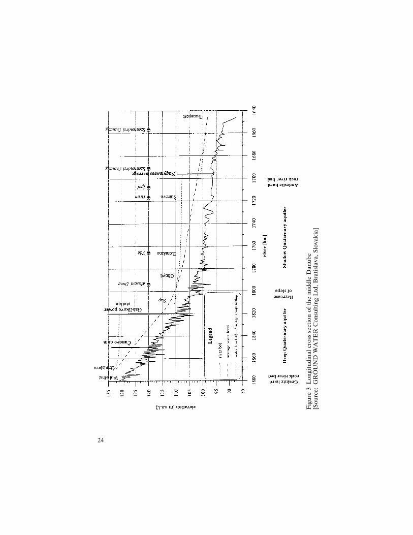
Figure
3Longitudinal
cross
sectionofthemiddle
Danube
[Source:GROUND
WATER
ConsultingLtd,Bratislava
,Slovak
ia]
24
lower navigation water depth, as well as higher erosion downstreamof the thresholds and serious flooding. Indeed, according to a report ofthe Nominated Monitoring Agent of the Slovak Republic (NMASR)(2001), before the eighteenth century, the two arms of the Danube intowhich the river splits downstream from Bratislava, the Maly Danube inSlovakia and the Mosoni Danube in Hungary, constituted meanderingsystems of shifting channels that created two similar large islands inthe two countries, ‘‘Zitny ostrov’’ (Rye Island, in English atlases) and‘‘Szigetkoz,’’ and a number of small ones, as a result of progressive sedi-mentation where the Danube entered into the plain. Downstream fromBratislava, the river was characterized by high-flow velocity and relativeshallowness. In addition, seasonal variability was accompanied byserious floods, such as the ones recorded in 1445, 1501, 1721, 1787, 1876,and 1884. These characteristics of and events along the Gabcıkovo-Nagymaros section of the Danube gave rise to the need for flood controlregulations and works for improving navigation in that section of theriver during those earlier years.
History of regulation works in the middle reaches of the Danube
According to Fitzmaurice (1996), flood control in the middle section ofthe Danube dates back to the thirteenth century. The earliest dikes wereconstructed in 1426; systematic flood protection measures were institutedin the seventeenth century; and river controls, drainage channels, andpumping stations were added at an increasing rate after 1850.
Regulations for navigation and hydroelectric power generation in themiddle reaches of the Danube started only in the nineteenth century,because they were technically, politically, and economically more de-manding. Initial proposals for channeling the middle Danube date backto the reign of the Emperor Charlemagne, and the dream for the con-struction of a navigable waterway connecting the rivers Rhine, Main, theDanube, and thus the North Sea and the Black Sea, which was finallyrealized on 25 September 1992. Concrete construction and regulationplans were considered by the Austro-Hungarian monarchy as early as1880 (Lejon, 1996). The earliest plans, elaborated by Pal Vasarhelyi,were modified by the Italian engineer Ennio Lafranconi, as the strategicimportance of the Bratislava harbor for the Habsburg Empire increased.Construction works, undertaken by a Swiss firm and led by Dr. Fischer-Reinan, were completed in 1915. Lafranconi’s works were primarily con-cerned with the training of the riverbed in order to improve the naviga-tion conditions for big steamships in the Bratislava region.
Together with regulations for navigation, Lafranconi also proposed theconstruction of a hydroelectric power plant on the Danube. Proposals for
THE GABCIKOVO-NAGYMAROS PROJECT 25
harnessing the middle section of the river for hydroelectric power werealso made by Dr. Fischer-Reinan in 1915, by Dr. Holecek in 1921, and byothers. In 1918 a Swiss firm acquired the rights to exploit the section ofthe river between Bratislava and Gyor for electricity production. In 1919the Hungarian Republic elaborated a plan for electrification, accordingto which one third of the production of electricity would have originatedfrom hydroelectric power generation from the middle Danube. Politicaland economic turmoil, border and population shifts, and changing usagerights in the period during and between the two world wars hindered thefurther development and implementation of regulation projects in themiddle Danube. However, increased flooding and the deterioration ofnavigation resulting from earlier regulation works on the river broughtthe issue back to the forefront following the political and economic sta-bilization in the region after World War II.
Physical impacts of early regulation works
The regulation works for improving navigation that started in the nine-teenth century transformed the once meandering river system connectingBratislava and Budapest into a straightened and heavily fortified channelcharacterized by rapid water level fluctuations, larger stream velocities,steeper and higher flood peaks, and shorter but more frequent floods.Dam constructions in the upper reaches of the river, preventing the move-ment of sand and gravel, resulted in increased flow velocity and erosionof the river bottom below Bratislava. The deepening of the water bedled to a sinking of the groundwater table and the drying up of wetlands.It also aggravated navigation conditions in the region, known for beingalmost as bad as those in the notorious Iron Gate section of the river.
The changed sedimentation because of dam construction upstream ofthe andesite hard-rock threshold at Nagymaros led to lowered perme-ability and aquifer thickness downstream from Gabcıkovo. As a result,the groundwater carried through the Danubian lowland by the alluvialfan or inland delta on the Slovakian side, which is characterized bycoarse sediment accumulation, erosion, and changes in the riverbed gra-dient, began to flow back into the Danube through river arms, tributaries,and drainage canals in the lower parts of the river, which are charac-terized by a drastic decrease in slope.
In addition, the cutting off of the meanderings and numerous smallerside branches and tributaries because of the construction of a main canalresulted in a decline in the groundwater levels in the side-arm area and inthe drying out of a part of the wetland woods behind the protective dikes.The large number of weirs and dams activated at higher dischargesformed a cascade system at low discharges.
These changes gave rise to floods which were shorter in duration but
26 THE DANUBE
more frequent and devastating. Before the development of regulationworks on the Danube, serious floods were recorded only once or twice acentury. But their number more than doubled during the twentieth cen-tury, as indicated by historical records listing serious floods in 1929, 1947,1954, 1963, and 1965. The 1954 and 1965 floods were particularly devas-tating. In 1954, the flood broke the dikes at four points on the Hungarianside in the Szigetkoz region, and water completely or partially flooded anarea of some 33,000 hectares. During the flood of 1965, the dikes brokeon the Czechoslovakian side at two places, near the villages Patince andCicov. Some 114,000 hectares were flooded completely, and at least 3,500buildings were completely destroyed (Nominated Monitoring Agent ofthe Slovak Republic, 2001). About 65,000 people had to be evacuatedfrom the affected areas. The flow at Bratislava during the flood reached9,170 m3/s (Lejon, 1996). While Slovakia was most seriously affected bythe 1965 flood, parts of Austria, Hungary, and Yugoslavia also sufferedheavy damages.
The response to the deteriorated navigation conditions and to theincrease in floods in the middle section of the Danube was shaped bythe parallel socioeconomic and political transformations taking place inHungary and Czechoslovakia.
Geopolitical setting
The nature and timing of the response to the water management needsin the middle section of the Danube have been determined by the geo-political location of the region and the politico-economic interests andpriorities of its inhabitants.
Situated in the heart of Europe, along the borderlines of warring em-pires, political blocs, and ethnic groups, the middle Danubian basin haslong been a battlefield of the geopolitical struggles for domination overthe region. The centuries of Roman, Ottoman, Habsburg, and Soviet rulehave shaped the conflicting national identities, political priorities, andeconomic interests of the Magyars (Hungarians), Slovaks, Germans,Czechs, Croats, and Serbs living there, but they have done so within thecommon geopolitical history of east-central Europe, which has led to thedevelopment of common traits and cultural bonds among them (Avenar-ius, 2000). Those contradictory interlinkages and levels of interactionamong Hungarians, Slovaks, and Czechs determined the complexity ofthe Gabcıkovo-Nagymaros project for the management of the sharedwater resources of the middle Danube.
Hungarian national identity was formed in the struggle for indepen-dence from the Habsburgs that had subjugated the Kingdom of Hungary
THE GABCIKOVO-NAGYMAROS PROJECT 27
and relegated it to the status of a colony from 1526 to 1867, when a dualAustro-Hungarian monarchy was formed. At the same time, Hungariandomination over Slovakia, among other Slav territories, since a.d. 907,gave rise to Slav nationalism, which ultimately sparked the flame of theFirst World War that engulfed the whole of Europe and led to the col-lapse of the Austro-Hungarian monarchy and the redrawing of the mapof Central Europe.
The 1920 Treaty of Trianon, which endorsed the establishment ofCzechoslovakia and Yugoslavia and the expansion of Romania and Uk-raine at the expense of Hungary after the end of World War 1, gave riseto new sources of resentment and conflict within and among the Danu-bian states that have hindered the joint management of the shared waterresources of the middle Danube. As a result of the treaty, Hungary losttwo-thirds of its pre-1920 territory, two-thirds of its total population, one-third of its Hungarian population, and 94.5% of its hydroelectric poten-tial (Fitzmaurice, 1996). Meanwhile, the political union between theCzechs and the Slovaks began an uneasy political partnership that af-fected the historical development of the Gabcıkovo-Nagymaros project.
Political turmoil in Europe in the first half of the twentieth century,particularly in the Central European Danubian basin, prevented the un-dertaking of joint water management projects. The transition periodduring and between the two world wars, involving frequent transfers ofpolitical control over the Danubian lands between Hungary and Czecho-slovakia, brought about conflicting political claims on the shared waterresources (Lipschutz, 2000). However, the political unification of the re-gion under Socialist rule provided the political basis and the economicstimulus for joint water management between Hungary and Czechoslo-vakia, as well as the social impetus for cooperation facilitated by the longhistory of the coexistence of Hungarians and Slovaks under the Habs-burg rulers and later the Austro-Hungarian monarchy.
Joint planning between the two countries for the modification of themiddle reaches of the Danube began in the 1950s with a proposal by theHungarian Academy of Sciences. It received the approval of the Councilfor Mutual Economic Cooperation (COMECON) among the Socialiststates in the early 1960s. However, domestic developments in the twocountries, namely, political turmoil followed by changing economic ori-entation and objectives in Hungary and internal struggles over the di-verging interests of Czechs and Slovaks in Czechoslovakia, did not allowfor reaching on agreement on the project until 1977 (Fitzmaurice, 1996).The change of the domestic leadership in the two countries, combinedwith external factors, such as the devastating floods mentioned above andthe sharp increase in world oil prices in the 1970s, brought about theconsensus necessary for finalizing the planning stage of the project.
28 THE DANUBE
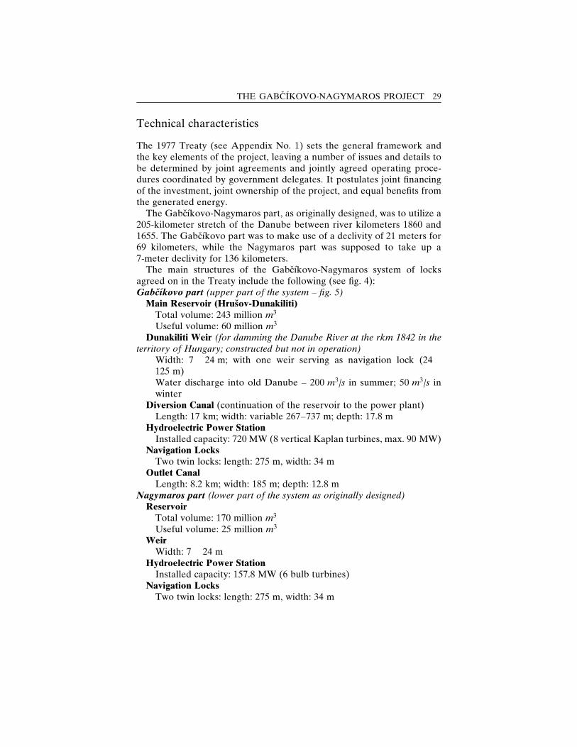
Technical characteristics
The 1977 Treaty (see Appendix No. 1) sets the general framework andthe key elements of the project, leaving a number of issues and details tobe determined by joint agreements and jointly agreed operating proce-dures coordinated by government delegates. It postulates joint financingof the investment, joint ownership of the project, and equal benefits fromthe generated energy.
The Gabcıkovo-Nagymaros part, as originally designed, was to utilize a205-kilometer stretch of the Danube between river kilometers 1860 and1655. The Gabcıkovo part was to make use of a declivity of 21 meters for69 kilometers, while the Nagymaros part was supposed to take up a7-meter declivity for 136 kilometers.
The main structures of the Gabcıkovo-Nagymaros system of locksagreed on in the Treaty include the following (see fig. 4):Gabcıkovo part (upper part of the system – fig. 5)
Main Reservoir (Hrusov-Dunakiliti)Total volume: 243 million m3
Useful volume: 60 million m3
Dunakiliti Weir (for damming the Danube River at the rkm 1842 in theterritory of Hungary; constructed but not in operation)
Width: 7 � 24 m; with one weir serving as navigation lock (24 �125 m)Water discharge into old Danube – 200 m3/s in summer; 50 m3/s inwinter
Diversion Canal (continuation of the reservoir to the power plant)Length: 17 km; width: variable 267–737 m; depth: 17.8 m
Hydroelectric Power StationInstalled capacity: 720 MW (8 vertical Kaplan turbines, max. 90 MW)
Navigation LocksTwo twin locks: length: 275 m, width: 34 m
Outlet CanalLength: 8.2 km; width: 185 m; depth: 12.8 m
Nagymaros part (lower part of the system as originally designed)Reservoir
Total volume: 170 million m3
Useful volume: 25 million m3
WeirWidth: 7 � 24 m
Hydroelectric Power StationInstalled capacity: 157.8 MW (6 bulb turbines)
Navigation LocksTwo twin locks: length: 275 m, width: 34 m
THE GABCIKOVO-NAGYMAROS PROJECT 29
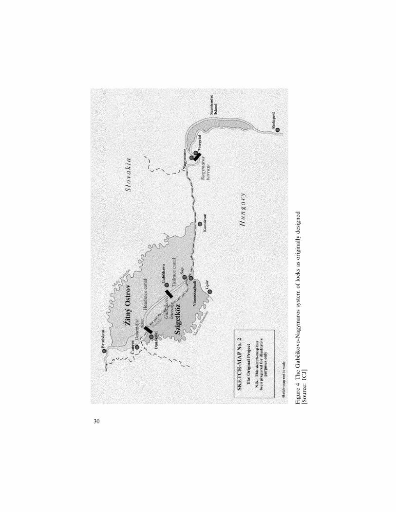
Figure
4TheGabcıkovo
-Nag
ymarossystem
oflock
sas
originally
designed
[Source:IC
J]
30
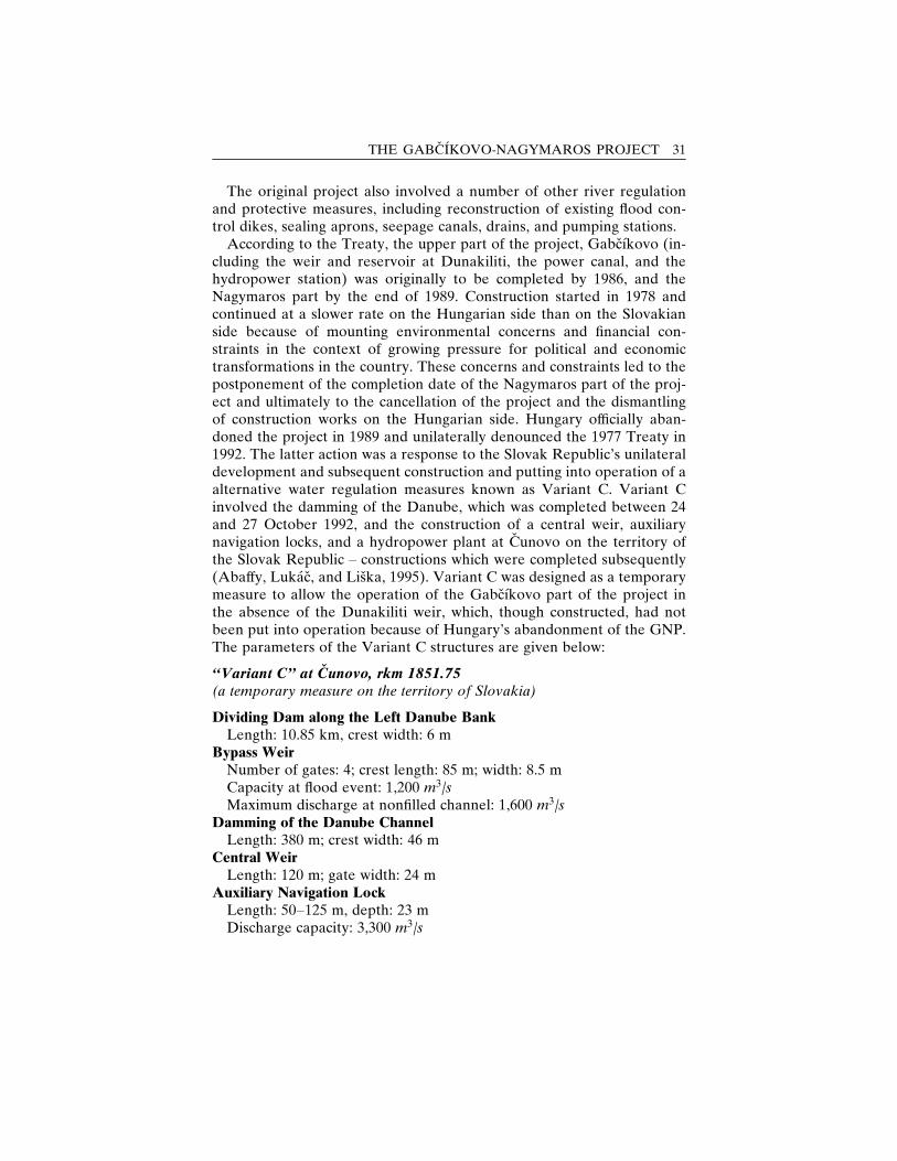
The original project also involved a number of other river regulationand protective measures, including reconstruction of existing flood con-trol dikes, sealing aprons, seepage canals, drains, and pumping stations.
According to the Treaty, the upper part of the project, Gabcıkovo (in-cluding the weir and reservoir at Dunakiliti, the power canal, and thehydropower station) was originally to be completed by 1986, and theNagymaros part by the end of 1989. Construction started in 1978 andcontinued at a slower rate on the Hungarian side than on the Slovakianside because of mounting environmental concerns and financial con-straints in the context of growing pressure for political and economictransformations in the country. These concerns and constraints led to thepostponement of the completion date of the Nagymaros part of the proj-ect and ultimately to the cancellation of the project and the dismantlingof construction works on the Hungarian side. Hungary officially aban-doned the project in 1989 and unilaterally denounced the 1977 Treaty in1992. The latter action was a response to the Slovak Republic’s unilateraldevelopment and subsequent construction and putting into operation of aalternative water regulation measures known as Variant C. Variant Cinvolved the damming of the Danube, which was completed between 24and 27 October 1992, and the construction of a central weir, auxiliarynavigation locks, and a hydropower plant at Cunovo on the territory ofthe Slovak Republic – constructions which were completed subsequently(Abaffy, Lukac, and Liska, 1995). Variant C was designed as a temporarymeasure to allow the operation of the Gabcıkovo part of the project inthe absence of the Dunakiliti weir, which, though constructed, had notbeen put into operation because of Hungary’s abandonment of the GNP.The parameters of the Variant C structures are given below:
‘‘Variant C’’ at Cunovo, rkm 1851.75(a temporary measure on the territory of Slovakia)
Dividing Dam along the Left Danube BankLength: 10.85 km, crest width: 6 m
Bypass WeirNumber of gates: 4; crest length: 85 m; width: 8.5 mCapacity at flood event: 1,200 m3/sMaximum discharge at nonfilled channel: 1,600 m3/s
Damming of the Danube ChannelLength: 380 m; crest width: 46 m
Central WeirLength: 120 m; gate width: 24 m
Auxiliary Navigation LockLength: 50–125 m, depth: 23 mDischarge capacity: 3,300 m3/s
THE GABCIKOVO-NAGYMAROS PROJECT 31
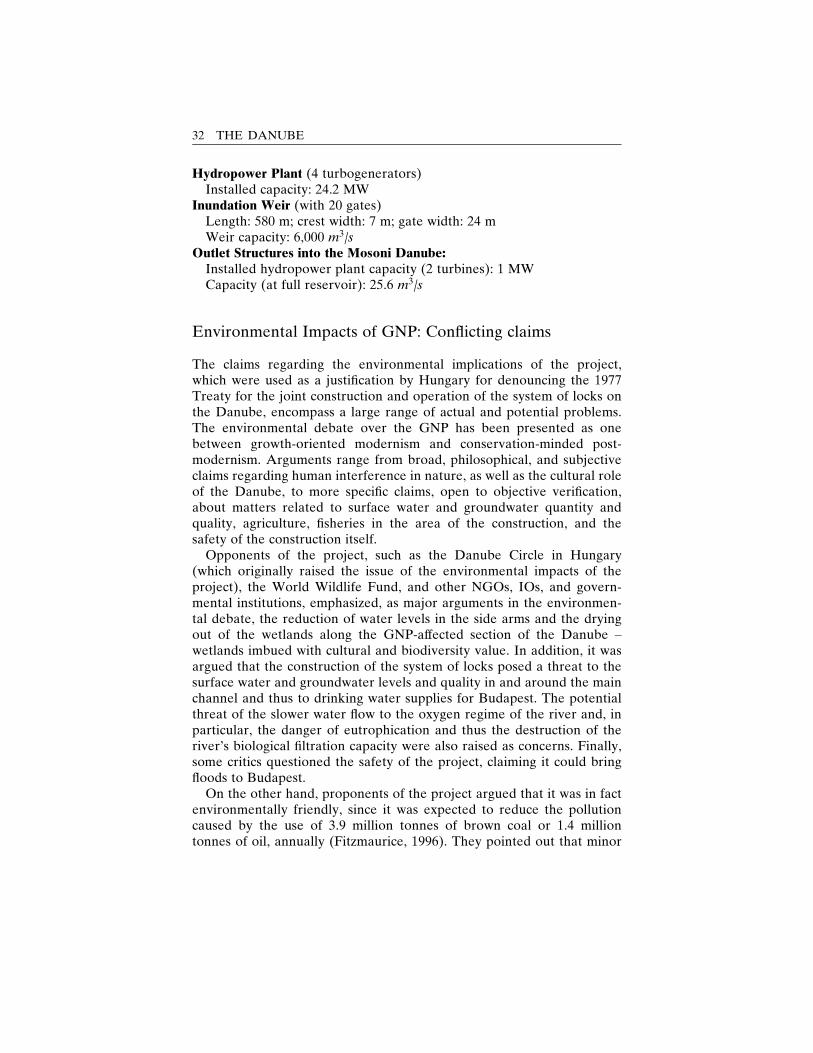
Hydropower Plant (4 turbogenerators)Installed capacity: 24.2 MW
Inundation Weir (with 20 gates)Length: 580 m; crest width: 7 m; gate width: 24 mWeir capacity: 6,000 m3/s
Outlet Structures into the Mosoni Danube:Installed hydropower plant capacity (2 turbines): 1 MWCapacity (at full reservoir): 25.6 m3/s
Environmental Impacts of GNP: Conflicting claims
The claims regarding the environmental implications of the project,which were used as a justification by Hungary for denouncing the 1977Treaty for the joint construction and operation of the system of locks onthe Danube, encompass a large range of actual and potential problems.The environmental debate over the GNP has been presented as onebetween growth-oriented modernism and conservation-minded post-modernism. Arguments range from broad, philosophical, and subjectiveclaims regarding human interference in nature, as well as the cultural roleof the Danube, to more specific claims, open to objective verification,about matters related to surface water and groundwater quantity andquality, agriculture, fisheries in the area of the construction, and thesafety of the construction itself.
Opponents of the project, such as the Danube Circle in Hungary(which originally raised the issue of the environmental impacts of theproject), the World Wildlife Fund, and other NGOs, IOs, and govern-mental institutions, emphasized, as major arguments in the environmen-tal debate, the reduction of water levels in the side arms and the dryingout of the wetlands along the GNP-affected section of the Danube –wetlands imbued with cultural and biodiversity value. In addition, it wasargued that the construction of the system of locks posed a threat to thesurface water and groundwater levels and quality in and around the mainchannel and thus to drinking water supplies for Budapest. The potentialthreat of the slower water flow to the oxygen regime of the river and, inparticular, the danger of eutrophication and thus the destruction of theriver’s biological filtration capacity were also raised as concerns. Finally,some critics questioned the safety of the project, claiming it could bringfloods to Budapest.
On the other hand, proponents of the project argued that it was in factenvironmentally friendly, since it was expected to reduce the pollutioncaused by the use of 3.9 million tonnes of brown coal or 1.4 milliontonnes of oil, annually (Fitzmaurice, 1996). They pointed out that minor
32 THE DANUBE
technical solutions in the Danube’s old riverbed could easily resolve theproblems of maintaining the inland Danube delta with its forests andwetlands, if the solutions were accepted by the parties (Lejon, 1996).Furthermore, they argued that the impounding of water would stop theerosion of the bed and thus prevent the decline of the groundwater. Theyalso pointed out that impoundment would feed the deeper aquifers andsecure a steady supply of water to the Mosoni Danube. They admittedthe threat of pollutants entering the water supply but dismissed it as the-oretical and easily resolvable with the help of the advanced purificationtechnologies available in both countries. They pointed out that the pos-sible transfer of traffic from more polluting sources to river transporta-tion was environmentally beneficial as well.
According to Fitzmaurice (1996), over 400 studies of the potential en-vironmental impacts of the project were carried out before the signing ofthe Treaty and many more after that. Some of those were developed andelaborated within the framework of the Bioproject, initiated in 1976 andsupplemented in 1982 and 1986 (Kocinger, 1998). On the basis of thosestudies, the 1977 Treaty included three paragraphs dealing with the pro-tection of the quality and quantity of surface water and groundwater, theprotection of the environment, and the protection of fish (Kocinger,1998). Different interpretations of those paragraphs, however, allowedfor the escalation and politicization of the dispute over the environmentalimpacts of the GNP.
While the judgment of the International Court of Justice settled thelegal aspects of the debate, it left the technical questions for the twocountries to agree upon. A basis for the ongoing negotiations on the issuehas been the accumulated data from the joint monitoring of the environ-mental impact of the Gabcıkovo part of the GNP. The monitoring wasestablished by the two countries in 1995 as an obligation under anAgreement (Appendix No. 3) signed by the governments of the republicsof Hungary and Slovakia. The agreement concerns certain technicalmeasures aimed at addressing the most critical negative impacts of thedamming of the river on the environment in the middle Danubian plain.The somewhat paradoxical political agreement laying the basis for coop-eration between relevant scientific communities of the two countriescould be seen as motivated by the need for Hungary and Slovakia to finda peaceful solution to the GNP dispute in view of their EU membershipaspirations and the favorable changes in the domestic balance of powerin the two countries at the time. A preexisting technical basis, as well as ahistory of cooperation between the two countries in monitoring differentelements of the environment in the affected areas of the Danubian basin,facilitated the establishment of the joint monitoring. Nevertheless, it hasproved a demanding task.
THE GABCIKOVO-NAGYMAROS PROJECT 33
4
Environmental monitoringof an international river
Environmental monitoring is a term applied to a range of disparate ac-tivities aiming at obtaining and providing information about the state ofthe environment. The UN Inter-Agency Working Group on Monitoring,which led to the development of the UN Global Environmental Mon-itoring System (GEMS) in 1974, defined monitoring broadly as ‘‘a systemof continued observation, measurement and evaluation for defined pur-poses’’ (Munn, 1973). Later definitions have narrowed the scope of theterm to a type of intermittent (regular or irregular) surveillance of eitherone or more environmental indicators carried out for the purpose of as-certaining the extent of compliance with a predetermined standard or thedegree of deviation from an expected norm, according to prearrangedschedules in space and time, and using comparable methodologies forenvironmental sensing and data collection (Goldsmith, 1991; Munn, 1973).
Principles of environmental monitoring
Environmental monitoring is an integral component of resource man-agement. Therefore, it should be seen as a process, starting with a defi-nition of policy-relevant information needs, which are then used to de-sign a monitoring strategy and develop a network. The next step in theprocess is data collection and processing, followed by data analysis andreporting (Helmer, 1997). Since information needs evolve with time andsocioeconomic developments, periodic adjustments of monitoring pro-grammes are essential for their optimization.
34
The objectives of monitoring programmes are broadly classified as fol-lows (Goldsmith, 1991):� detecting incipient change (early warning);� assessing the effectiveness of policy or legislation;� testing compliance with regulatory measures.
A properly designed and implemented monitoring programme canresult in the identification of harmful trends, the correction of unanti-cipated impacts, and/or the resolution of controversies over resourcemanagement through the provision of data useful for mediation betweeninterested parties (Glasson, Therivel, and Chadwick, 1999).
Research on environmental monitoring shows that, it has been mostwidely utilized as a tool for conflict resolution in a national context. Astudy conducted in Australia by Beckley in 1991 found that environmen-tal monitoring data and testable predictions were available for only 3%of the 1,000 environmental impact statements examined and that those3% were mainly related to ‘‘large complex projects, which had oftenbeen the subject of public controversy, and whose monitoring was aimedprimarily at testing compliance with standards rather than with impactpredictions’’ (Glasson, Therivel, and Chadwick, 1999).
From an issue-specific perspective, environmental monitoring covers arange of topics. According to a research study conducted at OxfordBrookes University, which examined a sample of 700 environmental-impact statements, water quality (16%) seems to be the problem mostcommonly addressed by monitoring programmes, followed by air emis-sions and aqueous emissions (Glasson, Therivel, and Chadwick, 1999).
The particular focus on the monitoring of international water qualityduring the past two decades, as exemplified by the monitoring networkson the Rhine (in Europe), la Plata (in South America), and the Mekong(in Southeast Asia), is in line with the above-mentioned trends, althoughthe level of complexity and accuracy of the different monitoring networksvaries. The large percentage of the world’s population (40%) dependentfor their water security on effective international water management, thehigh potential for and the significant costs associated with political con-flicts over transboundary river water quantity and quality (especially fordownstream countries in arid and semiarid areas), and catastrophic acci-dents on transboundary rivers (e.g., the Sandoz accident on the Rhine)have served as justifiable stimuli for undertaking the establishment ofcomplex and, under normal circumstances, costly environmental monitor-ing programmes (Ministry of Foreign Affairs of Sweden, 2001; Helmer,1997).
The design and the implementation of transboundary and internationalwater monitoring programmes follow the above-mentioned general mon-itoring cycle. Unlike national programmes, however, international moni-toring schemes need to be undertaken in ‘‘a highly integrated manner,
ENVIRONMENTAL MONITORING 35
based on commonly agreed objectives, criteria and standards related todifferent types of water uses as well as ecological requirements’’ (Helmer,1997). Transboundary water monitoring strategies also correspond to thethree major types of monitoring objectives mentioned above. Helmer(1997) summarizes them as follows:� ambient river water quality monitoring to observe the status and trend of as-pects such as the flow regime, sediment transport, ecological habitats, naturalwater constituents, and finally, any anthropogenic influences and pollutants;
� early warning systems in rivers which are potentially threatened by industrialaccidents or unintentional release of toxic effluents which may cause the closureof downstream waters’ intakers (as happened in the Rhine river); and
� effluent monitoring of wastewater discharges which have been authorizedunder certain conditions in a permit or license issued by the national regulatoryagency.
Important points to be considered in the design of the monitoring net-work and the sampling method are the location of the monitoring sta-tions and the sampling frequency and intensity. In view of the regulatoryfunction of monitoring, stations should be located at or near the bordercrossings and at major point sources and tributaries. In order for thesamples to be representative, the temporal and spatial variability of waterquality in the river system and the particular objectives of the monitoringprogramme should be taken into account (Goldsmith, 1991).
The selection of the concrete variables to be monitored should bebased upon the specific information needs of the programme, the in-tended water uses, the river functions, the existing and potential waterquality issues and threats, as well as the financial, technological, scientific,and human-resource limitations of the individual programmes. Examplesof water quality and quantity problems as related to different river func-tions and a list of indicators related to specific water quality issues aregiven in Tables 1 and 2 in Helmer (1997).
The comparability of data collection and processing procedures needsto be ensured through regular inter- and intralaboratory comparisonstudies and analytical quality control. Data have to be verified andtransformed into policy-relevant information through the use of compa-rable statistical analysis and reporting of annual and monthly averages,peaks and lows, pollution load calculations, and flux estimates. For reli-able trend analysis, one must consider the autocorrelation and the sepa-ration of the three main features contributing to the value of each obser-vation, namely, the effects of trends, the effects of cycles, and the residualvariation (Goldsmith, 1991). Evaluation of the results should be based oncommonly agreed and preselected baselines and criteria, taking into ac-count the long-term and cyclical processes in the environment (Goldsmith,1991; Nakayama, 1998b).
Given the changing nature of water pollutants (from biodegradable
36 THE DANUBE
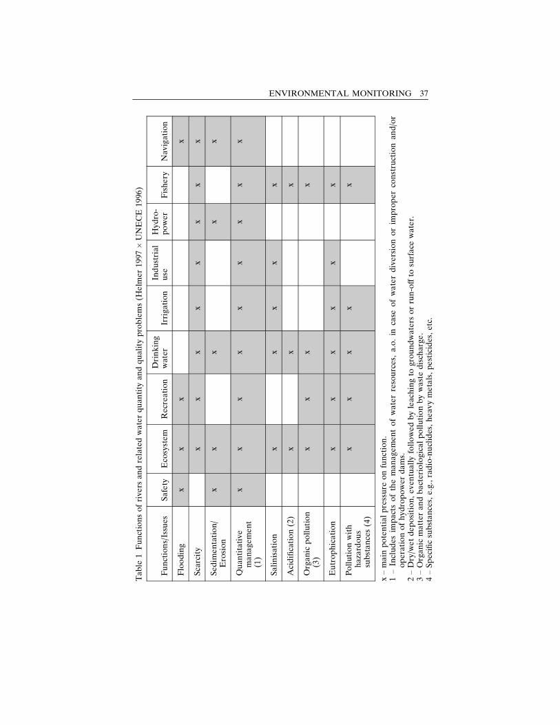
Table
1Functionsofrive
rsan
drelatedwaterquan
tity
andqualityproblems(H
elm
er19
97�UNECE
1996
)
Functions/Issues
Safety
Eco
system
Recreation
Drinking
water
Irriga
tion
Industrial
use
Hydro-
power
Fishery
Nav
igation
Flooding
xx
xx
Scarcity
xx
xx
xx
xx
Sedim
entation/
Erosion
xx
xx
x
Quan
titative
manage
ment
(1)
xx
xx
xx
xx
x
Salinisation
xx
xx
x
Acidification(2)
xx
x
Organic
pollution
(3)
xx
xx
Eutrophication
xx
xx
xx
Pollutionwith
hazardous
substances(4)
xx
xx
x
x–main
potentialpressure
onfunction.
1–Includes
impactsofthemanage
mentofwaterresources,
a.o.in
case
ofwaterdiversionorim
proper
constructionan
d/or
operationofhydropower
dams.
2–Dry/w
etdeposition,ev
entually
followedbyleachingto
groundwatersorrun-offto
surface
water.
3–Organic
matter
andbacteriologicalpollutionbywastedisch
arge
.4–Specificsubstances,e.g.,radio-nuclides,heav
ymetals,pesticides,etc.
ENVIRONMENTAL MONITORING 37
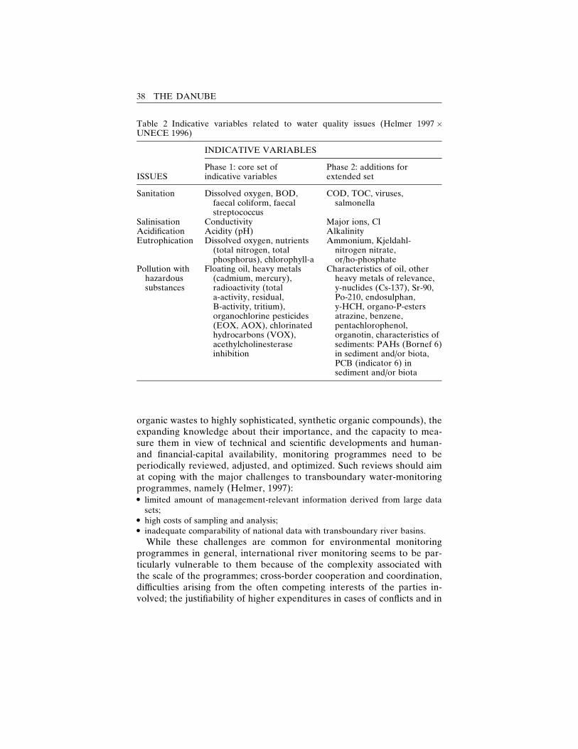
organic wastes to highly sophisticated, synthetic organic compounds), theexpanding knowledge about their importance, and the capacity to mea-sure them in view of technical and scientific developments and human-and financial-capital availability, monitoring programmes need to beperiodically reviewed, adjusted, and optimized. Such reviews should aimat coping with the major challenges to transboundary water-monitoringprogrammes, namely (Helmer, 1997):� limited amount of management-relevant information derived from large datasets;
� high costs of sampling and analysis;� inadequate comparability of national data with transboundary river basins.
While these challenges are common for environmental monitoringprogrammes in general, international river monitoring seems to be par-ticularly vulnerable to them because of the complexity associated withthe scale of the programmes; cross-border cooperation and coordination,difficulties arising from the often competing interests of the parties in-volved; the justifiability of higher expenditures in cases of conflicts and in
Table 2 Indicative variables related to water quality issues (Helmer 1997 �UNECE 1996)
INDICATIVE VARIABLES
ISSUESPhase 1: core set ofindicative variables
Phase 2: additions forextended set
Sanitation Dissolved oxygen, BOD,faecal coliform, faecalstreptococcus
COD, TOC, viruses,salmonella
Salinisation Conductivity Major ions, ClAcidification Acidity (pH) AlkalinityEutrophication Dissolved oxygen, nutrients
(total nitrogen, totalphosphorus), chlorophyll-a
Ammonium, Kjeldahl-nitrogen nitrate,or/ho-phosphate
Pollution withhazardoussubstances
Floating oil, heavy metals(cadmium, mercury),radioactivity (totala-activity, residual,B-activity, tritium),organochlorine pesticides(EOX, AOX), chlorinatedhydrocarbons (VOX),acethylcholinesteraseinhibition
Characteristics of oil, otherheavy metals of relevance,y-nuclides (Cs-137), Sr-90,Po-210, endosulphan,y-HCH, organo-P-estersatrazine, benzene,pentachlorophenol,organotin, characteristics ofsediments: PAHs (Bornef 6)in sediment and/or biota,PCB (indicator 6) insediment and/or biota
38 THE DANUBE
situations involving international pressure and support for improvingwater quality; and the larger institutional vested interests favoring themaintenance of the programme after its establishment.
The environmental monitoring of the areas affected by the Gabcıkovo-Nagymaros project presented below illustrates the benefits and complex-ities associated with the establishment of such programmes.
Joint environmental monitoring of areas affected by theGabcıkovo Part of the Gabcıkovo-Nagymaros Project
Legal and institutional framework and objectives
The joint environmental monitoring of areas affected by the Gabcıkovopart of the project was established as an obligation under the ‘‘Agree-ment between the Government of the Slovak Republic and the Govern-ment of Hungary about Certain Temporary Technical Measures andDischarges in the Danube and Mosoni Branch of the Danube,’’ signed on19 April 1995 (Appendix No. 3). The Agreement, aiming at addressingsome of the negative environmental impacts of the construction and op-eration of the Gabcıkovo part of the project, had a temporary character.Initially, it was contingent upon the judgment of the International Courtof Justice in the case concerning the Gabcıkovo-Nagymaros Project. On23 October 1997, the Slovak Republic informed the Republic of Hungaryof its willingness to prolong the validity of the Agreement from 19 April1995 to a date when an agreement on the implementation of the ICJjudgment, declared on 25 September 1997, was reached. The Republicof Hungary accepted this proposal by governmental resolution on 17December 1997 (Joint Annual Report, 2001). Discussions on the issueare currently being carried out by the Working Group on Legal Matters,which is comprised of delegates from the Government of the Slovak Re-public and the Government of Hungary and which held its first meetingin Bratislava on 29 October 2001. Although a draft of an agreement toeffect the judgment of the International Court of Justice of 25 September1997 was prepared as early as March 1998 (ICJ, 1998a), negotiations arestill continuing according to the minutes of the Working Group, whichheld its fourth meeting in April 2002, in Budapest (Plenipotentiary of theSlovak Republic, 2003). Input to the negotiations is being provided bythe ongoing joint monitoring of the environmental impact of the techni-cal measures implemented in 1995.
The technical measures and the monitoring obligations specified in the1995 Agreement, include the following (Appendix 3):
ENVIRONMENTAL MONITORING 39
� The Slovak Party will increase the discharge of water through the intake struc-ture at Cunovo into the Mosoni branch of the Danube to 43 m3/s subject tohydrological and technical conditions specified in Annex 1 to this Agreement.
� The discharge into the main riverbed of the Danube below the Cunovo weirwill be increased to an annual average of 400 m3/s, in accordance with the rulesof operation contained in Annex 2 to this Agreement.
� There will be a weir partly overflowed by water and constructed by the Hun-garian Party in the main riverbed of the Danube, at rkm 1843. . . . A maximumquantity of 150 m3/s will be discharged into the right side branch system on theHungarian side.
� The Parties undertake to exchange those data of their environmental monitor-ing systems operating in the area that are necessary to assess the impacts of themeasures envisaged in Articles 1–3. Collected data will be regularly exchangedand jointly and periodically evaluated with a view to making recommendationsto the Parties. The observation sites, parameters observed, periodicity of dataexchange, the methodology and periodicity or joint assessment are contained inAnnex 5 to this Agreement.
The explicit goals of the joint monitoring as formulated in the JointAnnual Reports (1996–2001) constitute a combination of the generalgoals of monitoring programmes discussed earlier and the specific politi-cal aspects of the GNP case. Thus they can be classified as follows:� Regulatory – to establish compliance with the technical measures set
by the 1995 Agreement;� Evaluatory – ‘‘to observe, record and jointly evaluate quantitative and
qualitative changes of surface and groundwater bodies and the water-related natural environment in connection to the realized measure andapplied water supply,’’ thus allowing for detection of incipient changesin the environment and evaluation of the environmental impact of theagreed policies;
� Advisory – ‘‘to submit joint evaluation of monitoring results and jointrecommendations for monitoring improvement and environment pro-tection activities to the respective governments.’’The elements included in the joint monitoring of the environment in
areas around the Danube influenced by the Gabcıkovo part of the project(fig. 5) are divided into the following groups:� Surface water and groundwater hydrological regime� Surface water and groundwater quality� Soil moisture monitoring� Biological monitoring� Forest monitoring
Basic guidelines for the design of the monitoring programme, includingdetermination of the scope of the affected areas, the sampling and mea-surement points, the monitored parameters, measurement frequencies,and frequency of data exchange are described in the Annexes to the
40 THE DANUBE
Agreement. The activities connected with the implementation of the en-vironmental monitoring in the influenced areas follow the Statute on theActivities of the Nominated Monitoring Agents, envisaged in the Agree-ment and signed in May 1995.
The monitoring on the Slovak side is financed by the state and is basedon data collected by the Slovak Hydrometeorological Institute, the Fac-ulty of Natural Sciences of Comenius University, the Slovak Academy ofSciences, the Forest Research Institute, the Soil Science and Conserva-tion Research Institute, West Slovakia’s Waterworks and Sewage Enter-prise, Waterworks and Sewage Enterprise (Bratislava), the Slovak WaterManagement Authority, the Water Research Institute, and GROUNDWATER Consulting, Ltd. The data exchange and the evaluation ofthe monitoring under the framework of the joint monitoring are coor-dinated by the Plenipotentiary of the Government of the Slovak Repub-lic for the Construction and Operation of the Gabcıkovo-NagymarosProject.
The Ministry of Environmental Protection is financing the monitoringat the Hungarian side. The monitoring and the evaluation are con-ducted by the North-Trans-Danubian Water Authority, the North-Trans-Danubian Inspectorate for Environment Protection, the Forest ResearchInstitute, Pannon Agricultural University, the Museum of Natural Sci-ences, the Hungarian Academy of Sciences, and Eotvos Lorand ScienceUniversity. The data exchange and evaluation are coordinated by theMinistry.
Incorporated in the design of the joint monitoring programme is amechanism for continuous review and optimization through regularmeetings and discussions of relevant issues among specialists in differentareas from the two countries. The effectiveness of that mechanism is ob-vious from the Joint Annual Reports, which, in addition to results fromthe monitoring, include information on the joint activities related to theoptimization of the monitoring programme carried out during the re-spective year in response to the recommendations from the previous one.In 2002, for example, field trips including experts from both sides werecarried out to observe the forest monitoring areas on the Hungarian sideand to prepare a new list of observation sites as suggested by the jointreport from the preceding year. In 2001 several meetings of biologicalmonitoring experts from the two countries were held, and three differentgroups of biological communities – phytocoenology, fishes, and phyto-and zooplankton – were chosen for elaboration of joint methodology forlong-term evaluation. Some progress with regard to phytocoenology wasmade; however, agreement on the ecological values of the respectiveplant species is still to be reached through joint consultations (Joint An-nual Report, 2001). In 1999 joint surface water discharge measurements
ENVIRONMENTAL MONITORING 41
on selected profiles and joint visits to biological monitoring areas werecarried out (Joint Annual Report, 1999).
The outcome of these activities is reflected in the continuous modifi-cation of the monitoring network, including replacement, exclusion, andinclusion of new monitoring areas and observation sites aimed at im-proving the evaluation of the environmental changes on the jointlymonitored areas. In 2001, for example, field documentation of newgroundwater level observation objects carried out on both the Slovak andthe Hungarian sides resulted in the replacement of monitoring points leftout from the regular observation network (Joint Annual Report, 2001).In addition, the Hungarian side proposed the inclusion of additional sur-face water quality monitoring sites in the framework of the joint mon-itoring programme. Similarly, in 2000, two new monitoring objects forsoil moisture observation and two for surface water quality measurementin the old Danube riverbed on the Slovak side became part of the jointevaluation (Joint Annual Report, 2000).
Policy issues related to the elaboration of technical solutions for theimplementation of the ICJ judgment based on results from the monitor-ing are being discussed along with the joint monitoring activities in aJoint Working Group for Water Management, Ecology, Navigation, andEnergy, which is comprised of specialists in the respective areas from thetwo countries. The first meeting of the Working Group was held on 19November 2001, in Bratislava. The mandate of the Working Group, ac-cepted at the sixth meeting, which was held in Budapest on 23 April2002, includes the following (Plenipotentiary of the Slovak Republic,2003):1) undertaking a dialogue and detailed discussions on water manage-
ment, ecology, river transport, and energy issues pertaining to the ICJjudgment concerning the GNP project on 25 September 1997;
2) discussing the possibilities of alternative, mainly technical, solutionsenabling the implementation of the ICJ judgment, including thefollowing:� fulfillment of the main targets of the original 1977 Treaty between
Czechoslovakia and Hungary (see Appendix No. 1) to the extentpossible in view of the new conditions;
� incorporation of the factual situation developed since 1989 into thecontext of the agreement (or contractual relations) for an optimalfulfillment of the purpose of the Treaty from 1977;
� renewal of the joint regime according to the Treaty of 1977;� incorporation of Variant C into the contractual agreement;� harmonization of the joint system with international standards for
environmental protection and sustainable development throughjoint examination of the environmental impacts and identification of
42 THE DANUBE
a satisfactory solution concerning the water discharge into the oldDanube River and the arms on both sides of the river;
� harmonization of the joint management of the Bratislava-Budapestsection of the Danube with the requirements of international riverlegislation and the 1977 Treaty through the identification of techni-cal solutions based on equality of the parties involved and on theoptimal use of joint energy resources;
3) preparing a methodology for the joint consideration of individualproposals/solutions in terms of Environmental Impact Assessment(EIA);
4) formulating joint statements for submission to the governmentaldelegations;
5) identifying the differences in the opinions of the parties in case theyfail to reach consensus on a certain issue;
6) ensuring compliance of the discussed solutions with the agreed prior-ity of the part of the Danube between Bratislava and Sap over thepart between Sap and Budapest.Some specific issues related to the management of the Bratislava-Sap
section of the Danube include the identification and development of thefollowing:1) requirements related to flood control and ice flow;2) targeting environmental conditions and requirements;3) navigation requirements;4) energy requirements;5) joint methodology and implementation of EIA;6) temporary measures necessary for the period until the implementa-
tion of a solution based on EIA results;7) solutions in response to issues related to the Cunovo and Dunakiliti
dams.The first five points apply to the management of the Sap-Budapest sec-tion of the river as well.
The mandate of the Working Group is not a substitute for eitherthe Treaty of 1977 or the ICJ judgment. The suggestions of the Work-ing Group become valid if jointly authorized by both governmentaldelegations. The decisions of the delegations are informed by the resultsfrom the joint environmental monitoring on the GNP–affected areaswhich united the previously separate decision-support information basesin the two countries.
Technical and scientific information bases for assessment of theenvironmental impacts of the GNP
A basis for the joint monitoring of the GNP-affected areas was providedby the preexisting monitoring experience in the two states. That included
ENVIRONMENTAL MONITORING 43
the measuring of hydrological elements along the Danube initiated fornavigation and meteorological purposes, as well as the monitoring of en-vironmental changes on the areas affected by the Gabcıkovo part of theproject – monitoring undertaken independently by both Hungary andSlovakia in the late 1980s and early 1990s in response to the escalation ofthe dispute over the environmental impacts of the GNP.
The development of hydrological monitoring on Hungarian and Slovakterritories can be traced back to the eighteenth century, when they werepart of a common political unity under the Habsburgs, and to the obliga-tions for hydrological observations of the Danube under the DanubeConvention. Tracking the development of the monitoring of environ-mental elements in the areas affected by the GNP is more complicated.
A predecessor of the joint environmental monitoring on the areas af-fected by the Gabcıkovo part of the GNP in Slovakia is an environmen-tal monitoring project carried out by the Slovak Academy of Sciencesand the Faculty of the Natural Sciences of Commenius University. Thegroundwater monitoring element of the project was based on earlier re-search on groundwater on the territory of the Danubian Lowland by theFaculty of Natural Sciences. Building on that research, in 1990 an inde-pendent group, GROUND WATER Consulting, was established as anadvisory group for the Plenipotentiary of the Government of Slovakiafor the Gabcıkovo-Nagymaros Hydropower Scheme (Mucha, 1995). Thebiota monitoring was initiated by the Slovak Academy of Sciences butwas later coordinated by the Comenius University Faculty of Sciences.The monitoring was established in the belief that the escalating disputeover the environmental impacts of the GNP could be resolved only bylimiting discussions on the topic to the scientific sphere, which couldprovide a common language and a verifiable basis for rational argumen-tation (Mucha, 1995). The monitoring specified parameters reflecting theproject’s direct operation and its potential impact on both the ecological-production area (agriculture, forestry) and the ecological-environmentalarea (the impact on natural ecosystems and the conservation of thegeographic environment). The monitored components were similar tothose currently included in the joint monitoring, namely, hydrologicalregime and quality of surface water and groundwater, soil moisture, andforest and biota monitoring. In addition, attention was paid to the influ-ence of the project on water in the zone of aeration and on climatechanges.
As part of the process of the development and the improvement ofthe pre-1995 environmental monitoring on the GNP-affected areas inSlovakia, suggestions for optimization have been made by Matecny et al.(1995b) and Molnar (1995). They include the following:
44 THE DANUBE
� better coordination of special groups aimed at interaction of individualsubsystems;
� a unified digitized database;� unified appliances and their regular standardized calibrations for com-
parability of measurements;� unified evaluation of quantitative and qualitative analysis;� authenticated methods for monitoring of chosen indicators;� compatible nets of monitoring territories and locations, ensuring an ex-
trapolation in space of individual subsystems and the whole ecosystem;� optimizing of the nets based on the dominating influence of the
hydrosphere;� simultaneous terms of monitoring of similar phenomena, assuring the
synchronization of the monitoring of the chosen indicators in time;� the use of appropriate mathematical models for the water balance of
the monitored ecosystems;� the use of methods of long-distance surveying of the earth for space
synthesis of the ecosystem;� the application of a functional geographic information system for the
total concerned area under the influence of the Gabcıkovo part of theproject.
Some of these suggestions have been taken into account in the designand optimization of the joint monitoring programme as well.
In Hungary environmental monitoring on the areas affected by theconstruction and operation of the Gabcıkovo part of the GNP, whichcovered the so-called Little Hungarian Plain in northwestern Hungaryand, in particular, the Sigetkoz region neighboring the Danube riverbed,was developed, based on a preexisting project carried out by the Geo-logical Institute of Hungary. In its work on the geological mapping oflowland areas and on the relationship between the effects of human ac-tivities and the geological settings of the given region, the institute hadbeen collecting data on the state of the physical environment in the areasince the mid-1960s (Lang, Banczerowski, and Berczik, 1997). The com-piled series of maps, including geological, hydrological, geomorpho-logical, engineering-geological, archaeological, environmental-ecological,and geophysical maps, facilitated the identification of the geologicalproperties of superficial formations, their vulnerability to pollution, andtheir features concerning the biological environment. The monitoringnetwork in the Sigetkoz region, established within the framework of theabove-mentioned project during the period 1982–1987, was used as abasis for the policy-oriented ecological research on the area commis-sioned by the Hungarian Parliament in 1992 in relation to the GNP. Thepurpose of the research was to develop a concept for the rehabilitation
ENVIRONMENTAL MONITORING 45
and development of Sigetkoz, with special regard for environmental pro-tection, landscape preservation, and regional development. As Lang,Banczerowski, and Berczik (1997) point out, the findings of the environ-mental monitoring, along with the conclusions drawn from them, werealso to be used in support of the Hungarian position taken during theproceedings at the Hague International Court of Justice.
Coordination of the related geological research, synthesis of the re-sults, and formulation of ecological requirements for the region with theinvolvement of the regional bodies concerned was assigned by the Min-istry for Environment and Regional Policy to the Hungarian Academy ofSciences. Data collection was based on a network of 45 sites evaluatedaccording to the following criteria (Lang, Banczerowski, and Berczik,1997):� topographic positioning;� assessment of land use and land resources management on the basis of
infrared aerial images;� geomorphologic setting of the microregion;� description of the geological environment, including profiles;� position and quality of groundwater;� type of soil profile;� engineering-geological features;� assessment of the geological setting in terms of nature conservation.
Geological data processing was computerized. By 1994 a regional,spatial GIS database of the Sigetkoz region was set up as a component ofthe complex geological database of the Little Hungarian Plain, makingthe collected information available to environmental protection expertsin a uniform format. Closely associated with the Environmental Geolog-ical Information System of the Little Hungarian Plain was the launchingof a project for the integration and presentation in a uniform format ofthe geological, hydrological, and environmental-geological informationaccumulated by the Geological Institutes of Hungary, Austria, and Slo-vakia. Thus, the accumulated data on Sigetkoz, according to Lang,Banczerowski, and Berczik (1997), could be regarded as reliable basisfor evaluating changes in the state of the environment in the region as aresult of putting into operation the Gabcıkovo part of the GNP.
While independently established, certain elements of the environmen-tal monitoring programmes, developed in Hungary and Slovakia in re-sponse to the escalating environmental dispute over the GNP, seem tohave been integrated or harmonized between the two countries longbefore the official establishment of a joint monitoring system underthe 1995 Agreement. In addition to the above-mentioned integrationof geological data between Hungary, Austria, and Slovakia, a Slovak-Hungarian Transboundary Water Commission agreed on the establish-
46 THE DANUBE
ment of an extended joint water quality monitoring at its meeting in 1989(Makovinska et al., 2001). The purpose of the programme was to studythe effect of the GNP on surface water quality in the Bratislava-Budapestsection of the Danube. The programme was motivated by concerns forthe safety of drinking water in the region, which depends on the Danubeas its primary source. Involved in the monitoring and analysis were thelaboratories EDUKF (Gyor), KODUKF (Budapest), VITUKI (Buda-pest), and WRI (Bratislava). Results were systematized jointly by theexpert group of the Slovak-Hungarian Transboundary Commission andhave been included in the Trans-National Monitoring Network, which isthe main framework for transnational monitoring along the river or-ganized and coordinated by the International Commission for the Pro-tection of the Danube River (ICPDR) as part of its activities related tointegrated Monitoring and Laboratory and Information Management inthe river basin.
The establishment of these environmental monitoring systems markeda change unparalleled in nature and scope toward a more qualitativeapproach to erecting engineering works in the two countries and in theregion. This change was instrumental for the initiation and realization ofthe joint environmental monitoring system under the 1995 Agreement.While initially established as tools for the legitimization of conflictingenvironmental and political claims, the environmental monitoring pro-grammes on both sides of the river came to be seen as a promising bridgebetween diverging views. The preexisting technical, institutional, and hu-man capacities provided the basis necessary for using science as a com-mon language for settling the international water management dispute.The common origin of the scientific language and instruments used in thetwo countries – associated with their common historical roots and socio-political development routes – facilitated the harmonization of the exist-ing independent monitoring practices. The interplay of these factors al-lowed for streamlining the monitoring efforts of the two countries towardthe establishment of a joint environmental monitoring system on theDanube in 1995. The information accumulated during the pre-1995 inde-pendent monitoring of the state of the environment and the short- andlong-term relationships among different environmental components inthe areas affected by the GNP provided the scientific knowledge and thebaseline necessary for measurement, evaluation, and interpretation ofthe environmental changes observed in the area following the introduc-tion of the joint technical water regulation measures in 1995. The histor-ical background of the establishment of the monitoring of each majorenvironmental component and the accumulated results from the inde-pendent monitoring conducted in Slovakia and Hungary before 1995 areexamined in detail below.
ENVIRONMENTAL MONITORING 47
Hydrological regime of surface water
As an obligation under the Danube Convention for navigation purposes(Danube Commission, 2003), monitoring hydrological profiles along theDanube River has been carried out in both countries as part of their hy-drometeorological monitoring of water and air (Slovak Hydrometeoro-logical Institute, 2003). On Hungarian territory, measurement of somehydrometeorological elements began as early as 1780, of water levels anddischarges in 1817 and 1825, respectively, and of sediments and waterquality in 1867 (Starosolszky, 1998). Systematic hydrological monitoringof water levels of the Danube in Slovakia has been regularly recordedsince 1823, discharges since 1871, and continuing data sets of both kindsof monitoring are available, beginning in 1901 (Minarik, 2003). The col-lection of hydrological data in more recent years has been coordinated bythe Danube Commission, which is in charge of managing activities re-lated to hydrometeorological services on the international river and thepublication of long-term hydrological forecasts. The regular consultationsand exchange of hydrological information among the Danubian stateswithin the framework of the activities of the Commission, the relevantprofessional linkages established during the Socialist period, and the ex-isting physical infrastructure and qualified human capital for hydrologicalmonitoring provided a useful basis, for coordinating the monitoring ofthe hydrological regime of surface water in the areas affected by theGabcıkovo part of the GNP between Hungary and the Slovak Republic.
According to long-term hydrological data, the annual average, mini-mum, and maximum fifty-year discharges in Bratislava are 2,025,570 and10,400 m3/s, and in Nagymaros, 2,421,590 and 8,180 m3/s, respectively.Predictable 100-, 1,000- and 10,000-year floods in the former will discharge10,600, 13,000, 15,000 m3/sm and in the latter, 8,700, 10,000, 11,100 m3/s(Hlavaty et al., 1999). The differences in peak discharges between Bra-tislava and Nagymaros reflect the retention function of the floodplainarea between them. The long-term trend of discharge fluctuations hasremained relatively constant over the years. However, a continual low-ering of the water level had been observed at Bratislava, and thus intothe Maly Danube and Mosoni Danube, over the three decades before theconstruction and putting into operation of the Gabcıkovo part of theGNP project. This trend is related to the geomorphological character-istics of the middle section of the Danube as well as the anthropogenicimpacts on the river upstream.
The water level in the Danube is a function of its discharge and of thedepth and shape of the riverbed, including the floodplain area, which hasbeen restricted to the space between the flood protection dikes during
48 THE DANUBE
the past century. The gradient of the Danube river declines in thereaches downstream of Bratislava from about 0.04% to approximately0.01% at Komarno (Kl’ucovska and Topol’ska, 1995). The Danubechanges its character from a mountainous to a lowland river just belowthe Gabcıkovo part of the project – at the village of Sap (fig. 3). Exten-sive aggradation has taken place in the areas where the slope reductionand the river created an inland delta with a number of meanderingbranches. River regulation works, carried out on the Danube since theearly eighteenth century, gradually reduced the natural river develop-ment processes to a strip several kilometers wide. Erosion of the river-bed, because of the increased velocity related to the barring of sedimenttransportation upstream, led to a lowering of the water level in the mainstream and a partial disconnection between the side arms of the inlanddelta and the main river during the low-flow periods of the year.
According to Hlavaty et al. (1999), the construction and operation ofthe Gabcıkovo part of the project did not have an impact on discharges(fig. 6) but reversed the declining trend in water level in the main streamat Bratislava. The damming of the river, however, threatened the oldDanube riverbed below Bratislava and the river branch system on bothsides. Results from hydrological monitoring in the area of Sigetkoz indi-cate that the rate of flow of the river’s main channel was subject to themost profound changes. According to Liebe (1997), who compares hy-drological conditions during the years 1993–1994 with the water levelsand discharges expected under normal conditions based on data accu-mulated during the preceding years, only 10–20% of the flow that couldbe expected without the diversion of the river was carried by the mainchannel, and water levels dropped by three meters on average. He alsopoints out that, without diversion, the floodplain on Hungarian territorywould have been inundated for a period of 32–36 days annually, while nowater levels causing inundation occurred after the diversion of the river.Similarly, the side river arms of the floodplain would have been suppliedwith water from the main channel for 63–70 days under ordinary con-ditions rather than for 2–4 days, as was the case during the two yearsafter 1992. The lowering of the water surface in the main stream and inthe side arms led to the drying of the upper parts of the sides of the mainriverbed and of the river arms and then to the overgrowth of vegetationon the land in those areas. Decreased flow velocities led to the depositionof much finer sediment than before in the area upstream of the conflu-ence of the tailrace canal. According to Liebe (1997), the accumulatedsediment, half a meter on average and up to two meters at certain loca-tions, severely damaged the drinking water production potential from thebank-filtered resources for a span of about ten kilometers along the river.
ENVIRONMENTAL MONITORING 49
Since changes in hydrological conditions determine changes in otherenvironmental elements, in order to prevent the negative impact of theconstruction and operation of the Gabcıkovo part of the project on sur-face water levels and discharges, temporary measures ensuring the pro-vision of additional water supply in the old Danube riverbed, the MosoniDanube, and the Hungarian floodplain were taken under the jointAgreement Hungary and Slovakia signed in 1995, which required the twocountries to jointly monitor the environmental impact of those measureson the affected areas.
The hydrological regime of surface water is one of the core elements ofthe joint monitoring programme. The joint surface water quantity mon-itoring network in 2001 included 28 jointly agreed gauging stations (15 inSlovakia and 13 in Hungary). The names and locations of the originallyagreed gauging stations included in the joint monitoring are presented intable 3 and figure 7. Particular attention is paid to measuring the dis-charges into the Danube downstream of the Cunovo weir and into theMosoni Danube, as well as their distribution over Hungarian territory, asregulated by the 1995 Agreement. The jointly agreed time series datafrom the conducted measurements create the basis for evaluating the mea-sures implemented, according to Articles 1–3 of the 1995 Agreement.
Surface water quality
Surface water quality in rivers is a function of anthropogenic impacts.The way human activities affect water quality, however, depends on anumber of river-specific factors such as flow speed, scouring, streamtemperature, nutrients, chemistry, sediment load, and size (Perry andVanderklein, 1996). At the same time, the definition of water quality de-pends on the intended use of the water resources. These factors, com-bined with the need for coordinating monitoring practices across thepolitical border, have determined the complexity of establishing a jointsurface water quality monitoring system in the areas affected by theGabcıkovo part of the project. Nevertheless, the importance of surfacewater quality in the Bratislava-Budapest section of the Danube fordrinking water supply in the region, as well as concerns regarding thesafety of drinking water related to the construction and operation of theGNP, made surface water quality one of the first jointly monitored ele-ments in the areas affected by the project.
As mentioned earlier, an extended joint surface water quality mon-itoring in the Bratislava-Budapest section was established as early asApril 1989 under the coordination of the Slovak-Hungarian Trans-boundary Water Commission (Makovinska et al., 2001), supported by thepreexisting surface water quality measurement practices in the two
50 THE DANUBE

countries. Joint evaluations carried out annually and based on jointlyagreed data from eighteen sampling sites on the Danube have served as abasis for modifying proposals that reflect the changing environment sincethe Gabcıkovo structures were put into operation.
The monitoring included the following groups of parameters: physical-chemical parameters, the levels of nutrients, organic and inorganic mi-cropollutants, indicators of radioactivity, and microbiological and hydro-biological parameters. For most of the parameters, over the period fromApril 1989 to December 1997, measurements were carried out regularlyin two-week intervals, except for 1991 when measurements were con-ducted from January to April only. Some special parameters were moni-tored quarterly and in a reduced number of sampling sites. The limitvalues of the water quality classes correspond to the six-class water qual-
Table 3 List of stations for surface water level and discharge monitoring [Source:Groundwater Consulting]
Country Station No. Location and station name
1 Slovakia 1250 Danube, Bratislava-Devın2 Slovakia 2545 Danube, Hamuliakovo3 Slovakia 2558 Danube, Dobrohost’4 Slovakia 1251 Danube, Gabcıkovo5 Slovakia 1252 Danube, Medved’ov6 Slovakia 1600 Danube, Komarno7 Slovakia 2848 reservoir, Cunovo-bypass weir8 Slovakia 2552 Danube, Cunovo-downstream the Cunovo weir9 Slovakia 2851 Mosoni Branch of the Danube, intake at Cunovo
10 Slovakia 3126 left-side river arm system, intake at Dobrohost’11 Slovakia 2849 power canal, Gabcıkovo Power station12 Slovakia 2850 tailrace canal, Gabcıkovo Power Station13 Slovakia 3124 seepage canal – upper water level, Cunovo14 Slovakia 3125 seepage canal – lower water level, Cunovo15 Slovakia 1653 Maly Danube, Male Palenisko
1 Hungary 0001 Danube, Rajka2 Hungary 0236 Danube, Doborgaz3 Hungary 0002 Danube, Dunaremete4 Hungary 0005 Danube, Komarom5 Hungary 0011 Mosoni Danube, Mecser6 Hungary 0018 Mosoni Danube, Bacsa7 Hungary 0043 Danube, underwater weir8 Hungary 0237 right-side river arm system, Helena9 Hungary 0082 seepage canal, lock No. I.
10 Hungary 0084 seepage canal, lock No. II.11 Hungary 0090 seepage canal, lock No. V.12 Hungary 0103 seepage canal, lock No. VI.13 Hungary 0106 Zatonyi Danube, Dunakiliti, Gyumolcsos ut
ENVIRONMENTAL MONITORING 51
ity classification scale of the former COMECON and to the proposals ofthe European Economic Committee (Makovinska, 1999).
In addition to the joint surface water quality monitoring, after the di-version of the Danube’s main arm as a result of the construction andputting into operation of the Gabcıkovo part of the GNP, the system forenvironmental monitoring on the affected Hungarian side was expandedwith a monitoring programme geared to record resulting changes in sur-face water quality (Horvath, 1997). Within the framework of that pro-gramme, water quality examinations at forty sampling sites along theDanube and the Mosoni Danube, as well as in the wet areas between theflood walls (in the floodplain) and outside the flood walls (on the pro-tected side) in the territory of Hungary, were performed biweekly.
Results from the extended joint monitoring summarized by Mako-vinska (1999) indicate that water quality in the Danube in the sectionbetween Bratislava and Visegrad was characterized by increasing watertemperature, reflecting the climate change trend in the region and theimpact of human activities upstream; low transparency due to the highcontent of suspended solids constraining photosynthetic activities; andhigh levels of nitrates and nitrogen and of bacteria (associated with ahigh content of biodegradable organic matter). Those characteristics ofwater quality in the middle Danube are in line with the general trends forthe Danube reported by the river-wide water quality reviews of IWAC(2002) and UNECE (1994). The report from a consultation on waterquality issues in central and eastern Europe (GWP, 2000), which pointsout the high level of nutrients as a problem in the middle reaches of theDanube, also confirms the monitoring results. According to Makovinska(1999), results from the extended joint monitoring also reflect a trend ofdecreasing organic load and ammonium and phosphorus levels and arelatively good oxygen condition in the Bratislava-Visegrad section, re-sults which she ascribes to waste water treatment in the upper part of theDanube and in Hungary and Slovakia. The monitoring results also re-flected an increasing abundance of zooplankton, indicating changes in theriver flow characteristics, while chlorophyll-a levels implied a decreasingtrend in phytoplankton biomass.
On the Hungarian side of the river, from the end of the 1950s to theend of the 1970s, the increased retention capacity of the Austrian riverbarrages resulted in a 50% decrease of the amount of suspended matterand an increase of transparency by 100–200% in some places (Berczik,1997). As a result, between 1970 and 1980 the algae count (or thechlorophyll-a content) increased 8–10 times, indicating a significant risein tropism. Long-term monitoring of organic pollutants over the period1976–1994 indicated a decreasing trend of chemical oxygen demand
52 THE DANUBE
(COD) but an increasing trend of NO3 in the main riverbed and ofchlorophyll-a concentrations along the Sigetkoz stretch of the river(Horvath, 1997). The quality of surface water in the Sigetkoz region inthe period after the damming was determined by that of water in theDunacsuny reservoir. Results from the monitoring of those areas suggestthat, during the first two years after the putting into operation of theGabcıkovo part of the project, the dissolved oxygen content of the waterreleased to the main channel, to the Mosoni Danube, and to the sideriver arms outside the levee was sometimes lower than before the diver-sion of the river, in areas where water stagnated and the transfer of waterslowed down. Suspended soil content was also somewhat reduced (Liebe,1997). In the main riverbed following the damming, an extreme increasein chlorophyll-a concentrations was also observed, while parameters in-dicating plant nutrients and organic matter did not show significantchanges. For the side arm system on Hungarian territory, while no sig-nificant difference in water quality following the damming could be no-ticed, fluctuations of pH values increased, and average values for organicmaterial and NO3 declined. No significant changes in water quality in theprotected side of the Upper-Sigetkoz branch were observed.
Surface water quality measurement as part of the joint monitoring es-tablished under the obligation of the 1995 Agreement is based on thepreexisting joint monitoring networks in Hungary and Slovakia. Cur-rently it includes 15 profiles on Slovak territory and 8 on Hungarian. Theoriginally agreed profiles and their locations are presented in table 4 andfigure 8. According to the Joint Annual Report (2001), the methodsof sampling and analysis were mainly based, with slight differences, onmethods agreed by the Subcommission for Water Quality Protection ofthe Slovak-Hungarian Transboundary Water Commission. The reportalso points out that evaluation in 2001 was based on long-term surfacewater quality developments, suggesting reliance on results from the pre-1995 water quality monitoring in the region. Evaluation was based onlimit values for surface water quality parameters agreed by the Slovak-Hungarian Transboundary Water Commission and following the generalsix-group classification used in the pre-1995 joint monitoring (table 5).
Hydrological regime of groundwater
The hydrological regime of groundwater, defined as water that exists be-low the earth’s surface and completely fills pore spaces in the rock strata(Thornton, Lerner, and Davidson, 2002), is one of the most complex andextensively studied elements of the joint monitoring of the areas affectedby the Gabcıkovo part of the project. The complexity of groundwater
ENVIRONMENTAL MONITORING 53
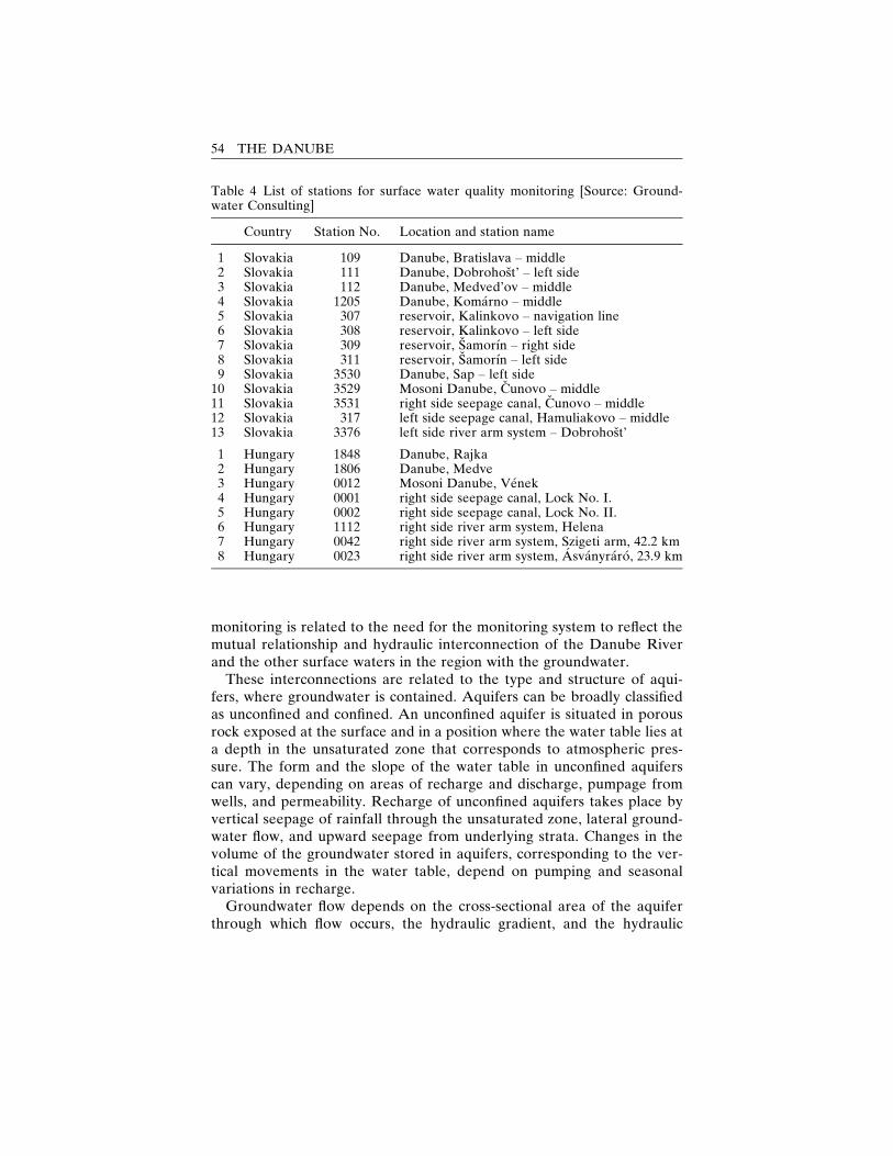
monitoring is related to the need for the monitoring system to reflect themutual relationship and hydraulic interconnection of the Danube Riverand the other surface waters in the region with the groundwater.
These interconnections are related to the type and structure of aqui-fers, where groundwater is contained. Aquifers can be broadly classifiedas unconfined and confined. An unconfined aquifer is situated in porousrock exposed at the surface and in a position where the water table lies ata depth in the unsaturated zone that corresponds to atmospheric pres-sure. The form and the slope of the water table in unconfined aquiferscan vary, depending on areas of recharge and discharge, pumpage fromwells, and permeability. Recharge of unconfined aquifers takes place byvertical seepage of rainfall through the unsaturated zone, lateral ground-water flow, and upward seepage from underlying strata. Changes in thevolume of the groundwater stored in aquifers, corresponding to the ver-tical movements in the water table, depend on pumping and seasonalvariations in recharge.
Groundwater flow depends on the cross-sectional area of the aquiferthrough which flow occurs, the hydraulic gradient, and the hydraulic
Table 4 List of stations for surface water quality monitoring [Source: Ground-water Consulting]
Country Station No. Location and station name
1 Slovakia 109 Danube, Bratislava – middle2 Slovakia 111 Danube, Dobrohost’ – left side3 Slovakia 112 Danube, Medved’ov – middle4 Slovakia 1205 Danube, Komarno – middle5 Slovakia 307 reservoir, Kalinkovo – navigation line6 Slovakia 308 reservoir, Kalinkovo – left side7 Slovakia 309 reservoir, Samorın – right side8 Slovakia 311 reservoir, Samorın – left side9 Slovakia 3530 Danube, Sap – left side
10 Slovakia 3529 Mosoni Danube, Cunovo – middle11 Slovakia 3531 right side seepage canal, Cunovo – middle12 Slovakia 317 left side seepage canal, Hamuliakovo – middle13 Slovakia 3376 left side river arm system – Dobrohost’
1 Hungary 1848 Danube, Rajka2 Hungary 1806 Danube, Medve3 Hungary 0012 Mosoni Danube, Venek4 Hungary 0001 right side seepage canal, Lock No. I.5 Hungary 0002 right side seepage canal, Lock No. II.6 Hungary 1112 right side river arm system, Helena7 Hungary 0042 right side river arm system, Szigeti arm, 42.2 km8 Hungary 0023 right side river arm system, Asvanyraro, 23.9 km
54 THE DANUBE

Table 5 Jointly agreed limits for surface water quality classification [Source:Groundwater Consulting]
Parameter Unit I. II. III. IV. V. VI.
temperature �C <20 25 25 30 30 >30pH – 6.5–8 6.5–8.5 6.5–8.6 6–8.5 6–8.5 6–9conductivity mS.m�1 <40 70 110 130 160 >160O2 mg.l�1 >8 6 5 4 2 <2Naþ mg.l�1 – – – – – –Kþ mg.l�1 – – – – – –Ca2þ mg.l�1 – – – – – –Mg2þ mg.l�1 – – – – – –NH4
þ mg.l�1 <0.1288 0.2576 0.644 2.576 6.44 >6.44HCO3
� mg.l�1 >200 200–100 100–20 20–10 <10 –Cl� mg.l�1 <50 150 200 300 500 >500SO4
2� mg.l�1 <50 150 200 300 400 >400NO3
� mg.l�1 <4.43 13.28 22.13 44.27 88.53 >88.53NO2
� mg.l�1 <0.0066 0.0164 0.066 0.164 0.33 >0.33PO4
3� mg.l�1 <0.0245 0.199 0.491 1.01 1.99 >1.99total P mg.l�1 0.016 0.13 0.33 0.65 0.98 >0.98total N mg.l�1 <0.3 0.75 1.5 2.5 >2.5 –Mn mg.l�1 <0.005 0.1 0.3 0.8 1.5 >1.5Fe mg.l�1 <0.5 1 2 5 10 >10Zn mg.l�1 <0.2 1 2 5 10 >10Hg mg.1�1 <0.1 0.2 0.5 1 5 >5As mg.1�1 <10 20 50 100 200 >200Cu mg.1�1 <20 50 100 200 500 >500Cr mg.1�1 <20 50 100 200 500 >500Cd mg.1�1 <3 5 10 20 30 >30Ni mg.1�1 <20 50 100 200 500 >500CODMn mg.l�1 <5 10 20 30 40 >40BOD5 mg.l�1 <2 4 8 15 25 >25suspended
solidsmg.l�1 <20 30 50 100 200 >200
saprobic index – 1 1.5 2.5 3.5 4 >4chlorophyll-a mg.m�3 <10 35 75 180 250 >250coliform
bacteriaCFU.ml�1 0.1 1 10 100 1000 >1000
faecal coliformbacteria
CFU.ml�1 <0.1 0.1–0.3 0.3–1 1–10 >10 –
faecalstreptococci
CFU.ml�1 <0.1 0.3 1 10 >10
TOC mg.l�1 <3 5 8 12 20 >20NEL-UV mg.l�1 0 <0.05 0.1 0.30 1 >1dissolved
solidsmg.l�1 <300 500 800 1000 1200 >1000
total numberof algae
cells.ml�1 – – – – – –
zooplankton In.ml�1 – – – – – –macrobenthos In.ml�1 – – – – – –
ENVIRONMENTAL MONITORING 55
conductivity, which indicates the rate at which water flows. Hydraulicconductivity is determined by the fluid and rock properties and in partic-ular by the interconnectivity of the rock pore spaces of the particularaquifer, and it can be measured through slug, pumping, or tracer tests.The porosity of the aquifer, which represents the volume of water storedin an aquifer, can be estimated through geophysical logging of boreholesand analysis of the aquifer rock core.
Despite the complexity associated with groundwater monitoring, regu-lar measurements and observations of the groundwater levels and regimeon both Slovak and Hungarian territory had been carried out for deca-des. Research and intensive studies in those areas have been promptedby the importance of groundwater as the primary source of drinkingwater, in addition to its use for industrial production and agriculture, inboth Hungary and Slovakia. A country’s reliance on groundwater, whichis usually considered as a cheaper and more easily exploitable drinkingwater supply source, reflects largely the geographical distribution of suit-able aquifers, i.e., rocks that are sufficiently porous to store water andthat are permeable enough to yield groundwater in economic quantities,as well as the availability of surface water supplies. While all rocks cancontain water, sedimentary rocks usually form the majority of importantaquifers.
Thus in the Slovak Republic 56% of the country’s utilizable ground-water resources are located in the quarternary sediments of the Danu-bian lowland and in the alluviums of the Van River and its tributaries.That percentage has effected the considerable attention and progressmade in the research and monitoring of groundwater in the Danubianlowland (Slovak Environmental Agency, 2003), including the develop-ment of mathematical modelling of groundwater flow and floodplainhydrology (Refsgaard and Soerensen, 1997). Currently groundwaterlevels are measured at more than 600 observation wells in the region ofBratislava-Komarno. The groundwater level monitoring network was es-tablished by the Slovak Hydrometeorological Institute (SHMU) (Banskyand Mazariova, 1995). Manual weekly measurements and continuousautomatic monitoring with the help of limnigraphs have provided a long-term database of groundwater levels in the region. The locations anddensity of the observation wells are shown in figure 9.
Like Slovakia, Hungary relies heavily on groundwater for its drinkingwater supply (78%–90%) and has therefore put special efforts intogroundwater research (Havas-Szilagyi, 1998). The fact that close to 40%of its 1,600 drinking water well fields, supplying more than two-thirds ofits drinking water, are considered vulnerable, i.e., not hydrologicallyprotected from pollution coming from the surface, has created additionalpressure for the continuous study and monitoring of such elements as
56 THE DANUBE
groundwater levels, flow systems, and recharge conditions in the country.Measurements of groundwater levels on Hungarian territory began in1866 and of springs and groundwater intakes in 1910. Since 1991 thedrinking water supply has been the responsibility of municipalities, whichhave been granted ownership of waterworks as part of the decentraliza-tion initiated in the country along with other transition reforms. How-ever, the groundwater monitoring and protection system in the countryhas been developed on a nationwide basis within the framework of thenational groundwater protection programme, the first phase of whichstarted in 1996. Financed by the central budget and executed with theassistance of the regional authorities, the countrywide groundwatermonitoring network includes 3,640 abstraction wells in 643 well fieldsdifferent in type, depth of the aquifer, number of wells, capacity, hydro-geology, and number and types of pollution sources. The long history ofgroundwater monitoring in both the Slovak Republic and Hungary haveprovided a basis for evaluating the impact of the GNP on the hydro-logical regime of groundwater from a long-term perspective. Resultsfrom monitoring on the Slovak territory for the period 1962–1992 (fig.10), for example, indicate the considerable lowering of groundwater lev-els in the area affected by the GNP, in particular the upper part of theDanubian basin downstream from Bratislava, during the three decadesbefore the construction and putting into operation of the Gabcıkovo partof the project. According to Bansky and Mazariova (1995), the causes ofthose changes vary in different places. While some changes are the resultsof the sinking of the riverbed, others have been caused by water pumpingfor industrial purposes, agricultural melioration, changes in irrigation anddrainage canal systems, irrigation patterns, exploitation of groundwaterfor municipal water supplies, and other changes driven by increasing ur-banization in the region.
The impact of putting into operation the Gabcıkovo part of the projecton groundwater levels on Slovak territory is illustrated in figure 11, whichshows the differences in groundwater levels in the affected region be-tween 1992 and 1995. The figure shows a general increase of groundwaterlevels, reversing the declining trend from the preceding decades in theupper part of Zitny ostrov as well as on the right side of the Danube inSlovak territory. At the same time, however, a lowering of the ground-water level close to the Gabcıkovo tailrace canal was recorded. A declinein the groundwater level was also noted in the area close to the Danubefloodplain, which, according to Bansky and Mazariova (1995), was theresult of the drainage of the old riverbed and which could be amelioratedby the construction of underwater weirs in the old Danube. Bansky andMazariova (1995) also suggested regulating seepage canals and watersupply, as well as flooding the inundation area, as technical measures for
ENVIRONMENTAL MONITORING 57
reducing the environmental impact of the construction and operation ofthe Gabcıkovo structures.
On Hungarian territory, the impact of the construction and operationof the Gabcıkovo part of the project on groundwater levels over the sameperiod (1992–1995) is also illustrated in figure 11. According to Liebe(1997), during the period 1993–1994, groundwater levels in the area be-tween Rajka and Asvanyraro near the Danube declined by three meterson average compared to expected water levels in undistributed channelflow conditions. Groundwater levels in the area between the Danube andthe Mosoni Danube had been considerably low in the middle part of thatregion and failed to reach the upper fine-particled topsoil in the upperpart of the Szigetkoz area before the diversion. As a result of the dam-ming, however, the areas with no groundwater supply reaching the top-soil expanded to include the middle part of Szigetkoz as well. Accordingto Palkovits (1997), within about 4,200 hectares (19% of the middle partof Szigetkoz), the drop in the groundwater level led to its disappearancefrom the topsoil after the diversion of the Danube. Measures for addi-tional water supply were taken in response to the situation.
According to Liebe (1997), however, the diversion of the Danubealso resulted in a change in the direction of the groundwater flow inthe region – from the south-southwest, toward the Mosoni Danube, to theeast, toward the main channel of the Danube. As a result, most of theinfiltrating water provided by the supplementary flow to the floodplainseeped back into the main channel. Further away from the Danuberiverbed, the likely source of recharging the groundwater became thereservoir. The extent to which the additional water supply provided inthe area as a result of technical measures agreed and introduced in 1995has changed the situation is currently being monitored jointly.
The joint monitoring network in 2001 included 257 observation wellssituated in the area of Zitny ostrov in Slovakia and in Szigetkoz inHungary (Joint Annual Report, 2001). The originally agreed observationwells are presented in figure 12. In order to account for the impact ofseasonal and other variations in surface water levels and discharges, pre-cipitation, evapotranspiration, irrigation, abstraction, and other relevantprocesses related to the input and output of water in the aquifer, the jointgroundwater monitoring in the areas affected by the Gabcıkovo part ofthe project selected three different discharge conditions in the Danube atBratislava, namely, 1,000, 2,000, and 3,000 m3/s, for studying ground-water level differences in comparable hydrological situations at differenttimes. For selected periods, maps of equipotential lines are jointly con-structed. In the wells where the water level is measured once a week, thegroundwater level for the selected periods is obtained through linear in-terpolation.
58 THE DANUBE
Groundwater quality
Closely related to the monitoring of the groundwater regime in the areahas been that of groundwater quality, which is critical in view of the useof groundwater for drinking water supply. Groundwater quality dependson the natural composition of groundwater and on the impact of anthro-pogenic factors. The major constituents of groundwater in its naturalstate are dissolved gases (e.g., oxygen, carbon dioxide, methane), inor-ganic ions (e.g., Ca, Mg, Na, K, Cl, NO3, SO4, HCO3), organic com-pounds (e.g., humic, fulvic, and amino acids), and a wide range of otherinorganic species present at trace levels. Differences in the levels ofchemicals contained in groundwater in its natural state depend on themineralogy of the aquifer rock. At the same time, a combination ofphysical processes (advection, dispersion, dilution), biological processes(biodegradation), and chemical reactions (sorption, precipitation, hydro-lysis, oxidation-reduction), which reduce or eliminate contaminant con-centration, controls the geometry, the composition, the extent of thedownstream transport of pollution, and thus the risk to receptors.Therefore, the choice of a groundwater monitoring strategy, as Thornton,Lerner, and Davidson (2002) point out, needs to take into account themineralogy of the aquifer and the behavior of expected contaminantplumes through time and space.
The design of the network should reflect the objectives of monitor-ing (e.g., to determine the water quality or chemistry of a specific watersupply or well field, to identify the extent of contamination of a knownsource, or to monitor a potential source of contamination) but also on theproperties of the contaminants under consideration in view of differencesin the position of their accumulation in geological structures and aquiferlayers. To avoid bias in sampling, the well’s diameter, the casing length,the method of installation, as well as the chemical compatibility of thematerial used with the groundwater contaminants under investigation,need to be taken into account in designing groundwater quality monitor-ing networks.
Evaluation of the results should reflect the desired use of groundwater.The suitability of groundwater for human or other use is determined by astandard set of constituents, such as pH, total dissolved solids, specificconductance, and inorganic salts. According to Thornton, Lerner, andDavidson (2002), ensuring that natural processes in situ are in accor-dance with the particular water use targets can be a legitimate end pointof monitoring.
In the GNP case, the groundwater quality monitoring system in theaffected areas, like the monitoring of the hydrological regime of thegroundwater, was based on the preexisting waterworks in the vicinity of
ENVIRONMENTAL MONITORING 59
the project. On the Slovak side, the system of municipal water wells nearthe previously existing river arms, near the reservoir, behind the seepagecanals, and opposite the downstream part of the Cunovo reservoir re-quired regular observation of groundwater quality long before the startof the GNP. The waterworks, in operation since 1972 and 1975 respec-tively, were established as a major source of drinking water for Bratislavabecause of polluted groundwater at the original source that supplied thecapital. Systematic measurement and monitoring of groundwater qualityin the region have been carried out within the framework of the basic andspecial-purpose monitoring networks of the Slovak HydrometeorologicalInstitute (SHMU). These networks include monofilter shallow wells,spread regularly between the Danube and Little Danube rivers, and asystem of deep, multilevel observation wells constructed parallel with thewater supply wells. The existing monitoring system in the region is cur-rently being used for monitoring the development of the impact ofGabcıkovo structures on the groundwater level and the groundwaterquality (Vavrova, 1995). Because of a decline in water demand duringthe past decade, some of the existing wells have been kept in operationsolely for monitoring the impact of the operation of the Gabcıkovo partof the GNP on groundwater quality in the region. In addition to theoriginal monitoring system, new methods of observation have been es-tablished between the reservoir and the waterworks’ walls under theproject ‘‘Ground Water Model for the Danubian Lowland,’’ funded bythe European Union.
The hydrochemical profile of the municipal water supply waterworkshas been determined based on a 3-D model of the groundwater flow. Thepresupposed course of geochemical processes in the infiltrating ground-water has been used to define the distance of individual wells from theDanube and the depth of their filter parts. Horizontal and vertical distri-bution of filters allows for following the development of the groundwaterquality along the flow lines at various depths. The collected data are em-ployed for hydro-geochemical analysis of migration processes in theaquifer of the Danube River side zone and for the study of oxidation oforganic matter, the oxidation-reduction state, the process of recharge ofthe gravel aquifer with Danube water, and other processes and states(Rodak and Mucha, 1995).
The peculiarities of the aquifer and the groundwater flow in the regionhave also been taken into account in designing the monitoring system.The relevant characteristics of the geological structure of the region, asdescribed by Rodak and Mucha (1995), include a layer of loam 1–2 me-ters thick, overlaying highly permeable and poorly graded sandy gravelwith an irregular lens of sand. The thickness of the sandy-gravel aquiferincreases further from the Danube, and the underlying aquitard is com-
60 THE DANUBE
posed of less permeable, fine- to medium-grained sand, sandstone, andclays of the Neogene epoch. Upstream from the municipal waterworks,water from the Danube recharges the groundwater of Zitny ostrov.
As in Slovakia, groundwater quality monitoring in Hungary has beendeveloped within the framework of hydrological monitoring in the coun-try. In more recent years, groundwater quality monitoring has been thefocus of the above-mentioned National Groundwater Protection Pro-gram, which was implemented in 1997. However, groundwater qualitymonitoring in the areas affected by the Gabcıkovo part of the GNP wasestablished before the official obligation for joint monitoring was agreedupon in 1995. According to Laszlo (1997), the pre-1995 groundwaterquality monitoring network in the areas consisted of a set of 70 observa-tion wells divided into 11 groups and situated along the banks of the sidearms and canals.
Results from the pre-1995 groundwater quality monitoring in the areasaffected by the Gabcıkovo part of the GNP in Slovakia indicate that nosignificant changes in groundwater quality have been detected as a resultof the construction and operation of the waterworks. In fact, according toHlavaty et al. (1999), a positive change in groundwater quality, linkedwith an increased proportion of water infiltrated from the Danube, wasobserved on the right side of the Danube after the Gabcıkovo part of theGNP was put into operation. According to results from long-term mon-itoring in Slovak territory, iron and manganese are typical components ofgroundwater in the area because of the geological composition of theaquifer. The high content of dissolved iron and manganese near the mu-nicipal water wells close to the river branches, a condition observed asearly as the 1970s, led to the exclusion of one of the wells from operation.The occurrence of iron and manganese dissolved in the groundwater de-pends on the content of oxygen and nitrate in the groundwater and onthe content of organic carbon in the groundwater and the aquifer. Thusthe decrease in the content of nitrates observed since 1992 could lead to afurther increase in the content of manganese and iron. Such problems,however, can be resolved (and have been resolved) in the region by aer-ation of water in the waterworks or by in situ treatment in the aquifer(Hlavaty et al., 1999). Other groundwater quality changes in Slovak ter-ritory, such as the decrease of total dissolved solids, chlorides, and sul-phates at the wells, which had been affected by water from urbanizedterritory during pre-dam conditions, have been noted as positive changesas a result of the construction and operation of the Gabcıkovo part of theGNP.
Pre-1995 monitoring on Hungarian territory also indicates that nosubstantial changes in groundwater quality were observed during the twoyears after the diversion of the Danube, although recharge patterns in
ENVIRONMENTAL MONITORING 61
the region were modified as a result of the damming (Liebe, 1997). Ac-cording to Laszlo (1997), during pre-dam conditions, groundwater inSzigetkoz was recharged primarily by the gravel bed of the main Danubechannel, and the quality of the bank-filtered water was suitable fordrinking water supply. As a result of the diversion of water from themain Danube riverbed, the bed lost its dominant recharge function alongsome of the river sections, and the reservoir and the side arm system be-came important recharge areas for the alluvial aquifer. Nevertheless thegroundwater quality changes observed in the area after the diversion aresimilar to those on Slovak territory, namely, a decrease of nitrate andammonium concentrations accompanied by an increase of dissolved ironand manganese.
The joint groundwater quality monitoring in the region introduced in1995 was conducted in 2001 through a network consisting of 40 wells, 22on the Hungarian side and 18 in Slovakia. The originally agreed jointmonitoring sites are given in table 6 and figure 13. Of the wells on theHungarian side, 16 are groundwater quality observation wells, situated inthe upper layers of the gravel sediments, and 6 are used for the observa-tion of the drinking water supply. The evaluation of the results of thejoint water quality monitoring is based on jointly agreed drinking waterquality limits for groundwater (table 7) and is being carried out from along-term perspective in both countries.
Soil monitoring
Changes in the surface water and groundwater regime and quality arecarried on to the living environment through changes in the moisture andquality of soil, i.e., the weathered material mainly composed of dis-integrated rock and of organic matter that sustains plant growth (Galle-gos, Brandstetter, and MacQueen, 1999). Soil moisture, one of the crucialcharacteristics of soil and the most relevant one regarding the environ-mental impact of the GNP, is a function of the availability of precipita-tion (in the form of rain, melting snow, and irrigation) and of watertransported from the ground via capillary rise. Soil moisture affects planttranspiration, soil aeration and temperatures, the vertical transport ofnutrients, chemicals, and pollutants, as well as the long-term develop-ment of soils and soil structures (Hlavaty et al., 1999). The character ofsediments or the type of soil, the sediments’ thickness, the groundwaterlevel, and its fluctuation determine the capillary rise. In gravel deposits,for example, the capillary transport is poor – nearly null. It is good infiner sediments, such as fine sand silt, loam, and agricultural soils, and itis best in loess (eolian sediments). The lack of water content but also the
62 THE DANUBE
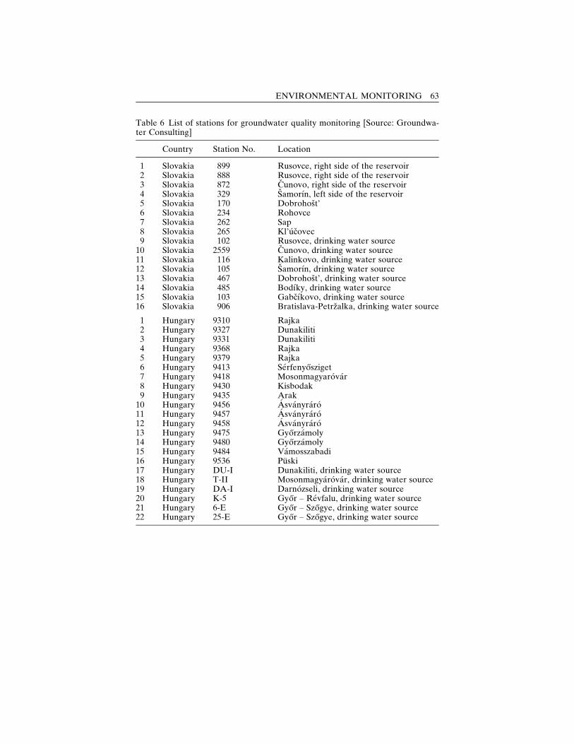
Table 6 List of stations for groundwater quality monitoring [Source: Groundwa-ter Consulting]
Country Station No. Location
1 Slovakia 899 Rusovce, right side of the reservoir2 Slovakia 888 Rusovce, right side of the reservoir3 Slovakia 872 Cunovo, right side of the reservoir4 Slovakia 329 Samorın, left side of the reservoir5 Slovakia 170 Dobrohost’6 Slovakia 234 Rohovce7 Slovakia 262 Sap8 Slovakia 265 Kl’ucovec9 Slovakia 102 Rusovce, drinking water source
10 Slovakia 2559 Cunovo, drinking water source11 Slovakia 116 Kalinkovo, drinking water source12 Slovakia 105 Samorın, drinking water source13 Slovakia 467 Dobrohost’, drinking water source14 Slovakia 485 Bodıky, drinking water source15 Slovakia 103 Gabcıkovo, drinking water source16 Slovakia 906 Bratislava-Petrzalka, drinking water source
1 Hungary 9310 Rajka2 Hungary 9327 Dunakiliti3 Hungary 9331 Dunakiliti4 Hungary 9368 Rajka5 Hungary 9379 Rajka6 Hungary 9413 Serfenyosziget7 Hungary 9418 Mosonmagyarovar8 Hungary 9430 Kisbodak9 Hungary 9435 Arak
10 Hungary 9456 Asvanyraro11 Hungary 9457 Asvanyraro12 Hungary 9458 Asvanyraro13 Hungary 9475 Gyorzamoly14 Hungary 9480 Gyorzamoly15 Hungary 9484 Vamosszabadi16 Hungary 9536 Puski17 Hungary DU-I Dunakiliti, drinking water source18 Hungary T-II Mosonmagyarovar, drinking water source19 Hungary DA-I Darnozseli, drinking water source20 Hungary K-5 Gyor – Revfalu, drinking water source21 Hungary 6-E Gyor – Szogye, drinking water source22 Hungary 25-E Gyor – Szogye, drinking water source
ENVIRONMENTAL MONITORING 63
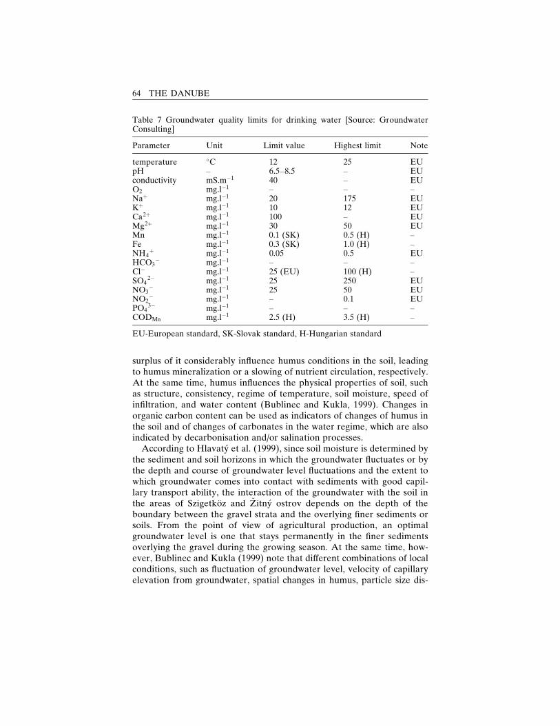
surplus of it considerably influence humus conditions in the soil, leadingto humus mineralization or a slowing of nutrient circulation, respectively.At the same time, humus influences the physical properties of soil, suchas structure, consistency, regime of temperature, soil moisture, speed ofinfiltration, and water content (Bublinec and Kukla, 1999). Changes inorganic carbon content can be used as indicators of changes of humus inthe soil and of changes of carbonates in the water regime, which are alsoindicated by decarbonisation and/or salination processes.
According to Hlavaty et al. (1999), since soil moisture is determined bythe sediment and soil horizons in which the groundwater fluctuates or bythe depth and course of groundwater level fluctuations and the extent towhich groundwater comes into contact with sediments with good capil-lary transport ability, the interaction of the groundwater with the soil inthe areas of Szigetkoz and Zitny ostrov depends on the depth of theboundary between the gravel strata and the overlying finer sediments orsoils. From the point of view of agricultural production, an optimalgroundwater level is one that stays permanently in the finer sedimentsoverlying the gravel during the growing season. At the same time, how-ever, Bublinec and Kukla (1999) note that different combinations of localconditions, such as fluctuation of groundwater level, velocity of capillaryelevation from groundwater, spatial changes in humus, particle size dis-
Table 7 Groundwater quality limits for drinking water [Source: GroundwaterConsulting]
Parameter Unit Limit value Highest limit Note
temperature �C 12 25 EUpH – 6.5–8.5 – EUconductivity mS.m�1 40 – EUO2 mg.l�1 – – –Naþ mg.l�1 20 175 EUKþ mg.l�1 10 12 EUCa2þ mg.l�1 100 – EUMg2þ mg.l�1 30 50 EUMn mg.l�1 0.1 (SK) 0.5 (H) –Fe mg.l�1 0.3 (SK) 1.0 (H) –NH4
þ mg.l�1 0.05 0.5 EUHCO3
� mg.l�1 – – –Cl� mg.l�1 25 (EU) 100 (H) –SO4
2� mg.l�1 25 250 EUNO3
� mg.l�1 25 50 EUNO2
� mg.l�1 – 0.1 EUPO4
3� mg.l�1 – – –CODMn mg.l�1 2.5 (H) 3.5 (H) –
EU-European standard, SK-Slovak standard, H-Hungarian standard
64 THE DANUBE
tribution, soil moisture distribution, porosity, penetrability for water, andsoil aeration may result in the same soil water regime, thus making theidentification of the causes of changes and the management of the soilwater regime a complicated task.
Information about the particular dynamics of soil moisture and thehydrological surface water and groundwater regimes, as well as dataabout the limiting values of the factors determining phytocenoses, couldfacilitate decision making on water management in the framework ofecosystem analysis. Soil research and monitoring carried out in both ag-ricultural and forest areas affected by the Gabcıkovo part of the GNPin Hungary and Slovakia during the past decade have provided a solidbasis for such decision making concerning the areas of Zitny ostrovand Szigetkoz.
Soil monitoring in agricultural areas on Slovak territory affected by theGabcıkovo part of the GNP started in 1989, although a wide set of thebasic physical and chemical soil parameters, the pedogenetic processes,the chemical compositions of the soil and the groundwater, and the cropproduction of the agricultural cooperatives in the region had been moni-tored since 1984. The 20 monitored observation plots included pedo-logical observation wells, soil moisture measuring wells, hydrogeologicalwells, and precipitation and irrigation gauging instruments, allowingfor the monitoring of the different characteristics of soil, such as soilmoisture, humus extent and quality, soil salinity, and other parameters(Fulajtar, 1995a; Fulajtar et al., 1998). Monitoring objects were situatedin areas where changes both in the groundwater levels after the con-struction of the Gabcıkovo structures and in the concentration of saltsin the groundwater had been forecast. Some of the factors consideredin the selection of the monitoring plots included the morphogenetic-stratigraphic structure of the soil profile, the depth of the gravel base, thegroundwater level and fluctuation, and the content of salts in the ground-water and in the soil.
The soil in forest areas affected by the construction and operation ofthe Gabcıkovo part of the GNP had also been monitored for more than adecade, starting in 1990. Monitoring was conducted on 24 permanentplots representing a variety of original (i.e., anthropologically unaffected)soil profile structures (Bublinec and Kukla, 1999). The objective of soilmonitoring was to observe changes in the soil as an acceptor, a source,and a medium reflecting changes in the ecosystem (Cambel, 1995).In order to quantify the potential impact of the Gabcıkovo structures onforest areas, changes in the humidity of the soil were measured in ten-centimeter intervals to a point below the groundwater level. Monitoringwas carried out at approximately ten-day intervals, using neutron logging.
On Hungarian territory, soil monitoring in areas affected by the con-
ENVIRONMENTAL MONITORING 65
struction and operation of the Gabcıkovo part of the GNP also startedbefore it became an obligation under the 1995 Agreement. According toPalkovits (1997), the water content of soil at 48 agricultural and 6 forestobservation points has been continually observed since 1989 by the Mo-sonmagyarovar Department of Production-Development of the PannonUniversity of Agricultural Sciences. Annually, 12–13 measurements, ad-justed to weather conditions and the development phases of plants, wereperformed between the end of March and the beginning of November.Phenological surveys were carried out on 47 agricultural fields, and thegrowth, the development, and the health of stands were examined in themain development phases of plants in production conditions based on 4–6 observations. The effects of the production methods on the sizes of theyields were taken into account in the evaluation of the field level data.
Soil studies of areas in Hungary affected by the construction and op-eration of the Gabcıkovo part of the GNP before 1995 were also carriedout as part of a larger study of the hydrogeological and soil-mechanicalproblems in the area in 1993 and 1994 – a study commissioned by theHungarian Ministry for Environmental and Regional Policy in responseto reports of house-cracking damages in settlements in Szigetkoz afterthe diversion of the Danube in 1992 (Nemesi and Pattantyus-Abraham,1997). The study was carried out by the Eotvos Lorand GeophysicalInstitute in cooperation with the Hungarian Geological Institute and withthe Geotechnical Department of the Budapest Technical University,which was responsible for soil sampling and analysis. Depth, soil type,and the mechanical properties of the different soil types in view of theirwater saturation were taken into account in selecting the samples. Fromthe stations along the integrated geophysical profile measured in one ofthe affected settlements, soil samples were taken from three depths inorder to reflect each of the characteristic layers below and above thewater table. A total of 20 samples were analyzed for grain size frequencydistribution and compressibility.
According to the findings of soil research and monitoring in the af-fected areas on Slovak territory, shallow soils prevail upstream, whiledeep soil horizons are typical downstream (Hlavaty et al., 1999). Water-logging of soils takes place only if the groundwater level is shallow, i.e.,usually close to the surface – 0–0.5 meters deep. A shallow groundwaterlevel in the floodplain supports a typical floodplain biotope and is natu-rally regulated by the river branches. The optimal depth of groundwaterin agricultural areas with shallow groundwater levels is ensured bydrainage systems, as in the eastern (lower) part of Zitny ostrov.
A comparison of the groundwater level with the gravel and finer-structured sediments having good capillary transport ability in agricul-tural areas on Slovak territory affected by the Gabcıkovo project in 1962,
66 THE DANUBE
1992, and shortly thereafter indicates that no waterlogging was observedin the region except in the inundation area, where conditions improvedafter 1992. According to Hlavaty et al. (1999), no additional waterloggingof agricultural soils was observed after the project was put into operation.
Based on results from the research and monitoring in the affected for-ests in Slovakia, the soil in those areas belongs to the class of eutric andcalcaric fluvisols with a different water-air regime and is built of sedi-ments with an admixture of carbonates, in particular CaCo3 (Bublinecand Kukla, 1999). The hygroscopic quality of the observed soils has beenfound to correspond to that of light and middle-heavy soils. Basic miner-als (quartz, feldspar, mica) were found to prevail in fractions of sand andsilt and in fractions of clay (a secondary mineral) in the humus-claycomplex.
In the areas near the old Danube riverbed where groundwater leveldeclined, a decrease in the humus content of the soil surface layers wasnoted, reaching levels about 22% and 41% lower than the humus contentobserved on average and in the flooded areas, respectively. Humus con-tent and quality determine the available phosphorus for plants, which isessential for their health. In certain areas a decrease in potassium wasalso observed. Insufficiency of potassium, a basic plant nutrient, causesdecomposition of proteins, increases the number of free amino acids,contributes to the accumulation of toxic substances, increases respiration,and decreases phosphorus content, resulting in the seed germination ca-pacity of the root system of plants. However, as Bublinec and Kukla(1999) point out, the limited time span of the pre-1995 observations didnot allow for drawing conclusions about the permanence of those changes.
According to soil monitoring in the affected agricultural areas in Hun-gary, the periodical or constant presence of groundwater in the coverlayer in Szigetkoz determined the limited impact of weather extremitieson soil moisture in the area (Palkovits, 1997). However, the decline ofgroundwater levels below the soil layer in 19% of the territory as a resultof the diversion of the Danube in 1992 led to an increase in the vulnera-bility of agricultural production to weather conditions. This was demon-strated by the lower-than-average yields from the region in 1993 and1994 because of the prolonged drought and limited precipitation duringthose years, especially 1993.
Studies of soil in forests indicate that changes in the fluctuation patternand chemical composition of surface water and groundwater in the regionaffected the direction and intensity of soil formation processes (Hahnet al., 1997). Analysis based on soil sampling data indicates that, as a re-sult of the diversion of the Danube, some abrupt changes were noted inthe natural trend of a gradual increase of fine sediment and a decreaseof gravel as one moves away from the open water toward the former
ENVIRONMENTAL MONITORING 67
riverbank. Those changes have been pointed out as causes of changes inthe natural vegetation in the region.
However, results from soil analysis also indicate that changes in watersaturation affected different soil types differently. While they had littleimpact on coarse-grained soils, they considerably affected the formationprocesses in the uppermost thick layer in areas characterized by clayeysoils. According to Nemesi and Pattantyus-Abraham (1997), a permanentdrop in the water level could cause a sinking of the clay layers by severalcentimeters as a consequence of compression and a loss of 5%–20% oftheir volume as they dry up. They note that the sinking of the relief as-sociated with similar changes in the period after the diversion of theDanube could have been the reason for house cracking in some of theaffected areas in Hungary.
The impact of the changes in the hydrological regime and quality ofsurface water and groundwater on soil and, in particular, on soil moistureon Slovak and Hungarian territories as a result of the construction andputting into operation of the Gabcıkovo part of the project is currentlybeing monitored jointly. In the hydrological year 2001, soil moisturemeasurements within the framework of the joint monitoring programmewere carried out at 34 observation sites. Measurements on the Slovakside were performed on 12 forest, 5 biological, and 3 agricultural mon-itoring areas, and on the Hungarian side, on 9 forest and 5 agriculturalareas. The originally agreed joint observation points are shown in figure14 and table 8. The measurement method used in the Slovak Republic isa neutron probe that reaches a prescribed depth of the groundwaterlevel. In Hungary, the method used is a capacity probe that reaches downto the underlying gravel layer. To allow for comparability, both sides usethe same method to present the measurement results. Soil moisture inboth Hungary and Slovakia is shown by the total soil moisture content involume percentage recorded in ten-centimeter depth intervals for eachmeasurement during the year. An example of the time record of soilmoisture changes in Dunajska Luzna is presented in figure 15.
Forest monitoring
The impact of the construction and operation of the GNP on forests,which are defined by FAO as land with an area greater than 0.5 hectaresand with tree crown density (or equivalent stocking level) exceeding 10%(ECPP, 1999), has been one of the major environmental concerns of theproject. Particularly controversial has been the impact of the decreasedwater supply in the old Danube riverbed and the arm system on flood-plain forests, which are characterized by much higher water needs fortranspiration than can be supplied through precipitation.
68 THE DANUBE
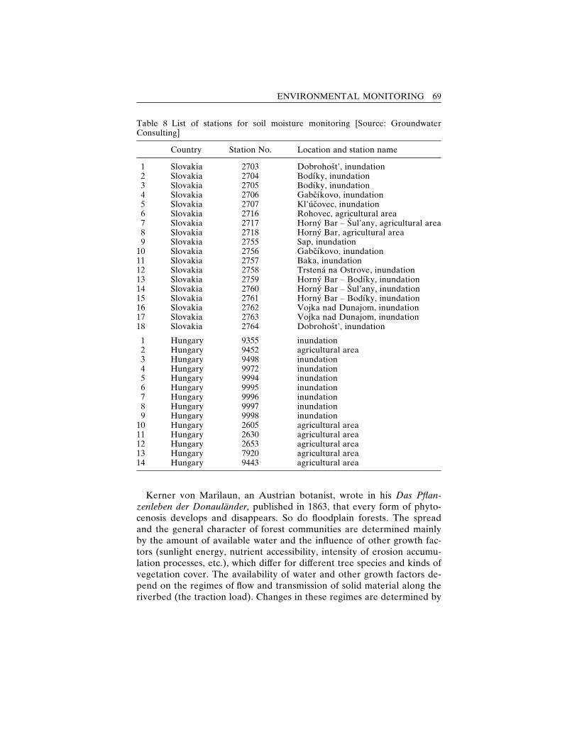
Kerner von Marilaun, an Austrian botanist, wrote in his Das Pflan-zenleben der Donaulander, published in 1863, that every form of phyto-cenosis develops and disappears. So do floodplain forests. The spreadand the general character of forest communities are determined mainlyby the amount of available water and the influence of other growth fac-tors (sunlight energy, nutrient accessibility, intensity of erosion accumu-lation processes, etc.), which differ for different tree species and kinds ofvegetation cover. The availability of water and other growth factors de-pend on the regimes of flow and transmission of solid material along theriverbed (the traction load). Changes in these regimes are determined by
Table 8 List of stations for soil moisture monitoring [Source: GroundwaterConsulting]
Country Station No. Location and station name
1 Slovakia 2703 Dobrohost’, inundation2 Slovakia 2704 Bodıky, inundation3 Slovakia 2705 Bodıky, inundation4 Slovakia 2706 Gabcıkovo, inundation5 Slovakia 2707 Kl’ucovec, inundation6 Slovakia 2716 Rohovec, agricultural area7 Slovakia 2717 Horny Bar – Sul’any, agricultural area8 Slovakia 2718 Horny Bar, agricultural area9 Slovakia 2755 Sap, inundation
10 Slovakia 2756 Gabcıkovo, inundation11 Slovakia 2757 Baka, inundation12 Slovakia 2758 Trstena na Ostrove, inundation13 Slovakia 2759 Horny Bar – Bodıky, inundation14 Slovakia 2760 Horny Bar – Sul’any, inundation15 Slovakia 2761 Horny Bar – Bodıky, inundation16 Slovakia 2762 Vojka nad Dunajom, inundation17 Slovakia 2763 Vojka nad Dunajom, inundation18 Slovakia 2764 Dobrohost’, inundation
1 Hungary 9355 inundation2 Hungary 9452 agricultural area3 Hungary 9498 inundation4 Hungary 9972 inundation5 Hungary 9994 inundation6 Hungary 9995 inundation7 Hungary 9996 inundation8 Hungary 9997 inundation9 Hungary 9998 inundation
10 Hungary 2605 agricultural area11 Hungary 2630 agricultural area12 Hungary 2653 agricultural area13 Hungary 7920 agricultural area14 Hungary 9443 agricultural area
ENVIRONMENTAL MONITORING 69
the climate and the anthropogenic activities in the riverbed and in thecatchment basin (Valtyni, 1993; 1994).
Floodplain forests in the middle reaches of the Danube on both Slovakand Hungarian territories have been subjected to similar climate condi-tions and anthropogenic factors related to the common water and forestresource management practices on both sides of the river. Those com-monalities have determined the similarities in the types of floodplain for-ests in the region, in their development through time, and in their currentcondition.
In the territory of Slovakia, for example, four phytocenologically dif-ferent vegetation groups, classified as economic sets of forest types, existin the Danube floodplain (Valtyni 1993; 1994). Arranged according towater needs in descending order, these groups include the following:1) Willow-poplar woods (soft floodplain woods), represented by the
group Saliceto-Alnetum (willow-alder);2) Oak-ash woods (intermediate floodplain woods), represented by the
groups Querceto fraxinetum (oak-ash) and Ulmeto-fraxineto populeum(elm-ash with poplar), which are typical of the river arm system;
3) Hornbeam-ash woods (hard floodplain woods), represented by thegroup Ulmeto-Fraxinetum carpineum (elm-hornbeam with ash);
4) Extremely limestone oak woods, represented by the group Corneto-Quercetum (cornel-oak).Forest vegetation on the floodplain in Hungary is characterized by
similar forest types. According to Fodor and Pal-Fam (2001) and Laszloand Pal-Fam (2001), the most common forest types in Szigetkoz include:1) Willow and poplar woods represented by Salix purpurea, Populus ni-
gra, and Alnus glutinosa in the wettest areas (Hahn et al., 1997);2) Ash-elm-oak (Pimpinello majoris-Ulmetum) gallery forests which are
typical of the higher region of the floodplain area;3) Oak-hornbeam forests (Majanthemo-Carpinetum) found in more arid
areas;4) Oak forests (Piptathero virescentis-Quercetum roboris) found in the
driest, semiarid habitats.Floodplain forest development, the result of which is today’s forests
around the middle reaches of the Danube River, began in the Subatlanticera, 2,800–1,400 years ago, when an increase in humidity and a decreasein temperature intensified erosion/accumulation processes in the Danubebed and created conditions for the disappearance of boreal forests andthe formation of forest communities capable of existing in extreme localconditions. Later, changes in the river flow and the traction load regimesmainly because of anthropic activities, such as antiflood measures and ashortening of the watercourse in connection with an increase in the lon-
70 THE DANUBE
gitudinal watercourse slope, resulted in changes in the development andspread of the Danubian riparian forests, changes which are obvious in thedifferences between Lichtenstern’s and Mikovıni’s maps from 1794 and1730, respectively (Valtyni, 1993; 1994).
The construction of antiflood dikes, which began in 1885, influencedthe flow regime in the area between the dikes, the extent and duration offloods, as well as the water level in the flooded area, increasing averagewater depth, deposition of fertile silt, and thus the supply of nutrients totree species between the dikes. As a result, hardwood broad-leaved treespecies were replaced by willow-poplar forests (Somsak, 1999). Later,anthropogenic influences upstream, namely, the construction of severaldams on the territories of Germany and Austria, led to a decrease of de-tritus in the lower parts of the stream. The decrease intensified riverbederosion, which, combined with gravel excavation from the Danube bot-tom and other measures taken to improve navigation, as well as withdrainage for agricultural purposes, resulted in a drop in the water levelnot only in the Danube watercourse but also in the soils of the adjacentflood plains, especially during the vegetation period. As a result of therepeated shortage of water in the poplar vegetation root zone, vegetationstarted to dry in some localities (namely, Rusovce and others), and marshhabitats disappeared.
Floodplain changes affected the distribution of individual tree speciesas well. In the Danubian lowland along the Danube and its tributaries,for example, willows belonging to the Salix genus originally prevailed. Insome places, willows were an admixture in alder woods (Alnetum gluti-nosse-salicetosum) or poplar-willowwoods (Saliceto-populeum). Poplars,predominantly domestic black poplar, created a vegetation cover of asimple structure which was well lit throughout. Elms and other accom-panying species gradually entered this vegetation cover, thus forming asecond floor. As a result of the drying of the alluvial upper parts, at ele-vated places poplars ceased to reproduce naturally and grew only spo-radically during periods of huge floods or rich atmospheric precipitation.Elms gradually took over, forming elm woods which included speciessuch as alder, buckthorn, blackthorn, maple, etc. Further developmentsled to the spread of oaks and the formation of elm-oak woods (Ulmeto-Quercetum) or other mixed deciduous vegetation covers. The poplarspecies, Populus nigra pannonica, as well as its genuina and pyramidalisvariants, which were originally spread in the neighborhood of the Dan-ube River, were mixed with white poplar, ash, elm, European alder, grayalder, which grew from seeds conveyed by the river from Alpine regionswhich then settled in the inland delta (Valtyni, 1993; 1994).
At the same time artificial afforestation was taking place in the dried-
ENVIRONMENTAL MONITORING 71
out areas. In Slovakia, starting from around 1850 and intensifying afterWorld War II, the planting of utility poplar monocultures, characterizedby up to ten times higher annual incremental growth than the average inthe country, added to changes in the vegetation cover in the area alongthe Danube, including the area between the weirs near Gabcıkovo. Ac-cording to Somsak (1999), approximately 80% of the natural floodplainforests were replaced by allochtonous monocultures. Similarly, in Hun-gary, artificial afforestation led to the introduction of poplar hybrids inthe floodplain area (Varga, 1997). Those changes are in line with forestmanagement practices on the rest of the territory of the two countries.According to a European Commission’s Phare Programme Report,‘‘Conservation and Sustainable Management of Forests in Central andEastern European Countries’’ (ECPP, 1999), in Hungary there are cur-rently no virgin forests, and in Slovakia forests undisturbed by man ac-count for 1% of the forests in the country.
Like previous water regulation activities, the GNP was expected toaffect forest ecosystems in the Danube floodplain as well. In order toevaluate the impacts, a number of studies, as well as regular monitoringof selected plots, were undertaken in the two countries. They drew onearlier research on floodplain forests in the Danube and their relation tosoil conditions and changes of groundwater levels, vegetation of stagnantwaters and dead arms, phytocenoses of bank biotopes, synecologicalconditions, and primary productivity of floodplain forests.
In Slovakia, monitoring of forest trends was established within theframework of the biota monitoring initiated by the Slovak Academy ofSciences in 1990. The monitoring included a set of plots representative ofthe variety of forest ecosystems found in the area, e.g., ecosystems withoriginal wood plant composition, cultivated poplar monocultures, mono-layer forests and forests with a developed shrub layer, forests with dis-integrated structure, and compact stands with high stocking and canopydensity. The monitoring aimed to evaluate the conditions and possiblechanges in the structure of the tree and shrub layer and in the leaf areaindex. The evaluation was based on features and parameters such asspecies composition, thickness, height and biosocial structure of the mainstand, Kraft-classified tree inventory, crown architecture, and canopycover (Oszlanyi, 1995).
Repeated phytocenological (semiquantitative) and population-ecological (quantitative) observations and analysis were carried out incertain areas, each measuring one hectare. Dendronometric and tree di-ameter measurements were performed in 15 permanent sampling plots(Smelko, 1999). For monitoring the dependence of increment on changesin the water regime, younger stands (of up to 10 years in age) of cultivarpoplars were observed since older trees were assumed to have an internal
72 THE DANUBE
physiological disposition to an incremental decrease in thickness (Somsaket al., 1995). For the monitoring process, the age of a poplar was de-termined by counting annual rings based on radial borings at a 130-centimeter height from the soil and by following the same direction ofborings in order to ensure comparability of long-term data. Results wereevaluated in relation to groundwater level developments and precipita-tion, annually and during the vegetation period, and were integrated witha computer-based Dendrochronological Analysis System, allowing forobservation of the whole course of growth in a tree’s diameter retro-spectively and for distinguishing a tree’s natural growth from deviationscaused by environmental factors, while taking into account the naturalincremental growth pattern as related to the age of a tree. Dendrochro-nological analysis of a tree’s lifelong growth was performed on 30 sampletrees to verify the reliability of short-term results (Smelko, 1999).
In addition the leaf area index, indicating the size of one side of a leafas related to one hectare of stand area, was monitored during an intervalof two to three years and evaluated with the help of planimetric analysis.Leaves, taken together as an assimilating apparatus, quickly and in-tensively react to changes in growth conditions within one growth seasonas well as over a longer period. Therefore they were used as indicators ofthe production capacity of a plant cover, as well as the cover’s vitality andhealth as related to the hydropedological regime in a locality (Oszlanyi,1999).
The monitored sites were located according to the expected impact ofthe GNP on floodplain affected forests in Slovak territory. Altogether,the forests were expected to come up to about 4,014 hectares and includean area of 1,092 hectares around the Hrusov reservoir and an area ofabout 2,922 hectares in the river arm system where floodplain forestsgrow inside the inundation area (containing 2,289 hectares) and outsidethe inundation area (containing 633 hectares). Several variants of antici-pated development had been worked out, especially for the forests in thearm system, based on the difference between the average flow rate in theold riverbed and the amount of water in the arm system conveyed by thediversion canal via the intake structure at Dobrohost’. In the area aroundthe Hrusov reservoir, the putting into operation of the GNP was ex-pected to lead to an improvement in the supply of the existing vegetation.However, redirecting the stream of the Danube was expected to changehabitat conditions along the old riverbed from those suitable to flood-plain softwoods to those more favorable to floodplain hardwoods, inproportion to changes in the average water level in the old bed. Even themost skeptical prognoses, did not envision the disappearance of flood-plain forests. They did predict, however, a replacement of the prevailingcultivated poplars with tree species capable of existing in drier locations,
ENVIRONMENTAL MONITORING 73
such as oaks, ashes, and other autochtons considered more natural forthe region but characterized by a substantially lower accumulation ofwood.
In Hungary, forest monitoring in the areas expected to be affected bythe construction and operation of the GNP began in 1986 in response torising public concern about the environmental impact of the project. Thisconcern also led to the establishment in 1987 of the Szigetkoz LandConservation District, which covered areas along the bank of the MosoniDanube, the old Danube floodplain, and areas between the two branches,65% of which constitute forests (Koltai, 1997). Concern focused on wet-land forests, i.e., willow carr forests, softwood and hardwood riparianforests, and riparian alder groves. As defined in the ‘‘European WetlandInventory Review’’ (Wetlands International 2002, October 30), wetlandsare water bodies with an area-related mean water depth below twometers at mean water level, parts of deeper waters covered or fringed bymacrophytes on at least one-third of their extent, as well as areas withhydromorphic soils, the upper layers of which are continuously or sea-sonally waterlogged and therefore support characteristic vegetation. Inorder to monitor the impact of the GNP on floodplain forests in Szi-getkoz, different institutes calculated production, growth, leaf area, andother indexes, which were used as indicators for forest health and trends.The forest monitoring performed by the Forest Research Institute withinthe framework of the general environmental monitoring in the countryhad the following objectives (Csoka-Szabados, Halupa, and Somogyi,1997):� to identify the main abiotic site factors and observe their changes;� to study the impact of the measurable abiotic factors on the growth and
development of trees and stands in the region;� to study how tree growth reflects changes in the environment;� to observe health conditions of trees and stands;� to make economic predictions for forestry enterprises;� to study forests as essential biological entities from a conservationist
point of view.In order to account for forest development changes in response to
abiotic factors, the study examined the major environmental factors con-sidered important in determining the spatial distribution, development,and productivity of terrestrial plants. These factors are climate, soil, andhydrological conditions. Csoka-Szabados, Halupa, and Somogyi (1997)classify the macroclimate of Szigetkoz as that of a forest steppe, unfa-vorable for forests and stands of higher-than-marginal productivity in theabsence of accessible groundwater or inundation. However, high evapo-ration because of the large open water of the river and its branches pro-
74 THE DANUBE
duces a mesoclimate slightly more favorable for the floodplain treesclassified as sessile oak-turkey oak. Pure alluvial soils, characterized byazonal formation because of repeated depositions from the river and bysandy and muddy-sandy physical structures, combined with humic allu-vial soils in higher elevations, define the soil profile of the region. Belowthe nutrient-rich and regularly deposited alluvial layers, ranging from 50to 150 centimeters in depth, a thick gravel layer mixed with coarse sandexists. The hydrological conditions are defined in terms of the elevationsof the soil surfaces above the water level. High elevations, according toCsoka-Szabados, Halupa, and Somogyi (1997), account for only 2% ofthe floodplain, and middle-high and middle-low elevations under a con-stant supply of water for 1–2 months annually account for 20% and 71%of the floodplain, respectively.
Productivity was measured on 30 plots, each measuring 0.1–0.25 hec-tares, in predominantly hybrid-poplar stands (80%), which are consid-ered most sensitive to environmental changes. Hybrid-poplar standsconstitute 65% of all floodplain forests. Stand volume and incrementwere determined by measurements of tree height and of tree diameter(at breast level) carried out annually after the vegetation season. Thechanges in the measured parameters and their variations according to thedifferences in tree species, age, and silvicultural treatment (thinnings), aswell as differences in weather conditions, were analyzed. Also, from 1–2weeks before the vegetation period to 1–2 weeks after it, girth growthmeasurements of single trees in 10 of the 30 plots were conducted weekly.Changes in growth rhythm, points of local maximum, and the length ofthe vegetation period were taken into account as indicators of changes inthe environment. Because of difficulties in investigating individual influ-ences, however, studies focused on factors at minimum values, i.e., limit-ing factors at the local positive or negative peaks of the growth curves(Csoka-Szabados, Halupa, and Somogyi, 1997).
In addition, the health of forests in Szigetkoz was monitored as an in-dicator of long-term trends in the region. The University of Forestry andWood Science in Sopron, together with the Scientific Institute of For-estry, conducted measurements twice a year at sample plots, each con-taining 100 trees. They recorded changes in the following parameters:lack of foliage, quantity of dry branches in the crown, top dryness, trunkdamage, stump and root decay (Varga, 1997). Insect light traps were usedfor recording changes in the whole community. Soil quality, based on soilprofiles in the sample plots, was also reported in order to help identifythe causes of changes in the health of the forests.
As in the Slovak Republic, changes in leaf area have been monitoredboth in localities on Szigetkoz which have been influenced by the diver-
ENVIRONMENTAL MONITORING 75
sion of the Danube and on areas which have not been affected, for thesake of comparison. Starting in 1989, the Department of Plant Taxonomyand Ecology at Eotvos Lorand University conducted annual measure-ments based on samples of 200 leaves collected in autumn, after leaf fall(Szabo et al., 1997).
Results from the above-mentioned monitoring activities indicate that,as expected, the putting into operation of the Gabcıkovo part of theproject did not have a uniform impact on floodplain forests in Slovakia.About 2,500 hectares of floodplain forests and other flora communitiesdisappeared. Disintegration of forest communities in the area betweenthe Cunovo reservoir and the main trailrace channel – a process whichhad started about two decades earlier – continued at an accelerated pace.However, the increase of groundwater levels at the reservoir stimulateda regeneration of the humid floodplain forest in previously destroyedhabitats (Somsak, 1999). Results from dendrometric and tree diametermeasurements during the periods before and after the damming roughlycorresponded to the model-based forecasts of intensified growth in theareas where groundwater levels increased, i.e., in the parts of the terri-tory downstream, and were confirmed by dendrochronological analysis(Smelko, 1999). The changes in the leaf area index also reflected thenegative impact of the decrease of groundwater level above the intakestructure at Dobrohost’ and in the narrow belt along the old Danubemain channel on floodplain forests, as well as the positive effect of therise of groundwater levels associated with the construction of the Cunovoreservoir. Small or insignificant groundwater level changes (both positiveand negative) in most of the monitored sites were not reflected in the leafindex changes (Oszlanyi, 1999).
On Hungarian territory, the most adverse impact of the diversion ofthe Danube on floodplain forests was registered in the middle part ofSzigetkoz, where groundwater levels fell below the topsoil layer. The re-sulting conditions were characterized as favorable for species with a widerange of tolerance for changes in the environment, in particular a highdegree of tolerance for drought (Szabo et al., 1997). The new conditionswere found to be most unfavorable for willow stands, according to theresults of growth monitoring (Csoka-Szabados, Halupa, and Somogyi,1997), and to have, on hardwoods, both a limited impact, since they areless dependent on water availability, and an impact more difficult to de-tect, since they grow at a slower rate. At the same time, however, Hahnet al. (1997) point out that changes in the hydrological conditions led tothe formation of new habitats for terrestrial plants, such as the exposedriverbed where a new willow thicket belt was formed in the years imme-diately after the diversion of the Danube. Csoka-Szabados, Halupa, andSomogyi (1997) report that the deteriorating health of the monitored
76 THE DANUBE
forests was reflected in an abnormally early shedding of leaves, the way atree reacts to drier conditions in order to avoid damage to itself. Topdryness, observed by Varga (1997) in the area of Rajka-Dunakiliti, seemsto support those findings. However, Csoka-Szabados, Halupa, and So-mogyi (1997) note that in some cases the exact causes of the observedchanges are difficult to determine and the period of observation was notlong enough to draw reliable conclusions.
The results of the floodplain forest monitoring carried out in the twocountries in the years before and immediately after the Gabcıkovo partof the GNP was put into operation were used as a basis for elaboratingtechnical measures needed to provide additional water supplies in themost adversely affected areas. Some of these measures were jointlyagreed in 1995 and implemented shortly afterward. Their impact is cur-rently being observed within the framework of the joint monitoring pro-gramme in the affected areas. In 2001 the joint forest monitoring networkincluded 15 observation plots on Slovak territory and 12 on Hungarian.Most of the monitored forests in the two countries are poplar stands.Two willow stands are monitored in Slovakia, and one alder and one oakstand in Hungary. The forest observation sites as other components ofthe joint monitoring network are being continually reviewed and modi-fied. The locations of the original joint monitoring sites are presented infigure 16 and table 9. The two countries are measuring the weekly girthgrowth and examining the health of their observed forests using compa-rable methodologies. To evaluate the forests’ health, they are using, orplanning to use, aerial photographs. In addition, they are evaluating dataconcerning annual wood yield (Joint Annual Report, 2001).
Biota monitoring
The monitoring of individual species or groups of fauna and flora has along tradition (Bocker et al., 1991; Duvigneaud, 1988) that can be tracedback to the earliest efforts to study life forms on earth. In more recentyears, the development of biological monitoring has been closely relatedto ecosystem ecology as a new ‘‘integrative science,’’ pioneered by Odum(1971). Taking a broad view of the environment, Odum urged integrationof the individual pieces of the puzzle in the context of the complex inter-relationship between the living and the nonliving environment.
Advances in the knowledge of biological organisms and their reac-tions to changes in the physical environment, combined with progress inmicroelectronic and information technology, led to the employment ofbiological indicators for monitoring the state of the environment and theimpact of anthropogenic factors. For example, continual biological mon-itoring of water quality in the major international rivers in Europe has
ENVIRONMENTAL MONITORING 77
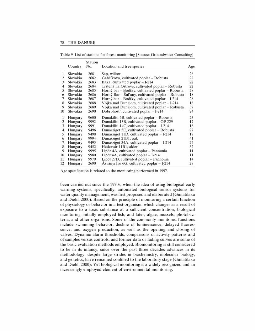
been carried out since the 1970s, when the idea of using biological earlywarning systems, specifically, automated biological sensor systems forwater quality management, was first proposed and elaborated (Gunatilakaand Diehl, 2000). Based on the principle of monitoring a certain functionof physiology or behavior in a test organism, which changes as a result ofexposure to a toxic substance at a sufficient concentration, biologicalmonitoring initially employed fish, and later, algae, mussels, photobac-teria, and other organisms. Some of the commonly monitored functionsinclude swimming behavior, decline of luminescence, delayed fluores-cence, and oxygen production, as well as the opening and closing ofvalves. Dynamic alarm thresholds, comparisons of activity patterns andof samples versus controls, and former data or fading curves are some ofthe basic evaluation methods employed. Biomonitoring is still consideredto be in its infancy, since over the past three decades advances in itsmethodology, despite large strides in biochemistry, molecular biology,and genetics, have remained confined to the laboratory stage (Gunatilakaand Diehl, 2000). Yet biological monitoring is a widely recognized and anincreasingly employed element of environmental monitoring.
Table 9 List of stations for forest monitoring [Source: Groundwater Consulting]
CountryStationNo. Location and tree species Age
1 Slovakia 2681 Sap, willow 262 Slovakia 2682 Gabcıkovo, cultivated poplar – Robusta 223 Slovakia 2683 Baka, cultivated poplar – I-214 224 Slovakia 2684 Trstena na Ostrove, cultivated poplar – Robusta 225 Slovakia 2685 Horny bar – Bodıky, cultivated poplar – Robusta 286 Slovakia 2686 Horny Bar – Sul’any, cultivated poplar – Robusta 187 Slovakia 2687 Horny bar – Bodıky, cultivated poplar – I-214 288 Slovakia 2688 Vojka nad Dunajom, cultivated poplar – I-214 189 Slovakia 2689 Vojka nad Dunajom, cultivated poplar – Robusta 37
10 Slovakia 2690 Dobrohost’, cultivated poplar – I-214 24
1 Hungary 9600 Dunakiliti 6B, cultivated poplar – Robusta 232 Hungary 9992 Dunakiliti 13B, cultivated poplar – OP-229 173 Hungary 9991 Dunakiliti 14C, cultivated poplar – I-214 164 Hungary 9496 Dunasziget 5E, cultivated poplar – Robusta 275 Hungary 9498 Dunasziget 11D, cultivated poplar – I-214 176 Hungary 9994 Dunasziget 21B1, oak 417 Hungary 9495 Dunasziget 34A, cultivated poplar – I-214 248 Hungary 9452 Hedervar 11B1, alder 529 Hungary 9995 Lipor 4A, cultivated poplar – Pannonia 11
10 Hungary 9980 Lipot 4A, cultivated poplar – I-214 1111 Hungary 9979 Lipot 27D, cultivated poplar – Pannonia 1412 Hungary 2690 Asvanyraro 6G, cultivated poplar – I-214 28
Age specification is related to the monitoring performed in 1997.
78 THE DANUBE
In addition to the kind of biological monitoring used for early warning,another type of biological monitoring, called biodiversity monitoring orbiota monitoring and used for conservation purposes, has expanded overthe past decade. Preserving biological diversity, which refers to the vari-eties of life on earth at the genus, species, and ecosystem levels, was in-ternationally recognized as a global concern through the Convention onBiological Diversity (CBD), which was adopted at the United NationsConference on Environment and Development (UNCED) in 1992 in Riode Janeiro. The international commitment to ensuring the preservationof biological diversity was confirmed at the 2002 World Summit on Sus-tainable Development in Johannesburg, which led to the development of‘‘A Framework for Action on Biodiversity and Ecosystem Management’’(WEHAB Working Group, 2002). Biological monitoring is a basic toolfor achieving this international goal as indicated by Article 7 of the CBDwhich requires each party to:a) identify components of biological diversity important for its conservation
and sustainable use according to the indicative list of categories set down inAnnex I;
b) monitor, through sampling and other techniques, the components of biologicaldiversity identified pursuant to subparagraph (a) above, paying particular at-tention to those requiring urgent conservation measures and those which offerthe greatest potential for sustainable use;
c) identify processes and categories of activities which have or are likely to havesignificant adverse impacts on conservation and sustainable use of biologicaldiversity, and monitor their effects through sampling and other techniques;and
d) maintain and organize, by any mechanism, data derived from identificationand monitoring activities pursuant to subparagraphs (a), (b), and (c) above.
In Europe, biodiversity has been part of the reports made to the min-isterial conferences within the ‘‘Environment for Europe’’ process of theUNECE. In addition, Pan-European intergovernmental conferences on‘‘Biodiversity in Europe,’’ held in Riga in 2000 and in Budapest in 2002,have taken up the issue of the establishment and integration of bio-diversity monitoring on the continent. The latter was elaborated in aproposal for a European Biodiversity Monitoring and Indicator Frame-work developed in 2001 by the European Center for Nature Conserva-tion and the European Environment Agency (EEA) in consultation withkey stakeholders in Europe (Delbaere, 2002). As indicated by the title ofthe framework, a major problem in the establishment of biodiversitymonitoring is the identification of appropriate indicators to capture theongoing biological processes.
Biota monitoring, or the monitoring of biocenoses and biotopes, aimsto study the accumulated long-term environmental trends reflected inchanges in flora and fauna populations. That study is possible becauseplant and animal species constitute vehicles of certain indicative charac-
ENVIRONMENTAL MONITORING 79
teristics and ecological functions in the ecosystem. However, the selec-tion of appropriate indicators, as well as the method of quantificationthereof must take into account the different organizational levels of biota –individual, population, ecosystem (Odum, 1971; Duvigneaud, 1988) –characterized by different resolution scales and time steps. Indeed, asmentioned above, an indicative list of suggested categories was devel-oped as an annex to CBD, and the process of developing national in-dicators is guided by a work programme endorsed at the third meeting ofthe Subsidiary Body on Scientific, Technical, and Technological Adviceand other CBD follow-up activities (Delbaere, 2002). Because of the dif-ferences in the ecological conditions in different areas, however, the setof recommended groups can not be readily applied to concrete cases.
In addition to the selection of appropriate indicators, data collectionand interpretation pose significant challenges related to the fluctuationsobscuring the detection of long-term underlying trends. Such fluctuationsmay be related to natural population dynamics associated with births,deaths, immigration, emigration, weather effects, etc., as well as tomethodological deficiencies and constraints (USGS Patuxent WildlifeResearch Center, 1999). Thus, while biological monitoring is not neces-sarily a capital-intensive activity requiring the use of sophisticated tech-nology, it does require highly qualified experts (‘‘Ecological Monitoring,’’1995).
In the GNP case, the necessary expertise for biological monitoring wasdeveloped in the course of the biota monitoring on the GNP-affectedarea, which was established in Hungary and the Slovak Republic in thelate 1980s and early 1990s. Although, compared to other components ofthe environmental monitoring, biota monitoring in the two countries hasa relatively short history, the accumulated data provide the baseline nec-essary for evaluating the ongoing biological processes in the area.
The appeal of biological monitoring is that, unlike traditional indica-tors, biological ones allow for directly measuring the state of the livingenvironment and its dynamic changes and responses to external factors,such as the construction and putting into operation of the GNP. In theSlovak Republic the biological monitoring in the areas affected by theGNP established in 1989 (fig. 20) was defined as a monitoring aimed atevaluating the impact of a particular stress factor on the living environ-ment (Lisicky et al., 1991; Rovny et al., 1992; Matecny et al., 1993; 1994;1995a; 1996a; 1997). That type of monitoring was differentiated fromwhat came to be known as basic monitoring under the two-level biotamonitoring network, which was established as one of the twelve sectionalmonitoring systems that the Ministry of the Environment of the SlovakRepublic developed in the framework of the Information System on theSlovak Republic’s Environment. The two levels are currently defined asfollows (Cambel and Rovny, 1991):
80 THE DANUBE
– a first (higher) level consisting of the so-called complex monitoringareas which are only few in number in each natural unit and displaya wide range of monitored elements with the highest frequency ofmonitoring;
– a second (lower) level consisting of so-called complementary monitor-ing areas with a reduced range of monitored elements and a lowerfrequency of monitoring. These complement the complex areas. Thesecond level is aimed at working toward characterizing the state of andchanges in the entire natural unit.
The network is currently made up of 120 basic and 316 complementarymonitoring areas by geomorphologic units.
The concept of biota underlying those monitoring projects was definedon the basis of discussions among specialists from different branches(zoology, botany, forestry, geography) and of works by Cambel, Matecny,and Rovny (1992) and by Cambel and Rovny (1991). A basis for the de-sign and implementation of the biota monitoring was provided by theknowledge accumulated through earlier observations of individual pro-tected animal species, short-term studies under the basic research ontracts of fauna or flora, early forest monitoring cognate to biota, espe-cially in a floristic respect (Zapletal and Dudık, 1991), as well as themonitoring carried out over the last two decades of some areas of bio-indicative groups like mosses, stricken by polluting emissions and dem-onstrating the concentrations of fluorine.
The main principles used as a basis for the design of the biota mon-itoring systems in the Slovak Republic and for the selection of the ap-propriate indicators are permanence, integrity, and comprehensiveness.Permanence is to be read as a time regularity and boundlessness of themonitoring process. Integrity resides in a uniform method of selecting themonitored areas of the observation network and in identical methods ofobserving, processing, and evaluating monitoring elements. Comprehen-siveness refers to the need for monitoring ecosystems in the context ofthe internal and external relationships they entail. In practice, that meansmonitoring not only the subject of the monitoring system – flora andfauna – but also those elements and relations that determine their state.These imply the need for the observation of relevant parameters fromthe atmosphere, hydrosphere, and pedosphere as well. Comprehensive-ness, however, does not mean that the biota is poised to be monitoredacross its species variety. The selected monitored elements, especially inthe case of fauna, have to be indicative of important groups – not neces-sarily of the so-called taxocenoses but of the groups considered importantin view of the objectives of the specific programme.
The principles of biota monitoring in the areas affected by the Gabcı-kovo part of the GNP were developed along with the broader conceptu-alization of the terms discussed above. The original idea was a network
ENVIRONMENTAL MONITORING 81
of 44 monitoring sites (Matecny et al., 1995b). Following the cancellationof the Nagymaros part of the project, the network was reduced to 24 sitesthat were selected based on surface projections of the stress factor beingexamined. In particular, the relation of the locale to an envisaged regimeof underground waters was used to select a set of observation pointscovering biotope areas representative for the region of anticipated waterlevel increases and decreases, as well as so-called control zones in theareas where no change was anticipated and relatively intact natural eco-systems was preserved (Lisicky et al., 1991; Matecny et al., 1995a). Thegoal of the monitoring were to identify the principal trends in the devel-opment of biota. Thus the focus of the monitoring was flora and fauna. Inaddition, and in accordance with the principle of comprehensiveness dis-cussed above, soil, water, and microclimate were also observed.
Individual methodologies were developed for each individual moni-tored indicator, both in light of sampling and measurement and process-ing and evaluating procedures (Matecny et al., 1993; 1994; 1995a; 1996a;1997; Cambel, Matecny, and Rovny, 1992; Koren et al., 1992). Individualprocedures were based on the standards accepted for the particularmethods in the respective disciplines (Braun-Blanquet, 1964; Hajduk,1989; Zapletal and Dudık, 1991; Lozek, 1956; Maglocky, 1983; Kovac,1994; Pilous and Duda, 1960; Pisut, 1985; Skapec, 1992; Barus and Oliva,1992; Dostal, 1990).
The monitoring of phytocenoses was subdivided into observation ofmicro- and mesostructures of vegetation. At the micro level, the quanti-fication method used was based on the principle of counting individualsinside a precisely delimited observation site; the count was carried outonce or twice annually during the optimum vegetation development pe-riod. Special attention was paid to dominant species and ones with indic-ative values, such as nitratophilles and neophytes. Balance indexes, inaddition to density and frequency indicators, were calculated. Ecologicalvalue indexes reflecting light, temperature, and humidity requirementswere also estimated. In forest ecosystems, including hardwood, softwood,and passable meadow groves, as well as Danubian hawthorn and poplargrafts, dendrological components were observed through measurementsof basic dendrometric quantities, health, and leaf loss. In some cases, leafarea index vegetation cover indicators were also calculated (Matecnyet al., 1995b). At the mesostructure level, geobotanical semiquantitativephotographs of vegetative communities were taken once or twice a yearwithin a period of optimum vegetation development and were evaluatedbased on a seven-point scale of abundance and dominance, with the cov-ering of individual tree, shrub, and herb layers or floors determined as apercentage.
Fauna monitoring was subdivided into terrestrial and aquatic fauna,
82 THE DANUBE
including 12 and 19 species groups, respectively. Terrestrial fauna wasmonitored on 5 key observation areas and 9 supplementary ones (Stepa-novicova, 1995). Data collection methods and frequencies varied in ac-cordance with the peculiarities of the wide spectrum of monitored species(Matecny et al., 1995a).
Soil observation within the framework of biota monitoring focused ontwo main parameters, namely, monitoring of soil moisture and chemicalproperties of soil. Measurements were performed at 7 and 11 of the 24biota monitoring locations, using methodology similar to that used for thesoil monitoring conducted independently from the biota monitoring. Forexample, soil humidity was measured with a neutron probe with a mea-surement step of 0.1 meter. The chemical properties of soil were eval-uated based on analysis of nine parameters, including humus content andsorption properties, in addition to a number of chemical indicators.
Groundwater measurements were carried out at 5 monitoring sitestwice or three times per month and at 3 observation sites daily. Nineteenphysical and chemical parameters were measured, using instruments ofthe Slovak Hydrometeorological Institute.
In addition to the above-mentioned components, microclimatic char-acteristics, focusing on air temperature, relative aerial humidity, soiltemperature, and velocity of wind, were measured at 3 localities in 1990.Because of the extraordinary requirements for such measurements andthe difficulties associated with the interpretation of the collected data,monitoring of those elements was discontinued with the intention ofsoliciting support from relevant monitoring agencies (Matecny et al.,1995b).
In Hungary a national biodiversity strategy proposing the monitoringof 290 plant species, 106 plant communities, 245 animal species, and 9animal assemblages was developed in response to the obligation of thecountry as a party to the Convention of Biological Diversity signed inRio de Janeiro in 1992 (Torok and Fodor, 2003). The programme, aimingat ensuring long-term biodiversity, was launched by the Authority forNature Conservation of the Ministry of the Environment in 1995, andmonitoring began in 1998 with the support of Phare funding. A ten-volume series of monitoring manuals describing the general funda-mentals of monitoring and giving a short description of the objects se-lected for monitoring and the sampling methods was published, and theproposed methods were tested in the Tisza River floodplain in 1995(Lisicky, 2000). The goals of the monitoring have been defined as fol-lows: to provide data on the state of the biota; to estimate the direction ofchanges (to distinguish trends from ‘‘noise’’); to test hypotheses on theeffects of different environmental changes and impacts; to support deci-sion making related to nature conservation; and to establish a biological
ENVIRONMENTAL MONITORING 83

information system. The main principles of guiding the monitoring are asfollows (Torok and Fodor, 2003):� The monitoring programme must follow the hierarchy of biological organiza-tion: landscape, community, population levels;
� at each level, a strict selection of entities is needed;� priorities during the selection of objects: endangered, protected values, ele-ments characteristic of Hungary, effects of environmental or human impacts;
� priorities during the selection of methods: simple, easily repeated, widely used(accepted) methods, partly to facilitate the participation of nonspecialists; non-destructive sampling of endangered species;
� priorities during the selection of localities: value of habitats, regional environ-mental constraints, representation of different landscapes, availability of his-torical data, easy access.
Currently a biodiversity monitoring system consisting of 124 monitor-ing sites for habitats (5 by 5 kilometers each), classified according to theEuropean Habitat Classification System (EUNISHAB), and of 130quadrates for plant communities (100–2500 m2 each) exists. The systemincludes degraded habitat types, as well as cultivated land and man-madehabitats. The monitoring is implemented by the National BiodiversityMonitoring Service, supported by the National Advisory Board, with theInstitute of Ecology and Botany of the Hungarian Academy of Sciencesand the Hungarian National History Museum as the leading institutions,as well as by other external specialists and NGOs (Lisicky, 2000; Czirak,2003; Torok and Fodor, 2003).
Biota monitoring on Szigetkoz is the oldest of the ten monitoringprojects within the Hungarian Biodiversity Monitoring System. It wasset up in 1986, and monitoring was carried out by the Department ofPlant Taxonomy and Ecology at Eotvos Lorand University in Budapest(Szabo et al., 1997). Zoological monitoring in the region was establishedbefore the diversion of the Danube in 1992 and has been carried outby the Zoological Department of the Hungarian National History Mu-seum in Budapest in cooperation with the Limited Company of Agricul-tural andFood-IndustrialManagers inGyor (Meszaros andBertalan, 1997).
The goal of the botanical monitoring system was the regular collectionand analysis of plant populations, communities, and the regional flora asindicators of environmental changes. The design of the monitoring pro-gramme was based on earlier studies and tested methodologies that usedchanges in certain vegetation characteristics to assess habitat properties –studies and methodologies such as those of Clements in 1920, Juhasz-Nagy in 1970, and Weaver in 1924, among others (Szabo et al., 1997). Ameasurement of vegetation changes at the community level included therecording of species composition and abundance based on annual surveysof permanent quadrates. For the analysis of the collected data, species
84 THE DANUBE
group spectra were computed from cenological tables; the proportion ofspecies groups was formulated according to a moisture preference index;and the nature conservation ranks of the species were estimated. Popu-lation indicators, capable of reflecting habitat changes more rapidly andsensitively, allowed for the study of morphology, ecophysiology, andphytomass production. Changes in leaf surface area and shoot height ofseveral indicator species were also monitored. The flora status and vital-ity of the populations of the protected and endangered rare plant specieswere evaluated. In the evaluation of vegetation changes, particular at-tention was paid to the dynamics of abundant changes of species in thenatural phase of succession, the speed of plant colonization on the newlyexposed substrate, and the changes in the substrate itself due to the veg-etation cover (Hahn et al., 1997).
Monitoring of the fauna on Szigetkoz was motivated by the high bio-diversity value of the region, characterized by species richness, specialassociations of species, and a high degree of special mosaicity, as well asby the expected damage or loss of value as a result of the constructionand operation of the GNP (Meszaros and Bertalan, 1997). Evaluationwas based on the belief that the sustenance of biodiversity, which is acharacteristic parameter of nature and thus of the preservation of everyspecimen, species, population, and association of the biota on earth, iscritical for the maintenance of life. A particular focus was placed on theconservation value of zoodiversity. This reflected in the wide spectrum offauna included in the Landscape Conservation Area in Szigetkoz estab-lished in 1987 and covering 375 km2 of land situated between the oldDanube and the Mosoni Danube branch (Koltai, 1997). The fauna of theconservation area consists of approximately 40 mammal species, 170–200species of birds, 67 fish species (constituting about 75% of the fish faunain Hungary), most of the amphibians living in the country, and severalreptile species (Bolla and Karpati, 1997).
The pre-1995 biota monitoring in the areas affected by the constructionand operation of the Gabcıkovo part of the GNP in the territories of boththe Slovak Republic and Hungary provides the basis for studying theimpact of the project on the living environment in the area. While thenature of biological processes and the limited time span of the monitor-ing make it difficult to draw conclusions regarding long-term trends, theaccumulated data provide not only snapshot pictures of the state of biotabefore and after the construction and putting into operation of the proj-ect but also an indication of the immediate, short-term impact of theproject on some of the elements of biota that were directly affected bythe water regulations. Aquatic fauna and flora indicators for exampleclearly reflected the changes in the hydrological regime of surface waterin the years immediately after the damming of the Danube. At the same
ENVIRONMENTAL MONITORING 85
time, changes in terrestrial organisms corresponding to the modificationsof the groundwater regime, and thus of soil moisture, were manifested ata slower rate. It should be noted, however, that the dependence of thesurface water and groundwater regime and quality, which are accepted asthe limiting factors for the development of biota in the area during theexamined period, on other natural and anthropogenic factors unrelatedto the water regulation works requires additional caution and adds to theuncertainty in interpreting the observed biota changes.
According to biota monitoring in the affected areas in the Slovak Re-public, the damming of the Danube had a most notable impact on aquaticfauna, which were affected by the two main changes in the hydrologicalregime of surface water after the putting of the Gabcıkovo part of theproject into operation – namely, the decrease of the discharge in the oldmain channel and the fluctuations of water levels in the adjacent sidearms. Krno et al. (1999) point out, however, that changes in the hydro-logical regime affected differently the different parts of the river and thusthe respective biological processes taking place there. In the upper partof the original riverbed, for example, the formerly mobile bottom par-tially stabilized; modified abiotic factors allowed excessive developmentof algae on the gravel bottom; and the metabolism of the river shiftedfrom heterotrophy to autotrophy. The increased amount of food selectionresulted in a significant increase of the abundance and biomass of zoo-benthos. At the same time, in the lower section of the Danube, upstreamfrom the confluence with the tailrace canal, the change of the character ofthe substrate and hydrological regime resulted in the almost completedestruction of the original community of benthos.
In the side arms a strong development of submersed macroscopicplants in formerly open water and/or on the gravel bottom was observed.The accumulation of silt and sandy sediments above the formerly gravelsediments resulted in a decrease of the diversity of benthos, along withthe transformation of the biota of those ecosystems from aquatic toterrestrial.
According to the results from the monitoring of zooplankton, thetransformation of the Danube arm system and in particular the periods ofstagnant water flow led to a considerable decrease of the arm system’saverage abundance and biomass. That change was particularly notablefor planktonic crustaceans in the previously parapotamon side armsdownstream from the water supply structure at Dobrohost’. The averageproportion of euplanktonic crustaceans among the potamoplankton alsodeclined in the section of the Danube between Cunovo and Gabcıkovo.Conditions for the development of euplanktonic crustaceans, however,remained suitable in the former parapotamon arms in the area betweenGabcıkovo and Sap (Vranovsky and Illyova, 1999).
86 THE DANUBE
The change of the character of some of the river branches from lotic,i.e., characterized by running water, to lentic, i.e., characterized by stillwater, and the associated changes in their physical and chemical charac-teristics also proved the determining factor for phytoplankton develop-ment in the period after the damming of the river (Makovinska andHindak, 1999). While the recorded diversity of phytoplankton, including263 genera, 1,063 species, and 106 varieties and forms, remained rela-tively high, chlorophyll-a, an indicator of phytoplankton biomass, showeda decreasing tendency in some of the monitored locations. Net primaryproduction of phytoplankton was characterized by seasonal fluctuationscorresponding to changes in the hydrological surface water regime.
Changes in zooplankton and phytoplankton – the main food ofjuveniles – constituted a part of the interrupted natural processes, whichalso affected the development of ichthyofauna after the damming of theDanube. Apart from the interruption of existing food chains the cuttingoff of some of the branches and the change of their character from loticto lentic hindered migration possibilities for fish, while the decrease inthe water level and the rise of the littoral in the original riverbed resultedin the disappearance of a number of natural shelters and thus in de-creased fish abundance and species diversity in the littoral of the formermain stream. The absence of floods and the extinction of the inland deltaof the Danube led to a decrease in the number of habitats suitable asspawning grounds, pastures, and wintering grounds, which caused sec-ondary changes in the structure of the ichthyocenoses and a decline intheir productivity (Cerny, 1995). According to Holcik (1995), followingthe damming of the river, total catch decreased by about 84% comparedto the long-term average, and the decline corresponds to the prognosis ofthe development of ichthyofauna and fishery as a result of the GNP – aprognosis published in 1981. However, while largely a result of the eco-logical changes in the environment, a part of that decline, according toCerny (1995), should be attributed to other causes, such as illegal fishing.At the same time, while the impact of the diversion of the Danube onitchyofauna and fisheries, especially in the side arms, has been largelyclassified as negative, the reservoir has been found to play an importantrole during extremely high discharges as a large refuge for fish that havedrifted from the very long upper stretch of the river, and the reservoir’sichthyofauna has been documented as diversified and valuable both froma zoological and economical point of view (Kirka, 1995).
Parallel to the changes in aquatic biota as a result of the changes in thehydrological regime of surface water, transformations of terrestrial floraand fauna because of the modification of the hydrological regime ofgroundwater in the region were also recorded. Those changes, however,were slower and somewhat more balanced. That was due to the indirect
ENVIRONMENTAL MONITORING 87
impact of surface water changes and to the reciprocal changes of ground-water levels, leading to the destruction of biotopes characterized by highlevels of biodiversity in certain areas but at the same time giving rise toconditions favorable for the creation of similar biotypes in other areas(Somsak and Kubıcek, 1995). As a result, the two years of terrestrialbiota monitoring following the damming of the Danube provided noevidence for an overall decrease in the biotypes in the affected areas inSlovak territory.
Studies of vegetation and ecosystem changes in the region from a long-term perspective, based on evidence provided by earlier human inter-ventions in the river basin environment, indicated the adaptability ofecosystems to different conditions. The development of terrestrial faunain the affected areas in Slovakia during the examination period was alsoevaluated on the basis of the accumulated knowledge of the dynamicchanges of original biotopes and of the changes in zoocenoses associatedwith them, elaborated in 1,979 items of zoological research on the regionof the Danubian lowland published until 1985 by 729 domestic and for-eign authors (Stepanovicova, 1995).
According to results from the terrestrial biota monitoring, the decreaseof soil humidity in the floodplain forests between the bypass canal andthe old Danube close to the riverbed which was manifested in 1992 afterthe diversion of the Danube, and the increase of soil moisture in the up-per part of the area at the reservoir after 1993, i.e., after the start of theoperation of the Gabcıkovo structures, had a very pronounced effect oninvertebrates inhabiting the upper layers of the soil and leaf litter offloodplain forests. For example, as a result of the decrease in thegroundwater level on the northern margin of the inner Danube delta,close to the beginning of the bypass canal, there was a decline in thepopulation density of typical hygrophilous species and an increase in lesswater-demanding mesohygrophilous species. This change reflects a mod-ification in the character of the softwood floodplain forest fauna com-munities. The impact of the changes of the hydrological regime on thefloodplain forest in the region of the bypass canal was exacerbated by thehigh average daily temperatures, a long-lasting drought, and an absenceof floods during the first years following the diversion of the Danube(Stepanovicova, 1995).
Unlike the partial aridization of floodplain forests in the region of thebypass canal in Slovakia there was the increase in soil moisture in theupstream part of this area, influenced by the Cunovo reservoir. Changesin terrestrial invertebrates in forest communities in this area were mostclearly manifested in transformations of the structure of molluscan spe-cies, which react to changes in soil moisture very sensitively. The increaseof the groundwater level resulted in the creation of conditions for the
88 THE DANUBE
appearance of typical hygrophilous species, which had not been observedthere in previous years. Corresponding changes in the population den-sities of dominant species and species spectrums were also recorded(Stepanovicova, 1995).
Worth noting are also the results of bird monitoring in the area, whichindicated a shifting of some of the water fowl from the old Danube river-bed and branch system to the reservoir and a considerable growth in thenumber of individuals, including species not typical of the Danubian areaand species rare in the country. According to Kovacovsky and Rychlık(1995), such a change was the result of the establishment of suitableconditions for hibernation, resting, food search, and nesting provided bythe new, stabilized water surface which became an important gatheringplace for migrating and hibernating birds, as well as a consequence of theconsiderable ongoing construction in the immediate surroundings of theDanube River during the examined period. Ac (1995) suggests that someof the observed changes may have been due to population trends andsome were most likely associated with the changes in the hydrologicalregime of the Danubian floodplain on Hungarian territory, as indicatedby recorded bird dynamics related to earlier regulation works in the area.
This hypothesis, however, is difficult to test, since biota monitoring inthe territory of Hungary before 1995 was carried out independently andwas based often on similar, but not necessarily identical, indicators andmethodologies. However, as in the Slovak Republic, biota monitoring inHungary was designed to study the impact of the changes in the hydro-logical regimes of surface water and groundwater on aquatic and terres-trial biota in the region, respectively (Meszaros and Bertalan, 1997).Since the surface water and groundwater hydrological regimes changedin a similar way, their impact on both aquatic and terrestrial fauna in theregion was similar, though the degree of the changes and thus their im-pact on biological processes differed. The decrease of water dischargesand water levels in the Danube old riverbed and in the branch system inSzigetkoz as a result of the diversion of the Danube directly affectedaquatic biota. According to results from the monitoring of aquatic andsemiaquatic fauna, aquatic molluscan species became extinct in tempo-rary ponds, channels, and ditches, where water disappeared completelyfollowing the diversion of the Danube. The decline of surface water levelsalso damaged or led to the disappearance of an estimated 50% of theSzigetkoz fish nurseries (Meszaros and Bertalan, 1997). The deteriorationof spawning sites in the big branches near the main branch in upper andmiddle Szigetkoz resulted in a decline of the production of fish. In 1993,for example, 20% less fish were caught from water bodies in Szigetkozthan in 1992. An estimated 50% of the bigger mussels completely van-ished, and about 70–80% of the smaller ones perished (Meszaros and
ENVIRONMENTAL MONITORING 89
Bertalan, 1997). Changes in the water regime were also detected throughthe population structure changes of frogs in certain areas. They corre-sponded with the general trend of a decrease in the number of aquaticand semiaquatic species and of an increase in the number of drought-tolerating or xerophilous species. Changes in habitat conditions, mani-fested in an abnormal migration pattern of some of the least mobile wet-land-meadows species, which were found outside their natural habitats inthe middle of the summer (Meszaros and Bertalan, 1997), also reflectedthe transformations of aquatic and terrestrial flora.
Results from the monitoring of cryptogams, i.e., flora species such asalgae, moss, and fern characterized by their small size and short life span,which make them more sensitive to changes in the environment, in-dicated a trend of disappearance of aquatic and riparian species and theirreplacement by forest ones (Buczko et al., 1997). The decline of sedimenttransported from the Danube created conditions for the development inthe Szigetkoz branch system of phytoplankton species, which are typicalfor the Danube main branch but which had not been previously observedin the region (Buczko et al., 1997). The constant low water level in thebranch system, however, promoted the uniform spread of algal patches,leading to a gradual disappearance of the mosaiclike character of thepreviously existing habitat. At the same time, the decline of the waterlevel and the associated increase of water plants emerging from the wateraccelerated the natural ageing process of the aquatic environment, whichtypically takes place through the accumulation of sediments. This wasmanifested in the years following the diversion of the Danube, in thesignificant benthonic eutrophication witnessed in 1994 (Buczko et al.,1997).
It should be noted, however, that these biological processes were notobserved throughout the Szigetkoz area. In the Mosoni Danube, specifi-cally in the channels outside the dikes and in the water bodies affected bythem, for example, no aquatic and semiaquatic fauna changes were de-tected, and in some places populations were strengthened (Meszaros andBertalan, 1997). At the same time, while terrestrial flora habitat degra-dation was observed in some places, as indicated by the decrease in theproportion of water-demanding species and by the more frequent occur-rence of weedy- or disturbance-tolerant ones (Szabo et al., 1997), theexposed riverbed created conditions favorable for the formation of newwillow thicket belts in certain areas (Hahn et al., 1997).
However, while results from the monitoring of biota in the years be-fore and immediately after the putting into operation of the Gabcıkovopart of the GNP give some indication of the state of the living environ-ment at the time, their interpretation is subject to the relative valuesplaced on different plant and animal species. Furthermore, Hungarian
90 THE DANUBE
and Slovak specialists reporting on the pre-1995 results of the biotamonitoring point out the uncertainties associated with the results and theinadequate basis they provide for a prognosis of long-term changes indifferent hydrological conditions. The joint biota monitoring in the areasaffected by the additional supply of water in the old Danube and side armsystem agreed in 1995 constitutes a step forward in overcoming thosechallenges. The joint monitoring network currently consists of 6 complexmonitoring areas on Slovak territory and 31 monitoring sites in Hungary.The originally agreed observation sites included in the joint monitoringare presented in figure 17. Biological monitoring in the two countriescurrently includes phytocoenological, terrestrial mollusks, macrophytes,aquatic mollusks, dragonflies, crustaceans, caddis flies, may flies, and fish.Despite ongoing consultations and attempts to integrate the monitoringand evaluation methods, some differences still exist.
Other monitored components
In addition to the components discussed above, which were initiallymonitored independently and later as part of the joint monitoring in theareas affected by the construction and operation of the Gabcıkovo part ofthe GNP, regular observation of a number of other elements of the en-vironment began in the two countries in the late 1980s and early 1990s,coinciding with the escalation of the debate over the environmental im-pacts of the project. The dynamics of water in the zone of aeration, cli-matic trends, and the socioeconomic impacts of the GNP-related changesin the hydrological surface water and groundwater regimes were also ex-amined by either or both of the countries in order to provide additionalinformation about the dynamic interaction between the anthropogenicimpacts and the environment in the region.
Zone of aeration (Slovakia)The zone of aeration, i.e., the area between the ground surface and thegroundwater level consisting of pores filled partially by water and par-tially by air, transfers changes in the surface water and groundwaterregimes to the biosphere through changes in the soil moisture regime.Water dynamics in the zone of aeration are affected by precipitation andevaporation at the surface level, by the exchange of water between thegroundwater and the zone of aeration at the bottom layer, and by theextraction of moisture by plants directly in the zone of aeration (Hlavatyand Cambel, 1995). In other words, the volume of water in the zone ofaeration can be defined as the biosphere’s water resources, and changesin the retained quantity can serve as an indicator of the impact of waterregulation works on the living environment (Matecny et al., 1995b).
ENVIRONMENTAL MONITORING 91
Given the above, the zone of aeration was included as a basic componentin the monitoring system in the areas affected by the construction andoperation of the Gabcıkovo part of the GNP and was established in Slo-vakia at the beginning of the 1990s. Given the dependence of the watertransmission processes in the zone of aeration on soil cracks, compositionof the soil horizon, and other characteristics of the individual environ-ment, the goal of the monitoring in the zone of aeration was to obtaindata on the retention and dynamic changes of individual characteristicsdefining the water regime and water chemistry in the aeration zone, inthe areas affected by the water regulation works.
In view of the peculiar function of the zone of aeration and its linkageswith the other monitored components of the environment, dynamicchanges in the zone of aeration were examined by four expert groups,namely, one group monitoring water in the aeration zone, one soil, oneforestry, and one biota. Monitoring of the water reserves, in particular ofthe course of cumulative water content and its quarterly averages in thezone of aeration, began in 1990 (Sutor, 1995). In addition, quantificationof the participation of individual soil stratum in the cumulative watercontent in the aeration zone during given time intervals for selected typ-ical monitored locations was performed. The analysis of water content inthe individual layers was based on the irregular emptying of individuallevels of the aeration zone. Changes in the water content in the differentlayers reflected the structure of the porous medium of the soils and weredocumented in changes in the distribution of the root systems of thevegetation cover.
Evaluation of the results of the monitoring of the zone of aerationduring the period 1990–1994 was made in regard to the humidity reten-tion line, which refers to the availability and accessibility of the existingwater resources in the zone of aeration and the point of field water ca-pacity, the point of lowered accessibility for vegetation, and the point ofwithering. In addition, discharge in the Danube (at Bratislava and Gab-cıkovo), precipitation, and temperature at the different times of mea-surement were taken into account to ensure comparability of the resultsand control for the influence of nontarget factors. Based on the results,the correspondence of seasonal variations of dynamics in the zone ofaeration with the hydrological regimes of surface water and groundwaterwas identified. However, regarding the impact of the waterworks, ac-cording to Hlavaty and Cambel (1995), the only certain conclusion thatcould be drawn was that an increase of the groundwater level as a resultof water regulation works may lead to an increase of humidity in theaeration zone at some locations, while the humidity may remain un-changed at others, but no decrease of humidity could be observed. Theopposite conclusion could be drawn in the case of a decrease of ground-
92 THE DANUBE
water levels. Concrete measurements indicate that, after the Gabcıkovostructures were put into operation, the average water content in the zoneof aeration did not reach wilting point in any quarter of any year, and theobserved integral water contents in the upper part of the Danubian low-land, in its central part and downstream fromGabcıkovo, as well as in somelocations in the inundation territory, were higher than former averagelevels (Sutor, 1995). Results also suggest that water in the zone of aera-tion reacts to sudden changes with inertia and imply the possibility of theoptimization of the water regime in cover layers in the inundation terri-tory by changing the groundwater levels and/or flooding the territorywithin the framework of operating the Gabcıkovo structures. While pro-viding a useful indicator of the interlinkages between different environ-mental elements, however, water dynamics in the zone of aeration wasnot included in the joint monitoring system most likely because of finan-cial considerations related to the establishment of a relevant monitoringsystem in Hungary and the maintenance and updating of the existing onein Slovakia, and in view of the close linkages between the regime ofwater in the zone of aeration and soil moisture monitoring, which is in-cluded among the jointly observed environmental components.
Impact on agricultureIn addition to the interlinkages between the anthropogenic factors andthe environment, as reflected by water dynamics in the zone of aeration,the monitoring of the impact of the water regulation works in both Hun-gary and Slovakia before 1995 attempted to quantify some of the directinfluences of the construction and operation of the Gabcıkovo part of theGNP in socioeconomic terms. Experts in the two countries, for example,attempted, independently of each other, to measure the impact of theGNP project on agriculture through the results of soil monitoring carriedout in the affected areas. In the Slovak Republic, for example, crop pro-duction of agricultural cooperatives in the affected area was monitoredtogether with a wide set of basic physical and chemical soil parameters,pedogenic processes, and chemical compositions of soil and groundwatersince 1984 (Fulajtar, 1995b). Results from the soil moisture monitoringand agricultural production studies in the Zitny ostrov area suggestedthat the pre-dam state of soil quality parameters, processes, and devel-opment trends in the monitored plots was preserved and agriculturalproduction in the areas remained unchanged, except in the region ad-joining the Cunovo reservoir, where agricultural conditions improved(Fujaltar, 1995a).
In Hungary, the impact of the construction and the putting into opera-tion of the Gabcıkovo part of the GNP was analyzed by the Production-Development Department of Pannon University of Agricultural Sciences,
ENVIRONMENTAL MONITORING 93
which carried out phenological surveys on 47 agricultural fields, examin-ing the growth, the development, and the health of stands in the maindevelopment phases of plants, in farm production conditions, togetherwith regular measurements of the water content of soil at 48 agriculturaland 6 forest observation points in selected localities. Starting in 1989,measurements, adjusted to the weather conditions at the different devel-opment stages of plants, were carried out on 12–13 occasions betweenthe end of March and the beginning of November. Agricultural utilitiessurveys based on field data from 17 agricultural units and 11 species cov-ering 90% of the arable land of the examined region were evaluated,with controls for the effects of the methods of production on the size ofthe yield, as well as for weather and other factors such as nutrient supply(Palkovits, 1997). Groundwater level and irrigation changes which deter-mined water supply were examined as limiting factors for agriculturalproduction in the years following the damming of the Danube. Resultsfrom the agricultural monitoring on Szigetkoz demonstrate the close re-lationship between groundwater levels and agricultural production andsuggest that the decrease of groundwater supply in the territory followingthe diversion of the river accelerated the negative impact of the unfavor-able weather conditions in the years following the diversion of the Dan-ube and the associated decrease of groundwater levels on 19% of theterritory of the island (Palkovits, 1997). Currently, while not directly in-cluded in the joint monitoring, the impact of groundwater and thus soilmoisture changes on agriculture is evaluated through the soil monitoringon agricultural areas in the two countries. The link between agriculturalproduction and soil moisture changes, however, is not analyzed in theJoint Annual Reports. Nevertheless, the linkages between agricultureand the environment are studied independently in the two countries, forexample within the framework of the ‘‘National Agri-environmentalProgramme in Hungary’’ (Institute of Environmental Management,Szent Istvan University, 2003).
House cracking in settlements in Szigetkoz (Hungary)Another socioeconomic-oriented consequence of the environmentalchanges in the area of Szigetkoz resulting from the construction and theputting into operation of the Gabcıkovo part of the GNP was the re-ported cracking of houses in certain settlements on the island followingthe damming of the Danube. The results from the study of the hydro-logical and soil mechanical conditions on the affected areas, commis-sioned by the Hungarian Ministry of Environment and Regional Policyand carried out by the Eotvos Lorand Geophysical Institute, the Geo-logical Institute of Hungary, and the Geotechnical Department of theBudapest Technical University, suggested that the drying up of clay soil
94 THE DANUBE
as a consequence of the drop of the groundwater level in the region dueto the diversion of the Danube led to a 5–20% decrease in volume ofthe clay soil and that the sinking of the relief associated with it could bea reason for the observed house cracking (Nemesi and Pattantyus-Abraham (1997).
Climatic trends (Slovakia)In Slovakia, monitoring of climatic trends was initiated in view of theimportance of long- and short-term climatic trends and conditions for theevaluation of observed changes in the environment. A long-term clima-tological study revealed the significance of regional time trends of criticalclimatic elements during the period 1901–1994 in the area affected by theconstruction and operation of the Gabcıkovo part of the project. The re-sults presented by Lapin (1995) show that regional trends of air temper-ature and potential evapotranspiration are unambiguously increasing.Within 90 years (1901–1990) air temperature rose by about 0.8 degreesCelsius, while potential evapotranspiration increased by about 14%. Inwarm half years (April to September), air temperature increased by 0.5degrees Celsius and potential evapotranspiration by 11%. On the otherhand, the trends of total precipitation, sunshine duration, and relative airhumidity decreased. Precipitation dropped by 15% (in warm half-yearsby 20%), sunshine duration declined by 2% (in warm half-years by 3%),and relative humidity was lower by 5% (also by 5% in warm half-years).These trends suggest that, during the last 90 years, regional climate hasbeen subjected to changes that have significantly affected several factorsin the environment. The rise in air temperature and the simultaneousdrop in precipitation and relative humidity have led to the increasedpotential for evapotranspiration. Because of these trends, requirementsfor soil moisture have increased while soil humidity, groundwater levels,and river discharges have declined in a larger area. The last decade wasmarked by particularly low precipitation, especially in the summer half-years.
The entire 1991–1993 period was characterized by above normal tem-peratures, especially in summer, with no month’s temperatures fallingbelow normal. Analysis of relative air humidity suggests that in each yearof the period values were lower than the long-term means of the period1951–1980, as well as those of the dry period 1981–1990. Potential evap-oration reached 791 millimeters in the decade 1961–1970, 784 millimetersin 1971–1980, and 821 millimeters in 1981–1990, with no significant dif-ferences found within the area. These observed climatic trends and con-ditions served as a basis for an evaluation of the observed changes in theenvironment from a long-term perspective.
They were also used to draw attention to the expected positive long-
ENVIRONMENTAL MONITORING 95
term impact of the construction of the hydroelectric power station in viewof its air pollution-saving capacity, as compared to other sources of en-ergy. According to some estimates, the production of net energy asso-ciated with savings of fossil fuels was expected to contribute to a decreaseof Slovak emissions of SO2, NOx and ash by 5–7%. The actual energy-saving impact of the hydropower station, its possible associated economicbenefits for Slovakia in view of the Kyoto Protocol, and its impact onlong-term climatic trends, however, have not been addressed within theframework of long-term climatic trend observations, which were discon-tinued because of financial and technical considerations (Matecny et al.,1995a).
The monitoring of changes in the zone of aeration in the areas affectedby the GNP, the studies of the project’s actual and potential impacts onagriculture in Hungary and Slovakia, on human settlements, and on thebroader climatic trends, as well as the analysis of long- and short-termclimate changes as a background for evaluating changes in the local en-vironment, draw attention to the multidimensional relationships amongenvironmental changes and their socioeconomic impacts. These issues,however, have been left out of the joint environmental monitoringframework in view of the objective of the programme to provide an un-biased basis for decision making by separating the environmental fromthe sociopolitical aspects of the debate. The extent to which the jointmonitoring programme has managed to fulfill its objective is illustratedby the results from the joint monitoring which have been accumulatedover the first six years of its operation.
Joint monitoring results
Hydrological regime of surface water
Results of the joint monitoring of the hydrological regime of surfacewater were evaluated on the basis of the jointly agreed discharges andlevels specified in the 1995 Agreement. In particular, the provisions ofthe Agreement state that, in case of an average annual discharge of2,025 m3/s at Bratislava, an annual average of 400 m3/s should be dis-charged into the old Danube, as it flows parallel to the Gabcıkovo navi-gation canal downstream of Cunovo. During the vegetation period, thedischarge should fluctuate between 400 and 600 m3/s; in the non-vegetation period it should not be less than 250 m3/s. In case of floods,the amount of water above 600 m3/s discharged through the inundationweir is not taken into consideration when the annual average is calcu-lated. In addition, 43 m3/s of water is to be discharged into the Mosoni
96 THE DANUBE
Danube. Also the distribution of the additional supply of water in Hun-garian territory is to be monitored (Joint Annual Report, 2001).
In hydrological year 2001, based on results of the monitoring, theaverage annual discharge at station number 1250, above Bratislava, was2,169.76 m3/s, about 7% higher than the long-term average for that sec-tion of the river. The average annual discharge flowing into the Danubedownstream of the Cunovo dam during the same year was 487.04 m3/s or436.61 m3/s, excluding the flood discharges. Both measures exceed the428.60 m3/s of discharges that the Slovak Republic was obliged to releaseaccording to the Agreement. Daily discharges during the year also fluc-tuated within the limits set in the Agreement, except for three occasionsin the winter, when they fell below the agreed minimum. Thus, accordingto the Joint Annual Report (2001), Slovakia fulfilled its obligations underthe 1995 Agreement regarding discharges downstream from Cunovo. Itshould be noted, however, that, as indicated by the earlier Joint AnnualReports (1996–2000), daily discharges regularly fell below the requiredminimum in the winter seasons and sometimes exceeded the agreedmaximum during the vegetation period.
According to the Joint Annual Report (2001), Slovakia fulfilled its re-quirements also for discharges into the Mosoni Danube. The agreed dis-charge of 43 m3/s was composed of the discharge of 40 m3/s released tothe Mosoni Danube through the intake structure at Cunovo and of thedischarge of 3 m3/s through the seepage canal. Although the actual val-ues fell below the set requirements, taking into account technical con-straints, measurement accuracy, and the lack of control over the seepagecanal discharges, which had been decreasing slowly over the past severalyears, the two parties agreed that the obligation concerning water dis-charges into the Mosoni Danube was fulfilled. The river branches onHungarian territory also received a regular supply of water, according tothe results of the joint monitoring.
Surface water quality
According to the Joint Annual Report (2001), fluctuations of surfacewater quality in the main stream and in the river arms downstream fromGabcıkovo coincided with surface water quality changes in the Danubemeasured at Bratislava. That correspondence has been noted as a generaltrend following the introduction of a continuous water supply in the riverarm system below the Gabcıkovo regulation works in 1995. Thus, thegeneral improvement of water quality observed in the Danube upstreamfrom Bratislava was reflected in positive changes downstream and in theriver arms affected by the temporary measures that were realized ac-cording to the 1995 Agreement. In particular, improvements were ob-
ENVIRONMENTAL MONITORING 97
served in the oxygen regime, dissolved solids, iron concentration, andCOD. Unfavorable values of some parameters, however, such as coliformbacteria, BOD, nitrates, phosphorus sulphates, and a saprobic index,were also noted in the Mosoni branch before its confluence with theDanube. In addition to water quality in the Danube upstream, those pa-rameters were affected by the water quality of the tributaries and thepollution of local settlements. As a whole, no significant changes in thewater quality were recorded in the hydrological year 2001, in comparisonwith that of the previous year.
The Joint Annual Report (2001) points out, however, that observationsfrom selected sampling sites (Rajka and Medved’ov) indicate that themeasurements made by the Slovak and the Hungarian parties do notalways correspond. Notable differences exist among the following pa-rameters: pH, dissolved oxygen, suspended solids, sulphates, nitrites,total nitrogen, ammonium ions, total phosphorus, BOD5, saprobic index,as well as iron, manganese, and other heavy metals. Differences also in-clude systematic deviations between the data measured by the two par-ties (e.g., sulphates or saprobic index), differences in trends (e.g., dis-solved oxygen, BOD5, etc.), and high deviation in values in cases ofsimilar tendencies. The time span of the discrepancies varies from occa-sional to periodic to year-round. According to the Joint Annual Report(2001), experts from the two parties are working jointly on identifyingthe causes and the possible solutions to those discrepancies.
Hydrological regime of groundwater
As mentioned earlier, groundwater levels in the area influenced by thewater supply are jointly evaluated on the basis of groundwater level dif-ferences for comparable hydrological situations in the period before andafter the introduction of the water supply. In particular, differences forlow, average, and high discharge conditions in the Danube, correspond-ing to discharges of approximately 1,000, 2,000 and 3,000 m3/s, werecompared for the years 1993–2000, based on data that included resultsfrom the pre-1995 groundwater monitoring activities in the region.
According to the Joint Annual Report (2001), at low and average dis-charge conditions, groundwater level during the period 1993–2001 in-creased by 0.3–1.0 meters and 0.5–1.0 meters, respectively, in the moni-tored areas, in particular in the Hungarian regions affected by theadditional water supply. The slight increase in groundwater levels ob-served in the inundation area on the Slovak side was related to the dif-ferent water supply regime there. In the area around the Bagomeri Riverbranch system, where no additional water supply was provided, ground-water levels remained similar to levels in 1993. This region is influenced
98 THE DANUBE
by the drainage of the tailrace canal. The observed decrease on the leftside of the reservoir was related to the lower water level in the reservoiras compared with that of 1993 and to the decrease in permeability of thereservoir bottom. In addition, partial deepening of the tailrace canal anderosion of the Danube riverbed downstream from the confluence haveresulted in a slight decrease of groundwater levels upstream from theconfluence of the old Danube riverbed. As a whole, however, the JointAnnual Report notes, groundwater levels at present are much higher atlow- and medium-discharge conditions than they were before the con-struction of the dam. During high discharges, the additional water supplyhas limited, if any, impact on groundwater levels. The insufficiency ofwater supply in the Asvanyi River and Bagomeri River branch systemsand on the left side of the Danube was most strongly pronounced.
These results confirm the groundwater trends in the region observedin the years immediately after the introduction of the additional watersupply. Differences in groundwater levels for low- , medium- , and high-discharge conditions at Bratislava during the period 1993–1997 indicatethat, the supply of water to the right side of the river guaranteed underthe 1995 Agreement increased groundwater levels in the concerned area,In low- and medium-discharge conditions, however a decrease of ground-water levels was observed at the lowest part of the inundation area,where no additional water was supplied – the downstream part of theAsvanyi River branch and the Bagomeri River branch, as well as thelower part of the reservoir – because of a different water level man-agement of the seepage canal on the left side (figs. 18 and 19). In high-discharge conditions, while high precipitation in the mountainous areasof the upper Danube River basin and those bordering the Danubefloodplain in 1997 resulted in a general increase in groundwater levels onthe boundaries, a significant decrease in groundwater levels in the areaalong the old Danube riverbed was observed (fig. 20). The latter waspartly related to the fact that the measurements for the period in 1993were made just after the passing of the high discharge in the old Danuberiverbed, while for the period in 1997 the measurements were made a fewdays later.
As the results from the monitoring suggest, the water supply of theright side river branch system ensured a general increase of groundwaterlevels in Szigetkoz at low and average discharge. According to the JointAnnual Report (2001), the decrease of groundwater levels in the lowerpart of the region (the area around the Asvanyi River and BagomeriRiver branch systems) characteristic for high discharge conditions, couldbe addressed through an extension of the water supply system. The re-port suggests that an increase of groundwater levels in the strip along theold Danube riverbed on both sides could be ensured by the technical so-
ENVIRONMENTAL MONITORING 99
lution applied at Dunakiliti at rkm 1843 and realized according to the1995 Agreement.
Groundwater quality
Unlike the joint approach to the evaluation of the hydrological regime ofgroundwater taken in the annual reports, groundwater quality is eval-uated separately by the two sides, though results and analysis thereof arebased on jointly agreed methodologies and limits. For the evaluation ofthe results, both countries take into account long-term groundwaterquality trends indicated by the pre-1995 groundwater quality monitoringin the respective areas where possible.
According to the Joint Annual Report (2001), in Hungary, waterquality at the observed sites changed in certain wells most likely becauseof changes in ground flow direction. In particular, in 2001 a decreaseof iron and manganese was observed in the region of Dunakiliti and Kis-bodak, and a decrease of organic matter in the region of Arak andAsvanyraro. Increasing salinity was detected in the inland area aroundMosonmagyarovar, Puski, and Gyorzamoly. Deteriorating tendencieswere observed at Rajka and Vamosszabadi, where iron content increased,and at Rajka, Asvanyraro, and Gyorzamoly, where an increase of am-monium ion concentrations was recorded. Analysis of the monitoringresults suggests that the drinking water supply around Gyor is charac-terized by low iron, manganese, and ammonium concentrations. In otherareas, where drinking water is supplied from a higher depth, water qual-ity according to the joint report is excellent, and the water composition ischaracterized by high stability.
In Slovakia, according to the Joint Annual Report (2001), the values ofthe basic physical and chemical parameters, the cations, the anions, andthe oxygen regime parameters of all of the objects satisfy the agreedlimits for groundwater quality. The decrease in conductivity at somewells in 2001, associated with a decrease of salinity, was ascribed togroundwater flow direction changes in the area around the reservoir. Adecreasing trend in nitrate content was observed at Rusovce, Cunovo,and Dobrohost; an increase in manganese was detected at Rusovce andSap; and a slight increase of iron was detected at Kalinkovo.
Soil monitoring
Soil moisture results from the different observation sites in both Hungaryand Slovakia differed, depending on their location with regard to theDanube and the river branches and in accordance with the soil layerthickness, composition, and the depth of the groundwater level in the re-
100 THE DANUBE
spective areas. Furthermore, the two depth intervals monitored, namely,that from 0 to 100 centimeters and that from 110 to 200 centimeters, dif-ferently reflected changes in climatic conditions and the hydrological re-gime of groundwater. Fluctuations of soil moisture in the depth intervalof 0–1 meters were most strongly affected by the climatic conditionsduring the year; soil moisture in the depth interval of 1–2 meters fluc-tuated in accordance with groundwater level changes. Thus, while thehigh groundwater levels ensured by the additional water supply on Hun-garian territory in 2001 provided moisture in the deeper soil layers, thelow amount of precipitation during the year resulted in a deficiency ofsoil moisture in the upper layers in upper and middle Szigetkoz. Whilethe position of the groundwater level did not allow it to compensate forthe climatic conditions in March and September, partial moisturing of theshallow profiles was made possible by the sufficient rise of groundwaterlevels related to the higher water level in the old Danube riverbed. Asimilar situation was observed on the Slovak side. However, soil moisturethere during the vegetation period was supplied by the increasedgroundwater levels during an artificial flood simulation.
Forest monitoring
Joint forest monitoring, just as forest monitoring before 1995, was carriedout mainly in poplar forest sites in the inundation area. The measuredindicators included annual growth increment, weekly girth growth, andthe general health of the forests. According to the Joint Annual Report(2001), yearly growth increment data indicate that the negative impact ofthe old Danube riverbed’s strong drainage effect on forest stands in theSzigetkoz region decreased after the water supply was introduced, en-sured by the underwater weir. However, the water supply for the foreststands situated along the old Danube riverbed is still an issue to be ad-dressed if willow stands in the area are to be preserved. While conditionshave improved as a result of the introduction of an additional water sup-ply, according to the data, girth growth of willow stands still lags behindthe expected values and does not reach the level recorded in the periodbefore the damming of the Danube. The situation is more favorable forpoplar stands, as indicated by their stabilized weekly girth growth mea-surements. Observations of the general health of forest stands in the re-gion confirm the above findings. While willow stands and forest standson shallow soils demonstrate moderate health in general, in the areaupstream from Dunasziget and Kisbodak villages, a remarkable deterio-ration was observed. The destruction of willows resulted in the accumu-lation of a high calcium content in the soil, which could allow for culti-vation of willows only in the presence of a plentiful water supply.
ENVIRONMENTAL MONITORING 101
On the Slovak side, the groundwater level decrease, after the diversionof a significant part of the discharge in the Danube, affected forest standsas well. The problem was to a large extent addressed through the provi-sion of additional water supply through the intake structure at Dobro-host’ and by a set of cross weirs in the river branch system. As on theHungarian side, however, the low surface water level in the old Danuberiverbed and the associated low groundwater levels are still consideredunfavorable for the development of forest stands in the area. In 2001 ar-tificial floods on some of the monitored areas mitigated the problem, andthe results of weekly girth growth measurements proved the significantinfluence of precipitation at the beginning of the vegetation period. Theconstruction of appropriate underwater weirs that could lead to a rise ofthe water level in the old Danube and mitigate the influence of insuffi-cient precipitation, especially at the beginning of the vegetation period,was suggested as a possible permanent solution to the problem.
Biota monitoring
Joint biota monitoring focuses on eight main groups of aquatic and ter-restrial flora and fauna. Results are reported in an integrated mannerrather than separately by the two countries. According to the Joint An-nual Report (2001), while biota indicators indicated significant signs ofimprovement compared to the situation before the introduction of theadditional water supply in 1995, biological indicators in some areas in theriver branch system continued to indicate water supply insufficiency.With respect to phytocenological communities, species dominance dur-ing the observation period remained the same, but the values of domi-nance changed. While in some areas the drying was stopped as a result ofthe introduced water supply, in several monitoring sites higher numbersof species characteristic of drier biotopes were observed. Monitoring ofterrestrial mollusks indicated a tendency of a return of the originalhygrophilous species.
Changes in aquatic fauna in 2001 reflected the changes in the river armsystem. The number of species in general, and of rheophilous species inparticular, i.e., species living in flowing water, rose in the areas whereadditional water was supplied and species composition stabilized. Theincreased water amount and flow velocity in the river branches influ-enced the development of aquatic macrophyte communities, leading to adecrease of species diversity and abundance. At the same time the watersupply in several places supported the development of original species.The water supply also led to the partial reestablishment of a connectionbetween the main riverbed and the branch system, to which the re-
102 THE DANUBE
appearance of some rheophilous species and the changes in the ichthyo-fauna observed in the branch system in recent years have been ascribed.
Evaluation and recommendations
The environmental monitoring in the middle Danubian basin shared byHungary and Slovakia developed in relation to the joint project for theconstruction of a system of locks for flood control, hydropower genera-tion, and improvement of navigation conditions in the section of theDanube flowing as a border between the two countries. The monitoringwas established in response to public concern about the environmentalimplications of the project, which began to mount in Hungary in the early1980s, and in relation to the political conflict over the fate of the GNPthat developed subsequently, along with the processes of the political andeconomic reforms taking place in the two countries. Domestic pressure inHungary led to the termination of work on the Hungarian side of theproject in 1989. In 1992 Slovakia responded by unilaterally completingand putting into operation the Gabcıkovo part of GNP. The two coun-tries submitted the case for judgment to the International Court of Jus-tice in 1993 as a result of pressure from the European Union, towardmembership in which they aspired. In 1997 the court pronounced its de-cision, which legitimized the status quo and urged the two parties toagree on a solution for dealing with the current situation.
In the meantime, first an independent and later a joint system formonitoring the environmental impacts of the project developed in bothHungary and Slovakia. The original goal of the monitoring programmeswas to provide a scientific basis for evaluating the environmental con-sequences of the project and thus an objective justification in support ofeach party’s claims. The need to depoliticize and formalize the politicaldebate was encouraged by the international institutional frameworks,within which the GNP case was handled, and by the international con-sensus concerning the norms of sustainable water resources managementthat had emerged during the decades-long incubation of the case.
The technical infrastructure, human capital, and financial requirementsfor the establishment of those independent monitoring systems on thetwo sides of the middle Danube were provided by relevant preexistingtechnical and scientific experience and by the socioeconomic and politicalenvironments in the two countries at the time. The long-term hydro-logical monitoring of the Danubian basin in both Hungary and Slovakia,dating back to the eighteenth century when the territories of both coun-tries constituted parts of a common political unity under the Habsburgs
ENVIRONMENTAL MONITORING 103
and carried on to the present under the obligation of the Danube Con-vention, facilitated the establishment of the surface water and ground-water monitoring systems on the GNP-affected areas. Earlier studies andaccumulated expertise on relevant aspects of the biological environmentin the region provided the scientific and human capital requirements forthe establishment of biological monitoring. The recognition of the con-cept of biological diversity and sustainable development on the interna-tional arena provided an additional incentive, justification, and support.Vested political interests in the escalating international conflict over thefate of the GNP ensured the financial basis for the launching of the envi-ronmental monitoring programmes in Hungary and Slovakia. They werecommissioned by the governments of the two states and carried out byrelevant departments in the national academies of sciences, state uni-versities, and consulting companies enlisted as advisory bodies for theconstruction and operation of the GNP.
The independent monitoring efforts in the two countries were ulti-mately integrated once domestic political dynamics in Hungary and Slo-vakia and the associated international goals and priorities of the twocountries ensured the political will for cooperation. The latter was ne-cessitated also by the realization of the limited legitimacy and thus use-fulness of the results from the independent environmental monitoring asan unbiased basis for decision making. In 1995 Hungary and Slovakiasigned an agreement for implementing certain technical measures toprovide additional water supplies to the old Danube riverbed and theMosoni Danube as a temporary solution to the most critical environ-mental problems that had resulted from the construction and putting intooperation of the Gabcıkovo part of GNP. The agreement gave rise to theobligation for joint monitoring and evaluation of the environmental im-pact of the technical measures agreed and implemented in 1995. Thejoint monitoring constitutes an ongoing effort on the part of the twocountries. It is a substantial one, in view of the scale and nature of thejoint monitoring initiative. The scientific complexities and uncertainties,the difficulties of cross-border communication and agreement, and thenumber of resources necessary to support them, raise the question: Is thejoint monitoring a worthwhile effort?
In view of the goals of sustainable development, the joint monitoringsystem established in 1995 undoubtedly added value to the preexistingmonitoring activities carried out independently by the two countries onthe areas affected by the Gabcıkovo part of the GNP. By integrating theefforts of the two riparian states directly affected by the project, the jointmonitoring and assessment of the environmental impact of the waterregulation works ensured a more equitable and efficient basis for makingsustainable water management decisions in the region. The attempt to
104 THE DANUBE
eliminate the artificial political division of the geographic and ecosystemunity of the river basin is in itself a step in the direction toward a moresustainable management of the middle Danube and its floodplain, giventhe fact that, as indicated by the environmental consequences of earlierwater regulation works in the Danube and of the unilateral implementa-tion of the Gabcıkovo part of the project itself, the discrepancy betweenthe political and the environmental borders of river basin ecosystemsconstitutes a major reason for the unsustainable management of fresh-water resources and basins. In this sense, the joint monitoring system canbe seen as an improvement over the preexisting independent systems.
In view of the operational efficiency and effectiveness of monitoringprogrammes, the basic principles of environmental monitoring suggestthe need for clearly defined goals, which can provide a basis for the se-lection of an appropriate design and methodology of the monitoring, abaseline for the evaluation of its effectiveness, flexibility allowing formodifications in line with changing information needs and circumstances,and a clearly defined exit point. In the case of the joint monitoring of theareas affected by the Gabcıkovo part of the GNP, the goals of the mon-itoring are defined in accordance with the monitoring obligations underthe 1995 Agreement. However, they are used mainly to modify the de-sign of the preexisting independent monitoring programmes rather thanto determine it. That does not necessarily constitute a problem, since thegeneral goal of both the independent and the joint monitoring is a com-mon one, namely, detecting and evaluating environmental changes in thearea affected by the construction and operation of the GNP and elabo-rating technical recommendations for addressing the observed problems.Furthermore, a flexible mechanism allowing for the necessary modifica-tions seems to be in place, in view of the regular meetings of the jointworking groups. The effectiveness of that mechanism and thus of thejoint monitoring itself is illustrated by the extent to which the joint mon-itoring programme has proved capable of achieving its professed goals.
As classified above, the three main goals of the joint monitoring areregulatory, evaluatory, and policy-oriented. The regulatory function ofthe monitoring, referring to the provision of evidence and the evaluationof compliance with the discharges into the old Danube riverbed and intothe Mosoni Danube agreed in 1995, seems to be adequately fulfilled bythe Joint Annual Reports, which meticulously elaborate and evaluate thehydrological regime of surface water in the Danube and the side armsystem, with a particular focus on the respective discharges and levels.
The fulfillment of the second function of the monitoring, however, hasproved less straightforward. As is obvious from the annual joint mon-itoring reports, the two parties attempt to evaluate the results from along-term perspective, when pre-1995 data are available, and in an in-
ENVIRONMENTAL MONITORING 105
tegrated manner, when the results indicate the need for such. Neverthe-less the following problems are clearly notable:� The focus of the reports is on reporting the annual changes of the ob-
served indicators rather than analyzing trends. That is related to the 1)limited time series data available, especially for the evaluation of bio-logical changes and processes; as well as to the 2) the complexity inevaluating environmental changes in view of the difficulty in tracing theparticular cause of the observed changes, given the simultaneous influ-ence of numerous factors on the monitored indicators.
� Results concerning the different monitored components of the envi-ronment are presented as independent elements rather than as inter-related parts of the whole ecosystem being monitored. While some ofthe interlinkages among them were examined in the earlier reportsfrom the independent monitoring in the two countries, they have beenleft out in the process of integration and systematization of the jointlyagreed monitored information.
� The joint reports continue to present the results for most of the moni-tored elements as subject to a political divide, since the monitoring isconducted separately and continuing discrepancies in measurementmethodologies make an integrated presentation and interpretation ofthe results difficult.The achievement of the third goal of the joint monitoring programme,
namely that of providing an unbiased scientific basis for decision makingand recommendations for improvement of the monitoring system and forthe necessary technical measures for resolving the observed environ-mental problems, has been similarly constrained. Indeed the input of thejoint monitoring does provide jointly agreed data and thus a politicallyunbiased ground for decision making. Furthermore, the monitoring ex-perts incorporate recommendations for optimization of the monitoring,which are taken into account and subsequently implemented as reportedin the activities of the joint working groups and in the section on the ful-fillment of the previous year’s recommendations included in the JointAnnual Reports. However, recommendations for improvement of thecurrent water management regime in the examined section of the Danubebasin are scarce. This may be due to the above-mentioned analyticalconstraints as well as to the difficulties in determining and reaching anagreement on the relative value of the observed environmental changesand affected species.
While specific policy recommendations developed based on the jointmonitoring results are few, however, the information about the state ofthe environment in the GNP-affected areas accumulated over the pasteight years provides an adequate idea of the major environmental prob-lems and their scope. Nevertheless, no measures have so far been taken
106 THE DANUBE
either to resolve them or to optimize the socioeconomic benefits from theexisting waterworks structures or the original GNP plan. Political nego-tiations on settling the GNP are still continuing and so is the joint envi-ronmental monitoring, whose exit point is politically bound. The politicaldependence of the joint monitoring programme in the context of a polit-ical stalemate makes it a costly endeavor, the potential benefits of whichare not being adequately used. Thus a reassessment of its rationale, na-ture, and scope is required.
If sustainable water management is to become the primary objectiveof the existing environmental monitoring programme, it would need tobe integrated into the Danube basin-wide institutional framework ofenvironmental monitoring and water management coordinated by theICPDR. This is exacted by the transboundary nature of environmentalproblems arising from water development works, which is illustratedby the history of water management in the Danube and in the middleDanube. The concept of Integrated River Basin Management, whichconstitutes the broadly recognized means of responding to this problem,underlies the basin-wide water management structures established in theDanubian basin over the past decade. Thus an integration of the GNP-related monitoring programme into the basin-wide structures would allowfor optimization of the existing technical infrastructure, human capital,and the already invested financial resources in line with the goal of thesustainable management of the river basin by providing the necessarygeographic unity and continuity in time.
The institutional basis and mandate for such restructuring of the jointmonitoring programme exist. The Joint Working Group on Water Man-agement, Ecology, Navigation, and Energy could serve as a forum ofdiscussion of the requirements for and feasibility of integration of theGNP-specific environmental monitoring into the basin-wide monitoringand water management structures coordinated by the ICPDR. Harmoni-zation of the joint environmental monitoring and water managementsystems with the international standards for environmental protectionand sustainable development and with the requirements of internationalriver legislation, respectively, are explicitly mentioned in the mandate ofthe Working Group. International water management norms and envi-ronmental standards, however, as indicated by the limited usefulness ofthe decision of the ICJ concerning the GNP, may be poor guides in re-solving practical water management questions and concerns. The Danubebasin, with its existing institutional water management structures andenvironmental standards, developed in view of the physical and socio-political characteristics, needs, and capacities of the region, could providethe institutional framework and practical criteria for evaluating the ef-forts of the experts and the delegations of the two countries.
ENVIRONMENTAL MONITORING 107
The expected entry of Hungary and Slovakia into the European Unionin 2004 provides a compelling political reason for their making use ofexisting institutional bases for integration of the GNP-monitoring intothe relevant basin-wide river management structures. As EU members,the two countries would need to abide by EU standards for environmen-tal quality and sustainable development. The EU framework directive onwater, in particular, promotes the principles of IRBM, information shar-ing, and stakeholder involvement in water management decisions. Thismeans that any decision regarding the GNP case would need to take intoaccount the interests of the upstream and downstream riparian states, aswell as the other stakeholders involved. In this sense, the environmentalmonitoring results need to be made accessible to a wider public than thegovernment delegations of and the decision-making authorities in thetwo countries involved. The existing Danube basin-wide structures forinformation exchange and public outreach would facilitate fulfillment ofthis requirement. To enable evaluation of the basin-wide implicationsof decisions regarding the GNP and the management of the middleDanubian basin, however, the monitoring methodologies, standards, andcriteria for interpretation, as well as the formats of presentation of theresults which are currently employed in the joint environmental mon-itoring on the GNP-affected areas, would need to be harmonized withthose of the environmental monitoring conducted by other riparianstates. The basin-wide monitoring network would provide the necessarybasis for this. Thus, integration of the environmental monitoring in theGNP-affected areas into the Danubian water management structures de-veloped under the framework of the ICPDR could be seen not only as anecessity from the point of view of sustainable and efficient use of re-sources but also as a political imperative.
The GNP case and the joint environmental monitoring system on themiddle Danube raise the need for caution in reliance on science and, inparticular, on environmental monitoring for finding solutions to inter-national water management political debates. The fact that monitoringactivities on the areas affected by the GNP in Hungary and Slovakia de-veloped parallel to the political debate gives a hint of the complexity in-volved. International consensus around the need for environmentallysustainable development is turning science into a tempting tool for justi-fication of conflicting political positions and claims. At the same time,growing economic and political interdependence in the world is fosteringa political will to cooperate. In this context, science could emerge as abridge among warring riparian states. Whether the states employ scien-tific knowledge for elaborating and implementing sustainable watermanagement solutions, however, would depend not on the will to coop-erate but on the readiness and ability to compromise. In the absence of
108 THE DANUBE
the latter, political dependence of the launch and exit point of joint sci-entific endeavors may lead to the paradoxically unsustainable use ofscarce resources for the purpose of sustainable development.
Indeed, the political will to cooperate is indispensable for scientific andtechnical cooperation in the case of international water disputes, espe-cially among developing states, where the establishment and mainte-nance of an international monitoring system, for example, would be closeto impossible without a political agreement and support from the states inview of the significant complexities and costs. To optimize the benefit ofsuch cooperation, however, the end points of project-specific monitoringneed to be tied to environmental rather than political benchmarks andgoals. Mechanisms that allow for nonpolitically bound reassessments ofthe rationale and objectives of the specific programme rather than itsoperation efficiency alone need to be incorporated into the design. Fur-thermore, if environmental sustainability is to turn into a sustainableconcept, the readiness and the ability to optimize rather than to maximizealternative objectives need to be fostered, along with technical and po-litical cooperation.
ENVIRONMENTAL MONITORING 109
5
Managing international waters:Concluding remarks
Sharing and jointly managing international waters is a challenging task.Political will to cooperate is a necessary prerequisite for beginning toaddress the complex transboundary issues and conflicting claims and de-mands. The GNP-case, however, illustrates that it is hardly a sufficientone. Indeed, political will can facilitate international legal and technicalcooperation. International law could encourage the formalization andobjective justification of conflicting environmental claims. Efforts to jus-tify alternative perspectives, though initially confrontationally motivated,may paradoxically turn into a basis for technical cooperation. The latteris critical for resolving the physical problems which arise from un-sustainable water management policies and about which internationallaw is currently incapable of providing practical guidance. However, a setof preexisting capacities, as well as international incentives and supportfor sustainable development and sustainable water management sol-utions, is essential for overcoming the financial and technical hindrancesfor establishing an unbiased information basis for joint decision making.Furthermore, various time, scientific, organizational, and judgmentalconstraints may limit the ability of such a joint information base to providepolicy-relevant advice. Policies are ultimately the outcome of decisions,based on subjective evaluation criteria, which are shaped by diverging per-spectives and goals.
Bridging different objectives through synergies among partners is oneof the four key elements of Vision 21 on Water and Sanitation adopted at
110
the Second World Water Forum in 2000. This idea recently brought to-gether representatives from NGOs, the private sector, governments, andinternational organizations in an attempt to evaluate the socioeconomicand environmental implications of dams. The basis for this was providedby the World Commission on Dams (WCD), established with the supportof the World Bank and the World Conservation Union upon an agree-ment reached at a joint workshop in Gland, Switzerland, in April 1997.
The final report of the WCD, presented in November 2000, proposed anew framework for decision making on the question of the developmenteffectiveness of dams based on the core values of equity, sustainability,efficiency, participatory decision making, and accountability (Bird andWallace, 2001). While recognizing that ‘‘dams have made an importantand significant contribution to human development, and the benefitsfrom them have been considerable,’’ the report points out that ‘‘in toomany cases an unacceptable and often unnecessary price has been paid tosecure those benefits, especially in social and environmental terms’’(WCD, 2000). With regard to the environmental impacts of dams, thereport concludes that they have been more negative than positive and inmany cases have led to irreversible losses of species and ecosystems.Furthermore, efforts to counteract these impacts, according to the report,have been hampered by the poor quality and uncertainty of predictionsabout anticipated impacts and the only partial implementation and suc-cess of the implemented mitigation measures (WCD, 2000). The poorlyaccounted-for environmental and social costs of dams have made theeconomic evaluation of their profitability an elusive issue as well. Ac-cording to the WCD, negotiating outcomes ‘‘by bringing to the table allthose whose rights are involved and who bear risks associated with dif-ferent options for water and energy resource development’’ can ensurethe development efficiency of water and energy projects (WCD, 2000).
The difficulties of negotiations among the different stakeholders, how-ever, have been brought home by the controversial reactions to the WCDreport itself. International water resource development organizations,such as the International Commissions on Large Dams (ICOLD), theInternational Commission on Irrigation and Drainage (ICID), the Inter-national Hydro-power Associations (IHA), the Institute of Civil En-gineers (in the UK), and the water resource development governmentauthorities in India, Russia, Japan, and other developing and developedcountries, have contested the findings of the report and have acceptedwith qualifications or rejected the recommendations of the WCD (2001),thus bringing back the questions: Should dams be built? Or should plansfor new ones be discarded? Should current dams be dismantled – even asthey are in the progress of being constructed?
While thousands of dam projects throughout the world are currently
CONCLUDING REMARKS 111
underway, numerous water regulatory works in developing countries,such as ‘‘Sardar Sarovar’’ and ‘‘Their’’ in India and ‘‘Arun III’’ in Nepal,have been frozen midway. In developed countries, governments havebeen subjected to growing pressure to dismantle existing dam structures.Illustrations of that pressure are the El-Wha dam complex in the UnitedStates, where more than 200 dams have been removed over the past de-cade because of financial, social, and environmental costs, and the Arasedam in Japan, the first of the 2,700 dams existing in the country which isto be reconstructed (Frederick, 2002) but not the last. At the World WaterForum held in Kyoto in March 2003, United States and Japanese expertslaunched a joint dam committee with the goal of examining Japan’s no-torious love affair with dams and drawing on the United States’ experi-ence in reviewing and decommissioning such projects (Murakami, 2003).
Since the concrete answer to the question of whether to dam or not isinevitably dependent on the physical-geographic environment and thepolitical and socioeconomic settings of the individual cases, the issue in-evitably brings to the forefront of the debate the conflicting interests ofthe different stakeholders involved. Against the background of conflict-ing claims, the cooperative efforts of Hungary and the Slovak Republichighlight the possibility of an alternative, integrative perspective. TheGNP case suggests that the discrepancy between diverging views couldbe seen as a gap of knowledge. Recognizing this is a promising first step.The ongoing search for a viable solution to the GNP dispute itself, how-ever, indicates that the gap is often more than a step wide. The next stepis the realization that entities – states, institutions, as well as individualsthemselves – constitute complex and dynamic elements in an organicwhole. Thus what should be sought after is not bridge-building knowl-edge. Bridges cannot be sustained since they can only be attached toperishable fractions of the dynamic whole. What is necessary therefore isknowledge that fosters wisdom or the ability to see the world from abroader perspective and to guide it toward a higher common goal.
112 THE DANUBE
Acronyms and abbreviations
United Nations organizations and agencies
ICJ International Court of JusticeUNCED United Nations Conference on Environment and DevelopmentUNDP United Nations Development ProgrammeUNECE United Nations Economic Commission for EuropeUNEP United Nations Environment ProgramUNESCO United Nations Educational, Scientific, and Cultural OrganizationUNU United Nations UniversityUNUP United Nations University PressWB World Bank
International organizations, agencies, and agreements
CBD Convention on Biological DiversityCIS Commonwealth of Independent StatesCEE Central and Eastern EuropeCEU Central European UniversityCOMECON Council for Mutual Economic CooperationDRP Danube Regional ProjectDRPC Danube River Protection ConventionEBRD European Bank for Reconstruction and DevelopmentEC European Commission
113
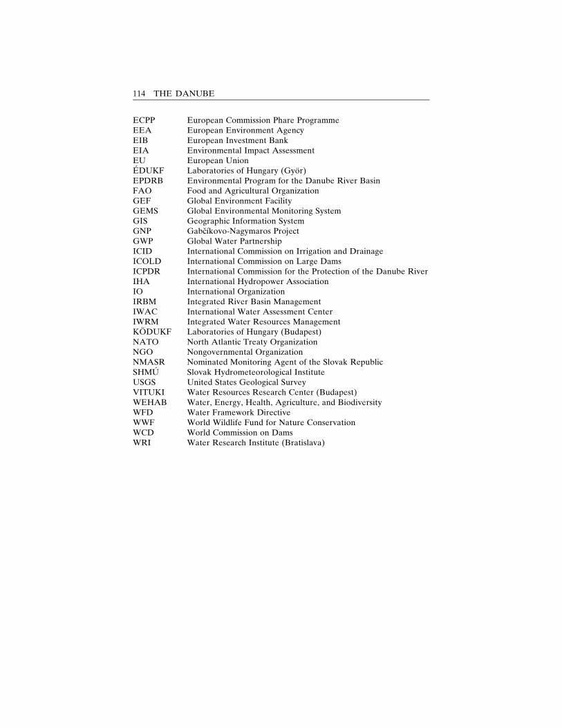
ECPP European Commission Phare ProgrammeEEA European Environment AgencyEIB European Investment BankEIA Environmental Impact AssessmentEU European UnionEDUKF Laboratories of Hungary (Gyor)EPDRB Environmental Program for the Danube River BasinFAO Food and Agricultural OrganizationGEF Global Environment FacilityGEMS Global Environmental Monitoring SystemGIS Geographic Information SystemGNP Gabcıkovo-Nagymaros ProjectGWP Global Water PartnershipICID International Commission on Irrigation and DrainageICOLD International Commission on Large DamsICPDR International Commission for the Protection of the Danube RiverIHA International Hydropower AssociationIO International OrganizationIRBM Integrated River Basin ManagementIWAC International Water Assessment CenterIWRM Integrated Water Resources ManagementKODUKF Laboratories of Hungary (Budapest)NATO North Atlantic Treaty OrganizationNGO Nongovernmental OrganizationNMASR Nominated Monitoring Agent of the Slovak RepublicSHMU Slovak Hydrometeorological InstituteUSGS United States Geological SurveyVITUKI Water Resources Research Center (Budapest)WEHAB Water, Energy, Health, Agriculture, and BiodiversityWFD Water Framework DirectiveWWF World Wildlife Fund for Nature ConservationWCD World Commission on DamsWRI Water Research Institute (Bratislava)
114 THE DANUBE
References
Abaffy, D., M. Lukac, and M. Liska (1995) Dams in Slovakia, Bratislava: TRTMedium.
Ac, P. (1995) ‘‘Adaptation of Selected Species of Birds to EnvironmentalChanges in the By-pass Canal of the Hydroelectric Power Structures Gabcı-kovo and the Adjacent Inundation of the Danube,’’ in I. Mucha (ed.) Gabcı-kovo Part of the Hydroelectric Power Project: Environmental Impact ReviewBased on Two Year Monitoring, Bratislava: Faculty of Natural Sciences, Co-menius University.
Adeel, Z. (ed.) (2003) East Asian Experience in Environmental Governance: Re-sponse in a Rapidly Developing Region, Tokyo: UNU Press.
Avenarius, A. (2000) ‘‘The Basic Problems of Slovak History and Historiogra-phy,’’ in E. Mannova (ed.) A Concise History of Slovakia, Bratislava: Histori-cky ustav SAV.
Bansky, L’. and K. Mazariova (1995) ‘‘Ground Water Regime Changes in theArea Influenced by Construction of Gabcıkovo Hydropower Structures,’’ inI. Mucha (ed.) Gabcıkovo Part of the Hydroelectric Power Project: Environ-mental Impact Review Based on Two Year Monitoring, Bratislava: Faculty ofNatural Sciences, Comenius University.
Barus, V. and O. Oliva (1992) Fauna of Czechoslovakia. Amphibia, Prague:Academia.
Beckett, P. H. T. (1997); personal communication with the authors at a meetingof the Faculty of Natural Sciences, Commenius University, Bratislava.
Bell, R. G., J. B. Stewart, and M. T. Nagy (2002) ‘‘Fostering a Culture of Envi-ronmental Compliance through Greater Public Involvement,’’ Environment, 44(8): 34–44.
115

Berczik, A. (1997) ‘‘Changes of the Hydrobiological Conditions in 1993–1994,’’ inI. Lang, I. Banczerowski, and A. Berczik (eds.) Studies on the EnvironmentalState of the Szigetkoz After the Diversion of the Danube, Budapest: MTA Szi-getkoz Bizottsag.
Bird, J. and P. Wallace (2001) ‘‘Dams and Development – an Insight into theReport of the World Commission on Dams,’’ Irrigation and Drainage, 50: 53–64.
Biswas, A. (1999) ‘‘Management of International Waters: Opportunities andConstraints,’’ Water Resources Development, 15 (4): 429–41.
Biswas, A. and J. Uitto (eds.) (2001) Sustainable Development of the Ganges-Brahmaputra-Meghna Basins, Tokyo: UNU Press.
Bocker, R., R. Grenzius, R. Planten, W. Linder, and N. Schacht (1991) ‘‘Mon-itoring fur die Naturschutzgebiete von Berlin,’’ Natur und Landschaft, 66 (9):436–37.
Bolla, S. and L. Karpati (1997) ‘‘A National Park Development from a Land-scape Conservation Area,’’ in I. Lang, I. Banczerowski, and A. Berczik (eds.)Studies on the Environmental State of the Szigetkoz After the Diversion of theDanube, Budapest: MTA Szigetkoz Bizottsag.
Braun-Blanquet, J. (1964) Pflanzensoziologie. Grundruge der Vegetationskunde(3rd Aufl.), Wien-New York: Springer Verl.
Bryson, B. (1992) ‘‘Main-Danube Canal. Linking Europe’s Waterways,’’ NationalGeographic 2 (182): 3–31.
Bublinec, E. and J. Kukla (1999) ‘‘Quality of Soil in the Gabcıkovo StructuresArea,’’ in I. Mucha (ed.) Gabcıkovo Part of the Hydroelectric Power Project:Environmental Impact Review Based on Six Year Monitoring, Bratislava: Fac-ulty of Natural Sciences, Comenius University.
Buczko, K., M. Rajczy, E. Acs, and B. Papp (1997) ‘‘Signals of Cryptograms,’’ inI. Lang, I. Banczerowski, and A. Berczik (eds.) Studies on the EnvironmentalState of the Szigetkoz After the Diversion of the Danube, Budapest: MTA Szi-getkoz Bizottsag.
Cambel, B. (1995) ‘‘The Monitoring of Anthropologically Unaffected Soils,’’ inI. Mucha (ed.) Gabcıkovo Part of the Hydroelectric Power Project: Environ-mental Impact Review Based on Two Year Monitoring, Bratislava: Faculty ofNatural Sciences, Comenius University.
Cambel, B. and B. Rovny (1991) ‘‘Concept of Monitoring the Biota in the SlovakRepublic,’’ Study Report, Institute of Zoology and Ecosozology, Slovak Acad-emy of Sciences, Bratislava.
Cambel, B., I. Matecny, and B. Rovny (1992) ‘‘Sectional Monitoring System‘Biota’,’’ Project of Monitoring Slovakia’s Biota for the Ministry of Environ-ment of the Slovak Republic, Institute of Zoology and Ecosozology, SlovakAcademy of Sciences, Bratislava.
Caponera, D. A. (1996) ‘‘Legal Aspects of the Development of the MekongBasin Area,’’ in Regional Development for the Mekong Basin, Report of theInternational Symposium, Tokyo: UNU Press.
Cerny, J. (1995) ‘‘Monitoring of Ichthyocoenoses in the Slovak Part of the DanubeInland Delta Before and After Operation Start of the Gabcıkovo BarriageSystem,’’ in I. Mucha (ed.) Gabcıkovo Part of the Hydroelectric Power Project:
116 THE DANUBE
Environmental Impact Review Based on Two Year Monitoring, Bratislava:Faculty of Natural Sciences, Comenius University.
Csoka-Szabados, I., L. Halupa, and Z. Somogyi (1997) ‘‘Study of Tree Growth inForestry Monitoring,’’ in I. Lang, I. Banczerowski and A. Berczik (eds.) Studieson the Environmental State of the Szigetkoz After the Diversion of the Danube,Budapest: MTA Szigetkoz Bizottsag.
Czabo, M., T. Simon, I. Hahn, A. Gergely, and R. Draskovits (1997) ‘‘Changes inthe Natural Vegetation in the Szigetkoz Following the Danube Diversion,’’ inI. Lang, I. Banczerowski, and A. Berczik (eds.) Studies on the EnvironmentalState of the Szigetkoz After the Diversion of the Danube, Budapest: MTA Szi-getkoz Bizottsag.
Czirak, Z. (n. d.) ‘‘State of the Environment in Hungary,’’ National Focal Point tothe CBD, Authority for Nature Conservation, Ministry of Environment, Hun-gary, available at 3http://www.grida.no/enrin/biodiv/biodiv/national/hungary/main.htm4
Danube Commission (2003) ‘‘Summary Information,’’ available at 3www.danubecom-intern.org/English/Summary.htm4
Deets, S. (1998) ‘‘Uncertainty and Political Changes in the Formation of Irrec-oncilable Symbols: the Case of the Gabcıkovo-Nagymaros Dams,’’ occasionalpaper no. 25, Harrison Program on the Future Global Agenda, University ofMaryland.
Delbaere, B. (2002) ‘‘Biodiversity Indicators and Monitoring: Moving TowardsImplementation,’’ in the proceedings of an event held at the Sixth Conferenceof the Parties of the Convention on Biological Diversity, European Center forNature Conservation, The Hague, 10 April.
Dostal, J. (1989) New Flora of Czechoslovakia (Vols. 1–2) Prague: AcademiaPraha.
Duvigneaud, P. (1988) Ecologic Synthesis, Prague: Academia.‘‘Ecological Monitoring’’ (1995), in Lithuania’s Environment. Status, Processes,
Trends, available at 3http://neris.mii.lt/aa/an95/ainf116.htm4Environmental Programme for the Danube River Basin, Task Force for the Pro-
gramme (1994) ‘‘Strategic Action Plan for the Danube River Basin 1995–2005,’’ Brussels: Author.
European Commission Phare Programme (ECPP) (1999) ‘‘Conservation andSustainable Management of Forests in Central and Eastern European Coun-tries,’’ in European Commission Phare Programme, Multi-country Report.
‘‘EU Water Framework Directive’’ (2000) (ref. o. 2000/60/EC), Official Journal ofthe European Communities (L 327): 22 December.
Fitzmaurice, J. (1996) Damming the Danube, Colorado and Oxford: WestviewPress.
Fodor, L. and F. Pal-Fam (2001) ‘‘Threatened Macromycetes Species of theSzigetkoz, Hungary,’’ in Proceedings of the Ninth International Conference ofHorticulture (Vol. 3, pp. 650–52), Lednice, Czech Republic.
Food and Agriculture Organization (FAO) (2001) ‘‘Global Forest ResourcesAssessment 2000 ; forestry paper no. 140, Rome: Author.
Frederick, J. (2002) ‘‘Dam Nation,’’ Time, 23 December.Fulajtar, E. (1995a) ‘‘Impact of the Gabcıkovo Hydropower Structures on the
REFERENCES 117
Soils and Agriculture,’’ in I. Mucha (ed.) Gabcıkovo Part of the HydroelectricPower Project: Environmental Impact Review Based on Two Year Monitoring(pp. 135–44), Bratislava: Faculty of Natural Sciences, Comenius University.
——— (1995b) ‘‘Results of Soil Monitoring at Zitny Ostrov Related to the Gab-cıkovo Water Works,’’ in Proceedings of the Second International Conferenceon Ecology of Danube (pp. 255–72), Bratislava: City University Bratislava.
Fulajtar, E., J. Curlık, G. Barancıkova, B. Sedlakova, and B. Surina (1998) Impactof the Gabcıkovo Hydropower Structure on the Agricultural Soils, Bratislava:Soil Fertility Research Institute.
Gallegos, G., E. Brandstetter, and D. MacQueen (1999) ‘‘Soil and SedimentMonitoring,’’ in Lawrence Livermore National Laboratory, EnvironmentalProtection Department, Environmental Report, University of California-U.S.Department of Energy: Author, available at 3http://www.llnl.gov/saer/saer99/saer99_home.html4
Gilyen-Hofer, A. and G. Pinter (2002) ‘‘Danube Accident Emergency WarningSystem and Its Operation in Hungary,’’ in International Congress INTER-PRAEVENT 2002 in the Pacific Rim, Protection of Habitat Against Floods,Debris Flows and Avalanches (Vol. 1, pp. 255–66) Matsumoto, Japan: Author.
Giordano, M. and A. Wolf (2002) ‘‘The World’s International FreshwaterAgreements,’’ in A. Wolf (ed.) Atlas of International Freshwater Agreements,n. p.: United Nations Environment Program.
Glasson, H., R. Therivel, and A. Chadwick (1999) Introduction to EnvironmentalImpact Assessment: Principles and Procedures, Process, Practice and Prospects(2nd ed.), London: University College London Press.
Global Environment Facility (GEF) (2002) ‘‘The Challenge of Sustainability: AnAction Agenda for the Global Environment,’’ Washington, D.C.: Author.
Global Water Partnership (GWP) (2000) ‘‘Water for the 21st Century: Vision toAction – Central and Eastern Europe,’’ in Global Water Partnership (GWP),Report of a Consultative Process, n. p.: Author.
Goldsmith, B. (ed.) (1991) Monitoring for Conservation and Ecology, London:Chapman & Hall.
Gunatilaka, A. and P. Diehl (2000) ‘‘A Brief Review of Chemical and BiologicalContinuous Monitoring of Rivers in Europe and Asia,’’ in F. M. Butterworth,A. Gunatilaka, and M. E. Gosenblatt (eds.) Biomonitors and Biomarkers asIndicators of Environmental Change (Vol. 2, pp. 9–28), New York: PlenumPress.
Hahn, I., M. Szabo, T. Simon, R. Draskovits, A. Gergely, and E. Molnar (1997)‘‘Vegetation Succession in the Exposed Danube Bed,’’ in I. Lang, I. Banczer-owski, and A. Berczik (eds.) Studies on the Environmental State of the Szi-getkoz After the Diversion of the Danube, Budapest: MTA Szigetkoz Bizottsag.
Hajduk, J. (1989) ‘‘Proposal for Developing Directives on the Establishment of aNetwork of Permanent Research Areas for Long-Term Research on Vegeta-tion,’’ Biologia 44: 883–89.
Hakka, A. and I. Lappalainen (2001) ‘‘Insights into Europe’s Forest Protection,’’report, World Wildlife Fund for Nature Conservation, Gland, Switzerland,February.
Havas-Szilagyi, E. (1998) ‘‘National Groundwater Protection Program in Hun-
118 THE DANUBE
gary,’’ paper presented at the International Conference Water and SustainableDevelopment, Paris, 19–21 March, available at 3http://www.oieau.fr/ciedd/contributions/at2/resume/rhavas.htm4
Helmer, R. (1997) ‘‘Monitoring Transboundary River Pollution,’’ EnvironmentalGovernance and Analytical Techniques: Water Pollution and Water Quality,Tokyo: UNU Press.
Hlavaty, Z. and B. Cambel (1995) ‘‘Changes in the Soil Moisture Regime in theAeration Zone After Setting the Gabcıkovo Hydroelectric Power Structuresinto Operation,’’ in I. Mucha (ed.) Gabcıkovo Part of the Hydroelectric PowerProject: Environmental Impact Review Based on Two Year Monitoring (pp. 87–118), Bratislava: Faculty of Natural Sciences, Comenius University.
Hlavaty, Z., L. Bansky, D. Rodak, and K. Kucarova (1999) ‘‘Surface Water,Ground Water, and Soil Moisture Regime,’’ in I. Mucha (ed.) Gabcıkovo Partof the Hydroelectric Power Project: Environmental Impact Review Based on SixYear Monitoring, Bratislava: Faculty of Natural Sciences, Comenius University.
Holcik, J. (1995) ‘‘Recreational Fishery Before and After Damming of the SlovakStretch of the Danube River,’’ in I. Mucha (ed.) Gabcıkovo Part of the Hydro-electric Power Project: Environmental Impact Review Based on Two YearMonitoring, Bratislava: Faculty of Natural Sciences, Comenius University.
Horvath, L. (1997) ‘‘The State of the Szigetkoz Water Systems,’’ in I. Lang,I. Banczerowski, and A. Berczik (eds.) Studies on the Environmental State ofthe Szigetkoz After the Diversion of the Danube, Budapest: MTA SzigetkozBizottsag.
Huber, S., B. Syed, A. Freudenschuß, V. Ernstsen, and P. Loveland (2001) ‘‘Pro-posal for a European Soil Monitoring and Assessment Framework,’’ technicalreport 61, European Environment Agency, Copenhagen.
Institute of Environmental Management, Szent Istvan University (2003) ‘‘Na-tional Agri-environmental Programme in Hungary,’’ Godollo, Hungary: Au-thor, available at 3http://www.ktg.gau.hu/uj/en/nakp_en.html4
International Association for Danube Research (IAD) (2002) ‘‘IAD BasemapsDanube Basin,’’ International Association for Danube Research, available at3http://www.iad.gs4
International Commission for the Protection of the Danube River (ICPDR)(2000) ‘‘Joint Action Programme for the Danube River Basin: January 2001–December 2005,’’ Vienna: Author.
——— (2003) ‘‘History,’’ International Commission for the Protection of theDanube River, available at 3http://www.icpdr.org4
International Court of Justice (ICJ) (1997) Case Concerning Gabcıkovo-Nagymaros Project (Hungary/Slovakia): Summary of the Judgment of 25 Sep-tember, available at 3http://www.icj-cij.org4
——— (1998a) Case Concerning Gabcıkovo-Nagymaros Project (Hungary/Slovakia): Slovakia Requests an Additional Judgment, 3 September, availableat 3http://www.icj-cij.org4
——— (1998b) Case Concerning Gabcıkovo-Nagymaros Project (Hungary/Slovakia): Hungary Is to File by 7 December 1998 a Written Statement of ItsPosition on Slovakia’s Request for an Additional Judgment, 7 October, avail-able at 3http://www.icj-cij.org4
REFERENCES 119
International Water Assessment Center (IWAC) (2002) ‘‘Assessment Practicesand Environmental Status of Ten Transboundary Rivers in Europe,’’ Lelystad,Netherlands: Author, available at 3http://www.iwac-riza.org/frontpage.htm4
Janauer, G. (2002, October) ‘‘Multifunctional Integrated Study Danube: Corridorand Catchment – MICCC,’’ Danube News.
Jansky, L. (1994, September 11) ‘‘Renewed Co-operation on the Danube River:The Problem of the Gabcıkovo-Nagymaros Barrier System’’ (in Japanese),Tokyo Shimbun.
——— (2001) ‘‘The River Danube: Needs for Integrated River Management,’’ inL. Jansky, M. Nakayama, and J. Uitto (eds.) Lakes and Reservoirs as Inter-national Water Systems: Towards World Lake Vision, Tokyo: UNU.
Joint Annual Reports (1996); (1997); (1998); (1999); (2000); (2001); producedaccording to the ‘‘Agreement between the Government of the Slovak Republicand the Government of Hungary about Certain Temporary Measures and Dis-charges to the Danube and Mosoni Danube, 19 April 1995.’’
Kirka, A. (1995) ‘‘Comment on the Ichthyofauna and Fisheries of the Danube,’’in I. Mucha (ed.) Gabcıkovo Part of the Hydroelectric Power Project: Environ-mental Impact Review Based on Two Year Monitoring, Bratislava: Faculty ofNatural Sciences, Comenius University.
Kl’ucovska, J. and J. Topol’ska (1995) ‘‘Water Level Regime in the DanubeRiver and Its River Branches,’’ in I. Mucha (ed.) Gabcıkovo Part of theHydroelectric Power Project: Environmental Impact Review Based on Two YearMonitoring (pp. 33–42), Bratislava: Faculty of Natural Sciences, ComeniusUniversity.
Kocinger, D. (1998) ‘‘The Gabcıkovo-Nagymaros Hydropower System and theSlovak Government,’’ in A. Vlavianos-Arvanitis and J. Morovic (eds.) Bio-politics: Danube River Bonds: Bio-environment and Bio-culture (Vol. 6),Athens: Biopolitics International Organization.
Koltai, G. (1997) ‘‘Natural Values of the Szigetkoz Land Conservation District,’’in I. Lang, I. Banczerowski, and A. Berczik (eds.) Studies on the EnvironmentalState of the Szigetkoz After the Diversion of the Danube, Budapest: MTASzigetkoz Bizottsag.
Koren, M. et al. (1992) Project of Monitoring the Geographic Environment ofthe Tatra National Park, Research Station of the TANAP Administration,Tatranska Lomnica.
Kovac, V. (1994) ‘‘Updated Red List of Slovak Fish and Cyclostomes,’’ in Pro-ceedings on Biodiversity Protection in Slovakia (pp. 153–58, in Slovak), Bra-tislava: Faculty of Natural Sciences, Comenius University.
Kovacovsky, P. and I. Rychlık (1995) ‘‘Bird Population and Their Adaptation toEnvironmental Changes in the Area of the Hydroelectric Power Structures atGabcıkovo,’’ in I. Mucha (ed.) Gabcıkovo Part of the Hydroelectric PowerProject: Environmental Impact Review Based on Two Year Monitoring, Bra-tislava: Faculty of Natural Sciences, Comenius University.
Kristensen, P. and H. O. Hansen (eds.) (1994) ‘‘European Rivers and Lakes: AnAssessment of Their Environmental State,’’ Environmental Monographs, no. 1,Copenhagen: European Environment Agency.
Krno, I. et al. (1999) ‘‘Development of the Zoobenthos in the Slovak Danube
120 THE DANUBE
Inundation Area after the Gabcıkovo Hydropower Structures Began Operat-ing,’’ in I. Mucha (ed.) Gabcıkovo Part of the Hydroelectric Power Project: En-vironmental Impact Review Based on Six Year Monitoring, Bratislava: Facultyof Natural Sciences, Comenius University.
Lang, I., I. Banczerowski, and A. Berczik (eds.) (1997) Studies on the Environ-mental State of the Szigetkoz After the Diversion of the Danube, Budapest:MTA Szigetkoz Bizottsag.
Lapin, M. (1995) ‘‘Climatological Monitoring of the Territory Affected by Con-struction of the Danube Hydroelectric Power Project and Evaluation of InitialImpact,’’ in I. Mucha (ed.) Gabcıkovo Part of the Hydroelectric Power Project:Environmental Impact Review Based on Two Year Monitoring (pp. 15–22),Bratislava: Faculty of Natural Sciences, Comenius University.
Laszlo, F. (1997) ‘‘Study of Groundwater Quality in the Szigetkoz,’’ in I. Lang,I. Banczerowski, and A. Berczik (eds.) Studies on the Environmental State ofthe Szigetkoz After the Diversion of the Danube, Budapest: MTA SzigetkozBizottsag.
Laszlo, S. and F. Pal-Fam (2001) ‘‘Mycocoenological Characterization of WoodyHabitats in Szigetkoz, Danube Valley, Hungary, in P. Salas (ed.) Proceedingsof Ninth International Conference of Horticulture (Vol. 3, pp. 585–88), Lednice,Czech Republic: Mendel University of Agriculture and Forestry BRNO, Facultyof Horticulture.
Lejon, E. (1996) Gabcıkovo-Nagymaros: Old and New Sins, Bratislava: H&H.Liebe, P. (1997) ‘‘Hydrological Changes in the Szigetkoz,’’ in I. Lang, I. Banc-
zerowski, and A. Berczik (eds.) Studies on the Environmental State of the Szi-getkoz After the Diversion of the Danube, Budapest: MTA Szigetkoz Bizottsag.
Lipschutz, R. (2000) ‘‘Damming Troubled Waters: Conflict Over the Danube,1950–2000,’’ Intermarium, 1 (2).
Lisicky, M. J. (2000) ‘‘Biodiversity Monitoring Questionnaire Evaluation,’’ inPhare Topic Link on Nature Conservation, Strengthening Capacity in the PhareAccession Countries in Environmental Reporting, available at 3www.uke.sav.sk/ptl-nc/BiodivMon.html4
Lisicky, M. J., B. Cambel, T. Cejka, E. Haviernikova, I. Matecny, P. Pisut, B.Rovny, and E. Uhercıkova (1991) ‘‘A Report on the Initial (So-Called Zero)State of the Geographic Environment of the Gabcıkovo-Nagymaros WaterWorks System, Gabcıkovo Stage from the Viewpoint of Biology and LandscapeEcology,’’ Bratislava: Institute of Zoology and Ecosozology, Slovak Academyof Sciences.
Lozek, V. (1956) Key of Czechoslovak Mollusca, Bratislava: Slovak Academy ofSciences Publishing House.
Maglocky, S. (1983) ‘‘A List of Extinct, Endemic and Endangered Taxones ofSlovakia’s Flora,’’ Biologia 38 (9): 825–52.
Makovinska, J. (1999) ‘‘The Danube Water Quality between Bratislava andVisegrad (1989–1997),’’ in I. Mucha (ed.) Gabcıkovo Part of the HydroelectricPower Project: Environmental Impact Review Based on Six Year Monitoring,Bratislava: Faculty of Natural Sciences, Comenius University.
Makovinska, J., E. Elexova, A. Shearman, and F. Laszlo (2001) ‘‘A Long-termWater Quality Monitoring of the Slovak-Hungarian Transboundary Water-
REFERENCES 121
courses,’’ paper presented at a Symposium on Surface Water and GroundwaterQuality, organized by the Internationale Arbeitsgemeinschaft der Wasserwerkeim Donaueinzugsgebiet, at the Water Research Institute Bratislava, Siofok,Hungary, 2–4 October.
Makovinska, J. and F. Hindak (1999) ‘‘Phytoplankton in the River Danube be-tween Bratislava and Visegrad in 1990–1997, in I. Mucha (ed.) Gabcıkovo Partof the Hydroelectric Power Project: Environmental Impact Review Based on SixYear Monitoring, Bratislava: Faculty of Natural Sciences, Comenius University.
Margesson, R. (1997) ‘‘Reducing Conflict over the Danube Waters: EquitableUtilisation and Sustainable Development,’’ Natural Resources Forum 1 (21):23–38.
Matecny, I. (1996b) ‘‘The Geographic Information System to Monitor the Biotaas Part of Assessing the Gabcıkovo Water Works’ Impact on the GeographicEnvironment,’’ Bratislava: Faculty of Natural Sciences, Comenius University.
Matecny, I., B. Cambel, M. J. Lisicky, B. Rovny, E. Uhercıkova, T. Cejka, and P.Pisut (1993) ‘‘A Report of the Biota Expert Group on the Results of Monitor-ing the Environment Affected by the Gabcıkovo Waterworks Construction andOperation in 1992,’’ Bratislava: Department of the Institute of Zoology andEcosozology, Slovak Academy of Sciences.
——— (1994) ‘‘Monitoring the Environment Affected by the Gabcıkovo Water-works Construction and Operation – ‘Biota’ Expert Group 1993 Report,’’ Bra-tislava: Department of the Faculty of Natural Sciences, Comenius University.
——— (1995a) ‘‘Monitoring the Environment Affected by the Gabcıkovo Water-works Construction and Operation – ‘Biota’ Expert Group 1994 Report,’’ Bra-tislava: Department of the Faculty of Natural Sciences, Comenius University.
——— (1996a) ‘‘Monitoring the Environment Affected by the Gabcıkovo Water-works Construction and Operation – ‘Biota’ Expert Group 1995 Report,’’ Bra-tislava: Department of the Faculty of Natural Sciences, Comenius University.
——— (1997) ‘‘Monitoring the Environment Affected by the Gabcıkovo Water-works Construction and Operation – ‘Biota’ Expert Group 1996 Report,’’ Bra-tislava: Department of the Faculty of Natural Sciences, Comenius University.
Matecny, I., J. Molnar, J. Oszlanyi, S. Rehak, and J. Sutor (1995b) OptimizingMonitoring of the Geographic Environment Affected by the Gabcıkovo Water-works Construction and Operation, Bratislava: Slovak HydrometeorologicalInstitute.
Meszaros, F. and O. Bertalan (1997) ‘‘Zoological Monitoring in the Szigetkoz(1994),’’ in I. Lang, I. Banczerowski, and A. Berczik (eds.) Studies on the En-vironmental State of the Szigetkoz After the Diversion of the Danube, Budapest:MTA Szigetkoz Bizottsag.
Minarik, B. (2003, February 7); personal communication with authors.Ministry of the Environment of the Slovak Republic (2000) ‘‘National ISPAStrategy of the Slovak Republic: Environment,’’ Bratislava: Author.
Ministry of Foreign Affairs of Sweden (2001) ‘‘Development Financing 2000:Transboundary Water Management as an International Public Good,’’ Study2001 1.
Molnar, L’. (ed.) (1995) Optimalisation of the Territorial Monitoring Influenced by
122 THE DANUBE
the Gabcıkovo Waterworks: Land and Agriculture, Forests, Biota, Water in theUnsaturated Zone, Bratislava: Slovak Academy of Sciences.
Mucha, I. (ed.) (1995) Gabcıkovo Part of the Hydroelectric Power Project: Envi-ronmental Impact Review Based on Two Year Monitoring, Bratislava: Facultyof Natural Sciences, Comenius University.
——— (1999) Gabcıkovo Part of the Hydroelectric Power Project: EnvironmentalImpact Review Based on Six Year Monitoring, Bratislava: Faculty of NaturalSciences, Comenius University.
Munn, R. (1973) Global Environmental Monitoring System (GEMS): Scope Re-port 3, Paris: International Council of Scientific Unions (ICSU)-Scope.
Murakami, A. (2003, March 22) ‘‘Committee to Review Nation’s Dams,’’ JapanTimes.
Murakami, M. (1996) Managing Water for Peace in the Middle East: AlternativeStrategies, Tokyo: UNU Press.
Murakami M. and L. Jansky (2002) ‘‘The Danube River, Conflict and Compro-mise – Damming or Removing the Dams,’’ Journal of Japanese Society of Shi-manto Policy and Integrated River Basin Management 1 (1): 55–66.
Murphy, I. (1997) Protecting Danube River Basin Resources: Ensuring Access toWater Quality Data and Information, Dodrecht: Kulwer Academic Publishers.
Nakayama, M. (1996) ‘‘Role of the World Bank in the Negotiation Process ofthe Indus Water Treaty,’’ Journal of Japan Society of Hydrology and WaterResources 9 (1): 77–87 (in Japanese).
——— (1997) ‘‘Successes and Failures of International Organizations in Dealingwith International Waters,’’ International Journal of Water Resources Develop-ment 13 (3): 367–82.
——— (1998a) ‘‘Possible Role of International Organizations in Management ofWater Resources and Abatement of Conflict in International Water Systems,’’Journal of Japan Society of Hydrology and Water Resources 11 (7): 723–31 (inJapanese).
——— (1998b) ‘‘Post-project Review on Environmental Impact AssessmentMethodology Applied for Saguling Dam for Involuntary Resettlement,’’ Inter-national Journal of Water Resources Development 14 (2): 217–29.
Nemesi, L. and M. Pattantyus-Abraham (1997) ‘‘Damage to Buildings in theSzigetkoz after the Diversion of the Danube,’’ in I. Lang, I. Banczerowski, andA. Berczik (eds.) Studies on the Environmental State of the Szigetkoz After theDiversion of the Danube, Budapest: MTA Szigetkoz Bizottsag.
Nominated Monitoring Agent of the Slovak Republic (NMASR) (2001) Gabcı-kovo Part of the Gabcıkovo-Nagymaros Hydropower Project and Joint Slovak-Hungarian Monitoring of Environmental Impact, Bratislava: Plenipotentiaryof the Slovak Republic for Construction and Operation of the Gabcıkovo-Nagymaros Hydropower Scheme.
Odum, E. P. (1971) Fundamentals of Ecology (3rd ed.), Philadelphia, London,Toronto: W. B. Saunders.
Oszlanyi, J. (1995) ‘‘Structure of Forest Ecosystems and Leaf Area Index ofWood Plants – Results of Monitoring over the Years 1991–1994,’’ in I. Mucha(ed.) Gabcıkovo Part of the Hydroelectric Power Project: Environmental Impact
REFERENCES 123
Review Based on Two Year Monitoring (pp. 161–64), Bratislava: Faculty ofNatural Sciences, Comenius University.
——— (1999) ‘‘Dynamics of Leaf Area Index in the Forest Ecosystems of theDanube Floodplain in the Period of 1988–1999,’’ in I. Mucha (ed.) GabcıkovoPart of the Hydroelectric Power Project: Environmental Impact Review Basedon Six Year Monitoring, Bratislava: Faculty of Natural Sciences, ComeniusUniversity.
Palkovits, G. (1997) ‘‘Agricultural Surveys and Their Results,’’ in I. Lang,I. Banczerowski, and A. Berczik (eds.) Studies on the Environmental State ofthe Szigetkoz After the Diversion of the Danube, Budapest: MTA SzigetkozBizottsag.
‘‘Pan-European Biological and Landscape Diversity and Strategy’’ (2002) SecondIntergovernmental Conference on Biological Diversity, Sixth Meeting of theCouncil for Pan-European Biological and Landscape Diversity Strategy,Budapest, 24–28 February.
Perry, J. and E. Vanderklein (1996) Water Quality: Management of a Natural Re-source, Cambridge: Backwell Science, 1996.
Pilous, Z. and J. Duda (1960) Key to Determining Mosses of Czechoslovakia,Praha: Czechoslovak Academy of Sciences Publishing House.
Pisut, I. (1985) ‘‘A List of Extinct, Missing and Endangered Lichens in Slovakia,’’1st version manuscript.
Plenipotentiary of the Slovak Republic for the Construction and Operation of theGabcıkovo-Nagymaros Hydropower Scheme (1993) ‘‘Special Agreement forSubmission to the International Court of Justice of the Differences betweenthe Republic of Hungary and the Slovak Republic Concerning the Gabcıkovo-Nagymaros Project – Jointly Notified to the Court on 2 July 1993.’’
——— (1995) ‘‘Agreement between the Government of the Slovak Republic andGovernment of Hungary about Certain Temporary Measures and Dischargesto the Danube and Mosoni Danube, Signed on 19 April 1995.’’
——— (2003) Minutes from the Meetings of the Working Group on Legal Mattersof the Delegations of the Government of the Slovak Republic and the Gov-ernment of the Republic of Hungary on the Implementation of the Judgmentof the International Court of Justice in the Case Concerning the Gabcıkovo-Nagymaros Project, available at 3http://www.gabcikovo.gov.sk/rokovania.htm4
——— (2003) ‘‘Negotiations of Governmental Delegations of the Slovak Repub-lic and the Republic of Hungary about the Ways of Realizing the Judgementof the International Court of Justice on 25 September 1997 Concerning theGabcikovo-Nagymaros Water Works’’: Author, available at 3http://www.gabcikovo.gov.sk/rokovania.htm4
Refsgaard, J. and H. Soerensen (1997) ‘‘The Danubian Lowland Ground WaterModel: Part 1 – Establishment of an Integrated Modelling System for Model-ling the Hydrological and Ecological Impacts of the Gabcıkovo HydropowerPlant,’’ Horsholm, Denmark: Danish Hydraulic Institute.
Regional Environmental Center for Central and Eastern Europe (2003) ‘‘Envi-ronmental Programme for the Danube River Basin,’’ available at 3http://www.rec.org/DanubePCU/index.html4
124 THE DANUBE
Revenga, C., S. Murray, J. Abramovitz, and A. Hammonds (1998) ‘‘Watershedsof the World. Ecological Value and Vulnerability,’’ Washington, D.C.: WorldResources Institute and Worldwatch Institute.
Rodak, D. and L. Bansky (1995) ‘‘Changes in the Ground Water Regime on theRight Side of the Danube after Setting the Gabcıkovo Hydropower Structuresinto Operation,’’ in I. Mucha (ed.) Gabcıkovo Part of the Hydroelectric PowerProject: Environmental Impact Review Based on Two Year Monitoring (pp. 57–64), Bratislava: Faculty of Natural Sciences, Comenius University.
Rodak, D. and I. Mucha (1995) ‘‘Current Activities in the Groundwater QualityMonitoring – Monitoring Wells, Methods of Sampling, in Situ Measurements,’’in I. Mucha (ed.) Gabcıkovo Part of the Hydroelectric Power Project: Environ-mental Impact Review Based on Two Year Monitoring, Bratislava: Faculty ofNatural Sciences, Comenius University.
Rovny, B. et al. (1992) ‘‘Monitoring of the Geographic Environment Affectedby the Gabcıkovo Waterworks Construction and Operation – ‘Biota’ ExpertGroup 1991 Report,’’ Bratislava: Institute of Zoology and Ecosozology, SlovakAcademy of Sciences.
Sands, P. (1998) ‘‘Watercourses, Environment and the International Court ofJustice: The Gabcıkovo-Nagymaros Case,’’ in S. Salman and L. Chazournes(eds.) International Watercourses: Enhancing Cooperation and Managing Con-flict, proceedings of a World Bank seminar, technical paper no. 414, Washing-ton, D.C.: The World Bank.
Secretariat of the United Nations Commission for Europe (1994) ‘‘Protection andUse of Transboundary Watercourses and International Lakes in Europe,’’Natural Resources Forum 18 (3): 171–80.
Serageldin, I. (1995) ‘‘Managing Global Water Resources Sustainability: A WorldBank Perspective,’’ available at 3http://www.serageldin.com/speeches/Fintimes.htm4
Shmueli, D. (1999) ‘‘Water Quality in International River Basins,’’ PoliticalGeography 18: 437–76.
Skapec, L. (1992) The Red Book of Endangered and Rare Plant and Animal Spe-cies of the Czechoslovakia. Invertebrates, Bratislava: Prıroda.
Slovak Environmental Agency (2003) ‘‘Components of the Environment andTheir Protection. Water. Groundwater,’’ available at 3http://www.sazp.sk/slovak/periodika/spravka/spravka2000eng/components/water_groundwater.html4
Slovak Hydrometeorological Institute (2003) History of the Slovak Hydrometeo-rological Institute, available at 3http://www.shmu.sk4
Smelko, S. (1999) ‘‘Tree Species Diameter Growth and Increment in the Gabcı-kovo Adjacement Forest Stands,’’ in I. Mucha (ed.) Gabcıkovo Part of theHydroelectric Power Project: Environmental Impact Review Based on Six YearMonitoring, Bratislava: Faculty of Natural Sciences, Comenius University.
Soltesz, A. et al. (1994) ‘‘Project on Environmental Monitoring of the TerritoryAffected by the Construction of the Gabcıkovo Water Engineering Structures,’’in Faculty of Civil Engineering, Slovak Technical University, Investigation Re-port, Bratislava: Author.
Somlyody, L., P. H. Brunner, R. Fenz, H. Kroiß, Ch. Lampert, and M. Zessner
REFERENCES 125
(1997) ‘‘Nutrient Balances for Danube Countries,’’ Environmental Programmefor the Danube River Basin,’’ available at 3http://www.iwa.tuwien.ac.at/htmd2264/publikat/publis/danube.htm4
Somsak, L. (1999) ‘‘Flora and Vegetation Conditions in Floodplain Ecosystems,’’in I. Mucha (ed.) Gabcıkovo Part of the Hydroelectric Power Project: Environ-mental Impact Review Based on Six Year Monitoring, Bratislava: Faculty ofNatural Sciences, Comenius University.
Somsak, L., M. Gazdık, and A. Jankovicova (1995) ‘‘Dendroecology of SelectedFloodplain Trees of the Danubian Lowland,’’ in I. Mucha (ed.) Gabcıkovo Partof the Hydroelectric Power Project: Environmental Impact Review Based onTwo Year Monitoring (pp. 155–60), Bratislava: Faculty of Natural Sciences,Comenius University.
Somsak, L. and F. Kubıcek (1995) ‘‘Genesis of Flora and Vegetation of theDanube Lowland in Relation to the Hydroelectric Power Structures Gabcıkovo-Nagymaros,’’ in I. Mucha (ed.) Gabcıkovo Part of the Hydroelectric PowerProject: Environmental Impact Review Based on Two Year Monitoring, Bra-tislava: Faculty of Natural Sciences, Comenius University.
South Carolina Department of Health and Environmental Control (2001)‘‘Drinking Water: Common Water Quality Problems and Their Treatment,’’ML-019012 PC, May, available at 3http://www.scdhec.net/water/pubs/ml019012.pdf4
Starosolszky, C. (1998) ‘‘Setting Up, Maintenance and Operation of MonitoringNetworks,’’ paper presented at an International Conference, ‘‘Water and Sus-tainable Development,’’ held in Paris, 19–21 March, available at 3http://www.oieau.fr/ciedd/contributions/at1/contribution/starosol.htm4
Stepanovicova, O. (1995) ‘‘Review of Zoological Research in the DanubianLowland (Terrestrial Animals),’’ in I. Mucha (ed.) Gabcıkovo Part of the Hy-droelectric Power Project: Environmental Impact Review Based on Two YearMonitoring, Bratislava: Faculty of Natural Sciences, Comenius University.
Sukosd, M. (1998) ‘‘The Gabcıkovo-Ngymaros Dam: Social, Political and Cul-tural Conflicts,’’ in A. Vlavianos-Arvanitis and J. Morovic (eds.) Biopolitics:The Bio-Environment, Bratislava: Biopolitics International Organization.
Sutor, J. (1995) ‘‘Influence of Gabcıkovo Hydropower Structures on the Dynam-ics of Water in the Aeration Zone,’’ in I. Mucha (ed.) Gabcıkovo Part of theHydroelectric Power Project: Environmental Impact Review Based on Two YearMonitoring (pp. 123–34), Bratislava: Faculty of Natural Sciences, ComeniusUniversity.
Szabo, M., T. Simon, I. Hahn, A. Gergely, and R. Draskovits (1997) ‘‘Changes inthe Natural Vegetation of the Szigetkoz Following the Danube Diversion,’’ inI. Lang, I. Banczerowski, and A. Berczik (eds.) Studies on the EnvironmentalState of the Szigetkoz After the Diversion of the Danube, Budapest: MTA Szi-getkoz Bizottsag.
Szaby, M., T. Simon, and I. Hahn (1995) ‘‘New Results of the Botanical Mon-itoring,’’ Budapest: Department of Plant Taxonomy and Ecology, EotvosLorand University, available at 3www.ace.hu/danube_dg/szakert/E_MTA1995/e5szabo.htm4
Szerenyi, M., E. Kovacs, S. Kerekes, and M. Kek (2002) ‘‘Loss of Value of the
126 THE DANUBE
Szeigetkoz Wetland Due to the Gabcıkovo-Nagymaros Barrage System Devel-opment: Application of Benefit Transfer in Hungary,’’ a national case study onHungary contributed to the OECD Applied Evaluation of Biodiversity Projectof the Working Group on Economic Aspects of Biodiversity, no. JTOO120895,OECD, 15 February.
Thornton, S., D. Lerner, and R. Davidson (2002) ‘‘Groundwater Monitoring,’’in A. El-Shaarawi and W. Piegorsch (eds.) Encyclopedia of Environmetrics(Vol. 2), Chichester: John Wiley & Sons, Ltd.
Topol’ska, J. and J. Kl’ucovska (1995) ‘‘River Morphology,’’ in I. Mucha (ed.)Gabcıkovo Part of the Hydroelectric Power Project: Environmental Impact Re-view Based on Two Year Monitoring (pp. 23–32), Bratislava: Faculty of NaturalSciences, Comenius University.
Torok, K. and L. Fodor (2003) ‘‘Hungarian Biodiversity Monitoring Sys-tem (HBMS),’’ Budapest: Ministry of Environment, Authority for NatureConservation, Institute for Environmental Management, Service for NatureConservation, available at 3www.grida.no/enrin/biodiv/national/hungary/monitor.htm4 and at 3www.krnap.cz/krnap/aktivity/oi/workshop/monitwrksh/presentations/torok.html4
Uitto, J. and A. Wolf (2002) ‘‘Water Wars? Geographical Perspectives,’’ TheGeographical Journal 168 (4): 289–92.
United Nations Development Programme/Global Environment Facility (UNDP/GEF) (1999) ‘‘Development of a Danube Information System for the Inter-national Commission for the Protection of the Danube River,’’ in Danube Pol-lution Reduction Programme, Overview Report, Vienna: International Societyfor Environmental Protection.
United Nations Economic Commission for Europe (UNECE) (1994) ‘‘Protectionand Use of Transboundary Watercourses and International Lakes in Europe,’’Natural Resources Forum 18 (3): 171–80.
United Nations Educational, Scientific, and Cultural Organization (UNESCO)(2001) ‘‘From Potential Conflict to Co-operation Potential: Project Documentand Rolling Work Plan. Resolution of Water-Related Conflicts within In-tegrated Water Resources Management, World Water Assessment Pro-gramme,’’ Paris: Author.
United Nations Environment Program (UNEP) (2002) Global EnvironmentalOutlook, London: Earthscan Publications.
United Nations Treaty Series (1978) ‘‘Treaty Concerning the Construction andOperation of the Gabcıkovo-Nagymaros System of Locks, Signed at Budapeston 16 September 1977 by Hungary and Czechoslovakia,’’ treaty no. 17134, inTreaty Series: Treaties and International Agreements Registered or Filed andRecorded with the Secretariat of the United Nations 1109 (1): 17124–42.
United States Geological Survey (USGS) Patuxent Wildlife Research Center,‘‘Power Analysis of Monitoring Programmes’’ (1999), available at 3http://www.mp2-pwrc.usgs.gov/powcase/4
Valtyni, J. (1993) ‘‘The Influence of the Gabcıkovo Water Works on FloodplainForests,’’ Urbanita 74: 74–76.
——— (1994) ‘‘Assumed Development of Danubian Floodplain Forest Hithertoand After Influenced by the Gabcıkovo Water Works,’’ in City University
REFERENCES 127
Bratislava, Proceedings of the International Conference on Danube Ecology(pp. 151–55), Bratislava: Author.
Varga, F. (1997) ‘‘Health Condition of Forests in the Szigetkoz,’’ in I. Lang,I. Banczerowski, and A. Berczik (eds.) Studies on the Environmental State ofthe Szigetkoz After the Diversion of the Danube, Budapest: MTA SzigetkozBizottsag.
Vavrova, M. (1995) ‘‘Groundwater Quality on the Left Side of the Danube Riverat the Waterworks Kalinkovo, Samorın and Gabcıkovo,’’ in I. Mucha (ed.)Gabcıkovo Part of the Hydroelectric Power Project: Environmental Impact Re-view Based on Two Year Monitoring (pp. 65–70), Bratislava: Faculty of NaturalSciences, Comenius University.
Vranovsky, M. and M. Illyova (1999) ‘‘Zooplankton in the Danube and its LeftSide Arm System,’’ in I. Mucha (ed.) Gabcıkovo Part of the HydroelectricPower Project: Environmental Impact Review Based on Six Year Monitoring,Bratislava: Faculty of Natural Sciences, Comenius University.
WEHAB Working Group (2002) ‘‘A Framework for Action on Biodiversityand Ecosystem Management,’’ World Summit on Sustainable Development,Johannesburg, August.
——— (2002) ‘‘A Framework for Action on Water and Sanitation,’’ World Sum-mit on Sustainable Development, Johannesburg, August.
Wessel, J. (1993) ‘‘Pathways of Co-operation for Riparian Countries in theDanube Basin,’’ in House of Technique, Slovak Scientific-Technical Union,Proceedings from the International Conference on the Danube – the Vein ofEurope (pp. 3–8), Bratislava: Author.
Wetlands International (2002, October 30) ‘‘European Wetland Inventory Re-view: Hungary,’’ available at 3www.wetlands.org/inventory&/pewi/countries/Hungary.htm4
Wolf, A. (ed.) (2002) Atlas of International Freshwater Agreements, Nairobi,Kenya: United Nations Environment Program.
World Commission on Dams (WCD) (2000) Dams and Development: A NewFramework for Decision-Making, London: Earthscan Publications.
——— (2001) Dams and Development: Reactions to the Final Report of the WorldCommission on Dams, available at 3www.dams.org/report/reaction/4
World Lake Vision Committee: The International Lake Environment Foundationand United Nations Environment Programme (2003) ‘‘World Lake Vision – aCall to Action’’ (p. 36): Author, available at 3http://www.ilec.or.jp/wwf/eng4
World Water Development Report (WWDR) (2003) ‘‘Water for People, Waterfor Life,’’ Paris and Oxford: UNESCO and Berghan Books.
Zapletal, S. and J. Dudık (1991) ‘‘Monitoring the State of Forests of the SlovakRepublic – Methodology,’’ Zvolen: Lesoprojekt Zvolen.
128 THE DANUBE
Glossary
aeration zone – That portion of thelithosphere in which the functionalinterstices of permeable rock orearth are not (except temporarily)filled with water under hydrostaticpressure.
abiotic – Nonliving.
advection – The usually horizontalmovement of a mass of fluid.
allochtonous – Of nonlocal origin,introduced.
alluvial fan – The alluvial deposit of astream where it issues from a gorgeupon a plain or of a tributary streamat its junction with the main stream.
amphibian – Of a class of cold-blooded vertebrates intermediatebetween fishes and reptiles andhaving gilled aquatic larvae andair-breathing adults.
aquifer – A water-bearing stratum ofpermeable rock, sand, or gravel.
aquitard – A water-saturated sedimentor rock whose permeability is so lowit cannot transmit any useful amountof water.
autocorrelation – The correlationbetween paired values of a functionof a mathematical or statisticalvariable taken at usually constantintervals that indicates the degree ofperiodicity of the function.
basin – Catchment area.
benthos – Organisms that live on or inthe bottom of a body of water.
biological diversity – The number andabundance of species found within acommon environment. This includesthe variety of genes, species,ecosystems, and the ecologicalprocesses that connect everything ina common environment.
biomass – The total weight of all livingorganisms in a biologicalcommunity.
129
biota – Plant and animal life of aparticular region.
biotope – A region uniform inenvironmental conditions and in thepopulations of animals and plantsinhabiting it.
biotype – The organisms sharing aspecified genotype.
canopy – The part of any stand oftrees represented by the treecrowns. It usually refers to theuppermost layer of foliage, but itcan be used to describe lower layersin a multistoried forest.
capillarity – The effect of surfacetension in drawing water up intonarrow pores (against gravity).
capillary fringe – The water heldabove the atmospheric pressuresurface by the capillarity, but notincluding the specific retention.
cover type (forest cover type) – Standsof a particular vegetation type thatare composed of similar species.
crustacean – Any of a large class ofmostly aquatic organisms that havea chitinous or calcareous andchitinous exoskeleton, a pair ofoften much modified appendageson each segment, and two pairs ofantennae and that include thelobsters, shrimps, crabs, wood lice,water fleas, and barnacles.
cryptogams – A plant (such as a fern,moss, alga, or fungus) reproducingby spores and not producing flowersor seed.
dendrochronology – The science ofdating events and variations in theenvironment in former periods bycomparative study of growth rings intrees and aged wood.
dendrology – The study of trees.
ecology – The interrelationships ofliving organisms to one another andto their environment, or the branchof science concerned with them.
ecophysiology – The science of theinterrelationships between thephysiology of organisms and theirenvironment.
ecosystem – The complex of acommunity of organisms and itsenvironment functioning as anecological unit.
endemic – Characteristic of orprevalent in a particular field, area,or environment; restricted orpeculiar to a locality or region.
Environmental Impact Assessment –A statement of environmentaleffects of a proposed action andalternatives to it.
eolian – Borne, deposited, produced,or eroded by the wind.
erosion – The wearing away of landsurface by wind or water.
eutrophication – The process by whicha body of water becomes enrichedin dissolved nutrients that stimulatethe growth of aquatic plant life,usually resulting in the depletion ofdissolved oxygen.
evapotranspiration – Loss of waterfrom the soil both by evaporationand by transpiration from the plantsgrowing thereon.
fluvial – Of, relating to, or living in astream or river; produced by theaction of a stream.
fauna – Animal life, the animalscharacteristic of a region, period, orspecial environment.
130 THE DANUBE
felling – Cutting down trees.
floodplain – Level land that may besubmerged by floodwaters; a plainbuilt up by stream deposition.
flora – Plant or bacterial lifecharacteristic of a region, period, orspecial environment.
forest health – A measure of therobustness of forest ecosystems.Aspects of forest health includebiological diversity; soil, air, waterproductivity, natural disturbances;and the capacity of the forest toprovide a sustaining flow of goodsand services for people.
geomorphology – A science that dealswith the relief features of the earthor of another celestial body andseeks a genetic interpretation ofthem.
Geographic Information Systems(GIS) – A database designed tohandle geographic data and a set ofcomputer operations that can beused to analyze the data.
groundwater – Water stored in theopen spaces within undergroundrocks and unconsolidated material.
habitat – The area where a plant oranimal lives and grows undernatural conditions.
hydraulic – Operated, moved, oreffected by means of water.
hydraulic conductivity – A measure ofthe ease of flow through aquifermaterial.
hydraulic gradient – In channel flow,the mean surface gradient; inunconfined groundwater, the meanwater table gradient in the directionof the flow; in confined aquifers, the
pressure gradient in the direction ofthe flow.
hydrology – The science dealing withthe properties, distribution, andcirculation of water on and belowthe earth’s surface and in theatmosphere.
hydrolysis – The chemical process ofdecomposition involving thesplitting of a bond and the additionof the hydrogen cation and thehydroxide anion of water.
hygrophilous – Living or growing inmoist places.
hygroscopic – Readily taking up andretaining moisture; taken up andretained under certain conditions ofhumidity and temperature.
hydrostatic pressure – The pressure,expressed as a total of quantity orper unit of area, exerted by a bodyof water at rest; in the case ofgroundwater, the pressure isgenerally due to the weight of waterat higher levels in the same zone ofsaturation.
ichthyofauna – The fish life of aregion.
indigeous (species) – Havingoriginated in and being produced,growing, living, or occurringnaturally in a particular region orenvironment.
in situ – In the natural or originalposition or place.
invertebrates – Lacking a spinalcolumn.
landscape – A large land areacomposed of interacting ecosystemsthat are repeated due to factors such
GLOSSARY 131
as geology, soils, climate, andhuman impacts.
lacustrine – Of, relating to, formed in,living in, or growing in lakes.
loess – An unstratified, usually buff-to-yellowish-brown loamy depositchiefly deposited by the wind.
lentic – Characterized by still water.
lotic – Characterized by runningwater.
litter (forest litter) – The freshly fallenor only slightly decomposed plantmaterial on the forest floor.
macrophyte – A member of themacroscopic plant life especially of abody of water.
mollusk – Any of a large group ofinvertebrate animals (such as snails,clams, or squids) with a softunsegmented body usually enclosedin a calcareous shell.
morphogenetic – Relating to orconcerned with the development ofnormal organic form.
morphology – The external struc-ture of rocks in relation to thedevelopment of erosional forms ortopographic features.
neutron probe – A technique formeasuring the hydrogen content(and hence by implication the watercontent) through a borehole section.
organic soil – Soil at least partlyderived from living matter, such asdecayed plant material.
oxidation-reduction – A chemicalreaction in which one or moreelectrons are transferred from oneatom or molecule to another.
parapotamon – The dead arm of the
main channel that remainsconnected to the river throughoutthe year at its downstream end.
pedology – Soil science.
permeability – Capacity to transmit afluid.
pH – A measure of acidity andalkalinity of a solution that is anumber on a scale on which a valueof 7 represents neutrality and lowernumbers indicate increasing acidityand higher numbers increasingalkalinity and that is the negativelogarithm of the effective hydrogen-ion concentration or hydrogen-ionactivity in gram equivalents per literof the solution.
phenology – A branch of sciencedealing with the relations betweenclimate and periodic biologicalphenomena (as bird migration orplant flowering).
photosynthesis – Synthesis of chemicalcompounds with the aid of radiantenergy and especially light;formation of carbohydrates fromcarbon dioxide and a source ofhydrogen in the chlorophyll-containing tissues of plants exposedto light.
phytocenoses – The totality of animalcommunities inhabiting a naturalcommunity.
phytoplankton – Planktonic plant life.
porosity – The ratio of the volume ofinterstices of a material to thevolume of its mass.
productive – The ability of an area toprovide goods and services and tosustain ecological values.
Quaternary – Of, relating to, or being
132 THE DANUBE
the geological period from the endof the Tertiary to the present timeor the corresponding system ofrocks.
recharge – The addition of water togroundwater by natural or artificialprocesses.
rheophilous – Species living in flowingwater.
riparian – Relating to or living orlocated on the bank of a naturalwatercourse (as a river).
saprogenic – Of, causing, or resultingfrom putrefaction, i.e., from thedecomposition of organic matter,typically through anaerobic splittingof proteins by bacteria and fungiwith the formation of foul-smelling,incompletely oxidized products.
seepage – Diffused groundwateremergence at the surface, asopposed to a spring; the loss ofwater by infiltration from a canal,reservoir, or a body of water, orfrom a field.
silviculture – A branch of forestrydealing with the development andcare of single trees and the forest asa biological unit.
stand – A group of trees that occupiesa specific area and is similar inspecies, age, and condition.
sustainability (ecosystem) – The abilityof an ecosystem to maintainecological processes and functions,biological diversity, and productivityover time.
sustainable – The yield of a naturalresource that can be producedcontinually at a given intensityof management is said to besustainable.
synecology – A branch of ecologythat deals with the structure,development, and distribution ofecological communities.
thinning – A cutting made in animmature stand of trees toaccelerate growth of the remainingtrees or to improve the form of theremaining trees.
tracer – Any distinctive substance thatcan be used to quantitatively orqualitatively ‘‘fingerprint’’ water.Tracers can be used to determinegroundwater flow directions,discrete groundwater pathways, themixing efficiency of two watersources or, by dilution gauging,surface water discharges.
vegetation type – A plant communitywith distinguishable characteristics.
watershed – The entire region drainedby a waterway (or into a lake orreservoir); an area of land abovea given point on a stream thatcontributes water to the stream flowat that point.
water table – The upper limit of theportion of the ground whollysaturated with water.
wetlands – Areas that are permanentlywet or are intermittently coveredwith water.
xerophilous – Thriving in or toler-ant or characteristic of a xericenvironment, i.e., an environmentcharacterized by only a smallamount of moisture.
zoocenoses – The totality of animalcommunities inhabiting a naturalcommunity.
zooplankton – Plankton composed ofanimals.
GLOSSARY 133
Note: The explanations of the terms included in the glossary draw upon the fol-lowing (and other) sources:
Merriam-Webster Dictionary Online (2003), available at 3http://www.m-w.com/home.htm4
Ponomarenko, S. and R. Alvo (2001) ‘‘Perspectives on Developing a CanadianClassification of Ecological Communities,’’ information report ST-X-18E, Nat-ural Resources, Ottawa, Canada.
Stanger, G. (1994) Dictionary of Hydrology and Water Resources, Adelaide:Lochan.
United States Department of Agriculture Forest Service (2003) ‘‘People’s Glos-sary of Ecosystem Management Terms,’’ available at 3http://www.fs.fed.us/land/emterms.html4
Vollmer, E. (1967) Encyclopedia of Hydraulics, Soil and Foundation Engineering,Amsterdam, London, and New York: Elsevier Publishing Company.
134 THE DANUBE

Appendices
135
Appendix 1
136
APPENDIX 1 137
138 APPENDIX 1
APPENDIX 1 139
140 APPENDIX 1

APPENDIX 1 141
142 APPENDIX 1
APPENDIX 1 143
144 APPENDIX 1
APPENDIX 1 145
146 APPENDIX 1
APPENDIX 1 147
148 APPENDIX 1
APPENDIX 1 149
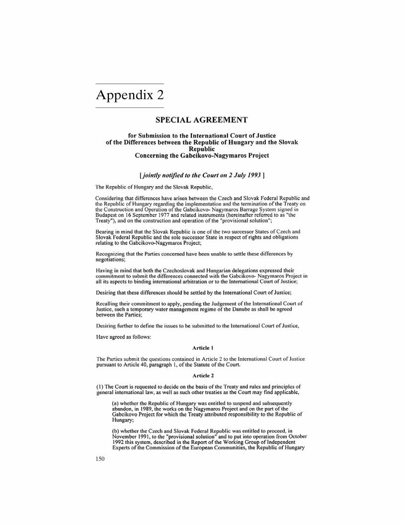
Appendix 2
150
APPENDIX 2 151
152 APPENDIX 2
Appendix 3
AGREEMENT
BETWEEN THE GOVERNMENT OF THE SLOVAK REPUBLIC
AND GOVERNMENT OF THE REPUBLIC OF HUNGARY
CONCERNING CERTAIN TEMPORARY TECHNICAL MEASURES
AND DISCHARGES IN THE DANUBE AND MOSONI BRANCH OF THE DANUBE
The Government of the Slovak Republic
and
the Government of the Republic of Hungary
have agreed as follows:
Article 1
1. Immediately following the conclusion of this Agreement, the Slovak Party will increase the
discharge of water through the intake structure at Cunovo into the Mosoni branch of the Danube
to 43 m 3/s subject to hydrological and technical conditions specified in Annex 1 to this
Agreement. This value includes the flow of water through the seepage canal on the right side of
the reservoir from Slovak territory into Hungarian territory.
2. The competent Slovak and Hungarian authorities shall take all necessary measures on their
respective territories to enable the continuous flow of the increased discharge of water from
Slovak territory into Hungarian territory.
3. The water will be distributed, on Hungarian territory, between the branch system on the right
side of the Danube, the protected area and the Mosoni branch of the Danube.
Article 2
1. The day following the conclusion of this Agreement the discharge into the main riverbed of the
Danube below the Cunovo weir will be increased to an annual average of 400 m3/s, in accordance
with the rules of operation contained in Annex 2 to this Agreement. Discharges entering the main
riverbed of the Danube through the inundation weir are excluded from the average calculation.
2. During the construction of the weir pursuant to Article 3 the discharge into the main riverbed of
the Danube below the Cunovo weir will be regulated in accordance with Annex 3 to this
Agreement.
153
Article 3
1. There will be a weir partly overflowed by water and constructed by the Hungarian Party in the
main riverbed of the Danube, at rkm 1843. The main parameters of the weir are specified in
Annex 4 to this Agreement.
2. The Parties undertake to ensure the issuance, without delay, of the administrative authorization
required by their respective national legislation for the construction and maintenance of the weir
in accordance with this Agreement.
3. The costs of the construction and maintenance of the weir will be borne by the Republic of
Hungary.
4. The construction of the weir will begin not later that 10 days following the conclusion of this
Agreement and is anticipated to be completed within a period of 50 days from the commencement
of works.
Article 4
The Parties undertake to exchange those data of their environmental monitoring systems
operating in the area that are necessary to assess the impacts of the measures envisaged in Articles
1-3. Collected data will be regularly exchanged and jointly and periodically-evaluated with a
view to making recommendations to the Parties. The observation sites, parameters observed,
periodicity of data exchange, the methodology and periodicity or joint assessment are contained
in Annex 5 to this Agreement.
Article 5
1. In the event that either Party believes the other Party is not complying with this Agreement, and
fail to persuade the other Party that it is in breach, the Party may invoke the good offices of the
Commission of the European Union and both Parties agree to give close cooperation to the
Experts of the Commission and to take duly into consideration any opinion rendered by them.
2. If, for whatever reason, the good offices are not provided or are unsuccessful and the material
breach continues to exist, the Party affected will be entitled to terminate this Agreement with a
one month notice.
Article 6
This Agreement has a temporary character, pending the judgment of the International Court of
Justice in the case concerning the Gabcíkovo - Nagymaros Project and is without prejudice to
154 APPENDIX 3
existing rights and obligations of the Parties as well as to their respective positions in the dispute
before the Court and, in any event, unless otherwise agreed, it shall terminate 14 days after the
judgment of the International Court of Justice in the case concerning the Gabcíkovo-Nagymaros
Project.
Article 7
On the termination of this Agreement and unless otherwise agreed or decided, Hungary shall at its
own expense remove the weir referred to in Article 3.
Article 8
This Agreement shall enter into force on the date of its signature.
Done at Budapest on the 19 day of April, 1995, in duplicate, in the Slovak, Hungarian and English
languages, the English text to prevail in the event of any discrepancy.
APPENDIX 3 155
Annex No. 1
Hydrological and technical conditions
for the increase of the discharges into the Mosoni Danube
1/ The increase of the discharge into the Mosoni Danube and into the right side seepage canal of
the Hrušov reservoir from 20 m3/sec up to 43 m3/sec will be ensured subject to the following
hydrological and technical conditions:
1.1 Provided that minimum difference between the water-level of the Mosoni Danube and the
Hrušov reservoir is 5.10 m.
1.2 Provided that the minimum water level of the Hrušov reservoir is 130.40 m above sea level.
1.3 Provided that the water-level of the Mosoni Danube does not exceed 125.30 m above sea
level.
1.4 Provided that the entrances to the intake structure are unobstructed. Whenever the discharges
of the Danube exceed 4000 m 3 /sec (involving the inundation of the flood-plain), the
water-borne materials will move to a greater extent this may restrict the amount of water
which can be provided.
1.5 Provided that there is no failure in the electricity network system. If the network system is
damaged or in the event of any other failure of the generating capacity, the energy system will
turn off automatically and the capacity of the intake structure will be reduced to halt of the
original.
2/ At the request of the Hungarian party the Slovak Party will moderate the discharge for a
period specified by the Hungarian party.
3/ The selected site for the measuring of the discharge of the Mosoni Danube is a gauge at 0.160
km on the left bank of the canal on the territory of the Slovak Republic. The selected site for
the measuring of the discharge of the right side canal of the Hrušov reservoir is on the
regulating weir at 1.100 km on the territory of the Hungarian Republic
156 APPENDIX 3
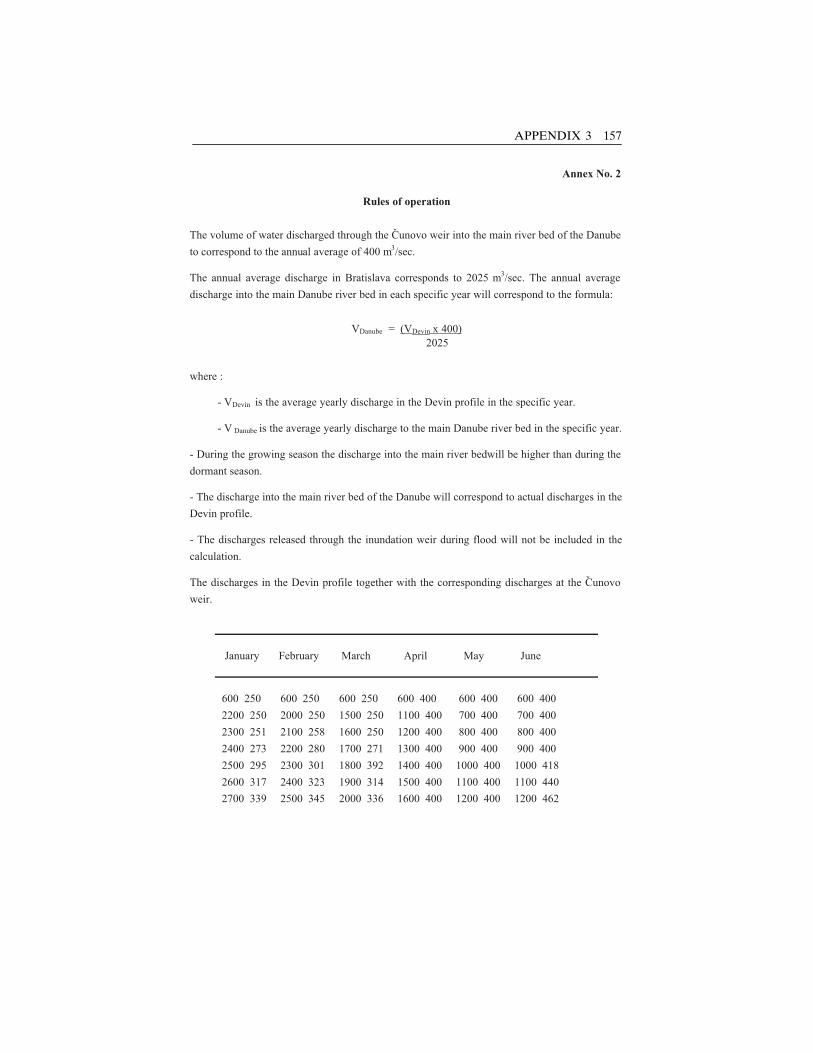
Annex No. 2
Rules of operation
The volume of water discharged through the Cunovo weir into the main river bed of the Danube
to correspond to the annual average of 400 m3/sec.
The annual average discharge in Bratislava corresponds to 2025 m3/sec. The annual average
discharge into the main Danube river bed in each specific year will correspond to the formula:
VDanube = (VDevin x 400) 2025
where :
- VDevín is the average yearly discharge in the Devin profile in the specific year.
- V Danube is the average yearly discharge to the main Danube river bed in the specific year.
- During the growing season the discharge into the main river bed will be higher than during the
dormant season.
- The discharge into the main river bed of the Danube will correspond to actual discharges in the
Devin profile.
- The discharges released through the inundation weir during flood will not be included in the
calculation.
The discharges in the Devin profile together with the corresponding discharges at the Cunovo
weir.
January February March April May June
600 250 600 250 600 250 600 400 600 400 600 400
2200 250 2000 250 1500 250 1100 400 700 400 700 400
2300 251 2100 258 1600 250 1200 400 800 400 800 400
2400 273 2200 280 1700 271 1300 400 900 400 900 400
2500 295 2300 301 1800 392 1400 400 1000 400 1000 418
2600 317 2400 323 1900 314 1500 400 1100 400 1100 440
2700 339 2500 345 2000 336 1600 400 1200 400 1200 462
APPENDIX 3 157
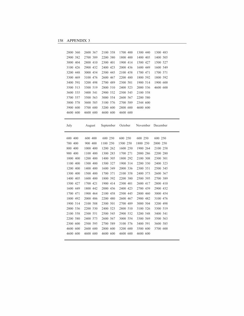
2800 360 2600 367 2100 358 1700 400 1300 440 1300 483
2900 382 2700 389 2200 380 1800 400 1400 405 1400 505
3000 404 2800 410 2300 401 1900 414 1500 427 1500 527
3100 426 2900 432 2400 423 2000 436 1600 449 1600 549
3200 448 3000 454 2500 445 2100 458 1700 471 1700 571
3300 469 3100 476 2600 467 2200 480 1800 592 1800 592
3400 591 3200 498 2700 489 2300 501 1900 514 1900 600
3500 513 3300 519 2800 510 2400 523 2000 536 4600 600
3600 535 3400 541 2900 532 2500 545 2100 558
3700 557 3500 563 3000 554 2600 567 2200 580
3800 578 3600 585 3100 576 2700 589 2344 600
3900 600 3700 600 3200 600 2800 600 4600 600
4600 600 4600 600 4600 600 4600 600
July August September October November December
600 400 600 400 600 250 600 250 600 250 600 250
700 400 900 400 1100 250 1500 250 1800 250 2000 250
800 400 1000 400 1200 262 1600 250 1900 264 2100 258
900 400 1100 400 1300 283 1700 271 2000 286 2200 280
1000 400 1200 400 1400 305 1800 292 2100 308 2300 301
1100 400 1300 400 1500 327 1900 314 2200 330 2400 323
1200 400 1400 400 1600 349 2000 336 2300 351 2500 345
1300 400 1500 400 1700 371 2100 358 2400 373 2600 367
1400 405 1600 400 1800 392 2200 380 2500 395 2700 389
1500 427 1700 421 1900 414 2300 401 2600 417 2800 410
1600 449 1800 442 2000 436 2400 423 2700 439 2900 432
1700 471 1900 464 2100 458 2500 445 2800 460 3000 454
1800 492 2000 486 2200 480 2600 467 2900 482 3100 476
1900 514 2100 508 2300 501 2700 489 3000 504 3200 498
2000 536 2200 530 2400 523 2800 510 3100 526 3300 519
2100 558 2300 551 2500 545 2900 532 3200 548 3400 541
2200 580 2400 573 2600 567 3000 554 3300 569 3500 563
2300 600 2500 595 2700 589 3100 576 3400 591 3600 585
4600 600 2600 600 2800 600 3200 600 3500 600 3700 600
4600 600 4600 600 4600 600 4600 600 4600 600
1
158 APPENDIX 3
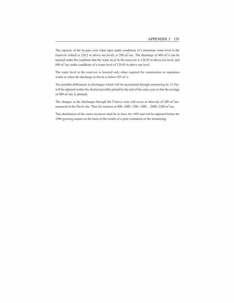
The capacity of the by-pass weir when open under conditions of a minimum water level in the
reservoir (which is 128.2 m above sea level), is 290 m3/sec. The discharge of 400 m3/s can be
assured under the condition that the water level in the reservoir is 128.45 m above sea level, and
600 m3/sec under conditions of a water level of 129.05 m above sea level.
The water level in the reservoir is lowered only when required for construction or reparation
works or when the discharge in Devin is below 925 m3/s.
The possible differences in discharges which will be ascertained through monitoring by 31 Oct.
will be adjusted within the shortest possible period by the end of the same year so that the average
of 400 m3/sec is attained.
The changes in the discharges through the Cunovo weir will occur at intervals of 200 m3/sec.
measured at the Devin site. Thus for instance at 800, 1000, 1200, 1400 ... 2000, 2200 m3/sec.
This distribution of the water resources shall be in force for 1995 and will be adjusted before the
1996 growing season on the basis of the results of a joint evaluation of the monitoring.
APPENDIX 3 159
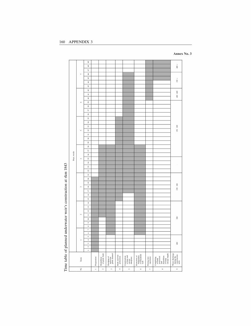
Annex No. 3
Tim
etable
ofplannedunderw
ater
weir’sco
nstructionat
rkm
1843
Days,wee
ks
No
Item
s1
23
45
67
12
34
56
78
910
1112
1314
1516
1718
1920
2122
2324
2526
2728
2930
3132
3334
3536
3738
3940
4142
4344
4546
4748
49
1Preparation
2Demolition
ofgu
ideban
k
3
Dredgingof
upstream
guidech
annel
4Ban
kan
dbed
protection
5
Construction
ofdam
and
energy
dissipater
6
Protectionof
bridga
plate
ofDunak
ilid
well
7Puttinginto
operation
8
Completing
ofban
kprotection
and
dem
olition
oflamp
energysupply
9
Water
disch
arge
duringthe
construction
m3/s
400
200
150�1
00�
150�1
00400�6
00
150>
400<
160 APPENDIX 3
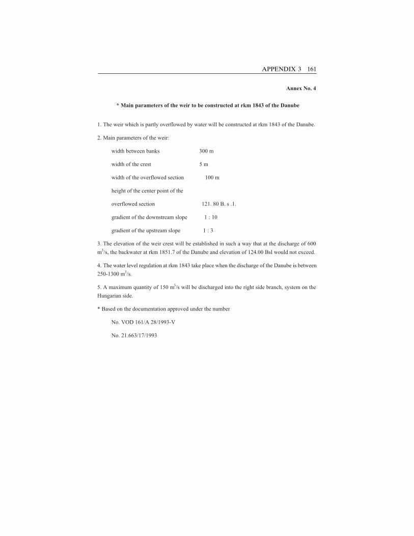
Annex No. 4
* Main parameters of the weir to be constructed at rkm 1843 of the Danube
1. The weir which is partly overflowed by water will be constructed at rkm 1843 of the Danube.
2. Main parameters of the weir:
width between banks 300 m
width of the crest 5 m
width of the overflowed section 100 m
height of the center point of the
overflowed section 121. 80 B. s .1.
gradient of the downstream slope 1 : 10
gradient of the upstream slope 1 : 3
3. The elevation of the weir crest will be established in such a way that at the discharge of 600
m3/s, the backwater at rkm 1851.7 of the Danube and elevation of 124.00 Bsl would not exceed.
4. The water level regulation at rkm 1843 take place when the discharge of the Danube is between
250-1300 m3/s.
5. A maximum quantity of 150 m3/s will be discharged into the right side branch, system on the
Hungarian side.
* Based on the documentation approved under the number
No. VOD 161/A 28/1993-V
No. 21.663/17/1993
APPENDIX 3 161
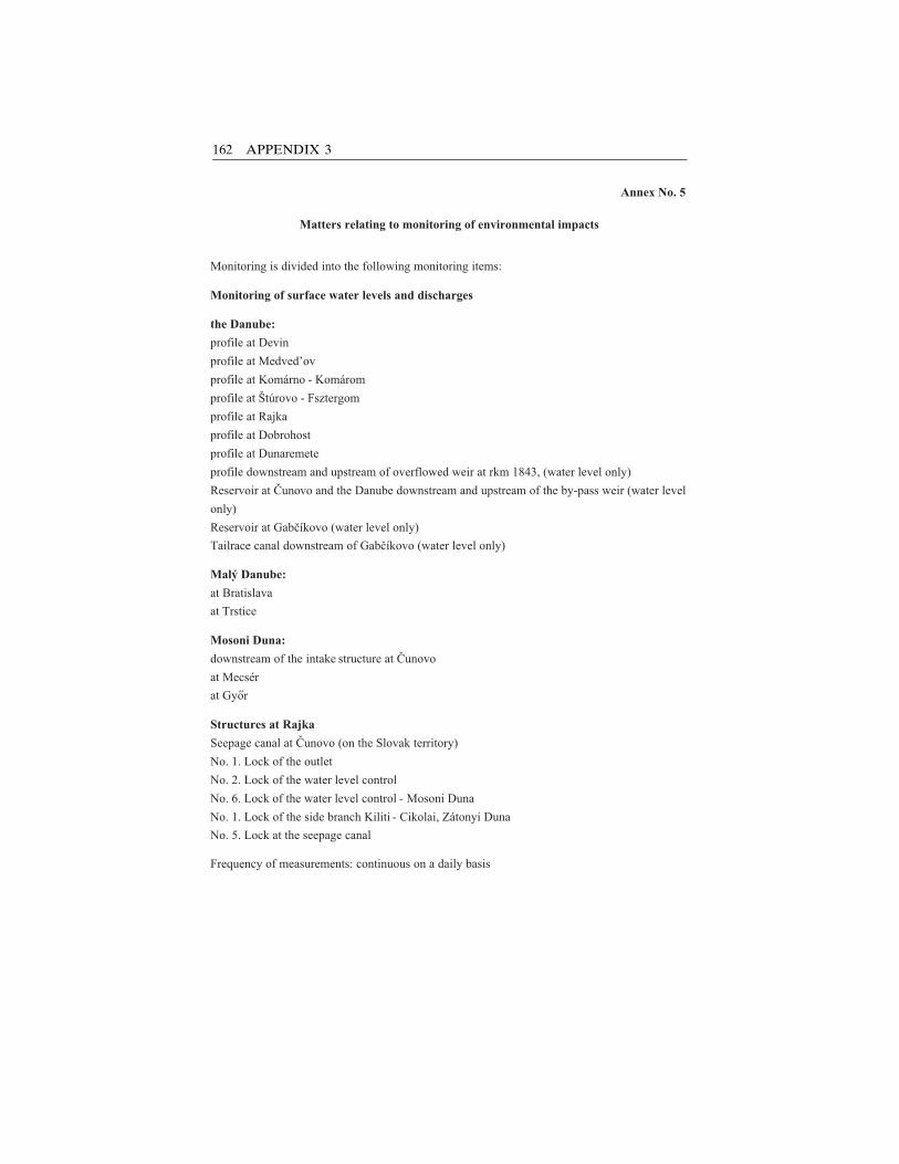
Annex No. 5
Matters relating to monitoring of environmental impacts
Monitoring is divided into the following monitoring items:
Monitoring of surface water levels and discharges
the Danube:
profile at Devin
profile at Medved’ov
profile at Komárno - Komárom
profile at Štúrovo - Fsztergom
profile at Rajka
profile at Dobrohost
profile at Dunaremete
profile downstream and upstream of overflowed weir at rkm 1843, (water level only)
Reservoir at Cunovo and the Danube downstream and upstream of the by-pass weir (water level
only)
Reservoir at Gabcíkovo (water level only)
Tailrace canal downstream of Gabcíkovo (water level only)
Malý Danube:
at Bratislava
at Trstice
Mosoni Duna:
downstream of the intake structure at Cunovo
at Mecsér
at Gyor
Structures at Rajka
Seepage canal at Cunovo (on the Slovak territory)
No. 1. Lock of the outlet
No. 2. Lock of the water level control
No. 6. Lock of the water level control - Mosoni Duna
No. 1. Lock of the side branch Kiliti - Cikolai, Zátonyi Duna
No. 5. Lock at the seepage canal
Frequency of measurements: continuous on a daily basis
162 APPENDIX 3
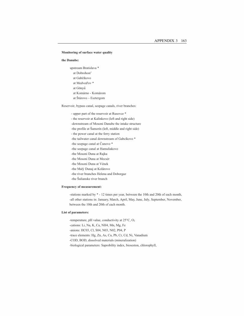
Monitoring of surface water quality
the Danube:
upstream Bratislava *
at Dobrohost’
at Gabcíkovo
at Medved'ov *
at Gönyu
at Komárno - Komárom
at Štúrovo – Esztergom
Reservoir, bypass canal, seepage canals, river branches:
- upper part of the reservoir at Rusovce *
- the reservoir at Kalinkovo (left and right side)
-downstream of Mosoni Danube the intake structure
-the profile at Šamorín (left, middle and right side)
- the power canal at the ferry station
-the tailwater canal downstream of Gabcíkovo *
-the seepage canal at Cunovo *
-the seepage canal at Hamuliakovo
-the Mosoni Duna at Rajka
-the Mosoni Duna at Mecsér
-the Mosoni Duna at Vének
-the Malý Dunaj at Kolárovo
-the river branches Helena and Doborgaz
-the Šulianske river branch
Frequency of measurement:
-stations marked by * - 12 times per year, between the 10th and 20th of each month,
-all other stations in: January, March, April, May, June, July, September, November,
between the 10th and 20th of each month.
List of parameters:
-temperature, pH value, conductivity at 25°C, O2
-cations: Li, Na, K, Ca, NH4, Mn, Mg, Fe
-anions: HC03, Cl, S04, N03, N02, P04, P
-trace elements: Hg, Zn, As, Cu, Pb, Cr, Cd, Ni, Vanadium
-COD, BOD, dissolved materials (mineralization)
-biological parameters: Saprobility index, bioseston, chlorophyll,
APPENDIX 3 163
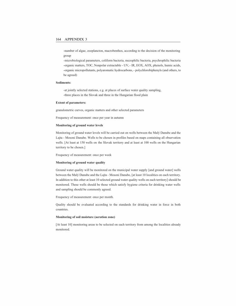
-number of algae, zooplancton, macrobenthos, according to the decision of the monitoring
group
-microbiological parameters, coliform bacteria, mezophilic bacteria, psychrophilic bacteria
-organic matters, TOC, Nonpolar extractable - UV, - IR, EOX, AOX, phenols, humic acids,
-organic micropollutants, polyaromatic hydrocarbons, - polychlorobiphenyls (and others, to
be agreed)
Sediments:
-at jointly selected stations, e.g. at places of surface water quality sampling,
-three places in the Slovak and three in the Hungarian flood plain
Extent of parameters:
granulometric curves, organic matters and other selected parameters
Frequency of measurement: once per year in autumn
Monitoring of ground water levels
Monitoring of ground water levels will be carried out on wells between the Malý Danube and the
Lajta - Mosoni Danube. Wells to be chosen in profiles based on maps containing all observation
wells. [At least at 150 wells on the Slovak territory and at least at 100 wells on the Hungarian
territory to be chosen.]
Frequency of measurement: once per week
Monitoring of ground water quality
Ground water quality will be monitored on the municipal water supply [and ground water] wells
between the Malý Danube and the Lajta - Mosoni Danube, [at least 10 localities on each territory.
In addition to this other at least 10 selected ground water quality wells on each territory] should be
monitored. These wells should be those which satisfy hygiene criteria for drinking water wells
and sampling should be commonly agreed.
Frequency of measurement: once per month.
Quality should be evaluated according to the standards for drinking water in force in both
countries.
Monitoring of soil moisture (aeration zone)
[At least 10] monitoring areas to be selected on each territory from among the localities already
monitored.
164 APPENDIX 3
Frequency of measurement: once every 10 days, but in winter (November, December, January
and February) twice a month. Each locality should also include a ground water level monitoring
well.
Monitoring of biota:
- microbenthos and macrobenthos in the Danube and river branches at places of water level
measurements
-fish, in all surface waters
-[Forestry, on at least 8 selected places from among existing monitoring localities on each side]
-Special water related organisms as for example: Odonata, Ephemeroptera, Trichopetra,
Braconidea and others, jointly selected.
Special monitoring
For the estimation of the impact of the overflowed weir special monitoring to be carried out. This
will include measurements of flow velocities, water levels, water quality, micro and macro
benthos, sediments, ground water quality in the impounded reach etc.
Submitting of data and reports:
Both sides will use data jointly agreed and will use jointly agreed methods of evaluation. All
monitoring items and locations, and methods of measurements to be jointly agreed. Annual
reports will include only measured data in tabulated, graphical and map forms with short
explanations.
Joint and verification measurements will be carried out at any location where a discrepance
occurs.
Data exchange will be carried out at three month intervals. Annual reports to be submitted as joint
reports by the end of each calendar year and covering a period or a hydrological year.
Annual reports will be issued in English language with standardised graphical annexes in
Hungarian or Slovak languages.
Statute
Monitoring will be carried out in accordance with the Statute of nominated Monitoring Agents.
Statute will be prepared by: Ing. Árpád Kovács, Ministry of Environment (Hungary), Ing.
Dominik Kocinger, Government plenipotentiary for the GNP (Slovakia)
Draft statute will be prepared jointly following the signing of this document and before 31. May
1995.
Text in square brackets [] contains Slovak proposals subject to agreement by the Monitoring
Agents.
APPENDIX 3 165
Index
Page references followed by m indicates a map; followed by fig indicates an illustratedfigure; followed by t indicates a table.
Ac, P., 89‘‘Agreement between the Government of
Slovak Republic and theGovernment of Hungary aboutCertain Temporary TechnicalMeasures and Discharges in theDanube and Mosoni Branch of theDanube’’ (1995), 39
Agricultureenvironmental impact monitoring on,
93–94link between soil moisture and, 94
Aral Sea basin water disputes, 3
Banczerowski, I., 46Bansky, L., 57Beckley, 35Berczik, A., 46Bioproject (1976), 33Biota monitoring
biodiversity monitoring form of, 79development of, 77–78as early warning system, 78environmental trends studied using,
79–80
GNP use ofbenefits of, 80bird monitoring results, 89design principles used in, 81–82findings of, 87–91goal of, 84–85methodologies used, 82–84pre-1995 biota monitoring affected by
GNP, 85–87reporting results of, 102–103two levels of, 80–81
Bublinec, E., 64, 67Bucharest Declaration for the Protection
of the Danube River (1985),21–22
Cambel, B., 92Caponera, D. A., 9Central Asian water resources, 3Central European water resources, 3Cerny, J., 87Climatic trends (Slovakia), 95–96COD (chemical oxygen demand), 52–53COMECON (Council for Mutual Economic
Cooperation), 28, 52
166
‘‘Conservation and SustainableManagement of Forests in Centraland Eastern European Countries’’(ECPP report 1999), 72
Convention on the Law of the Non-Navigational Uses of InternationalWatercourses (UN), 4
Csoka-Szabados, I. L., 74, 75, 76, 77Czechoslovakia
Danube river planning (1950s) by, 28establishment of, 28
Danube Circle, 32Danube Commission, 18–19Danube Convention (1856), 18Danube Convention (1948), 18Danube Pollution Reduction Programme
(UNDP/GEF), 22Danube river
conflicting claims regarding GNPenvironmental impact on, 32–33
declining water quality of, 19, 21geopolitical setting of, 27–28history of regulation works in middle
reaches of, 25–26hydroelectric power generated by, 19hydrological regime of surface water
along GNP of, 48–50longitudinal cross section of, 24figphysical characteristics of the middle, 23,
25physical impact of early regulation works
along, 26–27profile of dams along the, 20figUN report (1994) on waterworks
constructed on the, 19Danube River basin
map of, 17mriver profile of the Danube, 20figwater management in the, 16, 18–19,
21–23Davidson, R., 59Deets, S., 3Dendrochronological Analysis System, 73Department of Plant Taxonomy and Ecology
(Eotvos Lorand University), 76DRPC (Danube River Protection
Convention) [1994], 21–22
Eastern Europeinternationalization of domestic water
resources in, 3
Treaty of Trianon (1920) impact on, 28EDUKF, 47El-Wha dam complex (US), 112Environmental Impact Assessment System,
5–6Environmental monitoringdata collection/processing procedures of, 36described, 5, 34focus of monitoring water quality, 35joint endeavor outcomes of, 5–6objectives of, 35reassessment/adjustment of, 36, 38transboundary programs
design/implementation of, 35–36major challenges to, 38–39
See also Water qualityEnvironmental monitoring (Gabcıkovo part
of GNP)biota monitoring, 77–91evaluation and recommendations based
on, 103–109forest monitoring, 68–77, 78tgroundwater quality, 59–62, 63t, 64tHungary
agreement with Slovak Republic for,39–43
evaluation and recommendations from,103–109
house cracking in settlements, 94–95studies conducted on, 7–8
hydrological regimeof groundwater, 53–54, 56–58, 98–100of surface water, 48–50, 96–97
on impact on agriculture, 93–94legal and institutional framework/
objectives, 39–43results of
biota monitoring, 102–103forest monitoring, 101–102groundwater quality, 100hydrological regime of groundwater,98–100
hydrological regime of surface water,96–97
soil monitoring, 100–101surface water quality, 97–98
Slovakiaagreement with Hungary for, 39–43climatic trends, 95–96evaluation and recommendations of,103–109
zone of aeration, 91–93
INDEX 167
Environmental monitoring (cont.)soil monitoring, 62, 64–68, 69tsurface water quality, 50–53technical and scientific information bases
for assessment, 43–47See also Hungary; Slovak Republic
EPDRB (Environmental Programme forthe Danube River Basin), 21
EU (European Union)‘‘EU Water Framework Directive’’
(2000), 22GNP case examined by, 5‘‘Ground Water Model for the Danubian
Lowland’’ project of, 60EUNISHAB (European Habitat
Classification System), 84European Economic Committee, 52‘‘European wetland Inventory Review’’
(Wetlands International), 74‘‘EU Water Framework Directive’’ (2000),
22
Faculty of Natural Sciences (ComeniusUniversity), 41, 44
Fischer-Reinan, Dr., 25, 26Fitzmaurice, J., 25, 33Flood control
to mitigate low groundwater levels(2001), 102
origins of Danube river, 25Flooding
early regulation works and resulting,26–27
as technical measures for reducingenvironmental impact of GNP, 57–58
Floodplain forestsdevelopment of, 70–71impact of GNP on, 73–74monitoring of, 70
Forest monitoringoverview of, 68–77, 78treported results of, 101–102
Forest Research Institute, 41, 74
Gabcıkovo-Nagymaros HydropowerScheme, 44
Gabcıkovo Part of the Hydroelectric Power
Project: Environmental IMpactReview Based on Two Year
Monitoring (Comenius University), 7Ganges-Brahmaputra-Meghna water
disputes, 3
GEMS (UN GLobal EnvironmentalMonitoring System), 34
Geological Institutes of Hungary, Austria,and Slovakia, 46
Global Environmental Outlook (UNEP),3
Gnages River water dispute, 10–11GNP (Gabcıkovo-Nagymaros Project)
aims of, 12background information/origins of, 4–5,
23environmental impacts and conflicting
claims, 32–33environmental monitoring ofbiota monitoring, 77–91evaluation and recommendations based
on, 103–109forest monitoring, 68–77groundwater quality, 59–62, 63t, 64thydrological regime of groundwater,
53–58hydrological reime of surface water
and, 48–50legal and institutional framework/
objectives, 39–43list of stations for soil moisture
monitoring, 69tother monitored components, 91–96results of joint monitoring, 96–103soil monitoring, 62, 63–68surface water quality, 50–53technical and scientific information
bases for assessing, 43–47first water dispute taken to ICJ, 4, 5, 7, 11,
12–16geopolitical settingoverview of, 27–28technical characteristics, 29–30fig,
31–32ICJ decision on, 13–16issues disputed over, 12–13physical setting ofhistory of regulation works in middle
reaches of Danube, 25–26physical characteristics of the middle
Danube, 23–24fig, 25physical impacts of early regulation
works, 26–27water management in Danube River
basin, 16–17m, 18–19, 21–23research and literature on, 6–8See also Hungary; Slovak Republic
168 INDEX
GroundwaterGNP impact on agriculture and levels of,
94house cracking due to drop in level of,
94–95hydrological regime of, 53–54, 56–58,
98–100limits for drinking water, 64tmonitoring quality of, 59–62, 63t
GROUND WATER Consulting, Ltd., 41,44
‘‘Ground Water Model for the DanubianLowland’’ project (EU), 60
Halupa, L., 74, 75, 76, 77Helmer, R., 36Helsinki Rules (1966), 4Hlavaty, Z., 49, 61, 64, 67, 92Holcik, J., 87Holecek, Dr., 26Hungarian Academy of Sciences, 28, 46Hungarian Biodiversity Monitoring System,
84Hungary
agreement to submit GNP dispute to ICJ,13
environmental monitoringagreement with Slovak Republic for,39–43
evaluation and recommendations from,103–109
on house cracking in Szigethoz,94–95
studies conducted on, 7–8GNP dispute issues between Slovakia,
12–13groundwater resources of, 56–57hydroelectric power of, 26ICJ decision regarding GNP case and,
13–16national identity formation in, 27–28Treat of Trianon (1920) impact on, 28See also Environmental monitoring
(Gabcıkovo part of GNP); GNP(Gabcıkovo-Nagymaros Project)
Hydroelectric powerDanube river
generation of, 19historical origins and development of,25–26
Hydrological regimeof groundwater, 53–54, 56–58, 98–100
origins of Hungarian, 26surface water, 48–50, 96–97
ICID (International Commission onIrrigation and Drainage), 111
ICJ (International Court of Justice)GNP decision by, 13–16GNP dispute taken to, 4, 5, 7, 11, 12–13
ICOLD (International Commissions onLarge Dams), 111
ICPDR (International Commission for theProtection of the Danube River), 22,47, 107, 108
IHA (International Hydro-powerAssociations), 111
Indus river basin water disputes, 3Indus River dispute mediation, 11Interim Mekong Committee, 11International freshwater managementconflicts and resolution mechanisms of,
2–4environmental monitoring as part of, 5–6observations and recommendations
regarding, 110–112See also Transboundary river problems
IRBM (Integrated River BasinManagement), 3–4, 10, 22, 108
IWAC (International Water AssessmentCenter), 19, 52
IWRM (Integrated Water ResourcesManagement), 22
‘‘Joint Action Programme for the DanubeRiver Basin: January 2001–December 2005’’ (ICPDR), 22
Joint Annual Reports (1996–2001)[Hungary and Slovakia]
on biota monitoring results, 102on fluctuations of surface water quality,
97–98on forest monitoring results, 101on groundwater quality, 100on hydrological regime of groundwater,
98–100information provided in, 8on sampling/analysis methods used for
monitoring, 53Joint Working Groups on Legal Matters
and on Water Management, Ecology,Navigation, and Energy, 15, 42–43,107
Jordan river basin water disputes, 3
INDEX 169
KODUKF, 47Kovacovsky, P., 89Krno, I., 86Kukla, J., 64, 67
Lafranconi, E., 25Lang, I., 46Lapin, M., 95Laszlo, F., 61, 62Lerner, D., 59Liebe, P., 49, 58Little Hungarian Plain, 45, 46
Makovinska, J., 52Margesson, R., 14von Marilaun, Kerner, 69Mazariova, K., 57Mediation successes, 11Mekong River Commission, 11Mekong River Committee, 11Mekong River water dispute mediation, 11Ministry for Environment and Regional
Policy, 46Mucha, I., 60‘‘Multifunctional Integrated Study Danube:
Corridor and Catchment’’ (2002),23
‘‘National Agri-environmental Programmein Hungary’’ (Institute ofEnvironmental Management, SzentIstan University), 94
National Biodiversity Monitoring Service,84
National Groundwater Protection Program,61
NATO Science Programme, 22Nemsei, L., 68Nile river basin water disputes, 3NMASR (Nominated Monitoring Agent of
the Slovak Republic) [2001 report],25
North-Trans-Danubian Water Authority, 41
Odum, E. P., 77Oxford Brookes University, 35
Palkovits, G., 66Pan-European biodiversity initiatives, 22Pattantyus-Abraham, M., 68Das Pflanzenleben der Donaulander (von
Marilaun), 69
Phare Programme Report (EC), 72Plenipotentiary of the Government (Slovak
Republic), 41Plenipotentiary of the Slovak Republic for
the Construction and Operation ofthe Gabcıkovo-NagymarosHydropower Scheme, 7
Pollutionclimatic trends and, 96long-term monitoring (1976–1994) of,
52–53See also Water quality
Production-Development Department(Pannon University of AgriculturalSciences), 93–94
Rhine-Main-Danube waterway (1992),19
Rival or rivalis (one using river in commonwith another), 2
River basinsIRBM promotion of coordinated
planning/management of, 3–4locations of water stress around, 3
Rodak, D., 60Rychlik, I., 89
Sands, P., 14SHMU (Slovak Hydrometeorological
Institute), 56, 60Slovak Academy of Sciences, 41, 44Slovak-Hungarian Transboundary Water
Commission, 46–47, 50, 53Slovak Hydrometeorological Institute,
41Slovak Republic
agreement to submit GNP dispute to ICJ,13
Danube river planning by (1950s), 28environmental monitoringagreement with Hungary for, 39–43of climatic trends, 95–96evaluation and recommendations of,
103–109zone of aeration, 91–93
GNP dispute issues between Hungaryand, 12–13
groundwater resources of, 56history of Hungarian domination over,
28ICJ decision regarding GNP case and,
13–16
170 INDEX
See also Environmental monitoring(Gabcıkovo part of GNP); GNP(Gabcıkovo-Nagymaros Project)
Slovak Republic GNP studies (pre-1995),7–8
Slovak Water Management Authority,41
Soil monitoringoverview of, 62, 64–68, 69treported results of, 100–101
Soil Science and Conservation ResearchInstitute, 41
Somogyi, Z., 74, 75, 76, 77Strategic Partnership for the Danube and
the Black Sea Basin, 22Studies on the Environmental State of the
Szigetkoz after the Diversion of theDanube (Lang, Banczerowski, andBerczik), 7
Subcommission for Water QualityProtection, 53
Surface waterhydrological regime of, 48–50, 96–97list of stations for monitoring discharge/
level of, 51twater quality
environmental monitoring of, 50–53jointly agreed limits for, 55tlist of stations for monitoring, 54tmonitoring results of, 97–98
Szigetkoz Land Conservation District,74
Third party mediation, 11Thornton, S., 59Transboundary river problems
commonly occurring problems related to,9–10
national problems aggravating, 10origins of, 10See also International freshwater
managementTrans-National Monitoring Network,
47Treaty of Trianon (1920), 28
UNDP/GEF Danube Regional Project(DRP), 22
UNECE (United Nations EconomicCommission for Europe), 21, 52
UN Inter-Agency Working Group onMonitoring, 34
United Nations Convention on the Law ofthe Non-Navigational Uses ofInternational Watercourses, 4
Varga, F., 77Variant C system (GNP), 12, 31Vasarhelyi, Pal, 25Vision 21 on Water Sanitation (Second
World Water Forum, 2000), 110–111‘‘Vision to Action’’ plan, 22VITUKI, 47
Water qualityDanube river, declining, 19, 21estimates of economic costs of declining, 21focus of monitoring of, 35functions of rivers and related quantity
and, 37tgroundwater
limits for drinking water, 64tlist of stations for monitoring, 63tmonitoring, 59–62
indicative variables related to, 38tOxford Brookes University study on, 35surface water
jointly agreed limits for, 55tlist of stations monitoring, 54tmonitoring results of, 97–98
See also Environmental monitoring;Pollution
Water regulation worksinternational principles for shared
watercourses, 4original and contemporary functions of,
1–2transboundary nature of water and
impact on, 2Water Research Institute, 41Water stressdefinition of, 3examples of, 3successful mediation of, 11
Waterworks and Sewage Enterprise(Bratislava), 41
WCD (World Commission on Dams), 111Wessel, J., 10West Slovakia’s Waterworks and Sewage
Enterprise, 41Working Groups. See Joint Working
Groups on Legal Matters and onWater Management, Ecology,Navigation, and Energy
INDEX 171

World Bank, 111World Conservation Union, 111World Water Forum (Kyoto, 2003), 112WRI, 47
Yugoslavia, 28
Zone of aeration monitoring (Slovakia),91–93
172 INDEX
Related Documents