THE BASICS OF GEOMORPHOLOGY: KEY CONCEPTS Supporting Website Material This website provides material to supplement the text and is organized by chapter with the complete reference list given at the end. Diagrams and tables that are essential for understanding the text are contained in the book. For each chapter the synopsis is given together with additional material, which includes figures and tables, compiled to amplify the dis- cussion in the text, relevant articles in Progress in Physical Geography, which is an excellent resource to pursue particular themes, and a list of the concepts given in bold from the index (together with the references cited in each chapter). The complete reference list is given at the end.

Welcome message from author
This document is posted to help you gain knowledge. Please leave a comment to let me know what you think about it! Share it to your friends and learn new things together.
Transcript
THE BASICS OF GEOMORPHOLOGY:
KEY CONCEPTS
Supporting Website Material
This website provides material to supplement the text and is organized by chapter with the complete reference list given at the end. Diagrams and tables that are essential for understanding the text are contained in the book. For each chapter the synopsis is given together with additional material, which includes figures and tables, compiled to amplify the dis-cussion in the text, relevant articles in Progress in Physical Geography, which is an excellent resource to pursue particular themes, and a list of the concepts given in bold from the index (together with the references cited in each chapter). The complete reference list is given at the end.

1
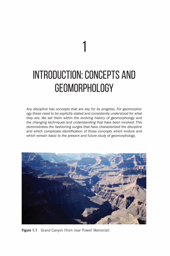
Introduction: Concepts and Geomorphology
Any discipline has concepts that are key for its progress. For geomorphol-ogy these need to be explicitly stated and consistently understood for what they are. We set them within the evolving history of geomorphology and the changing techniques and understanding that have been involved. This demonstrates the fashioning surges that have characterized the discipline and which complicate identification of those concepts which endure and which remain basic to the present and future study of geomorphology.
Figure 1.1 Grand Canyon (from near Powell Memorial)
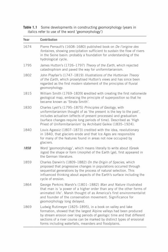
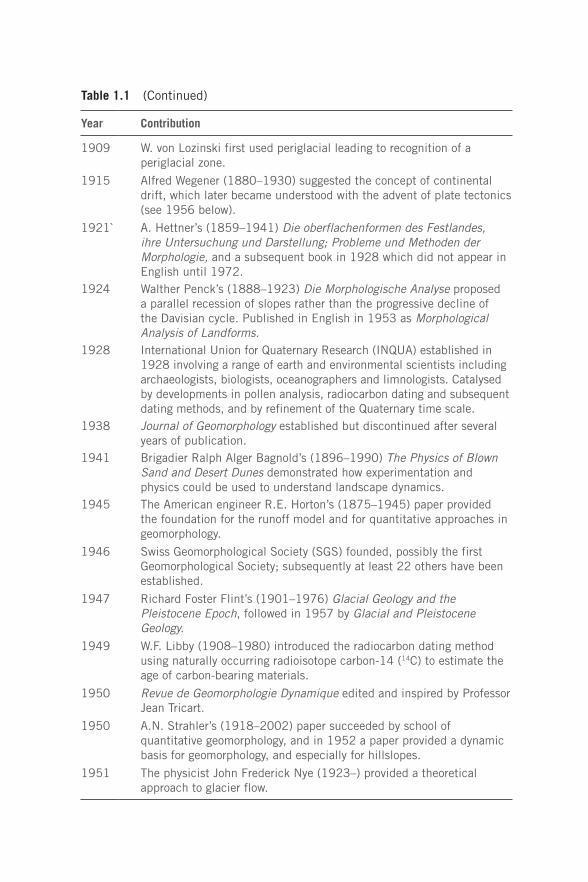
Table 1.1 Some developments in constructing geomorphology (years in italics refer to use of the word ‘geomorphology’)
Year Contribution
1674 Pierre Perrault’s (1608–1680) published book on De l’origine des fontaines, showing precipitation sufficient to sustain the flow of rivers in the Seine basin: probably a foundation for understanding of the hydrological cycle.
1795 James Hutton’s (1726–1797) Theory of the Earth, which rejected catastrophism and paved the way for uniformitarianism.
1802 John Playfair’s (1747–1819) Illustrations of the Huttonian Theory of the Earth, which proselytised Hutton’s views and has since been regarded as the first modern statement of the principles of fluvial geomorphology.
1815 William Smith (1769–1839) credited with creating the first nationwide geological map, embracing the principle of superposition so that he became known as ‘Strata Smith’.
1830 Charles Lyell’s (1795–1875) Principles of Geology, with uniformitarianism thought of as ‘the present is the key to the past’, includes actualism (effects of present processes) and gradualism (surface changes require long periods of time). Described as ‘High Priest of Uniformitarianism’ by Archibald Geikie (1835–1924).
1840 Louis Agassiz (1807–1873) credited with the idea, revolutionary in 1840, that glaciers erode and that Ice Ages are responsible for many of the features found in areas not now occupied by glaciers.
1858 Word ‘geomorphology’, which means literally to write about (Greek logos) the shape or form (morphe) of the Earth (ge), first appeared in the German literature.
1859 Charles Darwin’s (1809–1882) On the Origin of Species, which proposed that progressive changes in populations occurred through sequential generations by the process of natural selection. This influenced thinking about aspects of the Earth’s surface including the cycle of erosion.
1864 George Perkins Marsh’s (1801–1882) Man and Nature illustrated that man is ‘a power of a higher order than any of the other forms of animated life’. Marsh thought of as America’s first environmentalist and founder of the conservation movement. Significance for geomorphology long delayed.
1869 Ludwig Rutimeyer (1825–1895), in a book on valley and lake formation, showed that the largest Alpine valleys had been produced by stream erosion over long periods of geologic time and that different sections of a river course can be marked by distinct types of erosional forms including waterfalls, meanders and floodplains.
Year Contribution
1870 Oscar Peschel (1826–1875) compared the nature of similar landforms throughout the world, involving the classification of surface features and comparison of their morphology.
1875 J.W. Powell (1834–1902), in a study of the Colorado in 1875, identified three types of river valleys (antecedent, consequent, superimposed), referred to landforms, and developed the concept of base level.
1877 T.H. Huxley’s (1825–1895) Physiography provided a view of Earth’s surface processes at a stage when ‘physiography’ was still preferred to the term ‘geomorphology’.
1877 G.K. Gilbert’s (1843–1918) Report on the Geology of the Henry Mountains provided the first treatment by a geologist of the mechanics of fluvial processes, and later (in 1914) in The Transportation of Debris by Running Water included results from laboratory experiments. His approach was largely ignored until the 1960s when more attention was given to stresses acting on materials, aided by mathematical and statistical methods and the development of new models. The book by Leopold et al. (1964) was particularly influential.
1886 Referred to as ‘la geomorphologie’ by Emmanuel de Margerie (1862–1953).
1886 Baron Ferdinand von Richthofen’s (1833–1905) A Guidebook for Scientific Travellers was largely descriptive of landforms, including a classification of mountains.
1888 First use of ‘geomorphology’ in English by W.J. McGee (1853–1912), who compiled a genetic classification of landforms similar to those used in subsequent textbooks. The term came into general use, including by the US Geological Survey, after about 1890.
1889 W.M. Davis (1850–1934) proposed that landscape can be understood in terms of structure, process and stage, and that there are cycles of erosion whereby the land surface proceeds through stages of youth, maturity and old age. Associated landforms with stages in the cycle of erosion and furnished over 150 terms and phrases, some relating to landforms, with probably at least 100 generated by his students. Published Geographical Essays in 1909.
1891 ‘Geomorphology’ used at International Geological Congress by McGee and Powell.
1895 ‘Geomorphology’ used in Mackinder’s lecture to the British Association meeting in Ipswich, described as ‘the causal description of the Earth’s present relief’.International Geographical Congress to London had a section entitled ‘Geomorphology’, including a paper by A.Penck which used the term ‘geomorphology’.
(Continued)
Year Contribution
1909 W. von Lozinski first used periglacial leading to recognition of a periglacial zone.
1915 Alfred Wegener (1880–1930) suggested the concept of continental drift, which later became understood with the advent of plate tectonics (see 1956 below).
1921` A. Hettner’s (1859–1941) Die oberflachenformen des Festlandes, ihre Untersuchung und Darstellung; Probleme und Methoden der Morphologie, and a subsequent book in 1928 which did not appear in English until 1972.
1924 Walther Penck’s (1888–1923) Die Morphologische Analyse proposed a parallel recession of slopes rather than the progressive decline of the Davisian cycle. Published in English in 1953 as Morphological Analysis of Landforms.
1928 International Union for Quaternary Research (INQUA) established in 1928 involving a range of earth and environmental scientists including archaeologists, biologists, oceanographers and limnologists. Catalysed by developments in pollen analysis, radiocarbon dating and subsequent dating methods, and by refinement of the Quaternary time scale.
1938 Journal of Geomorphology established but discontinued after several years of publication.
1941 Brigadier Ralph Alger Bagnold’s (1896–1990) The Physics of Blown Sand and Desert Dunes demonstrated how experimentation and physics could be used to understand landscape dynamics.
1945 The American engineer R.E. Horton’s (1875–1945) paper provided the foundation for the runoff model and for quantitative approaches in geomorphology.
1946 Swiss Geomorphological Society (SGS) founded, possibly the first Geomorphological Society; subsequently at least 22 others have been established.
1947 Richard Foster Flint’s (1901–1976) Glacial Geology and the Pleistocene Epoch, followed in 1957 by Glacial and Pleistocene Geology.
1949 W.F. Libby (1908–1980) introduced the radiocarbon dating method using naturally occurring radioisotope carbon-14 (14C) to estimate the age of carbon-bearing materials.
1950 Revue de Geomorphologie Dynamique edited and inspired by Professor Jean Tricart.
1950 A.N. Strahler’s (1918–2002) paper succeeded by school of quantitative geomorphology, and in 1952 a paper provided a dynamic basis for geomorphology, and especially for hillslopes.
1951 The physicist John Frederick Nye (1923–) provided a theoretical approach to glacier flow.
Table 1.1 (Continued)
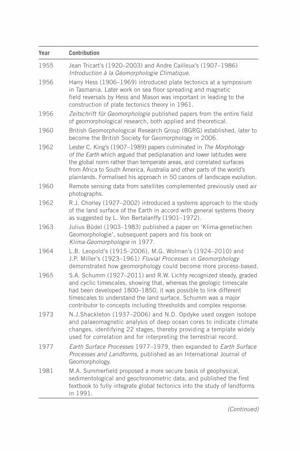
Year Contribution
1955 Jean Tricart’s (1920–2003) and Andre Cailleux’s (1907–1986) Introduction à la Géomorphologie Climatique.
1956 Harry Hess (1906–1969) introduced plate tectonics at a symposium in Tasmania. Later work on sea floor spreading and magnetic field reversals by Hess and Mason was important in leading to the construction of plate tectonics theory in 1961.
1956 Zeitschrift für Geomorphologie published papers from the entire field of geomorphological research, both applied and theoretical.
1960 British Geomorphological Research Group (BGRG) established, later to become the British Society for Geomorphology in 2006.
1962 Lester C. King’s (1907–1989) papers culminated in The Morphology of the Earth which argued that pediplanation and lower latitudes were the global norm rather than temperate areas, and correlated surfaces from Africa to South America, Australia and other parts of the world’s plainlands. Formalised his approach in 50 canons of landscape evolution.
1960 Remote sensing data from satellites complemented previously used air photographs.
1962 R.J. Chorley (1927–2002) introduced a systems approach to the study of the land surface of the Earth in accord with general systems theory as suggested by L. Von Bertalanffy (1901–1972).
1963 Julius Büdel (1903–1983) published a paper on ‘Klima-genetischen Geomorphologie’, subsequent papers and his book on Klima-Geomorphologie in 1977.
1964 L.B. Leopold’s (1915–2006), M.G. Wolman’s (1924–2010) and J.P. Miller’s (1923–1961) Fluvial Processes in Geomorphology demonstrated how geomorphology could become more process-based.
1965 S.A. Schumm (1927–2011) and R.W. Lichty recognized steady, graded and cyclic timescales, showing that, whereas the geologic timescale had been developed 1800–1850, it was possible to link different timescales to understand the land surface. Schumm was a major contributor to concepts including thresholds and complex response.
1973 N.J.Shackleton (1937–2006) and N.D. Opdyke used oxygen isotope and palaeomagnetic analysis of deep ocean cores to indicate climate changes, identifying 22 stages, thereby providing a template widely used for correlation and for interpreting the terrestrial record.
1977 Earth Surface Processes 1977–1979, then expanded to Earth Surface Processes and Landforms, published as an International Journal of Geomorphology.
1981 M.A. Summerfield proposed a more secure basis of geophysical, sedimentological and geochronometric data, and published the first textbook to fully integrate global tectonics into the study of landforms in 1991.
(Continued)
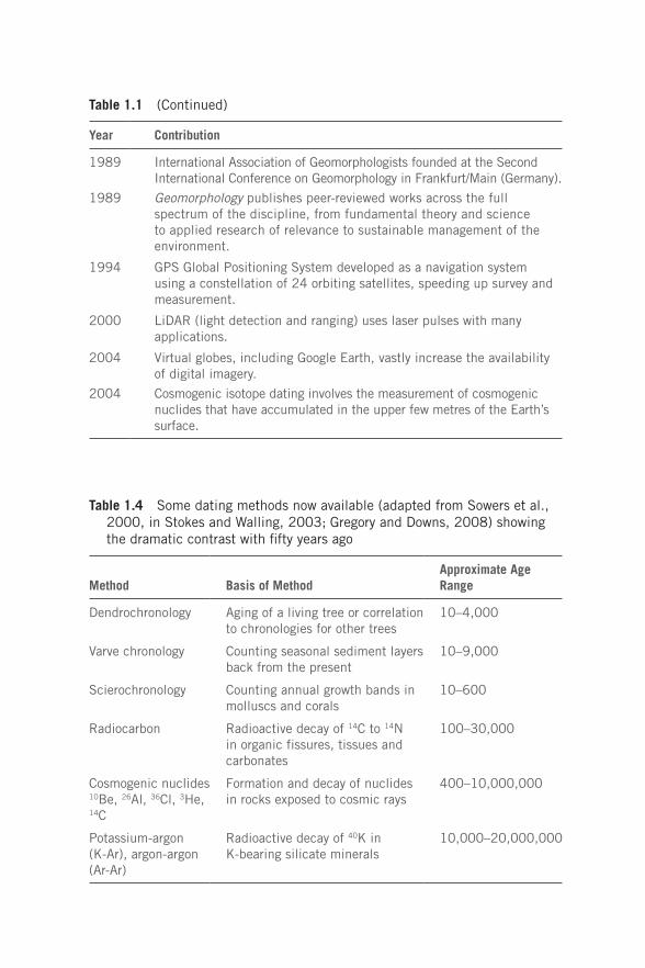
Year Contribution
1989 International Association of Geomorphologists founded at the Second International Conference on Geomorphology in Frankfurt/Main (Germany).
1989 Geomorphology publishes peer-reviewed works across the full spectrum of the discipline, from fundamental theory and science to applied research of relevance to sustainable management of the environment.
1994 GPS Global Positioning System developed as a navigation system using a constellation of 24 orbiting satellites, speeding up survey and measurement.
2000 LiDAR (light detection and ranging) uses laser pulses with many applications.
2004 Virtual globes, including Google Earth, vastly increase the availability of digital imagery.
2004 Cosmogenic isotope dating involves the measurement of cosmogenic nuclides that have accumulated in the upper few metres of the Earth’s surface.
Table 1.4 Some dating methods now available (adapted from Sowers et al., 2000, in Stokes and Walling, 2003; Gregory and Downs, 2008) showing the dramatic contrast with fifty years ago
Method Basis of MethodApproximate Age Range
Dendrochronology Aging of a living tree or correlation to chronologies for other trees
10–4,000
Varve chronology Counting seasonal sediment layers back from the present
10–9,000
Scierochronology Counting annual growth bands in molluscs and corals
10–600
Radiocarbon Radioactive decay of 14C to 14N in organic fissures, tissues and carbonates
100–30,000
Cosmogenic nuclides 10Be, 26Al, 36Cl, 3He, 14C
Formation and decay of nuclides in rocks exposed to cosmic rays
400–10,000,000
Potassium-argon (K-Ar), argon-argon (Ar-Ar)
Radioactive decay of 40K in K-bearing silicate minerals
10,000–20,000,000
Table 1.1 (Continued)
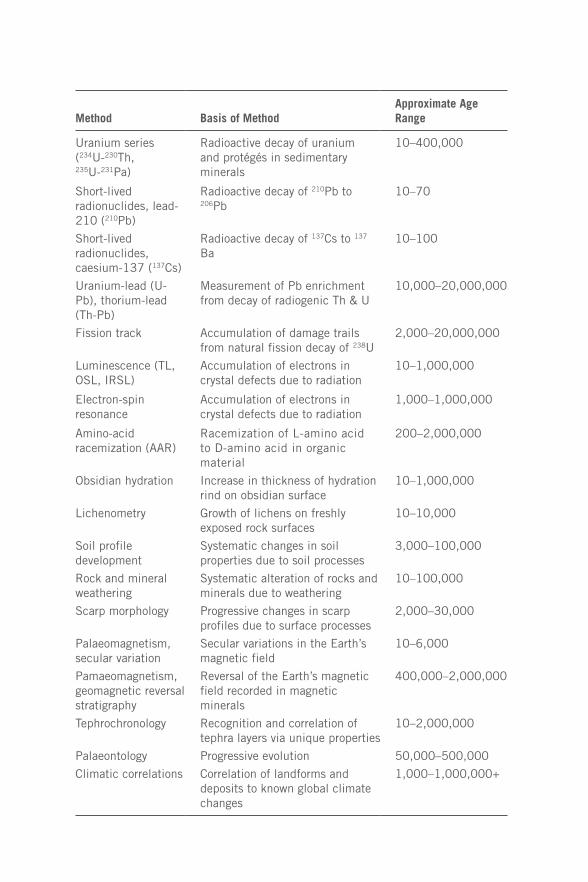
Method Basis of MethodApproximate Age Range
Uranium series (234U-230Th, 235U-231Pa)
Radioactive decay of uranium and protégés in sedimentary minerals
10–400,000
Short-lived radionuclides, lead-210 (210Pb)
Radioactive decay of 210Pb to 206Pb
10–70
Short-lived radionuclides, caesium-137 (137Cs)
Radioactive decay of 137Cs to 137
Ba 10–100
Uranium-lead (U-Pb), thorium-lead (Th-Pb)
Measurement of Pb enrichment from decay of radiogenic Th & U
10,000–20,000,000
Fission track Accumulation of damage trails from natural fission decay of 238U
2,000–20,000,000
Luminescence (TL, OSL, IRSL)
Accumulation of electrons in crystal defects due to radiation
10–1,000,000
Electron-spin resonance
Accumulation of electrons in crystal defects due to radiation
1,000–1,000,000
Amino-acid racemization (AAR)
Racemization of L-amino acid to D-amino acid in organic material
200–2,000,000
Obsidian hydration Increase in thickness of hydration rind on obsidian surface
10–1,000,000
Lichenometry Growth of lichens on freshly exposed rock surfaces
10–10,000
Soil profile development
Systematic changes in soil properties due to soil processes
3,000–100,000
Rock and mineral weathering
Systematic alteration of rocks and minerals due to weathering
10–100,000
Scarp morphology Progressive changes in scarp profiles due to surface processes
2,000–30,000
Palaeomagnetism, secular variation
Secular variations in the Earth’s magnetic field
10–6,000
Pamaeomagnetism, geomagnetic reversal stratigraphy
Reversal of the Earth’s magnetic field recorded in magnetic minerals
400,000–2,000,000
Tephrochronology Recognition and correlation of tephra layers via unique properties
10–2,000,000
Palaeontology Progressive evolution 50,000–500,000
Climatic correlations Correlation of landforms and deposits to known global climate changes
1,000–1,000,000+
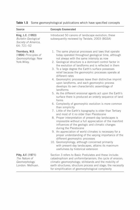
Table 1.5 Some geomorphological publications which have specified concepts
Source Concepts Enumerated
King, L.C. (1953) Bulletin Geological Society of America, 64: 721–52
Introduced 50 canons of landscape evolution; these subsequently reviewed by Twidale, 2003 (BGSA)
Thornbury, W.D. (1954) Principles of Geomorphology. New York:Wiley.
1. The same physical processes and laws that operate today operated throughout geological time, although not always with the same intensity as now
2. Geological structure is a dominant control factor in the evolution of landforms and is reflected in them
3. To a large degree the Earth’s surface possesses relief because the geomorphic processes operate at different rates
4. Geomorphic processes leave their distinctive imprint upon landforms, and each geomorphic process develops its own characteristic assemblage of landforms
5. As the different erosional agents act upon the Earth’s surface there is produced an orderly sequence of land forms
6. Complexity of geomorphic evolution is more common than simplicity
7. Little of the Earth’s topography is older than Tertiary and most of it no older than Pleistocene
8. Proper interpretation of present-day landscapes is impossible without a full appreciation of the manifold influences of the geologic and climatic changes during the Pleistocene
9. An appreciation of world climates is necessary for a proper understanding of the varying importance of the different geomorphic processes
10. Geomorphology, although concerned primarily with present-day landscapes, attains its maximum usefulness by historical extension
Pitty, A.F. (1971) The Nature of Geomorphology. London: Methuen.
Section 3 refers to Basic Postulates and these include: catastrophism and uniformitarianism; the cycle of erosion; climatic geomorphology; stillstands and the mobility of earth structures; structure process and stage; the necessity for simplification of geomorphological complexity
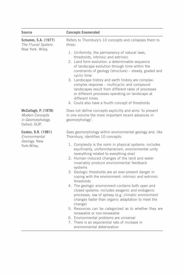
Source Concepts Enumerated
Schumm, S.A. (1977) The Fluvial System. New York: Wiley.
Refers to Thornbury’s 10 concepts and collapses them to three:
1. Uniformity: the permanency of natural laws, thresholds, intrinsic and extrinsic
2. Land form evolution: a determinable sequence of landscape evolution through time within the constraints of geology (structure) – steady, graded and cyclic time
3. Landscape history and earth history are complex: complex response – multicyclic and compound landscapes result from different rates of processes or different processes operating on landscape at different times
4. Could also have a fourth concept of thresholds
McCullagh, P. (1978) Modern Concepts in Geomorphology. Oxford: OUP.
Does not define concepts explicitly and aims ‘to present in one volume the more important recent advances in geomorphology’.
Coates, D.R. (1981) Environmental Geology. New York:Wiley.
Sees geomorphology within environmental geology and, like Thornbury, identifies 10 concepts:
1. Complexity is the norm in physical systems: includes equifinality, uniformitarianism, environmental unity (everything related to everything else)
2. Human-induced changes of the land and water invariably produce environmental feedback systems
3. Geologic thresholds are an ever-present danger in coping with the environment: intrinsic and extrinsic thresholds
4. The geologic environment contains both open and closed systems: includes exogenic and endogenic processes, law of aphasy (e.g. climatic environment changes faster than organic adaptation to meet the change)
5. Resources can be categorized as to whether they are renewable or non-renewable
6. Environmental problems are universal 7. There is an exponential rate of increase in
environmental deterioration
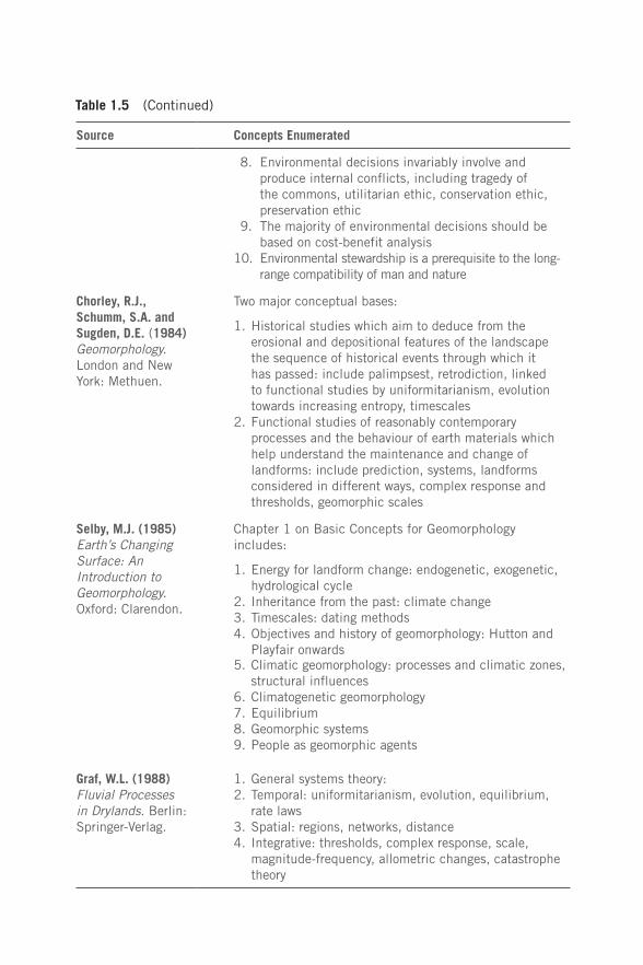
Table 1.5 (Continued)
Source Concepts Enumerated
8. Environmental decisions invariably involve and produce internal conflicts, including tragedy of the commons, utilitarian ethic, conservation ethic, preservation ethic
9. The majority of environmental decisions should be based on cost-benefit analysis
10. Environmental stewardship is a prerequisite to the long-range compatibility of man and nature
Chorley, R.J., Schumm, S.A. and Sugden, D.E. (1984) Geomorphology. London and New York: Methuen.
Two major conceptual bases:
1. Historical studies which aim to deduce from the erosional and depositional features of the landscape the sequence of historical events through which it has passed: include palimpsest, retrodiction, linked to functional studies by uniformitarianism, evolution towards increasing entropy, timescales
2. Functional studies of reasonably contemporary processes and the behaviour of earth materials which help understand the maintenance and change of landforms: include prediction, systems, landforms considered in different ways, complex response and thresholds, geomorphic scales
Selby, M.J. (1985) Earth’s Changing Surface: An Introduction to Geomorphology. Oxford: Clarendon.
Chapter 1 on Basic Concepts for Geomorphology includes:
1. Energy for landform change: endogenetic, exogenetic, hydrological cycle
2. Inheritance from the past: climate change3. Timescales: dating methods4. Objectives and history of geomorphology: Hutton and
Playfair onwards5. Climatic geomorphology: processes and climatic zones,
structural influences6. Climatogenetic geomorphology7. Equilibrium8. Geomorphic systems9. People as geomorphic agents
Graf, W.L. (1988) Fluvial Processes in Drylands. Berlin: Springer-Verlag.
1. General systems theory:2. Temporal: uniformitarianism, evolution, equilibrium,
rate laws3. Spatial: regions, networks, distance4. Integrative: thresholds, complex response, scale,
magnitude-frequency, allometric changes, catastrophe theory
(Continued)
Source Concepts Enumerated
Brunsden, D. (1984) Tablets of stone: Toward the ten commandments of geomorphology, Zeitschrift für Geomorphologie Supplementband, 79: 1–37.
1. Style and location of landform change are determined by the type, location and rate of tectonic movements and their associated stress fields over the relevant time and space framework of the landform assemblage
2. Landforms are shaped by tectonic and denudational processes proceeding concurrently and directly reflect the ratio between the rates of operation of these processes
3. The lower boundary conditions for landform development are set by the varying sea levels experienced during the lifetime of the landscape
4. For any given set of environmental conditions, through a constant set of processes, there will be a tendency over time to produce a set of characteristic landforms
5. Landforms are continually subject to perturbations that arise from form changes in the environmental conditions of the system: these impulses are episodic and complex in nature at all scales and therefore the changes to landforms will be episodic and complex
6. Within each tectono-climatic regime landforms are produced by specific process events: such events are called formative events
7. New landforms are produced when an event is reached on the frequency-magnitude scale of the tectono-climatic regime, at which the normal behaviour is overturned and a new system is created: such events are called geocatastrophies
8. When a perturbing displacement exceeds the resistance of the system, the system will react and relax toward a new stable state that will be expressed by a new characteristic form
9. There is in landscape a wide spatial variation in the ability of landforms to change: this is known as the sensitivity of change, and thus landscape stability is a function of the temporal and spatial distributions of the resisting and disturbing forces and is therefore diverse and complex
10. The ability of a landscape to resist impulses of change tends to increase with time
Thorn, C.E. (1988) AnIntroduction to Theoretical Geomorphology. Boston, MA: Unwin Hyman.
Concepts not in index but does include uniformitarianism, ergodicity, magnitude and frequency, equilibria, spatial concepts, equifinality and convergence
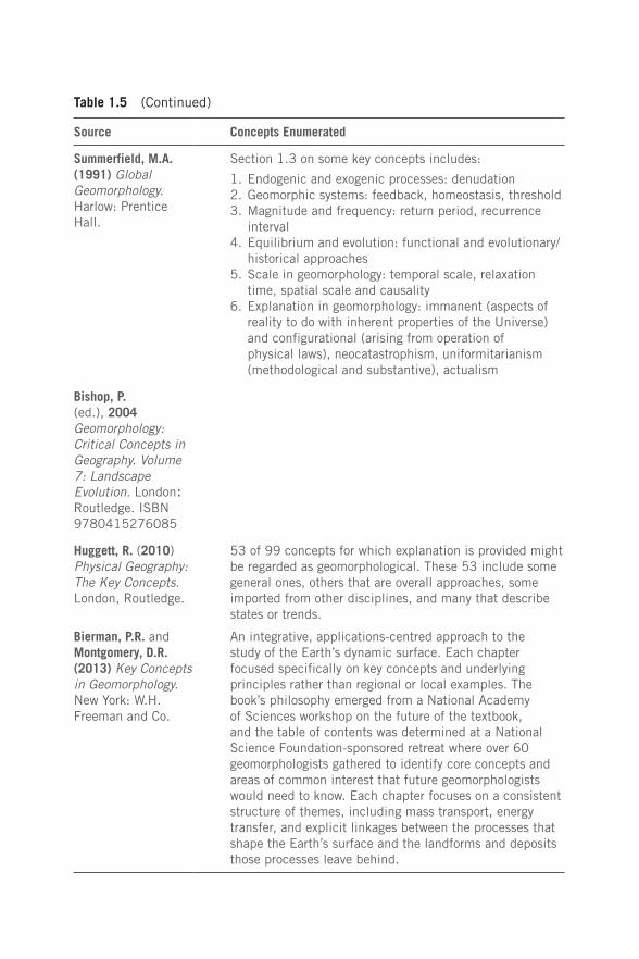
Table 1.5 (Continued)
Source Concepts Enumerated
Summerfield, M.A. (1991) Global Geomorphology. Harlow: Prentice Hall.
Section 1.3 on some key concepts includes:
1. Endogenic and exogenic processes: denudation2. Geomorphic systems: feedback, homeostasis, threshold3. Magnitude and frequency: return period, recurrence
interval4. Equilibrium and evolution: functional and evolutionary/
historical approaches5. Scale in geomorphology: temporal scale, relaxation
time, spatial scale and causality6. Explanation in geomorphology: immanent (aspects of
reality to do with inherent properties of the Universe) and configurational (arising from operation of physical laws), neocatastrophism, uniformitarianism (methodological and substantive), actualism
Bishop, P. (ed.), 2004 Geomorphology: Critical Concepts in Geography. Volume 7: Landscape Evolution. London: Routledge. ISBN 9780415276085
Huggett, R. (2010) Physical Geography: The Key Concepts. London, Routledge.
53 of 99 concepts for which explanation is provided might be regarded as geomorphological. These 53 include some general ones, others that are overall approaches, some imported from other disciplines, and many that describe states or trends.
Bierman, P.R. and Montgomery, D.R. (2013) Key Concepts in Geomorphology. New York: W.H. Freeman and Co.
An integrative, applications-centred approach to the study of the Earth’s dynamic surface. Each chapter focused specifically on key concepts and underlying principles rather than regional or local examples. The book’s philosophy emerged from a National Academy of Sciences workshop on the future of the textbook, and the table of contents was determined at a National Science Foundation-sponsored retreat where over 60 geomorphologists gathered to identify core concepts and areas of common interest that future geomorphologists would need to know. Each chapter focuses on a consistent structure of themes, including mass transport, energy transfer, and explicit linkages between the processes that shape the Earth’s surface and the landforms and deposits those processes leave behind.
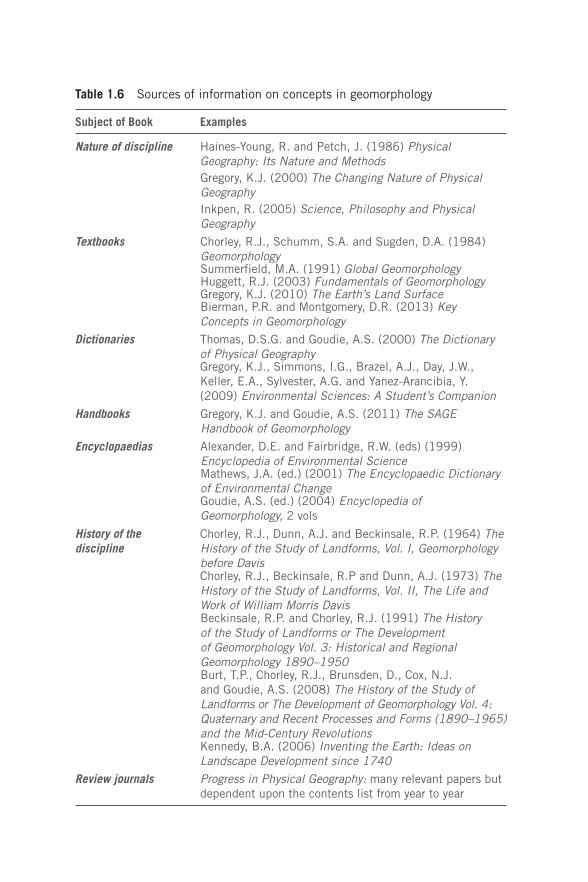
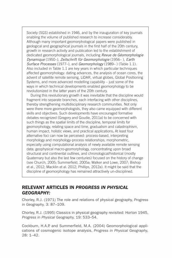
Table 1.6 Sources of information on concepts in geomorphology
Subject of Book Examples
Nature of discipline Haines-Young, R. and Petch, J. (1986) Physical Geography: Its Nature and Methods Gregory, K.J. (2000) The Changing Nature of Physical GeographyInkpen, R. (2005) Science, Philosophy and Physical Geography
Textbooks Chorley, R.J., Schumm, S.A. and Sugden, D.A. (1984) GeomorphologySummerfield, M.A. (1991) Global GeomorphologyHuggett, R.J. (2003) Fundamentals of GeomorphologyGregory, K.J. (2010) The Earth’s Land SurfaceBierman, P.R. and Montgomery, D.R. (2013) Key Concepts in Geomorphology
Dictionaries Thomas, D.S.G. and Goudie, A.S. (2000) The Dictionary of Physical GeographyGregory, K.J., Simmons, I.G., Brazel, A.J., Day, J.W., Keller, E.A., Sylvester, A.G. and Yanez-Arancibia, Y. (2009) Environmental Sciences: A Student’s Companion
Handbooks Gregory, K.J. and Goudie, A.S. (2011) The SAGE Handbook of Geomorphology
Encyclopaedias Alexander, D.E. and Fairbridge, R.W. (eds) (1999) Encyclopedia of Environmental ScienceMathews, J.A. (ed.) (2001) The Encyclopaedic Dictionary of Environmental ChangeGoudie, A.S. (ed.) (2004) Encyclopedia of Geomorphology, 2 vols
History of the discipline
Chorley, R.J., Dunn, A.J. and Beckinsale, R.P. (1964) The History of the Study of Landforms, Vol. I, Geomorphology before DavisChorley, R.J., Beckinsale, R.P and Dunn, A.J. (1973) The History of the Study of Landforms, Vol. II, The Life and Work of William Morris DavisBeckinsale, R.P. and Chorley, R.J. (1991) The History of the Study of Landforms or The Development of Geomorphology Vol. 3: Historical and Regional Geomorphology 1890–1950Burt, T.P., Chorley, R.J., Brunsden, D., Cox, N.J. and Goudie, A.S. (2008) The History of the Study of Landforms or The Development of Geomorphology Vol. 4: Quaternary and Recent Processes and Forms (1890–1965) and the Mid-Century RevolutionsKennedy, B.A. (2006) Inventing the Earth: Ideas on Landscape Development since 1740
Review journals Progress in Physical Geography: many relevant papers but dependent upon the contents list from year to year

Box 1.1
The development of geomorphology
Although geomorphology became defined in the late 19th century, its subject matter was recognizable much earlier (Tinkler, 1985) when it was significantly influenced by concepts including stratigraphical succession and uniformitarianism in Geology, and evolution in Biology. Despite antecedents in Geology, it became more geographically based with the contribution by W.M. Davis of the ‘normal’ cycle of erosion. Although alternative approaches, such as that of G.K.Gilbert, clearly introduced the physical process studies that the Davisian approach lacked, the influence of Davisian concepts themselves prevailed for the first half of the 20th century, ensuring emphasis upon the historical development of landforms. The cycle as introduced by Davis was appealing in its simplicity: from initial uplift via recognisable erosion stages to a landscape of low relief, it was presented logically and graphically, although at the time there was little in the way of dating techniques or other detailed evidence with which to test its field applicability. However, by the mid 20th century outstanding contributions provided by Bagnold, Strahler, Nye, and Leopold, Wolman and Miller (Table 1.1) were stimuli instigating the quantitative analysis of processes (largely physical but also chemical) shaping the land surface – and hence ‘process geomorphology’. Strahler (1952) identified two quite different viewpoints for geomorphology: dynamic (analytical, particularly involving physical forces) and historical (regional, with sequences in time); these were associated respectively with what came to be known as timeless and time bound perspectives. Quaternary investigations also became more prominent in the second half of the 20th century, particularly given advances in dating techniques and in the biological analysis of palaeoenvironments. Plate tectonics was a major transforming advance for the earth sciences and this has been reinforced by geochronological techniques including cosmogenic dating methods. This also reinvigorated geomorphology such that Summerfield (2005a) saw two scales to geomorphology: small scale process geomorphology contrasting with a macroscale geomorphology reflecting geophysical advances made by researchers outside the traditional geomorphological community. Summerfield (2005b) avowed that ‘there is enormous scope to advance geomorphology as a whole probably at its most exciting time since it emerged as a discipline’. In a sense both became process-driven: the one large-scale and dominantly tectonic, the other by smaller-scale surface landforming systems operating in rivers, in glaciated landscapes, at coastlines and in deserts. However, the bonus provided by new dating techniques allowed timescales to be placed on both.
Progress in the 20th century was aided by the foundation of geomorphological societies, as in the case of the Swiss Geomorphological
Society (SGS) established in 1946, and by the inauguration of key journals enabling the volume of published research to increase considerably. Although many important geomorphological papers were published in geological and geographical journals in the first half of the 20th century, growth in research activity and publication led to the establishment of dedicated geomorphological journals, including Revue de Géomorphologie Dynamique (1950–), Zeitschrift für Geomorphologie (1956– ), Earth Surface Processes (1977–), and Geomorphology (1989– ) (Table 1.1). Also included in Table 1.1 are key years in which particular techniques affected geomorphology: dating advances, the analysis of ocean cores, the advent of satellite remote sensing, LiDAR, virtual globes, Global Positioning Systems, and more advanced modelling capability – just some of the ways in which technical developments enabled geomorphology to be revolutionized in the latter years of the 20th century.
During this revolutionary growth it was inevitable that the discipline would fragment into separate branches, each interfacing with other disciplines, thereby strengthening multidisciplinary research communities. Not only were there more geomorphologists, they also came equipped with different skills and objectives. Such developments have encouraged formative debates recognized (Gregory and Goudie, 2011a) to be concerned with such things as the spatial limits of the discipline, temporal limits for geomorphology, relating space and time, gradualism and catastrophism, human impact, holistic views, and practical applications. At least four alternative foci can now be perceived: process-based, interpreting morphology and morphology-process relationships; morphometric, especially using computational analysis of newly available remote sensing data; geophysical macro-geomorphology, concentrating upon broad structural and continental outlines, and chronological/historical (mostly Quaternary but also the last few centuries) focused on the history of change (see Church, 2005; Summerfield, 2005a; Walker and Lowe, 2007; Bishop et al., 2012; Macklin et al. 2012; Phillips, 2012a). It might be said that the discipline of geomorphology has remained attractively un-disciplined.
RELEVANT ARTICLES IN PROGRESS IN PHYSICAL GEOGRAPHY:Chorley, R.J. (1971) The role and relations of physical geography, Progress in Geography, 3: 87–109.
Chorley, R.J. (1995) Classics in physical geography revisited: Horton 1945, Progress in Physical Geography, 19: 533–54.
Cockburn, H.A.P. and Summerfield, M.A. (2004) Geomorphological appli-cations of cosmogenic isotope analysis, Progress in Physical Geography, 28: 1–42.
Curran, P.J. (1994) Imaging spectrometry, Progress in Physical Geography, 18: 247–66.
Duller, G.A.T. (1996) Recent developments in luminescence dating of Quaternary sediments, Progress in Physical Geography, 20: 127–45.
Fisher, P. F., Mackaness, W.A., Peacegood, G. and Wilkinson, G.G. (1988) Artificial intelligence and expert systems in geodata processing, Progress in Physical Geography, 12: 371–88.
Gardiner, V. and Gregory, K.J. (1977) Progress in portraying the physical landscape, Progress in Physical Geography, 1: 1–22.
Goudie, A.S. (1994) R.J. Chorley Commemorative Issue, Progress in Physical Geography, 18: 317–18.
Mosley, M.P. and Zimpfer, G.L. (1978) Hardware models in geomorphology, Progress in Physical Geography, 2: 438–61.
Phillips, J.D. (1995) Self-organization and landscape evolution, Progress in Physical Geography, 19: 309–21.
Raper, J. (1991) Geographical information systems, Progress in Physical Geography, 15: 438–44.
Strahler, A.N. (1992) Quantitative/dynamic geomorphology at Columbia 1945–60: a retrospective, Progress in Physical Geography, 16: 65–84.
Trimble, S.W. (2008) The use of historical data and artifacts in geomorphology, Progress in Physical Geography, 32: 3–29.
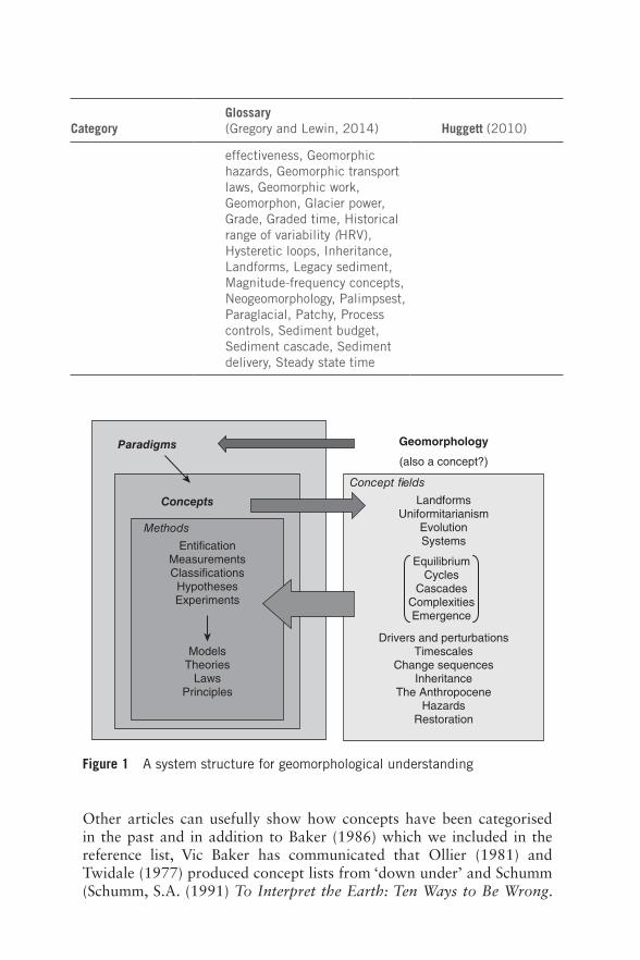
UPDATESAn article in Progress in Physical Geography 2015 (Gregory, K.J. and Lewin, J. (2015) Making concepts more explicit for geomorphology, Progress in Physical Geography, 1–17, available online, Doi: 10.1177/ 0309133315571208) reviews the nature, prevalence and function of concepts in geomorphology, and was written after the experience gained in writing this book. Table 4 in that paper provides a classification of concept types, grouped into 6 categories:
The paper also includes a diagram (Figure 1) suggesting a system structure for geomorphological understanding which can be used in relation to the content of the book to reinforce appreciation of the importance of concepts in geomorphology.
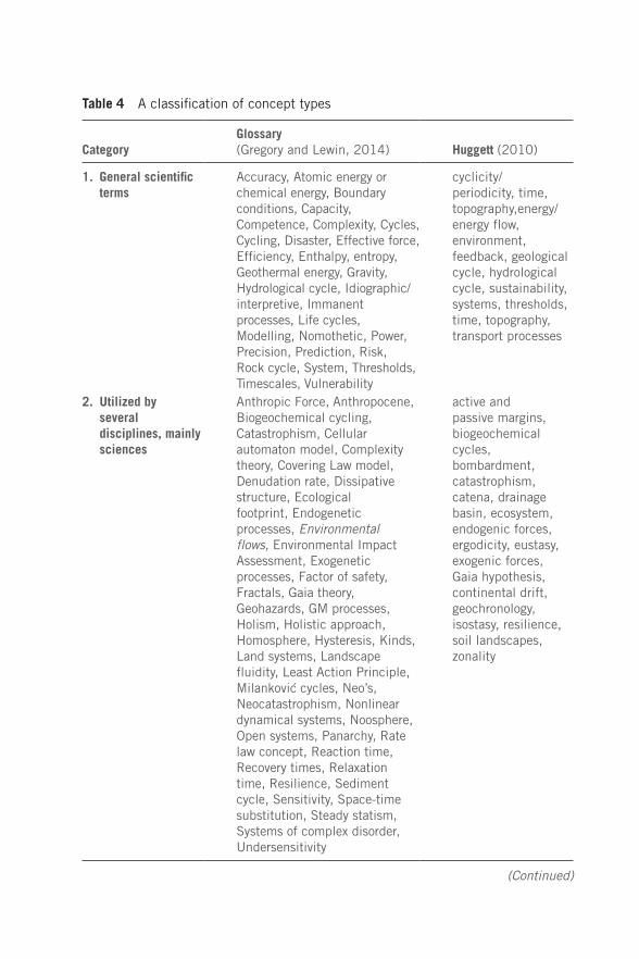
Table 4 A classification of concept types
CategoryGlossary (Gregory and Lewin, 2014) Huggett (2010)
1. General scientific terms
Accuracy, Atomic energy or chemical energy, Boundary conditions, Capacity, Competence, Complexity, Cycles, Cycling, Disaster, Effective force, Efficiency, Enthalpy, entropy, Geothermal energy, Gravity, Hydrological cycle, Idiographic/interpretive, Immanent processes, Life cycles, Modelling, Nomothetic, Power, Precision, Prediction, Risk, Rock cycle, System, Thresholds, Timescales, Vulnerability
cyclicity/periodicity, time, topography,energy/energy flow, environment, feedback, geological cycle, hydrological cycle, sustainability, systems, thresholds, time, topography, transport processes
2. Utilized by several disciplines, mainly sciences
Anthropic Force, Anthropocene, Biogeochemical cycling, Catastrophism, Cellular automaton model, Complexity theory, Covering Law model, Denudation rate, Dissipative structure, Ecological footprint, Endogenetic processes, Environmental flows, Environmental Impact Assessment, Exogenetic processes, Factor of safety, Fractals, Gaia theory, Geohazards, GM processes, Holism, Holistic approach, Homosphere, Hysteresis, Kinds, Land systems, Landscape fluidity, Least Action Principle, Milankovic cycles, Neo’s, Neocatastrophism, Nonlinear dynamical systems, Noosphere, Open systems, Panarchy, Rate law concept, Reaction time, Recovery times, Relaxation time, Resilience, Sediment cycle, Sensitivity, Space-time substitution, Steady statism, Systems of complex disorder, Undersensitivity
active and passive margins, biogeochemical cycles, bombardment, catastrophism, catena, drainage basin, ecosystem, endogenic forces, ergodicity, eustasy, exogenic forces, Gaia hypothesis, continental drift, geochronology, isostasy, resilience, soil landscapes, zonality
(Continued)
CategoryGlossary (Gregory and Lewin, 2014) Huggett (2010)
3. Describing states, processes or conditions
Actualism, Balance of nature, Disturbance regimes, Dynamic equilibrium, Dynamic metastable equilibrium, Emergence, Environmental forcing, Episodism, Equilibrium, Exhaustion effects, Forcing functions or drivers, Gradualism, Hazardousness of a place, Historical contingency, Hypersensitivity, Indeterminacy, Metastable equilibrium, Non-equilibrium, Quasi equilibrium, Regime, Steady state, Uniformitarianism
actualism/non-actualism, complexity, equilibrium, equifinality, gradualism, uniformitarianism
4. Describing trends Desertification, Global warming, Historical memory or persistence, Metamorphosis
aridity, climate change, desertification, environmental change, evolution, global warming, land degradation, sea level change
5. Describing geomorphological approaches
Adaptive management, Anthropogeomorphology, Earth system science, Engineering geomorphology, Environmental geomorphology, Environmental hazards, Geomorphic engineering, Geomorphometry, Hard engineering, Land evaluation, Landscape ecology, Resilience theory, Restoration, Self-organizing systems, Simple systems, Soft engineering
evolutionary geomorphology, geographical cycle, landscape ecology,plate tectonics, plume tectonics, systems, sustainability, tectonics and neotectonics
6. Developed in specific form within geomorphology
Anthropogenic alluvium, Autogenic or intrinsic processes, Characteristic form, Characteristic slope angles, Complex response, Configurational factors, Cyclic or geologic time, Duration time, Earthcasts, Effectiveness, Formation time, Formative events, Geomorphic
chronosequence, etchplanation, magnitude and frequency
Table 4 (Continued)
CategoryGlossary (Gregory and Lewin, 2014) Huggett (2010)
effectiveness, Geomorphic hazards, Geomorphic transport laws, Geomorphic work, Geomorphon, Glacier power, Grade, Graded time, Historical range of variability (HRV), Hysteretic loops, Inheritance, Landforms, Legacy sediment, Magnitude-frequency concepts, Neogeomorphology, Palimpsest, Paraglacial, Patchy, Process controls, Sediment budget, Sediment cascade, Sediment delivery, Steady state time
Paradigms
Concepts
Methods
Enti�cationMeasurementsClassi�cationsHypothesesExperiments
ModelsTheories
LawsPrinciples
Concept �elds
LandformsUniformitarianism
EvolutionSystems
Drivers and perturbationsTimescales
Change sequencesInheritance
The AnthropoceneHazards
Restoration
Geomorphology
(also a concept?)
EquilibriumCycles
CascadesComplexitiesEmergence
Figure 1 A system structure for geomorphological understanding
Other articles can usefully show how concepts have been categorised in the past and in addition to Baker (1986) which we included in the reference list, Vic Baker has communicated that Ollier (1981) and Twidale (1977) produced concept lists from ‘down under’ and Schumm (Schumm, S.A. (1991) To Interpret the Earth: Ten Ways to Be Wrong.
Cambridge: Cambridge University Press) also showed that both concepts and their opposites are important. Huggett (Huggett, R. (2010) Physical Geography: The Key Concepts. London: Routledge) considers concepts in physical geography as a whole.
A new book by Pauline Couper explores the relevance of broad philosophical schools of thought to geography as a science. She exam-ines such topics as positivism, critical rationalism, phenomenology, and social constructionism:
Couper, P. (2015) A Student’s Introduction to Geographical Thought. London: Sage.
In a paper on the lexicon of geomorphology John Lewin elaborates how the terms that geomorphology uses reveal much about its identity, his-tory, perceptions, external inspirations and methods. (Lewin, J. (2015) The lexicon of geomorphology, Earth Surface Processes and Landforms, available online, Doi: 10.1002/esp.3733). This discussion of the names we use, and the concepts that lie behind them is germane to all the chapters in the book.
Related Documents