Ceo!. Soc. MalaYdia, Bll!!etin 39, July 1996,. pp. IJI-156 Tectonics of deformed and undeformed Jurassic-Cretaceous strata of Peninsular Malaysia H.D. TJIA Petronas Research & Scientific Services Sdn. Bhd. Lot 1026 PKNS 54200 Hulu Kelang Abstract: The Jurassic-Cretaceous (JK) strata in Peninsular Malaysia occur as folded sequences (Tembeling Group, Koh Formation, Bertangga Sandstone) but also as undeformed, slightly tilted strata (Gagau Group, Ulu Endau Formation, Panti Sandstone). In recent years, some workers have claimed that the middle-upper Triassic strata (Semantan Formation, Gemas Formation) exhibit structural styles similar to the folded JK strata. This led them to suggest that the upper Triassic-lower Jurassic Titiwangsa granitoid complex resulted from anorogenic emplacement, and that the latest major deformation in the peninsula was of Cretaceous-Tertiary age. This hypothesis does not explain: (1) the regional extent oflate Triassic to early Jurassic granitoids throughout continental Southeast Asia and Sundaland; (2) the occurrence of deformed strata adjacent to some of the granitoid bodies; (3) sharply bounded, thin thermal aureoles consisting of cross-cutting contacts with country rock; (4) the absence of regional cleavage in the JK strata in contrast with its presence in the older Triassic rocks. A study of good quality, remotely-sensed images covering Peninsular Malaysia has resulted in the following conclusions: (a) the JK Tembeling Koh, and Bertangga Sandstone sequences were laid down in pull-apart depressions; (b) these depressions were developed through dextral slip motions on its major, bounding faults that trend north-south; (c) after the depressions were filled, dextral strike-slip motions continued in a transpressive regime which caused the sediment fill to be deformed into NNW-striking drag folds [These strike-slip movements persisted until middle Eocene as reset ages of cataclastics from major fault zones of the peninsula seemed to indicate]; (d) the JK-strata (Gagau, Panti Sandstone) outside the influence of renewed fault movements remained essentially undisturbed; (e) the structural style of the JK-strata is favourable for the entrapment of hydrocarbons, if source material is present. This study further re- establishes the widely accepted concept that during late Triassic-early Jurassic time, Southeast Asia experienced strong tectonic deformation that was accompanied by the emplacement of the Titiwangsa and coeval granitoid complexes. INTRODUCTION The Mesozoic stratigraphic column of Peninsular Malaysia shows clearly the presence of a regional unconformity between the Triassic and younger Mesozoic sequences (Fig. 1). Moreover, the younger Mesozoic sediments are of continental character; those of the lower Mesozoic were deposited in marine to deep marine environments (see Burton, 1973; Khoo, 1983). The regional unconformity coincides in age with the emplacement of huge granitoid masses that occur in a well-defined zone stretching from Yunnan in southern China, via Myanmar-Thailand-Peninsular Malaysia-Riau and Lingga islands to the main tin islands Bangka and Belitung in western Indonesia. In Peninsular Malaysia, the upper Triassic-lower Jurassic granitoids form the Main Range or Titiwangsa. Geologists experienced in the field geology of Peninsular Malaysia have agreed that these granitoids were emplaced during a strong orogenic event in Southeast Asia, named as the Cimmerian orogeny. Four geological domains are recognized PreJented at GSM Petroleum Geology Conference '95 based on differences in structural patterns, ages of sedimentary formations, ages of plutons, and types of mineralizations (Foo, 1983). The three main domains are the Western, Central, and Eastern belts (Fig. 2). The Central Belt is bordered by the Bentong Suture in west and by the Lebir Lineament in the east. The Bentong Suture separates a continental Gondwanan sliver in the west from the remainder of the peninsula that in late Palaeozoic was already part of Laurasia (Tjia, 1989a). Others, e.g. Metcalfe (1988), believe docking ofthe Western belt along the Suture was only completed in late Triassic. The latest wrench motion within the Bentong Suture was right lateral (Tjia, 1984). The Lebir Lineament consists in the north of the left- lateral Lebir fault zone, but south of the latitude of Kuantan, the lineament is poorly defined and comprises a wide zone of north-south faults. An ongoing study on Bouguer gravity and magnetic anomalies has indicated that the southern part of the Lebir lineament most probably coincides with the newly named and north-south trending East Tectonic Zone (Tjia, 1978b). Most pre-Mesozoic

Welcome message from author
This document is posted to help you gain knowledge. Please leave a comment to let me know what you think about it! Share it to your friends and learn new things together.
Transcript
Ceo!. Soc. MalaYdia, Bll!!etin 39, July 1996,. pp. IJI-156
Tectonics of deformed and undeformed Jurassic-Cretaceous strata of Peninsular Malaysia
H.D. TJIA
Petronas Research & Scientific Services Sdn. Bhd. Lot 1026 PKNS
54200 Hulu Kelang
Abstract: The Jurassic-Cretaceous (JK) strata in Peninsular Malaysia occur as folded sequences (Tembeling Group, Koh Formation, Bertangga Sandstone) but also as undeformed, slightly tilted strata (Gagau Group, Ulu Endau Formation, Panti Sandstone). In recent years, some workers have claimed that the middle-upper Triassic strata (Semantan Formation, Gemas Formation) exhibit structural styles similar to the folded JK strata. This led them to suggest that the upper Triassic-lower Jurassic Titiwangsa granitoid complex resulted from anorogenic emplacement, and that the latest major deformation in the peninsula was of Cretaceous-Tertiary age. This hypothesis does not explain: (1) the regional extent oflate Triassic to early Jurassic granitoids throughout continental Southeast Asia and Sundaland; (2) the occurrence of deformed strata adjacent to some of the granitoid bodies; (3) sharply bounded, thin thermal aureoles consisting of cross-cutting contacts with country rock; (4) the absence of regional cleavage in the JK strata in contrast with its presence in the older Triassic rocks. A study of good quality, remotely-sensed images covering Peninsular Malaysia has resulted in the following conclusions: (a) the JK Tembeling Koh, and Bertangga Sandstone sequences were laid down in pull-apart depressions; (b) these depressions were developed through dextral slip motions on its major, bounding faults that trend north-south; (c) after the depressions were filled, dextral strike-slip motions continued in a transpressive regime which caused the sediment fill to be deformed into NNW-striking drag folds [These strike-slip movements persisted until middle Eocene as reset ages of cataclastics from major fault zones of the peninsula seemed to indicate]; (d) the JK-strata (Gagau, Panti Sandstone) outside the influence of renewed fault movements remained essentially undisturbed; (e) the structural style of the JK-strata is favourable for the entrapment of hydrocarbons, if source material is present. This study further reestablishes the widely accepted concept that during late Triassic-early Jurassic time, Southeast Asia experienced strong tectonic deformation that was accompanied by the emplacement of the Titiwangsa and coeval granitoid complexes.
INTRODUCTION
The Mesozoic stratigraphic column of Peninsular Malaysia shows clearly the presence of a regional unconformity between the Triassic and younger Mesozoic sequences (Fig. 1). Moreover, the younger Mesozoic sediments are of continental character; those of the lower Mesozoic were deposited in marine to deep marine environments (see Burton, 1973; Khoo, 1983). The regional unconformity coincides in age with the emplacement of huge granitoid masses that occur in a well-defined zone stretching from Yunnan in southern China, via Myanmar-Thailand-Peninsular Malaysia-Riau and Lingga islands to the main tin islands Bangka and Belitung in western Indonesia. In Peninsular Malaysia, the upper Triassic-lower Jurassic granitoids form the Main Range or Titiwangsa. Geologists experienced in the field geology of Peninsular Malaysia have agreed that these granitoids were emplaced during a strong orogenic event in Southeast Asia, named as the Cimmerian orogeny. Four geological domains are recognized
PreJented at GSM Petroleum Geology Conference '95
based on differences in structural patterns, ages of sedimentary formations, ages of plutons, and types of mineralizations (Foo, 1983). The three main domains are the Western, Central, and Eastern belts (Fig. 2). The Central Belt is bordered by the Bentong Suture in west and by the Lebir Lineament in the east. The Bentong Suture separates a continental Gondwanan sliver in the west from the remainder of the peninsula that in late Palaeozoic was already part of Laurasia (Tjia, 1989a). Others, e.g. Metcalfe (1988), believe docking ofthe Western belt along the Suture was only completed in late Triassic. The latest wrench motion within the Bentong Suture was right lateral (Tjia, 1984). The Lebir Lineament consists in the north of the leftlateral Lebir fault zone, but south of the latitude of Kuantan, the lineament is poorly defined and comprises a wide zone of north-south faults. An ongoing study on Bouguer gravity and magnetic anomalies has indicated that the southern part of the Lebir lineament most probably coincides with the newly named and north-south trending East Tectonic Zone (Tjia, 1978b). Most pre-Mesozoic
U CRET
L
U
JURA M
TRIAS
L
R
S
C
L
A
THICKNESSES ARE MINIMUM
NW DOMAIN
KEDAH
SAYONG 1200 m
PERAK
UPPER PALAEOZOIC
CENTRAL DOMAIN
SOUTH KELANTAN
G. RABUNG
GUAMUSANG
ARING 3000 m
PAHANG
KOH TEMBELING 700 m 6800 m
SEMANTAN 150 m
PALAEOZOIC
JOHOR
ULU ENDAU PANTI Ss 300 m TEBAK
GEMASIMA' OKIL 5500 m
UPPER PALAEOZOIC ~ ~ .... s· ~------------~----------------~--------~~------~------------------~--------------~ ~ Figure 1. Mesozoic stratigraphy of Peninsular Malaysia. After Khoo (198::1),
.............. . --' .........
NOR
D
JuLy 1996
TECTONICS OF DEFORMED AND UNDEFORMED JURASSiC-CRETACEOUS STRATA OF PENINSULAR MALAYSIA 133
UPPER MESOZOIC MAINLY CONTINENTAL
LOWER MESOZOIC MAINLY MARINE
r ro 0-=;.
TECTONIC DOMAINS &
MESOZOIC STRATA
o~----o 100km
6
5
4
3
2
Figure 2. Geological domains of Peninsular Malaysia.
134 H.D. TJIA
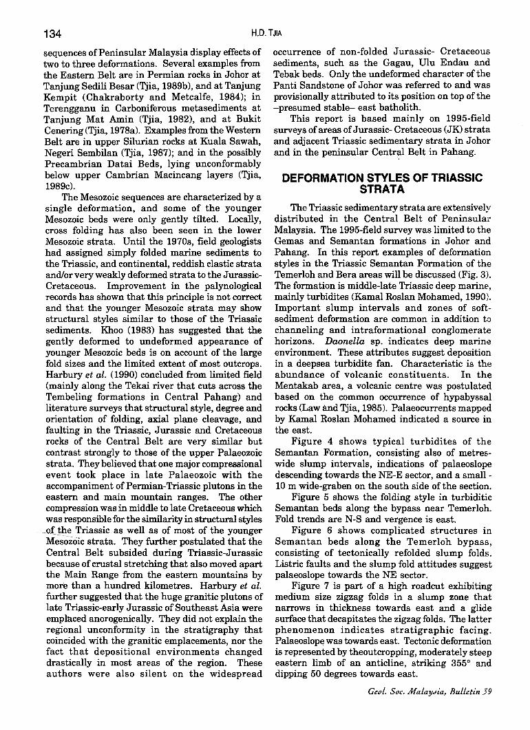
sequences of Peninsular Malaysia display effects of two to three deformations. Several examples from the Eastern Belt are in Permian rocks in Johor at Tanjung Sedili Besar (Tjia, 1989b), and at Tanjung Kempit (Chakraborty and Metcalfe, 1984); in Terengganu in Carboniferous metasediments at Tanjung Mat Amin (Tjia, 1982), and at Bukit Cenering (Tjia, 1978a). Examples from the Western Belt are in upper Silurian rocks at Kuala Sawah, Negeri Sembilan (Tjia, 1987); and in the possibly Precambrian Datai Beds, lying unconformably below upper Cambrian Macincang layers (Tjia, 1989c).
The Mesozoic sequences are characterized by a single deformation, and some of the younger Mesozoic beds were only gently tilted. Locally, cross folding has also been seen in the lower Mesozoic strata. Until the 1970s, field geologists had assigned simply folded marine sediments to the Triassic, and continental, reddish clastic strata and/or very weakly deformed strata to the JurassicCretaceous. Improvement in the palynological records has shown that this principle is not correct and that the younger Mesozoic strata may show structural styles similar to those of the Triassic sediments. Khoo (1983) has suggested that the gently deformed to undeformed appearance of younger Mesozoic beds is on account of the large fold sizes and the limited extent of most outcrops. Harbury et al. (1990) concluded from limited field (mainly along the Tekai river that cuts across the Tembeling formations in Central Pahang) and literature surveys that structural style, degree and orientation of folding, axial plane cleavage, and faulting in the Triassic, Jurassic and Cretaceous rocks of the Central Belt are very similar but contrast strongly to those of the upper Palaeozoic strata. They believed that one major compressional event took place in late Palaeozoic with the accompaniment of Permian-Triassic plutons in the eastern and main mountain ranges. The other compression was in middle to late Cretaceous which was responsible for the similarity in structural styles
.. oLtp.e Triassic as well as of most of the younger Mesozoic strata. They further postulated that the Central Belt subsided during Triassic-Jurassic because of crustal stretching that also moved apart the Main Range from the eastern mountains by mora than a hundred kilometres. Harbury et al. further suggested that the huge granitic plutons of late Triassic-early Jurassic of Southeast Asia were emplaced anorogenically. They did not explain the regional unconformity in the stratigraphy that coincided with the granitic emplacements, nor the fact that depositional environments changed drastically in most areas of the region. These authors were also silent on the widespread
occurrence of non-folded Jurassic- Cretaceous sediments, such as the Gagau, DIu Endau and Tebak beds. Only the undeformed character of the Panti Sandstone of Johor was referred to and was provisionally attributed to its position on top of the -presumed stable- east batholith.
This report is based mainly on 1995-field surveys of areas of Jurassic- Cretaceous (JK) strata and adjacent Triassic sedimentary strata in Johor and in the peninsular Centr~l Belt in Pahang.
DEFORMATION STYLES OF TRIASSIC STRATA
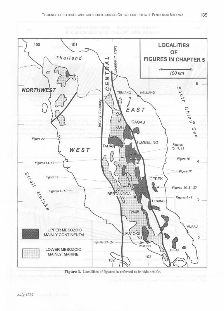
The Triassic sedimentary strata are extensively distributed in the Central Belt of Peninsula:r Malaysia. The 1995-field survey was limited to the Gemas and Semantan formations in Johor and Pahang. In this report examples of deformation styles in the Triassic Semantan Formation of the Temerloh and Bera areas will be discussed (Fig. 3). The formation is middle-late Triassic deep marine, mainly turbidites (Kamal Raslan Mohamed, 1990). Important slump intervals and zones of softsediment deformation are common in addition to channeling and intraformational conglomerate horizons. Daonella sp. indicates deep marine environment. These attributes suggest deposition in a deepsea turbidite fan. Characteristic is the abundance of volcanic constituents. In the Mentakab area, a volcanic centre was postulated based on the common occurrence of hypabyssal rocks (Law and Tjia, 1985). Palaeocurrents mapped by Kamal Raslan Mohamed indicated a source in the east.
Figure 4 shows typical turbidites of the Semantan Formation, consisting also of metreswide slump intervals, indications of palaeoslope descending towards the NE-E sector, and a small -10 m wide-graben on the south side of the section.
Figure 5 shows the folding style in turbiditic Semantan beds along the bypass near Temerloh. Fold trends are N-S and vergence is east .
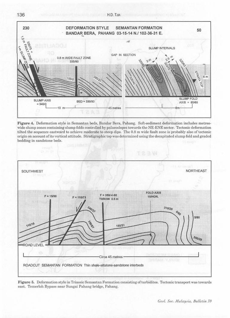
Figure 6 shows complicated structures in Semantan beds along the Temerloh bypass, consisting of tectonically refolded slump folds. Listric faults and the slump fold attitudes suggest palaeoslope towards the NE sector.
Figure 7 is part of a high roadcut exhibiting medium size zigzag folds in a slump zone that narrows in thickness towards east and a glide surface that decapitates the zigzag folds. The latter phenomenon indicates stratigraphic facing. Palaeoslope was towards east. Tectonic deformation is represented by theoutcropping, moderately steep eastern limb of an anticline, striking 3550 and dipping 50 degrees towards east.
Geol. Soc. MalaYJia, Bulletin 59
---
TECTONICS OF DEFORMED AND UNDEFORMED JURASSiC-CRETACEOUS STRATA OF PENINSULAR MALAYSIA 135
Thailand
-.-.... :::::. ... ::::: .... :::::: :: "7
:::::::: :::: :" ": . . ::::::::::::" ~
::::::::::: !
~~: i
LOCALITIES OF
FIGURES IN CHAPTER 5
0------10 100km
(j')
o c:. ......
-::s
6
Figure ?? ........................ .
JuLy 1996
WEST
Figures 14- 1
Figure 19 - ·-······
. Figures 4 - 5 .
UPPER MESOZOIC MAINLY CONTINENTAL
LOWER MESOZOIC MAINLY MARINE
Figures 23 - 24 ........ _ ...• , ............. .
Figures . to, 11, 13
.... _. Figure 18
... _ .... ::. ;:>. Figure 12
'liiIIt..~ • .. --+ ........ Figures 20, 21, 25
. ........ _. I ·················· Figures 6 - 9
Figure 3. Localities of figures in referred to in this article.
4
3
2
136
230
HD. TJIA
DEFORMATION STYLE SEMANTAN FORMATION BANDAR BERA, PAHANG 03-15-14 N./102-36-31 E.
50
SLUMP INTERVALS ,
GAP IN SECTION
BED:' 330/90 = 340/Q
L--10 m--....II--------45 metres
AXIS = 85/65
--------------~----_88ml----~1
Figure 4. Deformation style in Semantan beds, Bandar Bera, Pahang. Soft-sediment deformation includes metreswide slump zones containing slump folds controlled by palaeoslopes towards the NE-ENE sector. Tectonic deformation tilted the sequence eastward to achieve moderate to steep dips . The 0.8 m wide fault zone is probably also of tectonic origin on account of its vertical attitude. Stratigraphic top was determined using the decapitated slump fold and graded bedding in sandstone beds.
SOUTHWEST NORTHEAST
L------------------Circa 45 metres --------------------1
ROADCUT SEMANTAN FORMATION Thin shale-siltstone-sandstone interbeds
Figure 5. Deformation style in Triassic Semantan Formation consisting ofturbidites. Tectonic transport was towards east. Temerloh Bypass near Sungai Pahang bridge, Pahang.
Ceo!. Soc. MaLaYJia, BuLLetin 39
TECTONICS OF DEFORMED AND UNDEFORMED JURASSiC-CRETACEOUS STRATA OF PENINSULAR MALAYSIA 137
SOUTHWEST
VERGENCE;:
NORTHEAST
REFOLDED SYNFORM
ROADCUT SEMANTAN FORMATION NEAR TEMERLOH, PAHANG
L-__________________ ...o85 Met re s
Figure 6. Soft-sediment deformation consisting of refolded syncline and possibly also a recumbent fold superimposed by tectonic tilting of Seman tan beds . The palaeoslope was probably towards NE. Temerloh Bypass near Sungai Pahang bridge, Pahang.
SEMANTAN BEDS, BANDAR BERA 03115130 N - 102136/58 E
\~ .']..
Figure 7. Medium size zig-zag slump folds decapitated by a gliding plane suggest palaeoslope towards east. Semantan beds, Bandar Bera, Pahang.
JuLy 1996
138 H.D. TJIA
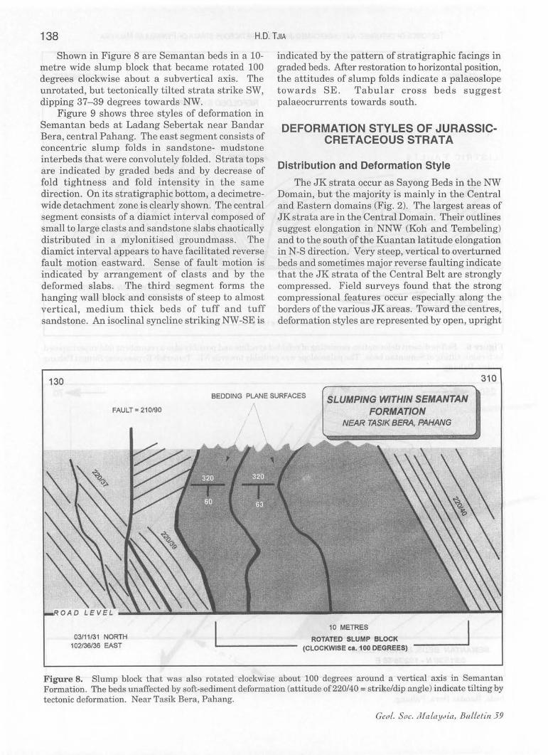
Shown in Figure 8 are Semantan beds in a 10-metre wide slump block that became rotated 100 degrees clockwise about a subvertical axis. The unrotated, but tectonically tilted strata strike SW, dipping 37- 39 degrees towards NW.
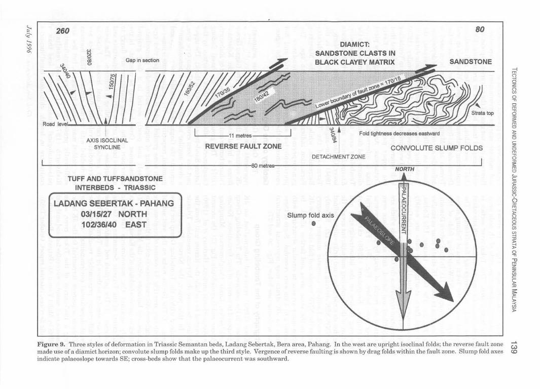
Figure 9 shows three styles of deformation in Semantan beds at Ladang Sebertak near Bandar Bera, central Pahang. The east segment consists of concentric slump folds in sandstone- mudstone interbeds that were convolutely folded. Strata tops are indicated by graded beds and by decrease of fold tightness and fold intensity in the same direction. On its stratigraphic bottom, a decimetrewide detachment zone is clearly shown. The central segment consists of a diamict interval composed of small to large clasts and sandstone slabs chaotically distributed in a mylonitised groundmass. The diamict interval appears to have facilitated reverse fault motion eastward. Sense of fault motion is indicated by arrangement of clasts and by the deformed slabs. The third segment forms the hanging wall block and consists of steep to almost vertical , medium thick beds of tuff and tuff sandstone. An isoclinal syncline striking NW -SE is
130
indicated by the pattern of stratigraphic facings in graded beds. After restoration to horizontal position, the attitudes of slump folds indicate a palaeoslope towards SE. Tabular cross beds suggest palaeocrurrents towards south.
DEFORMATION STYLES OF JURASSICCRETACEOUS STRATA
Distribution and Deformation Style
The JK strata occur as Sayong Beds in the NW Domain, but the majority is mainly in the Central and Eastern domains (Fig. 2). The largest areas of JK strata are in the Central Domain. Their outlines suggest elongation in NNW (Koh and Tembeling) and to the south ofthe Kuantan latitude elongation in N-S direction. Very steep, vertical to overturned beds and sometimes major reverse faulting indicate that the JK strata of the Central Belt are strongly compressed. Field surveys found that the strong compressional features occur especially along the borders ofthe various JK areas. Toward the centres, deformation styles are represented by open, upright
310
BEDDING PLANE SURFACES SLUMPING WITHIN SEMANTAN FORMATION FAULT = 210/90
03111/31 NORTH 102136/36 EAST
/
, ;\
, \
\ ., NEAR TASfK BERA, PAHANG
10 METRES
ROTATED SLUMP BLOCK (CLOCKWISE ca. 100 DEGREES)
Figure 8. Slump block that was also rotated clockwise about 100 degrees around a vertical axis in Semantan Formation. The beds unaffected by soft-sediment deformation (attitude of 220/40 = strike/dip angle) indicate tilting by tectonic deformation. Near Tasik Bera, Pahang.
Ceo!. Soc. Ma !aYJia, BIlLLetin39
260
Gap in section
AXIS ISOCLINAL SYNCLINE
L...-----11 metres ------'
REVERSE FAULT ZONE
DIAMICT: SANDSTONE CLASTS IN BLACK CLAYEY MATRIX
Fold tightness decreases eastward
80
SANDSTONE
CONVOLUTE SLUMP FOLDS DETACHMENT ZONE
--------------,80 metres-s ----------------N-O-R,.-r,--H------------'
TUFF AND TUFFSANDSTONE INTERBEDS - TRIASSIC
LADANG SEBERTAK - PAHANG 03/15/27 NORTH 102136140 EAST
Slump fold axis
• • I.
Figure 9. Three styles of deformation in Triassic Semantan beds, Ladang Sebertak, Bera area, Pahang. In the west are upright isoclinal folds; the reverse fault zone made use of a diamict horizon; convolute slump folds make up the third style. Vergence of reverse faulting is shown by drag folds within the fault zone. Slump fold axes indicate palaeoslope towards SE; cross-beds show that the palaeocurrent was southward.
-l m o -I o Z (') en o -n o m o :IJ s: m o :t> Z o c z o m o :IJ s: m o c.... C :IJ :t> en en (')
o :IJ m i:! o m o c en en -I :IJ
~ o -n \J m z Z en c 'l: :IJ
s::: :t>
'l: -< en J>
140 H.D. TJIA
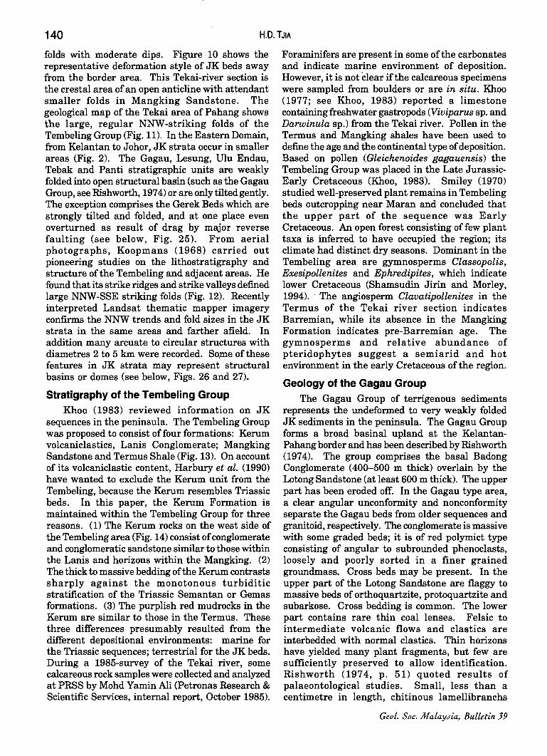
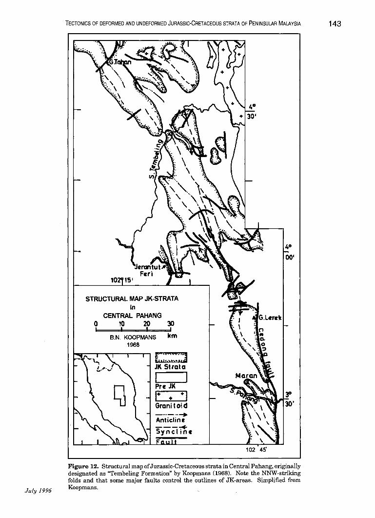
folds with moderate dips. Figure 10 shows the representative deformation style of JK beds away from the border area. This Tekai-river section is the crestal area of an open anticline with attendant smaller folds in Mangking Sandstone. The geological map of the Tekai area of Pahang shows the large, regular NNW-striking folds of the Tembeling Group (Fig. 11). In the Eastern Domain, from Kelantan to Johor, JK strata occur in smaller areas (Fig. 2). The Gagau, Lesung, Ulu Endau, Tebak and Panti stratigraphic units are weakly folded into open structural basin (such as the Gagau Group, see Rishworth, 1974) or are only tilted gently. The exception comprises the Gerek Beds which are strongly tilted and folded, and at one place even overturned as result of drag by major reverse faulting (see below, Fig. 25). From aerial photographs, Koopmans (1968) carried out pioneering studies on the lithostratigraphy and structure of the Tembeling and adjacent areas. He found that its strike ridges and strike valleys defined large NNW-SSE striking folds (Fig. 12). Recently interpreted Landsat thematic mapper imagery confirms the NNW trends and fold sizes in the JK strata in the same areas and farther afield. In addition many arcuate to circular structures with diametres 2 to 5 km were recorded. So,me of these features in JK strata may represent structural basins or domes (see below, Figs. 26 and 27).
Stratigraphy of the Tembeling Group Khoo (1983) reviewed information on JK
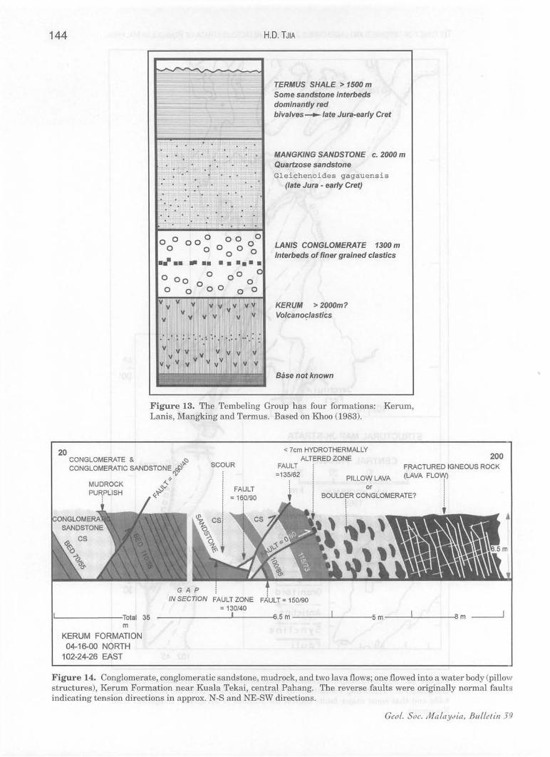
sequences in the peninsula. The Tembeling Group was proposed to consist offour formations: Kerum volcaniclastics, Lanis Conglomerate; Mangking Sandstone and Termus Shale (Fig. 13). On account of its volcaniclastic content, Harbury et al. (1990) have wanted to exclude the Kerum unit from the Tembeling, because the Kerum resembles Triassic beds. In this paper, the Kerum Formation is maintained within the Tembeling Group for three reasons. (1) The Kerum rocks on the west side of the Tembeling area (Fig. 14) consist of conglomerate and conglomeratic sandstone similar to those within the Lanis and horizons within the Mangking. (2) The thick to massive bedding of the Kerum contrasts sharply against the monotonous turbiditic stratification of the Triassic Semantan or Gemas formations. (3) The purplish red mudrocks in the Kerum are similar to those in the Termus. These three differences presumably resulted from the different depositional environments: marine for the Triassic sequences; terrestrial for the JK beds. During a 1985-survey of the Tekai river, some calcareous rock samples were collected and analyzed at PRSS by Mohd Yamin Ali (Petronas Research & Scientific Services, internal report, October 1985).
Foraminifers are present in some of the carbonates and indicate marine environment of deposition. However, it is not Clear if the calcareous specimens were sampled from boulders or are in situ. Khoo (1977; see Khoo, 1983) reported a limestone containing freshwater gastropods (Viviparus sp. and Darwinula sp.) from the Tekai river. Pollen in the Termus and Mangking shales have been used to define the age and the continental type of deposition. Based on pollen (Gleichenoides gagauensis) the Tembeling Group was placed in the Late JurassicEarly Cretaceous (Khoo, 1983). Smiley (1970) studied well-preserved plant remains in Tembeling beds outcropping near Maran and concluded that the upper part of the sequence was Early Cretaceous. An open forest consisting of few plant taxa is inferred to have occupied the region; its climate had distinct dry seasons. Dominant in the Tembeling area are gymnosperms Classopolis, Exesipollenites and Ephredipites, which indicate lower Cretaceous (Shamsudin Jirin and Morley, 1994). . The angiosperm Clavatipollenites in the Termus of the Tekai river section indicates Barremian, while its absence in the Mangking Formation indicates pre-Barremian age. The gymnosperms and relative abundance of pteridophytes suggest a semiarid and hot environment in the early Cretaceous of the region.
Geology of the Gagau Group The Gagau Group of terrigenous sediments
represents the undeformed to very weakly folded JK sediments in the peninsula. The Gagau Group forms a broad basinal upland at the KelantanPahang border and has been described by Rishworth (1974). The group comprises the basal Badong Conglomerate (400-500 m thick) overlain by the Lotong Sandstone (at least 600 m thick). The upper part has been eroded off. In the Gagau type area, a clear angular unconformity and nonconformity separate the Gagau beds from older sequences and granitoid, respectively. The conglomerate is massive with some graded beds; it is of red polymict type consisting of angular to subrounded phenoclasts, loosely and poorly sorted in a finer grained groundmass. Cross beds may be present. In the upper part of the Lotong Sandstone are flaggy to massive beds of orthoquartzite, protoquartzite and subarkose. Cross bedding is common. The lower part contains rare thin coal lenses. Felsic to intermediate volcanic flows and clastics are interbedded with normal clastics. Thin horizons have yielded many plant fragments, but few are sufficiently preserved to allow identification. Rishworth (1974, p. 51) quoted results of palaeontological studies. Small, less than a centimetre in length, chitinous lamellibranchs
Geol. Soc. MalaYJia, Bulletin 39
? «---~ "'"
WEST
Upper portion covered by vegetation
Slate with
2-m wide fault zone = 335/90 left-lateral drag
axial plane cleavage = 10159
EAST
1 m wide reverse fault zone = 350/40
Locality 16, Tekai river bank I I······················· ........................................................................................... "25 metres ............•...........................................................•.•. ............•... ..••..•. ........
WEST EAST Sungai Tekai level
I··········································· ·········· ......................................... ............. ····· ·OClrca 150 metres .••.•..............•............................• : . .•••..............................................
Figure 10. Fold style in Mangking Sandstone along the Tekai river, central Pahang: Anticlinorium with second-order folds and reverse faul ting verging west on a flank ofthe anticlinorium. Tekai river, central Pahang.
-l m ()
b z (') en o " o m o :IJ s: m o l> Z o c z o m
" o :IJ s: m o 'C :IJ l> en en (')
o :IJ
iJ () m o c en en --i :IJ
~ o " "lJ m z Z en c ~ :IJ
~ l> ~ -< en :i>
...... ~ ......

142 HD. TJIA
strongly resemble Sphaerium and Nakamuraiana, but do not determine age. The plants comprise a new species of Equisetites burchardti, Gleichenoides serratus, Otozamites gagauensis and a new subspecies Frenelopsis malaiana subsp. tenius, in addition to Gleichenoides gagauensis. This floral assemblage is Upper Triassic to Lower Cretaceous, pointing strongly to earliest Early Cretaceous. The absence of dicotyledenous remains suggests Late Jurassic to Early Cretaceous.
Comparison ofthe geological ages of the Gagau and Tembeling groups shows that the upper to middle Tembeling (Termus -Mangking) are equivalent with the Lotong Sandstone. Rishworth further declared that on the basis of palaeontology, lithology and structural style, the Gagau sequences
are correlatable with the Lesong (south Pahang) and Panti Sandstone (south Johor), possibly also with several other sequences of similar lithology and structure -except for the absence of fossils- in Peninsular Malaysia.
Descriptions of Outcrops
Figure 14 is a roadcut in volcanic Kerum Formation that Khoo (1983) has placed as the lowermost formation ofthe Tembeling Group (Fig . 10). The outcrop is near the western border of the Tembeling area. The 5-metre thick, deeply weathered boulder zone is problematic. It coul represent pillow lavas as suggested by the convexconcave cross sections of the 0.3-0.5 m long clasts of aphanitic, dark coloured (basaltic?) igneous rock.
Figure 11. Structural style of the Tembeling Group in the Tekai river area, Pahang. The three wrench faults were mapped during a survey by PRSS in 1993; the geology is mainly after H.P. Khoo who surveyed the area in the 1970s (unpublished report, Geological Survey of Malaysia).
CeoL. Soc. / /iIafaY,lia, BIILLetill 59
July 1996
TECTONICS OF DEFORMED AND UNDEFORMED JURASSiC-CRETACEOUS STRATA OF PENINSULAR MALAYSIA 143
10 151
STRUCTURAL MAP JK-STRATA in
CENTRAL PAHANG o 10 20 30
, , I
B.N. KOOPMANS km 1968
[:::::.::1 JK Strala
I I Pre JK 1+ + +1 Granitoid _ ... _._-+ Anticline ---~ Syncline
30'
102 45'
Figure 12. Structural map of Jurassic-Cretaceous strata in Central Pahang, originally designated as "Tembeling Formation" by Koopmans (1968). Note the NNW-striking folds and that some major faults control the outlines of JK-areas. Simplified from Koopmans.
144
20
HD. TJIA
TERMUS SHALE > 1500 m Some sandstone interbeds dominantly red bivalves _ late Jura-early Cret
MANGKING SANDSTONE c. 2000 m Quartzose sandstone Gleichenoides gagauensis
(late Jura - early Cret)
LANIS CONGLOMERATE 1300 m Interbeds of finer grained clastics
KERUM > 2000m? Volcanoclastics
Base not known
Figure 13. The Tembeling Group has four formations: Kerum, Lanis, Mangking and Termus. Based on Khoo (1983).
CONGLOMERATE & ~
CONGLOMERATIC SANDSTONE ",# SCOUR
< 7cm HYDROTHERMAlLY ALTERED ZONE
FAULT 200
FRACTURED IGNEOUS ROCK
'--------Total 35 m
KERUM FORMATION 04-16-00 NORTH
102-24-26 EAST
~" v'V «'?'
=135/62 PILLOW LAVA (LAVA
INSECT/ON = 150/90
-------...1'--------'6.5 m ___ ---''--___ :5 m -----L..---~B m
Figure 14. Conglomerate, conglomeratic sandstone, mudrock, and two lava flows; one flowed into a water body (pillow structures), Kerum Formation near Kuala Tekai, central Pahang. The reverse faults were originally normal faults indicating tension directions in approx. N-S and NE-SW directions.
Ceo!. Soc. Jl1a!aYJia, Bufletin 5 9
TECTONICS OF DEFORMED AND UNDEFORMED JURASSiC-CRETACEOUS STRATA OF PENINSULAR MALAYSIA 145
or it could be a boulder conglomerate. On its SSWside the "boulder" interval is overlain by sheeted and fractured, intermediate-type lava flow(s). The remainder of the roadcut consists of thickbedded conglomerate, conglomeratic sandstone, sandstone and purplish mudrock. If the faults were synsedimentary, normal faulting is indicated and a tensional stress regime may be interpreted.
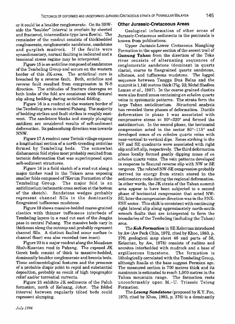
Figure 15 is an anticline composed of sandstones of the Tembeling Group and occurs on the western border of this JK-area. The anticlinal core is breached by a reverse fault. Both, anticline and reverse fault resulted from compression in N-S direction. The attitudes of fracture cleavages on both limbs of the fold are consistent with flexural slip along bedding during anticlinal folding.
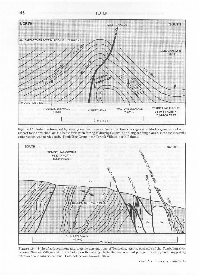
Figure 16 is a roadcut at the western border of the Tembeling area in central Pahang. The majority of bedding strikes and fault strikes is roughly eastwest. The sandstone blocks and steeply plunging antiform are considered results of soft-sediment deformation. Its palaeoslump direction was towards NNW.
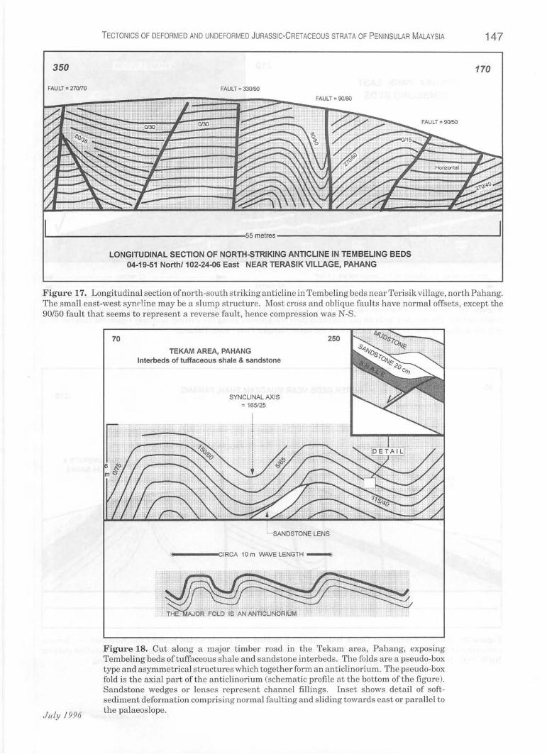
Figure 17 A roadcut near Terisik village exposes a longitudinal section of a north-trending anticline formed by Tembeling beds. The somewhat disharmonic fold styles most probably resulted from tectonic deformation that was superimposed upon soft-sediment structures.
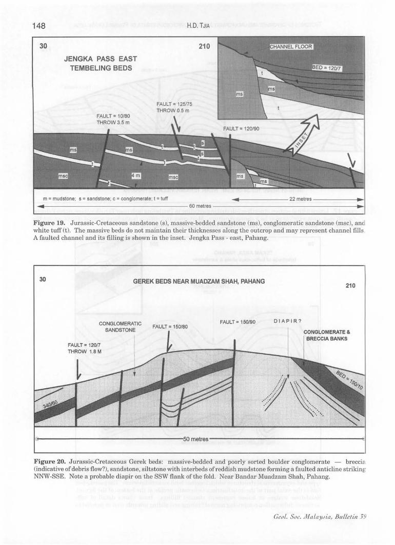
Figure 18 is a field sketch of a road cut along a major timber road in the Tekam area exposing smaller folds composed of?Kerum Formation of the Tembeling Group. The major fold is an anticlinorium (schematic cross section at the bottom of the sketch). Sandstone wedges probably represent channel fills in the dominantly finegrained tuffaceous mudstone.
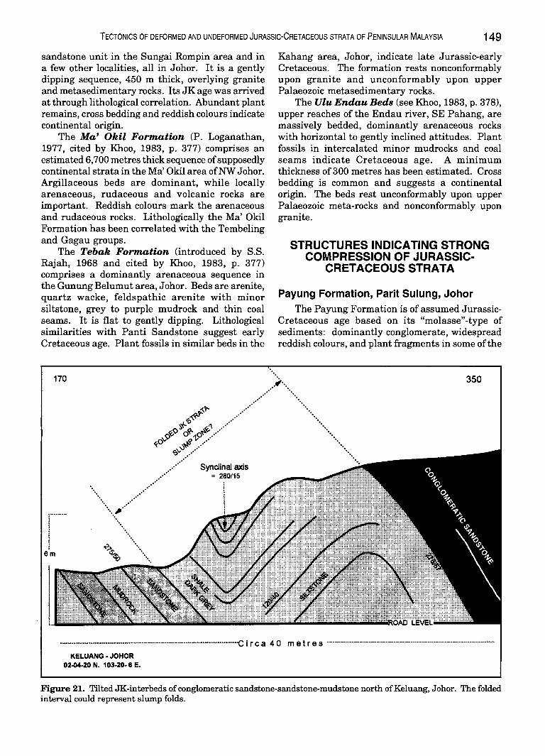
Figure 19 shows massive-bedded coarse-grained clastics with thinner tuffaceous interbeds of Tembeling layers in a road cut east of the Jengka pass in central Pahang. The massive beds vary in thickness along the outcrop and probably represent channel fills. A distinct faulted scour surface (= channel floor) was also recorded (see inset).
Figure 20 is a major roadcut along the Muadzam Shah-Kuantan road in Pahang. The exposed JK Gerek beds consist of thick to massive-bedded, dominantly boulder conglomerate and breccia beds. These sedimentological features and the presence of a probable diapir point to rapid and substantial deposition, probably as result of high topographic relief and/or torrential currents.
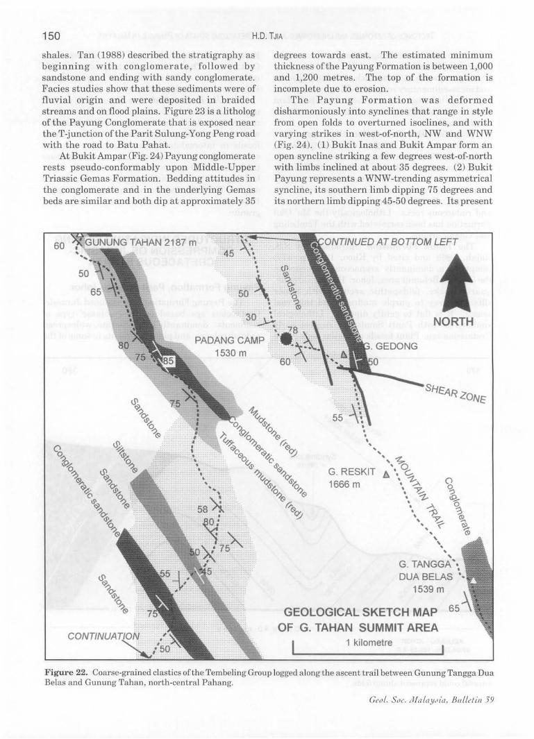
Figure 21 exhibits JK sediments of the Paluh formation, north of Keluang, Johor. The folded interval between regularly tilted beds could represent slumping.
July 1996
Other Jurassic-Cretaceous Areas Geological information of other areas of
Jurassic-Cretaceous sediments in the peninsula is known from publications.
Upper Jurassic-Lower Cretaceous Mangking Formation in the upper section ofthe ascent trail of Gunung Tahan from the direction of the Teku river consists of alternating sequences of conglomeratic sandstone (dominant in quartz clasts), coarse to finegrained quartz sandstone, siltstone, and tuffaceous mudstone. The logged sequence between Tangga Dua Belas and the summit is 1,140 metres thick (Fig. 22; Mohd Shafeea Leman et al., 1987). In the coarse grained clastics were also found zones containing en echelon quartz veins in systematic patterns. The strata form the large Tahan anticlinorium. Structural analysis has revealed three phases of deformation. Ductile deformation in phase 1 was associated with compressive stress in 50°-230° and formed the anticlinorium. In the second phase, the horizontal compression acted in the sector 80°-115° and developed zones of en echelon quartz veins with near-vertical to vertical dips. Zones striking in the NE and SE quadrants were associated with right slip and left slip, respectively. The third deformation phase locally formed gently dipping zones of en echelon quartz veins. The vein patterns developed in response to flexural reverse slip with NW or SE vergence. The related NW-SE compression probably derived its energy from strain stored in the sedimentary rocks during the regional deformation. In other words, the JK strata of the Tahan summit area appear to have been subjected to a second phase of horizontal compression that acted NWSE, later the compression direction was in the ENEESE sector. This shift is consistent with continuing right lateral slip along approximately north-south wrench faults that are interpreted to form the boundaries of the Tembeling (including the Tahan) area.
The Koh Formation in SE Kelantan introduced by Aw (Aw Peck Chin, 1972, cited by Khoo, 1983, p. 376; geological map sheet 46 and parts of 58, Kelantan, by Aw, 1978) consists of rudites and arenites interbedded with mudrock and a base of argillaceous limestone. The formation is lithologically correlated with the Tembeling Group, although fossils at the base suggest Permian age. The measured section is 700 metres thick and its maximum is estimated to reach 1,000 metres in the Tahan mountain range. The formation rests unconformably upon M.-U. Triassic Telong Formation.
The Lesong Sandstone (proposed by K.Y. Foo, 1970, cited by Khoo, 1983, p. 376) is a dominantly
146
FRACTURE CLEAVAGE = 85/80
HD. TJIA
QUARTZ VEINS
~ ______________ ~9 metres
FRACTURE CLEAVAGE = 270/30
TEMBEUNG GROUP 04-19-51 NORTH 102-24~8 EAST
Figure 15. Anticline breached by steeply inclined reverse faults; fracture cleavages of attitudes symmetrical with respect to the anticlinal axis indicate formation during folding by flexural slip along bedding planes. Note that tectonie compression was north-south. Tembeling Group near Terisik Village, north Pahang.
SOUTH
TEMBELING GROUP 04-19-47 NORTH 102-24-06 EAST
.--____ 0 m ____ -,
SLUMP FOLD AXIS =110/80
NORTH
'--------------------:35 metres--------------------'
Figure 16. Style of soft-sediment and tectonic deformations of Tembeling strata, east side of the Tembeling river between Terisik Village and Kuala Tekai, north Pahang. Note the near-vertical plunge of a slump fold, suggesting rotation about subvertical axis. Palaeoslope was towards NNW.
Ceol. Soc. }J;faLaYdia, BuLLetin 59
TECTONICS OF DEFORMED AND UNDEFORMED JURASSiC-CRETACEOUS STRATA OF PENINSULAR MALAYSIA 147
350 170
FAULT = 270(70 FAULT = 330/90
IL------------------------------------------oometres----------------------------------------------~
LONGITUDINAL SECTION OF NORTH-STRIKING ANTICLINE IN TEMBELING BEDS 04-19-51 North/102-24~6 East NEAR TERASIK VILLAGE, PAHANG
Figure 17. Longitudinal section of north-south striking anticline in Tembeling beds near Terisik village, north Pahang. The small east-west syndine may be a slump structure. Most cross and oblique faults have normal offsets, except the 90/50 fault that seems to represent a reverse fault , hence compression was N-S.
July /996
70
TEKAM AREA, PAHANG Interbeds of tuffaceous shale & sandstone
SYNCLINAL AXIS = 165/25
250
- SANDSTONE LENS
~~----OO(CIRCA 10 m WAVE LENGTH _ ,
Figure 18. Cut along a major timber road in the Tekam area, Pahang, exposing Tembeling beds oftuffaceous shale and sandstone interbeds . The folds are a pseudo-box type and asymmetrical structures which together form an anticlinorium. The pseudo-box fold is the axial part ofthe anticlinorium (schematic profile at the bottom ofthe figure). Sandstone wedges or lenses represent channel fillings . Inset shows detail of softsediment deformation comprising normal faulting and sliding towards east or parallel to the palaeoslope.
148
30
JENGKA PASS EAST TEMBELING BEDS
FAULT = 10/80
H.D. TJIA
FAULT = 125175 THROWO.5m
210
m = mudstone; s = sandstone; c = conglomerate; t = tuff ........ .._------22 metres ------..-1 ... ~ __ --------------------60 metres --------------------.-1
Figure 19. Jurassic-Cretaceous sandstone (s), massive-bedded sandstone (ms), conglomeratic sandstone (msc), an white tuff (t) . The massive beds do not maintain their thicknesses along the outcrop and may represent channel fills . A faulted channel and its filling is shown in the inset. Jengka Pass - east, Pahang.
30 GEREK BEDS NEAR MUADZAM SHAH, PAHANG
CONGLOMERATIC SANDSTONE
FAULT = 12017 THROW 1.8M
FAULT = 150/90 FAULT = 150/80
DIAPIR?
210
CONGLOMERATE & BRECCIA BANKS
1B-----------------------------------------t50m~res------------------------------------------~1
Figure 20. Jurassic-Cretaceous Gerek beds: massive-bedded and poorly sorted boulder conglomerate - brecci (indicative of debris flow?), sandstone, siltstone with interbeds of reddish mudstone forming a faulted anticline striking NNW-SSE. Note a probable diapir on the SSW flank ofthe fold. Near Bandar Muadzam Shah, Pahang.
Ceo!. Soc. Ma laYJia, BuLLetin 59
TECTONICS OF DEFORMED AND UNDEFORMED JURASSiC-CRETACEOUS STRATA OF PENINSULAR MALAYSIA 149
sandstone unit in the Sungai Rompin area and in a few other localities, all in Johor. It is a gently dipping sequence, 450 m thick, overlying granite and metasedimentary rocks. Its JK age was arrived at through lithological correlation. Abundant plant remains, cross bedding and reddish colours indicate continental origin.
The Ma' Okil Formation (P. Loganathan, 1977, cited by Khoo, 1983, p. 377) comprises an estimated 6,700 metres thick sequence of supposedly continental strata in the Ma' Okil area ofNW Johor. Argillaceous beds are dominant, while locally arenaceous, rudaceous and volcanic rocks are important. Reddish colours mark the arenaceous and rudaceous rocks. Lithologically the Ma' Okil Formation has been correlated with the Tembeling and Gagau groups.
The Tebak Formation (introduced by S.S. Rajah, 1968 and cited by Khoo, 1983, p. 377) comprises a dominantly arenaceous sequence in the Gunung Belumut area, Johor. Beds are arenite, quartz wacke, feldspathic arenite with minor siltstone, grey to purple mudrock and thin coal seams. It is flat to gently dipping. Lithological similarities with Panti Sandstone suggest early Cretaceous age. Plant fossils in similar beds in the
170
•.... ' . ..•..
' .
8m
..... ....
". ".
'. ".
'. .....
Synclinal axis = 280/15
Kahang area, Johor, indicate late Jurassic-early Cretaceous. The formation rests nonconformably upon granite and unconformably upon upper Palaeozoic metasedimentary rocks.
The Ulu Endau Beds (see Khoo, 1983, p. 378), upper reaches of the Endau river, SE Pahang, are massively bedded, dominantly arenaceous rocks with horizontal to gently inclined attitudes. Plant fossils in intercalated minor mudrocks and coal seams indicate Cretaceous age. A minimum thickness of 300 metres has been estimated. Cross bedding is common and suggests a continental origin. The beds rest unconformably upon upper Palaeozoic meta-rocks and nonconformably upon granite.
STRUCTURES INDICATING STRONG COMPRESSION OF JURASSIC
CRETACEOUS STRATA
Payung Formation, Parit Sulung, Johor The Payung Formation is of assumed Jurassic
Cretaceous age based on its "molasse" -type of sediments: dominantly conglomerate, widespread reddish colours, and plant fragments in some of the
350
................................ _ ..................... _ .................................. -c Ire a 4 0 met res .......... _-_ .. _ .......... _ ................................................ ..
KELUANG - JOHOR 02-04-20 N. 103-20- 8 E.
Figure 21. Tilted JK-interbeds of conglomeratic sandstone-sandstone-mudstone north ofKeluang, Johor. The folded interval could represent slump folds.
150 H.D. TJIA
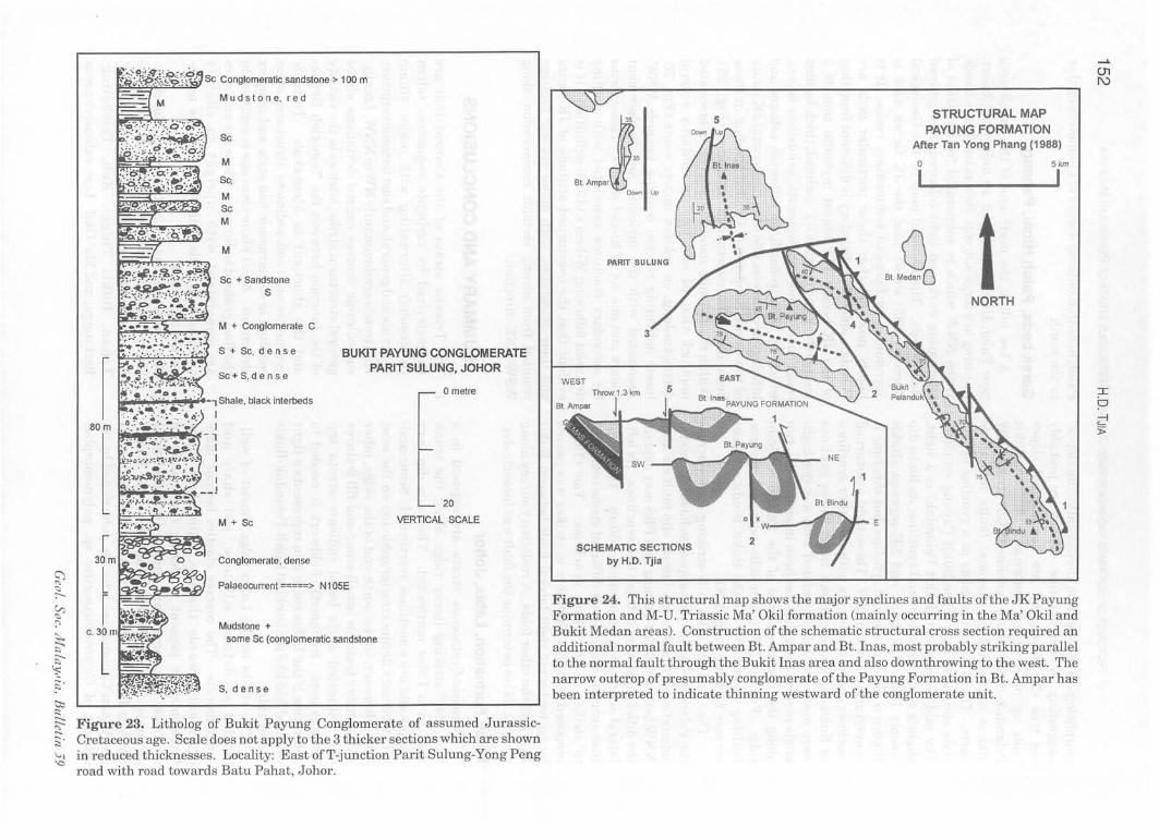
shales. Tan (1988) described the stratigraphy as beginning with conglomerate, followed by sandstone and ending with sandy conglomerate. Facies studies show that these sediments were of fluvial origin and were deposited in braided streams and on flood plains. Figure 23 is a litholog of the Payung Conglomerate that is exposed near the T-junction ofthe Parit Sulung-Yong Pengroad with the road to Batu Pahat.
At Bukit Ampar (Fig. 24) Payung conglomerate rests pseudo-conformably upon Middle-Upper Triassic Gemas Formation. Bedding attitudes in the conglomerate and in the underlying Gemas beds are similar and both dip at approximately 35
60
1530 m
degrees towards east. The estimated minimum thickness ofthe Payung Formation is between 1,000 and 1,200 metres. The top of the formation is incomplete due to erosion.
The Payung Formation was deformed disharmoniously into synclines that range in style from open folds to overturned isoclines, and with varying strikes in west-of-north, NW and WNW (Fig. 24). (1) Bukit Inas and Bukit Ampar form an open syncline striking a few degrees west-of-north with limbs inclined at about 35 degrees. (2) Bukit Payung represents a WNW-trending asymmetrical syncline, its southern limb dipping 75 degrees and its northern limb dipping 45-50 degrees. Its present
INUED AT BOTTOM LEFT
NORTH
• • • , .. .. ... "' .. ~
G. RESKIT b'" ~ 1666 m ' :.>.
'. ~ ."-t--• • ...A \ -}:J ,~ .... '(" .. ,
' .. .. , G. TANGGA .... DUA BELAS '-
GEOLOGICAL SKETCH MAP OF G. TAHAN SUMMIT AREA
1 kilometre
Figure 22. Coarse-grained clastics ofthe Tembeling Group logged along the ascent trail between Gunung Tangga Dua Belas and Gunung Tahan, north-central Pahang.
Ceo/. Soc. 17Ia/ay"ia , Bulletin 59
TECTONICS OF DEFORMED AND UN DEFORMED JURASSiC-CRETACEOUS STRATA OF PENINSULAR MALAYSIA 151
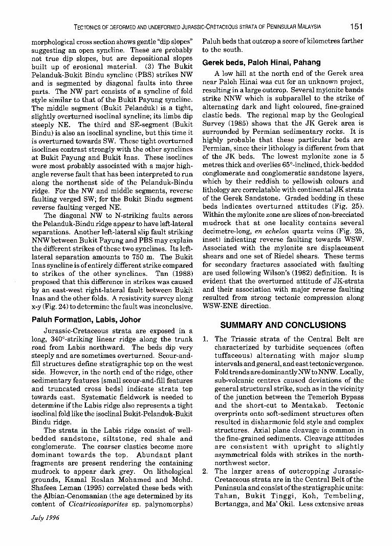
morphological cross section shows gentle "dip slopes" suggesting an open syncline. These are probably not true dip slopes, but are depositional slopes built up of erosional material. (3) The Bukit Pelanduk-Bukit Bindu syncline (PBS) strikes NW and is segmented by diagonal faults into three parts. The NW part consists of a syncline of fold style similar to that of the Bukit Payung syncline. The middle segment (Bukit Pelanduk) is a tight, slightly overturned isoclinal syncline; its limbs dip steeply NE. The third and SE-segment (Bukit Bindu) is also an isoclinal syncline, but this time it is overturned towards SW. These tight overturned isoclines contrast strongly with the other synclines at Bukit Payung and Bukit Inas. These isoclines were most probably associated with a major highangle reverse fault that has been interpreted to run along the northeast side of the Pelanduk-Bindu ridge. For the NW and middle segments, reverse faulting verged SW; for the Bukit Bindu segment reverse faulting verged NE.
The diagonal NW to N-striking faults across the Pelanduk-Bindu ridge appear to have left-lateral separations. Another left-lateral slip fault striking NNW between Bukit Payung and PBS may explain the different strikes of these two synclines. Its leftlateral separation amounts to 750 m. The Bukit Inas syncline is of entirely different strike compared to strikes of the other synclines. Tan (1988) proposed that this difference in strikes was caused by an east-west right-lateral fault between Bukit Inas and the other folds. A resistivity survey along x-y (Fig. 24) to determine the fault was inconclusive.
Paluh Formation, Labis, Johor
Jurassic-Cretaceous strata are exposed in a long, 340°-striking linear ridge along the trunk road from Labis northward. The beds dip very steeply and are sometimes overturned. Scour-andfill structures define stratigraphic top on the west side. However, in the north end ofthe ridge, other sedimentary features [small scour-and-fill features and truncated cross beds] indicate strata top towards east. Systematic fieldwork is needed to determine if the Labis ridge also represents a tight isoclinal fold like the isoclinal Bukit-Pelanduk-Bukit Bindu ridge.
The strata in the Labis ridge consist of wellbedded sandstone, siltstone, red shale and conglomerate. The coarser clastics become more dominant towards the top. Abundant plant fragments are present rendering the containing mudrock to appear dark grey. On lithological grounds, Kamal Roslan Mohamed and Mohd. Shafeea Leman (1995) correlated these beds with the ~bian-Cenomanian (the age determined by its content of Cicatricosisporites sp. palynomorphs)
July 1996
Paluh beds that outcrop a score of kilometres farther to the south.
Gerek beds, Paloh Hinai, Pahang A low hill at the north end of the Gerek area
near Paloh Hinai was cut for an unknown project, resulting in a large outcrop. Several mylonite bands strike NNW which is subparallel to the strike of alternating dark and light coloured, fine-grained clastic beds. The regional map by the Geological Survey (1985) shows that the JK Gerek area is surrounded by Permian sedimentary rocks. It is highly probable that these particular beds are Permian, since their lithology is different from that of the JK beds. The lowest mylonite zone is 5 metres thick and overlies 65°-inclined, thick-bedded conglomerate and conglomeratic sandstone layers, which by their reddish to yellowish· colours and lithology are correlatable with continental JK strata of the Gerek Sandstone. Graded bedding in these beds indicates overturned attitudes (Fig. 25). Within the mylonite zone are slices of non-brecciated mudrock that at one locality contains several decimetre-Iong, en echelon quartz veins (Fig. 25, inset) indicating reverse faulting towards WSW. Associated with the mylonite are displacement shears and one set of Riedel shears. These terms for secondary fractures associated with faulting are used following Wilson's (1982) definition. It is evident that the overturned attitude of JK-strata and their association with major reverse faulting resulted from strong tectonic compression along WSW-ENE direction.
SUMMARY AND CONCLUSIONS
1. The Triassic strata of the Central Belt are characterized by turbidite sequences (often tuffaceous) alternating with major slump intervals and general, and east tectonic vergence. Fold trends are dominantly NW to NNW. Locally, sub-volcanic centres caused deviations of the general structural strike, such as in the vicinity of the junction between the Temerloh Bypass and the short-cut to Mentakab. Tectonic overprints onto soft-sediment structures often resulted in disharmonic fold style and complex structures. Axial plane cleavage is common in the fine-grained sediments. Cleavage attitudes are consistent with upright to slightly asymmetrical folds with strikes in the northnorthwest sector.
2. The larger areas of outcropping JurassicCretaceous strata are in the Central Belt of the Peninsula and consist of the stratigraphic units: Tahan, Bukit Tinggi, Koh, Tembeling, Bertangga, and Ma' Okil. Less extensive areas
t;;, :::
~~:p::.,,-=~ Sc Conglomeratic sandstone> 100 m
Mud s ton e, red
Sc
M
Sc;
M Sc M
M
Sc + Sandstone S
M + Conglomerate C
S + Sc, den s e BUKIT PAYUNG CONGLOMERATE PARIT SULUNG, JOHOR
M + Sc
Conglomerate, dense
Palaeocurrent =====> N 1 OSE
Mudstone + some Sc (conglomeratic sandstone
S, den s e
o metre
20
VERTICAL SCALE
~ Figure 23. Litholog of Bukit Payung Conglomerate of assumed Jurassic-g. Cretaceous age. Scale does not apply to the 3 thicker sections which are sllown ~ in reduced thicknesses. Locality: East ofT-junction Parit Sulung-Yong Peng
road with road towards Batu Pahat, Johor.
PARIT SULUNG
3
WEST 5
SCHEMATIC SECTIONS by H.D. Tjia
5 STRUCTURAL MAP PAYUNG FORMATION
After Tan Yong Phang (1988)
o I
IJ\ CJ Bt Meda~O
Skm
I
NORTH
Figure 24. This structural map shows the major synclines and faults ofthe JK Payung Formation and M-U. Triassic Ma' Okil formation (mainly occurring in the Ma' Okil and Bukit Medan areas). Construction of the schematic structural cross section required an additional normal fault between Bt. Ampar and Bt. Inas, most probably striking parallel to the normal fault through the Bukit Inas area and also downthrowing to the west. The narrow outcrop of presumably conglomerate ofthe Payung Formation in Bt. Ampar has been interpreted to indicate thinning westward ofthe conglomerate unit.
TECTONICS OF DEFORMED AND UNDEFORMED JURASSiC-CRETACEOUS STRATA OF PENINSULAR MALAYSIA 153
are Paluh and Bukit Payung, both in J ohor (Fig. 2). JK-strata in these areas have been tectonically deformed. Compressional structures are especially well represented along the borders of the mentioned areas, where tight to isoclinal folds, and sometimes overturned structures and reverse faulting are present. On the other hand, the central parts the JK-areas are likely to consist of open folds and thus imply less strong compreSSIOn.
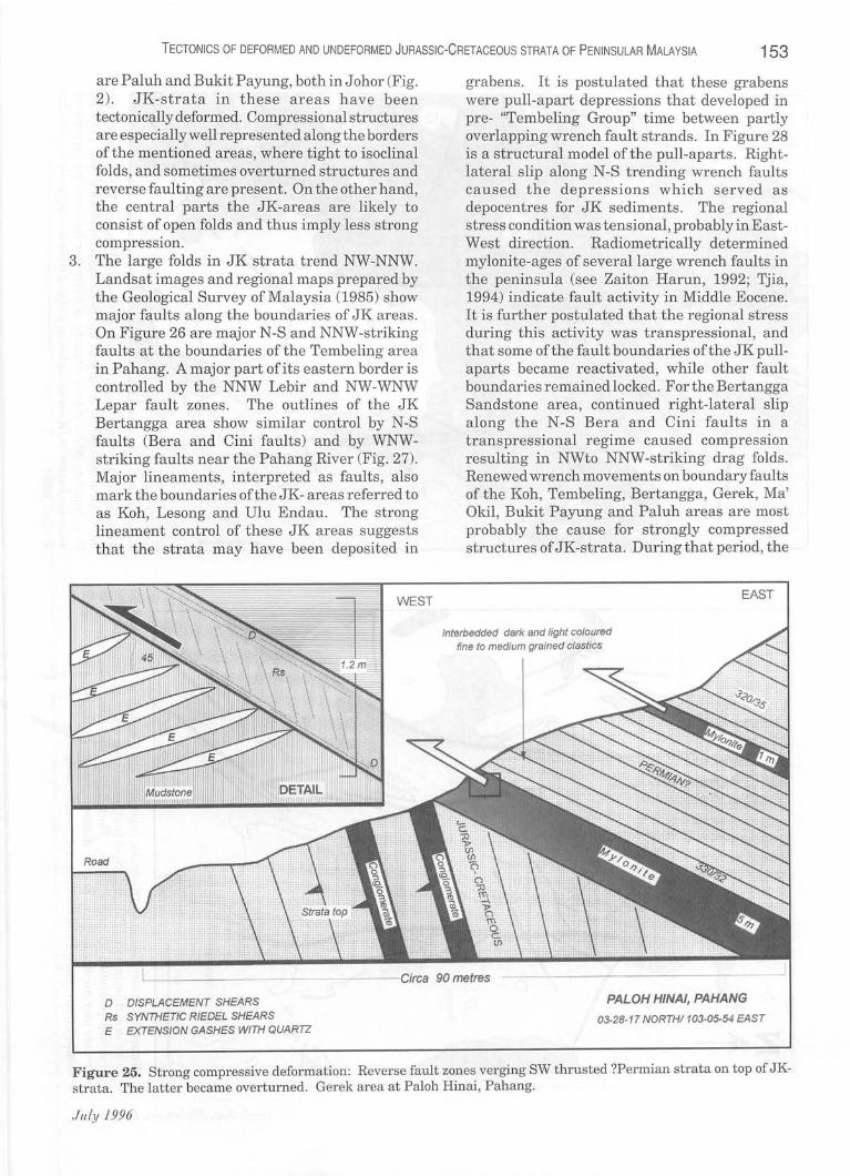
3. The large folds in JK strata trend NW-NNW. Landsat images and regional maps prepared by the Geological Survey of Malaysia (1985) show major faults along the boundaries of JK areas. On Figure 26 are major N-S and NNW-striking faults at the boundaries of the Tembeling area in Pahang. A major part of its eastern border is controlled by the NNW Lebir and NW -WNW Lepar fault zones . The outlines of the JK Bertangga area show similar control by N-S faults (Bera and Cini faults ) and by WNWstriking faults near the Pahang River (Fig. 27). Major lineaments, interpreted as faults , also mark the boundaries ofthe JK- areas referred to as Koh, Lesong and Vlu Endau. The strong lineament control of these JK areas suggests that the strata may have been deposited in
WEST
D DISPLACEMENT SHEARS Rs SYNTHETIC RIEDEL SHEARS E EXTENSION GASHES WITH QUARTZ
grabens. It is postulated that these grabens were pull-apart depressions that developed in pre- "Tembeling Group" time between partly overlapping wrench fault strands. In Figure 28 is a structural model of the pull-aparts . Rightlateral slip along N-S trending wrench faults caused the depressions which served as depocentres for JK sediments. The regional stress condition was tensional, probably in EastWest direction. Radiometrically determined mylonite-ages of several large wrench faults in the peninsula (see Zaiton Harun, 1992; Tjia, 1994) indicate fault activity in Middle Eocene. It is further postulated that the regional stress during this activity was transpressional, and that some ofthe fault boundaries ofthe JK pullaparts became reactivated, while other fault boundaries remained locked. For the Bertangga Sandstone area, continued right-lateral slip along the N-S Bera and Cini faults in a transpressional regime caused compression resulting in NWto NNW-striking drag folds . Renewed wrench movements on boundary faults of the Koh, Tembeling, Bertangga, Gerek , Ma' Okil, Bukit Payung and Paluh areas are most probably the cause for strongly compressed structures of JK-strata. During that period, the
Interbedded dark and light coloured fine to medium grained clastiCS
EAST
PALOH HINAI, PAHANG
03-28-17 NORTH/ 103-05-54 EAST
Figure 25. Strong compressive deformation: Reverse fault zones verging SW thrusted ?Permian strata on top of JKstrata. The latter became overturned. Gerek area at Paloh Hinai, Pahang.
JuLy 1996
Figure 26. Distribution of JK-strata, especially the Tembeling Group and Koh Formation in north Pahang. Note that boundaries ofthe JK Tembeling area are controlled by major faults. Dotted lines indicate strike ridges: arcuate and circular features may be domes or basins in JK-areas and were mapped fmm rpf'pnt T .a nn<:a t thpm Atif' mRpppr imA Pry.
G Granitoid
103.00
Figure 27. Distribution of JK-strata in central Pahang. The Bera and Cini faults form part of the outline of the Bertangga Sandstone beds. Dotted lines indicate strike ridges; arcuate and circular features may represent JUllle~ Ul" La~lml ll1 J K <11<.:35 nd r re m pped from recent Landsat thcma tic mapper images.

TECTONICS OF DEFORMED AND UNDEFORMED JURASSiC-CRETACEOUS STRATA OF PENINSULAR MALAYSIA 155
boundary faults of other JK-areas, such as the Gagau, UluEndau, and Tebakremainedinactive as wrench faults, but there the general compressional conditions resulted in en bloc tilting or in raising the pull-apart sedimentary fillings.
4. It is very unlikely that the huge complex of upper Triassic-lower Jurassic granitoid bodies that extends from southern China into western Indonesia was emplaced anorogenically, as postulated by Harbury et al. (1990). In several parts of the Titiwangsa (Main Range of Peninsular Malaysia) granitoid complex, thin thermal aureoles of not more than a few decimetres wide have been seen. Systematic metamorphic zonation around anorogenically emplaced crystalline-rock bodies should be expected, but such condition has never been reported from the Titiwangsa range (see Gobbett and Hutchison, 1973; Yin, 1990). For instance, the eastern boundary ofthe Titiwangsa granitoid complex in Pahang is sharply defined and the
adjacent lower Palaeozoic schists show general uniformi ty in metamorphic facies (see Geological Survey of Malaysia, 1985). Cross-cutting relations between Titiwangsa granitoids and country rock are common, which imply forceful intrusion. Sharply defined map boundaries between granitoids and country rock are also the rule.
5. This study arrives at the conclusion and reaffirms the hitherto widely held view that the latest major tectonic deformation of Peninsular Malaysia occurred in late Triassic-early Jurassic time and that the orogenesis was accompanied by intrusion of Titiwangsa granitoid bodies. Certain fractures that experienced strike-slip faulting in pre-late Jurassic developed pullaparts into which were deposited mainly continental Jurassic-Cretaceous sediments. In Middle Eocene, renewed wrench-faulting along several pull-apart boundaries deformed its JKfilling sediments into dragfolds and subjected these and older rocks to reverse faulting.
TRANSTENSION PULLAPART DEPRESSIONS (Loci of JK-strata deposition)
REGIONAL TRANSTENSION DIRECTION
TRANSPRESSION DRAG FOLDS OF JK STRATA
MIDDLE EOCENE
POPPED-UP AND TILTED JK STRATA
• • REGIONAL TRANSTENSION DIRECTION
ORIGINAL WIDTH OF PULLAPART
Figure 28. Model ofthe development of deformed and undeformed Jurassic-Cretaceous strata in Peninsular Malaysia. UPPER: In the Jurassic-Cretaceous, dextral strike-slip motion on mainly north-south striking faults produces pullaparts in areas sandwiched between fault segments. Resultant of regional tension is approximately east-west. LOWER: In middle Eocene, the regional stress regime has changed such as to produce transpression and to re-activate dextral slip on some ofthe faults. Sediments filling the pull-aparts are compressed into NW-striking drag folds. Where faults remained locked and only accomodate vertical displacements, the pull-apart sediments are pushed up to form structural plateaus with or without gentle dips.
Jllly /996

156 H.D. TJIA
Examples are the Tahan, Koh, Tembeling, Bertangga, Gerek, Ma' Okil, and Bukit Payung JK-strata. Where boundary faults of pull -a parts were locked, their JK-strata fills were slightly tilted or only uplifted, such as in the Gagau, Lesong, Tebak and Ulu Endau areas.
ACKNOWLEDGEMENTS The content of this article was presented at the
Geological Society of Malaysia, Petroleum Geology Conference '95 with permission of PRSS management. Fieldwork in 1995 was carried out in the company ofKK Liew and Jamaal Hoesni (both of PRSS). At one time or another also several colleagues of Petronas Exploration Management Department participated.
REFERENCES Aw, P.c., 1978. Geological map of Kelantan, Sheet 46 and
parts of Sheet 58. Geological Survey of Malaysia, scale 1:63,360.
BURTON, c.K., 1973. Mesozoic. In: D.J. Gobbett and C.S. Hutchison (Eds.), Geology of the Malay Peninsula. Wiley, New York, 97-141.
CHAKRABORTY, K.R. AND METCALFE, I., 1984. Analysis of mesoscopic structures at Mersing and Tanjung Kempit, Johore, Peninsular Malaysia. Bulletin Geological Society of Malaysia, 17,357-371.
Faa, K.Y., 1983. The Palaeozoic sedimentary rocks of Peninsular Malaysia - Stratigraphy and correlation. Proceedings Workshop on Stratigraphic Correlation of Thailand and Malaysia, 1, 1-19.
GEOLOGICAL SURVEY OF MALAYSIA, 1985. Geological Map of Peninsular Malaysia, 8th edition. Scale 1:500,000.
GOBBETT, D.J. AND HUTCHISON, C.S. (Eds.), 1973. Geology of the Malay Peninsula. Wiley, New York.
HARBURY,N.A.,JONES,M.E.,AUOLEY-CHARLES,M.G.,METCALFE, I. AND MOHAMED, K.R., 1990. Structural evolution of Mesozoic Peninsular Malaysia. Journal Geological Society of London, 147, 11-26.
KAMAL ROSLAN MOHAMED, 1990. Sistem Trias diJalurTengah. Sains Malaysiana, 19(1), 11-22.
KAMAL ROSLAN MOHO AND MOHO SHAFEEA LEMAN, 1995. Field Notes, Pre-Conference Sedimentalogy-Stratigraphy Fieldtrip. Annual Conference Geological Society of Malaysia, 1995, Melaka.
KHoo, HAN PENG, 1977. The geology of the Sungai Tekai area. Geological Survey of Malaysia, Annual Report 1977, 93-103.
KHoo, HAN PENG, 1983. Mesozoic stratigraphy in Peninsular Malaysia. Proceedings Workshop on Stratigraphic Correlation of Thailand and Malaysia, 1,370-383.
KOOPMANS, B.N., 1968. The Tembeling Formation - A lithostratigraphic description. Bulletin Geological Society of Malaysia, 1, 23-43.
LAW, S.F. AND TJiA, HD., 1985. An intrusive swarm near
Mentakab, Pahang: A probable volcanic centre. Warta Geologi 11(2), 43-46.
METCALFE, I., 1988. Origin and assembly of Southeast Asian continental terranes. In: M.G. Audley-Charles and A. Hallam (Eds.), Gondwana and Tethys. Geological Society of London, Special Publication 37, 79-100.
MOHO SHAFEEA LEMAN, IBRAHIM KOMOO AND TJIA, HD., 1987. Geologi kawasan kemuncak Gunung Tahan, Pahang: Beberapa cerapan. Sains Malaysiana 16(1), 49-64.
RiSHWORTH, D.E.H, 1974. The Upper Mesozoic terrigenous Gagau Group of Peninsular Malaysia. Geological Survey of Malaysia, Special Paper 1, 78p.
SHAMSUOIN JIRIN AND MORLEY, R., 1994. Lower Cretaceous palynormorphs from the Termus and Mangking formations (Tembeling Group), Peninsular Malaysia: Their stratigraphic and climatic significance [abstract). Warta Geologi 20(4), 219.
SMILEY, c.J., 1970. Later Mesozoic flora from Maran, Pahang Part 1: Geologic considerations. Bulletin Geologica; Society of Malaysia, 3, 77-88.
TAN, YONG PHANG, 1988. Stratigrafi geologi kawasan Parit Sulong, Johor. MSc. thesis, Universiti Kebangsaan Malaysia, Bangi (unpubl.).
TJIA, H.D., 1978a. Multiple deformations at Bukit Cenering. Terengganu. Bulletin Geological Society of Malaysia, 10. 15-24.
TJIA, H.D., 1978b. Structural geology of Peninsular Malaysia. Proceedings Third Regional Conference on Geology and Mineral Resources of Southeast Asia, Bangkok, Thailand. November 1978, 673-682.
TJiA, H.D., 1982. Disharmonic folds at Tanjung Mat Amin. Terengganu. Warta Geologi 8(6), 258-259.
TJiA, H.D., 1984. Multi-directional tectonic movements in the schist of Bentong, Pahang. Warta Geologi 10(5), 187-189.
TJiA, HD., 1987. Complex deformations and probable fold nappe in Upper Silurian metasediments near Kuala Sawah, Negeri Sembilan. Sains Malaysiana 16(1), 33-47.
TJIA, H.D., 1989a. Tectonic history of the Bentong-Bengkalis Suture. Geologi Indonesia 12(1),89-111.
TJIA, H.D., 1989b. Superimposed structures in upper Palaeozoic metasediments, eastern Johor. Sa ins Malaysiana 18(1),33-46.
TJIA, H.D., 1989c. Structural geology of Datai Beds and Macincang Formation, Langkawi. Bulletin Geological Society of Malaysia, 23, 85-120.
TJiA, H.D., 1989d. Major faults of Peninsular MalaYSia on remotely sensed images. Sains Malaysiana 18(1), 101-114.
TJiA,HD.,1994. Origin and tectonic development of MalayPenyu-West Natuna basins. Petronas Research and Scientific Services, Research for Business Excellence Seminar, Kuala Lumpur, June 1994.
WILSON, G., 1982. Introduction to small-scale geological structures. Allen & Unwin, London.
YIN, E.H., 1990. Regional geology. Peninsular Malaysia. Annual Report Geological Survey of Malaysia 1989,42-58
ZAITON HARUN, 1992. Anatomi sesar-sesar utama Semenanjung Malaysia. Doctor's thesis, Universiti Kebangsaan Malaysia, Bangi (unpublished).
Ie ....
Manuscript received 10 February 1996
CeoL. Soc. MaLaYJia, BuLLetin 3f}
Related Documents


![· Web viewet al. [47] investigated the variation in apparent GND densities in undeformed silicon and deformed copper as a function of step size in the range 0.5–10 µm. They found](https://static.cupdf.com/doc/110x72/5aad93a47f8b9a59658e7f82/viewet-al-47-investigated-the-variation-in-apparent-gnd-densities-in-undeformed.jpg)


![GE 162 Introduction to Seismology - clay/Ge162/Ge162_lecture_notes.pdfGE 162 Introduction to Seismology Winter 2013 - 2016. 6 [Sketch undeformed and deformed rod, annotate] Let 𝑥𝑥](https://static.cupdf.com/doc/110x72/5cf7382e88c99346318ca77c/ge-162-introduction-to-seismology-clayge162ge162lecturenotespdfge-162-introduction.jpg)