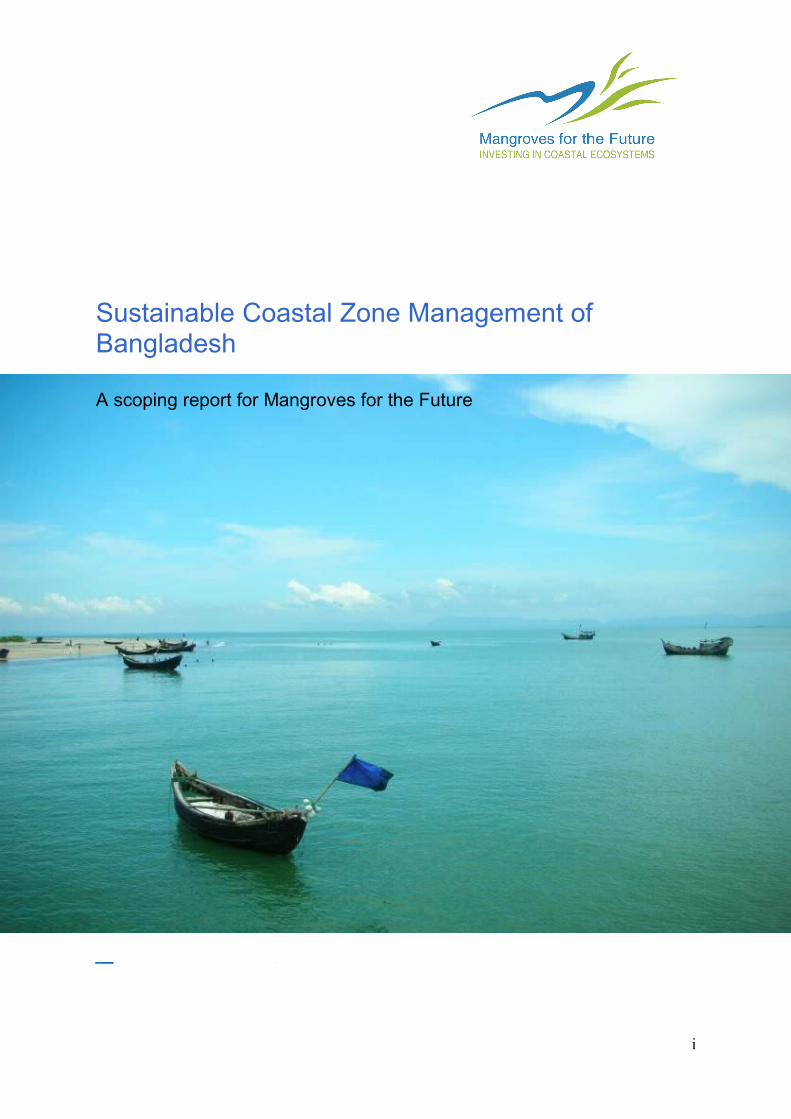
Sustainable Coastal Zone Management of Bangladesh A scoping report for Mangroves for the Future i

Welcome message from author
This document is posted to help you gain knowledge. Please leave a comment to let me know what you think about it! Share it to your friends and learn new things together.
Transcript
Sustainable Coastal Zone Management of Bangladesh
A scoping report for Mangroves for the Future
i
Sustainable Coastal Zone Management of BangladeshA Scoping Report for Mangroves for the Future
January 2011
Produced by MFF with the financial support of Norad and Sida
Prepared by
IUCN Bangladesh Country Office
Authors
Enamul Mazid Khan SiddiqueAhana Adrika
Reviewers
Remeen FirozDr. Istiak Sobhan
Photo used in the cover: “Saint Martin’s; the only island with coral reef in Bangladesh” © Ahana Adrika 2010
i
Acknowledgement
This report adopted informations and methodology from various documents of the Project Development Office of Integrated Coastal Zone Management Plan (PDO-ICZMP) and Coastal and Wetland Biodiversity Management Project (CWBMP). Existing national policies, strategies and plans have also been used. The core idea was to asses the prospects of MFF in line with the national priorities of Bangladesh. However, lack of data and contradiction among data sources has been encountered by the study team especially concerning ecosystems and biodiversity. There has not been large scale comprehensive survey of biodiversity throughout the whole coastal zone in last ten years. Moreover, Population Census 2011 report has not yet been published. So, the current analysis of livelihoods and human conditions has used the data of the previous census. A trend of population increase in Bangladesh contends that situation may be worse than the data, especially considering the number of lives under threat of various natural hazards.
Integrated Coastal Zone Management (ICZM) is a comprehensive concept with overwhelming scopes. It’s tough to combine all the relevant features and yet keep the report within a smart page limit. Smooth editing by Ms. Remeen Firoz and Dr. Istiak Sobhan has made the report precise and communicative. We must also acknowledge Mr. Hasibur Rahman and M. M. Abdullah-Al-Mamun for helping on the sections on critical habitats. We would also like to thank Maeve Nightingale, Coordinator, Regional Coastal & Marine Programme, IUCN Asia Reginal Office, for providing us with her insights and thoughtful comments on the report.
iiSustainable Coastal Zone Management of Bangladesh: A Scoping Report for Mangroves for the Future (MFF) Project. January 2011
Executive Summary
The coastal zone of Bangladesh consists of the 19 coastal districts. This area has further been divided into exposed and interior coast considering degree of vulnerabilities to disasters rooted in the seawards direction. More than 35 million people live in the 47,201 sq. km area of this coast. This report tries to identify identify the scopes and prospects of improving lives of the coastal communities through the implementation of Mangroves for the Future (MFF) initiative in Bangladesh. An overview of the countries coastal biodiversity, major environmental issues and threats of disasters, livelihoods of the coastal communities, gaps in the current institutional and legal arrangements of coastal zone management, ongoing and completed initiatives in the coastal zone, and an analysis of MFF PoWs in relation to the priorities of the Government of the People’s Republic of Bangladesh has been given in this report.
Among the 25 bio-ecological zones of the country, 11 are wholly situated in the coastal zone, 4 others have parts of them in the coast. The countries coastal ecosystems include mangroves, coral reefs, sea grass beds, sandy beaches, sand dunes, Inter-tidal and sub-tidal wetlands and mudflats, flood plain, salt Marshes, estuaries, lagoons, peninsula, offshore islands, tropical hill forest etc. Major part of the world’s largest mangrove “Sundarbans” is one of its key ecosystems. But these ecosystems are degrading alarmingly due to various external pressures especially due to pollution and exploitation. However, the country has developes a wide network of protected areas in the coast. There are 10 wildlife sanctuaries, 5 national parks, 17 fish sanctuaries, 3 ECAs, and 1 Ramsar site in the coastal zone.
The coastal zone contributes highly to the national development. There are 2 sea ports and 3 EPZs, 3 gas fields in the coast and several gas blocks in the EEZ. There is known stock of other minerals in the coast too. There is significant industrial development in the coast which is increasing. Fishery is the second largest contributing to the national GDP.
The major environmental issues faced by the country includes cyclones and storm surge, land erosion, flood, drainage congestion, salinity intrusion, drought, earthquake, shortage of drinking water & arsenic contamination,ecosystem degradation, pollution and climate change. The country is repeatedly struck by fierce cyclones leaving davastations for human beings as well as biodiversity. Changes in land use mainly due to the increased pressure of population on the limited resources are posing threat to the coastal ecosystems. NAPA (2005) has identified potential threat to the protected areas and biodiversity due to climate change. An assessment done after the 2004 Indian oceane Tsunami shows that the impacts will go beyond the coastal zone and may even reach Dhaka, the capital of the country.
Major livelihoods in the coastal zone are agriculture, fishery, salt farming, shrimp culture, industrial and agricultural labour, and extraction of forest resources etc. The urban areas in Khulna and Chittagong have diversity in livelihoods due to the growth of the service sector. GDP is high in these two areas thab the rest of the coastal zone. However, GDP of the coastal zone is lower than the national GDP. Poverty is very common in the coast, 29 % of the people are extreme poors. Livelihoods activities of the people’s dependent on natural resources are degrading the coastal ecosystems and invading spaces of biodiversity.
Women of the coast are disadvantaged socioeconomcally. They are deprived in terms of wage and life chances. Women comprise less than half of the paid workforce. However, all the national policies and plans emphesise on prioritising women in the development activities and gender mainstreaming.
iiiSustainable Coastal Zone Management of Bangladesh: A Scoping Report for Mangroves for the Future (MFF) Project. January 2011
The institutional setting is strong in the coastal zone. A wide network of Government and non-government organizations and agencies are active with different mendates in the coast. However, there is a gap of proper coordination. There is no single agency for overall coastal and marine zone management. A framework has been proposed by the Coastal Development Strategy with a central Programme Coordinating Unit at WARPO and District and Upazila Development Coordinating Committees throughout the coastal zone. There is a need of capacity development for the framework to be effective. Many research institutes are active concerning various aspects of the coastal zone.
Bangladesh has a Coastal Zone Policy that addresses the issues of ICZM and calls for integrating coastal development in the overall national development programmes with high priority. This policy is supported by a comprehensive policy framework of sectoral policies and a Coastal Development Strategy. PDO-ICZMP identified some common themes and gaps within this framework which has been further updated by this report. Coastal zone has been prioritized in different national plans such as Bangladesh Climate Change Strategic Action Plan, NAPA, NBSAP, NCS etc due to its environmental and economic importance and vulnerability.
ICZM as a concept is quite new to the development context of the country. However, initiatives for it have been there since the 70s. However, Bangladesh has many success stories and experience in the coastal zone which can be shared through MFF. The Forest Department has developed a coastal green belt through social forestry. Coastal Wetland and Biodiversity Management Project has developed management plans for ecologically critical area management. Bangladesh has a long experience in comprehensive disaster management and community based resilience. IUCN Bangladesh has been active in building nature based solution to climate change in the coastal zone through piloting salinity resilient rice variety, community based mangrove restoration, and awareness programmes.
All the MFF Programmes of Action (PoWs) are in line with the national priorities set by different policies and strategic papers. The gaps within institutional framework and needs for capacity development indicates the scopes for MFFs involvement in Bangladesh. A proposed National Coordinating Body (NCB) is under process of official endorsement of the Government of the People’s Republic of Bangladesh. Meanwhile, a draft indicative action plan has been prepared through the discussions of FD and IUCN Bangladesh Country Office with relevant stakeholders. The NCB is hoped to be endorsed by September 2011 and a National Strategy and Action Plan (NSAP) will be developed by December 2011. The goal is to achieve full membership of MFF.
ivSustainable Coastal Zone Management of Bangladesh: A Scoping Report for Mangroves for the Future (MFF) Project. January 2011
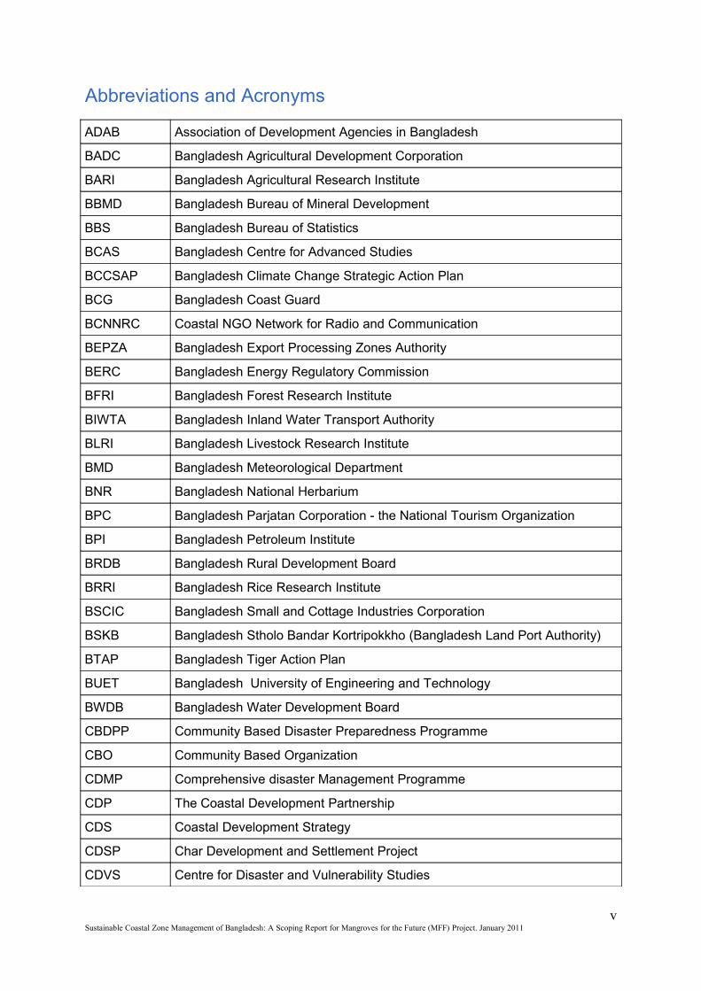
Abbreviations and Acronyms
ADAB Association of Development Agencies in Bangladesh
BADC Bangladesh Agricultural Development Corporation
BARI Bangladesh Agricultural Research Institute
BBMD Bangladesh Bureau of Mineral Development
BBS Bangladesh Bureau of Statistics
BCAS Bangladesh Centre for Advanced Studies
BCCSAP Bangladesh Climate Change Strategic Action Plan
BCG Bangladesh Coast Guard
BCNNRC Coastal NGO Network for Radio and Communication
BEPZA Bangladesh Export Processing Zones Authority
BERC Bangladesh Energy Regulatory Commission
BFRI Bangladesh Forest Research Institute
BIWTA Bangladesh Inland Water Transport Authority
BLRI Bangladesh Livestock Research Institute
BMD Bangladesh Meteorological Department
BNR Bangladesh National Herbarium
BPC Bangladesh Parjatan Corporation - the National Tourism Organization
BPI Bangladesh Petroleum Institute
BRDB Bangladesh Rural Development Board
BRRI Bangladesh Rice Research Institute
BSCIC Bangladesh Small and Cottage Industries Corporation
BSKB Bangladesh Stholo Bandar Kortripokkho (Bangladesh Land Port Authority)
BTAP Bangladesh Tiger Action Plan
BUET Bangladesh University of Engineering and Technology
BWDB Bangladesh Water Development Board
CBDPP Community Based Disaster Preparedness Programme
CBO Community Based Organization
CDMP Comprehensive disaster Management Programme
CDP The Coastal Development Partnership
CDS Coastal Development Strategy
CDSP Char Development and Settlement Project
CDVS Centre for Disaster and Vulnerability Studies
vSustainable Coastal Zone Management of Bangladesh: A Scoping Report for Mangroves for the Future (MFF) Project. January 2011
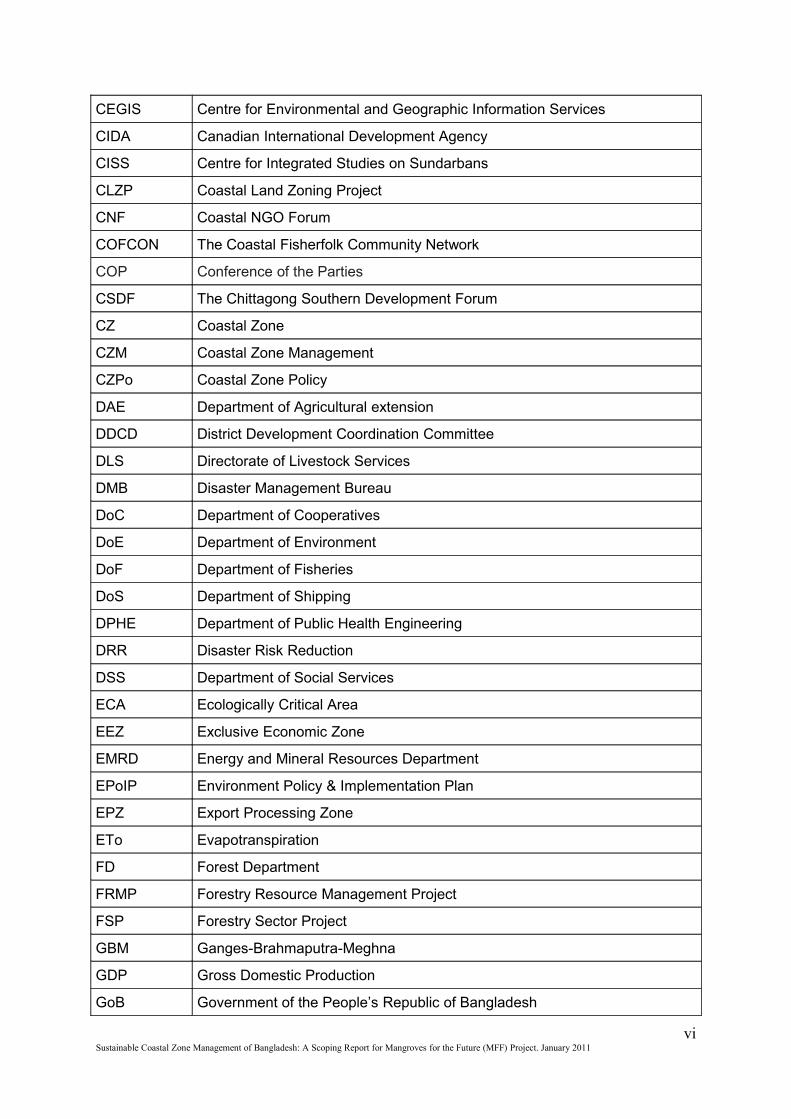
CEGIS Centre for Environmental and Geographic Information Services
CIDA Canadian International Development Agency
CISS Centre for Integrated Studies on Sundarbans
CLZP Coastal Land Zoning Project
CNF Coastal NGO Forum
COFCON The Coastal Fisherfolk Community Network
COP Conference of the Parties
CSDF The Chittagong Southern Development Forum
CZ Coastal Zone
CZM Coastal Zone Management
CZPo Coastal Zone Policy
DAE Department of Agricultural extension
DDCD District Development Coordination Committee
DLS Directorate of Livestock Services
DMB Disaster Management Bureau
DoC Department of Cooperatives
DoE Department of Environment
DoF Department of Fisheries
DoS Department of Shipping
DPHE Department of Public Health Engineering
DRR Disaster Risk Reduction
DSS Department of Social Services
ECA Ecologically Critical Area
EEZ Exclusive Economic Zone
EMRD Energy and Mineral Resources Department
EPoIP Environment Policy & Implementation Plan
EPZ Export Processing Zone
ETo Evapotranspiration
FD Forest Department
FRMP Forestry Resource Management Project
FSP Forestry Sector Project
GBM Ganges-Brahmaputra-Meghna
GDP Gross Domestic Production
GoB Government of the People’s Republic of Bangladesh
viSustainable Coastal Zone Management of Bangladesh: A Scoping Report for Mangroves for the Future (MFF) Project. January 2011
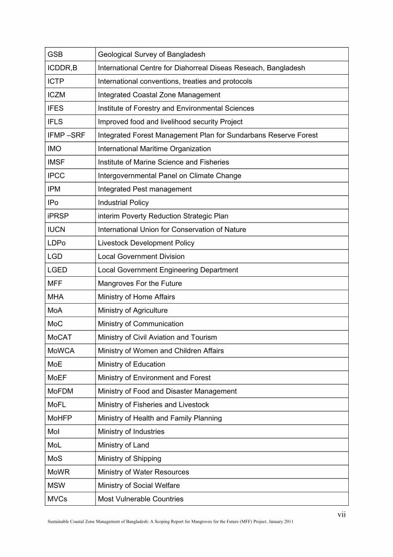
GSB Geological Survey of Bangladesh
ICDDR,B International Centre for Diahorreal Diseas Reseach, Bangladesh
ICTP International conventions, treaties and protocols
ICZM Integrated Coastal Zone Management
IFES Institute of Forestry and Environmental Sciences
IFLS Improved food and livelihood security Project
IFMP –SRF Integrated Forest Management Plan for Sundarbans Reserve Forest
IMO International Maritime Organization
IMSF Institute of Marine Science and Fisheries
IPCC Intergovernmental Panel on Climate Change
IPM Integrated Pest management
IPo Industrial Policy
iPRSP interim Poverty Reduction Strategic Plan
IUCN International Union for Conservation of Nature
LDPo Livestock Development Policy
LGD Local Government Division
LGED Local Government Engineering Department
MFF Mangroves For the Future
MHA Ministry of Home Affairs
MoA Ministry of Agriculture
MoC Ministry of Communication
MoCAT Ministry of Civil Aviation and Tourism
MoWCA Ministry of Women and Children Affairs
MoE Ministry of Education
MoEF Ministry of Environment and Forest
MoFDM Ministry of Food and Disaster Management
MoFL Ministry of Fisheries and Livestock
MoHFP Ministry of Health and Family Planning
MoI Ministry of Industries
MoL Ministry of Land
MoS Ministry of Shipping
MoWR Ministry of Water Resources
MSW Ministry of Social Welfare
MVCs Most Vulnerable Countries
viiSustainable Coastal Zone Management of Bangladesh: A Scoping Report for Mangroves for the Future (MFF) Project. January 2011
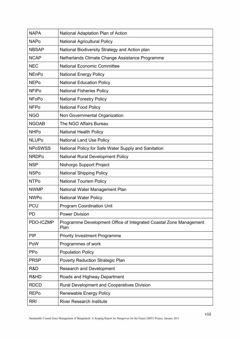
NAPA National Adaptation Plan of Action
NAPo National Agricultural Policy
NBSAP National Biodiversity Strategy and Action plan
NCAP Netherlands Climate Change Assistance Programme
NEC National Economic Committee
NEnPo National Energy Policy
NEPo National Education Policy
NFiPo National Fisheries Policy
NFoPo National Forestry Policy
NFPo National Food Policy
NGO Non Governmental Organization
NGOAB The NGO Affairs Bureau
NHPo National Health Policy
NLUPo National Land Use Policy
NPoSWSS National Policy for Safe Water Supply and Sanitation
NRDPo National Rural Development Policy
NSP Nishorgo Support Project
NSPo National Shipping Policy
NTPo National Tourism Policy
NWMP National Water Management Plan
NWPo National Water Policy
PCU Program Coordination Unit
PD Power Division
PDO-ICZMP Programme Development Office of Integrated Coastal Zone Management Plan
PIP Priority Investment Programme
PoW Programmes of work
PPo Population Policy
PRSP Poverty Reduction Strategic Plan
R&D Research and Development
R&HD Roads and Highway Department
RDCD Rural Development and Cooperatives Division
REPo Renewable Energy Policy
RRI River Research Institute
viiiSustainable Coastal Zone Management of Bangladesh: A Scoping Report for Mangroves for the Future (MFF) Project. January 2011
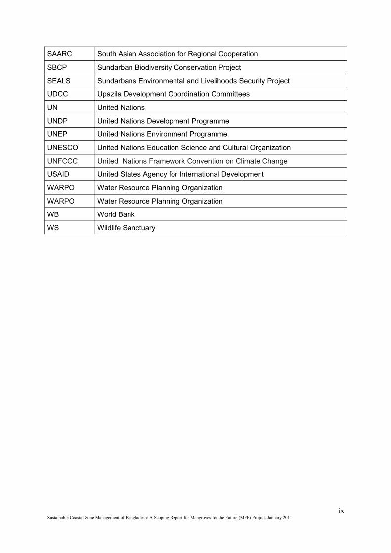
SAARC South Asian Association for Regional Cooperation
SBCP Sundarban Biodiversity Conservation Project
SEALS Sundarbans Environmental and Livelihoods Security Project
UDCC Upazila Development Coordination Committees
UN United Nations
UNDP United Nations Development Programme
UNEP United Nations Environment Programme
UNESCO United Nations Education Science and Cultural Organization
UNFCCC United Nations Framework Convention on Climate Change
USAID United States Agency for International Development
WARPO Water Resource Planning Organization
WARPO Water Resource Planning Organization
WB World Bank
WS Wildlife Sanctuary
ixSustainable Coastal Zone Management of Bangladesh: A Scoping Report for Mangroves for the Future (MFF) Project. January 2011
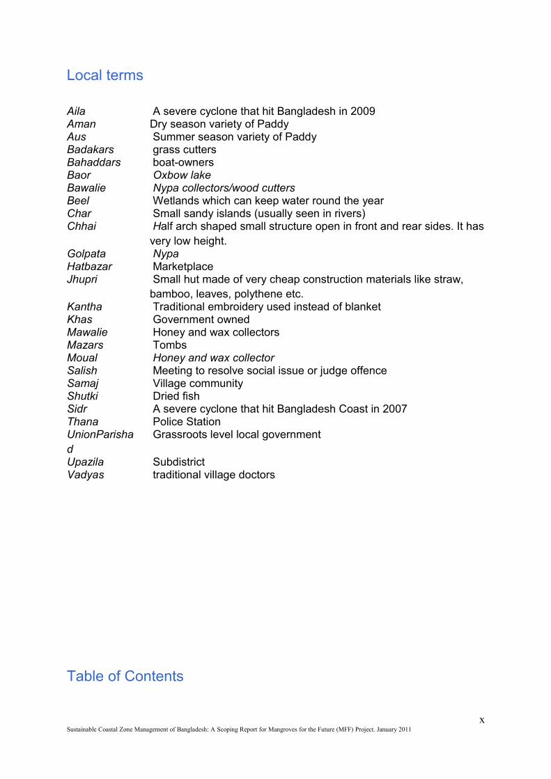
Local terms
Aila A severe cyclone that hit Bangladesh in 2009Aman Dry season variety of PaddyAus Summer season variety of PaddyBadakars grass cuttersBahaddars boat-ownersBaor Oxbow lakeBawalie Nypa collectors/wood cuttersBeel Wetlands which can keep water round the yearChar Small sandy islands (usually seen in rivers)Chhai Half arch shaped small structure open in front and rear sides. It has
very low height.Golpata NypaHatbazar Marketplace Jhupri Small hut made of very cheap construction materials like straw,
bamboo, leaves, polythene etc.Kantha Traditional embroidery used instead of blanket Khas Government ownedMawalie Honey and wax collectorsMazars TombsMoual Honey and wax collectorSalish Meeting to resolve social issue or judge offenceSamaj Village communityShutki Dried fishSidr A severe cyclone that hit Bangladesh Coast in 2007Thana Police StationUnionParishad
Grassroots level local government
Upazila SubdistrictVadyas traditional village doctors
Table of Contents
xSustainable Coastal Zone Management of Bangladesh: A Scoping Report for Mangroves for the Future (MFF) Project. January 2011
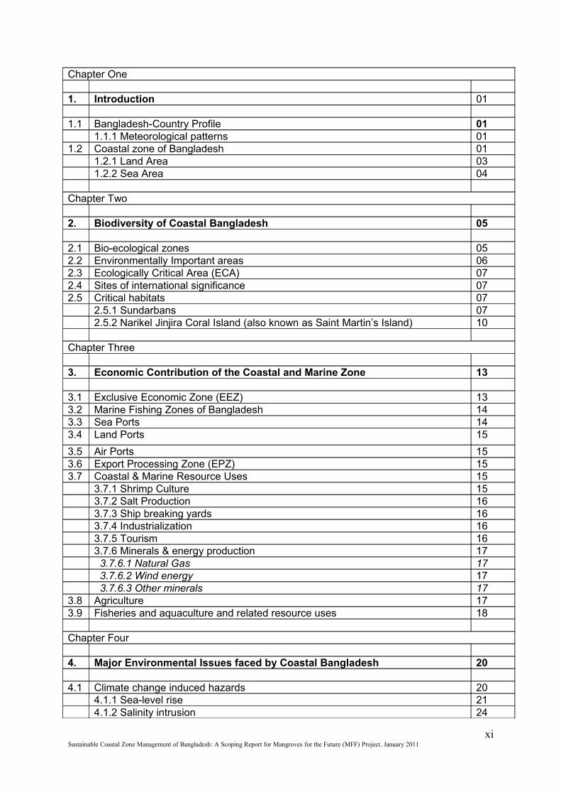
Chapter One
1. Introduction 01
1.1 Bangladesh-Country Profile 011.1.1 Meteorological patterns 01
1.2 Coastal zone of Bangladesh 011.2.1 Land Area 031.2.2 Sea Area 04
Chapter Two
2. Biodiversity of Coastal Bangladesh 05
2.1 Bio-ecological zones 052.2 Environmentally Important areas 062.3 Ecologically Critical Area (ECA) 072.4 Sites of international significance 072.5 Critical habitats 07
2.5.1 Sundarbans 072.5.2 Narikel Jinjira Coral Island (also known as Saint Martin’s Island) 10
Chapter Three
3. Economic Contribution of the Coastal and Marine Zone 13
3.1 Exclusive Economic Zone (EEZ) 133.2 Marine Fishing Zones of Bangladesh 143.3 Sea Ports 143.4 Land Ports 15
3.5 Air Ports 153.6 Export Processing Zone (EPZ) 153.7 Coastal & Marine Resource Uses 15
3.7.1 Shrimp Culture 153.7.2 Salt Production 163.7.3 Ship breaking yards 163.7.4 Industrialization 163.7.5 Tourism 163.7.6 Minerals & energy production 17 3.7.6.1 Natural Gas 17 3.7.6.2 Wind energy 17 3.7.6.3 Other minerals 17
3.8 Agriculture 173.9 Fisheries and aquaculture and related resource uses 18
Chapter Four
4. Major Environmental Issues faced by Coastal Bangladesh 20
4.1 Climate change induced hazards 204.1.1 Sea-level rise 214.1.2 Salinity intrusion 24
xiSustainable Coastal Zone Management of Bangladesh: A Scoping Report for Mangroves for the Future (MFF) Project. January 2011
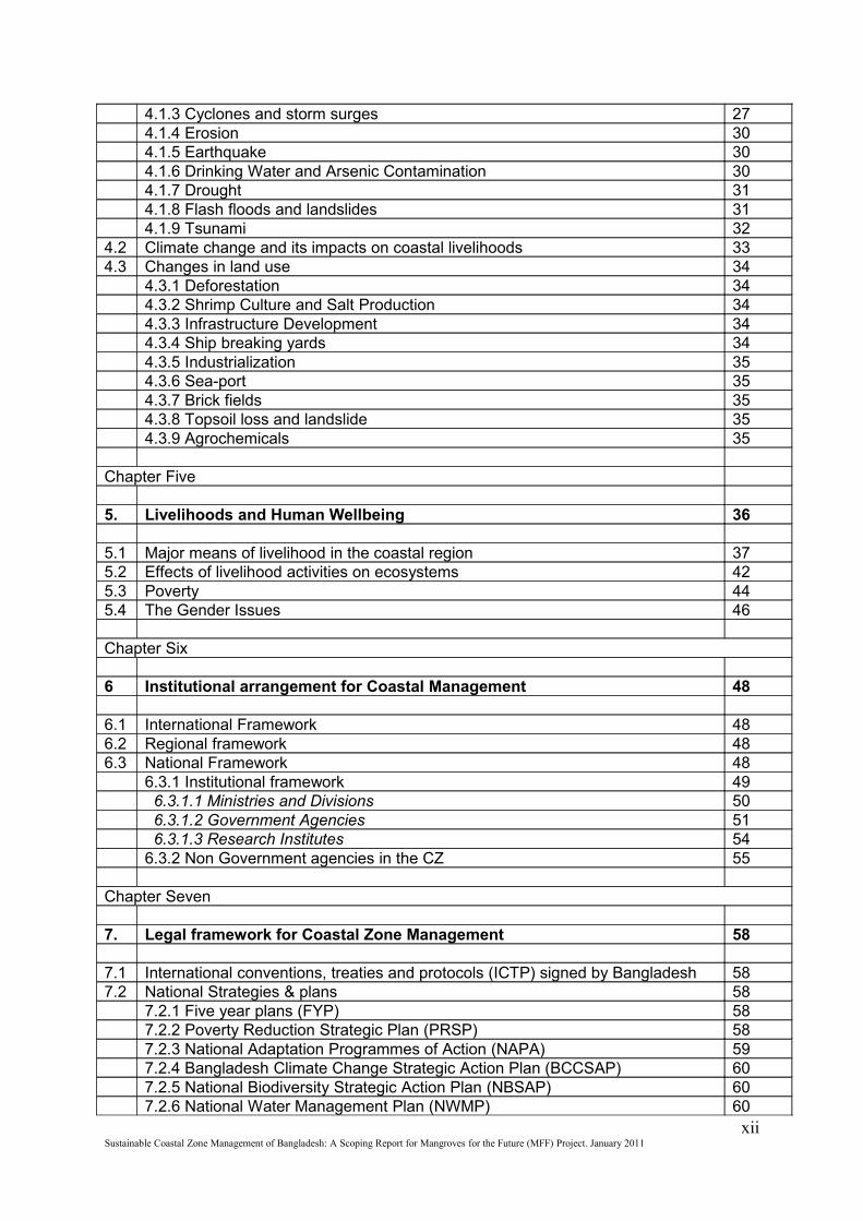
4.1.3 Cyclones and storm surges 274.1.4 Erosion 304.1.5 Earthquake 304.1.6 Drinking Water and Arsenic Contamination 304.1.7 Drought 314.1.8 Flash floods and landslides 314.1.9 Tsunami 32
4.2 Climate change and its impacts on coastal livelihoods 334.3 Changes in land use 34
4.3.1 Deforestation 344.3.2 Shrimp Culture and Salt Production 344.3.3 Infrastructure Development 344.3.4 Ship breaking yards 344.3.5 Industrialization 354.3.6 Sea-port 354.3.7 Brick fields 354.3.8 Topsoil loss and landslide 354.3.9 Agrochemicals 35
Chapter Five
5. Livelihoods and Human Wellbeing 36
5.1 Major means of livelihood in the coastal region 375.2 Effects of livelihood activities on ecosystems 425.3 Poverty 445.4 The Gender Issues 46
Chapter Six
6 Institutional arrangement for Coastal Management 48
6.1 International Framework 486.2 Regional framework 486.3 National Framework 48
6.3.1 Institutional framework 49 6.3.1.1 Ministries and Divisions 50 6.3.1.2 Government Agencies 51 6.3.1.3 Research Institutes 546.3.2 Non Government agencies in the CZ 55
Chapter Seven
7. Legal framework for Coastal Zone Management 58
7.1 International conventions, treaties and protocols (ICTP) signed by Bangladesh 587.2 National Strategies & plans 58
7.2.1 Five year plans (FYP) 587.2.2 Poverty Reduction Strategic Plan (PRSP) 587.2.3 National Adaptation Programmes of Action (NAPA) 597.2.4 Bangladesh Climate Change Strategic Action Plan (BCCSAP) 607.2.5 National Biodiversity Strategic Action Plan (NBSAP) 607.2.6 National Water Management Plan (NWMP) 60
xiiSustainable Coastal Zone Management of Bangladesh: A Scoping Report for Mangroves for the Future (MFF) Project. January 2011

7.2.7 Bangladesh Tiger Action Plan (BTAP) 617.3 Sectoral Policies and acts 61
7.3.1 Common Themes 627.3.2 Coordination between and among sectors 657.4 Policies and strategy on Coastal Zone 687.4.1 Coastal Zone Policy 2005 (CZPo) 687.4.2 Coastal Development Strategy 2006 (CDS) 697.4.3 National Programme of Action for Protection of Coastal and Marine Environment from Land Based Activities
70
7.5 Gaps and weak points of the current mechanism 71
Chapter Eight
8. Past and Present Development Initiatives in the Coastal Areas 75
8.1 Integrated Coastal Zone Management 758.1.1 Integrated Coastal Zone Management Plan Project (ICZMP) 758.1.2 Coastal Land Zoning Project (CLZP) 758.1.3 Char Development and Settlement Project (CDSP) III 76
8.2 Improving Coastal Livelihood 768.2.1 Sundarbans Environmental and Livelihoods Security (SEALS) 768.2.2 Improved food and livelihood security Project (IFLS) 76
8.3 Disaster Risk Reduction 768.3.1 Community Based Disaster Preparedness Programme 768.3.2 Comprehensive Disaster Management Programme (CDMP) 778.3.3 Community Based Adaptation to Climate Change through Coastal Afforestation
77
8.3.4 Promotion of Adaptation to Climate Change and Climate Vulnerability Project
77
8.3.5 Reducing Vulnerability to Climate Change (RVCC) Project 788.4 Forest Resource Development 79
8.4.1 Forestry Resource Management Project (FRMP) 798.4.2 Forestry Sector Project (FSP) 798.4.3 Coastal Green Belt Project 808.4.4 Coastal and Mangrove Afforestation Programme 808.4.5 Integrated Resource Development of the Sundarbans Reserved Forest 808.4.6 Rehabilitation of critical coastal ecosystem: Chokoria Sundarbans – IUCN’s pilot experience
80
8.5 Environmental Management 818.5.1 Integrated Protected Area Co-management (IPAC) project 81
8.6 Conservation of biodiversity 818.6.1 Coastal and Wetland Biodiversity Management Project (CWBMP) 818.6.2 Nishorgo Support Project (NSP) 82
8.7 Water resource management 82
Chapter Nine
9. MFF in Bangladesh; Need, Opportunities and Framework for implementation
83
9.1 Issues and challenges to be addressed 839.1.1 The challenge of climate change and associated vulnerabilities 83
xiiiSustainable Coastal Zone Management of Bangladesh: A Scoping Report for Mangroves for the Future (MFF) Project. January 2011
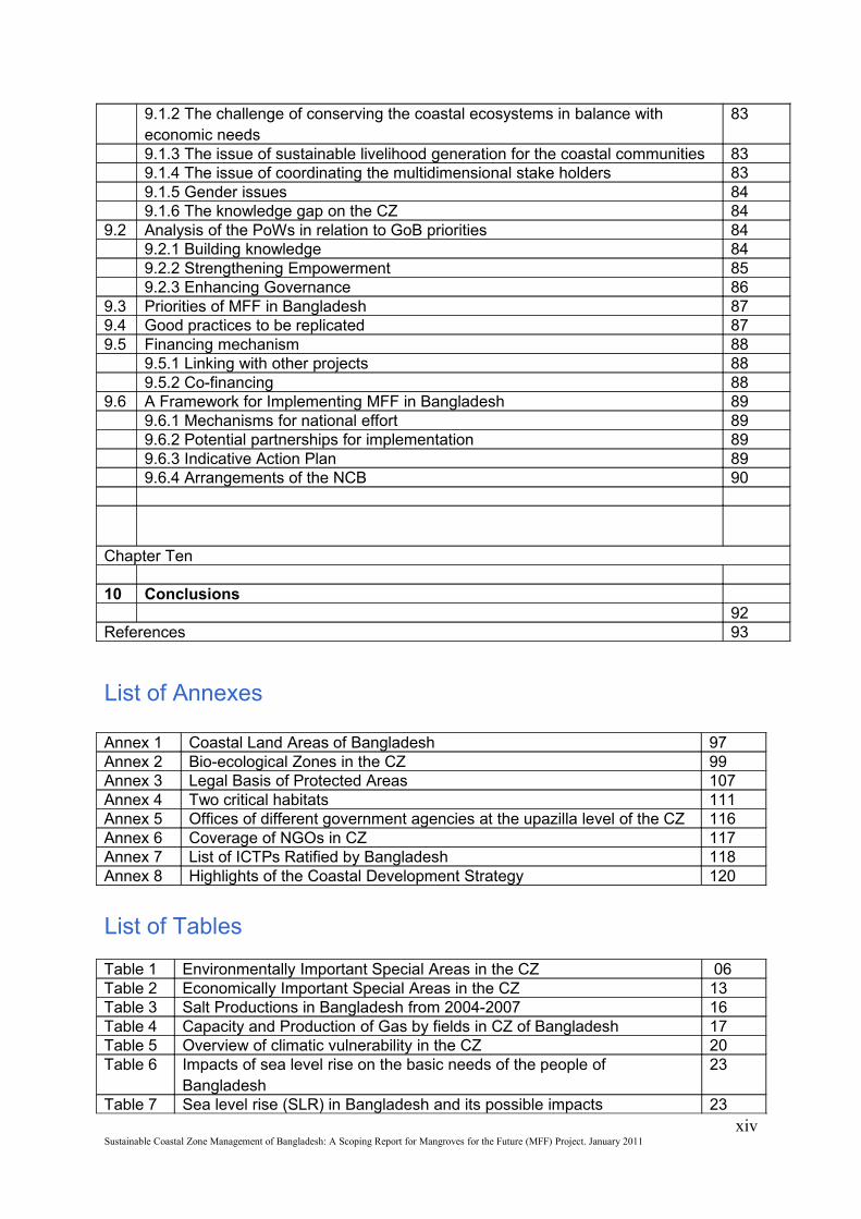
9.1.2 The challenge of conserving the coastal ecosystems in balance with economic needs
83
9.1.3 The issue of sustainable livelihood generation for the coastal communities 839.1.4 The issue of coordinating the multidimensional stake holders 839.1.5 Gender issues 849.1.6 The knowledge gap on the CZ 84
9.2 Analysis of the PoWs in relation to GoB priorities 849.2.1 Building knowledge 849.2.2 Strengthening Empowerment 859.2.3 Enhancing Governance 86
9.3 Priorities of MFF in Bangladesh 879.4 Good practices to be replicated 879.5 Financing mechanism 88
9.5.1 Linking with other projects 889.5.2 Co-financing 88
9.6 A Framework for Implementing MFF in Bangladesh 899.6.1 Mechanisms for national effort 899.6.2 Potential partnerships for implementation 899.6.3 Indicative Action Plan 899.6.4 Arrangements of the NCB 90
Chapter Ten
10 Conclusions92
References 93
List of Annexes
Annex 1 Coastal Land Areas of Bangladesh 97Annex 2 Bio-ecological Zones in the CZ 99Annex 3 Legal Basis of Protected Areas 107Annex 4 Two critical habitats 111Annex 5 Offices of different government agencies at the upazilla level of the CZ 116Annex 6 Coverage of NGOs in CZ 117Annex 7 List of ICTPs Ratified by Bangladesh 118Annex 8 Highlights of the Coastal Development Strategy 120
List of Tables
Table 1 Environmentally Important Special Areas in the CZ 06Table 2 Economically Important Special Areas in the CZ 13Table 3 Salt Productions in Bangladesh from 2004-2007 16Table 4 Capacity and Production of Gas by fields in CZ of Bangladesh 17Table 5 Overview of climatic vulnerability in the CZ 20Table 6 Impacts of sea level rise on the basic needs of the people of
Bangladesh23
Table 7 Sea level rise (SLR) in Bangladesh and its possible impacts 23xiv
Sustainable Coastal Zone Management of Bangladesh: A Scoping Report for Mangroves for the Future (MFF) Project. January 2011
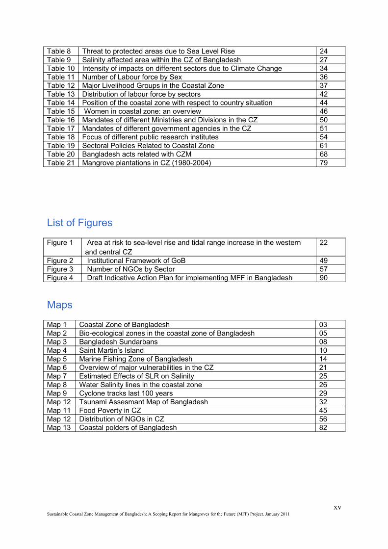
Table 8 Threat to protected areas due to Sea Level Rise 24Table 9 Salinity affected area within the CZ of Bangladesh 27Table 10 Intensity of impacts on different sectors due to Climate Change 34Table 11 Number of Labour force by Sex 36Table 12 Major Livelihood Groups in the Coastal Zone 37Table 13 Distribution of labour force by sectors 42Table 14 Position of the coastal zone with respect to country situation 44Table 15 Women in coastal zone: an overview 46Table 16 Mandates of different Ministries and Divisions in the CZ 50Table 17 Mandates of different government agencies in the CZ 51Table 18 Focus of different public research institutes 54Table 19 Sectoral Policies Related to Coastal Zone 61Table 20 Bangladesh acts related with CZM 68Table 21 Mangrove plantations in CZ (1980-2004) 79
List of Figures
Figure 1 Area at risk to sea-level rise and tidal range increase in the western and central CZ
22
Figure 2 Institutional Framework of GoB 49Figure 3 Number of NGOs by Sector 57Figure 4 Draft Indicative Action Plan for implementing MFF in Bangladesh 90
Maps
Map 1 Coastal Zone of Bangladesh 03Map 2 Bio-ecological zones in the coastal zone of Bangladesh 05Map 3 Bangladesh Sundarbans 08Map 4 Saint Martin’s Island 10Map 5 Marine Fishing Zone of Bangladesh 14Map 6 Overview of major vulnerabilities in the CZ 21Map 7 Estimated Effects of SLR on Salinity 25Map 8 Water Salinity lines in the coastal zone 26Map 9 Cyclone tracks last 100 years 29Map 12 Tsunami Assesmant Map of Bangladesh 32Map 11 Food Poverty in CZ 45Map 12 Distribution of NGOs in CZ 56Map 13 Coastal polders of Bangladesh 82
xvSustainable Coastal Zone Management of Bangladesh: A Scoping Report for Mangroves for the Future (MFF) Project. January 2011

xviSustainable Coastal Zone Management of Bangladesh: A Scoping Report for Mangroves for the Future (MFF) Project. January 2011
Chapter One
1. Introduction
Bangladesh is one of the Indian Ocean countries which are exposed to natural disasters like cyclones, tidal surges and Tsunami. It is a dialogue country of the Mangroves for the Future (MFF) initiative that was initiated in 2004; primarily to address the issues of coastal ecosystem conservation. As a dialogue country, Bangladesh is going through the preparatory phase to become a full member of MFF and IUCN Bangladesh Country Office is facilitating the Government of the People’s Republic of Bangladesh (GoB) in this process. This scoping report provides a comprehensive description of the coastal zone and its potentials in Bangladesh.
1.1 Bangladesh-Country Profile
Bangladesh is formed mainly by the sediments carried by Ganges-Brahmaputra-Meghna (GBM) river system except for the hilly regions in the northeast and southeast and terrace land in northwest and central zones. It is part of the largest deltas in the world and is still under a process of active delta development and morphological changes. The country is located between 20°34’ to 26°38’ north latitude and 88°01’ to 92°42’ east longitude. The total land area is 147,570 sq. km. and consists of low and flat land mainly. A network of 230 rivers with their tributaries and distributaries crisscross the country (DOE, 2010). The population of the country is increasing over the years with significant variation in urban and rural population growth. In the last decade (1991-2001), the overall increase was about 16 percent while urban and rural growth was about 37 percent and 11 percent respectively. It is estimated that the population of the country will be 170 million by the year 2020.
1.1.1 Meteorological patterns
Bangladesh is situated at the interface of 2 different environments, with the Bay of Bengal to the south and the Himalayas to the north. Due to this unique geography, Bangladesh generally enjoys a sub-tropical monsoon climate. While there are six seasons in a year, three namely, winter, summer and monsoon are prominent. The quite pleasant winter begins in November and ends in February. There is fluctuation in temperature which ranges from minimum of 7oC—13oC (45oF—55oF) to maximum of 24oC—31oC (75oF—85oF) in this season. The maximum temperature recorded in summer is 37oC (98oF) which occasionally rises up to 41oC (105oF) or more. The summer is also the season of tropical cyclones called ‘Kalbaishakhi’ locally. Monsoon starts in July and stays up to October. This period accounts for 80% of the total rainfall. The average annual rainfall varies from 1429 to 4338 millimeter (mm). The maximum rainfall is recorded in the coastal areas of Chittagong and northern part of Sylhet district, while the minimum is observed in the western and northern parts of the country.
1.2 Coastal zone of Bangladesh
Coastal Zone (CZ) is most frequently defined as "land affected by its proximity to the sea and that part of the sea affected by its proximity to the land" or, in other words, the area where the processes which depend on the sea-land interaction are the most intensive. The interface is CZ includes floodplains, mangroves, marshes, and fringing coral reefs. In general, there are tide flats, as well as beaches and dunes, and multiple aerial foci for ICZM; ocean waters, coastal waters, inter-tidal area, coastline, oceanfront or shore-lands area,
1Sustainable Coastal Zone Management of Bangladesh: A Scoping Report for Mangroves for the Future (MFF) Project. January 2011
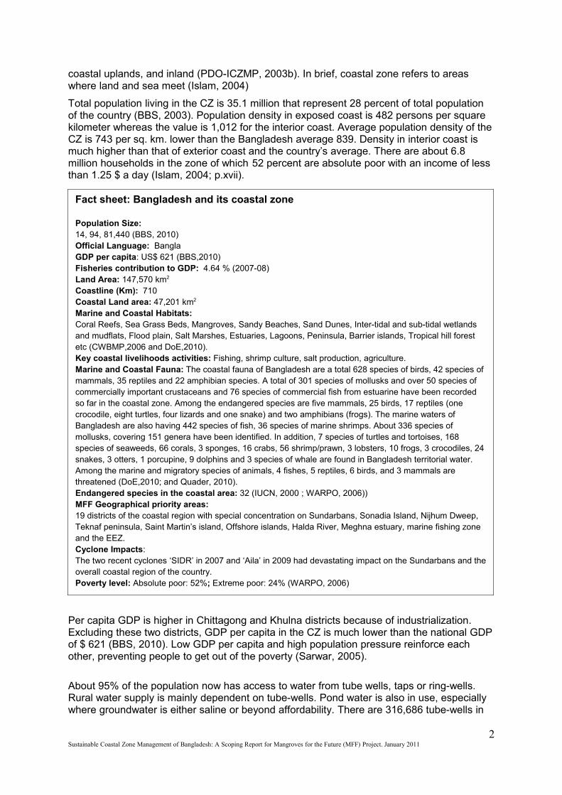
Fact sheet: Bangladesh and its coastal zone
Population Size:14, 94, 81,440 (BBS, 2010)Official Language: BanglaGDP per capita: US$ 621 (BBS,2010)Fisheries contribution to GDP: 4.64 % (2007-08)Land Area: 147,570 km2
Coastline (Km): 710Coastal Land area: 47,201 km2
Marine and Coastal Habitats: Coral Reefs, Sea Grass Beds, Mangroves, Sandy Beaches, Sand Dunes, Inter-tidal and sub-tidal wetlands and mudflats, Flood plain, Salt Marshes, Estuaries, Lagoons, Peninsula, Barrier islands, Tropical hill forest etc (CWBMP,2006 and DoE,2010).Key coastal livelihoods activities: Fishing, shrimp culture, salt production, agriculture.Marine and Coastal Fauna: The coastal fauna of Bangladesh are a total 628 species of birds, 42 species of mammals, 35 reptiles and 22 amphibian species. A total of 301 species of mollusks and over 50 species of commercially important crustaceans and 76 species of commercial fish from estuarine have been recorded so far in the coastal zone. Among the endangered species are five mammals, 25 birds, 17 reptiles (one crocodile, eight turtles, four lizards and one snake) and two amphibians (frogs). The marine waters of Bangladesh are also having 442 species of fish, 36 species of marine shrimps. About 336 species of mollusks, covering 151 genera have been identified. In addition, 7 species of turtles and tortoises, 168 species of seaweeds, 66 corals, 3 sponges, 16 crabs, 56 shrimp/prawn, 3 lobsters, 10 frogs, 3 crocodiles, 24 snakes, 3 otters, 1 porcupine, 9 dolphins and 3 species of whale are found in Bangladesh territorial water. Among the marine and migratory species of animals, 4 fishes, 5 reptiles, 6 birds, and 3 mammals are threatened (DoE,2010; and Quader, 2010).Endangered species in the coastal area: 32 (IUCN, 2000 ; WARPO, 2006))MFF Geographical priority areas: 19 districts of the coastal region with special concentration on Sundarbans, Sonadia Island, Nijhum Dweep, Teknaf peninsula, Saint Martin’s island, Offshore islands, Halda River, Meghna estuary, marine fishing zone and the EEZ.Cyclone Impacts: The two recent cyclones ‘SIDR’ in 2007 and ‘Aila’ in 2009 had devastating impact on the Sundarbans and the overall coastal region of the country.Poverty level: Absolute poor: 52%; Extreme poor: 24% (WARPO, 2006)
coastal uplands, and inland (PDO-ICZMP, 2003b). In brief, coastal zone refers to areas where land and sea meet (Islam, 2004)
Total population living in the CZ is 35.1 million that represent 28 percent of total population of the country (BBS, 2003). Population density in exposed coast is 482 persons per square kilometer whereas the value is 1,012 for the interior coast. Average population density of the CZ is 743 per sq. km. lower than the Bangladesh average 839. Density in interior coast is much higher than that of exterior coast and the country’s average. There are about 6.8 million households in the zone of which 52 percent are absolute poor with an income of less than 1.25 $ a day (Islam, 2004; p.xvii).
Per capita GDP is higher in Chittagong and Khulna districts because of industrialization. Excluding these two districts, GDP per capita in the CZ is much lower than the national GDP of $ 621 (BBS, 2010). Low GDP per capita and high population pressure reinforce each other, preventing people to get out of the poverty (Sarwar, 2005).
About 95% of the population now has access to water from tube wells, taps or ring-wells. Rural water supply is mainly dependent on tube-wells. Pond water is also in use, especially where groundwater is either saline or beyond affordability. There are 316,686 tube-wells in
2Sustainable Coastal Zone Management of Bangladesh: A Scoping Report for Mangroves for the Future (MFF) Project. January 2011

the coastal zone, which is 29% of total tube-wells in the country. According to latest DPHE data, the tubewell-population ratio is slightly higher in the coastal zone: 111 persons per running tubewell, compared to 115 nationally. Districts with lower than average density of tube-wells are: Bagerhat, Barguna, Bhola, Cox's Bazar, Khulna, Patuakhali and Satkhira.
Based on the GoB policy note on ICZM, PDO-ICZMP delineated the coastal zone of Bangladesh in two categories; Land area and Sea area (PDO-ICZMP, 2003b).
Map 1: Coastal Zone of Bangladesh
1.2.1 Land Area
The Bay of Bengal occupies an area of about 2.2 million sq. kilometres, and the average depth is 2,600m with a maximum depth of 5,258m; Bangladesh is at the top of it (DOE, 2010). The coastline is 714 km long and the coastal area of the country is virtually a conglomerate of rivers and islands and hosts a unique diversity of ecosystems (DOE, 2006).
The Coastal Zone Policy of Bangladesh considers three indicators for determining the landward boundaries of the coastal zone of Bangladesh, which are: influence of tidal waters, salinity intrusion and cyclones/storm surges (Ministry of Water Resources, 2005). Based on above, PDO – ICZMP (2003 b) classified the coastal land areas of Bangladesh under two broad categories; interior coast and exposed coast. Out of 19 coastal districts (147 upazilas), a total of 48 upazilas in 12 districts that are exposed to the sea and or lower estuaries, are defined as the exposed coast and the remaining 99 upazilas of the coastal districts are termed interior coast. Annex 1 provides a snapshot of the 19 coastal districts of the country.
3Sustainable Coastal Zone Management of Bangladesh: A Scoping Report for Mangroves for the Future (MFF) Project. January 2011
Islands The coastal zone has 185 islands and chars. These islands and chars are classified as detached chars, chars attached with the mainland and marine and estuarine islands (Ahmed and Wilde, 2011). Most of the islands are located in the central coastal zone, because of the dynamic river flow of the Ganges-Brahmputra-Meghna river system. Hatiya, Sandweep and Maheshkhali are three upazilas and Bhola, an administrative district are four larger islands in the zone. Some islands are limited to only one small village. St. Martin’s Island is the only coral-bearing island of the country, located in the Bay of Bengal, about 9.8 km (Hossain, 2001), with an area of 7.5 sq. km to the southeastern side of the mainland, situated under Teknaf thana of Cox’s Bazar district.
1.2.2 Sea Area
In accord with the specifications of the Law of the Sea (UN, 1997), the Bangladesh Government has defined the base line and consequently the territorial waters and the Exclusive Economic Zone (EEZ) in Proclamation No. LT-I/3/74 of 13 April 1974. The Coastal zone policy regards the exclusive economic zone as the seaward coastal zone which in fact is the "Ocean waters" covering the largest part of the sea belt, up to 200 nautical miles off shore. (PDO-ICZMP, 2003b).
4Sustainable Coastal Zone Management of Bangladesh: A Scoping Report for Mangroves for the Future (MFF) Project. January 2011
Chapter Two
2. Biodiversity of Coastal Bangladesh
Bangladesh hosts a number of ecosystems, flora and fauna, within its small but diverse territory. Physiographic variations in the soil and hydrological conditions, as well as variations in the climatic conditions, mainly contribute to the country’s diverse ecology (Nishat et al., 2002).
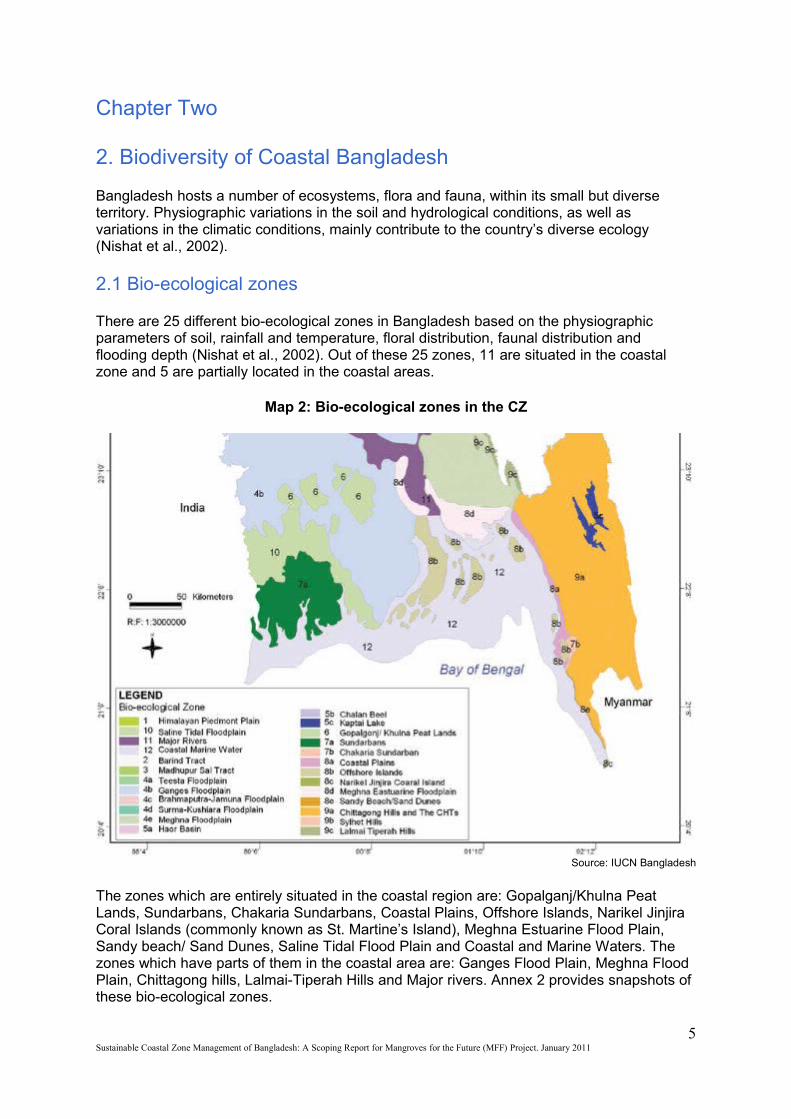
2.1 Bio-ecological zones
There are 25 different bio-ecological zones in Bangladesh based on the physiographic parameters of soil, rainfall and temperature, floral distribution, faunal distribution and flooding depth (Nishat et al., 2002). Out of these 25 zones, 11 are situated in the coastal zone and 5 are partially located in the coastal areas.
Map 2: Bio-ecological zones in the CZ
Source: IUCN Bangladesh
The zones which are entirely situated in the coastal region are: Gopalganj/Khulna Peat Lands, Sundarbans, Chakaria Sundarbans, Coastal Plains, Offshore Islands, Narikel Jinjira Coral Islands (commonly known as St. Martine’s Island), Meghna Estuarine Flood Plain, Sandy beach/ Sand Dunes, Saline Tidal Flood Plain and Coastal and Marine Waters. The zones which have parts of them in the coastal area are: Ganges Flood Plain, Meghna Flood Plain, Chittagong hills, Lalmai-Tiperah Hills and Major rivers. Annex 2 provides snapshots of these bio-ecological zones.
5Sustainable Coastal Zone Management of Bangladesh: A Scoping Report for Mangroves for the Future (MFF) Project. January 2011
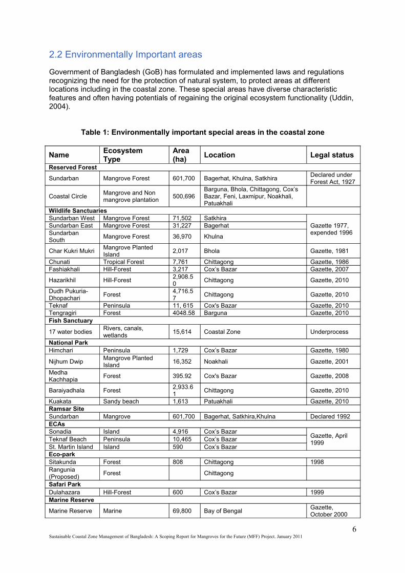
2.2 Environmentally Important areas
Government of Bangladesh (GoB) has formulated and implemented laws and regulations recognizing the need for the protection of natural system, to protect areas at different locations including in the coastal zone. These special areas have diverse characteristic features and often having potentials of regaining the original ecosystem functionality (Uddin, 2004).
Table 1: Environmentally important special areas in the coastal zone
Name Ecosystem Type
Area (ha)
Location Legal status
Reserved Forest
Sundarban Mangrove Forest 601,700 Bagerhat, Khulna, Satkhira Declared under Forest Act, 1927
Coastal Circle Mangrove and Non mangrove plantation
500,696 Barguna, Bhola, Chittagong, Cox’s Bazar, Feni, Laxmipur, Noakhali, Patuakhali
Wildlife Sanctuaries Sundarban West Mangrove Forest 71,502 Satkhira
Gazette 1977, expended 1996
Sundarban East Mangrove Forest 31,227 Bagerhat Sundarban South
Mangrove Forest 36,970 Khulna
Char Kukri Mukri Mangrove Planted Island
2,017 Bhola Gazette, 1981
Chunati Tropical Forest 7,761 Chittagong Gazette, 1986 Fashiakhali Hill-Forest 3,217 Cox’s Bazar Gazette, 2007
Hazarikhil Hill-Forest2,908.50
Chittagong Gazette, 2010
Dudh Pukuria-Dhopachari
Forest 4,716.57
Chittagong Gazette, 2010
Teknaf Peninsula 11, 615 Cox's Bazar Gazette, 2010Tengragiri Forest 4048.58 Barguna Gazette, 2010Fish Sanctuary
17 water bodiesRivers, canals, wetlands
15,614 Coastal Zone Underprocess
National Park Himchari Peninsula 1,729 Cox’s Bazar Gazette, 1980
Nijhum Dwip Mangrove Planted Island
16,352 Noakhali Gazette, 2001
Medha Kachhapia
Forest 395.92 Cox's Bazar Gazette, 2008
Baraiyadhala Forest2,933.61
Chittagong Gazette, 2010
Kuakata Sandy beach 1,613 Patuakhali Gazette, 2010Ramsar Site Sundarban Mangrove 601,700 Bagerhat, Satkhira,Khulna Declared 1992 ECAs Sonadia Island 4,916 Cox’s Bazar
Gazette, April 1999
Teknaf Beach Peninsula 10,465 Cox’s Bazar St. Martin Island Island 590 Cox’s Bazar Eco-parkSitakunda Forest 808 Chittagong 1998Rangunia (Proposed)
Forest Chittagong
Safari ParkDulahazara Hill-Forest 600 Cox’s Bazar 1999Marine Reserve
Marine Reserve Marine 69,800 Bay of Bengal Gazette, October 2000
6Sustainable Coastal Zone Management of Bangladesh: A Scoping Report for Mangroves for the Future (MFF) Project. January 2011
World Heritage Sites Wildlife Sanctuaries of the Sundarbans
Mangrove 139,699 Bagerhat, Satkhira, Khulna Declared in 1997
Shaat Gombuz Mosque
- Bagerhat Declared in 1985
Source: PDO-ICZMP and Forest Department
2.3 Ecologically Critical Area (ECA)
In order to conserve the nature, enhance the environment, control and mitigate pollution and for sustainable environmental management, the GOB under the provision of the Environment Conservation Act 1995, declared certain areas as ECA.
GOB has so far designated nine areas significant for biological diversity as Ecologically Critical Areas (ECAs) in the country. Three of these sites are in the coastal region; Teknaf Peninsula, St. Martins Island, and Sonadia Island.
2.4 Sites of international significance
Some areas in the coastal zone are special for their international significance of being Ramsar Sites and World Heritage Sites namely. The Sundarbans is the only ecosystem declared as a Ramsar site in the coastal area of the country, on the basis of its diversity and uniqueness and for harboring many important species, providing breeding ground and habitat for them. The Sundarbans is also a World Heritage Site, as declared by UNESCO in 1997.
Annex 3 gives an overview of the legal basis of all the protected areas.
2.5 Critical habitats
There are a number of critical habitats, situated within the coastal zone of Bangladesh, which are necessary for the survival of endemic and threatened flora and fauna. These ecosystems are not only hotspots of biodiversity, but are internationally acclaimed for their uniqueness. In this section, two of these critical habitats in the coastal zone are described in brief.
2.5.1. Sundarbans
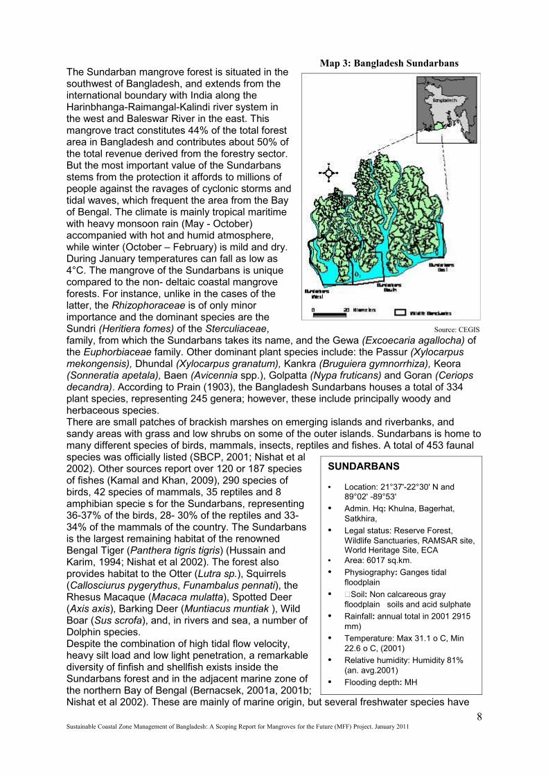
The Sundarbans is the largest single tract of mangrove ecosystem in the world (Hussain and Acharya, 1994; IUCN 2001, Siddiqi, 2001; Nishat et al 2002). It is located in the southwest corner of Bangladesh, between latitudes 21°30' and 22° 30' N and longitudes 89° 00' E and 89° 55' E, within the Khulna administrative division and extended over parts of Khulna, Satkhira and Bagerhat districts. At present, the Sundarbans covers 6,017 km2. It is a part of the world's largest delta, which has been formed from sediments deposited by the Great Rivers Ganges and Brahmaputra that converge on the Bengal basin. The western part of the forest lies in India and the rest (about 60%) in Bangladesh. River channels and tidal creeks, varying in width from just a few meters to 5 kilometers in some places, cover about one third of the total area of this forest. All parts of the Sundarbans forest are subject to tidal inundation during spring tides. The Bangladesh part of the forest is dominated by a high mangrove forest cover.
7Sustainable Coastal Zone Management of Bangladesh: A Scoping Report for Mangroves for the Future (MFF) Project. January 2011
SUNDARBANS
• Location: 21°37'-22°30' N and 89°02' -89°53'
• Admin. Hq: Khulna, Bagerhat, Satkhira,
• Legal status: Reserve Forest, Wildlife Sanctuaries, RAMSAR site, World Heritage Site, ECA
• Area: 6017 sq.km.
• Physiography: Ganges tidal floodplain
• Soil: Non calcareous gray floodplain soils and acid sulphate
• Rainfall: annual total in 2001 2915 mm)
• Temperature: Max 31.1 o C, Min 22.6 o C, (2001)
• Relative humidity: Humidity 81% (an. avg.2001)
• Flooding depth: MH
• Ecosystem: Natural mangrove
The Sundarban mangrove forest is situated in the southwest of Bangladesh, and extends from the international boundary with India along the Harinbhanga-Raimangal-Kalindi river system in the west and Baleswar River in the east. This mangrove tract constitutes 44% of the total forest area in Bangladesh and contributes about 50% of the total revenue derived from the forestry sector. But the most important value of the Sundarbans stems from the protection it affords to millions of people against the ravages of cyclonic storms and tidal waves, which frequent the area from the Bay of Bengal. The climate is mainly tropical maritime with heavy monsoon rain (May - October) accompanied with hot and humid atmosphere, while winter (October – February) is mild and dry. During January temperatures can fall as low as 4°C. The mangrove of the Sundarbans is unique compared to the non- deltaic coastal mangrove forests. For instance, unlike in the cases of the latter, the Rhizophoraceae is of only minor importance and the dominant species are the Sundri (Heritiera fomes) of the Sterculiaceae, family, from which the Sundarbans takes its name, and the Gewa (Excoecaria agallocha) of the Euphorbiaceae family. Other dominant plant species include: the Passur (Xylocarpus mekongensis), Dhundal (Xylocarpus granatum), Kankra (Bruguiera gymnorrhiza), Keora (Sonneratia apetala), Baen (Avicennia spp.), Golpatta (Nypa fruticans) and Goran (Ceriops decandra). According to Prain (1903), the Bangladesh Sundarbans houses a total of 334 plant species, representing 245 genera; however, these include principally woody and herbaceous species.There are small patches of brackish marshes on emerging islands and riverbanks, and sandy areas with grass and low shrubs on some of the outer islands. Sundarbans is home to many different species of birds, mammals, insects, reptiles and fishes. A total of 453 faunal species was officially listed (SBCP, 2001; Nishat et al 2002). Other sources report over 120 or 187 species of fishes (Kamal and Khan, 2009), 290 species of birds, 42 species of mammals, 35 reptiles and 8 amphibian specie s for the Sundarbans, representing 36-37% of the birds, 28- 30% of the reptiles and 33-34% of the mammals of the country. The Sundarbans is the largest remaining habitat of the renowned Bengal Tiger (Panthera tigris tigris) (Hussain and Karim, 1994; Nishat et al 2002). The forest also provides habitat to the Otter (Lutra sp.), Squirrels (Callosciurus pygerythus, Funambalus pennati), the Rhesus Macaque (Macaca mulatta), Spotted Deer (Axis axis), Barking Deer (Muntiacus muntiak ), Wild Boar (Sus scrofa), and, in rivers and sea, a number of Dolphin species. Despite the combination of high tidal flow velocity, heavy silt load and low light penetration, a remarkable diversity of finfish and shellfish exists inside the Sundarbans forest and in the adjacent marine zone of the northern Bay of Bengal (Bernacsek, 2001a, 2001b; Nishat et al 2002). These are mainly of marine origin, but several freshwater species have
8Sustainable Coastal Zone Management of Bangladesh: A Scoping Report for Mangroves for the Future (MFF) Project. January 2011
Source: CEGIS
Map 3: Bangladesh Sundarbans
Crisis of the Sundarbans
Integrated Forest Management Plan for the Sundarban Reserved Forest (IFMP -SRF) 1998 identified following main problems/issues and their probable causes.
Problems/issues
• Increasing incidence of sundri top-dying• Excessive extraction of timber and non-timber forest products• Inadequate ecological and environmental parameters and variables employed in the research
• Poor regeneration capacity of two commercially important species. viz; Heritiera fomes (Sundri) and Excoecaria agallocha (Gewa).
•Causes
• Factors associated with Sundri top dying is mostly environmental and inferences are mostly theoretical and without scientific basis.
• Inadequate information on the biometrics, such as growth, yield and volume tables of gewa and sundri• Insufficient basic information on the growth pattern of golpata and goran.• Inadequate permanent sample plots to cover three salinity zone• Insufficient scientific basis on the current extraction system impose by the GoB on Goran and Golpata• Poor instrumentation facilities to quantify ecological and environmental parameters• Severe browsing and trampling of wildlife• Heavy siltation and sedimentation• Variable salinity levels, tidal fluctuations and hydro dynamic attributes
• Decreased genetic integrity due to attack of bee hole borer in Excoecaria agallocha standing stock• Insufficient canopy opening retained after timber• Insufficient biomass on the forest flora• Insufficient information on the vegetative and coppicing ability of gewa and sundri.
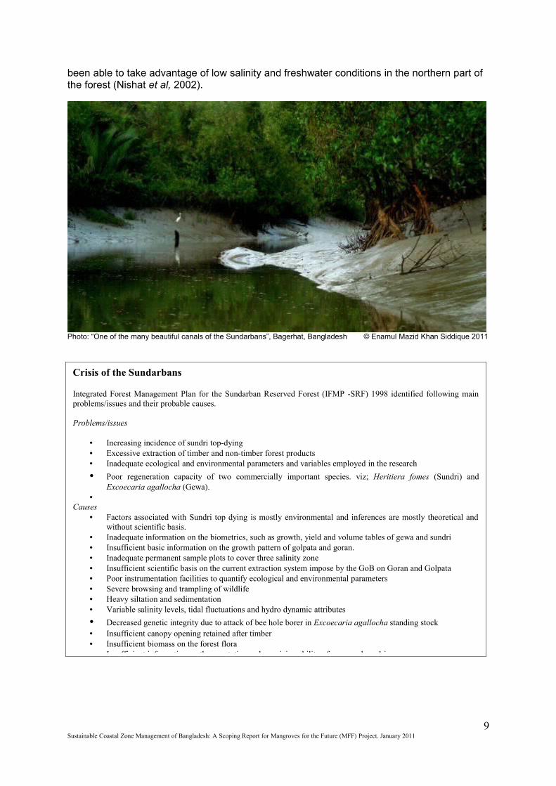
been able to take advantage of low salinity and freshwater conditions in the northern part of the forest (Nishat et al, 2002).
Photo: “One of the many beautiful canals of the Sundarbans”, Bagerhat, Bangladesh © Enamul Mazid Khan Siddique 2011
9Sustainable Coastal Zone Management of Bangladesh: A Scoping Report for Mangroves for the Future (MFF) Project. January 2011

Photo: Devastation of Sundarbans in Cyclone Sidr, Bangladesh © Arifur Rahman Munir, 2007
2.5.2 Narikel Jinjira Coral Island (also known as Saint Martin’s Island)
St. Martin’s Island is a small offshore island in the Bay of Bengal some 50 km to the south of Teknaf peninsula. The island is roughly dumb-bell shaped, approximately 7 km long and 500 m wide at its broadest point. This small island is rich in ecosystems and biodiversity.The island had until recently been considered by the scientific and conservation community as the only “coral island” of the country. However, recent studies have concluded that the island itself is a sedimentary island, consisting of continental base rocks which coral communities have colonized due to favorable ecological conditions. The site is one of the few areas in the world where coral-algal communities dominate rocky reefs. This unique set of environmental conditions, biotic and abiotic, has no parallel in Bangladesh and perhaps not worldwide. Other important habitats and communities include the rocky intertidal shore, rocky land, habitat, marine habitat, lagoons, mudflat, sandy beaches, sand
10Sustainable Coastal Zone Management of Bangladesh: A Scoping Report for Mangroves for the Future (MFF) Project. January 2011
Map 4: Narikel Jinjira Island
Source: CWBMP
dunes and mangrove. The site is also significant for several globally significant species (CWBMP, 2006).
Climate: The climatic conditions are similar to Sonadia Island and the Teknaf Peninsula, but the risk of cyclones and tidal surges are high. It has previous records of being surged by high tides during cyclones.
Plant Diversity: The Island is a good example of co-occurrence of corals, sea grasses and mangroves. Sandy beaches also support sand dune vegetation. A survey under NCSIP -1 recorded a total of 151 species of benthic and drifted algae, 18 species of bryophytes and 157 species of angiosperms. The mangrove formation here is quite different from any other mangroves in the country in that it is a pure Lumnitzera racemosa formation. Associated species are Acanthus ilicifolius, Aegialitis rotundifolia, Hibiscus tiliceous, Excoecaria agallocha and Clerodendrum inerme. Pandanus odoratissimus and Ipomea pescaprae, in association with grasses Panicum repens, Passpalum vaginatum and sedges Cyperus spp. and Fimbristylis spp., constitute the vegetation of the sand dunes. Streblus asper and Vitex trifoliata are also found among the crevices formed by the rocks. Common algal plants include Hypnea Ceramium, Acanthophora, Polysiphonia among Rhodophyceae; Sargassum spp. Dictyota spp.Sphacelaria spp. Padina among Phaeophyceae; Enteromorpha, Chaetomorpha Cladophora, Caulerpa, Helimeda and Ulva, which belong to Chlorophyceaea; Ocilatoria spp. Lyngbya spp. Calothrix and Nostoc are members of Cyanophyceae (MoEF,2001a).
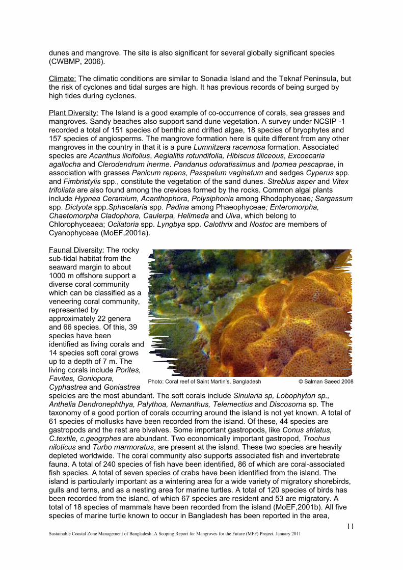
Faunal Diversity: The rocky sub-tidal habitat from the seaward margin to about 1000 m offshore support a diverse coral community which can be classified as a veneering coral community, represented by approximately 22 genera and 66 species. Of this, 39 species have been identified as living corals and 14 species soft coral grows up to a depth of 7 m. The living corals include Porites, Favites, Goniopora, Cyphastrea and Goniastrea speicies are the most abundant. The soft corals include Sinularia sp, Lobophyton sp., Anthelia Dendronephthya, Palythoa, Nemanthus, Telemectius and Discosorna sp. The taxonomy of a good portion of corals occurring around the island is not yet known. A total of 61 species of mollusks have been recorded from the island. Of these, 44 species are gastropods and the rest are bivalves. Some important gastropods, like Conus striatus, C.textile, c.geogrphes are abundant. Two economically important gastropod, Trochus niloticus and Turbo marmoratus, are present at the island. These two species are heavily depleted worldwide. The coral community also supports associated fish and invertebrate fauna. A total of 240 species of fish have been identified, 86 of which are coral-associated fish species. A total of seven species of crabs have been identified from the island. The island is particularly important as a wintering area for a wide variety of migratory shorebirds, gulls and terns, and as a nesting area for marine turtles. A total of 120 species of birds has been recorded from the island, of which 67 species are resident and 53 are migratory. A total of 18 species of mammals have been recorded from the island (MoEF,2001b). All five species of marine turtle known to occur in Bangladesh has been reported in the area,
11Sustainable Coastal Zone Management of Bangladesh: A Scoping Report for Mangroves for the Future (MFF) Project. January 2011
Photo: Coral reef of Saint Martin’s, Bangladesh © Salman Saeed 2008
Threats to biodiversity in Saint Martin’s ECA
The main threats to biodiversity at the site include the cutting of sand dune vegetation for fuelwood and hotel establishment, the degradation of sand dune habitat due to hotel establishment, the harvesting of turtle eggs, indiscriminate and uncontrolled exploitation of coral resources, the conversion of lagoons and rocky land habitat to agriculture, siltation of marine waters, deforestation, unplanned and unregulated tourism, destructive fishing methods, hunting of shorebirds, coastal erosion and coral damage due to shell collection and boulder removal, and pollution and land degradation from domestic sources, agricultural practices, fish processing practices and boat discharges. This pressure is further exacerbated by a lack of legally instituted protection measures for ECAs, field-level management that is only in the initial stages, limited meaningful participation by local communities in resource-use decision making, limited information on the status and functioning of critical ecosystems, no integrated management planning for ECAs, limited opportunities for alternative sustainable livelihoods, a lack of alternative sources of fuel wood, limited public awareness of environmental issues, a lack of technical knowledge and capacity, poor enforcement of fisheries and wildlife protection acts and a lack of integrated coastal zone management.
namely Chelonia mydas, Caretta caretta, Lepidochelys olivacea, Eretmochelys imbricata and Dermochelys coriacea. Three species are known to nest: L. olivacea, C. mydas and E. imbricata (Rashid, 1986;2005). A conservation estimate shows that at least 80- 120 turtles breed in the area during the nesting season (August to April in Bangladesh). Other reptiles include Varanus salvator and the sea-snakes Laticauda laticauda, L. colubrina and Enhydrina schistosa. Altogether, the island supports a total of 27 reptile species and four amphibians. Moray eel and sea cucumber are among other interesting species of this island.
Global biodiversity significance: Global biodiversity significance of St. Martin’s Island stems from a number of considerations i.e., bio-geographic importance, ecological importance, socioeconomic importance, scientific importance, international and national significance.While there have been considerable changes on land, the marine environment remains relatively intact along much of the coastline, especially along the southern part of the island. The sub-tidal habitat that supports coral resources is in a relatively undisturbed state throughout a significant part of the sub-tidal area. Extensive algal and sea-grass beds in the coastal waters may be important as spawning and/or nursery grounds for a number of economically important fish and shellfish species. The island supports a variety of habitats and a number of rare molluscs (e.g. Cone Shells) and two marine mammals from the areas surrounding the island Indo-Pacific Humpback Dolphin Sousa chinensis, and Black Finless Porpoise Neomeris phocaenoides. These are listed as globally threatened in the IUCN Red Data Book. The island is also an important nesting ground for two marine turtle species considered as globally endangered by IUCN, i.e., Lepidochelys olivacea and Chelonia mydas. It is the only continental island in Bangladesh with coral communities and associated flora and fauna, which are found on true coral reefs throughout the Indo-Pacific. There are only a few examples worldwide where coral communities dominate rock reefs; St. Martin’s Island provides a unique set of environmental conditions (biotic and abiotic) not found anywhere else in Bangladesh and perhaps not in the world. Finally, the island contains unique geological features. The current controversy over the geology and the origin of unique geomorphologic features on the island clearly demonstrates the high scientific value of St. Martin’s Island. Co-occurrence of corals, sea-grasses and mangroves in the island represents little known succession sequence of corals in the tropical areas and is of considerable scientific interest.The island also contains some of the most unique, but thus far not studied, benthic communities in Bangladesh, one not found elsewhere in the South Asian Region. Studies on the competitive interaction between corals and algae offer exciting research opportunities. Two other critical habitats have been described in Annex 4.
12Sustainable Coastal Zone Management of Bangladesh: A Scoping Report for Mangroves for the Future (MFF) Project. January 2011
Chapter Three
3. Economic Contribution of the Coastal and Marine Zone
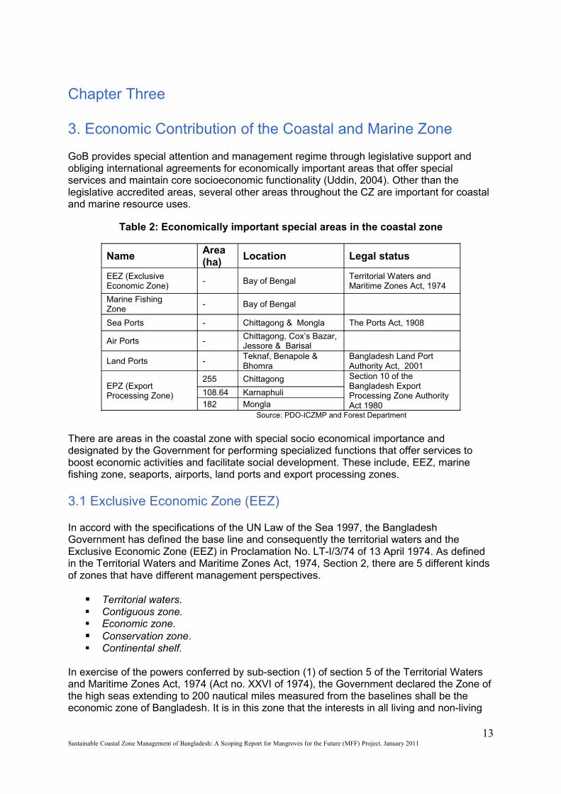
GoB provides special attention and management regime through legislative support and obliging international agreements for economically important areas that offer special services and maintain core socioeconomic functionality (Uddin, 2004). Other than the legislative accredited areas, several other areas throughout the CZ are important for coastal and marine resource uses.
Table 2: Economically important special areas in the coastal zone
Name Area (ha)
Location Legal status
EEZ (Exclusive Economic Zone)
- Bay of Bengal Territorial Waters and Maritime Zones Act, 1974
Marine Fishing Zone
- Bay of Bengal
Sea Ports - Chittagong & Mongla The Ports Act, 1908
Air Ports -Chittagong, Cox’s Bazar, Jessore & Barisal
Land Ports -Teknaf, Benapole & Bhomra
Bangladesh Land Port Authority Act, 2001
EPZ (Export Processing Zone)
255 Chittagong Section 10 of the Bangladesh Export Processing Zone Authority Act 1980
108.64 Karnaphuli182 Mongla Source: PDO-ICZMP and Forest Department
There are areas in the coastal zone with special socio economical importance and designated by the Government for performing specialized functions that offer services to boost economic activities and facilitate social development. These include, EEZ, marine fishing zone, seaports, airports, land ports and export processing zones.
3.1 Exclusive Economic Zone (EEZ)
In accord with the specifications of the UN Law of the Sea 1997, the Bangladesh Government has defined the base line and consequently the territorial waters and the Exclusive Economic Zone (EEZ) in Proclamation No. LT-I/3/74 of 13 April 1974. As defined in the Territorial Waters and Maritime Zones Act, 1974, Section 2, there are 5 different kinds of zones that have different management perspectives.
Territorial waters. Contiguous zone. Economic zone. Conservation zone. Continental shelf.
In exercise of the powers conferred by sub-section (1) of section 5 of the Territorial Waters and Maritime Zones Act, 1974 (Act no. XXVI of 1974), the Government declared the Zone of the high seas extending to 200 nautical miles measured from the baselines shall be the economic zone of Bangladesh. It is in this zone that the interests in all living and non-living
13Sustainable Coastal Zone Management of Bangladesh: A Scoping Report for Mangroves for the Future (MFF) Project. January 2011

resources is vested in Bangladesh. Based on the above definitions, the EEZ has been included in the coastal zone.
3.2 Marine Fishing Zones of Bangladesh
Marine fishing zones have been demarcated through a Bangladesh Gazette Extra dated September 12, 1983. However, the present situation is that the fishing grounds and shrimp grounds are scattered in the vast marine areas. The fishing ground of the bay depending on the ongoing fishing practice and fishing possibilities could be demarcated in to 5 patches of which the nearest two patches are fished at present and the remaining 3 patches have the potentials. Starting from coastline, depth 0 up to a depth of 40 m and extends up to 120 km (+/- 10 km) from the coastline is reserved for the artisan fishers . The next patch of fishing zone extends from 40 m depth (from 120 km (+/- 10km) line) to 80 m depth (170 km (+/- 10km) line) are trawling. All other patches are either inactive or no fishing at present.
Map 5: Marine Fishing Zone of Bangladesh
Source: Banglapedia
3.3 Sea Ports
Seaports in Bangladesh were established through the Ports Act, 1908. There are two seaports in Bangladesh: Chittagong & Mongla ports. Chittagong port came under special management jurisdiction through establishing port authorities under special Ordinances in 1976. They share similar mandates, responsibilities and administrative arrangements.
14Sustainable Coastal Zone Management of Bangladesh: A Scoping Report for Mangroves for the Future (MFF) Project. January 2011
Chittagong and Mongla ports apart from their role in importing and exporting items for and from coastal industry, they also handle the bulk of export and imports to and from other areas of the country, including essential food items and equipment.
In view of the problems of ships reaching Chittagong port, a proposal for development of a deep-sea port is under consideration. The primary planning was to develop this port at Sonadia-Moheshkhali, but the place is an ecologically critical area which has raised contradictions with the environmental concern. GoB is considering establishing a sea port in Patuakhali district too.
3.4 Land Ports
Land ports have been established to facilitate trade and commerce between bordering countries of Bangladesh: India and Myanmar. These ports are administered through Bangladesh Land Port Authority Act of 2001. There are 4 Land ports in the coastal zone:
1. Teknaf land port at Cox’s bazar to Myanmar
2. Benapole land port at Jessore to India;
3. Bhomra land port at Shatkhira to India.
4. Feni-belonia land port to India
3.5 Air Ports
The Airports are managed under the Ministry of Civil Aviation and Tourism (MoCAT). There are four functional airports in the coastal zone. Among new/proposed airports, preparatory construction is going on for a Khulna/Mongla Airport. The Government has declared initiation of another airport near Kuakata sea beach to support tourism.
3.6 Export Processing Zone (EPZ)
The Export Processing Zones (EPZ) is being established through the power given in section 10 of the Bangladesh Export Processing Zones Authority (BEPZA) Act, 1980. The Bangladesh Export Processing Zones Authority (BEPZA) is the official organ of the government to promote, attract and facilitate foreign investment in the Export Processing Zones. The primary objective of an EPZ is to provide special areas where potential investors would find a congenial investment climate, free from cumbersome procedures. There are two EPZ in the coastal zone: one at Chittagong and another at Mongla.
3.7 Coastal & Marine Resource Uses
The CZ of Bangladesh is full of potentials and opportunities. Given the fragile and disaster prone environment and the ever increasing demands of the growing population, the coastal zone offers much to its people and to investors. Some of the typical current coastal and marine resource uses have been discussed below:
3.7.1 Shrimp Culture
Bangladesh sea food export earns around some $356 million annually by exporting frozen shrimp accounting for 6.28 % of total earnings and there are around 9000 farms covering an
15Sustainable Coastal Zone Management of Bangladesh: A Scoping Report for Mangroves for the Future (MFF) Project. January 2011
area of 375,000 acres of coastal land which is 18% of the total number of such farms worldwide. Bangladesh is fifth in volume and eight in earning in shrimp export in the world. In Bangladesh the shrimp sector is the second largest export industry, employing 840,000 people. There are 43 commercial hatcheries, several ice plants and feed mills too which works to support this sector (PDO-ICZMP, 2004).
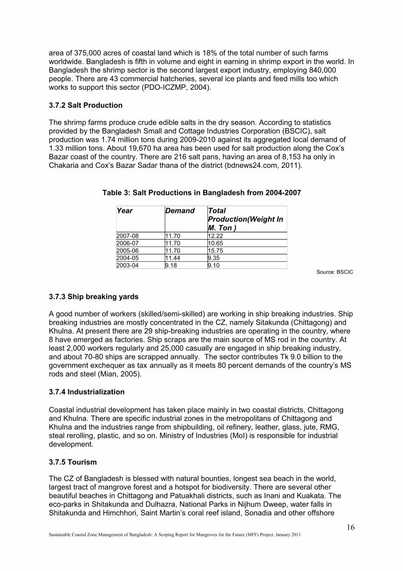
3.7.2 Salt Production
The shrimp farms produce crude edible salts in the dry season. According to statistics provided by the Bangladesh Small and Cottage Industries Corporation (BSCIC), salt production was 1.74 million tons during 2009-2010 against its aggregated local demand of 1.33 million tons. About 19,670 ha area has been used for salt production along the Cox’s Bazar coast of the country. There are 216 salt pans, having an area of 8,153 ha only in Chakaria and Cox’s Bazar Sadar thana of the district (bdnews24.com, 2011).
Table 3: Salt Productions in Bangladesh from 2004-2007
Year Demand Total Production(Weight In M. Ton )
2007-08 11.70 12.222006-07 11.70 10.652005-06 11.70 15.752004-05 11.44 9.352003-04 9.18 9.10
Source: BSCIC
3.7.3 Ship breaking yards
A good number of workers (skilled/semi-skilled) are working in ship breaking industries. Ship breaking industries are mostly concentrated in the CZ, namely Sitakunda (Chittagong) and Khulna. At present there are 29 ship-breaking industries are operating in the country, where 8 have emerged as factories. Ship scraps are the main source of MS rod in the country. At least 2,000 workers regularly and 25,000 casually are engaged in ship breaking industry, and about 70-80 ships are scrapped annually. The sector contributes Tk 9.0 billion to the government exchequer as tax annually as it meets 80 percent demands of the country’s MS rods and steel (Mian, 2005).
3.7.4 Industrialization
Coastal industrial development has taken place mainly in two coastal districts, Chittagong and Khulna. There are specific industrial zones in the metropolitans of Chittagong and Khulna and the industries range from shipbuilding, oil refinery, leather, glass, jute, RMG, steal rerolling, plastic, and so on. Ministry of Industries (MoI) is responsible for industrial development.
3.7.5 Tourism
The CZ of Bangladesh is blessed with natural bounties, longest sea beach in the world, largest tract of mangrove forest and a hotspot for biodiversity. There are several other beautiful beaches in Chittagong and Patuakhali districts, such as Inani and Kuakata. The eco-parks in Shitakunda and Dulhazra, National Parks in Nijhum Dweep, water falls in Shitakunda and Himchhori, Saint Martin’s coral reef island, Sonadia and other offshore
16Sustainable Coastal Zone Management of Bangladesh: A Scoping Report for Mangroves for the Future (MFF) Project. January 2011
islands and inland wetlands are home to thousands of migratory and resident bird populations. Over time, the tourism and ecotourism industry of the country has flourished, in addition to the National Tourism Organization – Bangladesh Parjatan Corporation (BPC), there are a number of private tour operators in the country that offer guided tours in different areas. In the year 2010, the revenue from tourism was Tk. 3121.47 million (till June). At present, around 0.50 million international tourists visit Bangladesh each year and this creates employment opportunities for over one million people. This sector has great potential as a green industry and recent studies have revealed that the country can earn about Tk. 140 billion every year from tourism alone. (The Financial Express 2010)
3.7.6 Minerals & energy production
The CZ is a reservoir of natural resources, with natural gas, minerals and potentials for energy production. However, lack of good governance and data deficiency and inadequate research has resulted in the pilferage of these resources. In this section, some resources are described in brief:
3.7.6.1 Natural Gas
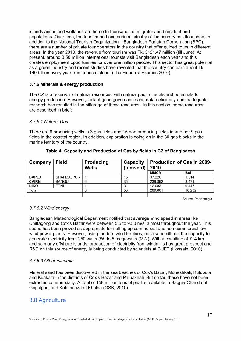
There are 8 producing wells in 3 gas fields and 16 non producing fields in another 9 gas fields in the coastal region. In addition, exploration is going on in the 30 gas blocks in the marine territory of the country.
Table 4: Capacity and Production of Gas by fields in CZ of Bangladesh
Company Field Producing Wells
Capacity(mmscfd)
Production of Gas in 2009-2010MMCM Bcf
BAPEX SHAHBAJPUR 1 15 37.226 1.314CAIRN SANGU 6 35 239.892 8.471NIKO FENI 1 3 12.683 0.447Total 8 53 289.801 10.232
Source: Petrobangla
3.7.6.2 Wind energy
Bangladesh Meteorological Department notified that average wind speed in areas like Chittagong and Cox’s Bazar were between 5.5 to 9.50 m/s, almost throughout the year. This speed has been proved as appropriate for setting up commercial and non-commercial level wind power plants. However, using modern wind turbines, each windmill has the capacity to generate electricity from 250 watts (W) to 5 megawatts (MW). With a coastline of 714 km and so many offshore islands; production of electricity from windmills has great prospect and R&D on this source of energy is being conducted by scientists at BUET (Hossain, 2010).
3.7.6.3 Other minerals
Mineral sand has been discovered in the sea beaches of Cox's Bazar, Moheshkali, Kutubdia and Kuakata in the districts of Cox’s Bazar and Patuakhali. But so far, these have not been extracted commercially. A total of 158 million tons of peat is available in Baggie-Chanda of Gopalganj and Kolamouza of Khulna (GSB, 2010).
3.8 Agriculture
17Sustainable Coastal Zone Management of Bangladesh: A Scoping Report for Mangroves for the Future (MFF) Project. January 2011
In the saline soils rice, jute, sugarcane, pulses, oilseeds, spices, vegetables and fruits are grown, but their contributions to cropping intensity vary greatly with regions. In salt affected highlands of Barisal, Khulna and Patuakhali regions, locally transplanted Aman rice (July-November) is the dominant crop, whereas in the same land type of Chittagong region, High Yield Variety (HYV) Aman rice is the major crop. In medium highlands of Barisal, Khulna, Noakhali, Patuakhali and Chittagong regions the dominant crop is locally transplanted Aman rice. The dominant crop in the medium low lands of the former three regions is broadcast Aman rice, whereas in Chittagong region broadcast Aus rice is the dominant crop.
During wet season, local Aman rice is grown extensively in the coastal saline areas with normal yields between 2.5 and 3.0 tons per hectare. Transplanted Aman-fallow is the most dominant cropping pattern in the Khulna, Barisal and Patuakhali regions. In Noakhali and Chittagong, Aus-locally transplanted Aman pattern covers 25-28% area. Next to this is the transplanted Aman-fallow pattern, representing about 18-20% of the area cropped.
Winter crops, such as wheat, potato and vegetables are grown, which cover a small area (11.5%). This is practiced in the district of Noakhali with transplanted Aman-winter crops. HYV rice cultivars vary considerably in different salinity affected regions. In Chittagong and Noakhali regions, there is substantial coverage of HYV rice in high and medium lands during both Aus and Aman seasons. Some coverage of HYV rice during Aman season is also found in the highlands of Khulna, Barisal and Patuakhali regions. But almost no HYV Aus rice is grown in Khulna, Barisal and Patuakhali regions. However, there is potential to HYV Aman rice cultivation in the regions on highlands. Most of the coastal areas are located over medium highlands, where flooding depth ranges from 0.3-0.9 meter. This category of land is suitable for minimum two crops and sometimes three crops with winter wheat or other winter crops. The low land use in saline area is mainly due to unfavorable soil salinity in dry season and unavailability of quality irrigation water. In addition to crop production, area of about 86,975 hectares supports brackish water shrimp culture farms, the major portion (62,120 ha) is in Khulna district followed by Chittagong district (24,755 ha) (Haque,2006).
3.9 Fisheries and aquaculture and related resource uses
The contribution of the fisheries sub-sector to the country’s GDP has been on a decline. It dropped gradually by 6.09% in 1999-2000 to 4.64 % in 2007-08. Total output includes 445,000 metric tons from marine fisheries, which is an important source of income and employment in the coastal zone. Coastal zone also has inland fisheries potentials. There are natural rivers, canals, beels, flood plain, baors and ponds. Inland open water fish catch increased by 25% over the seven-year period (1995/ 96 to 2002/03), while closed water fish production has more than doubled, to the extent of 122%. The coastal zone accounts for 40% of total pond-fish production and 36% for inland capture fisheries. In 2006-07, total inland fish catch in the CZ was 562,769 metric tons. Inland catch can be sustained and further enhanced through better management practices and enforcement of conservation strategies.
Pond aquaculture provides huge potential for farmers as alternative livelihood, which has not yet been fully exploited. The common inland fish species that are caught in the CZ are major local carps like Rui, katla, Mrigel, kalabaush and ghania, exotic carps like silver carp, common carp, grass carp and mirror carp, live fesh like koi, shingi and magur, cat fishes like rita, boal, pangash,shilong,air bacha, and marine fishes include Hilsha, bombay duck, Indian salmon, pomfret, jew fish, sea cat fish, sharks and rays, shrimp and other marine species.
18Sustainable Coastal Zone Management of Bangladesh: A Scoping Report for Mangroves for the Future (MFF) Project. January 2011
Shutki (dry fish) is also an exportable commodity and has an expansion potential. Fish drying is mainly concentrated in Cox's Bazar, Chittagong and Khulna. Part of the catch from the Bay of Bengal, particularly from September through April, is generally dried in various coastal areas and islands: St. Martins, Moheshkhali, Sonadia, Dublar Char, Aftabiya Char, Rangabali, Korushkool, etc. During this period, the availability of marine fish is high and the weather for sun drying is ideal. It is estimated that about 20 to 40% of the total catch during this period is used for drying. About 600 small enterprises are engaged in this process. In 2002, the total production of dehydrated fish was about 400,000 metric ton (PDO-ICZMP, 2004).
Recently, few enterprises started fish drying using hygienic methods, which has large potential for marketing at home and abroad. Other related opportunities exist in shell collection, crab collection and culture, natural and artificial pearl culture, turtle culture, crocodile farming, production of fish feed, net making, boat building and transportation of fish and fry.
19Sustainable Coastal Zone Management of Bangladesh: A Scoping Report for Mangroves for the Future (MFF) Project. January 2011
Chapter Four
4. Major Environmental Issues faced by Coastal Bangladesh
The major environmental issues of the CZ are either climate change induced disasters or anthropogenic impacts on environment, such as; rapid changes in the land use and degradation of the natural environment. Some of the major environmental issues faced by the CZ in Bangladesh have been discussed in this chapter.
4.1 Climate change induced hazards
Bangladesh is recognized as one of the most vulnerable countries (MVCs) in terms of climate change manifestations. Every year, Bangladesh experiences natural disasters which cause loss of life, damage to infrastructure and economic assets and adversely impact the lives and livelihoods of the people.
Table 5: Overview of climatic vulnerability in the CZ
Vulnerabilities Vulnerable areas
Present status
Risk of aggravation
Cyclone and storm surge
Islands, exposed upazilas
Devastating but seasonal
Increasing
Land erosion
Meghna and other estuaries, islands and coastal rivers
Serious, localized, seasonal
Increasing
Flood Exposed upazilas Serious, seasonal Increasing
Drainage congestion Khulna, Jessore, Noakhali
Localized, year round
Increasing
Salinity intrusion Western exposed upazilas
Localized, seasonal
Increasing
Drought Satkhira Localized, seasonal
Increasing
Earthquake Chittagong Unpredictable Increasing Shortage of drinking water & arsenic contamination
All over Serious, year round
Increasing
Ecosystem degradation
Marine, Sundarbans Serious, year round, cumulative
Increasing
Pollution Chittagong, Khulna Serious, year round, cumulative
Increasing
Climate change All over Year round, cumulative
Increasing
Source: Islam and Ahmad,2004
Many scientific aassessments using climate change models indicate that changes in rainfall and evapotranspiration (ETo) will alter significantly over the next 50 years. These scientific studies predict that, the dry season will become significantly drier with a noticeable increase in the irrigation water requirements. By the year 2050, this increase may be as much as 25%
20Sustainable Coastal Zone Management of Bangladesh: A Scoping Report for Mangroves for the Future (MFF) Project. January 2011
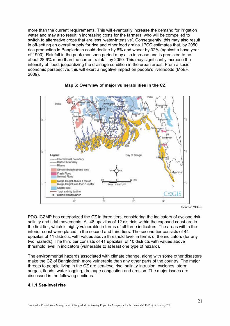
more than the current requirements. This will eventually increase the demand for irrigation water and may also result in increasing costs for the farmers, who will be compelled to switch to alternative crops that are less ‘water-intensive’. Consequently, this may also result in off-setting an overall supply for rice and other food grains. IPCC estimates that, by 2050, rice production in Bangladesh could decline by 8% and wheat by 32% (against a base year of 1990). Rainfall in the peak monsoon period may also increase and is predicted to be about 28.6% more than the current rainfall by 2050. This may significantly increase the intensity of flood, jeopardizing the drainage condition in the urban areas. From a socio-economic perspective, this will exert a negative impact on people’s livelihoods (MoEF, 2009).
Map 6: Overview of major vulnerabilities in the CZ
Source: CEGIS
PDO-ICZMP has categorized the CZ in three tiers, considering the indicators of cyclone risk, salinity and tidal movements. All 48 upazilas of 12 districts within the exposed coast are in the first tier, which is highly vulnerable in terms of all three indicators. The areas within the interior coast were placed in the second and third tiers. The second tier consists of 44 upazilas of 11 districts, with values above threshold level in terms of the indicators (for any two hazards). The third tier consists of 41 upazilas, of 10 districts with values above threshold level in indicators (vulnerable to at least one type of hazard).
The environmental hazards associated with climate change, along with some other disasters make the CZ of Bangladesh more vulnerable than any other parts of the country. The major threats to people living in the CZ are sea-level rise, salinity intrusion, cyclones, storm surges, floods, water logging, drainage congestion and erosion. The major issues are discussed in the following sections.
4.1.1 Sea-level rise
21Sustainable Coastal Zone Management of Bangladesh: A Scoping Report for Mangroves for the Future (MFF) Project. January 2011
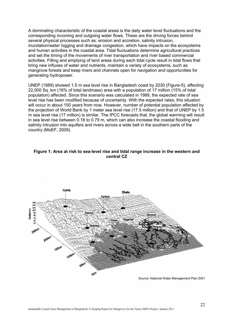
A dominating characteristic of the coastal areas is the daily water level fluctuations and the corresponding incoming and outgoing water flows. These are the driving forces behind several physical processes such as: erosion and accretion, salinity intrusion, inundation/water logging and drainage congestion, which have impacts on the ecosystems and human activities in the coastal area. Tidal fluctuations determine agricultural practices and set the timing of the movements of river transportation and river based commercial activities. Filling and emptying of land areas during each tidal cycle result in tidal flows that bring new influxes of water and nutrients, maintain a variety of ecosystems, such as mangrove forests and keep rivers and channels open for navigation and opportunities for generating hydropower.
UNEP (1989) showed 1.5 m sea level rise in Bangladesh coast by 2030 (Figure-5), affecting 22,000 Sq. km (16% of total landmass) area with a population of 17 million (15% of total population) affected. Since this scenario was calculated in 1989, the expected rate of sea level rise has been modified because of uncertainty. With the expected rates, this situation will occur in about 150 years from now. However, number of potential population affected by the projection of World Bank by 1 meter sea level rise (17.5 million) and that of UNEP by 1.5 m sea level rise (17 million) is similar. The IPCC forecasts that, the global warming will result in sea level rise between 0.18 to 0.79 m, which can also increase the coastal flooding and salinity intrusion into aquifers and rivers across a wide belt in the southern parts of the country (MoEF, 2009).
Figure 1: Area at risk to sea-level rise and tidal range increase in the western and central CZ
Source: National Water Management Plan 2001
22Sustainable Coastal Zone Management of Bangladesh: A Scoping Report for Mangroves for the Future (MFF) Project. January 2011
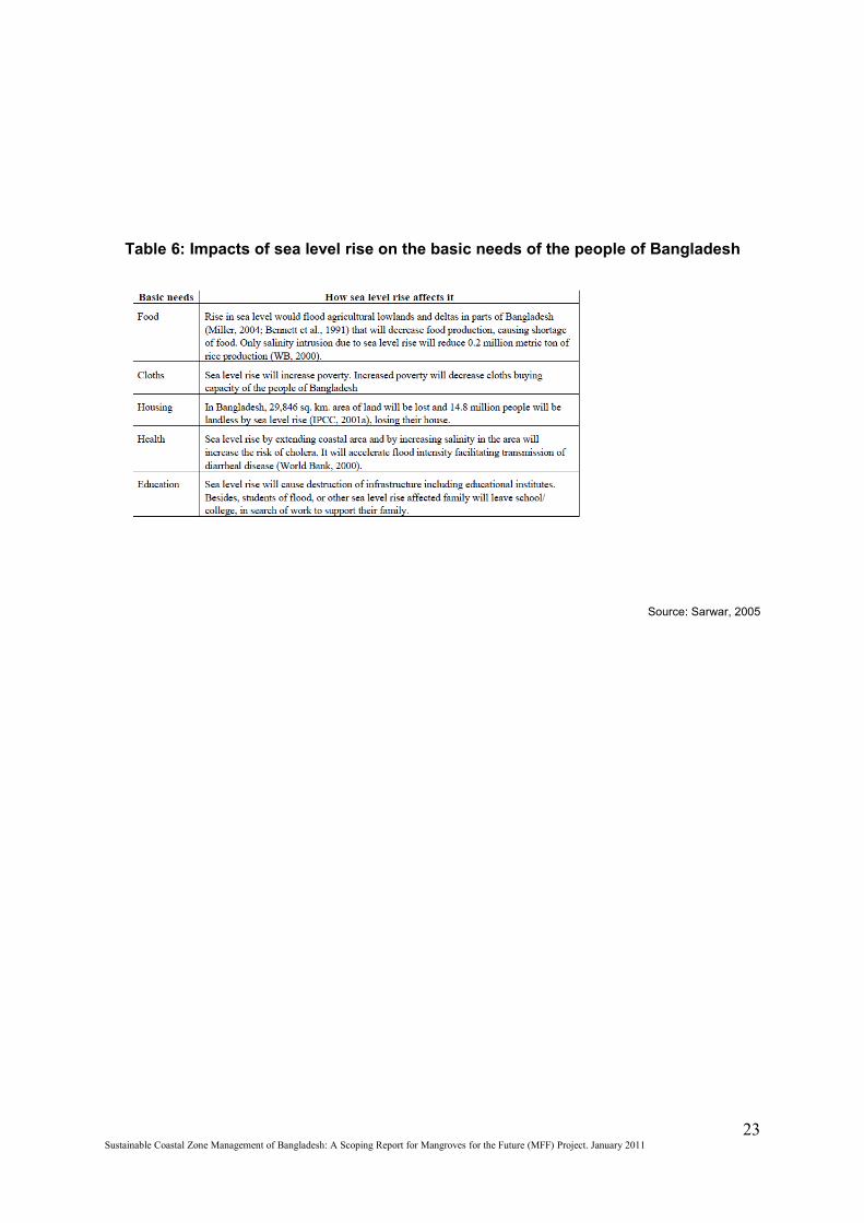
Table 6: Impacts of sea level rise on the basic needs of the people of Bangladesh
Source: Sarwar, 2005
23Sustainable Coastal Zone Management of Bangladesh: A Scoping Report for Mangroves for the Future (MFF) Project. January 2011

Table 7: Sea level rise (SLR) in Bangladesh and its possible impacts
Source: World Bank 2000
Table 8: Threat to protected areas due to Sea Level Rise
24Sustainable Coastal Zone Management of Bangladesh: A Scoping Report for Mangroves for the Future (MFF) Project. January 2011
Source: Islam 2004, p7
4.1.2 Salinity intrusion
The fluctuations of water levels and flows determine the intrusion of saline waters to a great extent; upstream river flows being the other main determining factor. Their combined effect results in a complicated situation in which the salinity content of surface water bodies, groundwater aquifers and soils in the coastal zone vary from day to day and between seasons. This influences the availability of fresh water and suitability of land for human use and also sets the basic ground for ecosystems.
The salinity levels found above the threshold values in the soil, surface or groundwater of 97 upazilas of 17 districts (66% of all upazilas). In Chandpur and Shariatpur districts salinity levels were found to be below threshold levels. Soil salinity is found above threshold levels in a total of 93 upazilas of these 17 districts; surface water salinity in a total of 65 upazilas of 10 districts and groundwater salinity in a total of 45 upazilas of 8 districts.
Map 7: Estimated Effects of SLR on Salinity
25Sustainable Coastal Zone Management of Bangladesh: A Scoping Report for Mangroves for the Future (MFF) Project. January 2011
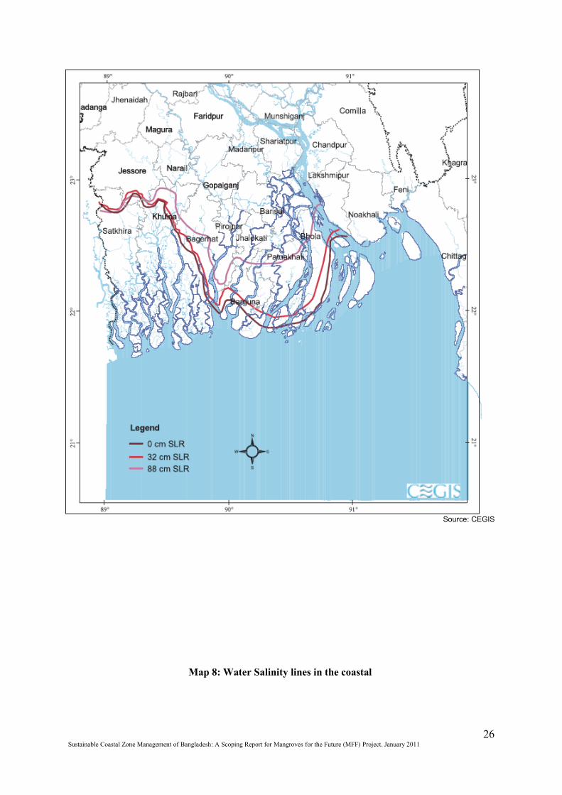
Source: CEGIS
26Sustainable Coastal Zone Management of Bangladesh: A Scoping Report for Mangroves for the Future (MFF) Project. January 2011
Map 8: Water Salinity lines in the coastal zone
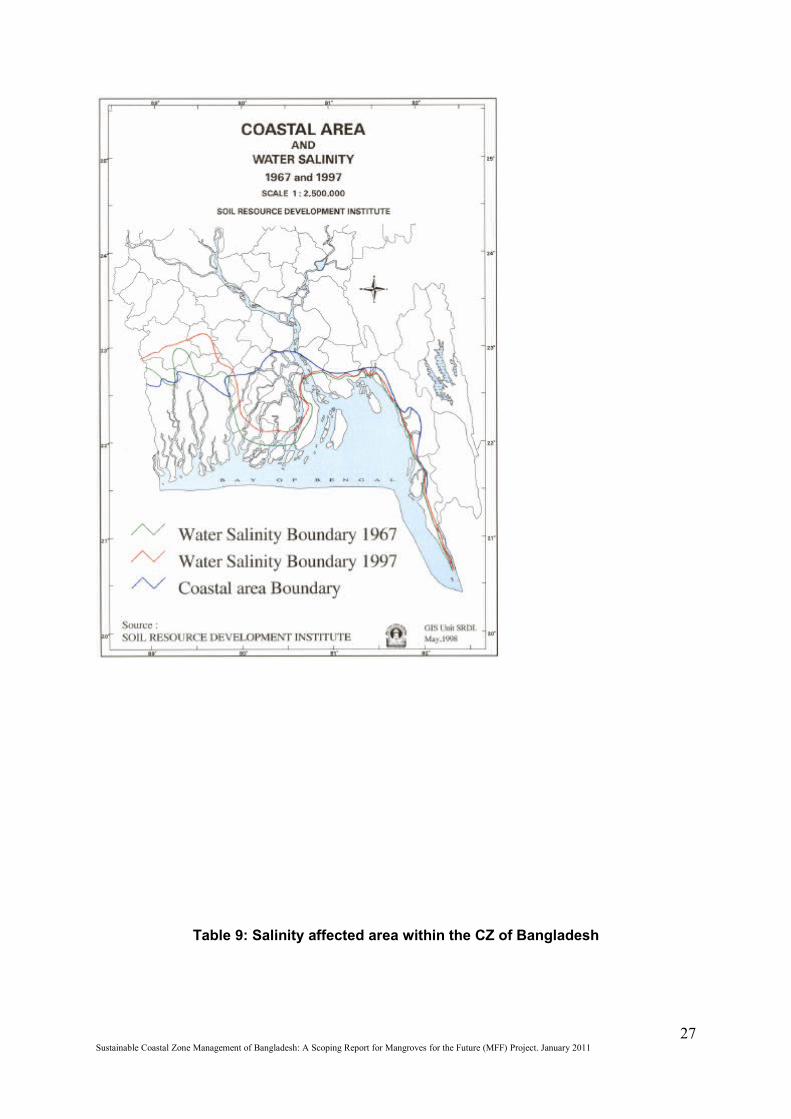
Table 9: Salinity affected area within the CZ of Bangladesh
27Sustainable Coastal Zone Management of Bangladesh: A Scoping Report for Mangroves for the Future (MFF) Project. January 2011
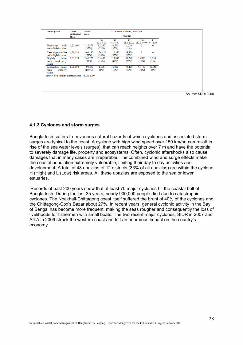
Source: SRDI 2000
4.1.3 Cyclones and storm surges
Bangladesh suffers from various natural hazards of which cyclones and associated storm surges are typical to the coast. A cyclone with high wind speed over 150 km/hr, can result in rise of the sea water levels (surges), that can reach heights over 7 m and have the potential to severely damage life, property and ecosystems. Often, cyclonic aftershocks also cause damages that in many cases are irreparable. The combined wind and surge effects make the coastal population extremely vulnerable, limiting their day to day activities and development. A total of 48 upazilas of 12 districts (33% of all upazilas) are within the cyclone H (High) and L (Low) risk areas. All these upazilas are exposed to the sea or lower estuaries.
‘Records of past 200 years show that at least 70 major cyclones hit the coastal belt of Bangladesh. During the last 35 years, nearly 900,000 people died due to catastrophic cyclones. The Noakhali-Chittagong coast itself suffered the brunt of 40% of the cyclones and the Chittagong-Cox’s Bazar about 27%. In recent years, general cyclonic activity in the Bay of Bengal has become more frequent, making the seas rougher and consequently the loss of livelihoods for fishermen with small boats. The two recent major cyclones, SIDR in 2007 and AILA in 2009 struck the western coast and left an enormous impact on the country’s economy.
28Sustainable Coastal Zone Management of Bangladesh: A Scoping Report for Mangroves for the Future (MFF) Project. January 2011
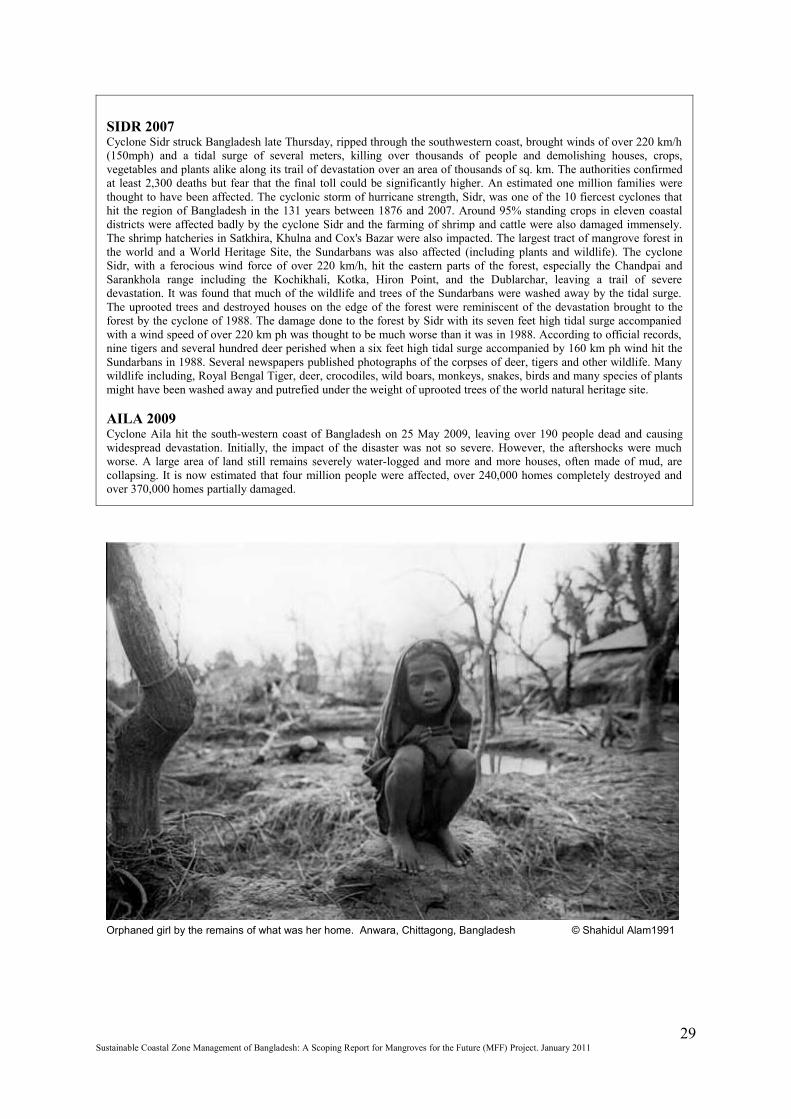
SIDR 2007Cyclone Sidr struck Bangladesh late Thursday, ripped through the southwestern coast, brought winds of over 220 km/h (150mph) and a tidal surge of several meters, killing over thousands of people and demolishing houses, crops, vegetables and plants alike along its trail of devastation over an area of thousands of sq. km. The authorities confirmed at least 2,300 deaths but fear that the final toll could be significantly higher. An estimated one million families were thought to have been affected. The cyclonic storm of hurricane strength, Sidr, was one of the 10 fiercest cyclones that hit the region of Bangladesh in the 131 years between 1876 and 2007. Around 95% standing crops in eleven coastal districts were affected badly by the cyclone Sidr and the farming of shrimp and cattle were also damaged immensely. The shrimp hatcheries in Satkhira, Khulna and Cox's Bazar were also impacted. The largest tract of mangrove forest in the world and a World Heritage Site, the Sundarbans was also affected (including plants and wildlife). The cyclone Sidr, with a ferocious wind force of over 220 km/h, hit the eastern parts of the forest, especially the Chandpai and Sarankhola range including the Kochikhali, Kotka, Hiron Point, and the Dublarchar, leaving a trail of severe devastation. It was found that much of the wildlife and trees of the Sundarbans were washed away by the tidal surge. The uprooted trees and destroyed houses on the edge of the forest were reminiscent of the devastation brought to the forest by the cyclone of 1988. The damage done to the forest by Sidr with its seven feet high tidal surge accompanied with a wind speed of over 220 km ph was thought to be much worse than it was in 1988. According to official records, nine tigers and several hundred deer perished when a six feet high tidal surge accompanied by 160 km ph wind hit the Sundarbans in 1988. Several newspapers published photographs of the corpses of deer, tigers and other wildlife. Many wildlife including, Royal Bengal Tiger, deer, crocodiles, wild boars, monkeys, snakes, birds and many species of plants might have been washed away and putrefied under the weight of uprooted trees of the world natural heritage site.
AILA 2009Cyclone Aila hit the south-western coast of Bangladesh on 25 May 2009, leaving over 190 people dead and causing widespread devastation. Initially, the impact of the disaster was not so severe. However, the aftershocks were much worse. A large area of land still remains severely water-logged and more and more houses, often made of mud, are collapsing. It is now estimated that four million people were affected, over 240,000 homes completely destroyed and over 370,000 homes partially damaged.
29Sustainable Coastal Zone Management of Bangladesh: A Scoping Report for Mangroves for the Future (MFF) Project. January 2011
Orphaned girl by the remains of what was her home. Anwara, Chittagong, Bangladesh © Shahidul Alam1991
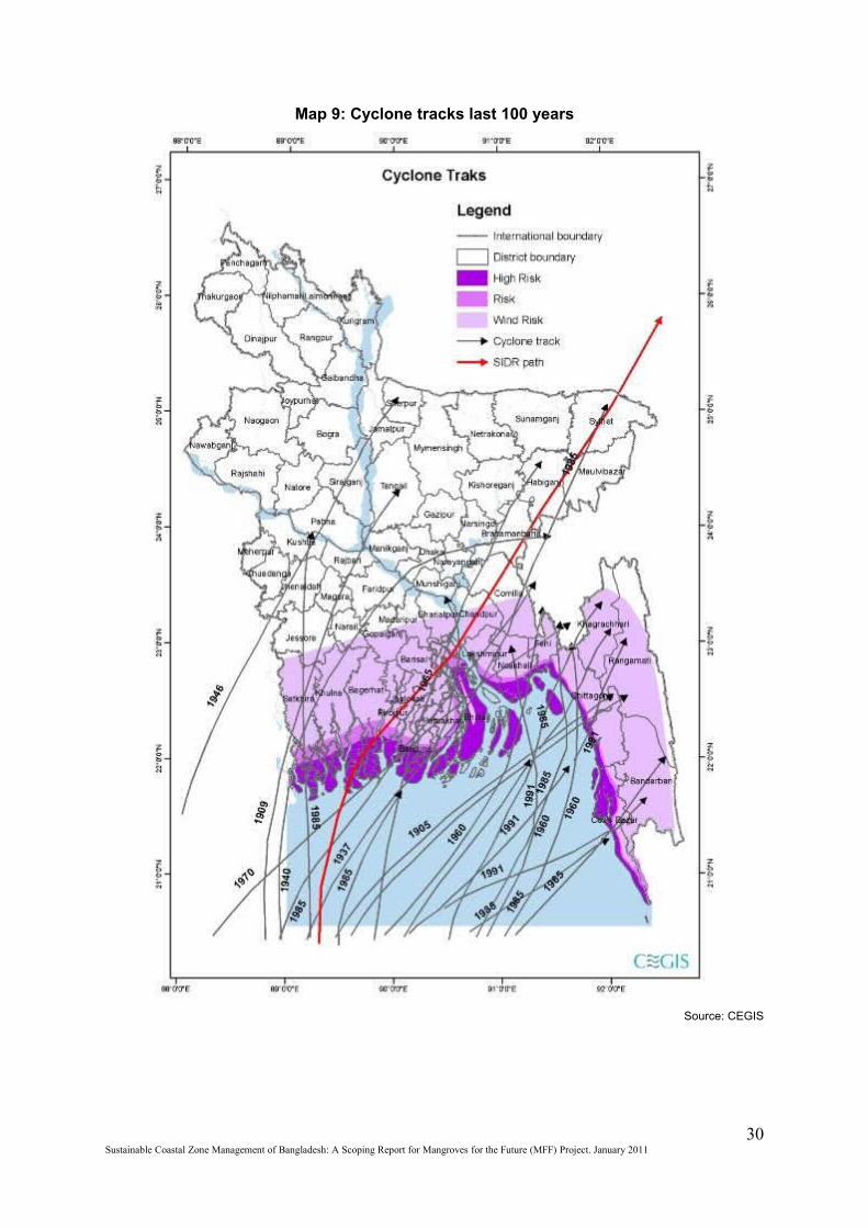
Map 9: Cyclone tracks last 100 years
Source: CEGIS
30Sustainable Coastal Zone Management of Bangladesh: A Scoping Report for Mangroves for the Future (MFF) Project. January 2011
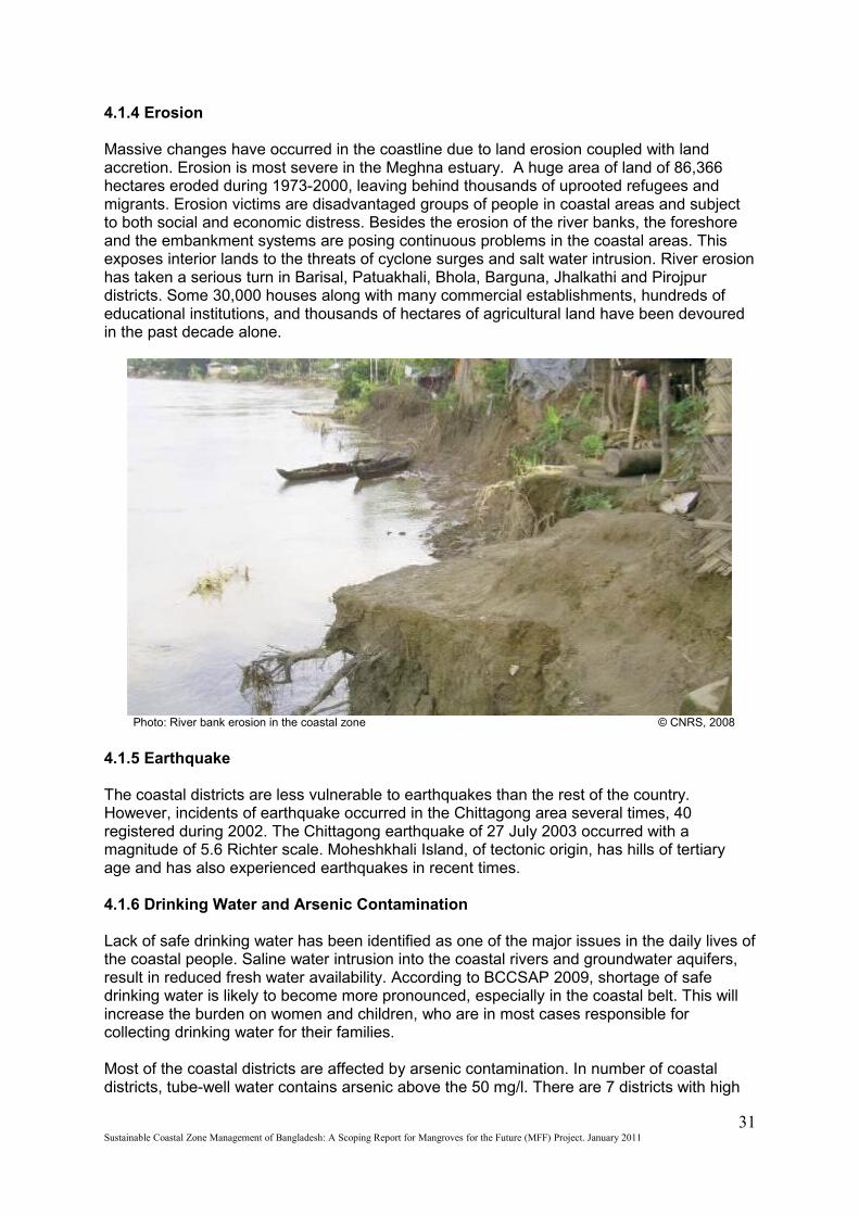
4.1.4 Erosion
Massive changes have occurred in the coastline due to land erosion coupled with land accretion. Erosion is most severe in the Meghna estuary. A huge area of land of 86,366 hectares eroded during 1973-2000, leaving behind thousands of uprooted refugees and migrants. Erosion victims are disadvantaged groups of people in coastal areas and subject to both social and economic distress. Besides the erosion of the river banks, the foreshore and the embankment systems are posing continuous problems in the coastal areas. This exposes interior lands to the threats of cyclone surges and salt water intrusion. River erosion has taken a serious turn in Barisal, Patuakhali, Bhola, Barguna, Jhalkathi and Pirojpur districts. Some 30,000 houses along with many commercial establishments, hundreds of educational institutions, and thousands of hectares of agricultural land have been devoured in the past decade alone.
Photo: River bank erosion in the coastal zone © CNRS, 2008
4.1.5 Earthquake
The coastal districts are less vulnerable to earthquakes than the rest of the country. However, incidents of earthquake occurred in the Chittagong area several times, 40 registered during 2002. The Chittagong earthquake of 27 July 2003 occurred with a magnitude of 5.6 Richter scale. Moheshkhali Island, of tectonic origin, has hills of tertiary age and has also experienced earthquakes in recent times.
4.1.6 Drinking Water and Arsenic Contamination
Lack of safe drinking water has been identified as one of the major issues in the daily lives of the coastal people. Saline water intrusion into the coastal rivers and groundwater aquifers, result in reduced fresh water availability. According to BCCSAP 2009, shortage of safe drinking water is likely to become more pronounced, especially in the coastal belt. This will increase the burden on women and children, who are in most cases responsible for collecting drinking water for their families.
Most of the coastal districts are affected by arsenic contamination. In number of coastal districts, tube-well water contains arsenic above the 50 mg/l. There are 7 districts with high
31Sustainable Coastal Zone Management of Bangladesh: A Scoping Report for Mangroves for the Future (MFF) Project. January 2011
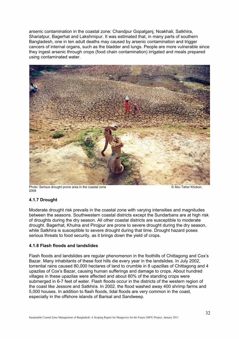
arsenic contamination in the coastal zone: Chandpur Gopalganj, Noakhali, Satkhira, Shariatpur, Bagerhat and Lakshmipur. It was estimated that, in many parts of southern Bangladesh, one in ten adult deaths may caused by arsenic contamination and trigger cancers of internal organs, such as the bladder and lungs. People are more vulnerable since they ingest arsenic through crops (food chain contamination) irrigated and meals prepared using contaminated water.
Photo: Serious drought prone area in the coastal zone © Abu Taher Khokon, 2008
4.1.7 Drought
Moderate drought risk prevails in the coastal zone with varying intensities and magnitudes between the seasons. Southwestern coastal districts except the Sundarbans are at high risk of droughts during the dry season. All other coastal districts are susceptible to moderate drought. Bagerhat, Khulna and Pirojpur are prone to severe drought during the dry season, while Satkhira is susceptible to severe drought during that time. Drought hazard poses serious threats to food security, as it brings down the yield of crops.
4.1.8 Flash floods and landslides
Flash floods and landslides are regular phenomenon in the foothills of Chittagong and Cox’s Bazar. Many inhabitants of these foot hills die every year in the landslides. In July 2002, torrential rains caused 80,000 hectares of land to crumble in 8 upazillas of Chittagong and 4 upazilas of Cox’s Bazar, causing human sufferings and damage to crops. About hundred villages in these upazilas were affected and about 80% of the standing crops were submerged in 6-7 feet of water. Flash floods occur in the districts of the western region of the coast like Jessore and Satkhira. In 2002, the flood washed away 400 shrimp farms and 5,000 houses. In addition to flash floods, tidal floods are very common in the coast, especially in the offshore islands of Barisal and Sandweep.
32Sustainable Coastal Zone Management of Bangladesh: A Scoping Report for Mangroves for the Future (MFF) Project. January 2011
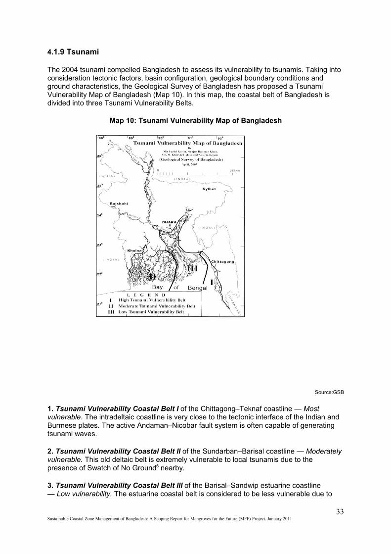
4.1.9 Tsunami
The 2004 tsunami compelled Bangladesh to assess its vulnerability to tsunamis. Taking into consideration tectonic factors, basin configuration, geological boundary conditions and ground characteristics, the Geological Survey of Bangladesh has proposed a Tsunami Vulnerability Map of Bangladesh (Map 10). In this map, the coastal belt of Bangladesh is divided into three Tsunami Vulnerability Belts.
Map 10: Tsunami Vulnerability Map of Bangladesh
Source:GSB
1. Tsunami Vulnerability Coastal Belt I of the Chittagong–Teknaf coastline — Most vulnerable. The intradeltaic coastline is very close to the tectonic interface of the Indian and Burmese plates. The active Andaman–Nicobar fault system is often capable of generating tsunami waves.
2. Tsunami Vulnerability Coastal Belt II of the Sundarban–Barisal coastline — Moderately vulnerable. This old deltaic belt is extremely vulnerable to local tsunamis due to the presence of Swatch of No Ground6 nearby.
3. Tsunami Vulnerability Coastal Belt III of the Barisal–Sandwip estuarine coastline — Low vulnerability. The estuarine coastal belt is considered to be less vulnerable due to
33Sustainable Coastal Zone Management of Bangladesh: A Scoping Report for Mangroves for the Future (MFF) Project. January 2011
the presence of numerous islands and shallow mudflats in the upper regime of the continental shelf.
It has been estimated that at least 4.7 million people live in the most tsunami-vulnerable area of Coastal Belt I and 12.9 million people in Coastal Belt II (Islam, 2006).
4.2 Climate change and its impacts on coastal livelihoods
Change in the climate has manifold impacts on various sectors such as, agriculture and fisheries and these in turn can affect the lives and livelihoods of the people. The NAPA exercise tried identify the likely changes, as second round of impacts of climate change. Climate change is expected to have major physical impacts on agriculture, industry, infrastructure, disaster, health and energy and consequently on people’s livelihood in terms of employment, income and consumption including food security. Various groups in the society will experience the impacts in various degrees depending upon their initial economic conditions, location and gender.
The impacts on livelihoods due to climate change depend on the nature and severity of the physical impacts relating to agriculture, water availability and quality, disaster-proneness, hospitability of the physical environment due to rising temperature and changing water regimes to pathogenic activity and coastal inundation. Given these physical changes including sea level rise, the livelihood impacts may be felt in several ways, not necessarily in any given sequence although the final outcome is always a diminution in employment or employability, income and consumption, although the impacts may be felt in different degrees by different socio-economic groups. These mean a poorer Bangladesh compared to a situation without climate change and lower level of development. Climate change impacts on livelihood thus become a challenge of development under most adversarial changes in dynamics of nature. On a more specific plane, in absence of climate change, the projected requirements for food grains by 2030 will be 42.5 million metric tons. The best that Bangladesh can produce by 2030 is 37.8 million metric tons.
The previous discussions show, livelihoods in the coastal zone are quite varied and influenced by socio-economic and physical environment of the coastal area too.
In a study, a total of 156 vulnerability factors were identified and clustered into four major thematic areas: environmental issues, economic issues, social issues and governance issues. Environmental issues are more pronounced for the small farmers and artisan fishers that are involved in primary production activities. Directly linked to the environmental issues are storm surge, flood, water logging, reduction of upland flow, salinity, pest infestation, crop damage, resource degradation, deterioration of soil fertility etc. Issues related to water are mostly perceived by respondents as affecting the vulnerability of small farmers. Particularly storm surge, flood, water logging/drainage congestion, sand deposition and soil salinity became the major physical hindrance to small farmer’s farming and production, and are also found as the major causes of sudden crop damage (CEGIS,2004; PDO-ICZMP,2004).
Change in climate is likely to trigger the incidence of water, air and vector borne diseases such as asthma, malaria and dengue, heat stroke (MoEF, 2009). Moreover, warmer and humid weather lead to faster growth of bacteria and parasites. This situation can be worse with poor sanitation and drainage facilities. Climate change induced illness can result in loss of livelihoods and can drive people into extreme poverty. Increase in the salinity in the drinking water may also result in health hazards, especially for expecting mothers. People living in and along the coastline are amongst the poorest of the poor in the country. Moreover, the livelihood scenario of the CZ indicates that it is a special zone with severe vulnerabilities.
34Sustainable Coastal Zone Management of Bangladesh: A Scoping Report for Mangroves for the Future (MFF) Project. January 2011

Table 11: Intensity of impacts on different sectors due to Climate Change
Physical Vulnerability Context
Extreme Temperature
Sea Level Rise
DroughtFlood Cyclone
and Storm Surges
Erosion and Accretion
SectoralVulnerabilityContext
Coastal Inundation
Salinity Intrusion
River Flood
Flash Flood
+++ ++ +++ +++ + ++ +++ -Crop Agriculture
++ + + ++ ++ + + - Fisheries++ ++ +++ - - + +++ - Livestock+ ++ - ++ + + +++ Infrastructure++ +++ ++ - ++ + + - Industries++ +++ +++ - ++ - + - Biodiversity+++ + +++ - ++ - ++ - Health
- - - - - - +++ +++Human Settlement
++ + - - + - + - EnergySource: National Adaptation Plan of Action (NAPA) 2005
4.3 Changes in land use
Due to the pressure of dense and high population, the land resource has become scarce. The land availability scenario is bleak and the pressure on fragile lands is increasing every day. This is causing major ecosystem degradation and land use changes and all over the country, including the CZ. Some of such cases have been discussed below:
4.3.1 Deforestation
Deforestation is a major issue for the CZ, as much as it is for the entire country’s well being. The annual rate of deforestation of mangroves is 2,000 hectares, lower than that of the national average. The causes of deforestation range from pure need of landless victims of erosion to the greed of the timber traders for more profit.
4.3.2 Shrimp Culture and Salt Production
Many farmers in Cox's Bazar have switched to salt production and those in Satkhira- Bagerhat-Khulna area have shifted to shrimp culture in the recent years from traditional agriculture, allowing more and more salt-water to enter the land. When one land owner allow salt water to seep in to the agricultural land, nearby lands become saline too. These lands then become unsuitable for any activity other than shrimp culture or salt production. In some cases, entire forest patches have been replaced with shrimp or salt production farms.
4.3.3 Infrastructure Development
Coastal plantation in the Cox’s Bazar is being cleared felled to build infrastructures such as hotels for tourists. The longest sea beach in the world is being degraded in the name of development.
4.3.4 Ship breaking yards
In the past few years, thousands of trees have been chopped down from the coastal green belt to build ship breaking yards in the Chittagong-Cox’s Bazar coastline. Since leasing of the lands with trees is prohibited by law, yard owners are felling the trees in order to show non-forested land for making ship breaking yards.
35Sustainable Coastal Zone Management of Bangladesh: A Scoping Report for Mangroves for the Future (MFF) Project. January 2011
4.3.5 Industrialization
There has been an increasing trend in industrialization in the CZ. Over three hundred industries have been developed in the EPZs of Chittagong, Karnaphuli and Mongla. Thousands of public and private owned industries are situated in the CZ outside these EPZs. Most of these industries do not follow environmental standards, neither for production nor for waste management processes. Failure to manage these industries poses severe threat to the ecosystems and environment of the CZ. Pollution caused by these industries has already caused damages to the Sundarbans biodiversity and the ecosystem.
4.3.6 Sea-port
The construction of a deep sea port in the ECA of Maheshkhali-Sonadia Island is proposed and under consideration. If the proposition does come through, Bangladesh will lose one of its unique ecosystems and biodiversity that is harboured there.
4.3.7 Brick fields
Urbanization has called for a boom in construction and thousands of brick fields have been built in the CZ to meet the demands. The average size of a brick field is usually 3.4 ha in Bangladesh. These occupy and degrade thousands of hectares of agricultural land causing topsoil loss and massive air pollution. These are condensed around the major cities of the coastline, such as Chittagong and Khulna.
4.3.8 Topsoil loss and landslide
Large scale topsoil loss and landslides occur in the Chittagong and Cox’s Bazar hills as a result of cutting hills. Large scale deforestation makes these areas more vulnerable to landslides. In recent years, urbanization in these areas prompted hill cutting, subjecting the surrounding inhabitants to the risks of landslides. In 2007, a landslide in Chittagong caused hundreds of people to die in the foothills.
4.3.9 Agrochemicals
Large amount of pesticides, fungicides and herbicides are used in the agricultural production process. The eco-friendly agricultural technologies such as Integrated Pest management (IPM) are not yet popularized in the CZ. There is much evidence that there is remarkable use of agrochemicals and those pose hazards to human health, fisheries, soil quality, livestock etc. It was reported that low grade agrochemicals are provided to the farmers, in the absence of a proper monitoring system. These chemicals could also lead to loss of many local species.
36Sustainable Coastal Zone Management of Bangladesh: A Scoping Report for Mangroves for the Future (MFF) Project. January 2011
Chapter Five
5. Livelihoods and Human Wellbeing
Livelihood conditions of the people largely depend on what resources are available at the household level in terms of ownership and access. Households exist and operate in a given local resource base. The local resource base encompasses a host of open access natural resources (khas land, wetland, forest, etc.), physical infrastructures (road, telecommunications, school, hospital, polder, cyclone shelter, embankment, tube well, etc.), social capital (formal institutions like Union Parishad, other service providers, legal regime, etc. and informal institutions like samaj, salish, traditional laws and tenets, social sanctions, community regulations, etc.) and financial resources (safety net programs, microcredit, relief, etc.). Access to these resources often influences livelihoods of the people to a significant extent. The process of pauperization and marginalization is aggravated because of shrinkage in open access resources, degradation of the ecosystems, coercive and discriminatory attitude and policy of some institutions and whim of the local power brokers.
Based on household assets (ownership and/ or access), members engage in a host of activities to earn their living. Choices are conditioned by the extent of the respective asset base. A household with a diversified asset base has obviously more options and is in a better position to maximize household well-being by attaining a higher level of income, consumption, comfort and security, and diversifying risk as well.Activities are of different nature. Some are directly cash earning (livestock or agriculture) and some are cost saving (boat maintenance, net repairing); some are related to self-employment (farming on own land, crab collection, horticulture) and some correspond to wage employment (agricultural labor, industrial labor, paddy husking); some contribute directly to household income (farming, fishing) while some relate to housekeeping for comfort of all household members (house cleaning, cooking). All these together define human existence in a particular setting (PDO-ICZMP, 2004).
The coastal zone provides 33% or 17.4 million (BBS, 2004) of the total national labor force of 53.5 million for the 15 years and above age group. Of this, 37% is female. In Bangladesh 72% urban active labor force and 60% rural active labor force is male. In urban CZ 71% and in rural CZ 61% is male active labor force. The rural and urban male labor composition is almost the same as the national rate but the rural active labor force is slightly higher in CZ. “Economically active” population (15-59 years) in the coastal areas is 53 percent; against county’s 55 percent of the total population. In future, dependent population (below 15 years) would decline mainly because of declining fertility and mortality rates. This phenomenon is likely to be offset by more adolescent population pursuing studies and they will not be available for work. The share of employed national labor force by different sectors of the economy according to Labor Force Survey 1995-96 and 1999-2000 can be depicted from the following table:
Table 11: Number of Labour force by Sex
Place 1995-96 1999-2000 Total Male (%) Female (%) Total Male (%) Female (%)
Coastal zone
16,708 62 38 17,418 63 37
Bangladesh 50,337 62.5 37.5 53,514 62.2 37.8 Source: Bangladesh Labor Force Survey 1999-2000
37Sustainable Coastal Zone Management of Bangladesh: A Scoping Report for Mangroves for the Future (MFF) Project. January 2011
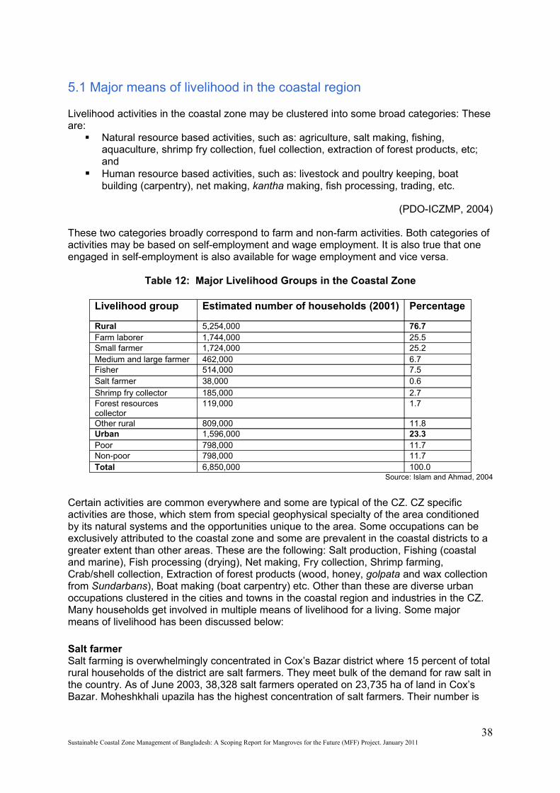
5.1 Major means of livelihood in the coastal region
Livelihood activities in the coastal zone may be clustered into some broad categories: These are:
Natural resource based activities, such as: agriculture, salt making, fishing, aquaculture, shrimp fry collection, fuel collection, extraction of forest products, etc; and
Human resource based activities, such as: livestock and poultry keeping, boat building (carpentry), net making, kantha making, fish processing, trading, etc.
(PDO-ICZMP, 2004)
These two categories broadly correspond to farm and non-farm activities. Both categories of activities may be based on self-employment and wage employment. It is also true that one engaged in self-employment is also available for wage employment and vice versa.
Table 12: Major Livelihood Groups in the Coastal Zone
Livelihood group Estimated number of households (2001) Percentage
Rural 5,254,000 76.7 Farm laborer 1,744,000 25.5 Small farmer 1,724,000 25.2 Medium and large farmer 462,000 6.7 Fisher 514,000 7.5 Salt farmer 38,000 0.6 Shrimp fry collector 185,000 2.7 Forest resources collector
119,000 1.7
Other rural 809,000 11.8 Urban 1,596,000 23.3 Poor 798,000 11.7 Non-poor 798,000 11.7 Total 6,850,000 100.0
Source: Islam and Ahmad, 2004
Certain activities are common everywhere and some are typical of the CZ. CZ specific activities are those, which stem from special geophysical specialty of the area conditioned by its natural systems and the opportunities unique to the area. Some occupations can be exclusively attributed to the coastal zone and some are prevalent in the coastal districts to a greater extent than other areas. These are the following: Salt production, Fishing (coastal and marine), Fish processing (drying), Net making, Fry collection, Shrimp farming, Crab/shell collection, Extraction of forest products (wood, honey, golpata and wax collection from Sundarbans), Boat making (boat carpentry) etc. Other than these are diverse urban occupations clustered in the cities and towns in the coastal region and industries in the CZ. Many households get involved in multiple means of livelihood for a living. Some major means of livelihood has been discussed below:
Salt farmerSalt farming is overwhelmingly concentrated in Cox’s Bazar district where 15 percent of total rural households of the district are salt farmers. They meet bulk of the demand for raw salt in the country. As of June 2003, 38,328 salt farmers operated on 23,735 ha of land in Cox’s Bazar. Moheshkhali upazila has the highest concentration of salt farmers. Their number is
38Sustainable Coastal Zone Management of Bangladesh: A Scoping Report for Mangroves for the Future (MFF) Project. January 2011
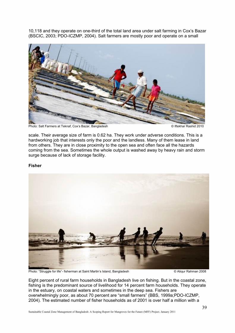
10,118 and they operate on one-third of the total land area under salt farming in Cox’s Bazar (BSCIC, 2003; PDO-ICZMP, 2004). Salt farmers are mostly poor and operate on a small
Photo: Salt Farmers at Teknaf, Cox’s Bazar, Bangladesh © Iftekhar Rashid 2010
scale. Their average size of farm is 0.62 ha. They work under adverse conditions. This is a hardworking job that interests only the poor and the landless. Many of them lease in land from others. They are in close proximity to the open sea and often face all the hazards coming from the sea. Sometimes the whole output is washed away by heavy rain and storm surge because of lack of storage facility.
Fisher
Photo: “Struggle for life”- fisherman at Saint Martin’s Island, Bangladesh © Atiqur Rahman 2008
Eight percent of rural farm households in Bangladesh live on fishing. But in the coastal zone, fishing is the predominant source of livelihood for 14 percent farm households. They operate in the estuary, on coastal waters and sometimes in the deep sea. Fishers are overwhelmingly poor, as about 70 percent are “small farmers” (BBS, 1999a;PDO-ICZMP, 2004). The estimated number of fisher households as of 2001 is over half a million with a
39Sustainable Coastal Zone Management of Bangladesh: A Scoping Report for Mangroves for the Future (MFF) Project. January 2011
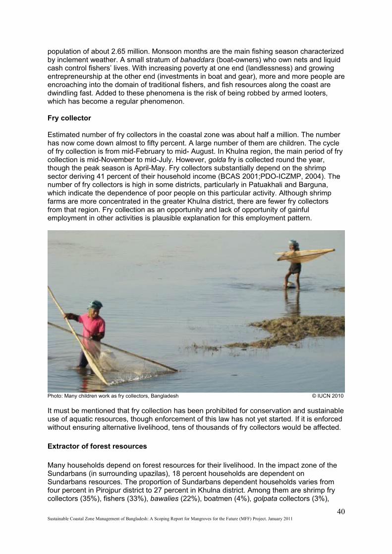
population of about 2.65 million. Monsoon months are the main fishing season characterized by inclement weather. A small stratum of bahaddars (boat-owners) who own nets and liquid cash control fishers’ lives. With increasing poverty at one end (landlessness) and growing entrepreneurship at the other end (investments in boat and gear), more and more people are encroaching into the domain of traditional fishers, and fish resources along the coast are dwindling fast. Added to these phenomena is the risk of being robbed by armed looters, which has become a regular phenomenon.
Fry collector
Estimated number of fry collectors in the coastal zone was about half a million. The number has now come down almost to fifty percent. A large number of them are children. The cycle of fry collection is from mid-February to mid- August. In Khulna region, the main period of fry collection is mid-November to mid-July. However, golda fry is collected round the year, though the peak season is April-May. Fry collectors substantially depend on the shrimp sector deriving 41 percent of their household income (BCAS 2001;PDO-ICZMP, 2004). The number of fry collectors is high in some districts, particularly in Patuakhali and Barguna, which indicate the dependence of poor people on this particular activity. Although shrimp farms are more concentrated in the greater Khulna district, there are fewer fry collectors from that region. Fry collection as an opportunity and lack of opportunity of gainful employment in other activities is plausible explanation for this employment pattern.
Photo: Many children work as fry collectors, Bangladesh © IUCN 2010
It must be mentioned that fry collection has been prohibited for conservation and sustainable use of aquatic resources, though enforcement of this law has not yet started. If it is enforced without ensuring alternative livelihood, tens of thousands of fry collectors would be affected.
Extractor of forest resources
Many households depend on forest resources for their livelihood. In the impact zone of the Sundarbans (in surrounding upazilas), 18 percent households are dependent on Sundarbans resources. The proportion of Sundarbans dependent households varies from four percent in Pirojpur district to 27 percent in Khulna district. Among them are shrimp fry collectors (35%), fishers (33%), bawalies (22%), boatmen (4%), golpata collectors (3%),
40Sustainable Coastal Zone Management of Bangladesh: A Scoping Report for Mangroves for the Future (MFF) Project. January 2011
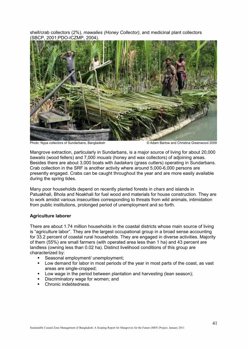
shell/crab collectors (2%), mawalies (Honey Collector), and medicinal plant collectors (SBCP, 2001;PDO-ICZMP, 2004).
Photo: Nypa collectors of Sundarbans, Bangladesh © Adam Barlow and Christina Greenwood 2009
Mangrove extraction, particularly in Sundarbans, is a major source of living for about 20,000 bawalis (wood fellers) and 7,000 mouals (honey and wax collectors) of adjoining areas. Besides there are about 3,000 boats with badakars (grass cutters) operating in Sundarbans. Crab collection in the SRF is another activity where around 5,000-6,000 persons are presently engaged. Crabs can be caught throughout the year and are more easily available during the spring tides.
Many poor households depend on recently planted forests in chars and islands in Patuakhali, Bhola and Noakhali for fuel wood and materials for house construction. They are to work amidst various insecurities corresponding to threats from wild animals, intimidation from public institutions, prolonged period of unemployment and so forth.
Agriculture laborer
There are about 1.74 million households in the coastal districts whose main source of living is “agriculture labor”. They are the largest occupational group in a broad sense accounting for 33.2 percent of coastal rural households. They are engaged in diverse activities. Majority of them (55%) are small farmers (with operated area less than 1 ha) and 43 percent are landless (owning less than 0.02 ha). Distinct livelihood conditions of this group are characterized by:
Seasonal employment/ unemployment; Low demand for labor in most periods of the year in most parts of the coast, as vast
areas are single-cropped; Low wage in the period between plantation and harvesting (lean season); Discriminatory wage for women; and Chronic indebtedness.
41Sustainable Coastal Zone Management of Bangladesh: A Scoping Report for Mangroves for the Future (MFF) Project. January 2011
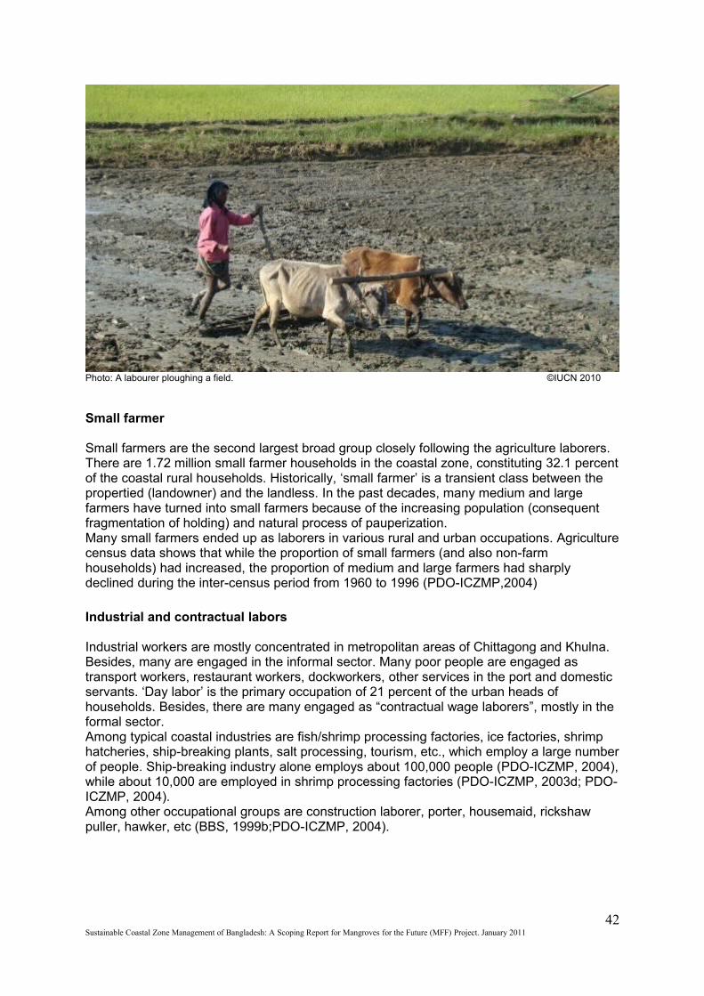
Photo: A labourer ploughing a field. ©IUCN 2010
Small farmer
Small farmers are the second largest broad group closely following the agriculture laborers. There are 1.72 million small farmer households in the coastal zone, constituting 32.1 percent of the coastal rural households. Historically, ‘small farmer’ is a transient class between the propertied (landowner) and the landless. In the past decades, many medium and large farmers have turned into small farmers because of the increasing population (consequent fragmentation of holding) and natural process of pauperization.Many small farmers ended up as laborers in various rural and urban occupations. Agriculture census data shows that while the proportion of small farmers (and also non-farm households) had increased, the proportion of medium and large farmers had sharply declined during the inter-census period from 1960 to 1996 (PDO-ICZMP,2004)
Industrial and contractual labors
Industrial workers are mostly concentrated in metropolitan areas of Chittagong and Khulna. Besides, many are engaged in the informal sector. Many poor people are engaged as transport workers, restaurant workers, dockworkers, other services in the port and domestic servants. ‘Day labor’ is the primary occupation of 21 percent of the urban heads of households. Besides, there are many engaged as “contractual wage laborers”, mostly in the formal sector.Among typical coastal industries are fish/shrimp processing factories, ice factories, shrimp hatcheries, ship-breaking plants, salt processing, tourism, etc., which employ a large number of people. Ship-breaking industry alone employs about 100,000 people (PDO-ICZMP, 2004), while about 10,000 are employed in shrimp processing factories (PDO-ICZMP, 2003d; PDO-ICZMP, 2004).Among other occupational groups are construction laborer, porter, housemaid, rickshaw puller, hawker, etc (BBS, 1999b;PDO-ICZMP, 2004).
42Sustainable Coastal Zone Management of Bangladesh: A Scoping Report for Mangroves for the Future (MFF) Project. January 2011
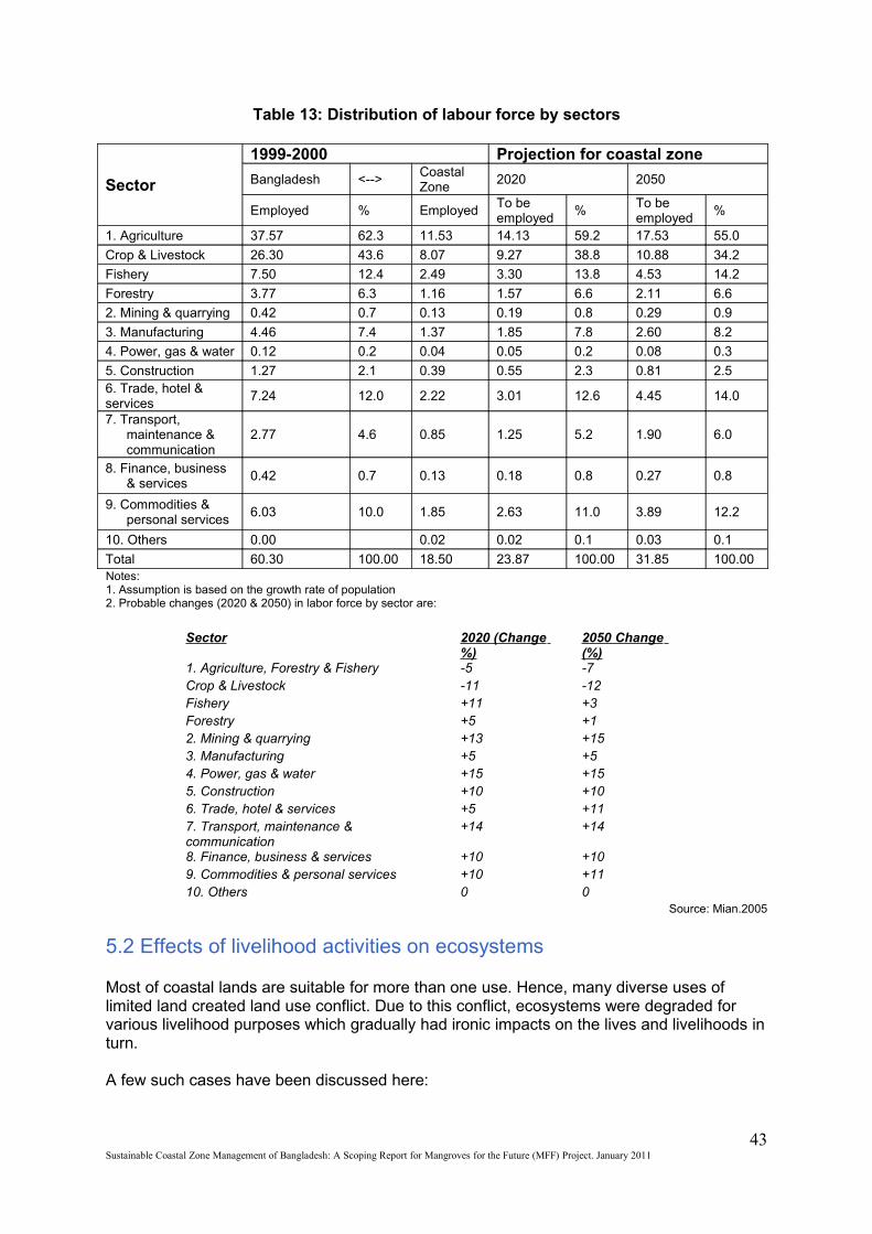
Table 13: Distribution of labour force by sectors
Sector
1999-2000 Projection for coastal zone
Bangladesh <--> Coastal Zone
2020 2050
Employed % Employed To be employed
% To be employed
%
1. Agriculture 37.57 62.3 11.53 14.13 59.2 17.53 55.0
Crop & Livestock 26.30 43.6 8.07 9.27 38.8 10.88 34.2
Fishery 7.50 12.4 2.49 3.30 13.8 4.53 14.2
Forestry 3.77 6.3 1.16 1.57 6.6 2.11 6.6
2. Mining & quarrying 0.42 0.7 0.13 0.19 0.8 0.29 0.9
3. Manufacturing 4.46 7.4 1.37 1.85 7.8 2.60 8.2
4. Power, gas & water 0.12 0.2 0.04 0.05 0.2 0.08 0.3
5. Construction 1.27 2.1 0.39 0.55 2.3 0.81 2.5 6. Trade, hotel & services
7.24 12.0 2.22 3.01 12.6 4.45 14.0
7. Transport, maintenance & communication
2.77 4.6 0.85 1.25 5.2 1.90 6.0
8. Finance, business & services
0.42 0.7 0.13 0.18 0.8 0.27 0.8
9. Commodities & personal services
6.03 10.0 1.85 2.63 11.0 3.89 12.2
10. Others 0.00 0.02 0.02 0.1 0.03 0.1
Total 60.30 100.00 18.50 23.87 100.00 31.85 100.00 Notes: 1. Assumption is based on the growth rate of population 2. Probable changes (2020 & 2050) in labor force by sector are:
Sector 2020 (Change %)
2050 Change (%)
1. Agriculture, Forestry & Fishery -5 -7 Crop & Livestock -11 -12 Fishery +11 +3 Forestry +5 +1 2. Mining & quarrying +13 +15 3. Manufacturing +5 +5 4. Power, gas & water +15 +15 5. Construction +10 +10 6. Trade, hotel & services +5 +11 7. Transport, maintenance & communication
+14 +14
8. Finance, business & services +10 +10 9. Commodities & personal services +10 +11 10. Others 0 0
Source: Mian.2005
5.2 Effects of livelihood activities on ecosystems
Most of coastal lands are suitable for more than one use. Hence, many diverse uses of limited land created land use conflict. Due to this conflict, ecosystems were degraded for various livelihood purposes which gradually had ironic impacts on the lives and livelihoods in turn.
A few such cases have been discussed here:
43Sustainable Coastal Zone Management of Bangladesh: A Scoping Report for Mangroves for the Future (MFF) Project. January 2011
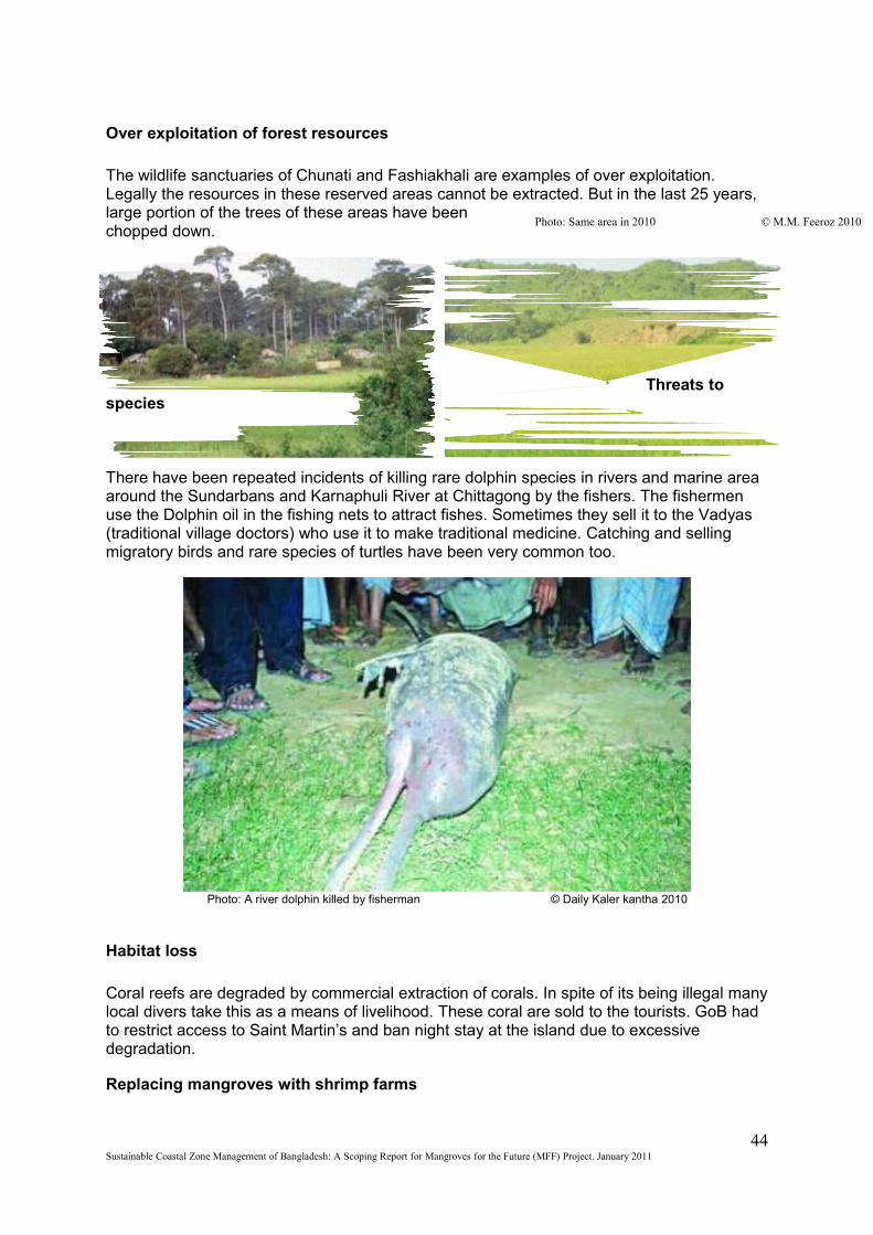
Over exploitation of forest resources
The wildlife sanctuaries of Chunati and Fashiakhali are examples of over exploitation. Legally the resources in these reserved areas cannot be extracted. But in the last 25 years, large portion of the trees of these areas have been chopped down.
Threats to species
There have been repeated incidents of killing rare dolphin species in rivers and marine area around the Sundarbans and Karnaphuli River at Chittagong by the fishers. The fishermen use the Dolphin oil in the fishing nets to attract fishes. Sometimes they sell it to the Vadyas (traditional village doctors) who use it to make traditional medicine. Catching and selling migratory birds and rare species of turtles have been very common too.
Photo: A river dolphin killed by fisherman © Daily Kaler kantha 2010
Habitat loss
Coral reefs are degraded by commercial extraction of corals. In spite of its being illegal many local divers take this as a means of livelihood. These coral are sold to the tourists. GoB had to restrict access to Saint Martin’s and ban night stay at the island due to excessive degradation.
Replacing mangroves with shrimp farms
44Sustainable Coastal Zone Management of Bangladesh: A Scoping Report for Mangroves for the Future (MFF) Project. January 2011
Photo: Chunati Wildlife Sanctuary in 1990 © DoE 1990Photo: Same area in 2010 © M.M. Feeroz 2010

Shrimp farming has gradually changed the land use patterns of the surrounding farms altering agriculture and mangrove areas into shrimp farming areas (Haque 2004). Several studies reported reduction in land for cattle grazing, death of trees and other vegetation, increased salinity of soil and water, and a reduction of drinking water supply due to shrimp farming. Brackish water shrimp cultivation in an industrial scale has brought large scale environmental degradation. Shrimp polders retain saline waters for months together and the salinity seeped in to adjacent farms and spread soil salinity. The loss of mangrove areas to aquaculture is a common feature with Chakaria Sundarban being the classic example. Between 1967 and 1988, areas of Chakaria Sundarban had been reduced from 7500 ha to only 973 ha. By 2005, it was hard to find any tress of the once rich mangrove ecosystem of the area (Mia and Islam, 2005).
Denudation of forest land for agriculture
Most of the wildlife sanctuaries and all the ECAs of the coastal zone are reported to be suffering from denudations due to the increasing need of agricultural land.
5.3 Poverty
Income-poverty is higher in the coastal zone compared to rest of Bangladesh. This is reflected through lower GDP per capita and higher extent of population without access to the requited caloric intake. With respect to human development indicators, the situation is mixed. For example, primary school enrolment rate is lower, but literacy rate is higher due to elder literacy programmes. Access to sanitation is a bit better, and so is the sex ratio. On the other hand, health situation is poorer in terms of population-hospital bed ratio, as well as the extent of severe child malnutrition.
Table 14: Position of the coastal zone with respect to country situation
Above average Below average Sex ratio is low Agriculture wage rate is high Literacy rate is high Primary school density is high Proportion of households with durable wall is
high Proportion of households with sanitary latrine
is high Density of road is high Land is accreting in some areas
Average size of household is high Demographic dependency ratio is high Proportion of small farm households is high Per capita GDP is low Poverty (both absolute and extreme) is high Primary school enrolment rate is low Severe child malnutrition is high Population per hospital bed is high Union Parishad density is low Per capita gross cropped area is low Proportion of functionally landless is high Proportion of households with durable roof is low Proportion of households with electricity connection
is low Proportion of households with access to tap and
tube well is low Household coverage by major micro-credit NGOs is
low Share if industrial sector in GDP is low Density of growth centers is low Land erosion is severe in some areas Susceptible to cyclone and storm surge
Source: PDO-ICZMP, 2004
Map 11: Food Poverty in Bang;adesh CZ
45Sustainable Coastal Zone Management of Bangladesh: A Scoping Report for Mangroves for the Future (MFF) Project. January 2011
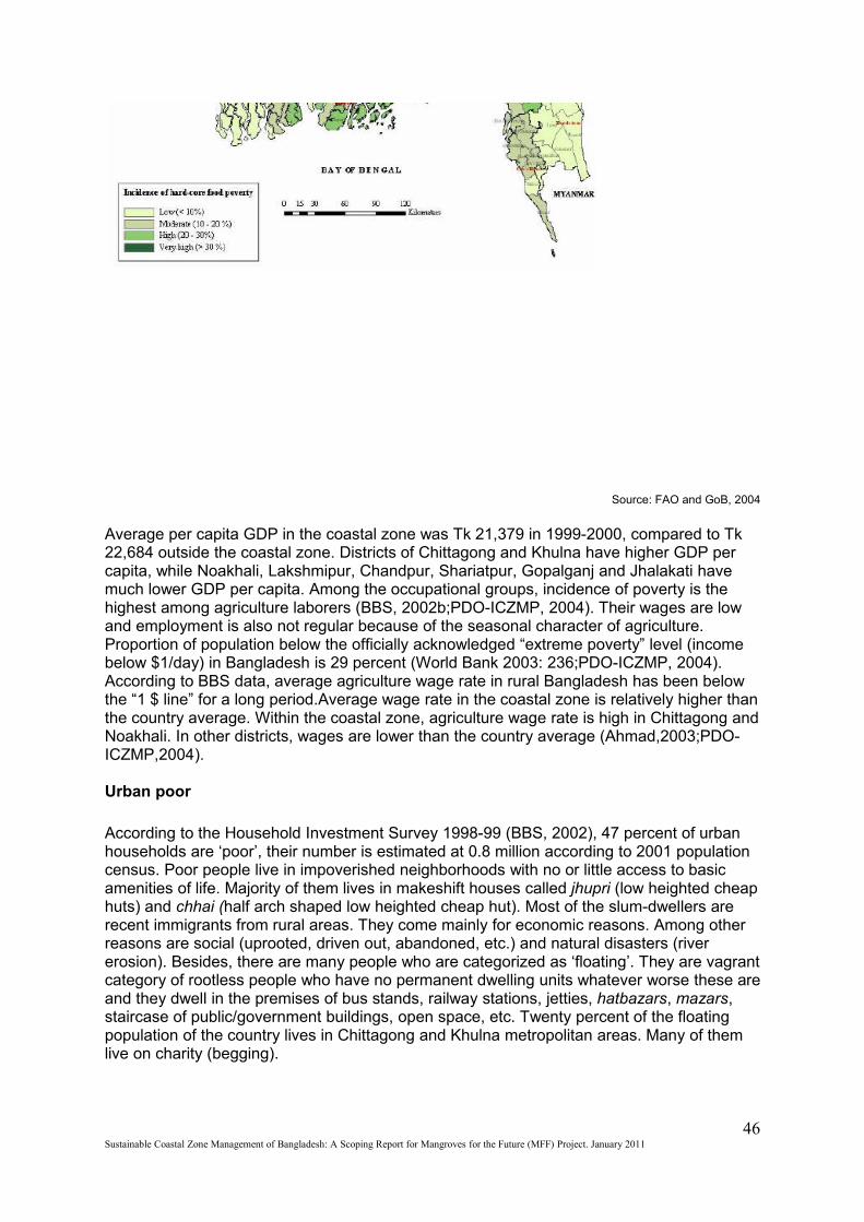
Source: FAO and GoB, 2004
Average per capita GDP in the coastal zone was Tk 21,379 in 1999-2000, compared to Tk 22,684 outside the coastal zone. Districts of Chittagong and Khulna have higher GDP per capita, while Noakhali, Lakshmipur, Chandpur, Shariatpur, Gopalganj and Jhalakati have much lower GDP per capita. Among the occupational groups, incidence of poverty is the highest among agriculture laborers (BBS, 2002b;PDO-ICZMP, 2004). Their wages are low and employment is also not regular because of the seasonal character of agriculture. Proportion of population below the officially acknowledged “extreme poverty” level (income below $1/day) in Bangladesh is 29 percent (World Bank 2003: 236;PDO-ICZMP, 2004). According to BBS data, average agriculture wage rate in rural Bangladesh has been below the “1 $ line” for a long period.Average wage rate in the coastal zone is relatively higher than the country average. Within the coastal zone, agriculture wage rate is high in Chittagong and Noakhali. In other districts, wages are lower than the country average (Ahmad,2003;PDO-ICZMP,2004).
Urban poor
According to the Household Investment Survey 1998-99 (BBS, 2002), 47 percent of urban households are ‘poor’, their number is estimated at 0.8 million according to 2001 population census. Poor people live in impoverished neighborhoods with no or little access to basic amenities of life. Majority of them lives in makeshift houses called jhupri (low heighted cheap huts) and chhai (half arch shaped low heighted cheap hut). Most of the slum-dwellers are recent immigrants from rural areas. They come mainly for economic reasons. Among other reasons are social (uprooted, driven out, abandoned, etc.) and natural disasters (river erosion). Besides, there are many people who are categorized as ‘floating’. They are vagrant category of rootless people who have no permanent dwelling units whatever worse these are and they dwell in the premises of bus stands, railway stations, jetties, hatbazars, mazars, staircase of public/government buildings, open space, etc. Twenty percent of the floating population of the country lives in Chittagong and Khulna metropolitan areas. Many of them live on charity (begging).
46Sustainable Coastal Zone Management of Bangladesh: A Scoping Report for Mangroves for the Future (MFF) Project. January 2011
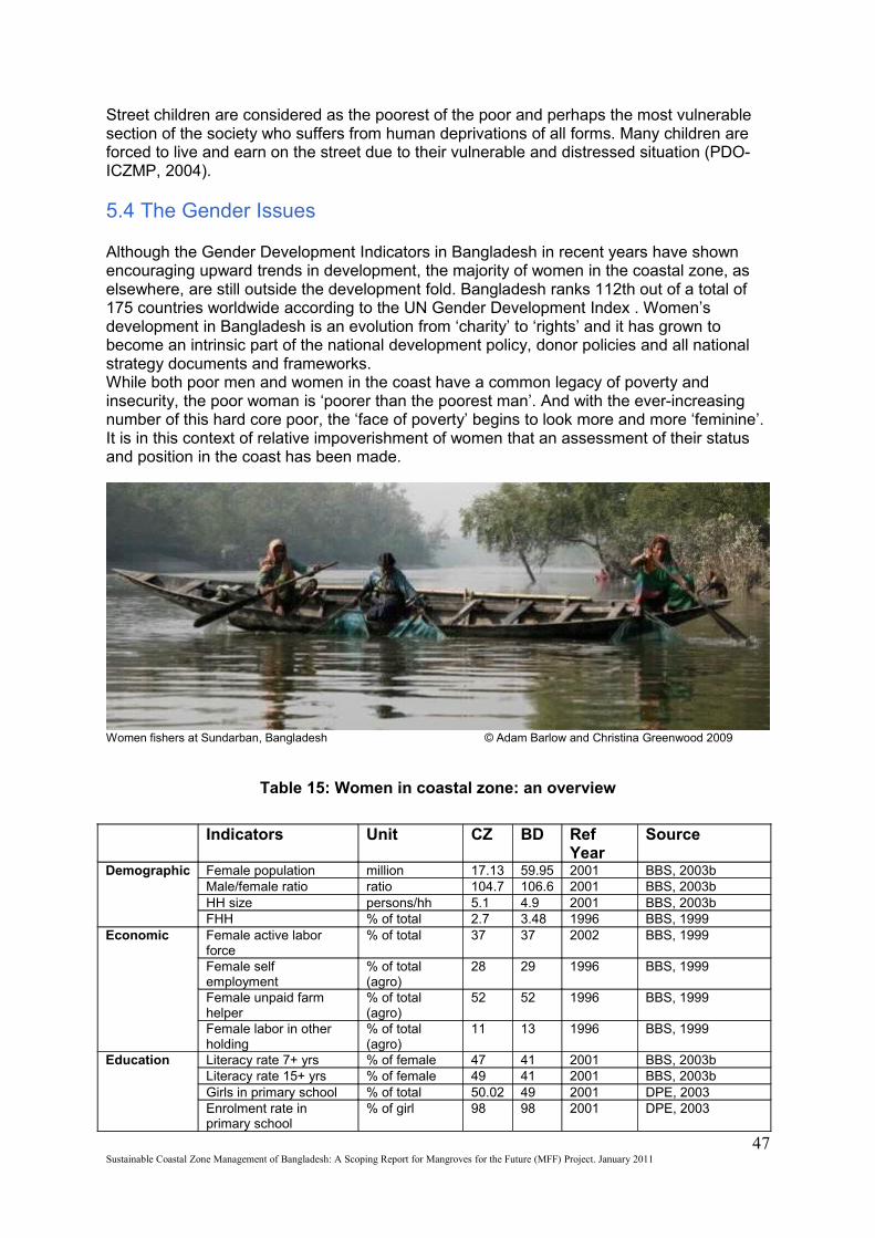
Street children are considered as the poorest of the poor and perhaps the most vulnerable section of the society who suffers from human deprivations of all forms. Many children are forced to live and earn on the street due to their vulnerable and distressed situation (PDO-ICZMP, 2004).
5.4 The Gender Issues
Although the Gender Development Indicators in Bangladesh in recent years have shown encouraging upward trends in development, the majority of women in the coastal zone, as elsewhere, are still outside the development fold. Bangladesh ranks 112th out of a total of 175 countries worldwide according to the UN Gender Development Index . Women’s development in Bangladesh is an evolution from ‘charity’ to ‘rights’ and it has grown to become an intrinsic part of the national development policy, donor policies and all national strategy documents and frameworks.While both poor men and women in the coast have a common legacy of poverty and insecurity, the poor woman is ‘poorer than the poorest man’. And with the ever-increasing number of this hard core poor, the ‘face of poverty’ begins to look more and more ‘feminine’. It is in this context of relative impoverishment of women that an assessment of their status and position in the coast has been made.Indicators
Women fishers at Sundarban, Bangladesh © Adam Barlow and Christina Greenwood 2009
Table 15: Women in coastal zone: an overview
Indicators Unit CZ BD Ref Year
Source
Demographic Female population million 17.13 59.95 2001 BBS, 2003b Male/female ratio ratio 104.7 106.6 2001 BBS, 2003b HH size persons/hh 5.1 4.9 2001 BBS, 2003b FHH % of total 2.7 3.48 1996 BBS, 1999
Economic Female active labor force
% of total 37 37 2002 BBS, 1999
Female self employment
% of total (agro)
28 29 1996 BBS, 1999
Female unpaid farm helper
% of total (agro)
52 52 1996 BBS, 1999
Female labor in other holding
% of total (agro)
11 13 1996 BBS, 1999
Education Literacy rate 7+ yrs % of female 47 41 2001 BBS, 2003b Literacy rate 15+ yrs % of female 49 41 2001 BBS, 2003b Girls in primary school % of total 50.02 49 2001 DPE, 2003 Enrolment rate in primary school
% of girl 98 98 2001 DPE, 2003
47Sustainable Coastal Zone Management of Bangladesh: A Scoping Report for Mangroves for the Future (MFF) Project. January 2011
Health Access to safe water TW % of hh 68.41 79.77 2001 BBS, 2003b DTW % of hh 15.57 8.42 2001 BBS, 2003b Tap % of hh 4.00 5.96 2001 BBS, 2003b Access to sanitation % of hh 46 37 2001 BBS, 2003b IMR per 000 51-
68 56 2000 BBS & UNICEF,
2001 TFR 3.1 3 2000 BBS & UNICEF,
2001 Severe malnutrition (12-59m)
% of girl 8 6 2000 BBS &UNICEF, 2001
Source: Murshid and Yasmeen, 2004.
Some of the key positive and negative aspects of women’ position in the coastal zone can be described as:
Positive Aspects –
Sex ratio is lower than national average. Literacy rate is high Number of divorced women is lower than national level. Under 5 Mortality Rate is at the same level as national average. Rural active labor force for women is higher in the CZ. Gross enrollment for girls is higher than national average. More women from CZ are visible in national politics.
Negative Aspects –
Fertility rate is higher in CZ than national. Infant Mortality Rate in CZ is higher than national average specially the girl child. Women work largely in domestic and non-monetized sector. Women are less than half than men in active labor force in CZ. Wage rate of women in CZ is lower than national average whether rural, urban or
overall. Women receive half of the minimum wage that men get. Severe malnutrition is slightly higher than national. In CZ it is twice as high among
women as men. Health infrastructure is inadequate in CZ especially for women. Reproductive health condition for women in CZ is worse than other parts of
Bangladesh. Overall gross enrollment is lower in CZ (though for girls, it is same as national
average).(Murshid and Yasmeen, 2004).
On the basis of three major variables, namely total population, literacy rate and proportion of economically active population, CPD-UNFPA has developed a Gender Related Development Index for 64 Districts of Bangladesh and has ranked the districts according to gender disparity. According to CPD-UNFPA (2002), as many as 11 out of the 19 CZ districts fall under ‘low gender disparity’ category (Barisal, Bhola, Patuakhali, Jhalokathi, Pirojpur, Barguna, Jessore, Magura, Narail, Bagerhat, Chittagong, and Noakhali), only 6 fall under ‘medium disparity’ (Khulna, Cox’s Bazar, Chandpur, Gopalganj, Feni and Lakshipur) and 2 fall under high disparity (Satkhira and Shariatpur) (Murshid and Yasmeen, 2004).
Chapter Six
48Sustainable Coastal Zone Management of Bangladesh: A Scoping Report for Mangroves for the Future (MFF) Project. January 2011
6. Institutional arrangement for Coastal Management
Institutions play an important role in the judicious management of natural resources. An effective institutional arrangement has to be in place in order to accelerate the development process. Moreover, establishing linkages and coordination between the institutions is essential to avoid duplications and to ensure consistent progress. This chapter describes potential institutions at various levels through which Bangladesh can manage its coastal ecosystem effectively. 6.1 International Framework
Bangladesh is a member of the International Maritime Organization (IMO); the UN specialized agency with the responsibility for safety and security of shipping and the prevention of marine pollution from marine motor vehicles. Many of the priorities related to this organization have high stakes in ICZM process.
6.2 Regional framework
Bangladesh is also a member of the South Asian Association for Regional Cooperation (SAARC). Environment ministers of the 8 SAARC countries meet periodically to discuss the issues concerning regional cooperation. There is a technical committee on ‘environment and forestry’ at SAARC. Through this framework, SAARC Environment Action Plan, 1997 and Dhaka Declaration and SAARC Action Plan on Climate Change, 2008 have been formulated. As most of the SAARC nations are along the coast of the Indian Ocean, there is much scope for developing regional cooperation for ICZM and environmental issues.
6.3 National Framework
The Coastal Development Strategy (CDS), 2006 proposed a framework for ICZM in Bangladesh, but it is yet to be realized. A scoping mission from the funding agency (Government of the Netherlands) visited Bangladesh in 2010 and it is expected that by 2012, strategies recommended in the CDS will be implemented through the line ministries and agencies earmarked. Currently, development activities in the CZ are being implemented through various programmes and projects of the government and non-government agencies.
Current National Framework
The development projects and programmes that involve any particular Ministry and/or agency are implemented in accord with its own mandate, mechanisms and personnel. The projects and programmes with multiple stakeholders are governed through inter-ministerial committees. The project and programme coordinating committees usually involve representatives of various related ministries, government agencies, research institutes, public representatives, NGOs, civil society and private sector. These committees often have subcommittees at the local level, involving the people from different government agencies, departments, NGOs, CBOs, and other stakeholders. In some cases International Organizations work as implementing agencies, along with other NGOs and CBOs.
The proposed national framework of the CDS, 2006 is as follows:
National level: A Program Coordination Unit (PCU) will act as the core facilitating and co-coordinating platform of the ICZM process. There will be a support structure that consists of
49Sustainable Coastal Zone Management of Bangladesh: A Scoping Report for Mangroves for the Future (MFF) Project. January 2011
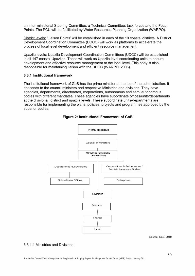
an inter-ministerial Steering Committee, a Technical Committee; task forces and the Focal Points. The PCU will be facilitated by Water Resources Planning Organization (WARPO).
District levels: ‘Liaison Points’ will be established in each of the 19 coastal districts. A District Development Coordination Committee (DDCC) will work as platforms to accelerate the process of local level development and efficient resource management.
Upazila levels: Upazila Development Coordination Committees (UDCC) will be established in all 147 coastal Upazilas. These will work as Upazila level coordinating units to ensure development and effective resource management at the local level. This body is also responsible for maintaining liaison with the DDCC (WARPO, 2006).
6.3.1 Institutional framework
The institutional framework of GoB has the prime minister at the top of the administration. It descends to the council ministers and respective Ministries and divisions. They have agencies, departments, directorates, corporations, autonomous and semi autonomous bodies with different mandates. These agencies have subordinate offices/units/departments at the divisional, district and upazila levels. These subordinate units/departments are responsible for implementing the plans, policies, projects and programmes approved by the superior bodies.
Figure 2: Institutional Framework of GoB
Source: GoB, 2010
6.3.1.1 Ministries and Divisions
50Sustainable Coastal Zone Management of Bangladesh: A Scoping Report for Mangroves for the Future (MFF) Project. January 2011
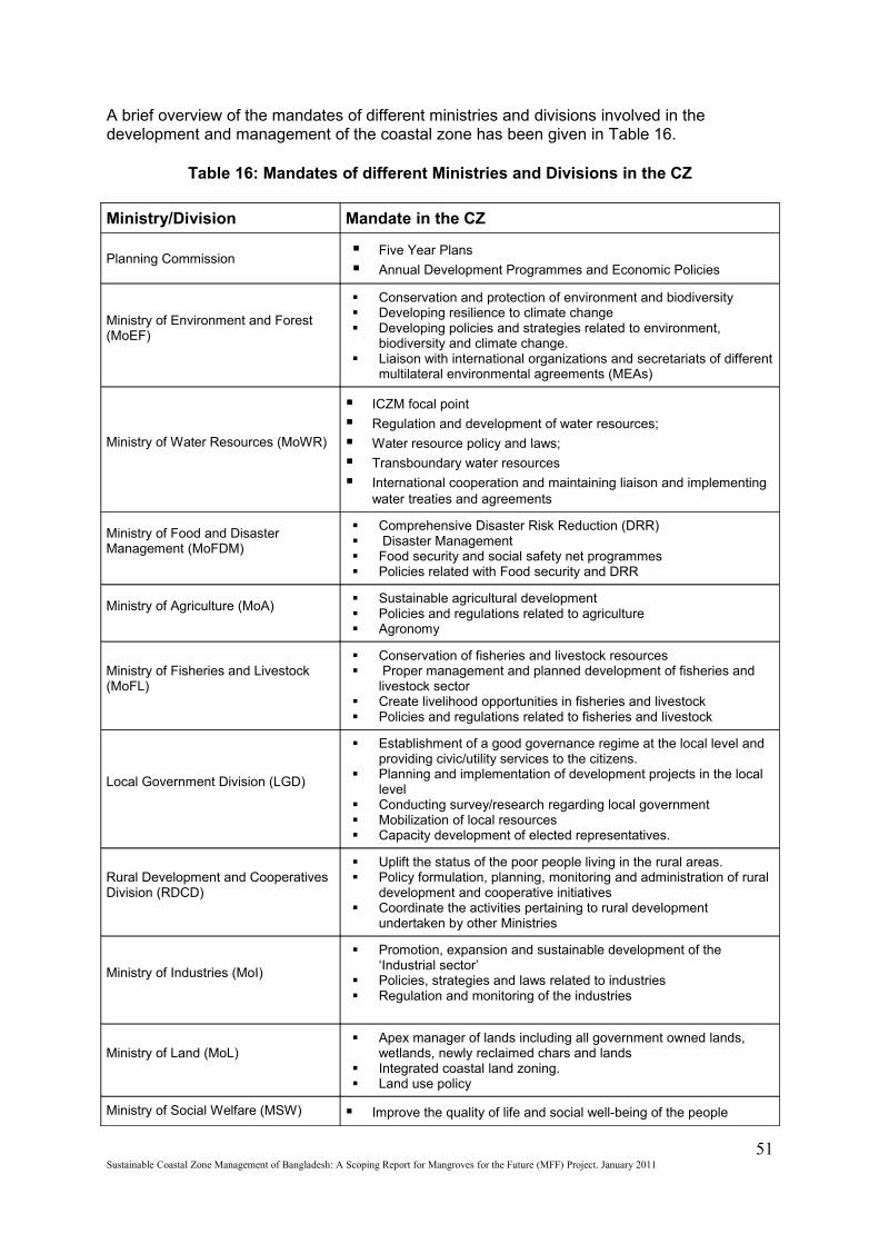
A brief overview of the mandates of different ministries and divisions involved in the development and management of the coastal zone has been given in Table 16.
Table 16: Mandates of different Ministries and Divisions in the CZ
Ministry/Division Mandate in the CZ
Planning Commission Five Year Plans
Annual Development Programmes and Economic Policies
Ministry of Environment and Forest (MoEF)
Conservation and protection of environment and biodiversity Developing resilience to climate change Developing policies and strategies related to environment,
biodiversity and climate change. Liaison with international organizations and secretariats of different
multilateral environmental agreements (MEAs)
Ministry of Water Resources (MoWR)
ICZM focal point
Regulation and development of water resources;
Water resource policy and laws;
Transboundary water resources
International cooperation and maintaining liaison and implementing water treaties and agreements
Ministry of Food and Disaster Management (MoFDM)
Comprehensive Disaster Risk Reduction (DRR) Disaster Management Food security and social safety net programmes Policies related with Food security and DRR
Ministry of Agriculture (MoA) Sustainable agricultural development Policies and regulations related to agriculture Agronomy
Ministry of Fisheries and Livestock (MoFL)
Conservation of fisheries and livestock resources Proper management and planned development of fisheries and
livestock sector Create livelihood opportunities in fisheries and livestock Policies and regulations related to fisheries and livestock
Local Government Division (LGD)
Establishment of a good governance regime at the local level and providing civic/utility services to the citizens.
Planning and implementation of development projects in the local level
Conducting survey/research regarding local government Mobilization of local resources Capacity development of elected representatives.
Rural Development and Cooperatives Division (RDCD)
Uplift the status of the poor people living in the rural areas. Policy formulation, planning, monitoring and administration of rural
development and cooperative initiatives Coordinate the activities pertaining to rural development
undertaken by other Ministries
Ministry of Industries (MoI)
Promotion, expansion and sustainable development of the ‘Industrial sector’
Policies, strategies and laws related to industries Regulation and monitoring of the industries
Ministry of Land (MoL) Apex manager of lands including all government owned lands,
wetlands, newly reclaimed chars and lands Integrated coastal land zoning. Land use policy
Ministry of Social Welfare (MSW) Improve the quality of life and social well-being of the people
51Sustainable Coastal Zone Management of Bangladesh: A Scoping Report for Mangroves for the Future (MFF) Project. January 2011
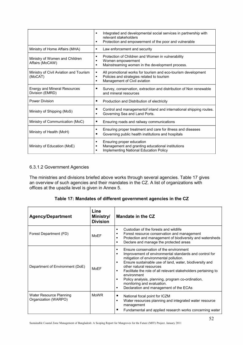
Integrated and developmental social services in partnership with relevant stakeholders
Protection and empowerment of the poor and vulnerable
Ministry of Home Affairs (MHA) Law enforcement and security
Ministry of Women and Children Affairs (MoCAW)
Protection of Children and Women in vulnerability Women empowerment Mainstreaming women in the development process.
Ministry of Civil Aviation and Tourism (MoCAT)
All promotional works for tourism and eco-tourism development Policies and strategies related to tourism Management of Civil aviation
Energy and Mineral Resources Division (EMRD)
Survey, conservation, extraction and distribution of Non renewable and mineral resources
Power Division Production and Distribution of electricity
Ministry of Shipping (MoS) Control and managementof inland and international shipping routes. Governing Sea and Land Ports.
Ministry of Communication (MoC) Ensuring roads and railway communications
Ministry of Health (MoH) Ensuring proper treatment and care for illness and diseases Governing public health institutions and hospitals
Ministry of Education (MoE) Ensuring proper education Management and granting educational institutions Implementing National Education Policy
6.3.1.2 Government Agencies
The ministries and divisions briefed above works through several agencies. Table 17 gives an overview of such agencies and their mandates in the CZ. A list of organizations with offices at the upazila level is given in Annex 5.
Table 17: Mandates of different government agencies in the CZ
Agency/DepartmentLine Ministry/Division
Mandate in the CZ
Forest Department (FD)MoEF
Custodian of the forests and wildlife Forest resource conservation and management Protection and management of biodiversity and watersheds Declare and manage the protected areas
Department of Environment (DoE)MoEF
Ensure conservation of the environment Improvement of environmental standards and control for
mitigation of environmental pollution. Ensure sustainable use of land, water, biodiversity and
other natural resources Facilitate the role of all relevant stakeholders pertaining to
environment Policy analysis, planning, program co-ordination,
monitoring and evaluation. Declaration and management of the ECAs
Water Resource Planning Organization (WARPO)
MoWR National focal point for ICZM Water resources planning and integrated water resource
management
Fundamental and applied research works concerning water
52Sustainable Coastal Zone Management of Bangladesh: A Scoping Report for Mangroves for the Future (MFF) Project. January 2011
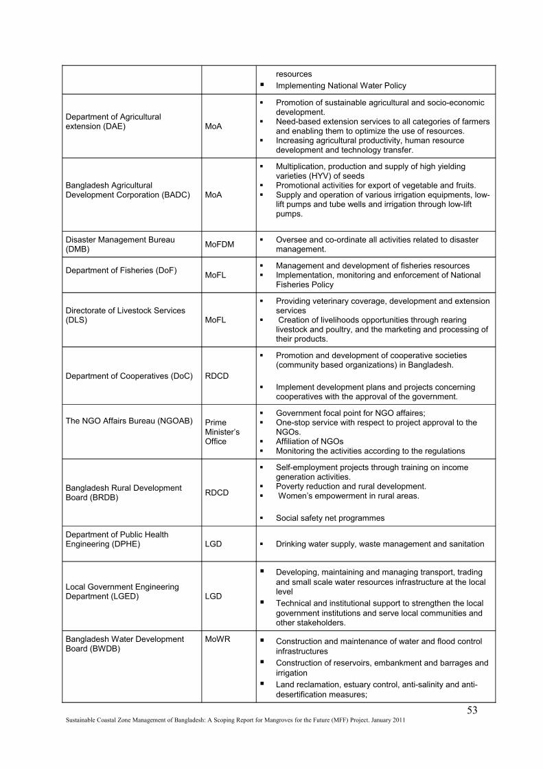
resources
Implementing National Water Policy
Department of Agricultural extension (DAE) MoA
Promotion of sustainable agricultural and socio-economic development.
Need-based extension services to all categories of farmers and enabling them to optimize the use of resources.
Increasing agricultural productivity, human resource development and technology transfer.
Bangladesh Agricultural Development Corporation (BADC) MoA
Multiplication, production and supply of high yielding varieties (HYV) of seeds
Promotional activities for export of vegetable and fruits. Supply and operation of various irrigation equipments, low-
lift pumps and tube wells and irrigation through low-lift pumps.
Disaster Management Bureau (DMB)
MoFDM Oversee and co-ordinate all activities related to disaster
management.
Department of Fisheries (DoF)MoFL
Management and development of fisheries resources Implementation, monitoring and enforcement of National
Fisheries Policy
Directorate of Livestock Services (DLS) MoFL
Providing veterinary coverage, development and extension services
Creation of livelihoods opportunities through rearing livestock and poultry, and the marketing and processing of their products.
Department of Cooperatives (DoC) RDCD
Promotion and development of cooperative societies (community based organizations) in Bangladesh.
Implement development plans and projects concerning cooperatives with the approval of the government.
The NGO Affairs Bureau (NGOAB) Prime Minister’s Office
Government focal point for NGO affaires; One-stop service with respect to project approval to the
NGOs. Affiliation of NGOs Monitoring the activities according to the regulations
Bangladesh Rural Development Board (BRDB)
RDCD
Self-employment projects through training on income generation activities.
Poverty reduction and rural development. Women’s empowerment in rural areas.
Social safety net programmes
Department of Public Health Engineering (DPHE) LGD Drinking water supply, waste management and sanitation
Local Government Engineering Department (LGED) LGD
Developing, maintaining and managing transport, trading and small scale water resources infrastructure at the local level
Technical and institutional support to strengthen the local government institutions and serve local communities and other stakeholders.
Bangladesh Water Development Board (BWDB)
MoWR Construction and maintenance of water and flood control infrastructures
Construction of reservoirs, embankment and barrages and irrigation
Land reclamation, estuary control, anti-salinity and anti-desertification measures;
53Sustainable Coastal Zone Management of Bangladesh: A Scoping Report for Mangroves for the Future (MFF) Project. January 2011
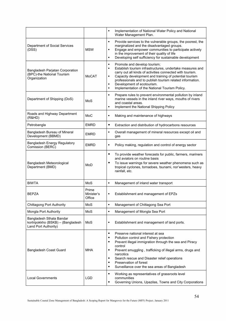
Implementation of National Water Policy and National Water Management Plan.
Department of Social Services (DSS) MSW
Provide services to the vulnerable groups, the poorest, the marginalized and the disadvantaged groups.
Engage and empower communities to participate actively in the improvement of their quality of life
Developing self sufficiency for sustainable development
Bangladesh Parjatan Corporation (BPC)-the National Tourism Organization
MoCAT
Promote and develop tourism; Establish tourism infrastructures, undertake measures and
carry out all kinds of activities connected with tourism. Capacity development and training of potential tourism
professionals and to publish tourism related information. Development of ecotourism. Implementation of the National Tourism Policy.
Department of Shipping (DoS)MoS
Prepare rules to prevent environmental pollution by inland marine vessels in the inland river ways, mouths of rivers and coastal areas.
Implement the National Shipping Policy
Roads and Highway Department (R&HD)
MoC Making and maintenance of highways
Petrobangla EMRD Extraction and distribution of hydrocarbons resources
Bangladesh Bureau of Mineral Development (BBMD)
EMRD Overall management of mineral resources except oil and
gas
Bangladesh Energy Regulatory Comission (BERC)
EMRD Policy making, regulation and control of energy sector
Bangladesh Meteorological Department (BMD)
MoD
To provide weather forecasts for public, farmers, mariners and aviators on routine basis
To issue warnings for severe weather phenomena such as tropical cyclones, tornadoes, tsunami, nor’westers, heavy rainfall, etc.
BIWTA MoS Management of inland water transport
BEPZAPrime Minister’s Office
Establishment and management of EPZs
Chittagong Port Authority MoS Management of Chittagong Sea Port
Mongla Port Authority MoS Management of Mongla Sea Port
Bangladesh Sthala Bandar kortripokkho (BSKB) – (Bangladesh Land Port Authority)
MoS Establishment and management of land ports.
Bangladesh Coast Guard MHA
Preserve national interest at sea Pollution control and Fishery protection Prevent illegal immigration through the sea and Piracy
control Prevent smuggling , trafficking of illegal arms, drugs and
narcotics Search rescue and Disaster relief operations Preservation of forest Surveillance over the sea areas of Bangladesh
Local Governments LGD Working as representatives of grassroots level
communities Governing Unions, Upazilas, Towns and City Corporations
54Sustainable Coastal Zone Management of Bangladesh: A Scoping Report for Mangroves for the Future (MFF) Project. January 2011
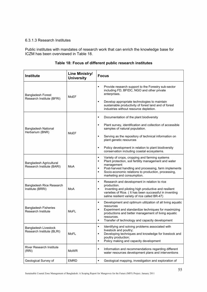
6.3.1.3 Research Institutes
Public institutes with mandates of research work that can enrich the knowledge base for ICZM has been overviewed in Table 18.
Table 18: Focus of different public research institutes
InstituteLine Ministry/University
Focus
Bangladesh Forest Research Institute (BFRI)
MoEF
Provide research support to the Forestry sub-sector including FD, BFIDC, NGO and other private enterprises.
Develop appropriate technologies to maintain sustainable productivity of forest land and of forest industries without resource depletion.
Bangladesh National Herbarium (BNR) MoEF
Documentation of the plant biodiversity
Plant survey, identification and collection of accessible samples of natural population.
Serving as the repository of technical information on plant genetic resources
Policy development in relation to plant biodiversity conservation including coastal ecosystems.
Bangladesh Agricultural Research Institute (BARI) MoA
Variety of crops, cropping and farming systems Plant protection, soil fertility management and water
management Post-harvest handling and processing, farm implements Socio-economic relations to production, processing,
marketing and consumption.
Bangladesh Rice Research Institute (BRRI) MoA
Research and development in relation to rice production.
Inventing and piloting high productive and resilient varieties of Rice. ( It has been successful in inventing saline resilient variety of rice called BR-47)
Bangladesh Fisheries Research Institute MoFL
Development and optimum utilization of all living aquatic resources
Experiment and standardize techniques for maximizing productions and better management of living aquatic resources.
Transfer of technology and capacity development
Bangladesh Livestock Research Institute (BLRI)
MoFL
Identifying and solving problems associated with livestock and poultry;
Developing techniques and knowledge for livestock and poultry production;
Policy making and capacity development
River Research Institute (RRI) MoWR
Information and recommendations regarding different water resources development plans and interventions
Geological Survey of EMRD Geological mapping, investigation and exploration of
55Sustainable Coastal Zone Management of Bangladesh: A Scoping Report for Mangroves for the Future (MFF) Project. January 2011
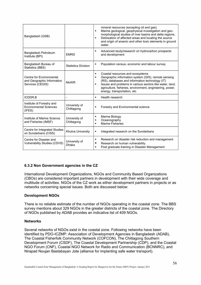
Bangladesh (GSB)
mineral resources (excepting oil and gas) Marine geological, geophysical investigation and geo-
morphological studies of river basins and delta regions. Delineation of affected areas and locating the source
and origin of arsenic and other toxic elements in ground water.
Bangladesh Petroleum Institute (BPI)
EMRD Advanced study/research on hydrocarbon prospects
and development
Bangladesh Bureau of Statistics (BBS)
Statistics Division Population census, economic and labour survey
Centre for Environmental and Geographic Information Services (CEGIS)
MoWR
Coastal resources and ecosystems Geographic information system (GIS), remote sensing
(RS), databases and information technology (IT) Issues and problems in various sectors like water, land,
agriculture, fisheries, environment, engineering, power, energy, transportation, etc
ICDDR,B - Health research
Institute of Forestry and Environmental Sciences (IFES)
University of Chittagong
Forestry and Environmental science
Institute of Marine Science and Fisheries (IMSF)
University of Chittagong
Marine Biology Oceanography Marine Fisheries
Centre for Integrated Studies on Sundarbans (CISS)
Khulna University Integrated research on the Sundarbans
Centre for Disaster and Vulnerability Studies (CDVS)
University of Dhaka
Research on disaster risk reduction and management Research on human vulnerability. Post graduate training in Disaster Management
6.3.2 Non Government agencies in the CZ
International Development Organizations, NGOs and Community Based Organizations (CBOs) are considered important partners in development with their wide coverage and multitude of activities. NGOs of the CZ work as either development partners in projects or as networks concerning special issues. Both are discussed below:
Development NGOs
There is no reliable estimate of the number of NGOs operating in the coastal zone. The BBS survey mentions about 329 NGOs in the greater districts of the coastal zone. The Directory of NGOs published by ADAB provides an indicative list of 409 NGOs.
Networks
Several networks of NGOs exist in the coastal zone. Following networks have been identified by PDO-ICZMP: Association of Development Agencies in Bangladesh (ADAB), The Coastal Fisherfolk Community Network (COFCON), The Chittagong Southern Development Forum (CSDF), The Coastal Development Partnership (CDP), and the Coastal NGO Forum (CNF), Coastal NGO Network for Radio and Communication (BCNNRC), and Nirapad Noujan Bastabayan Jote (alliance for implanting safe water transport).
56Sustainable Coastal Zone Management of Bangladesh: A Scoping Report for Mangroves for the Future (MFF) Project. January 2011
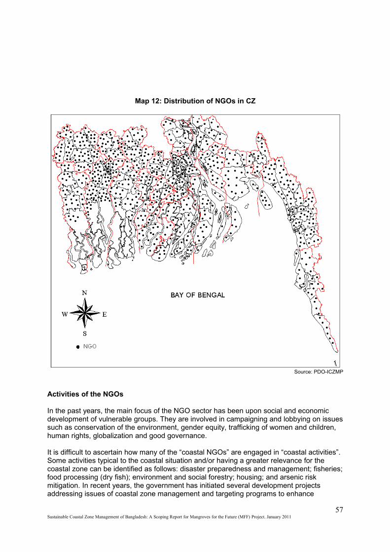
Map 12: Distribution of NGOs in CZ
Source: PDO-ICZMP
Activities of the NGOs
In the past years, the main focus of the NGO sector has been upon social and economic development of vulnerable groups. They are involved in campaigning and lobbying on issues such as conservation of the environment, gender equity, trafficking of women and children, human rights, globalization and good governance.
It is difficult to ascertain how many of the “coastal NGOs” are engaged in “coastal activities”. Some activities typical to the coastal situation and/or having a greater relevance for the coastal zone can be identified as follows: disaster preparedness and management; fisheries; food processing (dry fish); environment and social forestry; housing; and arsenic risk mitigation. In recent years, the government has initiated several development projects addressing issues of coastal zone management and targeting programs to enhance
57Sustainable Coastal Zone Management of Bangladesh: A Scoping Report for Mangroves for the Future (MFF) Project. January 2011
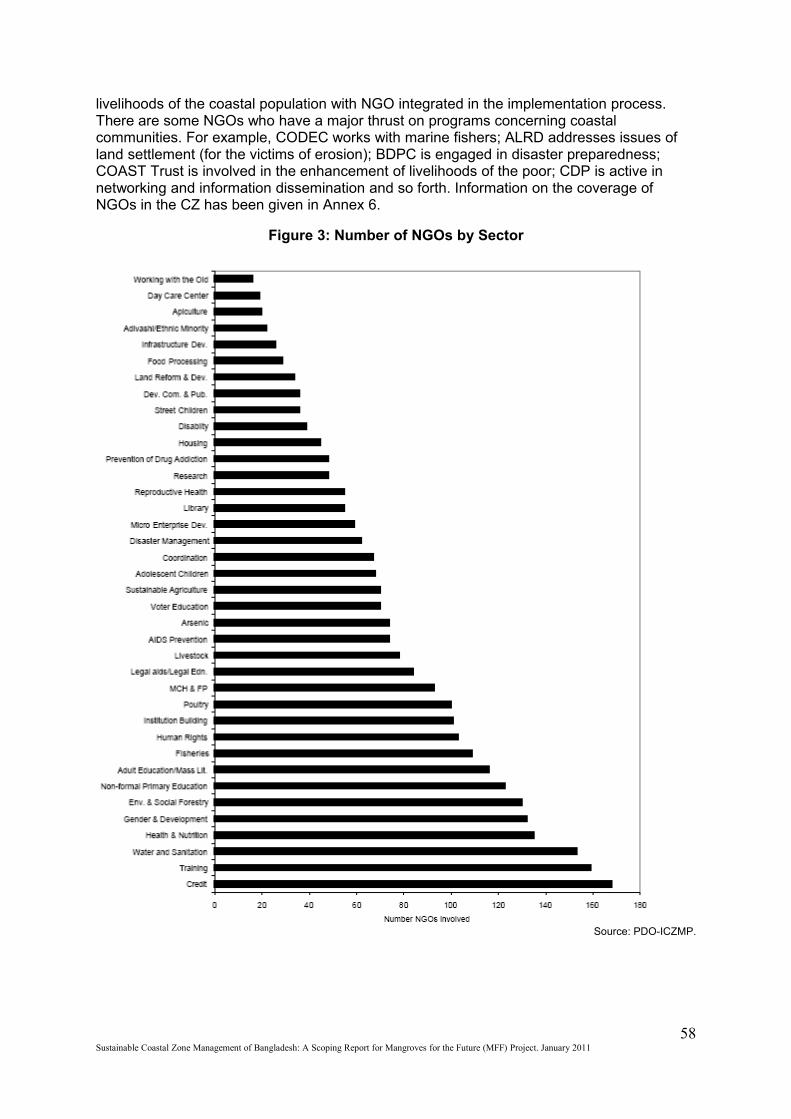
livelihoods of the coastal population with NGO integrated in the implementation process. There are some NGOs who have a major thrust on programs concerning coastal communities. For example, CODEC works with marine fishers; ALRD addresses issues of land settlement (for the victims of erosion); BDPC is engaged in disaster preparedness; COAST Trust is involved in the enhancement of livelihoods of the poor; CDP is active in networking and information dissemination and so forth. Information on the coverage of NGOs in the CZ has been given in Annex 6.
Figure 3: Number of NGOs by Sector
Source: PDO-ICZMP.
58Sustainable Coastal Zone Management of Bangladesh: A Scoping Report for Mangroves for the Future (MFF) Project. January 2011

Chapter Seven
7. Legal framework for Coastal Zone Management
The legal instruments concerning CZ management and coastal development can be categorized into three types; National Strategies and Long term plans which concerns the CZ, Sectoral Policies, Plans and Acts concerning CZM and development, and Policy and Strategy especially for the coastal zone.
7.1 International conventions, treaties and protocols (ICTP) signed by Bangladesh
Bangladesh has accredited a number of ICTPs most of them with stakes in coastal development, conservation or protection. It is a party to Agenda 21, Kyoto protocol of Climate change, UNFCC, Basel Convention, Ramsar Convention, and United Nations Convention on the Law of sea. The following table gives an overview of the ICTPs ratified by GoB and dates of signing and ratifying. These ICTPs has been listed in Annex 7.
7.2 National Strategies & plans
The national strategies and plans include annual development plans in short term, five year plans as midterm, and PRSP as a long term plan. The annual development plans are developed for the implementation of five year plan and PRSP. There are several sectoral plans with stakes in the CZ as well.
7.2.1 Five year plans (FYP)
The Five-Year Plans encapsulate the Government’s policy, strategy and plan for the country’s development in the 5-year reference period. It provides the only available comprehensive document setting out the totality of GoB’s development plans with a 5-year planning horizon. It is, however, sectoral policy documents that provide indications of the medium and longer-term strategic directions of the Government. The Fifth FYP provides an important starting point for understanding the vision of the Government for the development of any area, for example, the coastal zone. As the development of the coastal zone is neither an explicit national development target nor the responsibility of a specific ministry/agency, the FYPs do not allocate resources particularly for the development of the zone. Aspects of coastal development are embedded in activities/programs/projects of many sectoral ministries and agencies. For the present ICZM purpose, the most important aspects of the FYPs are their overall policies and strategies in so far they affect the coastal zone. In this context, sometimes the FYPs recognize the ‘coastal zone being a neglected region of Bangladesh’ and emphasises on its special needs.
7.2.2 Poverty Reduction Strategic Plan (PRSP)
PRSPs describe the country's macroeconomic, structural and social policies and programmes over a period of three years or longer horizon to promote broad-based growth and reduce poverty, and to identify associated external financing needs and major sources of financing. It is usually updated every three years. Bangladesh is under process of finalizing the PRSP. An interim PRSP (i-PRSP) has been prepared in 2003 titled ‘Bangladesh: A National Strategy for Economic Growth, Poverty Reduction and Social Development’. The Strategy has five broad components—i.e., five sets of institutions and
59Sustainable Coastal Zone Management of Bangladesh: A Scoping Report for Mangroves for the Future (MFF) Project. January 2011
policies to constitute the anti-poverty strategy to be followed. These are: (i) Promote pro-poor economic growth for increasing income and employment of the poor; (ii) Foster human development of the poor for raising their capability through education, health, nutrition and social interventions; (iii) Support women’s advancement and closing gender gaps in development; (iv) Improve social protection measures for the poor, especially women, against anticipated and unanticipated income/consumption shocks through targeted and other efforts; and (v) Promote participatory governance for enhancing voice of the poor and improving non-material dimensions of well-being including security, power and social inclusion by improving the performance of anti-poverty institutions and removing institutional hurdles to social mobility.A comprehensive poverty monitoring system was adopted for monitoring and evaluating the progress in implementing the strategy. Institutional Mechanism as well as Monitoring Indicators for this purpose was identified.
7.2.3 National Adaptation Programmes of Action (NAPA)
NAPA is prepared by the MOEF as a response to the decision of the Seventh Session of the Conference of the Parties (COP) of the UNFCCC. The basic approach to NAPA preparation was along with the sustainable development goals and objectives of the country where it has recognized necessity of addressing environmental issue and natural resource management with the participation of stakeholders in bargaining over resource use, allocation and distribution. The NAPA identified the major climate change related threats to Bangladesh. It was found that the population living in the coastal area is more vulnerable than the population in other areas. Following adaptation measures have been suggested for Bangladesh considering the vulnerability context of the country to address adverse effects of climate change including variability and extreme events based on existing coping mechanisms and practices: 1. Reduction of climate change hazards through coastal afforestation with community participation. 2. Providing drinking water to coastal communities to combat enhanced salinity due to sea level rise. 3. Capacity building for integrating climate change in planning, designing of infrastructure, conflict management and land water zoning for water management institutions. 4. Climate change and adaptation information dissemination to vulnerable community for emergency preparedness measures and awareness raising on enhanced climatic disasters. 5. Construction of flood shelter, and information and assistance centre to cope with enhanced recurrent floods in major floodplains. 6. Mainstreaming adaptation to climate change into policies and programmes in different sectors (focusing on disaster management, water, agriculture, health and industry). 7. Inclusion of climate change issues in curriculum at secondary and tertiary educational institution. 8. Enhancing resilience of urban infrastructure and industries to impacts of climate change. 9. Development of eco-specific adaptive knowledge (including indigenous knowledge) on adaptation to climate variability to enhance adaptive capacity for future climate change. 10. Promotion of research on drought, flood and saline tolerant varieties of crops to facilitate adaptation in future. 11. Promoting adaptation to coastal crop agriculture to combat increased salinity. 12. Adaptation to agriculture systems in areas prone to enhanced flash flooding in North East and Central Region. 13. Adaptation to fisheries in areas prone to enhanced flooding in North East and Central Region through adaptive and diversified fish culture practices. 14. Promoting adaptation to coastal fisheries through culture of salt tolerant fish special in coastal areas of Bangladesh. 15. Exploring options for insurance and other emergency preparedness measures to cope with enhanced climatic disasters.Some initial activities have already been pioneered in Bangladesh in adaptation to climate change at the community, national and international level in cooperation with IUCN B, CARE International, IIED, and BCAS through many projects and other initiatives.
60Sustainable Coastal Zone Management of Bangladesh: A Scoping Report for Mangroves for the Future (MFF) Project. January 2011
7.2.4 Bangladesh Climate Change Strategic Action Plan (BCCSAP)
GoB adopted BCCSAP based on the NAPA. It is built on six pillars; Food security, social protection and health, Comprehensive Disaster Management, Infrastructure, Research and Knowledge Management, Mitigation and low carbon development, Capacity building and institutional strengthening. The needs of the poor and vulnerable including women and children are prioritized in the BCCSAP. It comprises immediate, short-mid and long term plans. 44 programmes of action have been developed under the six pillers. NEC has the mandate to implement the BCCSAP. MoEF coordinates the implementation process. BCCSAP takes into account the extreme vulnerability of the CZ.
7.2.5 National Biodiversity Strategic Action Plan (NBSAP)
NBSAP of Bangladesh provides a framework for conservation, sustainable use and sharing the benefits of biodiversity of the country. A major focus of the NBSAP is the need for cross-sectoral linkages, reflecting the fact that biodiversity conservation is closely inter-woven with social and economic development. Thus, the NBSAP also provides a framework for securing the necessary environmental conditions to reduce poverty, ensure sustainable development and respond to the implementation of elements of the country’s i-PRSP. The overall goal of the NBSAP has been worked out as to conserve Bangladesh’s biological diversity in order to ensure that its various components are utilized in a sustainable manner for attaining progress and socio-economic development of the nation and ensuring livelihood security of the people for present and future generations. The major objectives of the NBSAP are to: Conserve, and restore the biodiversity of the country for well being of the present and future generations; Ensure that long-term food, water, health and nutritional securities of the people are met through conservation of biological diversity; Maintain and to improve environmental stability for ecosystems; Ensure preservation of the unique biological heritage of the nation for the benefit of the present and future generations; Guarantee the safe passage and conservation of globally endangered migratory species, especially birds and mammals in the country; and Stop introduction of invasive alien species, genetically modified organisms and living modified organisms. Sixteen strategies have been developed to shape and direct the actions towards achieving the goals and objectives of the NBSAP. The CZ shares the larger portion of the countries biodiversity and proper implementation of this plan is necessary for the conservation and regeneration of the coastal ecosystems of the country.
7.2.6 National Water Management Plan (NWMP)
NWMP is has been prepared to respond to the challenges and paradigms occurring within the water sector of the country. It has three central objectives consistent with the national aims and goals; rational management and wise use of the water resources of Bangladesh; people’s quality of life improved by equitable access to safe water for production, health and hygiene; clean water in sufficient and timely quantities for multipurpose use and preservation of the aquatic and water dependent ecosystems. The development strategy of the plan requires equal importance to be given to each national goal. 84 different programmes have been planned to be implemented in a 25 year period which should contribute to the individual and collective attainment of the overall objectives as well as intermediary and sub-sectoral goals. The programmes are grouped into 8 sub-sectoral clusters and spatially distributed across 8 planning regions of the country. 5 of these planning regions are situated in the CZ. Following issues of the CZ have been addressed in the plan: preservation of the Sundarbans; restoration of dry season fresh water inflows; maintenance of the coastal embankment system; alleviation of coastal drainage congestion and siltation; improved cyclone protection; flood protection for the offshore islands; remedial action for existing FCDI
61Sustainable Coastal Zone Management of Bangladesh: A Scoping Report for Mangroves for the Future (MFF) Project. January 2011
system; affordable long term strategy for protection from erosion; affordable long term strategy for regional augmentation; land accretion and land reclamation; protection of newly accredited chars and coastal land against tidal flooding and Gaseous aquifers. A National Water Resource Database has been developed with all the planning data available.
7.2.7 Bangladesh Tiger Action Plan (BTAP)
BTAP marks the beginning of a structured approach to achieving long-term conservation of tigers in Bangladesh. It is a policy-level document that provides a vision, goals, and objectives to guide an integrated and focused tiger conservation programme. The vision is to ensure protected tiger landscapes in Bangladesh, where wild tigers thrive at optimum carrying capacities and which continue to provide essential ecological services to mankind. The main goal for the next eight years is to stabilize or increase the Sundarbans tiger population, but one of the most important aspects of the BTAP is the recognition that the immense task of tiger conservation necessitates support and expertise outside the normal remit of forest management. Therefore, the establishment of a Forest Department-led platform that facilitates collaboration for the implementation of conservation activities will be fundamental to its success. 85 strategic actions have been identified under the 9 goals and 29 objectives in the plan. Strategies for prioritization, monitoring and evaluation have been identified too.
7.3 Sectoral Policies and acts
An extensive framework of policies has been developed in Bangladesh in the last 20 years. Few policies have an explicit focus or define specific interventions in the coastal zone; most of them refer somehow to the special characteristics of the coastal zone; but all of them propose general actions that have a bearing on the coastal zone. From an ICZM perspective, PDO-ICZMP (2003a) assessed whether and to what extent this policy framework is conducive to ICZM or can be instrumental in implementing ICZM. Some common themes and coordination issues were addressed in the process. Policies approved after this assessment have also been reviewed in a similar methodology to enrich this document.
Table 19: Sectoral Policies Related to Coastal Zone
Environment Policy & Implementation Plan, 1992 (EPoIP) Livestock Development Policy,1992 (LDPo) National Tourism Policy, 1992 (NTPo) National Forestry Policy, 1994 (NFoPo) National Energy Policy, 1996 (NEnPo) National Fisheries Policy, 1998 (NFiPo) National Policy for Safe Water Supply and Sanitation, 1998 (NPoSWSS) National Agricultural Policy, 1999 (NAPo) Industrial Policy, 1999 (IPo) National Water Policy, 1999 (NWPo) National Shipping Policy, 2000 (NSPo) National Rural Development Policy, 2001(NRDPo) National Land Use Policy, 2001(NLUPo) Population Policy, 2004 (PPo) National Food Policy, 2006 (NFPo) Renewable Energy Policy, 2008 (REPo) National Health Policy, 2009 (NHPo) National Education Policy, 2010 (NEPo)
Source: GoB
62Sustainable Coastal Zone Management of Bangladesh: A Scoping Report for Mangroves for the Future (MFF) Project. January 2011
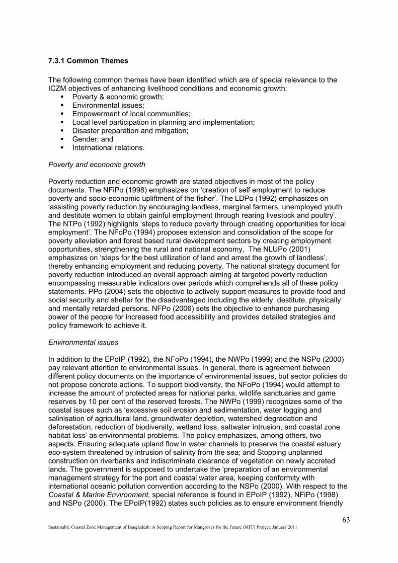
7.3.1 Common Themes
The following common themes have been identified which are of special relevance to the ICZM objectives of enhancing livelihood conditions and economic growth:
Poverty & economic growth; Environmental issues; Empowerment of local communities; Local level participation in planning and implementation; Disaster preparation and mitigation; Gender; and International relations.
Poverty and economic growth
Poverty reduction and economic growth are stated objectives in most of the policy documents. The NFiPo (1998) emphasizes on ‘creation of self employment to reduce poverty and socio-economic upliftment of the fisher’. The LDPo (1992) emphasizes on ‘assisting poverty reduction by encouraging landless, marginal farmers, unemployed youth and destitute women to obtain gainful employment through rearing livestock and poultry’. The NTPo (1992) highlights ‘steps to reduce poverty through creating opportunities for local employment’. The NFoPo (1994) proposes extension and consolidation of the scope for poverty alleviation and forest based rural development sectors by creating employment opportunities, strengthening the rural and national economy, The NLUPo (2001) emphasizes on ‘steps for the best utilization of land and arrest the growth of landless’, thereby enhancing employment and reducing poverty. The national strategy document for poverty reduction introduced an overall approach aiming at targeted poverty reduction encompassing measurable indicators over periods which comprehends all of these policy statements. PPo (2004) sets the objective to actively support measures to provide food and social security and shelter for the disadvantaged including the elderly, destitute, physically and mentally retarded persons. NFPo (2006) sets the objective to enhance purchasing power of the people for increased food accessibility and provides detailed strategies and policy framework to achieve it.
Environmental issues
In addition to the EPoIP (1992), the NFoPo (1994), the NWPo (1999) and the NSPo (2000) pay relevant attention to environmental issues. In general, there is agreement between different policy documents on the importance of environmental issues, but sector policies do not propose concrete actions. To support biodiversity, the NFoPo (1994) would attempt to increase the amount of protected areas for national parks, wildlife sanctuaries and game reserves by 10 per cent of the reserved forests. The NWPo (1999) recognizes some of the coastal issues such as ‘excessive soil erosion and sedimentation, water logging and salinisation of agricultural land, groundwater depletion, watershed degradation and deforestation, reduction of biodiversity, wetland loss, saltwater intrusion, and coastal zone habitat loss’ as environmental problems. The policy emphasizes, among others, two aspects: Ensuring adequate upland flow in water channels to preserve the coastal estuary eco-system threatened by intrusion of salinity from the sea; and Stopping unplanned construction on riverbanks and indiscriminate clearance of vegetation on newly accreted lands. The government is supposed to undertake the ‘preparation of an environmental management strategy for the port and coastal water area, keeping conformity with international oceanic pollution convention according to the NSPo (2000). With respect to the Coastal & Marine Environment, special reference is found in EPoIP (1992), NFiPo (1998) and NSPo (2000). The EPoIP(1992) states such policies as to ensure environment friendly
63Sustainable Coastal Zone Management of Bangladesh: A Scoping Report for Mangroves for the Future (MFF) Project. January 2011
conservation and development of resources available in the coastal and marine eco-systems, ban all activities resulting in pollution of coastal and marine areas, strengthening research in conservation and development of coastal and marine resources and environment, ensuring fish harvest from coastal and marine area at maximum tolerable limit; and oversee & prevent pollution in territorial water of Bangladesh. The NFiPo(1998) states about the banning of shrimp harvesting during shrimp breeding season, declaring selected breeding grounds of the sea as shrimp sanctuaries; The NSPo (2000) suggests the preparation of an environment management strategy for the port and coastal water area; and innovation of rules and regulations, monitoring and management system to ensure control and removal of environmental pollution effectively in the port and ocean area. The PPo (2004) provides policy support for the distribution of population in a manner that helps environmental conservation and stewardship. REPo (2008) states to develop clean energy for Clean Development Mechanism (CDM); it emphasizes on the potential of the CZ for wind energy. NFPo(2006) states to strengthen IPM to achieve pest control by natural means and ensure introduction of appropriate and environment-friendly agriculture and conservation system through use of bio-fertilisers
Empowerment of local communities and local level participation in planning and implementation
All policy documents, in general, promote local level participation in planning & implementation and there is full agreement regarding the need for involvement of local level institutions. A number of Ministries have already involved local institutions in their sector programmes. The real challenge is to integrate activities of different organization in a coordinated manner and strengthening capacity of local institutions. The NPoSWSS (1998) states the following in this respect; local government bodies at village, union and upazila level shall have a direct role in planning, implementation and maintenance of rural water supply and also sanitation. User Communities shall be responsible for operation and maintenance of water supply facilities and shall bear its total costs. The NFiPo (1998) states that ‘there will be a upazila, district, division and national committee to take care of the development of shrimp production, implement laws related to shrimp culture and mitigate other concerned problems in the coastal zone’. According to the NWPo (1999) the management of public water schemes, barring municipal schemes, with command area up to 5,000 ha will be gradually handed over to local and community organisations and their operations and management will be financed through local resources. The government may empower the local government or any local body it deems fit, to exercise its right to allocate water in scarcity zones during periods of severe drought, and it will monitor the water regime and enforcement of the regulations through specifically designed mechanisms. It may also mandate local governments to create awareness among the people in checking water pollution and wastage. GoB is supposed to lead the effort towards developing grass-root institutions, in conjunction with the civil society, for managing water resources at community levels. New projects proposed by a community or local institution has to be considered for implementation on a priority basis only when the beneficiaries have mobilised a certain percentage of the total cost as their contribution to the project. PPo (2004) asks for decentralization of population activities to ensure the people’s participation in population, nutrition and health activities, decentralization of services through devolution of power to the Upazila level and further below. NFPo (2006) asks to enable the local authorities to take decisions regarding the implementation of the food policy.
Disaster management
Several sector policies make specific reference to disaster management. The NFoPo (1994) recognizes the role of massive and planned tree plantation in the coastal areas to reduce the velocity and intensity of cyclone, tornado and tidal bore. The NPoSWSS (1998) makes policy statements for the protection of the safe and potable water sources in times of disasters
64Sustainable Coastal Zone Management of Bangladesh: A Scoping Report for Mangroves for the Future (MFF) Project. January 2011

while DPHE is mandated to store enough materials and spares to take immediate action for repairing or installing tube wells by this policy. The NWPo (1999) suggests that the government will ‘develop early warning and flood-proofing systems to manage natural disasters like flood and drought’. For disaster preparedness, the NWPo suggests ‘designation of flood risk zones’ and elaborates that ‘regions of economic importance such as metropolitan areas, sea and air ports, and export processing zones, will be fully protected against floods as a matter of first priority’. However, the national strategies and plans like National Adaptive Plan of Action (NAPA) and Bangladesh Climate Change Strategic Action Plan (BCCSAP) has been prepared in line with all these policies. PPo (2004) calls for measures to help the population to keep its habitat safe from environmental degradation such as pollution or land erosion and other disasters. It suggests involvement of the people in the DRR activities such as social forestry. NFPo (2006) provides a shock management system to cope up with sudden food crisis arising from disasters.
Gender
All most all policies have mentioned about gender equity and the increased role of women in all spheres of national development. Some policies indicate participation of women in specific activities; direct participation of women in afforestation programme (EPoIP 1992, NFoPo 1994), rearing of cattle, goat and poultry (LDPo 1992), management of water resources (NWPo 1999), fish culture (NFiPo 1998) etc. Most policies have set objectives to create higher income and employment opportunities for women, particularly destitute women. The NPoSWSS (1998) states that women will be supported to actively participate in decision making during planning, operation and maintenance of rural water supply and sanitation and in hygiene education. The NWPo (1999) stressed the need for creating enabling environment for participation of women in local community organizations for water management. The NEdPo (1997) emphasizes on elimination of gender bias in education, the IPo (1999) emphasizes on skill development. Ultimately, the NPoAW (1997) provides an extensive framework for implementing strategies aiming at improving women’s fate and stressed the need on cooperation between government and non-governmental organizations at all levels. PPo (2004) provides a highly gender sensitive policy framework for health, security and wellbeing of the women. It provides policy support to reduce all kind of violence against women, socio-economic empowerment of women, and reproductive health programmes inclusive of women from all spheres. NFPo (2006) provides the policy framework especially for the food security and well being of women and children.
International relations
Relevant statements in the reviewed policies are few in numbers regarding international relations and regional cooperation. The EPoIP (1992) calls for regional co-operation ‘to handle accidental pollution of coastal waters’. The NWPo (1999) emphasizes on cooperation with co-riparian countries, in relation to river basin management. The following two points are particularly relevant for the coastal zone: 1. Taking concerted efforts for management of the catchment areas with the help of afforestation and erosion control for watershed preservation and reduction of land degradation; and 2. Working jointly for the prevention of chemical and biological pollution of the rivers flowing through these countries, by managing the discharge of industrial, agricultural and domestic pollutants generated by human action. The NSPo (2000) calls for effective discussion regarding river basin management with neighbor countries. Matters of discussion identified are: exchange of data regarding hydrology and weather; afforestation and prevention of erosion to protect watersheds; and reducing degradation of soils. PPo (2004) states to develop skilled manpower for overseas employment. NFPo (2006) asks for a liberal international trade policy to ensure quality and supply sufficiency of food.
65Sustainable Coastal Zone Management of Bangladesh: A Scoping Report for Mangroves for the Future (MFF) Project. January 2011

7.3.2 Coordination between and among sectors
Though most policies deal with several issues that require some form of coordination between and among different GoB agencies, the following issues have been identified that were explicitly mentioned in or subject of different policies:
land use zoning; land accretion and reclamation /erosion; agriculture and irrigation; fisheries; forestry; water supply and sanitation; industrialization; tourism; and population control
The following sub-sections present more detail on the above listed issues and the policies in which they are addressed.
Land use zoning
Zoning has different connotations. Sector policies mostly will be implemented taking into account special regional characteristics. More importantly, however, zoning refers to an instrument to manage land use. The responsible agency for guiding and leading the concept of land zoning is naturally the Ministry of Land. The NLUPo (2001) with respect to regional differentiation, two policies have made statements relevant for ICZM. The EPoIP (1992) encourages land uses depending on eco-system prevailing at different parts of the country. The NWPo (1999) emphasizes that: ‘activity for planning and management of the nation’s river systems is undertaken within the context of hydrological regions’ and states that the Water Resources Planning Organisation (WARPO) will delineate the hydrological regions of the country, based on appropriate natural features, for planning the development of their water resources. The WARPO has, of late, delineated 7 hydrological regions whereby the coastal zone is spread over 3 different regions.
Land accretion and reclamation / erosion
Four policies refer to the aspects of land reclamation, accretion and erosion. The EPoIP (1992) emphasizes that efforts should be strengthened for land reclamation, erosion protection, soil fertility and reduction of soil salinity & alkalinity This policy also mentions about transferring newly accreted land to the Department of Forestry on a priority basis to stabilize and protect from erosion. The NFoPo (1994) mentions that ‘effective measures will be taken for afforestation in the newly accreted char in the coastal areas, as it protects soil and reduce the velocity and intensity of cyclone, tornado and tidal bore’. Afforestation also helps in stabilization of newly accreted land. The NWPo(1999) suggests toundertake surveys and investigations of the problem of riverbank erosion and develop and implement master plans for river training and erosion control; and plan and implement schemes for reclamation of land from the sea and rivers. The NLUPo (2001) recognises that it is almost impossible to increase the land area of the country. The amount of land obtained through natural accretion process is not that significant. Land reclamation by artificial means is expensive and effective only at a longer term perspective. Consequently, planning should be limited to the existing and available land resources. It appears that several policy documents emphasize on the need for reclamation of land but the NLUPo (2001) did not favour artificial land reclamation at all. Moreover, the NFiPo (1998) cautions against any obstruction to the anadromous migration routes of Hilsha fish (from coastal areas to the inland water bodies).
66Sustainable Coastal Zone Management of Bangladesh: A Scoping Report for Mangroves for the Future (MFF) Project. January 2011
Agriculture, aquaculture and irrigation
Agriculture is subject of the NAPo (1999) but is considered here in conjunction with the NFiPo (1998), dealing with aquaculture, the NWPo (1999), dealing with availability of water for both these sectors and the EPoIP (1992) dealing with the environmental impacts of agriculture. In general, there is agreement between different policy documents except the sectoral use of land. The NAPo (1999) states that ‘special development programmes will be taken-up with the aim to increase production of potential crops, suitable for the coastal area’ and ‘suitable projects will be taken-up for building water reservoirs to capture tidal water and thereby expanding mechanized irrigation facilities in the coastal areas’. The NFiPo (1998) incorporates a ‘Coastal Shrimp and Aquaculture Policy’ which states that ‘measures will be taken to conserve biodiversity in the coastal region and necessary steps will be taken to culture fish/shrimp along with rice crop, either in rotational or concurrent phases.’ The NWPo (1999) will ‘support the private development of groundwater irrigation for enabling agricultural growth to continue, alongside surface water development where feasible. But there will be a renewed focus towards increasing efficiency of water use in irrigation through various measures including drainage-water recycling, rotational irrigation, adoption of water conserving crop technology where feasible, and conjunctive use of groundwater and surface water’. Specific needs of the coastal agriculture and irrigation have not been mentioned. The NWPo (1999) will ‘encourage and promote continued development of minor irrigation, where feasible, without affecting drinking water supplies’. The EPoIP (1992) emphasizes environment friendly efforts & technology to attain self-sufficiency in food and agriculture. This also encourages increased use of natural fiber like jute and jute products. The policy discourages use of wood and farm wastes as fuel. NFPo (2006) suggests the diversification of agriculture as well as a improved agro-marketing system that calls for cooperative efforts of multiple GoB agencies as well as the local authorities.
Fisheries
Main impact bearing policies are the NFiPo (1998) and the NWPo (1999) concerning fisheries. The NFiPo (1998) contains a Coastal Shrimp and Aquaculture Policy which states that measures to conserve biodiversity in the coastal region and necessary steps to culture fish/shrimp along with rice crop will be taken, either in rotational or concurrent phases; demonstration shrimp farms will be established; and proper training will be given to the fry catchers to reduce mortality of fry or larvae during exploitation and transportation period and adequate infrastructure facilities will be established. The NWPo (1999) specifically mentions that ‘water development plans will not interrupt fish movement and will make adequate provisions in control structures for allowing fish migration and breeding’ and ‘brackish aquaculture will be confined to specific zones designated by the government for this purpose’. The NWPo (1999) recognizes that ‘a hydropower facility may be restrictive for fish movement’. NFPo (2006) suggests for the improvement of fisheries sector as an alternative food source.
Forestry
An important focus, in different policies, is to guarantee a minimum coverage of forest in the country. The EnvPoIP (1992) demands that interventions in fisheries & livestock development should not have negative impacts on mangrove forests and other eco-systemThe NFiPo(1998) states that ‘Expansion of shrimp culture in mangrove forest or destruction of mangrove forest will be completely banned. In order to ensure ecological balance, tree plantation will be encouraged in shrimp culture areas’. The NLUPo (2001) states that for balanced eco-environment and human health, 25% of the total land should be under forest coverage. This can be largely achieved by afforestation on char lands and other suitable
67Sustainable Coastal Zone Management of Bangladesh: A Scoping Report for Mangroves for the Future (MFF) Project. January 2011
lands. NFPo (2006) encourages agro, homestead and social forestry to generate income and food.
Water supply and sanitation
Water supply and sanitation is subject of both the NPoSWSS and the NWPo. In general, there is agreement between different policy documents on water supply and sanitation issues. Measures of arsenic mitigation are of concern. The NPoSWSS (1998) though not mentioning the coastal zone explicitly, adopts the principle to ‘assigning priority to underserved and un-served areas’. The NPoSWSS (1998) states that in each and every village of Bangladesh, at least one pond will be excavated/re-excavated and preserved for drinking water. Necessary security measures will be undertaken to prevent water of the pond from contamination. To encourage safe sanitation, the policy states ‘use of organic waste material for compost and bio-gas will be promoted’. The NWPo (1999) identified that ‘salinity intrusions from seawater deep into the land in the southwest are rendering groundwater unfit for consumption’ but did not make any policy statement to address this. However, the document suggested ‘facilitating availability of safe and affordable drinking water supplies through various means, including rainwater harvesting and conservation’. NFPo (2006) asks to see that the irrigation does not hamper fisheries.
Industrialization
In general, there is agreement between different policy documents on industrialization issues (NTPo, NFoPo, NFiPo, NWPo). Two of the industrial belts, Chittagong & Khulna and both the sea ports Chittagong & Mongla are located in the coastal zone. Protection of coastal environment from industrial pollution is an important concern for ICZM. As per IPo (1999), ‘Forest plantation and mechanized extraction within the bounds of reserved forests’ is regarded as Reserved Industries and ‘Agro-based Industries’, ‘Frozen Food’, ‘Oil & Gas’ and ‘Tourism’ as Thrust Industries. The NTPo (1992) states ‘tourism should be accepted as a priority industry’. The NFoPo (1994) mentions that ‘steps will be taken to bring state owned forest-based industries to competitive and profit-oriented management systems’ and that ‘emphasis will be imparted on modernization of forest-based industries to ensure effective utilization of the forest raw materials’. The NFiPo (1998) states that ‘shrimp farming will be considered an export industry and like other such industries, shrimp industry will be given proper facilities’. The NWPo (1999) recognizes that ‘excessive water salinity in the southwest region is a major deterrent to industrial growth’. The policy of the government will be that ‘zoning regulations will be established for location of new industries in consideration of fresh and safe water availability and effluent discharge possibilities’. The implication of such a policy would be that new industries would not be encouraged in the saline coastal zone of Bangladesh.
Tourism
Development of tourism is a cross-sectoral issue as well and needs concerted actions between a few main government agencies. Tourism was mentioned in the NFoPo and the NWPo. In general, there is agreement on the importance and the need to promote tourism, especially eco-tourism. The NTPo (1992) emphasizes on: wild-life conservation with tourism masterplan for the Sunderbans; development of Cox’s Bazar sea beach; development of Kuakata and sea beaches in southwestern Bangladesh; and delineation of special areas or islands for foreign tourists and development through private sector involvement. The NFoPo (1994) regards ecotourism, related to forest and wildlife, as forest related activity and ‘to be promoted taking into consideration the carrying capacity of nature’. The NWPo (1999) supports use of water for recreational purposes and its relationship for developing tourism facilities.
68Sustainable Coastal Zone Management of Bangladesh: A Scoping Report for Mangroves for the Future (MFF) Project. January 2011
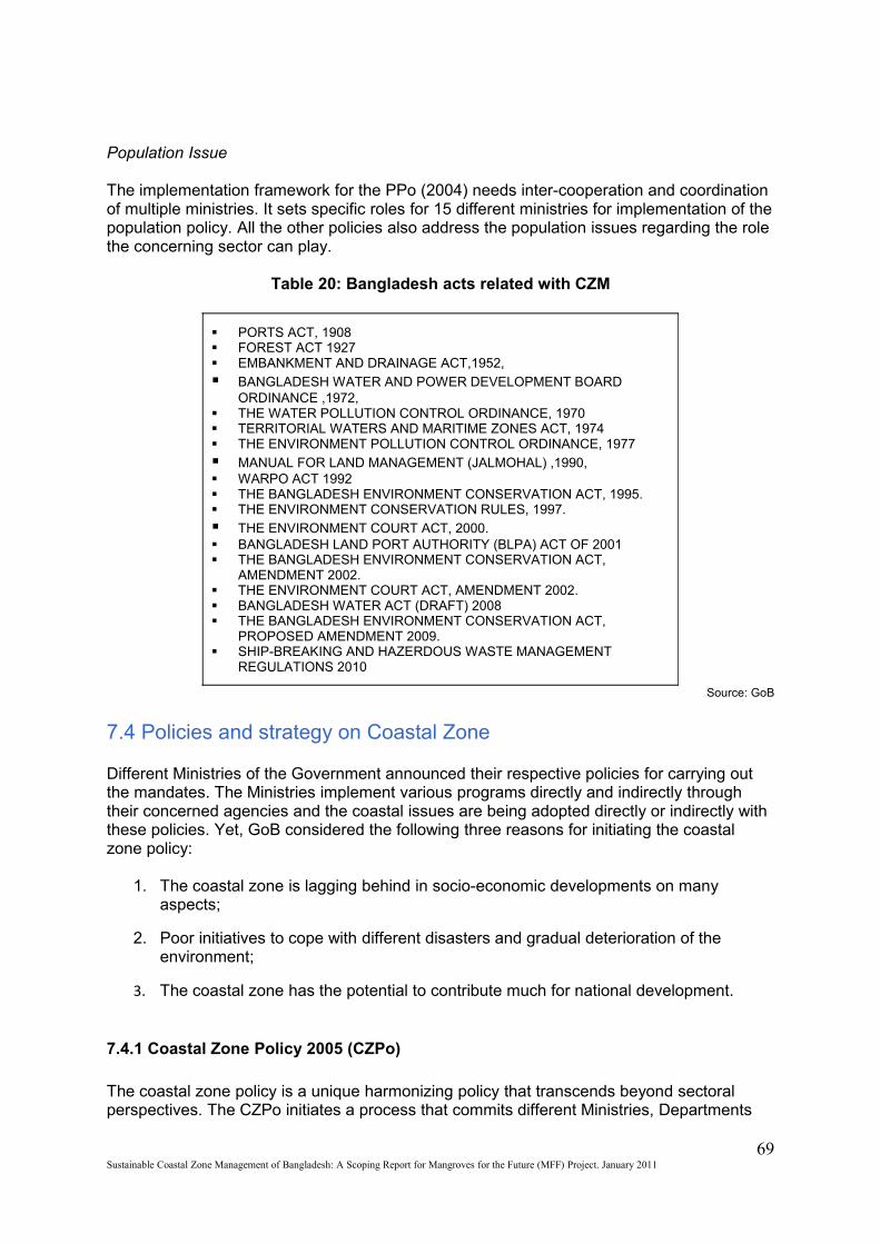
Population Issue
The implementation framework for the PPo (2004) needs inter-cooperation and coordination of multiple ministries. It sets specific roles for 15 different ministries for implementation of the population policy. All the other policies also address the population issues regarding the role the concerning sector can play.
Table 20: Bangladesh acts related with CZM
PORTS ACT, 1908 FOREST ACT 1927 EMBANKMENT AND DRAINAGE ACT,1952,
BANGLADESH WATER AND POWER DEVELOPMENT BOARD ORDINANCE ,1972,
THE WATER POLLUTION CONTROL ORDINANCE, 1970 TERRITORIAL WATERS AND MARITIME ZONES ACT, 1974 THE ENVIRONMENT POLLUTION CONTROL ORDINANCE, 1977
MANUAL FOR LAND MANAGEMENT (JALMOHAL) ,1990, WARPO ACT 1992 THE BANGLADESH ENVIRONMENT CONSERVATION ACT, 1995. THE ENVIRONMENT CONSERVATION RULES, 1997.
THE ENVIRONMENT COURT ACT, 2000. BANGLADESH LAND PORT AUTHORITY (BLPA) ACT OF 2001 THE BANGLADESH ENVIRONMENT CONSERVATION ACT,
AMENDMENT 2002. THE ENVIRONMENT COURT ACT, AMENDMENT 2002. BANGLADESH WATER ACT (DRAFT) 2008 THE BANGLADESH ENVIRONMENT CONSERVATION ACT,
PROPOSED AMENDMENT 2009. SHIP-BREAKING AND HAZERDOUS WASTE MANAGEMENT
REGULATIONS 2010
Source: GoB
7.4 Policies and strategy on Coastal Zone
Different Ministries of the Government announced their respective policies for carrying out the mandates. The Ministries implement various programs directly and indirectly through their concerned agencies and the coastal issues are being adopted directly or indirectly with these policies. Yet, GoB considered the following three reasons for initiating the coastal zone policy:
1. The coastal zone is lagging behind in socio-economic developments on many aspects;
2. Poor initiatives to cope with different disasters and gradual deterioration of the environment;
3. The coastal zone has the potential to contribute much for national development.
7.4.1 Coastal Zone Policy 2005 (CZPo)
The coastal zone policy is a unique harmonizing policy that transcends beyond sectoral perspectives. The CZPo initiates a process that commits different Ministries, Departments
69Sustainable Coastal Zone Management of Bangladesh: A Scoping Report for Mangroves for the Future (MFF) Project. January 2011
and Agencies to agree to harmonize and coordinate their activities in the coastal zone and elaborates the basis for a firm co-ordination mechanism. This policy was approved by the Government in January 2005. It has been formulated to provide a general guidance to all concerned for the management and development of the coastal zone in a manner so that the coastal people are able to pursue their life and livelihoods within secure and conducive environment. The policy states that the coastal development process aims to meet, on an overall basis, National Goal for economic growth, poverty reduction & social development; codes for responsible fisheries, Codes for responsible mangrove management and other international conventions and treaties including to achieve the targets of the Millennium Development Goals. The policy takes ICZM as the key to coastal development and sets the goal of the ICZM as ‘to create conditions, in which the reduction of poverty, development of sustainable livelihoods and the integration of the coastal zone into national processes can take place’. According to the CZPo, main principles in ICZM approach would include:
1. Integration through harmonization and coordination;
2. Adoption of a process approach;
3. Linkage to national planning mechanisms;
4. Implementation through respective line agencies;
5. Co-management and participatory decision;
6. Gender equality;
7. Participatory monitoring and evaluation;
8. Supporting national policy of decentralization and development of the private sector;
9. Interventions based on the best available knowledge; efforts to fill knowledge gaps;
10. Priority setting on issues of the coastal zone.
Based on the above principles, CZPo provides a policy framework that includes economic growth, basic needs and opportunities for livelihoods, reduction of vulnerabilities, sustainable management of natural resources, equitable distribution, empowerment of communities, women’s development & gender equity, and conservation and enhancement of critical ecosystems of the coastal zone.It also provides policy statements for an enabling institutional environment concerning mainstreaming Coastal Zone Management, strategic planning and program development, implementation, coordination, supporting activities, and legislative framework. It gives direction for management of the coastal development process through these statements.
7.4.2 Coastal Development Strategy 2006 (CDS)
CDS focuses on the implementation of the coastal zone policy (Coastal Development Strategy, 2006). The CDS was approved at the second meeting of the Inter-Ministerial Steering Committee on ICZMP held on 13 February 2006. CDS links the CZPo with development programs and interventions. The objectives set in the strategy document are: to select strategic priorities and actions in implementation of the Coastal Zone Policy with emphasis on the creation of the institutional environment that will enable Government of Bangladesh to embark on a continuous and structured process of prioritization, development and implementation of concerted interventions for the development of the coastal zone
70Sustainable Coastal Zone Management of Bangladesh: A Scoping Report for Mangroves for the Future (MFF) Project. January 2011
(WARPO, 2005). The document describes priorities and targets based on the Coastal Zone Policy objectives, the problems and issues in the coastal zone and the available resources.
The distinctive development opportunities of the coastal zone are considered as instrumental in reducing vulnerability and poverty of coastal communities. This strategy is an attempt to unlock the potentials of the coastal zone along with strategies to mitigate natural and man- made hazards and to preserve, restore and enhance coastal ecosystems. The CDS has been prepared through multi-level and multi-sectoral dialogues. It describes priorities and targets based on coastal zone policy objectives and the available resources. The strategic priorities are to be implemented through three strategic routes: mainstreaming, investment and governance. In such selective approach, the strategy aims to be complementary to the ongoing but often segmented activities of different government agencies, NGOs and development partners. It focuses on participation and partnership. This strategy is the baseline for integrated management of the coastal zone. Highlights of the CDS have been given in Annex 8.
7.4.3 National Programme of Action for Protection of Coastal and Marine Environment from Land Based Activities
A National Programme of Action for Protection of Coastal and Marine Environment from Land Based Activities has been developed in 2010 as per the priorities of the CZPo. This NPA takes into account Twelve major issues and problems as the main sources of coastal and marine pollution: Industrial waste (including ship Break yards), Sewage disposal, Solid waste management, Agrochemicals and PoPs, Deforestation, Salinity intrusion, Rapid urbanization, Erosion in the coastal zone, Extraction of coastal resources, Coastal tourism, Land use change, and Climate change. Seven broad strategies have been identified:
1. Proper management of agro-chemicals and domestic waste;
2. Proper management of industrial waste including ship breaking industries;
3. Increase coastal afforestation and conservation of existing forest areas;
4. Promotion of awareness and capacity building (training, awareness, research and monitoring);
5. Assessment of environmental flow requirement and salinity Intrusion;
6. Establishment of central data base directory and information system;
7. Ensure preparedness to address natural or man-made disasters.
Under the aforesaid strategies, 7 action programmes and 12 major activities have been identified. The action programmes are as follows:
1.1 Management of agro-chemicals; 1.2 Management of solid Waste; 1.3 Management of sewage; 2.1 Management of industrial waste including Ship Breaking and recycling industries; 2.2 Management of other industrial waste; 3. Increase Coastal Afforestation and Conservation of Existing Forest Areas; 4.1 Conduct training programmes; 4.2 Initiate awareness programmes; 4.3 Research and Monitoring Capacity Building; 5. Assessment of Environmental Flow Requirement and Salinity Intrusion;
71Sustainable Coastal Zone Management of Bangladesh: A Scoping Report for Mangroves for the Future (MFF) Project. January 2011
6. Establishment of Central Data Base Directory and Information System; 7.1 Land Management Options; 7.2 Water/ Coastal Management Options; 7.3 Conservation of Biological Options.
The NPA outlines the institutional arrangement for implementation of each of the actions considering all the stakeholders. The NPA is based on the CZPo 2005
7.5 Gaps and weak points of the current mechanism
Bangladesh has an extended policy framework for various sectors concerning ICZM as well as separate policy, strategy and plans for the CZ. Yet there are gaps, weak points and issues which will have explicit attention under the ICZM approach. Some of these issues are discussed below:
Implementation Issues
Implementation of the policies needs adequate institutional and legal arrangements, including mechanisms for harmonization of policies and corresponding actions, enforcement and monitoring to account for progress. These appear to be weak spots, as in many countries, partly due to its relative young experience with this these mechanisms of governance.The PDO-ICZM conducted an assessment of the status of implementation of policy statements. A total of 296 policy statements related to the coastal zone have been identified from 16 different sectoral policy documents. Successful implementation of policy statements generally involves many ministries, departments and agencies. There may or may not be a single/few statement which can be wholly implemented by the sponsoring ministry or department. This very nature of policy statements calls for support from many agencies and thereby is a concern for implementation. For implementation of many issues of the policies of the govt., the ministries have to pass through a detailed process of harmonization and coordination of various types of inter-departmental and inter-organizational activities. In respect of implementation, policy statements can be divided:
Issues requiring internal mobilization within the sponsoring ministry
Issues requiring support from other relevant ministries
Issues requiring support from financial & planning organizations including development partners
Issues requiring public participation/ participatory management
Issues relating to the sponsoring ministry vs. legal institutions
Issues requiring approval of the highest office/Cabinet
However, most of the policy statements fall into overlapping categories and require concurrence of many related agencies. There were limitations in assessing implementation status because of the nature of policy statements. It was difficult to make a straightforward assessment of implementation. Only 14 policy statements can be specifically identified as implemented and further 81 statements as generally implemented. These are mostly regulatory functions of the Ministries / agencies. In total, only 32% of the statements have been implemented. Activities related to a large number of policy statements have been initiated and represent as the ongoing activities of the concerned agencies. These have not yet attained the status of full implementation, because the improvements as envisaged in the
72Sustainable Coastal Zone Management of Bangladesh: A Scoping Report for Mangroves for the Future (MFF) Project. January 2011
items of the policy have not yet been attained. A total of 42 policy statements have been identified as not implemented.Few policies seem to invite for the step of strategy formulation. In cases where it is done, such as in case of the NWPo, efforts aim at the formulation of master plans (blue print planning), rather than on the creation of flexible planning and implementation procedures (process planning), that can be adapted to changed situations and priorities and is based on performance monitoring and continuous feed back with stakeholders.Considering the CZPo (2005) and CDS (2006), the proposed ICZM structure has not been implemented yet. However, the coastal zone has been considered as a special area with certain vulnerabilities in all the national plans, strategies and acts those have been approved after 2005.
Legal issues
The legal environment is not specifically covered in the policy documents. Only a few policy statements have been given on the status of act and subsequently received legal patronage. The NPoSWSS (1998) directs to enact legislation of compulsory sanitary latrine use within a specified period. The National Water Code provides the appropriate legislative framework to facilitate implementation of the NWPo (1999). The NWPo is vaguely states that ‘the Govt. will further frame rules, procedures, and guidelines for combining water-use and land-use planning’. It is not clear which organization will undertake this task of crucial integration of planning. A Marine Pollution Ordinance has been passed in parliament, which is mainly effective to prevent pollution of coastal areas and seaports. The NSPo (2000) had to authorise the Department of Shipping to prepare rules to prevent environmental pollution by inland marine vessels in the inland river ways, outlets of rivers and in coastal areas because of the vacuum of organisation for implementation of concerning rules and regulations. These indicate that there is a lack of integrated legal framework even within the sectoral policies. Added to it, there is a vacuum of an umbrella act or legal framework concerning ICZM and implementation of CZPo (2005).
Institutional issues
It appears from various policy documents that each sector has proposed its own institutional mechanism. This usually works reasonably well in implementing sector activities and programmes. But, co-ordination with other sectors is usually loose and even not existing at all. The EPoIP (1992) states MoEF as the responsible authority for coordination of activities under the policy. The Department of Environment is responsible for review and approval of all EIAs. An Inter-Ministerial Committee and supervised by a National Tourism Council is mandated for the implementation of the NTPo (1992) while the decisions of the Council will be mandatory for all relevant ministries. The NFoPo (1994) calls for strengthening the Forest Department to achieve the goal and objectives. It proposes establishment of the ‘Department of Social Forestry’. The NEnPo (1996) proposes a new regulatory organisation (National Energy Authority) to be to set up to facilitate co-ordination of the activities related to the future development of nonrenewable energy. This also proposes establishment of Renewable Energy Development Agency (REDA) for meeting challenges of planned development of renewable technologies. The NFiPo (1998) calls for the Central Shrimp Cell to be expanded up to the field level in order to provide services to the shrimp farms. The Dept. of Fisheries will be the authority to issue, cancel or renew licenses for fishing vessels and other implements for the proper management of marine fisheries resources. A registration system will be implemented for fish and shrimp hatcheries to control quality. The quality control system of the Dept. of Fisheries will be strengthened through the implementation of quality control laws on processed fisheries products. A Fisheries Bank may be established for easy sanctioning of loans. Regarding water supply and sanitation, the NPoSWSS (1998) states that the Local Govt. Division of the Ministry of Local Government, Rural Development & Co-operatives will be responsible for overall planning,
73Sustainable Coastal Zone Management of Bangladesh: A Scoping Report for Mangroves for the Future (MFF) Project. January 2011
identification of investment projects and co-ordination of activities of agencies under it (viz. DPHE, LGED, WASAs). The NWPo (1999) states that the National Water Resources Council (NWRC), through its Executive Committee, will coordinate all water resources management activities in the country with WARPO being the exclusive government institution for macro-level water resources planning. The National Shipping Policy (2000) states about the formation of a National Port Council which will comprise government representatives, port authorities, other organisations and port users. The function of the Council will be to advice the government on different matters relating to port operation. The NSPo (2000) desires effective inter-ministerial discussions so that negative effects of irrigation and flood control projects on navigability become less.
Missing Links
There are some missing links between several policy statements which needs to be coordinated for consensus. Some are discussed here;
Coastal and Marine Environment
With respect to the Coastal & Marine Environment, special reference is found in EPoIP (1992), NFiPo (1998) and NSPo (2000). This policy environment is elaborate & specific on issues related to marine environment, yet there is a wide gap in translating these policies into activities. For example turtle export’ is surprisingly emphasized in the NFiPo (1998).
Climate Change:
The risks from Global Climatic Change have not received attention in any of the sectoral policies. But they have been comprehended by the national strategic plans like NAPA, BCCSAP etc.
Coordination:
In none of the sectoral, policies concrete actions are proposed how to bring about the required coordination. This appears to be a delicate affair and often has proven to be a major bottleneck in implementing policies. In addition to lack of willingness of agencies to coordinate, coordination might be hampered by practicalities beyond their control that can be of one of the following types: jurisdiction or ownership of resources not well defined; unclear or overlapping legal responsibilities; unclear or unspecified institutional mandates; and insufficient resources available with the implementing agencies. The ICZM structure tried to sort it out by introducing coordinating units like PCU, DDCC and UDCC, but for such committees, it is hard to manage so many stakeholders unless all the gaps are reassessed and amended. Moreover, the proposed structure has not yet been implemented.
Landuse:
The NLUPo (2001) adopted by the MoL, has not mentioned anything about land zoning. NAPo (1999), NFiPo (1998), NWPo (1999), and EPoIP (1992) there is conflict between different land uses of coastal zone like uses of land for paddy cultivation, for salt production, for shrimp cultivation, for coastal afforestation or mangroves should be resolved. A consensus is important to find formula to determine proper land use.
Fisheries:
The policy framework within NFiPo (1998) and NWPo(1999) allows an unrestricted development of brackish aquaculture which is damaging local ecosystems and a land use zoning is needed to resolve conflicting land use.
74Sustainable Coastal Zone Management of Bangladesh: A Scoping Report for Mangroves for the Future (MFF) Project. January 2011
Forestry:
The forest cover to be achieved according to the NLUPo is 25%, to EPoIP it is 25% and to the NFoPo it is 20%. This may cause a conflict with agriculture and other growing land uses such as industry and recreation. In this respect, it has to be reassessed whether a policy of ‘25% of the area of Bangladesh to be afforested’ is a realistic one. NFoPo states: ‘keeping in view the ecology, the management of forest lands will be brought under profit-oriented businesses. The logic of this ‘orientation to business’ however is not explained in the policy document.
ICZM
The individual policies contain many statements that make sense in the context of ICZM but they are mainly formulated with the narrow sector production oriented objectives in mind. They are not part of an overall framework, FYPs are examples. It is thus difficult to set rational priorities for their implementation if scarce national resources have to be allocated. Still they should provide the context from which the ICZM embarks. ICZM should then provide the criteria for implementation of these policies, adhering to higher order national objectives such as poverty and sustainability. This lack of criteria is a reason behind the embarrassing lack of follow-up actions and implementation of the sector policies. Lack of institutional, financial and human capacities for implementation and monitoring capacity, lack of coordination mechanisms and lack of political motivation in combination, seem main reasons behind these policies having developed into mere window dressing documents.
75Sustainable Coastal Zone Management of Bangladesh: A Scoping Report for Mangroves for the Future (MFF) Project. January 2011

Chapter Eight
8. Past and Present Development Initiatives in the Coastal Areas
ICZM as a concept is relatively new in the development context of Bangladesh. However there have been various sectoral projects, programmes and initiatives which contributed to the overall coastal development. This chapter is a summary of the current status and stock-taking of initiatives, projects, programmes and efforts undertaken in the coastal areas of Bangladesh. The initiatives have been categorized into the following themes:
Integrated Coastal Zone Management Improving Coastal Livelihoods Disaster Risk Reduction Forest Resource Development Environmental Management Conservation of biodiversity Water resource management
8.1 Integrated Coastal Zone Management
There have been prioritized initiatives for ICZM in the recent years. A chain of preparatory activities have been covered by the ICZMP. Detailed coastal zoning is being done by CLZP and CDSP is the first project that adopted the CZPo and CDS guidelines.
8.1.1 Integrated Coastal Zone Management Plan Project (ICZMP)
The Government of Bangladesh (GoB), in collaboration with the United Kingdom and The Netherlands, initiated the preparation of the ICZMP for Bangladesh in 2002. The goal was to create conditions in which the reduction of poverty, development of sustainable livelihoods and the integration of the coastal zone were integrated into the national processes for greater economic growth, creating livelihood opportunities for coastal communities; reduction of vulnerabilities and enhancement of coping capacities; sustainable management of coastal resources; equitable distribution of resources, empowerment of coastal communities; women’s advancement and promotion of gender equality; and preservation and enhancement of critical ecosystems. As a result of this process, a Coastal Zone Policy (CZPo) was finalized in 2005, as well as a Coastal Development Strategy (CDS) and a Priority Investment Program (PIP).
8.1.2 Coastal Land Zoning Project (CLZP)
This project was initiated by the Ministry of Land in response to the call for following up the initiative of PDO-ICZMP for indicative land zoning of the CZ. The main objectives of the coastal land zoning are: to assign the land to its best possible uses like; agriculture, livestock, forestry, tourism, shrimp culture, natural reserve, industrial development and other uses in order to get optimum economic benefits resolving conflicts of interest; to prevent land degradation and restore degraded lands; to preserve and protect eco-systems with high ecological and cultural value. Moreover, this project aims at raising awareness among the planners, land users, policy makers and decision makers for rational use of land resources;
76Sustainable Coastal Zone Management of Bangladesh: A Scoping Report for Mangroves for the Future (MFF) Project. January 2011
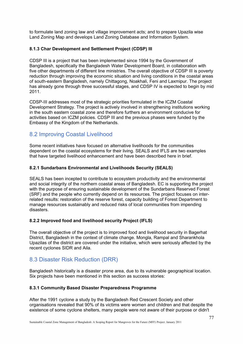
to formulate land zoning law and village improvement acts; and to prepare Upazila wise Land Zoning Map and develops Land Zoning Database and Information System.
8.1.3 Char Development and Settlement Project (CDSP) III
CDSP III is a project that has been implemented since 1994 by the Government of Bangladesh, specifically the Bangladesh Water Development Board, in collaboration with five other departments of different line ministries. The overall objective of CDSP III is poverty reduction through improving the economic situation and living conditions in the coastal areas of south-eastern Bangladesh, namely Chittagong, Noakhali, Feni and Laxmipur. The project has already gone through three successful stages, and CDSP IV is expected to begin by mid 2011.
CDSP-III addresses most of the strategic priorities formulated in the ICZM Coastal Development Strategy. The project is actively involved in strengthening institutions working in the south eastern coastal zone and therefore furthers an environment conducive for activities based on ICZM policies. CDSP III and the previous phases were funded by the Embassy of the Kingdom of the Netherlands.
8.2 Improving Coastal Livelihood
Some recent initiatives have focused on alternative livelihoods for the communities dependent on the coastal ecosystems for their living. SEALS and IFLS are two examples that have targeted livelihood enhancement and have been described here in brief.
8.2.1 Sundarbans Environmental and Livelihoods Security (SEALS)
SEALS has been incepted to contribute to ecosystem productivity and the environmental and social integrity of the northern coastal areas of Bangladesh. EC is supporting the project with the purpose of ensuring sustainable development of the Sundarbans Reserved Forest (SRF) and the people who currently depend on its resources. The project focuses on inter-related results: restoration of the reserve forest, capacity building of Forest Department to manage resources sustainably and reduced risks of local communities from impending disasters.
8.2.2 Improved food and livelihood security Project (IFLS)
The overall objective of the project is to improved food and livelihood security in Bagerhat District, Bangladesh in the context of climate change. Mongla, Rampal and Sharankhola Upazilas of the district are covered under the initiative, which were seriously affected by the recent cyclones SIDR and Aila.
8.3 Disaster Risk Reduction (DRR)
Bangladesh historically is a disaster prone area, due to its vulnerable geographical location. Six projects have been mentioned in this section as success stories:
8.3.1 Community Based Disaster Preparedness Programme
After the 1991 cyclone a study by the Bangladesh Red Crescent Society and other organisations revealed that 90% of its victims were women and children and that despite the existence of some cyclone shelters, many people were not aware of their purpose or didn't
77Sustainable Coastal Zone Management of Bangladesh: A Scoping Report for Mangroves for the Future (MFF) Project. January 2011
feel it was safe to take refuge in them. In response to these findings the German Red Cross in 1996 initiated the Community Based Disaster Preparedness Programme (CBDPP) in Cox's Bazar District with the objective to improve the communities’ self-help capacities. The programme was implemented by the Bangladesh Red Crescent together with communities living around 30 cyclone shelters along the most vulnerable points of the Bangladesh coastline.
8.3.2 Comprehensive Disaster Management Programme (CDMP)
CDMP is a strategic institutional and programming approach that is designed to optimise the reduction of long-term risks and to strengthen the operational capacities for responding to emergencies and disaster situations, including actions to improve recovery from these events. The project aims to help the GoB to strengthen existing systems in order to cope with natural hazards. It has been designed to provide information to local communities so that they mobilize their own coping mechanisms and to increase access to disaster warnings and protective materials.
The project offers an outstanding opportunity to improve linkages with, and synergies between, disaster risk reduction and adaptation to climate change. This applies both at the community and at the general stakeholder level. CDMP II is designed around a number of interrelated outcome areas, namely institutional strengthening, empowerment of local communities, reduced risks from disasters both in rural and urban communities, screening of projects for disaster proofing, adaptation to climate change and so on. The project is implemented by UNDP Bangladesh and MoFDM is the responsible government representative.
8.3.3 Community Based Adaptation to Climate Change through Coastal Afforestation
MoEF with support from MoA, MoFL and BFRI is implementing the project with financial support from United Nations Development Programme (UNDP), from 2008 to 2012. The project approach will facilitate the development of adaptive capacity at various levels. On the district level, the project will facilitate institutional coordination, structured information flows and targeted policy support to sensitize national policy stakeholders and re-evaluate key national policies that affect the sustainability of protective systems. IUCN Bangladesh Country Office is preparing the management plans for afforestation in the coastal areas.
8.3.4 Promotion of Adaptation to Climate Change and Climate Vulnerability Project
78Sustainable Coastal Zone Management of Bangladesh: A Scoping Report for Mangroves for the Future (MFF) Project. January 2011
Photo; A cyclone shelter in the CZ ©MoEF, 2008

This project was implemented by IUCN Bangladesh under the Netherlands Climate Change Assistance Programme (NCAP) II. A combination of the participatory approach and scientific tools and data was adopted in this project, to attain maximum input and ensure the interaction of stakeholders. The Participatory Vulnerability Assessment or PVA tools were used extensively to understand the climate change vulnerabilities persistent in the area. These approaches were based on the premise that there was a need to acquire an in-depth understanding of the local issues in terms of people’s perception and understanding of climate change and institutional capacities to respond to the perceived changes. The project developed disaster resilient designs of low cost houses and boats which were proven to be effective afterwards when the project area was affected by cyclone AILA. These designs are now being replicated in several other areas by the CDSP. The houses and boats were designed through assessment of people’s need and perception. Salinity resilient BR 47 rice was piloted through community participation which turned out to be successful too.
8.3.5 Reducing
Vulnerability to Climate Change (RVCC) Project
RVCC project was the first initiative of its kind in Bangladesh. It was a 3-year project from January 2002 to March 2005, funded by the Canadian International Development Agency
79Sustainable Coastal Zone Management of Bangladesh: A Scoping Report for Mangroves for the Future (MFF) Project. January 2011
Photo; A climate resilient house designed by IUCN being built. Noakhali, Bangladesh © IUCN 2009Photo: A farmer working on floating garden, Bangladesh © Anowar Razzaq, 2010
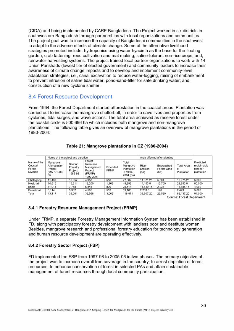
(CIDA) and being implemented by CARE Bangladesh. The Project worked in six districts in southwestern Bangladesh through partnerships with local organizations and communities. The project goal was to increase the capacity of Bangladeshi communities in the southwest to adapt to the adverse effects of climate change. Some of the alternative livelihood strategies promoted include: hydroponics using water hyacinth as the base for the floating garden; crab fattening; reed cultivation and mat making; saline-tolerant non-rice crops; and, rainwater-harvesting systems. The project trained local partner organizations to work with 14 Union Parishads (lowest tier of elected government) and community leaders to increase their awareness of climate change impacts and to develop and implement community-level adaptation strategies, i.e., canal excavation to reduce water-logging, raising of embankment to prevent intrusion of saline tidal water; pond-sand-filter for safe drinking water; and, construction of a new cyclone shelter.
8.4 Forest Resource Development
From 1964, the Forest Department started afforestation in the coastal areas. Plantation was carried out to increase the mangrove shelterbelt, in order to save lives and properties from cyclones, tidal surges, and wave actions. The total area achieved as reserve forest under the coastal circle is 500,696 ha which includes both mangrove and non-mangrove plantations. The following table gives an overview of mangrove plantations in the period of 1980-2004:
Table 21: Mangrove plantations in CZ (1980-2004)
Name of the Coastal Forest Division
Name of the project and duration Area affected after planting
Predicted reclaimable land for plantation
Mangrove Afforestation Project (MAP) 1980-85
Second Forestry Project 1985-92
Forest Resource Management Project (FRMP) 1992-2001
Extended FRMP
Total Mangrove Plantation in 1980-2004 (ha)
River Erosion(ha)
Encroached Forest Land (ha)
Total Area of Plantation
Chittagong 11,437 10,057 4,958 550 27,002 11,371.25 5,604 16,975.25 5,000Noakhali 14,615 15,314 18,200 1,163 49,292 14,153.8 15,700 29,853.8 80,000Bhola 11,011 7,758 5,845 800 25,414 11,849.15 2,036 13,885.15 4,000Patuakhali 6,114 5,932 4,565 552 19,163 2,233.0 190 2,423 5,000Total 43,117 39,061 33,568 3,065 118,871 39,607.20 23,530 63,137.20 94,000
Source: Forest Department
8.4.1 Forestry Resource Management Project (FRMP)
Under FRMP, a separate Forestry Management Information System has been established in FD, along with participatory forestry development with landless poor and destitute women. Besides, mangrove research and professional forestry education for technology generation and human resource development are operating effectively.
8.4.2 Forestry Sector Project (FSP)
FD implemented the FSP from 1997-98 to 2005-06 in two phases. The primary objective of the project was to increase overall tree coverage in the country; to arrest depletion of forest resources; to enhance conservation of forest in selected PAs and attain sustainable management of forest resources through local community participation.
80Sustainable Coastal Zone Management of Bangladesh: A Scoping Report for Mangroves for the Future (MFF) Project. January 2011
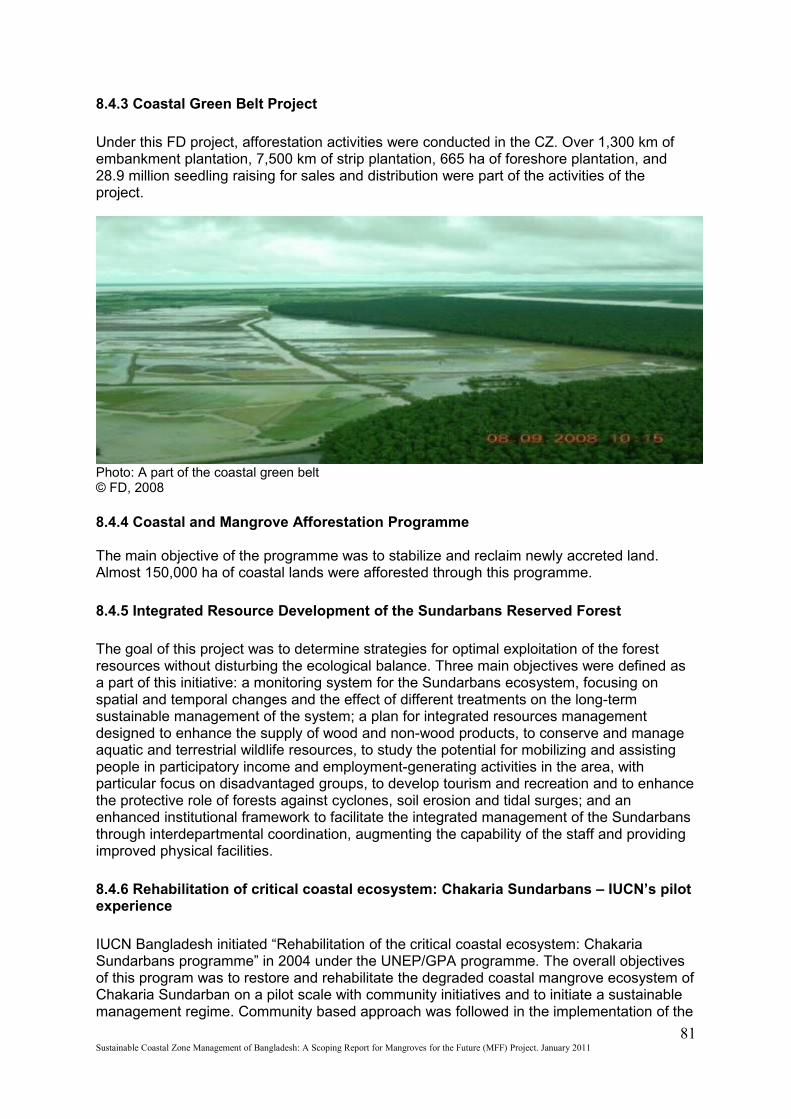
8.4.3 Coastal Green Belt Project
Under this FD project, afforestation activities were conducted in the CZ. Over 1,300 km of embankment plantation, 7,500 km of strip plantation, 665 ha of foreshore plantation, and 28.9 million seedling raising for sales and distribution were part of the activities of the project.
Photo: A part of the coastal green belt © FD, 2008
8.4.4 Coastal and Mangrove Afforestation Programme
The main objective of the programme was to stabilize and reclaim newly accreted land. Almost 150,000 ha of coastal lands were afforested through this programme.
8.4.5 Integrated Resource Development of the Sundarbans Reserved Forest
The goal of this project was to determine strategies for optimal exploitation of the forest resources without disturbing the ecological balance. Three main objectives were defined as a part of this initiative: a monitoring system for the Sundarbans ecosystem, focusing on spatial and temporal changes and the effect of different treatments on the long-term sustainable management of the system; a plan for integrated resources management designed to enhance the supply of wood and non-wood products, to conserve and manage aquatic and terrestrial wildlife resources, to study the potential for mobilizing and assisting people in participatory income and employment-generating activities in the area, with particular focus on disadvantaged groups, to develop tourism and recreation and to enhance the protective role of forests against cyclones, soil erosion and tidal surges; and an enhanced institutional framework to facilitate the integrated management of the Sundarbans through interdepartmental coordination, augmenting the capability of the staff and providing improved physical facilities.
8.4.6 Rehabilitation of critical coastal ecosystem: Chakaria Sundarbans – IUCN’s pilot experience
IUCN Bangladesh initiated “Rehabilitation of the critical coastal ecosystem: Chakaria Sundarbans programme” in 2004 under the UNEP/GPA programme. The overall objectives of this program was to restore and rehabilitate the degraded coastal mangrove ecosystem of Chakaria Sundarban on a pilot scale with community initiatives and to initiate a sustainable management regime. Community based approach was followed in the implementation of the
81Sustainable Coastal Zone Management of Bangladesh: A Scoping Report for Mangroves for the Future (MFF) Project. January 2011
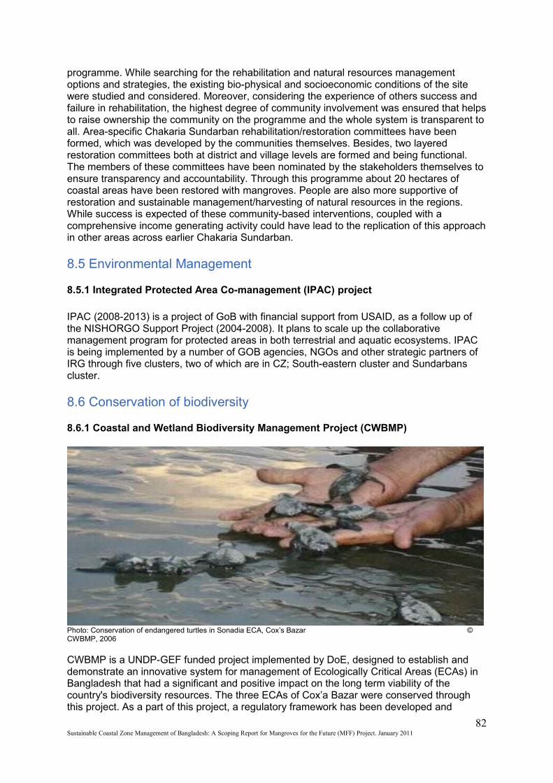
programme. While searching for the rehabilitation and natural resources management options and strategies, the existing bio-physical and socioeconomic conditions of the site were studied and considered. Moreover, considering the experience of others success and failure in rehabilitation, the highest degree of community involvement was ensured that helps to raise ownership the community on the programme and the whole system is transparent to all. Area-specific Chakaria Sundarban rehabilitation/restoration committees have been formed, which was developed by the communities themselves. Besides, two layered restoration committees both at district and village levels are formed and being functional. The members of these committees have been nominated by the stakeholders themselves to ensure transparency and accountability. Through this programme about 20 hectares of coastal areas have been restored with mangroves. People are also more supportive of restoration and sustainable management/harvesting of natural resources in the regions. While success is expected of these community-based interventions, coupled with a comprehensive income generating activity could have lead to the replication of this approach in other areas across earlier Chakaria Sundarban.
8.5 Environmental Management
8.5.1 Integrated Protected Area Co-management (IPAC) project
IPAC (2008-2013) is a project of GoB with financial support from USAID, as a follow up of the NISHORGO Support Project (2004-2008). It plans to scale up the collaborative management program for protected areas in both terrestrial and aquatic ecosystems. IPAC is being implemented by a number of GOB agencies, NGOs and other strategic partners of IRG through five clusters, two of which are in CZ; South-eastern cluster and Sundarbans cluster.
8.6 Conservation of biodiversity
8.6.1 Coastal and Wetland Biodiversity Management Project (CWBMP)
Photo: Conservation of endangered turtles in Sonadia ECA, Cox’s Bazar © CWBMP, 2006
CWBMP is a UNDP-GEF funded project implemented by DoE, designed to establish and demonstrate an innovative system for management of Ecologically Critical Areas (ECAs) in Bangladesh that had a significant and positive impact on the long term viability of the country's biodiversity resources. The three ECAs of Cox’a Bazar were conserved through this project. As a part of this project, a regulatory framework has been developed and
82Sustainable Coastal Zone Management of Bangladesh: A Scoping Report for Mangroves for the Future (MFF) Project. January 2011
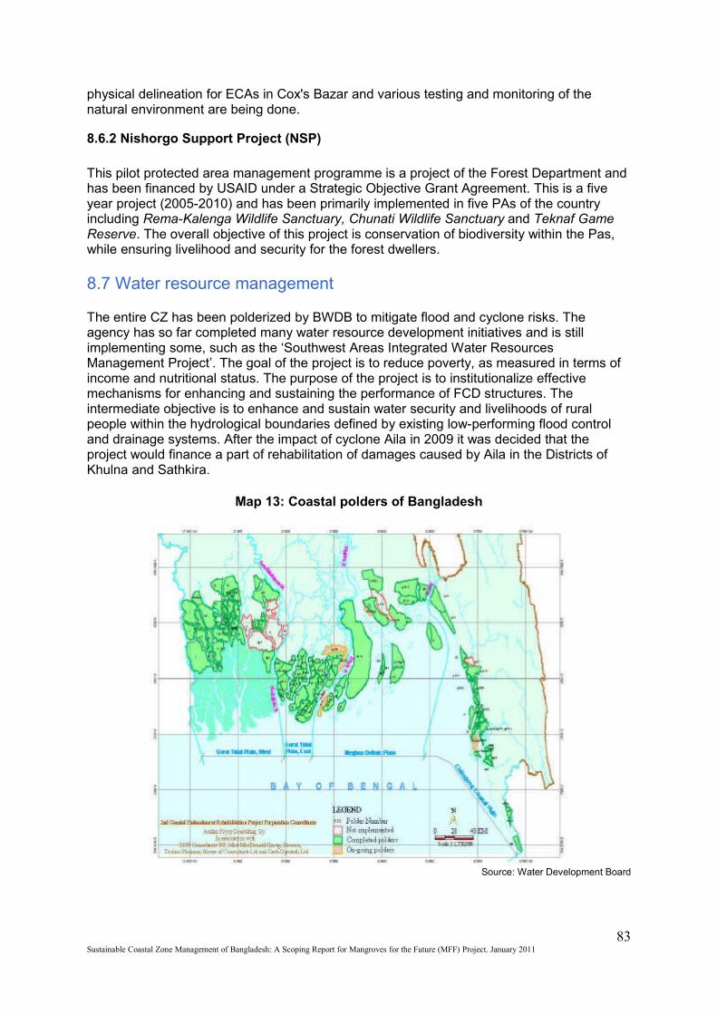
physical delineation for ECAs in Cox's Bazar and various testing and monitoring of the natural environment are being done.
8.6.2 Nishorgo Support Project (NSP)
This pilot protected area management programme is a project of the Forest Department and has been financed by USAID under a Strategic Objective Grant Agreement. This is a five year project (2005-2010) and has been primarily implemented in five PAs of the country including Rema-Kalenga Wildlife Sanctuary, Chunati Wildlife Sanctuary and Teknaf Game Reserve. The overall objective of this project is conservation of biodiversity within the Pas, while ensuring livelihood and security for the forest dwellers. 8.7 Water resource management
The entire CZ has been polderized by BWDB to mitigate flood and cyclone risks. The agency has so far completed many water resource development initiatives and is still implementing some, such as the ‘Southwest Areas Integrated Water Resources Management Project’. The goal of the project is to reduce poverty, as measured in terms of income and nutritional status. The purpose of the project is to institutionalize effective mechanisms for enhancing and sustaining the performance of FCD structures. The intermediate objective is to enhance and sustain water security and livelihoods of rural people within the hydrological boundaries defined by existing low-performing flood control and drainage systems. After the impact of cyclone Aila in 2009 it was decided that the project would finance a part of rehabilitation of damages caused by Aila in the Districts of Khulna and Sathkira.
Map 13: Coastal polders of Bangladesh
Source: Water Development Board
83Sustainable Coastal Zone Management of Bangladesh: A Scoping Report for Mangroves for the Future (MFF) Project. January 2011

Chapter Nine
9. MFF in Bangladesh; Need, Opportunities and Framework for implementation
This chapter summarises the potentials of Bangladesh for implementation of MFF, and concerning priorities. Bangladesh can be benefited through MFF as the priorities of the initiative are similar to that of GoB. Bangladesh has achieved valuable experience regarding many of these issues which can be useful to MFF as well.
9.1 Issues and challenges to be addressed
Considering the vulnerabilities and capacities in comparison with the needs of the country, the following issues and challenges have been identified;
9.1.1 The challenge of climate change and associated vulnerabilities
Bangladesh is considered to be the country with highest risks due to climate change. MFF initiative will certainly have to face the challenges associated with the climate change in Bangladesh. Vulnerabilities associated with climate change in the Bangladesh CZ have been briefed in chapter two.
9.1.2 The challenge of conserving the coastal ecosystems in balance with economic needs
The most important areas of the country are part of CZ; both economically and environmentally. A huge share of the population lives below the poverty line posing a serious challenge in the development scenario. Infrastructural development is necessary for the sake of economic development; simultaneous protection of the ecosystems from the affects of these ‘development’ is a must. Economic growth and development as well as environmental conservation have been prioritized in all the strategic plans and policies of GoB including the iPRSP, CZPo and CDS. Contradiction and conflicts among the changes of land use pattern due to economic needs and impacts of livelihood activities on the a
9.1.3 The issue of sustainable livelihood generation for the coastal communities
Bigger share of the coastal population (millions in numbers) lives under the poverty line. Many of them are dependent on the mangroves and other ecosystems for their livelihood but such activities cost the very ecosystems most of the time (see chapter three). Coastal ecosystems cannot be protected or conserved without ensuring sustainable livelihood for them. Ensuring sustainable livelihood for so many people will be a challenge.
9.1.4 The issue of coordinating the multidimensional stake holders
The stake holders of the CZ consist of a large number of GoB and non GoB stakeholders including the community itself. Any activity regarding the coast will have to incorporate multi dimensional stake holders. As the coordinating mechanism proposed by the CDS is not yet functioning, it remains an important issue.
84Sustainable Coastal Zone Management of Bangladesh: A Scoping Report for Mangroves for the Future (MFF) Project. January 2011
9.1.5 Gender issues
There is an extensive framework of policies (for example; NAPA) that supports and claims incorporation of gender values in all the coastal conservation and development works. Many of the ongoing projects in the CZ incorporate the gender values into action. Still it remains an important issue considering the disparity and vulnerability context of the coastal women.
9.1.6 The knowledge gap on the CZ
There is a huge knowledge gap, especially considering the state of biodiversity and the ecosystems as well as conservation strategy. This gap is at the levels of knowledge leaders and the mass. The causes are technological and financial as well as strategic. Filling up this gap from top to bottom will be great challenge.
9.2 Analysis of the PoWs in relation to GoB priorities
The 15 programmes of work (PoW) has been analysed in relation with the priorities of GoB in the context of the challenges briefed above; The objectives of MFF and the orientation of the projects towards process and projects have been considered in the analysis;
9.2.1 Building knowledge
PoW 1: Improve knowledge base for coastal planning, policy & management.
Bangladesh has been prioritizing the need for improving the knowledge base for coastal planning, policy and management since 2001. It has already developed integrative Coastal Zone Policy and Coastal Development Strategy. The successful ICZM Project contributed to Integrated Coastal Resource Database development. The successful completion of the Coastal land use zoning project will certainly improve the knowledge base for coastal planning, policy & management. The priorities of CZPo and CDS are completely in line with PoW 1.
PoW 2: Designing ecologically and socio-economically sound coastal rehabilitation.
The policies like EPoIP, NFPo, NWPo and the CZPo provide policy support for the PoW 2. Ongoing FD projects ‘Community based adaptation to climate change through coastal afforestation ‘ and SEALS are practical examples which resemble GoB priorities similar to PoW2. Scopes of projects under this PoW is high in Bangladesh.
PoW3 Providing decision support for ‘reef-to-ridge’ approaches to land and resource management.
The NLUPo, CZPo and the CDS provide policy framework for coastal land and resource use zoning. The outcomes of the Coastal land zoning project is supposed to make the base for reef to ridge approaches to coastal land and resource management. However, the existing EPoIP, NWPo, National Biodiversity Strategic Action Plan, Integrated Water Management Plan, NAPA and NCS as well as the CZPo provide the policy framework for a reef to ridge approach for coastal land and resource management. The legislative set up is fully in support of the PoW 3.
85Sustainable Coastal Zone Management of Bangladesh: A Scoping Report for Mangroves for the Future (MFF) Project. January 2011

PoW 4: Integrating coastal ecosystem economic values into development planning and appraisal.
The coastal ecosystem values are already integrated in the development planning of the country. Projects under PoW 4 can enhance the process of this integration in a wider range. The iPRSP, the EPoIP, the NFoPo had mentions of the values of coastal ecosystems. Two of the nine strategic priorities of the CDS are environmental conservation and sustainable resource management. One of the eight development objectives of the CZPo is ‘conservation and enhancement of critical ecosystems’; and considering the economic value of the coastal ecosystems it also takes sustainable resource management as an objective.
PoW.5: Applying a Monitoring, Learning and Evaluation (MLE) approach to accelerate knowledge dissemination
The continuous ICZM initiative is a good example of implementation of the MLE process in Bangladesh. ICZMP projects was the outcome of the learning of several past initiatives, now GoB is implementing the learning of ICZMP project in CDSP, CDMP and Coastal Land Zoning Project. The proposed ICZM structure has similar arrangements for regular monitoring and evaluation of coastal development as per the policy framework. All the policies can be revised through proper evaluation and in case of inconsistency with ICTPs or any international agreements or initiatives supported by GoB, they are sure to be revised. However, MFF has opportunities to enhance GoB capacity in this regard.
9.2.2 Strengthening Empowerment
PoW 6: Promoting civil society awareness and participation in coastal decision-making.
The policy framework of the country encourages civil society involvement in the development process, especially for awareness issue. The CZPo for example proposes campaigns involving the civil society for creating awareness among the decision makers, coastal community and the mass about ICZM.
PoW 7: Building the capacity of professional coastal managers for integrated coastal management.
GoB started this process with the inception of the PDO-ICZMP under WARPO. Capacity development of the professionals in the process was an outcome of the process. The CZPo and the CDS emphasizes on capacity development of the coastal managers. Bangladesh is comparatively new in ICZM and so PoW 7 is very relevant in the present context.
PoW8: Supporting environmentally sustainable livelihoods among coastal communities
EPoIP and NFoPo emphasized on similar priorities. The CZPo provide detail policy framework for creating environmentally sustainable livelihoods in fisheries, aquaculture, agriculture, and livestock. Through newly incepted SEALS project , GoB prioritizes the creation of alternative livelihoods for the people dependent on the forest resources. CDSP is a project with similar priorities. Projects under PoW 8 have high potential in Bangladesh.
PoW 9: Improving community resilience to natural disasters and climate change
86Sustainable Coastal Zone Management of Bangladesh: A Scoping Report for Mangroves for the Future (MFF) Project. January 2011
Bangladesh has a rich experience of developing community resilience to climate change. There has been extended planning including the BCCSAP and the NAPA. CDMP as a long term initiative is working for the cause. Community based adaptation to climate change through coastal afforestation project of FD is a project with values similar to PoW9. Yet, in consideration of the high vulnerability of the country to climate change, there always is need for more and more initiatives. So projects under PoW 9 will be highly effective. Bangladesh experience on this regard can contribute to the regional efforts as well.
PoW 10: Identifying sustainable financing mechanisms for coastal ecosystem conservation
Bangladesh has been struggling to generate sustainable financing mechanisms for various issues ranging from mitigating climate change associated hazards and conservation of biodiversity to poverty eradication. The approaches varied from creating multi donor trust fund to empowering and enabling the communities to conserve the ecosystems sustainably. The country is highly potential for investments in the coastal ecosystems, especially mangroves and will certainly be benefited through MFF. MFF can initiate generation of greater investments in the coastal ecosystems. Participatory socail forestry and coastal greenbelt creating experience of GoB can help the regional initiative as well regarding the involvement of coastal communities in the investment process as partners. PoW 10 remains highly relevant in accord with GoB priorities.
9.2.3 Enhancing Governance
PoW 11: Supporting national integrated coastal management programmes
As shown earlier, Bangladesh has been implementing ICZM for coastal development through a chain of initiatives. MFF has high potential to link up with these initiatives nationally integrated coastal management programmes and enhance the process. Projects under PoW 11 will get full policy support through the CZPo and CDS.
PoW 12: Strengthening the integration and enforcement of environmental and social safeguards in coastal land use planning
The ongoing coastal land zoning project under the MoL is integrating the environmental and social safeguards in coastal land use planning. Yet, PoW 12 remains relevant considering the enforcement of these plans.
PoW 13: Building national systems of marine and coastal protected areas that contribute to a regional network
Bangladesh has a rich network of protected areas in the CZ. The detail of these areas is given in chapter one of this report. The FD has plans to increase the number and range of these areas. An extensive policy framework including the CZPo, NFiPo, NFoPo and Wildlife preservaton act provides legislative support for the conservation of these areas as well as the marine reserve and fish sanctuaries. These can contribute to the regional network. Management and enhancement of these protected areas calls for relevant projects and initiatives. PoW 13 is fully in accord with GoB priorities.
PoW 14: Promoting adaptive coastal management programmes that include ongoing ecological and socio-economic assessment and monitoring
GoB has initiated such programmes in a few protected areas in a small scale; CWBMP as example. But the range and coverage of such programmes has to be widened. PoW 14 is highly relevant in the context of Bangladesh.
87Sustainable Coastal Zone Management of Bangladesh: A Scoping Report for Mangroves for the Future (MFF) Project. January 2011
PoW 15: Encouraging environmentally sustainable business practices in coastal areas.
This has been a burning issue in the recent years in the context of the country. There have been conflicts between economic ambitions and environmental needs. The legal framework of the country makes it mandatory for all business practices all over the country including the coast to be environmentally sustainable. But considering the economic condition of the country, the legislations could not be enforced properly. A wide range of initiatives regarding PoW 15 is needed in the country in this regard.
9.3 Priorities of MFF in Bangladesh
Following are the priorities for MFF based on the analysis above and the priorities set by the iPRSP, NAPA and CDS;
Enhancing resilience to climate change
Generating Sustainable livelihoods in the CZ
Promoting environmentally sustainable business practices
Empowerment of the coastal communities; especially women
Filling up the knowledge gap on ecosystems and biodiversity
Sustainable conservation and management of coastal ecosystems
Promoting renewable resource uses
Capacity development of Coastal Managers
Enhancing the ICZM process
9.4 Good practices to be replicated
There have been some good practices proven to be effective in relation to the MFF priorities. These practices can be replicated in the MFF initiative in Bangladesh as well as the other countries within the MFF region. Some of them have been discussed below;
Community Based Sustainable Management of Ecosystems
The Community based sustainable management of Tanguar Haor Programme is a great example of successful sustainable resource management with community participation for repetition in the conservation and management of coastal ecosystems. Community based ecosystem management implied by IUCN Bangladesh as a model has been proven socially, economically and environmentally effective in Tanguar Haor - the Ramsar site, and the model can be replicated for the CZ ecosystem management as well.
Multi stakeholder integration and coordination
CDSP (see 4.1.3) has been a good example of concerted action of CZM. Many GoB agencies successfully work in the project within a well coordinated mechanism. This can be an example of resolution the problem of coordination in the ICZM process. But the project is implemented in a limited area in Noakhali. This can be replicated in all the offshore islands of the CZ.
88Sustainable Coastal Zone Management of Bangladesh: A Scoping Report for Mangroves for the Future (MFF) Project. January 2011
Climate resilient technology innovation
IUCN Bangladesh improved climate resilient indigenous technologies under the NCAP-II programme (see 4.3.4). Such innovative measures can be useful for MFF.Integrated Land Use Zoning
Indicative coastal land use zoning of Bangladesh is being done through ‘Coastal land use zoning’ project (see 4.1.2) which will help the future initiatives. Such initiatives can be promoted throughout the region.
Micro level Sustainable Management Plan
Micro level sustainable management plan and GIS zoning of land use has been prepared for the ECAs of Cox’s Bazar by CWBMP (see 4.6.1) and four coastal unions in the coast by Community Based Adaptation to Climate Change through Coastal Afforestation project(see 4.3.3). Such plans and process can be replicated throughout the CZ and for all the protected areas.
Integrated coastal zone management plan
Bangladesh developed the CZPo and the CDS as well as the ICRD and knowledge base for ICZM through ICZMP project effectively (see 4.1.1 ). Such projects can be replicated throughout the region.
Alternative livelihood generation
Alternative livelihood generation approach of the SEALS project (see 4.2.1) can be replicated throughout the coast.
Comprehensive disaster management
Bangladesh’s experience on comprehensive disaster management (see 4.3) can be useful to the other countries in the region.
9.5 Financing mechanism
The fund usually allocated by MFF is not sufficient in the vulnerability context and wide range of scopes and priorities of Bangladesh. There are two possible ways to magnitude the effects of MFF investments; Linking with other projects and co-financing.
9.5.1 Linking with other projects
The following major ongoing projects in the CZ are in line with the PoWs of MFF as well as ICZM priorities, i.e. CDMP, CDSP, Community Based Adaptation to Climate Change through coastal afforestation, SEALS and CWBMP. MFF investments can be linked with these projects and programmes to make them more cost effective. Some international initiatives like the BOBLME-FAO Programme and ‘Bangladesh Climate Change Resilience Fund’ as well as proposed ‘Bangladesh Climate Multi-donor Trust Fund’ which can be approached and linked with the MFF initiative in Bangladesh.
9.5.2 Co-financing
89Sustainable Coastal Zone Management of Bangladesh: A Scoping Report for Mangroves for the Future (MFF) Project. January 2011
The following donors have been assisting Bangladesh and are potential co-financers as many of their priorities are in line with the priorities of MFF i.e. WB, ADB, IDB, UNDP, UNFP, UNEP, UNFPA, WHO, FAO, WWF, SDC, IFAD, DFID, CIDA,SIDA, USAID, CARE, WATER AID, ACTION AID, Government of Japan, Kingdom of Netherlands etc. There is a provision of CSR for the corporate houses, banks and financial institutions too which can be utilized for fund generation. There are a few local funds like the Arannyak foundation and Wildlife Trust Bangladesh (WTB) that can co-finance. Through proper mobilization and cooperation, the co-financing mechanism can be very effective to generate investments in the coastal ecosystems of Bangladesh.
9.6 A Framework for Implementing MFF in Bangladesh
A framework for implementing MFF has been developed in consultation with FD as the potential GoB focal point for MFF. In the process, mechanisms for national effort on MFF and potential partnership options have been looked for. This framework includes an indicative action plan too.
9.6.1 Mechanisms for national effort
The ICZM structure proposed by CDS (2006) asks for a Programme Coordinating Unit (PCU) which will coordinate the overall coastal development from an ICZM perspective. As the unit has not yet been established, the NCB can play a vital role as a national advisory body for ICZM and enhance the implementation of the CZPo and overall coastal development. Implementation of MFF can initiate the implementation of the CDS and enhance the overall ICZM of the country considering the similarities between the PoWs of MFF and CDS. IUCN Bangladesh with cooperation of the FD is working to develop a national effort for MFF by incorporating all potential stake holders. They are being informed about MFF and its prospects and associated needs and opportunities.
9.6.2 Potential partnerships for implementation
A vast network of NGO and CBOs is working in the coast who can be partners for implementing MFF at the grass root level. IUCN B has a good experience to implement development and sustainable environmental management incorporating such NGOs and CBOs. The GoB policies are in support of such partnerships. This potential of partnerships has been considered in the proposed indicative action plan.
9.6.3 Indicative Action Plan
Bangladesh is still an outreach country of MFF. Primary goal of MFF activities in Bangladesh at the moment is to achieve full membership of MFF. Bangladesh is working to reach the following targets for the cause.
Target 1: Official endorsement of the Bangladesh National Coordinating Body (NCB) for MFF by September 2011.
Target 2: Preparing National Strategy and Action Plan (NSAP) for MFF Bangladesh by December 2011.
Moreover, Forest Department (FD) and IUCN Bangladesh Country Office are communicating with different relevant stakeholders and the civil society to create a concerted approach for MFF Bangladesh. Several workshops and meetings have been planned concerning the formation of the NCB, the NSAP, financing mechanisms and potential partnerships.
FD and IUCN Bangladesh have been going through thorough discussions about the potential implementation process of MFF in Bangladesh. Following figure demonstrates the
90Sustainable Coastal Zone Management of Bangladesh: A Scoping Report for Mangroves for the Future (MFF) Project. January 2011
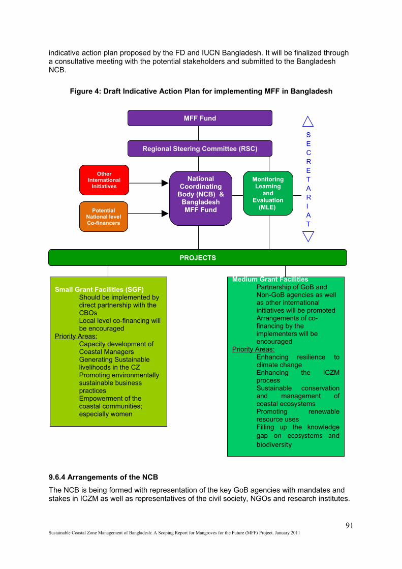
indicative action plan proposed by the FD and IUCN Bangladesh. It will be finalized through a consultative meeting with the potential stakeholders and submitted to the Bangladesh NCB.
Figure 4: Draft Indicative Action Plan for implementing MFF in Bangladesh
9.6.4 Arrangements of the NCB
The NCB is being formed with representation of the key GoB agencies with mandates and stakes in ICZM as well as representatives of the civil society, NGOs and research institutes.
91Sustainable Coastal Zone Management of Bangladesh: A Scoping Report for Mangroves for the Future (MFF) Project. January 2011
SECRETARIAT
Medium Grant Facilities Partnership of GoB and Non-GoB agencies as well as other international initiatives will be promotedArrangements of co-financing by the implementers will be encouraged
Priority Areas:Enhancing resilience to climate changeEnhancing the ICZM processSustainable conservation and management of coastal ecosystemsPromoting renewable resource usesFilling up the knowledge gap on ecosystems and biodiversity
Small Grant Facilities (SGF)Should be implemented by direct partnership with the CBOsLocal level co-financing will be encouraged
Priority Areas:Capacity development of Coastal ManagersGenerating Sustainable livelihoods in the CZPromoting environmentally sustainable business practicesEmpowerment of the coastal communities; especially women
PROJECTS
Other International
InitiativesMonitoring Learning
and Evaluation
(MLE)
National Coordinating
Body (NCB) & Bangladesh MFF FundPotential
National level Co-financers
Regional Steering Committee (RSC)
MFF Fund
FD is working as a focal point in the formation of the NCB while IUCN Bangladesh is
facilitating the process.
A tentative structure of the interim NCB has been prepared in consultation with the FD. The final list will be submitted to the MoEF as a formal proposal for approval and official recognition of GoB by July 2011.
Chapter Ten
92Sustainable Coastal Zone Management of Bangladesh: A Scoping Report for Mangroves for the Future (MFF) Project. January 2011
10. Conclusions
Bangladesh is highly potential for implementing MFF considering the environmental and economic values of its coastal ecosystems. The country has a vast network of protected areas which can contribute to the regional network. The country along with its people and ecosystems is highly vulnerable to the hazards associated with climate change. However, Bangladesh’s long experience of fighting calamities can be helpful in the regional knowledge sharing platform. There have been some bright examples of successful initiatives in the CZ of the country concerning ICZM and overall coastal human wellbeing. On the other hand, It is anticipated that, Bangladesh can also benefit from other MFF countries through technology transfer, knowledge generation on the issues that is common for each of the countries.
The existing institutional and legal arrangements in Bangladesh are supportive of MFF implementation. GoB priorities are in line with the PoWs of MFF. There is a wide network of natioanl and local NGOs and CBOs for potential partnerships. Moreover, co-financing and linking with the existing initiatives in line with the MFF PoWs is proposed for future collaboration and partnership. There is potential for the Bangladesh NCB (to be formed) to play an important role as the national advisory committee for ICZM, which can bring effective coordination amongst the stakeholders.
Through successful implementation of MFF, Bangladesh can be benefited by generating investments for the coastal ecosystems and can contribute to improve the lives and livelihoods of the coastal people.
References
93Sustainable Coastal Zone Management of Bangladesh: A Scoping Report for Mangroves for the Future (MFF) Project. January 2011
94Sustainable Coastal Zone Management of Bangladesh: A Scoping Report for Mangroves for the Future (MFF) Project. January 2011
Ahmad, M.2003a. Coastal livelihood: situation and context. PDO-ICZMP. WARPO, Dhaka.
Ahmad, M.2003b. NGOs in Coastal Development. PDO-ICZMP. WARPO, Dhaka.
Ahmad, M; 2002. An introduction to the non-profit sector in Bangladesh. Allavida, London.
Ahmed, I. and Wilde, K. de. 2011. Moving Coastlines; Emergence and Use of Land in the Ganges- Brahmaputra-Meghna Estuary.
Ali, A. 1999. Climate change impacts and adaptation assessment in Bangladesh. Climate Research, Vol. 12(2-3): 109–116, 1999.
Bangladesh Land Port Authority (BLPA) Act of 2001, Government of the People’s Republic of Bangladesh. Dhaka.
Bangladesh Tiger Action Plan 2009-2017. Forest Department. Ministry of Environment and Forest. Government of the People’s Republic of Bangladesh.
Bangladesh Wildlife Orfder 1973, Ministry of Law, Judiciary and Parliamentary affairs of the Government of the People’s Republic of Bangladesh. Dhaka.
BBS. 2004. Labor Force Survey 2002-2003. Dhaka.
BBS.2001.Popuation Census 2001.Dhaka.
BBS.2002.Household Investment Survey 1998-99. Dhaka.
BBS.2010. GDP Bangladesh 2004-05 to 2009-10, http://www.bbs.gov.bd/WebTestApplication/userfiles/Image/SubjectMatterDataIndex/ GDP_2008_09.pdf . Accessed on November 10, 2010.
BBS.2010. http://www.bbs.gov.bd, accessed November 10, 2010.
bdnews24.com.2011. Salt producers demand higher price. http://bdnews24.com/details.php?id=184547&cid=2 accessed 16th January 2011.
CEGIS.2007. Effect of cyclone Sidr on the Sundarbans A Preliminary Assessment. Dhaka.
Coastal Zone Policy.2005. WARPO, Ministry of Water Resources. Government of the People’s Republic of Bangladesh, Dhaka.
CWBMP.2006. “St Martin’s Island ECA Conservation Management Plan”. Coastal and Wetland Biodiversity Management Project. Cox’s Bazar.
DOE. 2006. Bangladesh: National Programme of Action for Protection of the Coastal and Marine Environment from Land-based Activities. Department of Environment. Ministry of Environment and Forest. Dhaka.
DOE. 2010. Biodiversity National Assesment and Programme of Action 2020. Department of Environment. Ministry of Environment and Forest, Dhaka.
DOF.2006. Fishery StatisticalYearbook of Bangladesh 2004-2005. Fisheries Resources Service System, Department of Fisheries (DOF), Ministry of Fisheries and Livestock, Dhaka, Bangladesh,42pp.
Environment Policy & Implementation Plan. 1992. Ministry of Environment and Forest. Government of the People’s Republic of Bangladesh. Dhaka.
FAO and GOB.2004. The Food Security Atlas of Bangladesh: Towards a Poverty and Hunger Free Bangladesh, Planning Division, Government of Bangladesh and World Food Programme, United Nations, Dhaka, Bangladesh.
GOB-IUCN.1992.The Bangladesh National Conservation Strategy: Towards Sustainable Development. Government of Bangladesh and IUCN Bangladesh Country Office,Dhaka.
Green, M. J. B. and Paine, J. 1997. State of the world’s protected areas at the end of the twentieth century. World Conservation Monitoring Centre, Cambridge, UK. Source: www.wcmc.org
GSB.2010. http://www.gsb.gov.bd/dm.html accessed 16 January 2011.
Haque, S.A.2006. Salinity Problems and crop production in coastal regions of Bangladesh. Pak. J. Bot., 38(5): 1359-1365, 2006.
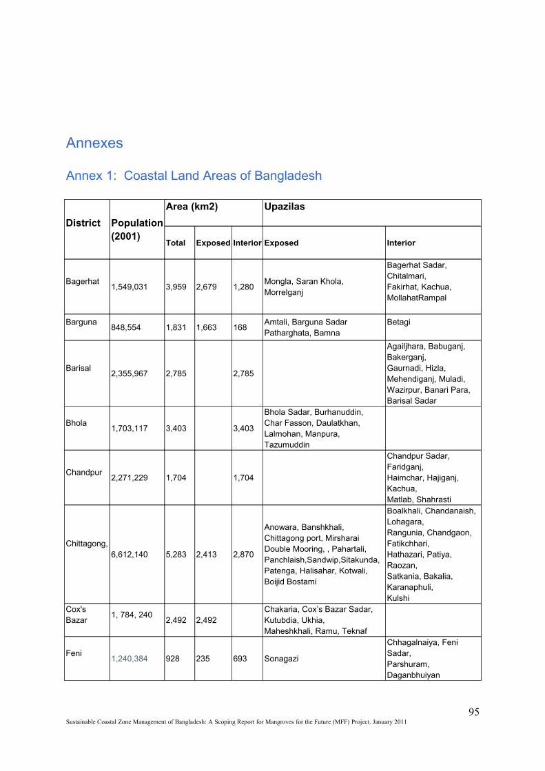
Annexes
Annex 1: Coastal Land Areas of Bangladesh
District Population(2001)
Area (km2) Upazilas
Total Exposed Interior Exposed Interior
Bagerhat1,549,031 3,959 2,679 1,280
Mongla, Saran Khola, Morrelganj
Bagerhat Sadar, Chitalmari,Fakirhat, Kachua, MollahatRampal
Barguna848,554 1,831 1,663 168
Amtali, Barguna SadarPatharghata, Bamna
Betagi
Barisal2,355,967 2,785 2,785
Agailjhara, Babuganj, Bakerganj,Gaurnadi, Hizla, Mehendiganj, Muladi, Wazirpur, Banari Para, Barisal Sadar
Bhola1,703,117 3,403 3,403
Bhola Sadar, Burhanuddin,Char Fasson, Daulatkhan,Lalmohan, Manpura,Tazumuddin
Chandpur2,271,229 1,704 1,704
Chandpur Sadar, Faridganj,Haimchar, Hajiganj, Kachua,Matlab, Shahrasti
Chittagong,6,612,140 5,283 2,413 2,870
Anowara, Banshkhali,Chittagong port, Mirsharai Double Mooring, , Pahartali,Panchlaish,Sandwip,Sitakunda, Patenga, Halisahar, Kotwali, Boijid Bostami
Boalkhali, Chandanaish, Lohagara,Rangunia, Chandgaon, Fatikchhari,Hathazari, Patiya, Raozan,Satkania, Bakalia, Karanaphuli,Kulshi
Cox's Bazar
1, 784, 2402,492 2,492
Chakaria, Cox’s Bazar Sadar,Kutubdia, Ukhia,Maheshkhali, Ramu, Teknaf
Feni1,240,384 928 235 693 Sonagazi
Chhagalnaiya, Feni Sadar,Parshuram, Daganbhuiyan
95Sustainable Coastal Zone Management of Bangladesh: A Scoping Report for Mangroves for the Future (MFF) Project. January 2011
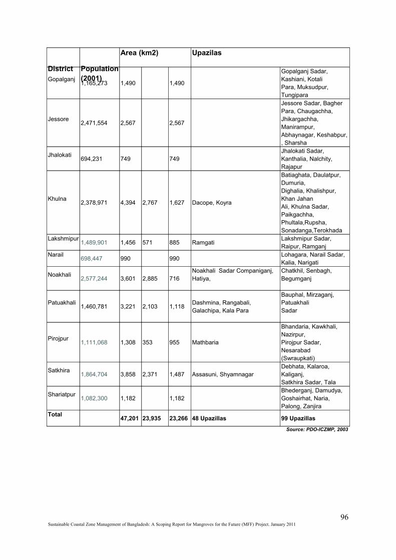
District Population(2001)
Area (km2) Upazilas
Gopalganj1,165,273 1,490 1,490
Gopalganj Sadar, Kashiani, KotaliPara, Muksudpur, Tungipara
Jessore2,471,554 2,567 2,567
Jessore Sadar, Bagher Para, Chaugachha, Jhikargachha, Manirampur, Abhaynagar, Keshabpur, , Sharsha
Jhalokati694,231 749 749
Jhalokati Sadar, Kanthalia, Nalchity, Rajapur
Khulna2,378,971 4,394 2,767 1,627 Dacope, Koyra
Batiaghata, Daulatpur, Dumuria,Dighalia, Khalishpur, Khan JahanAli, Khulna Sadar, Paikgachha,Phultala,Rupsha, Sonadanga,Terokhada
Lakshmipur1,489,901 1,456 571 885 Ramgati
Lakshmipur Sadar, Raipur, Ramganj
Narail698,447 990 990
Lohagara, Narail Sadar, Kalia, Narigati
Noakhali2,577,244 3,601 2,885 716
Noakhali Sadar Companiganj, Hatiya,
Chatkhil, Senbagh, Begumganj
Patuakhali1,460,781 3,221 2,103 1,118
Dashmina, Rangabali,Galachipa, Kala Para
Bauphal, Mirzaganj, PatuakhaliSadar
Pirojpur1,111,068 1,308 353 955 Mathbaria
Bhandaria, Kawkhali, Nazirpur,Pirojpur Sadar, Nesarabad(Swraupkati)
Satkhira1,864,704 3,858 2,371 1,487 Assasuni, Shyamnagar
Debhata, Kalaroa, Kaliganj,Satkhira Sadar, Tala
Shariatpur1,082,300 1,182 1,182
Bhederganj, Damudya,Goshairhat, Naria, Palong, Zanjira
Total47,201 23,935 23,266 48 Upazillas 99 Upazillas
Source: PDO-ICZMP, 2003
96Sustainable Coastal Zone Management of Bangladesh: A Scoping Report for Mangroves for the Future (MFF) Project. January 2011
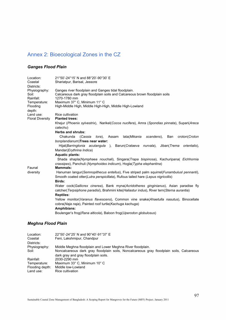
Annex 2: Bioecological Zones in the CZ
Ganges Flood Plain
Location: 21°50’-24°15’ N and 88°20’-90°30’ ECoastal Districts:
Shariatpur, Barisal, Jessore
Physiography: Ganges river floodplain and Ganges tidal floodplain.Soil: Calcareous dark gray floodplain soils and Calcareous brown floodplain soilsRainfall: 1270-1780 mmTemperature: Maximum 37° C, Minimum 11° CFlooding depth:
High-Middle High, Middle High-High, Middle High-Lowland
Land use: Rice cultivationFloral Diversity Planted trees:
Khejur (Phoenix sylvestrix), Narikel(Cocos nucifera), Amra (Spondias pinnata), Supari(Areca catechu)Herbs and shrubs: Chakunda (Cassia tora), Assam lata(Mikania scandens), Ban croton(Croton bonplandianum)Trees near water: Hijal(Barringtonia acutangula ), Barun(Crataeva nurvala), Jiban(Trema orientalis), Mandar(Erythrina Indica)Aquatic plants: Shada shapla(Nymphaea nouchali), Singara(Trapa bispinosa), Kachuripana( Eichhornia crassipes), Panchuli (Nymphoides indicum), Hogla(Typha elephantina)
Faunal diversity
Mammals: Hanuman langur(Semnopithecus entellus), Five striped palm squirrel(Funambulusl pennanti), Smooth coated otter(Lutra perspicillata), Rufous tailed hare (Lepus nigricollis)Birds: Water cock(Gallicrex cinerea), Bank myna(Acridotheres ginginianus), Asian paradise fly catcher(Terpsiphone paradisi), Brahmini kite(Haliastur indus), River tern(Sterna aurantia)Reptiles:Yellow monitor(Varanus flavescens), Common vine snake(Ahaetulla nasutus), Binocellate cobra(Naja naja), Painted roof turtle(Kachuga kachuga)Amphibians: Boulenger’s frog(Rana alticola), Baloon frog(Uperodon globulosus)
Meghna Flood Plain
Location: 22°50’-24°25’ N and 90°40’-91°37’ ECoastal Districts:
Feni, Lakshmipur, Chandpur
Physiography: Middle Meghna floodplain and Lower Meghna River floodplain.Soil: Noncalcareous dark gray floodplain soils, Noncalcareous gray floodplain soils, Calcareous
dark gray and gray floodplain soils.Rainfall: 2030-2290 mmTemperature: Maximum 33° C, Minimum 10° CFlooding depth: Middle low-LowlandLand use: Rice cultivation
97Sustainable Coastal Zone Management of Bangladesh: A Scoping Report for Mangroves for the Future (MFF) Project. January 2011
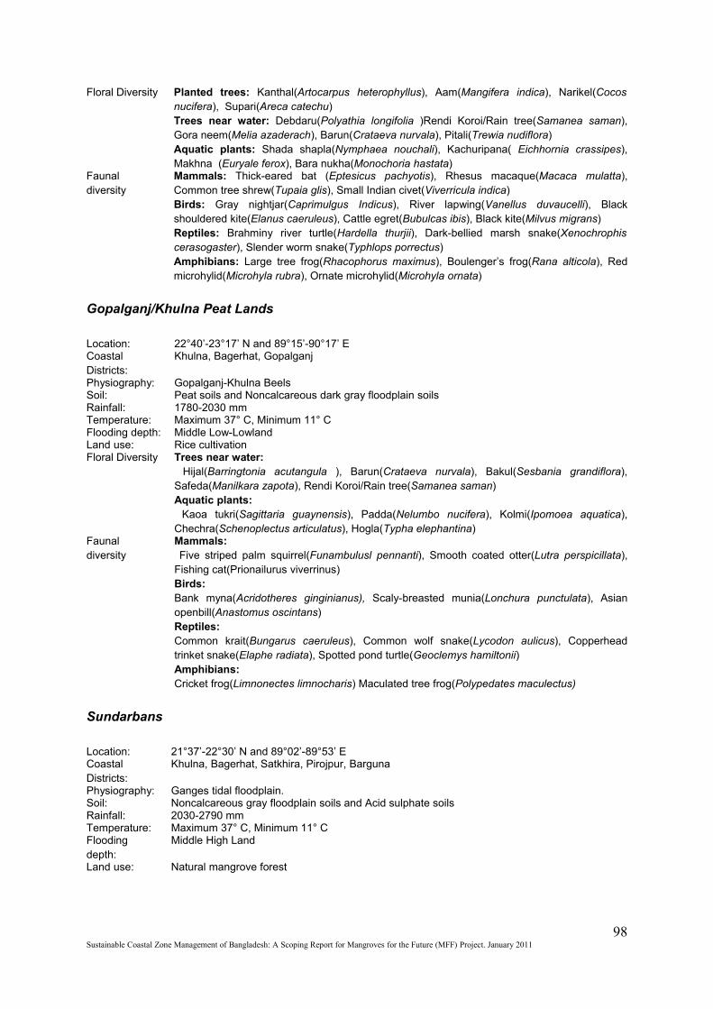
Floral Diversity Planted trees: Kanthal(Artocarpus heterophyllus), Aam(Mangifera indica), Narikel(Cocos nucifera), Supari(Areca catechu)Trees near water: Debdaru(Polyathia longifolia )Rendi Koroi/Rain tree(Samanea saman), Gora neem(Melia azaderach), Barun(Crataeva nurvala), Pitali(Trewia nudiflora)Aquatic plants: Shada shapla(Nymphaea nouchali), Kachuripana( Eichhornia crassipes), Makhna (Euryale ferox), Bara nukha(Monochoria hastata)
Faunal diversity
Mammals: Thick-eared bat (Eptesicus pachyotis), Rhesus macaque(Macaca mulatta), Common tree shrew(Tupaia glis), Small Indian civet(Viverricula indica)Birds: Gray nightjar(Caprimulgus Indicus), River lapwing(Vanellus duvaucelli), Black shouldered kite(Elanus caeruleus), Cattle egret(Bubulcas ibis), Black kite(Milvus migrans)Reptiles: Brahminy river turtle(Hardella thurjii), Dark-bellied marsh snake(Xenochrophis cerasogaster), Slender worm snake(Typhlops porrectus)Amphibians: Large tree frog(Rhacophorus maximus), Boulenger’s frog(Rana alticola), Red microhylid(Microhyla rubra), Ornate microhylid(Microhyla ornata)
Gopalganj/Khulna Peat Lands
Location: 22°40’-23°17’ N and 89°15’-90°17’ ECoastal Districts:
Khulna, Bagerhat, Gopalganj
Physiography: Gopalganj-Khulna BeelsSoil: Peat soils and Noncalcareous dark gray floodplain soilsRainfall: 1780-2030 mmTemperature: Maximum 37° C, Minimum 11° CFlooding depth: Middle Low-LowlandLand use: Rice cultivationFloral Diversity Trees near water:
Hijal(Barringtonia acutangula ), Barun(Crataeva nurvala), Bakul(Sesbania grandiflora), Safeda(Manilkara zapota), Rendi Koroi/Rain tree(Samanea saman)Aquatic plants: Kaoa tukri(Sagittaria guaynensis), Padda(Nelumbo nucifera), Kolmi(Ipomoea aquatica), Chechra(Schenoplectus articulatus), Hogla(Typha elephantina)
Faunal diversity
Mammals: Five striped palm squirrel(Funambulusl pennanti), Smooth coated otter(Lutra perspicillata), Fishing cat(Prionailurus viverrinus)Birds: Bank myna(Acridotheres ginginianus), Scaly-breasted munia(Lonchura punctulata), Asian openbill(Anastomus oscintans)Reptiles:Common krait(Bungarus caeruleus), Common wolf snake(Lycodon aulicus), Copperhead trinket snake(Elaphe radiata), Spotted pond turtle(Geoclemys hamiltonii)Amphibians: Cricket frog(Limnonectes limnocharis) Maculated tree frog(Polypedates maculectus)
Sundarbans
Location: 21°37’-22°30’ N and 89°02’-89°53’ ECoastal Districts:
Khulna, Bagerhat, Satkhira, Pirojpur, Barguna
Physiography: Ganges tidal floodplain.Soil: Noncalcareous gray floodplain soils and Acid sulphate soilsRainfall: 2030-2790 mmTemperature: Maximum 37° C, Minimum 11° CFlooding depth:
Middle High Land
Land use: Natural mangrove forest
98Sustainable Coastal Zone Management of Bangladesh: A Scoping Report for Mangroves for the Future (MFF) Project. January 2011
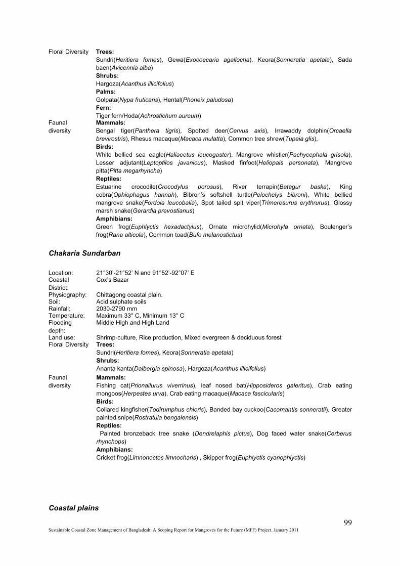
Floral Diversity Trees:Sundri(Heritiera fomes), Gewa(Exocoecaria agallocha), Keora(Sonneratia apetala), Sada baen(Avicennia alba)Shrubs:Hargoza(Acanthus illicifolius)Palms:Golpata(Nypa fruticans), Hental(Phoneix paludosa)Fern:Tiger fern/Hoda(Achrostichum aureum)
Faunal diversity
Mammals:Bengal tiger(Panthera tigris), Spotted deer(Cervus axis), Irrawaddy dolphin(Orcaella brevirostris), Rhesus macaque(Macaca mulatta), Common tree shrew(Tupaia glis), Birds: White bellied sea eagle(Haliaeetus leucogaster), Mangrove whistler(Pachycephala grisola), Lesser adjutant(Leptoptilos javanicus), Masked finfoot(Heliopais personata), Mangrove pitta(Pitta megarhyncha)Reptiles:Estuarine crocodile(Crocodylus porosus), River terrapin(Batagur baska), King cobra(Ophiophagus hannah), Bibron’s softshell turtle(Pelochelys bibroni), White bellied mangrove snake(Fordoia leucobalia), Spot tailed spit viper(Trimeresurus erythrurus), Glossy marsh snake(Gerardia prevostianus)Amphibians: Green frog(Euphlyctis hexadactylus), Ornate microhylid(Microhyla ornata), Boulenger’s frog(Rana alticola), Common toad(Bufo melanostictus)
Chakaria Sundarban
Location: 21°30’-21°52’ N and 91°52’-92°07’ ECoastal District:
Cox’s Bazar
Physiography: Chittagong coastal plain.Soil: Acid sulphate soilsRainfall: 2030-2790 mmTemperature: Maximum 33° C, Minimum 13° CFlooding depth:
Middle High and High Land
Land use: Shrimp-culture, Rice production, Mixed evergreen & deciduous forestFloral Diversity Trees:
Sundri(Heritiera fomes), Keora(Sonneratia apetala)Shrubs:Ananta kanta(Dalbergia spinosa), Hargoza(Acanthus illicifolius)
Faunal diversity
Mammals:Fishing cat(Prionailurus viverrinus), leaf nosed bat(Hipposideros galeritus), Crab eating mongoos(Herpestes urva), Crab eating macaque(Macaca fascicularis) Birds: Collared kingfisher(Todirumphus chloris), Banded bay cuckoo(Cacomantis sonneratii), Greater painted snipe(Rostratula bengalensis)Reptiles: Painted bronzeback tree snake (Dendrelaphis pictus), Dog faced water snake(Cerberus rhynchops)Amphibians: Cricket frog(Limnonectes limnocharis) , Skipper frog(Euphlyctis cyanophlyctis)
Coastal plains
99Sustainable Coastal Zone Management of Bangladesh: A Scoping Report for Mangroves for the Future (MFF) Project. January 2011
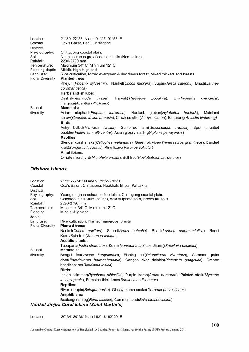
Location: 21°30’-22°56’ N and 91°25’-91°56’ ECoastal Districts:
Cox’s Bazar, Feni, Chittagong
Physiography: Chittagong coastal plain.Soil: Noncalcareous gray floodplain soils (Non-saline)Rainfall: 2290-2790 mmTemperature: Maximum 34° C, Minimum 12° CFlooding depth: Middle High-HighlandLand use: Rice cultivation, Mixed evergreen & deciduous forest, Mixed thickets and forestsFloral Diversity Planted trees:
Khejur (Phoenix sylvestrix), Narikel(Cocos nucifera), Supari(Areca catechu), Bhadi(Lannea coromandelica)Herbs and shrubs:Bashak(Adhatoda vasika), Paresh(Thespesia populnia), Ulu(Imperata cylindrica), Hargoza(Acanthus illicifolius)
Faunal diversity
Mammals:Asian elephant(Elephus maximus), Hoolock gibbon(Hylobates hoolock), Mainland serow(Capricornis sumatraenis), Clawless otter(Anoyx cinerea), Binturong(Arctictis binturong)Birds: Ashy bulbul(Hemixos flavala), Gull-billed tern(Gelochelidon nilotica), Spot throated babbler(Pellorneum albiventre), Asian glossy starling(Aplonis panayensis)Reptiles:Slender coral snake(Callophys melanurus), Green pit viper(Trimeresurus gramineus), Banded krait(Bungarus fasciatus), Ring lizard(Varanus salvator)Amphibians: Ornate microhylid(Microhyla ornata), Bull frog(Hoplobatrachus tigerinus)
Offshore Islands
Location: 21°35’-22°45’ N and 90°15’-92°05’ ECoastal Districts:
Cox’s Bazar, Chittagong, Noakhali, Bhola, Patuakhali
Physiography: Young meghna estuarine floodplain, Chittagong coastal plain.Soil: Calcareous alluvium (saline), Acid sulphate soils, Brown hill soilsRainfall: 2290-2790 mmTemperature: Maximum 34° C, Minimum 12° CFlooding depth:
Middle -Highland
Land use: Rice cultivation, Planted mangrove forestsFloral Diversity Planted trees:
Narikel(Cocos nucifera), Supari(Areca catechu), Bhadi(Lannea coromandelica), Rendi Koroi/Rain tree(Samanea saman)Aquatic plants:Topapana(Pistia strateotes), Kolmi(Ipomoea aquatica), Jhanji(Utricularia exoleata),
Faunal diversity
Mammals:Bengal fox(Vulpes bengalensis), Fishing cat(Prionailurus viverrinus), Common palm civet(Paradoxarus hermaphroditus), Ganges river dolphin(Platanista gangetica), Greater bandicoot rat(Bandicota indica)Birds: Indian skimmer(Rynchops albicollis), Purple heron(Ardea purpurea), Painted stork(Mycteria leucocephala), Eurasian thick-knee(Burhinus oedicnemus)Reptiles:River terrapin(Batagur baska), Glossy marsh snake(Gerardia prevostianus)Amphibians: Boulenger’s frog(Rana alticola), Common toad(Bufo melanostictus)
Narikel Jinjira Coral Island (Saint Martin’s)
Location: 20°34’-20°38’ N and 92°18’-92°20’ E
100Sustainable Coastal Zone Management of Bangladesh: A Scoping Report for Mangroves for the Future (MFF) Project. January 2011
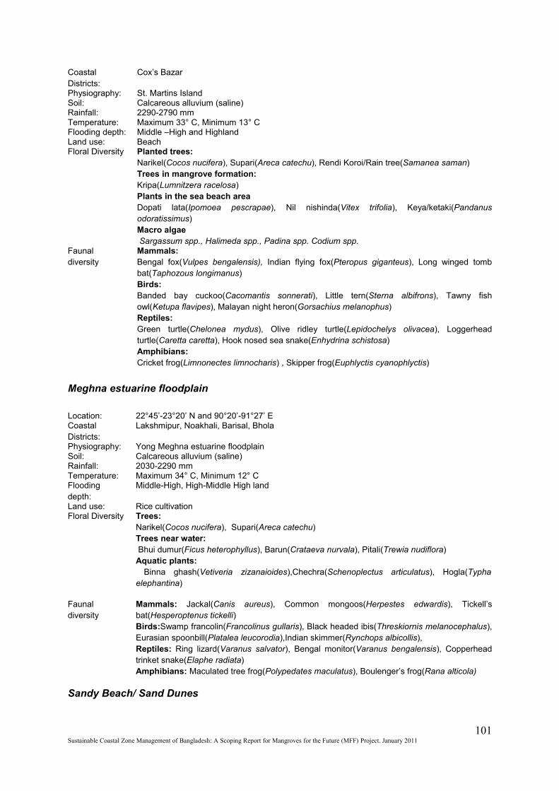
Coastal Districts:
Cox’s Bazar
Physiography: St. Martins IslandSoil: Calcareous alluvium (saline)Rainfall: 2290-2790 mmTemperature: Maximum 33° C, Minimum 13° CFlooding depth: Middle –High and HighlandLand use: BeachFloral Diversity Planted trees:
Narikel(Cocos nucifera), Supari(Areca catechu), Rendi Koroi/Rain tree(Samanea saman)Trees in mangrove formation:Kripa(Lumnitzera racelosa)Plants in the sea beach areaDopati lata(Ipomoea pescrapae), Nil nishinda(Vitex trifolia), Keya/ketaki(Pandanus odoratissimus)Macro algae Sargassum spp., Halimeda spp., Padina spp. Codium spp.
Faunal diversity
Mammals:Bengal fox(Vulpes bengalensis), Indian flying fox(Pteropus giganteus), Long winged tomb bat(Taphozous longimanus)Birds: Banded bay cuckoo(Cacomantis sonnerati), Little tern(Sterna albifrons), Tawny fish owl(Ketupa flavipes), Malayan night heron(Gorsachius melanophus)Reptiles:Green turtle(Chelonea mydus), Olive ridley turtle(Lepidochelys olivacea), Loggerhead turtle(Caretta caretta), Hook nosed sea snake(Enhydrina schistosa)Amphibians: Cricket frog(Limnonectes limnocharis) , Skipper frog(Euphlyctis cyanophlyctis)
Meghna estuarine floodplain
Location: 22°45’-23°20’ N and 90°20’-91°27’ ECoastal Districts:
Lakshmipur, Noakhali, Barisal, Bhola
Physiography: Yong Meghna estuarine floodplainSoil: Calcareous alluvium (saline)Rainfall: 2030-2290 mmTemperature: Maximum 34° C, Minimum 12° CFlooding depth:
Middle-High, High-Middle High land
Land use: Rice cultivationFloral Diversity Trees:
Narikel(Cocos nucifera), Supari(Areca catechu)Trees near water: Bhui dumur(Ficus heterophyllus), Barun(Crataeva nurvala), Pitali(Trewia nudiflora)Aquatic plants: Binna ghash(Vetiveria zizanaioides),Chechra(Schenoplectus articulatus), Hogla(Typha elephantina)
Faunal diversity
Mammals: Jackal(Canis aureus), Common mongoos(Herpestes edwardis), Tickell’s bat(Hesperoptenus tickelli)Birds:Swamp francolin(Francolinus gullaris), Black headed ibis(Threskiornis melanocephalus), Eurasian spoonbill(Platalea leucorodia),Indian skimmer(Rynchops albicollis),Reptiles: Ring lizard(Varanus salvator), Bengal monitor(Varanus bengalensis), Copperhead trinket snake(Elaphe radiata)Amphibians: Maculated tree frog(Polypedates maculatus), Boulenger’s frog(Rana alticola)
Sandy Beach/ Sand Dunes
101Sustainable Coastal Zone Management of Bangladesh: A Scoping Report for Mangroves for the Future (MFF) Project. January 2011
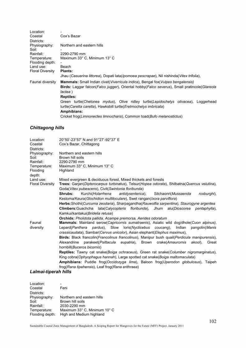
Location: -Coastal Districts:
Cox’s Bazar
Physiography: Northern and eastern hillsSoil: -Rainfall: 2290-2790 mmTemperature: Maximum 33° C, Minimum 13° CFlooding depth: -Land use: BeachFloral Diversity Plants:
Jhau (Casuarina littorea), Dopati lata(Ipomoea pescrapae), Nil nishinda(Vitex trifolia),
Faunal diversity Mammals: Small Indian civet(Viverricula indica), Bengal fox(Vulpes bengalensis)Birds: Laggar falcon(Falco jugger), Oriental hobby(Falco severus), Small pratincole(Glareola lactea )Reptiles:Green turtle(Chelonea mydus), Olive ridley turtle(Lepidochelys olivacea), Loggerhead turtle(Caretta caretta), Hawksbill turtle(Eretmochelys imbricata)Amphibians: Cricket frog(Limnonectes limnocharis), Common toad(Bufo melanostictus)
Chittagong hills
Location: 20°50’-23°57’ N and 91°27’-92°37’ ECoastal Districts:
Cox’s Bazar, Chittagong
Physiography: Northern and eastern hillsSoil: Brown hill soilsRainfall: 2290-2790 mmTemperature: Maximum 33° C, Minimum 13° CFlooding depth:
Highland
Land use: Mixed evergreen & deciduous forest, Mixed thickets and forestsFloral Diversity Trees: Garjan(Dipterocarpus turbinatus), Telsur(Hopea odorata), Shilbatna(Quercus velutina),
Goda(Vitex pubescens), Civit(Swintonia floribunda)Shrubs: Kurchi(Holarrhena antidysenterica), Silchaonri(Mussaenda roxburghi), Kestoma/Keura(Glochidion multiloculare), Swet rangan(Ixora parviflora)Herbs:Shothi(Curcuma zeodaria), Sharpagandha(Rauwolfia sarpentina), Staurogyne argenteaClimbers:Guachcha lata(Calycopteris floribunda), Jhum alu(Dioscorea pentaphylla), Kamkui/kantakui(Bridelia retusa)Orchids: Pholidota pallida, Acampe premorsa, Aerides odoratum
Faunal diversity
Mammals: Mainland serow(Capricornis sumatraenis), Asiatic wild dog/dhole(Cuon alpinus), Lepard(Panthera pardus), Slow loris(Nycticebus coucang), Indian pangolin(Manis crassicaudata), Sambar(Cervus unicolor), Asian elephant(Elephus maximus), Birds: Black francolin(Francolinus francolinus), Manipur bush quail(Perdicula manipurensis), Alexandrine parakeet(Psittacula eupatria), Brown crake(Amaurornis akool), Great hornbill(Buceros bicornis)Reptiles: Tawny cat snake(Boiga ochraceus), Green rat snake(Columber nigromarginatus), King cobra(Ophyophagus hannah), Large spotted cat snake(Boiga maltomaculata)Amphibians: Puddle frog(Occidozyga lima), Baloon frog(Uperodon globulosus), Taipeh frog(Rana tipehensis), Leaf frog(Rana erithraea)
Lalmai-tiperah hills
Location: -Coastal Districts:
Feni
Physiography: Northern and eastern hillsSoil: Brown hill soilsRainfall: 2030-2290 mmTemperature: Maximum 33° C, Minimum 10° CFlooding depth: High and Medium highland
102Sustainable Coastal Zone Management of Bangladesh: A Scoping Report for Mangroves for the Future (MFF) Project. January 2011
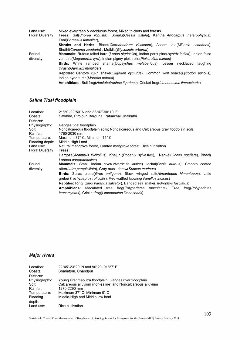
Land use: Mixed evergreen & deciduous forest, Mixed thickets and forestsFloral Diversity Trees: Sal(Shorea robusta), Sonalu(Cassia fistula), Kanthal(Artocarpus heterophyllus),
Taal(Borassus flabelifer), Shrubs and Herbs: Bhant(Clerodendrum viscosum), Assam lata(Mikania scandens), Shothi(Curcuma zeodaria) , Motkila(Glycosmis arborea)
Faunal diversity
Mammals: Rufous tailed hare (Lepus nigricollis), Indian porcupine(Hystrix indica), Indian false vampire(Megaderma lyra), Indian pigmy pipistrelle(Pipistrellus mimus)Birds: White ramped shama(Copsychus malabaricus), Lesser necklaced laughing thrush(Garrulux moniliger)Reptiles: Cantors kukri snake(Oligodon cyclurus), Common wolf snake(Lycodon aulicus), Indian eyed turtle(Morenia petersi)Amphibians: Bull frog(Hoplobatrachus tigerinus), Cricket frog(Limnonectes limnocharis)
Saline Tidal floodplain
Location: 21°50’-22°50’ N and 88°47’-90°10’ ECoastal Districts:
Satkhira, Pirojpur, Barguna, Patuakhali,Jhalkathi
Physiography: Ganges tidal floodplain.Soil: Noncalcareous floodplain soils; Noncalcareous and Calcareous gray floodplain soilsRainfall: 1780-2030 mmTemperature: Maximum 37° C, Minimum 11° CFlooding depth: Middle High LandLand use: Natural mangrove forest, Planted mangrove forest, Rice cultivationFloral Diversity Trees:
Hargoza(Acanthus illicifolius), Khejur (Phoenix sylvestrix), Narikel(Cocos nucifera), Bhadi( Lannea coromandelica)
Faunal diversity
Mammals: Small Indian civet(Viverricula indica) Jackal(Canis aureus), Smooth coated otter(Lutra perspicillata), Gray musk shrew(Suncus murinus)Birds: Sarus crane(Grus antigone), Black winged stilt(Himantopus himantopus), Little grebe(Trachybaptus ruficollis), Red wattled lapwing(Vanellus indicus)Reptiles: Ring lizard(Varanus salvator), Banded sea snake(Hydrophys fasciatus)Amphibians: Maculated tree frog(Polypedates maculatus), Tree frog(Polypedates leucomystax), Cricket frog(Limnonactus limnocharis)
Major rivers
Location: 22°45’-23°20’ N and 90°20’-91°27’ ECoastal Districts:
Shariatpur, Chandpur
Physiography: Young Brahmaputra floodplain, Ganges river floodplainSoil: Calcareous alluvium (non-saline) and Noncalcareous alluviumRainfall: 1270-2290 mmTemperature: Maximum 37° C, Minimum 9° CFlooding depth:
Middle-High and Middle low land
Land use: Rice cultivation
103Sustainable Coastal Zone Management of Bangladesh: A Scoping Report for Mangroves for the Future (MFF) Project. January 2011

Floral Diversity Plants:Binna ghash(Vetiveria zizanioides), Kash(Saccharum spontaneum), Ghagra(Xanthium indicum), Ban palang(Rumex maritimus)
Faunal diversity
Mammals: Ganges river dolphin(Platanista gangetica), Bengal fox(Vulpes bengalensis), Greater Bandicoot rat(Bandicota indica)Birds: River lapwing(Vanellus duvaucelii), Black bellied tern(Sterna acuticauda), Sand lark(Calendrella raytal), Spot billed duck(Anas poecilorhyncha), Small pratincole(Glareola lactea) Reptiles: Bibron’s soft shell turtle(Pelochelys bibroni), Gangetic gharial(Gavialis gangeticus), Ganges softshell turtle(Aspideretes gangeticus), Median roofed turtle(Kachuga tentoria)Amphibians: Jerdon’s bull frog(Hoplobatrachus crassus), Skipper frog(Euphlyctis cyanophlyctis)
Coastal and marine waters
Location: -Coastal Districts:
Cox’s Bazar, Chittagong, Noakhali, Bhola, Barisal, Patuakhali, Barguna, Bagerhat, Khulna, and Satkhira
Physiography: -Soil: -Rainfall: -Temperature: -Flooding depth:
-
Land use: -Floral Diversity N/A
Faunal diversity
Mammals: Irawaddy dolphin(Orcaella brevirostris), Short finned pilot whale(Globicephala macrorhynchas), Melon headed dolphin(Peponocephala electra), Indo-pacific hump-backed dolphin(Sousa chinensis)Birds: Lagger falcon(Falco jugger), Oriental hobby(Falco severus), Small pratincole(Glareola lactea)Reptiles:Green turtle(Chelonea mydus), Olive ridley turtle(Lepidochelys olivacea), Loggerhead turtle(Caretta caretta), Hawksbill turtle(Eretmochelys imbricata)Amphibians: Cricket frog(Limnonectes limnocharis) , Common toad(Bufo melanoatictus)
Annex 3: Legal basis of protected areas
Reserved Forest
The Forest Act, 1927 (Act No. XVI of 1927): An Act to consolidate the law relating to forests, the transit of forest-produce and the duty leviable on timber and other forest-produceClause 3 of The Forest Act provides the power to reserve forest. - The Government may constitute any forestland or wasteland or any land suitable for afforestation which is the property of Government, or over which the Government has proprietary rights, or the whole
104Sustainable Coastal Zone Management of Bangladesh: A Scoping Report for Mangroves for the Future (MFF) Project. January 2011
or any part of the forest-product of which the Government is entitled, a reserved forest in the manner hereinafter provided.Clause 26 of The Forest Act mentions prohibitions and allowed acts in the reserve forest as follows; Acts prohibited in such forests.- (l) Any person who, in a reserved forest- (a) kindles, keeps or carries any fire except at such seasons as the Forest-officer may notify in this behalf; (b) trespasses or pastures cattle, or permits cattle to trespass; (c) causes any damage by negligence in felling any tree or cutting or dragging any timber; (d) quarries stone, burns lime or charcoal, or collects, subjects to any manufacturing process, or removes, any forest produce other than timber; or who enters a reserved forest with fire arms without prior permission from the Divisional Forest officer concerned, shall be punishable with imprisonment for a term which may extend to six months and shall also be liable to fine which may extend to two thousand taka, in addition to such compensation for damage done to the forest as the convicting Court may direct to be paid. (IA) Any person who- (a) makes any fresh clearing prohibited by section 5; or (b) removes any timber from a reserved forest; or(c) sets fire to a reserved forest, of, in contravention of any rules made by the Government in this behalf, kindles any fire, or leaves any fire burning, in such manner as to endanger such a forest; or who, in a reserved forest- (d) fells, girdles, lops, tops or bums any tree or strips off the bark or leaves from, or otherwise damages, the same; (e) clears or breaks up any land for cultivation or any other purpose; (f) in contravention of any rules made in this behalf by the Government, hunts, shoots, fishes, poisons water or sets traps or snares; or (g) establishes saw-pits or saw-benches or converts trees into timber without lawful authority; shall be punishable with imprisonment for a term which may extend to five years and shall not be less than six months, and shall also be liable to fine which may extend to fifty thousand taka and shall not be less than five thousand taka, in addition to such compensation for damage done to the forest as the convicting Court may direct to be paid. (2) Nothing in this section shall be deemed to prohibit- (a) any act done by permission in writing of the Forest-officer or under any rule made by the Government, or (b) the exercise of any right continued under clause (c) of sub-section (2) of section 15, or created by grant or contract in writing made by or on behalf of the Government under section 23. 3) Whenever fire is caused willfully or by gross negligence in a reserved forest, the Government may (notwithstanding that any penalty has been inflicted under this section) direct that in such forest or any portion thereof the existence of all rights of pasture or to forest-produce shall be suspended for such period as it thinks fit.
Wildlife sanctuary
Bangladesh Wildlife (Preservation) order, 1973 (P.O No. 23 of 1973) defines wild life sanctuaries under clause No. 2 (p) which states that ‘wild life sanctuary means an area closed to hunting, shooting or trapping of wild animals and declared as such under Article 23 by the Government as undisturbed breeding ground primarily for the protection of wild life inclusive of all natural resources, such as vegetation, soil and water’ (Mohiuddin and Rezwana, 1996).Under Section 23 of (1) & (2) of Bangladesh Wildlife (Preservation) order, 1973 (P.O No. 23 of 1973) acts are indicated accordingly,
105Sustainable Coastal Zone Management of Bangladesh: A Scoping Report for Mangroves for the Future (MFF) Project. January 2011
(1) The Government may, by notification in the official Gazette, declare any area to be wild life sanctuary (2) No person shall – - Enter or reside in any wild life sanctuary or cultivate any land in any wild life sanctuary or damage or destroy any vegetation in any wild life sanctuary or hunt, kill or capture any wild animal in any wild life sanctuary or within one mile from the boundaries of wild life sanctuary or introduce any exotic species of animal into a wild life sanctuary or introduce any domestic animal or allow any domestic animal to stray into a wild life sanctuary or cause any fire in a wild life sanctuary or pollute water flowing in through a wild life sanctuary. Provided that Government may, for scientific purposes or for aesthetic enjoyment or betterment of scenery, relax all or any of the prohibitions specified above.
National Park
“National Park means comparatively large areas of outstanding scenic and natural beauty with the primary object of protection and preservation of scenery, flora and fauna in the natural state to which access for public recreation and education and research may be allowed”. Under Section 23 of clause (3) Bangladesh Wildlife (Preservation) order, 1973 (P.O No. 23 of 1973)The Government may, declare any area to be a national park where the following acts shall not be allowed, namely-
• Hunting, killing or capturing any wild animal in a national park and within the radius of one mile outside its boundary;
• Firing any gun or doing any other act which may disturb any wild animal or doing any act which may interfere with the breeding places of any wild animal;
• Feeling, tapping, burning or in any way damaging or destroying, taking, collecting or removing any plant or tree there from;
• Clearing or breaking up any land for cultivation, mining or for any other purpose;
• Polluting water flowing in and through the national park:
Provided that the Government may, for scientific purposes or for betterment of the national park or for aesthetic enjoyment of scenery or for any other exceptional reasons, relax all or any of the prohibition specified above.
Ecologically Critical Area (ECA)
The Government of Bangladesh has become convinced that the ecosystems of certain areas of the country are under threat and if not taken appropriate measure might loose the integrity and the natural system could be in danger. In order to conserve the nature, enhance the environment, control and mitigate pollution and for sustainable environmental management, the GOB under the provision of the Environment Conservation Act 1995, declares certain areas as ECA.Following activities are banned in the ECAs:
• Natural forest and trees felling and harvesting
• Wild life killing or game
• Catching or collection of corals, bivalves, turtles and other wild life
• Destruction or creation of habitats for flora and fauna
• Any activities that relate to destruction of natural characteristics of land and water
106Sustainable Coastal Zone Management of Bangladesh: A Scoping Report for Mangroves for the Future (MFF) Project. January 2011

• Establishment of industries that might pollute the land, water, air and make sound pollution
• Any activity that might harm fish and other aquatic lives
Marine Reserve
Bangladesh Government has declared an area of 204 sq nautical mile of the fishing ground of the south patches and the middle ground as marine reserve under the Section – 28 of Part – 8 of MarineFisheries Ordinance / 1983 (Ordinance Number 35, 1983) by S.R.O. No. 327 in 29/10/2000 to provide safe breeding ground for fisheries and shrimps inside Bangladesh territory to conserve and develop marine fisheries resources.
Fish Sanctuaries
The national Fisheries policy (1998) proposed that sanctuaries be established in suitable water bodies. Besides the reservation of areas for fish sanctuary as special areas there are also provisions of declaring certain critical fish habitat areas as special areas and maintained a closure for certain fish breeding seasons of the area.
Ramsar site
"Wetlands should be selected for the List [of Wetlands of International Importance] on account of their international significance in terms of ecology, botany, zoology, limnology or hydrology" and indicates that "in the first instance, wetlands of international importance to waterfowl at any season should be included".To facilitate the implementation of this provision, the Conference of the Parties has developed criteria to assist in the identification of wetlands of international importance. The latest version of the Criteria was adopted by the 7th meeting of the Conference of the Contracting Parties in 1999.
Group A of the Criteria . Sites containing representative, rare or unique wetland typesCriterion 1: A wetland should be considered internationally important if it contains a representative, rare, or unique example of a natural or near-natural wetland type found within the appropriate biogeographic region.
Group B of the Criteria . Sites of international importance for conserving biological diversityCriteria based on species and ecological communitiesCriterion 2: A wetland should be considered internationally important if it supports vulnerable, endangered, or critically endangered species or threatened ecological communities.Criterion 3: A wetland should be considered internationally important if it supports populations of plant and/or animal species important for maintaining the biological diversity of a particular biogeographic region.Criterion 4: A wetland should be considered internationally important if it supports plant and/or animal species at a critical stage in their life cycles, or provides refuge during adverse conditions.Specific criteria based on water birds
107Sustainable Coastal Zone Management of Bangladesh: A Scoping Report for Mangroves for the Future (MFF) Project. January 2011
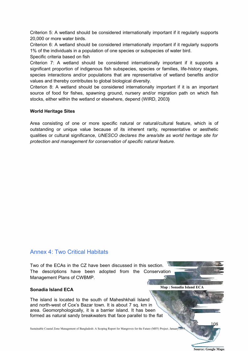
Criterion 5: A wetland should be considered internationally important if it regularly supports 20,000 or more water birds.Criterion 6: A wetland should be considered internationally important if it regularly supports 1% of the individuals in a population of one species or subspecies of water bird.Specific criteria based on fishCriterion 7: A wetland should be considered internationally important if it supports a significant proportion of indigenous fish subspecies, species or families, life-history stages, species interactions and/or populations that are representative of wetland benefits and/or values and thereby contributes to global biological diversity.Criterion 8: A wetland should be considered internationally important if it is an important source of food for fishes, spawning ground, nursery and/or migration path on which fish stocks, either within the wetland or elsewhere, depend (WIRD, 2003)
World Heritage Sites
Area consisting of one or more specific natural or natural/cultural feature, which is of outstanding or unique value because of its inherent rarity, representative or aesthetic qualities or cultural significance, UNESCO declares the area/site as world heritage site for protection and management for conservation of specific natural feature.
Annex 4: Two Critical Habitats
Two of the ECAs in the CZ have been discussed in this section. The descriptions have been adopted from the Conservation Management Plans of CWBMP.
Sonadia Island ECA
The island is located to the south of Maheshkhali Island and north-west of Cox’s Bazar town. It is about 7 sq. km in area. Geomorphologically, it is a barrier island. It has been formed as natural sandy breakwaters that face parallel to the flat
108Sustainable Coastal Zone Management of Bangladesh: A Scoping Report for Mangroves for the Future (MFF) Project. January 2011
Map : Sonadia Island ECA
Source: Google Maps
coastlines of Maheshkhali Island. Consisting of gently sloping low-lying coast unprotected from the sea by cliffs facing the ocean, it is the ideal site for such barrier island formation. In the east, a small channel a few meters wide separates Sonadia from Maheshkhali Island, while to the west shallow bays separate it by a few kilometers from the mainland. A sandy ridge extends along the island’s length from north-west to south east. Winds and waves are the major forces determining the features of the dunes. Two dune ridges are recognized, one known as “Barchar” and the other, “Maghchar”, covering a relatively smaller area.
Climate: The National Conservation Strategy Implementation Project-1 (NCSIP-1) Survey of Fauna (MoEF, 2001b) describes the climate as moist tropical maritime with high rainfall concentrated during the monsoon (usually June-September) and a dry period of 4-5 months. Average annual rainfall for the nearest administrative headquarter Cox’s Bazar for 1987-1996 varied from 2,867 mm to 4,684 mm. The temperature remains high year-round with small seasonal differences – the mean annual maximum and minimum temperatures recorded at Cox’s Bazar for 1987-1996 were 30.3ºC – 33.0ºC and 19.3ºC-22.4ºC respectively. Humidity remains relatively high throughout the year; it averaged 79.7% at Cox’s Bazar for 1987-1996. From November-February the prevailing winds are from the north-west, from March-May from the south-west and from June-September from the south-east. Access to the site is limited during the rainy season to those times when the channel isn’t rough. The site is particularly susceptible to cyclones and tidal surges. Cyclonic storms develop in the Bay, generally in April-May and October-November, occasionally coming to shore and causing severe damage to human settlements and vegetation.Geology: The quaternary of the coastal plain is described as a complex of various sediments including old sand beach, old calcareous corals, silty clay, acid-sulphate clays and alluvial deposits.Soils: Sonadia Island consists of 30% sandy soil (including sand dunes), 30% sandy loam and 40% muddy soils (the intertidal zone, which is subject to continuous siltation). The depth of mud varies from a few centimetres to a few metres.Topography: Sonadia Island is a gently sloping low-lying barrier island with an altitude range of 0-4 metres. The extremely low altitude of the site is a very important conservation management consideration as the Island in particular is subject to flooding during tidal surges, and is therefore very vulnerable to sea level rises.Habitat Diversity: Sonadia Island provides diverse habitat that supports three different vegetation types—sand dunes, salt marshes and mangroves. Unspoiled sandy beaches and extensive shallow sand bars provide important feeding, roosting and nesting ground for a number of resident and migratory shorebirds.Plant diversity: The vegetation of the sand dune consists of 35 species of angiosperm, in particular Ipomea pescapre, Vitex trifolia, Ziziphus mauritania Clerodendrum inerme, Bhat Pandanus odoratissimus and Calotropis gigantia. The salt marsh vegetation consists of Porteresia coarctata and Myristichia wighthenia. The mangrove vegetation consists of 27 species. Common among them are Avicennia officinalis, Avicennia marina, Avicennia alba, Sonneratia apetala, Aegicerus corniculatum, Ceriops decandra and Aegialitis rotundifolia.The mangrove vegetation consists of plants with higher salt tolerance than any other mangrove species occurring in other parts of the country, including the Sundarban. Unlike mangroves of theSundarban, Nypa fruiticans, Heritiera fomes are completely absent in Sonadia . Sonneratia griffithii, which was once common in the Chakaria Sundarban, including Sonadia Island, can no longer be seen in any other mangrove areas in Bangladesh. Homestead vegetation: In sonadia there are two cluster of setelment, popularly known as West para and east para. So, Sonadia Island can be recognizing as the two large homesteads. These are well decorated by homestead plants. A survey by the PBMS in the homestead ecosystem of the island found 91 plant species where 17 was fruits, 10 was medicinal, 17 were timbers and 24 was vegetables. Two invasive alien species, Ipomea carnea and Lantana camara are known to occur at the site. Ipomea occurs mostly in the
109Sustainable Coastal Zone Management of Bangladesh: A Scoping Report for Mangroves for the Future (MFF) Project. January 2011

Threats to Sonadia Island ECA01. Illegal capture of mangrove area by strong hold and destruction for shrimp culture and salt pan. 02. Leasing of mangrove area by the district administration for shrimp culture. 03. Fuel wood collection from the mangrove forest by the community. 04. Shrimp fry collection by the push net damage the planted & regenerated seedling of mangrove. 05. Cattle grazing in the mangrove seedling planted & regenerated area and damaging the seedling. 06. Negative attitude/action of district administration about mangrove. 07. Lake of knowledge of the community people regarding the importance of mangrove forest. 08. Lack of sufficient manpower in the coastal forest department for guarding and monitoring in forest. 09. Dishonest employees of coastal forest department help the strong hold to destroy the mangrove forest. 10. High population as well as growth rate and increasing need of shrimp, salt & fuel wood.
homestead areas of Ghotivanga where it is used for fencing and, to a lesser extent, fuelwood. Lantana is present on Sonadia Island.Faunal Diversity: Although the island is small in size, due to high diversity, species richness of the island is high. About 70 species of water-birds come there for resting, roosting, feeding, wintering and to use the island as a staging ground during their migration. The island is also very rich in mollusks and echinoderms. Three marine turtles—Olive Ridley turtle, Loggerhead, and green turtle—nest on the island’s unspoiled beach area.Infrastructure: The site has just over 2000 household dwellings, most of which are located in Ghotivanga. There is one concrete Village Resource Centre in Sonadia West village, one concrete cyclone shelter/primary school at Sonadia East village and a mosque in each of the villages. In Ghotivanga there are two cyclone shelters, a primary school, the Ghotivanga Union headquarters building and a dirt (katcha) road (Ghorokghata Road) that runs adjacent to an embankment. There is one dirt road of approximately four kilometres in length crossing the site from north to south, i.e. from Ghotivanga to the cyclone shelter at Sonadia East.Suitability for research: The site is suitable for research as it is relatively unpopulated and not highly visited; however no research or other facilities are available. The site is particularly suitable for research into globally and nationally endangered species like Porteresia coarctata - a salt-tolerant wild grass relative of rice. The mangrove, which has developed under extreme ecological conditions compared to other mangroves of Bangladesh, is also important for scientific research purposes. There appears to be a high degree of adaptation of marine species to estuarine and freshwater conditions, which is another interesting area for academic investigation.Global Conservation Significance: Bangladesh is bestowed with one of the largest compact patches of mangrove forest in the world, known as the Sundarbans. This forest is situated in the southwest region of the country. However, compared with the Sundarbans, the dominant plants in Sonadia’s mangrove forest are different. While the Sundarbans and the Chakaria Sundarban have developed in a deltaic formation, the mangroves of Sonadia Island have developed in a lagoonal coastal setting. Sonadia’s mangroves are thus more tolerant to salinity than their Sundarbans counterparts. Distinctiveness of the dominant plants of this forest has been attributed to the extreme ecological factors—high contents of salt in the soil and water, etc. Mangroves once occupied the entire coast of Chittagong and Cox’s Bazar. Chakaria Sundarban, one of the oldest mangroves, developed in the delta of the Matamuhuri river These forests, along with the forest in other parts of the coast, have been converted to agricultural land, shrimp culture, salt ponds and for human settlements. The process is still ongoing. Mangroves in Sonadia Island are the only natural mangrove left in the south-eastern portion of the country.Porteresia coarctata (Roxb) Tateoka, formerly classified as Oryza coarctata , a wild relative of rice, is native to the coastal saline areas of Bangladesh and eastern India. More recently, the species has gained considerable attention among the international scientific community due to its high level of tolerance for salinity. It could therefore be a source of genes for salt tolerance to transfer into cultivable rice. Due to high genetic variability in different ecological conditions, Swaminathon Institute has expressed concern to preserve different land races of the species before they become extinct. The plant population of Porteresia at Sonadia
110Sustainable Coastal Zone Management of Bangladesh: A Scoping Report for Mangroves for the Future (MFF) Project. January 2011
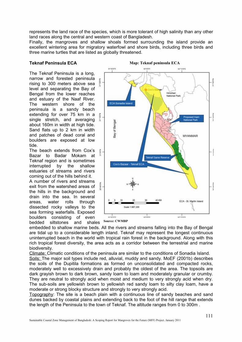
represents the land race of the species, which is more tolerant of high salinity than any other land races along the central and western coast of Bangladesh.Finally, the mangroves and shallow shoals formed surrounding the island provide an excellent wintering area for migratory waterfowl and shore birds, including three birds and three marine turtles that are listed as globally threatened.
Teknaf Peninsula ECA
The Teknaf Peninsula is a long, narrow and forested peninsula rising to 300 meters above sea level and separating the Bay of Bengal from the lower reaches and estuary of the Naaf River. The western shore of the peninsula is a sandy beach extending for over 75 km in a single stretch, and averaging about 160m in width at high tide. Sand flats up to 2 km in width and patches of dead coral and boulders are exposed at low tide.The beach extends from Cox’s Bazar to Badar Mokam at Teknaf region and is sometimes interrupted by the shallow estuaries of streams and rivers coming out of the hills behind it. A number of rivers and streams exit from the watershed areas of the hills in the background and drain into the sea. In several areas, water rolls through dissected rocky valleys to the sea forming waterfalls. Exposed boulders consisting of even bedded siltstones and shales embedded to shallow marine beds. All the rivers and streams falling into the Bay of Bengal are tidal up to a considerable length inland. Teknaf may represent the longest continuous uninterrupted beach in the world with tropical rain forest in the background. Along with this rich tropical forest diversity, the area acts as a corridor between the terrestrial and marine biodiversity.Climate: Climatic conditions of the peninsula are similar to the conditions of Sonadia Island.Soils: The major soil types include red, alluvial, muddy and sandy. MoEF (2001b) describes the soils of the Dupitila formations as formed on unconsolidated and compacted rocks, moderately well to excessively drain and probably the oldest of the area. The topsoils are dark grayish brown to dark brown, sandy loam to loam and moderately granular or crumby. They are neutral to strongly acid when moist and medium to very strongly acid when dry. The sub-soils are yellowish brown to yellowish red sandy loam to silty clay loam, have a moderate or strong blocky structure and strongly to very strongly acid.Topography: The site is a beach plain with a continuous line of sandy beaches and sand dunes backed by coastal plains and extending back to the foot of the hill range that extends the length of the Peninsula to the town of Teknaf. The altitude ranges from 0 to 300m .
111Sustainable Coastal Zone Management of Bangladesh: A Scoping Report for Mangroves for the Future (MFF) Project. January 2011
Source: CWMBP
Map: Teknaf peninsula ECA
Threats to biodiversity in Teknaf Peninsula ECA
1. Degradation of Sand dune habitat2. Land degradation and Beach Erosion3. Decreasing of homesteads plant biodiversity4. Degradation due to modern cultivation5. Degradation of Mangrove habitat6. Bottle necks to Mangrove regeneration
Habitat diversity: The coastal zone and the near shore areas of Teknaf Peninsula beach, consist of diverse habitats in their natural condition, Sand dunes and beaches, Mudflats, Mangrove patch, Estuaries, Homestead area, agricultural field and Rocky intertidal areas.Plant diversity: The coastal vegetation along the peninsular beach is represented by sand dune vegetation. The succession sequence of strand vegetation of the tropical coast is discernable in some areas. But, in most cases the seral communities are deflected due to intense human disturbance. The vegetation of the dunes consists of 35 species of Angiosperm, including 26 dicots and 9 monocots. lpomoea pes-capre (Chagal-kuri) lpomoea sp. Leucas aspera (Shetodron) Clerodendrum viscosum (Budding) Argyreia nervosa (Bijtarak) are the common creeping plants that act as sand binders in the primary dunes. The grasses in these dunes include Cynodon dactylon (Durba) Cynodon sp. (Narichha) Paspalum scrobiculatum (Goicha), Paspalum vaginatum. The mature inland dunes consist of trees and shrubs. The common plants found are Phyllanthus reticulatus (Panseuli), Cassia tora ( ) Clerodendrum inure (Bhat), Vitex trifolia (Nil-nishinda), Ziziphus mauritania (Baroi), Casuarina equisetifolia (Jhao), Streblus aspera (Sheora) Vitex pubescens (Goda) and Pandanus odoratissimus ( Kea).Invasive alien species known to occur within the site include Mimosa pudica, Ipomea carnea, Lantana camara, Mikania cordata and Eichornia crassipes (water hyacinth).Faunal diversity: The area is important for a wide variety of waterfowl and shorebirds. The project’s wildlife specialist reports more than 200 species of birds which are common residents, including Amaurornis phoenicurus White-breasted Waterhen, Anhinga melanogaster Darter/ Snake bird, Ardea cinerea Grey heron, Dendrocygna javanica Lesser Whistling Teal, Egretta alba Large Egret, Egretta gularis, Gallicrex cinerea Water Cock, Gelochelidon nilotica Gull-billed Tern, Ixobrychus flavicollis Black Bittern, Glareola maldivarum Small Indian Pratincole, Himantopus himantopus Black-winged stilt , lxobrychus cinnamomeus Chestnut Bittern , Metopidius indicus Bronze-winged Jacana, Nettapus coromandelianus Cotton Teal, Phalacrocorax niger Little Cormorant, Porphyrio porphyrio Moorhen, Porzana fusca Ruddy Crake, Rallus aquaticus Water Rail, Sterna albifrons Little Tern, Sterna aurantia Indian River Tern, Tachybaptus ruficollis, Little Grebe, Vanellus malabaricus, Yellow-wattled Lapwing, Vanellus indicus Red-wattled Lapwing, Vanellus spinosus Spur-winged Lapwing. Several pairs of the Leptoptilos javanicus (Lesser Adjutant) also been recorded from the area.Common migrants and winter visitors include Anas acuta Pintail, Pluvialis dominica Eastern Golden Plover, Charadrius dubius Little -Ringed Plover, Charadrius alexandrinus Kentish Plover, Charadrius hiaticula Ringed Plover, Charadrius mongolus Mongolian Plover, Numenius phaeopus Whimbrel, Numenius arquata Curlew, Tringa totanus Common Redshank, Tringa nebularia Greenshank, Gallinago stenura Pintail Snipe, Gallinago gallinago Common Snipe, Calidris alba Sanderling, Chlidonias hybrida Whiskered Tern, Larus ridibundus Black-headed Gull, Philomachus pugnax Ruff / Reeve and Sterna hirundo Common Tern. Large numbers of Open-bill Storks Anastomus oscitans occur on migration and flocks of up to several hundred birds have been recorded. Other migrants and winter visitors recorded in small numbers include Threskiornis melanocephalus White Ibis, Pseudibis papillosa, Anser indicus Bar-headed Goose, Anser anser Grey-Lag Goose, Haematopus ostralegus Oyster Catcher, Tringa stagnatilis Marsh Sandpiper, Calidris tenuirostris Eastern Knot, Larus ichthyaetus Great Black-headed Gull, Larus brunnicephalus Brown-headed Gull and Larus cachinnans Yellow-legged Gull, Limnodromus semipalmatus Asian Dowitcher, and Tringa guttifer Nordmann's Greenshank. Birds of Prey include Haliaeetus leucogaster White-bellied Sea-Eagle.The coastal beach is an important nesting site for at least four species of marine turtles. These are
112Sustainable Coastal Zone Management of Bangladesh: A Scoping Report for Mangroves for the Future (MFF) Project. January 2011
Caretta caretta Loggerhead, Chelonia mydas Green Turtle, Eretmochelys imbricata Hawksbill Turtle, Lepidochelys olivacea Olive Ridley. Important terrestrial mammal species include Asian or Golden Jackal Canis aureus; Vulpes bengalensis Bengal Fox; Neofelis nebulosa Clouded leopard; Felis chaus Jungle Cat, Leopard Cat Prionailurus bengalensis. All occur in the contiguous hills and prey on animals on the beach. Prionailurus viverrinus Fishing Cat, Aonyx cinerea Oriental Small Clawed Otter, Lutra perspicillata Smooth-coated Otter are found in the hill streams and their estuaries.Global Biodiversity Significance: As noted above, the coastal beach area is an important nesting site for at least four species of marine turtles listed as globally threatened by IUCN. These are Chelonia mydas Green Turtle, Eretmochelys imbricata Hawksbill Turtle, Lepidochelys olivacea Olive Ridley; and Dermochelys coraicea Leatherback turtle. Presence of Caretta caretta Loggerhead is doubtful. Besides, the area is used as corridor for movement by a number of terrestrial mammals of the tropical evergreen forest. The important species include Vulpes bengalensis Bengal Fox, Catopuma temmincki Asiatic Golden Cat, Neofelis nebulosa Clouded Leopard, Prionailurus viverrinus Fishing Cat, Aonyx cinerea Oriental Small-clawed Otter, Lutra perspicillata Smooth-coated Otter. Capped Langur Trachypithecus pileata, Rhesus Macaque Macaca mulatta, Large Indian Civet Viverra zibetha, Himlayan Palm Civet Paguma larvata , Binturong Arctictis binturong, etc. The sandy tidal flats and lagoons also support a number of globally threatened shorebirds that include Limnodromus semiplamatus Asian Dowitcher, Tringa guttifer Nordmann's Greenshank, and Leptoptilos javanicus Lesser Adjutant. All are listed as globally threatened species.
Annex 5: Offices of different government agencies at the upazilla level of the CZ
S.L No. Name of the Office or Department / Head of the Office
1. Upazila Nirbahi Office / UNO
2. Upazila Engineering Office /UE
3. Upazila Primary Education Office
4. Upazila Secondary Education Office /UEO
5. Upazila Fisheries Office /UFO
6. Upazila Livestock Office / ULO
7. Upazila BRDB Office / URDO
8. Upazila Relief & Rehabilitation Office / URRO
113Sustainable Coastal Zone Management of Bangladesh: A Scoping Report for Mangroves for the Future (MFF) Project. January 2011
9. Upazila Samaj Sheba (Social Services) Office
10. Upazila Agriculture Office /UAO
11. Upazila Cooperative Office /UCO
12. Upazila Statistics Office / USO
13. Upazila Health & Family Planning Office
14. Public Health Engineering Office
15. Youth Development Office
16. Bangladesh Agricultural Development Corporation - BADC (Seeds)
17. Bangladesh Agricultural Development Corporation - BADC (Fertilizer)
18. Total Literacy Movement (TLM)
19. Upazila Police / OC
20. Upazila Land Office / AC Land
21. Upazila Ansar-VDP
22. Upazila Food Office
23. Upazila Education Engineering Office
24. Upazila Account Office (Non-existent at Sadar Upazila) Source: PDO-ICZMP
Annex 6: Coverage of NGOs in CZ
NGO activities are prevalent in all the coastal districts. Chittagong has the highest number of NGOs (83), closely followed by Khulna (78), Jessore (71) and Barisal (64), while Shariatpur and Feni are covered by the lowest number of NGOs (14 each) followed by Jhalakati (15). Among the NGOs that work exclusively in rural areas, highest numbers are involved in water and sanitation (53%), closely followed by environment and social forestry (51%), fisheries (49%) and credit (48%). Among the urban NGOs (with no rural coverage), the highest number of them works in the field of AIDS prevention (12%), followed by programs on street children (9%), health and nutrition and programs on adolescent children (8% each). Among the NGOs with activities both in rural and urban areas, the highest number of them has programs in the field of training (42%), followed by women’s development (38%) and credit (36%). Many NGOs operate in the coastal districts. However, not many NGOs are present in the most exposed coastal zone that is, in the chars and islands. People in those areas have distinctive vulnerabilities as they live with recurrent disasters (cyclones and erosion) and are deprived of basic services (because of isolation). Among those who work exclusively
114Sustainable Coastal Zone Management of Bangladesh: A Scoping Report for Mangroves for the Future (MFF) Project. January 2011
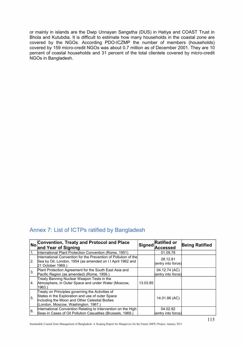
or mainly in islands are the Dwip Unnayan Sangstha (DUS) in Hatiya and COAST Trust in Bhola and Kutubdia. It is difficult to estimate how many households in the coastal zone are covered by the NGOs. According PDO-ICZMP the number of members (households) covered by 159 micro-credit NGOs was about 0.7 million as of December 2001. They are 10 percent of coastal households and 31 percent of the total clientele covered by micro-credit NGOs in Bangladesh.
Annex 7: List of ICTPs ratified by Bangladesh
NoConvention, Treaty and Protocol and Place and Year of Signing
SignedRatified or Accessed
Being Ratified
1. International Plant Protection Convention (Rome, 1951) 01.09.78
2.International Convention for the Prevention of Pollution of the Sea by Oil, London, 1954 (as amended on I I April 1962 and 21 October 1969.)
28.12.81
(entry into force)
3.Plant Protection Agreement for the South East Asia and Pacific Region (as amended) (Rome, 1956.)
04.12.74 (AC)
(entry into force)
4.Treaty Banning Nuclear Weapon Tests in theAtmosphere, in Outer Space and under Water (Moscow, 1963.)
13.03.85
5.
Treaty on Principles governing the Activities ofStates in the Exploration and use of outer SpaceIncluding the Moon and Other Celestial Bodies(London, Moscow, Washington, 1967.)
14.01.86 (AC)
6.International Convention Relating to Intervention on the High Seas in Cases of Oil Pollution Casualties (Brussels, 1969.)
04.02.82
(entry into force)
115Sustainable Coastal Zone Management of Bangladesh: A Scoping Report for Mangroves for the Future (MFF) Project. January 2011
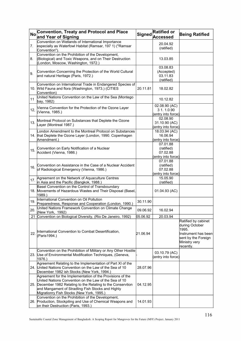
NoConvention, Treaty and Protocol and Place and Year of Signing
SignedRatified or Accessed
Being Ratified
7.Convention on Wetlands of International Importance especially as Waterfowl Habitat (Ramsar, 197 1) ("Ramsar Convention").
20.04.92(ratified)
8.Convention on the Prohibition of the Development, (Biological) and Toxic Weapons, and on Their Destruction (London, Moscow, Washington, 1972.)
13.03.85
9.Convention Concerning the Protection of the World Cultural and natural Heritage (Paris, 1972.)
03.08.83(Accepted)03.11.83(ratified)
10.Convention on International Trade in Endangered Species of Wild Fauna and flora (Washington, 1973.) (CITIES Convention)
20.11.81 18.02.82
11United Nations Convention on the Law of the Sea (Montego bay, 1982)
10.12.82
12,Vienna Convention for the Protection of the Ozone Layer (Vienna, 1985.)
02.08.90 (AC)
3 1. 1.0.90(entry into force)
13.Montreal Protocol on Substances that Deplete the Ozone Layer (Montreal 1987.)
02.08.90
31.10.90 (AC)(entry into force)
14.London Amendment to the Montreal Protocol on Substances that Deplete the Ozone Layer (London, 1990. Copenhagen Amendment.)
18.03.94 (AC)
16.06.94(entry into force)
15.Convention on Early Notification of a NuclearAccident (Vienna, 1986.)
07.01.88(ratified)07.02.88
(entry into force)
16.Convention on Assistance in the Case of a Nuclear Accident of Radiological Emergency (Vienna, 1986.)
07.01.88(ratified)07.02.88
(entry into force)
17.Agreement on the Network of Aquaculture Centres in Asia and the Pacific (Bangkok, 1988.)
15.05.90(ratified)
18.Basel Convention on the Control of Transboundary Movements of Hazardous Wastes and Their Disposal (Basel, 1989.)
01.04.93 (AC)
19.International Convention on Oil PollutionPreparedness, Response and Cooperation (London, 1990.)
30.11.90
20.United Nations Framework Convention on Climate Change (New York, 1992)
09.06.92 16.02.94
21 Convention on Biological Diversity, (Rio De Janeiro, 1992) 05.06.92 20.03.94
22.International Convention to Combat Desertification, (Paris1994.)
21.06.94
Ratified by cabinet during October 1995.Instrument has been sent by the Foreign Ministry very recently.
23.Convention on the Prohibition of Military or Any Other Hostile Use of Environmental Modification Techniques, (Geneva, 1976.)
-03.10.79 (AC)
(entry into force)
24.Agreement Relating to the Implementation of Part XI of the United Nations Convention on the Law of the Sea of 10 December 1982 ish Stocks (New York, 1994.)
28.07.96
25.
Agreement for the Implementation of the Provisions of the United Nations Convention on the Law of the Sea of 10 December 1982 Relating to the Relating to the Conservtion and Mangament of Stradling Fish Stocks and Highly Migrationry Fish Stocks (New York, 1995.)
04.12.95
26.Convention on the Prohibition of the Development, Production, Stockpiling and Use of Chemical Weapons and on their Destruction (Paris, 1993.)
14.01.93
116Sustainable Coastal Zone Management of Bangladesh: A Scoping Report for Mangroves for the Future (MFF) Project. January 2011
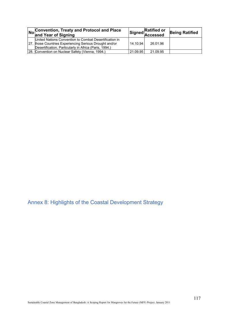
NoConvention, Treaty and Protocol and Place and Year of Signing
SignedRatified or Accessed
Being Ratified
27.United Nations Convention to Combat Desertification in those Countries Experiencing Serious Drought and/or Desertification, Particularly in Africa (Paris, 1994.)
14.10.94 26.01.96
28. Convention on Nuclear Safety (Vienna, 1994.) 21.09.95 21.09.95
Annex 8: Highlights of the Coastal Development Strategy
117Sustainable Coastal Zone Management of Bangladesh: A Scoping Report for Mangroves for the Future (MFF) Project. January 2011
The CDS planning horizon for specific actions/interventions is 5 years that fits into the PRSP Policy, Agenda (FY 05-07) and (FY 08-10).
The CDS does not represent one overall framework and recipe for all development actions for the whole of coast. It is a targeted process and the targeting is identified with respect to: Regions (islands and chars, exposed coastal zone / districts; high tsunami risk area; South-West region);Disadvantaged groups (erosion victims, women and children, fisher and small farmers);Issues (shrimp culture, land zoning; groundwater management, climate change); and Opportunities (tourism, renewable energy, marine fisheries)
Nine strategic priorities, evolved through a consultation process, guides interventions and investments in the coastal zone:Ensuring fresh and safe water availabilitySafety from man-made and natural hazardsOptimizing use of coastal landsPromoting economic growth emphasizing non-farm rural employmentSustainable management of natural resources: exploiting untapped and less explored opportunitiesImproving livelihood conditions of people; especially womenEnvironmental conservationEmpowerment through knowledge managementCreating an enabling institutional environment
Implementation of these strategic priorities contributes to poverty reduction strategy nationally and achievement of Millennium Development Goals globally.
The three equally important routes in implementing strategic priorities are mainstreaming, investments and governance.
Mainstreaming focuses on the planning efforts at national level and the approaches by line agencies. In addition, mainstreaming addresses cross-cutting national issues (like gender, urbanization), supporting multi-sectoral regional studies and maintaining existing or new partnerships.
Investment program relates to both public and private sectors. Each of nine strategic priorities are translated into 2-5 investment projects, packaged in a Priority Investment Program (PIP). Private Sector investments are key to coastal development: creating employment and services. Implementation of the CDS will create a conducive investment climate in line with ’Bangladesh Private Sector Infrastructure Guidelines 2004’ for developing less explored and untapped resources by linking these to existing Facility funds. A structured approach to investment and financing is taken through such instruments as national budget, local resources mobilization, private sector investment and proposed special funds like ‘Coastal Environment and Development Facility’ and ‘Coastal Disaster Preparedness and Emergency Mitigation Fund’.
Governance focuses on three aspects: a) institutional developments, b) legal frameworks and c) assessments. An enabling environment of ‘governance’, is sought to be created based on models of good practices, to implement the multi-sector and mainstreaming actions.
An institutional framework consisting of bodies from national to upazilla level to coordinate and enhance coastal development is proposed. It consists of a Programme Coordinating Unit (PCU), an Inter-ministerial Steering Committee, Technical Committee, Task forces, Focal points, Liason Points at the district level, 19 District Development Coordinating Committee (DDCC), and 147 Upazilla Development Coordinating Committee (UDCC).
Participation of NGOs, CBOs and other stakeholders, as partners, is promoted.
Legal Framework. Giving emphasis on enforcement and capacity building of enforcing agencies. It suggests the assessment of the need for an umbrella Coastal Zone Regulations in line with similar regulations in India, USA and other countries.
It claims assessment of CZ developments on a regular basis against the development objectives formulated in the CZPo and this CDS. This includes information on the inputs, the outputs and outcome into the development process.
Establishment of the PCU as a permanent set-up within Water Resources Planning Organization (WARPO), Ministry of Water Resources (MoWR). Incorporating a few GoB Departmental Experts deputed from different ministries.
The Plan (CDS and PIP) is translated into Program with 3 activities: implementation of the priority investment program, implementation of the district development plans and support to PCU. The ‘support to PCU’ component has been elaborated in a PPP titled ‘Institutionalization & Operationalization of ICZM Approaches’ for the period of 2006-2010. This program has 6 components.
Implementation of the CDS started from January 2006, with establishment and operationalization of the PCU.
118Sustainable Coastal Zone Management of Bangladesh: A Scoping Report for Mangroves for the Future (MFF) Project. January 2011
Related Documents