Peter Magni Spatial Planning and Infrastructure 49 th ISOCARP Congress 2013 1 Strategic Spatial Planning’s Role in Guiding Infrastructure Delivery in a Metropolitan Municipality Context: The Case of Johannesburg Peter Magni Synopsis: Strategic spatial plans have been used with limited success to guide infrastructure provision. The paper reviews the example of the City of Johannesburg where processes and mechanisms have been implemented to this effect, highlighting tensions between future visions and the reality of existing infrastructure networks and municipal financing systems. 1. Introduction Within the practice of town planning, strategic spatial plans are recognised internationally as a tool to guide and locate development outcomes within a given jurisdiction, particularly local government. A significant consideration of strategic spatial plans is public infrastructure (e.g. roads, water, electricity, waste removal, transport, and community facilities). Consequently an academic debate has considered the role of spatial plans in ensuring infrastructure provision (Healey et al. 2003) (Morphet J. 2011). This paper seeks to understand how strategic spatial planning has been used to provide public infrastructure and the success of the endeavour in the context of the City of Johannesburg. The global experience of using spatial planning to guide public infrastructure provision through the academic debate has been generally negative (Mattingley M, Winarso H.2000) (Baker M, Hincks S. 2009) (Dodson J. 2009). A common challenge being acknowledged is the lack of implementation of infrastructure projects defined by a spatial plan. The paper reviews an example where strategic spatial plans have been successfully used at the City of Johannesburg over the past ten years to guide infrastructure development and refurbishment. Central to the success of this endeavour has been the acceptance by a range of service providers of the need to prioritise spending given limited finances and to commit to an extensive process of negotiation to finalise the City’s capital budget. The tool used to catalogue and prioritise projects based on the spatial planning priorities of the City is known as the Capital Investment Management System (CIMS). The paper highlights the fragility of the approach undertaken by the City of Johannesburg. A key tension is between infrastructure asset management plans which assess capital need based on the condition of existing infrastructure, and strategic spatial plans that use a City wide future based template to define this need. The second tension is the difficulty experienced in monitoring expenditure and the material success in directing capital funding. Strategic spatial plans are meant to be about creating visions of the future, but they cannot be divorced from the existing material and institutional realities. This is particularly true in relation to applying strategic spatial plans to guide infrastructure development.

Welcome message from author
This document is posted to help you gain knowledge. Please leave a comment to let me know what you think about it! Share it to your friends and learn new things together.
Transcript
Peter Magni Spatial Planning and Infrastructure 49th ISOCARP Congress 2013
1
Strategic Spatial Planning’s Role in Guiding Infrastructure Delivery in
a Metropolitan Municipality Context: The Case of Johannesburg
Peter Magni
Synopsis: Strategic spatial plans have been used with limited success to guide infrastructure
provision. The paper reviews the example of the City of Johannesburg where processes and
mechanisms have been implemented to this effect, highlighting tensions between future visions
and the reality of existing infrastructure networks and municipal financing systems.
1. Introduction
Within the practice of town planning, strategic spatial plans are recognised internationally as a
tool to guide and locate development outcomes within a given jurisdiction, particularly local
government. A significant consideration of strategic spatial plans is public infrastructure (e.g.
roads, water, electricity, waste removal, transport, and community facilities). Consequently an
academic debate has considered the role of spatial plans in ensuring infrastructure provision
(Healey et al. 2003) (Morphet J. 2011). This paper seeks to understand how strategic spatial
planning has been used to provide public infrastructure and the success of the endeavour in the
context of the City of Johannesburg.
The global experience of using spatial planning to guide public infrastructure provision through
the academic debate has been generally negative (Mattingley M, Winarso H.2000) (Baker M,
Hincks S. 2009) (Dodson J. 2009). A common challenge being acknowledged is the lack of
implementation of infrastructure projects defined by a spatial plan.
The paper reviews an example where strategic spatial plans have been successfully used at the
City of Johannesburg over the past ten years to guide infrastructure development and
refurbishment. Central to the success of this endeavour has been the acceptance by a range of
service providers of the need to prioritise spending given limited finances and to commit to an
extensive process of negotiation to finalise the City’s capital budget. The tool used to catalogue
and prioritise projects based on the spatial planning priorities of the City is known as the Capital
Investment Management System (CIMS). The paper highlights the fragility of the approach
undertaken by the City of Johannesburg. A key tension is between infrastructure asset
management plans which assess capital need based on the condition of existing infrastructure,
and strategic spatial plans that use a City wide future based template to define this need. The
second tension is the difficulty experienced in monitoring expenditure and the material success
in directing capital funding.
Strategic spatial plans are meant to be about creating visions of the future, but they cannot be
divorced from the existing material and institutional realities. This is particularly true in relation to
applying strategic spatial plans to guide infrastructure development.

Peter Magni Spatial Planning and Infrastructure 49th ISOCARP Congress 2013
2
2. Strategic Spatial Planning
Strategic spatial plans and associated planning process is a means of taking selective decisions
on future actions based on defined existing geographical areas for a defined population, often
under the jurisdiction of a government administration (Morphet. 2011). It is essentially an
American and European planning concept which has been extensively researched (Healey.
2006) (Albrechts.1992) (Faludi.2009) (van den Broeck.2008).
There is no common agreement of what defines the content of a strategic spatial plan. A view is
that it is a plan focused on promoting the future economic development of a jurisdiction
(UNHABITAT 2009). Another, is that the plans are there to promote sustainable development
through identifying drivers for change’ in complex economic, social, political and environment
systems (Healey et al 2003). Alternatively, strategic spatial plans are perceived as a future
vision for the urban form used to guide land use management decisions (ibid).
There is however agreement on what the process of strategic spatial planning entails.
Simplified, it involves the definition of priorities and subsequent outcomes; the drafting of the
strategic plan displayed geographically; the implementation of the plan; and the monitoring of
the outcomes of the plan (Sartorio. 2005).
Methodologies for undertaking such processes vary and include: visionary incrementalism,
objective setting; public participation; the use of a package of instruments or concepts;
overcoming specific economic, social or environmental barrier approaches; or a combination of
these methodologies (Ko et al. 2000). A common modus operandi is integration. Morphet (2009)
argues that the integration of a strategic spatial plan must also occur within government in a
horizontal fashion between sectors, but also vertically between other policy objectives of the
administration.
3. Strategic Spatial Planning and Infrastructure Provision
Projects identified in strategic spatial plans as outcomes or ‘drivers of change’ are often service
infrastructure related, aiming to meet the needs of the population in question. Morphet (2009)
perceives service provision as the primary role of strategic spatial plans,
“the role of spatial planning is to deliver infrastructure within a local governance wide framework
which comprises of a vision, objectives and shorter-term delivery plans” (Morphet.2009).
Yet despite this affirmation of the role of strategic spatial plans in service infrastructure provision
the experience in the past ten to twenty years is that plans are not guiding infrastructure delivery
(Morphet. 2011)(Wong and Watkins.2009)
The relationship between strategic spatial plans and infrastructure provision has been
researched in a number of contexts. Studies reviewed included experiences in the United
Kingdom (Baker M, Hincks S. 2009), Australia (Dodson J. 2009) and Indonesia (Mattingley M,
Winarso H.2000). The outcomes of the reviews are sobering. The three case studies viewed
Peter Magni Spatial Planning and Infrastructure 49th ISOCARP Congress 2013
3
linking strategic spatial plans to projects as an important initiative to provide direction to
development in a jurisdiction. The challenge arose in reconciling the outcomes of the spatial
plan to the projects that were, or were not, implemented. The reasons provided for this
disjunction included: lack of administrative coordination between planners, budget officials and
project implementers (e.g. United Kingdom and Australia); contradictory policies (United
Kingdom and Indonesia); political interference and the prioritization of either the cheapest and
easiest projects (Indonesia); resistance from town planners who are used to land use
management planning and not strategic spatial planning (United Kingdom). Even in Australia, a
role-model for integrating strategic spatial plans with infrastructure provision, there are concerns
that the broader integrative outcomes of the plans are being overshadowed by a single minded
emphasis on public infrastructure provision (Dodson J. 2009). There is a sense from the
literature that despite outcome monitoring occurring that the success of such plans cannot be
measured by infrastructure projects completed, or the quality of the work. Success requires the
commitment of all parties to accept a plan for an area in question and implement infrastructure
interventions stipulated within the plan within agreed timeframes and standards.
There are key components, or aspects, of a strategic spatial planning that need to be
considered, in order to ensure that there is coordination between the plan and provision of
infrastructure. These components include:
1. The existing and future population that needs to be planned for. This Information is
critical for modelling the appropriate infrastructure intervention.
2. The location of the infrastructure project must be defined accurately.
3. Existing infrastructure capacity – Without an understanding the condition of
existing infrastructure one will not be able to know whether the existing population is
adequately provided for.
4. The nature of the infrastructure project (Project Type) – A strategic spatial plan’s
outcomes may require service delivery to be done differently in the future in order to
meet changing expectations (e.g. achieving environmental sustainability).
5. The implementing agent needs to take responsibility for executing a planned and
budgeted for project
6. Coordination of infrastructure delivery between implementers of different
infrastructure types is critical.
7. A capital budget
8. The Sources of funding used in paying for infrastructure.
9. Implementation and Monitoring (Wong and Watkins.2009)
In order for the above components to be used successfully certain tools and methodologies
have been used to bridge the gap between planning and implementation of infrastructure
Peter Magni Spatial Planning and Infrastructure 49th ISOCARP Congress 2013
4
interventions. Examples of tools used, have been used or proposed in the South African
context. The tools include:
1. Infrastructure cost model that considers population, population density projection,
infrastructure demand, location, existing infrastructure capacity and cost (Biermann and
Landre. 2002).
2. The Municipal Infrastructure Investment Framework (DBSA.2009) identifies
infrastructure need based on infrastructure backlogs, infrastructure standards,
population projections, an assessment of future requirements and a cost analysis.
3. Computer based development models and associated databases that would consider
the range of components detailed above, and link these to custom made software to aid
decision making in relation to where resources should be directed in relation to
infrastructure provision. Multi-variable analysis is combined with Geographical
Information Systems, financial management tools and engineering considerations.
Examples include the Centre for Scientific and Industrial Research’s Urban SIMS (CSIR.
2011), Integrated Infrastructure Management Environments as proposed by Mamoud
Halfawy (2010) and the City of Johannesburg’s Capital Investment Management
System.
4. Infrastructure Standards or guidelines are the most common approach to define
infrastructure requirements as a base for future development projections. There are
numerous examples of this approach such as the South African Human Settlement
Guidelines (CSIR.2000).
In the South African context, the strategic spatial plan used by municipalities is the Spatial
Development Framework (SDF). With respect to conceptualising infrastructure SDFs typically
use a set of common structuring concepts – namely nodes, corridors, open spaces and areas
designated to the intensification of land uses. The focus infrastructure provision is generally
poor. There is often little connection between proposed interventions in the SDFs and the
execution of these interventions. Over the past five years there has been greater interest in
linking SDFs to infrastructure implementation in the Country (Todes (2011). The emphasis in
these deliberations has been on the process to implement the infrastructure outcomes of the
SDF and the plan itself.
4. The City of Johannesburg’s Experience
The City of Johannesburg (CoJ) is located in the Province of Gauteng, South Africa. The City is
located within the urban conurbation of Mogale City, Tshwane Metropolitan Municipality and
Ekurhuleni Metropolitan Municipality and the less urban municipalities of Mid-vaal and
Randfontein. It is one of the most populous cities in South Africa (COJ 2011) with an estimated
Peter Magni Spatial Planning and Infrastructure 49th ISOCARP Congress 2013
5
population of 3.8 million people within a broader provincial population of 10.5 million (CoJ
2011a)
The City of Johannesburg’s planning regime is determined by the Municipal Systems Act of
2000 (DPLG.2000). It includes a 30 year strategic plan, the Growth and Development Strategy
2040; a 5 year medium term strategic plan, the Integrated Development Plan and three year
operational and capital budgets.
5. Spatial Development Frameworks
The strategic spatial plan for the City, the Spatial Development Framework, is a component of
the Integrated Development Plan. The Spatial Development Framework includes a hierarchy of
local level plans namely: regional spatial development frameworks, urban development
frameworks and precinct plans.
The key component of the Spatial Development Framework for prioiritising infrastructure
projects is the Growth Management Strategy. This strategy identifies those areas where, and
when, the municipality should direct infrastructure investment. Priority areas include:
marginalised areas (former black townships), transit orientated development corridors (as
defined by the City’s bus rapid transit system and rail network). Other areas in the City are given
lower priority for future development and by extension, capital investment. The ‘investment
footprint’ of the Growth Management Strategy is combined with an infrastructure coordination
process that negotiates the three year capital budget for the City with technical departments.
The computer based multi-variable tool used in this process to store and prioritise capital project
information in the City is the Capital Investment Management System (CIMS).
Infrastructure in the City is provided by local government departments and government owned
companies known as Municipal Owned Entities. For simplicity’s sake these divisions will be
referred to as departments.
6. The Spatial Planning/ Infrastructure coordination process
The Infrastructure Coordination process has been in operation since the formation of the City of
Johannesburg in 2001.
The system was piloted at the Midrand Transitional Local Council in the late 1990s (Herman
Pienaar 2011). The City Manager required a means of prioritising Ivory Park, a black township,
for infrastructure delivery. The town planning department engaged with technical departments
and determined the municipality’s infrastructure need. A list of infrastructure projects for Midrand
was determined. Subsequently the draft project list was prioritised based on the spatial
imperatives.
Peter Magni Spatial Planning and Infrastructure 49th ISOCARP Congress 2013
6
When the Midrand Transitional Council was consolidated into the City of Johannesburg the
concept of linking strategic spatial plans to infrastructure requirements was applied the City.
During 2002/3 a Software/Civil Engineering collaborative was appointed by the City to develop a
tool to facilitate this process. The operated by the Development Planning Department was the
Capital Investment Management System (CIMS) (Herman Pienaar 2011). The function of the
system was to facilitate the capture and prioritisation of infrastructure projects and reflect this as
a capital budget.
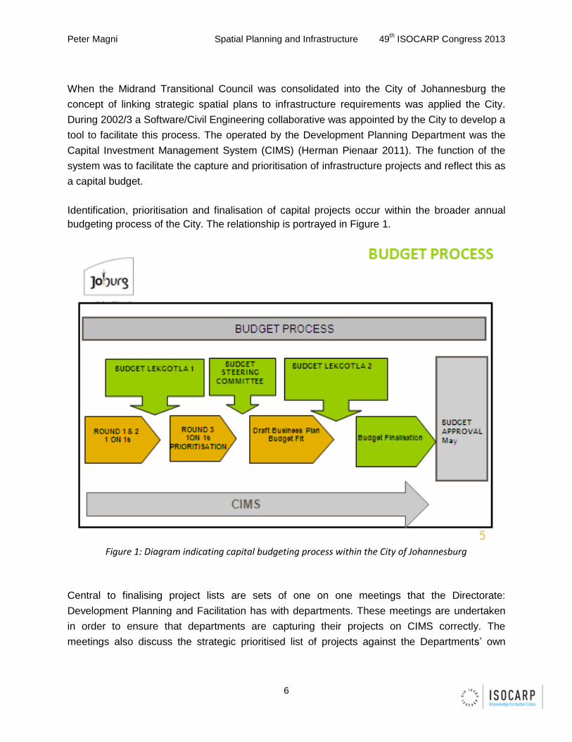
Identification, prioritisation and finalisation of capital projects occur within the broader annual
budgeting process of the City. The relationship is portrayed in Figure 1.
Central to finalising project lists are sets of one on one meetings that the Directorate:
Development Planning and Facilitation has with departments. These meetings are undertaken
in order to ensure that departments are capturing their projects on CIMS correctly. The
meetings also discuss the strategic prioritised list of projects against the Departments’ own
Figure 1: Diagram indicating capital budgeting process within the City of Johannesburg
Peter Magni Spatial Planning and Infrastructure 49th ISOCARP Congress 2013
7
priorities. The discussion attempts to balance the strategic intent of the City against the realities
of infrastructure provision in the City.
Financial oversight of the capital budgeting process occurs through the Budget Steering
Committee where a panel hears motivations from departments for capital funding in future
financial years.
Political input into the capital budgeting process occurs at meetings, known as Lekgotlas. There
are generally two Lekgotlas. At the first Lekgotla the broad principles for expenditure are
determined. At the second Lekgotla the draft budget for the City is reviewed and inputs made.
The benefits of the CIMS and the capital budgeting process have been:
1. The provision of an annual process within the City whereby all departments’ projects are
represented on the same platform.
2. The provision of a single capital budget that is recognised across the administration.
3. The ability to link the strategic outcomes of the City as captured in the Growth and
Development Strategy and Spatial Development Framework to specific projects
4. For engineering officials CIMS provides a platform on which the technical need can be
assessed.
5. A means of directing a higher percentage of capital funding to marginalised and public
transport areas for infrastructure service delivery where the funding will benefit the poor.
6. A means to achieve a consolidated overview of the sources of funding required by the City
to fund new, refurbishment or operational capital projects.
7. Improved transparency for the public.
The challenges in implementing the CIMS system include:
1. The project list is only as good as the information captured on CIMS by the Departments. If
this information is not correctly captured, this is the information that appears in the budget.
2. There is a tendency for departments and MOEs to redirect funding from projects in the
budget that are located in strategic areas to other projects during the budget adjustment
period. This is in the absence of effective administrative oversight during the adjustment
budget process.
3. There is no means of verifying whether the CAPEX spend was spent on what was budgeted,
and whether the infrastructure provided was of sufficient quality. The lack of an effective
monitoring system is a major concern.
4. The prioritisation model used on CIMS is complex. This makes it difficult to communicate to
departments and MOEs why one project is prioritised over another.
Peter Magni Spatial Planning and Infrastructure 49th ISOCARP Congress 2013
8
The capital budgeting process and the attendant CIMS system have been relatively successful
over the past ten in guiding capital expenditure as a means of coordinating capital expenditure.
The extent to which it has impacted on achieving the spatial outcomes of the City set out in the
Spatial Development Framework is difficult to gauge in the absence of a comprehensive
monitoring system. From a subjective perspective, certain areas, such as Soweto and the Inner
City, have clearly benefitted from ten years of intensive capital investment. Other priority areas
have not benefitted to the same extent.
The future of the capital planning process is closely bound to infrastructure procedures and to
the financial processes within the City. Changes to these systems have significant ramifications
for whether or not strategic spatial plans will continue to be linked to infrastructure budgeting.
7. Spatial Plans and Infrastructure Asset Management Plans (IAMPS)
The impetus for IAMPs to be undertaken in the City of Johannesburg was a raft of national
policy that was introduced by the Department of Cooperative Governance and Traditional Affairs
(COGTA) in 2007 and 2008 and was initiated by the Draft Municipal Infrastructure Support
Strategy (COGTA.2007).
IAMP is a methodology by which existing assets are identified and monitored so that the
condition of the assets of a given department can be ascertained, and that necessary
interventions can be undertaken in order to maximize the asset’s expected lifespan.
Similarly, Consolidated Infrastructure Plans (CIPS), in the context of a South African
Municipality, consolidate the findings of all IAMPs to determine the overall conditions of the
capital assets in question, and as a means to understand the infrastructure backlogs of the
institution (Manqoba Soni 2011).
Infrastructure backlog in this circumstance is defined as:
1. The Apartheid backlog that resulted in a lack of service infrastructure in areas formerly
reserved for Blacks, Coloureds and Indians.
2. The housing backlog which entails ensuring that all South African citizens have access
to housing of an approved standard.
3. The maintenance backlog, which concerns the inadequate maintenance history of a
municipality’s assets. The backlog includes economic and population growth demands
considerations in relation to infrastructure provision (SACN 2007).
The need for a standardized tool that assists in the on-going monitoring of the state of existing
infrastructure cannot be questioned given the scale of municipal backlogs.
Peter Magni Spatial Planning and Infrastructure 49th ISOCARP Congress 2013
9
However, the policy does not consider how to integrate strategic spatial policy, in the form of the
Spatial Development Framework, with the IAMPs or for the CIP. This was an acknowledged
shortcoming by COGTA (Santhurie Naidoo 2011). The IAMP/CIP policy sees the strategic policy
link between the CIP and municipal policy as the IDP and specifically the sector plans in the IDP
(COGTA.2007b.p9) and not the SDF. This is problematic if strategic spatial planning is to have
a future in guiding infrastructure delivery. The nature of IDPs varies from municipality to
municipality, as does the level of detail in these plans. Whether the CIP can be ‘linked’ to the
IDP in such a generic manner is questionable. If the current strategic objectives of the IDP is to
be altered and driven by the contents of the CIP, the question arises as to whether service
infrastructure need should be the only factor to drive infrastructure delivery outcomes?
Service delivery through the provision and maintenance of public infrastructure must be primary
intention of a municipality. It is what a municipality are envisaged to do in terms of the
Constitution (See 152b and Schedule 4 Part B of the Constitution (RSA, 1996)). However,
achieving this intention means undertaking service delivery in a manner that achieves the other
desirable outcomes that constitute ‘developmental local government’ (see 152 c-e of the
Constitution (ibid)).
The constraint with IAMPs and CIPs is that the methodologies do not have the means to
prioritise projects based on the other desirable factors. Neither does IAMPS/CIP have
population projections for the municipality in question, nor a conceptualization of what the
densities for a given area will be in the future. Nor do the IAMPs provide a spatial perspective.
What IAMPs do provide is critical threshold information regarding infrastructure capacity and
design. IAMPs also provide current and historical information relating to infrastructure costing.
What is required is a strategic spatial plan, in the form of an SDF that provides the outstanding
information, draws on the IAMPs and CIP for information in relation to infrastructure provision,
and prioritizing where new refurbishment and renewal projects are to take place based on
priority areas identified in the plan.
8. Spatial Plans and Financial Procedure
The Municipal Finance Management Act’s (no.56 of 2003) (Treasury.2003) intention is
“To secure sound and sustainable management of the financial affairs of municipalities and
other institutions in the local sphere of government; to establish treasury norms and standards
for the local sphere of government; and to provide for matters connected therewith.”
The intention of the act is not to enhance service delivery or promote ‘developmental Local
Government’ as per the Constitution (RSA.1996). Service delivery is not the primary outcome of
the MFMA, financial prudence is (see also SACN.2007p68). This is not in and of itself a criticism
of the MFMA. Sound financial management at municipalities is critical. But when commentators
Peter Magni Spatial Planning and Infrastructure 49th ISOCARP Congress 2013
10
criticize slow service delivery at the municipal level they need to realize that officials in
municipalities work within a financial framework that is not geared to this outcome. Due to the
effectiveness of National Treasury’s implementation of the legislation the broad financial
philosophy has become entrenched in South African Municipalities.
In relation to the City of Johannesburg there are two sections of the Act that influence planning
for service infrastructure. The first relates to the municipal budgets set out in chapter 4 of the
Act (Treasury. 2003). The second, relates to the acquisition of those goods and services in
terms of Chapter 11 of the Act.
In relation to planning and budgeting it is the MFMA that legislates that:
1. IDPs provide the strategic framework for budgeting
2. Expenditure be linked to outcomes and goals as part of the budgeting process
3. That the project name detail be reduced and be standardized
4. Greater public participation be undertaken with residents and with other spheres of
government in the finalization of budgets
5. A draft budget be finalised four months before the beginning of the financial year.
6. That formal adjustment budgets be tabled and that these occur once or year or under
exceptional circumstances (SACN. 2007. p70).
From the above it may appear that the link between strategic plans and the budget would suffice
to link financial sustainability and developmental local government. However, it is in the realm of
the procurement of service infrastructure that the City of Johannesburg is feeling the burden of
the MFMA’s managerial emphasis. In this regard the establishment of tender committees(bid
specification, bid evaluation and bid adjudication committees) depending on the complexity and
the value of the tender concerned, have negatively impacted on Departments and MOEs ability
to spend capital budgets (Manqoba Soni 2011).
The MFMA has become central legislation in defining how strategic spatial plans are linked to
infrastructure provision within the City. Yet the linking of budgets to strategic outcomes is being
negated in the City of Johannesburg because the budgets for capital projects are not being
linked to actual expenditure, and that the procurement procedure is hindering the completion of
capital projects in budget and on time.
9. Assessment
The City of Johannesburg has implemented a formal process by which strategic spatial plans
have been used to direct infrastructure spending for over ten years. The use of defined and
agreed to capital budgeting process has done much to mitigate against arbitrary political
interference in the budget, and has provided a platform on which technical and strategic
Peter Magni Spatial Planning and Infrastructure 49th ISOCARP Congress 2013
11
considerations can be weighed. The process has also gained support for strategic spatial
planning from technical departments.
The Capital Investment Management System has been a useful tool in providing a strategic
spatial plan’s budget that in turn provides the basis for discussions with technical departments
and politicians
The capital planning process has also made a contribution to ensuring that capital is directed
towards those areas in the City where infrastructure is needed most – marginalised areas,
public transportation areas and priority areas requiring refurbishment.
However, it is in the monitoring and determination of the actual impact of the City’s process to
link its strategic spatial plans to infrastructure where the System has failed. While the CIMS
system can indicate what is budgeted for in a given financial year, it does not provide what the
actual expenditure was on a given project. This makes assessing the spatial impact of policy
very difficult. It also opens up the capital budgeting process to challenges from other existing
processes within the City Administration.
Two of these existing processes relating to Infrastructure Asset Management Plans and
Financial Systems were discussed in detail. The challenge is to continually re-negotiate policy
interventions where responsibilities of departments in relation to strategic spatial planning,
budgeting and infrastructure provision intersect. As such the role strategic spatial plans play in
guiding infrastructure delivery is far from secure, and shifts in relation to new policy interventions
and changing staff compliments.
10. Conclusion
Unlike other cities, Johannesburg has had relative success in coordinating strategic spatial
plans with infrastructure delivery over the past ten years. The success has been due to an
intensive well defined capital budgeting process in conjunction with an internet database, CIMS,
that prioritises projects based on the developmental outcomes of the strategic spatial plan. In
addition, on-going support from technical departments and politicians has been critical to this
success.
However existing policies relating to infrastructure and financial management mean that the
strategic spatial planning’s role has to be constantly re-negotiated especially in a circumstance
where the impact of the capital budget planning process cannot be fully understood in the
absence of detailed and consistent information relating to expenditure on previous annual
budgets.
11. References:
Albrechts L. 1992. New Challenges for Urban Policy under a flexible regime of accumulation.
Landscape and Urban Planning. Landscape and Urban Planning 22(1992) 189-203)
Peter Magni Spatial Planning and Infrastructure 49th ISOCARP Congress 2013
12
Baker M, Hincks S. 2009. Infrastructure Delivery and Spatial Planning: The case of English
Local Development Frameworks. Town Planning Review. 80(2) 2009 173-196
Biermann S, Landre M. 2002. The Utilisation of Engineering Service Bulk Infrastructure
Component in Integrated Development Planning. Development Southern Africa. Volume
19.No.2. June 2002
COGTA. 2007. Draft Municipal Infrastructure Support Strategy
COGTA. 2007b. Municipal Infrastructure: Roles and Responsibilities of National Sector
Departments, Provincial Counterparts and Municipalities
CoJ.2010. City of Johannesburg: Spatial Development Framework 2010/11
CoJ. 2011. Joburg My City my Future. http://www.joburg.org.za/gds2040/intro.php
CoJ. 2011a. Draft Growth and Development Strategy for Consultation. 2 August 2011.
CSIR. 2000. Guidelines for Human Settlement Planning and Design Vols 1 and 2 for the
Department of Housing. Pretoria
CSIR. 2011. Minutes of Meetings taken by the CSIR for the Integrated Planning and
Development Modelling Project process between CSIR and the City of Johannesburg – 4 March
2011, 17 March 2011, 12 April 2011, 3 May 2011, 20 May 2011
DBSA.2009.Development Bank of Southern Africa. Infrastructure Investment Training Workshop
Manual – MIIF Municipal Infrastructure Investment Framework. Compiled by the Palmer
Development Group Consultants
Dodson J. The ‘Infrastructure Turn’ in Australian Metropolitan Spatial Planning. 2009. Research
Paper 25. September 2009. Griffith University
DPLG.2000. Municipal Systems Act. Act 32 of 2000
Faludi A. 2009. A turning point in the development of European spatial planning? The ‘Territorial
Agenda of the European Union’ and the ‘First Action Programme’. Progress in Planning.
71(2009) p1-42
Halfawy M R. 2010. Municipal information models and federated software architecture for
implementing integrated infrastructure management environments. Automation in
Construction 19 (2010) 433–446
Healy P, Albrechts l, Kunsman K. 2003. Strategic Spatial Planning and Regional Governance in
Europe. American Planning Association Journal. Spring 2003. Vol 62. 113-129
Healey P. 2006. Collaborative Planning: Shaping Places in Fragmented Societies. 2nd
edition. Palgrave Macmillan. London
Herman Pienaar. 2011. Personal Communication 23 August 2011
Peter Magni Spatial Planning and Infrastructure 49th ISOCARP Congress 2013
13
Ko R, Niegl M, Knoflacher H. 2000. A Strategic Planning Methodology. Transport Policy 15
(2008) 273-282.
Manqoba Soni. 2011. Manqoba Soni personal communication 22 August 2011
Mattingly M, Winarso H.2000. Urban Spatial Planning and Public Capital Investments the
Experience of Indonesia’s Integrated Urban Infrastructure Investment Programme. Working
Paper 113. Institute of Technology Bandung/University College London.
Morphet J. 2009.Local integrated spatial planning – the changing role in England. Town
Planning Review, 80 (4–5) 2009 p393-414
Morphet J. 2011. Effective Practice in Spatial Planning. Routledge. London and New York
SACN. 2007. South African Cities Network: State of City Finances Report 2007. Colourpress
Santhurie Naidoo. 2011. Santhurie Naidoo personal communication 29 August 2011
Sartorio F. 2005. Strategic Spatial Planning: A Historical Review Approaches, its Recent Revival
and an Overview of the State of the Art in Italy. Discourse in Planning disp162.3/2005
RSA (Republic of South Africa). 1996. The Constitution
Treasury. 2003. Municipal Finance Management Act. Act No. 56 of 2003.
Todes A. 2011. Reinventing Planning:Critical Reflections. Urban Forum. (2011)22:115-133.
UNHABITAT. 2009. Planning, Spatial Structure of Cities and Provision of Infrastructure.
Planning Sustainable Cities. Chapter 8 p152
Van den Broeck. 2008. Strategic Spatial Planning and Strategic Projects. A transformative
Practice. Presentation to the 44th ISOCARP Congress 2008
Wong C, Watkins C. 2009. Conceptualising Spatial Planning Outcomes: Towards an Integrative
Measurement Framework. Town Planning Review 80(4-5)
Related Documents