Start Point Distance/Time Terrain Public transport Key to Facilities www.forestofbowland.com © Crown Copyright. All rights reserved (100023320) (2010) OS Explorer OL41 About This Walk N Cafe (open March to November), Also available (but not shown on map) Toilets, Shop and Pub in nearby Slaidburn and Pub at Tosside. 3 9 15 4 10 16 5 11 17 6 12 7 13 1 2 8 14 SD 732 565 SD 731 565 SD 730 566 SD 728 573 SD 724 573 SD 720 579 SD 718 578 SD 718 578 SD 714 573 SD 718 553 SD 717 548 SD 718 546 SD 719 544 SD 724 551 SD 734 556 SD 736 556 SD 736 561 Bus Service B10 to Clitheroe,Tosside and Settle. 8 Miles 3 Hrs Roads and tracks Some gates. Stocks Reservoir School Lane Car Park SD 732 565 0.5 Mile 1 Mile 0 Miles 0 Km 1 Km 2 Km 1 2 3 4 5 6 7 8 9 10 11 12 13 14 15 16 17

Welcome message from author
This document is posted to help you gain knowledge. Please leave a comment to let me know what you think about it! Share it to your friends and learn new things together.
Transcript
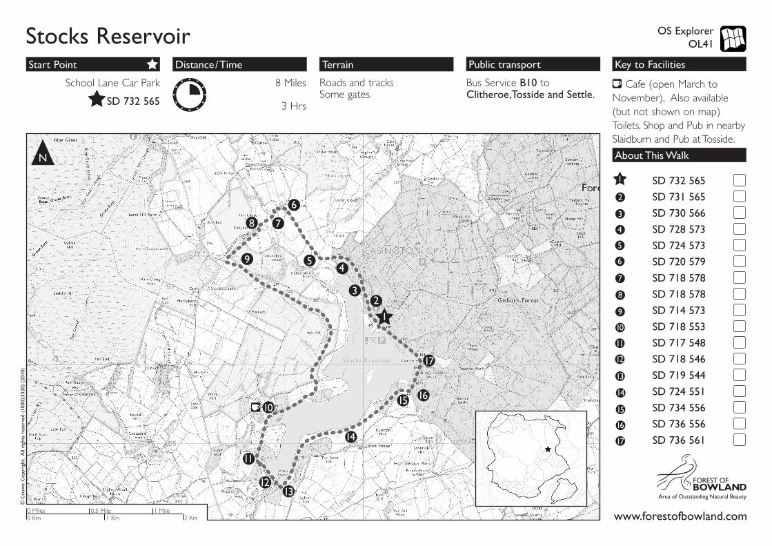
Start Point Distance/Time Terrain Public transport Key to Facilities
www.forestofbowland.com
© C
row
n C
opyr
ight
. A
ll ri
ghts
res
erve
d (1
0002
3320
) (2
010)
OS Explorer OL41
About This WalkN
Cafe (open March to November), Also available (but not shown on map) Toilets, Shop and Pub in nearby Slaidburn and Pub at Tosside.
3
9
15
4
10
16
5
11
17
6
12
7
13
1
2
8
14
SD 732 565 SD 731 565 SD 730 566 SD 728 573 SD 724 573 SD 720 579 SD 718 578 SD 718 578 SD 714 573 SD 718 553 SD 717 548 SD 718 546 SD 719 544 SD 724 551 SD 734 556 SD 736 556 SD 736 561
Bus Service B10 to Clitheroe,Tosside and Settle.
8 Miles
3 Hrs
Roads and tracks Some gates.
Stocks Reservoir
School Lane Car Park
SD 732 565
0.5 Mile 1 Mile0 Miles0 Km 1 Km 2 Km
1
23
45
6
78
9
10
11
1213
14
15 16
17
Stocks ReservoirAbout This Walk
GPS: SD 718 546Stocks Reservoir Dam with huge overflow returning water to the River Hodder.
GPS: SD 719 544Towards the end of the dam, descend the steps, turn left and left again to join the old railway track.
GPS: SD 724 551Follow the path along the edge of the reservoir then head slightly right, through fields and then into the coniferous woodland. Emerge at the other side into a meadow.
GPS: SD 734 556Wildflower Meadow - during the summer this is a good site for many wild flowers, including Orchids.
GPS: SD 736 556Continue and then through a kissing gate on the left towards the end of the field, emerging next to the road. Continue ahead on a footpath adjacent to the road, emerging onto the road before the causeway.
GPS: SD 736 561After the causeway follow the path behind the hedge on your left to your starting point at School Lane Car Park.
The reservoir
Stocks reservoir was opened by HRH The Prince George on July 5th 1932. Annual rainfall here is about 1500mm (5 feet) and when full the reservoir covers an area of about 192 hectares, the equivalent of about 500 football pitches. After treatment, the water from Stocks goes mainly to the Fylde area of Lancashire.
Forestry
Gisburn Forest, to the north east of the reservoir, is a major part of the Stocks catchment area. The coniferous trees generate a useful raw material, contributing to the regional demand for timber. Small areas of ancient woodland are being supplemented by the creation of new native woodland providing a range of important wildlife habitats. The forest has also become an important recreation destination for locals and visitors alike.
Farming
The massive catchment area for the reservoir is split between three farms, all of which produce sheep as the mainstay. The principal breed is Swaledale and around 3000 animals are present for most of the year. It is important that visitors, especially those with dogs, take extra care to avoid disturbing the flocks.
GPS: SD 732 565School Lane Car Park makes a good starting point for the reservoir walk and also for many forest trails. It is also the former site of St James’ Church, which was reconstructed at its present site down the road at Dalehead. The walk is approximately 8 miles through fields and woodlands. Follow United Utilities ‘Stock’s Reservoir Circular Walk’ green signs.
Go through the kissing gate from the car park and follow the path ahead.
GPS: SD 731 565A few yards on there is a Picnic area on your left.
GPS: SD 730 566A little further and notice a bird hide on your left, followed closely by a second one. Excellent observation points (particularly the 2nd hide) for many water related birds, ducks, geese, with the occasional rare visitor. Continue through the woodland.
GPS: SD 728 573Site of Birch Hill Farm. The small building is all that remains. Many farms became unviable when the reservoir was constructed and afforestation of the land took place. Continue across field and then to a bridge over Hasgill Beck.
GPS: SD 724 573Lock Bridge over Hasgill Beck carried the old road which would connect the farms of Hasgill, New House and Collyholme. Continue along grassy track eventually reaching New House Farm.
GPS: SD 720 579New House Farm. Whilst the house and barn are derelict, the land is still farmed. Turn left in front of New House Farm and descend a zig-zagged grassy track to a footbridge over the River Hodder.
GPS: SD 718 578New footbridge replacing one which was washed away when the River Hodder was in flood condition. Continue ahead, then through a kissing gate and right and continue.
GPS: SD 718 578
Ruined remains of Collyholme Farm. Continue alongside Copped Hill Clough until you reach a track, turn left over the flags then a footbridge until you reach a track, turn left.
GPS: SD 714 573
Route of old railway track taking walkers to the Fishing Lodge. Continue along the track all the way to Stock’s Reservoir Fly Fishery.
GPS: SD 718 553The Fishing Lodge - fishing is available during the season. Refreshments can also be obtained when open. Continue along the track.
GPS: SD 717 548Stocks Board House - formerly offices of the Fylde Water Board. Now United Utilities Bowland Estate Office. Continue straight ahead along a path away from the main track and over the dam.
1
2
3
4
5
6
7
8
9
10
11
12
13
14
15
16
17
Points of intrest along the way
Related Documents