APACHE ENERGY LTD (ABN 39 009 301 964) 100 ST GEORGES TERRACE / PERTH / WA / 6000 TEL (08) 6218 7100 / FAX (08) 6218 7200 Stag-44H, Stag-45H and Stag-46 Environment Plan Summary

Welcome message from author
This document is posted to help you gain knowledge. Please leave a comment to let me know what you think about it! Share it to your friends and learn new things together.
Transcript
APACHE ENERGY LTD (ABN 39 009 301 964) 100 ST GEORGES TERRACE / PERTH / WA / 6000 TEL (08) 6218 7100 / FAX (08) 6218 7200
Stag-44H, Stag-45H and Stag-46 Environment Plan Summary
Stag Environment Summary
Stag-44H, Stag-45H and Stag-46 Environment Plan Summary 2 of 22
CONTENTS
1. INTRODUCTION .................................................................................................................................... 3
2. LOCATION OF THE ACTIVITY ................................................................................................................. 4
3. DESCRIPTION OF THE RECEIVING ENVIRONMENT ................................................................................ 6
3.1 Physical environment ......................................................................................................................... 6
3.2 Biological environment ...................................................................................................................... 6
3.3 Socio-economic environment ............................................................................................................. 7
4. DESCRIPTION OF THE ACTION .............................................................................................................. 8
4.1 Stag-21H workover ............................................................................................................................. 8
4.2 Stag-44H (Stag-9H abandonment and drilling) ................................................................................... 8
4.3 Stag-45H (Stag-39H abandonment and drilling) ................................................................................. 8
4.4 Stag-46 (drilling and abandonment) ................................................................................................... 9
5. MAJOR ENVIRONMENTAL HAZARD AND CONTROLS ...........................................................................10
6. MANAGEMENT APPROACH .................................................................................................................11
7. CONSULTATION ...................................................................................................................................12
8. CONTACT DETAILS ...............................................................................................................................13
9. ENVIRONMENTAL ASPECTS, IMPACTS AND CONTROLS .......................................................................14
10. REFERENCES ......................................................................................................................................21

Stag Environment Summary
Stag-44H, Stag-45H and Stag-46 Environment Plan Summary 3 of 22
1. INTRODUCTION
Apache Energy Ltd (Apache) proposes to drill the horizontal development wells Stag-44H, Stag-45H and Stag-46 (referred to jointly as Stag-44H, 45-H and 46) in permit area WA—15L in Commonwealth Waters. Apache is the operator of the WA-15-L permit, with its Joint Venture participants, Apache Northwest Pty Ltd (33.34%) and Santos Offshore Pty Ltd (66.66%).
Drilling is scheduled to commence in August 2012 and is expected to take approximately 61 days. The objective of drilling the wells is to intersect, complete and produce from the depleted M. Australis (Muderong Shale) reservoir of the Stag field. The proposed surface well locations are approximately 60 km northwest of Dampier in the Commonwealth waters of the North West Shelf (NWS), in approximately 49 m water depth.
The Stag-44H, 45-H and 46 Environment Plan (EP) has been prepared in accordance with the Offshore Petroleum and Greenhouse Gas Storage (Environment) Regulations 2009 (OPGGS (E) Regulations). The EP has been reviewed and accepted by the National Offshore Petroleum Safety and Environmental Management Authority (NOPSEMA).
This EP summary has been prepared as per the requirements of Regulation 11 (7) and (8) of the referenced OPGGS(E) Regulations.
Stag Environment Summary
Stag-44H, Stag-45H and Stag-46 Environment Plan Summary 4 of 22
2. LOCATION OF THE ACTIVITY
The proposed Stag-44H, 45H and 46 well surface locations are on the Stag platform (“Slot J and Slot D”) approximately 37km northwest of the Dampier Archipelago and 72 km east northeast of the Montebello Islands, in approximately 48 m water depth (Table 1 and Table 2, Figure 1).
Table 1: Surface locations for Stag-44H, 45H and 46 wells
Parameter Stag-44H and 46 Stag-45H
Surface location (GDA94 Zone 50)
20˚ 17’ 23.964”S (Lat) 116˚ 16’ 31.025”E (Long)
20˚ 17’ 23.851”S (Lat) 116˚ 16’ 31.025”E (Long)
Table 2: Distances from Surface hole locations to key regional features
Regional Feature Distance Direction
Dampier Archipelago 37 km SE
Closest boundary to Montebello Marine Park 64 km WSW
Closest Montebello Island 72 km WSW
Varanus Island 88 km SW
Barrow Island 100 km SW
Glomar Shoals 124 km NE
Distance to Ningaloo World Heritage Area 245 km SW
Stag Environment Summary
Stag-44H, Stag-45H and Stag-46 Environment Plan Summary 5 of 22
Figure 1: Location Map for Stag-44H, 45H and 46 wells
Stag Environment Summary
Stag-44H, Stag-45H and Stag-46 Environment Plan Summary 6 of 22
3. DESCRIPTION OF THE RECEIVING ENVIRONMENT
3.1 Physical environment
The proposed Stag-44H, 45H and 46 wells are located in the North-West Marine Bioregion in the NWS Province (DEWHA, 2008). The region lies in the arid tropics experiencing high summer temperatures, periodic cyclones and associated rainfall. Rainfall in the region is generally low with evaporation exceeding rainfall throughout the year. The summer and winter seasons fall into the periods September–March and May–July, respectively. Winters are characterised by clear skies, fine weather, predominantly strong east to south-east winds and infrequent rain. Summer winds are more variable, with strong south-westerlies dominating. Three to four cyclones per year are typical, primarily between December and March (WNI, 1995), and can generate wind speeds 50–120 knots within the region.
The dominant surface offshore current (typically seaward of the 200 m isobath) is the Leeuwin Current, which carries warm tropical water south along the edge of WA's continental shelf, reaching its peak strength in winter and becoming weaker and more variable in summer. The Indonesian Throughflow is the other important current influencing the upper 200 m of the outer NWS (Woodside, 2005). This current brings warm and relatively fresh water to the region from the western Pacific via the Indonesian Archipelago. Initial modelling undertaken by Woodside indicates that significant east-west flows across the NWS to the north of the North West Cape, possibly linking water masses in the area (Woodside, 2005). Seasonal current roses for the Stag-44H, 45H and 46 location show the clear predominance of north northeasterly to northeasterly flowing currents during the majority of summer, with the exception of late summer (March) when current directions are variable. During early to mid-winter, west to west southwesterly currents prevail, tending westerly and then northeasterly during later winter (August). During the autumn transition (April) current flow is towards the west and during spring transition, current flow is to the north and northwest.
The Stag field is located within the middle continental shelf in a water column depth of approximately 49 m. The area of shelf within the Stag field is characterised by a thick sequence of carbonate rock that is overlain by thin layers of unconsolidated fine to medium grained, carbonate sediments with occasional shell or gravel patches (RACAL, 1994; Dames and Moore, 1995). Surveys conducted over the NWS indicate that a similar seafloor occurs extensively over this geographic region, but with spatial variation in the grain size and origin of the surface sediments (McLoughlin and Young, 1985; Woodside, 1990).
3.2 Biological environment
Infauna sampling around the location of the Stag Central Production Facility and FSO (located approximately 50 km from Stag-44H, 45H and 46) was conducted prior to development drilling as a baseline for comparison to the post-development and post-commissioning states (Kinhill, 1997, 1998). This study confirmed that the benthic biota within the vicinity of Stag is comparable to that found over similar substratum and at similar depths over the wider region (Ward and Rainer, 1988; Woodside, 1988; Rainer, 1991).
The EPBC Act Protected Matters Search Database lists ten species of marine fauna, found within the proposed drilling area as threatened (endangered or vulnerable) and migratory under the EPBC Act (DSEWPaC, 2012). This list includes the southern giant-petrel, cetaceans (blue and humpback whales), the whale shark and marine turtles. The timing of the Stag-44H, 45H and 46 drilling activity coincides with the humpback whale southern migration (peaking early September) and it is therefore possible that humpback whales will be observed during drilling activity, however the presence of the proposed activity is not expected to deter them on their migratory path. The location of the proposed Stag-44H, 45H and 46 wells is not near key nesting, feeding or aggregation areas of the other listed fauna.
Stag Environment Summary
Stag-44H, Stag-45H and Stag-46 Environment Plan Summary 7 of 22
3.3 Socio-economic environment
Oil exploration and production and commercial fisheries are the two main activities operating in the NWS region. There are three Commonwealth fisheries zones adjacent to the Stag well locations: the Western Tuna and Billfish Fishery (North of 34° South), Southern Bluefin Tuna Fishery and the Western Skipjack Tuna Fishery. Although these Commonwealth fisheries are permitted to operate within the proposed Stag drilling location, there is no current fishing effort (AFMA, 2010). A number of State managed fisheries have boundaries that overlie or are in close proximity to part or all of the survey area (Woodside, 2006; AEL, 2010; DoF, 2011). However, of these, only the Pilbara Demersal Scalefish Fishery (trap and line) and Onslow Prawn Managed Fishery would potentially operate in the vicinity.
The proposed Stag-44H, 45H and 46 well location and surrounding waters are also used for petroleum exploration and development (Figure 1). The nearest production activities include:
• Stag Terminal (Apache operated) located in WA-15-L, approximately 2 km north of the proposed wells, and associated subsea pipeline running to the terminal,
• Wandoo Production Platforms located in Exploration Permit WA-14-L, approximately 20 km northeast, and
• Gas pipelines run from the Reindeer platform to the mainland (north to south), to the east of the proposed wells (approximately 6 km), another gas pipeline runs east to west, approximately 10km north of the proposed well.
There are no recognised shipping routes through the proposed Stag-44H, 45H & 46 drilling location. There is a shipping route heading northeast to the south of the proposed drilling location but the Stag Facility is located 4 km northwest of a proposed designated shipping route.
The proposed drilling activity is unlikely to impact on tourism activities in the Pilbara region given the distance from the mainland and islands of the Dampier Archipelago where most of the tourism activities (including recreational fishing) usually occur.
There are no listed Commonwealth Heritage Places or National Heritage Places within, or in the immediate vicinity of the proposed Stag-44H, 45H and 46 drilling location. There are also no historic shipwrecks listed near the proposed drilling location.

Stag Environment Summary
Stag-44H, Stag-45H and Stag-46 Environment Plan Summary 8 of 22
4. DESCRIPTION OF THE ACTION
The Stag-44H, 45H and 46 drilling activity will follow on from the Stag-21H workover and final abandonment of the Stag 9H well. The drilling activity is scheduled for August 2012 and will take approximately 61 days. The Ensco 104 jack-up drilling rig, operated by Ensco PLC (Ensco), will be used to undertake the Stag-44H, 45H and 46 drilling. Three support vessels sourced from Farstad Shipping and Mermaid Marine, will be used to supply fresh water, food, bulk drilling fluid materials and transportation of the equipment used in the drilling process. Helicopter transfers, operated by Bristow Australia, will transfer personnel between the rig and Karratha airport.
Once the drill rig has arrived at the well location and jacked the legs down, well work over, abandonment, drilling and completion activities will commence. Operations will be conducted 24 hours a day, seven days a week for the duration of the activity.
4.1 Stag-21H workover
The ESP upper completion in Stag-21H requires replacement. The chemical injection lines to the ESP inhibitors will be flushed with water to prevent any spills of chemicals during the ESP pull operations. The well will be flooded with seawater to ensure any potential for “gas” or hydrocarbons is reduced by putting the well in a loss situation – called a “well kill”. The rig will run a new upper completion to 714 m MD and the well will be handed over to production.
4.2 Stag-44H (Stag-9H abandonment and drilling)
Stag-9H (Slot D), located on the Stag Facility, will be abandoned as per the abandonment document (DR-62-LD-077). The remainder of the activity requires the Ensco 104 drilling rig. The abandonment consists of placing another cement retainer in the 340mm (13 3/8”) casing directly above the cut 244mm (9 5/8”) casing to further isolate the 340mm x 244mm (13 3/8” x 9 5/8” annulus prior to cutting and pulling the 340 mm (13 3/8”) and 762 mm (30”) casings and setting the surface cement T-Plug for isolation purposes. Following that, operations will be assigned to Stag-46 (see Section 4.4). Following Stag 46 abandonment the Stag 44-H 311 mm (12 ¼”) hole section will be directionally drilled with 244 mm (9 ⅝”) casing. The well will be displaced with a KCL/ Polymer or Silicate WBM system and a 311 mm (12¼”) hole will be directionally drilled to ~1,800 m MDRT utilising the 244 mm (9⅝”) casing as the work string (mud density will be between 1.15–1.25 sg). Once on depth (within the Upper Muderong), the casing will be cemented in place. A 216 mm (8 ½”) hole will be directionally drilled using a KCL/ Polymer or Silicate WBM system (1.15 – 1.25 SG) to drill and penetrate the Stag reservoir. Once the reservoir is confirmed (Stag Sand at approximately 2,300 MDRT), drilling will cease and a 178 mm (7”) drilling liner will be run and cemented in place. Subsequent to successfully testing the integrity of the drilling liner, the well will be displaced to a 1.10 sg Stress Cage (SC) Water Based Drill-in Fluid and the 178 mm (7”) liner shoe track will be drilled out. A 152 mm (6”) hole will be directionally drilled horizontally through the reservoir to total depth. An 89 mm (3 ½”) Sand Screen Lower completion will be run and set at total depth, suspended by a liner hanger system in the 178 mm (7”) liner. An ESP upper completion with 114.3 mm (4 ½”) tubing will be run and the well will be secured to hand over to production.
4.3 Stag-45H (Stag-39H abandonment and drilling)
Stag-39H (Slot J) will have the reservoir interval abandoned to allow the well to be reclaimed and Stag-45H drilled and completed. Slot J will be partly abandoned by pulling the upper completion as well as setting two tested reservoir isolation barrier within the production casing. The casing hole whipstock will then be set in the existing 244mm (9 5/8”) casing to initiate a sidetrack and drill Stag-45H. Once rigged up over Slot J, a 244 mm (9 5/8”) casing whipstock will be run and set within the existing casing and a window will be milled. A 216 mm (8 ½”) hole will be kicked off at ~1,160 m MD and conventionally drilled ahead to inside the Stag Sand. The 178 mm (8 ½”) hole section will be drilled using a 1.18–1.25 sg KCL/Polymer WBM. Once total depth has been reached and confirmation received that the reservoir penetrated, a 178 mm (7”) drilling liner will be run and cemented in place. Subsequent to successfully testing the integrity of the
Stag Environment Summary
Stag-44H, Stag-45H and Stag-46 Environment Plan Summary 9 of 22
drilling liner, the well will be displaced to a 1.10 sg SC Water Base Drill-in Fluid and the 178 mm (7”) liner shoe track will be drilled out. A 152 mm (6”) hole will be directionally drilled horizontally through the reservoir to total depth at 2,800 MDRT. An 88.9 mm (3 ½”) Sand Screen Lower completion will be run and set at total depth, suspended by a liner hanger system in the 178 m (7”) liner. An ESP upper completion with 114.3 mm (4 ½”) tubing will be run and the well will be secured to hand over to production.
4.4 Stag-46 (drilling and abandonment)
Stag 46 is a directional appraisal well drilled below the platform and evaluated for the presence of recoverable stranded hydrocarbon reserves. Stag-46 activity will include all operations from spudding 406 mm (16”) hole through plugging back the production hole and will end when a successful side-track has been achieved. Following Stag-46 drilling, drilling of Stag-44H will recommence.
A 406 mm (16”) hole will be directionally drilled to ~20 m into the Whitnell formation (~340 m MD) using sea water and sweeps and 340 mm (13 3/8”) casing run and cemented. At this point, the wellhead and BOP will be installed and pressure tested. The hole will be displaced with a KCL / Polymer WBM system and a 311mm (12¼”) hole drilled to 10m above the top of the Stag sand (core point). The bottomhole assembly (BHA) will contain a full Quad Combo system for logging purposes. Once the planned core point is reached, the BHA will be pulled out of the hole and racked back. A 311mm (12 ¼”) coring assembly will be run in hole. A conventional core will be cut from 10m above the reservoir to approximately 10m below the reservoir. This equates to roughly 36m of core in total. The coring assembly will then be pulled and the core retrieved. The 311 (12 ¼”) BHA will be re-run into the well and the LWD assembly washed by the cored interval to allow for gathering of the LWD data. The assembly will then be used to drill to a total depth of 840mMD/812mTVD. A planned backream to the 340mm (13 3/8”) casing shoe will be conducted to ensure the hole is in good condition. Following a successful coring operation the reservoir will be evaluated using wireline logging tools. The following logs; Quad-Combo (quadropole), Sonic and Image Scan will be conducted. Once at total depth and all the required logs have been compiled, Stag-46 will be permanently abandoned, in accordance with Apache and government regulation.
At the completion of drilling, a remotely operated vehicle (ROV) will then be used to survey the seabed to ensure that no debris remains from the drilling activities.
Stag Environment Summary
Stag-44H, Stag-45H and Stag-46 Environment Plan Summary 10 of 22
5. MAJOR ENVIRONMENTAL HAZARD AND CONTROLS
Apache undertook an environmental risk assessment for routine and non-routine events for Stag-44H, 45H and 46 drilling centred around a hazard identification workshop held on 27 April 2012 and attended by a subset of Apache’s environmental scientists and drilling personnel. The outcomes of a broader scale hazard identification workshop on Apache’s drilling activities across the NWS (Oracle, 2011), independently facilitated by risk consultants using the combined experience of Apache’s Drilling, Environment and Logistics Departments, was used to inform the Stag-44H, 45H and 46 workshop. The purpose of the risk assessment was to understand and identify the potential environmental risks to ensure they are reduced to As Low As Reasonably Practicable (ALARP) utilising Apache’s management and mitigation actions which have been developed from experience in the environmental management of offshore exploration in Australia and are based on Australian petroleum industry best practice environmental management guidelines, as defined by the APPEA Code of Environmental Practice (2008). The key environmental hazards and control measures to be applied to the Stag-44H, 45H and 46 drilling activities are shown in Section 9. These are consistent with Apache corporate and project specific performance objectives, standards and criteria. All commitments associated with these will be used to reduce Environmental risk to ALARP and will be of an acceptable level.
Stag Environment Summary
Stag-44H, Stag-45H and Stag-46 Environment Plan Summary 11 of 22
6. MANAGEMENT APPROACH
The for Stag-44H, 45H and 46 drilling activity will be managed in compliance with the Stag-44H, Stag-45H and Stag-46 Environment Plan (EA-62-RI-036/Revision 1) accepted by NOPSEMA under the OPGGS(E) Regulations, other environmental legislation and Apache’s Management System (e.g. Apache Environmental Management Policy). The objective of the EP is to ensure that potential adverse environmental impacts associated with the Stag-44H, 45H and 46 drilling activity during both routine and non-routine activities, are identified and assessed and to stipulate mitigation measures to avoid and/or reduce any adverse impacts to the marine environment to ALARP. The EP details for each environmental impact identified (and assessed in the Environmental Risk Assessment) specific performance objectives, standards and procedures and identifies the range of controls to be implemented (Section 9) to be implemented (consistent with the standards) to achieve the performance objectives and also identifies the specific measurement criteria and records to be kept to demonstrate the achievement of each performance objective. The goal of the environmental implementation strategy, detailed in the EP, is to direct, review and manage activities so that environmental impacts and risks are continually being reduced to ALARP, and performance objectives and standards are met over the duration of the drilling activity. It includes the following;
1. Details on the systems, practices and procedures to be implemented
2. Key roles and responsibilities
3. Training and competencies for all personnel (Apache and contractors)
4. Monitoring, auditing, management of non-conformance and review
5. Incident Response including Oil Spill Contingency Plan
6. Record Keeping
The reporting requirements for routine activities and environmental incidents (recordable and reportable) and reporting on overall compliance of the activity with the EP (e.g. close out reports submitted to NOPSEMA within 3 months of drilling completion) are also detailed.

Stag Environment Summary
Stag-44H, Stag-45H and Stag-46 Environment Plan Summary 12 of 22
7. CONSULTATION
The proposed Stag-44H, 45H and 46 drilling activity is located in waters approximately 48 m deep and approximately 37km northwest of the Dampier Archipelago. At this location, the proposed activity falls within the jurisdiction of the Commonwealth government.
Relevant interested parties for consultation of the proposed drilling activity were identified based on the extent of the modelled zone of potential impact (ZPI) and identified sensitive resources. Each identified stakeholder was initially emailed a summary of the proposed Stag-44H, 45H and 46 drilling activities in July 2012 which was followed up by emails and phone calls in August 2012.
Key stakeholders contacted prior to commencement of drilling activities are detailed in Table 3 together with their feedback.
Table 3: Stakeholders feedback and assessment for the Stag-44H, 45H and 46 drilling activity
Stakeholder Feedback (refer Appendix 5) Assessment of Feedback
Recfishwest No issues or conflict. Based on drilling activity being far from shore, this was the expected outcome. No further consultation required for Stag drilling activity.
AFMA No feedback received Previous correspondence (for other drilling activity consultation) with AFMA has stated that AFMA would get back to us with concerns, and haven’t to date, no further consultation required for Stag drilling activity. As this information has previously been provided in July 2012, this is considered adequate time for response.
Pearl Producers Association
No issues with the drilling at this location
No further consultation required for Stag drilling activities.
DoF Information received, advised of historic fishing effort on the permit area in the last 5 years. Recommended to follow up with WAFIC and Recfishwest.
Recfishwest have responded there is no conflict. There has been no feedback from WAFIC to date. Apache consultation for Stag Drilling has included relevant fisheries.

Stag Environment Summary
Stag-44H, Stag-45H and Stag-46 Environment Plan Summary 13 of 22
8. CONTACT DETAILS
Further information about the Stag-44H, 45H and 46 drilling activity can be obtained from:
Libby Howitt
Environment Manager
Apache Energy Limited
100 St Georges Terrace, Perth, Western Australia, 6000
Phone: 08 6218 7181
Email: [email protected]

Stag Environment Summary
Stag-44H, Stag-45H and Stag-46 Environment Plan Summary 14 of 22
9. ENVIRONMENTAL ASPECTS, IMPACTS AND CONTROLS
The following tables (Table 4 and Table 5) provide a summary of potential environmental impacts that could be expected from the drilling of Stag-44H, 45H and 46. It lists the activities which might give rise to the environmental impact and the controls and measures which eliminate or ensure the residual risk is reduced to ALARP.

Stag Environment Summary
Stag-44H, Stag-45H and Stag-46 Environment Plan Summary 15 of 22
Table 4: Environmental risk summary for Stag-44H, 45H and 46 – routine activities
Activity and Cause of Impact Potential Impacts Risk treatment (Avoidance, Mitigation and Management Measures)
Introduction of invasive marine pest species to permit area through contaminated ballast water or from vessel hulls
Introduction and possible establishment and spread of marine pests.
• No environmentally sensitive seabed features/ habitat identified in proximity of proposed drilling. • Any vessels imported into Australian waters will meet Australian Quarantine and Inspection Service (AQIS) quarantine requirements. • All vessels will comply with AQIS Aus. Ballast Water Management Requirements and the National Biofouling Management Guidance for the Petroleum Production and Exploration
Industry. • Ensco 104 is being mobilised from drilling activities at Hoss-1 in Australian waters located on the northwest shelf of Australia approximately 65km, northeast of Stag-44H, 45H and
46 • The Ensco 104 and support vessels will not be working in, and as far as practicable will avoid, marine protected areas.
Hydrocarbon spill resulting from vessel collision with rig, support vessels or floating dunnage
Damage to support vessels, rig and/or platform, leading to oil spill.
• Stag-44H, 45H and 46 not located in a major shipping route (very low intensity transient shipping traffic). • Apache’s Drilling and Completions Standards Manual (AE-91-004) will be adhered to
• Rig move procedures in place (including 2 support vessels for final positioning of rig) – refer Apache-Ensco 104 Safety Case Revision (DR-00-RF-033, Rev 6) Section 2.1. • Adherence to Australian Maritime Safety Authority (AMSA)’s marine notices and marine orders (maritime safety measures) • 500m gazetted exclusion zone monitored by support vessels. • Notice to Mariners issued for site. • Qualified tow master to move the rig and on board for all transits. • Certified towing equipment. • Radio and radar communications adopted on vessels. • Vessel illumination at night and during times of low visibility to assist navigation and make rig visible
• Support vessel crew experienced and competent (International Convention of Standards of Training, Certification and Watch keeping for Seafarers, 2010)
• Ensco 104 has an Automatic Identification System (AIS) which allows tracking of the rig by surrounding vessels. • Support vessel radar watch during mobilisation of rig • Tanks on the Ensco 104 do not abutt the side of the rig, and are located immediately under the engine room – and therefore cannot be damaged through side impact. • Fuel storage tanks are double-hulled. • Rig is mobilising to site outside of the cyclone season (November to March), less likely to have poor weather conditions that may impact navigation. • Consultation with relevant fisheries prior to drilling, on proposed activities and dates. • Incident response - Ensco 104 HSE Case (EN104-HSE-001) – emergency response procedures (section 4.3.1). • Implementation of Stag Drilling Oil Spill Contingency Plan (EA-62-RI-036/2) as the control in event of spill to minimise impact.
Marine Fauna interaction resulting from collision with vessel
Marine fauna disturbance, injury or death
• No nearby breeding, nesting, feeding or aggregation areas for marine fauna. • Cetacean observations to be logged in Apache’s Marine Fauna database and record sent to DSEWPaC. • Adherence to Australian National Guidelines for Whale and Dolphin Watching (DEWHA 2005).
Seabed disturbance from rig positioning
Localised disturbance to seabed, resulting in loss of or change in benthic habitat.
• No environmentally sensitive seabed features/ habitat identified in proximity of proposed drilling (300m radius). • Rig Tow Plan Ensco 104 (Stag-44H, 45H and 46) • Ensco 104 Marine Operating Manual • Standards detailed in Apache’s Drilling and Completions Standards Manual • All equipment and gear on rigs and support vessels secured during mobilisation/demobilisation • Existing spud can holes will be utilised. • No anchoring planned by support vessels. • Post ROV survey to check for and retrieve dropped objects (if relevant)
Stag Environment Summary
Stag-44H, Stag-45H and Stag-46 Environment Plan Summary 16 of 22
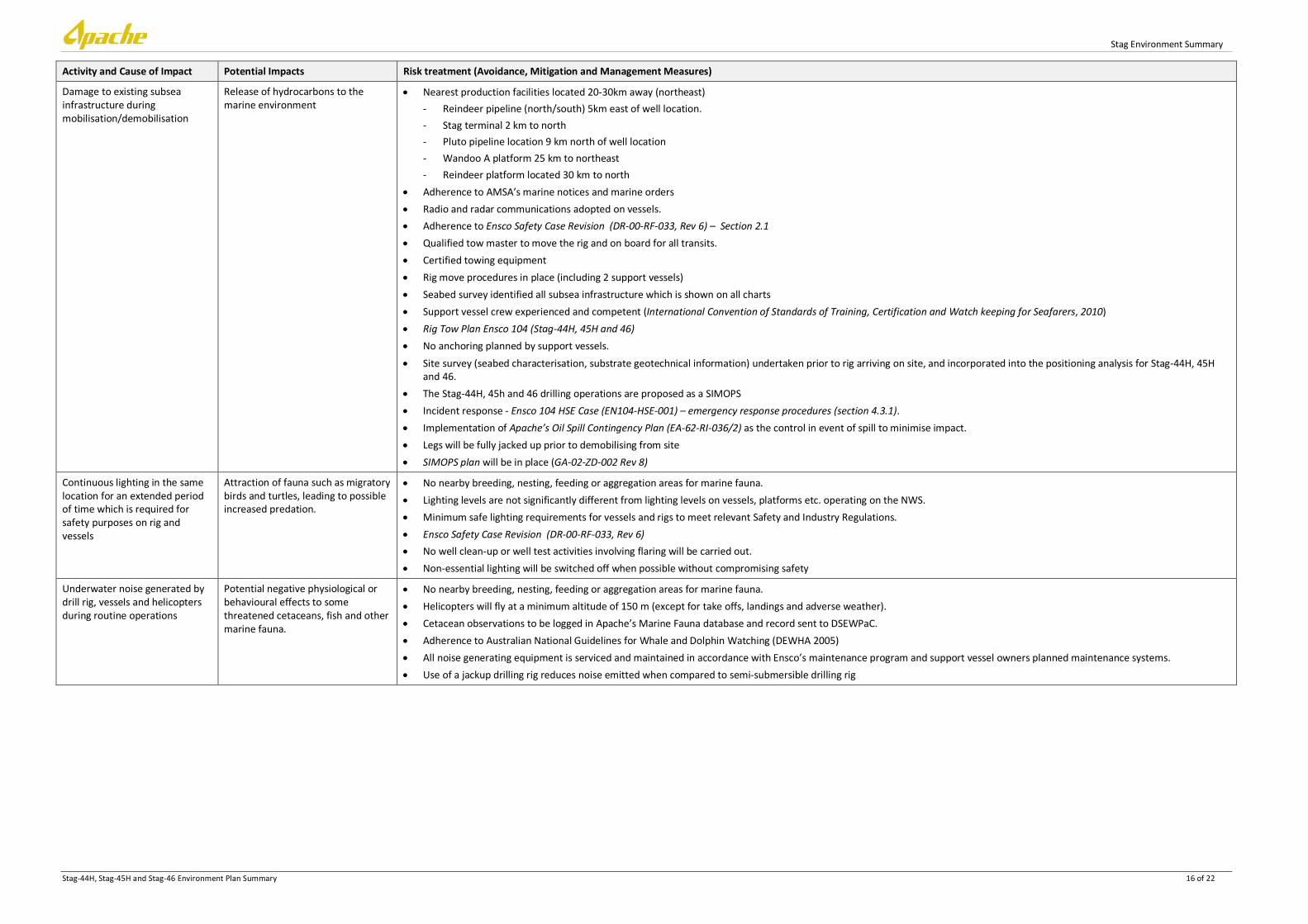
Activity and Cause of Impact Potential Impacts Risk treatment (Avoidance, Mitigation and Management Measures)
Damage to existing subsea infrastructure during mobilisation/demobilisation
Release of hydrocarbons to the marine environment
• Nearest production facilities located 20-30km away (northeast) - Reindeer pipeline (north/south) 5km east of well location. - Stag terminal 2 km to north - Pluto pipeline location 9 km north of well location - Wandoo A platform 25 km to northeast - Reindeer platform located 30 km to north
• Adherence to AMSA’s marine notices and marine orders • Radio and radar communications adopted on vessels. • Adherence to Ensco Safety Case Revision (DR-00-RF-033, Rev 6) – Section 2.1 • Qualified tow master to move the rig and on board for all transits. • Certified towing equipment • Rig move procedures in place (including 2 support vessels) • Seabed survey identified all subsea infrastructure which is shown on all charts • Support vessel crew experienced and competent (International Convention of Standards of Training, Certification and Watch keeping for Seafarers, 2010) • Rig Tow Plan Ensco 104 (Stag-44H, 45H and 46) • No anchoring planned by support vessels. • Site survey (seabed characterisation, substrate geotechnical information) undertaken prior to rig arriving on site, and incorporated into the positioning analysis for Stag-44H, 45H
and 46. • The Stag-44H, 45h and 46 drilling operations are proposed as a SIMOPS • Incident response - Ensco 104 HSE Case (EN104-HSE-001) – emergency response procedures (section 4.3.1). • Implementation of Apache’s Oil Spill Contingency Plan (EA-62-RI-036/2) as the control in event of spill to minimise impact. • Legs will be fully jacked up prior to demobilising from site • SIMOPS plan will be in place (GA-02-ZD-002 Rev 8)
Continuous lighting in the same location for an extended period of time which is required for safety purposes on rig and vessels
Attraction of fauna such as migratory birds and turtles, leading to possible increased predation.
• No nearby breeding, nesting, feeding or aggregation areas for marine fauna. • Lighting levels are not significantly different from lighting levels on vessels, platforms etc. operating on the NWS. • Minimum safe lighting requirements for vessels and rigs to meet relevant Safety and Industry Regulations. • Ensco Safety Case Revision (DR-00-RF-033, Rev 6) • No well clean-up or well test activities involving flaring will be carried out. • Non-essential lighting will be switched off when possible without compromising safety
Underwater noise generated by drill rig, vessels and helicopters during routine operations
Potential negative physiological or behavioural effects to some threatened cetaceans, fish and other marine fauna.
• No nearby breeding, nesting, feeding or aggregation areas for marine fauna. • Helicopters will fly at a minimum altitude of 150 m (except for take offs, landings and adverse weather). • Cetacean observations to be logged in Apache’s Marine Fauna database and record sent to DSEWPaC. • Adherence to Australian National Guidelines for Whale and Dolphin Watching (DEWHA 2005) • All noise generating equipment is serviced and maintained in accordance with Ensco’s maintenance program and support vessel owners planned maintenance systems. • Use of a jackup drilling rig reduces noise emitted when compared to semi-submersible drilling rig
Stag Environment Summary
Stag-44H, Stag-45H and Stag-46 Environment Plan Summary 17 of 22
Activity and Cause of Impact Potential Impacts Risk treatment (Avoidance, Mitigation and Management Measures)
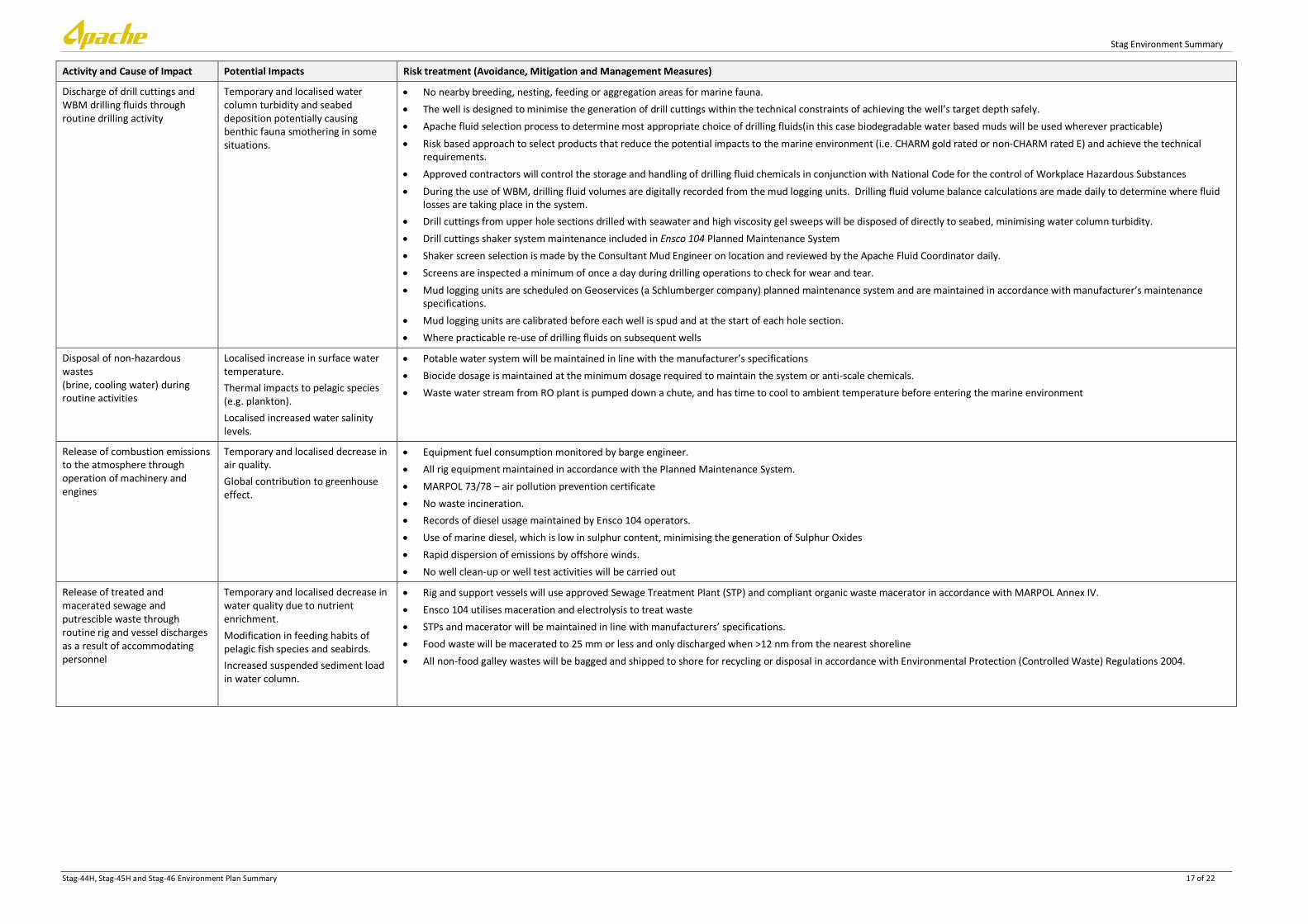
Discharge of drill cuttings and WBM drilling fluids through routine drilling activity
Temporary and localised water column turbidity and seabed deposition potentially causing benthic fauna smothering in some situations.
• No nearby breeding, nesting, feeding or aggregation areas for marine fauna. • The well is designed to minimise the generation of drill cuttings within the technical constraints of achieving the well’s target depth safely. • Apache fluid selection process to determine most appropriate choice of drilling fluids(in this case biodegradable water based muds will be used wherever practicable) • Risk based approach to select products that reduce the potential impacts to the marine environment (i.e. CHARM gold rated or non-CHARM rated E) and achieve the technical
requirements. • Approved contractors will control the storage and handling of drilling fluid chemicals in conjunction with National Code for the control of Workplace Hazardous Substances • During the use of WBM, drilling fluid volumes are digitally recorded from the mud logging units. Drilling fluid volume balance calculations are made daily to determine where fluid
losses are taking place in the system. • Drill cuttings from upper hole sections drilled with seawater and high viscosity gel sweeps will be disposed of directly to seabed, minimising water column turbidity. • Drill cuttings shaker system maintenance included in Ensco 104 Planned Maintenance System • Shaker screen selection is made by the Consultant Mud Engineer on location and reviewed by the Apache Fluid Coordinator daily. • Screens are inspected a minimum of once a day during drilling operations to check for wear and tear. • Mud logging units are scheduled on Geoservices (a Schlumberger company) planned maintenance system and are maintained in accordance with manufacturer’s maintenance
specifications. • Mud logging units are calibrated before each well is spud and at the start of each hole section. • Where practicable re-use of drilling fluids on subsequent wells
Disposal of non-hazardous wastes (brine, cooling water) during routine activities
Localised increase in surface water temperature. Thermal impacts to pelagic species (e.g. plankton). Localised increased water salinity levels.
• Potable water system will be maintained in line with the manufacturer’s specifications • Biocide dosage is maintained at the minimum dosage required to maintain the system or anti-scale chemicals. • Waste water stream from RO plant is pumped down a chute, and has time to cool to ambient temperature before entering the marine environment
Release of combustion emissions to the atmosphere through operation of machinery and engines
Temporary and localised decrease in air quality. Global contribution to greenhouse effect.
• Equipment fuel consumption monitored by barge engineer. • All rig equipment maintained in accordance with the Planned Maintenance System. • MARPOL 73/78 – air pollution prevention certificate • No waste incineration. • Records of diesel usage maintained by Ensco 104 operators. • Use of marine diesel, which is low in sulphur content, minimising the generation of Sulphur Oxides • Rapid dispersion of emissions by offshore winds. • No well clean-up or well test activities will be carried out
Release of treated and macerated sewage and putrescible waste through routine rig and vessel discharges as a result of accommodating personnel
Temporary and localised decrease in water quality due to nutrient enrichment. Modification in feeding habits of pelagic fish species and seabirds. Increased suspended sediment load in water column.
• Rig and support vessels will use approved Sewage Treatment Plant (STP) and compliant organic waste macerator in accordance with MARPOL Annex IV. • Ensco 104 utilises maceration and electrolysis to treat waste • STPs and macerator will be maintained in line with manufacturers’ specifications. • Food waste will be macerated to 25 mm or less and only discharged when >12 nm from the nearest shoreline • All non-food galley wastes will be bagged and shipped to shore for recycling or disposal in accordance with Environmental Protection (Controlled Waste) Regulations 2004.

Stag Environment Summary
Stag-44H, Stag-45H and Stag-46 Environment Plan Summary 18 of 22
Activity and Cause of Impact Potential Impacts Risk treatment (Avoidance, Mitigation and Management Measures)
Discharge of contaminated water to the ocean consists of wash down water, occasional rainwater which may contain oil, grease, chemicals or detergent. E.g. through poor housekeeping practice, washdown or rainwater, or corrosion of bunds (Areas include deck drainage, machinery space spillage and drainage, enclosed storage area drainage, drill floor, moon pool and pipe deck drainage and drainage from support vessels).
Temporary and localised reduction of water quality. Physiological damage to marine fauna ingesting contaminated water.
• No nearby breeding, nesting, feeding or aggregation areas for marine fauna. • Ensco’s procedures for the collection and treatment of drainage ensure that no contaminated waste streams are routinely discharged from the drainage system to the marine
environment. • Drainage and discharge in accordance with MARPOL Annex I. • Deck drains are directed overboard. • Biodegradable washdown detergents used. • Material Safety Data Sheets are available for all chemicals used on the Ensco 104 (which includes spill response requirements). • The oily water system is routinely monitored and regularly maintained. • Bulk hydrocarbon and chemicals will be stored in designated storage areas, which are bunded. • Drainage from bunded areas will be collected through a closed drain system and processed to ensure discharge water has less than 15 ppm oil-in-water (OIW). Over-spec fluids will
be re-directed through the separator again or held for future offloading. • Fully stocked spill kits, located in accessible location, on board to clean deck spills. • Spill exercises are to be conducted quarterly and recorded on daily report. • Minor oil/lubricant spills will be mopped up immediately with absorbent materials that will then be disposed of onshore as hazardous waste, and not washed overboard. • Main deck drain scuppers closed in the event of a spill on deck. • Deck drain scuppers used in fuel transfer area to contain spills during refuelling • Recovered oil from spills etc stored onboard rig for onshore disposal. • Used lubricants will be stored in bunded areas aboard the rig and subsequently transported onshore for recycling or disposal at approved locations. • In non-drill floor areas, drainage to MARPOL Annex I requirements. • Daily inspections will ensure that deck areas are clean of spillages and accumulations of oil/grease and chemicals, and that all spills and leaks are recorded / reported.
Interference with commercial shipping or fishing vessels due to e.g. breakdown in navigation equipment, poor weather, poor communications or human error
Vessel collision. Fuel spill (see hydrocarbon spill above). Fishing gear snags.
• No major shipping channels through proposed drilling location • Notice to Mariners (rig move notice) will be issued. • A 500m radius safety exclusion zone around the rig will be gazetted when on location. • Standard maritime safety measures to be applied. • Written and radio warnings to other vessels (via AMSA notification). • Support vessel crew experienced and competent • Bridge watch and radio standby on all vessels. • Pre-drilling stakeholder consultation. • Support vessels to patrol safety exclusion zone and act as chase vessels • Support vessel crew experienced and competent (International Convention of Standards of Training, Certification and Watch keeping for Seafarers, 2010).

Stag Environment Summary
Stag-44H, Stag-45H and Stag-46 Environment Plan Summary 19 of 22
Table 5: Environmental risk summary for Stag-44H, 45H and 46 – non-routine activities
Activity and Cause of Impact Potential Impacts Risk treatment (Avoidance, Mitigation and Management Measures)
Spill of hydro-carbons to the sea (excluding vessel-to-rig refuelling) e.g. through equipment malfunction, corrosion, inadequate bunding, spillage during transfer.
Short-term impact to water quality. Impact on pelagic fauna.
• No nearby breeding, nesting, feeding or aggregation areas for marine fauna. • Equipment maintained in accordance with Planned Maintenance System. • Ensco Safety Case HSE System (EN104-HSE-001) - section 2.7 and Apache-Ensco104 Safety Case Revision (DR-00-RF-033, Rev 6) – Section 4 • Ensco 104 SOPEP • MARPOL 73/78 Annex I • Ensco 104 International Oil Pollution Prevention Certificate • Support vessels International Oil Pollution Prevention Certificate • Use marine diesel rather than HFO • Drip trays used under portable equipment and when refuelling portable equipment. • Rig decks bunded. Scupper plugs available to prevent liquid discharges from decks. • Chemicals and hydrocarbons stored within continuously bunded areas. • Spill kits placed strategically around Ensco 104 and support vessel work areas. • Weekly inspection of spill kits is undertaken and recorded to ensure they are intact, clearly labelled and contain adequate quantities of absorbent materials. • Oily water discharged in accordance with Marpol requirements • Spills cleaned up immediately and clean up material contained, and not washed overboard. • Spill exercises conducted quarterly • All Ensco 104 personnel to complete the Ensco 104 environmental induction that includes response to spills.
Dropped objects (e.g., Blowout preventer (BOP), anchor, drill pipe, bulkis, tools). E.g. due to equipment failure, human error, adverse weather
Oil leak from subsea equipment. Seabed disturbance.
• No environmentally sensitive seabed features/ habitat identified in proximity of proposed drilling. • Ensco Safety Case HSE System (EN104-HSE-001) includes Lifting Equipment Management System (LEMS). • ROV survey at completion of drilling campaign to retrieve any dropped objects. • Planned maintenance undertaken on lifting equipment. • Apache’s Drilling and Completions Standards Manual (AE-91-004) • PTW system for lifts between the support vessel and the rig. • Offloading procedures. • Use of competent, trained rig and support vessel crew. • Certification of lifting equipment. • All equipment and gear on rigs and support vessels secured during mobilisation/demobilisation
Overboard loss/ accidental disposal of non-hazardous wastes e.g. If waste is not properly contained, waste management procedures not in place and/or not communicated
Marine pollution. Injury or death of marine fauna through ingestion or entanglement
• No nearby breeding, nesting, feeding or aggregation areas for marine fauna. • Procurement and contract process will ensure only essential items brought on board the rig in line with well design requirements. • MARPOL 73/78 Annex V • Wastes to be collected in covered bins (and compacted where possible) for appropriate onshore disposal. • All scrap metal to be collected in bins for appropriate onshore disposal
• Apache and Ensco 104 waste management procedures.
• The volume of concrete mixed will be accurately calculated to ensure only that which is necessary for drilling requirements is mixed

Stag Environment Summary
Stag-44H, Stag-45H and Stag-46 Environment Plan Summary 20 of 22
Activity and Cause of Impact Potential Impacts Risk treatment (Avoidance, Mitigation and Management Measures)
Over-board loss of hazardous waste.
Death or injury of marine fauna through ingestion. Short-term reduction in water quality.
• No nearby breeding, nesting, feeding or aggregation areas for marine fauna. • MARPOL 73/78 Annex V • Ensco Safety Case HSE System (EN104-HSE-001) • Environment Protection (Controlled Waste) Regulations 2004. • Waste segregation, onshore disposal of hazardous waste • MSDS and handling procedures for hazardous goods will be available in locations nearby to where the wastes are stored. • Onshore disposal of controlled waste will follow DEC requirements for transportation and disposal. • OCNS will be used in chemical selection to select products that have the least environmental impact. (Chemicals that are either ranked Gold and Silver using the OCNS CHARM
model or non-CHARMable E and D). • Bunding around stored bulk wet chemicals or hazardous waste storage areas are continuous around the entire area. • Spill kits placed strategically around Atwood Falcon and support vessel work areas. • All hazardous wastes are documented, tracked and segregated from non-hazardous wastes (via waste tracking records). • Minor spills will be mopped up immediately with absorbent materials that will then be disposed of onshore as hazardous waste and not washed overboard. • If spillage occurs in bunded area it will be removed, and treated as hazardous or oil waste.
• Ensco 104 Oil Record Book is up to date and records waste oil disposal.
• Weekly inspection of spill kits is undertaken and recorded to ensure they are intact, clearly labelled and contain adequate quantities of absorbent materials. • Spill exercises are to be conducted quarterly and recorded on daily report.
Spill of diesel oil to sea during refuelling through e.g. Equipment failure, support vessel runs over refuelling hose
Widespread surface water diesel slick, with death or physiological impacts on sensitive species such as planktonic crustaceans. Decrease in surface water quality.
• No nearby breeding, nesting, feeding or aggregation areas for marine fauna. • Fully manned operation • Diesel storage tanks and fuel transfer hoses will be maintained on the rig and vessels in line with the planned maintenance systems. • Use of marine diesel rather than heavy fuel oil (HFO).
• Ensco Safety Case HSE System (EN104-HSE-001) – section 2.7 and Apache-Ensco104 Safety Case Revision (DR-00-RF-033, Rev 6) – Section 4
• MARPOL 73/78 Annex I • Ensco 104 and support vessel SOPEPs • Adherence to Apache refuelling procedure including:
- Fuel transfer hoses fitted with dry break couplings. - PTW system must be used to commence refuelling. - Emergency Shut Down (ESD) must be tested prior to refuelling. - Hoses must be fitted with floatation equipment. - Refuelling to occur under suitable weather conditions.
• Vessels equipped with sophisticated navigation aids and competent marine crew. • Weekly inspection of spill kits is undertaken and recorded to ensure they are intact, clearly labelled and contain adequate quantities of absorbent materials • Spill exercises are to be conducted quarterly and recorded on daily report. • Drains closed in fuel transfer area to contain spills. • Stag Drilling Oil Spill Contingency Plan (EA-62-RI-036/2) will be in place and implemented immediately upon a diesel spill if necessary.
Oil spill response due to a spill to the marine environment
Increased emissions Reduction in water quality Continued release of hydrocarbon into the pelagic environment, with death or physiological impacts to sensitive species.
• NEBA incorporated in the planning stages and part of the response strategy process. • Monitoring of the spill and response strategy. • Undertake lessons learnt on oil spill exercises and response activities.

Stag-44H, Stag-45H and Stag-46 Environment Plan Summary 21 of 22
10. REFERENCES
Australian Fisheries Management Authority (AFMA) (2010). Annual Report 09/10. Australian Government, Canberra, Australia.
Apache Energy Ltd (AEL) (2010). Western Australia Kultarr 3D Marine Seismic Survey - Environment Plan. Commonwealth Waters. Document No. EA-00-RI-176. February 2010.
Dames and Moore (1995). Geotechnical investigation. Stag Development, North West Shelf, Western Australia. A report for Apache Energy Limited. 23 November 1995.
Department of the Environment and Heritage (DEH) (2005) Australian National Guidelines for Whale and Dolphin Watching. Department of the Environment and Heritage, Canberra, Australia.
Department of the Environment, Water, Heritage and the Arts (DEWHA) (2008) EPBC Act Policy Statement 2.1 – Interaction between offshore seismic exploration and whales. Department of the Environment, Water, Heritage and the Arts, Canberra, Australia.
Department of Fisheries (DoF), (2011). State of the Fisheries and Aquatic Resources Report 2010/11. Fletcher, W.J. and Santoro, K. (eds).Department of Fisheries, Western Australia 359p.
Department of Sustainability, Environment, Water, Population and Communities (DSEWPaC) (2012). Protected matters search tool. Database of fauna listed as Threatened and Migratory Marine Species under the EPBC Act. Department of Sustainability, Environment, Water, Population and Communities. Last accessed for this proposed activity on 23rd January 2012.
Jenner, K.C.S., Jenner, M-N.M., and McCabe, K.A. (2001). 'Geographical and Temporal Movements of Humpback Whales in Western Australian Waters.' In:APPEA Journal 41 (2001):749-765.
Kinhill Pty Ltd (1997). East Spar First Post-commissioning Survey Report. A report to Apache Energy. October 1997. Report EA-00-RI-9981/B.
Kinhill Pty Ltd (1998). East Spar Benthic Survey. Biological Monitoring Program. A report to Apache Energy. October 1998. Report EA-66-RI-006/B.
McLoughlin R.J. and Young P.C. (1985). Sedimentary provinces of the fishing grounds of the North-West Shelf of Australia: Grain-Size frequency analysis of surficial sediments. Australian Journal of Marine and Freshwater Research 36: 671–81.
Oracle Risk Consultants (2011). North West Shelf Drilling Environmental Impact Identification Workshop Report (EA-00-RI-190). Report for Apache, 31 October 2011.
RACAL (1994). Analogue site survey report for Apache Energy Ltd. Stag-8. Report A2267G. December 1994.
Rainer S.F. (1991). High species diversity in demersal polychaetes of the North West Shelf of Australia. Ophelia. Supplement 5. Systematics, Biology and Morphology of World Polychaeta: 497 – 505.
Ward T.J. and Rainer S.F. (1988). Decapod crustaceans of the North West Shelf, a tropical continental shelf of North-western Australia. Australian Journal of Marine and Freshwater Research 39: 751–765.
Woodside Offshore Petroleum Pty Ltd, (1988). Physical, Chemical and Biological Characteristics of the Goodwyn Field. Woodside Offshore Petroleum Pty Ltd, 1988. A review of the petroleum geology and hydrocarbon potential of the Barrow-Dampier Subbasin and environs. Petroleum in Australia, The First Century. APEA Journal: 213-31.
Woodside (1990). Preliminary environmental impact assessment Report. Cossack Field Development. Woodside Offshore Petroleum Pty Ltd. September 1990.
WNI (1995). Preliminary report on ambient and non-cyclonic design criteria for the Stag location. WNI Science & Engineering. December 1995.

Stag-44H, Stag-45H and Stag-46 Environment Plan Summary 22 of 22
Woodside Offshore Petroleum Pty Ltd, (1988). Physical, Chemical and Biological Characteristics of the Goodwyn Field. Woodside Offshore Petroleum Pty Ltd, 1988. A review of the petroleum geology and hydrocarbon potential of the Barrow-Dampier Subbasin and environs. Petroleum in Australia, The First Century. APEA Journal: 213-31.
Woodside (2005). The Vincent Development. Draft EIS. EPBC Referral 2005/2110.
Woodside (2006). Pluto LNG Development - Draft Public Environment Report / Public Environmental Review EPBC Referral 2006/2968 Assessment No. 1632 December 2006.
Related Documents


![STAG DIESEL (Pompowtryskiwacze)[2017.10.19] PL EN RU ES PT ITfile.autogasmarket.ua/stag/docs/STAG-DIESEL-Unit... · 2020. 1. 21. · I info@ac.com.pl STAG DIESEL 3 Wiring diagram](https://static.cupdf.com/doc/110x72/6089b495f716d74a545a5355/stag-diesel-pompowtryskiwacze20171019-pl-en-ru-es-pt-2020-1-21-i-infoaccompl.jpg)