STATE OF FLORIDA DEPARTMENT OF ENVIRONMENTAL PROTECTION ST. JOHNS RlVERKEEPER, INC., Petitioner, RECEIVED I April 1, 20161 Dept . of Envi ronmental Protection Office of General Counsel vs. DEP Permit File No.: 1292772-017-BI Variance File No.: 129277-018-BV FLORIDA DEPARTMENT OF ENVIRONMENTAL PROTECTION, Respondent. PETITION FOR FORMAL ADMINISTRATIVE HEARING Petitioner , St. Johns Riverkeeper, Inc., by and through undersigned counsel, pursu- ant to Sections 120.569 and 120.57(1), and Rules 28 -10 6.201 and 62-110.106, Florida Ad- ministrative Code, respectfully petitions for a formal administrative hearing regarding the Florida Department of Environmental Protection's (the "DEP") Notice of Intent to Issue an Environmental Resource Permit and Variance (the "Permi t") for the Jacksonville Harbor Navigation Channel project (the "Project"), File Nos. 0129277-017-BI and Variance File Number: 129277-018-BV, a nd states: NAMES AND ADDRESSES OF PARTIES l._The Applicant is the United States Anny Corps of Engineers (the "Corps"). Its mailing ad- dress is U.S. Corps of Engineer s, Attn: Eric Summa , Planning and Policy Division, Jacksonville Di strict, 701 San Marco Boulevard, Jacksonville, Florida, 32207. 2. The Petitioner is St. Johns Ri verkeeper, Inc., 2800 University Boulevard, Jack sonville, Florida 32211. 3. The name, address, and telephone number of P et itioner's representative, which shall be the address for service purposes during the course of these proceedings, is: 1

Welcome message from author
This document is posted to help you gain knowledge. Please leave a comment to let me know what you think about it! Share it to your friends and learn new things together.
Transcript

STATE OF FLORIDA DEPARTMENT OF ENVIRONMENTAL PROTECTION
ST. JOHNS RlVERKEEPER, INC., Petitioner,
RECEIVED I April 1, 20161
Dept. of Environmental Protection Office of General Counsel
vs. DEP Permit File No.: 1292772-017-BI Variance File No.: 129277-018-BV
FLORIDA DEPARTMENT OF ENVIRONMENTAL PROTECTION,
Respondent.
PETITION FOR FORMAL ADMINISTRATIVE HEARING
Petitioner, St. Johns Riverkeeper, Inc., by and through undersigned counsel, pursu-
ant to Sections 120.569 and 120.57(1), and Rules 28-106.201 and 62-110.106, Florida Ad-
ministrative Code, respectfully petitions for a formal administrative hearing regarding the
Florida Department of Environmental Protection's (the "DEP") Notice of Intent to Issue an
Environmental Resource Permit and Variance (the "Permit") for the Jacksonville Harbor
Navigation Channel project (the "Project"), File Nos. 0129277-017-BI and Variance File
Number: 129277-018-BV, and states:
NAMES AND ADDRESSES OF PARTIES
l._The Applicant is the United States Anny Corps of Engineers (the "Corps"). Its mailing ad-
dress is U.S. Corps of Engineers, Attn: Eric Summa, Planning and Policy Division, Jacksonville
District, 701 San Marco Boulevard, Jacksonville, Florida, 32207.
2. The Petitioner is St. Johns Riverkeeper, Inc., 2800 University Boulevard, Jacksonville, Florida
32211.
3. The name, address, and telephone number of Petitioner's representative, which shall be the
address for service purposes during the course of these proceedings, is:
1

2
Jane West Law, P.L. Jane West, Esq. Florida Bar No.: 0159417 6277 A1A South, Suite 101 St. Augustine, FL 32080 Ph: (904) 471-‐0505 E-‐MAIL: [email protected]
NOTICE OF AGENCY DECISION
4. St. Johns Riverkeeper requested written notice of any and all agency actions relating to the
Project. St. Johns Riverkeeper became aware of a draft Notice of Intent to issue on February 19,
2016 by monitoring the DEP e-permitting portal.
5. Upon discovering multiple defects with the notice, undersigned counsel contacted DEP and
the Corps and a revised notice was published by the Corps on March 18, 2016. Due to discrep-
ancies in the deadlines from the two notices, St. Johns Riverkeeper requested, and DEP granted,
an extension of time to file the instant Petition until April 1, 2016. This Petition is timely filed
pursuant to Sections 120.569 and 120.57, Florida Statutes, and Rule 62-110.106, Florida Admin-
istrative Code.
BACKGROUND 6. In 2007, the Panama Canal Authority announced plans to expand the Panama Canal to ac-
commodate cargo container vessels drafting up to 50 feet and a container ship capacity of up to
12,000 TEUs. Containerships carry their load in containers measured in Twenty-Foot Equivalent
Unit “boxes” or TEUs.
7. The Panama Canal expansion was stimulated by the development of a new, larger, class of
container ships (herein referred to as “Post-Panamax”). These ships, seen by the industry as mak-
ing overseas commerce more economical and efficient, are more than twice the size of the ships
passing through the Panama Canal before the Panamax expansion. Such ships have been de-

3
ployed in trade routes servicing the few ports large enough to accommodate them. But once these
huge container ships are able to traverse the expanded Panama Canal, they are expected to domi-
nate overseas trade.
8. JaxPort, on the St. Johns River in Jacksonville Harbor, is one of many U.S. ports vying for a
share of the Post-Panamax container ship traffic. To compete for that market requires channel
deepening and widening. Other southeast seaboard ports dredging to share in this commerce in-
clude: Wilmington, North Carolina; Charleston, South Carolina; Savannah, Georgia, Port Ever-
glades, Florida; and Miami, Florida (completed in 2015).
9. The portion of the St. Johns River from the mouth almost to JaxPort’s Talleyrand Terminal
has a federally designated and maintained navigational channel. The Corps currently maintains
the Federal channel at a depth of 40 feet and a width ranging from 400 to 1,200 feet.
4
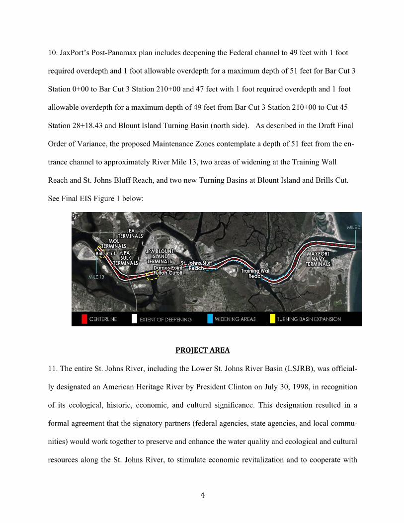
10. JaxPort’s Post-Panamax plan includes deepening the Federal channel to 49 feet with 1 foot
required overdepth and 1 foot allowable overdepth for a maximum depth of 51 feet for Bar Cut 3
Station 0+00 to Bar Cut 3 Station 210+00 and 47 feet with 1 foot required overdepth and 1 foot
allowable overdepth for a maximum depth of 49 feet from Bar Cut 3 Station 210+00 to Cut 45
Station 28+18.43 and Blount Island Turning Basin (north side). As described in the Draft Final
Order of Variance, the proposed Maintenance Zones contemplate a depth of 51 feet from the en-
trance channel to approximately River Mile 13, two areas of widening at the Training Wall
Reach and St. Johns Bluff Reach, and two new Turning Basins at Blount Island and Brills Cut.
See Final EIS Figure 1 below:
PROJECT AREA
11. The entire St. Johns River, including the Lower St. Johns River Basin (LSJRB), was official-
ly designated an American Heritage River by President Clinton on July 30, 1998, in recognition
of its ecological, historic, economic, and cultural significance. This designation resulted in a
formal agreement that the signatory partners (federal agencies, state agencies, and local commu-
nities) would work together to preserve and enhance the water quality and ecological and cultural
resources along the St. Johns River, to stimulate economic revitalization and to cooperate with

5
other state, local, and federal agencies to serve their common interest in the St. Johns River. Fed-
eral agencies entered into this agreement for all the purposes stated above, to the extent allowed
by law and agency policy, including staffing and funding.
12. The Lower St. Johns River is an elongated estuary that extends about 101 miles from its un-
ion with the Ocklawaha River to its mouth at the Atlantic Ocean. From Palatka to Jacksonville,
the river widens from about one to three miles, with an average depth of less than 10 feet. The
channel narrows at Jacksonville and turns eastward to the Atlantic Ocean, deepening to almost
30 feet.
13. The St. Johns is a slow-moving river with a very mild slope averaging 0.1 foot drop per mile.
The gentle slope of the river allows tidal effects to extend at least 106 river miles from the river
mouth in Duval County to Lake George in Volusia County. Lake George, with an area of 67
square miles, is the second largest lake in Florida. According to the applicant, the filling and
draining of Lake George, due to subtidal variability of Atlantic Ocean water levels, causes inter-
mittent periods of reverse flow extending far upstream in the Lower St. Johns River. These re-
verse flow periods, when the daily net discharge moves upstream, extend the upstream move-
ment of salt as well as upstream dispersal of pollutants entering the river.
14. The Timucuan Ecological and Historic Preserve straddles the St. Johns River over much of
the project area. In 1988, Congress created the preserve as part of the National Park System to
“preserve certain wetlands and historic and prehistoric sites in the St. Johns River Valley” and to
protect the many cultural resources present at the park. Florida designated the Preserve an Out-
standing Florida Water (OFW) in 1994. Fla. Admin. Code R. 62-302.700(9)(k)(2).
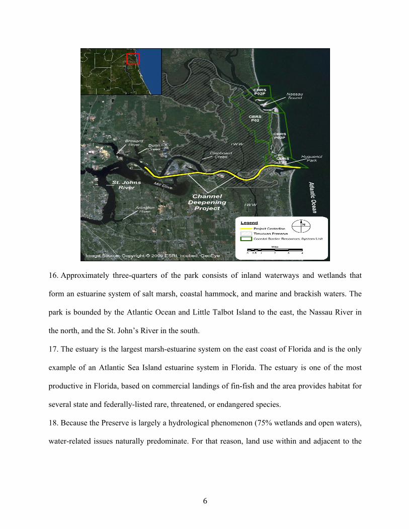
15. The National Park footprint is shown in grey diagonal shading on the EIS Map below.
6
16. Approximately three-quarters of the park consists of inland waterways and wetlands that
form an estuarine system of salt marsh, coastal hammock, and marine and brackish waters. The
park is bounded by the Atlantic Ocean and Little Talbot Island to the east, the Nassau River in
the north, and the St. John’s River in the south.
17. The estuary is the largest marsh-estuarine system on the east coast of Florida and is the only
example of an Atlantic Sea Island estuarine system in Florida. The estuary is one of the most
productive in Florida, based on commercial landings of fin-fish and the area provides habitat for
several state and federally-listed rare, threatened, or endangered species.
18. Because the Preserve is largely a hydrological phenomenon (75% wetlands and open waters),
water-related issues naturally predominate. For that reason, land use within and adjacent to the
7
Preserve, as well as land use anywhere in the watersheds, connected by either groundwater or
surface water has the potential to affect the Preserve.
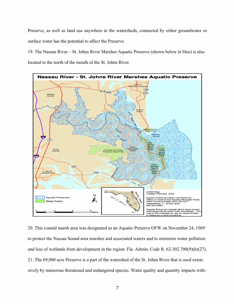
19. The Nassau River – St. Johns River Marshes Aquatic Preserve (shown below in blue) is also
located to the north of the mouth of the St. Johns River.
20. This coastal marsh area was designated as an Aquatic Preserve OFW on November 24, 1969
to protect the Nassau Sound area marshes and associated waters and to minimize water pollution
and loss of wetlands from development in the region. Fla. Admin. Code R. 62-302.700(9)(h)(27).
21. The 69,000 acre Preserve is a part of the watershed of the St. Johns River that is used exten-
sively by numerous threatened and endangered species. Water quality and quantity impacts with-
8
in the Lower St. Johns watershed affect the flow of water to the preserve and its vegetation, fish,
and wildlife.
THE DREDGING PROJECT
22. Between 1890 and 1951, multiple Corps dredging projects deepened the original 15-foot St.
Johns River channel to 34-feet, with the total costs over that time, including maintenance dredg-
ing, amounting to more than $26 million.
23. The current channel deepening proposal was first studied pursuant to a February 5, 1992 au-
thorizing resolution of the Committee on Public Works and Transportation, U.S. House of Rep-
resentatives. The resulting feasibility study recommended modifications from the entrance chan-
nel to River Mile 14.7, including deepening 38 feet to 40 feet. Deepening of that segment was
authorized in 1999 Water Resources Development Act, and construction was completed in 2003.
24. A General Reevaluation Report (GRR) recommended deepening the harbor from River Mile
14.7 to River Mile 20 from 38 feet to 40 feet; deepening of that segment was authorized in the
FY2006 Appropriations Act and construction was completed in 2010.
25. In order to pursue further dredging envisioned by the original 1992 study, it was determined
by U.S. Army Corps of Engineers (USACE) that further study was needed. The Feasibility and
Cost Sharing Agreement (FCSA) for this study was signed July 1, 2005 and amended June 15,
2006.
26. In June 2012, the Corps’ Institute for Water Resources released U.S. Port and Inland Water-
ways Modernization: Preparing for Post-Panamax Vessels, which concluded, among other
things, that south of Norfolk, Virginia along the Southeast and Gulf Coasts there were no ports
considered “Post-Panamax ready.” Southeastern ports did not have channel depths of 50 feet
9
with allowances for tide, as well as sufficient channel width, turning basin size, dock and crane
capacity.
27. The Institute, called upon to advise the Congress, opined that: “There is uncertainty in the
port specific details of when such vessels will arrive in large number, which ports they will call,
how deep vessels calling will draft and, consequently, how deep navigation channels must be.
Over time these uncertainties will reduce as experience replaces expectation. Even in the face of
this uncertainty, individual ports are actively engaged in port expansions and studies to deepen
and widen Federal access channels. We can predict that in the absence of transshipment centers
post-Panamax vessels will call in large numbers, they will call at most major ports and their sail-
ing drafts will become known. Our challenge is to invest in capacity expansion in the right places
at the right time consistent with industry needs.”
28. On March 22, 2012, in an effort to stimulate jobs and the U.S. economy, President Barack
Obama issued Executive Order 13604. This Executive Order established the ”We Can't Wait"
Initiative, among other things, expediting completion of the Jacksonville Harbor deepening study
and reducing the study schedule. A July 19, 2012 White House Press Release boasted that: “One
of the critical steps in modernizing and expanding the Port of Jacksonville is to finalize the fed-
eral feasibility study examining the costs and benefits of deepening the harbor. Nationally, fea-
sibility studies take an average of 10 years and the expedited process announced today will shave
7 years off of that timeline, committing the federal government to finalize the study by April of
2013, years ahead of previous projections.”
29. The six-step planning process for the study was modified with incorporation of a Corps initi-
ative to streamline the planning process, and the President’s “We Can’t Wait Initiative.” Both of
these initiatives resulted in an expedited study process.

10
30. In April 2014, Federal studies were completed and the Corps published its Final Integrated
General Reevaluation Report II and Supplemental Environmental Impact Statement, U.S. Army
Corps of Engineers, Jacksonville District (April 2014), intending the GRRII to serve as both the
Corps’ Decision Document for the navigation improvement project and as the Environmental
Impact Statement (EIS) supplement for the proposed federal action.
31. Though the GRRII study concluded dredging to 45 feet was indicated by cost-benefit analy-
sis, JaxPort prevailed upon the Corps to proceed with a plan to deepen the Federal channel to 47
feet from the entrance channel to approximately River Mile 13, and widen two areas at the Train-
ing Wall Reach and St. Johns Bluff Reach, and dredge two new Turning Basins at Blount Island
and Brills Cut.
32. Construction of the recommended plan would involve dredging of approximately 18 million
cubic yards of material during construction. Fracturing (confined blasting) of any consolidated
sediments and underlying rock is anticipated prior to dredging. Dredged material will be dis-
posed at an ocean dredged material disposal site (ODMDS).
THE ERP APPLICATION
33. The Corps submitted the ERP application for the proposed project on April 10, 2015. DEP
sent the Corps a Request for Additional Information (RAI) on May 13, 2015; and the Corps re-
sponded to the RAI on July 29, 2015.
34. Dredging proposed from approximately river mile 1 to approximately river mile 8 would be
located within the Timucuan National Ecological and Historic Preserve. Dredging from the At-
lantic Ocean to between river miles 3 and 4 would be located adjacent to the southern boundary
of the Nassau River – St. Johns River Marshes Aquatic Preserve. The center of the proposed

11
dredge material disposal site is located approximately 4.4 miles southeast of the waterward tip of
the St. Johns River entrance channel south jetty, outside of state waters.
35. The Applicant acknowledges the dredging is likely to cause turbidity for an extended period
of time (up to 2,920 days) over an expansive area of the St. Johns estuary, exceeding DEP’s rule
criteria and leading DEP to propose variances to authorize the Corps to exceed applicable turbid-
ity mixing zone criteria.
36. Hydrodynamic modeling submitted by the Applicant shows the recommended plan will also
cause changes in salinity, causing an increase in salinity stress in estuarine wetlands and sub-
merged aquatic vegetation as well as changes in fish and macroinvertebrate distributions. Uncer-
tainty exists about the magnitude of both the effect of deepening on salinity and the ecological
response to changes in salinity.
THE PROPOSED AGENCY ACTION
37. On February 19, 2016, DEP entered a Notice of Intent to Issue specifying the following pro-
posed agency actions: (a) issue to the Corps a 10-year Environmental Resource Permit (ERP)
under Part IV of Chapter 373, Florida Statutes (F.S.), and Title 62, Florida Administrative Code
(F.A.C.); and (b) grant a variance to the Corps (File No. 0129277-018-BV) from the provisions
of Rule 62-4.244(5)(c), F.A.C., to allow the turbidity mixing zone to exceed 150 meters; and
from Rules 62-302.700(1) and 62-4.242(2)(a)2.b., F.A.C., to establish a maximum allowable tur-
bidity level above background for work within the Timucuan National Ecological and Historic
Preserve and the Nassau River – St. Johns River Marshes Aquatic Preserve, which are both Out-
standing Florida Waters (OFWs).
38. Explosives and “hydrohammers” will be allowed to break up rock prior to dredging. Blasting
is expected to be required for up to 250 days and is not excluded from the OFWs.
12
39. The requested variance (File No. 0129277-018-BV) from Rule 62-4.244(5)(c), F.A.C., would
establish an “expanded mixing zone that extends 600 meters downcurrent from the dredge for
work adjacent to the existing federal channel in the OFWs. Outside of this expanded mixing
zone, the requested variance from the antidegradation provisions in Rules 62-302.700(1) and 62-
4.242(2)(a)2.b., F.A.C., would establish a maximum allowable turbidity level of 6 Nephelome-
tric Turbidity Units (NTUs) above corresponding background turbidity levels for work within the
OFWs.”
40. In addition to the 18 million cubic yards of river bottom that will be dumped offshore, the
proposed Permit authorizes the Corps to dredge approximately 56 million cubic yards of material
during annual maintenance dredging over the 50-year life of the project, resulting in continuing
ecosystem impacts long after the construction phase of the Project.
41. The dredging, blasting, and turbidity, which DEP is allowing for a period of 2920 days (eight
years), will adversely affect the St. Johns River and its adjacent wetlands during the construction
and post-construction phases of the Project.
42. NO MITIGATION IS REQUIRED FOR ANY IMPACTS.
PETITIONER’S SUBSTANTIAL INTERESTS
43. Established in 2000, the St. Johns Riverkeeper is a non-profit membership based corporation
with its primary place of business in Jacksonville, Florida. St. Johns Riverkeeper was formed for
the purpose of the protection of the environment, fish and wildlife resources, and protection of
air and water quality and St. Johns Riverkeeper has standing because St. Johns Riverkeeper has
had more than 25 members residing in Duval County, where the proposed project would take
place, since about the year 2000. See, §403.412(6), Fla. Stat.

13
44. The mission of St. Johns Riverkeeper is to be an independent voice that defends, advocates,
and activates others for the protection and restoration of the St. Johns River.. As an advocate for
the river, St. Johns Riverkeeper seeks to eliminate or mitigate threats to the St. Johns River for
current users and future generations. St. Johns Riverkeeper has an interest in preserving and pro-
tecting the health and aesthetic qualities of the St. Johns River, its tributaries, and adjacent wet-
lands. St. Johns Riverkeeper encourages and inspires citizens to reclaim and protect the natural
and cultural heritage of the St. Johns River, while also participating in public policy decision-
making to represent the interests of its members and the public.
45. St. Johns Riverkeeper has nearly 1400 individual, family, business, and organizational mem-
berships that includes several thousand people who use and enjoy the waters of the St. Johns
River for boating, fishing, and observing birds and other wildlife throughout the watershed of the
St. Johns River. St. Johns Riverkeeper organizes regular boat trips for its members and citizens
to learn more about the ecology of the river and its vast cultural history. Additionally, St. Johns
Riverkeeper organizes clean up events in and around the St. Johns River and its tributaries, as
well as organizes outreach programs to bolster community involvement in issues relating to the
river.
46. St. Johns Riverkeeper is a member of the Waterkeeper Alliance, an international environ-
mental organization uniting more than 270 Waterkeeper affiliates globally. Members recreate,
use, enjoy, and benefit economically from the St. Johns River and the marine resources that in-
habit the river. Members boat, fish, swim, observe wildlife, and enjoy the aesthetic qualities of
the St. Johns River and its adjacent wetlands.
47. The Project will impact coastal property owned and used by members as a result of shoreline
erosion from increased wakes of the post-Panamax ships. The long-term effects of the Project

14
will cause significant ecological changes to the St. Johns River and its adjacent wetlands, which
will greatly diminish or eliminate the current opportunities for members to observe fish and wild-
life. The short-term turbidity and sedimentation problems will harm submerged vegetation, lead-
ing to more devastating long-term effects on the ecology of the river.
48. Dredge spoil may disperse over long distances instead of sinking to the ocean floor, causing
negative effects to the ecology of the offshore spoil site, as well as unknown impacts to the
coastline near the mouth of the river. Further, the dumping of dredge spoil offshore may affect
the habitat of the North Atlantic Right Whale.
49. The Project will significantly alter public access to the St. Johns River, and at some points
completely block public access.
50. Should the permit and variances be issued, there will be substantial impacts to water quality
and the ecology of the river and its adjacent wetlands. The Project will result in the following
adverse effects to the St. Johns River: (1) salinity will move farther upstream, impacting hun-
dreds of acres of wetlands and submerged aquatic vegetation in the St. Johns River watershed;
(2) an increased probability for algae blooms because nutrient-laden water will have a longer res-
idence time in the river; (3) greater shoreline erosion from larger wakes caused by post-Panamax
ships; (4) potential exposure of the surficial aquifer to saltwater intrusion as a result of consecu-
tive days of confined blasting; (5) impacts to threatened and endangered species from the blast-
ing necessary for the project; (6) long term ecological changes to the river affecting the habitat of
threatened and endangered species; (7) turbidity and sedimentation during the construction phase
of the project; and (8) significant exacerbation of the likely effects of sea-level rise.
51. The impacts of the Project adversely affect the interests of St. Johns Riverkeeper and its
members in maintaining the health and aesthetic quality of the St. Johns River, and adversely

15
affect St. Johns Riverkeeper’s members’ use and enjoyment of these water resources and ecosys-
tem. The Project is not in the public interest, because of its adverse impacts on the ability of St.
Johns Riverkeeper members and the general public to use the St. Johns River for boating, fish-
ing, wildlife observation, and other recreational activities. While all Project impacts cannot be
predicted with certainty, the Port of Miami’s Post-Panamax dredge project has resulted in turbid-
ity and sedimentation problems that have violated state water quality standards because the envi-
ronmental risks of the project were ignored or downplayed during the planning phase. In the
Miami Harbor dredging project, the violations of state water quality standards resulted in linger-
ing turbidity problems that have blanketed coral and submerged vegetation with an overabun-
dance of silt and clay long after the project’s completion. A similar effect on the St. Johns River
as a result of the Project would negatively impact all members of St. Johns Riverkeeper, as well
as other individuals in their use and enjoyment of the river for generations to come.
52. The injury is sufficiently immediate and of the type and nature that Chapters 120 and 403,
Florida Statutes, are designed to protect.
DISPUTED ISSUES OF MATERIAL FACT
53. In this Petition, St. Johns Riverkeeper contends there is merit to the assertion that the Project
meets the requirements of Chapter 373, Part IV, Florida Statutes for the reasons herein, which St.
Johns Riverkeeper asserts in good faith and which assertions may include good faith argument
for the application, extension, or modification of existing law, or the establishment of new law as
necessitated by the material facts regarding the project and proposed Project.
54. St. Johns Riverkeeper disputes whether the applicant has provided reasonable assurances that
the activities authorized by the Project:
16
a. Will not adversely impact the value of functions provided to fish and wildlife and
listed species by wetlands and other surface waters [paragraph 62- 330.301(1)(d), F.A.C.]; so
as to cause adverse impacts to: (a) The abundance and diversity of fish, wildlife, listed spe-
cies, …; and (b) The habitat of fish, wildlife, and listed species;
b. Will not adversely affect the quality of receiving waters such that the water quality
standards set forth in Chapters 62-4, 62-302, 62-520, and 62-550, F.A.C., including any an-
tidegradation provisions of paragraphs 62-4.242(1)(a) and (b), subsections 62-4.242(2) and
(3), and Rule 62-302.300, F.A.C., and any special standards for Outstanding Florida Waters
… set forth in subsections 62- 4.242(2) and (3), F.A.C., will be violated [paragraph 62-
330.301(1)(e), F.A.C.];
c. Will not cause unacceptable cumulative impacts upon wetlands and other surface wa-
ters [paragraph 62-330.302(1)(b), F.A.C.] as set forth in sections 10.2.8 through 10.2.8.2 of
Volume I;
d. Will not adversely affect the public health, safety, or welfare or the property of others
(subparagraph 62-330.302(1)(a)1, F.A.C.);
e. Will not adversely affect the conservation of fish and wildlife, including endangered
or threatened species, or their habitats (subparagraph 62- 330.302(1)(a)2, F.A.C.);
f. Will not adversely affect navigation or the flow of water or cause harmful erosion or
shoaling (subparagraph 62-330.302(1)(a)3, F.A.C.);
g. Will not adversely affect the fishing or recreational values or marine productivity in
the vicinity of the activity (subparagraph 62-330.302(1)(a)4, F.A.C.); Examples of activities
that may adversely affect fisheries or marine productivity are the elimination or degradation
of fish nursery habitat, change in ambient water temperature, change in normal salinity re-
17
gime, reduction in detrital export, change in nutrient levels, or other adverse effects on popu-
lations of native aquatic organisms;
h. Will not have temporary and permanent adverse impacts (subparagraph 62-
330.302(1)(a)5, F.A.C.);
i. Will not adversely affect or will enhance significant historical and archaeological re-
sources under the provisions of Section 267.061, F.S. (subparagraph 62- 330.302(1)(a)6,
F.A.C.);
j. Will not cause adverse effects to existing recreational uses of a wetland or other sur-
face water. Wetlands and other surface waters may provide recreational uses such as boating,
fishing, swimming, waterskiing, hunting, and birdwatching. An example of potential adverse
effects to recreational uses is the construction of a traversing work, such as a road crossing a
waterway, which could impact the current use of the waterway for boating;
k. Are clearly in the public interest;
l. Will have adverse impacts fully offset or mitigated;
m. Will not cause adverse water quantity impacts to receiving waters and adjacent lands;
n. Will not cause adverse flooding to on-site or off-site property;
o. Will not cause adverse impacts to existing surface water storage and conveyance ca-
pabilities;
p. Will be capable, based on generally accepted engineering and scientific principles, of
performing and functioning as proposed;
q. Will be implemented by an entity with the financial, legal and administrative capabil-
ity of ensuring that the activity will be undertaken in accordance with the terms and condi-
tions of the permit, if issued;

18
r. The proposed mixing zone complies with Florida’s antidegradation policy and rules;
s. The Applicant and DEP performed required antidegradation analyses, including anal-
ysis of the Project’s impacts on ambient water quality;
t. The Applicant has complied with Florida Administrative Code Rule 62-110.104(1) by
submitting a petition containing all of the information required by the Rule;
u. The proposed variance complies with Florida’s antidegradation policy and rules;
v. There is no practicable means known or available for the adequate control of the tur-
bidity and salinity pollution involved;
w. The variance complies with the limitations contained in Sections 373.414(17) and
403.201, Florida Statutes, and Florida Administrative Code Rule 62-110.104;
x. Any hardship asserted as a basis of the need for a variance is peculiar to the affected
property and is not self-imposed.
ULTIMATE FACTS
55. The ultimate facts asserted in good faith, and potentially including good faith argument for
the application, extension, or modification of existing law, or the establishment of new law, in-
clude that the Applicant has not provided reasonable assurance regarding the matters identified
in paragraph 54 above.
STATUTES AND RULES
56. The statutes and rules which entitle St. Johns Riverkeeper to relief include, but are not lim-
ited to, the following:
a. Sections 120.569 and 120.57, Florida Statutes;
b. Section 373.414, Florida Statutes;
c. Section 403.201, Florida Statutes;

19
d. Rule 62B-49, Florida Administrative Code;
e. Rule 62-4.070, Florida Administrative Code;
f. Rule 62-4.242, Florida Administrative Code;
g. Rule 62-4.244, Florida Administrative Code;
h. Rule 62-110.104, Florida Administrative Code;
i. Rule 62-302.300, Florida Administrative Code;
j. Rule 62-302.530, Florida Administrative Code;
k. Rule 62-302.700, Florida Administrative Code; and
l. Chapter 62-330, Florida Administrative Code.
WHEREFORE, Petitioner respectfully requests the following:
A. A formal administrative hearing before the Division of Administrative Hearings;
B. A final order denying the proposed ERP for the Army Corps of Engineers Jackson-
ville Harbor Navigation Channel Project and the proposed Variance, File Nos.
0129277-017-BI and 0129277-018-BV.
C. Attorney’s fees and costs pursuant to Florida Statutes, Section 120.57; and
D. Any other relief deemed necessary and proper.
Respectfully submitted this 1st day of April, 2016.
Jane West Law, P.L. 6277 A1A South, Suite 101 St. Augustine, FL 32080 Ph: (904) 471-‐0505 [email protected] By: /s/ Jane West Jane West Fla. Bar No.: 0159417
Related Documents