1 Office of Management and Budget United States Federal Geographic Data Committee Specifications for Descriptions of Land: For Use in Land Orders, Executive Orders, Proclamations, Federal Register Documents, and Land Description Data Bases United States Department of the Interior Bureau of Land Management Cadastral Survey CADASTRAL SUBCOMMITTEE REVISED 2013

Welcome message from author
This document is posted to help you gain knowledge. Please leave a comment to let me know what you think about it! Share it to your friends and learn new things together.
Transcript
1
Office of Management and Budget
United States Federal Geographic Data Committee
Specifications for Descriptions of Land: For Use in Land Orders, Executive Orders, Proclamations, Federal Register
Documents, and Land Description Data Bases
United States Department of the Interior Bureau of Land Management
Cadastral Survey
CADASTRAL SUBCOMMITTEE
REVISED 2013
2
Specifications for Descriptions of Land:
For Use in Land Orders, Executive Orders, Proclamations,
Federal Register Documents, and Land Description Data Bases
WASHINGTON: 2013
U.S. DEPARTMENT OF THE INTERIOR
For sale by the Public Land Survey System Foundation
http://www.blmsurveymanual.org/
3
U.S. DEPARTMENT OF THE INTERIOR
As the Nation's principal conservation agency, the Department of the Interior
(Department) has basic responsibilities for water, fish, wildlife, mineral, land, park, and
recreational resources. Indian and Territorial affairs are other major concerns of
America's “Department of Natural Resources.”
The Department works to assure the wisest choice in managing all of the nation’s
resources so each will make its full contribution to a better United States – now and in the
future.
The Department manages about 500 million acres, or one-fifth, of the land in the
United States. The Bureau of Land Management (BLM) manages more than 245 million
surface acres and also administers more than 700 million acres of subsurface mineral
estate and in all 50 States.
The BLM is the Nation’s surveyor and maintains extensive current and historical
information about land ownership in the United States. Most title to land, public or
private, begins with a land description established by an original cadastral survey.
Security of legal title to land is the fundamental object of the cadastral surveyor’s work.
It is more important now than in the past that the person preparing land
descriptions be knowledgeable of requirements for the preparation of the various types of
land descriptions. It is necessary to use the proper format, terms and phrases, and intent
with qualification to assure the content of the land description is free of ambiguity. The
ambiguous descriptions of the past are the boundary disputes of the future.
Previous editions of Specifications for Descriptions of Tracts of Land for Use in
Executive Orders and Proclamations were issued in 1931, re-issued in 1941 with
corrections as to procedure, revised in 1942, and reprinted without revision in 1960. In
1979 the Specifications was revised and the title was changed to Specifications for
Descriptions of Tracts of Land for Use in Land Orders and Proclamations.
4
CONTENTS
Chapter Page
INTRODUCTION AND PURPOSE OF THIS PUBLICATION
1. LAND DESCRIPTIONS
General Considerations - Purpose
Authority
Descriptions of Land
Types of Descriptions
Description by Reference to Official Records
2. THE PUBLIC LAND SURVEY SYSTEM
Rectangular Surveys
Preferred Order
The Preferred Method for the Writing of Descriptions
Area
Conventional Symbols and Abbreviations
Examples of Descriptions of Lands based upon the Rectangular Surveys of the
Public Land Survey System
3. METES-AND-BOUNDS
Natural and Artificial Boundaries
Area
The Parts of Metes-and-Bounds Descriptions
Examples
Caption or Preamble
Body
Clauses
Strip Descriptions
Ambulatory Descriptions
4. LOT AND BLOCK DESCRIPTIONS
5. ILLUSTRATIONS (MAPS) AND COORDINATES
Maps to be Published
Survey Plats, Maps or Diagrams Forming Official Supplements
Description by Coordinates
Geographic Positions
Examples of Geographic Coordinate Positions
6. FORM AND ARRANGEMENT
Titles
Proclamations
Public Land Orders
Executive Order No. 11030, as Amended
Preparation, Presentation, Filing, and Publication of Executive Orders and
Proclamations
Applicable to All Documents Filed with Federal Register
Applicable to All Proposed Executive Orders and Proclamations
Executive Order No. 10355

5
Federal Land Policy and Management Act Withdrawal, Reservation and
Classification of Lands
Department of the Interior Secretary’s Orders
Executive Order No. 13327
Federal Real Property Asset Management
Marine Managed Areas: Best Practices for Boundary Making
INTRODUCTION TO PREVIOUS EDITIONS
6
INTRODUCTION AND PURPOSE OF THIS PUBLICATION
The Federal Board of Surveys and Maps (Board) was established by Executive
order in 1919, to coordinate and promote improved surveying and mapping activities by
Federal agencies. In 1930, the Department of State requested the Board to prepare rules
and specifications for descriptions of tracts of land appropriate for use in Executive
orders and Proclamations. The original edition, entitled, Specifications for Descriptions
of Tracts of Land for Use in Executive Orders and Proclamations, was completed and
published in 1931, with subsequent editions issued in 1941, 1942, 1960, and 1979. Since
1931, the Specifications have served the vital function of providing guidance to those
who must write and interpret land descriptions and have been used by experts in the legal,
survey, public administration, and geospatial data analyst professions.
A boundary is the fixing of a limit or extent of property and in this publication is
associated with uplands, inland waters, and tidelands with application to marine
boundaries. When an Executive department or any agency or establishment of the
Federal Government describes or specifies any parcel of land or marine area by boundary
or subdivisional unit, the description should be a model of precision, to the extent the
available record data permit. A law, regulation or order cannot fulfill its intended effect
if the boundary description is inaccurate, vague or ambiguous.
This publication will provide guidance for writing accurate boundary descriptions,
locations by survey, the form and arrangement to be followed for Executive and Public
Land Orders and Proclamations, and examples of boundary descriptions. Use of this
publication will provide a standardized process for review of descriptions to assure that
only the best available descriptions are published.
Many land descriptions are used to develop products for Federal administrative
purposes. To facilitate the sharing of land description information in an electronic data
base format, all data sets should be accompanied with essential cadastral metadata that
conforms to the Federal Geographic Data Committee (FGDC) Subcommittee for
Cadastral Data FGDC Metadata Data Content Standard and Publication Standard. Core
data is the minimal set of information needed for sharing data among agencies for initial
search and discovery by the user community and use in basic business operations.
The database content definitions for land descriptions are found in the FGDC
Cadastral Data Content Standard. The data content standard provides the logical design
definitions and relationship of land description elements. Physical implementations
should be consistent and compliant with the standard’s definitions and intent.
Accurate and precise geographic (or geospatial) information is critical to promote
economic development, improve stewardship of natural resources, and protect the
environment. Standardized land descriptions avoid wasteful duplication of effort and
promote effective and economical management of land and resources by Federal
agencies. Since the publication of the 1979 Edition, certain procedures have been
rendered inapplicable due to reorganization and transfer of functions of various Federal
7
Agencies.1 There are also new survey and digital applications and methods mandating
this revision. Further experience in the use of the specifications, and improvements to
survey and digital data collection during the near thirty-year period, which has elapsed
since the previous revision, has indicated the need for additional and updated explanatory
text and examples.
Executive Order No. 12906, as amended, requires each agency to document all
new geospatial data it collects or produces, using the standard developed by the FGDC.2
Geospatial data mean information that identifies the geographic location and
characteristics of natural or constructed features and boundaries on the earth.3 The
geospatial information necessary to describe the geographic extent and the rights and
interests include surveys, legal description reference systems, parcel-by-parcel surveys,
and descriptions.4
The Office of Management and Budget (OMB) assists the President in preparing
the budget, formulating fiscal programs, supervising the administration of the budget,
conducting efficiency reviews of Executive branch organizational structure and
management procedures, assisting in clearing legislative proposals from Federal
agencies, in drafting Executive orders and Presidential Proclamations, in developing
regulatory reform programs, coordinating government activities, and advising the
President on program progress.
The FGDC was established by OMB Circular No. A-16, Coordination of
Geographic Information and Related Spatial Data Activities; Revised 2002, to coordinate
the Federal Government’s development, use, sharing and dissemination of geographic
data. The FGDC Cadastral Subcommittee is responsible for the standard that covers the
development, maintenance, and dissemination of the core set of digital geospatial
cadastral information (section 2(b)(1)), including descriptions of tracts of land.
The term “land order” by common usage has come to mean “Executive order”
and “Public Land Order.” The terms “legal description” and “land description” over the
past have commonly been used interchangeably. In reality the “legal description”
contains the “land description” within the legal document or order. The “legal
description” also defines the use, purpose, encumbrances, and/or time frame (4-
dimensional) of the tract(s) being described. The actual “land description” defines the
1 The policies and procedures for publication in the FEDERAL REGISTER are established by the
Administrative Committee of the Federal Register. The functions connected with the preparation and
presentation of Public Land Orders, Executive orders and Proclamations are carried on by the Office of the
Federal Register, National Archives Records Administration, under the provisions of the Federal Register
Act, as amended, and the Administrative Procedure Act. The pertinent regulations are published in Title 1
of the Code of Federal Regulations. These entities have introduced certain changes in procedure and
requirements and have rendered inapplicable some of the material contained in the 1979 revision. 2 E.O. 13286 (02/28/03) 68 FR 10619 – Transfer of certain functions to the Secretary of Homeland
Security. 3 E.O. 12906.
4 Federal Geographic Data Committee. 1997. Framework Introduction and Guide. p. 21.

8
delimitation5 of an area of the subsurface, submerged lands, water column, water surface,
land surface or air column, and 2-dimensional, or 3-dimensional limits.
5 Delimitation/delimited/delimiting means the determination of a boundary; includes all phases of
boundary development.
9
Chapter I
LAND DESCRIPTIONS
GENERAL CONSIDERATIONS
PURPOSE
Public Land Orders, Executive orders and Proclamations containing land
descriptions are usually designed to reserve and set apart certain tracts6 or areas owned or
controlled by the Federal Government for specific public uses or purposes, or for Indian
trust responsibilities. These tracts or areas could be reserved or set apart for military and
naval requirements, national forests, parks and monuments, game and bird refuges,
Indian or Alaska native lands, minerals development, various administrative uses, or for
classification in aid of proposed legislation. An initial action is ordinarily taken by the
bureau or agency exercising administrative control or jurisdiction over the land.7
A Proclamation is normally an announcement by the President of the United
States issued to carry out the provisions of an Act of Congress. Proclamations are usually
of wider public distribution than Public Land Orders and Executive orders, which
normally apply to affairs of the Government, have a more limited and particular purpose,
and are of a temporary nature or duration. An example of a Proclamation would be the
establishment of a new national monument. It is the practice to withdraw the land by
Executive order or Public Land Order preliminary to survey, examination, and permanent
establishment. Subsequent modification of the boundaries of such a reservation may
become necessary, and the general practice is to accomplish these purposes by Executive
order or Public Land Order. In some cases the authorizing legislation specifies the
manner in which the action should be taken.
All Proclamations are published in the United States Statutes at Large.
Proclamations, Executive orders and Public Land Orders are published in the Federal
Register under the provisions of the Acts of July 26, 1935 (49 Stat. 500) and October 22,
1968 (82 Stat. 1274; 44 U.S.C. 1505).
AUTHORITY
The President has the power to reserve or withdraw lands owned or controlled by
the United States for public purposes. 6 Pub. Lands Dec. 317 states: “The President is
vested with general authority in the matter of reserving for public uses, and lands so set
apart is not subject to disposition under the public land laws during the existence of such
reservation.” Section 2, of the Act of June 8, 1906, (34 Stat. 225; 16 U.S.C. 431 et seq.)
authorizes the President of the United States, in his discretion, to declare by public
proclamation historic landmarks, historic and prehistoric structures, and other objects of
6 The term “tract” by common usage is applied to an expanse of land of no particular size. In modern
Federal land surveys, the term is used specifically to mean an expanse of land that lies in more than one
section or that cannot be identified in whole as part of a particular section. It is described by tract number
and township. 7 By Public Law 94-579 “Federal Land Policy and Management Act of 1976,” 90 Stat. 2743, 43 U.S.C.
1701 et seq., the Secretary of the Interior is authorized to sign all orders withdrawing or reserving public
lands of the United States and all orders revoking or modifying such orders.
10
historic or scientific interest that are situated upon the lands owned or controlled by the
Government of the United States as national monuments.
Section 204, of the “Federal Land Policy and Management Act of 1976,” Public
Law 94-579, 90 Stat. 2743, 43 U.S.C. 1714, authorizes the Secretary of the Interior
(Secretary) to make, modify, extend, or revoke withdrawals in accordance with the
provisions and limitations of the section. The Secretary may delegate this withdrawal
authority only to individuals in the Office of the Secretary who have been appointed by
the President of the United States, by and with advice and consent of the U.S. Senate.
DESCRIPTIONS OF LAND
The land description portion of an Order, Proclamation or any document
delimiting limits of land or space must be susceptible of one, and only one, interpretation.
Simplicity and clarity are paramount, and are to be achieved through established proper
usage of terminology, phraseology, punctuation, arrangement and paragraphing. It
should furnish sufficient information for the identification of the spatial limits or area by
a land surveyor. It should contain clear “intent” and proper “qualification” of the lands
being described for the present and the future without ambiguity.
R. H. Skelton wrote in The Legal Elements of Boundaries and Adjusted
Boundaries: “The only rule that can be given for the writing of legal descriptions is ----
that the scrivener should place himself as nearly as possible in the seats of those which
will be occupied by those who, 20 years hence, attempt to lay down the grant --- describe
the land conveyed with such clarity and certainty that the intention as effectively
expressed will be significant to the next generation as it is to the writer.” The definition
of a legally sufficient real property description is one that can be located on the ground by
a land surveyor.
Executive orders have prescribed certain requirements in connection with the
preparation of land descriptions. These requirements state each document will have a
suitable title, the citation under which it is issued, proper punctuation, capitalization,
spelling and style, correct spelling of geographic names. The land descriptions of tracts
or areas must conform to Bureau of Land Management Cadastral Survey standards.
The drafting of Public Land and Executive Orders and Proclamations is subject to
review by a legal expert on the correctness of the legal subject matter, as to the citation of
the appropriate statutes, previous Orders and Proclamations, and reference to Federal
court decisions. In like manner, equal care should be taken to formulate the land
description of a tract or area in plain technical terms, and each description should be
written, or at a minimum, scrutinized by a boundary survey expert. This review will
consider not only the technical sufficiency and form of the description but the feasibility
and practicability of the boundary from the viewpoint of proper administration.
The originating bureau or agency is responsible for the authenticity and accuracy
of the data upon which the land descriptions are based. Field notes and plats of the basic
11
surveys or copies of deed records or comparable documents, together with maps or
diagrams showing the tract, spatial limits, or area referred to should be available for
review and reference.
TYPES OF DESCRIPTIONS
Descriptions of land in Land orders and Proclamations are of three general types.
Many land descriptions are a combination of two or more types:
1. Those cases where the lands are described by reference to designated
Public Land Survey System (PLSS) subdivisions based upon surveys of
official character and shown upon plats filed in the United States survey
records. The most common of these are aliquot parts of the rectangular
system of surveys.
2. Those cases where the location and limits of land are described in specific
terms by recital of its boundaries and/or adjoiners, generally termed a
metes-and-bounds description.
3. Those cases where the lands are described by reference to designated
subdivisions based upon surveys and shown upon plats or maps filed in a
public office, generally termed a lot and block survey or residential
subdivision survey.
DESCRIPTION BY REFERENCE TO OFFICIAL RECORDS The first type of land description referred to in the preceding paragraph was
considered by the United States Supreme Court in the case of Cragin v. Powell, 128 U.S.
691, 696 (1888), from which the following is quoted:
It is a well settled principle that when lands are granted according to an
official plat of the survey of such lands, the plat, itself, with all its notes,
lines, descriptions, and land marks, becomes as much a part of the grant or
deed by which they were conveyed, and controls so far as limits are
concerned, as if such descriptive features were written out upon the face of
the deed or grant itself.
This fundamental principle finds wide application in the description of tracts and
areas located both within and outside of the original public domain. Because of the large
volume of Land orders and Proclamations involving lands in the 30 public land states,
Chapter 2 is devoted to land descriptions based on the official plats of that system.
However, the principle of reference to a record of survey is generally applicable
to all kinds of land descriptions. For example, parcels may be described by lot and block
numbers of a city or townsite subdivision based upon a properly identified plat duly
recorded in a public office of record.
12
Descriptions based on recorded plats and maps of the character just referred to by
designation of subdivision shown thereon should identify the particular plat or map by
title and date, giving the name and location of the place of record as well as the approving
or certifying authority. Such methods will have the advantage of a plat or map being
incorporated as part of the description and will show intent. An example of a land
description referring to a survey is (see figure 5):
It is hereby certified That, the application 1234, filed pursuant to the Act
of May 17, 1906, as amended, has been approved pursuant to the act, as
amended, for the following described land:
U.S. Survey No. 14188, Alaska.
Containing 80.00 acres, as shown on the plat of survey officially filed on
September 13, 2011.
13
Chapter II
THE PUBLIC LAND SURVEY SYSTEM
RECTANGULAR SURVEYS
On the 20th
of May 1785, the Congress of the Confederation passed “An
ordinance for ascertaining the mode of locating and disposing of lands in the western
territory and for other purposes therein mentioned.” Shortly thereafter, the part of the
Northwest Territory, which became the State of Ohio, was used to experiment and
develop the system of rectangular surveys prior to disposing of the land. This system
became known as the Public Land Survey System (PLSS). Revisions to the rules of
survey and disposition were made as the survey and settlement progressed westward.
The revisions to the General Plan are codified in the editions of the Manual of Surveying
Instructions (Survey Manual), published by the Department of the Interior.8
The rectangular system was used in that part of the United States acquired by the
Federal Government by cession from the states, treaty and purchase, now embraced in the
public land states of Alabama, Alaska, Arizona, Arkansas, California, Colorado, Florida,
Idaho, Illinois, Indiana, Iowa, Kansas, Louisiana, Michigan, Minnesota, Mississippi,
Missouri, Montana, Nebraska, Nevada, New Mexico, North Dakota, Oklahoma, Ohio,
Oregon, South Dakota, Utah, Washington, Wisconsin, and Wyoming, which comprised
the original public domain. The rectangular system of surveys has been extended or is
now in progress over this area as the basis for the identification, administration, and
disposal of the remaining Federal interest lands and is the basis for the identification of
the disposed lands.
The land description within the scope of the PLSS rectangular surveys should
conform to the accepted nomenclature of that system, citing the name of the proper
principal meridian, the state, the appropriate township and range numbers, and where
necessary, the section and sectional subdivisions shown upon the official plats of survey.9
Each principal meridian has its own base line; therefore, the words “and base line” are
usually omitted from the meridian. The name of the principal meridian should be spelled
in full. If the lands have not been surveyed, the description should conform to the
subdivisions shown on the approved protraction diagram. If the lands have not been
surveyed and there is no approved protraction diagram, the description should conform to
the legal subdivisions that will, when established, include the lands.
A detailed description of the rectangular system of survey and its nomenclature is
given in the Survey Manual. Figure 1-1 in the Survey Manual depicts the principal
meridians and base lines of the PLSS.
8 The current edition is 2009.
9 Most PLSS land descriptions by law are implicitly descriptions by reference, i.e., the area of interest has
previously been delimited on an official survey plat. When the Federal Government writes the land
description, the presumption is; the intention is in conformance to the PLSS of establishment of survey
monuments and the survey record prior to a land description, unless explicitly stated otherwise.
14
The rectangular survey system is basically curvilinear lines based upon true
meridian and is originated from an “Initial Point” 10
. Once the initial point is established
a north-south line is configured through the point with reference to “true north”, not
magnetic north. This is referred to as the “Principle Meridian” and is extended as far
north or south as necessary for the lands to be referenced to this meridian. Next an east-
west line is configured through the initial point parallel to the equator. This is referred to
as the “Base Line” and is extended east and west as far as necessary for the lands to be
referenced to the base line. “Township Lines” are then established north and south of the
base line at six mile intervals and numbered north or south from the base line as
necessary. Then “Range Lines” are established east and west of the principle meridian at
six mile intervals and numbered east or west of the principle meridian as necessary. The
intersection created by the township lines and the range lines form a nominal six mile
square creating what is referred to as a “Township”. It is noted that two different
meanings have been applied to the term “township”.
The first use of “township” was to describe a series of nominal 6-mile wide
horizontal rows north and south of the baseline. The second use of the term “township”
is used to describe the nominal 6-mile square area that is situated between two adjacent
range lines and two adjacent township lines. This 6-mile square township consists of 36
“Sections” with each section being nominally 1 square mile.
10
Meaning lines of constant bearing (rhumb lines), reported as horizontal distance at average ground
elevation of the end points. True meridian is defined by the axis of the earth’s rotation. See chapter II of
the Survey Manual for a discussion of the Public Land Survey System Datum.
15
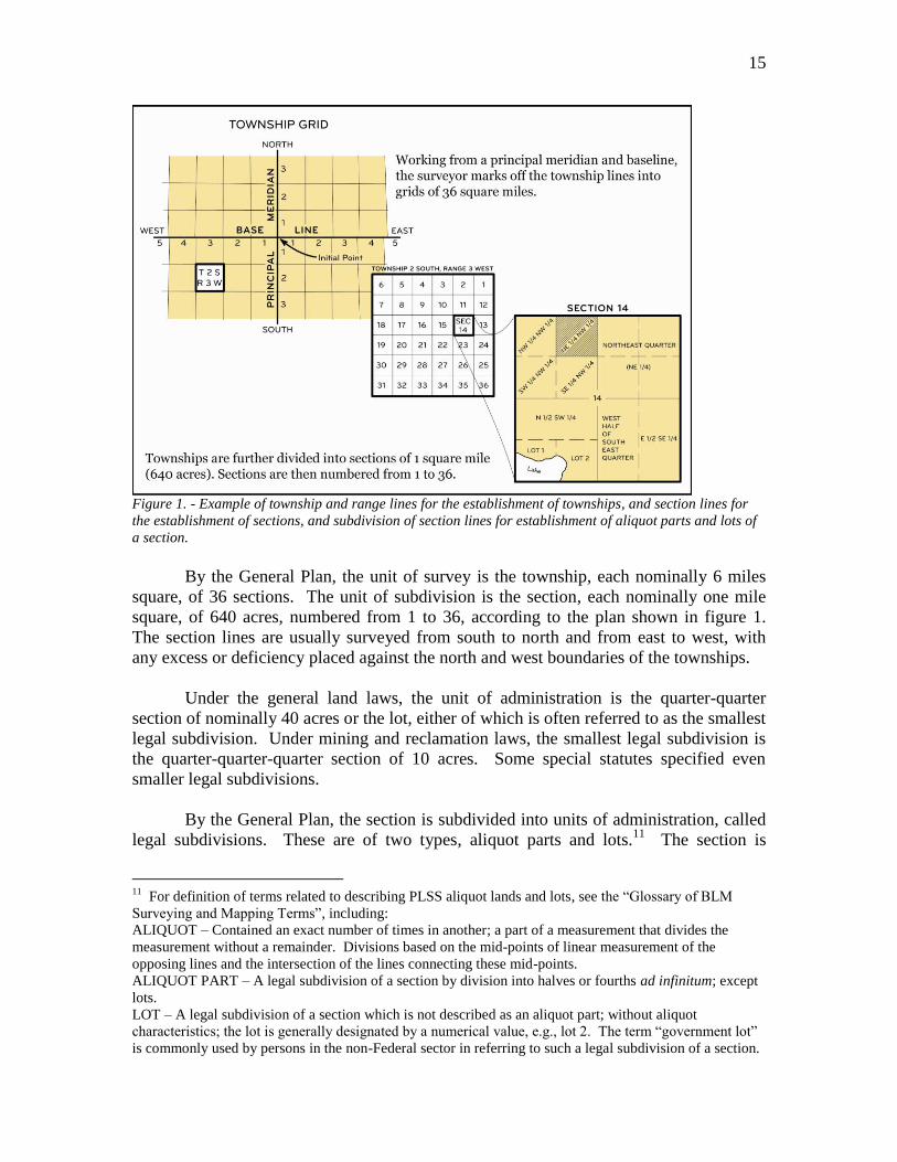
Figure 1. - Example of township and range lines for the establishment of townships, and section lines for
the establishment of sections, and subdivision of section lines for establishment of aliquot parts and lots of
a section.
By the General Plan, the unit of survey is the township, each nominally 6 miles
square, of 36 sections. The unit of subdivision is the section, each nominally one mile
square, of 640 acres, numbered from 1 to 36, according to the plan shown in figure 1.
The section lines are usually surveyed from south to north and from east to west, with
any excess or deficiency placed against the north and west boundaries of the townships.
Under the general land laws, the unit of administration is the quarter-quarter
section of nominally 40 acres or the lot, either of which is often referred to as the smallest
legal subdivision. Under mining and reclamation laws, the smallest legal subdivision is
the quarter-quarter-quarter section of 10 acres. Some special statutes specified even
smaller legal subdivisions.
By the General Plan, the section is subdivided into units of administration, called
legal subdivisions. These are of two types, aliquot parts and lots.11
The section is
11
For definition of terms related to describing PLSS aliquot lands and lots, see the “Glossary of BLM
Surveying and Mapping Terms”, including:
ALIQUOT – Contained an exact number of times in another; a part of a measurement that divides the
measurement without a remainder. Divisions based on the mid-points of linear measurement of the
opposing lines and the intersection of the lines connecting these mid-points.
ALIQUOT PART – A legal subdivision of a section by division into halves or fourths ad infinitum; except
lots.
LOT – A legal subdivision of a section which is not described as an aliquot part; without aliquot
characteristics; the lot is generally designated by a numerical value, e.g., lot 2. The term “government lot”
is commonly used by persons in the non-Federal sector in referring to such a legal subdivision of a section.
16
subdivided into quarter-sections by running straight lines from the established quarter-
section corners to the opposite corresponding quarter-section corners. These nominal
160-acre units are designated by symbol in tabular descriptions as, NE1/4, NW1/4,
SW1/4, and SE1/4.
The quarter-section is subdivided into quarter-quarter sections by running straight
lines from the established quarter-quarter section corners to the opposite corresponding
quarter-quarter section corners. These nominal 40-acre units are designated by symbol in
tabular descriptions as, SW1/4NE1/4. Occasionally the quarter-quarter section is further
subdivided into its aliquot parts by connecting opposite corresponding corners. These
resulting nominal 10-acre units are designated by symbol as, NW1/4SW1/4NE1/4.
In theory, aliquot parts can be divided ad infinitum. However the lengthy
descriptions that result from this practice tend to invite error in the preparation and
recordation of documents. It also further complicates the maintenance and interpretation
of the land records. As a policy (sections 3-33 and 9-90 Survey Manual), land
descriptions by aliquot part must not go beyond a four component description. For
example, a 5-acre unit described as the S1/2NE1/4NW1/4SE1/4 is acceptable, as is a 2½-
acre unit described as the SE1/4NE1/4NE1/4SW1/4. Aliquot parts of 1¼-acre or less
described with five components or more, e.g., the W1/2SE1/4NE1/4SW1/4SE1/4 are
unacceptable. When it is anticipated that lands will be subdivided into aliquot parts of
less than 2½-acres, an official survey will be conducted or a supplemental plat will be
prepared and lot numbers assigned. Exceptions may be granted in cases where the actual
on-the-ground location of the division line does not and will not govern. If the
originating bureau or office determines there is a need for an exception, it is advisable to
request a Standards for Boundary Evidence Certificate(s) (SBE) from a Certified
Department of the Interior Land Surveyor (CILS)12
.
PREFERRED ORDER
If more than one township is included, the preferred order of listing is to begin
with the lowest range number, and within each range by the township numbers also
beginning with the lowest. Where townships east and west of the principal meridian or
north and south of the base line or both are involved, the preferred order of listing is; first
those north and east of the initial point, followed by those north and west, south and west,
and south and east in the order named. All the parts of each township and range will be
described before proceeding to the next township and range.
The preferred order of listing sections is to begin with the lowest-numbered
section in each township, giving first the lot numbers in order, then the subdivisions
within each quarter section, in the order NE, then the NW, SW, and SE; if parts of the
“Lot” is also the name given individual parcels of recorded subdivision of private tracts, i.e., lot and block
subdivisions. 12
See Department of the Interior Departmental Manual Standards for Federal Lands Boundary Evidence
(600 DM 5).
17
quarter-sections are to be described, the same order is observed, and all the parts of each
quarter-section will be described before proceeding to the next quarter-section, and so on.
THE PREFERRED METHOD FOR THE WRITING OF DESCRIPTIONS
The use of a comma is significant in writing the descriptions of the subdivisions
of a section. A comma means “AND THE” and the absence of a comma means “OF
THE”. The improper use or placement of a comma could drastically change an aliquot
description and the intended acreage to be described. The description NE1/4SW1/4SE1/4
absent of the comma describes an aliquot part of 10 acres. With a comma as such NE1/4,
SW1/4, SE1/4 describes three aliquot parts totaling 480 acres. Demonstrating the proper
use of the comma in an aliquot description follows. The NW1/4, NE1/4SE1/4SW1/4,
NW1/4SE1/4, describes three aliquot parts containing 210 acres.
Example: Assume it is section 15, township 4 north, range 20 east, Mount Diablo
Meridian (M.D.M.), Nevada. The proper aliquot description should contain all of the
reference elements within it.
Mount Diablo Meridian, Nevada
T. 4 N., R. 20 E.,
sec. 15, NW1/4, NE1/4SE1/4SW1/4, and NW1/4SE1/4.
The area described contains 210.00 acres.
In using symbols, the usual punctuation is omitted. Note that the period is
omitted after N, NE, S, SE, etc., and that there is no comma and no space between
symbols indicating a quarter-quarter section (NE1/4SE1/4).
Some contiguous units may be combined. For example, if section 10, NW1/4 and
section 10, SW1/4 is included, the resulting 320-acre unit can be designated as “sec. 10,
W1/2”. Where section 22, NE1/4NW1/4 and SE1/4NW1/4 is included, the resulting 80-
acre unit can be designated as “sec. 22, E1/2NW1/4”. And where section 22,
NE1/4NW1/4, NW1/4NW1/4, and SE1/4NW1/4 is included, can be designated as “sec.
22, N1/2NW1/4 and SE1/4NW1/4”. The combination will follow the preferred order of
listing.
One half of a regular section consists of two quarter sections having a common
boundary, and the section divided by a line between opposite quarter section corners.
Half of a half description should not be used as it could cause ambiguity to the intended
location of the division line.13
For example if section 10, W1/2NW1/4 and W1/2SW1/4
13
HALF – A part of a section subdivision (section, quarter section, quarter-quarter section, quarter-
quarter-quarter section, etc.), by government measurement, is determined according to equally divided or at
proportionate linear measurement of opposing lines without consideration of the areas of the halves. This
is the rule unless a contrary intent is explicitly shown.
(1) How to subdivide quarter-sections is defined by Federal statute law;
(A.) 43 USC 752 (act of February 11, 1805; 2 stat. 313):
“The boundaries and contents of the several sections, half-sections, and quarter-sections of the public lands
shall be ascertained in conformity with the following principles:”
18
is included, the symbol “sec. 10, W1/2W1/2” is not used. The latter description is
ambiguous and subject to more than one interpretation.
For half of a half description of acquired lands, the prevailing rule does vary from
state to state; whether the presumption is to describe half by area or half by government
measurement. Half of half descriptions should not be used or with extreme caution and if
there is doubt as to the location of the division line further explanation of the intent is
required.14
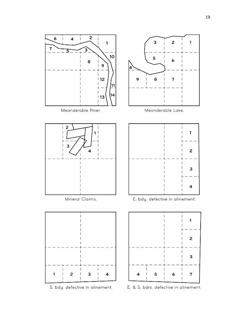
The sections along the north tier and west range of a regular township are
typically irregular sections and contain lots. These lots are a legal subdivision of a
section and designated by section and lot numbers such as “sec. 3, lot 1”. Lots cannot be
described as aliquot.15
For example, an irregular section 3 will typically contain 4 lots
adjoining the north boundary of the township. A contiguous unit such as, lots 1 and 2,
and S1/2NE1/4 should not be combined as, NE1/4. The latter description is ambiguous
and subject to more than one interpretation. See figure 2 for other situations for lots
within irregular sections.
Lots have been erroneously patented in halves or quarters. Without explicit
evidence of the government’s intent, the location of the division line is uncertain. For
example, is the division line to be determined by a straight line between equally divided
opposing lines or at proportionate linear measurement of opposing lines, or with regard to
equal areas? If the latter, it is still a question of how are the equal areas to be achieved,
i.e., how the division line to be determined is, e.g., parallel with the opposing boundary or
run to form a parallelogram, etc.
Lots and other irregular tracts/parcels do not have aliquot characteristics. When
they are subdivided there is a remainder. The uncertainty of the location of the remainder
intended by the subdivision renders the description ambiguous and subject to more than
one interpretation. An official survey will be conducted or a supplemental plat will be
prepared with lot numbers assigned to each subdivision to clearly show the intent when
subdividing lots.
First. “ . . . and the corners of half- and quarter-sections, not marked on the surveys, shall be
placed as nearly as possible equidistant from two corners which stand on the same line.”
Second. “And the boundary lines which have not been actually run and marked shall be
ascertained, by running straight lines from the established corners to the opposite corresponding corners;”
(B.) 43 USC 753 (acts of April 24, 1820; 3 stat. 566, and April 5, 1832; 4 stat. 503): Describes that
the division and content of a quarter section and of a half quarter section shall be ascertained in the manner
and on the principles directed and prescribed by 43 USC 752. That is, a quarter section is divided by a
straight line connecting the opposite corresponding quarter-quarter (1/16) section corners. To subdivide the
NE and NW quarter sections into halves, the center 1/16 section corner must be established. A straight line
between the exterior 1/16 section corners, will not intersect the center 1/16 section corner, except in very
rare cases. 14
If half (1/2) of a half (1/2) is used, a statement at the end of the description, after the area statement,
similarly to “Any area described as a half (1/2) of a half (1/2) is based on the proper subdivision of section
as per the Manual of Surveying Instructions” should be included. 15
See footnote 10.
19
20
Figure 2. - Examples of subdivision of sections by protraction and showing lots.
AREA
In some cases, a statement of the total area follows the description. If the lands
described are entirely surveyed, the legal (nominal) acreage as shown upon the official
plats of survey will be used. Where unsurveyed16
land is included the acreage as shown
upon the official protraction diagrams of the township will be used. Where land is not
returned on an official survey plat and there is no official protraction diagram an
approximate area will be given in even acres.
The terms “land” and “area” are used when referring to delimited land or area that
has contiguity.17
The terms “lands” and “areas” are used when referring to delimited
lands or areas that do not have contiguity.
When referencing the acreage for land or area having contiguity the following
statement will be used: The area described contains ______ acres.
When referencing the acreage for lands or areas not having contiguity the
following statement will be used: The areas described aggregate ______ acres.
Where both Federal interest and non-Federal lands are included, the following
statement will be used: The areas described, including both Federal and non-Federal
lands, aggregate ________ acres.
Descriptions containing the legal acreage as shown upon the official plats of
survey will carry a statement reading as follows: The area (or areas) described contains
(or aggregate) _________ acres, according to the official plat (or plats) of the survey (or
surveys) of the said land (or lands), on file in the Bureau of Land Management.
The value will be carried to the nearest hundredth of an acre or where justified by
the accuracy of the survey to the square foot. Acreage designations normally will not be
carried beyond two decimal places. The acreage will be rounded to the nearest even
hundredth, e.g., 0.625 acre should read 0.62 acre. Delimited areas having a rounded
acreage of less than 0.01 acre should be shown as having 0.01 acre. Square footage of a
delimited area may be shown as an additional exhibit.
When acreage other than the legal acreage as shown upon the official plats of
survey is used, the source for the acreage and an explanation of its derivation should be
included in the documents to be reviewed. A great deal of confusion is needlessly
16
In the Federal survey system, unsurveyed means not returned (described) on an official survey plat. 17
Contiguity means where delimited lines of land or area touch. Lands or areas that touch only at a corner
are not contiguous.
21
interjected into the management of special areas when acreage is derived from unofficial
sources or is based upon erroneous assumptions.18
It is not expected that every bureau or office will have the mathematical
necessities to provide official or accurate acreage. To determine or confirm the status of
the acreage it is advisable to request a SBE Certificate(s) from a CILS.
Table 1. Conversions used in PLSS surveying.
Units of Linear Measure
1 chain = 100 links
= 66 feet (U.S. Survey feet)
= 4 poles, perches, rods
1 mile = 80 chains
= 5,280 feet (U.S. Survey feet)
Units of Area
1 acre = 10 square chains
= 43,560 square feet (U.S. Survey feet)
1 square mile = 640 acres
Metric Conversions
U.S. Survey Foot
1 meter = 39.37 inches (exact)
1 U.S. Survey foot = 0.3048006096… meter
1 link = 0.2011684023… meter
1 meter = 3.2808333333… U.S. Survey feet
18
For a discussion of the Public Land Survey System Datum and associated area computations, see chapter
II of the Manual of Surveying Instructions (2009).
Using plane computational techniques within the PLSS will create problems due to the orthogonal
nature of basic trigonometric functions. Geodetic computations or the use of geodetic projections will
eliminate many problems. To properly use these projections, many factors must be addressed, such as
proper conversion to and from the true meridian, to and from mean bearings, and between ground
horizontal distances and grid distances. To properly use geodetic computations, the correction between
mean, forward and back bearings and the elevation of the lines must be considered.
The mathematical conversions between field measurements and plane coordinate values involve
many relationships. Some of the considerations to be treated correctly before accurate acreage can be
assured are: Sea level factors relate ground distances to sea level or geoid equivalents. Elevation factors
relate ground distances to geodetic equivalents on the ellipsoid. Grid scale factors relate ellipsoidal or
geodetic distances to an equivalent on the projection or grid surface. The mapping angle, or convergence
angle, relates geodetic north to grid north. Arc to chord, or second-term corrections, relate observed
pointings to equivalents on the grid and are relevant to both bearings and angles. The grid bearing is a true
bearing only along the central meridian of a given SPCS zone, and a grid distance is not generally a true
ground distance.
Many popular commercial computing software applications do not compute PLSS areas
accurately. For example, when the software is written for plane coordinate computations the acreages
computed can be significantly different from acreage derived from geodetic coordinate computations based
upon PLSS constraints. Acreage on the grid surface differs from the sea level surface and both differ from
the ground surface used in the PLSS.
22
1 acre = 0.4046872610… hectare
International Foot (SI)
1 inch = 25.4 millimeters (exact)
1 SI foot = 0.3048 meter (exact)
1 meter = 3.2808398950… SI feet
CONVENTIONAL SYMBOLS AND ABBREVIATIONS
The conventional symbols for degrees (°), minutes (’), and seconds (”) of arc
should usually be employed in giving the direction of lines.
The abbreviations for the units most frequently used are:
Chains(s) ………………… ch., chs.
Link(s) …………………… lk., lks.
Foot (feet) ……………….. ft.
Meter(s) …………………. m.
The words “township” and “range” and the designations “north” or “south,”
“east” or “west” are sometimes written in full when used in the text, but the land
description itself should be in tabular form and these terms abbreviated and capitalized
where appropriate. The principal abbreviations are as follows:
Township(s) …………………………………………..… T. or Tps.
Range(s) ………………………………………………… R. or Rs.
Section(s) ……………………………………….…….… sec. or secs.
North ……………………………………………………. N.
Northeast ……………………………...……………….... NE
Where two or more township units are to be grouped in the description, the plural
abbreviation “Tps.” and/or “Rs.” should always be used, even though all the townships
have the same number east or west of the principal meridian or north or south of the base
line. The term “township” and “range” is abbreviated in the singular or plural as the
meaning may require, for example:
T. 13 N., R. 11 E.
Tps. 4 and 5 N., R. 14 W.
T. 3 S., Rs. 16 and 17 W.
Tps. 1 thru 4 S., Rs. 6 thru 9 E.
EXAMPLES OF DESCRIPTIONS OF LANDS BASED UPON THE
RECTANGULAR SURVEYS OF THE PUBLIC LAND SURVEY SYSTEM
Single Section
Example No. 1
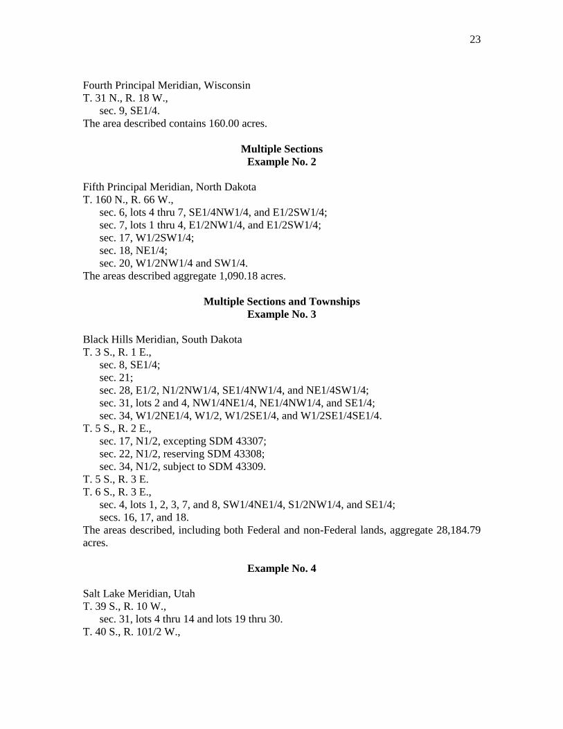
23
Fourth Principal Meridian, Wisconsin
T. 31 N., R. 18 W.,
sec. 9, SE1/4.
The area described contains 160.00 acres.
Multiple Sections
Example No. 2
Fifth Principal Meridian, North Dakota
T. 160 N., R. 66 W.,
sec. 6, lots 4 thru 7, SE1/4NW1/4, and E1/2SW1/4;
sec. 7, lots 1 thru 4, E1/2NW1/4, and E1/2SW1/4;
sec. 17, W1/2SW1/4;
sec. 18, NE1/4;
sec. 20, W1/2NW1/4 and SW1/4.
The areas described aggregate 1,090.18 acres.
Multiple Sections and Townships
Example No. 3
Black Hills Meridian, South Dakota
T. 3 S., R. 1 E.,
sec. 8, SE1/4;
sec. 21;
sec. 28, E1/2, N1/2NW1/4, SE1/4NW1/4, and NE1/4SW1/4;
sec. 31, lots 2 and 4, NW1/4NE1/4, NE1/4NW1/4, and SE1/4;
sec. 34, W1/2NE1/4, W1/2, W1/2SE1/4, and W1/2SE1/4SE1/4.
T. 5 S., R. 2 E.,
sec. 17, N1/2, excepting SDM 43307;
sec. 22, N1/2, reserving SDM 43308;
sec. 34, N1/2, subject to SDM 43309.
T. 5 S., R. 3 E.
T. 6 S., R. 3 E.,
sec. 4, lots 1, 2, 3, 7, and 8, SW1/4NE1/4, S1/2NW1/4, and SE1/4;
secs. 16, 17, and 18.
The areas described, including both Federal and non-Federal lands, aggregate 28,184.79
acres.
Example No. 4
Salt Lake Meridian, Utah
T. 39 S., R. 10 W.,
sec. 31, lots 4 thru 14 and lots 19 thru 30.
T. 40 S., R. 101/2 W.,
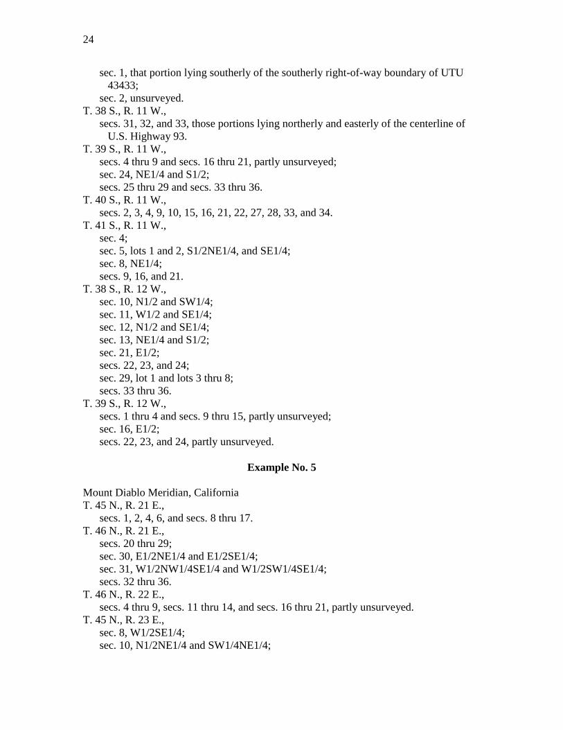
24
sec. 1, that portion lying southerly of the southerly right-of-way boundary of UTU
43433;
sec. 2, unsurveyed.
T. 38 S., R. 11 W.,
secs. 31, 32, and 33, those portions lying northerly and easterly of the centerline of
U.S. Highway 93.
T. 39 S., R. 11 W.,
secs. 4 thru 9 and secs. 16 thru 21, partly unsurveyed;
sec. 24, NE1/4 and S1/2;
secs. 25 thru 29 and secs. 33 thru 36.
T. 40 S., R. 11 W.,
secs. 2, 3, 4, 9, 10, 15, 16, 21, 22, 27, 28, 33, and 34.
T. 41 S., R. 11 W.,
sec. 4;
sec. 5, lots 1 and 2, S1/2NE1/4, and SE1/4;
sec. 8, NE1/4;
secs. 9, 16, and 21.
T. 38 S., R. 12 W.,
sec. 10, N1/2 and SW1/4;
sec. 11, W1/2 and SE1/4;
sec. 12, N1/2 and SE1/4;
sec. 13, NE1/4 and S1/2;
sec. 21, E1/2;
secs. 22, 23, and 24;
sec. 29, lot 1 and lots 3 thru 8;
secs. 33 thru 36.
T. 39 S., R. 12 W.,
secs. 1 thru 4 and secs. 9 thru 15, partly unsurveyed;
sec. 16, E1/2;
secs. 22, 23, and 24, partly unsurveyed.
Example No. 5
Mount Diablo Meridian, California
T. 45 N., R. 21 E.,
secs. 1, 2, 4, 6, and secs. 8 thru 17.
T. 46 N., R. 21 E.,
secs. 20 thru 29;
sec. 30, E1/2NE1/4 and E1/2SE1/4;
sec. 31, W1/2NW1/4SE1/4 and W1/2SW1/4SE1/4;
secs. 32 thru 36.
T. 46 N., R. 22 E.,
secs. 4 thru 9, secs. 11 thru 14, and secs. 16 thru 21, partly unsurveyed.
T. 45 N., R. 23 E.,
sec. 8, W1/2SE1/4;
sec. 10, N1/2NE1/4 and SW1/4NE1/4;
25
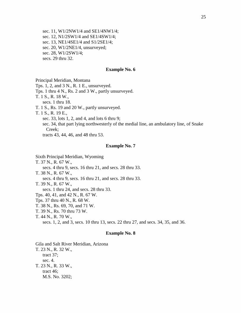
sec. 11, W1/2NW1/4 and SE1/4NW1/4;
sec. 12, N1/2SW1/4 and SE1/4SW1/4;
sec. 13, NE1/4SE1/4 and S1/2SE1/4;
sec. 20, W1/2NE1/4, unsurveyed;
sec. 28, W1/2SW1/4;
secs. 29 thru 32.
Example No. 6
Principal Meridian, Montana
Tps. 1, 2, and 3 N., R. 1 E., unsurveyed.
Tps. 1 thru 4 N., Rs. 2 and 3 W., partly unsurveyed.
T. 1 S., R. 18 W.,
secs. 1 thru 18.
T. 1 S., Rs. 19 and 20 W., partly unsurveyed.
T. 1 S., R. 19 E.,
sec. 33, lots 1, 2, and 4, and lots 6 thru 9;
sec. 34, that part lying northwesterly of the medial line, an ambulatory line, of Snake
Creek;
tracts 43, 44, 46, and 48 thru 53.
Example No. 7
Sixth Principal Meridian, Wyoming
T. 37 N., R. 67 W.,
secs. 4 thru 9, secs. 16 thru 21, and secs. 28 thru 33.
T. 38 N., R. 67 W.,
secs. 4 thru 9, secs. 16 thru 21, and secs. 28 thru 33.
T. 39 N., R. 67 W.,
secs. 1 thru 24, and secs. 28 thru 33.
Tps. 40, 41, and 42 N., R. 67 W.
Tps. 37 thru 40 N., R. 68 W.
T. 38 N., Rs. 69, 70, and 71 W.
T. 39 N., Rs. 70 thru 73 W.
T. 44 N., R. 70 W.,
secs. 1, 2, and 3, secs. 10 thru 13, secs. 22 thru 27, and secs. 34, 35, and 36.
Example No. 8
Gila and Salt River Meridian, Arizona
T. 23 N., R. 32 W.,
tract 37;
sec. 4.
T. 23 N., R. 33 W.,
tract 46;
M.S. No. 3202;

26
sec 9.
T. 23 N., Rs. 34 and 35 W.,
tract 57;
M.S. No. 246.
The areas described aggregate 3,233.86 acres.
27
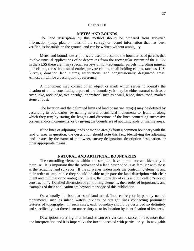
Chapter III
METES-AND-BOUNDS
The land description by this method should be prepared from surveyed
information (map, plat, or notes of the survey) or record information that has been
verified, is locatable on the ground, and can be written without ambiguity.
Metes-and-bounds descriptions are used to describe the boundaries of parcels that
involve unusual applications of or departures from the rectangular system of the PLSS.
In the PLSS there are many special surveys of non-rectangular parcels, including mineral
lode claims, forest homestead entries, private claims, small holding claims, ranchos, U.S.
Surveys, donation land claims, reservations, and congressionally designated areas.
Almost all will be a description by reference.
A monument may consist of an object or mark which serves to identify the
location of a line constituting a part of the boundary; it may be either natural such as a
river, lake, rock ledge, tree or ridge; or artificial such as a wall, fence, ditch, road, marked
stone or post.
The location and the delimited limits of land or marine area(s) may be defined by
describing its boundaries; by naming natural or artificial monuments to, from, or along
which they run; by stating the lengths and directions of the lines connecting successive
corners and/or monuments; or by giving the boundaries of abutting lands or marine areas.
If the lines of adjoining lands or marine area(s) form a common boundary with the
land or area in question, the description should note this fact, identifying the adjoining
land or area by the name of the owner, survey designation, description designation, or
other appropriate means.
NATURAL AND ARTIFICIAL BOUNDARIES
The controlling elements within a description have importance and hierarchy in
their use. It is important that the scrivener of a land description is as familiar with these
as the retracing land surveyor. If the scrivener understands the controlling elements and
their order of importance they should be able to prepare the land description with clear
intent and minimal or no ambiguity. In law, the hierarchy of calls is often called “rules of
construction”. Detailed discussion of controlling elements, their order of importance, and
examples of their application are beyond the scope of this publication.
Occasionally the boundaries of land are defined entirely or in part by natural
monuments, such as inland waters, divides, or straight lines connecting prominent
features of topography. In such cases, each boundary should be described so definitely
and specifically that there is no uncertainty as to its location by identification of features.
Descriptions referring to an inland stream or river can be susceptible to more than
one interpretation and it is imperative the intent be stated with particularity. In navigable
28
waters the ordinary high water mark, the deepest navigable channel (thalweg) or a medial
line are usually specified. In meandered nonnavigable waters the ordinary high water
mark, the medial line or the deepest channel (thread) are specified. And in
nonmeandered nonnavigable waters the medial line or the deepest channel (thread) is
usually specified. In the case of tidal waters the line of mean high tide is usually
specified.
In referring to a natural monument such as a divide or peak, or to such permanent
artificial monuments as ditches, the specific line or point intended to be used should be
described with sufficient particularity as to be capable of definite identification and
susceptible to only one interpretation. Boundaries of this sort are normally winding, and
it should be understood that they may be technically defined by the location of the feature
and not by the straight lines between angle points. The intent should be clear in these
cases whether the boundary is defined by straight (mean bearing) lines between angle
points, or by the meander of the feature.
Similarly, in referring to such permanent artificial monuments such as highways,
railroads, or utility lines, the specific line must be described with sufficient particularity
as to be capable of definite identification and susceptible to only one interpretation. The
description should specify whether a right-of-way line, centerline, or another location is
intended. Also, over time, roadways and utility lines can move via official actions or
unofficial activity, typically the location on the date of the description will be considered
the best available evidence of the party’s intent.
In connection with these types of boundaries, it is important that the agency
preparing the land description consider not only the technical sufficiency and form of the
description but the feasibility and practicability of the boundary from the viewpoint of
proper administration. For example, the selection of a boundary described as an
elevation contour or as paralleling a road at a distance of two miles should be avoided as
such lines would be difficult to establish and impractical from an administrative
standpoint.
By Executive Order 11988 of May 24, 1977 as amended by Executive Order
12148 of July 20, 1979 – Floodplain Management, special areas, such as floodplain
location, must be described. In some cases it may be feasible to describe the lands
subject to the restrictive covenant by aliquot parts or by metes-and-bounds. In other
cases, the Department of Housing and Urban Development (HUD) floodplain map or a
more detailed map of an area may be used. If neither are available, use of the best
available information is referenced in the description. It is important that the agency
subject proposed descriptions to persons experienced in on-the-ground determinations.
AREA
A statement of the delimited land or area usually follows the description and in
most cases is expressed in acres. Where justified by the accuracy of the survey, the value
29
may be carried to the nearest hundredth of an acre or by square footage. Approximate
areas should be indicated as such and given in even acres.
THE PARTS OF METES-AND-BOUNDS DESCRIPTIONS
There are 3 primary parts of a metes-and-bounds description:
Caption or Preamble
Body
Clauses
EXAMPLES
Caption or Preamble
This is a general location of the lands to be described, such as city, county and
state. This could include the section, township and range, principal meridian, county and
state, or the subdivision or map reference with the city, county and state. It may be a
combination of any of these stated. The caption or preamble is used to locate the land
being described in general vicinity and the details to the location of the lands being
described are contained within the body of the description.
Example No. 1 – Caption
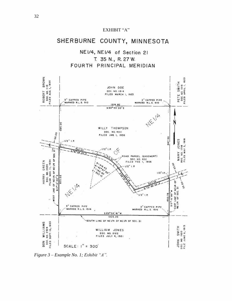
(See figure 3)
A PARCEL OF LAND SITUATED IN THE NORTHEAST QUARTER (NE1/4) OF
THE NORTHEAST QUARTER (NE1/4) OF SECTION 21, TOWNSHIP 35 NORTH,
RANGE 27 WEST, FOURTH PRINCIPAL MERIDIAN, SHERBURNE COUNTY,
MINNESOTA, BEING A PORTION OF THAT PARCEL OF LAND DESCRIBED IN
DOCUMENT NO. 4311, FILED JANUARY 01, 1956, IN THE OFFICIAL RECORDS
OF SHERBURNE COUNTY, AND SHOWN IN EXHIBIT “A”. BEING MORE
PARTICULARLY DESCRIBED AS FOLLOWS:
Body
The body of a description contains all the specifics locating the land or space it
delineates. The body is a combination of all or portions of the following elements utilized
to describe the land and to reference its location to the surrounding lands:
Point of commencement
Point of beginning
Course (bearing or direction)
Distance
Calls by reference
Calls for monuments and bounds or adjoining lands with qualifying terms and
descriptions
Closing call to the Point of Beginning or other known locatable point or line
Area of land contained (if applicable)
Basis of bearings
30
Any additional information that can assist with the accurate location of the land
being described (such as clauses)
In addition it is preferred not to use abbreviations within a land description as that
they may have various interpretations in a land description. A common example
is “IP”, is an “iron pipe” or an “iron pin”. If there is a survey map or plat
reference in the description that these abbreviations are reflected it may be
acceptable. It would probably be preferred still not to abbreviate so that the land
description could stand independent if necessary from the accessory of the survey
map or plat. Avoiding abbreviations can help avoid ambiguities.
Example No. 1 – Body
(See figure 3)
COMMENCING at the corner of sections 15, 16, 21, and 22, marked with a 3 inch
diameter iron pipe with cap marked R.L.S. 910, identical with the southeast corner
described in Document No. 1314, filed March 01, 1923, the southwest corner
described in Document No. 1516, filed April 01, 1920, and the northwest corner
described in Document No. 1718, filed May 03, 1918, all in the official records of
Sherburne County, Minnesota;
Thence, South 00°16’00” West, on the line between sections 21 and 22, identical with
the west line of the aforesaid parcel described in Document 1718, a distance of
867.90 feet to the center line of a 66 foot wide road parcel described in Document No.
652, filed February 01, 1906, marked with a 1/2 inch diameter iron pipe and the
POINT OF BEGINNING of the herein described parcel;
Thence, South 00°16’00” West, continuing on the section line, a distance of 450.78 feet
to the north 1/16 section corner of sections 21 and 22, marked with a 3 inch diameter
iron pipe with cap marked R.L.S. 1516, identical with the southwest corner described
in aforesaid Document No. 1718, the northwest corner described in Document No.
1920, filed June 06, 1913, and the northeast corner described in document No. 2122,
filed July 04, 1921, all in the official records of Sherburne County, Minnesota;
Thence, South 89°54’41” West, on the east and west center line of the northeast 1/4 of
section 21, identical with the north line described in aforesaid Document No. 2122, a
distance of 1325.26 feet to the northeast 1/16 section corner of section 21, marked
with a 3 inch iron pipe with cap marked R.L.S. 1516, identical with the northwest
corner described in aforesaid Document No. 2122, the northeast corner described in
Document No. 2324, filed September 12, 1930, and the southwest corner described in
Document No. 2526, filed November 11, 1934, all in the official records of Sherburne
County, Minnesota;
Thence, North 00°12’00” East, on the north and south center line of the northeast 1/4 of
section 21, identical with the east line described in said Document No. 2526, a
distance of 823.02 feet to the center line of the aforesaid 66 foot wide road parcel
described in Document No. 652, marked with a 1/2 inch diameter iron pipe;
Thence, along the center line of said road parcel and crossing a portion of the aforesaid
described parcel in Document No. 4311, the following four (4) courses and distances:
1. South 78°48’00” East, a distance of 462.00 feet to a 1/2 inch diameter iron pipe
for a point of curvature to the right, concave southwesterly,
31
2. With said curve through a central angle of 42°57’00”, having a radius of 419.43
feet, an arc distance of 314.42 feet to a 1/2 inch diameter iron pipe,
3. South 35°51’00” East, a distance of 327.16 feet to a 1/2 inch diameter iron pipe,
4. North 70°20’02” East, a distance of 447.26 feet to a 1/2 inch diameter iron pipe
being the POINT OF BEGINNING, containing 17.64 acres of land.
Clauses
Clauses are usually at the end of the body of a land description and are for the
purpose of encumbering, taking away from, adding to, or restricting something with
reference to the land being described.
A qualifying clause can imply an encumbrance such as an easement, or
reservation of some use, or a restriction of how the land described may or may not be
used. A qualifying clause may also be “subject to” any previous recorded encumbrances
such as, easements, restrictions or reservations on the land being described.
An augmenting clause can imply the addition of some right or privilege with the
property being described. This could be an access easement, restrictions on adjacent
properties for view purposes, or utility easements that are attached to the land described.
Except, means exclusion from the area, to cut off a portion of the whole area that
has just been described, withdraws from the description of the property conveyed the
excepted property. Reserving, is keeping a certain right from the area just granted or is a
taking back of part of something granted. Subject to, refers to a reservation already
existing; when used in a conveyance means “subordinate to,” “subservient to,” “limited
by,” or “charged to.”
When exception and reservation are used together, its customary meaning holds
that certain property is both withdrawn from the description of what is conveyed, and/or
an independent right to an interest in the land is created and vested in the grantor. In the
context of split estates, a provision excepting and reserving the mineral estate retains and
creates title to the mineral estate in the grantor.
External evidence may prove that the terms were not used according to their
usual, and different, connotations.
Example No. 1 – Clauses
(See figure 3)
Basis of Bearings: South 00°16’00” West, being the east line of aforesaid NE1/4NE1/4,
Section 21.
Reserving all minerals; except coal.
Subject To a 66 foot wide road parcel, Document No. 652, filed February 01, 1906, in
the Official Records of Sherburne County, Minnesota.
Exhibit “A”: Attached hereto and made a part of.
32
EXHIBIT “A”
Figure 3 – Example No. 1; Exhibit “A”.
33
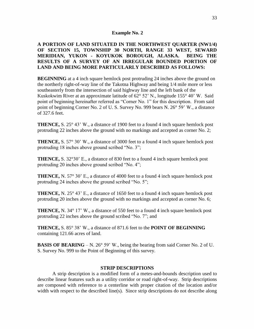
Example No. 2
A PORTION OF LAND SITUATED IN THE NORTHWEST QUARTER (NW1/4)
OF SECTION 15, TOWNSHIP 30 NORTH, RANGE 33 WEST, SEWARD
MERIDIAN, YUKON - KOYUKOK BOROUGH, ALASKA. BEING THE
RESULTS OF A SURVEY OF AN IRREGULAR BOUNDED PORTION OF
LAND AND BEING MORE PARTICULARLY DESCRIBED AS FOLLOWS:
BEGINNING at a 4 inch square hemlock post protruding 24 inches above the ground on
the northerly right-of-way line of the Takotna Highway and being 1/4 mile more or less
southeasterly from the intersection of said highway line and the left bank of the
Kuskokwim River at an approximate latitude of 62° 52’ N., longitude 155° 40’ W. Said
point of beginning hereinafter referred as “Corner No. 1” for this description. From said
point of beginning Corner No. 2 of U. S. Survey No. 999 bears N. 26° 59’ W., a distance
of 327.6 feet.
THENCE, S. 25° 43’ W., a distance of 1900 feet to a found 4 inch square hemlock post
protruding 22 inches above the ground with no markings and accepted as corner No. 2;
THENCE, S. 57° 30’ W., a distance of 3000 feet to a found 4 inch square hemlock post
protruding 18 inches above ground scribed “No. 3”;
THENCE, S. 32°30’ E., a distance of 830 feet to a found 4 inch square hemlock post
protruding 20 inches above ground scribed “No. 4”;
THENCE, N. 57° 30’ E., a distance of 4000 feet to a found 4 inch square hemlock post
protruding 24 inches above the ground scribed “No. 5”;
THENCE, N. 25° 43’ E., a distance of 1650 feet to a found 4 inch square hemlock post
protruding 20 inches above the ground with no markings and accepted as corner No. 6;
THENCE, N. 34° 17’ W., a distance of 550 feet to a found 4 inch square hemlock post
protruding 22 inches above the ground scribed “No. 7”; and
THENCE, S. 85° 38’ W., a distance of 871.6 feet to the POINT OF BEGINNING
containing 121.66 acres of land.
BASIS OF BEARING – N. 26° 59’ W., being the bearing from said Corner No. 2 of U.
S. Survey No. 999 to the Point of Beginning of this survey.
STRIP DESCRIPTIONS
A strip description is a modified form of a metes-and-bounds description used to
describe linear features such as a utility corridor or road right-of-way. Strip descriptions
are composed with reference to a centerline with proper citation of the location and/or
width with respect to the described line(s). Since strip descriptions do not describe along
34
the perimeter of a closed figure, they can be used to avoid lengthy land descriptions in
certain cases.
The actual composition of a strip description is very similar to a metes-and-
bounds description, with some key differences to the caption and body. The caption
should contain a citation stating the width of the strip and the position of the described
centerline. The body is constructed mostly the same, except the end point of the
described line is referred to as the “Point of Termination”, and no call is made back to the
“Point of Beginning” or the “Point of Commencement”. It is assumed that the described
centerline is, by definition, located exactly midway between both sidelines, unless stated
otherwise. The sidelines are assumed to be perpendicular and parallel to the described
line, unless stated otherwise. A qualifying clause should be included to state how the
beginnings and ends of the sidelines should be interpreted. For example, property
ownership boundaries will seldom be perpendicular to your described line, which if the
description is intended to terminate at such property boundaries, will create “gaps” and
“overlaps” in the described area. The intended land interest, whether fee, easement, etc.,
should be stated clearly in a qualifying clause.
Example No. 3 – Strip Description
(See figure 4)
A portion of the East Half of the Southeast Quarter of Section 9, Township 45
South, Range 11 East, Willamette Meridian, County of Klamath, State of Oregon,
and shown in Exhibit “A”, being a 100 foot wide strip of land, the centerline of
which is more particularly described as follows:
BEGINNING AT A POINT on the east line of the E1/2SE1/4 said section 9, 694 feet
along the section line from the corner of sections 9, 10, 15, and 16. Thence from the point
of beginning, the following two courses:
1) North 40°56’ West, 1468 feet; and
2) North 65°06’ West, 395 feet, more or less, to the west line of said E1/2SE1/4
and the point of termination.
The sidelines of said strip shall be lengthened or shortened, as necessary, so as to
intersect with the east and west lines of said E1/2SE1/4.
Containing 4.28 acres of land.
The bearings shown herein are based upon the south half of the east line of said section
9, bearing North 0°48’ East as shown upon the official plat thereof. All distances stated
are in U.S. Survey Feet.
The interest to be conveyed is an easement for the purposes of installation and
maintenance of an overhead transmission line.
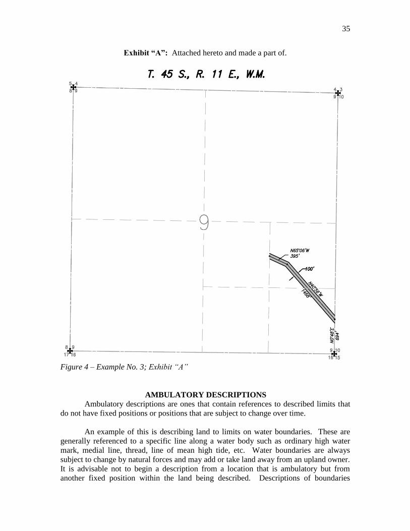
35
Exhibit “A”: Attached hereto and made a part of.
Figure 4 – Example No. 3; Exhibit “A”
AMBULATORY DESCRIPTIONS
Ambulatory descriptions are ones that contain references to described limits that
do not have fixed positions or positions that are subject to change over time.
An example of this is describing land to limits on water boundaries. These are
generally referenced to a specific line along a water body such as ordinary high water
mark, medial line, thread, line of mean high tide, etc. Water boundaries are always
subject to change by natural forces and may add or take land away from an upland owner.
It is advisable not to begin a description from a location that is ambulatory but from
another fixed position within the land being described. Descriptions of boundaries
36
running parallel with an ambulatory line must be very specific whether the boundary is
ambulatory or fixed. Before a description incorporates a body of water as a boundary,
the effects of subsequent movement and whether riparian rights are intended must be
considered.
Another example of an ambulatory line would be one not clearly defined to a
vertical reference datum or one referenced to natural surface contour lines. If it is
referenced to a qualified vertical reference and straight lines are referenced between
physical monuments the line becomes fixed in its location. When reference to a contour
line is used without the clear delineation of its vertical reference or physical monuments
and without lines run between the monuments, this can become ambulatory over time.
Natural forces of erosion or accumulation may create an ambulatory situation. For
example, 0.5 foot of erosion or accumulation over a period of time on a 1% slope could
change the horizontal position of the original location by 50 feet. Even if the contour
reference is well defined it would be located in a new position without physical
monuments and lines run between the locations for a retraceable boundary. For these
reasons making reference to contour lines of elevation for delimitation of lands should be
avoided.
Boundaries involving water bodies can be within the category of previously
described ambulatory descriptions. When describing the boundary it would be very
similar to, if not the same as writing a metes-and-bounds description. The difficulties are
(a) clearly stating whether the boundary is fixed or ambulatory and (b) unambiguously
describing a boundary that is ambulatory. Descriptions written along the meanders of a
water body probably is not describing a fixed boundary line but courses and distances in
the near vicinity of the water body to be used for the purpose of calculating closure and
computing acreage of the land, the water body being the boundary. If writing to
meanders it may be prudent to have a qualifying clause at the end of the description to
clarify the reason for the meanders and that the boundary is to the actual delineating
water boundary, e.g., ordinary high water mark, line of mean high tide, medial line,
thread, etc.
Following are a few excerpt examples of describing water boundaries:
1. Thence, with the meanders of the navigable Johnson Lake the following nine
(9) courses and distances:
2. Thence, along the meanders of the shoreline of the Pacific Ocean the
following seven (7) courses and distances:
3. Thence, along the centerline meanders of non-navigable Otter Creek the
following three (3) courses and distances:
4. Thence, with the meanders of the navigable Truckee River the following six
(6) courses and distances:
Example of qualifying clause:
The meanders described within this land description are for the convenience of
computing mathematical closure and computing acreage for the described parcel.
Actual ownership is to the ordinary high water mark and the acreage delineated

37
may or may not include the area between the meanders and the ownership
boundary.
38
Chapter IV
LOT AND BLOCK DESCRIPTIONS
Lot and block descriptions are primarily created within the private sector,
however Federal townsites fall into this category also. These types of descriptions create
land divisions of varying acreage sizes commonly referred to as “lots” and generally have
a “lot” identifier that could be numeric, alpha character or a combination thereof. When
the map creates these divisions they are commonly referred to as a “simultaneous
conveyance”. In reality there may not be any conveyance performed at all and the
process simply has created multiple divisions of land at the same moment in time, similar
to sections returned on the same official rectangular survey plat of the General Land
Office (GLO) or BLM. Not all lot and block descriptions will contain all the elements
required for a description listed below. It is prudent to the scrivener and/or the reviewer
to ascertain from the subject map or plat the proper elements for a description.
The basic elements are:
1. Lot, parcel or unit identifier.
2. Block identifier if applicable (some land divisions may not contain a block
identifier).
3. Name or plat/map reference title, i.e. “Sunny Acres Subdivision”.
4. Recording information (which could be file, book or volume with page
number) to include date and location of recordation.
5. County and State.
Example descriptions:
1. Lot 2, Block R, Bandy Subdivision in Book 99, Page 10 of Official Records
recorded May 9, 1998, Document No. 10225, El Dorado County, Missouri.
2. Lot 101, Tidelands Subdivision, recorded in File 73, Page 23 of County
Surveyor Records, dated August 1, 2001, Document No. 555555, Lincoln
County, State of California.
39
Chapter V
ILLUSTRATIONS (MAPS) AND COORDINATES
MAPS TO BE PUBLISHED
Under some conditions it is essential that a plat, map or diagram be incorporated
as an integral part of a Land order or Proclamation, either in place of or in addition to a
written description. Such a plat, map or diagram usually has to be reduced for
publication in the Federal Register. The scale and detail should be legible when
reproduced within the size specified. The reduction in making the printing plate should
not exceed one-third, consequently the drawing should have maximum dimensions of
12.7 x 16.5 inches.
Federal Register Regulations (1 CFR 18.10) apply to the preparation of
documents required to be filed in the Office of the Federal Register for publication:
(a) If it is necessary to publish a form or illustration, a clear and legible
original form or illustration, or a clear and completely legible reproduction
approximately 8½ by 11 inches, shall be included in the original document
and each certified copy.
(b) A document that includes tabular material may be assigned to the
deferred publication schedule. See § 17.7 [1 CFR 17.7].
The following requirements should be observed in the preparation of the plat, map
or diagram (see figure 5 for example):
(a) The title should be identical with that of the Land order or Proclamation
insofar as practicable.
(b) The date should be the same as that of the Land order or Proclamation.
(c) Two or more parallels and meridians, with the latitude and longitude of each,
should be shown where the size of the tract warrants; otherwise the latitude and
longitude of one point and an orientation arrow should be shown.
(d) The plat, map or diagram should carry an appropriate graphic scale.
(e) The lines and lettering should be in black only and legible when reduced for
publication.
(f) The name of the originating bureau or agency, list of sources, and a statement
that the plat, map or diagram is attached to and forms a part of the Land order or
Proclamation should be shown.
The text of the Land order or Proclamation should include a clause, reading
substantially as follows:
* * the boundaries (or tract) shown upon the (survey plat) (map) (diagram)
attached hereto and made a part hereof * *
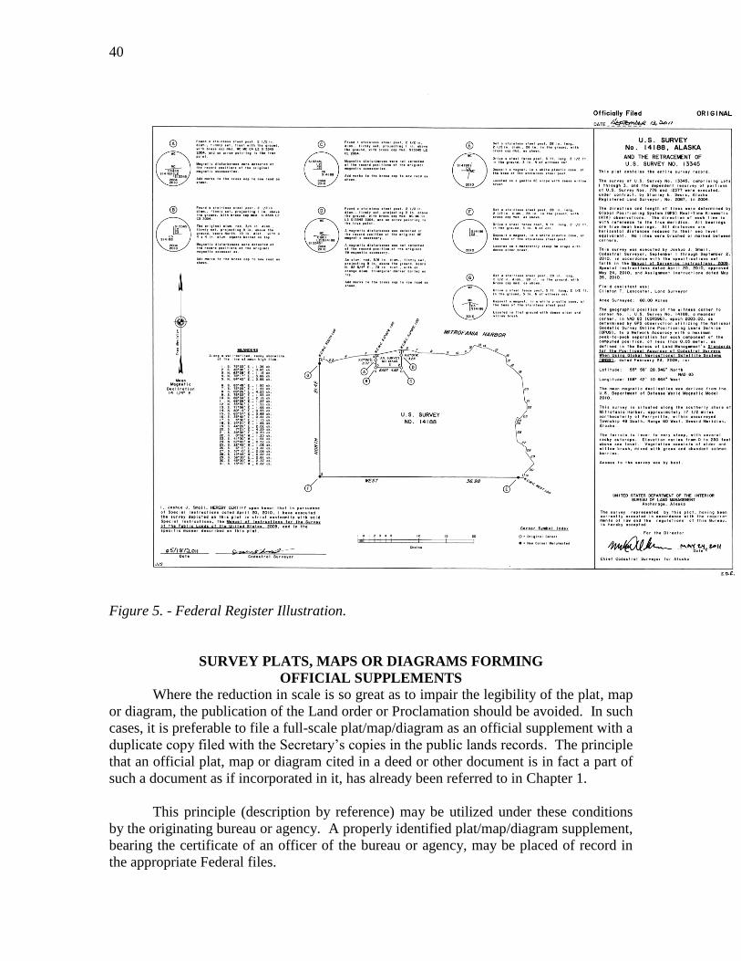
40
Figure 5. - Federal Register Illustration.
SURVEY PLATS, MAPS OR DIAGRAMS FORMING
OFFICIAL SUPPLEMENTS
Where the reduction in scale is so great as to impair the legibility of the plat, map
or diagram, the publication of the Land order or Proclamation should be avoided. In such
cases, it is preferable to file a full-scale plat/map/diagram as an official supplement with a
duplicate copy filed with the Secretary’s copies in the public lands records. The principle
that an official plat, map or diagram cited in a deed or other document is in fact a part of
such a document as if incorporated in it, has already been referred to in Chapter 1.
This principle (description by reference) may be utilized under these conditions
by the originating bureau or agency. A properly identified plat/map/diagram supplement,
bearing the certificate of an officer of the bureau or agency, may be placed of record in
the appropriate Federal files.
41
A file of plats/maps/diagrams which serve as official supplements to Land orders
or Proclamations should comply with the following requirements:
1. The plats/maps/diagrams should be adequately indexed, classified, and
described.
2. They should be available for inspection and consultation by interested
persons.
3. Copies of the plats/maps/diagrams should be available for sale to the public at
uniform listed prices.
Full-scale copies of these plats/maps/diagrams may be folded and attached to
printed copies of Land orders and Proclamations for administrative use or for sale at
scheduled price to interested persons.
Where official supplements are used, the text of the Land order or Proclamation
should include a statement reading substantially as follows:
The boundaries (or tract) described (or referred to) are shown upon
__________________________________________________________________
(bureau or agency) (survey plat or map or diagram) entitled
___________________________________, dated ________________________,
filed in ____________________________ (place of filing), supplementing this
Land order (or Proclamation).
DESCRIPTION BY COORDINATES
The location of a point on the surface of the earth may be accurately described by
expressing its position on any well established system of coordinates.
Two general classes of coordinates are available for such use in the United States:
geographic positions (latitudes and longitudes), and plane-coordinate (x and y) positions
which are derived from and are dependent upon geographic positions.
A point can be reestablished after its coordinates have been determined. Every
geographic coordinate pair should be defined by the datum, date of adjustment or epoch
date, and the geoid model used. If coordinates are reported in a projection, state the
projection used and the previously stated attribute data as well. However, great care must
be exercised to ensure that the original coordinate pairs were produced by a process that
is repeatable within a quantifiable accuracy standard. Occasionally, coordinates can be
the best available evidence for the position of a point, if the coordinate data is determined
and reported with an adequate degree of precision.
GEOGRAPHIC POSITIONS
The United States is covered by a network of triangulations and traverses, which
determines the latitudes and longitudes of thousands of marked points, based on a
standard geodetic datum known as the North American Datum of 1983 (NAD83). In
42
addition, a network of continuously operating reference stations (CORS) provide for
global positioning system (GPS) carrier phase corrections in support of 3-dimensional
positioning activities.
The sum is the National Spatial Reference System (NSRS) which is the official
system of the Federal Government that allows users to determine geodetic latitude,
longitude and height, plus orthometric height, geopotential, acceleration of gravity and
deflection of the vertical at any point within the United States or its territories. The
responsible agency for this network is the National Geodetic Survey (NGS), National
Oceanic and Atmospheric Administration (NOAA), Department of Commerce.
As NAD83 superseded earlier datums, it is essential that all computations and
recorded values on a geodetic datum be accompanied by a legend identifying the datum
used. There is nothing in the form of a geographic position itself to identify it as being
on a certain geodetic datum, or as an independent astronomical position.
The Earth is dynamic, that is every point has some movement, called velocity,
relative to other points. Therefore, all new coordinates of defining points of the NSRS
will have an epoch tag. In particular, an epoch-tagged set of coordinates will identify the
date and instant corresponding to the position of a coordinate system, all subsequent
positions being referred to the position at that epoch. In this sense, it is equivalent to
date. It is understood that descriptions are created for different purposes. It can be a
wasted effort to provide significantly higher degree of geographic position accuracy than
is necessary. It is advisable to obtain a statement from the appropriate BLM Cadastral
Survey office relative to the appropriate coordinates to be employed.
The individual needs to be aware of the relative accuracy that is rendered by the
values displayed for the latitude and longitude coordinates. A rough rule of thumb is for
every second of arc equals one hundred feet of position change. This is consistent with
latitude values, however with longitude values this distance decreases due to convergence
of the meridians the farther you progress north or south from the equator to the poles. If
you provide values to the nearest second you have a positional accuracy of +/- 100 feet,
to the nearest 1/10 of a second a positional accuracy of +/- 10 feet, to the nearest 1/100 of
a second a positional accuracy of +/- of 1 foot, and to the nearest 1/1000 of a second a
positional accuracy of +/- 1/10 of a foot, etc.
If the geographic position is referenced by a physical monument or natural feature
the preceding could become irrelevant, but if it is of position only with no physical
reference it could be perceived to be within the positional tolerances described. It is
important that the individual makes clear the intent of the positional accuracy intended
for the latitude and longitude coordinate being provided.
Where a boundary is defined by expressing the geodetic latitudes and longitudes
of its corners, the forward and back azimuths and the lengths of the lines forming the
boundary should also be given. This data should be arranged in the tabular form
generally adopted for such data by the various Federal survey bureaus. The descriptions

43
of the station and corner sites and of their monuments and marks should follow the table
of positions and be in short paragraphs arranged in the same sequence as the positions.
While considered a complete, legal and satisfactory description, it should be noted
that many state laws may not require a party to a real property transaction to rely wholly
on a description, any part of which, depends exclusively upon coordinates or geographic
positions.
EXAMPLES OF GEOGRAPHIC COORDINATE POSITIONS
(Note decimal accuracy of the coordinates)
Example No. 1
Witness Corner to Meander Corner No. 1, U.S. Survey No. 14280, Alaska
________________________________________________________________________
NAD 83 (2011) - 62° 59’ 14.370” (N) 144° 29’ 00.461” (W)
EPOCH DATE - 2010.00
Example No. 2
Southeast Corner of Township 16 South, Range 15 East, Umiat Meridian, Alaska
________________________________________________________________________
NAD 83 (2011) - 68° 00’ 22.214” (N) 148° 32’ 23.603” (W)
EPOCH DATE - 2010.00
The geographic positions, in NAD83 (2011), epoch 2010.00, for the corners above were
determined by Global Positioning System (GPS) observations, utilizing the National
Geodetic Survey (NGS) Online Positioning User Service (OPUS), to a Network
Accuracy, with a maximum peak-to-peak separation for each component of the computed
position, of less than 0.05 meters, semi-major axis 95% error ellipse, as defined in
Standards for the Positional Accuracy of Cadastral Surveys When Using Global
Navigation Satellite Systems (GNSS), dated February 23, 2009.
44
Chapter VI
FORM AND ARRANGEMENT
Executive Order No. 11030 of June 19, 1962, as amended by Executive Order No.
11354, May 23, 1967, Executive Order No. 12080, September 18, 1978, and Executive
Order No. 12608, September 9, 1987 under Section one, prescribe certain requirements in
connection with the preparation of Executive orders and Proclamations. The following
suggestions relative to the form and arrangement of such documents should also be
followed:
1. Titles
The title should indicate, in two or three lines: (a) either the purpose or the
content of the document, and (b) the geographic locality of the area, as the state with
further details of location whenever appropriate, if they can be briefly indicated.
The titles of Land orders and Proclamations are usually arranged in three or more
lines in capital letters, with no periods at the ends of the lines.
2. Proclamations
A Proclamation is written in more formal style than a Land order. The following
points should be noted:
(a) The initial and immediately succeeding paragraphs which state the reason and
purpose of the action customarily begin with the lead word:
WHEREAS,
(b) The paragraph announcing the action begins as follows with capitalization
and punctuation as indicated:
NOW, THEREFORE, I, GEORGE W. BUSH, President of the United States of
America,
(c) The citation of authority is usually given in the same paragraph, immediately
after the title. The following form should be followed:
____________ by the authority vested in me by Section 2 of the Act of June 8,
1906, (34 Stat. 225, 16, U.S.C. 431), do hereby proclaim __________________________
(d) Preceding the date paragraph, the following introductory sentence is used:
IN WITNESS WHEREOF, I have hereunto set my hand this ________ day of
________, in the year of our Lord ________, and of the Independence of the United
States of America, the ____________________.
3. Public Land Orders
A Public Land Order should be prepared in a form as set forth in the Bureau of
Land Management, Preparation of Public Land Orders and Associated Documents
guidance. Land descriptions must conform with the guidance contained in the BLM
publication, Specifications for Descriptions of Land.
45
EXECUTIVE ORDER NO. 11030, AS AMENDED
PREPARATION, PRESENTATION, FILING, AND PUBLICATION OF
EXECUTIVE ORDERS AND PROCLAMATIONS
[Source: The provisions of Executive Order No. 11030 of June 19, 1962, appear at 27
FR 5847, 3 CFR, 1959-1963 Comp., p. 610, unless otherwise noted.]
By virtue of the authority vested in me by the Federal Register Act (49 Stat. 500,
as amended; 44 U.S.C. 301 et seq.), and as President of the United States, I hereby
prescribe the following regulations governing the preparation, presentation, filing, and
publication of Executive orders and proclamations:
Section 1. Form. Proposed Executive orders and proclamations shall be prepared
in accordance with the following requirements:
(a) The order or proclamation shall be given a suitable title.
(b) The order or proclamation shall contain a citation of the authority under
which it is issued.
(c) Punctuation, capitalization, spelling, and other matters of style shall, in
general, conform to the most recent edition of the Style Manual of the United States
Government Printing Office.19
(d) The spelling of geographic names shall conform to the decisions of the
Board on Geographic Names, established by Section 2 of the Act of July 25, 1947, 61
Stat. 456 (43 U.S.C. 364a).
(e) Descriptions of tracts of land shall conform, so far as practicable, to the
most recent edition of the “Specifications for Descriptions of Tracts of Land for Use
in Executive Orders and Proclamations,” prepared by the Bureau of Land
Management, Department of the Interior.
(f) Proposed Executive orders and proclamations shall be typewritten on
paper approximately 8 x 13 inches, shall have a left-hand margin of approximately 1½
inches and a right-hand margin of approximately 1 inch, and shall be double-spaced,
except that quotations, tabulations, and descriptions of land may be single-spaced.
(g) Proclamations issued by the President shall conclude with the following –
described recitation –
IN WITNESS WHEREOF, I have hereunto set my hand this _____ day of
_______, in the year of our Lord __________, and of the Independence of the United
States of America the ______.
[Sec. 1 amended by Executive Order 11354 of May 23, 1967, 32 FR 7695, 3 CFR, 1966-
1970 Comp., p. 652; by adding subsection (g)]
19
1 CFR 18.9 - Each document submitted by an agency for filing and publication in the Federal Register
shall conform to the current edition of the U.S. Government Printing Office Style Manual in punctuation,
capitalization, spelling, and other matters of style.
46
Section 2. Routing and approval of drafts.
(a) A proposed Executive order or proclamation shall first be submitted, with
seven copies thereof, to the Director of the Office of Management and Budget, together
with a letter, signed by the head or other properly authorized officer of the originating
Federal agency, explaining the nature, purpose, background, and effect of the proposed
Executive order or proclamation and its relationship, if any, to pertinent laws and other
Executive orders or proclamations.
(b) If the Director of the Office of Management and Budget approves the
proposed Executive order or proclamation, he or she shall transmit it to the Attorney
General for his consideration as to both form and legality.
(c) If the Attorney General approves the proposed Executive order or
proclamation, he or she shall transmit it to the Director of the Office of the Federal
Register, National Archives and Records Administration: Provided, that in cases
involving sufficient urgency the Attorney General may transmit it directly to the
President; and provided further, that the authority vested in the Attorney General by this
section may be delegated by him, in whole or in part, to the Deputy Attorney General,
Solicitor General, or to such Assistant Attorney General as she or he may designate.
(d) After determining that the proposed Executive order or proclamation
conforms to the requirements of Section 1 of this order and is free from typographical or
clerical error, the Director of the Office of the Federal Register shall transmit it and three
copies thereof to the President.
(e) If the proposed Executive order or proclamation is disapproved by the
Director of the Office of Management and Budget or by the Attorney General, it shall not
thereafter be presented to the President unless it is accompanied by a statement of the
reasons of such disapproval.
[Sec. 2 amended by Executive Order 12608 of September 9, 1987, 52 FR 34617, 3 CFR,
1987 Comp., p. 245; by deleting the words “Bureau of the Budget” and “Bureau” and
inserting in lieu thereof “Office of Management and Budget” and “Office” respectfully,
and by deleting the words “National Archives and Records Service, General Services
Administration” and inserting in lieu thereof “National Archives and Records
Administration.”]
Section 3. Routing and certification of originals and copies.
(a) If the order or proclamation is signed by the President, the original and
two copies shall be forwarded to the Director of the Office of the Federal Register for
publication in the FEDERAL REGISTER.
(b) The Office of the Federal Register shall cause to be placed upon the copies
of all Executive orders and proclamations forwarded as provided in subsection (a) of this
section the following notation, to be signed by the Director or by some person authorized
by him to sign such notation: “Certified to be a true copy of the original.”
[Sec. 3(a) amended by Executive Order 11354 of May 23, 1967, 32 FR 7695, 3 CFR,
1966-1970 Comp., p. 652]
47
Section 4. Proclamations calling for the observance of special days or events.
Except as may be otherwise provided by law, responsibility for the preparation and
presentation of proposed proclamations calling for the observance of special days, or
other periods of time, or events shall be assigned by the Director of the Office of
Management and Budget to such agencies as she or he may consider appropriate. Such
proposed proclamations shall be submitted to the Director at least sixty days before the
date of the specified observances. Notwithstanding the provisions of Section 2, the
Director shall transmit any approved commemorative proclamations to the President.
[Sec. 4 amended by Executive Order 12080 of September 18, 1978, 43 FR 42235, 3 CFR,
1978 Comp., p. 224, by addition of last sentence; Executive Order 12608 of September 9,
1987, 52 FR 34617, 3 CFR, 1987 Comp., p. 245, by deleting the words “Bureau of the
Budget” and inserting in lieu thereof “Office of Management and Budget”]
Section 5. Proclamations of treaties excluded. Consonant with the provisions of
Section 12 of the Federal Register Act (49 Stat. 503; 44 U.S.C. 1511), nothing in this
order shall be construed to apply to treaties, conventions, protocols, or other international
agreements, or proclamations thereof by the President.
[Sec. 5 amended by Executive Order 12608 of September 9, 1987, 52 FR 34617, 3 CFR,
1987 Comp., p. 245, by deleting the words “44 U.S.C. 312” and inserting in lieu thereof
“44 U.S.C. 1511”]
Section 6. Definition. The term “Presidential proclamations and Executive
orders,” as used in Section 5(a) of the Federal Register Act (44 U.S.C. 1505(a)), shall,
except as the President or his representative may hereafter otherwise direct, be deemed to
include such attachments thereto as are referred to in the respective proclamations or
orders.
[Sec. 6 amended by Executive Order 12608 of September 9, 1987, 52 FR 34617, 3 CFR,
1987 Comp., p. 245, by deleting the words “44 U.S.C. 305(a)” and inserting in lieu
thereof “44 U.S.C. 1505(a)”]
Section 7. Prior order. Upon its publication in the FEDERAL REGISTER,20
this
order shall supersede Executive Order No. 10006 of October 9, 1948.
The regulations prescribed by this order shall be codified under Title 1 of the
Code of Federal Regulations.21
JOHN F. KENNEDY
The White House,
June 19, 1962.
20
Editorial note: Published in the FEDERAL REGISTER of June 21, 1962. 21
Editorial note: Codified at 1 CFR 19.
48
APPLICABLE TO ALL DOCUMENTS FILED WITH FEDERAL REGISTER
STYLE – 1 CFR 18.9
§ 18.9 Style.
Each document submitted by an agency for filing and publication shall conform to
the current edition of the U.S. Government Printing Office Style Manual in punctuation,
capitalization, spelling, and other matters of style.
PLATS AND MAPS – 1 CFR 18.10
§ 18.10 Illustrations, tabular material, and forms.
(a) If it is necessary to publish a form or illustration, a clear and legible
original form or illustration, or a clear and completely legible reproduction
approximately 8½ by 11 inches, shall be included in the original document and each
certified copy.
(b) A document that includes tabular material may be assigned to the
deferred publication schedule. See § 17.7.
History & Authority: 54 FR 9681, Mar. 7, 1989: 44 U.S.C. 1506, sec. 6, E.O.
10530, 19 FR 2709; 3 CFR, 1954-1958 Comp., p. 189.
APPLICABLE TO ALL PROPOSED EXECUTIVE ORDERS
AND PROCLAMATIONS
Pertinent to the requirement in Executive Order No. 11030, as amended,
regulations prescribed by the order are codified under Title 1, Part 19 of the Code of
Federal Regulations (1 CFR 19.1):
§ 19.1 Form.
Proposed Executive orders and proclamations shall be prepared in accordance with the
following requirements:
(a) The order or proclamation shall be given a suitable title.
(b) The order or proclamation shall contain a citation of the authority under which
it is issued.
(c) Punctuation, capitalization, spelling, and other matters of style shall, in
general, conform to the most recent edition of the U.S. Government Printing Office Style
Manual.
(d) The spelling of geographic names shall conform to the decisions of the Board
on Geographic Names, established by section 2 of the Act of July 25, 1947, 61 Stat. 456
(43 U.S.C. 364a).
(e) Descriptions of tracts of land shall conform, so far as practicable, to the most
recent edition of the “Specifications for Descriptions of Tracts of Land for Use in
49
Executive Orders and Proclamations,”22
prepared by the Bureau of Land Management,
Department of the Interior.
(f) Proposed Executive orders and proclamations shall be typewritten on paper
approximately 8 x 13 inches, shall have a left-hand margin of approximately 1½ inches
and a right-hand margin of approximately 1 inch, and shall be double-spaced except that
quotations, tabulations, and descriptions of land may be single-spaced.
(g) Proclamations issued by the President shall conclude with the following-
described recitation:
IN WITNESS WHEREOF, I have hereunto set my hand this __ day of _____, in
the year of our Lord _______, and of the Independence of the United States of America
the _______.
History & Authority: 37 FR 23610, Nov. 4, 1972, as amended at 54 FR 9681, Mar. 7,
1989; Secs. 1 to 6 of E.O. 11030, 27 FR 5847, 3 CFR, 1959-1963 Comp., p. 610; E.O.
11354, 32 FR 7695, 3 CFR, 1966-1970 Comp., p. 652; and E.O. 12080, 43 FR 42235, 3
CFR, 1978 Comp., p. 224.
EXECUTIVE ORDER NO. 10355
FEDERAL LAND POLICY AND MANAGEMENT ACT
WITHDRAWAL, RESERVATION AND CLASSIFCATION OF LANDS
The land description portion of applications, proposals, petitions, and orders for
the making, modification, relinquishment, revocation, extension, correction, review, and
termination of withdrawals or reserves are required to be suitable for publication in the
FEDERAL REGISTER.
Legal description means a written land description based upon either an
approved and filed Federal land survey executed as a part of the United
States Public Land Survey System or, where specifically authorized under
Federal law, upon a protraction diagram. In the absence of the foregoing, the
term means a written description, approved by the authorized officer, which
defines the exterior boundaries of a tract of land by reference to a metes-
and-bounds survey or natural or other monuments.23
The acreage listed in the applications, proposals, petitions, and orders for the
making, modification, revocation, or extension of a withdrawal or reservation shall be
based upon the actual acreage as shown upon the official plats of survey, diagrams or
maps used for the written land description. In the absence of the foregoing the acreage
used shall be approved by the authorized officer.
History & Authority: 43 CFR Group 2300, 35 FR 9558, June 13, 1970; 42 FR 28721,
June 3, 1977; 46 FR 5796, Jan. 19, 1981; E.O. 10355, May 28, 1952, 17 FR 4831, 3 CFR,
1949-1953 Comp., p. 873; 43 U.S.C. 2, 1201, 1714 (FLPMA sec. 204) and 1740.
22
Agencies with computer processed data are urged to consult with the Office of the Federal Register staff
about possible use of the data in the publication process. 23
43 CFR 2300.0-5(n).
50
Land classifications are considered de facto withdrawals and therefore the land
descriptions are systematically reviewed as part of BLM’s withdrawal program.24
DEPARTMENT OF THE INTERIOR SECRETARY’S ORDERS
The requirements of Chapter 1.3 of Departmental Manual Part 012 – Secretary’s
Order, Chapter 1 – Preparation and Issuance of Secretary’s Orders; Proposed orders
containing a description of land, drafted by other than the Bureau of Land Management,
will be referred to that Bureau for review of the accuracy and sufficiency of the
description. By BLM policy this will be coordinated through the Cadastral Survey
program.
EXECUTIVE ORDER NO. 13327
FEDERAL REAL PROPERTY ASSET MANAGEMENT
It is the policy of the United States to promote efficient and economical use of
America’s real property assets and to assure management accountability for
implementing federal real property management reforms. There shall be maintained a
single, comprehensive, and descriptive data base of all real property under the custody
and control of all executive branch agencies. There shall be collected from each
executive branch agency such descriptive information, except for classified information,
considered the best available to describe the nature, use, and extent of the real property
holdings of the Federal Government.
MARINE MANAGED AREAS: BEST PRACTICES FOR BOUNDARY MAKING
The handbook written by the FGDC Marine Boundary Working Group should be
referenced for marine boundary delimitation and for developing those boundaries within
a digital environment. This manual offers guidance to boundary developers:
“This manual attempts to provide guidelines to reduce boundary
misunderstandings and litigation. Haste, inexperience, and lack of
consulting with boundary experts are common reasons for poor boundary
development. The lesson that this experience teaches is important:
boundary developers must resolve or account for all boundary issues before
they can develop effective boundaries. Heeding this advice and employing
best technical practices are beneficial to creating effective marine
boundaries.” p. 1.
These are wise words for the terrestrial boundary developer.
24
FLPMA sec. 202(d); 43 U.S.C. 1712(d); BLM Manual 2355.07(D) – Withdrawal Review.
51
INTRODUCTION TO PREVIOUS EDITIONS
(to 1979 Edition)
Certain procedures have been rendered inapplicable due to reorganizations and
transfer of functions of various Federal Agencies. The issuance of certain Executive
Orders and the enactment of Public Law 94-576, Federal Land Policy and Management
Act of 1976, 90 Stat. 2743 have introduced numerous changes.
A general revision has been found necessary and work was undertaken by the
Bureau of Land Management in 1979.
MEMORANDUM
(to 1960 Edition)
This edition of “Specifications for Descriptions of Tracts of Land for Use in
Executive Orders and Proclamations” was issued in 1931, revised in 1942, and reprinted
without change pending revision April 1960.
MEMORANDUM
(to 1942 Edition)
This revision of “Specification for Descriptions of Tracts of Land for Use in
Executive Orders and Proclamations” issued in 1931 and reprinted in 1941 is published
through the cooperation of the Commissioner of the General Land Office, United States
Department of the Interior.
INTRODUCTION
(to 1942 Edition)
In 1930 the Department of State requested the Federal Board of Surveys and
Maps to prepare rules and specifications for descriptions of tracts of land appropriate for
use in Executive orders and proclamations. The preparation of these specifications was
undertaken by the following members of the Board's Committee on Cadastral Surveys:
A. D. Kidder, General Land Office, Chairman;
S. W. Boggs, Department of State;
C. H. Squire, Forest Service;
W. T. Paine, General Land Office.
The original edition, entitled “Specifications for Descriptions of Tracts of Land
for Use in Executive Orders and Proclamations,” was completed and published in 1931,
and reissued, with some corrections as to procedure, in 1941.
52
The functions connected with the preparation and presentation of Executive
orders and proclamations, formerly performed by the Department of State, are now
carried on by the Division of the Federal Register, the National Archives, under the
provisions of the Federal Register Act, approved July 26, 1935. This has introduced
certain changes in procedure and requirements and has rendered inapplicable some of the
material contained in the first edition. Further experience in the use of the specifications
during the ten-year period which has elapsed since their first publication has indicated the
need for additional explanatory text and examples.
A general revision of the publication was, therefore, found advisable, and the
work was undertaken in 1940, 1941 and 1942 by the following members of the Board's
Committee on Cadastral Surveys and Maps:
W. H. Richards, General Land Office, Chairman;
S. W. Boggs, Department of State;
J. E. Burch, Forest Service;
H. C. Mitchell, U.S. Coast and Geodetic Survey;
P. A. Rosendorn, Bureau of Reclamation;
J. M. Stewart, Office of Indian Affairs.
The revision was nearly complete on March 10, 1942, when the functions of the
Federal Board of Surveys and Maps were transferred to the Director of the Bureau of the
Budget by Executive Order No. 9094. The completion of this work and the publication
of this edition were carried out at the request of the Bureau of the Budget.
MEMORANDUM
(to 1941 Edition)
This edition is a re-issue under the supervision and approval of the Federal Board
of Surveys and Maps in cooperation with the Commissioner of the General Land Office,
Department of the Interior, to supplement the original issue of 1931, the stock of which is
exhausted, pending a more general revision and the preparation of new material.
Corrections that show the current practice are indicated by marginal and footnote
references; the principal amendments are set out on pages 3 and 33.
Related Documents