International Environmental Modelling and Software Society (iEMSs) 2010 International Congress on Environmental Modelling and Software Modelling for Environment’s Sake, Fifth Biennial Meeting, Ottawa, Canada David A. Swayne, Wanhong Yang, A. A. Voinov, A. Rizzoli, T. Filatova (Eds.) http://www.iemss.org/iemss2010/index.php?n=Main.Proceedings Simulating the Thames water resource system using IRAS-2010 Evgenii S. Matrosov 1 , Julien J. Harou 1 1 University College London (UK), Department of Civil, Environmental and Geomatic Engineering; [email protected] , [email protected] Abstract: The Interactive River-Aquifer Simulation 2010 (IRAS-2010) is a computationally efficient open-source water resource management simulation computer program. Given hydrological inflows, evaporation rates, water allocation and reservoir release rules, consumptive water demands and minimum flows, IRAS-2010 estimates flows and storages throughout the node-link water resource network at each time period. The program is an updated version of a code originally developed at Cornell University. It now links to a generic customizable user-interface for water models called HydroPlatform. This paper briefly describes IRAS-2010 then describes an application of IRAS-2010 to the Thames river system (UK). The system is simulated weekly over an 85 year historical record. IRAS-2010 results are compared to those of an existing calibrated simulation model built with Aquator, a simulator commonly used by the UK water industry. IRAS-2010 satisfactorily emulates the more sophisticated model with some discrepancies resulting from its current limitations. IRAS-2010 limitations, benefits and plans for future improvements are outlined. Keywords: water management models, decision support systems (DSS), simulation models, open-source. 1. INTRODUCTION Water resource simulation models have helped analysts plan, design and operate water systems since the 1960s. Water resource system simulation models use user-defined operating and allocation rules to emulate system operation. By predicting the flow and storage of water throughout the system they show how management rules and infrastructure configurations react to adverse conditions such as droughts or flooding. 1.1 Approaches to water management simulation Two main algorithmic approaches exist for simulating water resource management: rule- based programming and optimization-driven simulation. Rule-based models use procedural or object-oriented computer code where programming instructions sequentially define how water is managed using for example “if then else” statements and iterative instructions (‘loops’). Such models are intricate to build but can reproduce management mechanisms with high fidelity. Optimization-driven simulation set up a distinct optimization model for each simulated time step. This method is popular because of its relative ease of use and flexibility; optimization-driven allocation takes much of the burden off the programmer whose code no longer has to consider every conceivable system outcome. However, some complex rules and institutions may be difficult to represent using optimization methods. Each approach has advantages and limitations, often it is the institutional and water management context that determine which is most suitable for a particular application. A further feature of some modern simulation programs is the ability to use scripting languages to customize a particular instance of a node or link in the network. Scripting increases the

Welcome message from author
This document is posted to help you gain knowledge. Please leave a comment to let me know what you think about it! Share it to your friends and learn new things together.
Transcript

International Environmental Modelling and Software Society (iEMSs) 2010 International Congress on Environmental Modelling and Software
Modelling for Environment’s Sake, Fifth Biennial Meeting, Ottawa, Canada David A. Swayne, Wanhong Yang, A. A. Voinov, A. Rizzoli, T. Filatova (Eds.)
http://www.iemss.org/iemss2010/index.php?n=Main.Proceedings
Simulating the Thames water resource system using IRAS-2010
Evgenii S. Matrosov1, Julien J. Harou1
1University College London (UK), Department of Civil, Environmental and Geomatic Engineering; [email protected] , [email protected]
Abstract: The Interactive River-Aquifer Simulation 2010 (IRAS-2010) is a computationally efficient open-source water resource management simulation computer program. Given hydrological inflows, evaporation rates, water allocation and reservoir release rules, consumptive water demands and minimum flows, IRAS-2010 estimates flows and storages throughout the node-link water resource network at each time period. The program is an updated version of a code originally developed at Cornell University. It now links to a generic customizable user-interface for water models called HydroPlatform. This paper briefly describes IRAS-2010 then describes an application of IRAS-2010 to the Thames river system (UK). The system is simulated weekly over an 85 year historical record. IRAS-2010 results are compared to those of an existing calibrated simulation model built with Aquator, a simulator commonly used by the UK water industry. IRAS-2010 satisfactorily emulates the more sophisticated model with some discrepancies resulting from its current limitations. IRAS-2010 limitations, benefits and plans for future improvements are outlined. Keywords: water management models, decision support systems (DSS), simulation models, open-source. 1. INTRODUCTION Water resource simulation models have helped analysts plan, design and operate water systems since the 1960s. Water resource system simulation models use user-defined operating and allocation rules to emulate system operation. By predicting the flow and storage of water throughout the system they show how management rules and infrastructure configurations react to adverse conditions such as droughts or flooding. 1.1 Approaches to water management simulation Two main algorithmic approaches exist for simulating water resource management: rule-based programming and optimization-driven simulation. Rule-based models use procedural or object-oriented computer code where programming instructions sequentially define how water is managed using for example “if then else” statements and iterative instructions (‘loops’). Such models are intricate to build but can reproduce management mechanisms with high fidelity. Optimization-driven simulation set up a distinct optimization model for each simulated time step. This method is popular because of its relative ease of use and flexibility; optimization-driven allocation takes much of the burden off the programmer whose code no longer has to consider every conceivable system outcome. However, some complex rules and institutions may be difficult to represent using optimization methods. Each approach has advantages and limitations, often it is the institutional and water management context that determine which is most suitable for a particular application. A further feature of some modern simulation programs is the ability to use scripting languages to customize a particular instance of a node or link in the network. Scripting increases the
E. Matrosov, J. Harou / Simulating the Thames water resource system using IRAS‐2010
flexibility of these programs to represent real-world water management systems while also increasing the modeling skills required by the user. This paper describes the IRAS-2010 water resource management simulation model and its application to the Thames basin water system in South East England. The first parts of this paper describe IRAS-2010 and its simulation procedure. Next the IRAS-2010 model of the Thames Basin is described. Results of the IRAS-2010 Thames model are presented and compared to those of a calibrated planning Thames model with a similar spatial resolution maintained by the Environment Agency of England and Wales. Finally, limitations and advantages of the model and directions of future development are discussed. 1.2 IRAS-2010 Overview The Interactive River-Aquifer Simulation 2010 (IRAS-2010) is a rule-based water resource management simulation program. It simulates water flows and storages, water consumption, single and joint reservoir releases, hydropower and pumping energy use in an interlinked surface and ground water system. An IRAS-2010 model is a network composed of nodes and links of various types. Nodes can be diversions, natural lakes, reservoirs, aquifers, wetlands, gauge sites with a defined time-series flow, and demand consumption sites. Links can be either unidirectional or bidirectional and represent surface or groundwater conveyance. Unidirectional links can be further divided into diversion, demand or natural links where diversion links represent artificial canals or pipelines, demand links are connected to demand nodes which actively call for water allocation based on deficits in demands which can be either flow or storage demand targets and natural links passively accept water Allocations to demand links can come from surface storage (reservoirs) or river reaches. Reservoirs can be either independent or in a group. In addition to the demand driven reservoir releases as previously described, reservoirs can release water based on reservoir rules and balance tables which dictate how much water a reservoir should release dependent on its storage volume or the reservoir group’s combined volume. Bidirectional links can be either groundwater links or surface bidirectional links. Groundwater links represent flow to or from an aquifer. Surface bidirectional links connect to wetlands. IRAS-2010 estimates hydropower and pumping energy production or requirements and simple river routing routines can be activated. Limited aquifer-aquifer and aquifer-surface water interaction can be represented. Flow factors to modify baseline historical flows (e.g. for scenario analysis or climate change adaptation modeling) can be used. The original IRAS program (Loucks, Taylor et al. 1995) was developed at Cornell University and released in 1995. IRAS was used in several published and unpublished studies around the world as a tool for addressing regional, national and international water basin management (Salewicz and Nakayama 2004). Using IRAS Brandgo and Rodrigues (2000) conducted a study of the downstream effects in Portugal of reservoir storage capacity increases on Spain’s Guadiana river. This study simulated several scenarios of future water agreements between the two nations. Unpublished studies were carried out on several basins, e.g. in New Jersey, a contaminated river in Canada, and for irrigation planning in India (Loucks, Taylor et al. 1995). IRAS-2010 is a new code built based on the 1995 version and subsequent modifications. Differences with the previous release include: text based input files (as opposed to binary), a more flexible demand deficit calculation algorithm, support for reservoir maximum flow releases, improved numerical output, support for multiple runs for climatic simulations, better aquifer-aquifer and aquifer surface water interactions, and support for leap years. Water quality routines included in IRAS have not been implemented in IRAS-2010 but could appear in later versions.

E. Matrosov, J. Harou / Simulating the Thames water resource system using IRAS‐2010
2. IRAS-2010 PROGRAM DESCRIPTION
IRAS-2010 is programmed in Fortran 90 using procedural programming, meaning it splits tasks into subroutines. It is a monolithic code; this means all functionality must be included in its subroutines whereas custom scripting of specific network elements is not possible. It is an open-source code (GPL license) with an online code management website (wiki, code repository, bug reports, etc. accessed from hydroplatform.org). IRAS-2010 does not have its own user-interface, instead it is available as an add-in within HydroPlatform, an open-source generic user-interface and data manager for water models. Because both the code’s subroutines and user-interface are free and open-source, they can be improved and customized for particular applications. IRAS-2010 runs on a yearly loop from day 1 to 365 in time steps that are n days long where n is an integer between 1 and 365. A week long time step uses n = 7 days and a monthly time step typically uses n = 30 days.
IRAS-2010’s internal algorithms break each time step into sub time-steps. The simulation procedure summarized in Figure 1 is run for each sub-time step. The user can define how many sub time steps are in each time step; the default is 10. The more sub-time steps there are, the more precise calculations become especially when reservoir rules, aquifers and wetlands or demand and source nodes are part of the network (Loucks, Taylor et al. 1995). Including more sub-time steps results in increased run times. A trade-off exists between run time and precision. At each sub-time step the program executes several repetitive series of instructions (“loops”). First IRAS-2010 reads in the current sub-time step’s inflows. Four loops then calculate the release of flow from storage nodes and propagate these and other flows through the system (Figure 1). The first loop calculates releases and losses from surface storage nodes. The final releases can be based on demand-driven target releases to demands nodes or supply-driven based on reservoir rules, reservoir balancing functions or storage volume rating tables. Before calculating the final sub-time step releases, IRAS-2010 makes several passes
through the network to calculate each type of release independently before the final sub-time step reservoir outflow calculation is performed. Before the first pass through the system the program determines if any demand nodes experienced a deficit in the previous sub-time step. Demand nodes can be either storage nodes or flow nodes where storage nodes have a storage demand target and flow demand nodes have a target flow rate. During the first sub-time step of a time-step no deficits for flow demand nodes are calculated. This is because the beginning sub-time step serves to determine how natural hydrological flows propagate through the system without “artificial” (managed) releases or allocations to storage or flow demand nodes. The program extrapolates how much natural flow would reach demand sites at the end of the full time step then estimates how much water should be released from reservoir nodes and how it should be allocated in the next sub-time step. This extrapolation procedure using the actual cumulative sub-time step inflows into demand nodes from cumulative previous sub-time
Figure 1. The IRAS-2010 simulation procedure (Loucks,
Taylor et al. 1995).

E. Matrosov, J. Harou / Simulating the Thames water resource system using IRAS‐2010
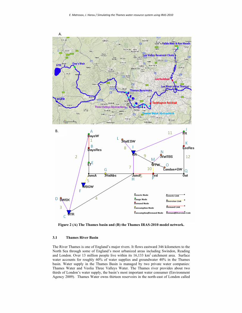
steps is repeated until the end of the time-step to determine how water should be allocated in each sub-time step. The first pass in the first loop determines demand-driven release targets from reservoirs to demand nodes. These releases, which are termed demand based releases, as they are initiated by downstream deficits at demand nodes, attempt to alleviate any storage or flow deficits that were calculated as described above. The second pass computes lake and reservoir supply based releases based on defined reservoir rules and node specific storage vs. outflow rating tables. Additional supply-based releases from reservoirs are calculated using reservoir balance tables which serve to activate releases from individual reservoirs based on their current storage and that of other reservoirs in the same reservoir group. These releases are based on the storages in the reservoirs and not on downstream demand deficits and so are called supply releases. Demand-based releases are added to supply based releases and the final release is subject to available storage and maximum and minimum release rates. The final pass in this loop serves to calculate evaporation and seepage losses from rainfall additions to surface storage nodes. The second loop calculates the inflow and outflow of all non-aquifer and non-wetland nodes and computes hydropower generation and pumping energy on the links connected to these nodes. To accomplish this a pass through the system is done from the most upstream nodes to the most downstream nodes propagating natural flow and storage node releases downstream byfirst calculating the outflows of the most upstream nodes followed by the inflow of the next downstream nodes in the system. Allocations are made following user-defined tables and considering demand deficits in downstream nodes. The flow is propagated until the most downstream nodes are reached. Bidirectional links that connect aquifers or wetlands to surface nodes are computed in this loop as well. Any hydropower or pumping energy requirements defined on links calculated in this loop are also estimated. The third loop in the sub-time step computes the remaining uncalculated flows including flows through bidirectional links connecting groundwater or wetland nodes on both ends. The fourth and final loop updates the volumes of water in aquifers and wetland nodes using their calculated inflows and outflows. This four-loop process is repeated for every sub-time step until the time step finishes and then restarts for every time-step until the end of the simulation. Figure 1 displays a schematic of the IRAS-2010 simulation procedure. 3. THAMES BASIN APPLICATION To demonstrate the effectiveness of IRAS-2010, a model of the Thames water resource system was built (Error! Reference source not found. exhibit a). Input data was obtained from an existing Thames water resource system model maintained by the Environment Agency of England and Wales. The EA’s Thames model uses a water resource simulation software package developed in the UK water industry context named AQUATOR. Both Thames models have similar spatial resolution and use a daily simulation time step over the historical time horizon (1920-2005). A schematic of the IRAS-2010 network as it appears in the current release of Hydroplatform is displayed in Error! Reference source not found.Error! Reference source not found. exhibit b.
E. Matrosov, J. Harou / Simulating the Thames water resource system using IRAS‐2010
Figure 2 (A) The Thames basin and (B) the Thames IRAS-2010 model network.
3.1 Thames River Basin The River Thames is one of England’s major rivers. It flows eastward 346 kilometers to the North Sea through some of England’s most urbanized areas including Swindon, Reading and London. Over 13 million people live within its 16,133 km2 catchment area. Surface water accounts for roughly 60% of water supplies and groundwater 40% in the Thames basin. Water supply in the Thames Basin is managed by two private water companies: Thames Water and Veolia Three Valleys Water. The Thames river provides about two thirds of London’s water supply, the basin’s most important water consumer (Environment Agency 2009). Thames Water owns thirteen reservoirs in the north-east of London called
B.
A.

E. Matrosov, J. Harou / Simulating the Thames water resource system using IRAS‐2010
the Lee Valley Reservoir Chain which is supplied by the Lee river and a group of reservoirs south-west of London that are supplied by the Thames. Groundwater comes from boreholes distributed throughout the basin. Excess treated water is pumped back into the ground in north London under a scheme known as the North London Artificial Recharge Scheme (NLARS) for later use during dry periods. In addition to the surface reservoirs and NLRAS, an additional aquifer in West Berkshire in the west of the basin is available for use during extreme droughts. This is called the West Berkshire Ground Water Scheme (WBGW). The Thames basin is one of the driest in England averaging 719 mm of rainfall annually. The basin has experienced six major droughts in the last 90 years (Thames Water 2009). Climate changes will likely result in a reduction of summer-time precipitation whilst population increases are expected to add further strain on the basin. To mitigate future problems, Thames Water has begun the construction of a desalination plant and has proposed the construction of a new reservoir in the north west of the basin known as the Upper Thames Reservoir (UTR). 3.1 Thames IRAS-2010 Model Components Inflows into the system Surface water enters the system at nodes A and E on the River Thames and Node J on the River Lee. These inflows obtained are from daily historical flow rates from gauging stations. London’s groundwater is modeled as an aggregate inflow directly into London, Node O. Water Consumption Nodes Nodes D, G, L N and O are consumption nodes that represent regions or urban areas that consume water to meet their demands. Some of these demands vary on a monthly basis to simulate seasonal demand variations. All the consumption nodes are fed by surface storage with the exception of node G which obtains its demand directly from the Thames and Node O which is supplemented by groundwater inflow with a time-series on that node. Storage Nodes Node I is the aggregate storage of the Thames and Lee River reservoirs. NLARS is incorporated into the London Aggregate Storage (LAS) node. Water is diverted to LAS first from the Lee River and then from the Thames subject to environmental minimum flows directly downstream of the abstractions (Nodes P and K) and maximum daily abstraction limitations. The WBGW, Node F, is modeled as a reservoir even though it is a groundwater node. This is the case in both Aquator and IRAS-2010 because it functions more like a storage node rather than an unmanaged aquifer. Its release, which goes into the Thames, is activated by reservoir balance tables which link it to the real-time storage in the aggregate storage node. The WBGW has a set storage level which limits how much it can contribute to the Thames in drought situations. It is refilled by a small daily inflow small enough that it cannot serve as an unlimited source. This inflow is continuous, but serves only to refill the node and does not directly contribute to the Thames; it is lost from the system when the WBGW is not in use. The IRAS-2010 model includes the planned Upper Thames Reservoir (UTR, Node C). The UTR supplies water to a consumption site and when activated to the Thames. Flow to the Thames is activated when flow at Node E goes below 3000 Ml/day. The UTR is fed by an abstraction off the Thames and is limited to a minimum environmental flow directly downstream at Node B and a daily abstraction limit. Water Treatment Works The Water Treatment Works, (WTW, Node M) are modeled as a divergence node that feeds two consumption sites. A part of the inflow into the WTW leaks out into the environment. Most of this leakage makes its way to the Thames as the most of the WTWs are located near the river and so it is modeled as a link into Teddington and contributes to

E. Matrosov, J. Harou / Simulating the Thames water resource system using IRAS‐2010
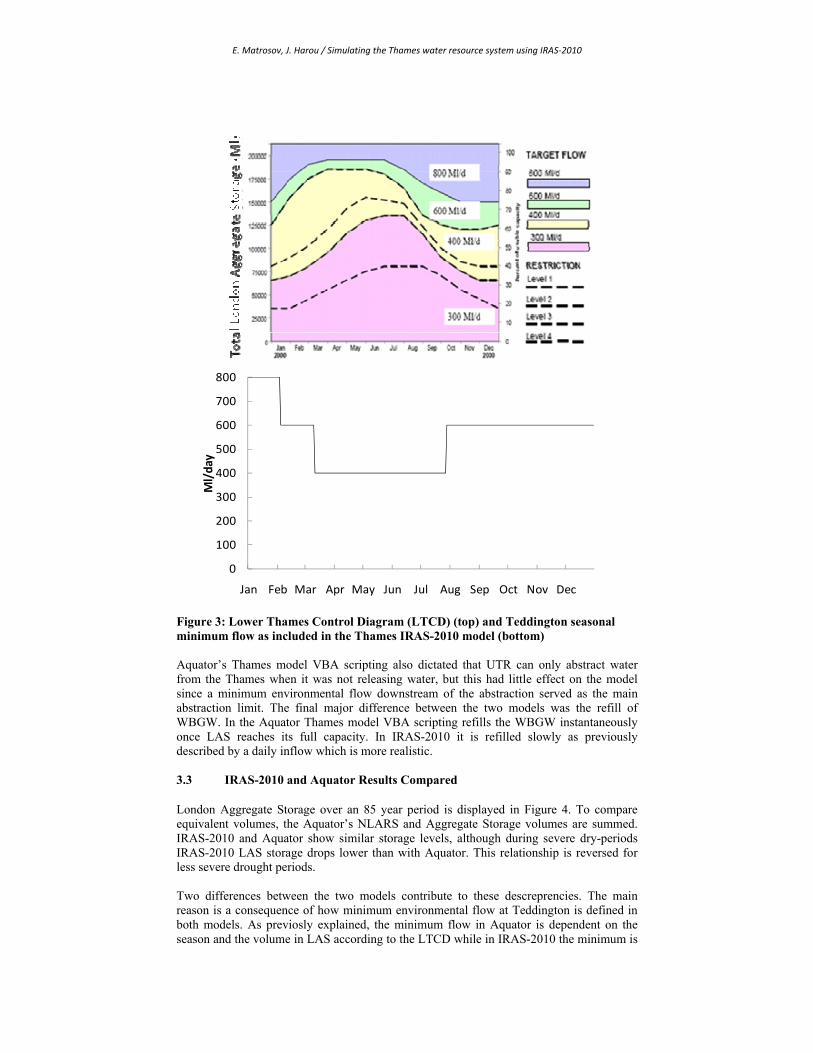
Teddinton’s minimum environmental flow. Some WTW are located near the Lee and thus do not contribute to Teddington’s flow and so this part of the leakage is modeled as seepage from this link. Teddington Teddington weir, node P, has a defined environmental flow which limits the abstraction from the Thames. The minimum flow varies seasonally between 400 and 800 Ml/day with the lower environmental flows occurring during summer months to enable maximum abstraction to LAS. 3.2 Differences between IRAS-2010 and Aquator Thames models Aquator allows for custom scripting of individual network elements. For this reason Aquator is able to provide a level of customization not available in a monolithic program like IRAS-2010 . Using VBA several components in Aquator are controlled by the Lower Thames Control Diagram (LTCD) seen in Error! Reference source not found.. One use for the LTCD is to make the minimum flows at Teddington weir dependent on both the time of year and on the total storage in LAS. Without building a new IRAS-2010 module to represent this, only different fixed seasonal minimum flows were used in this study. Error! Reference source not found. also shows the IRAS-2010 approximation of the LTCD. The LTCD also defines restriction zones that are used as activation switches for several components. In Aquator, as restriction lines are crossed, London and other water demands are lowered to represent water saving measures. Such demand restrictions are currently not available in IRAS-2010 and so were not included. Additionally, restriction level 2 in Aquator activates WBGW releases. This was approximated by IRAS-2010 using seasonal balance tables.
E. Matrosov, J. Harou / Simulating the Thames water resource system using IRAS‐2010
0
100
200
300
400
500
600
700
800
Jan Feb Mar Apr May Jun Jul Aug Sep Oct Nov Dec
Ml/day
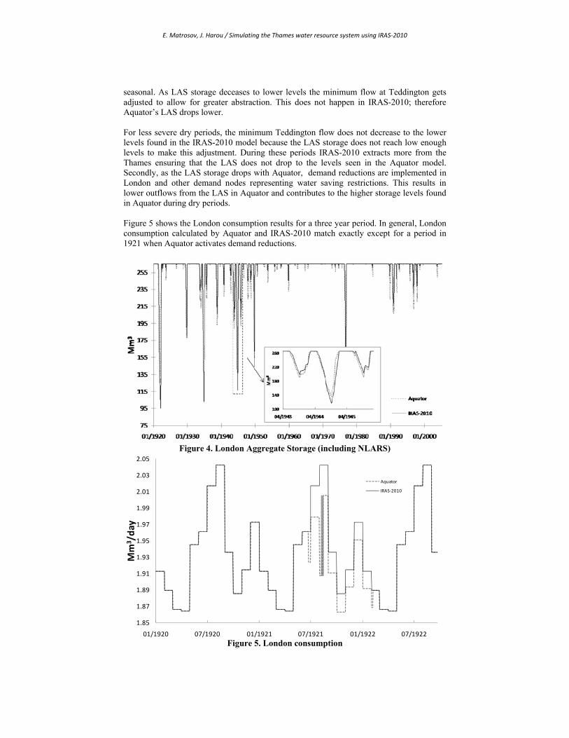
Figure 3: Lower Thames Control Diagram (LTCD) (top) and Teddington seasonal minimum flow as included in the Thames IRAS-2010 model (bottom) Aquator’s Thames model VBA scripting also dictated that UTR can only abstract water from the Thames when it was not releasing water, but this had little effect on the model since a minimum environmental flow downstream of the abstraction served as the main abstraction limit. The final major difference between the two models was the refill of WBGW. In the Aquator Thames model VBA scripting refills the WBGW instantaneously once LAS reaches its full capacity. In IRAS-2010 it is refilled slowly as previously described by a daily inflow which is more realistic. 3.3 IRAS-2010 and Aquator Results Compared London Aggregate Storage over an 85 year period is displayed in Figure 4. To compare equivalent volumes, the Aquator’s NLARS and Aggregate Storage volumes are summed. IRAS-2010 and Aquator show similar storage levels, although during severe dry-periods IRAS-2010 LAS storage drops lower than with Aquator. This relationship is reversed for less severe drought periods. Two differences between the two models contribute to these descreprencies. The main reason is a consequence of how minimum environmental flow at Teddington is defined in both models. As previosly explained, the minimum flow in Aquator is dependent on the season and the volume in LAS according to the LTCD while in IRAS-2010 the minimum is
E. Matrosov, J. Harou / Simulating the Thames water resource system using IRAS‐2010
seasonal. As LAS storage deceases to lower levels the minimum flow at Teddington gets adjusted to allow for greater abstraction. This does not happen in IRAS-2010; therefore Aquator’s LAS drops lower. For less severe dry periods, the minimum Teddington flow does not decrease to the lower levels found in the IRAS-2010 model because the LAS storage does not reach low enough levels to make this adjustment. During these periods IRAS-2010 extracts more from the Thames ensuring that the LAS does not drop to the levels seen in the Aquator model. Secondly, as the LAS storage drops with Aquator, demand reductions are implemented in London and other demand nodes representing water saving restrictions. This results in lower outflows from the LAS in Aquator and contributes to the higher storage levels found in Aquator during dry periods. Figure 5 shows the London consumption results for a three year period. In general, London consumption calculated by Aquator and IRAS-2010 match exactly except for a period in 1921 when Aquator activates demand reductions.
Figure 4. London Aggregate Storage (including NLARS)
1.85
1.87
1.89
1.91
1.93
1.95
1.97
1.99
2.01
2.03
2.05
01/1920 07/1920 01/1921 07/1921 01/1922 07/1922
Mm
3 /day
Aquator
IRAS‐2010
Figure 5. London consumption

E. Matrosov, J. Harou / Simulating the Thames water resource system using IRAS‐2010
Figure 6. Flow rates at Teddington
Figure 6 shows the flow going through Teddington weir after all abstractions from the Thames have been made and after the additions from the WTW. Abstraction to LAS directly upstream of this node is limited by the minimum environmental flow at Teddington which is dictated by the IRAS-2010 approximation of the LTCD. Aquator and IRAS-2010 generally show the same flow rates through Teddington except for parts of periods when only the minimum environmental flow is left to flow past Teddington. This is visible in the sub-plot of Figure 6. The divergence is due to differing minimum flow rates set by the two models as a result of the IRAS-2010 LTCD limitation as previously described. The circled portion of the blown up plot also shows slight noise in the IRAS-2010 calculated flow. This is a consequence of imperfect demand deficit calculations arising from inaccurate estimation of expected inflow during the sub-time step procedure; a known current limitation of IRAS-2010. This however does not have a large effect on the results as the discrepancy is small. 4. IRAS-2010 DISCUSSION 4.1 Limitations While IRAS-2010 and Aquator model results are similar most of the time, significant discrepancies between them exist under certain conditions. The factor that most inhibited IRAS-2010’s ability to emulate the Aquator Thames model is the lack of scripting capabilities to customize network object behavior. Some complex relationships between model components are difficult to represent without customized scripting. In monolithic programs like IRAS-2010, such special behavior would need to be included into the standard subroutines used for all nodes. Some features scripted in Aquator could be programmed into IRAS-2010 but they would not be as flexible. This limitation prevented the LTCD in IRAS-2010 to depend on the volume of the LAS resulting in IRAS-2010 extracting too much water in less severe dry periods and not enough during more severe dry periods producing unrealistic variations in LAS storage. Lack of node customization also forced the IRAS-2010 model to integrate the NLARS into LAS whilst ideally these should be separate nodes. With Aquator NLARS and LAS required extensive customization to regulate outflow and inflows; this wasn’t possible with IRAS-2010.

E. Matrosov, J. Harou / Simulating the Thames water resource system using IRAS‐2010
Another current limitation of IRAS-2010 involves demand node contribution priorities. There is currently no way to define which storage node or link serves as a higher priority contributor to a demand node. The order in which links connecting to a demand node are defined in IRAS-2010 sets the priority in some instances, but this is not fully adhered to because of the current implementation of the sub-time step calculation algorithm. Priority is seen only to a limited extent where higher priority contributors contribute the greatest part to a demand node, but some water is still drawn from lower priority links. Another minor current limitation occurs when demand based release from a reservoir provides the majority of flow to a flow demand node. The sub time step lag in demand deficit calculation results in the reservoir reaching a maximum volume of capacity minus the reservoir’s sub-time step release. This limitation becomes less apparent with smaller sub-time steps. This and other known minor computational limitations will likely be corrected or mitigated over time. 4.2 Benefits Despite these limitations the IRAS-2010 Thames model produced satisfactory results for the Thames system and was able to closely emulate the EA’s calibrated system model in most conditions. As a monolithic program, IRAS-2010 is straight forward to configure and use and requires no advanced scripting skills. The availability of a separate customizable open-source user interface (HydroPlatform) is useful for users who would want to use IRAS-2010 in a customized decision support system (DSS). IRAS-2010 is computationally efficient making it an attractive model for planning methods that require multiple runs or for collaborative workshops where participants want quick feedback on effects of proposed system changes. The IRAS-2010 Thames model using a weekly time step over an 85 year time horizon runs in under 15 seconds on a 2 Ghz desktop computer. The variable time step and ability to implement hydrological routing and simple aquifer interactions increase the tool’s flexibility. The ability to use flow factors is useful for climate change studies which typically multiply historical flows by perturbation factors meant to represent possible climate change. 4.3 Future work As an open-source project IRAS-2010 will be updated to improve performance and add features. The ability to represent demand saving measures is planned to lower demands during periods of low storage. Demand targets will be made dependent not only on the season but also on storage. The ability to add priorities on links leading to demand sites and improving the storage demand node deficit calculation would be a useful improvement. 5. CONCLUSIONS
IRAS-2010 is an effective computationally efficient open-source generalised computer program to simulate water resource systems. IRAS-2010 estimates flow and storage of water in natural (rivers, lakes, wetlands, aquifers) and engineered (reservoirs, canals, water abstractions, consumptive use, hydropower, etc.) water resource systems. An application to the Thames River water system shows IRAS-2010 can in most instances emulate a more detailed management model maintained by the Environment Agency of England and Wales. The EA model is built using Aquator, a commercial water modeling system commonly used in the UK water industry. Generally differences originate from the fact that IRAS-2010 is a monolithic procedural code, where all model behavior must be programmed into general subroutines, where as Aquator can customize the behavior of
E. Matrosov, J. Harou / Simulating the Thames water resource system using IRAS‐2010
specific network elements using a scripting language. IRAS-2010 is a free and open-source software allowing the water management modeling community to further diversify its subroutines and improve its performance. Its computational efficiency makes it appropriate for stochastic applications, where many model runs are required, or for interactive use in a workshop context. Promising fields of application include climate change impact and adaptation studies and modeling with stakeholders. A HydroPlatform add-in acts as a customizable user-interface for IRAS-2010. IRAS-2010 will be further improved over time to better suit the needs of water managers and researchers. ACKNOWLEDGMENTS
The authors thank Oxford Scientific Software for granting them an Aquator licence and for their assistance, and the Environment Agency for supplying the Thames model and providing support. REFERENCES Brandgo, C. and C. Rodrigues (2000). "Hydrological Simulation of the International
Catchment of Guadiana River." Physics and Chemistry of the Earth 25(3): 329-339.
Environment Agency. (2009). "More about the Thames River Basin District." Retrieved October 15th, 2009, from http://www.environment-agency.gov.uk/research/planning/33130.aspx.
Loucks, D. P., M. R. Taylor, et al. (1995). IRAS - Interactive river-aquifer simulation model, program description and operating manual. I. Cornell University, NY. Ithaca, NY., Cornell University.
Rani, D. and M. Moreira (2009). "Simulation–Optimization Modeling: A Survey and Potential Application in Reservoir Systems Operation." Water Resources Management.
Salewicz, K. A. and M. Nakayama (2004). "Development of a web-based decision support system (DSS) for managing large international rivers." Global Environmental Change Part A 14(Supplement 1): 25-37.
Thames Water (2009). "Revised Draft Water Resources Management Plan." Wurbs, R. A. (1993). "Reservoir-System Simulation and Optimization Models." Journal of
Water Resources Planning and Management-Asce 119(4): 455-472.
Related Documents