- January 2016 Comanche Trail Pipeline, LLC Docket No. CP15-503-000 San Elizario Crossing Project Environmental Assessment Washington, DC 20426 Federal Energy Regulatory Commission Office of Energy Projects

Welcome message from author
This document is posted to help you gain knowledge. Please leave a comment to let me know what you think about it! Share it to your friends and learn new things together.
Transcript

-
January 2016
Comanche Trail Pipeline, LLC Docket No. CP15-503-000
San Elizario Crossing Project
Environmental Assessment
Washington, DC 20426
Fe
dera
l Ene
rgy
Reg
ulat
ory
Com
mis
sion
Office of
Energy Projects
FEDERAL ENERGY REGULATORY COMMISSION
WASHINGTON, D.C. 20426
OFFICE OF ENERGY PROJECTS
In Reply Refer To:
OEP/DG2E/Gas 1
Comanche Trail Pipeline, LLC
San Elizario Crossing Project
Docket No. CP15-503-000
TO THE PARTY ADDRESSED:
The staff of the Federal Energy Regulatory Commission (FERC or Commission) has
prepared this Environmental Assessment (EA) of the San Elizario Crossing Project
(Project) proposed by Comanche Trail Pipeline, LLC in the above-referenced docket.
Comanche Trail Pipeline, LLC requests authorization to construct, operate, and maintain
a new natural gas pipeline in El Paso County, Texas.
The proposed San Elizario Crossing Project would involve construction of approximately
1,800 feet of FERC-jurisdictional 42-inch-diameter pipeline, installed beneath the Rio
Grande River near the City of San Isidro, State of Chihuahua. The new pipeline would
transport natural gas to a new delivery interconnect with pipeline facilities owned by an
affiliate of Comanche Trail at the United States - Mexico border for expanding electric
generation and industrial market needs in Mexico.
The EA assesses the potential environmental effects of the construction and operation of
the Project in accordance with the requirements of the National Environmental Policy Act
of 1969 (NEPA). The FERC staff concludes that approval of the proposed Project, with
appropriate mitigating measures, would not constitute a major federal action significantly
affecting the quality of the human environment.
The FERC staff mailed copies of the EA to federal, state, and local government
representatives and agencies; elected officials; environmental and public interest groups;
Native American tribes; potentially affected landowners and other interested individuals
and groups; newspapers and libraries in the Project area; and parties to this proceeding.

2
In addition, the EA is available for public viewing on the FERC’s website
(www.ferc.gov) using the eLibrary link.
A limited number of copies of the EA are also available for distribution and public
inspection at:
Federal Energy Regulatory Commission
Public Reference Room
888 First Street, NE, Room 2A
Washington, DC 20426
(202) 502-8371
Any person wishing to comment on the EA may do so. Your comments should focus on
the potential environmental effects, reasonable alternatives, and measures to avoid or
lessen environmental impacts. The more specific your comments, the more useful they
will be. To ensure that your comments are properly recorded and considered prior to a
Commission decision on the proposal, it is important that the FERC receives your
comments in Washington, DC on or before February 3, 2016.
For your convenience, there are three methods you can use to submit your comments to
the Commission. In all instances, please reference the project docket number (CP15-503-
000) with your submission. The Commission encourages electronic filing of comments
and has dedicated eFiling expert staff available to assist you at 202- 502-8258 or
(1) You may file your comments electronically by using the eComment
feature, which is located on the Commission's website at www.ferc.gov
under the link to Documents and Filings. An eComment is an easy method
for interested persons to submit text-only comments on a project;
(2) You may file your comments electronically by using the eFiling feature,
which is located on the Commission's website at www.ferc.gov under the
link to Documents and Filings. With eFiling you can provide comments in
a variety of formats by attaching them as a file with your submission. New
eFiling users must first create an account by clicking on “eRegister.” You
will be asked to select the type of filing you are making. A comment on a
particular project is considered a “Comment on a Filing”; or
3
(3) You may file a paper copy of your comments at the following address:
Kimberly D. Bose, Secretary
Federal Energy Regulatory Commission
888 First Street, NE, Room 1A
Washington, DC 20426
Although your comments will be considered by the Commission, simply filing
comments will not serve to make the commentor a party to the proceeding. Any person
seeking to become a party to the proceeding must file a motion to intervene pursuant to
Rule 214 of the Commission's Rules of Practice and Procedures (Title 18 Code of Federal
Regulations Part 385.214).1 Only intervenors have the right to seek rehearing of the
Commission's decision. Affected landowners and parties with environmental concerns
may be granted intervenor status upon showing good cause by stating that they have a
clear and direct interest in this proceeding that would not be adequately represented by
any other parties. You do not need intervenor status to have your comments
considered.
Additional information about the Project is available from the Commission's
Office of External Affairs, at 1-866-208-FERC (3372) or on the FERC website
(www.ferc.gov) using the eLibrary link. Click on the eLibrary link, click on “General
Search,” and enter the docket number excluding the last three digits in the Docket
Number field (i.e., CP15-500). Be sure you have selected an appropriate date range. For
assistance, please contact FERC Online Support at [email protected] or toll
free at 1-866-208-3676, or for TTY, contact 1-202-502-8659. The eLibrary link also
provides access to the texts of formal documents issued by the Commission, such as
orders, notices, and rulemakings.
In addition, the Commission offers a free service called eSubscription, which
allows you to keep track of all formal issuances and submittals in specific dockets. This
can reduce the amount of time you spend researching proceedings by automatically
providing you with notification of these filings, document summaries, and direct links to
the documents. Go to www.ferc.gov/docs-filing/esubscription.asp.
1 Interventions may also be filed electronically via the Internet in lieu of paper. See the
previous discussion on filing comments electronically.
i
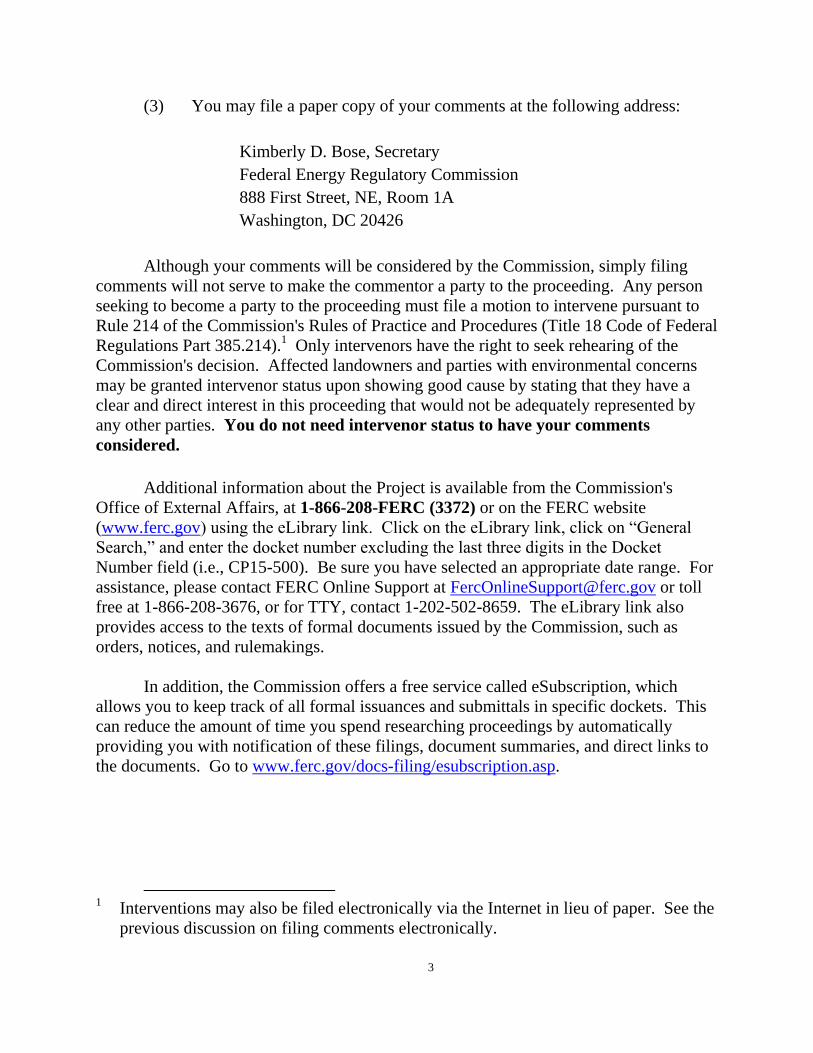
ENVIRONMENTAL ASSESSMENT
SAN ELIZARIO CROSSING PROJECT
TABLE OF CONTENTS
A.PROPOSED ACTION ....................................................................................... 1
1.0 PURPOSE AND NEED ....................................................................................... 1 2.0 PUBLIC REVIEW ............................................................................................. 2 3.0 LAND REQUIREMENTS .................................................................................... 3 4.0 CONSTRUCTION, OPERATION, AND MAINTENANCE PROCEDURES ................. 5 5.0 NON-JURISDICTIONAL FACILITIES .................................................................. 6
B.ENVIRONMENTAL ANALYSIS ..................................................................... 8
1.0 GEOLOGY AND SOILS ..................................................................................... 8 2.0 GROUNDWATER AND SURFACE WATER RESOURCES ................................... 10 3.0 VEGETATION, FISHERIES AND WILDLIFE ..................................................... 13 4.0 LAND USE .................................................................................................... 16 5.0 CULTURAL RESOURCES ............................................................................... 17 6.0 AIR QUALITY AND NOISE ............................................................................. 18 7.0 RELIABILITY AND SAFETY ........................................................................... 22 8.0 CUMULATIVE IMPACTS ............................................................................... 23
C.ALTERNATIVES ............................................................................................. 34
D.STAFF’S CONCLUSIONS AND RECOMMENDATIONS ........................ 35
E.REFERENCES .................................................................................................. 40
F.LIST OF PREPARERS .................................................................................... 41
List of Tables:
Table 1. Permits and Approval………………………………………………….7
Table 2. Estimated Construction Emissions ………………………....................19
Table 7. Non-Jurisdictional Comanche Trail Pipeline Project Environmental
Effects ……………………………………………………………………………44
List of Figures:
Figure 1. General Location of Facilities…………………………………………8
Figure 2. Map of Nonjurisdictional Intrastate Pipeline..………..........................36
ii
TECHNICAL ACRONYMS AND ABBREVIATIONS
Border Patrol U.S. Customs and Border Protection, Border Patrol Division
CEQ Council on Environmental Quality
CFR Code of Federal Regulations
CO carbon monoxide
CO2e carbon dioxide equivalent
Commission Federal Energy Regulatory Commission
dBA decibels on the A-weighted scale
DOE United States Department of Energy
DOT United States Department of Transportation
EA environmental assessment
EI environmental inspector
EPA U.S. Environmental Protection Agency
ESA Endangered Species Act
FERC Federal Energy Regulatory Commission
FWS U.S. Fish and Wildlife Service
GHG greenhouse gas
HDD horizontal directional drill
IBWC International Water Boundary Commission
Ldn day-night sound level
Leq 24-hour equivalent sound level
MBTA Migratory Bird Treaty Act
MP milepost
NAAQS National Ambient Air Quality Standards
NEPA National Environmental Policy Act of 1969
NGA Natural Gas Act
NOI
Notice of Intent to Prepare an Environmental Assessment for the
Proposed Comanche Trail Crossing Project and Request for
Comments on Environmental Issues
NOx Nitrogen Oxide
NRCS Natural Resource Conservation Service
NRHP National Register of Historic Places
NSA noise-sensitive areas
OEP Office of Energy Projects
Plan Upland Erosion Control, Revegetation, & Maintenance Plan

iii
TECHNICAL ACRONYMS AND ABBREVIATIONS
PM2.5 particle matter with an aerodynamic diameter less than or equal to
2.5 microns
PM10 particulate matter with an aerodynamic diameter less than or equal
to 10 microns
Procedures Wetland and Waterbody Construction and Mitigation Procedures
Project Comanche Trail Border Crossing Project
Comanche Trail Comanche Trail Pipeline, LLC
RRC Railroad Commission of Texas
Secretary Secretary of the Commission
SHPO State Historic Preservation Office
SO2 sulfur dioxide
SPCC Plan Spill Prevention, Containment, and Countermeasure Plan
TCEQ Texas Commission on Environmental Quality
TPWD Texas Parks and Wildlife Department
USGS U.S. Geologic Survey
VOCs Volatile Organic Compounds
1
A. PROPOSED ACTION
On May 29, 2015, Comanche Trail Pipeline, LLC (Comanche Trail) filed an
application in Docket No. CP15-503-000 pursuant to section 3 of the Natural Gas Act
(NGA) and Part 153 of the Federal Energy Regulatory Commission’s (FERC or
Commission) regulations, for an order authorizing construction of new border crossing
natural gas pipeline facilities, and for the issuance of a Presidential Permit for those
facilities. The proposed facilities would export up to 1.1 billion cubic feet per day
(Bcf/d) of natural gas at the International Boundary between the United States and
Mexico. Comanche Trail proposes to construct its new international border crossing in
El Paso County, Texas. The San Elizario Crossing Project (Project) would consist of the
construction of approximately 1,800 feet of FERC-jurisdictional 42-inch-diameter
pipeline, installed beneath the Rio Grande River near San Elizario in El Paso County
Texas. The new pipeline would transport natural gas to a new delivery interconnect in
the vicinity of the city of San Isidro, in the state of Chihuahua for expanding electric
generation and industrial market needs in Mexico.
We2 prepared this environmental assessment (EA) in compliance with the
requirements of the National Environmental Policy Act of 1969 (NEPA); the Council on
Environmental Quality’s (CEQ) implementing regulations at Title 40 of the Code of
Federal Regulations (CFR), Parts 1500-1508 (40 CFR 1500-1508); and the
Commission’s regulations at 18 CFR 380.This EA will be used by the Commission in the
process of deciding whether to grant Comanche Trail’s requested authorization. Our
principal purposes in preparing this EA are to:
identify and assess potential impacts on the natural and human environment
that could result from implementation of the proposed action;
identify and recommend specific mitigation measures, as necessary, to
minimize environmental impacts; and
assess reasonable alternatives to the proposed action that would avoid or
minimize adverse effects to the environment.
1.0 Purpose and Need
On May 29, 2015, Comanche Trail filed an application for Commission
authorization and a Presidential Permit to site, construct, operate and maintain certain
natural gas pipeline facilities for export of natural gas between the United States and
Mexico. The overall purpose of this Project is to provide natural gas to fuel natural-gas
electric generation plants and supply potential industrial customers in Mexico.
2 “We,” “us,” and “our” refer to the environmental staff of the FERC’s Office of
Energy Projects.
2
The FERC is the federal agency responsible for evaluating applications pursuant
to section 3 of the Natural Gas Act (NGA) for natural gas import and export facilities,
and for Presidential Permits which are necessary pursuant to Executive Order 10485
when export/import facilities are to be constructed at international borders. Under
Section 3 of the NGA, the FERC considers as part of its decision to authorize natural gas
facilities, all factors bearing on the public interest. Specifically, regarding whether to
authorize natural gas facilities used for importation or exportation, the FERC shall
authorize the proposal unless it finds that the proposed facilities will not be consistent
with the public interest.
Section 3 of the NGA also requires prior approval from the Department of Energy
(DOE) for the import or export of natural gas from or to a foreign country. Section 3(c)
of the NGA, as amended by section 201 of the Energy Policy Act of 1992 (Public Law
102-148), requires that import and export of natural gas applications to the U.S.
Department of Energy, Office of Fossil Energy (DOE/FE) from and to any nation with
which the United States currently has or in the future will have a Free Trade Agreement
be deemed consistent with the public interest and granted without modification or delay.
On May 7, 2015 DOE/FE found that San Elizario Project Crossing meets the Section 3(c)
criterion and authorized Comanche Trail to import and export natural gas from and to
Mexico up to a combined total of 450billion cubic feet for a 2-year period effective
beginning on June 11, 2015 extending through June 10, 2017 (DOE/FE 2015).
2.0 Public Review
On August 3, 2015, the Commission issued a Notice Of Intent To Prepare An
Environmental Assessment for the Proposed San Elizario Crossing Project and Request
for Comments on Environmental Issues (NOI). The NOI was published in the Federal
Register and was mailed to interested parties including federal, state, and local officials;
agency representatives; Native American Tribes, local libraries and newspapers; and
property owners potentially affected by the Project activities.
Written comments were requested from the public on specific concerns about the
Project or issues that should be considered during preparation of the EA. We received
over 100 comment letters on the San Elizario Crossing Project. These letters expressed
concern about the regulatory framework in place to review pipeline projects and the San
Elizario Crossing Project’s potential impact on the environment. Local officials in the
city of San Elizario and El Paso, Texas filed comments in response to the Notice of Intent
siting concerns for the non-jurisdictional pipelines associated with the San Elizario
Crossing Project and a proposed intrastate pipeline unrelated to the project called the
Trans-Pecos Pipeline. The primary concerns were of segmentation, impact to cultural
resources and the need for a NEPA analysis for impacts associated with the non-
jurisdictional pipeline, described further in section 5.0. Additional comments received
include safety, cultural impacts, water resources, and environmental impacts. We address
all comments concerning the Project in the appropriate sections of this EA.
3
Executive Order 10485 requires that the FERC obtain the favorable
recommendations of the Secretary of Defense and Secretary of State before issuing a
Presidential Permit. On June 26, 2015, the FERC issued letters to both secretaries
informing them of Comanche Trail’s application, providing copies of a draft Presidential
Permit, and soliciting their views. On October 7, 2015 the Secretary of State responded
stating there are no objections to the issuance of the proposed Presidential Permit. A
response from the Secretary of Defense is pending.
3.0 Land Requirements
Construction of the Project pipeline would affect 4.2 acres of temporary
workspace in the United States for HDD construction and hydrostatic testing of the
pipeline. All equipment staging, contractor parking, and materials storage would occur
within the HDD workspace. Comanche Trail would use without modification or
improvement an existing county maintained road. Following construction, Comanche
Trail would retain a 50-foot-wide permanent right-of-way over the Project facilities,
totaling 1.3 acres. Although Comanche Trail has identified areas where extra workspace
and access roads would be required, additional or alternative areas could be identified in
the future due to changes in site-specific construction requirements. Comanche Trail
would be required to file information on each of those areas for review and approval prior
to use. A general project location map is shown in figure 1.

4
Figure 1. General Location of Facilities

5
4.0 Construction, Operation, and Maintenance Procedures
The Project would be designed, constructed, operated, and maintained in
accordance with applicable requirements defined by the U.S. Department of
Transportation (DOT) regulations in 49 CFR 192, Transportation of Natural and Other
Gas by Pipeline: Minimum Federal Safety Standards; by FERC’s Siting and
Maintenance Requirements in 18 CFR 380.15; and by other applicable federal and state
safety regulations. Prior to construction, Comanche Trail would notify the one
landowner regarding effects on their property, business, or operations. Comanche Trail is
owned by Energy Transfer Mexicana, LLC an affiliate of Energy Transfer Partners, L.P.
(Energy Transfer). Energy Transfer or an affiliate would be the operator of Comanche
Trail.
Comanche Trail states that the Project would be constructed in accordance with
our Upland Erosion Control, Revegetation, and Maintenance Plan (Plan), and Wetland
and Waterbody Construction and Mitigation Procedures (Procedures).3 Comanche
Trail has also prepared a Horizontal Directional Drill Inadvertent Release Control Plan
that it would use to monitor, contain, and respond if an inadvertent release were to occur.
We have reviewed this plan and found it to be adequate.
The Project would have an environmental inspector (EI) who would be
responsible for ensuring compliance with our Plan and Procedures, project-specific
conditions contained in any FERC authorization, and other applicable environmental
permits, approvals, and landowner agreements. Project personnel, including the chief
inspector, EI, and construction contractor, would receive copies of construction related
documents to ensure compliance with all federal, state, and local permit requirements.
Construction of the Project facilities would take approximately three months to complete
and Comanche Trail anticipates starting construction in the first quarter of 2016.
The HDD method would be used to construct the pipeline across the Rio Grande
River. Generally, an HDD allows for trenchless construction across an area by drilling a
hole below the depth of a conventional pipeline trench, and then pulling a prefabricated
section of pipe through the hole. This method is used to avoid direct impacts on sensitive
environmental features, such as waterbodies, or areas that otherwise present difficulties
for standard pipeline construction.
3 The FERC Plan and Procedures are a set of construction and mitigation measures
that were developed in collaboration with other federal and state agencies and the natural
gas pipeline industry to minimize the potential environmental impacts of the construction
of pipeline projects in general. The FERC Plan can be viewed on the FERC internet
website at http//www.ferc.gov/industries/gas/enviro/plan.pdf. The FERC Procedures can
be viewed on the FERC internet website at
http//www.ferc.gov/industries/gas/enviro/procedures.pdf.
6
To install the border-crossing pipelines, Comanche Trail would HDD beneath the
Rio Grande from the Mexico side. The pipe would be fabricated on the U.S. side. The
pipeline would then be hydrostatically tested, attached to the drill string at the exit point,
and drawn back toward the drill rig at the entry location in Mexico. Upon completion of
pipeline construction, Comanche Trail would again hydrostatically test the entire length
of the pipeline. All disturbed workspaces would be restored per the requirements in our
Plan.
5.0 Non-jurisdictional Facilities
Occasionally, projects have associated facilities that are constructed in support of
the project, but do not come under the jurisdiction of the FERC. Such non-jurisdictional
facilities are often constructed upstream or downstream of the jurisdictional facilities for
the purpose of delivering, receiving, or using the proposed gas volumes.
The Project would interconnect with Comanche Trail’s new intrastate pipeline
facilities, which includes 195 miles of 42-inch-diameter pipeline, metering stations, and
other auxiliary facilities from a hub in Pecos County, Texas. The intrastate facilities
would be subject to the jurisdiction of the Railroad Commission of Texas (RRC) and
would be non-jurisdictional to the FERC.
We have received comments in the record regarding the potential of the non-
jurisdictional facilities to affect historic properties. The Comanche Trail Intrastate
Project is an applicant for a USACE Nationwide Permit #12. The conditions of the
permit specify that if the district engineer determines that the activity may affect any
properties listed in, or eligible for listing in, the National Register of Historic Places, the
activity is not authorized until the requirements of Section 106 the NHPA have been
satisfied. The permit conditions also require the permittee to notify the district engineer
if any previously unknown historic, cultural or archaeological remains and artifacts are
discovered in the course of the activity. Therefore, effects to historic properties on the
FERC non-jurisdictional facilities will be taken into account by the USACE.
Comanche Trail has conducted cultural resources surveys of 165 miles of the non-
jurisdictional pipeline to date. The survey has identified 10 archaeological sites, none of
which Comanche Trail recommends as significant. Comanche Trail will file a report of
the assessment with the State Historic Preservation Office (SHPO) upon completion.
Comanche Trail has indicated that their planned 42-inch-diameter intrastate
pipeline facilities would transport natural gas from the Waha Hub in Pecos County, Texas
to the Project border facilities. The 195 mile long pipeline would interconnect to the
Project border crossing pipeline. The facilities would be constructed under the
jurisdiction of the RRC. Construction of the non-jurisdictional facilities would also
include associated facilities, compression, and header and lateral pipelines. The facilities
7
would be capable of transporting approximately 1.1 billion cubic feet per day of natural
gas.
A map depicting the non-jurisdictional pipeline facilities is provided on figure 2 in
section B of this EA. These facilities are not part of the proposed action and not subject
to the Commission’s jurisdiction because they constitute construction of an intrastate
pipeline subject to the jurisdiction of the RRC. However, we are providing the public
and the Commission with the available information on the associated impacts in order to
make a fully informed decision in the cumulative impacts analysis in section B.8.
In addition, at the crossing of the Rio Grande River, Comanche Trail plans to
install a fiber optics cable to connect Energy Transfer Company’s Supervisory and
Control and Data Acquisition (SCADA) control system at the Waha Compressor Station
to the Mexican pipeline company’s control system in Mexico and allow for monitoring of
pipeline system operations on the Comanche Trail pipeline and interconnecting pipeline
in Mexico in real time from a control room in Mexico City. The cable would be installed
in a 1,770-foot-long, 6-inch-diameter conduit installed under the Rio Grande River by
HDD. The conduit HDD entry would be offset from the natural gas pipeline HDD by 15
feet and would follow a shallower profile depth of 25 feet below the river but paralleling
the natural gas pipeline. Installation of the fiber-optic cable would occur during the same
timeframe as the Project pipeline and would not require additional width of permanent
easement of the jurisdictional pipeline or additional workspace for its installation.
The RRC Oil and Gas Division is responsible for regulating natural gas pipeline
projects. According to Comanche Trail, it received an Oversight and Safety Division T-4
Permit from the RRC(Comanche Trail Pipeline) on May 12, 2015. We have determined
that the non-jurisdictional Comanche Trail Pipeline is outside the scope of the proposed
action for this EA. However, we include publicly available information for this project in
our cumulative impacts analysis.
6.0 Permits, Approvals, and Regulatory Requirements
A number of federal, state, and local regulatory agencies have permit, approvals,
or consultations that may be needed for the Project (see table 1).
Table 1. Permits and Approvals Administrating Agency Permit/Approval Status
Federal
Federal Energy Regulatory
Commission
Natural Gas Act Section 3
Presidential Permit Application and
18 CFR 153
Application filed May 29, 2015,
assigned Docket No. CP15-503-000.
Approval Pending
U.S. Fish and Wildlife Service Threatened and Endangered Species
Act Section 7 Consultation Consultation complete
U.S. Army Corp of Engineers Rivers and Harbors Action Section
10 (Nationwide Permit 12) Approval Pending.
8
International Boundary and Water
Commission (IBWC) License to Construct Pipeline
Approval Pending.
U.S Customs and Border Protection
Border Patrol Division
Consultation to determine if
proposed project would conflict with
US Border Patrol operations
Ongoing coordination.
U.S.Environmental Protection
Agency Region
National Pollutant Discharge
Elimination System permit for
hydrostatic test water discharge.
Consultation complete
State
Texas State Historic Preservation
Office
Section 106 of National
Historic Preservation Act Consultation complete.
Railroad Commission of Texas PS-48; Notice of Construction;
Hydrostatic Test Discharge Permit
PS-48 Required 30 days prior to
construction. Discharge Permit
requested 30 days prior to
construction.
Texas Parks and Wildlife
Department
Consultation regarding Marl, Sand,
Gravel, Shell or Mudshell Permit. Consultation complete
B. ENVIRONMENTAL ANALYSIS
1.0 Geology and Soils
The Project is located within the broad floodplain of the Rio Grande River.
Average annual rainfall is on the order of 10 inches, and the Rio Grande River from El
Paso downstream to San Elizario is a dry riverbed due to extensive irrigation and
municipal withdrawals. Flash flooding is possible during a significant rainfall event over
the watershed. However, the potential for scour of the pipeline is nonexistence because
the pipeline would cross beneath the Rio Grande River at a depth of 52 feet beneath the
river bottom.
Geology
The Project is located in the Basin and Range Physiographic Province in El Paso
County, Texas along the Rio Grande River. The Project area lies within the Hueco
Bolson, an extensive interior basin drained by the Rio Grande River extending from
central New Mexico to the Rio Conchos Valley west of El Paso, Texas. Most of El Paso
County is underlain by intermontane sediments known locally as bolson deposits.
Along the Rio Grande River, surficial sediments consist of colluvium, alluvium
deposited by the flooding of the Rio Grande River, and alluvial-fan deposits.
Topographically, the Project area is relatively flat, with a slight slope to the southwest
and an average ground surface elevation of 3,630 feet above mean sea level. There is no
identified hydrocarbon or earthen mineral resources in the Project area.
There are no known karst features in the proposed Project basin. However, the
proposed Project is underlain by the Hueco Bolson aquifer, and the surficial Rio Grande
Alluvial Aquifer. The Hueco Bolson is a major source of municipal supply and for
9
irrigation in the El Paso area. Over pumping of this aquifer in excess of naturally
occurring recharge amounts within this arid environment have caused subsidence in El
Paso County measured to be on the order of 0.05 feet between 1952 and 1978. The
pipeline is designed, however, to withstand the levels of subsidence experienced in the
area.
Paleontological resources could occur in the Project area consisting of Tertiary-
age vertebrate and Cretaceous-age invertebrate fossils. Given the relatively small
footprint of the Project, and the Quaternary alluvium deposits present, the Project is not
expected to impact paleontological resources.
Hazards for steel pipelines used for the transmission of natural gas are limited to
those that produce permanent deformation along the pipeline alignment. These hazards
include seismicity or strong and prolonged ground shaking, surface fault rupture,
seismically-induced soil liquefaction, slope instability and landslide susceptibility.
The United States Geologic Survey (USGS 2014) earthquake hazard program
mapping shows that seismicity in terms of peak ground acceleration (PGA) within the
Project area is between 3 to 5 percent gravity for the 10-percent probability of return
period in 50 years. There have been five recorded earthquakes in the last 50 years within
50 miles of the Project area, the largest of these during year 2010 and registering as a
magnitude 3.7. These values represent light to moderate ground shaking with little to no
associated damage, and low potential for soil liquefaction to occur.
There are no recent faults which cross or that are present in the immediate vicinity
of the Project. However, there are about 27 Holocene-age faults that lie within El Paso
County, the nearest located about 6 miles east of the Project area. The flat terrain renders
the Project area negligible for slope instability and landslides.
Given the geologic conditions at the site of the Project’s crossing of the Rio
Grande River, we do not anticipate that pipeline safety would be compromised due to
geologic seismicity, ground rupture, soil liquefaction, subsidence or landslides.
Soils
The U.S. Department of Agriculture-National Resource Conservation Service
(USDA-NRCS) on-line soil survey for El Paso County was used to define soils within the
Project area. Surficial soils at the Project site consist of the Anapra Silty Clay Loam;
Gila Loam; Glendale Loam; Harkey Loam; and Saneli silty clay. These soils are
predominantly developed from stratified alluvial deposits, and clayey alluvium over
sandy alluvium and occur along floodplains, and stream terraces. Soils in these series are
considered well drained.
Comanche Trail would minimize soil impacts during construction by adhering to
the construction and restoration methods required by our Plan, including: restricting
10
construction activities to approved work areas; installing temporary erosion controls such
as silt fencing and properly maintaining these temporary controls until permanent
erosion controls are installed or restoration is complete; reseeding temporary work areas;
and monitoring for at least two years after construction to confirm successful restoration.
Comanche Trail would perform topsoil segregation, per our Plan requirements,
and in accordance with their landowner easement agreement. Topsoil would be
stockpiled separately from subsoil and replaced in the proper order during backfill and
final grading. Project area soils are considered susceptible to soil rutting, depending on
the degree of saturation within work areas during construction. Comanche Trail would
minimize potential fugitive soil losses during construction disturbance by applying dust
control measures such as watering the construction work areas and access roads, and
would de-compact soils pre our Plan requirements.
Inadvertent spills or leaks of fuels, lubricants or coolant from construction
equipment could impact Project soils. These are normally minor events of low frequency
and small volumes. However, Comanche Trail has developed a Spill Prevention,
Control, and Countermeasure (SPCC) Plan that specifies the prevention measures and
cleanup procedures in the event of a spill or leak during construction activities. We have
reviewed the contents of this plan and find it acceptable.
We conclude that the effects of construction and operation of the Project on soils
would be minor.
2.0 Groundwater and Surface Water Resources
The proposed Project is within the Hueco Bolson alluvial aquifer, which is part of
the Rio Grande Aquifer System. The Hueco Bolson aquifer is comprised of
unconsolidated alluvial deposits, including the Rio Grande alluvium, or surficial aquifer
with a thickness of about 200 feet overlying the Hueco Bolson aquifer. Per the findings
of the geotechnical investigation conducted by Comanche Trail at the site of the proposed
HDD alignment, groundwater in the surficial aquifer at the Project area occurs at a depth
of about 13.5 feet below ground surface.
The Hueco Bolson aquifer is the principal aquifer for the El Paso area and Ciudad
Juarez in Mexico. Nearly 90 percent of the water pumped from the Hueco Bolson, and
adjacent Mesilla Bolson aquifer to the west is used for public water supply. The surficial
aquifer is used primarily for supplemental irrigation when surface water flow in the Rio
Grande River is not sufficient to meet agricultural water needs of the region.
Over pumping of the Hueco Bolson Aquifer in excess of naturally occurring
recharge amounts within this arid environment have caused increased salinity in the
aquifer, and water-level declines and minimal local land subsidence within the El Paso
County area.

11
There are no public or private water wells within one-half mile of the Project area.
There are no protected aquifers or U.S. Environmental Protection Agency (EPA) –
designated sole source aquifers, or source-water protection zones in the Project area.
The Project facilities would be within the Rio Grande-Fort Quitman watershed.
The HDD would cross beneath the Rio Grande River and a man-made ditch owned by the
El Paso County Irrigation District No.1. There are no potable water intakes in the Rio
Grande River within 3 miles downstream of the Project. The majority of surface water in
the Rio Grande is diverted at a point upstream of the Project for irrigation and municipal
use.
The Texas Commission on Environmental Quality (TCEQ) 2012 Texas Integrated
Report of Surface Water Quality for Clean Water Act 303(d) lists this segment of the Rio
Grande River from the confluence of the Rio Conchos (Mexico) in Presidio County
upstream to the Riverside Dam in El Paso County (Assessment Unit No. 2307) as
impaired water for bacteria, chlorides, and total dissolved solids. No discharges to this
segment of the Rio Grande River are anticipated from Project construction.
Comanche Trail would implement the measures within our Plan and Procedures to
minimize the potential for sediment runoff to impact adjacent surface waterbodies from
construction work areas. Inadvertent releases of fuels, lubricants, or solvents from
construction activities that could potentially impact adjacent surface waters and shallow
groundwater resources would be addressed through implementation of Comanche Trail’s
SPCC Plan.
Comanche Trail’s proposed HDD would be at depth of 52 feet beneath the Rio
Grande River. The results of Comanche Trail’s geotechnical soil boring shows
subsurface material consisting of sandy clay in the upper 5 feet, underlain by poorly
graded sands to a depth of 30 feet below ground surface, and sandy gravel to 40 feet
below ground surface. Below 40 feet, well graded and poorly graded, medium dense
gravel was encountered to a depth of 55 feet below ground surface, underlain by poorly
graded sands to the bottom of the boring at 101.5 feet below ground surface. Bedrock
was not encountered in the boring.
Groundwater was detected at depths of 13.5 feet below ground surface in the
boring. These results indicate that the subsurface along the depth of the HDD profile
above 40 feet below ground surface are amenable to the HDD method. The presence of
15 feet of medium-dense gravel between 40 and 55 feet below ground surface could
present borehole stability problems during drilling, however Comanche Trail’s
geotechnical contractor (Hatch Mott MacDonald) states that HDD through the planned
profile is technically feasible.
12
Comanche Trail conducted an analysis of estimated downhole drilling fluid
pressures versus overburden pressure which shows that the risk of inadvertent release of
drilling fluid reaching the ground and water surface is low with the exception of within
200 feet of the exit location in Mexico. Use of the HDD technique typically avoids
disturbing a waterbody bed and banks and minimizes environmental impacts. However,
an inadvertent release of drilling fluids from the drilled borehole through hydrofractures
could reach the surface along the drill path. The release of drilling fluids could likewise
occur in areas of mud pits or tanks. Drilling fluid is comprised of a mixture of water and
non-toxic, naturally occurring bentonite clay, which in small quantities would not be
detrimental to vegetation, fish, or wildlife. In larger quantities, the release of drilling
fluids into a waterbody could affect fisheries and vegetation by causing turbidity,
sedimentation, and changes to aquatic habitat.
Comanche Trail has prepared a Directional Drilling Contingency Plan to monitor
and mitigate the potential effects of an inadvertent release of drilling fluids. Comanche
Trail would monitor the volume of drilling fluids and the borehole pressures during
drilling to determine if a substantial loss of drilling fluid circulation is occurring. An
inadvertent release of drilling fluid within upland areas would be immediately contained
with barriers such as hay bales, sand bags, or silt fencing, and collected. If the release is
large enough to allow collection, the drilling mud would be collected and returned to the
drill rig operations, or disposed of at a disposal site.
If a release were to occur within the Rio Grande River, Comanche Trail would
notify the FERC, as well as the United Stated Army Corps of Engineers (USACE), the
United States Fish and Wildlife Service (USFWS) and other applicable agencies to
inform them of the release. In the event of a release into the Rio Grande River, varying
by water levels, and flow within the river, silt fence may be used to surround and contain
the release point. If water depth exceeds the ability to use silt fence, turbidity curtains
may be utilized within the open water areas to contain the release and decrease turbidity
levels, thus allowing the drilling mud to settle to the bottom of the waterbody. During
containment procedures, Comanche Trail would minimize and limit impacts to adjacent
wetland or riparian habitat areas. Once the release is contained, the drilling fluid would
be pumped into trucks, and reused or disposed of at an appropriate off-site facility.
However, Comanche Trail’s contingency plan does not include measures that would be
utilized to collect and dispose of the drilling mud release into the river. Additionally, the
contingency plan does not contain the provision for notifying the International Boundary
and Water Commission (IBWC) of the release. Therefore, we recommend that:
Prior to construction, Comanche Trail should file with the Secretary
of the Commission (Secretary) for review and written approval by the
Director of the Office of Energy Projects (OEP):
13
a. a revised Directional Drilling Contingency Plan to provide for
the measures to be implemented for collection and disposal
of an inadvertent release of drilling mud into the Rio Grande
River; and
b. that provides notification of the IWBC of any release of
drilling mud into the river.
Comanche Trail would obtain about 200,000 gallons of water for hydrostatic
testing and for drilling from a 16-inch-diameter irrigation well owned by a private
landowner. This well is located at Milepost 194.3 on the intrastate pipeline alignment,
approximately 2,950 foot east of the HDD entry location. Comanche Trail would ensure
that water is discharged to vegetated upland areas utilizing hay bales, bag filters, and sock
filters as needed to minimize erosion and sedimentation in accordance with FERC’s
Procedures. Comanche Trail would not be adding any chemicals to the hydrostatic test
water and would test the water prior to discharge.
Field surveys conducted by Comanche Trail, the only areas that would meet
wetland criteria are below the normal channel banks of the Rio Grande River, which the
Project HDD would pass beneath.
Based on Comanche Trail’s proposed construction methods and mitigation
measures, including the measures in their SPCC Plan and their Directional Drilling
Contingency Plan, and our recommendation, we conclude that impacts on groundwater
(quality or quantity) and surface water resources would not be significant and would be
adequately protected during construction of the Project.
3.0 Vegetation, Fisheries and Wildlife
Vegetation
The proposed Project workspaces are located entirely within previously
disturbed agricultural cropland. None of the proposed workspaces contain undisturbed
natural vegetation or trees. No wetlands or other sensitive plant communities exist
within the proposed Project vicinity.
Construction could result in an increased potential for the introduction and
establishment of invasive and noxious weeds. Comanche Trail would restore and
revegetate disturbed areas in accordance with the FERC’s Plan and Procedures and/or
landowner requirements, and would implement control measures to reduce the spread of
exotic, invasive, and noxious plant species after construction. As required by our Plan,
Comanche Trail would monitor disturbed areas for at least two years following
construction to determine if invasive or exotic species have become established. If

14
species or colonies of species were more abundant than in nearby undisturbed areas,
Comanche Trail would remove invasive species.
Based on the minor footprint of the Project, a lack of vegetation resources in the
Project area and Comanche Trail’s post-construction monitoring for noxious weeds, we
conclude that construction and operation of the Project would not significantly affect
vegetation in the Project area.
Fisheries
There are no designated essential fish habitats near the Project nor are there any
significant fisheries of commercial or recreational value that would be crossed or
otherwise affected by the Project.
Comanche Trail would avoid fish habitat impacts by crossing the river and
channel using the HDD method, which eliminates the need for in-stream construction.
However, temporary habitat alteration, streambed structural changes, and substrate
disturbance could also occur, from
an inadvertent release of drilling fluids into the waterbody;
increased sedimentation from overland flow off of construction work
areas; and
an inadvertent spill or release of fuels and/or lubricants into the
waterbody.
Comanche Trail would implement the construction mitigation measures outlined
in our Plan and Procedures to minimize impacts on waterbodies and fisheries. These
mitigation measures include:
reducing the size of workspaces near waterbodies where possible;
locating extra work areas at least 50 feet from the edge of the waterbody;
installing erosion controls to prevent run-off from entering waterbodies
from construction work areas; and
restricting refueling activities within 100 feet of the waterbody.
In addition, Comanche Trail would also implement its Horizontal Directional
Drill Inadvertent Release Control Plan and its SPCC Plan.
Based on Comanche Trail’s adherence to the construction and mitigation
measures in our Plan and Procedures, and implementation of their Project-specific Plans,
we conclude that impacts would not be significant.

15
Wildlife
The cropland described previously provides marginal habitat for commonly found
wildlife. Protected species are addressed below. Wildlife observed during surveys of the
project area included Brewer’s blackbird (Euphagus cyanocephalus), mourning dove
(Zenaida macroura), and white-winged dove (Zenaida asiatica).
Installing and operating the proposed pipeline would temporarily affect wildlife
and wildlife habitat. Project related activities including clearing and the general use of
construction equipment would result in the loss of wildlife habitat, change the
characteristics of adjacent wildlife habitat, displace wildlife, alter wildlife behavior; and
could increase the rates of mortality, injury and stress experienced by wildlife. However,
based on the scope of the Project; amount of land affected and short duration of Project-
related activities, we have determined that these effects would be minor and highly
localized. Therefore, we conclude installing and operating the proposed pipeline would
not significantly affect wildlife.
Threatened, Endangered, and Special Status Species
The USFWS identified six species listed under the Endangered Species Act as
potentially occurring within the vicinity of the Project, but has not designated any critical
habitat within El Paso County. These species include:
least tern (Sternula antillarum);
Mexican spotted owl (Strix occidentalis lucida);
northern aplomado falcon (Falco femoralis septentrioinalis);
southwestern willow flycatcher (Empidonas tradillii extimus);
yellow-billed cuckoo (Coccyzus americanus); and
Sneed’s pincushion cactus (Excobaria sneedii var sneedii).
Habitat assessment surveys conducted on May 5, 2015, did not identify any
individuals or suitable habitat for any of these species. Therefore, we have determined
the Project would have no effect on these species from construction or operation, and our
responsibility for the Endangered Species Act section 7 consultation is complete.
State-Listed Species
Because of the small Project construction footprint, as well as the previously
disturbed condition of the land and lack of suitable habitat, we conclude that Project
construction and operation would not adversely affect any special-status species.
16
Migratory Birds
Migratory birds are species that nest in the United States and Canada during the
summer, and make short or long-distance migrations for the non-breeding season.
Neotropical migrants migrate to and from the tropical regions of Mexico, Central and
South America, and the Caribbean.
Migratory birds are protected under the Migratory Bird Treaty Act ([MBTA]-16
U.S. Code 703-711), and Bald and Golden Eagles are additionally protected under the
Bald and Golden Eagle Protection Act (16 U.S. Code 668-668d). The MBTA, as
amended, prohibits the taking, killing, possession, transportation, and importation of
migratory birds, their eggs, parts, or nests unless authorized under a U.S. Fish and
Wildlife Service (USFWS) permit. Executive Order 13186 directs federal agencies to
identify where unintentional take is likely to have a measurable negative effect on
migratory bird populations and avoid or minimize adverse impacts on migratory birds
through enhanced collaboration with the FWS, and emphasizes species of concern,
priority habitats, and key risk factors, and that particular focus should be given to
population-level impacts.
On March 30, 2011, the USFWS and the Commission entered into a Memorandum
of Understanding (MOU) that focuses on avoiding or minimizing adverse effects on
migratory birds and strengthening migratory bird conservation through enhanced
collaboration between the Commission and the USFWS by identifying areas of
cooperation. This voluntary MOU does not waive legal requirements under the MBTA,
the Endangered Species Act, the NGA, or any other statutes and does not authorize the
take of migratory birds.
We have determined based on the characteristics and habitat requirements of the
birds of conservation concern and migratory birds occurring or potentially occurring in
the Project area, impacts on wildlife habitat, the amount of habitat affected and the
presence of similar habitats adjacent to and in the vicinity of the Project that constructing
and operating the Project would not result in population-level impacts or significant
measureable negative impacts migratory birds.
4.0 Land Use
Construction of the Project would require temporary disturbance of approximately
4.2 acres classified as cultivated cropland on privately-owned property and would utilize
an existing county road without modification or improvement. Following construction,
Comanche Trail would restore areas disturbed by construction to pre-construction
conditions, unless otherwise requested by the landowner or land managing agency.
About 1.3 acre would be retained for a permanent pipeline right-of-way.
17
The Project would not affect nor be within 0.25 miles of any public use areas or
special/sensitive land uses. Further, there are no occupied residential buildings within 50
feet of the Project. Visual impacts associated with temporary construction activities
associated with the HDD would be temporary and insignificant.
5.0 Cultural Resources
Section 106 of the National Historic Preservation Act (NHPA), as amended,
requires the FERC to take into account the effects of its undertakings (including the
issuance of Authorizations) on properties listed in or eligible for listing in the National
Register of Historic Places (NRHP), and to afford the Advisory Council on Historic
Preservation (ACHP) an opportunity to comment on the undertaking. Comanche
Tra i l as a nonfederal party, is assisting the FERC in meeting our obligations
under Section 106 by preparing the necessary information, analyses and
recommendations as authorized by 36 CFR 800.2(a)(3).
Comanche Trail conducted a cultural resources survey of the proposed river
crossing and additional temporary work space for the HDD. No cultural resources were
identified. The Texas State Historic Preservation Officer (SHPO) requested deep testing
to investigate the possibility of buried cultural deposits. Comanche Trail subsequently
excavated two backhoe trenches which did not produce any archaeological material. On
August 4, 2015 the SHPO recommended that no historic properties would be affected.
We concur.
In an August 27, 2015 letter the National Park Service (NPS) notified the
Commission that the El Camino Real del Tierra Adento National Historic Trail was
located within the Project area. Comanche Trail provided the cultural resources report,
the results of the deep testing and the SHPO comments on the reports to the NPS. On
November 10, 2015, the NPS concurred with the SHPO’s recommendation of “no
historic properties affected”.
On May 22, 2015 Comanche Trail wrote to the Apache Tribe of Oklahoma, the
Comanche Nation of Oklahoma, the Mescalero Apache Tribe of the Mescalero
Reservation, the Tonkawa Tribe of Oklahoma, the Ysleta del Sur Pueblo, the Fort Sill
Apache Tribe of Oklahoma, and the White Mountain Apache Tribe to request their
comments on the proposed Project. The Comanche Nation of Oklahoma responded that
no properties would be affected by the proposed Project. The Ysleta del Sur Pueblo
responded that they did not object to the Project but requested that they be notified in the
event any artifacts or human remains were unearthed during the project. On August 3,
2015, we sent our NOI to the same tribes. We have not received any responses to our
NOI to date.

18
Comanche Trail has prepared a plan in the event any unanticipated cultural
resources or human remains are encountered during construction. We find the plan to be
acceptable.
Therefore, we have determined in consultation with the Texas SHPO and Native
American tribes that the Project as proposed would not affect any properties listed in, or
eligible for listing in, the National Register of Historic Places.
6.0 Air Quality and Noise
Federal and state air quality standards are designed to protect human health. The
Environmental Protection Agency (EPA) has developed National Ambient Air Quality
Standards (NAAQS) for air contaminants designated “criteria pollutants” such as
nitrogen dioxide and carbon monoxide (CO), the primary pollutants emitted by natural
gas-fired compressor facilities. Other relevant criteria pollutants include ozone (O3),
sulfur dioxide (SO2), and particulate matter (PM10 and PM2.5 for size fractions less than
10 microns and less than 2.5 microns, respectively). The NAAQS were set at levels the
EPA believes are necessary to protect human health and welfare.
If measured ambient air pollutant concentrations for a subject area remain below
the NAAQS criteria, the area is considered to be in attainment with the NAAQS. The
Project location is in the TCEQ El Paso-Juarez Air Quality Control Region in El Paso
County. As of 2015, the City of El Paso is considered in moderate nonattainment status
for PM10 and the entire county is in maintenance status for carbon monoxide. The county
is considered in attainment for all other current NAAQS criteria.
Regulations
The Clean Air Act is the basic federal statute governing air pollution. However,
the jurisdictional Project does not include permanent stationary air emissions sources that
would be subject to permitting provisions under the Clean Air Act. Nor would the
Project be subject to the Greenhouse Gas (GHG) Reporting Rule as emissions are
expected to be well below the threshold of 25,000 TPY of carbon dioxide equivalents
(CO2 e).
Conformity of General Federal Actions
A conformity analysis must be conducted by the lead federal agency if a federal
action would generate emissions that would exceed the conformity applicability threshold
levels of the pollutant(s) for which an air basin is in non-attainment. According to
Section 176(c)(1) of the CAA (40 CFR Section 51.853), a federal agency cannot approve
or support activity that does not conform to an approved State Implementation Plan. The
Project location is in the TCEQ El Paso-Juarez Air Quality Control Region in El Paso
County. As of 2015, the City of El Paso is considered in moderate nonattainment status
for PM10 and the entire county is in maintenance status for carbon monoxide.
19
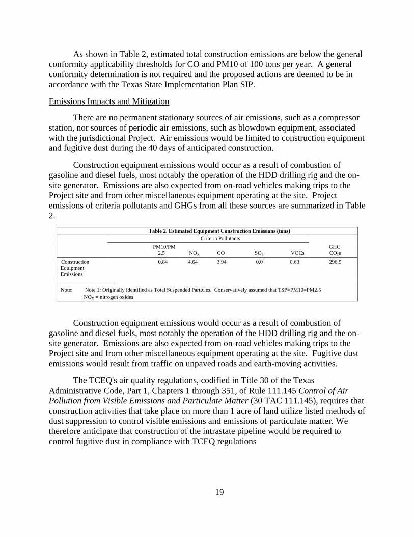
As shown in Table 2, estimated total construction emissions are below the general
conformity applicability thresholds for CO and PM10 of 100 tons per year. A general
conformity determination is not required and the proposed actions are deemed to be in
accordance with the Texas State Implementation Plan SIP.
Emissions Impacts and Mitigation
There are no permanent stationary sources of air emissions, such as a compressor
station, nor sources of periodic air emissions, such as blowdown equipment, associated
with the jurisdictional Project. Air emissions would be limited to construction equipment
and fugitive dust during the 40 days of anticipated construction.
Construction equipment emissions would occur as a result of combustion of
gasoline and diesel fuels, most notably the operation of the HDD drilling rig and the on-
site generator. Emissions are also expected from on-road vehicles making trips to the
Project site and from other miscellaneous equipment operating at the site. Project
emissions of criteria pollutants and GHGs from all these sources are summarized in Table
2.
Table 2. Estimated Equipment Construction Emissions (tons)
Criteria Pollutants
GHG
CO2e
PM10/PM
2.5 NOX CO SO2 VOCs
Construction
Equipment
Emissions
0.84 4.64 3.94 0.0 0.63 296.5
____________________
Note: Note 1: Originally identified as Total Suspended Particles. Conservatively assumed that TSP=PM10=PM2.5
NOX = nitrogen oxides
Construction equipment emissions would occur as a result of combustion of
gasoline and diesel fuels, most notably the operation of the HDD drilling rig and the on-
site generator. Emissions are also expected from on-road vehicles making trips to the
Project site and from other miscellaneous equipment operating at the site. Fugitive dust
emissions would result from traffic on unpaved roads and earth-moving activities.
The TCEQ's air quality regulations, codified in Title 30 of the Texas
Administrative Code, Part 1, Chapters 1 through 351, of Rule 111.145 Control of Air
Pollution from Visible Emissions and Particulate Matter (30 TAC 111.145), requires that
construction activities that take place on more than 1 acre of land utilize listed methods of
dust suppression to control visible emissions and emissions of particulate matter. We
therefore anticipate that construction of the intrastate pipeline would be required to
control fugitive dust in compliance with TCEQ regulations

20
Based on the temporary, short-term nature of construction activities and our
review of construction and fugitive dust emissions, we conclude that construction of the
Project would not have a significant impact on air quality.
Noise
The ambient sound level of a region is defined by the total noise generated within
the specific environment, over varying land use types, and is usually comprised of natural
and artificial sounds. The land use in the project area is primarily agricultural land. At
any location, both the magnitude and frequency of environmental noise may vary
considerably over the course of a day and throughout the week. This variation is caused
in part by changing weather conditions, the effect of seasonal vegetation cover, and
human activities.
Two measurements used by federal agencies to relate the time-varying quality of
environmental noise to its known effects on people are the equivalent sound level (Leq)
and the day-night sound level (Ldn). The Leq is an A-weighted sound level1 containing
the same sound energy as instantaneous sound levels measured over a specific time
period. Noise levels are perceived differently, depending on length of exposure and time
of day, among other factors. The Ldn takes into account the duration and time the noise is
encountered. Late night through early morning (10:00 p.m. to 7:00 a.m.) noise exposures
are penalized +10 decibels (dB) to account for people’s greater sensitivity to sound
during nighttime hours. An Ldn of 55 dB on the A-weighted scale (dBA) is equivalent to
a continuous Leq noise level of 48.6 dBA. In general, an increase of 3 dB is the threshold
of noticeable difference for humans, 5 dB is clearly noticeable, and a 10-dB difference
would be substantially noticeable.
The EPA has indicated that an Ldn of 55 dBA protects the public from indoor and
outdoor activity interference. We have adopted this criterion and use it to evaluate the
potential noise impact from operation of compressor facilities. We are not aware of any
state or local noise regulations or ordinances applicable to the construction of the project
facilities.
Impacts are determined at receptors known as noise-sensitive areas (NSAs).
NSAs include residences, schools and day-care facilities, hospitals, long-term care
facilities, places of worship, libraries, and parks and recreational areas (e.g., wilderness
areas) valued specifically for their solitude and tranquility.
The jurisdictional Project does not include any aboveground facilities; therefore,
no operational noise impacts would occur. Construction noise impacts are described
further below.
21
Construction Noise Impacts and Mitigation
Overall noise levels in the Project area would be affected during construction of
the Project facilities. While individuals in the immediate vicinity of the construction
activities would experience an increase in noise, this effect would be temporary and local.
The changing number and type of construction equipment present at these sites would
result in varying levels of noise. The principal activity of the Project construction is the
HDD under the Rio Grande, from which noise would be generated during the drilling and
pullback of the pipeline. In addition, noise would be generated during construction from
the use of standard heavy equipment, such as excavators, bulldozers, drill rig, and large
trucks. Construction equipment would be operated on an as-needed basis during daylight
hours only; therefore, nighttime noise levels would remain unaffected by most
construction activities, with the possible exception of the proposed HDD itself.
The HDD would require up to 40 days of drilling. Comanche Trail states a
potential for 24-hour drilling schedule in response to site-specific drilling conditions.
The nearest NSA to the HDD is located 878 feet to the north. The noise impact
attributable to HDD operations at this NSA could potentially reach 56.3 dBA Leq, which
would be equivalent to 62.7 dBA Ldn during any unmitigated night-time drilling.
Comanche Trail states that it intends to install a temporary 20-foot-tall noise attenuation
wall on the west and northwest sides of the HDD workspace to achieve at least a 10 dBA
reduction in noise. However a noise attenuation wall which reflects sound waves could
increase the noise attributable to the HDD to the south and east sides of the Project. To
the east of the Project area are several NSAs within a half-mile of the proposed drilling
entry point.
To ensure that the nearest NSAs to the HDD site are not exposed to excessive
noise during nighttime HDD operations in the event that Comanche Trail conducts 24-
hour HDD activities, we recommend that:
Prior to commencing any drilling operations, Comanche Trail should file
with the Secretary, for the review and written approval by the Director of
OEP, a HDD noise analysis identifying the existing and projected noise levels
at each NSA within 0.5 mile of the HDD entry site; and a HDD noise
mitigation plan to reduce the projected noise level attributable to the
proposed drilling operations at all NSAs with predicted Ldn noise levels above
55dBA. During drilling operations, Comanche Trail should implement the
approved plan, monitor noise levels, and make all reasonable efforts to
restrict the noise attributable to the drilling operations to no more than a
day-night sound level of 55 decibels on the A-weighted scale at the NSAs.
We conclude that construction activities associated with the project would result in
short-term, temporary increases in ambient noise levels. With non-HDD-related
construction limited to daytime hours, and based on the anticipated noise levels

22
attributable to the short-term HDD activities, the mitigation measures proposed, and our
recommendation, we conclude that adjacent landowners would not be significantly
affected by construction-related noise.
7.0 Reliability and Safety
The transportation of natural gas by pipeline involves some risk to the public in
the event of an accident and subsequent release of gas. The greatest hazard is a fire or
explosion following a major pipeline rupture. Methane, the primary component of
natural gas, is colorless, odorless, and tasteless. It is not toxic, but is classified as a
simple asphyxiate, possessing a slight inhalation hazard. If breathed in high
concentration, oxygen deficiency can result in serious injury or death.
The pipeline facilities associated with the project must be designed, constructed,
operated, and maintained in accordance with the Department of Transportation (DOT)
Minimum Federal Safety Standards in 49 CFR Part 192. The regulations are intended to
ensure adequate protection for the public and to prevent natural gas facility accidents and
failures.
The DOT pipeline standards are published in Parts 190-199 of Title 49 of the
CFR. For example, Part 192 of 49 CFR specifically addresses natural gas pipeline safety
issues, prescribes the minimum standards for operating and maintaining pipeline
facilities, including compressor station design, emergency shutdowns and safety
equipment (sections 192.163-192.173). Part 192 also requires a pipeline operator to
establish a written emergency plan that includes procedures to minimize the hazards in a
natural gas pipeline emergency.
The operator must also establish a continuing education program to enable
customers, the public, government officials, and those engaged in excavation activities to
recognize a gas pipeline emergency and report it to appropriate public officials.
Comanche Trail’s construction and operation of the Project would represent a
minimum increase in risk to the public and we are confident that with the options
available in the detailed design of Comanche Trail’s facilities, that they would be
constructed and operated safely.
7.1 Border Crossing Considerations
The Project location is in the El Paso Sector of the Customs and Border Patrol
(CBP) headquartered in El Paso, Texas, and the temporary work space (TWS) occurs on
the U.S. side of the border control fence. Comanche Trail’s representatives met with the
local CBP office on June 23, 2015, and were provided a list of recommendations for
safety and security during construction. Comanche Trail is committed to including CBP
recommendations to all staff and contractors during construction and to using “Project

23
Hangtags” to be placed on vehicle rearview mirrors to assist CBP staff in identifying
“Project associated vehicles.”
8.0 Cumulative Impacts
In accordance with the NEPA and FERC policy, we considered the cumulative
impacts of the Project and other projects in the general area. Cumulative impacts
represent the incremental effects of the proposed action when added to other past,
present, or reasonably foreseeable future actions, regardless of the agency or party
undertaking such other actions. Cumulative impacts can result from individually minor,
but collectively significant actions taking place over a period of time. We address the
direct and indirect impacts of the Project in other sections of this EA.
The purpose of the cumulative impact analysis is to identify and describe
cumulative impacts that would potentially result from implementation of the Project.
This cumulative impact analysis generally follows the methodology set forth in relevant
guidance (CEQ, 1997). Under these guidelines, inclusion of other projects within the
analysis is based on identifying commonalities of impacts from other projects with
impacts that would result from the Project. The cumulative impacts analysis includes
actions meeting the following three criteria:
impact a resource potentially affected by the proposed project;
cause this impact within all or part of the proposed project area; and
the impact occurs or is sustained within all, or part, of the time span for the
potential impact from the Project.
For the purposes of this EA, the region of influence (ROI) for cumulative impacts
includes the Project’s area of direct effect plus the area where impacts on a resource, such
as air emissions, may extend beyond the disturbance area. Because the Project’s ground
disturbing activity would be relatively minor, we limited the cumulative impact region of
influence to the visual range from the Project site to a maximum of a one-mile radius.
For the resources affected by the Project, effects of more distant projects were not
assessed because their impacts would not be additive with those of the Project. Because
of its limited scope, the Project would not have a meaningful contribution to cumulative
impacts at a larger geographic scale.
As previously discussed in this EA, Comanche Trail would perform activities that
are not under the jurisdiction of the FERC. Because the planned non-jurisdictional
intrastate facilities would be built in close proximity to the Project, there could be
cumulative impacts. Therefore, we are disclosing a description of the non-jurisdictional
Comanche Trail pipeline and its associated facilities, and the potential environmental
effects related to construction using the best available data provided by Comanche Trail.
However, with the exception of a small segment in proximity to the Project, the impacts

24
that would result from construction and operation of the Comanche Trail Pipeline would
be too far removed from the San Elizario Crossing Project to be additive. That is, nearly
all of the impacts for the pipeline would occur outside the potential ROI for the San
Elizario Crossing Project.
We did not identify any other reasonably foreseeable development projects aside
from the non-jurisdictional pipeline facilities and the Project’s associated fiber optics
cable in the ROI that meet the above listed criteria to warrant a cumulative impacts
analysis. Therefore, the cumulative impact analysis only discusses the Project and the
non-jurisdictional Comanche Trail Pipeline and the fiber optics cable.
Comanche Trail Intrastate Pipeline
Comanche Trail plans to construct a 195-mile-long 42-inch-diameter intrastate
pipeline (Comanche Trail Pipeline), which would extend from the Waha Hub
approximately 3 miles northwest of Coyanosa, Texas to delivery locations with local
towns and utilities in south Texas, and terminate at an interconnect with the San Elizario
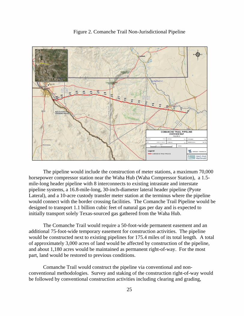
Crossing Project. Comanche Trail provided us with a map of the proposed Comanche
Trail Pipeline, which is shown in figure 2.
25
Figure 2. Comanche Trail Non-Jurisdictional Pipeline
The pipeline would include the construction of meter stations, a maximum 70,000
horsepower compressor station near the Waha Hub (Waha Compressor Station), a 1.5-
mile-long header pipeline with 8 interconnects to existing intrastate and interstate
pipeline systems, a 16.8-mile-long, 30-inch-diameter lateral header pipeline (Pyote
Lateral), and a 10-acre custody transfer meter station at the terminus where the pipeline
would connect with the border crossing facilities. The Comanche Trail Pipeline would be
designed to transport 1.1 billion cubic feet of natural gas per day and is expected to
initially transport solely Texas-sourced gas gathered from the Waha Hub.
The Comanche Trail would require a 50-foot-wide permanent easement and an
additional 75-foot-wide temporary easement for construction activities. The pipeline
would be constructed next to existing pipelines for 175.4 miles of its total length. A total
of approximately 3,000 acres of land would be affected by construction of the pipeline,
and about 1,180 acres would be maintained as permanent right-of-way. For the most
part, land would be restored to previous conditions.
Comanche Trail would construct the pipeline via conventional and non-
conventional methodologies. Survey and staking of the construction right-of-way would
be followed by conventional construction activities including clearing and grading,

26
trenching, pipe stringing, bending and welding, lowering-in and backfilling, hydrostatic
testing, commissioning, cleanup and restoration, and non-conventional construction
techniques (horizontal bores and horizontal drills) of crossings of highways and canals.
These activities would proceed in an assembly line fashion and construction crews would
move down the construction right-of-way as work progressed. Any single point along the
project would typically take 6 to 10 weeks to complete and would vary by soil conditions
and construction methods. Comanche Trail plans to begin construction in April 2016
with a planned in-service date during the first quarter of 2017.
Cumulative Impacts within the ROI
The components of the Comanche Trail Pipeline project that would be within the
ROI and therefore could result in additive impacts with the San Elizario Crossing Project
include the 10-acre custody meter station and the part of the pipeline that would be
constructed and operated within one mile of the ground disturbance associated with the
San Elizario Crossing Project.
Potential Environmental Impacts
Geology and Soils
As stated before, the San Elizario Crossing Project would require minimal ground
disturbance limited to a small area, and ground contours would be restored after
construction. Similarly, construction of the Comanche Trail Pipeline would include
localized disturbance, which would be returned to pre-construction conditions after
construction. Because of the temporary and minor nature of Project activities, the
cumulative effect on geological conditions and soils would be negligible.
The fiber optics cable would require no additional workspace for its
installation. Because of the temporary and minor nature of these project activities, the
cumulative effect on geological conditions and soils would be negligible.
Water Resources
Neither projects would directly impact surface waters as the Rio Grande River
would be crossed using an HDD. Further, the projects would not likely have an impact
on groundwater resources. Therefore, there would be no additive impacts on water
resources. The fiber optics cable would be installed via HDD to avoid direct impacts on
the Rio Grande River. Therefore, there would be no additive impacts on water resources.

27
Wildlife and Vegetation
As stated, the San Elizario Crossing Project would require minimal ground
disturbance limited to a small area, and vegetation would be restored after construction.
Wildlife could experience temporary disruptions, displacement, and loss of habitat, but
would be able to return to the area following completion of activities. Activities and
ground disturbance associated with the non-jurisdictional project in the ROI would also
be limited in scope, vegetation would be restored when construction is complete, and
wildlife would be able to return to the area. Because of the temporary and minor nature
of project activities, the cumulative effect on vegetation and wildlife would not be
significant.
Land Use
The San Elizario Crossing Project would temporarily affect 4.2 acres of active
agricultural land, which would be restored upon completion of the Project. The non-
jurisdictional Comanche Trail Pipeline facilities within the ROI would temporarily affect
between about 25-35 acres of active agricultural land, and about 10 acres of land would
be maintained as a permanent custody transfer meter station. The fiber optics cable
would be installed within the permanent easement of the jurisdictional pipeline, and
would have no added impact on land use.
Because construction activities associated with the San Elizario Crossing Project
would be temporary and land use would revert to pre-construction conditions after the
project is complete, the additive impacts on land use would be negligible.
Cultural Resources
Comanche Trail undertook a background review of recorded archaeological sites
within 1 mile of the proposed route. The route is in the immediate vicinity of two
significant previously identified archaeological sites. The proposed pipeline route avoids
these sites. There are six other sites adjacent to the route but they are classified as “not
significant”.
Air Quality and Noise
Construction Emissions
Construction of the Comanche Trail intrastate pipeline would generate emissions
of air pollutants and fugitive dust. Emissions of criteria air pollutants and GHGs are
expected from the combustion of gasoline and diesel fuels in construction equipment,
including pipeline lay, bores, supporting equipment, supply trucks, and vehicles used to
commute to and from the work locations. All other counties (Pecos, Reeves, Culberson,
28
and Hudspeth) crossed by the intrastate pipeline are in an unclassified/attainment status
for the NAAQS (EPA, 2015). Fugitive dust would be generated from land clearing,
grading, and trench-digging for the intrastate pipeline as well as driving on unpaved
roads. With the exception of GHG emissions, air quality impacts would be highly
localized.
The TCEQ’s air quality regulations, codified in Title 30 of the Texas
Administrative Code, Part 1, Chapters 1 through 351, of Rule 111.145 Control of Air
Pollution from Visible Emissions and Particulate Matter (30 TAC 111.145), requires that
construction activities that take place on more than 1 acre of land utilize listed methods of
dust suppression to control visible emissions and emissions of particulate matter. We
therefore anticipate that construction of the intrastate pipeline would be required to
control fugitive dust to comply with TCEQ regulations.
The impacts from construction of the portion of the intrastate pipeline within the
immediate vicinity of the Project would be considered cumulative with the project during
any overlap in construction schedules. The Project’s fugitive dust contribution to local
air quality would be minor as an HDD utilizes a wet mud slurry to drill underground
which disturbs less land and produces less fugitive dust than conventional pipeline
trenching methods. Considering the limited scope of the jurisdictional project, we do not
anticipate significant cumulative air quality impacts to result during construction of the
Project.
We anticipate that construction of both the intrastate pipeline facilities including
the fiber optics cable installation would be required to control fugitive dust by TCEQ
regulations.
As the jurisdictional Project would not have operational emissions, it would not
contribute any impact on cumulative long-term air quality.
Noise
Construction Noise
Noise would be generated from the construction equipment which, barring
unlikely nighttime construction would operate during daylight hours only. Noise impacts
would also be temporary and short term, attenuating as the distance from the noise source
increases.
These noise impacts from construction of the portion of the intrastate pipeline
within the vicinity of the Project would be considered cumulative with the Project during
any overlap in construction schedules. Construction equipment emissions and noise from
the Project would be greater than construction of the proximate pipeline portion given the
29
need to use stationary drilling equipment for up to 30 days. While the cumulative
impacts of a concurrent construction schedule would be greater, we conclude the impacts
would be short-term, temporary and limited to the immediate vicinity of the Project area.
Operational Noise
Meter stations have been known to generate a high-pitched noise during operation.
Comanche Trail describes plans to construct an intrastate meter station approximately
3,300 feet from the Project’s HDD entry/exit point on the U.S. side.
As the jurisdictional Project would not have operational noise, we do not
anticipate significant cumulative long-term noise impacts to occur.
Conclusion
The impacts of the Comanche Trail’s San Elizario Crossing Project activities
would be short-term and include minimal localized ground disturbance. All land
disturbed would be restored to its previous condition after construction. Therefore,
impacts from the border crossing activities would not contribute meaningfully to
cumulative impacts in the area. Likewise, the construction of Comanche Trail Pipeline
would be temporary and land disturbed would be restored to its previous condition,
except for the permanent area needed to operate the custody meter station. For these
reasons, we conclude that the potential additive impacts would not be significant.
Comanche Trail Pipeline Impacts Outside of the ROI
Comanche Trail filed information regarding the environmental impacts of the
planned Comanche Trail Pipeline, which we present for the purposes of informing
stakeholders and decision makers.
Geology and Soils
In general, the pipeline would be buried at a depth of six feet. At this depth, the
impact on regional geology would be minimal. Potential geologic hazards for the
Comanche Trail Pipeline include liquefaction, lateral spread movement, and seismic-
induced slope instability, which can occur as the result of large earthquakes over 6.0
moment magnitude. Based on the USGS data, the maximum probability of an earthquake
exceeding a moment magnitude of 6.0 within 50 years is approximately 6 percent.
Comanche Trail Pipeline has conducted seismic and geological hazard risk assessments
along the pipeline route and would design and construct the pipeline to incorporate these
risks.
30
Construction activities such as clearing, grading, trenching, backfilling, and the
movement of construction equipment along the right-of-way could affect soil resources.
Clearing of vegetation increases the potential for soil erosion and sedimentation.
Construction activities could also affect soil fertility and revegetation potential, and
facilitate the dispersal and establishment of weeds. Comanche Trail would implement a
Storm Water Pollution Prevention Plan (SWPPP), which includes erosion control
measures during construction to minimize the potential for soil erosion and sediment
transport from temporary ground disturbance.
Water Resources
Construction of the Comanche Trail Pipeline could affect water resources in
several ways. Clearing and grading of stream banks, in-stream trenching, trench
dewatering, backfilling, and expansion of access roads could result in increased
sedimentation and erosion, modification to hydrological flow, releases of chemical and
nutrient pollutant from sediments, and introduction of chemical contaminants such as fuel
and lubricants.
Construction of the Comanche Trail Pipeline is not expected to have major
impacts on groundwater resources. Comanche Trail would excavate a shallow trench to
construct the pipeline. Thus, construction of the pipeline is not likely to impact
groundwater deeper underground.
The Comanche Trail Pipeline would cross 92 streams and tributaries that are
USACE jurisdictional and subject to Clean Water Act regulations. Based on desktop data
and consultation with USACE, all streams crossed by the project are ephemeral. This
determination would be verified through field assessments. The pipeline would be
installed underneath seven irrigation canals that are not subject to regulation by USACE.
Comanche Trail would use HDD methods to construct the pipeline underneath the canals.
All stream work (except for irrigation canals) would fall under the jurisdiction of the
USACE Nationwide Permit 12. Comanche Trail states that based on review of
topographic and National Wetland Inventory maps and aerial photography, impacts on
wetlands are not anticipated.
Vegetation and Wildlife
The intrastate pipeline would cross primarily desert grassland, some of which has
been converted into a community dominated by bare soil and invasive woody plant
species due to overgrazing by livestock, suppression of fire, and anthropogenic use of
groundwater. Vegetation in the area consists of creote bush, tarbush, mariola, whitethorn
acacia, honey mesquite, cacti, juniper, catclaw mimosa, sacahuiste, can cholla, adolphia,
and prickly pear. The primary direct effect from pipeline construction would be the
cutting, clearing, and removal of existing vegetation within the construction workspace.
31
The degree of impact would depend on the type and amount of vegetation affected, the
rate at which the vegetation would regenerate after construction, and the frequency of
vegetation maintenance conducted during operation. After construction, Comanche Trail
would comply with its Post Construction Restoration Procedures, which include
reseeding of the affected lands according to reseeding guidelines prepared using
recommendations from the U.S. Department of Agriculture range specialists.
Potential effects on wildlife would include noise and movement associated with
the construction activity and the temporary decrease in the amount of available habitat.
However, any effects from construction noise and the decrease in habitat would be
temporary. During construction activities, more mobile wildlife such as mammals and
birds could be displaced to other available nearby habitat. Some smaller, less mobile
individuals such as reptiles and amphibians could be unintentionally killed by
construction equipment. Given the limited area affected by construction along the 125-
foot-wide pipeline construction right-of-way and Comanche Trail’s restoration plans,
Comanche Trail states that it is unlikely that there would be significant impacts on the
region’s wildlife.
Construction activities and vegetation removal could result in the displacement of
migratory birds and their avoidance of affected lands. Displacement and avoidance could
impact bird migration, nesting, foraging, and mating behaviors. Behavior changes
combined with the loss and/or conversion of wildlife habitats could increase the rates of
mortality, injury, and stress experienced by migratory birds. Based on the characteristics
and habitat requirements of the birds of conservation concern and migratory birds
occurring or potentially occurring in the Project area, impacts on wildlife habitat, the
amount of wildlife habitat affected, the presence of similar habitats adjacent to and in the
vicinity of the Project, constructing and operating the Project would not result in
population-level impacts or significant measureable negative impacts on birds of
conservation concern or migratory birds.
Comanche Trail consulted the USFWS IPAC database to evaluate the presence of
threatened and endangered species near the proposed pipeline facilities. Several species
of birds, crustaceans, fish, plants, and snails were listed as potentially occurring near the
project area. However, based on data from the Texas Natural Heritage Database, there
are no known occurrences of federally listed species on or immediately adjacent to, the
proposed pipeline route. Additionally, there would be no designated critical habitat,
refuges, or federal lands crossed by the pipeline.
Land Use
The land use types that would be crossed by the Comanche Trail Pipeline are
mostly livestock rangeland and some active agriculture. As previously described, a total

32
of about 3,000 acres of land would be affected by construction, and about 1,180 acres
would be maintained as permanent right-of-way. In general, lands required for
construction would experience short-term, long-term, and permanent impacts based on
the time it would take the land to recover to pre-construction conditions. Lands disturbed
by construction would return to rangeland and active agriculture. In addition, lands
required for permanent right-of-way would essentially return to pre-construction
conditions.
Cultural Resources
The archaeology contractor for Comanche Trail has utilized the Texas
Archaeological Archives to perform a background review of recorded archaeological sites
within 1 mile of either side of all routes considered in development of the proposed route.
The project route does not directly affect any known significant cultural resource sites. It
is in immediate proximity, or immediately adjacent to two significant sites, but field
assessments confirmed these are avoided. There are six other known sites adjacent to the
route, all of which are classified as “not significant”. Field assessments have documented
10 previously unrecorded sites, none of which are significant.
Air Quality and Noise
Construction of the Comanche Trail Pipeline would involve the use of heavy
equipment that would generate emissions of air contaminants, fugitive dust, and
noise. With the exception of GHG emissions, air impacts would be localized and
confined primarily to the airshed in which they occur. All counties the project would
cross through are either unclassifiable or in attainment for NAAQS. Construction of the
Comanche Trail Pipeline would contribute to temporary construction noise impacts along
the pipeline route. However, construction noise is generally highly localized and
attenuates quickly as the distance from the noise source increases.
Operation of the Comanche Trail intrastate pipeline would generate emissions of
air pollutants and noise from aboveground facilities. The principal aboveground facility,
and thus source of noise and operational emissions, would be the 70,000-horsepower
Waha Compressor Station in Pecos County, Texas, which is expected to serve several
pipelines including the Comanche Trail intrastate pipeline. Comanche Trail states that
this station will ultimately include the installation of 14 CAT 3616 KBU 5,000
horsepower dual-drive electric/natural gas-driven units . A unit driven by natural gas
would generate air emissions, most notably GHGs, NOx, and fine particulate matter.
Emissions of the criteria pollutants would be regulated under the CAA and the TCEQ as
the lead air permitting authority in Texas responsible for this facility. Should the units be
electrically-driven, they would not generate criteria air pollutants and may not require
permitting under Title V of the CAA.
33
On November 8, 2010, the EPA signed a rule that finalizes reporting requirements
for the petroleum and natural gas industry under 40 CFR 98. Subpart W of 40 CFR 98
requires petroleum and natural gas facilities that emit 25,000 metric tons or more of
carbon dioxide equivalent per year to report annual emissions of specified GHGs from
various processes within a facility. Given the size of the facility and the number of
individual units, this reporting requirement would most likely apply to the Waha
Compressor Station. Along the intrastate pipeline, we estimated the fugitive emission of
GHGs using the emission factors in 40 CFR 98, Subpart W, Table W-3, Default Total
Hydrocarbon Emission Factors for Onshore Natural Gas Transmission Compression. We
can expect that each meter station and mainline block valve would emit 12.3 and 27.0
tons per year of CO2e respectively.
Operational noise from the Comanche Trail intrastate pipeline and associated
facilities would be expected from the Waha Compressor Station and, to a lesser degree,
from the meter stations along the pipeline. Comanche Trail states that the nearest noise-
sensitive area to the new Waha Compressor Station is a single residence 1.08 miles
northwest of the planned facility boundary. They calculated the noise impact from full-
capacity operations at this receptor to be 33 dBA.
Cumulative Impacts Conclusion
In general, small scale projects, such as Comanche Trail’s FERC jurisdictional
border-crossing facilities and fiber optics cable with minimal impacts and of short
duration, would not contribute significantly to cumulative impacts. We conclude that the
potential additive impacts resulting from Comanche Trail’s intrastate project within the
ROI and the San Elizario would not be significant. Comanche Trail’s FERC
jurisdictional Project would represent a negligible contribution to the overall cumulative
impacts in the Project area.
34
C. ALTERNATIVES
In accordance with NEPA and Commission policy, we evaluated alternatives to
the Project. Our evaluation criteria included whether the alternatives would: 1) provide a
significant environmental advantage over the Project; 2) meet the Project’s stated
objectives; and 3) be technically and economically feasible and practical.
Under the no-action alternative, Comanche Trail would not construct the Project.
While this alternative would eliminate the potential impact on the environment,
Comanche Trail’s stated need to meet Mexico’s projected energy demands and to
promote Mexico’s initiative to expand electric generation and industrial markets in
Mexico would not be met. Other natural gas companies could construct projects in
substitute for the natural gas supplies offered by Comanche Trail. Such alternative
projects could require the construction of additional and/or new pipeline facilities in the
same or other locations to transport the gas volumes proposed by the Project. These
projects would result in their own set of specific environmental impacts that could be
equal to or greater than those described for the Project.
Comanche Trail selected the siting of the proposed HDD route to traverse the
shortest distance necessary across the Rio Grande River in order to transport natural gas
from an interconnect with the future non-jurisdictional intrastate pipeline, owned and
operated by Comanche Trail, to a non-jurisdictional pipeline interconnect in Mexico. No
substantial adverse impacts were identified during scoping or in our analysis of the
Project. Therefore, we did not identify any crossing location or other alternatives that
could provide a significant environmental advantage over the Project as proposed, and we
identified no alternatives that could satisfy all three of our evaluation criteria.
35
D. STAFF’S CONCLUSIONS AND RECOMMENDATIONS
Based on the analysis in this EA, the mitigation measures proposed by Comanche
Trail, and the implementation of our recommendations below, we have determined that if
constructed in accordance with its application and supplements, approval of this proposal
would not constitute a major federal action significantly affecting the quality of the
human environment.
We recommend that the Commission Order contain a finding of no significant
impact. If the Commission approves the Project, we recommend that the Commission
Order contain the following conditions:
1. Comanche Trail shall follow the construction procedures and mitigation measures
described in its application and supplements, including responses to staff data
requests, and as identified in the EA, unless modified by the Order. Comanche
Trail must:
a. request any modification to these procedures, measures, or conditions in a
filing with the Secretary of the Commission (Secretary);
b. justify each modification relative to site-specific conditions;
c. explain how that modification provides an equal or greater level of
environmental protection than the original measure; and
d. receive approval in writing from the Director of the Office of Energy
Projects (OEP) before using that modification.
2. The Director of OEP has delegated authority to take whatever steps are necessary
to ensure the protection of all environmental resources during activities associated
with the construction and operation of the Project. This authority shall allow:
a. the modification of conditions of the Order; and
b. the design and implementation of any additional measures deemed
necessary (including stop-work authority) to assure continued compliance
with the intent of the environmental conditions as well as the avoidance or
mitigation of adverse environmental impact resulting from Project
construction and operation.
3. Prior to any construction of facilities, Comanche Trail shall file an affirmative
statement with the Secretary, certified by a senior company official, that all
company personnel, environmental inspectors (EIs), and contractor personnel will
be informed of the EI’s authority and have been or will be trained on the
implementation of the environmental mitigation measures appropriate to their jobs
before becoming involved with construction and restoration activities.
36
4. The authorized facility locations shall be as shown in the EA. As soon as they
are available, and before the start of construction, Comanche Trail shall file
with the Secretary any revised construction workspace configuration drawings at a
scale not smaller than 1:6,000 with station positions for all activities approved by
the Order. All requests for modifications of environmental conditions of the Order
or site-specific clearances must be written and must reference locations designated
on these alignment maps/sheets.
5. Comanche Trail shall file with the Secretary detailed alignment maps/sheets and
aerial photographs at a scale not smaller than 1:6,000 identifying all route
realignments or facility relocations, and staging areas, pipe storage yards, new
access roads, and other areas that would be used or disturbed and have not been
previously identified in filings with the Secretary. Approval for each of these
areas must be explicitly requested in writing. For each area, the request must
include a description of the existing land use/cover type, documentation of
landowner approval, whether any cultural resources or federally listed threatened
or endangered species would be affected, and whether any other environmentally
sensitive areas are within or abutting the area. All areas shall be clearly identified
on the maps/sheets/aerial photographs. Each area must be approved in writing by
the Director of OEP before construction in or near that area.
This requirement does not apply to extra workspace allowed by the FERC
Plan and/or minor field realignments per landowner needs and requirements which
do not affect other landowners or sensitive environmental areas such as wetlands.
Examples of alterations requiring approval include all route realignments
and facility location changes resulting from:
a. implementation of cultural resources mitigation measures;
b. implementation of endangered, threatened, or special concern
species mitigation measures;
c. recommendations by state regulatory authorities; and
d. agreements with individual landowners that affect other landowners
or could affect sensitive environmental areas.
6. Within 60 days of the acceptance of the authorization and before construction
begins, Comanche Trail shall file an Implementation Plan with the Secretary for
review and written approval by the Director of OEP. Comanche Trail must file
revisions to the plan as schedules change. The plan shall identify:
a. how Comanche Trail would implement construction procedures and
mitigation measures described in its application and supplements (including

37
responses to staff data requests), identified in the EA, and required by the
Order;
b. how Comanche Trail would incorporate these requirements into the
contract bid documents, construction contracts (especially penalty clauses
and specifications), and construction drawings so that the mitigation
required at each site is clear to onsite construction and inspection
personnel;
c. the number of EIs assigned, and how the company would ensure that
sufficient personnel are available to implement the environmental
mitigation;
d. company personnel, including EIs and contractors, who would receive
copies of the appropriate material;
e. the location and dates of the environmental compliance training and
instructions Comanche Trail would give to all personnel involved with
construction activities and restoration (initial and refresher training as the
Project progresses and personnel change);
f. the company personnel (if known) and specific portion of Comanche
Trail’s organization having responsibility for compliance;
g. the procedures (including use of contract penalties) Comanche Trail will
follow if noncompliance occurs; and
h. for each discrete facility, a Gantt or PERT chart (or similar project
scheduling diagram), and dates for:
(1) the completion of all required surveys and reports;
(2) the environmental compliance training of onsite personnel;
(3) the start of construction; and
(4) the start and completion of restoration.
7. Beginning with the filing of its Implementation Plan, Comanche Trail shall file
updated status reports with the Secretary on a weekly basis until all construction
and restoration activities are complete. On request, these status reports will also
be provided to other federal and state agencies with permitting responsibilities.
Status reports shall include:
a. an update on Comanche Trail’s efforts to obtain the necessary federal
authorizations;
b. the construction status of the Project, work planned for the following
reporting period, and any schedule changes for stream crossings or work in
other environmentally sensitive areas;
c. a listing of all problems encountered and each instance of noncompliance
observed by the EI(s) during the reporting period (both for the conditions
imposed by the Commission and any environmental conditions/permit
requirements imposed by other federal, state, or local agencies);
38
d. a description of corrective actions implemented in response to all instances
of noncompliance, and their cost;
e. the effectiveness of all corrective actions implemented;
f. a description of any landowner/resident complaints which may relate to
compliance with the requirements of the Order, and the measures taken to
satisfy their concerns; and
g. copies of any correspondence received by Comanche Trail from other
federal, state or local permitting agencies concerning instances of
noncompliance, and Comanche Trail’s response.
8. Comanche Trail shall employ at least one EI. The EI shall be:
a. responsible for monitoring and ensuring compliance with all mitigation
measures required by the Order and other grants, permits, certificates, or
other authorizing documents;
b. responsible for evaluating the construction contractor's implementation of
the environmental mitigation measures required in the contract (see
condition 6 above) and any other authorizing document;
c. empowered to order correction of acts that violate the environmental
conditions of the Order, and any other authorizing document;
d. responsible for documenting compliance with the environmental conditions
of the Order, as well as any environmental conditions/permit requirements
imposed by other federal, state, or local agencies; and
responsible for maintaining status reports.
9. Prior to receiving written authorization from the Director of OEP to
commence construction of any Project facilities, Comanche Trail shall file with
the Secretary documentation that it has received all applicable authorizations
required under federal law (or evidence of waiver thereof).
10. Comanche Trail must receive written authorization from the Director of OEP
before placing the Project into service. Such authorization will only be granted
following a determination that rehabilitation and restoration of all areas affected
by the Project are proceeding satisfactorily.
11. Within 30 days of placing the authorized facilities in service, Comanche Trail
shall file an affirmative statement with the Secretary, certified by a senior
company official:
a. that the facilities have been constructed in compliance with all applicable
conditions, and that continuing activities will be consistent with all
applicable conditions; or

39
b. identifying which of the conditions in the Order Comanche Trail has
complied with or will comply with. This statement shall also identify any
areas affected by the Project where compliance measures were not properly
implemented, if not previously identified in filed status reports, and the
reason for noncompliance.
12. Prior to construction, Comanche Trail should file with the Secretary for review
and written approval by the Director of OEP:
a. a revised Directional Drilling Contingency Plan to provide for the measures
to be implemented for collection and disposal of an inadvertent release of
drilling mud into the Rio Grande River; and
c. provides notification of the International Boundary and Water Commission
(IBWC) of any release of drilling mud into the Rio Grande River.
13. Prior to commencing any drilling operations, Comanche Trail shall file with the
Secretary, for the review and written approval by the Director of OEP, a HDD
noise analysis identifying the existing and projected noise levels at each NSA
within 0.5 mile of the HDD entry site; and a HDD noise mitigation plan to reduce
the projected noise level attributable to the proposed drilling operations at all
NSAs with predicted Ldn noise levels above 55dBA. During drilling operations,
Comanche Trail shall implement the approved plan, monitor noise levels, and
make all reasonable efforts to restrict the noise attributable to the drilling
operations to no more than a day-night sound level of 55 decibels on the A-
weighted scale at the NSAs.

40
E. REFERENCES
Council on Environmental Quality. 1997. Considering Cumulative Effects Under the
National Environmental Policy Act. Council on Environmental Quality,
Exectuive Office of the President. January 1997. Available online at:
http://energy.gov/sites/prod/files/nepapub/nepa_documents/RedDont/G-CEQ-
ConsidCumulEffects.pdf Accessed January 2015
International Boundary and Water Commission, U.S. Section Texas Clean Rivers
Program. 2015. 2015 Basin Highlights Report – Texas Rio Grande Basin
Program
Update. Website: <http://www.ibwc.gov/CRP/documents/BHR2015_IBWC.pdf>
. Accessed: 30 July, 2015.
Texas Commission on Environmental Quality (TCEQ). 2015. “El Paso: Current
Attainment Status” https://www.tceq.texas.gov/airquality/sip/elp/elp-status. Last
modified October 14, 2015.
Texas Water Development Board. 2014. Water Information Integration and
Dissemination System Interactive Mapping. Available at:
http://wiid.twdb.state.tx.us/ims/wwm_drl/viewer.htm. Accessed January 2015
United States Department of Agriculture - Natural Resources Conservation Service; Web
Soil Survey, http://websoilsurvey.sc.egov.usda.gov
U.S. Department of National Archives and Records Administration 2014. Code of
Federal Regulations, Title 40. Control of Air Pollution from Mobile Sources.
Available at: www.fdsys.gov
U.S. EPA. 2015. “Greenbook: Texas Nonattainment/Maintenance Status for Each County
by Year for All Criteria Pollutants”
http://www3.epa.gov/airquality/greenbk/anayo_tx.html. Last modified on October
1, 2015.
41
F. LIST OF PREPARERS
Munoz, Kelley – Project Manager, Proposed Action, Land Use, Alternatives
B.S., Environmental Science, 1997, Lubbock Christian University
Rana, Anthony –Geology, Groundwater Resources
M.S., International Development, 2012, Tulane University Law School Payson
Center for International Development
Oklahoma State University, 1985 to 1988. Hydrogeology and
Geochemistry;
B.S., Geology, 1984, New Jersey City University
Armbruster, Ellen– Cultural Resources
M.A., Anthropology, 1986, University of Pennsylvania
B.A., Anthropology, 1979, Bryn Mawr College
Peconom, John, - Vegetation, Wildlife, Threatened and Endangered Species
B.S., 2000, Environmental Biology and Management, University of California,
Davis.
S. Xiah Kragie – Air Quality, Noise, and Reliability and Safety
M.A., Geochemistry, 2013, Columbia University, New York, NY
M.P.H., Global Environmental Health, 2008, Emory University, Atlanta, GA
B.S., Civil & Environmental Engineering, 2006, University of Maryland, College
Park, MD
Related Documents