THIS PROJECT IS BEING PART-FINANCED BY THE EUROPEAN UNION EUROPEAN REGIONAL DEVELOPMENT FUND Arne Villumsen Anders Stuhr Jørgensen Abdel Barten Janne Fritt-Rasmussen Laust Løgstrup Niels Brock Niels Hoedeman Ragnhildur Gunnarsdóttir Sara Borre Thomas Ingeman-Nielsen ROAD CONSTRUCTION IN GREENLAND – THE GREENLANDIC CASE October 2007

Welcome message from author
This document is posted to help you gain knowledge. Please leave a comment to let me know what you think about it! Share it to your friends and learn new things together.
Transcript
THIS PROJECT IS BEING PART-FINANCED BY
THE EUROPEAN UNION EUROPEAN REGIONAL DEVELOPMENT FUND
Arne Villumsen
Anders Stuhr Jørgensen
Abdel Barten
Janne Fritt-Rasmussen
Laust Løgstrup
Niels Brock
Niels Hoedeman
Ragnhildur Gunnarsdóttir
Sara Borre
Thomas Ingeman-Nielsen
ROAD CONSTRUCTION IN GREENLAND– THE GREENLANDIC CASEOctober 2007
Arne Villumsen
Anders Stuhr Jørgensen
Abdel Barten
Janne Fritt-Rasmussen
Laust Løgstrup
Niels Brock
Niels Hoedeman
Ragnhildur Gunnarsdóttir
Sara Borre
Thomas Ingeman-Nielsen
ROAD CONSTRUCTION IN GREENLAND– THE GREENLANDIC CASEOctober 2007
Translation: J. Richard Wilson
CONTENTS1. GEOLOGy, NATuRE ANd CLImATE OF GREENLANd ........................... 4
1.1. GEOLOGy . . . . . . . . . . . . . . . . . . . . . . . . . . . . . . . . . . . . . . . . . . . . . . . . . . . . . . . . . . . . . . . . . . . . . . .4
1.2. CLImATE . . . . . . . . . . . . . . . . . . . . . . . . . . . . . . . . . . . . . . . . . . . . . . . . . . . . . . . . . . . . . . . . . . . . . . . .5
1.3. WEATHER ANd CLImATE IN ANd AROuNd GREENLANd . . . . . . . . . . . . . . . . . . . . . . . . . . . . . . . .5
1.4. PRECIPITATION . . . . . . . . . . . . . . . . . . . . . . . . . . . . . . . . . . . . . . . . . . . . . . . . . . . . . . . . . . . . . . . . . .5
1.5. WEATHER- ANd CLImATE REGIONS IN GREENLANd . . . . . . . . . . . . . . . . . . . . . . . . . . . . . . . .6
1.6. PERmAFROST . . . . . . . . . . . . . . . . . . . . . . . . . . . . . . . . . . . . . . . . . . . . . . . . . . . . . . . . . . . . . . . . . . . .9
1.7. VEGETATION . . . . . . . . . . . . . . . . . . . . . . . . . . . . . . . . . . . . . . . . . . . . . . . . . . . . . . . . . . . . . . . . . . . .10
2. RELEVANT INFORmATION FOR ROAd-BuILdING PROJECTS IN GREENLANd ........................................................................................... 11
3. ExISTING ROAdS IN TOWNS ANd VILLAGES IN GREENLANd ......... 17
3.1. ExAmINATION OF ExISTING ROAdS IN TOWNS ANd VILLAGES IN GREENLANd . . . . . . . . . . .19
3.1.1. ROAdS IN SISImIuT TOWN. . . . . . . . . . . . . . . . . . . . . . . . . . . . . . . . . . . . . . . . . . . . . . . . . . . . . . . . . . . . . . .19
3.1.2. SISImIuT AIRPORT . . . . . . . . . . . . . . . . . . . . . . . . . . . . . . . . . . . . . . . . . . . . . . . . . . . . . . . . . . . . . . . . . . . . .19
3.1.3. THE ROAd FROm KANGERLuSSSuAq TO THE INLANd ICE . . . . . . . . . . . . . . . . . . . . . . . . . . . . . . . . . . .20
3.1.4. KANGERLuSSuAq AIRPORT . . . . . . . . . . . . . . . . . . . . . . . . . . . . . . . . . . . . . . . . . . . . . . . . . . . . . . . . . . . . .21
3.2. STudIES OF ROAdS ELSEWHERE IN GREENLANd . . . . . . . . . . . . . . . . . . . . . . . . . . . . . . . . . . . .22
3.2.1. SOuTH GREENLANd . . . . . . . . . . . . . . . . . . . . . . . . . . . . . . . . . . . . . . . . . . . . . . . . . . . . . . . . . . . . . . . . . . .23
3.2.2. ILLORSuIT . . . . . . . . . . . . . . . . . . . . . . . . . . . . . . . . . . . . . . . . . . . . . . . . . . . . . . . . . . . . . . . . . . . . . . . . . . . .27
4. THE SISImIuT-KANGERLuSSuAq ROAd ............................................ 32
4.1. GEOLOGICAL ANd GEOGRAPHICAL OVERVIEW . . . . . . . . . . . . . . . . . . . . . . . . . . . . . . . . . . . . . .32
4.2. SuITABLE mATERIALS FOR ROAd CONSTRuCTION ANd PERmAFROST . . . . . . . . . . . . . . . . . .35
4.3. GEOLOGICAL mOdEL FOR THE AREA . . . . . . . . . . . . . . . . . . . . . . . . . . . . . . . . . . . . . . . . . . . . . . .39
4.4. SummARy . . . . . . . . . . . . . . . . . . . . . . . . . . . . . . . . . . . . . . . . . . . . . . . . . . . . . . . . . . . . . . . . . . . . . .55
4.5. ENVIRONmENTAL ANd CONSERVATION ASPECTS . . . . . . . . . . . . . . . . . . . . . . . . . . . . . . . . . . . .55
4.6. ROuTE PROPOSAL – GENERAL ASPECTS . . . . . . . . . . . . . . . . . . . . . . . . . . . . . . . . . . . . . . . . . . .57
A ROAd GEOmETRy . . . . . . . . . . . . . . . . . . . . . . . . . . . . . . . . . . . . . . . . . . . . . . . . . . . . . . . . . . . . . . . . . . . . . . . .58
B GEOLOGy, FROST . . . . . . . . . . . . . . . . . . . . . . . . . . . . . . . . . . . . . . . . . . . . . . . . . . . . . . . . . . . . . . . . . . . . . . . .58
C THE AVAILABILITy OF ROAd-BuILdING mATERIAL . . . . . . . . . . . . . . . . . . . . . . . . . . . . . . . . . . . . . . . . . . . . . .58
d ARCHAEOLOGICAL ANd CONSERVATIONAL CONSIdERATIONS . . . . . . . . . . . . . . . . . . . . . . . . . . . . . . . . . .59
E THE PASSAGE OF WATER COuRSES, dRAINAGE . . . . . . . . . . . . . . . . . . . . . . . . . . . . . . . . . . . . . . . . . . . . . .59
F dRAINAGE OF THE THAW . . . . . . . . . . . . . . . . . . . . . . . . . . . . . . . . . . . . . . . . . . . . . . . . . . . . . . . . . . . . . . . . . .59
4.7. ROuTE PROPOSAL – dETAILEd dESCRIPTION . . . . . . . . . . . . . . . . . . . . . . . . . . . . . . . . . . . . . . .60
4.8. SEISmIC STudIES IN AmERdLOq, IKERTOq ANd FøRSTE FJORd . . . . . . . . . . . . . . . . . . . . . . .63
5. CONCLuSIONS ....................................................................................... 68
6. REFERENCES ........................................................................................ 69
APPENdIx 1. ................................................................................................. 71
APPENdIx 2. ................................................................................................. 76
APPENdIx 3. ................................................................................................. 79
APPENdIx 4. ................................................................................................. 82
1. Geology, Nature and Climate of Greenland
Roadex III The Northern Pheriphery Research
Page 4
1. Geology, Nature and Climate of Greenland
1.1. GEOLOGyGreenland occupies an area of 2,166,086 km2. This area is dominated by the Inland Ice, but along its margin there is an ice-free zone that covers a total of ~410,000 km2. This zone consists of an arctic mountain landscape which is almost free of vegetation and with rocky surfaces that have often been scoured and polished by the Inland Ice and local glaciers.
The geological history of Greenland spans more than 3,800 million years. The basement consists largely of composite gneisses that were formed more than 1,600 million years ago when they were involved in the construction of several early mountain chains. Thick sequences of sedimentary rocks were subsequently deposited in basins in the marginal areas surrounding this basement complex. Some 430-350 million years ago, two younger mountain chains developed parallel with the coast in North and East Greenland. About 60-55 million years ago there was widespread volcanic activity in Greenland and extensive volcanic provinces developed. The last major event was the Ice Age over the last two million years during most of which time Greenland has been largely covered by ice.
The ice-free zone, on which it is relevant for us to concentrate with reference to roads, consists of crystalline basement rocks covered by sediments. The thickness of this cover varies from zero to several hundreds of meters. It is, as a rule, fairly straightforward to build on basement rocks, and crushed basement rocks generally provide good road-building material.
The nature of the sedimentary rocks, of course, varies greatly over an area as large as Greenland. moraine and melt-water deposits are widespread throughout the ice-free zone, and marine deposits occur up to ~100 meters a.s.l. Post-glacial peat is locally common. The temperature in Greenland is so low that chemical alteration is minimal. This means that, for example, melt water is almost salt-free so that there is almost no formation of new clay minerals – except in the most southerly part of Greenland. While the sediment-covered areas provide material for road construction, they pose problems with hydraulic conductivity and are frost-sensitive which, combined with the problems with water mentioned earlier, mean that road-construction is very challenging (Henriksen, 2005).
1. Geology, Nature and Climate of Greenland
Roadex III The Northern Pheriphery Research
Page 5
1.2. CLImATEThe climate in Greenland as a whole is arctic – the mean temperature for the warmest month is below +10 °C everywhere, apart from some deep fjords, where this limit is only just exceeded. Otherwise, the world’s largest island, with the southernmost point at almost the same latitude as Oslo in Norway and the northern tip located not far from the North Pole, may in terms of weather be characterised by the rather large contrasts seen in the country. The differences between north and south are enormous - a distance of more than 2.600 km. There are also considerable differences between the coastal areas and the inland portions of fjords towards the ice cap. during the winter the temperatures can exceed -70°C in the northern parts of the ice cap, while summery temperatures above 25 °C can occur in the coastal areas in July. Southern parts of Greenland sometimes “drown” in nearly 3,5 meters of precipitation, while the “arctic deserts” in some places in northern Greenland hardly receive any precipitation at all. Large local contrasts can also be seen as the climate in Greenland varies considerably even over short distances. If all the different weather conditions prevailing in Greenland were to be covered, the observation sites would be countless. That is obviously an impossible task, but the danish meteorological Institute (dmI) has nevertheless collected many weather observations from stations in the coastal areas and, in recent times, also from a few sites located on the ice cap (dmI, 2001).
1.3. WEATHER ANd CLImATE IN ANd AROuNd GREENLANd
The world’s largest island (2.2 million square kilometers) stretches almost 24 degrees of latitude from top to bottom. To the south the altitude of the sun, and consequently the duration of nights and days, is almost the same as in denmark. To the north there is midnight sun in almost one third of the year and winter darkness in another third. An uninterrupted, slightly domed ice cap, the Greenland Ice Sheet, covers 80% of the land. At some places this ice cap is more than 3 km thick. Borings through the central part of the ice cap have shown that the bedrock is located at a depth of 3,030 meters. The remaining 20% of the island is the habitat of the country’s flora and fauna, and this is also where the human population lives - at the edge of the ice age, as it were - mainly along coasts which provide access to open water. The northerly location of the country and the cold, more or less ice-filled sea that surrounds it, are the most important factors determining the cold climate of the country (dmI, 2001).
1.4. PRECIPITATIONThe amount of precipitation is generally higher at the coasts than inland. It is very high in the southern part of the country, especially on the east coast, whereas it is low in North Greenland, where there are several “Arctic deserts”, i.e. areas that are almost snow-free in the winter, and where evaporation may exceed precipitation in the summer. At sea level, precipitation falls as rain in the summer and mainly as snow
1. Geology, Nature and Climate of Greenland
Roadex III The Northern Pheriphery Research
Page 6
in the winter in the southern part of the country. In the northernmost regions it may sometimes snow in July, while rain is extremely rare in the winter. Precipitation in the form of showers is common in the winter at locations close to open sea. In the summer there may be showers inland as a result of sun-warming. Thunder occurs in unstable weather, though only very rarely and generally for very short periods of time. In the winter, heavy showers over the sea may be accompanied by thunder. Precipitation measurements carried out during the winter are unreliable because of frequent snow-drifting (dmI, 2001).
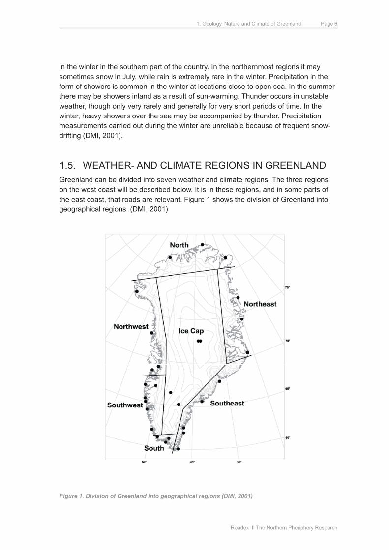
1.5. WEATHER- ANd CLImATE REGIONS IN GREENLANd Greenland can be divided into seven weather and climate regions. The three regions on the west coast will be described below. It is in these regions, and in some parts of the east coast, that roads are relevant. Figure 1 shows the division of Greenland into geographical regions. (dmI, 2001)
Figure 1. Division of Greenland into geographical regions (DMI, 2001)

1. Geology, Nature and Climate of Greenland
Roadex III The Northern Pheriphery Research
Page 7
South GreenlandThe large temperature differences in the area - between the cold sea and the warm inland area in the summer and between the warm sea and the cold inland area in the winter - give rise to a local but dominant monsoon system in the fjords, featuring sea breezes in the summer and equally dominant land breezes in the winter. This pattern is disturbed in times of unstable weather. The winter weather is generally changeable, but differs a great deal from year to year. Low-pressure systems crossing South Greenland from the southwest to the northeast will make the weather change between easterly winds accompanied by rising temperature and precipitation in the form of snow or rain, and northwesterly winds with clearing and colder weather. Sometimes, with a stationary low pressure area to the south of Greenland, strong, warm and dry Foehn winds from an easterly direction may blow in the fjords for relatively long periods of time, in rare cases for weeks. The temperature of such winds will be in the region of 10°C or more. The winds may reach gale force with gusts up to hurricane force. Locally these winds are referred to as a “sydøst” (“southeast”) even though the wind direction is typically northeast. In such scenarios the snow cover will disappear and the ice in the fjords will break-up. In contrast, a stationary low-pressure area near Iceland may be characterised by a long period of northwesterly winds with hard frost and frequent snow showers in the coastal area.
Clear skies prevail in the inland portions of Greenland. Summers are warm inside the country. In certain locations the mean temperature for July is a little above 10°C. Temperatures are lower near the coast because of the cold sea, where fog is frequent (above 20% of time). The sea breeze brings the fog into the sun-heated fjord areas where it dissolves.
The amount of precipitation is large. In the summer, precipitation will always be in the form of rain, whereas snow is most common in the winter. The thickness of the snow layer may occasionally be reduced by melting. (dmI, 2001)
Southwest GreenlandThis area is that part of the country where ships can navigate almost unimpeded by sea ice all year round. The open sea means that the coastal zone, where the population is concentrated, has relatively mild winters, while summers are characterized by relatively cool and often unsettled weather. Inside the fjords, winters are cold, while summers are warmer. However, just as in South Greenland, there are major fluctuations in the weather from year to year. The amount of precipitation is generally large in the southern part of the area but decreases northwards and especially inland from the coast. While winters in Sisimiut are characterised by relatively much snow, there is generally only a thin layer of snow in the Kangerlussuaq - Sdr. Strømfjord area. In winter, northerly winds are predominant. They are typically associated with clear, cold weather in the coastal area, although there are many snow showers over the sea which occasionally affect the coast. unstable, rough weather accompanies low-pressure systems passing through the davis Strait from the south or southwest. during their
1. Geology, Nature and Climate of Greenland
Roadex III The Northern Pheriphery Research
Page 8
passage temperatures will rise, and there will be abundant precipitation and strong winds from the south, often reaching gale force, and occasionally even hurricane force, in the coastal area. The best known of these winds is the “sydvesten” (“the southwest”) at Nuuk (called “nigersuaq” in Greenlandic). When combined with a Foehn effect, this southerly wind may bring temperatures up to 10-15 °C even in the middle of winter, although this is relatively rare. The high temperatures will only last for a short period of time. In the event of major outbreaks of cold air from Canada, polar lows will often develop over the sea. If they reach the coast they will be very manifest in the form of strong winds combined with blinding, drifting snow and hard frost. In summer, lows passing from the south and southwest through the davis Strait are relatively frequent. Just as in winter, these lows may cause rather abundant precipitation in coastal areas with strong winds from the south. In June precipitation may still be in the form of snow, but otherwise it will be rain. Inside the fjords, the winds are generally more moderate, although local outbreaks of strong Foehn winds or mountain gusts may occur. Stable summer weather occurs in periods with high pressure over the central part of Greenland. In such conditions there may be “midsummer weather” even in may, with day temperatures (omit “of”) up to 20°C in the inner part of the fjords, but with frequent fog and temperatures only slightly above 0°C at the outer coast. The midnight sun line passes through maniitsoq, while the limit for polar nights is located just to the north of Sisimiut. (dmI, 2001)
Northwest GreenlandSince the ice cover is almost uninterrupted in Baffin Bay in the winter, winters are less unstable but colder than in southwest Greenland. The area has the same storm patterns: strong winds from the southeast or south, bringing large amounts of precipitation both summer and winter, accompany cyclones moving towards Baffin Bay from directions between south and west. On the lee-side of the Cap york peninsula, southeasterly winds appear as extremely turbulent Foehn winds at Pituffik/Thule Air Base. The inner parts of disko Bay and uummannaq Fjord have occasional strong Foehn winds from the southeast, while the strait between disko and Nuussuaq (the Vaigat) is known for its changeable winds. Generally the mean wind velocity peaks in the autumn and falls again in december when the sea freezes over. The amount of precipitation is relatively large in the southern part of the area, but lower in the northern part. In winter precipitation is almost always in the form of snow, while rain is most common in the summer, though it may sometimes snow in the northern part. Fog is very frequent at sea and in coastal areas in the summer. The durations of periods with the midnight sun and polar nights in the northern part of the area are 127 and 110 days respectively, decreasing to 52 and 24 days respectively in the southern part.
1. Geology, Nature and Climate of Greenland
Roadex III The Northern Pheriphery Research
Page 9
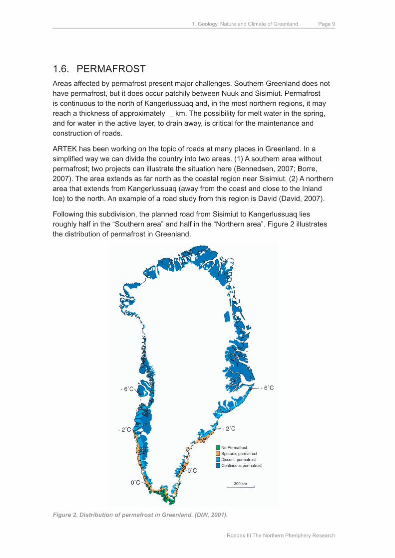
1.6. PERmAFROSTAreas affected by permafrost present major challenges. Southern Greenland does not have permafrost, but it does occur patchily between Nuuk and Sisimiut. Permafrost is continuous to the north of Kangerlussuaq and, in the most northern regions, it may reach a thickness of approximately _ km. The possibility for melt water in the spring, and for water in the active layer, to drain away, is critical for the maintenance and construction of roads.
ARTEK has been working on the topic of roads at many places in Greenland. In a simplified way we can divide the country into two areas. (1) A southern area without permafrost; two projects can illustrate the situation here (Bennedsen, 2007; Borre, 2007). The area extends as far north as the coastal region near Sisimiut. (2) A northern area that extends from Kangerlussuaq (away from the coast and close to the Inland Ice) to the north. An example of a road study from this region is david (david, 2007).
Following this subdivision, the planned road from Sisimiut to Kangerlussuaq lies roughly half in the “Southern area” and half in the “Northern area”. Figure 2 illustrates the distribution of permafrost in Greenland.
Figure 2. Distribution of permafrost in Greenland. (DMI, 2001).
1. Geology, Nature and Climate of Greenland
Roadex III The Northern Pheriphery Research
Page 10
1.7. VEGETATIONThe flora of Greenland includes ~500 plant species including flowering plants, ferns, horsetails and club mosses. most of these plants are widely developed in the arctic and alpine areas. Greenland extends across two vegetation belts of which the arctic belt, which is too cold for tree-growth, is by far the larger. Sparse tree growth takes place in the warmest valleys in Southern Greenland so that these areas belong to a boreal zone of vegetation. The arctic vegetation belt is often divided into low-arctic and high-arctic parts, where the latter does not have willow scrub. The low-arctic area extends as far north as upernavik on the west coast and Scoresbysund on the east coast.
In the inland area between Nanortalik and Ivittuut there are small areas of mountain forest with common birch, mountain ash and willow, that are up to 10 meters tall. Willow scrub is widely developed and in the inland regions can be up to 3-4 meters high.
Low-arctic heath-land is developed along the entire west coast. Progressing northwards, as the number of months with temperatures over 0°C falls to 5, the heath-land becomes poorer and poorer. It is, however, here that reindeer find food in the winter. In the summer they move inland to feed and breed.
In the inner parts of Godthåbsfjord and Kangerlussuaq, where there are only 5 months with temperatures over 0°C, the average temperature in July is 10-11°C and there is very little precipitation. The moss-rich heath-lands contain dwarf-birch and blue-grey willow, but the dry slopes and large areas of the valley floors have steppe-like vegetation, dominated by grasses and grass-like plants (Fredskild, 1999).
2. Relevant information for road-building projects in Greenland
Roadex III The Northern Pheriphery Research
Page 11
2. Relevant information for road-building proj-ects in Greenland
We have selected some reports that are relevant for Greenland from ROAdEx´s large archive of published material. The following reports are particularly relevant:
• Dealing with bearing capacity problems on low volume roads constructed on peat
• *)Drainage on low traffic volume roads
• Structural innovations
• *)Managing spring thaw weakening on low volume roads
• *)Permanent deformation
• Road management policies for low volume roads – some proposals
*) These reports have been translated to Greenlandic and Danish and distributed at ARTEK´s road conference in march 2007. Contributions at the conference were provided by colleagues that are not members of the ROAdEx cooperation. Please refer to the relevant publications for further information.
Below we refer to these reports and their summaries are reproduced. Additional relevant material is included.
A. drainageThe ROAdEx reports on drainage are very relevant for road construction in Greenland. The nature of the problem and a summary of the reports is given below:
“drainage on low volume roadsWater has a key role when discussing the mechanical performance and lifetime of any traffic infrastructure. The fact, known for centuries, is that as long as road structures and sub-grade soil do not have excess water the road will work well. But increased water content reduces the bearing capacity of a soil, which will increase the rate of deterioration and shorten the lifetime of the road. In such cases, the road will need rehabilitation more often than a well-drained road structure. When selecting maintenance strategies the paving costs in the maintenance of the road surface need to be compared with the costs of maintaining or improving the drainage. This analysis very challenging in the Northern Periphery because the problem is more complex in cold areas since the freeze-thaw cycles affect moisture content to a much greater extent than elsewhere.
2. Relevant information for road-building projects in Greenland
Roadex III The Northern Pheriphery Research
Page 12
In the ROADEX pilot project 1998-2001 drainage problems were identified to be one of the greatest problems shared by all of the ROAdEx partner Road regions. Funding for road condition management has been decreasing in all of the countries participating in the ROAdEx project for several years and as a result basic drainage maintenance tasks, such as ditch and culvert cleaning, as well as tasks related to the drainage system in general, are neglected since there are considered low on the list of priorities. Instead of drainage maintenance, the priority tasks have been those that are more important to the road user in the short term i.e. repaving and snow removal.
This report concentrates on presenting the problems that inadequate drainage causes for low volume roads in the NP area of Europe. It also discusses the monitoring methods that can be used when evaluating the drainage condition and proposes possible improvement techniques for different drainage problems. In addition, the effects of drainage on the pavement lifetime and life cycle costs of the pavement structure have been studied and are part of the report. The report is mainly based on the research work done during the ROADEX II subproject “Drainage on Low Traffic Volume Roads” written by Berntsen & Saarenketo (2005). The original report contains an extensive literature review on the moisture-content in the road structure, together with the relationship between moisture-content and the characteristics of unbound granular materials and sub-grade soils. ” (Berntsen & Saarenketo, 2005).
Similar experiences have been made outside the ROAdEx cooperation. Two articles that describe the situation in Iceland were presented at ARTEK´s road conference in march 2007. These examples are considered relevant for comparison with Southern Greenland, i.e. areas without permafrost.
ARTEK investigations in Southern Greenland (Bennedsen & Borre, 2006) confirm that drainage of roads is a considerable problem that requires annual maintenance.
B. Freeze-thaw problems with moisture-sensitive materialsNot all types of soil and rock materials present the same problems regarding moisture.
ROAdEx´s experience with the treatment of water-sensitive materials is reproduced below:
“Treatment of moisture-Susceptible AggregatesSeasonal changes and freeze-thaw cycles are the most significant factors that contribute to the loss of bearing capacity of moisture-susceptible materials in cold climates. The deterioration is caused by excess water that has accumulated in the road structure and cannot escape from the layers as the structure thaws. As a result, the road may quickly be damaged by heavy traffic.
material treatment of the road structure can be used to keep water away from the moisture-susceptible materials. If water is scarce in the structural layer before and
2. Relevant information for road-building projects in Greenland
Roadex III The Northern Pheriphery Research
Page 13
during the freezing period, the layer does not usually create ice lenses. Even during the thawing period in the spring the layer will work as designed and spread the load across a wider area so that the road will have a better durability against traffic loads.
Traditional stabilizers, such as bitumen and cement, are generally used to make a significant improvement to the strength and stiffness of the treated layers. However, these techniques require large quantities of stabilization agents to be used and thus the treatment methods are usually uneconomical on low volume roads. New types of stabilization agents have been developed to reduce the moisture-susceptibility and to improve the low bearing capacitates due to seasonal changes. These new agents, usually called non-traditional stabilization agents, are aimed for road materials whose bearing capacity and strength are sufficient, except for the short-term, but nevertheless significant, losses of bearing capacity relate to seasonal changes.
This report concentrates on presenting the types of information and investigations that are needed when using stabilization agents to reduce the moisture-susceptibility of the materials in the structural layers of the road. An essential part of the report is to clarify and even simplify the process of how information can be used and utilized. Since the research project concentrates primarily on low volume roads in the Northern Periphery of the European union, the report aims to focus on cost-effective investigation and information gathering methods.
When reading the report one should bear in mind that a complex combination of factors affects the water flow and its impact in different aggregates and weather conditions. The mixing of stabilization agents will complicate the situation so that they may be used in inappropriate places if their combined behaviour is not known well enough. Especially important is research on non-traditional stabilization agents since until now there is no reliable information available about their long-term performance in road structures.” (Vuorimies & Kolisoja, 2006).
“design and Repair of Roads Suffering Spring Thaw WeakeningSeasonal changes, freeze-thaw cycles and the damage they cause are the most significant factors affecting the road condition of northern cold climate road networks in Europe, Asia and North America. Freeze-thaw processes also cause major problems in high areas in countries with warmer climates. In the united States, the AASHO research program studied the appearance of pavement distress during different seasons (White and Goree 1990) and, according to the results, 60% of the distresses appeared during the springtime when the relative amount of traffic was 24%. During the summer time the relative amount of new pavement damage was only 2% when the relative traffic amount was 30%.
Frost damage is evident in roads as uneven frost heave and longitudinal and transverse cracking, but above all as softening of the road structure and permanent deformation during the thawing period. In the worst scenario, driving on these roads can be impossible. Thaw-weakening damage is usually the biggest problem
2. Relevant information for road-building projects in Greenland
Roadex III The Northern Pheriphery Research
Page 14
on “unbuilt” gravel roads, but it also causes major problems on paved roads, and especially on weak roads with a surface dressing pavement.
depending on the scale and scope of the spring thaw-weakening problem there are several policies and techniques for managing a road during the weak period. In general the management tools can be divided into:
1) different maintenance techniques to reduce the effect of spring thaw
2) load restrictions and different tools to minimize the problems caused by these restrictions
3) strengthening weak road sections to the extent that load restrictions can be removed or used only in extreme conditions and
4) co-operation with transportation organizations using heavy vehicles.
Traditionally road administrators have endeavoured to prevent spring thaw damage by implementing load restrictions or even closing the road. The use of spring load restrictions increases the pavement lifetime but at the same time load restriction measures also incur major extra costs for industries using heavy transport vehicles. For instance, the extra costs to the forest industry due to spring thaw-weakening in Finland has been calculated to be 100m€, of which 65 m€ comes from public roads (Pennanen and mäkelä 2003).
The best and most sustainable solution for managing thaw-weakening problems is therefore to strengthen and rehabilitate the weak road sections. However, this can, and should, only be done if the road region has enough resources to take appropriate measures that will function over the long term. major mistakes have been made when road sections have been strengthened using structures that are too weak. These problems become especially apparent if the road is paved afterwards.” (Aho & Saarenketo, 2006).
C. Road construction over PeatThere are extensive peat deposits in Greenland, even though their thicknesses are small compared with those in countries with warmer and moister climates.
ROAdEx´s report “managing Peat Related Problems on Low Volume Roads” explain the nature of the problems and indicate technical solutions.
“Road Construction over PeatThe construction and maintenance of roads over peat tends to be considered as a “black art” by many engineers. As a consequence a great number of engineers, without peat experience, tend to avoid construction risk and opt for safer, more conservative forms of construction whereby any peat found on the route of a road is totally removed
2. Relevant information for road-building projects in Greenland
Roadex III The Northern Pheriphery Research
Page 15
and replaced with clean, sound, road foundation material. This practice, however, ignores some very good practices, developed over long periods of time in northern latitudes and is an expensive solution, as well as being a primary user of scarce natural resources, and only really affordable in the construction of high speed national roads.
Lower classes of roads, and particularly low volume roads, can realize real benefits from retaining peat as a sub-grade (benefits such as economy, environmental sustainability, lesser use of materials, etc.) and develop more cost-effective and site-specific solutions than simply always digging out the material and throwing it away. This is especially the case in rehabilitation projects of roads “floating” on peat where it is unlikely that a simple solution of full excavation, a re-alignment or a local diversion is possible. If it was, the original designers of the road should probably have done it in the first place.
decreasing national roads budgets, and the need to get more road kilometers per Euro, now provide the impetus for conservative construction practices to be re-examined. The bearing capacity problems of roads over peat were identified as a common problem across the Northern Periphery in the ROAdEx pilot project and the subsequent ROAdEx II report “dealing with bearing capacity problems on low volume roads constructed on peat” (munro 2005) reviewed the state of the art in road construction over peat in the partner areas.
This report will look at the difficulties of rehabilitating existing roads over peat, primarily the so-called “floating” roads”, and discuss how modern survey, monitoring and construction practices can assist engineers in assessing and evaluating problem roads sections that “fit for purpose” solutions can be developed and implemented without the need to resort to excavation on all occasions.
The report will summarize the main issues to be considered when planning these types of works and offer guidance to recognizable problems where possible. Its aim will be to be a practical guide for the local road maintenance engineer/designer that can be used to address the common problems raised by roads over peat sub-grades.“ (munroe & macCulloch 2006).
d. EnvironmentEnvironmental considerations play an ever-increasing role, also for road construction. The ROAdEx reports “Environmental guidelines” provide good advice and an overview of potential problems. The nature of problems varies from those experienced in the construction phase when landscape and cultural aspects can be involved, to the operation phase when emissions from vehicles, dust problems etc. can be relevant. A summary of the report mentioned above is given here:
2. Relevant information for road-building projects in Greenland
Roadex III The Northern Pheriphery Research
Page 16
“Environmental GuidelinesGrowing interest in the environment in modern society has led to increasing focus on environmental issues. This also applies to the road sector. By its very nature, this sector involves appreciable loading on the environment, so there is every reason to take active measures to achieve more environmentally sustainable operations. Appreciable gains can be made, both environmentally and also economically.
The major environmental loading from the road sector originates principally from exhaust gases and emissions from road traffic, although road building, rebuilding and maintenance of the road network can also cause significant environmental impact in certain cases.
This report deals only with those elements involved in the construction and maintenance of road objects.
This report is aimed at giving an overview of how the project partners deal with environmental matters in road building, and to give advice on how good environmental management can be assured in road building. The report is based on contacts with the various road authorities concerned, and also a number of reports.
A short checklist for use on site accompanies the report. This guideline is a brief compilation of various items of advice that have been developed in chapter three of this report and is intended for use by persons on site.” (ullberg, 2004).
The VVm-statement by (Aggerbeck et al., 2003) from ARTEK´s road conference, which is concerned with the planned road from Sisimiut to Kangerlussuaq, is a good example that deals systematically with potential environmental problems.
E. Permafrost and climate changesIt is generally difficult to build a road on sediments that are subjected to permafrost. drainage from the active layer (that melts in the summer) is one of the problems. The climatic changes in recent years have altered the stability conditions for the permanently frozen layer in many places. There were several contributions that addressed this problem at ARTEK´s road conference. These include a contribution from Arctic Canada on methods for removal of water from sensitive road constructions. There were three contributions from Greenland on the decay of permafrost and mapping methods. Surface materials with light colours appear to have a positive effect; this information was also presented at the conference.
3. Existing roads in towns and villages in Greenland
Roadex III The Northern Pheriphery Research
Page 17
3. Existing roads in towns and villages in Greenland
Greenland is a very large country and the natural conditions vary enormously from south to north. The ice-free zone, which is relevant for the topic of roads, consists of crystalline basement rocks with a cover of sediments whose thickness varies from zero to several hundreds of meters.
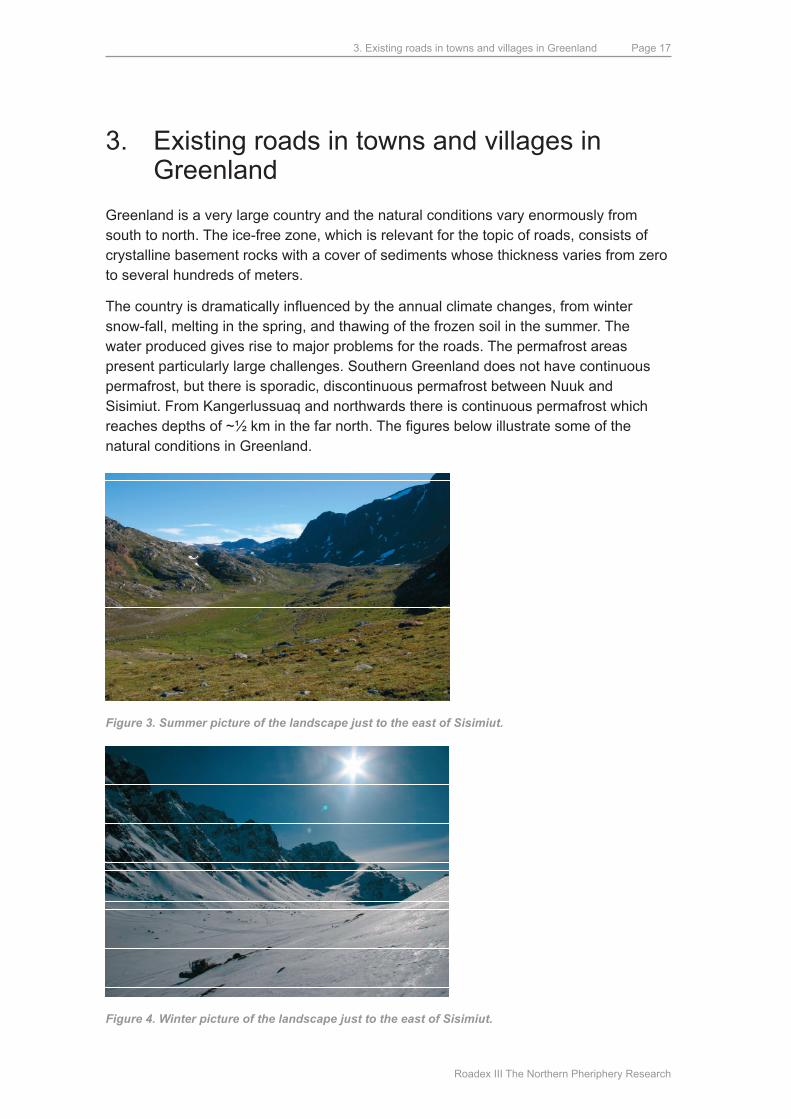
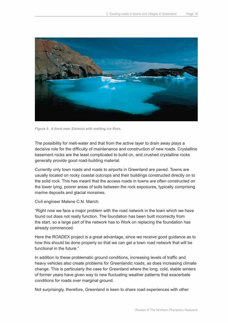
The country is dramatically influenced by the annual climate changes, from winter snow-fall, melting in the spring, and thawing of the frozen soil in the summer. The water produced gives rise to major problems for the roads. The permafrost areas present particularly large challenges. Southern Greenland does not have continuous permafrost, but there is sporadic, discontinuous permafrost between Nuuk and Sisimiut. From Kangerlussuaq and northwards there is continuous permafrost which reaches depths of ~½ km in the far north. The figures below illustrate some of the natural conditions in Greenland.
Figure 3. Summer picture of the landscape just to the east of Sisimiut.
Figure 4. Winter picture of the landscape just to the east of Sisimiut.
3. Existing roads in towns and villages in Greenland
Roadex III The Northern Pheriphery Research
Page 18
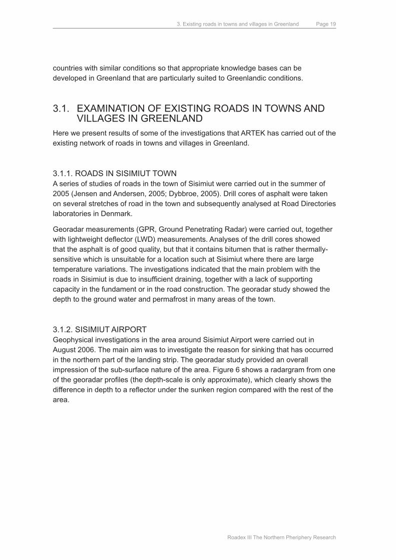
Figure 5. A fiord near Sisimiut with melting ice floes.
The possibility for melt-water and that from the active layer to drain away plays a decisive role for the difficulty of maintenance and construction of new roads. Crystalline basement rocks are the least complicated to build on, and crushed crystalline rocks generally provide good road-building material.
Currently only town roads and roads to airports in Greenland are paved. Towns are usually located on rocky coastal outcrops and their buildings constructed directly on to the solid rock. This has meant that the access roads in towns are often constructed on the lower lying, poorer areas of soils between the rock exposures, typically comprising marine deposits and glacial moraines.
Civil engineer malene C.N. mørch:
“Right now we face a major problem with the road network in the town which we have found out does not really function. The foundation has been built incorrectly from the start, so a large part of the network has to Work on replacing the foundation has already commenced.
Here the ROAdEx project is a great advantage, since we receive good guidance as to how this should be done properly so that we can get a town road network that will be functional in the future.”
In addition to these problematic ground conditions, increasing levels of traffic and heavy vehicles also create problems for Greenlandic roads, as does increasing climate change. This is particularly the case for Greenland where the long, cold, stable winters of former years have given way to new fluctuating weather patterns that exacerbate conditions for roads over marginal ground.
Not surprisingly, therefore, Greenland is keen to share road experiences with other
3. Existing roads in towns and villages in Greenland
Roadex III The Northern Pheriphery Research
Page 19
countries with similar conditions so that appropriate knowledge bases can be developed in Greenland that are particularly suited to Greenlandic conditions.
3.1. ExAmINATION OF ExISTING ROAdS IN TOWNS ANd VILLAGES IN GREENLANd
Here we present results of some of the investigations that ARTEK has carried out of the existing network of roads in towns and villages in Greenland.
3.1.1. ROAdS IN SISImIuT TOWNA series of studies of roads in the town of Sisimiut were carried out in the summer of 2005 (Jensen and Andersen, 2005; dybbroe, 2005). drill cores of asphalt were taken on several stretches of road in the town and subsequently analysed at Road directories laboratories in denmark.
Georadar measurements (GPR, Ground Penetrating Radar) were carried out, together with lightweight deflector (LWD) measurements. Analyses of the drill cores showed that the asphalt is of good quality, but that it contains bitumen that is rather thermally-sensitive which is unsuitable for a location such at Sisimiut where there are large temperature variations. The investigations indicated that the main problem with the roads in Sisimiut is due to insufficient draining, together with a lack of supporting capacity in the fundament or in the road construction. The georadar study showed the depth to the ground water and permafrost in many areas of the town.
3.1.2. SISImIuT AIRPORTGeophysical investigations in the area around Sisimiut Airport were carried out in August 2006. The main aim was to investigate the reason for sinking that has occurred in the northern part of the landing strip. The georadar study provided an overall impression of the sub-surface nature of the area. Figure 6 shows a radargram from one of the georadar profiles (the depth-scale is only approximate), which clearly shows the difference in depth to a reflector under the sunken region compared with the rest of the area.
3. Existing roads in towns and villages in Greenland
Roadex III The Northern Pheriphery Research
Page 20
Figure 6. Radargram fra Sisimiut Airport. The black lines indicate the difference in depth to a reflec-tor below the sunken area (to the right) and the adjacent area (left).
The present results does not allow us to determine the precise cause of the sinking, but it is evident that the sub-surface structure is different in this area.
3.1.3. THE ROAd FROm KANGERLuSSSuAq TO THE INLANd ICEGeoradar investigations were performed along the entire length of the road from Kangerlussuaq to the Inland Ice in 2006 (Stürup-Toft et al., 2006). The gravel road to the Inland Ice was constructed by the Volkswagen concern when they established a test road on the ice in the 1990´s. In 2005, Volkswagen decided to shut down their activities and leave the area so that Sisimiut municipality has subsequently been responsible for service and maintenance of the road.
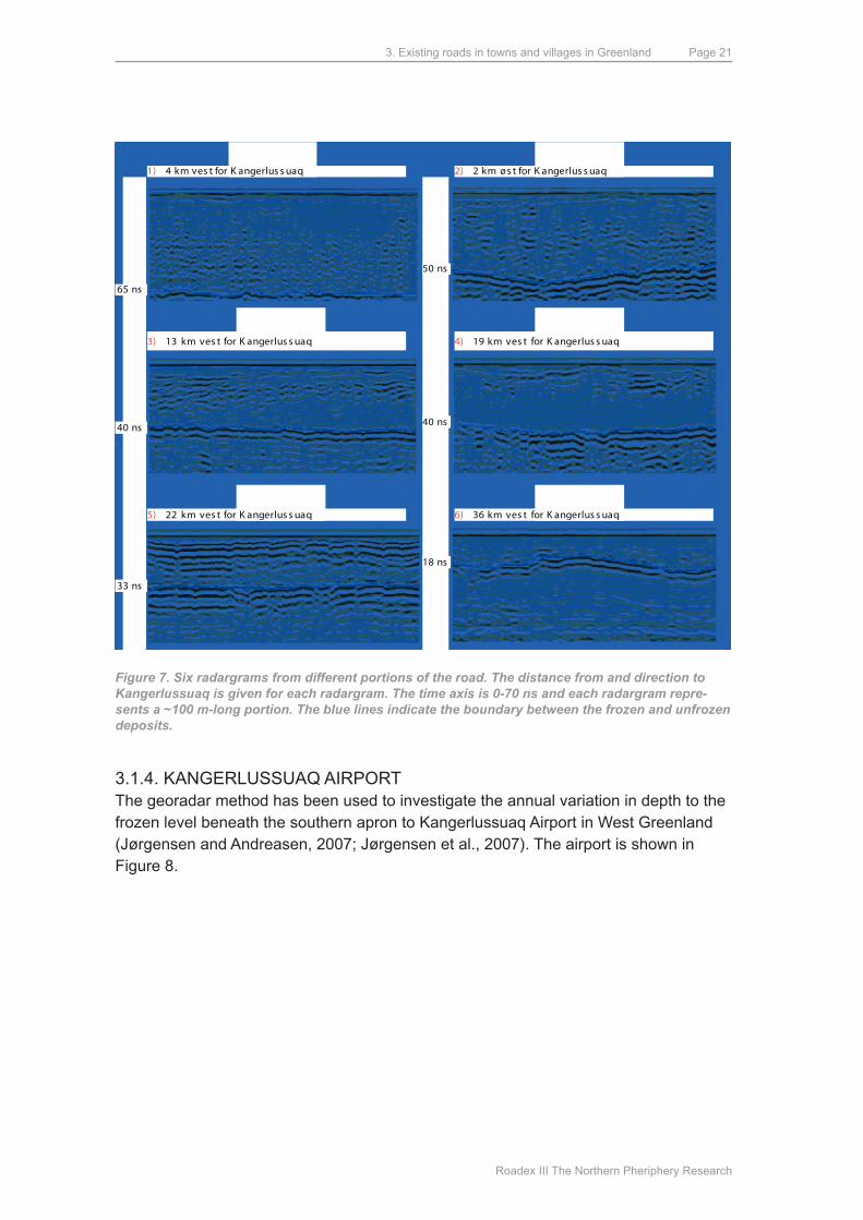
The georadar studies were performed to investigate the thickness and variation of the active layer. Figure 7 shows 6 radargrams, each of which represents a length of ~100 meters. depths are given in nanoseconds (ns). Conversion of these values to depth in meters requires knowledge of the nature of the materials above the permafrost. The investigations indicate that the uppermost layer consists of coarse material (gravely sand) which was used to stabilise the road. Silty sand would be expected below the roadbed which will be either water-saturated or dry depending on the time of year. The rate of propagation of electromagnetic waves in dry sand is 12.0-15.0 cm/ns, whereas it is in the range 5.5-10.0 cm/ns for wet, silty sand (Andreasen, 2000). These values give a depth of ~2.5 m to the frost level on radargram 1, whereas the depth is only ~0.5 m close to the Inland Ice in radargram 6. This variation in thickness of the active layer is due to the variation in temperature in the area; the closer to the Inland ice, the colder it gets, largely because of the cold wind that blows off the ice.
3. Existing roads in towns and villages in Greenland
Roadex III The Northern Pheriphery Research
Page 21
3) 13 km ves t for K angerlus s uaq
1) 4 km ves t for K angerlus s uaq
5) 22 km ves t for K angerlus s uaq
2) 2 km øs t for K angerlus s uaq
4) 19 km ves t for K angerlus s uaq
6) 36 km ves t for K angerlus s uaq
65 ns
40 ns
33 ns
50 ns
40 ns
18 ns
Figure 7. Six radargrams from different portions of the road. The distance from and direction to Kangerlussuaq is given for each radargram. The time axis is 0-70 ns and each radargram repre-sents a ~100 m-long portion. The blue lines indicate the boundary between the frozen and unfrozen deposits.
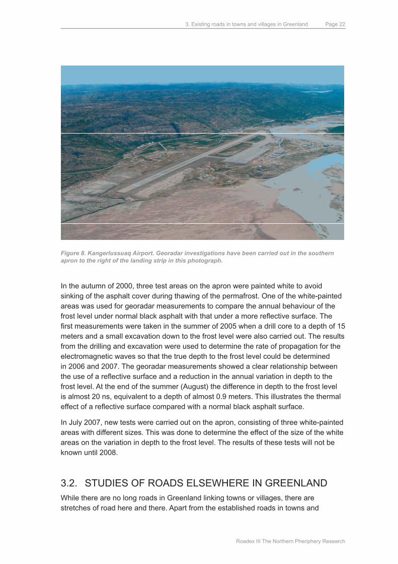
3.1.4. KANGERLuSSuAq AIRPORTThe georadar method has been used to investigate the annual variation in depth to the frozen level beneath the southern apron to Kangerlussuaq Airport in West Greenland (Jørgensen and Andreasen, 2007; Jørgensen et al., 2007). The airport is shown in Figure 8.
3. Existing roads in towns and villages in Greenland
Roadex III The Northern Pheriphery Research
Page 22
Figure 8. Kangerlussuaq Airport. Georadar investigations have been carried out in the southern apron to the right of the landing strip in this photograph.
In the autumn of 2000, three test areas on the apron were painted white to avoid sinking of the asphalt cover during thawing of the permafrost. One of the white-painted areas was used for georadar measurements to compare the annual behaviour of the frost level under normal black asphalt with that under a more reflective surface. The first measurements were taken in the summer of 2005 when a drill core to a depth of 15 meters and a small excavation down to the frost level were also carried out. The results from the drilling and excavation were used to determine the rate of propagation for the electromagnetic waves so that the true depth to the frost level could be determined in 2006 and 2007. The georadar measurements showed a clear relationship between the use of a reflective surface and a reduction in the annual variation in depth to the frost level. At the end of the summer (August) the difference in depth to the frost level is almost 20 ns, equivalent to a depth of almost 0.9 meters. This illustrates the thermal effect of a reflective surface compared with a normal black asphalt surface.
In July 2007, new tests were carried out on the apron, consisting of three white-painted areas with different sizes. This was done to determine the effect of the size of the white areas on the variation in depth to the frost level. The results of these tests will not be known until 2008.
3.2. STudIES OF ROAdS ELSEWHERE IN GREENLANdWhile there are no long roads in Greenland linking towns or villages, there are stretches of road here and there. Apart from the established roads in towns and
3. Existing roads in towns and villages in Greenland
Roadex III The Northern Pheriphery Research
Page 23
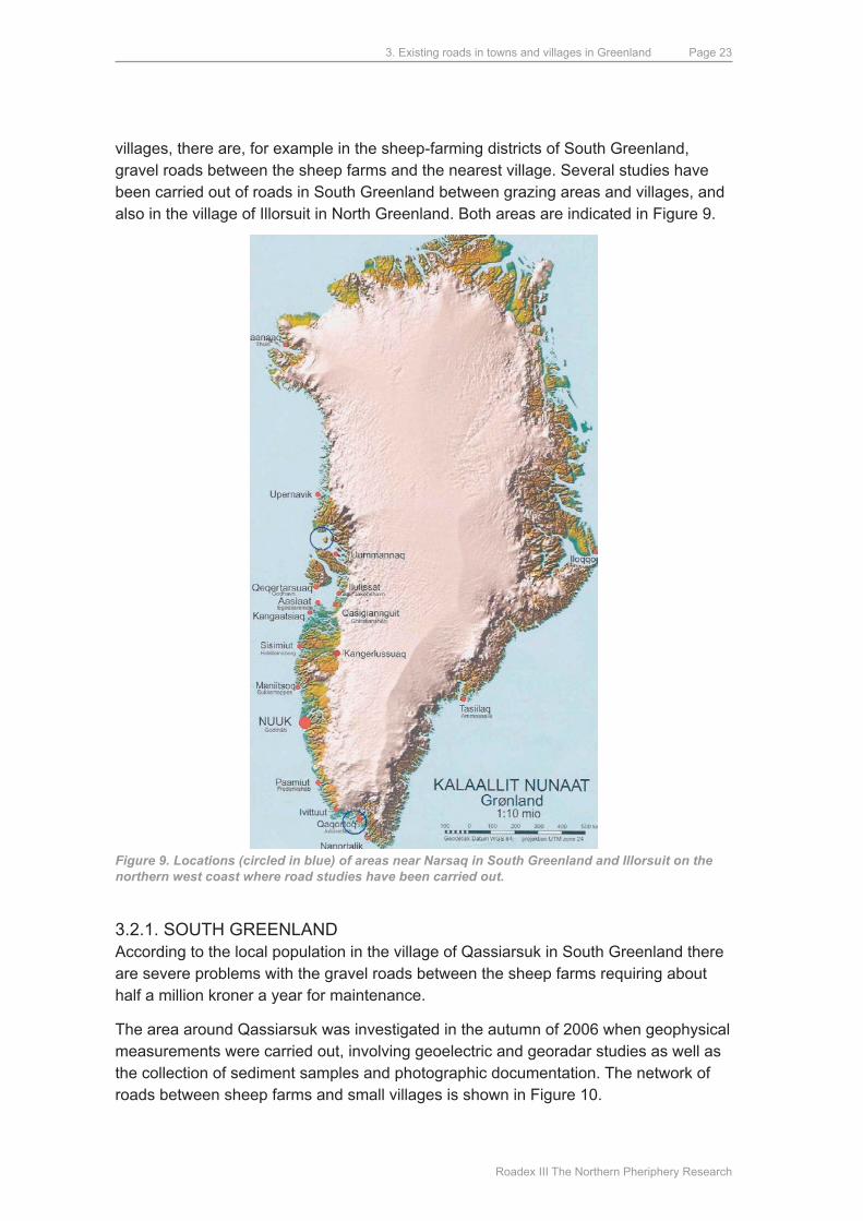
villages, there are, for example in the sheep-farming districts of South Greenland, gravel roads between the sheep farms and the nearest village. Several studies have been carried out of roads in South Greenland between grazing areas and villages, and also in the village of Illorsuit in North Greenland. Both areas are indicated in Figure 9.
Figure 9. Locations (circled in blue) of areas near Narsaq in South Greenland and Illorsuit on the northern west coast where road studies have been carried out.
3.2.1. SOuTH GREENLANdAccording to the local population in the village of qassiarsuk in South Greenland there are severe problems with the gravel roads between the sheep farms requiring about half a million kroner a year for maintenance.
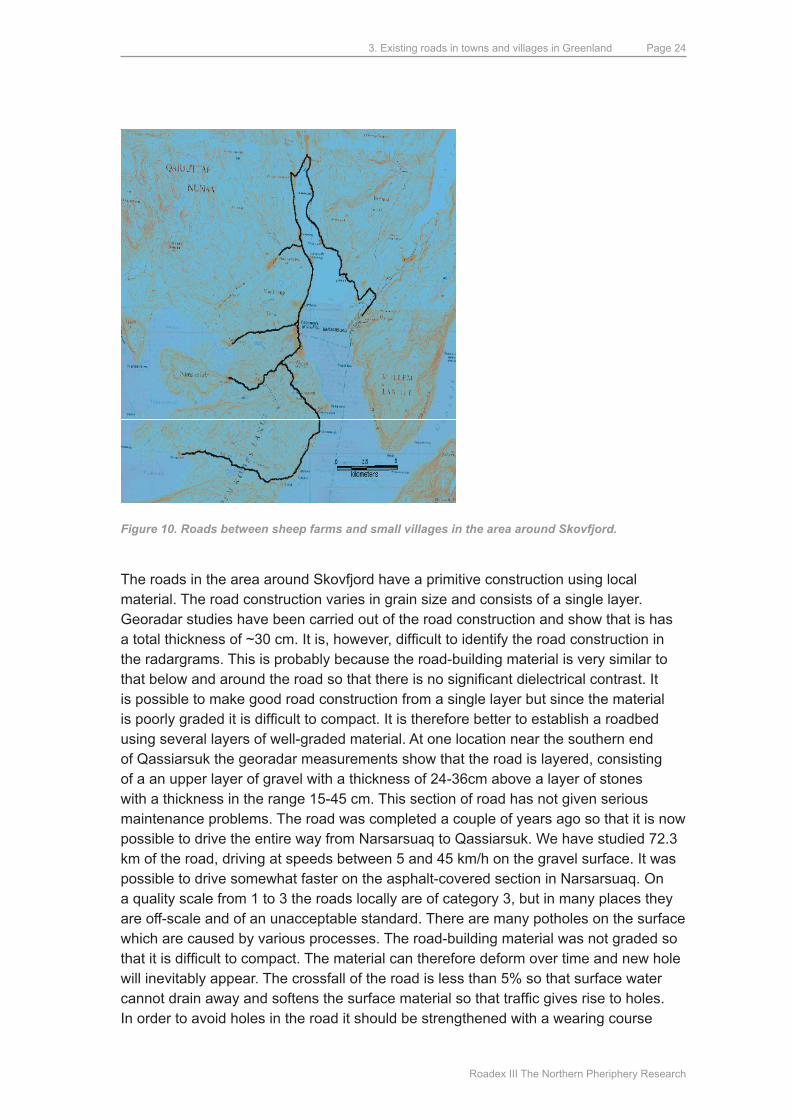
The area around qassiarsuk was investigated in the autumn of 2006 when geophysical measurements were carried out, involving geoelectric and georadar studies as well as the collection of sediment samples and photographic documentation. The network of roads between sheep farms and small villages is shown in Figure 10.
3. Existing roads in towns and villages in Greenland
Roadex III The Northern Pheriphery Research
Page 24
Figure 10. Roads between sheep farms and small villages in the area around Skovfjord.
The roads in the area around Skovfjord have a primitive construction using local material. The road construction varies in grain size and consists of a single layer. Georadar studies have been carried out of the road construction and show that is has a total thickness of ~30 cm. It is, however, difficult to identify the road construction in the radargrams. This is probably because the road-building material is very similar to that below and around the road so that there is no significant dielectrical contrast. It is possible to make good road construction from a single layer but since the material is poorly graded it is difficult to compact. It is therefore better to establish a roadbed using several layers of well-graded material. At one location near the southern end of qassiarsuk the georadar measurements show that the road is layered, consisting of a an upper layer of gravel with a thickness of 24-36cm above a layer of stones with a thickness in the range 15-45 cm. This section of road has not given serious maintenance problems. The road was completed a couple of years ago so that it is now possible to drive the entire way from Narsarsuaq to qassiarsuk. We have studied 72.3 km of the road, driving at speeds between 5 and 45 km/h on the gravel surface. It was possible to drive somewhat faster on the asphalt-covered section in Narsarsuaq. On a quality scale from 1 to 3 the roads locally are of category 3, but in many places they are off-scale and of an unacceptable standard. There are many potholes on the surface which are caused by various processes. The road-building material was not graded so that it is difficult to compact. The material can therefore deform over time and new hole will inevitably appear. The crossfall of the road is less than 5% so that surface water cannot drain away and softens the surface material so that traffic gives rise to holes. In order to avoid holes in the road it should be strengthened with a wearing course
3. Existing roads in towns and villages in Greenland
Roadex III The Northern Pheriphery Research
Page 25
uppermost with a maximum grain size of 22.4 mm and a filler-content of 10-16%. The latter is important because it increasing the binding capacity of the material.
There are problems with dust when driving in qassiarsuk; this can also be improved by a better binding capacity. determination of the abrasive strength of aggregate materials using the mikro-deval method has shown that it is very important to use the correct materials. Sandstone that is used for road construction in qassiarsuk loses 36% of its weight in the tests compared with a granite sample that only loses ~3%. The gravel samples have also been investigated for their organic content, proportion of rounded stones and grain size distribution. Based on these studies, and on how much material can be expected to be extracted from individual gravel pits, some pits have been selected to provide the optimal material for road construction in the area. much of the rounded material in these pits can crushed using a rock-crusher. Wearing course material and base course material should not contain more than 50% of rounded material. much of the material is, however, in a suitable size-range so that sieving will be more important than crushing. In order to provide suitable crushed material, stones in the range 32-100 mm can be used; there is ample suitable material in the area.
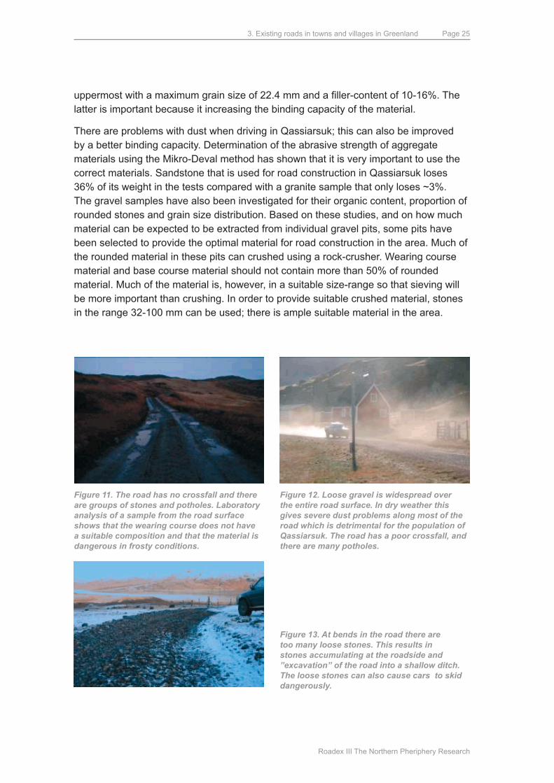
Figure 11. The road has no crossfall and there are groups of stones and potholes. Laboratory analysis of a sample from the road surface shows that the wearing course does not have a suitable composition and that the material is dangerous in frosty conditions.
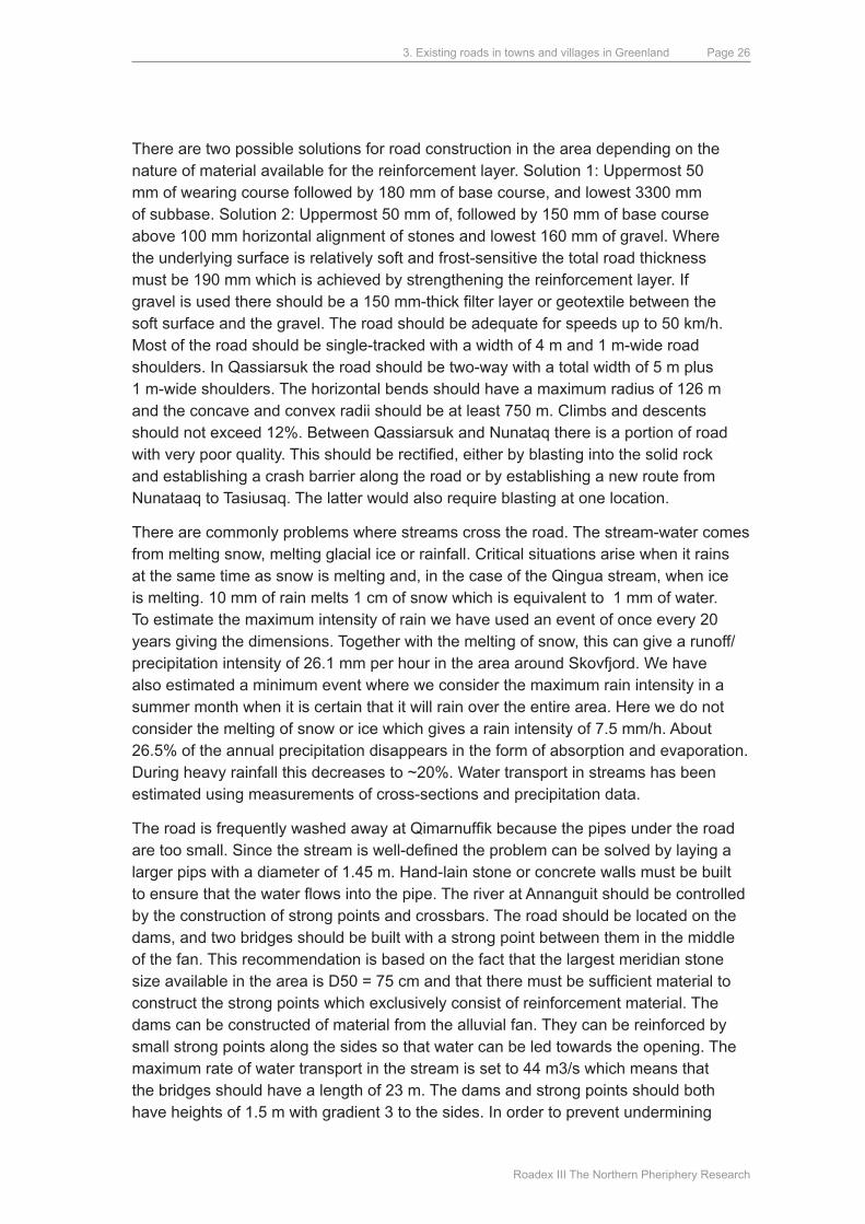
Figure 12. Loose gravel is widespread over the entire road surface. In dry weather this gives severe dust problems along most of the road which is detrimental for the population of Qassiarsuk. The road has a poor crossfall, and there are many potholes.
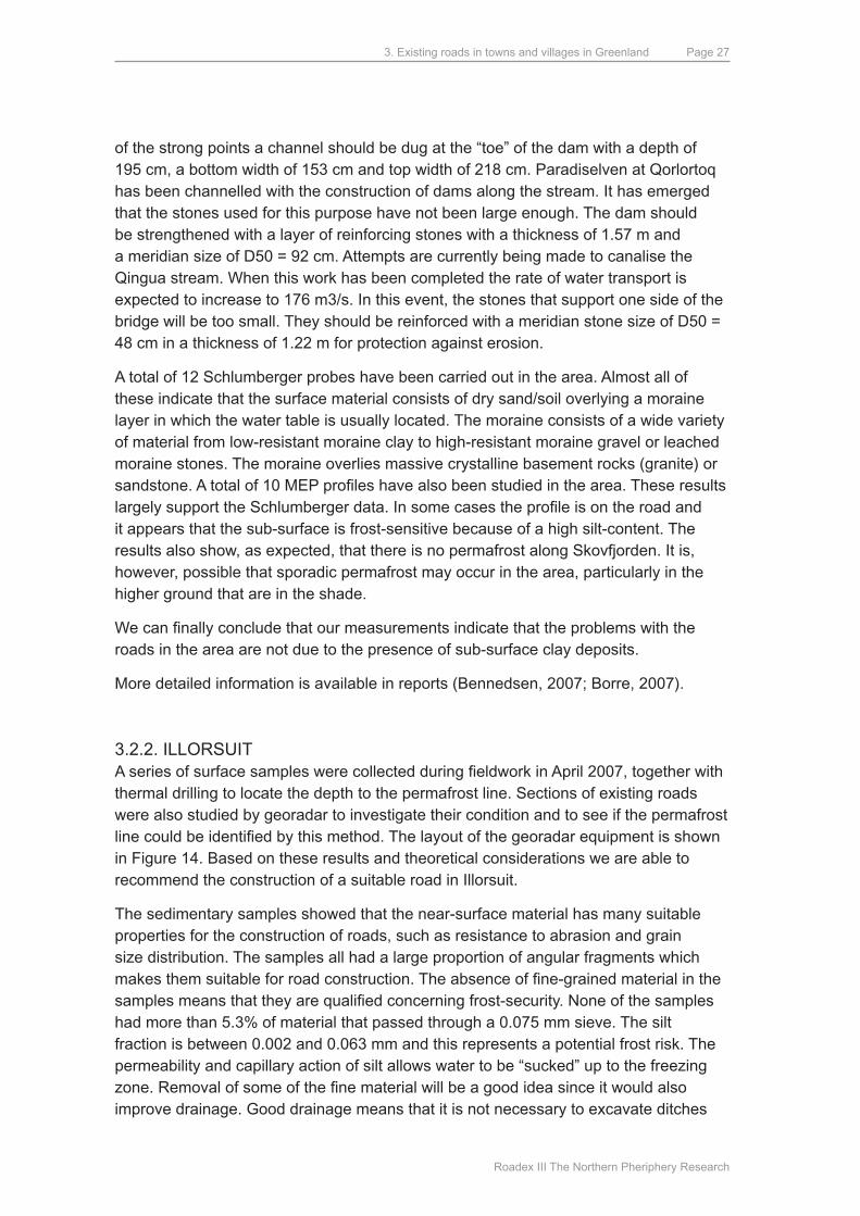
Figure 13. At bends in the road there are too many loose stones. This results in stones accumulating at the roadside and ”excavation” of the road into a shallow ditch. The loose stones can also cause cars to skid dangerously.
3. Existing roads in towns and villages in Greenland
Roadex III The Northern Pheriphery Research
Page 26
There are two possible solutions for road construction in the area depending on the nature of material available for the reinforcement layer. Solution 1: uppermost 50 mm of wearing course followed by 180 mm of base course, and lowest 3300 mm of subbase. Solution 2: uppermost 50 mm of, followed by 150 mm of base course above 100 mm horizontal alignment of stones and lowest 160 mm of gravel. Where the underlying surface is relatively soft and frost-sensitive the total road thickness must be 190 mm which is achieved by strengthening the reinforcement layer. If gravel is used there should be a 150 mm-thick filter layer or geotextile between the soft surface and the gravel. The road should be adequate for speeds up to 50 km/h. most of the road should be single-tracked with a width of 4 m and 1 m-wide road shoulders. In qassiarsuk the road should be two-way with a total width of 5 m plus 1 m-wide shoulders. The horizontal bends should have a maximum radius of 126 m and the concave and convex radii should be at least 750 m. Climbs and descents should not exceed 12%. Between qassiarsuk and Nunataq there is a portion of road with very poor quality. This should be rectified, either by blasting into the solid rock and establishing a crash barrier along the road or by establishing a new route from Nunataaq to Tasiusaq. The latter would also require blasting at one location.
There are commonly problems where streams cross the road. The stream-water comes from melting snow, melting glacial ice or rainfall. Critical situations arise when it rains at the same time as snow is melting and, in the case of the qingua stream, when ice is melting. 10 mm of rain melts 1 cm of snow which is equivalent to 1 mm of water. To estimate the maximum intensity of rain we have used an event of once every 20 years giving the dimensions. Together with the melting of snow, this can give a runoff/precipitation intensity of 26.1 mm per hour in the area around Skovfjord. We have also estimated a minimum event where we consider the maximum rain intensity in a summer month when it is certain that it will rain over the entire area. Here we do not consider the melting of snow or ice which gives a rain intensity of 7.5 mm/h. About 26.5% of the annual precipitation disappears in the form of absorption and evaporation. during heavy rainfall this decreases to ~20%. Water transport in streams has been estimated using measurements of cross-sections and precipitation data.
The road is frequently washed away at Qimarnuffik because the pipes under the road are too small. Since the stream is well-defined the problem can be solved by laying a larger pips with a diameter of 1.45 m. Hand-lain stone or concrete walls must be built to ensure that the water flows into the pipe. The river at Annanguit should be controlled by the construction of strong points and crossbars. The road should be located on the dams, and two bridges should be built with a strong point between them in the middle of the fan. This recommendation is based on the fact that the largest meridian stone size available in the area is D50 = 75 cm and that there must be sufficient material to construct the strong points which exclusively consist of reinforcement material. The dams can be constructed of material from the alluvial fan. They can be reinforced by small strong points along the sides so that water can be led towards the opening. The maximum rate of water transport in the stream is set to 44 m3/s which means that the bridges should have a length of 23 m. The dams and strong points should both have heights of 1.5 m with gradient 3 to the sides. In order to prevent undermining
3. Existing roads in towns and villages in Greenland
Roadex III The Northern Pheriphery Research
Page 27
of the strong points a channel should be dug at the “toe” of the dam with a depth of 195 cm, a bottom width of 153 cm and top width of 218 cm. Paradiselven at qorlortoq has been channelled with the construction of dams along the stream. It has emerged that the stones used for this purpose have not been large enough. The dam should be strengthened with a layer of reinforcing stones with a thickness of 1.57 m and a meridian size of d50 = 92 cm. Attempts are currently being made to canalise the qingua stream. When this work has been completed the rate of water transport is expected to increase to 176 m3/s. In this event, the stones that support one side of the bridge will be too small. They should be reinforced with a meridian stone size of d50 = 48 cm in a thickness of 1.22 m for protection against erosion.
A total of 12 Schlumberger probes have been carried out in the area. Almost all of these indicate that the surface material consists of dry sand/soil overlying a moraine layer in which the water table is usually located. The moraine consists of a wide variety of material from low-resistant moraine clay to high-resistant moraine gravel or leached moraine stones. The moraine overlies massive crystalline basement rocks (granite) or sandstone. A total of 10 MEP profiles have also been studied in the area. These results largely support the Schlumberger data. In some cases the profile is on the road and it appears that the sub-surface is frost-sensitive because of a high silt-content. The results also show, as expected, that there is no permafrost along Skovfjorden. It is, however, possible that sporadic permafrost may occur in the area, particularly in the higher ground that are in the shade.
We can finally conclude that our measurements indicate that the problems with the roads in the area are not due to the presence of sub-surface clay deposits.
more detailed information is available in reports (Bennedsen, 2007; Borre, 2007).
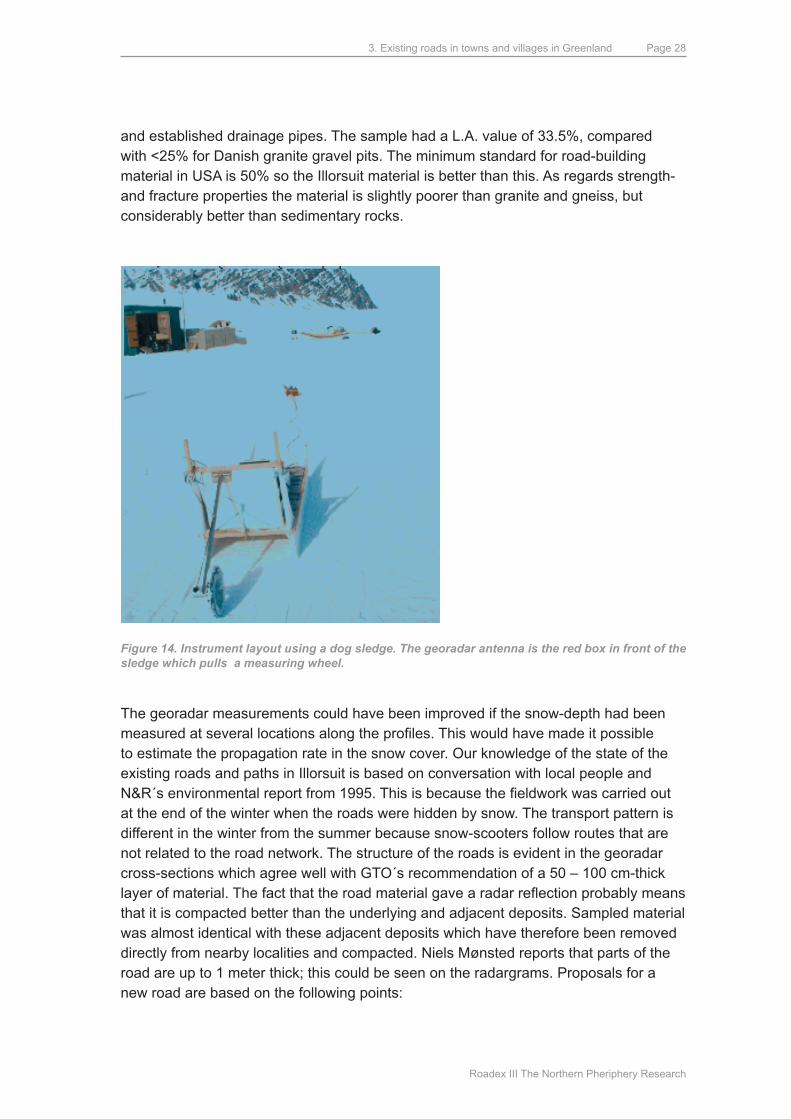
3.2.2. ILLORSuITA series of surface samples were collected during fieldwork in April 2007, together with thermal drilling to locate the depth to the permafrost line. Sections of existing roads were also studied by georadar to investigate their condition and to see if the permafrost line could be identified by this method. The layout of the georadar equipment is shown in Figure 14. Based on these results and theoretical considerations we are able to recommend the construction of a suitable road in Illorsuit.
The sedimentary samples showed that the near-surface material has many suitable properties for the construction of roads, such as resistance to abrasion and grain size distribution. The samples all had a large proportion of angular fragments which makes them suitable for road construction. The absence of fine-grained material in the samples means that they are qualified concerning frost-security. None of the samples had more than 5.3% of material that passed through a 0.075 mm sieve. The silt fraction is between 0.002 and 0.063 mm and this represents a potential frost risk. The permeability and capillary action of silt allows water to be “sucked” up to the freezing zone. Removal of some of the fine material will be a good idea since it would also improve drainage. Good drainage means that it is not necessary to excavate ditches
3. Existing roads in towns and villages in Greenland
Roadex III The Northern Pheriphery Research
Page 28
and established drainage pipes. The sample had a L.A. value of 33.5%, compared with <25% for danish granite gravel pits. The minimum standard for road-building material in uSA is 50% so the Illorsuit material is better than this. As regards strength- and fracture properties the material is slightly poorer than granite and gneiss, but considerably better than sedimentary rocks.
Figure 14. Instrument layout using a dog sledge. The georadar antenna is the red box in front of the sledge which pulls a measuring wheel.
The georadar measurements could have been improved if the snow-depth had been measured at several locations along the profiles. This would have made it possible to estimate the propagation rate in the snow cover. Our knowledge of the state of the existing roads and paths in Illorsuit is based on conversation with local people and N&R´s environmental report from 1995. This is because the fieldwork was carried out at the end of the winter when the roads were hidden by snow. The transport pattern is different in the winter from the summer because snow-scooters follow routes that are not related to the road network. The structure of the roads is evident in the georadar cross-sections which agree well with GTO´s recommendation of a 50 – 100 cm-thick layer of material. The fact that the road material gave a radar reflection probably means that it is compacted better than the underlying and adjacent deposits. Sampled material was almost identical with these adjacent deposits which have therefore been removed directly from nearby localities and compacted. Niels mønsted reports that parts of the road are up to 1 meter thick; this could be seen on the radargrams. Proposals for a new road are based on the following points:
3. Existing roads in towns and villages in Greenland
Roadex III The Northern Pheriphery Research
Page 29
• The road should be passable and not damp or muddy
• It must be able to withstand climate variations
• It must be constructed using local materials
• It must be able to be maintained with vehicles and equipment that is already available in Illorsuit
In order to avoid the road becoming damp and remaining wet we recommend that it is raised above its surroundings. Fine-grained material should be removed by sieving to improve drainage properties. This means, unfortunately, that the surface becomes looser, but it emerges that the vehicles in Illorsuit can drive on the surface without problems. It is inevitable that frost reaches deep levels in the area. The location of Illorsuit in a region with artic climate, where winter lasts for 8 months, means that it is not possible to construct a road so that frost will not penetrate to its fundament. It is therefore advisable to try to keep the road in a frozen state throughout the year. unfortunately, no peat deposits that could insulate the road were located during our fieldwork, and artificial insulating material is very expensive. Modern solutions in Canada using Heat-drain are still in the experimental stage, and use of light-reflecting material is impractical because the local basalts are brownish-black. It is also impractical to build a road with a thick layer which can elevate the permafrost in the road itself because of the expense during construction and the local availability of suitable material. The proposals therefore require that the road must be regularly maintained every year. The proposals are based on the use of rolls of geotextile and geogrids. These are relatively cheap and easy to transport. use of geogrids could be restricted to the most critical, wet areas, while the rest of the road is constructed with the aid of filter cloth. This saving in construction costs must be weighed against the expense involved in identifying the most critical stretches of road. The rest of the material is local. Our proposals do not involve the excavation of ditches. ditches are the cause of many problems on permafrost ground, and at the Arctic Road Conference, no modern researches were enthusiastic supporters of ditches if they could be avoided. If ditches cannot be avoided they should not be very close to the road and they should be cleaned regularly so that they do not contain water.
If, however, the road is constructed where the natural contours of the terrain mean that water will collect near the road, ditches and pipes should be used for drainage. maintenance of a gravel road can be carried out using a road scraper, rake or grader. The top surface of the road is planed and holes and deformation filled in. This should be done about once a yea, preferably when the road is dry after the thaw. Experience from Roadex, amongst others, shows that most damage to the road occurs during the springtime thaw when the ground is not drained and water lies on the surface and in the uppermost soil. The inhabitants of Illorsuit also experience problems with the paths in the summer where they have to walk on planks and sheets of wood because of surface water. Paths can be constructed using a thinner coating than for the road. A problem here is that the present paths are at or below the level of the terrain. Elevation with stones overlain by finer material will give drier paths. This has been recommended
3. Existing roads in towns and villages in Greenland
Roadex III The Northern Pheriphery Research
Page 30
by GTO and has been put into practice in Attu which also lies in a marshy area.
The local transport of drums of oil to the power station will be improved as a result of the new road. The road will make travel easier and more comfortable for the local inhabitants, but it is unlikely to cause development. All of North Greenland is to be united as a single municipality and uummannaq will probably lose jobs when the administration is moved south. This will further worsen the quality of supplies since people will no longer sail to uummannaq to buy better supplies. Even at the present time the range of supplies in Illorsuit and uummannaq is very similar. This may accelerate depopulation. The head of the factory expressed a strong desire for a solid coating on the loading area in front of the building. This is not because of its strength or transport properties but to reduce the amount of dust that enters the factory. If there is to be a solid surface, it would be advisable to study the risk of sinking since flexible coatings like asphalt are sensitive to deformation. Our proposals do not include provision of a solid coating because of its practicality and expense. A continued increase in temperature will have serious consequences for both the network of roads and the buildings in Illorsuit. Even at the present time there is some building damage where bearing constructions have sunk into the ground as a result of the lowering of the level of permafrost. It is important to closely follow climate changes and their influences on the permafrost if new roads are to be established. Matters are not improved by the fact that the soil in the area is very dark and there is very little vegetation. A thick layer of peat would mean that the permafrost would be somewhat higher and it would thaw more slowly.
Sub-surface studies failed to clearly indicate the depth to the permafrost. The 2 m-deep drilling showed a temperature of -1.7°C. Whether the frost line is above or below this depth is difficult to establish until data from the summer is available. It is interesting to note that the local inhabitants believe that the permafrost layer is quite thin. The head of the factory suggested a thickness of only 40-50 cm. It may be that the permafrost layer is thinner than elsewhere, but if it was as thin as suggested it should have been clear on the radargrams since a boundary from frozen to unfrozen deposits at this depth would give a strong reflection. Georadar measurements also failed to give a clear indication of the depth to the permafrost. The length-profile, and particularly the cross-profile, show a clear reflection in the centre of the village at a depth of 1-2 m. In the length-profile this depth increases towards the coast. This could imply that the reflection shows the boundary between the active layer and the permafrost. We cannot be entirely certain, however, until a boring demonstrates that it is not sedimentary layering, there is no indication of sedimentary layers in any of the other profiles.
3. Existing roads in towns and villages in Greenland
Roadex III The Northern Pheriphery Research
Page 31
Based on our investigations we make the following recommendations for establishment of a road in Illorsuit:
• The road should be elevated to aid draining and to reduce the amount of snow lying on the surface
• Local material can be used
• The material should be sieved to improve the grain size distribution. Some fine material could be added to the wearing course
• The use of a filter cloth will inhibit mixing of materials and will lengthen the lifetime of the road
• The strengthening of the base course with geonet will facilitate construction, improve the interlocking properties and decrease tension at the formation level. If suitable peat deposits can be found nearby, a peat layer should be lain under the road to aid insulation
A detailed account of the investigations is available in the report (david, 2007).
4. The Sisimiut-Kangerlussuaq road
Roadex III The Northern Pheriphery Research
Page 32
4. The Sisimiut-Kangerlussuaq road
Road-building projects in the Arctic are very different from projects to be carried out in denmark. The presence of permafrost below the surface means the material used for construction must be chosen carefully, and that the effects of variations in temperature in the uppermost layers can give rise to problems. The fact that the areas are usually very thinly populated also means that road construction must be achieved using the existing infrastructure. It is necessary to transport road-building material along the road that is under construction. This means that the process is expensive and time-consuming. The availability of material in the area where the road is being built can considerably reduce transport expenses, but requires that the quality of the material has been studied before it can be used. Geological and geophysical studies are very useful in this context. Geophysical studies can show the vertical and lateral extent of permafrost, and geological studies and laboratory tests can indicate the suitability of local material for road construction.
Sisimiut Municipality, in cooperation with ARTEK, has carried out extensive field studies in the area as part of this project. Previous student projects with ARTEK have involved, for example, reconnaissance of possible routes, detailed geometrical road studies, and the quality of the basement rocks. Based on these studies, a series of orthophotos were taken along the length of the projected road in 2003. The road has been planned in detail on the basis of these photographs, but the entire length of the road has not yet been studied in the field. Further studies have proved to be very useful but they have been restricted to the more accessible portions. The cooperation between Sisimiut muncipality and ARTEK led to a “helicopter project”, which started in August 2006, to improve our knowledge, and therefore aid the decision-making process, for the road construction. The helicopter project involved placing five reconnaissance teams at some of the most inaccessible parts of the road. Their geophysical and geological investigations have been able to assess the quality of the local material for road-construction and to pinpoint potential problems. Their results have made a major contribution to our knowledge of the stretch between Sisimiut and Kangerlussuaq.
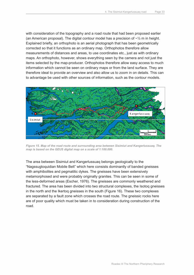
4.1. GEOLOGICAL ANd GEOGRAPHICAL OVERVIEWFigure 15 presents and overview of the area in which the road is planned. The map is based on a GEuS digital map on a scale of 1:100,000. The planned route is indicated by a red line on the map. In addition to this there are hiking maps on the same scale published by Scankort (3 map sheets: Sisimiut, Pingu og Kangerlussuaq), as well as maps on a scale of 1:250.000 published by Saga maps. The entire stretch was photographed from the air by Scankort in 2003, who produced orthophotos and a digital contoured model, with a width of several kilometres, for the complete planned route for the road. A total of 386 pictures were taken. The flight altitude was such that a width of ~2300 meters was covered at a scale of 1:10,000. The flight path was selected
4. The Sisimiut-Kangerlussuaq road
Roadex III The Northern Pheriphery Research
Page 33
with consideration of the topography and a road route that had been proposed earlier (an American proposal). The digital contour model has a precision of ~½ m in height. Explained briefly, an orthophoto is an aerial photograph that has been geometrically corrected so that it functions as an ordinary map. Orthophotos therefore allow measurements of distances and areas, to use coordinates etc., just as with ordinary maps. An orthophoto, however, shows everything seen by the camera and not just the items selected by the map-producer. Orthophotos therefore allow easy access to much information which cannot be seen on ordinary maps or from the land surface. They are therefore ideal to provide an overview and also allow us to zoom in on details. This can to advantage be used with other sources of information, such as the contour models.
K a nge r lus s ua q
S is im iut
Figure 15. Map of the road route and surrounding area between Sisimiut and Kangerlussuaq. The map is based on the GEUS digital map on a scale of 1:100.000.
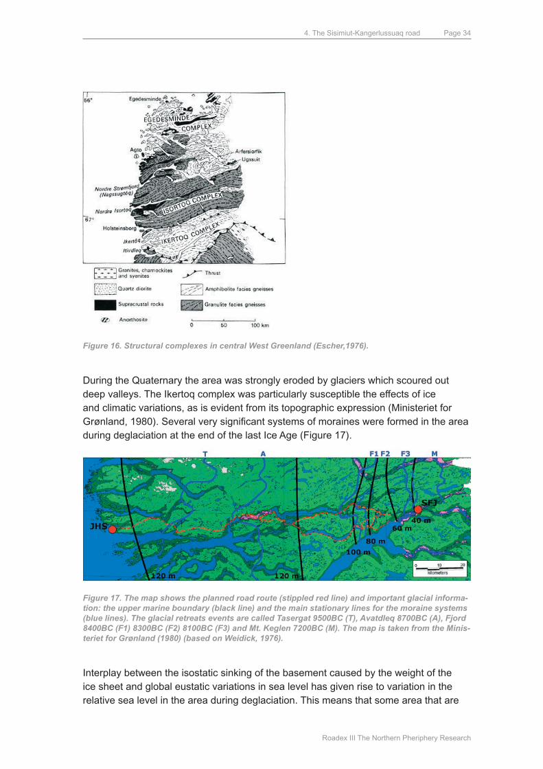
The area between Sisimiut and Kangerlussuaq belongs geologically to the “Nagssugtoquidian mobile Belt” which here consists dominantly of banded gneisses with amphibolites and pegmatitic dykes. The gneisses have been extensively metamorphosed and were probably originally granites. This can be seen in some of the less-deformed areas (Escher, 1976). The gneisses are commonly weathered and fractured. The area has been divided into two structural complexes, the Isotoq gneisses in the north and the Ikertoq gneisses in the south (Figure 16). These two complexes are separated by a fault zone which crosses the road route. The gneissic rocks here are of poor quality which must be taken in to consideration during construction of the road.
4. The Sisimiut-Kangerlussuaq road
Roadex III The Northern Pheriphery Research
Page 34
Figure 16. Structural complexes in central West Greenland (Escher,1976).
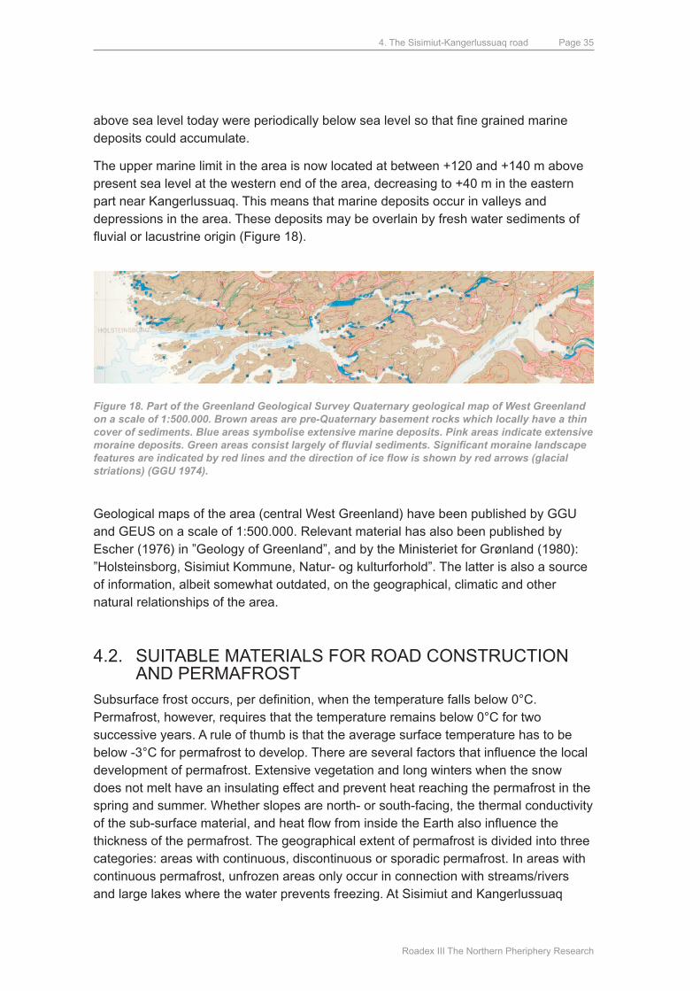
during the quaternary the area was strongly eroded by glaciers which scoured out deep valleys. The Ikertoq complex was particularly susceptible the effects of ice and climatic variations, as is evident from its topographic expression (ministeriet for Grønland, 1980). Several very significant systems of moraines were formed in the area during deglaciation at the end of the last Ice Age (Figure 17).
Figure 17. The map shows the planned road route (stippled red line) and important glacial informa-tion: the upper marine boundary (black line) and the main stationary lines for the moraine systems (blue lines). The glacial retreats events are called Tasergat 9500BC (T), Avatdleq 8700BC (A), Fjord 8400BC (F1) 8300BC (F2) 8100BC (F3) and Mt. Keglen 7200BC (M). The map is taken from the Minis-teriet for Grønland (1980) (based on Weidick, 1976).
Interplay between the isostatic sinking of the basement caused by the weight of the ice sheet and global eustatic variations in sea level has given rise to variation in the relative sea level in the area during deglaciation. This means that some area that are
4. The Sisimiut-Kangerlussuaq road
Roadex III The Northern Pheriphery Research
Page 35
above sea level today were periodically below sea level so that fine grained marine deposits could accumulate.
The upper marine limit in the area is now located at between +120 and +140 m above present sea level at the western end of the area, decreasing to +40 m in the eastern part near Kangerlussuaq. This means that marine deposits occur in valleys and depressions in the area. These deposits may be overlain by fresh water sediments of fluvial or lacustrine origin (Figure 18).
Figure 18. Part of the Greenland Geological Survey Quaternary geological map of West Greenland on a scale of 1:500.000. Brown areas are pre-Quaternary basement rocks which locally have a thin cover of sediments. Blue areas symbolise extensive marine deposits. Pink areas indicate extensive moraine deposits. Green areas consist largely of fluvial sediments. Significant moraine landscape features are indicated by red lines and the direction of ice flow is shown by red arrows (glacial striations) (GGU 1974).
Geological maps of the area (central West Greenland) have been published by GGu and GEuS on a scale of 1:500.000. Relevant material has also been published by Escher (1976) in ”Geology of Greenland”, and by the ministeriet for Grønland (1980): ”Holsteinsborg, Sisimiut Kommune, Natur- og kulturforhold”. The latter is also a source of information, albeit somewhat outdated, on the geographical, climatic and other natural relationships of the area.
4.2. SuITABLE mATERIALS FOR ROAd CONSTRuCTION ANd PERmAFROST
Subsurface frost occurs, per definition, when the temperature falls below 0°C. Permafrost, however, requires that the temperature remains below 0°C for two successive years. A rule of thumb is that the average surface temperature has to be below -3°C for permafrost to develop. There are several factors that influence the local development of permafrost. Extensive vegetation and long winters when the snow does not melt have an insulating effect and prevent heat reaching the permafrost in the spring and summer. Whether slopes are north- or south-facing, the thermal conductivity of the sub-surface material, and heat flow from inside the Earth also influence the thickness of the permafrost. The geographical extent of permafrost is divided into three categories: areas with continuous, discontinuous or sporadic permafrost. In areas with continuous permafrost, unfrozen areas only occur in connection with streams/rivers and large lakes where the water prevents freezing. At Sisimiut and Kangerlussuaq
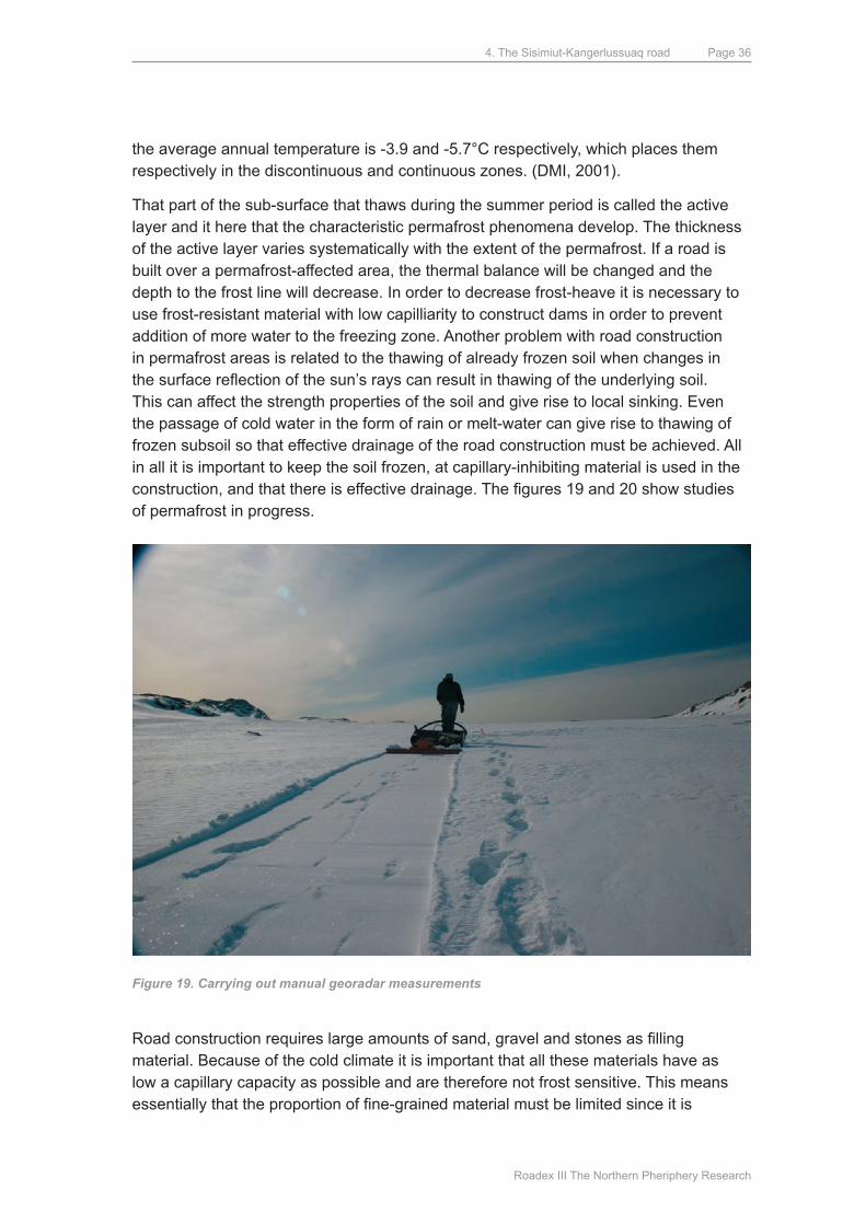
4. The Sisimiut-Kangerlussuaq road
Roadex III The Northern Pheriphery Research
Page 36
the average annual temperature is -3.9 and -5.7°C respectively, which places them respectively in the discontinuous and continuous zones. (dmI, 2001).
That part of the sub-surface that thaws during the summer period is called the active layer and it here that the characteristic permafrost phenomena develop. The thickness of the active layer varies systematically with the extent of the permafrost. If a road is built over a permafrost-affected area, the thermal balance will be changed and the depth to the frost line will decrease. In order to decrease frost-heave it is necessary to use frost-resistant material with low capilliarity to construct dams in order to prevent addition of more water to the freezing zone. Another problem with road construction in permafrost areas is related to the thawing of already frozen soil when changes in the surface reflection of the sun’s rays can result in thawing of the underlying soil. This can affect the strength properties of the soil and give rise to local sinking. Even the passage of cold water in the form of rain or melt-water can give rise to thawing of frozen subsoil so that effective drainage of the road construction must be achieved. All in all it is important to keep the soil frozen, at capillary-inhibiting material is used in the construction, and that there is effective drainage. The figures 19 and 20 show studies of permafrost in progress.
Figure 19. Carrying out manual georadar measurements
Road construction requires large amounts of sand, gravel and stones as filling material. Because of the cold climate it is important that all these materials have as low a capillary capacity as possible and are therefore not frost sensitive. This means essentially that the proportion of fine-grained material must be limited since it is
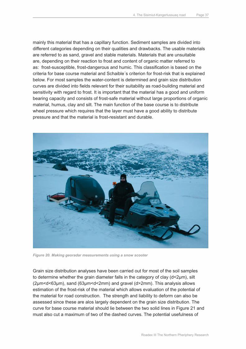
4. The Sisimiut-Kangerlussuaq road
Roadex III The Northern Pheriphery Research
Page 37
mainly this material that has a capillary function. Sediment samples are divided into different categories depending on their qualities and drawbacks. The usable materials are referred to as sand, gravel and stable materials. materials that are unsuitable are, depending on their reaction to frost and content of organic matter referred to as: frost-susceptible, frost-dangerous and humic. This classification is based on the criteria for base course material and Schaible´s criterion for frost-risk that is explained below. For most samples the water-content is determined and grain size distribution curves are divided into fields relevant for their suitability as road-building material and sensitivity with regard to frost. It is important that the material has a good and uniform bearing capacity and consists of frost-safe material without large proportions of organic material, humus, clay and silt. The main function of the base course is to distribute wheel pressure which requires that the layer must have a good ability to distribute pressure and that the material is frost-resistant and durable.
Figure 20. Making georadar measurements using a snow scooter
Grain size distribution analyses have been carried out for most of the soil samples to determine whether the grain diameter falls in the category of clay (d<2µm), silt (2µm<d<63µm), sand (63µm<d<2mm) and gravel (d>2mm). This analysis allows estimation of the frost-risk of the material which allows evaluation of the potential of the material for road construction. The strength and liability to deform can also be assessed since these are alos largely dependent on the grain size distribution. The curve for base course material should lie between the two solid lines in Figure 21 and must also cut a maximum of two of the dashed curves. The potential usefulness of
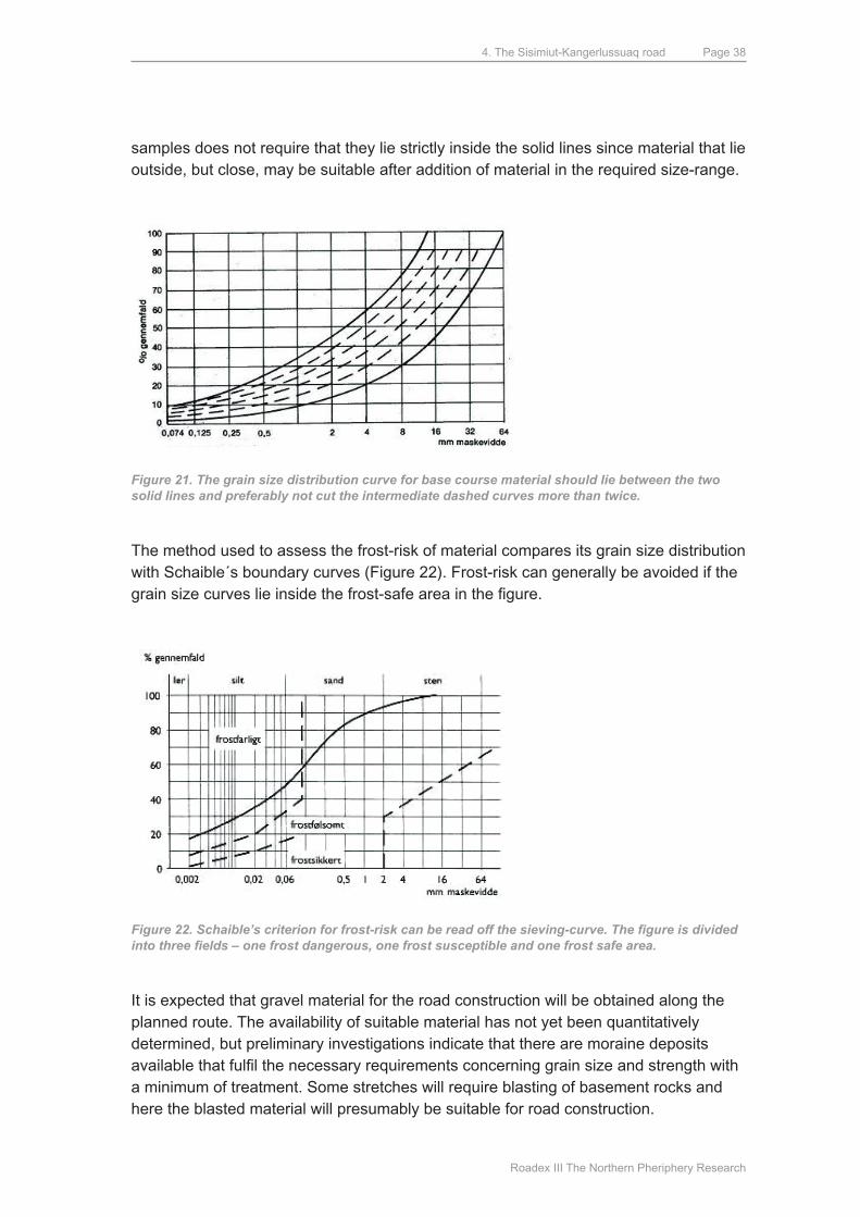
4. The Sisimiut-Kangerlussuaq road
Roadex III The Northern Pheriphery Research
Page 38
samples does not require that they lie strictly inside the solid lines since material that lie outside, but close, may be suitable after addition of material in the required size-range.
Figure 21. The grain size distribution curve for base course material should lie between the two solid lines and preferably not cut the intermediate dashed curves more than twice.
The method used to assess the frost-risk of material compares its grain size distribution with Schaible´s boundary curves (Figure 22). Frost-risk can generally be avoided if the grain size curves lie inside the frost-safe area in the figure.
Figure 22. Schaible’s criterion for frost-risk can be read off the sieving-curve. The figure is divided into three fields – one frost dangerous, one frost susceptible and one frost safe area.
It is expected that gravel material for the road construction will be obtained along the planned route. The availability of suitable material has not yet been quantitatively determined, but preliminary investigations indicate that there are moraine deposits available that fulfil the necessary requirements concerning grain size and strength with a minimum of treatment. Some stretches will require blasting of basement rocks and here the blasted material will presumably be suitable for road construction.
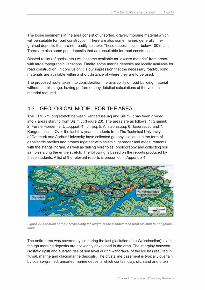
4. The Sisimiut-Kangerlussuaq road
Roadex III The Northern Pheriphery Research
Page 39
The loose sediments in the area consist of unsorted, gravely moraine material which will be suitable for road construction. There are also some marine, generally fine-grained deposits that are not readily suitable. These deposits occur below 100 m a.s.l. There are also some peat deposits that are unsuitable for road construction.
Blasted rocks (of gneiss etc.) will become available as “excess material” from areas with large topographic variations. Finally, some marine deposits are locally available for road construction. In conclusion it is our impression that the necessary road-building materials are available within a short distance of where they are to be used.
The proposed route takes into consideration the availability of road-building material without, at this stage, having performed any detailed calculations of the volume material required.
4.3. GEOLOGICAL mOdEL FOR THE AREAThe ~170 km long stretch between Kangerlussuaq and Sisimiut has been divided into 7 areas starting from Sisimiut (Figure 23). The areas are as follows: 1: Sisimiut, 2: Første Fjorden, 3: uttoqqaat, 4: Itinneq, 5: Amitsorssuaq, 6: Taserssuaq and 7: Kangerlussuaq. Over the last few years, students from The Technical university of denmark and Aarhus university have collected geophysical data in the form of geoelectric profiles and probes together with seismic, georadar and measurements with the stangslingram, as well as drilling boreholes, photography and collecting soil samples along the entire stretch. The following is based on the reports produced by these students. A list of the relevant reports is presented in Appendix 4.
Figure 23. Location of the 7 areas along the length of the planned road from Sisimiut to Kangerlus-suaq.
The entire area was covered by ice during the last glaciation (late Weischselian), even though moraine deposits are not widely developed in the area. The interplay between isostatic uplift and eustatic rise of sea level during withdrawal of the ice has resulted in fluvial, marine and glaciomarine deposits. The crystalline basement is typically overlain by coarse-grained, unsorted marine deposits which contain clay, silt, sand and often
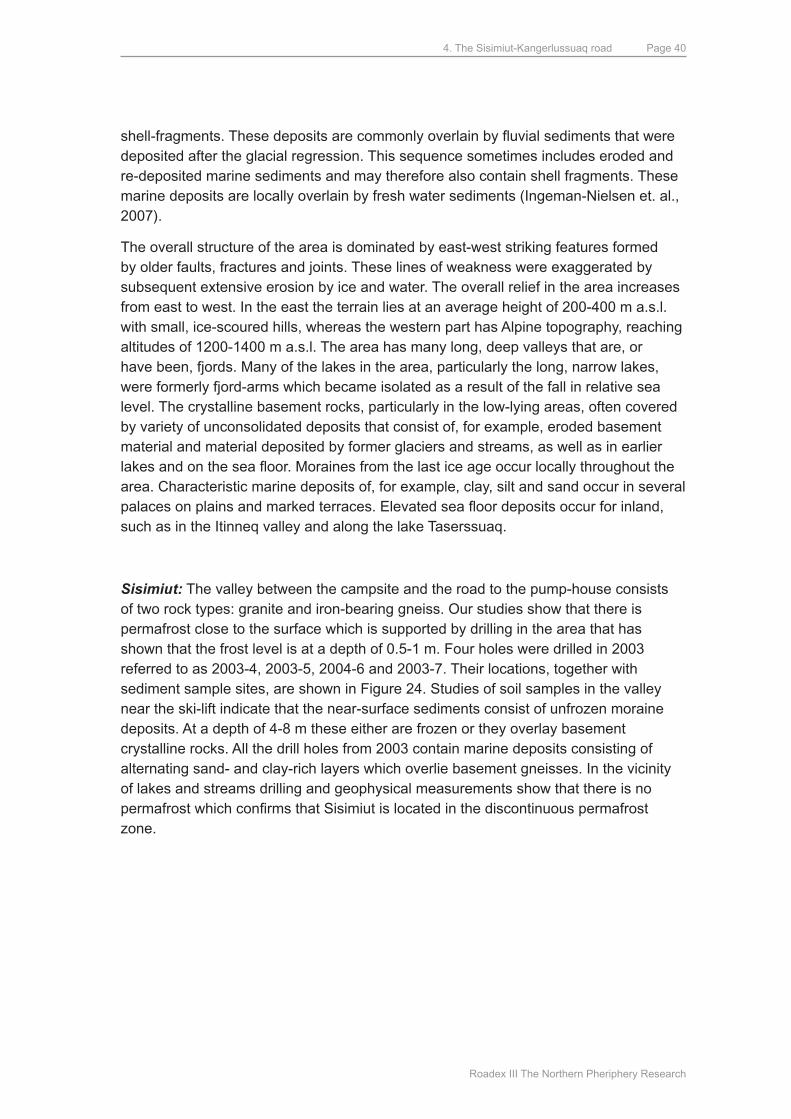
4. The Sisimiut-Kangerlussuaq road
Roadex III The Northern Pheriphery Research
Page 40
shell-fragments. These deposits are commonly overlain by fluvial sediments that were deposited after the glacial regression. This sequence sometimes includes eroded and re-deposited marine sediments and may therefore also contain shell fragments. These marine deposits are locally overlain by fresh water sediments (Ingeman-Nielsen et. al., 2007).
The overall structure of the area is dominated by east-west striking features formed by older faults, fractures and joints. These lines of weakness were exaggerated by subsequent extensive erosion by ice and water. The overall relief in the area increases from east to west. In the east the terrain lies at an average height of 200-400 m a.s.l. with small, ice-scoured hills, whereas the western part has Alpine topography, reaching altitudes of 1200-1400 m a.s.l. The area has many long, deep valleys that are, or have been, fjords. many of the lakes in the area, particularly the long, narrow lakes, were formerly fjord-arms which became isolated as a result of the fall in relative sea level. The crystalline basement rocks, particularly in the low-lying areas, often covered by variety of unconsolidated deposits that consist of, for example, eroded basement material and material deposited by former glaciers and streams, as well as in earlier lakes and on the sea floor. Moraines from the last ice age occur locally throughout the area. Characteristic marine deposits of, for example, clay, silt and sand occur in several palaces on plains and marked terraces. Elevated sea floor deposits occur for inland, such as in the Itinneq valley and along the lake Taserssuaq.
Sisimiut: The valley between the campsite and the road to the pump-house consists of two rock types: granite and iron-bearing gneiss. Our studies show that there is permafrost close to the surface which is supported by drilling in the area that has shown that the frost level is at a depth of 0.5-1 m. Four holes were drilled in 2003 referred to as 2003-4, 2003-5, 2004-6 and 2003-7. Their locations, together with sediment sample sites, are shown in Figure 24. Studies of soil samples in the valley near the ski-lift indicate that the near-surface sediments consist of unfrozen moraine deposits. At a depth of 4-8 m these either are frozen or they overlay basement crystalline rocks. All the drill holes from 2003 contain marine deposits consisting of alternating sand- and clay-rich layers which overlie basement gneisses. In the vicinity of lakes and streams drilling and geophysical measurements show that there is no permafrost which confirms that Sisimiut is located in the discontinuous permafrost zone.
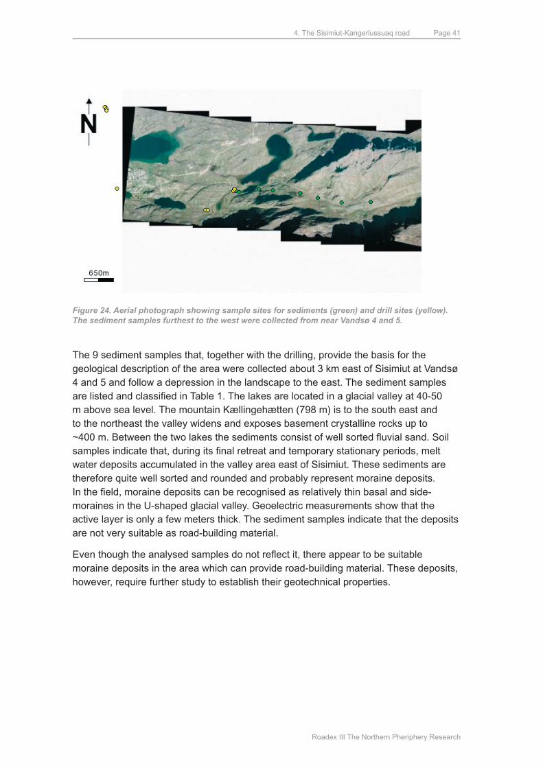
4. The Sisimiut-Kangerlussuaq road
Roadex III The Northern Pheriphery Research
Page 41
Figure 24. Aerial photograph showing sample sites for sediments (green) and drill sites (yellow). The sediment samples furthest to the west were collected from near Vandsø 4 and 5.
The 9 sediment samples that, together with the drilling, provide the basis for the geological description of the area were collected about 3 km east of Sisimiut at Vandsø 4 and 5 and follow a depression in the landscape to the east. The sediment samples are listed and classified in Table 1. The lakes are located in a glacial valley at 40-50 m above sea level. The mountain Kællingehætten (798 m) is to the south east and to the northeast the valley widens and exposes basement crystalline rocks up to ~400 m. Between the two lakes the sediments consist of well sorted fluvial sand. Soil samples indicate that, during its final retreat and temporary stationary periods, melt water deposits accumulated in the valley area east of Sisimiut. These sediments are therefore quite well sorted and rounded and probably represent moraine deposits. In the field, moraine deposits can be recognised as relatively thin basal and side-moraines in the u-shaped glacial valley. Geoelectric measurements show that the active layer is only a few meters thick. The sediment samples indicate that the deposits are not very suitable as road-building material.
Even though the analysed samples do not reflect it, there appear to be suitable moraine deposits in the area which can provide road-building material. These deposits, however, require further study to establish their geotechnical properties.
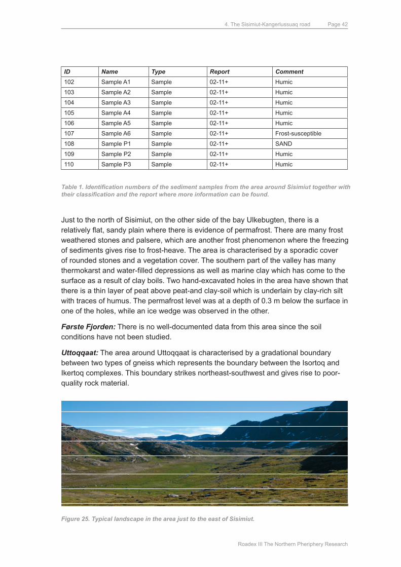
4. The Sisimiut-Kangerlussuaq road
Roadex III The Northern Pheriphery Research
Page 42
ID Name Type Report Comment
102 Sample A1 Sample 02-11+ Humic
103 Sample A2 Sample 02-11+ Humic
104 Sample A3 Sample 02-11+ Humic
105 Sample A4 Sample 02-11+ Humic
106 Sample A5 Sample 02-11+ Humic
107 Sample A6 Sample 02-11+ Frost-susceptible
108 Sample P1 Sample 02-11+ SANd
109 Sample P2 Sample 02-11+ Humic
110 Sample P3 Sample 02-11+ Humic
Table 1. Identification numbers of the sediment samples from the area around Sisimiut together with their classification and the report where more information can be found.
Just to the north of Sisimiut, on the other side of the bay ulkebugten, there is a relatively flat, sandy plain where there is evidence of permafrost. There are many frost weathered stones and palsere, which are another frost phenomenon where the freezing of sediments gives rise to frost-heave. The area is characterised by a sporadic cover of rounded stones and a vegetation cover. The southern part of the valley has many thermokarst and water-filled depressions as well as marine clay which has come to the surface as a result of clay boils. Two hand-excavated holes in the area have shown that there is a thin layer of peat above peat-and clay-soil which is underlain by clay-rich silt with traces of humus. The permafrost level was at a depth of 0.3 m below the surface in one of the holes, while an ice wedge was observed in the other.
Første Fjorden: There is no well-documented data from this area since the soil conditions have not been studied.
Uttoqqaat: The area around uttoqqaat is characterised by a gradational boundary between two types of gneiss which represents the boundary between the Isortoq and Ikertoq complexes. This boundary strikes northeast-southwest and gives rise to poor-quality rock material.
Figure 25. Typical landscape in the area just to the east of Sisimiut.
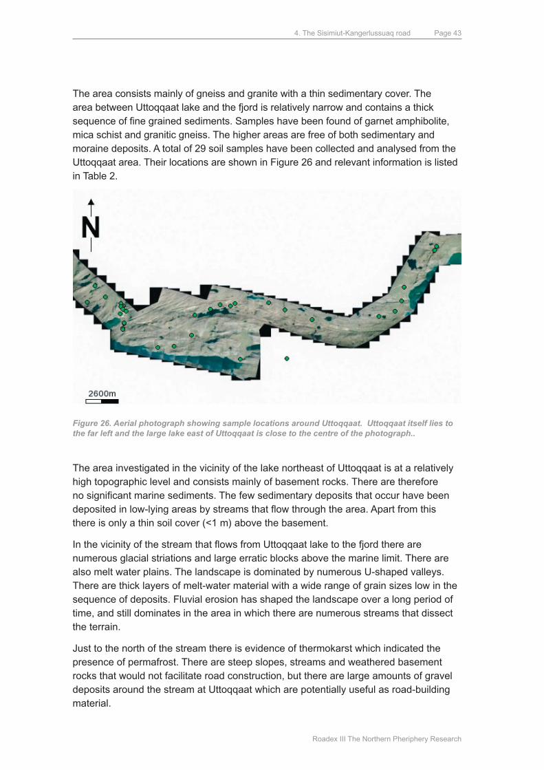
4. The Sisimiut-Kangerlussuaq road
Roadex III The Northern Pheriphery Research
Page 43
The area consists mainly of gneiss and granite with a thin sedimentary cover. The area between uttoqqaat lake and the fjord is relatively narrow and contains a thick sequence of fine grained sediments. Samples have been found of garnet amphibolite, mica schist and granitic gneiss. The higher areas are free of both sedimentary and moraine deposits. A total of 29 soil samples have been collected and analysed from the uttoqqaat area. Their locations are shown in Figure 26 and relevant information is listed in Table 2.
Figure 26. Aerial photograph showing sample locations around Uttoqqaat. Uttoqqaat itself lies to the far left and the large lake east of Uttoqqaat is close to the centre of the photograph..
The area investigated in the vicinity of the lake northeast of uttoqqaat is at a relatively high topographic level and consists mainly of basement rocks. There are therefore no significant marine sediments. The few sedimentary deposits that occur have been deposited in low-lying areas by streams that flow through the area. Apart from this there is only a thin soil cover (<1 m) above the basement.
In the vicinity of the stream that flows from Uttoqqaat lake to the fjord there are numerous glacial striations and large erratic blocks above the marine limit. There are also melt water plains. The landscape is dominated by numerous u-shaped valleys. There are thick layers of melt-water material with a wide range of grain sizes low in the sequence of deposits. Fluvial erosion has shaped the landscape over a long period of time, and still dominates in the area in which there are numerous streams that dissect the terrain.
Just to the north of the stream there is evidence of thermokarst which indicated the presence of permafrost. There are steep slopes, streams and weathered basement rocks that would not facilitate road construction, but there are large amounts of gravel deposits around the stream at uttoqqaat which are potentially useful as road-building material.
4. The Sisimiut-Kangerlussuaq road
Roadex III The Northern Pheriphery Research
Page 44
ID Name Type Report Comment
111 Sample u1-427 Sample 02-11+ Humic
112 Sample u2-429 Sample 02-11+ Humic
113 Sample u3-433 Sample 02-11+ Humic
114 Sample u4-439 Sample 02-11+ Frost-susceptible
115 Sample u5-440 Sample 02-11+ SANd
116 Sample u6-447 Sample 02-11+ Frost-susceptible
117 Sample u7-451 Sample 02-11+ SANd
118 Sample u8-452 Sample 02-11+ Frost-susceptible
119 Sample u9-468 Sample 02-11+ Humic
120 Sample u10-469 Sample 02-11+ GRAVEL
121 Sample u11-471 Sample 02-11+ GRAVEL
543 Sample WP003 Sample 06-mar maybe STABLE mATERIAL
544 Sample WP018 Sample 06-mar Weathered crystalline basement
545 Sample WP026 Sample 06-mar Crystalline basement
546 Sample WP033 Sample 06-mar STABLE mATERIAL
547 Sample WP037 Sample 06-mar Frost-susceptible
548 Sample WP071 Sample 06-mar Crystalline basement
549 Sample WP090 Sample 06-mar Crystalline basement
550 Sample WP107 Sample 06-mar SANd
781 Sample u2-4 Sample 03-may STABLE mATERIAL
783 Sample u2-5 Sample 03-may SANd
784 Sample u2-1 Sample 03-may SANd
785 Sample u2-2 Sample 03-may STABLE mATERIAL
786 Sample u2-3 Sample 03-may SANd
787 Sample u3 Sample 03-may STABLE mATERIAL
788 Sample u4 Sample 03-may STABLE mATERIAL
789 Sample u5 Sample 03-may STABLE mATERIAL
791 Sample u1 Sample 03-may Frost-susceptible
793 Sample u2 Sample 03-may STABLE mATERIAL
Table 2. Identification numbers of the sediment samples from the area around Uttoqqaat together with their classification and the report where more information can be found.
Itinneq: Geophysical and geotechnical studies have been carried out at Itinneq in the form of seismic and geoelectric investigations, in addition to the collection of soil samples and photographic reconnaissance of the delta. Itinneq consists of a large sedimentary complex with both fluvial and marine deposits. The figure below shows the route along which samples have been collected.
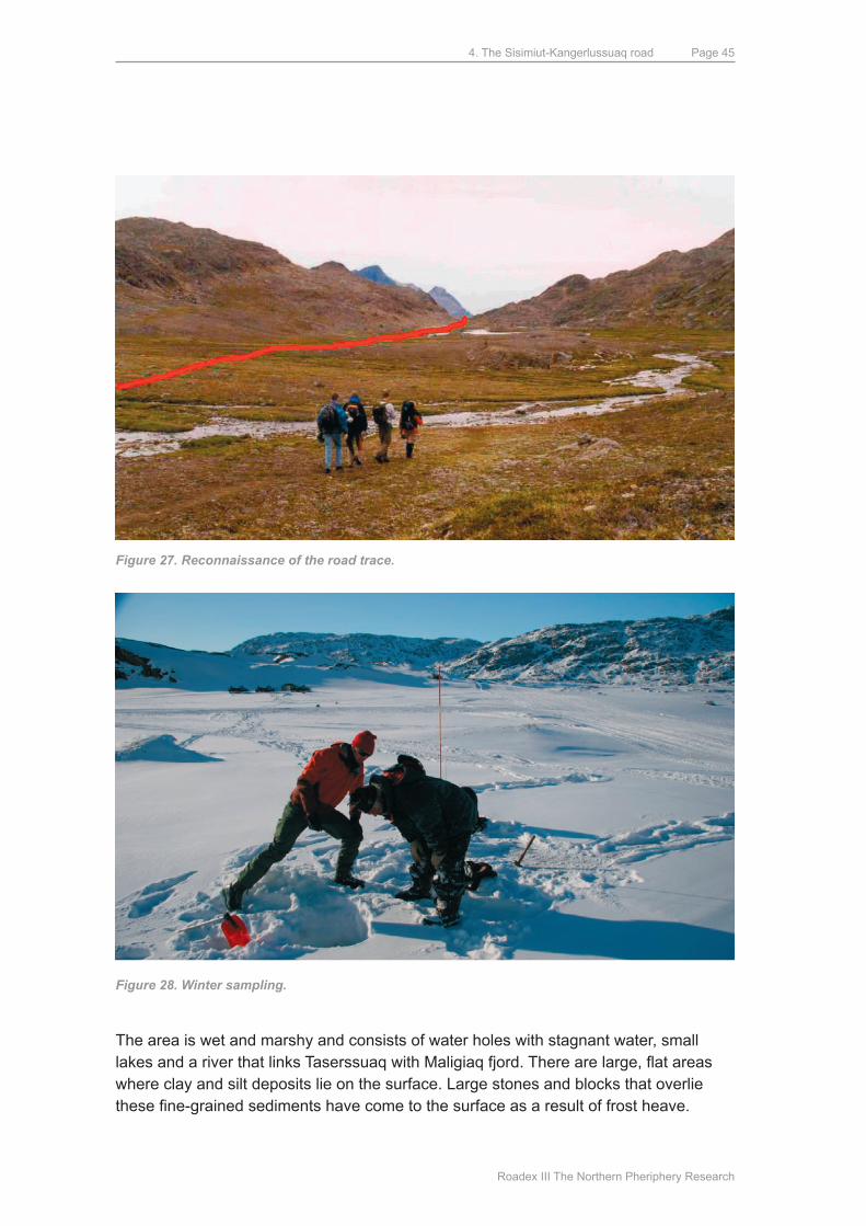
4. The Sisimiut-Kangerlussuaq road
Roadex III The Northern Pheriphery Research
Page 45
Figure 27. Reconnaissance of the road trace.
Figure 28. Winter sampling.
The area is wet and marshy and consists of water holes with stagnant water, small lakes and a river that links Taserssuaq with Maligiaq fjord. There are large, flat areas where clay and silt deposits lie on the surface. Large stones and blocks that overlie these fine-grained sediments have come to the surface as a result of frost heave.
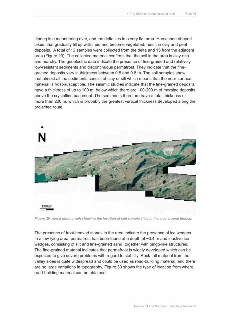
4. The Sisimiut-Kangerlussuaq road
Roadex III The Northern Pheriphery Research
Page 46
Itinneq is a meandering river, and the delta lies in a very flat area. Horseshoe-shaped lakes, that gradually fill up with mud and become vegetated, result in clay and peat deposits. A total of 12 samples were collected from the delta and 15 from the adjacent area (Figure 29). The collected material confirms that the soil in the area is clay-rich and marshy. The geoelectric data indicate the presence of fine-grained and relatively low-resistant sediments and discontinuous permafrost. They indicate that the fine-grained deposits vary in thickness between 0.5 and 0.8 m. The soil samples show that almost all the sediments consist of clay or silt which means that the near-surface material is frost-susceptible. The seismic studies indicate that the fine-grained deposits have a thickness of up to 100 m, below which there are 100-200 m of moraine deposits above the crystalline basement. The sediments therefore have a total thickness of more than 200 m, which is probably the greatest vertical thickness developed along the projected route.
Figure 29. Aerial photograph showing the location of soil sample sites in the area around Itinneq.
The presence of frost-heaved stones in the area indicate the presence of ice wedges. In a low-lying area, permafrost has been found at a depth of ~0.4 m and inactive ice wedges, consisting of silt and fine-grained sand, together with pingo-like structures. The fine-grained material indicates that permafrost is widely developed which can be expected to give severe problems with regard to stability. Rock-fall material from the valley sides is quite widespread and could be used as road-building material, and there are no large variations in topography. Figure 30 shows the type of location from where road-building material can be obtained.
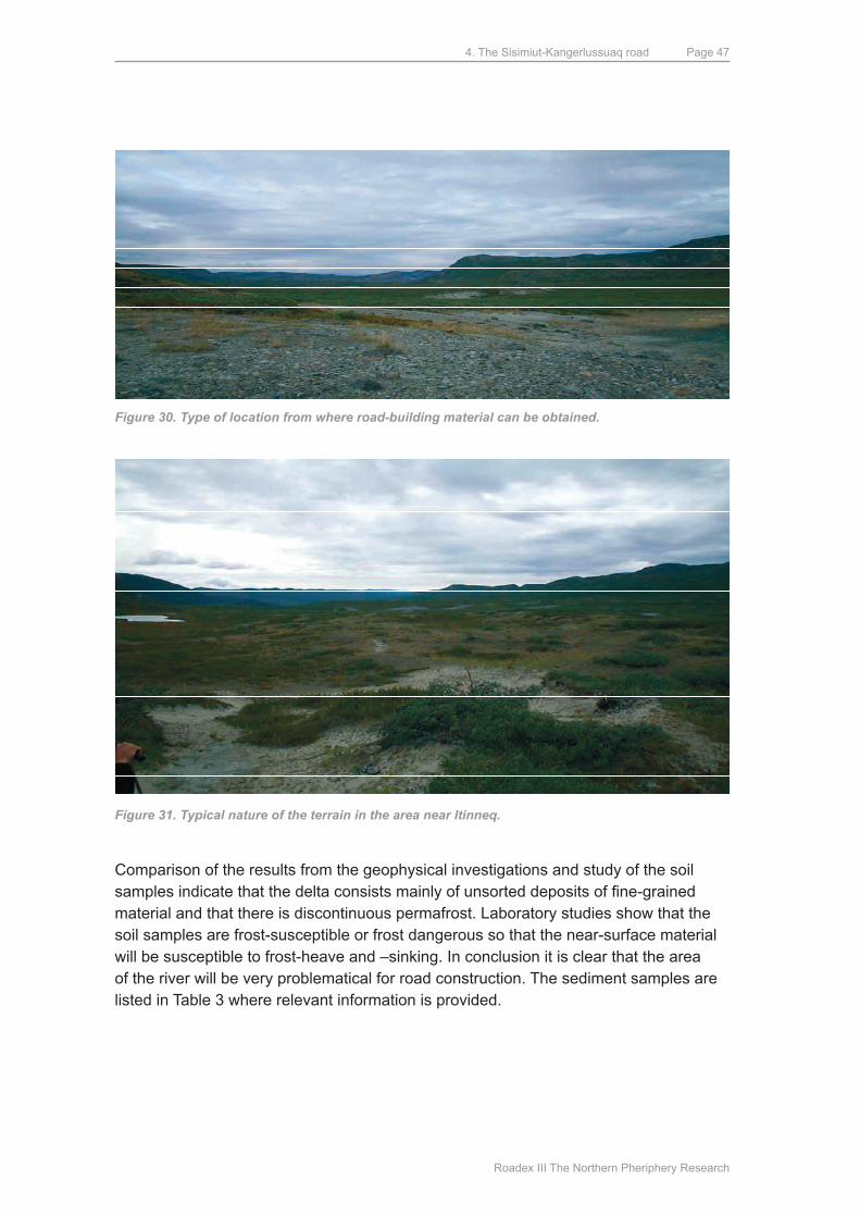
4. The Sisimiut-Kangerlussuaq road
Roadex III The Northern Pheriphery Research
Page 47
Figure 30. Type of location from where road-building material can be obtained.
Figure 31. Typical nature of the terrain in the area near Itinneq.
Comparison of the results from the geophysical investigations and study of the soil samples indicate that the delta consists mainly of unsorted deposits of fine-grained material and that there is discontinuous permafrost. Laboratory studies show that the soil samples are frost-susceptible or frost dangerous so that the near-surface material will be susceptible to frost-heave and –sinking. In conclusion it is clear that the area of the river will be very problematical for road construction. The sediment samples are listed in Table 3 where relevant information is provided.
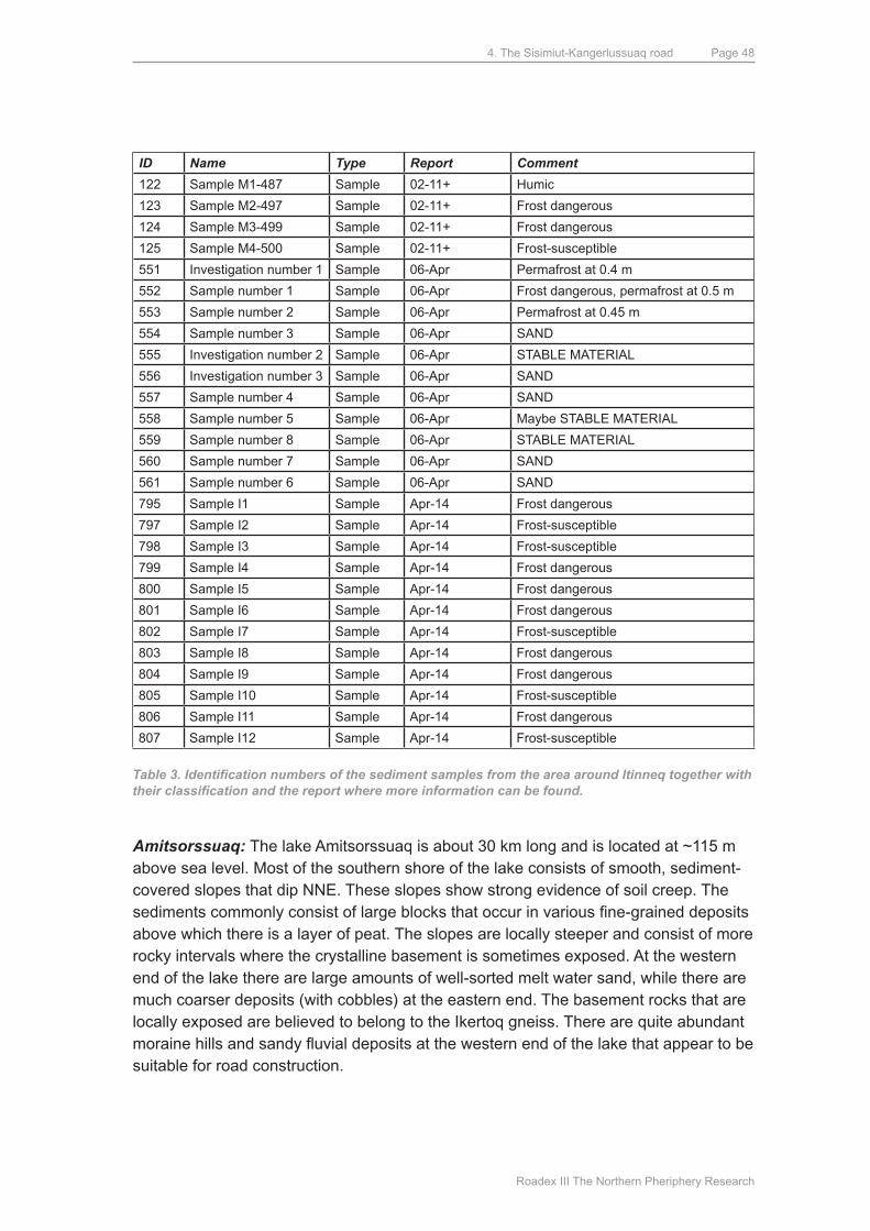
4. The Sisimiut-Kangerlussuaq road
Roadex III The Northern Pheriphery Research
Page 48
ID Name Type Report Comment
122 Sample m1-487 Sample 02-11+ Humic
123 Sample m2-497 Sample 02-11+ Frost dangerous
124 Sample m3-499 Sample 02-11+ Frost dangerous
125 Sample m4-500 Sample 02-11+ Frost-susceptible
551 Investigation number 1 Sample 06-Apr Permafrost at 0.4 m
552 Sample number 1 Sample 06-Apr Frost dangerous, permafrost at 0.5 m
553 Sample number 2 Sample 06-Apr Permafrost at 0.45 m
554 Sample number 3 Sample 06-Apr SANd
555 Investigation number 2 Sample 06-Apr STABLE mATERIAL
556 Investigation number 3 Sample 06-Apr SANd
557 Sample number 4 Sample 06-Apr SANd
558 Sample number 5 Sample 06-Apr maybe STABLE mATERIAL
559 Sample number 8 Sample 06-Apr STABLE mATERIAL
560 Sample number 7 Sample 06-Apr SANd
561 Sample number 6 Sample 06-Apr SANd
795 Sample I1 Sample Apr-14 Frost dangerous
797 Sample I2 Sample Apr-14 Frost-susceptible
798 Sample I3 Sample Apr-14 Frost-susceptible
799 Sample I4 Sample Apr-14 Frost dangerous
800 Sample I5 Sample Apr-14 Frost dangerous
801 Sample I6 Sample Apr-14 Frost dangerous
802 Sample I7 Sample Apr-14 Frost-susceptible
803 Sample I8 Sample Apr-14 Frost dangerous
804 Sample I9 Sample Apr-14 Frost dangerous
805 Sample I10 Sample Apr-14 Frost-susceptible
806 Sample I11 Sample Apr-14 Frost dangerous
807 Sample I12 Sample Apr-14 Frost-susceptible
Table 3. Identification numbers of the sediment samples from the area around Itinneq together with their classification and the report where more information can be found.
Amitsorssuaq: The lake Amitsorssuaq is about 30 km long and is located at ~115 m above sea level. most of the southern shore of the lake consists of smooth, sediment-covered slopes that dip NNE. These slopes show strong evidence of soil creep. The sediments commonly consist of large blocks that occur in various fine-grained deposits above which there is a layer of peat. The slopes are locally steeper and consist of more rocky intervals where the crystalline basement is sometimes exposed. At the western end of the lake there are large amounts of well-sorted melt water sand, while there are much coarser deposits (with cobbles) at the eastern end. The basement rocks that are locally exposed are believed to belong to the Ikertoq gneiss. There are quite abundant moraine hills and sandy fluvial deposits at the western end of the lake that appear to be suitable for road construction.
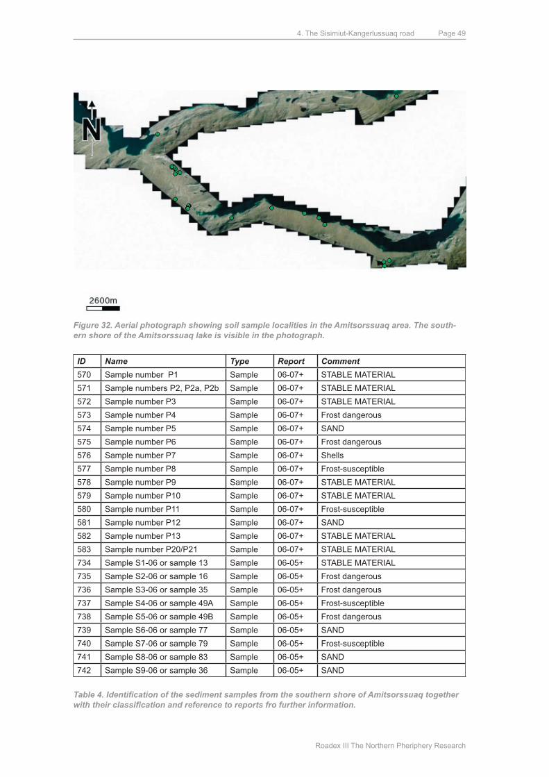
4. The Sisimiut-Kangerlussuaq road
Roadex III The Northern Pheriphery Research
Page 49
Figure 32. Aerial photograph showing soil sample localities in the Amitsorssuaq area. The south-ern shore of the Amitsorssuaq lake is visible in the photograph.
The geoelectric studies show that the sedimentary cover above the basement is a few meters thick. Permafrost is present at a depth of ~2 meters. The occurrence of soil creep on the southern shores of the lake may indicate the presence of ice. A total of 23 soil samples from this area indicate the presence of widespread silty, frost-susceptible and frost dangerous deposits. There are, however, quite extensive moraine deposits that can potentially provide material that can be used for road construction. Locations of the sediment samples can be seen in Figure 32, and relevant information on the samples is listed in Table 4.
ID Name Type Report Comment
570 Sample number P1 Sample 06-07+ STABLE mATERIAL
571 Sample numbers P2, P2a, P2b Sample 06-07+ STABLE mATERIAL
572 Sample number P3 Sample 06-07+ STABLE mATERIAL
573 Sample number P4 Sample 06-07+ Frost dangerous
574 Sample number P5 Sample 06-07+ SANd
575 Sample number P6 Sample 06-07+ Frost dangerous
576 Sample number P7 Sample 06-07+ Shells
577 Sample number P8 Sample 06-07+ Frost-susceptible
578 Sample number P9 Sample 06-07+ STABLE mATERIAL
579 Sample number P10 Sample 06-07+ STABLE mATERIAL
580 Sample number P11 Sample 06-07+ Frost-susceptible
581 Sample number P12 Sample 06-07+ SANd
582 Sample number P13 Sample 06-07+ STABLE mATERIAL
583 Sample number P20/P21 Sample 06-07+ STABLE mATERIAL
734 Sample S1-06 or sample 13 Sample 06-05+ STABLE mATERIAL
735 Sample S2-06 or sample 16 Sample 06-05+ Frost dangerous
736 Sample S3-06 or sample 35 Sample 06-05+ Frost dangerous
737 Sample S4-06 or sample 49A Sample 06-05+ Frost-susceptible
738 Sample S5-06 or sample 49B Sample 06-05+ Frost dangerous
739 Sample S6-06 or sample 77 Sample 06-05+ SANd
740 Sample S7-06 or sample 79 Sample 06-05+ Frost-susceptible
741 Sample S8-06 or sample 83 Sample 06-05+ SANd
742 Sample S9-06 or sample 36 Sample 06-05+ SANd
Table 4. Identification of the sediment samples from the southern shore of Amitsorssuaq together with their classification and reference to reports fro further information.

4. The Sisimiut-Kangerlussuaq road
Roadex III The Northern Pheriphery Research
Page 50
Taserssuaq: The geology in the area reflects a landscape which was formed by the interplay between glacial retreat and isostatic uplift. The area consists of a large, broad valley at ~100 m a.s.l., with basement rocks to the north and south. The area contains mainly silty and fine sandy marine deposits. The marine deposits are well preserved in the slopes down to lakes and waterways. The north-eastern slopes in particular have many locations with marine deposits that have been influenced by permafrost and considerable wind erosion. There are several terraces that represent earlier levels of the sea. There are also inactive ice wedge polygons, and at one locality permafrost was found at a depth of 0.8 m. The area with the polygons is on the valley floor and will often be in the shade because of the cliff to the south (Figure 33). A total of 16 sediment samples have been collected to cover the various types of deposit (Figure 34).
Figure 33. Aerial photograph of area with relict ice wedge polygons.
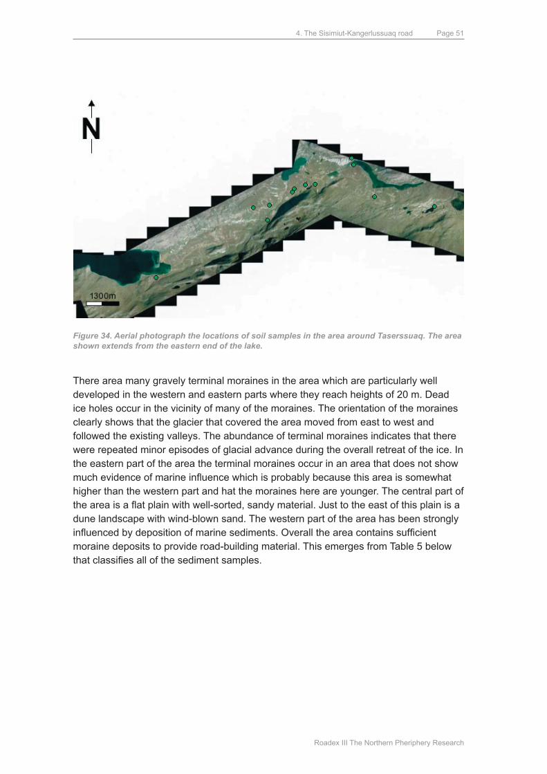
4. The Sisimiut-Kangerlussuaq road
Roadex III The Northern Pheriphery Research
Page 51
Figure 34. Aerial photograph the locations of soil samples in the area around Taserssuaq. The area shown extends from the eastern end of the lake.
There area many gravely terminal moraines in the area which are particularly well developed in the western and eastern parts where they reach heights of 20 m. dead ice holes occur in the vicinity of many of the moraines. The orientation of the moraines clearly shows that the glacier that covered the area moved from east to west and followed the existing valleys. The abundance of terminal moraines indicates that there were repeated minor episodes of glacial advance during the overall retreat of the ice. In the eastern part of the area the terminal moraines occur in an area that does not show much evidence of marine influence which is probably because this area is somewhat higher than the western part and hat the moraines here are younger. The central part of the area is a flat plain with well-sorted, sandy material. Just to the east of this plain is a dune landscape with wind-blown sand. The western part of the area has been strongly influenced by deposition of marine sediments. Overall the area contains sufficient moraine deposits to provide road-building material. This emerges from Table 5 below that classifies all of the sediment samples.
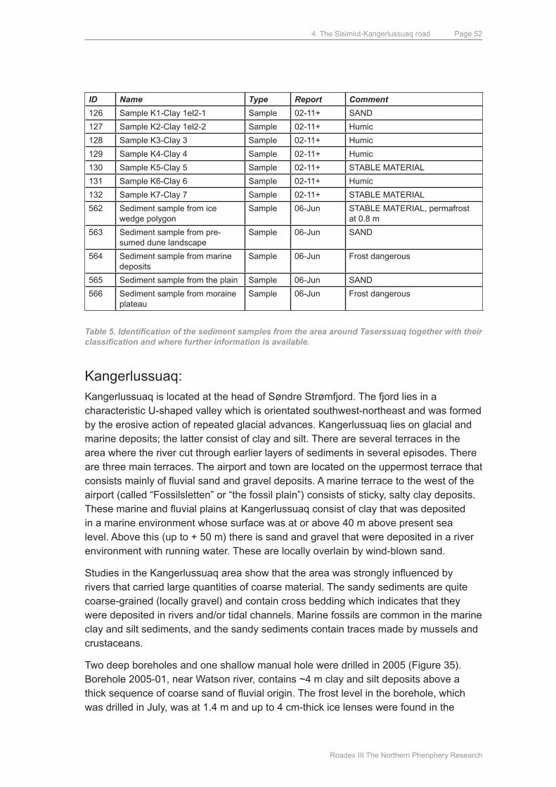
4. The Sisimiut-Kangerlussuaq road
Roadex III The Northern Pheriphery Research
Page 52
ID Name Type Report Comment
126 Sample K1-Clay 1el2-1 Sample 02-11+ SANd
127 Sample K2-Clay 1el2-2 Sample 02-11+ Humic
128 Sample K3-Clay 3 Sample 02-11+ Humic
129 Sample K4-Clay 4 Sample 02-11+ Humic
130 Sample K5-Clay 5 Sample 02-11+ STABLE mATERIAL
131 Sample K6-Clay 6 Sample 02-11+ Humic
132 Sample K7-Clay 7 Sample 02-11+ STABLE mATERIAL
562 Sediment sample from ice wedge polygon
Sample 06-Jun STABLE mATERIAL, permafrost at 0.8 m
563 Sediment sample from pre-sumed dune landscape
Sample 06-Jun SANd
564 Sediment sample from marine deposits
Sample 06-Jun Frost dangerous
565 Sediment sample from the plain Sample 06-Jun SANd
566 Sediment sample from moraine plateau
Sample 06-Jun Frost dangerous
Table 5. Identification of the sediment samples from the area around Taserssuaq together with their classification and where further information is available.
Kangerlussuaq: Kangerlussuaq is located at the head of Søndre Strømfjord. The fjord lies in a characteristic u-shaped valley which is orientated southwest-northeast and was formed by the erosive action of repeated glacial advances. Kangerlussuaq lies on glacial and marine deposits; the latter consist of clay and silt. There are several terraces in the area where the river cut through earlier layers of sediments in several episodes. There are three main terraces. The airport and town are located on the uppermost terrace that consists mainly of fluvial sand and gravel deposits. A marine terrace to the west of the airport (called “Fossilsletten” or “the fossil plain”) consists of sticky, salty clay deposits. These marine and fluvial plains at Kangerlussuaq consist of clay that was deposited in a marine environment whose surface was at or above 40 m above present sea level. Above this (up to + 50 m) there is sand and gravel that were deposited in a river environment with running water. These are locally overlain by wind-blown sand.
Studies in the Kangerlussuaq area show that the area was strongly influenced by rivers that carried large quantities of coarse material. The sandy sediments are quite coarse-grained (locally gravel) and contain cross bedding which indicates that they were deposited in rivers and/or tidal channels. Marine fossils are common in the marine clay and silt sediments, and the sandy sediments contain traces made by mussels and crustaceans.
Two deep boreholes and one shallow manual hole were drilled in 2005 (Figure 35). Borehole 2005-01, near Watson river, contains ~4 m clay and silt deposits above a thick sequence of coarse sand of fluvial origin. The frost level in the borehole, which was drilled in July, was at 1.4 m and up to 4 cm-thick ice lenses were found in the
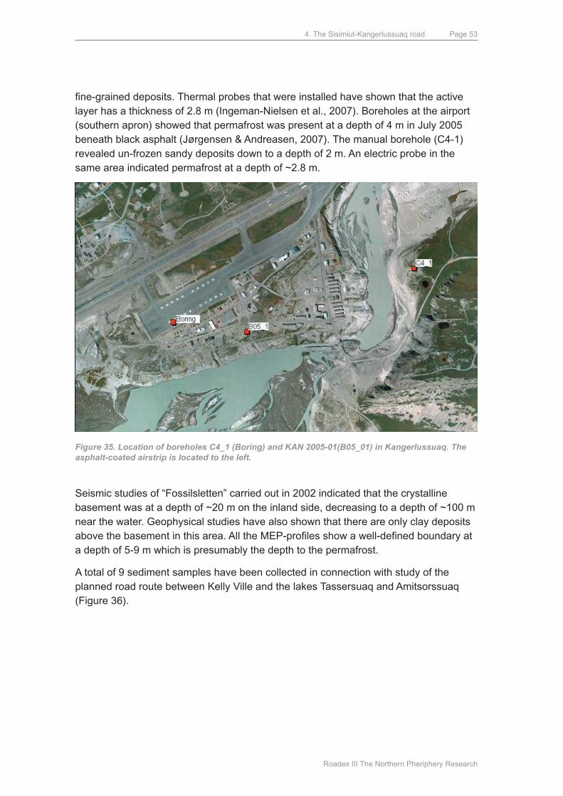
4. The Sisimiut-Kangerlussuaq road
Roadex III The Northern Pheriphery Research
Page 53
fine-grained deposits. Thermal probes that were installed have shown that the active layer has a thickness of 2.8 m (Ingeman-Nielsen et al., 2007). Boreholes at the airport (southern apron) showed that permafrost was present at a depth of 4 m in July 2005 beneath black asphalt (Jørgensen & Andreasen, 2007). The manual borehole (C4-1) revealed un-frozen sandy deposits down to a depth of 2 m. An electric probe in the same area indicated permafrost at a depth of ~2.8 m.
Figure 35. Location of boreholes C4_1 (Boring) and KAN 2005-01(B05_01) in Kangerlussuaq. The asphalt-coated airstrip is located to the left.
Seismic studies of “Fossilsletten” carried out in 2002 indicated that the crystalline basement was at a depth of ~20 m on the inland side, decreasing to a depth of ~100 m near the water. Geophysical studies have also shown that there are only clay deposits above the basement in this area. All the MEP-profiles show a well-defined boundary at a depth of 5-9 m which is presumably the depth to the permafrost.
A total of 9 sediment samples have been collected in connection with study of the planned road route between Kelly Ville and the lakes Tassersuaq and Amitsorssuaq (Figure 36).
4. The Sisimiut-Kangerlussuaq road
Roadex III The Northern Pheriphery Research
Page 54
Figure 36. Aerial photograph showing the locations of soil samples and boreholes in the Kanger-lussuaq area. The sediment samples have been collected west of Kangerlussuaq near Kelly Ville, whereas the boreholes have been drilled in Kangerlussuaq itself.
Most of the sediment samples from the area indicate that it consists of fine- to medium-grained, frost-susceptible material, which can be expected to be subjected to the formation of ice-lenses and frost-heave. In addition to this, the subsurface is soft and marshy (Table 6).
ID Name Type Report Comment
772 Sample 1x Sample 05-Feb Frost-susceptible
773 Sample 2x Sample 05-Feb Frost-susceptible
774 Sample 3x Sample 05-Feb Frost-susceptible
775 Sample 1 Sample 05-Feb Frost-susceptible
776 Sample 3 Sample 05-Feb Frost-susceptible
777 Sample 4 Sample 05-Feb Frost-susceptible
778 Sample 5 Sample 05-Feb Frost-susceptible
779 Sample 6 Sample 05-Feb SANd
780 Sample 9 Sample 05-Feb Frost-susceptible
Table 6. List of sediment samples from the area around Kangerlussuaq and Kelly Ville together with their classification and reference to the reports in which further information is available.
4. The Sisimiut-Kangerlussuaq road
Roadex III The Northern Pheriphery Research
Page 55
4.4. SummARyThe investigations outlined above provide an overview of conditions along the planned road route. Potentially useful, large reserves of road-building material are available at several places along the route. The deposits in uttoqqaat valley (area 3), along the northern flank of Itinneq valley (area 4), and near Amitsorssuaq lake (area 5) are particularly noteworthy. There are also potentially useful deposits in the Sisimiut and Kangerlussuaq areas. The fjords also contain potentially useful material. It is important to note, however, that some stretches of the route do not contain useful material, such as the area between uttoqqaat and maligiaq (area 3) and the mountainous passage between Itinneq valley and Amitsorssuaq valley (southeast part of area 4).
Permafrost is widely developed throughout the area, although to various extents. Areas with fine-grained deposits are particularly likely to give problems in the form of local sinking as a result of the thawing of permafrost. The map in Figure 37 indicates the valley areas that are particularly rich in fine-grained material and may therefore pose a risk. most of these deposits, however, are marine and saline which lowers the freezing point. This considerably reduces the risk of thawing and resulting sinking of the surface, as this material may be considered to be equivalent to areas without permafrost as regards the sinking risk. Problems may still arise, however, in connection with the annual thaw in the spring/summer.
The investigations and analyses have been described in detail in ARTEKs reports available at ftp://artekftp.byg.dtu.dk/rapporter. Most of the investigations are registered in a database that gives an overview of the locality of the area where the investigations were performed. The database gives direct access to sample descriptions, analysis results and the individual reports.
Figure 37. Location of the potentially most problematic areas (marked in red) with frost-susceptible, fine-grained deposits along the road route.
4.5. ENVIRONmENTAL ANd CONSERVATION ASPECTSThe purpose of studying the overall environmental impact of the construction of a road between Sisimiut and Kangerlussuaq is to identify potential problems at an early
4. The Sisimiut-Kangerlussuaq road
Roadex III The Northern Pheriphery Research
Page 56
stage. This will allow necessary modifications to the project to be considered to reduce the environmental consequences. The construction of a road between Sisimiut and Kangerlussuaq will inevitably influence the environment. Kangerlussuaq is an area with hills, valleys, fjords, rivers, lakes, marshes and low vegetation. many areas are used for hunting and other outdoor activities, but most of the area consists of untouched nature. The area around Sisimiut contains many prehistoric remains dating back to the Stone Age. The areas around uttoqqaat and Itinneq, and the eastern parts of the lakes Taserssuaq and Amitsorssuaq, are particularly rich in prehistoric remains related to hunting and fishing. The National Museum of Greenland in Nuuk (NKA) has indicated that there are 12 locations along the length of the planned road that are covered by the Conservation of Nature law. It is very likely that new, small prehistoric sites will be discovered during road construction so that it will be necessary to adjust the route to minimise damage to the sites of archaeological interest as far as is practically possible. It is to be expected that finds will be made, particularly of summer living sites, notably in the vicinity of lakes (Rambøll, 2006), during preliminary studies prior to road construction.
material eroded from a road, or simply run-off from a road surface, may contain contaminants in the form of petrol- and oil-spill, small particles of exhaust material, heavy metals etc. Thawing and heavy rainfall will transport particles to lakes, some of which are used for drinking water. The clay particles are so fine-grained that they are not completely removed by the waterworks. Heavy metals and heavy oil-components will accumulate in the lake sediments. While the amount of contamination caused by construction of a road between Sisimiut and Kangerlussuaq is not expected to be very large, factors that are important for the breakdown and reduction of contaminants are very limited in the arctic environment. Surface water is particularly sensitive to contamination in arctic areas. This is because large amounts of water, containing organically-bound nutrients from marshy and peaty areas, enter the lakes during the springtime thaw. Because of the permafrost and the nature of the underlying basement, transport will primarily be horizontal and components will not seep down into the soil but enter lakes and rivers. Road traffic is also a cause of air pollution in the form of a series of dangerous materials with different environmental effects. There is a clear relationship between pollution of water and soil since the contaminating materials that do not enter the soil are primarily transported by water and therefore often end up in streams, rivers and lakes.
The planned route for the road passes alongside Vandsø 5 which is Sisimiut´s drinking water reservoir. The water comes from precipitation in the catchment area together with melt water from snow that accumulates during the winter. The lake is ice-free for 2½ months during the summer and covered by a ~1 m-thick layer of ice in the winter. This results in a very variable rate of supply of water to the lake through the year. Water supply to the lake, as an average over the year, is estimated to be 90% surface water and 10% groundwater, from a catchment area that covers about 45 km². The lake is supplied by two streams and drained by one that runs into the bay ulkebugten. The lake has a relatively low alkalinity and is therefore very sensitive to small changes in the acid/base ratio. Supply of atmospheric particles is very significant because of the
4. The Sisimiut-Kangerlussuaq road
Roadex III The Northern Pheriphery Research
Page 57
large surface area of the lake. At the end of the lake nearest the ski lift, where snow scooters drive in the winter, human activity has already had a small but measurable effect on the lake.
Construction of a road from Sisimiut to Kangerlussuaq is an ambitious project that will help promote tourism, trade and industry and will improve the global infrastructure in Greenland by provision of a well-organised transport system. From an environmental point of view, the most negative influence will take place during the construction phase in the form of noise, dust, vibrations and the disturbance of fauna and flora. Most of these disturbances will be temporary, but some will have a permanent effect, such as changes to the landscape. The operative phase after completion of the road will have less influence because of the relatively small volume of traffic. The main problem will be water pollution. It will be necessary to carry out further studies of the pollution risks before construction commences, but preliminary data suggest that it will be possible to carry out the road-building project without causing serious environmental damage (Hubert, 2003; Nielsen et al., 2003).
A road connection that involves closure of regular flights between Sisimiut and Kangerlussuaq will involve a slight increase in emissions, but it is the relatively few snow scooters in the area that are largely responsible for emission of CO and THC and are the next-largest source of NOx-emissions . The amount of emissions from traffic will be low compared with most other places in the world because of the low traffic intensity along the road. During both the construction and operational phase, however, particular care must be taken in the vicinity of drinking water reservoirs (at Sisimiut and Sarfannguaq). This is because polluting materials (oil etc.) from vehicles and possible accidents, can severely affect water quality since they only break down slowly in the arctic environment (Rambøll, 2006).
4.6. ROuTE PROPOSAL – GENERAL ASPECTSAs mentioned above, the route has been chosen on the basis of the topography and, to some extent, avoiding marshy areas. The “old route proposal” (American from 1960) has played an important role in the decision-making process.
Aerial photographs were taken in 2003 and the route planned according to the above criteria. Where there were alternative possibilities several potential routes were photographed. Some additional photographs were taken away form the main route which may become relevant in the near future, such as routes to the Alpine area to the north near 2. Fjord. After conversion of the aerial pictures to orthophotos and
¹ CO is the chemical composition of carbon monoxide which is a colourless gas with no aroma; it is extremely poisonous. It is formed as a result of the combustion of, for example, petrol and diesel oil in cars (Nazaroff and Alvarez-Cohen, 2001).² THC stands for hydrocarbons in general (de Europæiske Fællesskabers Tidende, 1999).³ NOx stands for the total NO + NO2 (together with other nitrogen oxides, which are typically in very small quantities). NO is a byproduct of combustion. NO2 is formed by the oxidation of NO in the atmo-sphere (Nazaroff og Alvarez-Cohen, 2001).
4. The Sisimiut-Kangerlussuaq road
Roadex III The Northern Pheriphery Research
Page 58
construction of a digital contour model the road could be located more precisely in the terrain, paying attention to:
A. Rise and fall, bend radius etc. (road geometry)
B. Geological relationships, frost
C. The availability of road-building material
d. Archaeological and conservational considerations
E. The passage of water courses, drainage
F. Snow clearance
A ROAd GEOmETRyThe road is planned as a 2-track road for traffic with an axle pressure of maximum 15 tons and a top speed of 60 km/h. The road geometrical conditions necessary to achieve this can be summarised as follows:
• The bend radius must be at least 30 meters
• The maximum slope must be 12%
• The crossfall must at least be equivalent to a bend radius of 30 meters
The topography along the route passes from sea level to 800 m; this involves many challenges. The route in the vicinity of uttoqqaat, for example, is planned with several hairpin bends.
B GEOLOGy, FROSTExtensive studies of the geological relationships and the frost-risk have been carried out by ARTEK, as has been reported above. The route has been planned to cross basement rocks or coarse-grained sediments since these are less frost-susceptible. Slopes with a risk of soil creep have been avoided, and the route also avoids low-lying marshy/peaty areas as far as possible.
C THE AVAILABILITy OF ROAd-BuILdING mATERIALThis has played some role in the route planning since road-geometrical aspects have been considered to avoid any more excavation/filling than absolutely necessary. A ”soil balance measurement” has been carried out, but this can be optimised by, for example, using NovaPoint or a similar computer program. We consider that there is sufficient road-building material available along the route, possibly supplemented with marine deposits from shallow fjords. The route has therefore not been planned to provide close access to available gravel or similar deposits.
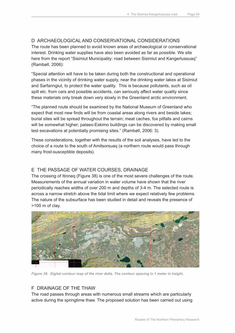
4. The Sisimiut-Kangerlussuaq road
Roadex III The Northern Pheriphery Research
Page 59
d ARCHAEOLOGICAL ANd CONSERVATIONAL CONSIdERATIONSThe route has been planned to avoid known areas of archaeological or conservational interest. drinking water supplies have also been avoided as far as possible. We site here from the report “Sisimiut municipality: road between Sisimiut and Kangerlussuaq” (Rambøll, 2006):
“Special attention will have to be taken during both the constructional and operational phases in the vicinity of drinking water supply, near the drinking water lakes at Sisimiut and Sarfanngiut, to protect the water quality. This is because pollutants, such as oil spill etc. from cars and possible accidents, can seriously affect water quality since these materials only break down very slowly in the Greenland arctic environment.
“The planned route should be examined by the National museum of Greenland who expect that most new finds will be from coastal areas along rivers and beside lakes; burial sites will be spread throughout the terrain; meat caches, fox pitfalls and cairns will be somewhat higher; palaeo-Eskimo buildings can be discovered by making small test excavations at potentially promising sites.” (Rambøll, 2006: 3).
These considerations, together with the results of the soil analyses, have led to the choice of a route to the south of Amitsorsuaq (a northern route would pass through many frost-susceptible deposits).
E THE PASSAGE OF WATER COuRSES, dRAINAGEThe crossing of Itinneq (Figure 38) is one of the most severe challenges of the route. measurements of the annual variation in water volume have shown that the river periodically reaches widths of over 200 m and depths of 3-4 m. The selected route is across a narrow stretch above the tidal limit where we expect relatively few problems. The nature of the subsurface has been studied in detail and reveals the presence of >100 m of clay.
Figure 38. Digital contour map of the river delta. The contour spacing is 1 meter in height.
F dRAINAGE OF THE THAWThe road passes through areas with numerous small streams which are particularly active during the springtime thaw. The proposed solution has been carried out using
4. The Sisimiut-Kangerlussuaq road
Roadex III The Northern Pheriphery Research
Page 60
underground Armco pipes or their equivalent. Observations of water courses and wetlands provide a picture of drainage requirements in the form of pipes and possibly bridges in connection with the road construction. It is, however, necessary to estimate the volume of water involved to determine the required sizes of pipes and/or bridges. The critical volume of water occurs in connection with the springtime thawing of snow and ice masses. For any specific section of road it is therefore necessary to determine the size of the catchment area, measure the thickness of snow, determine variations in temperature and, not least, investigate the possibility for alternative drainage patterns, before the water volumes can be estimated. Study of orthophotos of the route between Sisimiut and Kangerlussuaq has identified places where the road will cross streams and water courses.
Areas subjected to permafrost typically have poor drainage because of the impermeable frozen subsurface. The collection of stagnant water can lead to further thawing below and along the road construction. Flowing water will lead to erosion and the washing away of materials which, in the worst case, can result in collapse of the road (Jørgensen, 2004).
Ad. F Snow clearanceThe snow problem, the risk of road closure because of drifting, plays a role in the choice of route and construction of the roadbed. Elevation of the road slightly above its surroundings can restrict snow drifts accumulating on the road. Local people that travel extensively in the area in the winter months have provided helpful information regarding snow drifting. The section of the road nearest Kangerlussuaq has only a small amount of precipitation and snow drifting is unlikely to be a serious problem here.
4.7. ROuTE PROPOSAL – dETAILEd dESCRIPTIONA total of 79 large posters, presenting details of the entire route, have been prepared. Below we comment on the proposed route. more detailed information is obtainable from the 79 posters that are available on an FTP server (ftp://artekftp.byg.dtu.dk/Vejen-Sisimiut-Kangerlussuaq-Linieføringsforslag). A paper copy has been provided to Sisimiut municipiality.
Sisimiut: Just outside Sisimiut the road is suggested to pass a shallow lake on a dam construction. This will split the lake into two minor lakes. The existing lake has a shallow sediment deposit which is well suited for the dam. After passage of the lake the road will continue between two mountain ridges. The road will be placed in the northern site of the valley. After this the trace follows the natural valley for almost 10 km, where it will pass the gorge at majoriaq and cross the northern mountain to Kangerluarsuk Tulleq (1. Fjorden).
4. The Sisimiut-Kangerlussuaq road
Roadex III The Northern Pheriphery Research
Page 61
uttoqqaat:The proposed route here starts from the melt water terraces in the west, continues eastwards to the large river, beside the river and then across an area of gneiss to a grassy plain. From the grassy plain the route passes near some lakes on a plateau and continues down to the large lake east of uttoqqaat, where it passes north of the lake. This route involves some problematical sections which cannot be avoided. These involve slopes, crossing river beds, and the danger of rock falls.
Itinneq:The sediment samples m2-497 and m3-499, from close to Itinneq, are a frost risk since they both contain a large proportion of fine-grained material. It is evident from the orthophoto that large parts of the delta consist of the same material. This means that the passage of Itinneq will be problematical because the foundation consists of soft material. Samples m1-487 and m4-500 are from the foot of the northern mountain ridge and it appears that sandy deposits occur along the entire ridge which should not give problems for road construction. The western part of the road is proposed to lie at the foot of the most northerly mountain, avoiding the soft area along the river. The river will be crossed near sample site m2-497 so that the road avoids the large marshy area south of the river. To the south of Itinneq the road again passes along the foot of the mountain to avoid marshy areas. Seismic studies were performed in 2004 to determine the depth to the basement below the delta. This waas located at a depth of >200 m which means that it cannot be used in connection with passage of the delta.
Amitsorssuaq:The road passes eastwards up the slope along the stream that drains lake Amitsorssuaq (Figure 39). The route then follows the lake shore on a rocky slope that dips at 30-45°. This steep stretch is >600 m long and the basement is exposed between the thin surface deposits. The road then passes over a flat, bush-covered plateau and swings to the right over a ridge where the basement is exposed. It then passes south of a small lake via a steep slope that suffers from soil creep. After this it continues in a straight line through the flat area south of the canoe centre and along the slope beside the lake. This slope becomes increasingly rocky as it swings gently to the right. A large quantity of fist-sized stones has been observed beside the lake. The slope south of the lake suffers from soil creep, is relatively steep and has quite rocky intervals. The road continues parallel to the lake shore on sediment-covered slopes.
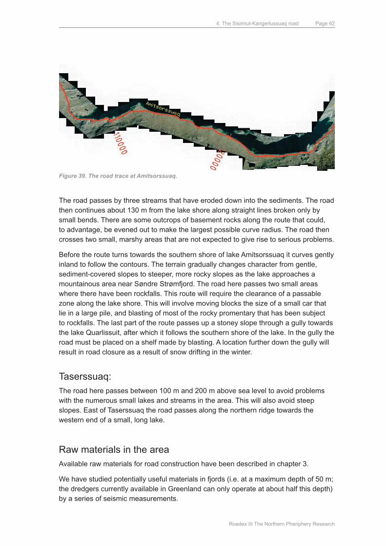
4. The Sisimiut-Kangerlussuaq road
Roadex III The Northern Pheriphery Research
Page 62
Figure 39. The road trace at Amitsorssuaq.
The road passes by three streams that have eroded down into the sediments. The road then continues about 130 m from the lake shore along straight lines broken only by small bends. There are some outcrops of basement rocks along the route that could, to advantage, be evened out to make the largest possible curve radius. The road then crosses two small, marshy areas that are not expected to give rise to serious problems.
Before the route turns towards the southern shore of lake Amitsorssuaq it curves gently inland to follow the contours. The terrain gradually changes character from gentle, sediment-covered slopes to steeper, more rocky slopes as the lake approaches a mountainous area near Søndre Strømfjord. The road here passes two small areas where there have been rockfalls. This route will require the clearance of a passable zone along the lake shore. This will involve moving blocks the size of a small car that lie in a large pile, and blasting of most of the rocky promentary that has been subject to rockfalls. The last part of the route passes up a stoney slope through a gully towards the lake quarlissuit, after which it follows the southern shore of the lake. In the gully the road must be placed on a shelf made by blasting. A location further down the gully will result in road closure as a result of snow drifting in the winter.
Taserssuaq: The road here passes between 100 m and 200 m above sea level to avoid problems with the numerous small lakes and streams in the area. This will also avoid steep slopes. East of Taserssuaq the road passes along the northern ridge towards the western end of a small, long lake.
Raw materials in the areaAvailable raw materials for road construction have been described in chapter 3.
We have studied potentially useful materials in fjords (i.e. at a maximum depth of 50 m; the dredgers currently available in Greenland can only operate at about half this depth) by a series of seismic measurements.
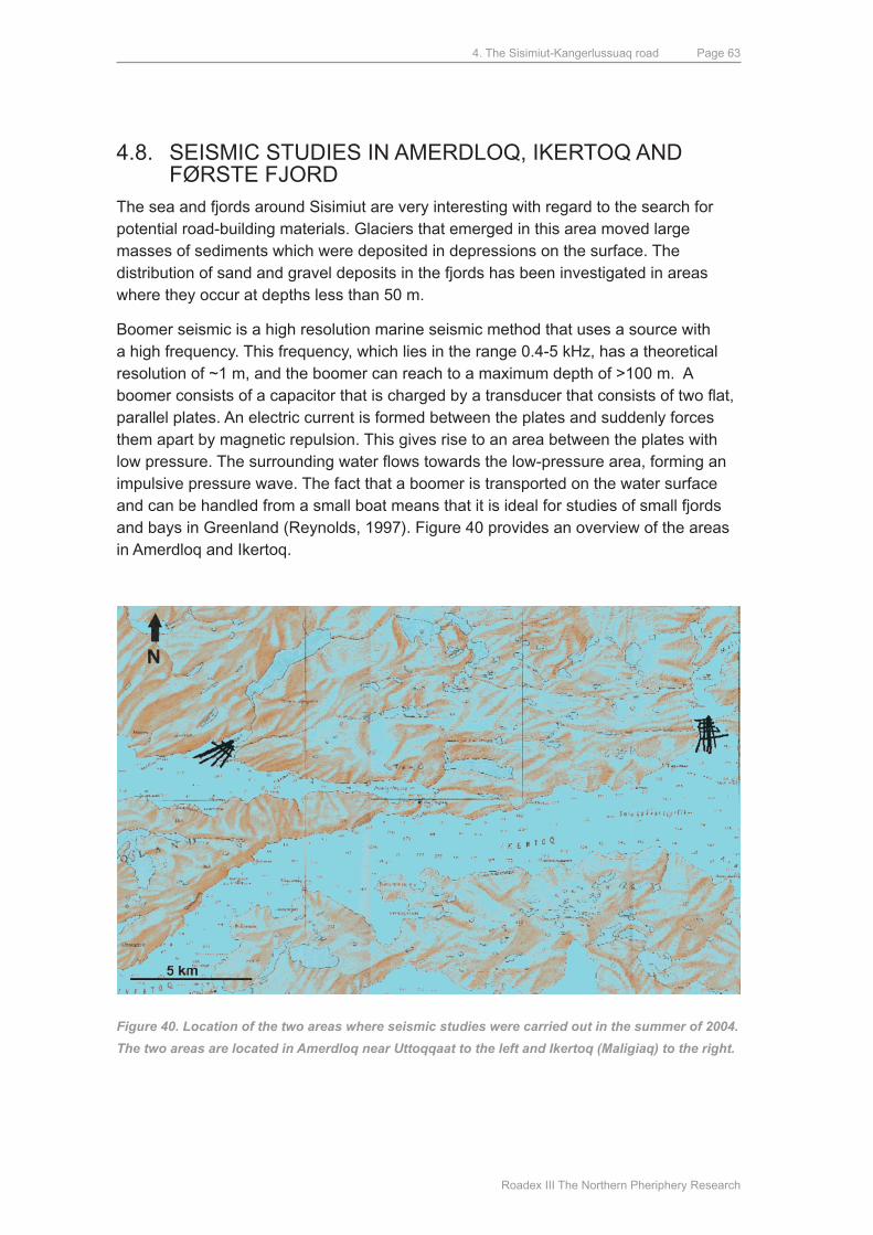
4. The Sisimiut-Kangerlussuaq road
Roadex III The Northern Pheriphery Research
Page 63
4.8. SEISmIC STudIES IN AmERdLOq, IKERTOq ANd FøRSTE FJORd
The sea and fjords around Sisimiut are very interesting with regard to the search for potential road-building materials. Glaciers that emerged in this area moved large masses of sediments which were deposited in depressions on the surface. The distribution of sand and gravel deposits in the fjords has been investigated in areas where they occur at depths less than 50 m.
Boomer seismic is a high resolution marine seismic method that uses a source with a high frequency. This frequency, which lies in the range 0.4-5 kHz, has a theoretical resolution of ~1 m, and the boomer can reach to a maximum depth of >100 m. A boomer consists of a capacitor that is charged by a transducer that consists of two flat, parallel plates. An electric current is formed between the plates and suddenly forces them apart by magnetic repulsion. This gives rise to an area between the plates with low pressure. The surrounding water flows towards the low-pressure area, forming an impulsive pressure wave. The fact that a boomer is transported on the water surface and can be handled from a small boat means that it is ideal for studies of small fjords and bays in Greenland (Reynolds, 1997). Figure 40 provides an overview of the areas in Amerdloq and Ikertoq.
Figure 40. Location of the two areas where seismic studies were carried out in the summer of 2004.
The two areas are located in Amerdloq near Uttoqqaat to the left and Ikertoq (Maligiaq) to the right.
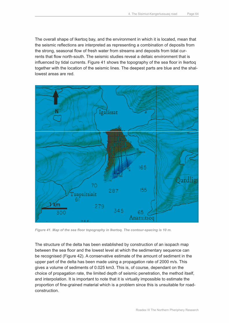
4. The Sisimiut-Kangerlussuaq road
Roadex III The Northern Pheriphery Research
Page 64
The overall shape of Ikertoq bay, and the environment in which it is located, mean that the seismic reflections are interpreted as representing a combination of deposits from the strong, seasonal flow of fresh water from streams and deposits from tidal cur-rents that flow north-south. The seismic studies reveal a deltaic environment that is influenced by tidal currents. Figure 41 shows the topography of the sea floor in Ikertoq together with the location of the seismic lines. The deepest parts are blue and the shal-lowest areas are red.
Figure 41. Map of the sea floor topography in Ikertoq. The contour-spacing is 10 m.
The structure of the delta has been established by construction of an isopach map between the sea floor and the lowest level at which the sedimentary sequence can be recognised (Figure 42). A conservative estimate of the amount of sediment in the upper part of the delta has been made using a propagation rate of 2000 m/s. This gives a volume of sediments of 0.025 km3. This is, of course, dependant on the choice of propagation rate, the limited depth of seismic penetration, the method itself, and interpolation. It is important to note that it is virtually impossible to estimate the proportion of fine-grained material which is a problem since this is unsuitable for road-construction.
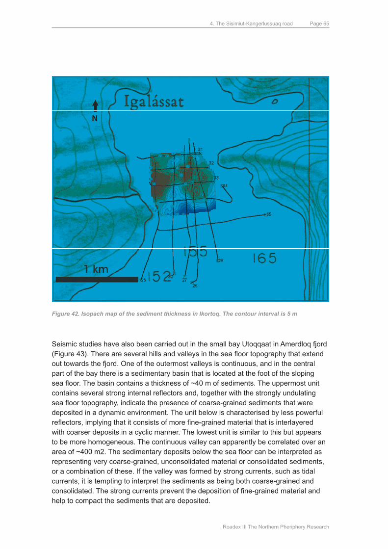
4. The Sisimiut-Kangerlussuaq road
Roadex III The Northern Pheriphery Research
Page 65
Figure 42. Isopach map of the sediment thickness in Ikortoq. The contour interval is 5 m
Seismic studies have also been carried out in the small bay utoqqaat in Amerdloq fjord (Figure 43). There are several hills and valleys in the sea floor topography that extend out towards the fjord. One of the outermost valleys is continuous, and in the central part of the bay there is a sedimentary basin that is located at the foot of the sloping sea floor. The basin contains a thickness of ~40 m of sediments. The uppermost unit contains several strong internal reflectors and, together with the strongly undulating sea floor topography, indicate the presence of coarse-grained sediments that were deposited in a dynamic environment. The unit below is characterised by less powerful reflectors, implying that it consists of more fine-grained material that is interlayered with coarser deposits in a cyclic manner. The lowest unit is similar to this but appears to be more homogeneous. The continuous valley can apparently be correlated over an area of ~400 m2. The sedimentary deposits below the sea floor can be interpreted as representing very coarse-grained, unconsolidated material or consolidated sediments, or a combination of these. If the valley was formed by strong currents, such as tidal currents, it is tempting to interpret the sediments as being both coarse-grained and consolidated. The strong currents prevent the deposition of fine-grained material and help to compact the sediments that are deposited.
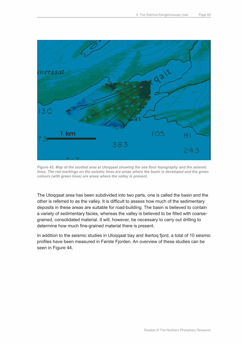
4. The Sisimiut-Kangerlussuaq road
Roadex III The Northern Pheriphery Research
Page 66
Figure 43. Map of the studied area at Utoqqaat showing the sea floor topography and the seismic lines. The red markings on the seismic lines are areas where the basin is developed and the green colours (with green lines) are areas where the valley is present.
The utoqqaat area has been subdivided into two parts, one is called the basin and the other is referred to as the valley. It is difficult to assess how much of the sedimentary deposits in these areas are suitable for road-building. The basin is believed to contain a variety of sedimentary facies, whereas the valley is believed to be filled with coarse-grained, consolidated material. It will, however, be necessary to carry out drilling to determine how much fine-grained material there is present.
In addition to the seismic studies in utoqqaat bay and Ikertoq fjord, a total of 10 seismic profiles have been measured in Første Fjorden. An overview of these studies can be seen in Figure 44.
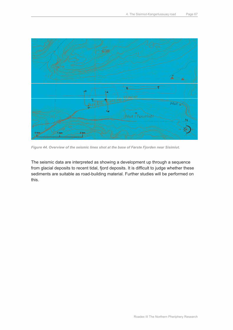
4. The Sisimiut-Kangerlussuaq road
Roadex III The Northern Pheriphery Research
Page 67
Figure 44. Overview of the seismic lines shot at the base of Første Fjorden near Sisimiut.
The seismic data are interpreted as showing a development up through a sequence from glacial deposits to recent tidal, fjord deposits. It is difficult to judge whether these sediments are suitable as road-building material. Further studies will be performed on this.
5. Conclusions
Roadex III The Northern Pheriphery Research
Page 68
5. Conclusions
We consider that 2007 is a landmark year for road construction in Greenland. A variety of efforts have been made to achieve a result that can be described as follows:
• The ROADEX cooperation, that includes experts from Finland, Scotland, Norway and Sweden, has made their collective expertise and reports available for the construction of roads in the arctic. This expertise can benefit Greenland in many ways, not least in connection with the maintenance of streets and roads in towns and villages, and in connection the planning and construction of new roads outside residential areas.
A selection of the reports has been translated to danish and Greenlandic and distributed to the participants at the road conference in march 2007.
• Colleagues from Greenland, Canada, Russia, Alaska, Denmark and Iceland have presented contributions to arctic road construction at the conference “Arctic Roads” in Sisimiut in march 2007.
• Detailed preliminary investigations concerning the road from Sisimiut to Kangerlussuaq carried out by ARTEK have been reported. The experience of ROAdEx, and others outside this organisation, has played an important role in these reports. A two-fold subdivision of Greenland, based on the distribution of permafrost and precipitation, plays an important role in the report. This subdivision facilitates comparisons and the exchange of experiences with road constructors outside Greenland (Northern Iceland and Southern Greenland are, for example, comparable, as are Nunavik and Northern Greenland). The planned road from Sisimiut to Kangerlussuaq has a western ”Southern Greenland” section and an eastern “Northern Greenland” section.
• The international road conference, with >100 participants, was arranged by ARTEK as part of a broad cooperation with all those concerned with road-construction both from Greenland and elsewhere: KANUKOKA, ROADEX, Nutaaliorfik and Sanaartornermik Ilinniarfik. This has given a very broad basis for the exchange of ideas and experience with road construction.
While 2007 has been a very important “road year”, the subject of roads in Greenland remains a very active field. There is still much to be done. The present report, however, presents the “state of the game” as it stands as regards important aspects of road construction in Greenland.
6. References
Roadex III The Northern Pheriphery Research
Page 69
6. References
Aggerbeck, Jens Christian, Nielsen, Nanja Hedal og Rahbak, malene Louise (2003). Vej mellem Sisimiut og Kangerlussuaq – VVM-redegørelse. Center for Arktisk Teknologi, BYG•DTU, Danmarks Tekniske universitet. Kgs. Lyngby.
Aho, Saara & Saarenketo, Timo (2006): design and Repair of Roads Suffering Spring Thaw Weakening. Executive Summary. ROAdEx III Project. Roadscanners Oy.
Aho, Saara & Saarenketo, Timo (2006): managing drainage on Low Volume Roads. Exectutive Summary. ROAdEx III Project. Roadscanners Oy.
Andreasen, F. (2000): Anvendelse af georadar. Ph.d. afhandling. Grundvandscentret, Institut for Geologi og Geoteknik, danmarks Tekniske universitet, Kgs. Lyngby.
Bennedsen, Nicolai Skjøt (2007): Ingeniørgeologiske undersøgelser for vejanlæg i qassiarsukområdet, Sydgrønland. Center for Arktisk Teknologi, BYG•DTU, Danmarks Tekniske Universitet, Kgs. Lyngby.
Borre, Sara (2007). Geofysiske undersøgelser af de marine leraflejringer i den indre del af Skovfjorden, Sydgrønland. Center for Arktisk Teknologi, BYG•DTU, Danmarks Tekniske Universitet, Kgs. Lyngby.
Christiansen, Hanne Hvidtfeldt; Humlum, Ole (2000): Permafrost, pp. 32-35. In: Jakobsen, B. H.; Böcher, J.; Nielsen, N.; Guttesen, R.; Humlum, O. & Jensen, E. (Eds.): Topografisk Atlas Grønland. Det Kongelige Danske Geografiske Selskab and Kort & Matrikelstyrelsen, Copenhagen.
David, H.C. (2007): Permafrost funderet bygdevej. Center for Arktisk Teknologi, BYG•DTU, Danmarks Tekniske universitet, Kgs. Lyngby.
De Europæiske Fællesskabers Tidende (1999): Kommissionens direktiv 1999/100/EF, af 15. december 1999 om tilpasning til den tekniske udvikling af Rådets direktiv 80/1268/EØF om motorkøretøjers CO2-emissioner og brændstofforbrug. http://eur-lex.europa.eu/LexUriServ/site/da/oj/1999/l_334/l_33419991228da00360040.pdf (Visited 25.9.2007).
dmI (2001): Cappelen, John; Jørgensen, Bent Vraae; Laursen, Ellen Vaarby; Stannius, Lotte Sligting; Thomsen, Rikke Sjølin (2001): Klimaobservationer i Grønland, 1958-99 – med klimanormaler 1961-90; Technical report 00-18, dmI, Copenhagen.
DMI: Danmarks Metrologiske Institut. Klimanormaler for Grønland. www.dmi.dk/dmi/index/gronland/klimanormaler-gl.html
Dybbroe, C. (2005): Overfladenær geologi i Sisimiut kortlagt med Ground Penetrating Radar. Center for Arktisk Teknologi, BYG•DTU, Danmarks Tekniske Universitet, Kgs. Lyngby.
Escher, A., Sørensen, K., & Zeck, H. P. (1976): Nagssugtoquidian mobile Belt in West Greenland. In A. Escher & W. S. Watt (Eds.), Geology of Greenland (pp. 76-95). Copenhagen. denmark: The Geological Survey of Greenland.
Fredskild, Bent (1999): Flora. Gyldendals bog om Grønland, red. af Bent Gynther et al (pp.71-79). Copenhagen.
Grønlands Geologiske undersøgelse (1974). Kvartærgeologisk kort over Grønland, Søndre Strømfjord – Nûgssuaq,1:500.000.
Henriksen, Niels (2005): Grønlands Geologiske udvikling. GEuS, Copenhagen.
Ingeman-Nielsen, Thomas, Clausen, Helle og Foged, Niels (2007). Engineering geological and geophysical investigations for road construction in the municipality of Sisimiut, West Greenland. pp. 53-61. In; Ingeman-Nielsen, T.; Fritt-Rasmussen, J.; Brock, N. and Villumsen, A.: Proceedings from the
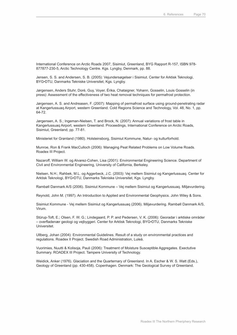
6. References
Roadex III The Northern Pheriphery Research
Page 70
International Conference on Arctic Roads 2007, Sisimiut, Greenland, ByG Rapport R-157, ISBN 978-877877-230-5, Arctic Technology Centre. Kgs. Lyngby, denmark, pp. 88.
Jensen, S. S. and Andersen, S. B. (2005): Vejundersøgelser i Sisimiut. Center for Arktisk Teknologi, BYG•DTU, Danmarks Tekniske Universitet, Kgs. Lyngby.
Jørgensen, Anders Stuhr, doré, Guy, Voyer, Érika, Chataigner, yohann, Gosselin, Louis Gosselin (in press): Assessment of the effectiveness of two heat removal techniques for permafrost protection.
Jørgensen, A. S. and Andreasen, F. (2007): mapping of permafrost surface using ground-penetrating radar at Kangerlussuaq Airport, western Greenland. Cold Regions Science and Technology, Vol. 48, No. 1, pp. 64-72.
Jørgensen, A. S.; Ingeman-Nielsen, T. and Brock, N. (2007): Annual variations of frost table in Kangerlussuaq Airport, western Greenland. Proceedings, International Conference on Arctic Roads, Sisimiut, Greenland, pp. 77-81.
ministeriet for Grønland (1980). Holsteinsborg, Sisimiut Kommune, Natur- og kulturforhold.
munroe, Ron & Frank macCulloch (2006): managing Peat Related Problems on Low Volume Roads. Roadex III Project.
Nazaroff, William W. og Alvarez-Cohen, Lisa (2001): Environmental Engineering Science. department of Civil and Environmental Engineering, university of California, Berkeley.
Nielsen, N.H.; Rahbek, m.L. og Aggerbeck, J.C. (2003): Vej mellem Sisimiut og Kangerlussuaq. Center for Arktisk Teknologi, BYG•DTU, Danmarks Tekniske Universitet, Kgs. Lyngby.
Rambøll Danmark A/S (2006). Sisimiut Kommune – Vej mellem Sisimiut og Kangerlussuaq. Miljøvurdering.
Reynold, John m. (1997). An Introduction to Applied and Environmental Geophysics. John Wiley & Sons.
Sisimiut Kommune - Vej mellem Sisimiut og Kangerlussuaq (2006). Miljøvurdering. Rambøll Danmark A/S, Virum.
Stürup-Toft, E.; Olsen, F. W. G.; Lindegaard, P. P. and Pedersen, V. K. (2006): Georadar i arktiske områder – overfladenær geologi og vejbyggeri. Center for Arktisk Teknologi, BYG•DTU, Danmarks Tekniske universitet.
ullberg, Johan (2004): Environmental Guidelines. Result of a study on environmental practices and regulations. Roadex II Project. Swedish Road Administration, Luleå.
Vuorimies, Nuutti & Kolisoja, Pauli (2006): Treatment of moisture Susceptible Aggregates. Exectutive Summary. ROAdEx III Project. Tampere university of Technology.
Weidick, Anker (1976). Glaciation and the quarternary of Greenland. In A. Escher & W. S. Watt (Eds.), Geology of Greenland (pp. 430-458). Copenhagen. denmark: The Geological Survey of Greenland.
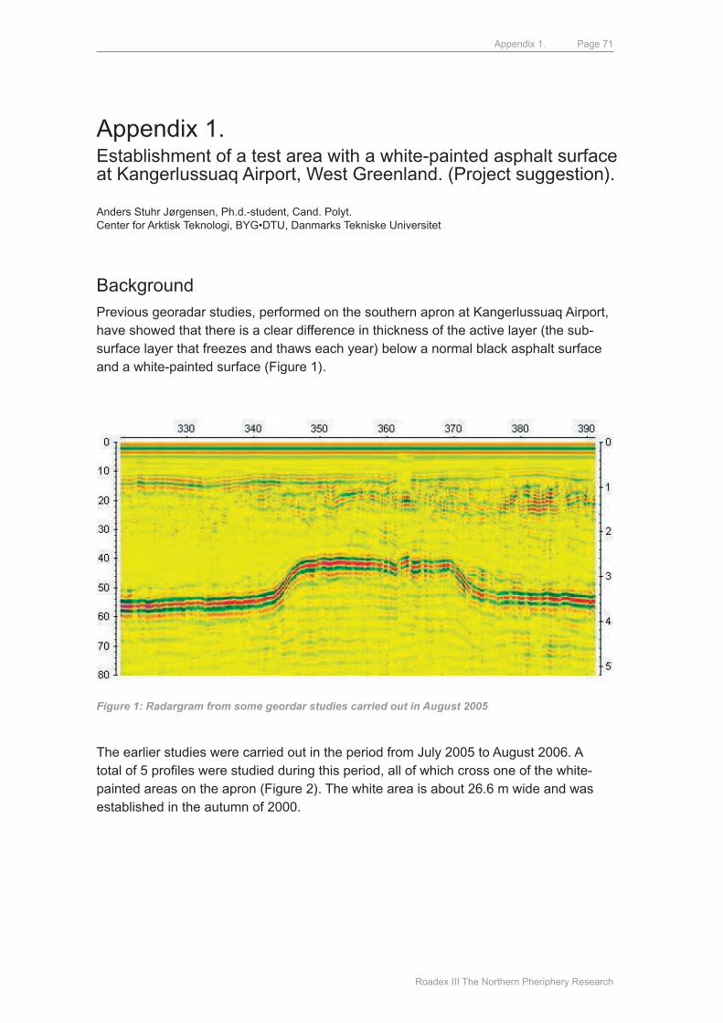
Appendix 1.
Roadex III The Northern Pheriphery Research
Page 71
Appendix 1.Establishment of a test area with a white-painted asphalt surface at Kangerlussuaq Airport, West Greenland. (Project suggestion).
Anders Stuhr Jørgensen, Ph.d.-student, Cand. Polyt.Center for Arktisk Teknologi, BYG•DTU, Danmarks Tekniske Universitet
BackgroundPrevious georadar studies, performed on the southern apron at Kangerlussuaq Airport, have showed that there is a clear difference in thickness of the active layer (the sub-surface layer that freezes and thaws each year) below a normal black asphalt surface and a white-painted surface (Figure 1).
Figure 1: Radargram from some geordar studies carried out in August 2005
The earlier studies were carried out in the period from July 2005 to August 2006. A total of 5 profiles were studied during this period, all of which cross one of the white-painted areas on the apron (Figure 2). The white area is about 26.6 m wide and was established in the autumn of 2000.
Appendix 1.
Roadex III The Northern Pheriphery Research
Page 72
Whi te p ai n te d as p h a lt s urf ac e
Slo p e
B o r eh o le
T re n ch
Figure 2: The white-painted area is in the upper right part of the aerial photograph
Since georadar had proved to be successful in following the annual variation in the active layer beneath black and white surfaces it would be interesting to expand the investigations. It would be interesting to establish white-painted areas with different sizes so that their influence on the frost level can be compared.
Time planThe areas should be painted in the autumn of 2006, so that georadar studies can begin in the spring of 2007. Below is a proposed time plan to carry out the investigations at a regular 4-week interval from April to October 2007.
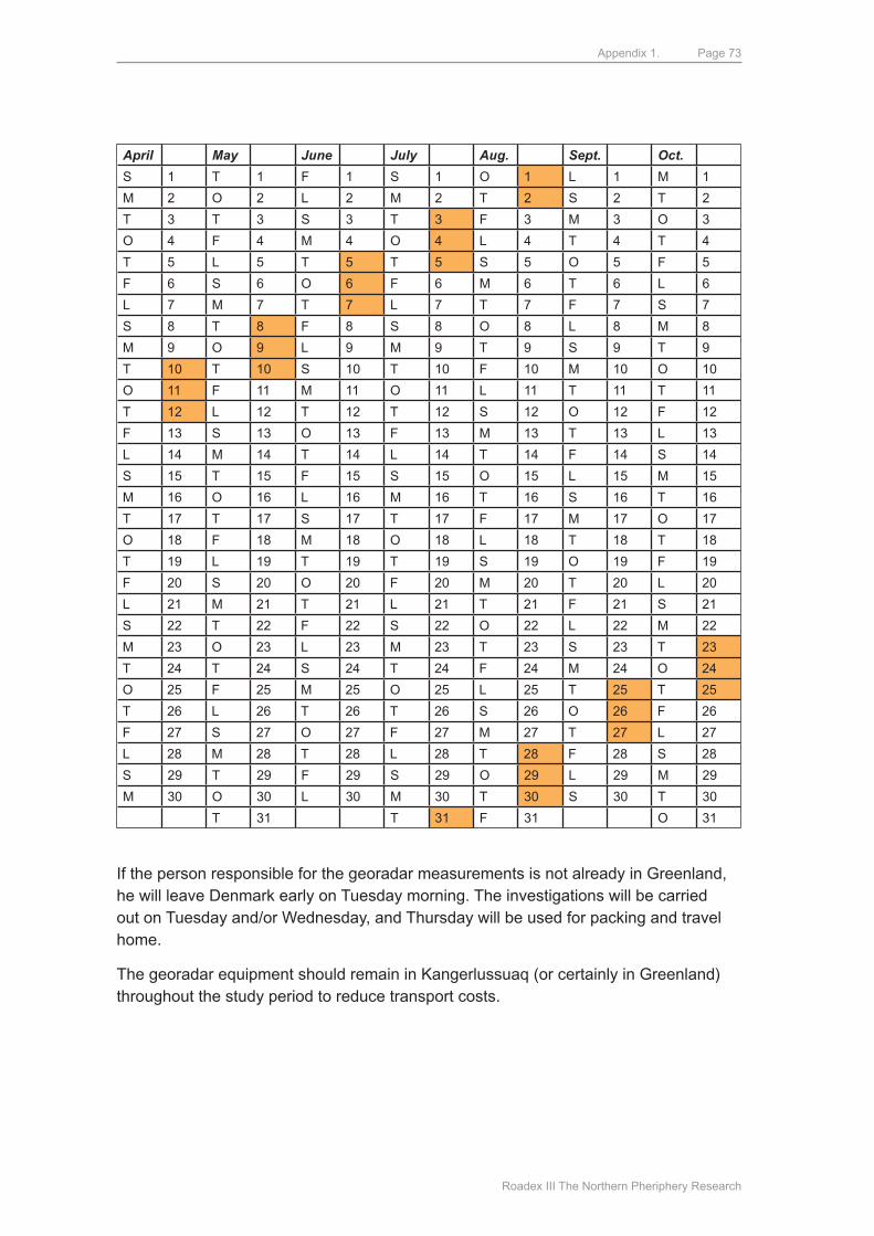
Appendix 1.
Roadex III The Northern Pheriphery Research
Page 73
April May June July Aug. Sept. Oct.
S 1 T 1 F 1 S 1 O 1 L 1 m 1
m 2 O 2 L 2 m 2 T 2 S 2 T 2
T 3 T 3 S 3 T 3 F 3 m 3 O 3
O 4 F 4 m 4 O 4 L 4 T 4 T 4
T 5 L 5 T 5 T 5 S 5 O 5 F 5
F 6 S 6 O 6 F 6 m 6 T 6 L 6
L 7 m 7 T 7 L 7 T 7 F 7 S 7
S 8 T 8 F 8 S 8 O 8 L 8 m 8
m 9 O 9 L 9 m 9 T 9 S 9 T 9
T 10 T 10 S 10 T 10 F 10 m 10 O 10
O 11 F 11 m 11 O 11 L 11 T 11 T 11
T 12 L 12 T 12 T 12 S 12 O 12 F 12
F 13 S 13 O 13 F 13 m 13 T 13 L 13
L 14 m 14 T 14 L 14 T 14 F 14 S 14
S 15 T 15 F 15 S 15 O 15 L 15 m 15
m 16 O 16 L 16 m 16 T 16 S 16 T 16
T 17 T 17 S 17 T 17 F 17 m 17 O 17
O 18 F 18 m 18 O 18 L 18 T 18 T 18
T 19 L 19 T 19 T 19 S 19 O 19 F 19
F 20 S 20 O 20 F 20 m 20 T 20 L 20
L 21 m 21 T 21 L 21 T 21 F 21 S 21
S 22 T 22 F 22 S 22 O 22 L 22 m 22
m 23 O 23 L 23 m 23 T 23 S 23 T 23
T 24 T 24 S 24 T 24 F 24 m 24 O 24
O 25 F 25 m 25 O 25 L 25 T 25 T 25
T 26 L 26 T 26 T 26 S 26 O 26 F 26
F 27 S 27 O 27 F 27 m 27 T 27 L 27
L 28 m 28 T 28 L 28 T 28 F 28 S 28
S 29 T 29 F 29 S 29 O 29 L 29 m 29
m 30 O 30 L 30 m 30 T 30 S 30 T 30
T 31 T 31 F 31 O 31
If the person responsible for the georadar measurements is not already in Greenland, he will leave denmark early on Tuesday morning. The investigations will be carried out on Tuesday and/or Wednesday, and Thursday will be used for packing and travel home.
The georadar equipment should remain in Kangerlussuaq (or certainly in Greenland) throughout the study period to reduce transport costs.
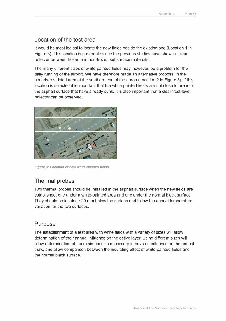
Appendix 1.
Roadex III The Northern Pheriphery Research
Page 74
Location of the test areaIt would be most logical to locate the new fields beside the existing one (Location 1 in Figure 3). This location is preferable since the previous studies have shown a clear reflector between frozen and non-frozen subsurface materials.
The many different sizes of white-painted fields may, however, be a problem for the daily running of the airport. We have therefore made an alternative proposal in the already-restricted area at the southern end of the apron (Location 2 in Figure 3). If this location is selected it is important that the white-painted fields are not close to areas of the asphalt surface that have already sunk. It is also important that a clear frost-level reflector can be observed.
Figure 3: Location of new white-painted fields.
Thermal probesTwo thermal probes should be installed in the asphalt surface when the new fields are established, one under a white-painted area and one under the normal black surface. They should be located ~20 mm below the surface and follow the annual temperature variation for the two surfaces.
PurposeThe establishment of a test area with white fields with a variety of sizes will allow determination of their annual influence on the active layer. Using different sizes will allow determination of the minimum size necessary to have an influence on the annual thaw, and allow comparison between the insulating effect of white-painted fields and the normal black surface.
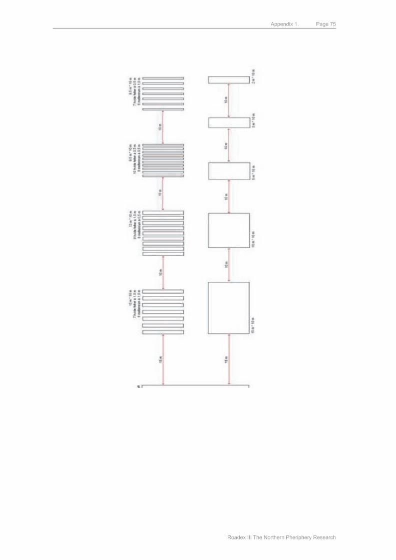
Appendix 1.
Roadex III The Northern Pheriphery Research
Page 75
Appendix 2.
Roadex III The Northern Pheriphery Research
Page 76
Appendix 2.Establishment of a test section in Sisimiut, West Greenland. (Project suggestion).
Anders Stuhr Jørgensen, Ph.d.-student, Cand. Polyt.Center for Arktisk Teknologi, BYG•DTU, Danmarks Tekniske Universitet
BackgroundThe establishment of roads and other transport facilities under arctic conditions has a considerable influence on the sub-surface thermal conditions and lead to thawing of the frozen material during construction.
Climatic changes are also important since roads that have hitherto been stable now show signs of weakness as global warming results in the thawing of permafrost.
With these potential problems in mind, a variety of methods to successfully build and maintain roads in arctic areas have been studied since the 1960´s. For a variety of reasons, including the considerable expense involved in construction and maintenance, only a few of these methods have been tried in practise.
Some of the possible methods will be tested in connection with construction of a new road in Sisimiut, West Greenland. This test section is planned to be built in the summer of 2007. The precise location of the test section will be decided in cooperation with Sisimiut municipality.
Project descriptionThe following methods to establish more stable thermal conditions during road construction will be tested: Air Convection Embankment, Heat Drain and Reflective Surface.
Air Convection EmbankmentConstruction of the road shoulders (and possibly the entire roadbed) with blocks of stone allows the warm air to escape from the structure and allows cold air to enter it from the foot and sides of the shoulder (Figure 1).
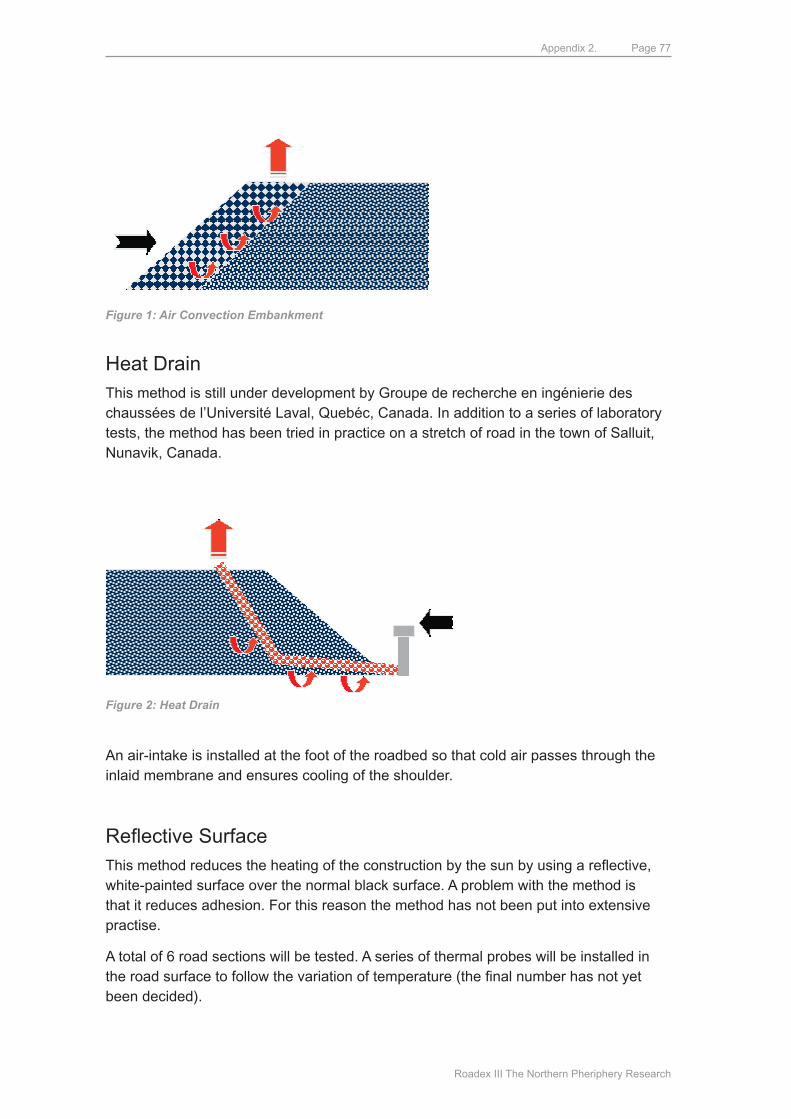
Appendix 2.
Roadex III The Northern Pheriphery Research
Page 77
Figure 1: Air Convection Embankment
Heat drainThis method is still under development by Groupe de recherche en ingénierie des chaussées de l’université Laval, quebéc, Canada. In addition to a series of laboratory tests, the method has been tried in practice on a stretch of road in the town of Salluit, Nunavik, Canada.
Figure 2: Heat Drain
An air-intake is installed at the foot of the roadbed so that cold air passes through the inlaid membrane and ensures cooling of the shoulder.
Reflective SurfaceThis method reduces the heating of the construction by the sun by using a reflective, white-painted surface over the normal black surface. A problem with the method is that it reduces adhesion. For this reason the method has not been put into extensive practise.
A total of 6 road sections will be tested. A series of thermal probes will be installed in the road surface to follow the variation of temperature (the final number has not yet been decided).
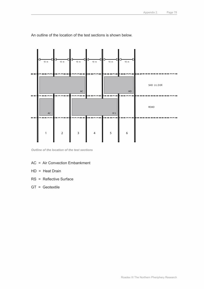
Appendix 2.
Roadex III The Northern Pheriphery Research
Page 78
An outline of the location of the test sections is shown below.
SHO U L D ER
ROAD
10 m 10 m 10 m 10 m 10 m 10 m
AC
AC R S
HD
1 2 3 4 5 6
Outline of the location of the test sections
AC = Air Convection Embankment
Hd = Heat drain
RS = Reflective Surface
GT = Geotextile
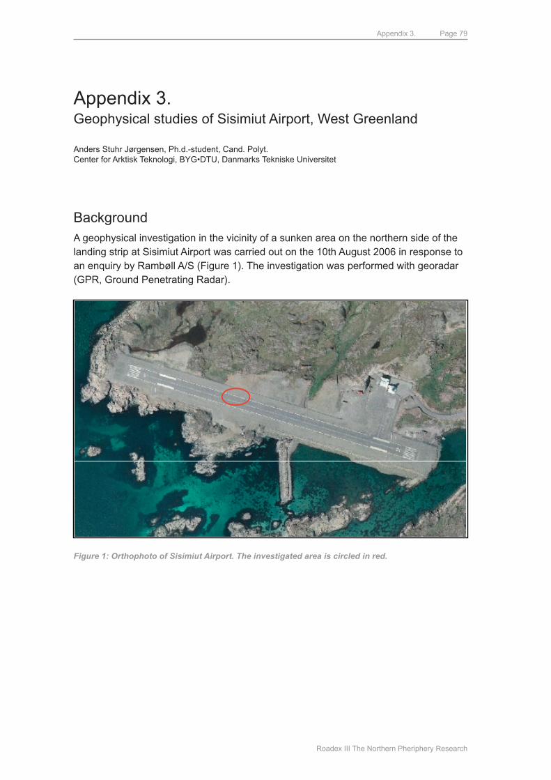
Appendix 3.
Roadex III The Northern Pheriphery Research
Page 79
Appendix 3.Geophysical studies of Sisimiut Airport, West Greenland
Anders Stuhr Jørgensen, Ph.d.-student, Cand. Polyt.Center for Arktisk Teknologi, BYG•DTU, Danmarks Tekniske Universitet
BackgroundA geophysical investigation in the vicinity of a sunken area on the northern side of the landing strip at Sisimiut Airport was carried out on the 10th August 2006 in response to an enquiry by Rambøll A/S (Figure 1). The investigation was performed with georadar (GPR, Ground Penetrating Radar).
Figure 1: Orthophoto of Sisimiut Airport. The investigated area is circled in red.
N
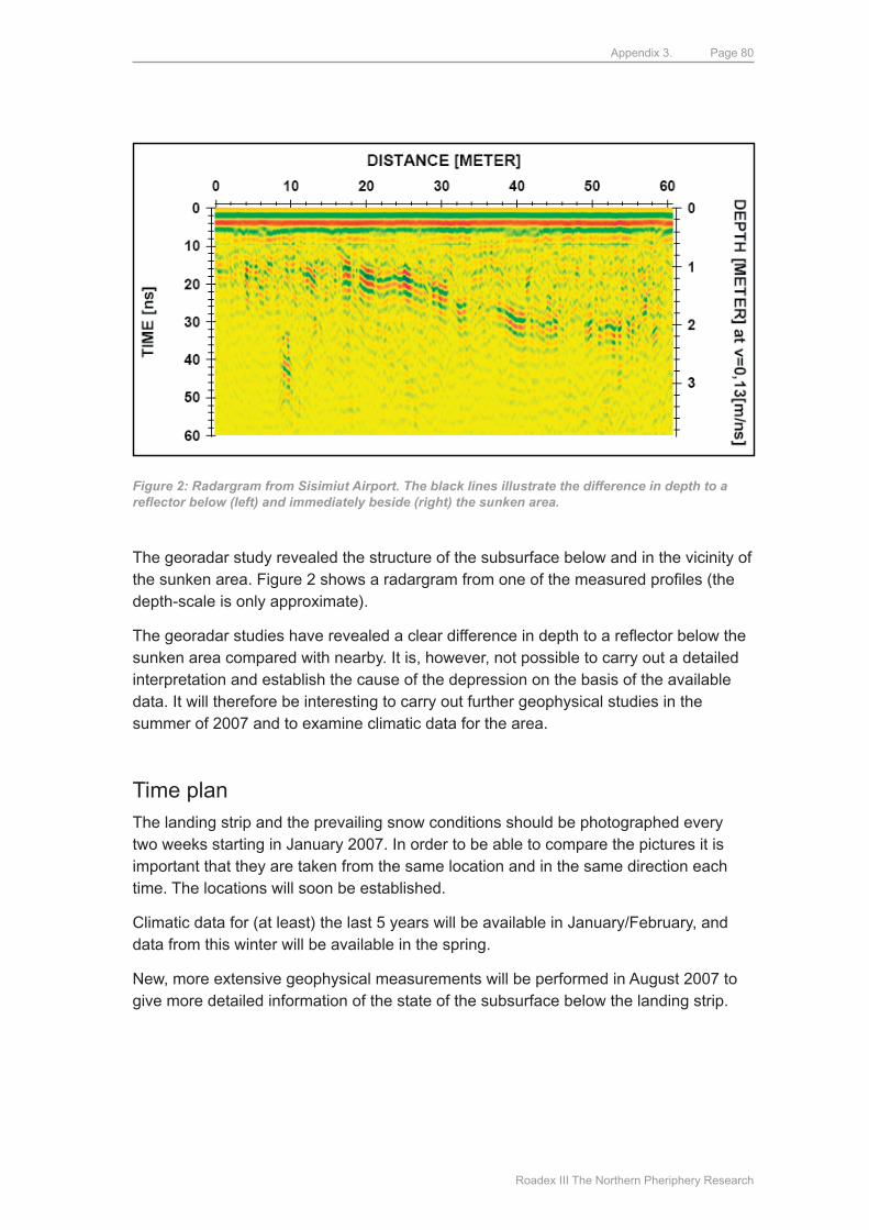
Appendix 3.
Roadex III The Northern Pheriphery Research
Page 80
Figure 2: Radargram from Sisimiut Airport. The black lines illustrate the difference in depth to a reflector below (left) and immediately beside (right) the sunken area.
The georadar study revealed the structure of the subsurface below and in the vicinity of the sunken area. Figure 2 shows a radargram from one of the measured profiles (the depth-scale is only approximate).
The georadar studies have revealed a clear difference in depth to a reflector below the sunken area compared with nearby. It is, however, not possible to carry out a detailed interpretation and establish the cause of the depression on the basis of the available data. It will therefore be interesting to carry out further geophysical studies in the summer of 2007 and to examine climatic data for the area.
Time planThe landing strip and the prevailing snow conditions should be photographed every two weeks starting in January 2007. In order to be able to compare the pictures it is important that they are taken from the same location and in the same direction each time. The locations will soon be established.
Climatic data for (at least) the last 5 years will be available in January/February, and data from this winter will be available in the spring.
New, more extensive geophysical measurements will be performed in August 2007 to give more detailed information of the state of the subsurface below the landing strip.
Appendix 3.
Roadex III The Northern Pheriphery Research
Page 81
PurposeStudy of climatic data, new geophysical measurements and relevant literature related to the construction of the airport and the geological structure of the area can be expected to allow the cause/causes of the sinking to be established.
The Centre for Arctic Technology has already made an agreement with Kangerlussuaq Airport regarding access to the southern apron. The geophysical measurements will allow us to follow the annual variation in depth to the frost level.
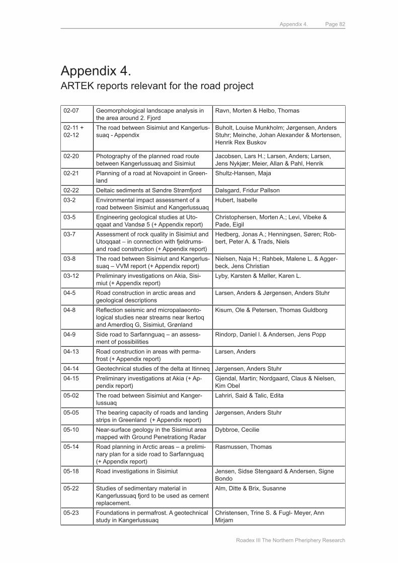
Appendix 4.
Roadex III The Northern Pheriphery Research
Page 82
Appendix 4.ARTEK reports relevant for the road project
02-07 Geomorphological landscape analysis in the area around 2. Fjord
Ravn, morten & Helbo, Thomas
02-11 + 02-12
The road between Sisimiut and Kangerlus-suaq - Appendix
Buholt, Louise munkholm; Jørgensen, Anders Stuhr; meinche, Johan Alexander & mortensen, Henrik Rex Buskov
02-20 Photography of the planned road route between Kangerlussuaq and Sisimiut
Jacobsen, Lars H.; Larsen, Anders; Larsen, Jens Nykjær; meier, Allan & Pahl, Henrik
02-21 Planning of a road at Novapoint in Green-land
Shultz-Hansen, maja
02-22 deltaic sediments at Søndre Strømfjord dalsgard, Fridur Pallson
03-2 Environmental impact assessment of a road between Sisimiut and Kangerlussuaq
Hubert, Isabelle
03-5 Engineering geological studies at uto-qqaat and Vandsø 5 (+ Appendix report)
Christophersen, morten A.; Levi, Vibeke & Pade, Eigil
03-7 Assessment of rock quality in Sisimiut and utoqqaat – in connection with fjeldrums- and road construction (+ Appendix report)
Hedberg, Jonas A.; Henningsen, Søren; Rob-bert, Peter A. & Trads, Niels
03-8 The road between Sisimiut and Kangerlus-suaq – VVm report (+ Appendix report)
Nielsen, Naja H.; Rahbek, malene L. & Agger-beck, Jens Christian
03-12 Preliminary investigations on Akia, Sisi-miut (+ Appendix report)
Lyby, Karsten & møller, Karen L.
04-5 Road construction in arctic areas and geological descriptions
Larsen, Anders & Jørgensen, Anders Stuhr
04-8 Reflection seismic and micropalaeonto-logical studies near streams near lkertoq and Amerdloq G, Sisimiut, Grønland
Kisum, Ole & Petersen, Thomas Guldborg
04-9 Side road to Sarfannguaq – an assess-ment of possibilities
Rindorp, daniel l. & Andersen, Jens Popp
04-13 Road construction in areas with perma-frost (+ Appendix report)
Larsen, Anders
04-14 Geotechnical studies of the delta at Itinneq Jørgensen, Anders Stuhr
04-15 Preliminary investigations at Akia (+ Ap-pendix report)
Gjendal, martin; Nordgaard, Claus & Nielsen, Kim Obel
05-02 The road between Sisimiut and Kanger-lussuaq
Lahriri, Said & Talic, Edita
05-05 The bearing capacity of roads and landing strips in Greenland (+ Appendix report)
Jørgensen, Anders Stuhr
05-10 Near-surface geology in the Sisimiut area mapped with Ground Penetrationg Radar
dybbroe, Cecilie
05-14 Road planning in Arctic areas – a prelimi-nary plan for a side road to Sarfannguaq (+ Appendix report)
Rasmussen, Thomas
05-18 Road investigations in Sisimiut Jensen, Sidse Stengaard & Andersen, Signe Bondo
05-22 Studies of sedimentary material in Kangerlussuaq fjord to be used as cement replacement.
Alm, ditte & Brix, Susanne
05-23 Foundations in permafrost. A geotechnical study in Kangerlussuaq
Christensen, Trine S. & Fugl- meyer, Ann mirjam
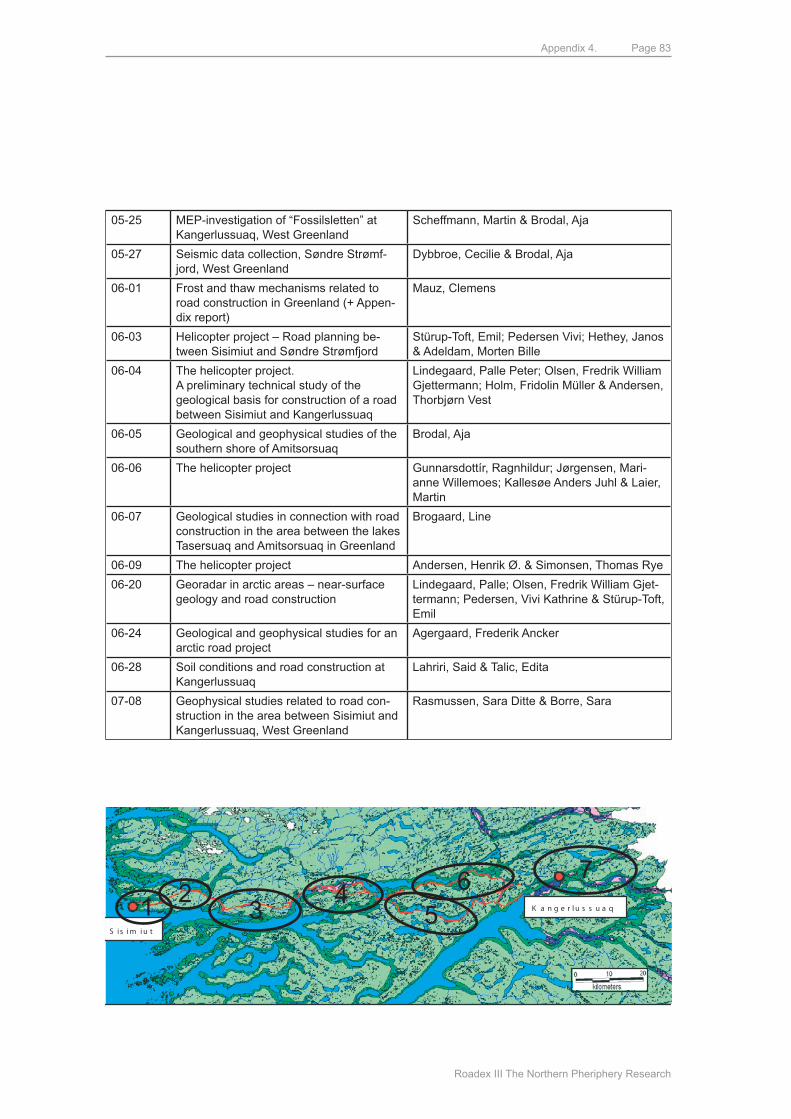
Appendix 4.
Roadex III The Northern Pheriphery Research
Page 83
05-25 mEP-investigation of “Fossilsletten” at Kangerlussuaq, West Greenland
Scheffmann, martin & Brodal, Aja
05-27 Seismic data collection, Søndre Strømf-jord, West Greenland
dybbroe, Cecilie & Brodal, Aja
06-01 Frost and thaw mechanisms related to road construction in Greenland (+ Appen-dix report)
mauz, Clemens
06-03 Helicopter project – Road planning be-tween Sisimiut and Søndre Strømfjord
Stürup-Toft, Emil; Pedersen Vivi; Hethey, Janos & Adeldam, morten Bille
06-04 The helicopter project.A preliminary technical study of the geological basis for construction of a road between Sisimiut and Kangerlussuaq
Lindegaard, Palle Peter; Olsen, Fredrik William Gjettermann; Holm, Fridolin müller & Andersen, Thorbjørn Vest
06-05 Geological and geophysical studies of the southern shore of Amitsorsuaq
Brodal, Aja
06-06 The helicopter project Gunnarsdottír, Ragnhildur; Jørgensen, mari-anne Willemoes; Kallesøe Anders Juhl & Laier, martin
06-07 Geological studies in connection with road construction in the area between the lakes Tasersuaq and Amitsorsuaq in Greenland
Brogaard, Line
06-09 The helicopter project Andersen, Henrik ø. & Simonsen, Thomas Rye
06-20 Georadar in arctic areas – near-surface geology and road construction
Lindegaard, Palle; Olsen, Fredrik William Gjet-termann; Pedersen, Vivi Kathrine & Stürup-Toft, Emil
06-24 Geological and geophysical studies for an arctic road project
Agergaard, Frederik Ancker
06-28 Soil conditions and road construction at Kangerlussuaq
Lahriri, Said & Talic, Edita
07-08 Geophysical studies related to road con-struction in the area between Sisimiut and Kangerlussuaq, West Greenland
Rasmussen, Sara ditte & Borre, Sara
K a n g e r l u s s u a q
S is i m i u t
1 23
45
6 7
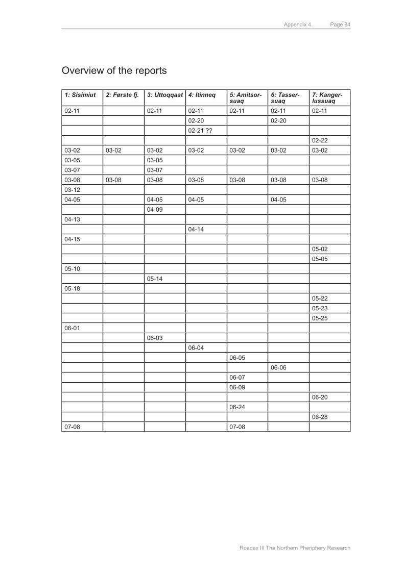
Appendix 4.
Roadex III The Northern Pheriphery Research
Page 84
Overview of the reports
1: Sisimiut 2: Første fj. 3: Uttoqqaat 4: Itinneq 5: Amitsor-suaq
6: Tasser-suaq
7: Kanger-lussuaq
02-11 02-11 02-11 02-11 02-11 02-11
02-20 02-20
02-21 ??
02-22
03-02 03-02 03-02 03-02 03-02 03-02 03-02
03-05 03-05
03-07 03-07
03-08 03-08 03-08 03-08 03-08 03-08 03-08
03-12
04-05 04-05 04-05 04-05
04-09
04-13
04-14
04-15
05-02
05-05
05-10
05-14
05-18
05-22
05-23
05-25
06-01
06-03
06-04
06-05
06-06
06-07
06-09
06-20
06-24
06-28
07-08 07-08
ROADEX III PUBLICATIONS
Developing Drainage Guidelines for Maintenance Contracts
Tyre Pressure Control on Timber Haulage Vehicles
Understanding Low-Volume Pavement Response to Heavy Traffic Loading
Health Issues Raised by Poorly Maintained Road Networks
Road condition management policies for low volume roads – tests and development of proposals
Policies for Forest Roads – Some Proposals
Road Construction in Greenland - The Greenlandic Case
Related Documents