River Riparian Connectivity & Habitat - Section 506 GLFER Appendix D: Hydrology and Hydraulics Agency Technical Review Document 2016 H6TH9MSD Cook County Chicago, Illinois January 2016

Welcome message from author
This document is posted to help you gain knowledge. Please leave a comment to let me know what you think about it! Share it to your friends and learn new things together.
Transcript
River Riparian Connectivity & Habitat - Section 506 GLFER
Appendix D: Hydrology and Hydraulics Agency Technical Review Document
2016
H6TH9MSD
Cook County
Chicago, Illinois
January 2016
2
River Riparian Restoration DRAFT
GLFER Section 506
Appendix D: Hydrology and Hydraulics
Introduction
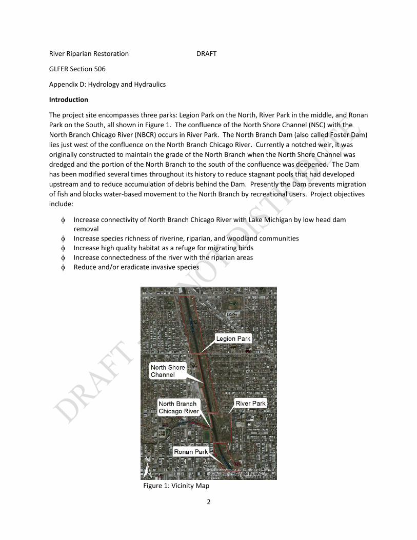
The project site encompasses three parks: Legion Park on the North, River Park in the middle, and Ronan Park on the South, all shown in Figure 1. The confluence of the North Shore Channel (NSC) with the North Branch Chicago River (NBCR) occurs in River Park. The North Branch Dam (also called Foster Dam) lies just west of the confluence on the North Branch Chicago River. Currently a notched weir, it was originally constructed to maintain the grade of the North Branch when the North Shore Channel was dredged and the portion of the North Branch to the south of the confluence was deepened. The Dam has been modified several times throughout its history to reduce stagnant pools that had developed upstream and to reduce accumulation of debris behind the Dam. Presently the Dam prevents migration of fish and blocks water-based movement to the North Branch by recreational users. Project objectives include:
φ Increase connectivity of North Branch Chicago River with Lake Michigan by low head dam removal
φ Increase species richness of riverine, riparian, and woodland communities φ Increase high quality habitat as a refuge for migrating birds φ Increase connectedness of the river with the riparian areas φ Reduce and/or eradicate invasive species
Figure 1: Vicinity Map
3
Available Data
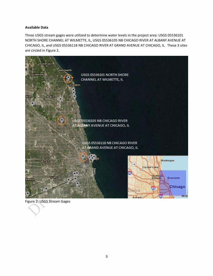
Three USGS stream gages were utilized to determine water levels in the project area: USGS 05536101 NORTH SHORE CHANNEL AT WILMETTE, IL, USGS 05536105 NB CHICAGO RIVER AT ALBANY AVENUE AT CHICAGO, IL, and USGS 05536118 NB CHICAGO RIVER AT GRAND AVENUE AT CHICAGO, IL. These 3 sites are circled in Figure 2.
Figure 2: USGS Stream Gages
4
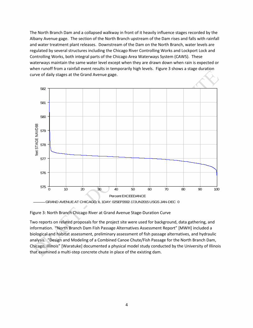
The North Branch Dam and a collapsed walkway in front of it heavily influence stages recorded by the Albany Avenue gage. The section of the North Branch upstream of the Dam rises and falls with rainfall and water treatment plant releases. Downstream of the Dam on the North Branch, water levels are regulated by several structures including the Chicago River Controlling Works and Lockport Lock and Controlling Works, both integral parts of the Chicago Area Waterways System (CAWS). These waterways maintain the same water level except when they are drawn down when rain is expected or when runoff from a rainfall event results in temporarily high levels. Figure 3 shows a stage duration curve of daily stages at the Grand Avenue gage.
Figure 3: North Branch Chicago River at Grand Avenue Stage-Duration Curve
Two reports on related proposals for the project site were used for background, data gathering, and information. “North Branch Dam Fish Passage Alternatives Assessment Report” [MWH] included a biological and habitat assessment, preliminary assessment of fish passage alternatives, and hydraulic analysis. “Design and Modeling of a Combined Canoe Chute/Fish Passage for the North Branch Dam, Chicago, Illinois” [Waratuke] documented a physical model study conducted by the University of Illinois that examined a multi-step concrete chute in place of the existing dam.
Percent EXCEEDANCE
0 10 20 30 40 50 60 70 80 90 100
feet
STA
GE N
AVD
88
575
576
577
578
579
580
581
582
GRAND AVENUE AT CHICAGO, IL 1DAY: 02SEP2002-17JUN2015 USGS JAN-DEC 0
5
Existing Site Conditions
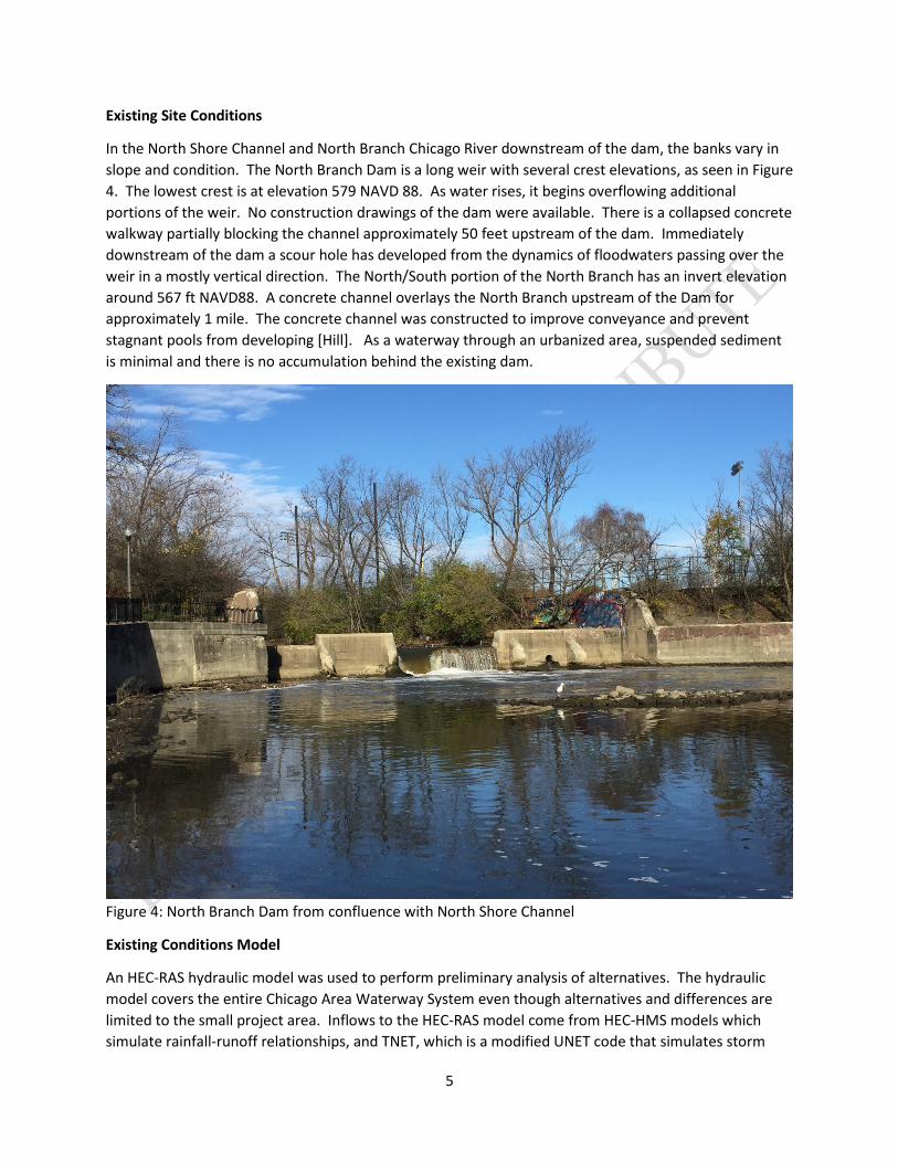
In the North Shore Channel and North Branch Chicago River downstream of the dam, the banks vary in slope and condition. The North Branch Dam is a long weir with several crest elevations, as seen in Figure 4. The lowest crest is at elevation 579 NAVD 88. As water rises, it begins overflowing additional portions of the weir. No construction drawings of the dam were available. There is a collapsed concrete walkway partially blocking the channel approximately 50 feet upstream of the dam. Immediately downstream of the dam a scour hole has developed from the dynamics of floodwaters passing over the weir in a mostly vertical direction. The North/South portion of the North Branch has an invert elevation around 567 ft NAVD88. A concrete channel overlays the North Branch upstream of the Dam for approximately 1 mile. The concrete channel was constructed to improve conveyance and prevent stagnant pools from developing [Hill]. As a waterway through an urbanized area, suspended sediment is minimal and there is no accumulation behind the existing dam.
Figure 4: North Branch Dam from confluence with North Shore Channel
Existing Conditions Model
An HEC-RAS hydraulic model was used to perform preliminary analysis of alternatives. The hydraulic model covers the entire Chicago Area Waterway System even though alternatives and differences are limited to the small project area. Inflows to the HEC-RAS model come from HEC-HMS models which simulate rainfall-runoff relationships, and TNET, which is a modified UNET code that simulates storm
6
sewer conveyance and pumping station outflows into surface water streams. Synthetic event rainfall depths and distribution of precipitation are from Illinois State Water Survey (ISWS) Bulletins 70 and 71 [Huff]. Hydraulic parameters in the model have been calibrated and verified to several events under previous studies that utilized the model. The North Shore Channel and the North Branch Chicago River downstream of the dam use cross section elevations from a 2015 USGS bathymetric survey. Surveyed cross sections in the North Branch upstream of the dam are sparse; this will be improved upon completion of surveys.
Alternatives
Some project features have limited impact on the hydraulics of the area. Removing invasive species plants and trees is one example of this. Bank grading to flatten the slopes of the banks will change the height of flood peaks. Current plans for the grading areas are to pull the bank back, which will expand the cross sectional area of the channel and lower flood peaks. If other considerations require banks to be filled into the current channel in order to flatten the slopes, Illinois Department of Natural Resources permitting requirements will be met which require demonstrating no stage increases upstream or downstream of the project.
Cobble stone revetment sections may be used in conjunction with flagstone walls where space is limited. The cobble stone revetment section would be placed on the bank from the toe of the channel up to an elevation above the normal water level that ties into the flagstone wall.
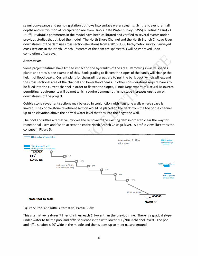
The pool and riffles alternative involves the removal of the existing dam in order to clear the way for recreational users and fish to access the entire North Branch Chicago River. A profile view illustrates the concept in Figure 5.
Figure 5: Pool and Riffle Alternative, Profile View
This alternative features 7 lines of riffles, each 1’ lower than the previous line. There is a gradual slope under water to tie the pool and riffle sequence in the with lower NSC/NBCR channel invert. The pool and riffle section is 20’ wide in the middle and then slopes up to meet natural ground.
7
Variations of the riffle and pool alternative were briefly considered but are not presented for one of two reasons. First, a design that had fewer riffles (five) and taller drops (1.5’) spread out over the same length in the channel produced similar profiles and velocities throughout the project area. It is the same concept and produces very similar benefits as the design presented above; during design phase advantages and disadvantages will be considered. Secondly, a design involving partial dam and concrete channel removal compressed the length available to step the North Branch down to the downstream channel. This would require taller drops, shorter pools, and higher velocities, which all are counter to the project goals of fish passage and recreational boat access.
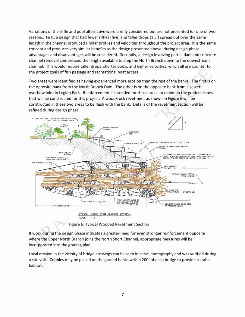
Two areas were identified as having experienced more erosion than the rest of the banks. The first is on the opposite bank from the North Branch Dam. The other is on the opposite bank from a sewer overflow inlet in Legion Park. Reinforcement is intended for those areas to maintain the graded slopes that will be constructed for this project. A wood/rock revetment as shown in Figure 6 will be constructed in these two areas to be flush with the bank. Details of the revetment section will be refined during design phase.
Figure 6: Typical Wooded Revetment Section
If work during the design phase indicates a greater need for even stronger reinforcement opposite where the upper North Branch joins the North Short Channel, appropriate measures will be incorporated into the grading plan.
Local erosion in the vicinity of bridge crossings can be seen in aerial photography and was verified during a site visit. Cobbles may be placed on the graded banks within 200’ of each bridge to provide a stable habitat.
8
Design Objectives
The hydraulic analysis of alternatives had different objectives for the different features. Bank grading needed to be stable and allow habitat to flourish. Two spots identified as severely eroded were to be reinforced.
Maintaining a stable condition at and around the confluence of the North Shore Channel and the North Branch Chicago River was a primary objective of the pool and riffle (dam removal) alternative. Water levels cannot increase upstream or downstream of the project area. Velocities needed to remain the same, or measures needed to be implemented to protect from higher velocities.
According to a University of Chicago report on a potential North Branch Dam replacement, literature suggested a minimum of 4” was required for canoes to pass over a weir [Waratuke]. Pool areas 40’x40’ were deemed acceptable for allow for resting between drops. Velocities over the riffles were to be minimized to allow weaker swimming fish to pass upstream.
Maintaining the low flow depth upstream of the project was another objective. The median water level in the regulated portion of the North Branch is several feet below the North Shore Channel invert, so removing the dam without full consideration of low flows could allow the upper North Branch to change to a lower profile or potentially begin head cutting.
Results and Conclusions
A 10 year, 24 hour rainfall event was used during feasibility phase to determine stage impacts and design velocities for project features. The complete event – using the entire unsteady flow hydrograph – was analyzed. A suite of synthetic rainfall events covering the full range of flows will be considered during design phase.
In the riparian habitat restoration areas, banks will be graded to as gentle of slopes as possible with grass or plants on the banks to stabilize the slopes. Design velocities were 3.0-3.5 ft/s with the current slopes and will decrease with the flatter slopes. Maintaining stable banks requires simply establishing vegetation for these conditions.
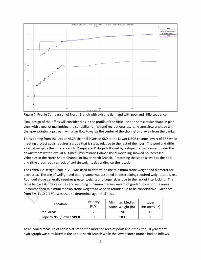
Preliminary modeling of the pool and riffle alternative showed that design objectives were met. Depth over the riffle lines during low flows was approximately 6” when 4” is acceptable. Velocities through the riffles, pools, and sloped transition remain below 10 feet per second. Peak water surface elevations did not increase upstream or downstream of the project. A profile comparison of existing conditions and the pool and riffle alternative is shown in Figure 7. The pool and riffle alternative is slightly lower than the existing conditions for a few hundred feet upstream of the existing dam at the peak of the storm.
9
Figure 7: Profile Comparison of North Branch with existing dam and with pool and riffle sequence
Final design of the riffles will consider dips in the profile of the riffle line and semicircular shape in plan view with a goal of maximizing the suitability for fish and recreational users. A semicircular shape with the apex pointing upstream will align flow towards the center of the channel and away from the banks.
Transitioning from the Upper NBCR channel invert of 580 to the Lower NBCR channel invert of 567 while meeting project goals requires a grade that is steep relative to the rest of the river. The pool and riffle alternative splits the difference into 7 separate 1’ drops followed by a slope that will remain under the downstream water level at all times. Preliminary 1 dimensional modeling showed no increased velocities in the North Shore Channel or lower North Branch. Protecting the slope as well as the pool and riffle areas requires rock of certain weights depending on the location.
The Hydraulic Design Chart 712-1 was used to determine the minimum stone weight and diameter for each area. The use of well-graded quarry stone was assumed in determining required weights and sizes. Rounded stone generally requires greater weights and larger sizes due to the lack of interlocking. The table below lists the velocities and resulting minimum median weight of graded stone for the areas. Recommended minimum median stone weights have been rounded up to be conservative. Guidance from EM 1110-2-1601 was used to determine layer thickness.
Location Velocity (ft/s)
Minimum Median Stone Weight (lb)
Layer Thickness (in)
Pool Areas 7 20 15 Slope to NSC / lower NBCR 9 180 30
As an added measure of conservatism for the modified area of pools and riffles, the 10 year storm hydrograph was simulated in the upper North Branch while the lower North Branch had no inflows,
0 500 1000 1500
570
575
580
585
590
CAWS_RiverRiparian Plan: 1) 10yr 24hr 11/16/2015 2) 7 1' drops wider 12/1/2015
Main Channel Distance (ft)
Ele
vatio
n (ft
)
Legend
WS Max WS - 7 1' drops wider
WS Max WS - 10yr 24hr
Ground
Left Levee
NBCR 1
10
resulting in a greater head differential to give the greatest velocities. Results presented in the table are robust to that scenario. The alternative performs under a variety of conditions attributable to climate change. Literature suggests increased precipitation and precipitation extremes, although with considerable uncertainty [USACE]. High flows associated with increased precipitation and low flows associated with dry periods have been considered and project benefits are realized during both conditions.
The riffle lines will also be 180 lb minimum median stone weight to remain stable with high turbulence and to create multiple hard lines to prevent any future potential head cutting. The first 12 linear feet downstream of each riffle will be the 180 lb median stone weight to account for higher turbulence in these areas and additional vertical forces from the 1’ drop.
A nearby recently completed restoration project at Horner Park featured grading similar to the proposed grading for this project. The banks were protected only with vegetation and have remained stable, just as modeling indicated would happen.
Uncertainty
The biggest uncertainty lies with the future condition of the pool and riffle alternative. Removing any existing dam has the possibility to change conditions upstream, downstream, and at the project. This uncertainty is being managed by designing a pool and riffle sequence that will be stable through a wide range of flows. Any final design will check for and minimize velocities that could cause excessive erosion or dangerous hydraulic jumps. Designing the riffle/pool/drop sequences over the longest channel length possible is an important advantage to limit the slope of the grade difference and in turn limit velocities. As the system experiences high flow events over time, maintenance activities such as replacing riffles or riprap would ensure project longevity and remedy any localized erosion issues.
Several parameters related to the North Branch Dam removal were developed using best-guess and conservative assumptions in the absence of data that can have a large influence on any configuration that goes in place of the current dam. Bathymetry data was not available for the area immediately downstream of the Dam, but will be collected in time to be used in the design phase. Bathymetry and additional channel surveys will improve the existing conditions modeling and improve understanding of localized hydraulic phenomena. Surveyed cross sections upstream of the existing dam will improve the accuracy of existing conditions modeling for the full range of possible flows and specifically low flows that would have a major influence on the design to facilitate fish and recreation access. Hydraulic jump, turbulence, and vertical forces downstream of the riffles will be thoroughly analyzed with any alternative in the design phase. Final design of shape of riffles, height of riffles, depth of pools, and length of pools will impact calculations.
Any uncertainties remaining after collection of additional data and more comprehensive analysis of the selected alternative will be mitigated by using conservative assumptions.
Potential consequences are greater with the dam removal alternative than with more conventional ecosystem restoration measures. The existing North Branch Dam contributes to maintaining the stable condition of the channels and banks in the project area. Along with the collapsed walkway 50’ upstream, it controls upstream stages when flows are low. The dam and head differential during large events direct energy in a more vertical direction compared to a without-dam condition. The existing
11
condition has created a scour hole downstream of the dam while the surrounding banks are relatively static. Flow patterns and velocities will be investigated further when additional bathymetric and topographic data is available. Possible increases in channel velocities and additional energy propagating to the bank opposite the existing dam are topics of interest. Consequences to prevent include possible head cutting, undermining of bridge abutments at Albany Avenue and elsewhere, undermining of the guide walls and retaining walls adjacent to the project, and worsening the scouring of nearby channel banks.
References
EM 1110-2-1601, U.S. Army Corps of Engineers, HYDRAULIC DESIGN OF FLOOD CONTROL CHANNELS
Huff, F. A., and J. R. Angel, 1989. Rainfall Distributions and Hydroclimatic Characteristics of Heavy Rainstorms in Illinois (Bulletin 70), Illinois State Water Survey.
Huff, F. A. and J. R. Angel, 1992. Rainfall Frequency Atlas of the Midwest (Bulletin 71). Illinois State Water Survey.
Hill, Libby. The CHICAGO RIVER, a natural and unnatural history. 2000.
MWH. North Branch Dam Fish Passage Alternatives Assessment Report. April 2006. USACE (2015). Recent US Climate Change and Hydrology Literature Applicable to US Army Corps of Engineers Missions – Water Resources Region 07, Upper Mississippi. Civil Works Technical Report, CWTS-2015-13, USACE, Washington, DC Waratuke, Andrew R., et al, Design and Modeling of a Combined Canoe Chute/Fish Passage for the North Branch Dam, Chicago, Illinois, Ven Te Chow Hydrosystems Laboratory Department of Civil and Envir. Engineering University of Illinois at Urbana-Champaign Urbana, Illinois, November 2009
Related Documents