Edited by Anne Jensen, Michael Good, Prudence Tucker and Martine Long A report for the Murray – Darling Basin Commission — June 2000 An evaluation of environmental flow needs in the Lower Lakes and Coorong River Murray Barrages Environmental Flows

Welcome message from author
This document is posted to help you gain knowledge. Please leave a comment to let me know what you think about it! Share it to your friends and learn new things together.
Transcript

Edited by Anne Jensen, Michae l Good, Prudence Tucker and Mar t ine Long
A report for the Murray – Darling Basin Commission — June 2000
A n e v a l u a t i o n o f e n v i r o n m e n t a l f l o w n e e d s i n t h e L o w e r L a k e s a n d C o o r o n g
River Murray BarragesE n v i r o n m e n t a l F l o w s
MDBC barrages flowcover 27/8/01 2:40 PM Page 2

RIVER MURRAY BARRAGES ENVIRONMENTAL FLOWS
An evaluation of environmental flow needs in the Lower Lakes and Coorong
A report for the Murray–Darling Basin Commission
June 2000
Edited by Anne Jensen, Michael Good, Paul Harvey,
Prudence Tucker and Martine Long
Project funded by the Murray–Darling Basin Commission
Wetlands Management Program
Department for Water Resources
GPO Box 1047Adelaide
South Australia 5001
R i v e r M u r r a y B a r r a g e s E n v i r o n m e n t a l F l o w s i
Murray Barrages flow edit 28/8/01 11:14 AM Page i

R i v e r M u r r a y B a r r a g e s E n v i r o n m e n t a l F l o w s
Scott Nichols for initial coordination of scientific panelworkshops and field trips.
Daphne Matthews for organisational assistance inarrangements for workshops and field trips.
Gary Tong for providing a presentation on his work onmodelling of the Coorong estuary.
Jane Doolan of DNRE in Victoria for attending the firstworkshop to provide links with the upstream scientificpanel.
Andy Close of MDBC Canberra for attending twoworkshops to provide system hydrology information andlinks with the upstream scientific panel approach.
River Murray Environmental Flows Scientific Panel foraccess to their draft report to ensure consistent linkages.
Jim Marsh for giving time to meet the scientific panel inthe field and share knowledge on operation of thebarrages.
John Eckert for giving time to meet the scientific panelin the field and share knowledge on managing saltmarshhabitat for waders at Tolderol.
Gary Hera Singh for giving time to meet the scientificpanel in the field and share knowledge on issues forprofessional fishers.
Graham Camac for giving time to meet the scientificpanel in the field and share knowledge on the problem oflake shore erosion.
John Gilliland for giving time to meet the scientific panelin the field and share knowledge on issues raised in thecommunity in relation to wise use of the Ramsar wetland.
Editing, layout and production: Lynne GriffithsCover design: Phoenix Design
Wetlands Management ProgramDepartment for Water ResourcesGPO Box 1047Adelaide South Australia 5001
Murray-Darling Basin Commision
15 Moore Street Canberra City, Australian Capital Territory
Postal address: GPO Box 409; Canberra ACT 2601
Telephone: (02) 6279 0100; international 612 6279 0100
Facsimile: (02) 6248 8053; international 612 6248 8053
Website: http://www.mdbc.gov.au
This work is copyright. Except for the MDBC logo,graphical and textual information in this publication may be reproduced in whole or in part provided that it is not sold or put to commercial use and its source (“River Murray Barrages Environmental Flows”) isacknowledged. Such reproduction includes fair dealingfor the purpose of private study, research criticism orreview as permitted under the Copyright Act 1968.Reproduction for other purposes is prohibited withoutthe written permission of the Murray-Darling BasinCommission.
The contents of this publication do not purport torepresent the position of the Murray-Darling Basin. They are presented solely to stimulate discussion forimproved management of the Basin’s natural resources.
ISBN 0 7308 5831 6
© Copyright Murray-Darling Basin Commission 2000
ACKNOWLEDGEMENTS
ii
Murray Barrages flow edit 28/8/01 11:14 AM Page ii
ACKNOWLEDGEMENTS ii
EXECUTIVE SUMMARY viii
PART 1: Introduction and Methodology 1
INTRODUCTION 2
Project brief 2Membership of the panel and steering committee 2
METHODOLOGY 5
Definition of study area 5Process of evaluation 5Background and current status of Lower Lakes and Coorong 8Context of management issues and constraints 10Summary of upstream panel findings and recommendations 11Management framework for future operation of barrages 11
PART 2: CURRENT STATUS, KEY ISSUES AND ECOLOGICAL NEEDS 13
HYDROLOGY OF THE LOWER LAKES AND COORONG 14
R Newman, Water Resource Manager Murray SA, DENR, Murraylands RegionCurrent status 14
Hydrology of the Murray–Darling Basin 14Construction of the barrages 14Lower Lakes and Coorong 15River regulation and development 1900 to 1980 18
Key issues 19
Controlling diversions from the Murray–Darling system 19Major changes in flow regimes 19Estuary–Murray Mouth zone 19The Lower Lakes 20The Coorong 20
Opportunities for improved barrage operation 20
The challenge 21
GEOMORPHOLOGY OF THE LOWER MURRAY LAKES AND COORONG 23
R P Bourman, Faculty of Engineering and the Environment, University of South AustraliaBackground and current status 23
Key issues 24
Natural changes 24Geomorphic impacts of river and lake regulation 25Reduction of River Murray estuary 27
Ecological needs 28
Opportunities for improvement 28
AQUATIC AND RIPARIAN VEGETATION 30
G G Ganf, Botany Department, University of AdelaideBackground and current status 30
Key issues 31
Salinity 31
CONTENTS
R i v e r M u r r a y B a r r a g e s E n v i r o n m e n t a l F l o w s iii
Murray Barrages flow edit 28/8/01 11:14 AM Page iii
R i v e r M u r r a y B a r r a g e s E n v i r o n m e n t a l F l o w s
Turbidity 31Water regime 32Wave action and wind 32Supplementary issues 32
ECOLOGICAL NEEDS 33
Opportunities for improved environmental conditions 33
BIRD ECOLOGY IN THE COORONG AND LAKES REGION 35
D C Paton, Department of Zoology, University of AdelaideBACKGROUND AND CURRENT STATUS 35
KEY ISSUES 37
Lakeshore erosion 37Turbidity 39Increasing sedimentation 39European carp 39Rapid changes in water level 39Impacts of human activity 40
ECOLOGICAL NEEDS 40
OPPORTUNITIES FOR IMPROVEMENT 40
FISH AND INVERTEBRATES 43
M Geddes, Zoology Department, University of AdelaideBACKGROUND AND CURRENT STATUS 43
KEY ISSUES 45
Reduced estuarine area 46Changed water regime 47
ECOLOGICAL NEEDS 47
OPPORTUNITIES FOR IMPROVED ENVIRONMENTAL CONDITIONS 49
PHYTOPLANKTON IN THE LOWER LAKES OF THE RIVER MURRAY 51
P Baker, Australian Water Quality Centre, Salisbury SABACKGROUND AND CURRENT STATUS 51
KEY ISSUES 54
ECOLOGICAL NEEDS 54
OPPORTUNITIES FOR IMPROVED ENVIRONMENTAL CONDITIONS 55
PART 3: OPPORTUNITIES FOR IMPROVED ENVIRONMENTAL CONDITIONS 57
ECOLOGICAL NEEDS AND OPPORTUNITIES FOR IMPROVED HYDROLOGICAL MANAGEMENT 58
Universal outcomes 58Short-term opportunities 58Medium-term opportunities 67Long-term opportunities 71Effectiveness of management options 74Complementary management opportunities 74
iv
Murray Barrages flow edit 28/8/01 11:14 AM Page iv
Shoreline erosion 76Riparian buffer zones 76Carp 76Dryland salinity 76
CONCLUSIONS 77
KEY ISSUES 77
Reduced estuarine area 77Changed water regimes of the lakes and river 78Freshening of brackish and saline habitats 78Reduced habitat for aquatic plants 78Increased algal blooms 78Dryland salinity 78
CURRENT STATUS AND FUTURE PROGNOSIS FOR THE LOWER LAKES AND COORONG 79
RECOMMENDATIONS OF THE SCIENTIFIC PANEL 79
Short-term 79Medium-term 79Long-term 80General recommendations 80
IMPLEMENTATION 80
GUIDELINES 80
Barrage operation 80Coorong water levels 80Flushing of lakes 81Enlarge estuary 81Fish passage 81Lake levels 81Vegetation 81Sedimentation 81Erosion control 81
OPERATING CRITERIA 82
FURTHER INVESTIGATIONS 83
Sedimentation 83Bird ecology 83Fish and invertebrates 83Hydrological management 83Phytoplankton 83
SALINITY 84
LINKS TO OTHER ACTIVITIES 84
IMPLICATIONS FOR MANAGEMENT AGENCIES 84
IMPLICATIONS FOR UPSTREAM WATER MANAGEMENT 84
CONSULTATION 85
REFERENCES 86
APPENDICES 91
R i v e r M u r r a y B a r r a g e s E n v i r o n m e n t a l F l o w s v
Murray Barrages flow edit 28/8/01 11:14 AM Page v

R i v e r M u r r a y B a r r a g e s E n v i r o n m e n t a l F l o w s
I Process for Evaluating Environmental Flow Requirements for the River Murray
Barrages 92
II Assessment Process for Environmental Flow Requirements for River Murray and
Lower Darling 103
III Issues Raised in Ramsar Planning Process for the Lower Lakes and Coorong 105
IV Constraints and Current Operation Strategies for the Barrages and Lower Lakes 106
V Constraints and Operating Strategies for the River Murray System 110
VI Impacts of the Barrages on Sedimentation Interactions Between the Lower Lakes
and the Coorong 111
VII Issues in Fish Management and Proposals for Changed Management of the Barrages 115
VIII Interactions with Coorong Reserve Management Issues 117
IX On Site Talk to Expert Panel 118
ILLUSTRATIONS
PLATES
1 River Murray Barrages Environmental Flows Scientific Panel on Tauwitchere Barrage 1
2 Murray Mouth – aerial view 8
3 Goolwa Barrage 13
4 Pelicans, Ewe Island 37
5 Expert panel at Lake Albert 57
FIGURES
1.1 Lower Murray and lakes study area 4
1.2 Methodology flow chart for the River Murray Barrages Environmental Flows
Scientific Panel 5
1.3 Five ecological areas: eroding lakeshores, prograding lakeshores, Coorong Northern
Lagoon (from Pelican Point to Hells Gate), Coorong Southern Lagoon and estuary 7
1.4 The locality of the five barrages inside the Murray Mouth 9
2.1 Annual flow patterns at the barrages 15
2.2 Operational history of barrage openings at Goolwa, 1982–96 16
2.3 Growth of diversions in the Murray–Darling Basin 17
2.4 SA diversions as a proportion of ‘entitlement flow’ 18
2.5 Pelican Point salinity – boundary conditions for long-term model 22
2.6 Development of the Murray Mouth flood tidal delta 23
2.7 Coorong and Lower Lakes Ramsar Wetland area – key to critical bird habitats 38
2.8 Longitudinal and vertical salinity patterns in the Coorong at irregular intervals
between 1975 and 1985 43
2.9 Total commercial catches of mulloway in South Australia 1951–85 and river level
above Lock 1 45
2.10 Increase in Coorong mulloway catches as a response to a reinstated natural winter
flow regime 46
vi
Murray Barrages flow edit 28/8/01 11:14 AM Page vi

2.11 Water quality at Milang and Lake Alexandrina 1990–97 52
I.1 Process of development of evaluation methodology 92
I.2 Amended barrages recording sheet, based on upstream methodology 96
I.3 Amended barrages recording sheet (stage 1) 97
I.4 Amended barrages recording sheet (stage 2) 98
I.5 Assessment of recording sheets needed to cover the issue versus region matrix 99
I.6 Recording sheet test (for the issue of shore erosion in the eroding lakeshores region) 100
I.7 Key problems and causes cross-checked against the five regions 101
I.8 Summary of issues covered in the amended field recording sheet 102
III.1 Ramsar planning process 105
VI.1 Data highlighting the changing condition of the surface waters of the Pelican
Point channel 112
VI.2 Percentage of silt-clay relative to sand, Lake Alexandrina substrate 113
VI.3 Particle size distribution of fine deposited sediment 113
VI.4 South-easterly extent of deposited Lake Alexandrina suspended sediments,
extrapolated from presence of ‘fingerprint’ 114
TABLES
i.1 Opportunities for improved hydrological management xi
1.1 Composition and expertise of River Murray Barrages Environmental Flows
Scientific Panel 3
1.2 Composition and management areas represented on River Murray Barrages
Environmental Flows Steering Committee 3
1.3 Barrage structures of the River Murray estuary 8
2.1 Dimensions of the Murray-Darling system compared with major river systems of
the world 14
2.2 Surface water salinity tolerances of plant communities in the Lower Lakes and Coorong 30
2.3 Scientific bird names 36
2.4 Fish of the Coorong 44
3.1 Environmental needs and critical outcomes to meet needs 60
3.2 Hydrological management opportunities 61
3.3 Proposed automation of barrage gates 64
3.4 Pattern of delivery of South Australia’s flow entitlement 66
3.5 Location of environmental needs satisfied by each hydrological management opportunity 75
3.6 Non-hydrological opportunities for improved management of Lower Lakes and Coorong 76
II.1 Composition of River Murray Environmental Flows Scientific Panel 103
IV.1 Flow to South Australia 108
IV.2 Particulars of barrages 109
VII.1 Estimated costs of automated barrage gates 115
R i v e r M u r r a y B a r r a g e s E n v i r o n m e n t a l F l o w s vii
Murray Barrages flow edit 28/8/01 11:14 AM Page vii

R i v e r M u r r a y B a r r a g e s E n v i r o n m e n t a l F l o w s
BACKGROUND
The Murray-Darling Basin Commission (MDBC) iscurrently developing an environmental flow managementprogram for the River Murray and Lower Darling River.This is being overseen by the Project Board forEnvironmental Flows and Water Quality objectives, whichhas sought input on key issues from a number of sourcesincluding expert scientific panels.
The development of an environmental flow managementprogram is part of the Commission response to widespreadconcerns about the level of consumptive diversions fromthe river systems and the effects these are having on thecondition of aquatic ecosystems within the basin.
A cap on further consumptive diversions was agreed by all the states in July 1997. This has provided furtherimpetus to investigate options for optimising the benefitsfrom the water available for the environment within theriver systems. As part of this process the MDBC ProjectBoard has sought an evaluation of environmental flowneeds of the Lower Lakes and Coorong and an assessmentof the opportunities for improved operation of thebarrages to meet these needs. This report provides thisassessment and evaluation.
PURPOSE OF THE STUDY
The objective of the River Murray Barrages EnvironmentalFlows Project was:
to identify key environmental flow requirementsin relation to management of flow through thebarrages, and maintaining the ecosystem of theLower Lakes, the Coorong Estuary and CoorongLagoons.
A Panel of appropriate scientific experts was drawntogether to collaborate in the provision of thisinformation. This Barrages Environmental Flows Projectreport by the Scientific Panel provides:
• an overview of the ecological needs of the region of theformer River Murray estuary,
• an assessment of the environmental impacts of thebarrages which separate marine and fresh waters nearthe Murray mouth,
• recommendations for changes in management tominimise these impacts.
This study has been conducted using a separate scientificpanel to that used for the River Murray upstream of Wellington due to the different nature of the ecosystems involved.
The Barrages Scientific Panel comprises academic and stategovernment agency experts in the fields of hydrology,geomorphology, riparian and aquatic vegetation, birdecology, fish and invertebrate ecology and algal ecology. Asteering Committee comprising state and MDBC agencystaff has provided management advice.
BIOPHYSICAL ENVIRONMENT
The barrage structures divide the fresh waters of theLower Lakes from the saltier waters of the Coorong andthe sea just upstream of the Murray Mouth. Part of theoriginal Murray estuary, the Coorong and Lower Lakes(Lake Albert and Lake Alexandrina) cover approximately660 km2 adjoining the mouth of the River Murray. TheCoorong is a narrow coastal lagoon running south-eastfrom the river mouth for about 100 km, and is separatedfrom the sea by a narrow dune system. The lakes are broadand shallow, with Lake Alexandrina containing a largenumber of sand and mud islands adjacent to the rivermouth.
This diverse range of wetland habitats (marine, hypo-marine, hyper-marine, estuarine and freshwater) supports ahigh biological diversity. The entire area is of national andinternational conservation status, especially as habitat forbirds. It is listed as a Ramsar Wetland, protected as aNational Park and subject to two international bilateralmigratory bird agreements (JAMBA and CAMBA). It alsosupports a significant commercial fishing industry,provides stock and domestic water supplies, and attractsmajor recreational fishing and boating use.
Since European settlement the area has been subject tomany management pressures which threaten itsconservation values. These include:
_ an altered input flow regime due to upstream riverregulation
_ an altered lake and estuary flow regime due to thecontruction of barrages separating the lakes fromthe mouth and the Coorong
_ agricultural pressures (stock grazing, vegetationclearance and diffuse run off, nutrient pollution)
_ recreational and tourism impacts (boating, fishing,4WD vehicles)
_ exotic plants and animals.
This report focuses primarily on the first and second issuesdue to their major impacts on flow regimes, influencinghabitat changes, decline in native species and increases inexotic species.
EXECUTIVE SUMMARY
viii
Murray Barrages flow edit 28/8/01 11:14 AM Page viii

KEY ISSUES
The Scientific panel identified four key issues driving theserious degradation of environmental values in the LowerLakes and Coorong. These are:
• the reduced area of the estuary
• changed water regimes of the lakes and river
• freshening of brackish and saline habitats
• reduced habitat for aquatic plants
The first two issues are the most significant in terms oftheir impact and their influence in driving the other keyissues.
In assessing the current status of the Lower Lakes andCoorong the panel found that:
• the River Murray does not end at the Barrages andflow management should take into account the flowregimes and ecological needs of the remnant estuary,the Coorong, the mouth channel and the offshorezone,
• the remnant estuary, including the northern andsouthern Coorong lagoons, is only 11% of the naturalestuary area, with less fresh water inflows than thenatural system allowing seawater to dominateconditions,
• total flow through the Murray system has beenreduced to approximately one third of the medianunregulated flow with the frequency of no flow at theriver mouth increased from 1 year in 20 toapproximately 1 year in 2,
• the current status and biodiversity of aquatic plantcommunities is reduced by the low through-flow ofwater, reasonably static water levels and high turbidity,
• the change to fresh water habitat and increasingnutrient inputs is favouring fresh water algal species inthe Lower Lakes including bloom forming andpotentially toxic cyanobacteria,
• the barrages have disrupted the transition between thefresh and salt water environments negatively affectingbreeding and recruitment of estuarine plant and animalspecies,
• the abrupt changes in water level in the Coorong arelimiting the available habitat for migratory birds whichare protected under the China-Australia MigratoryBird Agreement (CAMBA) and the Japan-AustraliaMigratory Bird Agreement (JAMBA),
• the value of the commercial fishery in the remnantestuary is equal to that from the whole of thefreshwater lakes which are nine times greater in area,
• the significant decline in fish catches is believed to bedue to the rapid changes in flow and salinity caused bycurrent barrage operation and the reduced estuarinearea,
• the changed tidal and river flow conditions areincreasing the likelihood of river mouth closures,
• the flow through Mundoo channel has beensignificantly reduced from natural conditions which iscausing siltation of the mouth,
• the current limited evidence indicates that the primarymajor sources of sediment and nutrient inputs to thelakes are from their own catchments rather than fromthe River Murray,
• lake shore erosion caused by high constant lake levels,wind and highly erodible soils is a significantcontributor of sediment and nutrients to the lakes.
In addition, the Panel identified two other long termissues of concern for the ecology of the Lower Lakes,Coorong and Murray Mouth area. These are concernsregarding the apparent increased frequency of major algalblooms and the salinisation of land surrounding the studyarea. These issues have not been addressed in this report asthey will not be directly affected by management of thebarrages in the short term.
Algal blooms and, in particular, toxic cyanobacterial (orblue-green algal) blooms, could have a significant effect ontourism and recreational uses of the area and may impacton the fishery.
Salinisation of the surrounding land by rising watertablescould have significant long term effects on salt and waterbalances in the region.
In summary the Panel found that the currentoperating system for the Lower Lakes, Coorongand Murray Mouth is not sustainable withcontinued significant environmental degradationexpected. In particular, it is anticipated thatthere will be increasing problems in both thelakes and the Coorong related to reducedthrough flows, increased sedimentation andaccumulation of nutrients.
R i v e r M u r r a y B a r r a g e s E n v i r o n m e n t a l F l o w s ix
Murray Barrages flow edit 28/8/01 11:14 AM Page ix

R i v e r M u r r a y B a r r a g e s E n v i r o n m e n t a l F l o w s
ECOLOGICAL NEEDS ANDOUTCOMES
The Scientific Panel identified fifteen ecological changesneeded to address these key issues. In addition the criticaloutcomes required to meet those needs were identified.
The ecological needs identified are:
1. protect aquatic plants in the Coorong and maximisemudflat habitat,
2. maximise estuarine area,
3. limit deposition at the Murray Mouth,
4. increase fish passage through the river mouth,
5. provide fish passage through the barrages,
6. protect and enhance salt marsh habitat around theLower Lakes,
7. increase the diversity of riparian vegetation,
8. reduce sediment transport into the Coorong,
9. reduce nutrient inputs to the Lower Lakes,
10. maintain a diverse water quality regime in the estuaryand the Coorong,
11. reduce exotic fish in the Lower Lakes,
12. increase aquatic vegetation throughout the LowerLakes area,
13. reduce lake shore erosion,
14. reduce lake water turbidity.
15. reduce the area of dryland salinity affecting theLower Lakes and Coorong,
KEY RECOMMENDATIONS
From these ecological needs, the Scientific Panel identified15 opportunities for improved hydrological management(see Table i.1). These range from minor modifications tocurrent operating procedures to investigations into majorchanges to the barrages. Implementation of therecommended package of actions would result in asignificant improvement in the ecological condition of thearea as well as social and economic benefits.
The broad categories of recommendations are:
• establish an environmental monitoring program as abasis for adaptive management,
• articulate detailed barrage operating guidelines tomeet ecological needs,
• automate barrage gates for more flexible operation and
sensitivity to ecological needs,
• investigate opportunities to manage lake levels over a
greater range of levels,
• modify Mundoo Barrage to increase flow capacity and
operate preferentially to limit sedimentation at the
Murray mouth,
• evaluate options for relocation and revised
management of the barrages to enlarge estuarine area
to increase the range of habitats,
• undertake complementary measures (lake shore
revegetation and stabilisation, carp control, regional
revegetation),
• integrate flow management actions with other regional
planing and management activities for maximum
effectiveness.
The most significant short to medium term
recommendation is for automation of the barrage gates
and fine tuned operation to maximise fish passage, increase
water bird habitat, increase the area of estuarine habitat
and maximise the control of water quality.
Another key recommendation is to increase the scour
capacity of the Mundoo Channel in order to restrict
continuing sedimentation in the Murray Mouth Zone.
In the longer term, the feasibility of relocating the ageing
barrage structures should be investigated, for the
ecological benefits of increasing the area of the estuarine
zone and the economic benefits of decreasing evaporative
losses. Any feasibility study into this option should be
linked to wider consultation and investigations regarding
the social and economic implications of such a proposal.
The fundamental recommendation of the Scientific Panel
is that these management changes should take place in a
framework of active adaptive management, which requires
the establishment of a monitoring baseline before any
changes take place. Targeted monitoring designed to
measure the effectiveness of various management
strategies, with regular review (suggested at 5 yearly
intervals) is required to evaluate and update these
management strategies. Complemnetary actions such as
control of lake shore erosion and revegetation of the lake
catchment are also recommended.
x
Murray Barrages flow edit 28/8/01 11:14 AM Page x

IMPLEMENTATION
The entire package of recommendations should be implemented over the suggested timetable to provide the maximumecological benefits. Many of these recommendations complement each other or are sequential or concurrent, with oneaction being dependent on or at least enhanced by others. For example fish passage would be promoted at low flows,while scouring of the river mouth zone would require medium to high flows to be effective. Importantly, long termactions need to be investigated in the medium term to allow sufficient time for planning.
A draft work program has been prepared by the steering committee for release with this report.
TABLE i.1 OPPORTUNITIES FOR IMPROVED HYDROLOGICAL MANAGEMENT
Implementation of short-term hydrological management opportunities (1-3 years)(assuming work will commence by the end of 2000)
7 assess spatial extent of salinity impacts from marineincursions (incorporate modelling and monitoring programs)
8 investigate alternative solutions to levees
9 cost-benefit analysis of proposed works
10 evaluate the proposal to construct levees as a basis fora decision as to whether to issue a permit for worksunder the Water Resources Act 1997
2000 — 2001
2000
2001
2001
Assess proposal to build leveeson island spillways to minimiseimpacts on the interfacebetween fresh and salt water
A3
5 identify short-term environmental flow needs(based on existing knowledge), eg for fish passage,in terms of volume, location, gate openings andtiming
6 develop specific rules and operating procedures for the use of environmental flows for maximumbenefit at the barrages
2000
2000 — 2001
Develop specific arrangements for maximisingthe ecological benefit of the non-consumptive proportion of entitlementflows to South Australia
A2
1 document the current operating guidelines andtriggers (ie actions taken to achieve the operatingrule of 0.75 m AHD lake levels) in order to identifyconstraints and opportunities for changes in operating guidelines
2 articulate detailed environmental operating principlesand guidelines to meet identified ecological needs
3 implement short term optimal guidelines, foroperation of the structures within the currentagreed range of lake levels based on existingknowledge and an assessment of the environmentaloperating principles against social and economicconstraints
4 set up ecological monitoring program, based on active adaptive management principles and coordinate and include existing monitoring
2000
2001
2001
2000(ongoing)
Change the timing,sequence and frequency of opening and closing ofbarrage gates within currentoperating range of lake levels (0.60–0.85 m EL) tooptimise the ecological,social and economicbenefits.
A1
Work program
(to be completed within time scales)Timetable for
actionsActionCode
R i v e r M u r r a y B a r r a g e s E n v i r o n m e n t a l F l o w s xi
Murray Barrages flow edit 28/8/01 11:14 AM Page xi

R i v e r M u r r a y B a r r a g e s E n v i r o n m e n t a l F l o w s
16 assess the environmental needs for operation of thelakes over a wider range of levels and identifyoptions for management of lake levels
17 evaluate impacts of options and trade-offenvironmental, economic and social benefits againstenvironmental, economic and social costs, using theTong model of the estuary and Coorong lagoonsto assess potential impacts and benefits of variousmanagement options
18 seek agreement on a trial of a new operating regimebased on the preferred option
19 establish a monitoring program to assess impacts ofa greater range of lake levels on irrigators,recreational users and the ecology of the lakes andthe fringing saltmarsh land
2000 — 2001
2000 — 2001
2001
2001 (on-going)
Investigate operating automatedgates at a greater range of lakelevels (ie higher or lower thancurrent 0.60-0.85 m EL).
B2
11 finalise feasibility studies of gate automation(engineering works, economics, fundingarrangements etc)
12 develop environmental guidelines for operation ofautomated gates within the currently agreed rangeof lake levels
13 install automated gates and operate within agreedguidelines.
14 monitor impacts of improved gate operation on fishmovement, salinity control and ecological impacts.
15 design fish passage trials in land holder channels atMundoo and at selected barrage gates
2000 — 2001
2000 — 2001
2001
2000 (on-going)
2001
Automate approximately22% of gates across all fivebarrages and finetunetiming sequence andfrequency of opening andclosing of automatedbarrage gates according toenvironmental guidelineswithin the current range oflake levels.
B1
xii
Murray Barrages flow edit 28/8/01 11:14 AM Page xii

Implementation of medium-term hydrological management opportunities (3-10 years)
29 evaluate environmental data from monitoringprograms
30 Investigations – engineering design– economic analysis– cost-sharing arrangements
2005–2007
2005–2007
Automate more barragegates as determined byadaptive managementmonitoring results andoperate at a wider range oflake levels according toenvironmental guidelines.
D3
26 determine preferred operating guidelines andperformance indicators
27 trial altered operating regime with wider range of lake levels (consult monitoring program andimplement operational changes based on ecological data
28 renegotiate agreement on altered operating regimeon the basis of the trial
2000–2001
2001
2003
Trial operation of the lakesat a wider range of levels (ie outside 0.6-0.85 m EL).
D2
24 investigate options to change design andmanagement of Mundoo Barrage to limitsedimentation in the mouth zone and formulateoperational strategy satisfying multiple objectives ieoptimum size of opening, flow size that can begenerated, flooding risks and marine incursion risks
25 negotiate implementation of any structural oroperational changes identified in this investigation
2001–2002
2000–2002
Investigate structural andoperational modifications toMundoo Barrage toincrease scour capacity andoperate preferentially tolimit sedimentation at theMurray Mouth zone andimplement if appropriate.
D1
23 review effectiveness of changed operating guidelinesand adapt management as required. (based onmonitoring and other investigations)
2005–2007First revision of operatingrules for automated gatesand flow allocations onbasis of adaptivemanagement monitoringresults.
C1
20 determine what different monthly and/or dailyflows in the pattern of delivery of entitlement flowswould be of environmental benefit throughproviding seasonal flow at the barrages
21 formulate guidelines incorporating upstreamirrigation requirements, storage and weirmanagement, and flow requirements for fish andwater exchange
22 negotiate a different pattern of delivery of flows bysubmission from the SA commissioners to theMDBC
2000–2001
2001–2002
2001
Investigate the benefits ofdifferent monthly and/ordaily flows in the pattern ofdelivery of entitlementflows to provide seasonalflows at barrages andnegotiate changes ifappropriate.
B3
R i v e r M u r r a y B a r r a g e s E n v i r o n m e n t a l F l o w s xiii
Murray Barrages flow edit 28/8/01 11:14 AM Page xiii

R i v e r M u r r a y B a r r a g e s E n v i r o n m e n t a l F l o w s
Implementation of long-term hydrological management opportunities (>10 years)
38 evaluate option of operating Lake Albert as an estuary and investigate environmental impacts ofthis enlarged estuary and changed habitat
39 negotiate agreements for supply of fresh water tomaintain estuarine environment
40 formulate operational guidelines considering environmental needs, lake irrigators needs and public water supply requirements (time dependenton implementation of the action)
2001Investigate the option ofincreasing the estuary areaby converting Lake Albertinto an estuarine zone, egby constructing a barrage atNarrung Narrows and achannel from Marnooswamp into the Coorong.
F2
33 Investigate costs and benefits of relocating thebarrages upstream to maintain a larger estuarinearea as part of the scheduled maintenance review.
34 Investigate alternative and innovative barragedesign and operation for fish and boat passage
35 investigate options for relocation of barrages (eg toWellington or Point Sturt) and for revisedoperation of the barrages, incorporatingenvironmental needs, lake irrigators needs andpublic water supply requirements
36 negotiate agreements for supply of fresh water tomaintain estuarine environment
37 formulate operational guidelines considering environmental needs, lake irrigators needs and public water supply requirements (time dependenton implementation of the action)
2001
2000 (ongoing)
2000
Relocate the barragesupstream to Wellington or Point Sturt and investevaporative savings intoenvironmental flows for the Lakes and Coorong, to maintain a larger estuarine area.
F1
32 review effectiveness of changed operating guidelinesand adapt management measures as required,update monitoring baseline
2010–2012Second revision of operatingrules for automated gatesand revise flow allocations onbasis of adaptive managementmonitoring results.
E1
31 investigate basin-wide opportunities for water savings for transfer to the Lower Lakes andCoorong environment to meet identified environmental needs (link to review of water cap arrangements)
2000 (on-going)
Increase environmentalflows to meet ecologicalneeds in the Lower Lakesand Coorong throughongoing basin-wide waterallocation reviews.
D4
xiv
Implementation of medium-term hydrological management opportunities (3-10 years) continued
Murray Barrages flow edit 28/8/01 11:14 AM Page xiv

PART 1:
INTRODUCTION AND METHODOLOGYPLATE 1 RIVER MURRAY BARRAGES ENVIRONMENTAL FLOWS SCIENTIFIC PANEL ON TAUWITCHERE BARRAGE (PHOTOGRAPH: ANNE JENSEN)
R i v e r M u r r a y B a r r a g e s E n v i r o n m e n t a l F l o w s 1
Murray Barrages flow edit 28/8/01 11:14 AM Page 1

R i v e r M u r r a y B a r r a g e s E n v i r o n m e n t a l F l o w s
PROJECT BRIEF
This project aims to articulate the environmental
needs of the Lower Lakes and Coorong in the region
of the former River Murray estuary, and to identify
opportunities to change management of flows at the
barrage structures which separate marine and fresh
waters near the Murray Mouth in South Australia.
The Murray–Darling Basin Commission has sought an
environmental assessment of the operation of the flow
regime for the length of the River Murray and
Lower Darling, with a view to identifying management
options for improving environmental conditions. The
project is being conducted in response to:
• proposed changes to water resource allocation in the
Murray–Darling Basin
• the recently agreed cap on any further diversion of
water from the basin’s rivers
• increasing concerns about the environmental health of
the basin ecosystems.
A steering committee has been appointed. It has the task
of identifying changes in river operations which should
result in general improvements in the environmental
condition of these river reaches, whilst recognising the
current needs of existing water users.
The assessment has been undertaken using scientific
panels. The purpose of this approach is to collate the
best available knowledge and expertise to evaluate
environmental issues with regard to altering the present
flow regime of the river.
The overall objective of the River Murray Environmental
Flows study is:
to identify changes in river operations for
the River Murray and Lower Darling that
should result in general improvement in the
environmental condition of these river reaches
whilst recognising the current needs of the
existing water users.
The recommendations from the assessment for changes in
river operations for improved environ-mental outcomes
will be directed to the proposed Interstate Working Group
on River Murray Flows, for evaluation and preparation of
recommendations for implementation.The Murray
Scientific Panel on Environmental Flows undertook the
assessment of the flow regime in the River Murray from
Dartmouth Dam to Wellington in 1996–97 (Close et al in
press).
Due to the complex interaction of fluvial and marine
environments in the Lower Lakes and Coorong region and
the need for different specialist knowledge to assess the
environmental issues, a separate panel was established to
consider the regions affected by the operation of the
Murray Mouth barrages.
The objective of the River Murray Barrages Environmental
Flows evaluation is:
to identify key environmental flow requirements
in relation to management of flow through the
barrages, as it relates to maintaining the
ecosystem of the Lower Lakes, the Coorong
estuary and Coorong lagoons.
MEMBERSHIP OF THE PANELAND STEERING COMMITTEE
In order to address the complex range of environmental
issues facing the Lower Lakes and Coorong region, those
appointed to the River Murray Barrages Environmental
Flows Scientific Panel have expertise in the areas of
geomorphology, hydrology, riparian vegetation and
macrophytes, bird ecology, fish and aquatic
macroinvertebrates and phytoplankton (Table 1.1).
The composition of the steering committee and the
expertise of each panel member are shown in Table 1.2.
The project has been coordinated by Anne Jensen of the
former South Australian Department of Environment and
Natural Resources, now the Department for Environment
and Heritage.
INTRODUCTION
2
Murray Barrages flow edit 28/8/01 11:14 AM Page 2

R i v e r M u r r a y B a r r a g e s E n v i r o n m e n t a l F l o w s 3
TABLE 1.1 COMPOSITION AND EXPERTISE OF RIVER MURRAY BARRAGES ENVIRONMENTAL FLOWS SCIENTIFICPANEL
TABLE 1.2 COMPOSITION AND MANAGEMENT AREAS REPRESENTED ON RIVER MURRAY BARRAGESENVIRONMENTAL FLOWS STEERING COMMITTEE
DENR
Department of Natural Resources andEnvironment (Victoria)
SA Water
DENR
SARDI
DENR
Murray–Darling Basin Commission
Anne Jensen
Jane Doolan
John Parsons
Bernice Cohen
Bryan Pierce
Phil Hollow
Andy Close
wetlands management
wetlands management
river operations
natural resources policy
fish biology
land management, visitor management
flow management and hydrology
OrganisationCommittee member
appointedManagement area
Department of Environment and NaturalResources (DENR)
Faculty of Engineering and the Environment,University of South Australia,
Botany Department, University of Adelaide
Zoology Department, University of Adelaide
Zoology Department, University of Adelaide
Australian Water Quality Centre
Bob Newman
Bob Bourman
George Ganf
David Paton
Mike Geddes
Peter Baker
hydrology
geomorphology, shore erosionand Murray Mouth
riparian vegetation and macrophytes
bird ecology
fish and aquatic invertebrates
phytoplankton (algae)
OrganisationExpert appointedArea of expertise
Murray Barrages flow edit 28/8/01 11:14 AM Page 3
R i v e r M u r r a y B a r r a g e s E n v i r o n m e n t a l F l o w s4
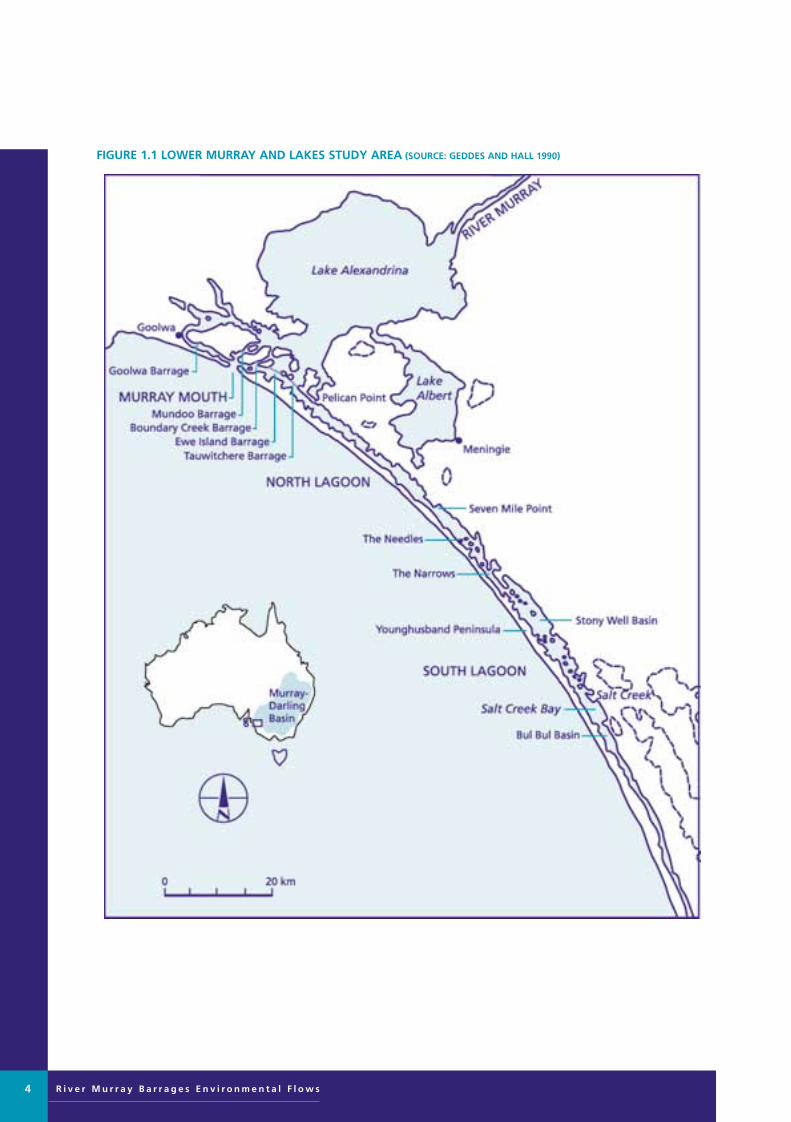
FIGURE 1.1 LOWER MURRAY AND LAKES STUDY AREA (SOURCE: GEDDES AND HALL 1990)
Murray Barrages flow edit 28/8/01 11:14 AM Page 4

DEFINITION OF STUDY AREA
This study focuses on the effect of the barrages on
the waterbodies and floodplains below Wellington
which are part of the River Murray system. This area
includes lakes Alexandrina and Albert, the Coorong
estuary below the barrages, the Murray Mouth, the
Coorong Northern Lagoon and the Coorong
Southern Lagoon (Figure 1.1).
PROCESS OF EVALUATION
The process of evaluation adopted by the panel involved a
combination of workshops and field trips, as well as other
key sources of information (Figure 1.2).
As part of this process, the River Murray Barrages
Environmental Flows Scientific Panel evaluated the system
of recording sheets used by the Murray Scientific Panel on
Environmental Flows. The methodologies of previous
METHODOLOGY
R i v e r M u r r a y B a r r a g e s E n v i r o n m e n t a l F l o w s 5
FIGURE 1.2 METHODOLOGY FLOW CHART FOR THE RIVER MURRAY BARRAGES ENVIRONMENTAL FLOWSSCIENTIFIC PANEL
WORKSHOP 3
(Appendix I, figure I.1)
• panel members present key issuesand recommendations for each discipline
• develop operational guidelines
WRITE UP PHASE (Appendix I, figure I.1)
• panel members contribute chapters
• support team coordinate editing, include supporting information
panel cross check regions, needs andoperational guidelinesstages 7—9
(Appendix I, figure I.7)
WORKSHOP 2
(Appendix I, figure I.1)
• discussed field observations
• reviewed recording sheet
develop a more achievable approach, stages 4—6
(Appendix I, figure I.5 & I.6)
FIELD TRIP
(Appendix I, figure I.1)
• visited sites, considered issues
• identified key issues
tested and modified recording sheets,stage 3
(Appendix I, figure I.2, I.3 & I.4)
WORKSHOP 1
(Appendix I. figure I.1)
• background information
• discussed methodology
• identified key issues
amended recording sheet based onupstream panel method, stages 1 and 2
(Appendix I, figure I.2, I.3 & I.4)
Panel briefed on study and issues to consider
Scientific Panel appointed in consultation with upstream panel
Murray Barrages flow edit 28/8/01 11:14 AM Page 5

R i v e r M u r r a y B a r r a g e s E n v i r o n m e n t a l F l o w s
scientific panels were also considered. A modifiedapproach was developed to suit the Lower Lakes andCoorong. The detailed process is outlined in Appendix I.
Initial discussion covered the following issues:
• former natural patterns of discharge to the MurrayMouth
• current volume, seasonality, frequency and duration offlow over barrages
• rate of rise and fall of flow rates over barrages
• rate of rise and fall in water levels in the Cooronglagoons and effect of rapid changes in level
• impacts of rises and falls in lake water levels on lakesshores and wetlands
• effects of no-flow periods and any critical factors related to length of closure
• effect of sequence of barrage use, including very infrequent opening of Mundoo and Boundary Creekbarrages
• potential for controlled small releases to freshen theCoorong
• required flows to maintain the Murray Mouth
• critical periods for fish passage through the MurrayMouth
• impact of barrages as barriers to fish passage
• mass carp deaths when trapped in estuary.
From this list, the panel then identified several key issuesto be addressed in the evaluation process, as summarised inorder of priority below:
• changed water regimes
• reduced area of estuary habitat
• reduced suitable habitat for aquatic plants
• increased algal blooms
• freshening of brackish and saline habitats around lakes
• dryland salinity on floodplain and islands.
The key time scales, based on degree of planning,investigation, consultation and investment required, are:
• short-term (1–3 years),
• medium-term (3–10 years)
• long-term (>10 years).
The diverse environments of the region have been dividedinto five distinct biological/ecological areas, based onmajor habitat types (reflecting water regimes in particular):
• eroding lakeshores
• prograding lakeshores
• estuary
• Coorong Northern Lagoon (from Pelican Point toHells Gate)
• Coorong Southern Lagoon (Figure 1.3).
There was discussion as to whether management opportunities could be grouped into two categories:upstream of barrage structures; and downstream of barrage structures.
Most recommended actions fall either upstream or downstream of the barrages, but it was found that in twoareas the benefits cross the barrages — namely in reducingturbidity and providing fish passage. In addition, by retaining the five regional habitat divisions, greater detail on potential benefits could be included. The five categories have therefore been retained.
The full process of evaluation and development of themethodology is given in Appendix I.
6
Murray Barrages flow edit 28/8/01 11:14 AM Page 6

FIGURE 1.3 FIVE ECOLOGICAL AREAS: ERODING LAKESHORES, PROGRADING LAKESHORES, COORONGNORTHERN LAGOON (FROM PELICAN POINT TO HELLS GATE), COORONG SOUTHERN LAGOON AND ESTUARY
R i v e r M u r r a y B a r r a g e s E n v i r o n m e n t a l F l o w s 7
Murray Barrages flow edit 28/8/01 11:14 AM Page 7

R i v e r M u r r a y B a r r a g e s E n v i r o n m e n t a l F l o w s
BACKGROUND AND CURRENTSTATUS OF LOWER LAKES ANDCOORONG
The barrage structures separate marine and fresh waters
across the chain of sand and mud barrier islands inside the
Murray Mouth, 100 km south-east of Adelaide in South
Australia (Figure 1.4). The barrages total 593 gates in five
structures across the various channels in the mouth delta
(Table 1.3). The barrages, linked by earthern causeways,
create a barrier 7.6 km long. Originally built for navigationand agriculture, their primary purpose now is to retainfresh water storage for water supply diversions to regionalcommunities.
The Coorong lagoons and lakes Alexandrina and Albertare major wetlands situated at the mouth of the RiverMurray. The lagoons and the Lower Lakes span over 660 square kilometres, the remnant of what used to be an extensive Murray estuary (Barnett 1995; Geddes &Hall 1990)
PLATE 2 MURRAY MOUTH – AERIAL VIEW
8
FIGURE 1.3 BARRAGE STRUCTURES OF THE RIVER MURRAY ESTUARY
(Further details of barrage structures are given in Appendix IV)
632.5 m
792.5 m
243.8 m
2270.7 m
3658 m
largest capacity channel, boat access, frequentlyopened
narrow opening in wide channel, infrequentlyopened
narrow opening in wide channel, infrequentlyopened
broad shallow lake connection, frequently opened
broad shallow lake connection, restricted boataccess, gates frequently opened
stop logs
stop logs
stop logs
radial gates,concrete slabs
radial gates
128
26
6
111
322
Goolwa
Mundoo
BoundaryCreek
Ewe Island
Tauwitchere
Totallength
CommentsType of gatesNo ofgates
Barrage
Murray Barrages flow edit 28/8/01 11:14 AM Page 8

R i v e r M u r r a y B a r r a g e s E n v i r o n m e n t a l F l o w s 9
FIGURE 1.4 THE LOCALITY OF THE FIVE BARRAGES INSIDE THE MURRAY MOUTH
Murray Barrages flow edit 28/8/01 11:14 AM Page 9
R i v e r M u r r a y B a r r a g e s E n v i r o n m e n t a l F l o w s
Regulatory structures built on the major streams of theMurray–Darling Basin in the 1920s and 1930s have significantly altered the natural flow regime of the river. Inthe Murray Mouth region these changes to flow are compounded by the five barrages completed in 1940.
The unique assemblage of marine, hypo-marine, estuarine,hypermarine and freshwater habitats in the wetlands of the Lower Lakes and Coorong forms the foundation forthe high level of biological diversity in the region. Itsrecognition as an area of outstanding national and inter-national conservation value is reflected in its National Park status, its listing as a Ramsar Wetland and itsprotection under the Japan-Australia and China-AustraliaMigratory Bird Agreements (Edyvane & Carvalho 1995).
The listing as a Ramsar Wetland acknowledges the range ofhabitats from freshwater through to hyper-saline lagoonsand ephemeral salt lakes, as well as the summer feedinggrounds for cape barren geese, more than 1% of breedingpopulations for swans and pelicans, nesting grounds forthe threatened hooded plover, conditioning and moultinggrounds for large numbers of migratory waders, andwaterfowl numbers in excess of 20 000 (Upper South EastDryland Salinity and Flood Management Plan, 1993).
The Murray Mouth Biological Resource AssessmentWorkshop, a major workshop held in 1995, brought keyexperts together to consider the current state of knowledge for the Murray Mouth region and the prioritiesfor future management (Edyvane & Carvalho 1995).Despite the outstanding conservation value of the region,workshop participants identified a number of threats andmanagement issues undermining the conservation valuesof the region. These issues included the absence of dataand management resources for the region, and the relatedissue of the lack of an integrated ecosystem approach tomanagement.
The specific threats identified encompassed the followingfive areas (Edyvane & Carvalho 1995):
• altered flow regime
• impacts from land-based activities
• impacts from increased visitor pressure
• impacts from land and aquatic exotic and feral species
• impacts from the freshening of the hypersaline regimeof the southern Coorong.
The Murray Mouth Biological Resource AssessmentWorkshop recommended ecosystem-based management of the Murray estuary and an integrated regional
management plan for the Lower Murray, to conserve thenatural and cultural values and resources of the region(Edyvane & Carvalho 1995).
The Murray Mouth Biological Resource AssessmentWorkshop recommended investigation of the followingareas in order to determine appropriate flow regimes:
• diversity and quality of aquatic and riparian habitats
• adequate flows through the Murray Mouth
• passage for fish past the barrages
• improvement in water quality.
It was recognised that there is an urgent need to examineand revise flow management operating rules to providegreater environmental benefit from flows (Edyvane &Carvalho 1995). The development of an appropriate flowregime is considered the highest priority managementissue in the Murray Mouth region.
It is in this context that the River Murray BarragesEnvironmental Flows Scientific Panel was appointed toidentify the key ecological needs and to highlight optionsfor improvement.
CONTEXT OF MANAGEMENTISSUES AND CONSTRAINTSThe management context for this project was set througha series of presentations made by members of the steeringcommittee and other representatives of interested groups.
The issues considered included:
• the need for consistency with the upstream scientific panel assessment methodology and draft recommendations (Appendix II and Part 3)
• interactions with the concurrent Ramsar PlanningProcess, which is conducting extensive communityconsultation on range of issues intimately linked withthe condition of the lakes, estuary and Coorong(Appendix III)
• the current operating strategies and constraints, particularly existing user demands, which have led topresent conditions (Appendix IV)
• current flow conditions and management constraintsalong the length of the River Murray, and the extent ofchange from natural conditions (Appendix V)
• the impacts of the barrages in increasing the rate of fine sediment transport into the Coorong and theassociated high load of nutrients being transferredfrom the lakes to the Coorong (Appendix VI)
10
Murray Barrages flow edit 28/8/01 11:14 AM Page 10

• the demonstrated benefits of automation of approximately 22% of barrage gates to allow significantpassage of commercial species of fish (Appendix VII)
• interactions with land management issues in theCoorong National Park (Appendix VIII).
SUMMARY OF UPSTREAM PANEL FINDINGS AND RECOMMENDATIONS
The report of the Murray Scientific Panel onEnvironmental Flows is still in draft form and has not been finally approved by the authors. The following summary has been drawn from the current draft report(Close et al in press), as an indication of the likely findingsof the panel.
Key considerations identified are:
• to maintain natural diversity of habitats and biota within the river channel, riparian zone and floodplain
• to maintain the natural linkages between the river andthe floodplain
• to maintain the natural metabolic functioning ofaquatic ecosystems.
The following two guiding principles have been developed:
• elements of natural seasonality should be retained as far as possible, in the interest of conserving a niche for native rather than invasive exotic species and inmaintaining the natural functions of the river
• consistent and constant flow and water level regimesshould be avoided as much as possible, because this iscontrary to the naturally variable flow regime of the river.
For the Wentworth to Wellington Reach, the majorenvironmental issues identified (Close et al in press) are:
• unseasonal wetting and drying of fringing riverine wetlands
• reduction in the frequency of flooding of most areas ofthe floodplain, affecting floodplain health and nativefish breeding
• barriers to fish passage within the river and onto andacross floodplains
• bank erosion downstream of weirs due to rapid rate offall after re-installment of weirs
• increased risk of algal blooms
• increased turbidity in summer months affecting
instream productivity with consequential impacts onfood chain.
The draft recommendations of the River MurrayEnvironmental Flows Scientific Panel (Close et al in press)include:
high priority
• reduce unseasonal wetting/drying of fringing wetlandsand mainstream littoral zones
• increase flooding frequency on floodplain outsideriverine fringing zone
– conserve natural flood events
– enhance floodplain watering
– conserve the ecological functioning of theremaining floodplain
• improve fish passage
• combat bank erosion downstream of weirs
• maintain and improve abundance and distribution of snags.
medium priority
• reduce the risk of algal blooms
• decrease turbidity sourced from the Darling River insummer months affecting instream productivity withconsequential impacts on the food chain.
MANAGEMENT FRAMEWORK FOR FUTURE OPERATION OFBARRAGESAny recommendations for the future management of thebarrages in the River Murray estuary need to take intoaccount the framework of management objectives andimperatives associated with the vital water resource of the River Murray and Lower Lakes. In addition, the veryhigh conservation values of the region place constraints onevaluation of management options.
The key constraints are listed below:
• the need to maintain ecosystem processes in the wetlands which are protected under the following multiple listings:
– Wetland of International Importance under theRamsar Convention
– wetland habitats subject to JAMBA andCAMBA bi-lateral migratory bird agreements with Japan and China respectively
R i v e r M u r r a y B a r r a g e s E n v i r o n m e n t a l F l o w s 11
Murray Barrages flow edit 28/8/01 11:14 AM Page 11

R i v e r M u r r a y B a r r a g e s E n v i r o n m e n t a l F l o w s
– National Estate register
– Coorong National Park, Mud Islands andCurrency Creek Game Reserves and SaltLagoon Conservation Park
• the role of the Lower Lakes as a balancing storage forwater supplies to metropolitan Adelaide
• the water level required to maintain water supply togravity-fed flood-irrigated dairy pastures upstream toMannum
• the water level required to supply diverters around theLower Lakes
• the water level required to minimise marine incursionsinto the Lower Lakes
• concerns about water quality issues in relation to watersupplies to rural communities and townships aroundthe Lower Lakes (salinity and algal blooms)
• the need for an integrated catchment managementapproach
• the need for community support and participation.
Recommendations relating to key environmental flowrequirements to maintain the ecosystem of the LowerLakes, Coorong estuary and Coorong lagoons will need toaddress the full range of ecological processes and diversityof habitats. A fully diverse ecosystem will incorporate a balance between representative and biomass, with anemphasis on conservation of a range of habitats and communities, rather than the highest numbers of individuals or protection of individual species.
The recommendations of this assessment should be compatible with the goal of the National Strategy for theConservation of Australia’s Biological Diversity, which is‘to protect biological diversity and maintain ecologicalprocesses and systems’. The strategy defines ecosystemdiversity as the variety of habitats, biotic communities andecological processes. The strategy describes biodiversity as not only the conservation of wildlife and habitats, but also the sustainable use of biological resources and safeguarding of life-support systems.
12
Murray Barrages flow edit 28/8/01 11:14 AM Page 12
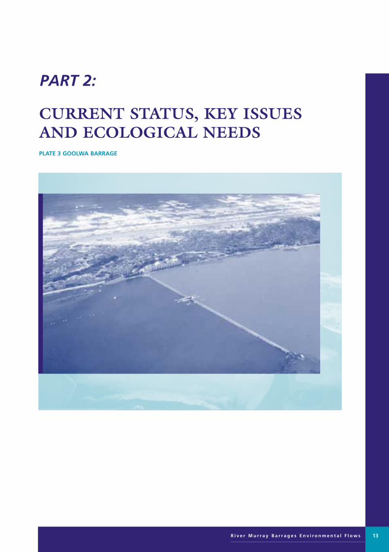
PART 2:
CURRENT STATUS, KEY ISSUES AND ECOLOGICAL NEEDSPLATE 3 GOOLWA BARRAGE
R i v e r M u r r a y B a r r a g e s E n v i r o n m e n t a l F l o w s 13
Murray Barrages flow edit 28/8/01 11:14 AM Page 13

R i v e r M u r r a y B a r r a g e s E n v i r o n m e n t a l F l o w s
CURRENT STATUS
Hydrology of the Murray–DarlingBasin
The Murray–Darling is one of the world’s great riversystems. By length or area, the Murray–Darling ranksapproximately twentieth in the world. However, theannual mean yield is very low, compared with theother major river basins of the world. For example,the yield of the Murray–Darling is 14 mm (or 14ML/km2) compared with 68 mm for theMississippi/Missouri or 900 mm for the Amazon(Table 2.1).
Twenty major tributary rivers discharge into the RiverMurray above Wentworth. The source of much of the flowis winter rainfall and snowfall on the Great DividingRanges. The Darling River delivers flow from summer sub-tropical storms further north. Most of theMurray–Darling Basin is in an extremely arid zone andevaporation is high. In fact many of the tributaries do notreach the main stem but rather terminate in inland marshes,where they evaporate or infiltrate into the groundwatersystem. For example, only in the most extreme events doesthe Lachlan River reach the Murrumbidgee River. Creekssuch as the Billabong Creek and the Paroo River do notreach the Darling River.
The natural mean flow in the River Murray belowWentworth is 11 000 GL/a. However, the system isunusually variable, with peaks of around 40 000 GL/a and
droughts of virtually nil flow (Eastburn and Mackay1990). The flow variation appears to occur in cycles ofseven to ten years. Periods of high flow are often followed by many years of drought. Recent advances in theunderstanding of global weather systems are beginning to offer an explanation. The El Nino and La Nina cyclesaffect the basin, particularly in the east and north regions.
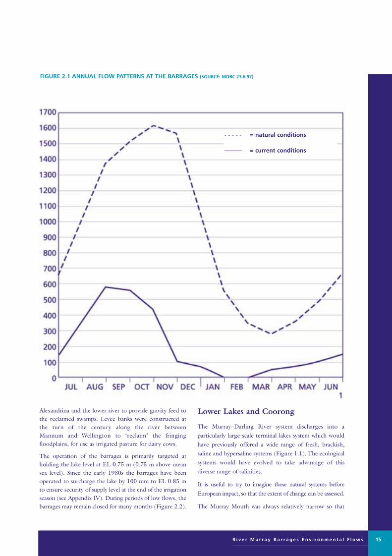
The natural flows pattern below Wentworth and down tothe Murray Mouth featured peak flows in spring to earlysummer and low flows from late summer into winter(Figure 2.1). Figure 2.1 illustrates the variability of the system and the change in flow volumes that has occurreddue to present day development.
Construction of the barrages
The barrages were the last of the major regulatory structures constructed by the River Murray Commissionin the initial phase of development. The structure includesfive low head weirs and earthern causeways linking theislands that once formed an old shoreline (Table 1.3). The barrages now block 7.6 km of previously (at times)passage channels and prevent tidal exchange into LakeAlexandrina, maintaining fresh water in the Lower Lakesand River Murray.
The barrage structures were constructed between 1935and 1940 for the purpose of stabilising water levels andsalinity regimes in order to provide a reliable water supply to the communities fringing the lakes. In particularthe Lower Murray swamp irrigation systems as farupstream as Mannum rely on the higher levels in Lake
HYDROLOGY OF THE LOWER LAKES AND COORONGBob Newman, Water Resource Manager Murray Mallee SA, Department of Environment and Natural Resources, Murraylands Region
14
TABLE 2.1 DIMENSIONS OF THE MURRAY–DARLING SYSTEM COMPARED WITH MAJOR RIVER SYSTEMS OF THEWORLD (SOURCE: BRITANNIA 1996 AND MDBC)
897.4
555.4
373.7
216.0
166.0
135.2
67.7
66.3
31.6
13.8
8.97
5.55
3.74
2.16
1.66
1.35
0.68
0.66
0.32
0.14
5518800
1014700
1293000
565700
220752
157680
405100
51100
88500
14700
6150000
1827000
3460000
2619000
1330000
1166000
5980000
771000
2802000
1063000
6570
5980
4700
5870
3500
2900
6020
4840
6690
2560
S America
China
Africa
Russia
Africa
India
USA
China
Africa
Australia
Amazon
Yangtze
Congo
Yenisey/Selenga
Zambezi
Indus
Mississippi/Misouri
Hwang Ho
Nile
Murray–Darling
(mm)
Annual Yeild
(ML/ha)
Annual Flow
(GL)
CatchmentArea
(sg km)
Length
(km)CountryRiver
Murray Barrages flow edit 28/8/01 11:14 AM Page 14
Alexandrina and the lower river to provide gravity feed tothe reclaimed swamps. Levee banks were constructed atthe turn of the century along the river between Mannum and Wellington to ‘reclaim’ the fringing floodplains, for use as irrigated pasture for dairy cows.
The operation of the barrages is primarily targeted at holding the lake level at EL 0.75 m (0.75 m above meansea level). Since the early 1980s the barrages have beenoperated to surcharge the lake by 100 mm to EL 0.85 mto ensure security of supply level at the end of the irrigationseason (see Appendix IV). During periods of low flows, thebarrages may remain closed for many months (Figure 2.2).
Lower Lakes and Coorong
The Murray–Darling River system discharges into a particularly large-scale terminal lakes system which wouldhave previously offered a wide range of fresh, brackish,saline and hypersaline systems (Figure 1.1). The ecologicalsystems would have evolved to take advantage of thisdiverse range of salinities.
It is useful to try to imagine these natural systems before
European impact, so that the extent of change can be assessed.
The Murray Mouth was always relatively narrow so that
R i v e r M u r r a y B a r r a g e s E n v i r o n m e n t a l F l o w s 15
FIGURE 2.1 ANNUAL FLOW PATTERNS AT THE BARRAGES (SOURCE: MDBC 23.6.97)
- - - - - = natural conditions
——— = current conditions
Murray Barrages flow edit 28/8/01 11:14 AM Page 15

R i v e r M u r r a y B a r r a g e s E n v i r o n m e n t a l F l o w s16
FIGURE 2.2 OPERATIONAL HISTORY OF BARRAGE OPENINGS AT GOOLWA, 1982–96(SOURCE: DENR, BERRI)
Murray Barrages flow edit 28/8/01 11:14 AM Page 16

the interface with the sea was localised. It has always beenhighly mobile (Bourman ibid). At the time of barrage construction in 1940, it was some 1.5 km further southand it has migrated northwards over the past fifty years.
The winter and spring river flows would have maintainedan outflow at the mouth in most years; however, duringthe low flows of summer and autumn, and throughout the year in drought, the fluctuating tide levels would have allowed a substantial tidal exchange and semi-marineconditions would have established over most of the LowerLakes. At the margins of the lakes brackish groundwater discharges and trapped sea water would have created saltmarshes, with varying salinity over several seasons.
The Coorong would have received more frequent freshwater at the northern end, but would have beenincreasingly saline or sometimes hypersaline into theSouthern Lagoon, much as it is today. There is considerabledebate as to the freshening impact of surface inflows at thesouthern end of the system, prior to drainage in the SouthEast. It is clear that the primary source of freshwater
inflows from the river has been reduced to less than 30%
of natural inflows. Flows from the South East were
infrequent but significant when they occurred.
The land surrounding the Lower Lakes and the eastern
shore of the Coorong would generally have been heavily
vegetated with low scrub and saltmarsh. The lakes would
have fluctuated in level and salinity on a seasonal basis,
probably over a range of EL (AHD) 0 m to EL 0.5 m
during most seasons, giving water depths of 1–2 m. Severe
drought and flood would have increased this range.
The primary change for the lower River Murray, since the
construction of the barrages and the dramatic reduction in
flows, has been the loss of the vast estuarine system and the
consequent loss of biodiversity and ecological resilience.
The ecosystems are at risk of degrading into a uniform
condition, having low diversity and interfering with the
natural productive capacity of the region, particularly from
a fishery perspective.
R i v e r M u r r a y B a r r a g e s E n v i r o n m e n t a l F l o w s 17
FIGURE 2.3 GROWTH OF DIVERSIONS IN THE MURRAY–DARLING BASIN (SOURCE: MDBMC)
Murray Barrages flow edit 28/8/01 11:15 AM Page 17

R i v e r M u r r a y B a r r a g e s E n v i r o n m e n t a l F l o w s
River regulation and development 1900to 1980
The ‘development’ of the resources of the Murray–DarlingBasin has followed the traditional path of optimisticexploitation of the available water with little regard for theecological consequences. As with all major river basinsworldwide, the development or exploitation phase hasgradually slowed as the stresses have become apparent andconcern for the resource management issues begins toarise.
The River Murray and its tributary streams have been progressively regulated over the past century. With the formation of the River Murray Commission under theRiver Murray Waters Agreement of 1915, several majorstorages were constructed. The storage capacity is now 30000 GL, which represents nearly three times the annualmean flow volume of 11 000 GL. Total diversions areapproaching 9000 GL, or more than 80% of the meanannual flow volume (Figure 2.3).
Following regulation of river flows, many schemes havebeen developed to divert the water for productive use.There are many urban and industrial uses of the waterincluding 1.4 million people in towns and districts alongthe main tributaries, and one million people in Adelaideand rural South Australia who rely on this water supply.However, it is irrigation ventures which draw the bulk ofthe water from the basin.
At the downstream end of the system, South Australia has negotiated an annual entitlement of 1850 GL to guarantee a reliable supply. The upstream states share the remainder (the bulk) of the resource as it becomes
available and therefore have developed a more variable
consumption regime. Further upstream the flow is more
variable, especially upstream of major storages. In spite of
the exploitative approach to development across the basin,
the lower reaches of the river still retain some resemblance
of variable flow due to the difficulty in harvesting the
fluctuating flow occurrences.
Flow to South Australia averages around 6000 GL/a,
including large flow events. However, the median flow is
only 4047 GL/a, marginally above the entitlement flow.
The flow patterns in the lower reaches still maintain the
seasonal spring flows, but these are greatly reduced in
frequency and volume. A flow of at least 35 000 ML/day
is required to inundate the river valley floodplains and
trigger breeding and regeneration of waterbirds fish and
plants in the wetlands. The guaranteed entitlement flow to
South Australia is allocated to domestic, industrial and
agricultural use (Figure 2.4), with a large proportion
required to cover evaporation losses from the terminal
lakes and transmission along the river channel. Initially,
irrigation developments involved largescale infrastructure
delivering water to government or community schemes.
However, since the 1950s private development has
dominated, using a variety of allocation policies in each
state. These private schemes and the policies supporting
them, particularly in the upstream states, have encouraged
the diversion of the medium flow peaks in an opportunist
manner. The loss or reduction of these peaks has placed
further stress on the downstream ecosystem.
The Murray–Darling system generates considerable
variability in flow. However, in the lower reaches, as
the grade line is very flat, the river provides considerable
warning of these medium flow events. This has enabled the
development of pumping systems which can divert these
‘opportunity flows’ either directly onto seasonal crops
or to short-term farm storages for use several months
or up to one year later. It has been this increasing capacity
to aggressively harvest these ‘opportunity flows’ that
ultimately caused concern over the increasing exploitation
of the river system for consumptive use. The question
arose in 1995 as to when is enough enough? The
Murray–Darling Basin Ministerial Council agreed that
the current rate of diversions could no longer continue
(MDBC 1995a) (Figure 2.3).
18
FIGURE 2.4 SA DIVERSIONS AS A PROPORTION OF‘ENTITLEMENT FLOW’ (SOURCE: DENR)
Murray Barrages flow edit 28/8/01 11:15 AM Page 18

KEY ISSUES
Controlling diversions from theMurray–Darling system
The Murray–Darling Basin Commission Water Audit(MDBC 1995b) has very clearly established the extent ofusage and the trends over the development phase of thebasin. By 1994 around 75% of the mean flow was beingabstracted for consumptive use and diversions were stillincreasing at around 1% per annum. The Murray–DarlingBasin Ministerial Council has now taken the impressivedecision to halt development at the 1994 level of diversions.It has taken more than two years to develop a strategy fordefining the operational rules that can effect this outcome(MDBC 1995a). Since the 1960s the consequences ofriver regulation and diversions have been observed, especially along the downstream reaches of the RiverMurray. Some attempts have occurred both to limitgrowth in diversions and to redress some of the resourceimpacts, particularly those relating to reducing water quality for human use. Salinity issues were the first tobecome apparent and more recently the risks of blue-greenalgal blooms have dominated concerns.
Major changes in flow regimes
The changes brought about through the ‘developmentphase’ of the basin have resulted in artificial drought conditions coupled with constant unnaturally high poollevels and severe fluctuations in flow following a moderateto high flow event. Water levels have generally been maintained at unnaturally static levels, and the ebb andflow of water levels that occurred in the natural regime are now constrained. The operation of the regulatingstructures has been dominated by a management desire tohold water levels static. This is most pronounced duringlow to moderate flows (up to around 50 000 ML/d).
In addition, there is now a very abrupt interface betweenthe marine system and the freshwater lakes which has beencreated by the barrages. In its natural state there wouldhave been a very large and transient interface between thefresh river flows and the marine system, creating estuarineconditions.
An important effect of the extent of storage capacity and upstream diversion of water is the reduction in the frequency of medium flow events; for example, flows inthe range 20 000 ML/d to 80 000 ML/d have reduced in frequency by threefold (Figure 2.3). In addition to the
change in frequency of flow events, the duration of theseevents is now much shorter. In particular, as high flowspass weirs, the desire to retain pool levels at the weirsresults in the increasing abruptness of the flood recessionas the flood peak passes downstream. This change resultsin a loss of the natural smoothing of flow and level recessions. Apart from causing physical damage by theslumping of banks due to excess water pressure in the soil, there is also confusion in the natural ecological ‘signals’ and reduction in breeding and regeneration success in waterbirds, fish and plants.
Another change to the system — caused by regulation andconsumption, land practices and the imbalance in aquaticbiology — is the increase in silt and colloids load, resultingin increasing turbidity. This increase in solids, togetherwith urban and agricultural drainage disposal, has alsocaused an increase in nutrient loads. Increased turbiditysuppresses native plant and animal growth, while increased nutrients cause an imbalance in ecosystemswhich increases the risk of nuisance algal blooms.
Estuary–Murray Mouth zone
The estuary has serious hydrologic issues because the estuarineregime now operates over only 11% of its previous scale.However, the Southern Lagoon no longer operates as atypical estuary, reducing the total to about 7% of the overallarea. This means that rapid changes in flow and level associated with barrage operations cause rapid majorchanges in both the water level and salinity (Paton ibid).
The mouth region is progressively silting, causing evenfurther reduction of tidal exchange (Bourman ibid). TheMurray Mouth closed over during low flows in May 1981,which is the first time since European settlement, although it would be an occasional possibility under thenatural flow regime.
An important hydrologic consequence of mouth closuresis the likelihood of flooding during the next high flowevent. After the mouth closes, the high energy coastalprocesses cause the dunes to re-establish, creating a leveeacross the mouth some metres above lake level. If themouth had not been mechanically opened in 1981 then all the townships and fringing lands would have beenflooded as far as Wellington during the floods ofOctober–November.
Access for recreational, tourist and commercial boatsbetween the Goolwa Channel and the Coorong becomeslimited if the mouth zone silts up. The closure of themouth also causes changes in the ecologic regime. Apart
R i v e r M u r r a y B a r r a g e s E n v i r o n m e n t a l F l o w s 19
Murray Barrages flow edit 28/8/01 11:15 AM Page 19
R i v e r M u r r a y B a r r a g e s E n v i r o n m e n t a l F l o w s
from the increased likelihood of closure, the reducedmedium flow regime has caused the mouth to migratenorthwards. It has moved 1.4 km since 1940 (Bourmanibid, Figure 2.6). The high energy coastal process of dune migration also creates the possibility of the seabreaking through and threatening the Goolwa Barrage(Bourman ibid).
The Lower Lakes
The Lower Lakes have been hydrologically separated fromthe estuary by the barrages in order to provide a reliablewater supply. However, as abstraction across the basin hasincreased, the ability of the lakes to provide this functionhas reduced. The lakes have become more frequentlysaline and the level now falls below an acceptable level fordiverters during entitlement flow years. With the current development regime, entitlement flow years are now farmore frequent than when the barrages were built. It isintended that the cap on diversions will prevent this trendfrom worsening (MDBC 1995a).
The Coorong
The estuarine-marine Northern Lagoon and the marine-hypersaline Southern Lagoon of the Coorong provide two major habitats within the Ramsar wetland site.Key habitats include the tidal mudflats of the NorthernLagoon and the extensive beds of Ruppia megacarpa in the Northern Lagoon and Southern Lagoon, which provide essential food sources for extensive numbers of waterbirds. These habitats are maintained by the hydrologic regime, in which key factors are:
• salinity ranges
• rates of rise and fall in water level
• wind-seiche effects
• tides
• mixing of river water and sea water.
The construction of the barrages has not only severelyreduced the area of estuarine conditions, but has also disrupted the transition between fresh and salt conditions.The remnant estuary can change abruptly from salt tofresh conditions and back again in an unseasonal, unnatural pattern which disrupts breeding and regenerationof estuarine plant and animal species. The reduced tidalprism and flow velocities have allowed acceleration of siltation in the Coorong channels (Bourman ibid).
OPPORTUNITIES FOR IMPROVEDBARRAGE OPERATION
As the decline of ecological indicators gradually becomes
apparent, the community identifies with the changes taking
place. Usually there is little historical data on the ecological
changes. Anecdotal information abounds, and clearly
confirms the extent of changes and the fact that the
changes are occurring at an increasing rate. Even today
the ecological databases are very limited. How can the
ecological outcomes be optimised?
The main ecological need of the Lower Lakes and
Coorong is for the re-establishment of higher flow
regimes. In today’s social situation with so many people
dependant on the rivers, this is not likely to happen
easily. The task is therefore to move towards a sustainable
situation with as much replication of the natural systems as
is feasible. It will be necessary to emulate or mimic the
natural systems with only a fraction of the water that once
passed through the system.
The barrage structures have ageing operational technology
which means that they are not readily amenable to rapid
response operation. Some parts of the structure are rarely
operated because of operational difficulties. Upgrades of
structures have concentrated on the Goolwa and
Tauwitchere barrages. Modification of the barrages to
allow rapid responses would have significant operational,
water quality and environmental benefits.
No clearly defined environmental objectives have been
determined for amended management of flows at the
barrages. However, over recent years, discussions with the
local commercial fishers have led to some changes in the
operation of the gates to encourage better mixing of the
fresh and saline water in the estuary below the barrages, to
improve fish response.
From this assessment it is clear that there are significant
opportunities to improve management of flows at the
barrages in response to ecological needs. In particular,
the minor successes with fish movements can be greatly
expanded.
Clear environmental objectives need to be developed
and translated into operating guidelines. Minor changes
in flow patterns could bring positive benefits, for
example by extending flows later into spring, or renegotiating
the pattern of flow distribution for entitlement flows.
These options should be further investigated.
20
Murray Barrages flow edit 28/8/01 11:15 AM Page 20
Automation of the barrage gates would have multiple benefits, including:
• selective opening of barrages to optimise estuarineconditions
• fish exchange during high tide with little water loss
• improved operator safety
• rapid response to weather changes to prevent salineintrusions into the lakes
• selective opening of barrages to improve lake waterquality
• selective opening of barrages to scour blocked channels.
The option of operating the lakes at a wider range of levels is worth investigation. More information is requiredon the constraints which determine the operating ranges,and alternative solutions which could allow more flexibilityin barrage operations. Detailed information such as lakebathymetry and location and levels of pump offtakes will be needed. Community consultation will be a keyingredient in assessing this option.
In the medium to long term, there is a major opportunityto consider the options for renovation, redesign or relocation of the ageing, out-of-date barrage structures.There is an opportunity to consider all aspects of theiroperation, including:
• alternative locations, including Wellington and PointSturt
• alternative designs to allow easy operation, fish passage, removal in floods and boat passage
• protection of saltmarsh habitat on the barrier islands
• operation of two sets of barrages, at the present location and further upstream
• operation of Lake Albert as an estuary.
There are many issues to consider, including the impactson existing users, but the longer timeframe allows investigation, debate and room for innovation in considering how to replace the barrage structures whenthis becomes necessary.
The challenge
The challenge is to develop a range of short –, medium – and long – term management strategies whichmove from the current operational system to one whichcombines social and economic needs with ecological needsin order to maintain a healthier system. Priorities need tobe set so that changes can be introduced sequentially withminimal disruption. The first priority is to adjust gateoperation, with automation of gates in the short term toprovide much greater operational control and flexibility.
A range of hydrologic tools are available, including:
• monthly simulation models for the River Murray(MDBC)
• daily simulation models for the River Murray downstream from Yarrawonga (being developed by theMDBC), and monthly models upstream fromYarrawonga (Figure 2.5)
• daily data archives (DENR)
• Murray Mouth estuary model and Coorong model(Gary Tong, International Fluid Dynamics)
• Murray Mouth modelling (University of SouthAustralia).
The river is a heavily regulated system supplying a heavydemand for water to entrenched user groups. However,there is room for significant modification and flexibility to simulate key parts of the natural hydrological regime to meet ecological needs and improve the sustainable management of the water resource.
R i v e r M u r r a y B a r r a g e s E n v i r o n m e n t a l F l o w s 21
Murray Barrages flow edit 28/8/01 11:15 AM Page 21

R i v e r M u r r a y B a r r a g e s E n v i r o n m e n t a l F l o w s22
FIGURE 2.5 PELICAN POINT SALINITY – BOUNDARY CONDITIONS FOR LONG-TERM MODEL(SOURCE: COMPUTATIONAL FLUID MECHANICS INTERNATIONAL)
Murray Barrages flow edit 28/8/01 11:15 AM Page 22

BACKGROUND AND CURRENTSTATUS
Geomorphically the lower Murray lakes and Coorongarea is naturally very dynamic. A major impact ofriver regulation has been to reduce that dynamism;the tendency has been to maintain an unnatural constancy in the system. In order to provide environmental benefits, future management operations of the barrage system should be undertaken in the context of improving the variabilityof the area to accommodate both short-term andlonger-term natural changes.
The region is not only affected by river flows. It is also affected by aeolian processes, tidal oscillations, storm surges, wave action on lake and ocean shores, wind-induced lake level changes and variations in local sealevel due to global sea level changes and long-term land
subsidence. Furthermore, human influences impact onmany of these processes.
The natural River Murray estuary, which comprises terminal lakes Alexandrina, Albert and the CoorongLagoon, is a Holocene feature, occupying Quaternaryinterdune areas and formed as a result of drowning by theeustatic sea level rise (from -150 m) that accompaniedglobal deglaciation from 17 000 years to 7000 years BP.The location of the estuary also reflects subsidence of thelakes region in relation to the Mt Lofty Ranges and theRobe–Naracoorte area of south-eastern South Australia.
The last interglacial shoreline parallels the modern shoreline several kilometres inland, and most of the barragesystem has been built on this substrate. The northern half of Hindmarsh Island formed during the last interglacialtimes (125 000 years BP) when longshore transport wasdominantly from the southeast, effectively pushing the
GEOMORPHOLOGY OF THE LOWER MURRAY LAKES ANDCOORONG
R P Bourman, Faculty of Engineering and the Environment, University of South Australia
R i v e r M u r r a y B a r r a g e s E n v i r o n m e n t a l F l o w s 23
FIGURE 2.6 DEVELOPMENT OF THE MURRAY MOUTH FLOOD TIDAL DELTA (SOURCE: BOURMAN & HARVEY 1983)
Murray Barrages flow edit 28/8/01 11:15 AM Page 23

R i v e r M u r r a y B a r r a g e s E n v i r o n m e n t a l F l o w s
course of the River Murray westward, partly explaining thelarge bend in the River Murray at Goolwa (Ngarrindjerifor ‘elbow’).
The modern coastal barrier system (Sir Richard Peninsula and Younghusband Peninsula) formed from7000 years ago when sea level rose following glacial melt. The development of Sir Richard Peninsula completed the elbow of the main Goolwa Channel.Subsequently, the barriers have migrated landward, sporadically exposing lagoonal sediments on the oceanbeaches. During the Holocene about 5000 years BP, an extensive sand flat with associated dunes formed immediately inland of the coastal barrier.
Aeolian processes are of significance, with at least six generations of Late Pleistocene dune systems in theregion. For example, during the last glacial period whenthe climate was drier, colder and windier; a system of parallel, west-east trending, yellow-red desert dunes developed around the lakes.
Aeolian processes remain important with occasionally upto 5000 tonnes of sand being in motion along the modernshoreline (Bourman 1986). During mouth migration,dunes up to two metres high have been formed and vegetated in 12 months, directly inland from the mouth(Bourman & Harvey 1983). In the Coorong, sand isblown directly from barrier dune systems into the lagoons, clogging channels.
The position of the Murray Mouth is extremely dynamic,migrating over 1.6 km since the 1830s, with migrations of up to 6 km over the past 3000 years (Bourman &Harvey 1983; Harvey 1996) (Figure 2.6). Movements of14 metres in 12 hours have been observed. These documented changes reveal the geomorphic dynamismand fragility of the Murray estuary and highlight the needto minimise future human impacts.
KEY ISSUES
Natural changes
There are some natural, ongoing geomorphic changeswhich will have impacts on the long-term flow managementof the lower Murray system. Natural changes are operating,trending towards returning the artificial freshwater lakesystem back into an estuary. Differential levels of the searelative to the lakes are likely to decrease as a result of thefactors described below.
Accelerated Greenhouse-induced global sea-levelrise
Predictions of accelerated Greenhouse-induced global sea-level rise of the past seem to have been downgraded.The range of Intergovernmental Panel on Climate Change(IPCC) best current estimates for global sea-level rise(eustatic) are now 1 to 2.5 mm/yr (IPCC, 1996).Calculations of the sea-level trend for Victor Harbor is+0.6 mm/yr, which can be revised downwards to+0.5 mm/yr based on expected neotectonic movements inthe region (Harvey 1996).
Recent work at Port Pirie suggests a possible rate of localeustatic sea-level rise of no more than 0.29 mm/yr(Barnett et al 1997; Harvey et al 1997).
Despite these low rates of predicted, climatically-inducedsea-level rise, it should be noted that there is evidence thatwhen climate change occurs, it may change extremelyrapidly. A rapid melting of the West Antarctic ice sheetwould result in major marine incursions into the LowerLakes region.
Tectonic movement
Tectonic dislocation of the last interglacial shoreline of125 000 years ago indicates that Hindmarsh Island andthe barrage system is subsiding at a rate of 0.02 mm/yr.The level of the last interglacial shoreline is 6 m AHD atVictor Harbor, 2 m AHD on Hindmarsh Island, 2 mAHD at Mark Point, 3 m AHD at Salt Creek, 8 m AHDat Robe (Woakwine Range) and 18 m AHD near MountGambier. This indicates tilting down towards the MurrayMouth area from both westerly and south-easterly directions.
Coastal erosion
Erosion has been well documented on Sir RichardPeninsula, with the neck of land at the proximal end of the barrier (immediately upstream of Goolwa Barrage)narrowing (Bourman & Murray-Wallace 1991). This section of the spit is important because it forms a barrierbetween the sea and the freshwater upstream of theGoolwa Barrage. Aboriginal middens (2000 to 3000 yearsold) on sand dunes have been eroded and reincorporatedinto the modern beach sediments, back barrier lagoonalsediments approximately 6000 years old have beenexposed on the modern beach face, and surveyed roadsand a European beach shelter now occur in the subtidalzone (Bourman 1979; Bourman & Murray-Wallace1991). Sir Richard Peninsula is affected by high energywaves, but the small tidal range and limited surge effects,
24
Murray Barrages flow edit 28/8/01 11:15 AM Page 24

together with the dissipative effect of the offshore topography, suggest that there is little likelihood of oceanic breaching of the barrier. Even during the 1981blockage of the Murray Mouth, when a storm surge resulted in washover of the barrier near the western end ofBarkers Knoll on Younghusband Peninsula, a new channelwas cut but silted up rapidly. The rates of change are notextremely rapid and there is no imminent danger of abreakthrough given wise management of the area.
Nevertheless, it is an area that should be monitored closely. A rise in sea level, related in part to enhanced‘Greenhouse’ influences or the continuance of the long-term tectonic subsidence of the Murray Mouth area(Sprigg 1952), could exacerbate this problem.
Geomorphic impacts of river and lake regulation
The significant geomorphic impacts of river and lake levelregulation include:
• the development of prograding shorelines in shelteredareas
• accelerated shoreline erosion in exposed localities
• accelerated rates of sedimentation in the lakes
• a change in the character of the sediments depositedand the acceleration of salinity in soils associated withsalinisation of depressions and blocked drainage channels.
The most important geomorphic impact of river regulation has been the growth and consolidation of theflood tidal delta (Bird Island) landward of the MurrayMouth (Bourman & Harvey 1983) (Figure 2.6).
Prograding shorelines
These have developed on sheltered coasts and in formerestuaries such as those of the Finniss River and CurrencyCreek where digitate deltas have formed. Theprogradation is closely related to the colonisation of theshoreline by freshwater plants (reeds and rushes), whichaid the trapping of sediments (Bourman 1974). No detailedstudies have been undertaken on the rates ofsedimentation, although comparison of 1945 aerialphotographs with modern ones should producereasonably reliable estimates. Prograding shorelines do notappear to present major problems to managers except thatfreshwater plants may dominate in former salineenvironments.
Eroding shorelines
These occur predominantly (but not exclusively) onexposed coasts, especially where fluviatile clays overlymarine sands. The marine sands were deposited as anextensive sand flat approximately 5000 to 6000 years agoin relation to a slightly higher (approximately 1 m) sealevel than at present. This marine sand is in turn overlainby some 20–30 cm of dark fluvial, lacustrine clay. Thesubdued conditions of sedimentation of the sand flatsuggest that the sand horizon is at a uniform elevation, andthat the sand horizon occurs within and below the currentrange of lake levels. Wherever this situation occurs, therate of shoreline erosion does not appear to be slowingdown, as might be expected with movement towards anew equilibrium condition.
Often human-induced geomorphic change occurs rapidlyin the first instance but slows down and eventually a newequilibrium condition is established. However, in this case, because of the disposition of the easily-eroded sandhorizon, within the zone of lake water levels, a new equilibrium condition will not be achieved until the eroding shoreline reaches harder material. Given the widespread occurrence of this vulnerable sand flat aroundthe lake shores and the need to sacrifice large areas of landbefore a new equilibrium could be achieved, there appearsto be little alternative but to try to protect the shorelinefrom erosion by physical means. The stability and aesthetics of these physical structures could be improvedby fencing off stock, planting reeds and revegetating theriparian fringe.
The eroding shorelines have contributed to the acceleratedsedimentation (Bourman & Barnett 1995) and the deterioration in water quality in the lakes, as fine sedimentsand stored salt have been incorporated into the lakes following shoreline erosion. The increased rates of sedimentation are discussed below. Coulter (1992) notedmaximum rates of erosion of 12 m/yr, with an average of 1 m/ yr. The costs of land and production losses sincebarrage construction were calculated at $4.2 million in1992 (Coulter 1992).
Accelerated sedimentation in lakes
The amount of clastic sediment reaching the coast mayhave been greater in the past. Sprigg (1952) attributed thehigher quartzose contents in beach sediments near theMurray Mouth to terrestrial sediment inputs from theriver, but it could also have been derived from offshoresources during the post-glacial rise in sea level (Bourman& Murray-Wallace 1991). If there has been a reduction in
R i v e r M u r r a y B a r r a g e s E n v i r o n m e n t a l F l o w s 25
Murray Barrages flow edit 28/8/01 11:15 AM Page 25

R i v e r M u r r a y B a r r a g e s E n v i r o n m e n t a l F l o w s
the delivery of coarse sandy material to the coast, it couldreflect the impacts of river regulation upstream, wherecoarse sediment is trapped by weirs and dams (Thoms &Walker 1992; 1993). There may be some longer-termimpacts of coastal stability due to decreased sedimentinput from the River Murray. Johnston (1917), noting thegentle gradient of the river and the settling impact of theterminal lakes, wrote that ‘It is probable, therefore, thatthe water which reaches the Murray Mouth is quite free ofsediment’. The greatest amount of sediment in suspension,measured by Johnston in 1915, was one in 4200 parts atMorgan. Johnston (1917) also noted that considerablequantities of sand blown from Sir Richard Peninsula intothe Goolwa Channel have been transported through themouth and onto the offshore bar.
Johnston (1917) also reported on the observations of aLieut. Goalen who stated in 1876 that ‘The matter whichdiscolours the water sometimes for miles seaward of themouth is so impalpable that it cannot sink if there is theslightest motion in the water — that contained in a bucketful is not more than sufficient to slightly stain ahandkerchief’. The matter referred to is almost certainlyphyto-plankton, and it is interesting to note that it wasoccurring more than 120 years ago.
Accelerated sedimentation in Lake Alexandrina has beenaccompanied by minor increases in organic carbon, totalphosphorus and copper concentrations (Barnett 1993;1994). While these can mostly be related to either earlydiagenic processes or fluctuating algal populations in thelake, the addition of organic matter, nutrients and trace elements due to European settlement cannot be overlooked.There has been an increase in the sedimentation rate in Lake Alexandrina over the past 100 years, perhaps related to accelerated lakeshore erosion. Barnett (1993) demonstrateda long-term (over thousands of years) sedimentation rate of 0.5 mm/yr in the central channel of the lake and a much greater shorter-term (over tens of years) rate of 1.7 mm/yr. As stated above, the cause of the increased sedimentation is probably related to accelerated lake shore erosion. The implications of this increased rate of sedimentation is that greater amounts of sediment, much of which is very fine-grained, has been put in motionin the lake waters, increasing turbidity and the potentialfor increased nutrient storage in the lakes.
Change in the character of the sedimentsdeposited
Generally there has been a change in the character of the sediments deposited towards finer particles which can adsorb phosphorus. Accelerated sedimentation
has occurred upstream of the barrages. For example, sedimentation upstream of Goolwa Barrage has occurredat a rate of 4.5 mm/yr over the past 50 years (Bourman &Barnett 1955), with a change from bioclastic sands to muds. The upstream weirs also cut off the supply ofcoarser sediments, with only the finer, clay-sized materialswhich carry nutrients being transported through theupstream barrier systems in suspension.
Acceleration of salinity
Raised water tables associated with artificially-elevated lakelevels (and probably in association with regional vegetationclearance) has raised the salinity of soils, with associatedsalinisation of depressions and blockage of natural flowpaths/drainage channels. A distributary system of channelsformerly discharged river floodwaters across HindmarshIsland, sometimes forming wetlands where the dischargewas blocked by sand dunes on the south side ofHindmarsh Island. Elsewhere the floodwaters dischargeddirectly to the sea.
Artificial blockage of these channels has occurred onHindmarsh Island by road causeway construction. Evenwhen there is no flood overflow into the channels, runofffrom local rainfall accumulates in the channels. This watercannot flow away, evaporates and increases the salinity ofthe channels. Local landholder Kym Denver is makingsteps towards resurrecting the seaward flushing of these channels. This process should be encouraged. The operation of the barrages has minimal impact on thisprocess, except that maintaining a water level at +0.75 mAHD should encourage through-flow, provided that the channels are cleared. These channels should be operated to maximise biotic exchanges between the estuary and the lakes.
Saline depressions occur in many localities on HindmarshIsland and it is likely that their current level of salinity isrelated to elevated water table levels consequent upon permanent raising of the lake level to +0.75 m. However,vegetation clearance on the island has also probably contributed to the salinisation of the depressions.Lowering of the lake levels may reduce the level of salinityin the depressions, but this is difficult to justify given the lack of detailed knowledge about the character and formation of these saline depressions, and given theunknown contribution of vegetation clearance and irrigation activities to their salinity levels.
From a geomorphological point of view there is no obvious reason to oppose the proposal to build levees tostop marine incursions across the island spillways. These
26
Murray Barrages flow edit 28/8/01 11:15 AM Page 26

are already artificial barriers to flow and maintain the lakelevel at the prescribed +0.75 m. There is little doubt that they would be effective in limiting saline incursions into the freshwater lakes. On the other hand,there may be a danger of increased flooding risk during amajor flood event down the Murray system. It is suspectedthat in the original design of the system these lower levelswere built to accommodate the discharge of high floodevents. Today, with increased water abstraction from thesystem, the high flood events may occur less frequently.
Despite the fact that there is little objection on purely geomorphic grounds to the proposal to build higher leveeson some of the causeways, the levees would change thesalinity levels of the overflow regions, which may be importantfor fish passage and habitat for waders (Paton ibid).
Development of Bird Island
Ecologically, the most important geomorphic impact offlow restriction and regulation has been the development ofBird Island by the growth and consolidation of the formerflood tidal delta immediately inland from the MurrayMouth. This is particularly related to the lack of discharge through the Mundoo Barrage. The barrageswere not completed until 1940, but the Mundoo Channelimmediately upstream from Bird Island was closed by abarrage with timber sluiceway in 1915 to restrict salt wateringress into Lake Alexandrina. The continuing growth ofBird Island and the sedimentation in the surroundingchannels has the potential to result in more frequent andpermanent blockages of the Murray Mouth. The island isapproximately 1 km in diameter and sand dunes on theisland stand well above the level of the 1956 flood(Bourman & Barnett 1995).
Flood-tidal delta formation was detailed by Bourman and Harvey (1983) (Figure 2.6). Historical surveys andphotographic sequences of the mouth area were summarised by Harvey (1983), and Carruthers (1992)reported on the progressive vegetation colonisation of Bird Island. The growth of Bird Island is described anddocumented in a series of aerial photographs in Bourmanand Barnett (1995). Together these studies highlight therapid growth and consolidation of Bird Island in the areaof the Murray Mouth since barrage completion. A combination of no river flow and subdued meteorologicaland oceanic conditions led to the closure of the MurrayMouth in April 1981 (Bourman & Harvey 1983) (Plate 3).A channel was dredged by the then Department ofEngineering and Water Supply (E&WS) to re-open themouth (Shanks 1981) in order to prevent flooding of large
areas of land, homes and shacks on the shores of the lakesand channels. The mouth has been close to closure onmany occasions in the past (Marsh pers comm) and upuntil 1981 there had been sixteen times when river flowwas stopped for 100 or more consecutive days by barrageclosure (Shanks 1981). During the drought of 1967–68the barrages were closed for 529 days, but the mouth didnot close completely as it did in 1981 when the barrageswere closed for only 196 days, suggesting that conditionsother than lack of river discharge (high tides, storm surges)are important in maintaining the opening to the sea.
The cost of re-opening the mouth has been estimated at $50 000 (Victor Harbor Times (June 1, 1983). TheMurray Mouth Advisory Committee in 1987 considereddredging a channel at a cost of $225 000 as a possibleoption for mouth maintenance. Other options includedallowing a river outflow of at least 20 000 ML a day forone month, the construction of groynes ($500 000),installation of drift fencing on Younghusband Peninsula($15 000) and artificial closure of the mouth to preventsand movement into the lagoon.
The mouth threatened to close several times since 1981and again in late 1996, when soundings at the mouth wereas shallow as 1.5 m, but the sedimentation process wasinterrupted by an unseasonal summer storm which drovesea water through the mouth (Marsh pers comm).
Reduction of River Murray estuary
The River Murray estuary has been heavily modified by progressive river regulation. There have been 20–30 periods of no flow after barrage construction, when thebarrages have been closed for 100 or more consecutivedays. There has been a reduction in the water flow availablefor flushing of mouth by as much as 75 % compared tonatural conditions (Close 1990; Newman ibid).
The barrages have also resulted in a physical restriction ofthe area of tidal influence. Furthermore, during periods oflow or no flow, it has been noticed that the mouth restriction increases as the tidal influence diminishes.Winter tides are generally higher than summer tides andcalm meteorological conditions lead to decreasing tidalamplitudes through the mouth which may ultimatelyresult in the blockage of the mouth.
The progressive restriction of the lagoon and channelsnear the mouth can be related to:
• The total flow through the Murray system has beenreduced to one-third of the median flow, with the frequency of no flow at the mouth increased from onein twenty to one in two (Close 1995).
R i v e r M u r r a y B a r r a g e s E n v i r o n m e n t a l F l o w s 27
Murray Barrages flow edit 28/8/01 11:15 AM Page 27

R i v e r M u r r a y B a r r a g e s E n v i r o n m e n t a l F l o w s
• The reduction in the size of the estuary has reducedthe size of the tidal prism by around 90% of its originalpre-barrage size. In 1914 the lake area affected by tideswas 97.3 km2 (75 000 hectares), with a spring tidalprism of 20 000 ML (Walker 1990). These figuresindicate that the original tidal prism produced a twice-daily exchange of similar magnitude to the flowsof 20 000 ML/day for a month or more which wouldnow be required to substantially clear the mouth ofaccumulated deposition (Harvey 1988).
• Storm surges, which have become more important inclearing the mouth with the reduction in river outflows, occur with variable frequency. Thus periodswill occur when storms are less likely to occur, increasing the risk of mouth closure. A threatened closure in December 1996 was averted by an unseasonalsummer storm surge (Marsh pers comm). Chappell(1991) showed that in the seven months prior tomouth closure in 1981 only 28 storms capable of moving sand at the mouth occurred, compared with anaverage of 44 storms for similar periods during1940–90.
• The volume of water discharged through the MundooBarrage has become negligible. Mundoo Barrage isoperated infrequently, as the gates are cumbersome to operate, making it extremely difficult to respond torapid changes in conditions induced by wind. Thestructure consists mostly of causeway with a smallnumber of discharge gates. Even when the gates arefully open, there is a restriction of flow as the barragegates only cover 20% of the natural channel width. As a result, flows through the Mundoo Channel aregreatly reduced in volume and frequency from pre-barrage flows.
• The pattern of flow discharges through the estuarychannels has been altered. Under natural conditionsthe Holmes Creek or Mundoo Channel accommodated10–20% of the total flow of the River Murray. TheGoolwa Channel has always been the major channel,carrying 60–70% of flows, with the balance of 10–20%of flows passing the remaining three openings(McIntosh 1949; Johnston 1917). Today the mainflow is still through the Goolwa Channel, but virtuallyno water passes through the Mundoo and BoundaryCreek barrages (see Figure 2.2).
• A flow shadow has formed on the southern side ofHindmarsh Island. Plumes from the changing floodtidal delta landward of the mouth have become progressively vegetated and stabilised, eg Bird Island.
Much of the island now stands above the flood heightof the 1956 flood (Bourman & Harvey 1983) andwould not be removed even by a major flood. It hasalso permanently reduced the tidal prism and the flowcapacity at the Murray Mouth.
• The sand spit produced during the westward migrationof the Murray Mouth is protecting the ocean side of Bird Island from coastal processes. The progradationof Bird Island towards the Murray Mouth continues and increases the possibility of more frequent and permanent closures of the mouth, which is undesirableon many counts.
ECOLOGICAL NEEDS
From a geomorphological perspective, there are four keyecological needs which require addressing, as listed below:
• limit sedimentation inside the Murray Mouth
• limit shoreline erosion in lakes Alexandrina and Albertand rehabilitate areas experiencing these pressures
• reduce the rate of sedimentation in the lakes
• reduce the effects of this sedimentation by addressingturbidity levels.
OPPORTUNITIES FOR IMPROVEMENT
Options for rehabilitation measures to address the keygeomorphological issues are outlined below.
Short-term
Salinity
• Reduce the effects of salt concentration in the artificially blocked drainage lines on Hindmarsh Island.This could be achieved by clearing the channels, facilitating the through-flow of river water. Options forimprovement require further investigation.
• Identify options to reduce salinity problems in thedepressions on Hindmarsh Island affected by artificiallyraised water tables.
Sedimentation
A combination of measures may be required to reduce sedimentation caused by shoreline erosion. Such measures must take into account the impact of wind-generated lake setups. Physical structures will
28
Murray Barrages flow edit 28/8/01 11:15 AM Page 28

probably be necessary to protect erosion control measures.These should be used in combination with grazing controls and revegetation with appropriate native speciesto maximise stability and habitat value and to minimisevisual impact.
• Remove sediment and nutrients from the Lower Lakesby promoting the flushing of sediments through theMurray Mouth when turbidity levels are high. Toensure the sediments and nutrients are not transportedinto the Coorong Lagoon, it is suggested that thisflushing take place during summer when low tides predominate or during periods of low tide and calm seas.
• Improve the water quality of Lake Alexandrinathrough reduced sediment inputs by reducing theeffects of lakeshore erosion and establishing sites ofnutrient storage (reed beds). Management options inthis area may need to incorporate the temporary lowering of lake levels to allow farmers to undertakeremedial work along eroding lakeshores.
Medium-term
• Minimise the chances of mouth closure by clearingsediment from the channels upstream and downstreamof the barrages. As Mundoo Channel has the steepestgradient to the sea, Mundoo Barrage should beopened first and more frequently to maximise flowvelocities. The barrage opening should be enlarged toincrease flow volumes and scouring effects.
A detailed study is required of the size of the flows that can
be generated, the optimum size of opening in the MundooBarrage and the optimum operating strategy to maximisescouring effects at the Murray Mouth. Some initial dredging of the Mundoo, Holmes Creek Channel may berequired. Clearly, a detailed hydrological and ecologicalstudy is needed. The recommended automation of thebarrage (in association with other benefits such as fishmigration) will facilitate short-term responses that areessential in operating this barrage.
The danger of flooding downstream of the barrage and theimpacts on upstream irrigators in Mundoo Channel wouldneed to be investigated
This option is essential for maintenance of an estuarineenvironment and flow through the Murray Mouth in themedium to long term. Without action, the frequency of mouth closures will increase, with associated losses tofishing, recreation and tourism. The cost of re-opening the mouth to prevent serious flooding is also significant,with estimates of up to $1 million in machinery and expertise given in late 1996 (Jensen pers comm).
Long-term
• Enlarge the diversity of habitat in the estuary byincreasing the size of the tidal prism and the flushingeffects of tides at the mouth. An option for management is to relocate the barrage system toWellington or to Pt Sturt–Pt McLeay.
These options are further explored and integrated withother recommended actions in Part 3.
R i v e r M u r r a y B a r r a g e s E n v i r o n m e n t a l F l o w s 29
Murray Barrages flow edit 28/8/01 11:15 AM Page 29
R i v e r M u r r a y B a r r a g e s E n v i r o n m e n t a l F l o w s
BACKGROUND AND CURRENTSTATUS
Salinity is the overriding factor determining the productivity and species composition of the plantcommunities associated with the junction of freshand saline water. The original flora of the LowerLakes and Coorong would have been dominated bythose species able to tolerate both saline surfacewaters and high root zone salinities.
Previous work relevant to this region of South Australia(Brock 1979; Renfrey et al 1989; Margules et al 1990;Mensforth 1996), including the Coorong and the areaaround Hindmarsh Island, suggests characteristic communities associated with surface water salinity tolerances (Table 2.2).
The soil salinities associated with the freshwater speciesranged from 190 to 2150 µS/cm, and >50,000 µS/cm(1:5 extract) for the halophytic species.
These data suggest that the saline tolerant plant communities
(Ruppia spp – Isolepsis spp, Sarcocornia quinqueflora –Distichlis distichophylla, Halosarcia sp – Distichlisdistichophylla) would have dominated the more salineareas. The transition zone between fresh and saline waterwould have been dominated by Paspalum distichum,Schoenoplectus littoralis, Melaleuca halmaturorum, Juncuspallidus, Juncus kraussi, Bolboschoenus medianus, and onthe higher ground by two species of Gahnia (G filum andG trifida). The freshwater areas would have includedemergent vegetation such as Typha domingensis,Phragmites australis and possibly members of the genusBaumea and other members of the Cyperaceae (egEleocharis spp and Schoenoplectus pungens). The submerged and semi-emergent vegetation would haveincluded species such as Triglochin procerum, Villarsiareniformis,Vallisneria americana and Myriophyllum spp, aswell as species belonging to the genus Potamogeton.
The current distribution of species along the salinity gradient created by the presence of the barrages reflectsthis range of tolerances. Thus the more saline and permanent waters of the Coorong and Murray estuary are
AQUATIC AND RIPARIAN VEGETATION
GG Ganf Botany Department, University of Adelaide
30
TABLE 2.2 SURFACE WATER SALINITY TOLERANCES OF PLANT COMMUNITIES IN THE LOWER LAKES ANDCOORONG
0.38 – 42.40
23.9 – 56.5
36.9 – 56.5
0.01 – 18.69
0.2 – 17.3
0.84 – 17.12
0.01 – 0.53
0.01 – 0.51
0.01 – 0.51
0.01 – 0.49
0.38 – 0.50
0.38 – 0.50
0.43 – 0.49
0.49 – 0.50
0.45
Sarcocornia quinqueflora – Distichlis distichophylla
Halosarcia sp – Distichlis distichophylla
Ruppia spp – Isolepsis spp
Paspalum distichum – Schoenoplectus littoralis
Melaleuca halmaturorum
Juncus pallidus – Bolboschoenus medianus
Typha domingensis – Berula erecta
Typha domingensis – Phragmites australis
Phragmites australis
Hydrocotyle verticillata – Paspalum distichum
Muehlenbeckia florulenta
Myriophyllum salsugineum
Schoenoplectus littoralis
Bolboschoenus medianus – Triglochin procerum
Vallisneria americana
Surface water salinity(ppm)
Dominant species and plant associations
Murray Barrages flow edit 28/8/01 11:15 AM Page 30

dominated by three species of Ruppia andLamprothamnium papulosum. The saline but less permanently inundated soils of the coastal region are dominated by Sarcocornia quinqueflora, Halosarcia sp,Wilsonia spp, Suadea australis and Selliera radicans, aswell as the more terrestrial members of theChenopodiaceae family (eg Enchylaena tomentosa).
The current distribution of the emergent vegetation onthe upstream freshwater side of the barrages is dominatedby those species which require a freshwater environmentand include Typha spp, Phragmites australis andBolboschoenus medianus, which often form dense andapparently monospecific stands. The dense and extensivenature of these stands often obscures the smaller specieswhich add to the biodiversity of the area. For example,Utricularia spp, Wolfia spp, Lemna spp, Spirodella sppand many of the shade-loving stoneworts (Nitella spp andChara spp), as well as some of the herbland species such asTriglochin striatum occur beneath the canopy of theseextensive stands. Indeed Blanch (1997) lists more than200 species associated with the sub-littoral, littoral andlower floodplain of the Lower Murray betweenBlanchetown and Wentworth during collections madebetween 1993 and 1996.
Prior to river regulation much of plant biodiversity appears to have been concentrated on the floodplain andthe temporary wetlands rather than in the main channelwhere the persistent rise and fall of water levels probablyinhibited the establishment of the flora (Blanch 1997). Itis worth noting that the explorer Sturt comments on theextreme variability of the water clarity which ranged fromtransparent to so turbid that it was impossible to seeobjects (Blanch 1997). In 1962, following exceptionallystable water levels and low turbidities (< 25 NTU), Harris(1963) described a rich aquatic flora 20 km upstream ofBlanchetown which extended out into the main channel 6to 10 metres. Whether this was because of exceptionallyclear Murray water or whether there was some other reason is unknown.
The submerged vegetation in the Lower Lakes is nowrestricted to inshore areas, whereas anecdotal evidencesuggests that these species were once more widely spreadthroughout the lake basins. Although it is not possible tocome to any definitive process-orientated description ofwhy the Lower Lakes or the main channel of lower Murraylack a significant submersed flora, speculation should includethe idea that turbidity, water levels and flow were alwaysvariable on both annual and inter-annual scales and thishas persisted since regulation, although at different scales.
KEY ISSUES
The four key issues influencing the productivity, distribution and floristic composition of the aquaticand riparian vegetation are:
• salinity
• turbidity
• water regime
• wind and wave action.
Salinity
The barrages split the water mass into two distinct zonesjuxtaposed to each other and artificially maintained. Thetransition from seawater to freshwater now usually occurswithin a very confined distance and is maintained irrespective of river flows.
This management protocol has effectively removed thosehabitats which represent the transition from saline tofreshwater characteristic of undisturbed estuaries. As aconsequence, the flora adapted to this transition zone ispoorly represented and restricted to those areas where itcan survive despite competition from those species betteradapted to a permanent freshwater environment.
In addition, those species which have now establishedthemselves throughout the freshwater lakes as a consequence of 50 years of freshwater impoundment arealso able to tolerate periods of relatively high salinities.Phragmites, Typha and Bolboschoenus can tolerate salinities between one-third and two-thirds of seawater.Furthermore, their underground rhizomes are able to survive long periods of high soil salinities as the soil driesout, yet will re-sprout as the soil profile freshens as a resultof freshwater inputs.
Turbidity
The lack of many submerged plant species in the LowerLakes appears to be correlated with the reduced penetration of light as turbidities have increased as Darlingflows make a significant contribution to the lower Murraywater budget (Mackay et al 1988; Mackay 1990). This andthe labile nature of the bottom sediments restricts the vegetation to the near shore areas, where it is subject to wave and wind action and where individuals are susceptible to desiccation and uprooting.
The light required to maintain positive growth inVallisneria americana has been investigated by Blanch et
R i v e r M u r r a y B a r r a g e s E n v i r o n m e n t a l F l o w s 31
Murray Barrages flow edit 28/8/01 11:15 AM Page 31

R i v e r M u r r a y B a r r a g e s E n v i r o n m e n t a l F l o w s
al (1997). They showed that if the average midday irradiance between the water surface and the sediment surface is > ca 30 mmol/m2/s, then the plant will be ableto maintain a positive growth rate. However, if the averagewater column irradiance falls below this level, then thespecies is unable to survive. At turbidities of ca 500 NTUthis critical level of light penetration will occur at a depthof between 20 and 30 cm. For a turbidity of 209 NTU,the survival limit would be at a depth of 60 cm, and for 90NTU plants could survive to a depth of 110 cm.
At average intensities of 110 µmol/m2/s, the leaf recruitment is much greater than leaf senescence, but asthe average intensity falls to 35 µmol/m2/s, leaf senescence outstrips leaf recruitment. In addition, thelonger the duration of top flooding with turbid water, theless likely is the survival of the plants.
The origins of the turbidity in the lakes and Coorong isunclear. In addition to the turbidity due to the particulatesadvected downstream in the main river, and their re-suspension due to wind and wave action, an additionalsource may occur in the lakes. This is due to a combination of significant bank erosion as a consequenceof wave action and wind-blown soil erosion directly entering the lakes. The particles are kept in suspension byturbulent water movement. There is evidence to suggestthat particulate matter is discharged through the barragesand enters the Coorong, where it can be resuspended viawind action at the surface (Tucker 1996).
Water regime
The water regime of the Lower Lakes and Coorong aimsto maintain a relatively static level of 0.75 cm AHD butfeatures frequent major rapid water-level changes of morethan one metre due to wind-induced seiching. Major fluctuations in water levels may cause water stress to thoseplants high on the littoral elevation gradient. Althoughmany aquatic plants can withstand sudden inundation, fewcan withstand sudden desiccation. Experimental work with Bolboschoenus suggests that if the fall in water level isca two cm per day for 30 days (a total fall in water level of60 cm), plants can extend their roots to maintain contact with the receding water table (Blanch et al 1997).However, the optimal rate will depend upon the hydrauliccharacteristics of the soil (eg sand, loam or clay).
Alternatively, rising water levels may drown emergentspecies by restricting access to atmospheric carbon dioxideand oxygen or by restricting light energy. Denton andGanf (1994) have shown that if Melaleuca halmaturorumseedlings are top-flooded for more than three weeks they
do not survive. Blanch et al (1997) have shown thatBolboschoenus must have at least 10% of its leaf surface areaabove the water surface, otherwise it will die. Other workhas demonstrated that if those species which pump air intothe sediments (eg Phragmites spp and Typha spp) are top-flooded, rhizome growth will be restricted. Cooling(1997) has demonstrated that the critical water depth forVallisneria reniformis is ca 60 cm, whereas if Baumeajuncea is top-flooded growth ceases but it can recoverfollowing draw down.
Wave action and wind
A major factor influencing the establishment of aquatic plants is the stability of the sediment. Continualwave action caused by either natural (wind) or artificial(boats) means is always a problem, particularly in theestablishment phase of an aquatic plant community. This is often exacerbated by grazing of both domesticstock and water birds.
Supplementary issues
Unpublished work obtained from the river betweenBlanchetown and Nildottie during the summers of 1995and 1996 demonstrated that concentrations in the riverwater of inorganic phosphorus and nitrogen were oftenbelow the limits of routine chemical analysis. Furthermore,Brookes, Ganf, Burch, Baker and Geary (unpub,University of Adelaide and Australian Water QualityCentre) showed via a series of bioassay experiments thatboth nitrogen and phosphorus limited phyto-planktongrowth. Similarly, transplant experiments with Vallisneria americana during 1995 in the region of Lock 1 demonstrateda significant increase in growth on the addition of nutrients. These data strongly suggest that during the period of investigation nutrient limited growth of bothmacrophytes and phytoplankton occurred in the mainriver. It is unknown whether similar nutrient limitationoccurs in the Lower Lakes. However, it is reasonable tosuppose that after fifty years of sedimentation from riverflows and surrounding land, internal stores of phosphorusand other nutrients will have built up. This process of nutrient accumulation poses a potential problem to thesystem.
The data suggest that phosphorus concentrations are afunction of the origin of the water (Darling v Murray) andthis will vary from year to year (Burch pers comm). The literature suggests that to induce P-limitation, the concentration of inorganic phosphorus should not exceed10 mg/m3 on average for the entire growing season or
32
Murray Barrages flow edit 28/8/01 11:15 AM Page 32

absolutely for 50% of the growing season (Reynolds1992). The bioavailability of the phosphorus dependsupon the water source and will vary from 20% to 80%(Oliver 1993). Further investigation is required to determine whether the primary source of nutrients is thelake catchment region rather than inputs from the river.
ECOLOGICAL NEEDS
In order to manage the vegetation communities of the Lower Lakes and Coorong with the objective of maintaining the diversity and range of habitat types whichexisted prior to regulation, there are a number of ecological needs which would need to be met:
• re-establish a salinity gradient to promote speciesdiversity (active management would be required topromote native species and community establishmentwhile controlling weed invasion)
• reduce turbidity levels in the Lower Lakes to enhance growth and recruitment of aquatic and riparian vegetation
• establish a water regime allowing for optimum survivaland growth of a diversity of flora.
OPPORTUNITIES FOR IMPROVED ENVIRONMENTAL CONDITIONS
Salinity
The management objective should be to create a flowregime which maintains a viable estuarine habitat and maintains a range of salinities along appropriate gradients. Itis important to maintain the salinity gradient of estuarine to hypermarine along the Coorong, as Paton(1997) has demonstrated that the performance of theimportant food source Ruppia tuberosa is dependent upon salinity. To return to pre-barrage vegetation communities, one solution would be to remove the barrages and permit the salinity gradient to re-establishitself. However, this is not practical and even if it were,there is no certainty that the flora would revert tosomething resembling the historical associations. It ismore likely to provide fertile ground for the invasion and establishment of exotic weed species.
The greatest potential for reinstatement of estuarine vegetation communities would be to ensure that anyfuture manipulation or re-construction of the barragesmaintains a salinity gradient over an ecologically sounddistance, which is in tune with the seasonal fluctuations insalinities afforded by river discharges.
Turbidity
To produce minimum illuminance conditions, there are anumber of suggested approaches to reducing turbidity inthe Lower Lakes and Coorong. These include:
• directing turbid water over the barrages and out to seawith minimum interaction with the Coorong (notethat this would have minimum impact in the marinezone, where turbid river water quickly disperses andmixes)
• ensuring that there is an adequate re-vegetation of thelakes shore and restriction of grazing and cultivation ofthe riparian zone. This may include revegetation withspecies such as Typha and Phragmites as a first step, butcould also include Cyperus gymnocaulus and otherbank stabilising species (eg Eleocharis acuta)
• ensuring that the catchment is adequately vegetated toprevent wind borne soil particles entering the lakes
• implementing shoreline protection including erosioncontrol works.
Water regime
To provide a varied water regime with a range of conditions to support a diverse and balanced ecosystem,the water management regime should incorporate the following requirements:
• the rate of fall should not exceed ca two cm per day forno longer than 30 days
• seedlings should not be top-flooded for more than twoweeks
• average water column irradiances given for Vallisneriaamericana should be used as a guideline for the duration and depth of flooding
• at least 10% of emergent leaf area should be maintainedat the maximum operating height.
Any successful management through water manipulationwill need to take into account and try to minimise wind-induced seiche movements.
Wave action and wind
To reduce desiccation and physical damage of aquaticplants and damage to riparian vegetation, wave and windaction needs to be minimised. Options to considerinclude:
• Drop the water level at the rates referred to above, thusincreasing the littoral zone available for plants. It is
R i v e r M u r r a y B a r r a g e s E n v i r o n m e n t a l F l o w s 33
Murray Barrages flow edit 28/8/01 11:15 AM Page 33
R i v e r M u r r a y B a r r a g e s E n v i r o n m e n t a l F l o w s
likely that those plants that invade these temporaryareas are likely to be the herbland species which have arelatively small biomass. Although these plants may actas a suitable food source for birds, it should also berecognised that the larger, more permanent emergentreeds and rushes act as very significant nutrient sinks.Any removal of these species may well result in furthernutrient enrichment of the water column, with anincrease in the probability of phytoplankton blooms.
• Any structure (either artificial or natural, eg re-vegetation of reed beds or trees in the riparian zone)which creates a wind break reducing the fetch and lessening the impact of wind-driven turbulence, would provide an advantage for the riparian and aquatic plant communities. There is a need to evaluatethe effectiveness of options in reducing wind and waveaction.
Supplementary issues
Options to reduce the internal store of phosphorus in thelakes and to reduce the risk of cyanobacterial blooms needto be considered. Any flushing of the lakes would be anadvantage. However, while the impact on the high-energy, high-volume marine environment would be negligible,this discharge should not be allowed to impact on therestricted environment of the Coorong.
34
Murray Barrages flow edit 28/8/01 11:15 AM Page 34

BACKGROUND AND CURRENTSTATUS
The wetlands of the Coorong, Murray Mouth region,lakes Albert and Alexandrina, including the oceanbeach, constitute a Wetland of InternationalImportance under the Ramsar Convention. The primary reason for the initial nomination was thediversity and abundance of waterbirds that usedthese wetlands. The nomination also acknowledgedthe diversity of wetland habitats (freshwater, estuarine, marine and hypermarine) and singled outthe hypermarine southern Coorong for special mention, indicating that this was a particularly goodexample of this type of wetland.
Over 85 species of waterbirds have been recorded from the Coorong and Lower Lakes wetlands, including variousgrebes, cormorants, ducks, geese, swans, pelicans, egrets,herons, ibis, spoonbills, gulls, terns and waders. Thesespecies are not evenly distributed over the region. Certainwetland systems are favoured by different species of birds(eg the exposed mudflats and shallows of the Coorong andMurray Mouth estuary are favoured haunts of waders).Within these wetlands, selected areas consistently attractsubstantial numbers of waterbirds.
These locations have been identified and recently mappedas part of the Coorong and Lower Lakes RamsarManagement Plan (Berggy et al in press). The significanceof the area for waterbirds is easily established by comparing the numbers and diversity of birds that usethese wetlands with other wetland regions in Australia. Interms of species richness and overall numbers of waterbirdsof all kinds, the Coorong and Lower Lakes rank within themost important six waterbird sites in Australia. On a statebasis, the area is a stronghold for more than half of thewaterbirds that occur in South Australia.
The extensive mudflats and shallow waters of the Coorongand Murray Mouth estuary are particularly important forwaders. The Coorong and estuary wetlands (mudflats)rank among the top three sites in Australia for sevenspecies of wader (Lane 1987):
• banded stilt
• red-necked stint
• sharp-tailed sandpiper
• curlew sandpiper
• red-necked avocet
• black-winged stilt
• red-capped plover.
Coupled with the ocean beach, the region also ranks in thetop two sites for pied oystercatchers and sanderlings. For afurther three species, the Coorong is ranked in the top sixsites and for another three species it is ranked in the topthirteen most important sites in Australia.
To reinforce the importance of the region as a whole forwaders, the fringing wetlands and marshes associated withLake Alexandrina (and to a lesser extent Lake Albert) alsorank amongst the top 20 sites in Australia for seven ofthese species.
According to Lane (1987), significant recordings of birduse in the Coorong include:
• 77 000 banded stilts
• 40 000 curlew sandpipers
• 64 000 red-necked stints
• 56 000 sharp-tailed sandpipers.
These numbers probably represent in excess of 20% of thetotal Australian populations for these species. The latterthree species are listed on the CAMBA and JAMBA international treaties. For a range of other species the peak numbers recorded in the Coorong probably representbetween 5% and 10% of the estimated Australian populations.Various waterfowl also occur in large numbersin the Coorong and lakes wetlands. Up to 60 000 grey tealand over 60 000 hoary-headed grebes have been recordedin just the Southern Lagoon of the Coorong in someyears, and up to 50 000 black swans may also be present inthe region as a whole in some years. Other species thatexist in large numbers (>1000) include:
• australian pelican
• australian shelduck
• pacific black duck
• chestnut teal
• cape barren goose
• fairy tern
• crested tern
• whiskered tern.
Cape barren geese usually congregate on adjacent pasturesrather than in or on the wetlands themselves. As yet thereare no complete or accurate counts of the numbers ofwaterbirds using the freshwater wetlands associated withthe lakes, but ibis, cormorants, coots, moorhens,swamphens and several other species of duck are also likely to have population sizes in the thousands. These
BIRD ECOLOGY IN THE COORONG AND LAKES REGION
D C Paton, Deparment of Zoology, University of Adelaide
R i v e r M u r r a y B a r r a g e s E n v i r o n m e n t a l F l o w s 35
Murray Barrages flow edit 28/8/01 11:15 AM Page 35
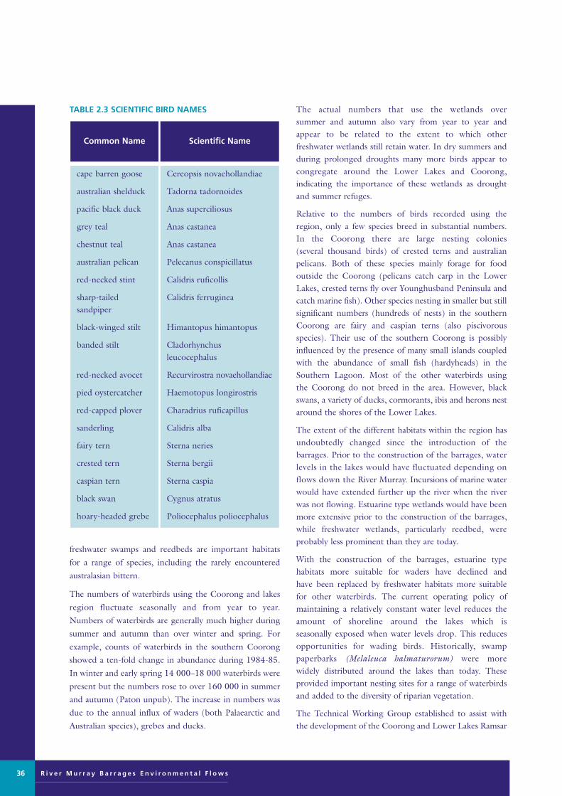
R i v e r M u r r a y B a r r a g e s E n v i r o n m e n t a l F l o w s
TABLE 2.3 SCIENTIFIC BIRD NAMES
freshwater swamps and reedbeds are important habitats
for a range of species, including the rarely encountered
australasian bittern.
The numbers of waterbirds using the Coorong and lakes
region fluctuate seasonally and from year to year.
Numbers of waterbirds are generally much higher during
summer and autumn than over winter and spring. For
example, counts of waterbirds in the southern Coorong
showed a ten-fold change in abundance during 1984-85.
In winter and early spring 14 000–18 000 waterbirds were
present but the numbers rose to over 160 000 in summer
and autumn (Paton unpub). The increase in numbers was
due to the annual influx of waders (both Palaearctic and
Australian species), grebes and ducks.
The actual numbers that use the wetlands over summer and autumn also vary from year to year andappear to be related to the extent to which other freshwater wetlands still retain water. In dry summers andduring prolonged droughts many more birds appear tocongregate around the Lower Lakes and Coorong, indicating the importance of these wetlands as droughtand summer refuges.
Relative to the numbers of birds recorded using theregion, only a few species breed in substantial numbers. In the Coorong there are large nesting colonies (several thousand birds) of crested terns and australian pelicans. Both of these species mainly forage for food outside the Coorong (pelicans catch carp in the LowerLakes, crested terns fly over Younghusband Peninsula andcatch marine fish). Other species nesting in smaller but stillsignificant numbers (hundreds of nests) in the southernCoorong are fairy and caspian terns (also piscivorousspecies). Their use of the southern Coorong is possiblyinfluenced by the presence of many small islands coupledwith the abundance of small fish (hardyheads) in theSouthern Lagoon. Most of the other waterbirds using the Coorong do not breed in the area. However, blackswans, a variety of ducks, cormorants, ibis and herons nest around the shores of the Lower Lakes.
The extent of the different habitats within the region hasundoubtedly changed since the introduction of the barrages. Prior to the construction of the barrages, waterlevels in the lakes would have fluctuated depending onflows down the River Murray. Incursions of marine waterwould have extended further up the river when the riverwas not flowing. Estuarine type wetlands would have beenmore extensive prior to the construction of the barrages,while freshwater wetlands, particularly reedbed, wereprobably less prominent than they are today.
With the construction of the barrages, estuarine type habitats more suitable for waders have declined and have been replaced by freshwater habitats more suitable for other waterbirds. The current operating policy ofmaintaining a relatively constant water level reduces theamount of shoreline around the lakes which is seasonally exposed when water levels drop. This reducesopportunities for wading birds. Historically, swamp paperbarks (Melaleuca halmaturorum) were more widely distributed around the lakes than today. These provided important nesting sites for a range of waterbirdsand added to the diversity of riparian vegetation.
The Technical Working Group established to assist withthe development of the Coorong and Lower Lakes Ramsar
Cereopsis novaehollandiae
Tadorna tadornoides
Anas superciliosus
Anas castanea
Anas castanea
Pelecanus conspicillatus
Calidris ruficollis
Calidris ferruginea
Himantopus himantopus
Cladorhynchusleucocephalus
Recurvirostra novaehollandiae
Haemotopus longirostris
Charadrius ruficapillus
Calidris alba
Sterna neries
Sterna bergii
Sterna caspia
Cygnus atratus
Poliocephalus poliocephalus
cape barren goose
australian shelduck
pacific black duck
grey teal
chestnut teal
australian pelican
red-necked stint
sharp-tailedsandpiper
black-winged stilt
banded stilt
red-necked avocet
pied oystercatcher
red-capped plover
sanderling
fairy tern
crested tern
caspian tern
black swan
hoary-headed grebe
Scientific NameCommon Name
36
Murray Barrages flow edit 28/8/01 11:15 AM Page 36
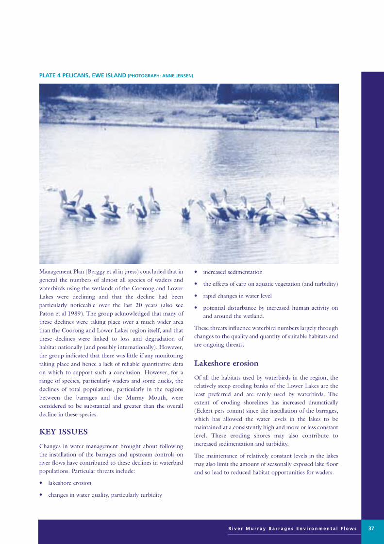
Management Plan (Berggy et al in press) concluded that ingeneral the numbers of almost all species of waders and waterbirds using the wetlands of the Coorong and LowerLakes were declining and that the decline had beenparticularly noticeable over the last 20 years (also seePaton et al 1989). The group acknowledged that many ofthese declines were taking place over a much wider areathan the Coorong and Lower Lakes region itself, and thatthese declines were linked to loss and degradation ofhabitat nationally (and possibly internationally). However,the group indicated that there was little if any monitoringtaking place and hence a lack of reliable quantitative dataon which to support such a conclusion. However, for arange of species, particularly waders and some ducks, thedeclines of total populations, particularly in the regionsbetween the barrages and the Murray Mouth, wereconsidered to be substantial and greater than the overalldecline in these species.
KEY ISSUES
Changes in water management brought about followingthe installation of the barrages and upstream controls onriver flows have contributed to these declines in waterbirdpopulations. Particular threats include:
• lakeshore erosion
• changes in water quality, particularly turbidity
• increased sedimentation
• the effects of carp on aquatic vegetation (and turbidity)
• rapid changes in water level
• potential disturbance by increased human activity onand around the wetland.
These threats influence waterbird numbers largely throughchanges to the quality and quantity of suitable habitats andare ongoing threats.
Lakeshore erosion
Of all the habitats used by waterbirds in the region, therelatively steep eroding banks of the Lower Lakes are theleast preferred and are rarely used by waterbirds. Theextent of eroding shorelines has increased dramatically(Eckert pers comm) since the installation of the barrages,which has allowed the water levels in the lakes to be maintained at a consistently high and more or less constantlevel. These eroding shores may also contribute toincreased sedimentation and turbidity.
The maintenance of relatively constant levels in the lakesmay also limit the amount of seasonally exposed lake floorand so lead to reduced habitat opportunities for waders.
R i v e r M u r r a y B a r r a g e s E n v i r o n m e n t a l F l o w s 37
PLATE 4 PELICANS, EWE ISLAND (PHOTOGRAPH: ANNE JENSEN)
Murray Barrages flow edit 28/8/01 11:15 AM Page 37

R i v e r M u r r a y B a r r a g e s E n v i r o n m e n t a l F l o w s38
FIGURE 2.7 COORONG AND LOWER LAKES RAMSAR WETLAND AREA – KEY TO CRITICAL BIRD HABITATS(SOURCE: DHUD)
1 Hindmarsh and barrage islands waterfowl, waders, waterbirds,
Cape Barron Geese
2 Estuary and Murray Mouth waders, terms, waterbirds, Musk Duck, Blue-billed Duck
3a Coorong – Narung shore waders, waterbirds
3b Coorong islands waders, terns
4 Currency Creek waterfowl, waterbirds
5 Finiss Estuary waterfowl, waterbirds, Emu Wrens
6a Clayton – Point Sturt waterfowl, waterbirds, waders
6b Clayton – Clayton swamp waterbirds, waders
7a Milang shore waterfowl, waders, waterbirds
7b Milang Town Latham’s Snipe
8 Tolderol Point waterfowl, waders, waterbirds
9 Mosquito Point waterfowl, waders, waterbirds, Ibis
10 Mulgundawa Great Crested Grebes, Darter
11 Grote Hill Caspian Terns
12 Pelican Lagoon waterbirds, waterfowl
13 Wellington Point Darter, waterbirds
14 Poltalloch waterfowl, waders, waterbirds
15 Narrung Narrows waterbirds, Ibis
16 Reedy Point waterbirds, pelicans
17 Waltowa waterfowl, waders, waterbirds
18 Waringee Point waterfowl, waterbirds
19 Yalkuri and Salt Lagoon waterfowl, waders
Murray Barrages flow edit 28/8/01 11:15 AM Page 38

Turbidity
Increasing turbidity levels impact on bird populations bydecreasing food sources and limiting their hunting ability.The sources of turbidity in the Lower Lakes and Cooronginclude particulates in river inflows, regional catchmenterosion and feeding activity by carp.
Increased turbidity may have contributed to reductions in grebes, other diving birds, as well as herons, egrets, cormorants and terns, all of which hunt largely by sight.Increased turbidity may have also reduced the productivityof any remaining submerged aquatic plants (Ganf ibid).Similarly, turbidity may have increased in the Cooronglagoons over time, affecting the quantity of light andhence productivity of submerged aquatic plants in theseregions as well (Paton et al unpub; Paton 1997).
Increasing sedimentation
Changes in the quantities and timing of releases of waterover the barrages may have influenced the availability andor productivity of the mudflats used by waders and somewaterfowl (grey teal, black swans, australian shelduck).Increased levels of sedimentation, particularly large quantities of sand, in the region of the Murray Mouthestuary and the dynamics of sand movements in the region (Bourman ibid) may have rendered some of themudflats in this region less suitable for aquatic plants andinvertebrates, smothering them or alternatively restrictingtidal volumes and so reducing the extent to which moredistant mudflats are tidally flushed and/or exposed. Thereare no specific data to support this contention but it is alogical biological outcome following the extensive and relatively rapid rates (Bourman ibid) at which sand hasbeen deposited in the region. This could also reduce theareas of habitat suitable for some of the aquatic plants thatgrow in channels and the Northern Coorong Lagoon,affecting both aquatic invertebrate abundances and fish,which in turn reduces the carrying capacity of the area forbirds.
European carp
European carp are now abundant in the Lower Lakes andare believed to contribute to increased turbidity anddegradation of aquatic plant communities (Roberts et al1995). The loss of aquatic (submerged) plants within thelakes has been cited as the likely factor contributing to therecent and substantial declines in musk ducks and blue-billed ducks (Soon 1992). Loss of these aquatic plants mayalso affect invertebrate food resources used by other birds.
Rapid changes in water level
The effect of rapid changes in water level on habitat qualityis best illustrated by examining the performances of thekey aquatic plant in the southern Coorong, Ruppiatuberosa. This ‘annual’ plant grows around the ephemeralshoreline of the Southern Lagoon and produces largequantities of seeds and turions which are consumed bysome of the waterbirds and waders. The plant also provides resources and habitats for aquatic invertebrates(chironomid larvae, ostracods, etc) which in turn providefood for birds and the abundant small-mouthed hardyhead(Atherinosoma microstoma), an important resource forsome of the waders, terns, grebes, herons and cormorants(Paton 1982; 1986; Molsher et al 1994; Brooks et al1995; Paton et al unpub).
Water levels in the Southern Lagoon fluctuate seasonallyby about one metre, with rainfall (and/or groundwater)and evaporation considered to be the major contributorsto this seasonal pattern (Tong pers comm). As a consequence, extensive areas of mudflats (typically several hundred metres wide around most of the shores of the Southern Lagoon) are exposed during late summer and autumn. It is on these mudflats that Ruppiatuberosa grows. Seeds and turions germinate or sprout in late autumn and winter when water levels rise (often in association with rainfall and local runoff) (Paton 1997 unpub).
The plants grow through winter and spring and, providedwater levels are maintained for long enough, will flower inlate spring and produce seeds and then turions beforewater levels drop again. Examination of the performanceof this plant shows that it performs best in water depthsthat range from about 0.3 m to 0.8 m during winter andspring (Paton 1997). In shallower water plants are limitedby periodic desiccation due to day-to-day fluctuations inwater levels brought on by changes in the direction andstrength of the wind. In water deeper than about 0.8 mthe plants perform poorly, presumably because insufficientlight penetrates the turbid water. Although some seedlingsmay survive at these depths they generally do not growand most eventually die without reproducing. The operation of the barrages thus has a bearing on the abilityof Ruppia tuberosa to complete its reproductive cyclethrough the affect on water levels.
The water levels in the southern Coorong have a slightlyhigher head than the water levels in the Murray Mouthregion, such that the level of water may be a metre higherthan sea level during late winter and spring. Thus when thebarrages are not open, water from the Southern Lagoon
R i v e r M u r r a y B a r r a g e s E n v i r o n m e n t a l F l o w s 39
Murray Barrages flow edit 28/8/01 11:15 AM Page 39

R i v e r M u r r a y B a r r a g e s E n v i r o n m e n t a l F l o w s
slowly shifts northwards but when the barrages are openthe water levels are higher in the northern Coorong. Thisessentially plugs the Coorong, reduces the movement ofwater northwards and so water levels in the SouthernLagoon are higher.
However, if the barrage gates are closed over a relativelyshort period of time, the water level in the SouthernLagoon can drop rapidly (as it did in December 1990),such that the beds of Ruppia are suddenly exposed to desiccation and both seed and turion production are prevented. Prior to the construction of the barrageschanges in water levels in the northern Coorong wouldhave been more gradual as flows down the Murray subsided gradually and not abruptly.
A gradual change in water depth may provide Ruppiaplants with the time to package resources into turions,with the plants using any of a number of cues to switchfrom sexual reproduction (seeds) to asexual reproduction(turions). Changes in light intensity (caused by slowlydropping water levels) and/or changes in day length(anticipating reduced water levels well in advance) mighthave normally triggered turion production during summerand into autumn. Prior to the construction of the barragesand locks, flows of water into the northern Coorong mayhave extended for a longer period of time and further intolate summer and autumn. This would have given thisannual plant a longer period of time in which to completeits cycle.
Impacts of human activity
A further and increasing threat to the ‘quality’ of the habitats in the region is linked to increases in human recreational activity. Human activity ranging from walkingalong the shoreline to use of canoes, power boats and jetskis could all disturb birds while they are foraging on nearby mudflats and in shallow water. That disturbance iffrequent may greatly reduce the time the birds spend foraging, may force them to abandon preferred areas, maycontribute to reductions in aquatic and or riparian plantsand may be critical for some of the waders, particularlythose that are attempting to fatten prior to migratingnorthwards.
ECOLOGICAL NEEDS
To maintain and protect the diversity of avifauna unique to the Lower Lakes and Coorong, it is essentialthat management of the system addresses these ecologicalneeds:
• buffer the abrupt changes in water levels in the
southern Coorong
• allocate more water downstream of the barrages,
extending the period of flow and mitigating the rate of
recession of water levels in the Coorong
• reduce sedimentation of the mouth
• increase the size of the tidal prism
• increase the spatial extent of wader habitat by
increasing the tidally exposed mudflats
• reduce turbidity in the lakes to improve the growth
of submerged plants
• reduce sediment transport into the Coorong
• protect saline wetland habitat for waders
• enlarge the area of estuarine habitat and create
additional estuarine habitat around the lakes
• reduce carp numbers and human disturbance.
The first task is to restore and rehabilitate the estuarine
habitat that existed between the barrages and the Murray
Mouth until recently, by flushing out some of the coarser
marine sands that have been deposited in the estuary
region.
OPPORTUNITIES FOR IMPROVEMENT
Management opportunities for improvement can be
divided into short-, medium- and long-term options,
which are detailed below.
Short-term
The management objective should be to reduce the abrupt
changes to water levels in the Coorong. This could be
achieved through the short-term, minor changes to the
operation of the barrage gates. This would involve opening
gates progressively, perhaps starting a little earlier than
currently happens, keeping some of the gates open for a
longer period into summer. When the gates need to be
closed, the gates could be closed progressively, perhaps
starting earlier than is currently the case but extending the
period over which the gates are closed. Closing the
Tauwitchere Barrage last might slightly prolong water level
recessions in the Coorong, because of its proximity to the
northern Coorong (relative to other barrages).
40
Murray Barrages flow edit 28/8/01 11:15 AM Page 40

Medium-term
The priority medium-term action is to improve the ‘fine’control of barrage releases by automating some of thegates. The proportion of gates needing to be automatedfor optimum environmental benefits is unknown, howevereven if only a small percentage can be modified initially,that will still be of some benefit. Automatic gates (even afew on each of the barrages currently serviced with power)will clearly improve the ability of barrage operators todeliver the short-term management objectives.
Additional medium-term actions should consider allocatingmore water for environmental use downstream of the barrages, enabling the barrage operators to extend theperiod of flow over the barrages until later in the yearand/or to allow water levels to be dropped more graduallydownstream of the barrages during late summer orautumn.
The third priority medium-term action should aim toreduce the sedimentation taking place adjacent to themouth and to scour out this region with a view of increasing the tidal prism and increasing the potentialwader habitats in the regions. This may involve increasingthe frequency and volume of water released throughMundoo Channel, possibly requiring additional gates tobe added to that barrage. To achieve this objective, substantial quantities of water may need to be released for an extended length of time. This action may only befeasible when there is a substantial flow of water cominginto the lakes for sufficient time. There may also be benefits to release the water strategically for parts of theday when tides are lowest and winds are favourable.
A similar scouring effect may be required to remove sandaccumulating in the Coorong estuary channels betweenthe mouth and Tauwitchere. That may require the strategic release of high flows over the TauwitchereBarrage (while the others are not opened).
The second reason for recommending increased volumes and strategic opening of the Mundoo Barrage isto promote reductions in turbidity in the lakes. This wouldfavour various submerged aquatic plants and increase theirproductivity, which indirectly is likely to increase the numbers of invertebrates, fish and birds in the lakes. Theuse of Mundoo Barrage could thus be considered to helpflush/remove suspended material from the lakes, to helpreduce turbidity. This may require the gates at Mundoo tobe opened strategically during windy weather, when the quantity of suspended material is higher.
The choice of Mundoo Barrage over the others for this
purpose is because of its proximity to the Mouth andhence reduced risks of the suspended material beingdeposited or remaining in suspension in the Coorong, in the northern channels or other parts of the estuary. Tomaximise the effectiveness of this action, the gates shouldbe opened during windy weather when sediment has beenresuspended, and during a falling tide to maximise theprobability that this turbid water will be flushed straightout to sea with minimal impact on the marine environment (Ganf ibid).
Another medium-term management action worth considering is reducing the water levels in the lakes to helpprotect the habitat of the constructed and natural salinewetlands around the lake shores, used by waders, frominfluxes of freshwater when water levels are surcharged to0.85 m prior to the barrages closing for summer. If waterlevels are not dropped then the height of the levee bankscould be raised slightly to help protect the fringing salinehabitats during times when the water level of the lake ismaintained near 0.85 m. However, some temporary dropin water level below current operating levels is required ifany additional mud flats are to be exposed around theshoreline.
Dropping the level (or allowing the level to drop below0.65 m), particularly during the summer/ autumn period,might also expose some of the lake floor, providing additional mudflats and shallow water suitable for wadingbirds around the perimeter of the lake. Drops in level of10–20 cm may be sufficient to increase the area of suitableforaging habitat for waders.
Reduced water levels might also reduce erosion pressureon exposed shores. Lowering water levels in the lakes may also assist remedial action on those shores that arecurrently eroding. However, given that many of theseeroding shores are already steep, dropping water levelseven by substantial amounts (0.5 m) may not be sufficientto provide any real benefits simply because of the largewind-induced water level changes and erosive strength ofthe wind-induced waves.
Long-term
To establish a larger estuarine area the long-term option of shifting the barrages to a point further upstream is likely to benefit waders by providing opportunities fortidally-exposed estuarine mudflats to re-establish in thearea immediately above the current barrages. At the same time this would reduce the freshwater habitatsaround the current lakes at the expense of the more freshwater-dependent waterbirds.
R i v e r M u r r a y B a r r a g e s E n v i r o n m e n t a l F l o w s 41
Murray Barrages flow edit 28/8/01 11:15 AM Page 41

R i v e r M u r r a y B a r r a g e s E n v i r o n m e n t a l F l o w s
Depending on the frequency and volumes of water thatwould be released over a weir at Wellington if it replacedthe current barrages, substantial parts of the northern and central lakes may not change greatly. An agreementwould be required to ensure that freshwater flows weremaintained into the new estuarine zone. A broader, morenatural estuarine zone might establish over the southernparts of Lake Alexandrina.
Such a drastic change to this wetland system might challenge the obligations for maintaining ecological character under the Ramsar convention. Nevertheless, itwould clearly improve the functioning of the mouthregion with clear benefits to biota and biotic processes inthis part of the wetland.
Other approaches to management
There are a series of other management actions that shouldbe implemented. Although they complement any adjustments to water regimes in the study area, theyshould be implemented irrespective of any adjustments to the operation of the barrages. In particular, thereshould be urgent remedial work on locations around the lakes currently experiencing or at risk of shore erosionto stabilise the shore (use of protective structures, destocking, and revegetation), as well as broader regionalrevegetation programs aimed at reducing impacts of dryland salinisation and possible sources of sediments tothe lakes.
As Darling water is more turbid than Murray water, theremay be benefits in reducing the amounts of Darling waterentering the system, particularly if any build up in sediments and fine suspended material currently in thelakes cannot be flushed out to sea.
The presence of carp in the lakes remains a major obstacle to reducing turbidity and to stimulating the re-establishment of submerged aquatic plants. Althoughsuitable techniques may not yet be available, implementingprograms to reduce the carp numbers would be beneficial.Some commercial fish species, if they can be introducedinto the lakes in adequate numbers, may help to reducedensities of carp by preying on fry and eggs (Pierce perscomm; Geddes ibid).
Impacts
In general the short- and medium-term actions of adjusting the operation of the barrages and installing automatic gates should have minimal impacts and are consistent with delivering other environmental benefits.
Implementing these proposals, however, may lead togreater fluctuations in water levels in the lakes and/orperiods when the Lower Lakes might have a lower meanlevel than the current 0.75 m AHD level. Lower lake levels and possibly greater fluctuations in water levels(more frequent in time and over a greater amplitude) mayhave some impacts on users such as irrigators and someshort-term impacts on freshwater habitats (eg reedbeds).
If lake levels were permanently lowered the freshwaterfringing vegetation (reeds) would presumably shifttowards the new water level but once established mightassume similar dimensions to the current system. Lowerwater levels might also reduce groundwater mounding inadjacent areas but lead to increased incursions of salinegroundwater into the lakes. Revegetation programs ifimplemented at appropriate scales and in time would limitsuch influxes.
The lifespan of the barrages is unknown but they willeventually require replacement. Therefore, evaluation ofthe benefits and impacts of shifting the location of thecontrol structure is warranted. Removing the barrages and replacing them with a weir at Wellington would probablybe the most financially viable alternative. How this willaffect waterbird habitats is not known and appropriateassessment of the risks of further impact on the ecosystem should be conducted.
42
Murray Barrages flow edit 28/8/01 11:15 AM Page 42

BACKGROUND AND CURRENTSTATUS
The macroinvertebrates of the Coorong NorthernLagoon and Murray Mouth are an estuarine assemblage that is similar to that of other southern Australian estuaries. However, only 21macroinvertebrate species were collected by Geddesand Butler (1984), compared to over 100 species inmany other estuaries in south-eastern Australia.Major groups include Amphipods and Gastropods(particularly Hydrobia) that are highly abundant in macrophyte beds (Ruppia megacarpa), and polychaetes and bivalves that are abundant in thesoft sediments in the central parts of the lagoons.
The Southern Lagoon is characterised by a restrictedhypermarine fauna. The chironomid Tanytarsus barbitarsusis abundant as are the hardyhead fish Atherinosoma microstoma (Geddes 1987). A limited array of crustaceans including ostracods, cyclopoid and harpacticoid copepodsand the salt lake isopod Haloniscus searlei along with salinewater dipteran larvae such as ephydrids and ceratopogonidsalso occur. Along with the seeds and turions of Ruppiatuberosa, these invertebrates and the hardyhead provideforage for the aquatic birds that feed in the SouthernLagoon of the Coorong (Paton ibid).
The fauna is adapted to extreme fluctuations in salinitywith tolerances from 2–5 ppt to 50–60 ppt (Geddes &Hall 1990) (Figure 2.8). Even so, in periods of low flow
FISH AND INVERTEBRATES
M Geddes, Zoology Department, University of Adelaide
R i v e r M u r r a y B a r r a g e s E n v i r o n m e n t a l F l o w s 43
FIGURE 2.8 LONGITUDINAL AND VERTICAL SALINITY PATTERNS IN THE COORONG AT IRREGULAR INTERVALSBETWEEN 1975 AND 1985 (SOURCE: GEDDES & HALL 1990)
Murray Barrages flow edit 28/8/01 11:15 AM Page 43

R i v e r M u r r a y B a r r a g e s E n v i r o n m e n t a l F l o w s
and associated high salinity, the distribution of the estuarine fauna covers only part of the Northern Lagoon.The high productivity of the macrophyte beds and theopen water of the Northern Lagoon supports a highly productive macroinvertebrate fauna. The SouthernLagoon has extensive beds of Ruppia tuberosa, Lepilaenaand Lamprothamnion. These plants require particular combinations of salinity depth and light (Paton ibid).Salinity is also important in the distribution of chironomids and hardyheads, with upper salinity limits ofabout 100 ppt. At periods of lowered salinity the estuarinefauna may move into the Southern Lagoon. Periods of
extended low flow result in high salinity in the SouthernLagoon and the southern parts of the lagoon may havesalinities beyond the tolerance of the hypermarine fauna(Geddes 1995).
The fish of the Coorong lagoons (Table 2.4) includespecies that move between the sea and the Coorong, suchas mulloway and australian salmon, and species that areresident in the Coorong, including black bream, greenback flounder, river garfish, yellow eye (coorong) mullet,and congolli. For mulloway and australian salmon, theCoorong is a juvenile nursery. The truly estuarine speciesbreed in the Coorong, where freshwater inflows and
44
TABLE 2.4 FISH OF THE COORONG (SOURCE: GEDDES & HALL 1990)
(1) Species of commercial and/or recreational importance
(2) Species of little of no direct commercial or recreational importance
as with congolli
all stages estuarine
all stages marine and hypermarine
unknown
unknown
unknown
unknown
freshwater – may spawn in either river or estuary
australian smelt
bridled goby
small-mouthedhardyhead
southern anchovy
blue spot goby
blue sprat
sandy sprat
common galaxias
Retropinna semoni
Gobius bifrenatus
Atherinosoma microstoma
Engraulis australis
Lizagobius galwayi
Spratelloides robustus
Hyperlophus vittatus
Galaxias maculatus
Estuarine DependencyCommon NameScientific Name
spawns in marine zone; juveniles estuarine; adult marine
spawns in estuary; juveniles estuarine; adults estuarine
spawns in estuary/ocean; juveniles estuarine
all stages estuarine
all stages freshwater/estuarine may need to spawn in estuary
all stages marine/estuarine
all stages marine
mulloway
black bream
greenback flounder
river garfish
congolli or tupong
yellow-eye mullet
australian salmon
Argyrosomus hololepidotus
Acanthopagrus butcheri
Rhombosolea tapirina
Hyporhamphus regularis
Pseudaphritis urvilli
Aldrichetta forsteri
Arripis trutta esper
Estuarine DependencyCommon NameScientific Name
Murray Barrages flow edit 28/8/01 11:15 AM Page 44
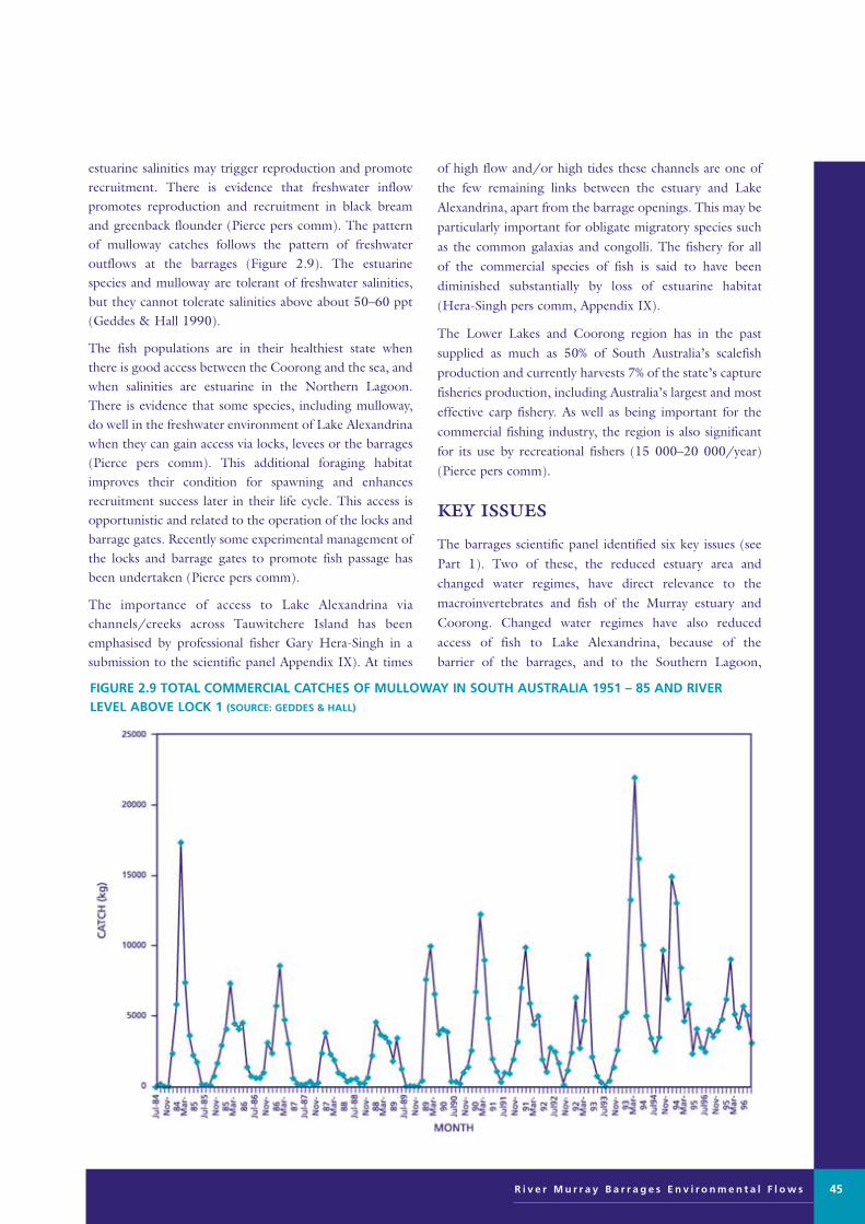
estuarine salinities may trigger reproduction and promoterecruitment. There is evidence that freshwater inflow promotes reproduction and recruitment in black breamand greenback flounder (Pierce pers comm). The patternof mulloway catches follows the pattern of freshwater outflows at the barrages (Figure 2.9). The estuarinespecies and mulloway are tolerant of freshwater salinities,but they cannot tolerate salinities above about 50–60 ppt(Geddes & Hall 1990).
The fish populations are in their healthiest state whenthere is good access between the Coorong and the sea, andwhen salinities are estuarine in the Northern Lagoon.There is evidence that some species, including mulloway,do well in the freshwater environment of Lake Alexandrinawhen they can gain access via locks, levees or the barrages(Pierce pers comm). This additional foraging habitatimproves their condition for spawning and enhancesrecruitment success later in their life cycle. This access isopportunistic and related to the operation of the locks andbarrage gates. Recently some experimental management ofthe locks and barrage gates to promote fish passage hasbeen undertaken (Pierce pers comm).
The importance of access to Lake Alexandrina via channels/creeks across Tauwitchere Island has beenemphasised by professional fisher Gary Hera-Singh in asubmission to the scientific panel Appendix IX). At times
of high flow and/or high tides these channels are one ofthe few remaining links between the estuary and LakeAlexandrina, apart from the barrage openings. This may beparticularly important for obligate migratory species suchas the common galaxias and congolli. The fishery for all of the commercial species of fish is said to have beendiminished substantially by loss of estuarine habitat (Hera-Singh pers comm, Appendix IX).
The Lower Lakes and Coorong region has in the past supplied as much as 50% of South Australia’s scalefish production and currently harvests 7% of the state’s capturefisheries production, including Australia’s largest and mosteffective carp fishery. As well as being important for thecommercial fishing industry, the region is also significantfor its use by recreational fishers (15 000–20 000/year)(Pierce pers comm).
KEY ISSUES
The barrages scientific panel identified six key issues (seePart 1). Two of these, the reduced estuary area andchanged water regimes, have direct relevance to themacroinvertebrates and fish of the Murray estuary andCoorong. Changed water regimes have also reduced access of fish to Lake Alexandrina, because of the barrier of the barrages, and to the Southern Lagoon,
R i v e r M u r r a y B a r r a g e s E n v i r o n m e n t a l F l o w s 45
FIGURE 2.9 TOTAL COMMERCIAL CATCHES OF MULLOWAY IN SOUTH AUSTRALIA 1951 – 85 AND RIVERLEVEL ABOVE LOCK 1 (SOURCE: GEDDES & HALL)
Murray Barrages flow edit 28/8/01 11:15 AM Page 45

R i v e r M u r r a y B a r r a g e s E n v i r o n m e n t a l F l o w s
because of higher average salinities associated with reducedinflows from the River Murray.
Reduced estuarine area
In pre-regulation and pre-barrage times the Lower Lakes,Murray Mouth and Coorong lagoons operated as oneextensive estuary system. The barrages have separated
the now freshwater lakes from the Murray Mouth. Thereduction in the area of highly productive estuarine habitat has affected the abundance of commercial andnon-commercial fish species. The extent of estuarine conditions in the Coorong lagoons has also been restricted. Salinities in the northern and southern lagoonsare controlled primarily by outflow from the barrages(Geddes 1987). With reduced outflows, salinity in the
46
FIGURE 2.10 INCREASE IN COORONG MULLOWAY CATCHES AS A RESPONSE TO A REINSTATED NATURALWINTER FLOW REGIME (SOURCE: SARDI)
Murray Barrages flow edit 28/8/01 11:15 AM Page 46

Coorong has risen. Estuarine salinities have not beenrecorded in the Southern Lagoon since the Murray floodsof 1975 (Geddes & Butler 1984). When the barrages are closed for extended periods there may be no areas at all ofestuarine conditions, but rather the mouth zone becomesa marine tidal system.
Changed water regime
The regulation of River Murray flows has led to reducedoutflows at the barrages, especially at times when moderateflows would have operated (Newman ibid). There are nowmany periods of barrage closure and no outflow. Outflowfrom the Murray Mouth to the sea is important to manyaspects of fish ecology. It provides nutrients to increaseproductivity in the system and promote survival of larvaland juvenile fish. The outflow of water from the MurrayMouth is also a cue to attract large mulloway in spawningcondition and to encourage juvenile mulloway, australian salmon and other species to enter the Coorong.
Changed flow regimes through the barrages at differenttimes of the year are being investigated by SARDI.Through recommendations made by local fishers (togetherwith fish passage research), minor freshwater inflowincreases have been implemented over winter since 1994.The result has been attraction, feeding and maintenance ofmulloway stocks over the full year, as can be clearly seen inFigure 2.10. Note that the most recent annual data are notfinalised, but preliminary analyses demonstrate a similarpattern (for example a minimum of 5 tonne of this speciesalone taken monthly in the winter commercial fishery).The causal nature of the relationship is demonstrated inthe recent (August 1997) stoppage of increased flows,resulting in a noticeable reduction in fish numbers onlyseven days after the reduced flows (Pierce pers comm).While mulloway, a top predator (150 mm to over 20 kg),benefit from this flow increase, flounder and bream arealso seen to be more active in the presence of this stimulus(Pierce pers comm).
We can predict that over spring/summer/late autumn, useof attractant flows and proactive gate operation will allowfish passage. However, in the event of a significant storm,fish passage through the barrages is not possible as theywould be severely buffeted (for example at Tauwitchereand Ewe Island barrages). Instead, computer operatedbarrages would open the sheltered Boundary Creek sitewhere major aggregations of particularly sub-adult fish willbe found and enticed into freshwater and out again (Piercepers comm).
Current management of floodwaters restricts the
recruitment of many estuarine fish species. Floodwaters aretypically ‘captured’ in upriver weir pools, or behind thebarrage network, which means from the perspective of anestuarine fish freshwater inflows are shut off almostinstantly. Recruitment of most estuarine fish speciesworldwide is linked to the post-flood productivity withspawning linked to the final outflows (Kennish 1990).Estuarine species such as greenback flounder and bream arecurrently often found in advanced reproductive stages, butinstead of receiving smooth flow cues to successfulspawning, they usually suddenly find all inflows shut offover a one-day period. These fish then disperse andsubsequent sampling fails to find evidence of significantrecruitment. For example, bream catches were consistently around 100+tonnes/year in the 1970s, but are now around 3tonnes/year and consistently declining (Pierce perscomm). Natural flow reductions in less modified systemsthan the River Murray are spread over longer periods. Smoothing of the reduced flows over the barrageswould more closely replicate the natural conditionsexpected by fish adapted to a natural estuarine ecosystem.This flow management regime is recommended to smooth and extend flows for the period September toJanuary (Harbison 1974; Weng 1970) for bream, forgreenback flounder as well as for other estuarine species(Hall pers comm).
ECOLOGICAL NEEDS
The changes in water regime and the presence of the barrages have both led to a reduced extent of the estuarine system, now approximately 11% of the former area (Bourman ibid). Along with the changes, there has been an increase in the extent of the freshwater environment behind the barrages and an increase in thespatial and temporal occurrence of hypermarine conditionsin the Southern Lagoon. There has been the establishmentof unvarying marine salinities for long periods in theremnant estuary when the barrages are closed.
Clearly, management of the region needs to enhance theenvironment for estuarine macro-invertebrates and forestuarine-marine fish. To enhance the environment forestuarine macro-invertebrates and for estuarine-marinefish, the following are key ecological needs.
Maximise estuarine area
The area which is estuarine may be defined on salinity criteria or on the basis of access between marine and freshwater habitats. It might best be considered as that
R i v e r M u r r a y B a r r a g e s E n v i r o n m e n t a l F l o w s 47
Murray Barrages flow edit 28/8/01 11:15 AM Page 47

R i v e r M u r r a y B a r r a g e s E n v i r o n m e n t a l F l o w s
part of the environment that supports an estuarine biota.The estuarine area can be maximised by extending the areaof the Coorong that has salinities between freshwater andabout 50 ppt. This will depend upon the extent of outflowfrom the barrages and the way in which that outflow ismanaged. Substantial outflows can control salinities in theCoorong lagoons, and small outflows can be managed soas to maximise their effect on salinity in the Murray Mouthregion. The estuary can be increased by removal or relocation of the barrages to re-include the Lower Lakes inthe estuary. Alternatively, if access to the lakes is providedfor estuarine species that are able to use that habitat, thenthe lakes, even in the present freshwater condition, canbecome a functional part of the estuary.
In attempting to maximise the estuarine area the followingtwo limitations need to be recognised:
• Peak outflows must not be sacrificed for the sake ofextended flows. Large numbers of mulloway areattracted to the Murray Mouth at high flows, and peakflows also possess hydraulic benefits in retaining mouthdepth and channel capacity.
• Avoid implementing a fixed flow regime. Variation isinherent to the productivity of the system. For example,enhanced productivity, as seen through prey speciessuch as shore crabs, mullet and hardyheads, can fail tobe made available to higher trophic levels throughfixed flow regimes.
Increase fish passage between the NorthernLagoon estuarine zone and the sea via theMurray
Mouth
Several species of fish move between the Coorong and thesea during their lifecycle. The best known is the mulloway,which spawns in the sea (offshore from the MurrayMouth). Larvae and juveniles then spend several monthsat sea before migrating into the Coorong where theyspend four to five years. Upon reaching sexual maturity,they migrate out of the Murray Mouth to sea for spawning.This outward migration occurs in November–December,and the inward migration occurs ten months later inOctober–December.
Australian salmon also move through the Murray Mouth.Yellow-eye mullet may also move in and out of the mouth (Hall 1984), although studies by Harris (1968)suggest that they breed in the Coorong in the monthsFebruary to May.
Provide conditions suitable for spawning andlarval/juvenile survival in the Coorong andMurray Mouth regions
Inflows of freshwater into the Coorong lagoons promotespawning success in estuarine species such as black breamand greenback flounder. Further studies are needed toprovide an understanding of spawning in these species.Greenback flounder are thought to spawn from July toSeptember and black bream from November to March.Flows should be maintained during the spawning season ofthese species. It is also important that flows are not shutoff suddenly, but the recession of flow should be gradualto replicate conditions for fish spawning under naturalestuary conditions (Pierce pers comm).
Provide fish passage through the barrages
Some species require access between freshwater and estuarine/marine water to complete their lifecycle. Theseinclude congolli and common galaxias. The barrier of thebarrages has had a substantial impact on the populationnumbers of these species. Other species that may have usedthe lakes when they were an open estuarine system prior tothe construction of the barrages include freshwater eelsand lampreys.
In addition to these species that require fresh and estuarine/marine habitat, many of the estuarine/marinespecies may be able to use the freshwater habitat of the lakes during pre-adult growth (Pierce pers comm).
In order to meet these ecological needs, future managementof flows at the barrages should incorporate the followingfeatures:
• Manage existing structure with a view to maximisingfreshwater flows to the Coorong, especially during lowflow seasons.
• Manage outflow from the barrages at low flow to maximise the extent of estuarine/brackish water in theMurray Mouth region. This may involve maintaining gates open at the further ends of the barrages at Goolwa and Tauwitchere.
• Provide outflows at times of spawning of estuarinespecies (such as black bream and greenback flounder)to maximise spawning success.
• Ensure that the recession of flows is gradual to replicateconditions in a natural estuary.
• Promote flows through the Murray Mouth at criticaltimes for fish migration.
• Retain at least two open gates at both Tauwitchere andGoolwa sites over winter to enhance recruitment ofnative Coorong fishes over the winter period.
48
Murray Barrages flow edit 28/8/01 11:15 AM Page 48

• Smooth and extend the spring flood recession flow tothe Coorong to mimic natural conditions particularlyover the period September to January.
• Experimentally manage barrage outflow (with automation preferable) so they are timed to increasetidal ebb flows and thus increase the net flow impacton channel formation. Benefits to fish include maintenance of deeper water habitats as well as migratory access to and within the Coorong.
• Provide increased passage into the lakes from the estuary by automation of 22% of barrage gates andusing them under fine control to promote fish passage(see Appendix VII).
• Provide environmental flows to maintain limited flowthrough barrages throughout the year and especially inOctober to May. These flows do not need to be evenand should aim to replicate natural historical flows asclearly as possible. The exact management of theseflows requires further research on the spawning andlarval/juvenile recruitment of fish species in theCoorong.
• Consider removal/relocation of barrages to enlargemarine/estuarine habitat. Substantially more information on the ecology of the system and the biology of the fish species would be required beforethis major change to the system could be proposed.
OPPORTUNITIES FOR IMPROVED ENVIRONMENTAL CONDITIONS
A range of management options are suggested below inthe context of time scales and extent of associated impacts(see Part 3). These options aim to improve conditions for fish and invertebrates, and are integrated with other environmental needs in Part 3.
AIM: Maximise estuarine area
Short-term, minor
• Manage the outflow from the barrages by selecting theplace and timing of gate opening to maximise theextent of estuarine/brackish conditions in the MurrayMouth area, especially at times of low flow.
• Maximise the transfer of freshwater to the Coorongparticularly during times of seasonal low flow inJanuary and May. This would involve managing thetiming, sequence and duration of barrage gates opening and closing.
Short-term, major
• Maximise the environmental benefits of outflow fromthe barrages by automating approximately 22% of the
gates of all five barrages allowing for finer control ofbarrage operation (see Appendix VII). This will allowfor control of flows to promote fish spawning, fish passage across the barrages and the transfer of water tothe Coorong for maintenance of estuarine conditionsin the Northern Lagoon.
• Make diluting flows available to the Coorong at periods of seasonal low flow, for example by operatingthe Lower Lakes at lower lake levels.
Medium-term, minor
• Maintain estuary habitat in seasonal low flow periodsby allocating environmental flows for flows throughthe barrages.
Medium-term, major
• Make additional water available for the Coorong environment by operating the lakes at lower levels andallocating water saved to the estuary.
Long-term, major
• Consider removal of present barrages and investigateoptions for new structures at Wellington or Pt Sturt.This would greatly enlarge the estuary and return it toits historical form. More information on hydrology, geomorphology and biology of the system is neededbefore this major change could be implemented.
• Develop Lake Albert as a managed estuarine system toincrease the size of the estuary, which may involve acontrol structure at the Narrows and a channel fromLake Albert to the Coorong. Again more informationon hydrology and ecological systems would be neededbefore this management proposal could be implemented.
AIM: Promote fish movement throughthe Murray Mouth
All of the above management strategies will promotefreshwater flushing through the Murray Mouth.Consideration would need to be given to flow management in the months of likely high fish migration inand out of the mouth (October to December). However,further research is required to determine an optimal environmental flow regime and details of associated watermanagement requirements.
Medium-term, minor
• Manage flows in association with tidal movements tomaximise the tidal prism in the Murray Mouth area.
R i v e r M u r r a y B a r r a g e s E n v i r o n m e n t a l F l o w s 49
Murray Barrages flow edit 28/8/01 11:15 AM Page 49

R i v e r M u r r a y B a r r a g e s E n v i r o n m e n t a l F l o w s
Medium-term, major
• To promote flushing of the Murray Mouth, widenMundoo Barrage and automate gates.
AIM: Promote fish passage betweenMurray Mouth and LakeAlexandrina.
Short-term, minor
• To promote fish passage, change details of presentoperation of locks, levees and barrage gates. Note thatthe access to Lake Alexandrina via the creek systemsacross low-lying islands presently is an important connection between the Murray Mouth and LakeAlexandrina that needs to be better understood.Experiments on fish passage via locks and barrage gatesis currently being undertaken by Bryan Pierce ofSARDI.
Short-term, major
• In order to meet the requirements for fish passage asthey relate to lunar cycles, tidal cycles and attractantflows, a suggested approach to management involvesautomating 22% of gates to allow for finer operation.
Medium-term, minor/major
• Provide flows for fish passage and attractant flows bymanaging Lake Alexandrina and River Murray flows to provide flows for these ecological needs at the barrages.
Long-term, major
• Allow access to an enlarged estuarine environment byremoving the barrages.
50
Murray Barrages flow edit 28/8/01 11:15 AM Page 50

BACKGROUND AND CURRENTSTATUS
Phytoplankton composition and abundance hasbeen monitored by SA Water in the Lower Lakes atGoolwa, Milang and Meningie since the 1950s. Inrecent years, the strategy of monitoring has changedto focus upon the detection of dominant and problem species which are likely to impair the quality of water used for domestic, recreational andagricultural purposes. Most attention has focused onrecent toxic blooms in primarily located in LakeAlexandrina and Lake Albert, with most attention onrecent toxic blooms on Lake Alexandrina.
Aspects of the limnology of Lake Alexandrina have beenexamined by Geddes (1984a; 1988) and a model has been proposed identifying the factors that may be responsible for dominance of different phytoplanktongroups. Turbidity is recognised as a key factor in the availability of light and nutrients, which in turn determinesphytoplankton community structure. Total biomass is alsodetermined by flushing and sedimentation rates, as well asgrazing by zooplankton.
Under conditions of high turbidity, low light availabilityand high nutrient levels (nitrogen and phosphorus), algaldiversity may be limited and the filamentous chlorophytePlanctonema lauterbornei is the dominant phytoplanktonspecies in Lake Alexandrina, often exceeding densities of105 cells/mL (Geddes 1988; SA Water unpublished data).This is often associated with periods of high flow and highsuspended load in the incoming River Murray water.Conversely, low flow and low suspended load in the riveris associated with low turbidity, relatively high light availability and moderate to low nutrient levels. These conditions favour the growth of cyanobacteria, particularlyNodularia spumigena, Anabaena spp and Aphanizomenon sp.
The ability of cyanobacterial cells to regulate their buoyancyand position in the water column provides a significantadvantage over other phytoplankton species, which tend tosettle out during periods of low turbulence (Reynolds1987). Cyanobacteria are able to exploit turbid conditionsto monopolise the available light at the water surface, butthis may only occur when stability of the water column is maintained for extended periods. In the LowerLakes, the occurrence of cyanobacterial blooms has beenconsistent with extended periods of calm weather, low turbulence and low turbidity (Steffensen 1995).
Flow data from Lock 1 and physical, chemical and phytoplankton data from Milang, Lake Alexandrina for the
period 1990 to 1997 are presented in Figure 2.11 (SAWater unpublished data). The occurrence of Nodulariablooms in summer/autumn of 1990, 1991 and 1995 wasassociated with periods of low flow (<10 000 ML/day),turbidity less than 50 NTU, conductivity 400–1100 ECand variable nutrient concentrations (TP, SRP, Oxidised N).Blooms were reported in Lake Albert in the same years and also in 1992. High concentrations of Anabaenaspp. were present in both lakes in 1990 and 1991. Amonospecific bloom of Anabaena circinalis in both lakesin spring 1993 decreased significantly in biomass fromDecember to February 1994 during a high flow event(>100 000 ML/day). The bloom was again prominent in March and April 1994 as flows and turbidity declined.In 1991, an extensive bloom of Nodularia persisted fromFebruary to July, while a bloom of Anabaena circinalis was recorded from November 1993 to March1994. Both blooms were found to be toxic and dulyrecognised as a threat to public water supplies, agricultureand recreation. Cyanobacterial blooms have not occurredsince 1990 at times of high flow and when abiogenetic turbidity was greater than 100 NTU.
The turbidity of River Murray inflows is influenced greatlyby their source. It has been established that releases fromthe Darling River into the Murray River at Wentworthintroduce a very high load of suspended fine clays(Woodyer 1978). Median turbidities for the period1980–85 in the Darling River at Burtundy were 88 NTU, compared with 30 NTU in the RiverMurray at Euston, upstream of the Murray–Darling confluence (Sullivan et al 1988). At Milang, turbidity ranged from 14 to 390 NTU during the same period, withthe highest values directly attributable to the River Darlingflood of 1983–84. High turbidities (>150 NTU) and elevated nutrients at Milang in 1990 (Figure 2.11) canalso be attributed in part to a proportionately high releaseof River Darling water to the lower River Murray (SAWater unpublished data). Blooms of Nodularia haveoccurred following seasons of both high flow and high nutrient input (1990–91) and low flow and low nutrientinput (1994–95).
The influence of wind on the open shallow lake (averagedepth 2.9 m) appears to be significant in destabilising thermal stratification in the water column and producingfluctuating turbidity and nutrient levels. Recent studiesalso indicate that both nitrogen and phosphorus waterquality in the lower River Murray may be limiting for phytoplankton growth during periods of low flow (Gearyet al 1997). Therefore, it might be hypothesised thatcyanobacterial growth in the Lower Lakes in
PHYTOPLANKTON IN THE LOWER LAKES OF THE RIVER MURRAY
P Baker, Australian Water Quality Centre
R i v e r M u r r a y B a r r a g e s E n v i r o n m e n t a l F l o w s 51
Murray Barrages flow edit 28/8/01 11:15 AM Page 51
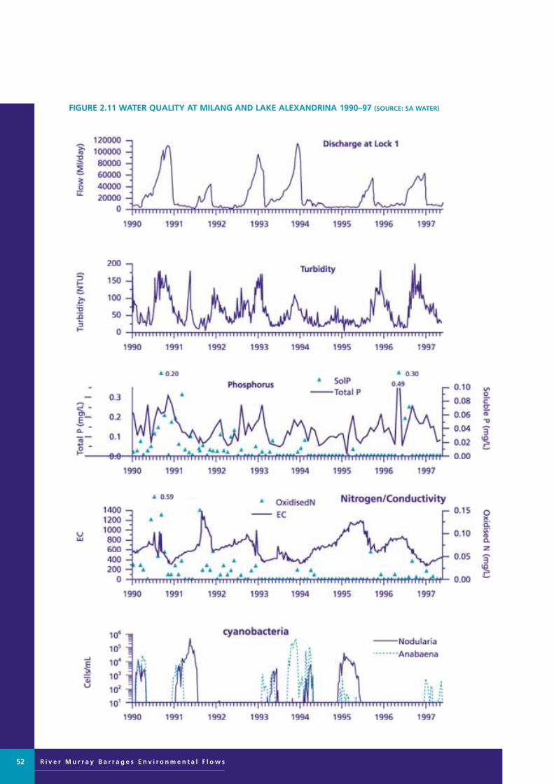
R i v e r M u r r a y B a r r a g e s E n v i r o n m e n t a l F l o w s52
FIGURE 2.11 WATER QUALITY AT MILANG AND LAKE ALEXANDRINA 1990–97 (SOURCE: SA WATER)
Murray Barrages flow edit 28/8/01 11:15 AM Page 52

summer/autumn months is dependant upon internal recycling of phosphorus from the sediments.Sedimentation rates and nutrient loadings in the LowerLakes have not been determined in relation to flow regulation. However, analysis of sediment cores collectedin Lake Alexandrina by Barnett (1994) showed that thesediment accumulation rate and phosphorus concentrationwas higher in core sections corresponding to the last 100years, compared with those dated over the past 7000 years.
The first reported cyanobacterial bloom (Nodularia spumigena) in Lake Alexandrina occurred over one hundredyears ago (Francis 1878). It was considered at that time tobe caused by a combination of low flow and an extended period of warm, calm weather. The impact ofEuropean settlers on water quality and quantity in theMurray–Darling Basin would have been minimal at thistime and algal blooms might therefore be regarded as anatural occurrence. There is a general consensus, however,that the incidence of cyanobacterial blooms in the LowerLakes has increased with time (five out of eight years since 1990) and that this is a symptom of gradual eutrophication of the Lower Lakes from anthropogenicsources (Codd et al 1994).
Cyanobacterial toxicity has been associated with blooms of both Nodularia spumigena and Anabaena circinalis inthe Lower Lakes. Supply from Milang Pump Station was temporarily closed during the 1991 bloom and alternative domestic supplies were provided. Health riskalerts were issued with respect to domestic, recreationaland agricultural use. No stock deaths attributable to these blooms were reported. Epidemiological evidencefrom recreational water exposure studies at Goolwa in1995 demonstrated increased symptom occurrence associated with increased contact with water containingcyanobacteria (Pilotto et al 1997). The economic cost of cyanobacterial blooms in the Lower Lakes has not beendetermined, but future estimates should include the costof monitoring and analysis, provision of emergency watersupplies, preparation of contingency and managementplans, public awareness campaigns, public health issues,research and impacts on agriculture and tourism. Therehave been no reported effects on the natural environmentas a direct result of cyanobacterial blooms in the LowerLakes.
The hepatotoxins produced by Nodularia spumigena areknown to produce chronic liver damage and to promotetumor growth, whereas the neurotoxins produced byAnabaena circinalis present a low risk of acute poisoningand have no known sub-acute or chronic effects (Jones et
al 1993). From a public health perspective, current knowledge would suggest therefore, that blooms of Nodularia might pose a more significant risk than bloomsof Anabaena circinalis.
Although there is no information available on changes to the phytoplankton composition in the lakes since barrage construction, the occurrence of at least somefreshwater species is assumed to be a direct consequence ofthe altered water regime freshening of the lakes. A lack ofbase-line data has also prevented “an assessment ofchanges in biodiversity of phytoplankton communities or impact on the food chain that has resulted from thealtered water regime. Geddes (1984b) however, found noapparent relationship between phytoplankton biomass andthe density or composition of filter-feeding zooplankton inLake Alexandrina, and suggested that detritus and bacteriamay be the major food source of the zooplankton, ratherthan the phytoplankton.
There is evidence to suggest that growth of at least one cyanobacterial species, Nodularia spumigena, is predisposed to a wide salinity tolerance, ranging from thatof the brackish natural estuary which existed at the time ofthe 1878 bloom, to that in the now existing freshwaterlakes (0.16–1.7 ppt). This species has been describedmostly from brackish and saline waters, with developmentof blooms reported at salinities varying from 7–10 ppt inthe Baltic Sea (Kononen 1992), 15–20 ppt in OrieltonLagoon, Tasmania (Jones et al 1994) and 3–30 ppt in thePeel-Harvey Estuary, WA. (Hodgkin et al 1985). Hobson(1996) found that the optimum salinity for growth in alaboratory culture isolated from Lake Alexandrina was10–13 ppt. Laboratory studies have demonstrated that the optimum salinity for germination of Nodularia akinetesproduced by a strain from the Peel–Harvey estuary was between 0-10 ppt (Huber 1985) and that akinete production of Nodularia isolated from Orielton Lagoonwas positively correlated with increasing salinity up to 35ppt (Jones et al 1994). Anabaena circinalis is a commonbloom-forming species in the River Murray and other freshwater habitats, and may be a more recent (post-regulation) phenomenon in the Lower Lakes.
It is unknown whether changes have occurred at theautotrophic level in the Coorong estuary and Cooronglagoons since the construction of the barrages. There areno reports of initiation and growth of cyanobacterialblooms in the Coorong, although trailing scums from lakeblooms discharged through the barrages were observed by local fishermen in 1991 as far downstream as Dodds Landing in the Northern Lagoon. The occurrence
R i v e r M u r r a y B a r r a g e s E n v i r o n m e n t a l F l o w s 53
Murray Barrages flow edit 28/8/01 11:10 AM Page 53
R i v e r M u r r a y B a r r a g e s E n v i r o n m e n t a l F l o w s
of dinoflagellate blooms (‘red tides’) has also beenobserved in the Coorong estuary and may be associatedwith the mixing of saline water with freshwater inflows from the lakes. Certain species are known to produce toxins, but no information is available on the frequency of these blooms and their environmental effectsin the Coorong.
The ecological significance of cyanobacterial blooms islargely unknown. The toxins produced by some cyanobacteria, including Nodularia spumigena are potentinhibitors of protein phosphatases and may affect a rangeof higher plants and animals. Toxic effects have beenobserved on other phytoplankton and aquatic macrophytes(Kirpenko 1986), which could have significant consequenceson primary production (Lindholm et al 1992). Thickscums often accumulate along littoral zones and may shadeaquatic plants and benthic algae and also restrict access byfish and birds to reproduction and feeding areas.
It is likely that aquatic invertebrates and fish have developeddefence mechanisms or avoidance strategies to co-existwith cyanobacteria and their toxins. There are conflictingdata on toxicity to invertebrates, but inhibitory effectshave been reported on some species (Carmichael 1992).The specific contribution of toxins to fish kills in naturalwaters is unclear, as is the mode of toxin action; whethervia food or the gills. In many instances, oxygen depletionin the water due to decay of algal blooms may have beenthe cause of fish kills. Mortality of small fish, crabs andbenthic invertebrates in the Peel–Harvey Estuary was considered to be caused by deoxygenation below the watersurface during Nodularia blooms (Hodgkin et al 1985).Larger fish may be able to avoid severely affected areas ofblooms, but it has been suggested that the Nodulariablooms in the Peel–Harvey Estuary have had a majorinhibitory effect on feeding, respiratory movements, oralbrooding and egg development of fish (Potter et al 1983).
There is clear evidence of bio-accumulation of cyanobacterial toxins in shellfish, but it is not knownwhether fish can accumulate toxins. Falconer et al (1992)demonstrated significant accumulation of Nodularia toxin(nodularin) in the intestinal tract of mussels (Mytilusedulis) collected from the Peel–Harvey Estuary during abloom and Negri and Jones (1995) found that the freshwater mussel Alathyria condola accumulated high levelsof PSP toxins when fed the neurotoxic cyanobacteriumAnabaena circinalis under laboratory conditions.Poisoning of birds and animals is occasionally associatedwith blooms, but these incidences might be consideredinadvertent and not necessarily an ecological consequence(Yoo et al 1995).
KEY ISSUES
The increased frequency of algal blooms is clearly animportant water quality issue in the Lower Lakes, particularly with regard to risks to human health andimpacts on recreation and agriculture. Direct effects onecosystem biodiversity and function have not been demonstrated, although there is evidence from studieselsewhere that the quality of aquatic habitat may be temporarily reduced and some loss of native fauna may beincurred. The management of algal blooms for the purpose of maintaining the ecosystem of the Lower lakes and Coorong may therefore be considered a low priorityrelative to other environmental issues.
Management of algal blooms has been addressed under aseparate agenda and has resulted in the development of anAlgal Management Strategy for the Murray–Darling Basin(Murray–Darling BasinCommission Ministerial Council1993).
Of the five identified regions for assessment (progradinglakeshores, eroding lakeshores, Coorong estuary, CoorongNorthern Lagoon, Coorong Southern Lagoon) (Figure1.3), both freshwater lake-shore regions were identified as the primary areas of concern. The causes of increased algalbloom frequency that might be linked to flow regulationinclude:
• increased nutrient loadings to the lakes by sedimentationprocesses, arising from reduced flow-through rates inwinter/spring
• reduced turbidity in the lakes attributable to reducedinflow rates in summer/autumn
• increased nutrient loadings to the lakes from shorelineerosion caused by higher lake operating levels
• increased residence time of water in the lakes arisingfrom reduced flow-through rates in summer/autumn.Significant cell growth and accumulation may occur,which may then be redistributed by wind action to leeward shorelines
• change to freshwater habitat favouring freshwater algalspecies. This includes the bloom-forming (and toxic)cyanobacterial species Anabaena circinalis, Microcystisaeruginosa and Cylindrospermopsis raciborskii.
ECOLOGICAL NEEDS
The causes of cyanobacterial blooms in the Lower Lakeshave not been clearly elucidated, but it appears that a combination of low inflow from the River Murray and
54
Murray Barrages flow edit 28/8/01 11:10 AM Page 54

persistent periods of calm weather are significant factors inthe short term and sedimentation of phosphorus on thelake-bed in the long term.
In order to decrease the frequency of cyanobacterialblooms in the Lower Lakes, the following managementobjectives should be adopted:
• a reduction in nutrient loading to the lakes from sedimentation processes
• a reduction in nutrient loading into the lakes fromshoreline erosion
• the provision of adequate flows (in summer/autumn)to reduce residence time, and maximise throughflows.
OPPORTUNITIES FOR IMPROVEMENT
A decrease in the frequency of algal blooms in the LowerLakes may be achieved by addressing the relevant ecologicalneeds through implementation of certain operating strategies at the barrages.
• Reduce residence time, maximise throughflows andminimise biomass accumulation by providing flushingflows for short critical periods (probably insummer/autumn). Higher flows through the lake mayalso increase mixing of the water column with subsequentreduction in cyanobacterial growth rates. Proposedchanges to flow regulation should reflect the transient nature of algal blooms and be able to provide rapidresponses to fluctuating conditions. In the short term(1–3 years), alterations might be implemented at the barrages to allow flexibility in the operation(timing, frequency or duration) of gate opening and toallow adjustment of water levels outside the currentoperating range of 0.60–0.85 m EL.
The success of this strategy may be compromised bylocalised concentrations of cyanobacterial scum aroundlake shorelines. The accumulation of cyanobacterial cells isalso likely to exceed the maximum possible flushing rate(50 000 ML/day) and period of flushing under existingoperating rules, assuming a growth rate of say 0.2 doublings/day.
• Reduce nutrient loadings to the lakes by transportingsediments and associated nutrient loads through thebarrages and out to sea with flushing flows throughLake Alexandrina. Enlargement of Mundoo Barrage inthe medium term (3–10 years) may allow this processto be carried out with minimum impact on theCoorong, by creating a direct flow path to the sea.
• Control shoreline erosion and subsequent nutrientinput to the lakes by operating the lake at lower levels. The establishment and protection of riparianvegetation around lake shorelines should also be promoted as an additional measure for prevention oferosion and also to create buffer zones to act as nutrient sinks.
The long-term option of re-creating an estuarine environment in Lake Alexandrina and Lake Albert withthe construction of a barrage at Wellington on the RiverMurray offers advantages and disadvantages with respectto minimising cyanobacterial blooms. The incidence ofblooms of the toxic freshwater species Anabaena circinalismay be reduced, but blooms of Nodularia spumigenacould quite likely increase as a result of moderate to largeincreases in salinity (say 1–20 ppt). Germination rates of akinetes of Nodularia spumigena may not be greatlyaffected by moderate increases in salinity (up to 10 ppt),but this requires further investigation.
Toxic blooms of Nodularia spumigena are considered topose a higher public health risk than those of Anabaenacircinalis in drinking water, but both species are likely to produce allergenic effects on contact fromwashing and recreation. In the event that alternativedomestic water supplies are provided to the communitysurrounding Lake Alexandrina, it might be argued that therestoration of the lakes to their original estuarine statewould not introduce an additional public health risk. Thecreation of a barrage in Lake Alexandrina at Point Sturt in lieu of their current location, may eliminate blooms ofAnabaena in the Goolwa/Hindmarsh Island region wheremuch recreational activity is based. The use of the MilangPumping Station for domestic supplies would then still be an option.
The potential for development of Nodularia blooms in theCoorong should also be considered as a possible outcomeof freshening by environmental flows from the barrages. Acontributing factor may also be the observed transport and deposition of river sediments and adsorbed nutrientsacross the barrages into the Coorong estuary andNorthern Coorong Lagoon (Tucker 1996).
It is probable that cyanobacterial blooms will continue to be a common occurrence in the Lower Lakes due tointernal recycling of the large phosphorus store in the sediments. Some degree of control may be possible in thelong term by managing water regimes to decrease residence time of water in the lakes, so that the rate of sedimentation and phosphorus loading in the lakes is alsodecreased. Flushing flows could be allocated to transport a
R i v e r M u r r a y B a r r a g e s E n v i r o n m e n t a l F l o w s 55
Murray Barrages flow edit 28/8/01 11:10 AM Page 55

R i v e r M u r r a y B a r r a g e s E n v i r o n m e n t a l F l o w s
larger proportion of the phosphorus load from the riverstraight to the ocean. When algal blooms do occur, theirsocial and economic impact may be reduced in the shortterm by providing flushing flows at critical periods toreduce residence time and to minimise accumulation ofcell biomass.
A reduction in nutrient load to the lakes and a decrease in algal bloom frequency in the long term may also be possible by controlling the rate of shoreline erosion.Options to achieve this objective may involve temporaryoperation of the lakes at a lower level to allow constructionof protective structures along shorelines, supplemented byencouragement for the growth of riparian vegetation.
56
Murray Barrages flow edit 28/8/01 11:10 AM Page 56
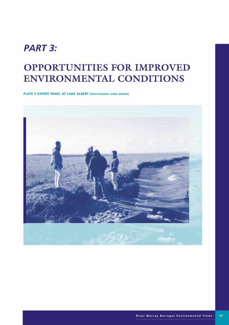
PART 3:
OPPORTUNITIES FOR IMPROVED ENVIRONMENTAL CONDITIONSPLATE 5 EXPERT PANEL AT LAKE ALBERT (PHOTOGRAPH: ANNE JENSEN)
R i v e r M u r r a y B a r r a g e s E n v i r o n m e n t a l F l o w s 57
Murray Barrages flow edit 28/8/01 11:10 AM Page 57
R i v e r M u r r a y B a r r a g e s E n v i r o n m e n t a l F l o w s
Several significant ecological needs and opportunities
for management actions to improve environmental
conditions have been identified by the scientific
panel. These have been linked to each of the five
broad environmental regions (Figure 1.3). These
opportunities have been identified by the scientific
panel after considering the current management of
the barrages and reviewing scientific, engineering
and social information relevant to modified
management of the barrages.
Fifteen key ecological needs have been identified. These
are presented in Table 3.1 with the critical actions required
to address these needs.
Fifteen opportunities to improve environmental conditionsby changing hydrological management were identified(Table 3.2). These primarily relate to the management of the barrages, but other changes to upstream flow management were also identified.
Complementary opportunities to change local land or water management practices were also identified andthese are discussed in the section ‘Complementary management opportunities’. Opportunities have beenidentified as major or minor over three time scales: short-, medium- and long-term.
Three time scales have been used:
• short-term (1–3 years)
• medium-term (3–10 years)
• long-term (> 10 years).
These have been used to take account of investment planning, infrastructure design and planning, and socialand economic adjustment if required.
Opportunities have been split between major and minorcategories on the basis of the:
• cost of capital works and/or the cost of changed management
• off-site social and economic costs.
The time scales give no consistent indication of the timingof positive environmental benefits flowing from the management actions. In some cases positive impacts willbe very rapid and in others there may be a significant lagbetween action and environmental response. The latterapplies particularly to those responses highly dependent onthe occurrence of higher river flows.
Table 3.2 summarises the opportunities to improve
environmental condition by changed hydro-logical management.
Options for rehabilitation measures to address the keyissues are outlined as follows.
Universal outcomes
A number of universal outcomes are assumed for alloptions. These are listed below and are not repeated for allvariations of options. They include opportunities to:
• create a flow regime which maintains a viable estuarinehabitat and maintains a range of salinities along appropriate gradients
• maintain the salinity gradient of estuarine to hypermarinealong the Coorong, as the important food sourceRuppia tuberosa is dependent upon salinity
• provide a varied water regime with a range of conditions to support a diverse and balanced ecosystem
• maximise estuarine area
• reduce abrupt changes to water levels in the Coorong
• maximise the transfer of freshwater from the lakes tothe Coorong
• promote freshwater flushing through the MurrayMouth, and promote fish passage between LakeAlexandrina and the estuary
• to reduce turbidity and nutrient loadings, transportsediments and associated nutrient loads through thebarrages and out to sea with flushing flows throughLake Alexandrina
• ensure sediments and nutrients are not transportedinto the Coorong Lagoon
• to limit the potential for algal blooms, control thewater regime, particularly temperature stratification,mixing and turbidity, to decrease the accumulation ofcell biomass.
Short-term opportunities
Minor short-term options, to be undertaken within threeyears, include:
• changing the timing, sequence and frequency of opening and closing gates in the existing structuresand operating within the current range of lake levels
• development of specific arrangements for maximisingthe ecological benefit of the non-consumptive proportion of entitlement flows to South Australia
ECOLOGICAL NEEDS AND OPPORTUNITIES FOR IMPROVEDHYDROLOGICAL MANAGEMENT
58
Murray Barrages flow edit 28/8/01 11:10 AM Page 58

• modification of the proposed levees across the islandspillways to allow interface of fresh and salt water.
Major short-term options, which will involve greaterexpense or potential impacts, include:
• automation of approximately 22% of barrage gatesacross all five structures and finetuning of gate operation within current lake levels
• investigation of the options for operating over a widerrange of lake levels
• negotiating different monthly or daily flows in the pattern of delivery of entitlement flows to produceflow patterns at the barrages to meet ecological needs.
The environmental outcomes which could be achieved bythese management measures are outlined below.
Recommended action
A1 Change the timing, sequence and frequencyof opening and closing of barrage gates within current operating range of lakelevels (0.60-0.85 m EL) to optimise the ecological, social and economic benefits
Current operation
The current operating rules are primarily determined bythe aim of maintaining an average lake level of 0.75 m EL.Additional factors are:
• ease of operation of various barrages
• limited staff resources
• distance from staff bases to barrages
• economic limits on staff over-time at weekends
• hydraulic capacity of channels
• risk of marine intrusions
• capacity of barrage structures for rapid adjustment
• short-term effects of wind on lake levels
• extreme weather events.
The combined effects of these factors is a tendency tooperate barrages in the following order of preference andfrequency of opening:
• Goolwa
• Tauwitchere
• Ewe Island.
Boundary Creek and Mundoo barrages are rarely opened,due to the required removal of the road platform, thus disrupting through traffic across the barrages from PelicanPoint to Goolwa ferry. These barrages are only openedwhen favourable tides, weather conditions and extended(high) summer flows are available in the system. Typically,this would be when River Murray flows exceed 80 000ML/d at the South Australian border. Boundary CreekBarrage is operated at least once per year and this has beenthe case for the last ten years. The operation of MundooBarrage does not prevent through traffic to Pelican Pointonce the water ways have been opened. The deck units arereinstated and the stop logs stored along one edge of thedecking. This does restrict access for large vehicles whilstwater ways are open.
While the general guidelines for operating the barrages aredocumented, the observations and trigger factors involvedin daily operation of the barrages to maintain the 0.75 mEL are known to personnel within SA Water but are apparentlynot recorded in published form. It is recommended thatthese daily guidelines be articulated, both to ensure thatthis knowledge is not lost with change of personnel. It isalso required to provide a factual basis for negotiation ofaltered operational rules to meet environmental needs.
Opportunity
The suggested alterations to current operating conditionsinclude the following (some of which are already beingpractised informally):
• attractant flows for fish passage
• brief openings of limited gates at key points of tidalcycle for fish passage
• minor flows (few gates at key sites) maintainedthrough long periods of barrage closure
• altered opening and closing sequences to maximisefresh water exchange into the Coorong
• preferential opening of Mundoo Barrage during highflows to increase scour velocities through the MurrayMouth zone
• operation of closures to reduce rapid falls in water levelin the Coorong.
Issues arising
Operation of the barrages affects water levels, irrigationoperations and native fisheries upstream to Mannum andeven as far as Blanchetown.
R i v e r M u r r a y B a r r a g e s E n v i r o n m e n t a l F l o w s 59
Murray Barrages flow edit 28/8/01 11:10 AM Page 59

R i v e r M u r r a y B a r r a g e s E n v i r o n m e n t a l F l o w s60
TABLE 3.1 ENVIRONMENTAL NEEDS AND CRITICAL OUTCOMES TO MEET NEEDS
Prevent abrupt Coorong level changes
Maximise water mixing into CoorongProvide flows during low flow periodsIncrease river outflows
Increase volume and velocity of flows at mouth
Maintain mouth passage
Provide attractant and passage flows through the barrages
Reduce fresh water overwash from lakesAllow interface of fresh and salt water across islands
Protect, maintain and encourage regeneration or revegetation to re-establish diverse riparian communities
Reduce inputs, divert to sea
Reduce inputs by increasing riparian vegetation to filter in-flows * and fencing/stock management to increase buffer zone *Increase through-put by maintaining critical flows over period of high risk of blooms
Manage to maintain a range of salinities, from fresh to hyper-saline
Provide water regimes and manage fish effort to favour native fishCapture fish when trapped in estuary, manage fishing effort to targetexotics*
Reduce impact of exotic fish in lakesProvide water regime to ensure minimum light and level requirementsfor aquatic plants
Provide water regime to minimise impact on groundwater
Reduce or buffer erosive power of waves, stabilise and protect shorelines to allow establishment of riparian vegetation*
Reduce sediment inputs, increase wind buffers, reduce fetch at keylocations
Protect aquatic plants in Coorong andmaximise mudflat habitat
Maximise estuarine area
Limit deposition at mouth
Increase fish passage through the rivermouth
Provide fish passage through barrages
Protect and enhance saltmarsh habitataround lakes
Increase diversity of riparian vegetation
Reduce sediment transport intoCoorong
Reduce nutrient in lakes
Maintain a diverse water quality regimein the estuary and Coorong
Reduce exotic fish in lakes
Increase aquatic vegetation
Reduce area of dryland salinity
Reduce lakeshore erosion
Reduce lake water turbidity
Critical outcomes required to meet needsEnvironmental needs
* Management actions other than modification to hydrological regimes (Addressed in section Complementary Management Opportunities)
Murray Barrages flow edit 28/8/01 11:10 AM Page 60

R i v e r M u r r a y B a r r a g e s E n v i r o n m e n t a l F l o w s 61
TABLE 3.2 HYDROLOGICAL MANAGEMENT OPPORTUNITIES
Change the timing, sequence and frequency of opening and closing of barrage gateswithin current operating range of lake levels (0.60–0.85 m EL)
Develop specific arrangements for maximising the ecological benefit of the non-consumptive proportion of entitlement flows to South Australia
Assess proposal to build levees on island spillways to minimise impacts on the interface between fresh and salt water
Automate approximately 22% of gates across all five barrages and finetune timingsequence and frequency of opening and closing of automated barrage gates according to environmental guidelines within the current range of lake levels
Investigate operating automated gates at a greater range of lake levels (ie higher orlower than current 0.60–0.85 m EL)
Negotiate different monthly and/or daily flows in the pattern of delivery of entitlement flows to provide seasonal flows at barrages
First revision of operating rules for automated gates and flow allocations on basis ofadaptive management monitoring results
Modify Mundoo Barrage to increase scour capacity and to operate preferentially tolimit sedimentation in the Murray Mouth zone
Trial operation of lakes at a wider range of levels (ie outside 0.6–0.85 m EL)
Automate more barrage gates as determined by adaptive management monitoringresults and operate at a wider range of lake levels according to environmental guidelines
Increase environmental flows to meet ecological needs in the Lower Lakes andCoorong through ongoing basin-wide water allocation reviews
Second revision of operating rules for automated gates and revise flow allocationson basis of adaptive management monitoring results
Relocate the barrages upstream to Wellington and invest evaporative savings intoenvironmental flows for the lakes and Coorong, to maintain a larger estuarine area
Increase the estuary area by converting Lake Albert into an estuarine zone, eg by constructing a barrage at Narrung Narrows and a channel from Marnooswamp into the Coorong
Relocate the barrages upstream to Point Sturt and invest evaporative savings intoenvironmental flows for the lakes and Coorong, to maintain a larger estuarine area
A1
A2
A3
B1
B2
B3
C1
D1
D2
D3
D4
E1
F1
F2
F3
Minor
Major
Minor
Major
Minor
Major
Short-term(1–3 years)
Medium–term (3–10years)
Long–term(> 10 years)
Hydrological management opportunitiesCode link
to Table 3.5
Scope ofworks
Time scale
Murray Barrages flow edit 28/8/01 11:10 AM Page 61
R i v e r M u r r a y B a r r a g e s E n v i r o n m e n t a l F l o w s
Expected outcomes
The following outcomes are expected from changing current barrage gate operations:
• create a flow regime which maintains a viable estuarinehabitat and maintains a range of salinities along appropriate gradients
• maintain the salinity gradient of estuarine to hypermarine along the Coorong
• reduce abrupt changes to water levels in the Coorong
• maximise the transfer of freshwater from the lakes tothe Coorong
• promote freshwater flushing through the MurrayMouth, and promote fish passage between LakeAlexandrina and the estuary
• maintain open passage particularly in period of likelyhigh fish migration in and out of the Murray Mouth(October to December)
• provide flows for fish passage and attractant flows atthe barrages, particularly in winter
• reduce turbidity and nutrient loadings, transport sediments and associated nutrient loads through thebarrages and out to sea with flushing flows throughLake Alexandrina
• ensure sediments and nutrients are not transportedinto the Coorong Lagoon
• limit the potential for algal blooms, control the water regime, particularly temperature stratification,mixing and turbidity, to decrease the accumulation ofcell biomass.
Recommended action
A2 Develop specific arrangements for maximising the ecological benefit of the non-consumptive proportion of entitlement flows to South Australia
Current operation
Under the Murray–Darling Basin Agreement SouthAustralia receives an ‘entitlement flow’ of 1850 GL perannum, as twelve monthly minimum monthly flows. While this is guaranteed there is provision for reduction in drought years. In reality the median flow to SA isapproximately 4047 GL per annum and we receive the
entitlement flow or less only about 30 % of the time. Thismeans that about 70 % of the time we receive greater flowsthan 1850 GL per annum.
Opportunity
The new Water Resources Act (1997), requires water allocation plans to be developed for all prescribed waterresources. These plans must assess the water needs ofecosystems and provide water for these needs above whatis required for consumptive use. The responsibility will restwith the River Murray Catchment Water ManagementBoard appointed late September 1997.
South Australia’s position under the recently agreedMurray–Darling Basin ‘cap’ on further water diversionsfrom the river has implications for this opportunity. The position is that 573 GL per annum is allocated for irrigation use and 180 GL per annum for SA Water, and that all water above this is effectively water for ecological purposes. This should be formalised as part of the water allocation plan for the River Murray prescribed watercourse.
The Lower Murray Flow Management Working Group(1997) has reported on opportunities to manipulate weir structures from Lock 10 to the barrages during entitlement flows to improve riverine littoral habitat andwetlands connected at pool level. This current scientificpanel process for the barrages will provide detail on opportunities to improve or maintain the environmentalvalues of the Lower Lakes and Coorong. Both of these setsof needs and opportunities should be recognised in thewater allocation plan in the form of operational rules tomaximise environmental benefit from the water allocatedto the environment. For example, a few gates could remainopen for fish passage during periods of barrage closure.Assuming a flow of 250 ML/d per gate, a flow of say 75GL would allow 10 gates to remain open for a month forfish passage. Further investigation will be required todetermine the volume, timing and frequency of flowsrequired.
Other potential benefits of an allocation for environmentalpurposes include maintenance of mudflats for waterbirds,buffering of abrupt water level changes in the Coorong,and extension of estuarine habitat. Flows could be allocated to limit sedimentation in the mouth zone and topromote fish passage through the mouth channel.However, the effectiveness of these options will be limitedby the relatively small volumes available and the limitedflexibility of opening and closing of gates.
62
Murray Barrages flow edit 28/8/01 11:10 AM Page 62

Expected outcomes
The expected outcomes from the development of specialarrangements to maximise environmental benefits includeopportunities to:
• create a flow regime which maintains a viable estuarinehabitat and maintains a range of salinities along appropriate gradients
• maintain the salinity gradient of estuarine to hypermarine along the Coorong
• reduce abrupt changes to water levels in the Coorong
• maximise the transfer of freshwater from the lakes tothe Coorong
• allocate environmental flows to the Coorong at periods of seasonal low flow
• maintain estuary habitat in seasonal low flow periodsby allocating environmental flows for flows throughthe barrages
• promote freshwater flushing through the MurrayMouth and promote fish passage between LakeAlexandrina and the estuary
• improve habitat quality through flushing of the lakes
• to reduce turbidity and nutrient loadings, transportsediments and associated nutrient loads through thebarrages and out to sea with flushing flows throughLake Alexandrina
• ensure sediments and nutrients are not transportedinto the Coorong Lagoon
• to limit the potential for algal blooms, control thewater regime, particularly temperature stratification,mixing and turbidity, to decrease the accumulation ofcell biomass
• reduce the internal store of phosphorus in the lakes
• reduce the risk of cyanobacterial blooms
• provide flushing flows for short critical periods todecrease the risk of blooms (probably insummer/autumn).
Recommended action
A3 Assess proposal to build levees on islandspillways to minimise impacts on theinterface between fresh and salt water
Current operation
Two extended low-lying areas on Ewe Island andTauwitchere Island act as spillways when water levelsexceed 0.85–0.9 m EL. The natural habitat of the island issalt marsh, which requires inundation by a mixture of freshand salt water, and acts as a buffer between the two waterbodies, slowing the water exchange across tussocky marshwith ill-defined channels.
This buffering effect has been weakened by recentdrainage works on the freshwater side, designed toenhance access to fresh water for irrigation of pastures andto flush out salt from saline soils. When marine incursionsoccur due to high tides, winds or storms, the salt waternow has much more efficient flow paths into the freshwater body, causing water quality problems for irrigators.Once a salt slug is trapped in the Goolwa Channel, this canbe drawn into the Currency Creek reach when the GoolwaBarrage is opened, causing problems for irrigators.
The proposal to build levees to prevent marine incursionsis designed to protect water quality for lake diverters.However, the proposed levees will prevent this importantinterface of fresh and salt water, to the detriment of the saltmarsh habitat and associated fauna. The levees will alsoprevent fish passage through this region, which is anextremely important by-pass for the barrier presented bythe barrages.
It is recommended that the proposal for the levees beassessed to ensure minimum impacts on fish passage andmaintenance of the salt marsh habitat. Opportunitiesshould also be investigated to divert saline drainage waterfrom the Angas–Bremer basin to sustain saltmarshcommunities on the western shores of Lake Alexandrina.The impacts of the drains on the water balance and marshhabitat should also be examined.
Expected outcomes
Assessment of this proposal should lead to outcomeswhich:
• ensure that management maintains a salinity gradientover an ecologically sound distance, which is in tunewith the seasonal fluctuations in salinities afforded byriver discharges
• allow fish passage across salt marsh and freshwater wetland habitats
• minimise impacts of drainage and levee constructionon saltmarsh habitats.
R i v e r M u r r a y B a r r a g e s E n v i r o n m e n t a l F l o w s 63
Murray Barrages flow edit 28/8/01 11:10 AM Page 63

R i v e r M u r r a y B a r r a g e s E n v i r o n m e n t a l F l o w s
Recommended action
B1 Automate approximately 22% of gatesacross all five barrages and finetune timing,sequence and frequency of opening andclosing of automated barrage gatesaccording to environmental guidelineswithin the current range of lake levels
Opportunity
The number of gates proposed to be automated in eachbarrage is summarised in Table 3.3 and Appendix VII.These gates should then be operated according to the recommended environmental guidelines (part 2; Ganf;Paton; Geddes ibid) within the current range of lake levels.
Automation of the gates will greatly improve the flexibilityof barrage operations, allowing short-term, rapid responseoperation at all five structures with minimal staff resources.The benefits outlined for option A1 can be achieved morerapidly over the full length of the barrages. (Note that apower supply will be required at the Boundary Creek andEwe Island sites). Much greater flexibility and shorterresponse times would greatly improve benefits from minoropening and closing sequences. For example, if the gateswere only opened for 20 minutes at the top of the tide toallow fish passage, 720 gates could be opened for fish passage for 30 days using an allocation, as there would bevery little water passed through the gates.
Issues arising
In order to ensure the fish are not targeted by recreationaland commercial fishers at the point of passage, some formof regulation of fishing may be required. Commercial andrecreational harvest is currently excluded from a zone on
either side of all barrages. The Inland FisheriesManagement Committee has accepted that with gateautomation this matter will be immediately revisited, bothto ensure fish passage benefits meet sustainability andequitability criteria, and to ensure that production benefitsdemonstrably exceed harvest.
Expected outcomes
The expected outcomes from automation of barrage gatesand finetuning of gate operation are to:
• improve the ‘fine’ control of barrage releases to deliverthe short-term ecological management objectives
• create a flow regime which maintains a viable estuarinehabitat and maintains a range of salinities alongappropriate gradients
• maintain the salinity gradient of estuarine tohypermarine along the Coorong
• reduce abrupt changes to water levels in the Coorong
• maximise the transfer of freshwater from the lakes tothe Coorong
• promote freshwater flushing through the MurrayMouth, and promote fish passage between LakeAlexandrina and the estuary
• remove sand accumulating in the Coorong estuarychannels between the mouth and Tauwitchere
• meet the requirements for fish passage as they relate tolunar cycles, tidal cycles and attractant flows
• maintain open passage particularly in period of likelyhigh fish migration in and out of the Murray Mouth(October to December)
• provide flows for fish passage and attractant flows atthe barrages
64
TABLE 3.3 PROPOSED AUTOMATION OF BARRAGE GATES
replace logs with radial gates, automate
replace logs with radial gates, automate
replace logs with radial gates, automate
automate radial gates
automate radial gates
21.9% of gates automated
20 (128)
15 (26)
5 (6)
30 (111)
60 (322)
130 (593)
Goolwa
Mundoo
Boundary Creek
Ewe Island
Tauwitchere
Total
Modification requiredGates to be automated
(total gates)Barrage
Murray Barrages flow edit 28/8/01 11:10 AM Page 64

• reduce turbidity and nutrient loadings, transport sediments and associated nutrient loads through thebarrages and out to sea with flushing flows throughLake Alexandrina
• ensure sediments and nutrients are not transportedinto the Coorong Lagoon
• limit the potential for algal blooms, control the waterregime, particularly temperature stratification, mixingand turbidity, to decrease the accumulation of cell biomass
• reduce the internal store of phosphorus in the lakes
• reduce the risk of cyanobacterial blooms.
Recommended action
B2 Investigate operating automated gatesover a greater range of lake levels (ie higher orlower than current 0.60-0.85 m EL)
Opportunity
This option has the potential to generate a greater range ofhabitat conditions in the region, and has a high priority for investigation of its feasibility. Using the fine-controlcapability of the automated gates and the wider operational range of lake levels, the management objectives could include:
• attractant flows for fish passage
• brief openings of limited gates at key points of tidalcycle for fish passage
• minor flows (few gates at key sites) maintainedthrough long periods of barrage closure
• altered opening and closing sequences to maximisefresh water exchange into the Coorong
• preferential opening of Mundoo Barrage during highflows to increase scour velocities through the MurrayMouth zone
• operation of closures to reduce rapid falls in water levelin the Coorong
• maximisation of the estuarine habitat
• maintenance of fish passage through the MurrayMouth
• increased diversity of riparian vegetation
• flushing of lakes to reduce turbidity and nutrient loadings, while reducing sediment transport into theCoorong
• provision of a water regime to favour native fish andreduce exotic fish species
• enhancement of aquatic vegetation communities
• protection and enhancement of salt marsh habitat.
Issues arising
The maximum level of 0.85 m cannot be exceeded unlessthe existing spillway sill levels (0.85–0.9 m) are raised. Theminimum level of 0.6 m relates to the requirements ofgravity irrigators near Mannum, who would be unable tooperate if levels fall below this (for significant periods).During extended dry conditions the level sometimes fallsbelow this by usage and evaporation. These impacts wouldhave to be assessed as part of the evaluation.
Expected outcomes
If this option proves to be feasible, it could provide opportunities to:
• create a flow regime which maintains a viable estuarinehabitat and maintains a range of salinities along appropriate gradients
• maintain the salinity gradient of estuarine to hypermarine along the Coorong
• reduce abrupt changes to water levels in the Coorong
• maximise the transfer of freshwater from the lakes tothe Coorong
• promote freshwater flushing through the MurrayMouth, and promote fish passage between LakeAlexandrina and the estuary
• remove sand accumulating in the Coorong estuarychannels between the mouth and Tauwitchere
• meet the requirements for fish passage as they relate tolunar cycles, tidal cycles and attractant flows
• maintain open passage particularly in period of likelyhigh fish migration in and out of the Murray Mouth(October to December)
• reduce turbidity and nutrient loadings, transport sediments and associated nutrient loads through thebarrages and out to sea with flushing flows throughLake Alexandrina
• ensure sediments and nutrients are not transportedinto the Coorong Lagoon
• limit the potential for algal blooms, control the water regime, particularly temperature stratification,mixing and turbidity, to decrease the accumulation ofcell biomass
R i v e r M u r r a y B a r r a g e s E n v i r o n m e n t a l F l o w s 65
Murray Barrages flow edit 28/8/01 11:10 AM Page 65
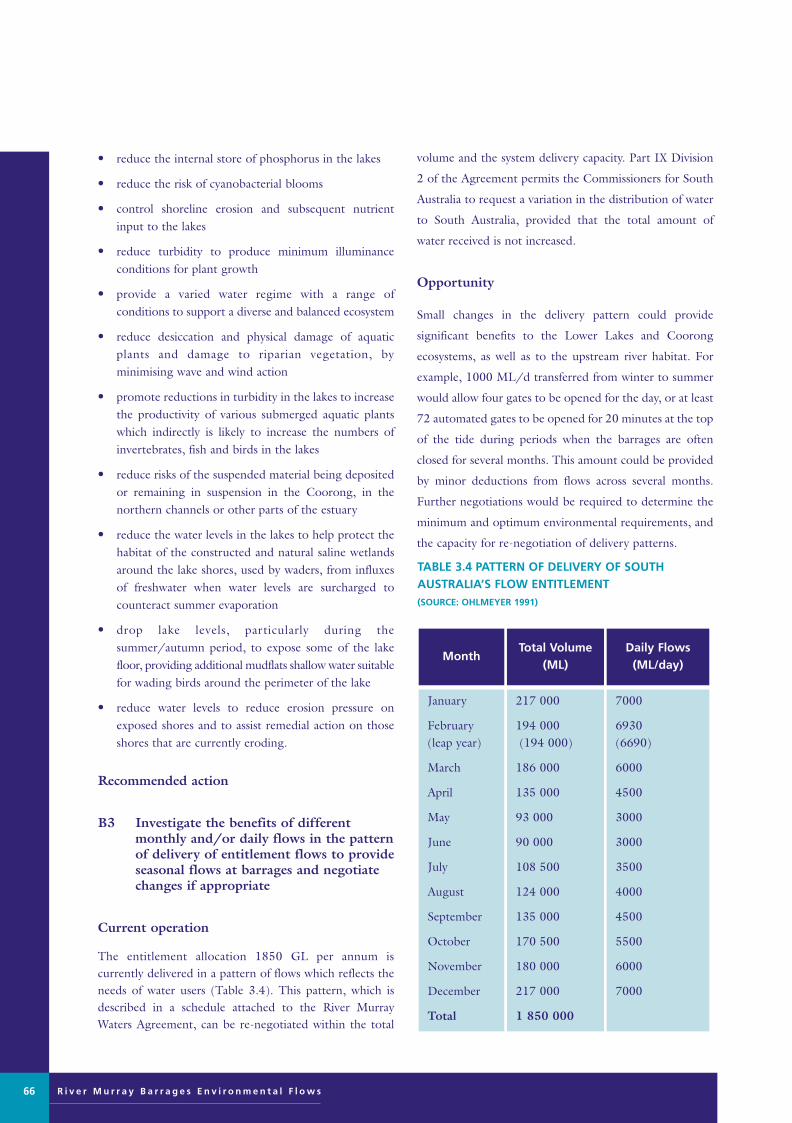
R i v e r M u r r a y B a r r a g e s E n v i r o n m e n t a l F l o w s
• reduce the internal store of phosphorus in the lakes
• reduce the risk of cyanobacterial blooms
• control shoreline erosion and subsequent nutrientinput to the lakes
• reduce turbidity to produce minimum illuminanceconditions for plant growth
• provide a varied water regime with a range of conditions to support a diverse and balanced ecosystem
• reduce desiccation and physical damage of aquaticplants and damage to riparian vegetation, by minimising wave and wind action
• promote reductions in turbidity in the lakes to increasethe productivity of various submerged aquatic plantswhich indirectly is likely to increase the numbers ofinvertebrates, fish and birds in the lakes
• reduce risks of the suspended material being depositedor remaining in suspension in the Coorong, in thenorthern channels or other parts of the estuary
• reduce the water levels in the lakes to help protect thehabitat of the constructed and natural saline wetlandsaround the lake shores, used by waders, from influxesof freshwater when water levels are surcharged tocounteract summer evaporation
• drop lake levels, particularly during thesummer/autumn period, to expose some of the lakefloor, providing additional mudflats shallow water suitablefor wading birds around the perimeter of the lake
• reduce water levels to reduce erosion pressure onexposed shores and to assist remedial action on thoseshores that are currently eroding.
Recommended action
B3 Investigate the benefits of differentmonthly and/or daily flows in the patternof delivery of entitlement flows to provideseasonal flows at barrages and negotiatechanges if appropriate
Current operation
The entitlement allocation 1850 GL per annum is currently delivered in a pattern of flows which reflects theneeds of water users (Table 3.4). This pattern, which isdescribed in a schedule attached to the River MurrayWaters Agreement, can be re-negotiated within the total
volume and the system delivery capacity. Part IX Division
2 of the Agreement permits the Commissioners for South
Australia to request a variation in the distribution of water
to South Australia, provided that the total amount of
water received is not increased.
Opportunity
Small changes in the delivery pattern could provide
significant benefits to the Lower Lakes and Coorong
ecosystems, as well as to the upstream river habitat. For
example, 1000 ML/d transferred from winter to summer
would allow four gates to be opened for the day, or at least
72 automated gates to be opened for 20 minutes at the top
of the tide during periods when the barrages are often
closed for several months. This amount could be provided
by minor deductions from flows across several months.
Further negotiations would be required to determine the
minimum and optimum environmental requirements, and
the capacity for re-negotiation of delivery patterns.
66
TABLE 3.4 PATTERN OF DELIVERY OF SOUTHAUSTRALIA’S FLOW ENTITLEMENT (SOURCE: OHLMEYER 1991)
7000
6930 (6690)
6000
4500
3000
3000
3500
4000
4500
5500
6000
7000
217 000
194 000(194 000)
186 000
135 000
93 000
90 000
108 500
124 000
135 000
170 500
180 000
217 000
1 850 000
January
February (leap year)
March
April
May
June
July
August
September
October
November
December
Total
Daily Flows(ML/day)
Total Volume(ML)
Month
Murray Barrages flow edit 28/8/01 11:10 AM Page 66

Expected outcomes
The expected outcomes from changed seasonality in thepattern of flows at the barrages include opportunities to:
• create a flow regime which maintains a viable estuarinehabitat and maintains a range of salinities along appropriate gradients
• maintain the salinity gradient of estuarine to hypermarine along the Coorong
• reduce abrupt changes to water levels in the Coorong
• maximise estuarine area
• promote freshwater flushing and fish movementthrough the Murray Mouth, and promote fish passagebetween Lake Alexandrina and the estuary
• allocate more water for environmental use downstreamof the barrages
• extend the period of flow over the barrages until laterin the year
• allow water levels to be dropped more graduallydownstream of the barrages during late summer orautumn
• maintain estuary habitat in seasonal low flow periodsby allocating environmental flows for flows throughthe barrages
• reduce turbidity and nutrient loadings, transport sediments and associated nutrient loads through thebarrages and out to sea with flushing flows throughLake Alexandrina
• promote the flushing of sediments through the MurrayMouth when turbidity levels are high
• ensure the sediments and nutrients are not transportedinto the Coorong Lagoon
• provide a varied water regime with a range of conditions to support a diverse and balanced ecosystem.
Medium-term opportunities
Minor medium-term options, to be undertaken within tenyears, include action to:
• revise operating rules and water allocations on the basisof adaptive management monitoring results.
Major medium-term options, which will involve greaterexpense or potential impacts, include action to:
• modify Mundoo Barrage to increase scour capacity andoperate preferentially to limit sedimentation in theMurray Mouth zone
• trial operation of the lakes over a wider range of levels
• automate more barrage gates as determined by adaptive management monitoring results and operateaccording to environmental guidelines over a widerrange of lake levels
• increase environmental flows for the barrages throughongoing basin-wide water allocation reviews.
The environmental outcomes which could be achieved bythese management measures are outlined below.
Recommended action
C1 First revision of operating rules for automated gates and flow allocations on basis of adaptive management monitoring results
Opportunity
In the medium term, it will be necessary to revise the operating rules and flow allocations in relation to adaptivemanagement monitoring results, and to adapt operationalguidelines as appropriate to maximise environmental benefits and minimise any social costs.
Expected outcomes
The expected outcomes from finetuning of operationalguidelines include opportunities to:
• create a flow regime which maintains a viable estuarinehabitat and maintains a range of salinities along appropriate gradients
• maintain the salinity gradient of estuarine to hypermarinealong the Coorong
• reduce abrupt changes to water levels in the Coorong
• extend the period of flow over the barrages until laterin the year
• allow water levels to be dropped more graduallydownstream of the barrages during late summer orautumn
• maintain estuary habitat in seasonal low flow periodsby allocating environmental flows for flows throughthe barrages
• promote freshwater flushing through the MurrayMouth, maintaining access for fish
• maintain estuary habitat in seasonal low flow periodsby allocating environmental flows for flows throughthe barrages
R i v e r M u r r a y B a r r a g e s E n v i r o n m e n t a l F l o w s 67
Murray Barrages flow edit 28/8/01 11:10 AM Page 67

R i v e r M u r r a y B a r r a g e s E n v i r o n m e n t a l F l o w s
• reduce turbidity and nutrient loadings, transport sediments and associated nutrient loads through thebarrages and out to sea with flushing flows throughLake Alexandrina
• promote the flushing of sediments through the MurrayMouth when turbidity levels are high
• ensure the sediments and nutrients are not transportedinto the Coorong Lagoon
• provide a varied water regime with a range of conditionsto support a diverse and balanced ecosystem.
Recommended action
D1 Investigate structural and operationalmodifications to Mundoo Barrage toincrease scour capacity and operate preferentially to limit sedimentation in the Murray Mouth zone and implement if appropriate
Current operation
The Mundoo Barrage currently consists of a long solidcauseway with a short section of 26 gates towards the easternside of the channel. The gated length is approximately 20% of the natural channel width. Thus, even when thegates are fully opened, there is still an 80% reduction offlow capacity in the channel. Extensive siltation hasoccurred downstream and upstream of the structure sinceits construction.
Prior to construction of the barrages, the MundooChannel carried up to 20% of flows to the Murray Mouth(Bourman ibid). The creation of Bird Island between themouth of the Mundoo Channel and the Murray Mouthdates from after construction of the barrages and is suggested to be linked to the overall reduction of flows tothe mouth, and particularly to the reduction of flowsthrough the Mundoo Channel (Bourman ibid). Withoutactive intervention, it is predicted that Bird Island will coalesce with Hindmarsh Island in the foreseeable future(Bourman ibid).
Opportunity
Widening of the Mundoo Barrage is expected to increasethe flow capacity of the channel and provide the capacityto scour the mouth zone more effectively. With a wideropening and automated gates, medium to high flowscould be selectively directed to limit the rate of sedimentation on Bird Island.
Other benefits of this option include the ability to use the shortest, steepest channel to flush the lakes, to reduceturbidity and nutrient levels, reduced sediment transportto the Coorong, and maintenance of the mouth channelfor fish passage.
Issues arising
It should be noted that this channel is the most susceptibleto marine incursions from storms, requiring a rapidresponse facility to shut the gates prior to high salt waterlevels.
There are two irrigators drawing water from upstream ofthe Mundoo Barrage and their needs should be taken intoaccount in determining operating guidelines.
The widening of the Mundoo structure may not significantlyincrease the flow capacity of this channel, as channel capacity is limited downstream of the barrage by siltingand it is suspected that it may also be limited upstream ofthe barrage. An hydraulic investigation and evaluation ofthe channel is required as part of a feasibility study of thisoption.
Expected outcomes
Increased scour capacity in the Mundoo Channel shouldprovide opportunities to:
• reduce the sedimentation taking place adjacent to themouth
• scour out this region with a view of increasing the tidalprism and increasing the potential wader habitats inthe regions
• increase the frequency and volume of water releasedthrough Mundoo Channel
• reduce risks of the suspended material being depositedor remaining in suspension in the Coorong, in thenorthern channels or other parts of the estuary
• promote fish movement through the Murray Mouth
• promote freshwater flushing through the MurrayMouth, maintaining access for fish.
Recommended action
D2 Trial operation of the lakes at a widerrange of levels (ie outside 0.60-0.85 mEL)
68
Murray Barrages flow edit 28/8/01 11:10 AM Page 68

Opportunity
The feasibility of operating the lakes at higher or lower levels (B2) should be trialled.
The option of operating the lakes at a greater range of levels offers a long list of environmental benefits. It shouldbe emphasised that many of the variations sought areshort-term seasonal variations, allowing room for negotiation to accommodate users’ needs.
Naturally fluctuating water levels over a wider range, eg with spring-early summer peak levels and lower winterlevels, would favour native plants and animals over introduced species. Lower levels in winter-early springcould reduce the amount of freshwater splash onto saltmarsh zones.
Lower levels and/or simulated tidal fluctuations in latesummer/early autumn could increase mudflat habitat formigratory waders during their moulting and fatteningphase prior to migration to the northern hemisphere.
Lake levels could be lowered at key times to provide a flowover the barrages to allow fish passage, or to flush throughthe Murray Mouth, or to provide freshwater into theCoorong.
Operation of lake levels should take into account depthand light requirements for survival and growth of nativeaquatic plants. These needs include observation of depthlimits for light penetration, access to air and prevention ofdesiccation.
For prevention of lakeshore erosion, short-term loweringof lake levels may be necessary for access to the shore tobuild protective structures.
Issues arising
The trials must include provisions to minimise the impactson users. The physical constraints of the barrage structuresmust be taken into account.
Fluctuating levels of the order indicated during a normal irrigation season (October to April) would causesignificant operational problems for irrigators, especiallythose who irrigate by gravity in the reclaimed swampsbetween Wellington and Mannum. Typically, the springfresh of above entitlement flows would have receded byNovember/December and maximum use would berequired of the storage capacity of the lower reach, including the lakes.
Navigational requirements must be taken into account.
Expected outcomes
Operation of the lakes at a wider range of levels shouldprovide flexibility to:
• promote the flushing of sediments through the MurrayMouth when turbidity levels are high
• minimise the chances of mouth closure by clearing sediment from the channels upstream and downstreamof the barrages
• reduce turbidity to produce minimum illuminanceconditions by directing turbid water over the barragesand out to sea with minimum interaction with theCoorong
• reduce the internal store of phosphorus in the lakes
• reduce the risk of cyanobacterial blooms
• improve aquatic habitat through flushing of the lakes
• reduce the sedimentation taking place adjacent to themouth
• promote reductions in turbidity in the lakes to increaseproductivity of various submerged aquatic plants,which indirectly is likely to increase the numbers ofinvertebrates, fish and birds in the lakes
• reduce turbidity and nutrient loadings, transport sediments and associated nutrient loads through thebarrages and out to sea with flushing flows throughLake Alexandrina
• limit the potential for algal blooms, control the waterregime, particularly temperature stratification, mixingand turbidity
• improve the water quality of Lake Alexandrina byreducing the effects of lakeshore erosion andestablishing sites of nutrient storage (reed beds)
• allow temporary lowering of lake levels to allow farmersto undertake remedial work along eroding lakeshores
• control shoreline erosion and subsequent nutrientinput to the lakes
• provide a varied water regime with a range of conditionsto support a diverse and balanced ecosystem
• reduce desiccation and physical damage of aquaticplants and damage to riparian vegetation, by minimising wave and wind action
• reduce the internal store of phosphorus in the lakes
• reduce the risk of cyanobacterial blooms
• reduce the water levels in the lakes to help protect thehabitat of the constructed and natural saline wetlands
R i v e r M u r r a y B a r r a g e s E n v i r o n m e n t a l F l o w s 69
Murray Barrages flow edit 28/8/01 11:10 AM Page 69

R i v e r M u r r a y B a r r a g e s E n v i r o n m e n t a l F l o w s
around the lake shores, (used by waders) from influxesof freshwater when water levels are surcharged to 0.85m prior to the barrages closing for summer
• drop lake levels, particularly during thesummer/autumn period, to expose some of the lake floor, providing additional mudflats shallow water suitable for wading birds around the perimeterof the lake
• reduce water levels to reduce erosion pressure onexposed shores and to assist remedial action on thoseshores that are currently eroding.
Recommended action
D3 Automate more barrage gates as determined by adaptive managementmonitoring results and operate at a wider range of lake levels according to environmental guidelines
Opportunity
This medium-term option expands the short-term optionof automation for greater effects, subject to monitoringresults to determine which gates should be automated as apriority.
Expected outcomes
Increased management control and flexibility is expectedto:
• create a flow regime which maintains a viable estuarinehabitat and maintains a range of salinities along appropriate gradients
• maintain the salinity gradient of estuarine to hypermarinealong the Coorong, as the important food sourceRuppia tuberosa is dependent upon salinity
• reduce the abrupt changes to water levels in theCoorong
• maximise estuarine area
• promote freshwater flushing and fish movementthrough the Murray Mouth, and promote fish passagebetween Lake Alexandrina and the estuary
• reduce turbidity and nutrient loadings, transport sediments and associated nutrient loads through thebarrages and out to sea with flushing flows throughLake Alexandrina
• promote the flushing of sediments through the MurrayMouth when turbidity levels are high
• ensure the sediments and nutrients are not transportedinto the Coorong Lagoon
• make additional water available for the Coorong environment by revision of operating guidelines and allocation options, and allocating water saved toecological needs.
Recommended action
D4 Increase environmental flows to meet ecological needs in the Lower Lakes andCoorong through ongoing basin-widewater allocation reviews
Opportunity
This option seeks a new allocation of water for environmental purposes, to be obtained through watersavings upstream. This could be negotiated within the current environmental flows evaluation as an allocationoutside the South Australian entitlement, in high flowevents (eg >15 000 ML/day). It is likely that ongoingbasin-wide water allocation reviews may provide furtheropportunities.
Any allocation which was gained could then be assignedfor specific purposes, which could be reviewed annually.These could include flushing of the lakes to improve waterquality, flows for fish passage at the barrages, flushing ofthe Murray Mouth Channel, or maintenance of estuaryhabitat.
Expected outcomes
Increased environmental allocations for the barrages couldprovide opportunities to:
• create a flow regime which maintains a viable estuarinehabitat and maintains a range of salinities along appropriate gradients
• maintain the salinity gradient of estuarine to hypermarinealong the Coorong
• reduce abrupt changes to water levels in the Coorong
• maximise estuarine area
• promote freshwater flushing and fish movementthrough the Murray Mouth, and promote fish passagebetween Lake Alexandrina and the estuary
• allocate more water for environmental use downstreamof the barrages
70
Murray Barrages flow edit 28/8/01 11:10 AM Page 70

• extend the period of flow over the barrages until laterin the year
• allow water levels to be dropped more graduallydownstream of the barrages during late summer orautumn
• maintain estuary habitat in seasonal low flow periodsby allocating environmental flows for flows throughthe barrages
• reduce turbidity and nutrient loadings, transport sediments and associated nutrient loads through thebarrages and out to sea with flushing flows throughLake Alexandrina
• promote the flushing of sediments through the MurrayMouth when turbidity levels are high
• ensure the sediments and nutrients are not transportedinto the Coorong Lagoon
• provide a varied water regime with a range of conditionsto support a diverse and balanced ecosystem.
Long-term opportunities
Minor long-term options, to be undertaken beyond tenyears, include to:
• revise operating rules and water allocations on basis ofadaptive management monitoring results.
Major long-term options, which will involve greaterexpense or potential impacts, include to:
• relocate the barrages upstream to Wellington andinvest evaporative savings into environmental flows tomaintain a larger estuarine area
• increase estuarine area in Lake Albert, eg by constructinga barrage at Narrung and a channel between southernend of Lake Albert and the Coorong
• relocate the barrages upstream to Point Sturt–PointMcLeay and invest evaporative savings into environmentalflows to maintain a larger estuarine area.
The environmental outcomes which could be achieved bythese management measures are outlined below.
Recommended action
E1 Second revision of operating rules for automated gates and revise flow allocations on basis of adaptive management monitoring results
Opportunity
In the long term, it will be necessary to revise again theoperating rules and flow allocations in relation to monitoringresults, and to adapt operational guidelines as appropriate.
Expected outcomes
The revisions are expected to:
• create a flow regime which maintains a viable estuarinehabitat and maintains a range of salinities along appropriate gradients
• maintain the salinity gradient of estuarine to hypermarinealong the Coorong
• reduce abrupt changes to water levels in the Coorong
• extend the period of flow over the barrages until laterin the year
• allow water levels to be dropped more graduallydownstream of the barrages during late summer orautumn
• maintain estuary habitat in seasonal low flow periodsby allocating environmental flows for flows throughthe barrages
• promote freshwater flushing through the MurrayMouth, maintaining access for fish
• maintain estuary habitat in seasonal low flow periodsby allocating environmental flows for flows throughthe barrages
• reduce turbidity and nutrient loadings, transport sediments and associated nutrient loads through thebarrages and out to sea with flushing flows throughLake Alexandrina
• promote the flushing of sediments through the MurrayMouth when turbidity levels are high
• ensure the sediments and nutrients are not transportedinto the Coorong Lagoon
• provide a varied water regime with a range of conditionsto support a diverse and balanced ecosystem
• make additional water available for the Coorong environment by revision of operating guidelines andallocation options, and allocating water saved to ecological needs.
Recommended action
F1 Investigate costs and benefits of relocatingthe barrages upstream to maintain a largerestuarine area as part of the scheduledmaintenance review
R i v e r M u r r a y B a r r a g e s E n v i r o n m e n t a l F l o w s 71
Murray Barrages flow edit 28/8/01 11:10 AM Page 71

R i v e r M u r r a y B a r r a g e s E n v i r o n m e n t a l F l o w s
Opportunity
Assuming that the ageing barrage structures will requirereplacement in the longer term, consideration has beengiven to options for relocation rather than reinstatement atthe current site. Given current predictions for sea-level riseand the geomorphological trend of sinking at the currentsite, relocation may become a necessity (Bourman ibid).
There would be several significant benefits associated withrelocation of the barrages to Wellington. It is assumed that operation of a barrage at Wellington would includethe following features:
• river water would continue to flow into the lakes
• the existing barrages would no longer be used as control structures
• the lakes would be allowed to operate as an estuary,with tidal influence on water levels
• alternative freshwater sources would be provided forregional water users currently diverting from the lakes
• lake levels would no longer be required to be relatively static.
Under these conditions, an estuarine system could beallowed to re-establish. However, it should be noted thatthe freshwater system which has established in the LowerLakes over the past 50 years would gradually be replacedby estuarine plant communities. The impacts of this majorchangeover in habitat conditions are difficult to predict indetail.
If the lake can be operated at more widely fluctuatingwater levels, it may be possible to achieve a regime whichreduces the extent of shoreline erosion.
It should be emphasised that there would be little ecologicalbenefit if insufficient water is allowed to flow from theriver into the estuary, resulting in a predominantly marineenvironment in the Lower Lakes.
An operating regime would be required for the river reachupstream of the new barrage to maintain water quality andlevels for gravity irrigators.
Issues arising
It is acknowledged that many social and economic impactsmust be taken into account in considering this option.However, present and future environmental problemsoccurring with the current system of operation of the barrages and Lower Lakes, and associated impacts onwater quality, may necessitate a major review of operationsin any case. Creation of an estuarine environment in Lake
Alexandrina and Lake Albert could result in an increase inblooms Nodularia spumigena in a brackish/saline waterenvironment.
Expected outcomes
Operation of Lake Albert as an estuary include opportunities to:
• create a flow regime which maintains a viable estuarinehabitat and maintains a range of salinities along appropriate gradients
• maintain the salinity gradient of estuarine to hypermarinealong the Coorong
• ensure that any future manipulation or re-constructionof the barrages maintains a salinity gradient over an ecologically sound distance, which is in tune withthe seasonal fluctuations in salinities afforded by river discharges
• enlarge the diversity of habitat in the estuary byincreasing the size of the tidal prism and the flushingeffects of tides at the mouth
• reduce abrupt changes to water levels in the Coorong
• establish a larger estuarine area to benefit waders byproviding opportunities for tidally-exposed estuarinemudflats to re-establish in the area immediately abovethe current barrages
• an agreement would be required to ensure thatfreshwater flows were maintained into the newestuarine zone
• a broader, more natural estuarine zone might establishover the southern parts of Lake Alexandrina
• improve the functioning of the mouth region withclear benefits to biota and biotic processes in this partof the wetland
• create an enlarged estuarine environment around thenatural delta
• promote freshwater flushing and fish movementthrough the Murray Mouth, and promote fish passagebetween Lake Alexandrina and the estuary.
Recommended action
F2 Investigate the option of increasing theestuary area by converting Lake Albertinto an estuarine zone, eg by constructinga barrage at the Narrung Narrows and achannel from Marnoo swamp into theCoorong
72
Murray Barrages flow edit 28/8/01 11:10 AM Page 72

Opportunity
Consideration has been given to any options which couldincrease the area of the estuarine zone, currently severelyrestricted to the channels downstream of the barrages, andlimited by the reduced river outflows.
There would be several significant environmental benefitsassociated with conversion of Lake Albert into estuarinehabitat. It is assumed that operation of a barrage atNarrung would include the following features:
• river water would continue to flow into Lake Albert
• Lake Albert would be allowed to operate as an estuary,with tidal influence on water levels
• alternative freshwater sources would be provided forregional water users currently diverting from the lake
• the lake level would no longer be required to be relatively static.
Under these conditions, an estuarine system could beallowed to re-establish. However, it should be noted thatthe freshwater system which has established in Lake Albertover the past 50 years would gradually be replaced by estuarine plant communities. The impacts of this majorchangeover in habitat conditions are difficult to predict indetail.
It should be emphasised that there would be little ecological benefit if insufficient water is allowed to flowfrom the river into the estuary, resulting in a predominantly marine environment in Lake Albert.
If the lake can be operated at more widely fluctuatingwater levels, it may be possible to achieve a regime whichreduces the extent of shoreline erosion.
Expected outcomes
• create a flow regime which maintains a viable estuarinehabitat and maintains a range of salinities along appropriate gradients
• maintain the salinity gradient of estuarine to hypermarinealong the Coorong, as the important food sourceRuppia tuberosa is dependent upon salinity
• ensure that any future manipulation or re-constructionof the barrages maintains a salinity gradient over anecologically sound distance, which is in tune with the seasonal fluctuations in salinities afforded by riverdischarges
• reduce abrupt changes to water levels in the Coorong
• establish a larger estuarine area to benefit waders byproviding opportunities for tidally-exposed estuarinemudflats to re-establish in the area immediately abovethe current barrages
• an agreement would be required to ensure that freshwater flows were maintained into the new estuarine zone
• create an enlarged estuarine environment.
Issues arising
It is acknowledged that many social and economic impactsmust be taken into account in considering this option.However, present and future environmental problemsoccurring with the current system of operation of the barrages and Lower Lakes, and associated impacts onwater quality, may necessitate a major review of operationsin any case. The reaction of regional groundwater to achanged water regime would need to be assessed. The feasibility of this option should be fully investigated.
Recommended action
F3 Relocate the barrages upstream at PointSturt and invest evaporative savings intoenvironmental flows for the lakes and Coorong,to maintain a larger estuarine area
Opportunity
An alternative option for barrage relocation is between themain body of Lake Alexandrina and the sand barrierislands in the natural estuary, along a line between PointSturt and Point McLeay. While this would require a moreexpensive structure, the major water body could beretained for freshwater supply to the region. This optioncould be operated in conjunction with a barrage atNarrung (option F2) or with Lake Albert continuing as afreshwater lake.
There would be similar significant benefits associated with relocation of the barrages to Point Sturt as for theWellington option. It is similarly assumed that operation of a barrage at Point Sturt would include the followingfeatures:
• river water would continue to flow into the estuary
• the existing barrages would no longer be used as control structures
• the new estuary zone would be allowed to operate as
R i v e r M u r r a y B a r r a g e s E n v i r o n m e n t a l F l o w s 73
Murray Barrages flow edit 28/8/01 11:10 AM Page 73

R i v e r M u r r a y B a r r a g e s E n v i r o n m e n t a l F l o w s
an estuary, with tidal influence on water levels
• alternative freshwater sources would be provided forregional water users currently diverting from this area
• lake levels in the new estuary would no longer berequired to be relatively static.
Under these conditions, an estuarine system could re-establish. However, it should be noted that the freshwater system which has established in this zone overthe past 50 years would gradually be replaced by estuarineplant communities. The impacts of this major changeoverin habitat conditions are difficult to predict in detail.
It should be emphasised that there would be little ecologicalbenefit if insufficient water is allowed to flow from theriver into the estuary, resulting in a predominantly marineenvironment in the new estuary.
Issues arising
It is acknowledged that many social and economic impactsmust be taken into account in considering this option.However, present and future environmental problemsoccurring with the current system of operation of the barrages and Lower Lakes, and associated impacts onwater quality, may necessitate a major review of operationsin any case. Creation of an estuarine environment in LakeAlexandrina and Lake Albert could result in an increase inblooms Nodularia spumigena in a brackish/saline waterenvironment. The feasibility of this option should be fullyinvestigated.
Expected outcomes
If the barrages were relocated, benefits would includeopportunities to:
• create a flow regime which maintains a viable estuarinehabitat and maintains a range of salinities along appropriate gradients
• maintain the salinity gradient of estuarine to hypermarinealong the Coorong
• ensure that any future manipulation or re-constructionof the barrages maintains a salinity gradient over anecologically sound distance, which is in tune with theseasonal fluctuations in salinities afforded by river discharges
• enlarge the diversity of habitat in the estuary byincreasing the size of the tidal prism and the flushingeffects of tides at the mouth
• reduce abrupt changes to water levels in the Coorong
• establish a larger estuarine area to benefit waders byproviding opportunities for tidally-exposed estuarinemudflats to re-establish in the area immediately abovethe current barrages
• an agreement would be required to ensure that freshwater flows were maintained into the new estuarine zone
• a broader, more natural estuarine zone might establishover the southern parts of Lake Alexandrina
• improve the functioning of the mouth region withclear benefits to biota and biotic processes in this partof the wetland
• create an enlarged estuarine environment around thenatural delta
• promote freshwater flushing and fish movementthrough the Murray Mouth, and promote fish passagebetween Lake Alexandrina and the estuary.
Effectiveness of management options
The management opportunities across all regions for alltime scales are summarised in Table 3.5. This table showsthat the most effective actions which satisfy the most ecological needs would be:
• D2 – trial operation of lakes across a wider range of levels
• F1 – relocate barrages upstream to Wellington andallocate water savings for environmental flows to maintain estuary
• B1 – automate approximately 22% of barrage gatesacross all five structures and operate according to environmental guidelines
• F3 – relocate barrages upstream to Point Sturt andallocate water savings for environmental flows to maintain estuary.
Complementary management opportunities
There are a series of other management actions, not related to flow management at the barrages, that should beimplemented. Although they complement any adjustmentsto water regimes in the study area, they should be implemented irrespective of any adjustments to barrageoperation.
In particular, there should be urgent remedial work onlocations around the lakes currently experiencing or at riskof shore erosion to stabilise the shore (use of protective
74
Murray Barrages flow edit 28/8/01 11:10 AM Page 74

R i v e r M u r r a y B a r r a g e s E n v i r o n m e n t a l F l o w s 75
TABLE 3.5 LOCATION OF ENVIRONMENTAL NEEDS SATISFIED BY EACH HYDROLOGICAL MANAGEMENTOPPORTUNITY (LOCATION CODES IN EACH CELL SHOWN BELOW TABLE)
LE = lake with eroding shoreline; LP = lake with prograding shoreline; E = estuary; CN = Coorong Northern Lagoon; CS = Coorong Southern Lagoon* These are recommended investigations.Outcomes will only be derived after trial operation under D2.
19920121212251481225*1851414Total number of environmental needs satisfied
LELP
ECSN
LELPReduce water turbidity
LELELEReduce lakeshore erosion
LELP
LELP
LELP
LELP
Reduce area of dryland salinity
LELP
LELP
Increase aquatic vegetation
LELP
LELP
LELP
LELP
Reduce exotic fish in lakes
ECNCS
ECNCS
ECNCS
ECNCS
ECNCS
ECNCS
ECNCS
ECNCS
ECNCS
ECNCS
ECNCS
ECNCS
EECNCS
ECNCS
Maintain a diverse water qualityregime in the estuary andCoorong
LELELP
LELELP
LELP
Reduce nutrient in lakes
CNE
CNE
CNE
Reduce sediment transportinto Coorong
LPLE
LPLE
Increase diversity of riparianvegetation
LPLPLPLPLPEProtect and enhance saltmarshhabitat around lakes
LELPE
LELPE
LELPE
LELPE
LELPE
LELPE
LELPE
LELPE
LELPE
LELPE
LELPE
LELPE
LELPE
Provide fish passage through barrages
CNE
CNE
CNE
CNE
CNE
CNE
CNE
CNE
CNE
CNE
CNE
ECNE
CNE
Increase fish passage throughthe river mouth
CNE
CNE
CNE
CNE
Limit deposition at month
CNE
CNE
CNE
CNE
CNE
CNE
CNE
CNE
CNE
CNE
ECNE
CNE
Maximise estuarine area
CNCS
CNCS
CNCS
CNCS
CNCS
CNCS
CNCS
CNCS
CNCS
ECNCS
CNCS
Protect aquatic plants inCoorong and maximise mudflat habitat
F3F2F1E1D4D3D2D1C1B3B2*B1A3A2A1Environmental needs
Hydrological management opportunities (by code from Table 3.2)
Murray Barrages flow edit 28/8/01 11:10 AM Page 75

R i v e r M u r r a y B a r r a g e s E n v i r o n m e n t a l F l o w s
structures, destocking, and revegetation), as well as broaderregional revegetation programs aimed at reducing impactsof dryland salinisation and possible sources of sediments tothe lakes.
Shoreline erosion
Any structure (either artificial or natural, eg revegetationof reed beds or trees in the riparian zone) which creates awind break reducing the fetch and lessening the impact ofwind-driven turbulence, would provide an advantage forthe riparian and aquatic plant communities. Suggestedactions include:
• control shoreline erosion and subsequent nutrientinput to the lakes
• reduce sedimentation caused by shoreline erosion
• take into account the impact of wind-generated lakesetups
• physical structures will probably be necessary to protect erosion control measures.
Riparian buffer zones
The establishment and protection of riparian vegetationaround lake shorelines should be promoted for preventionof erosion and also to create buffer zones to act as nutrientsinks. Erosion controls works should be used in combinationwith grazing controls and revegetation with appropriatenative species to maximise stability and habitat value andto minimise visual impact.
Carp
The presence of carp in the lakes remains a major obstacle
to reducing turbidity and to stimulating the re-establishment
of submerged aquatic plants. Although suitable techniques
may not yet be available, implementing programs to
reduce the carp numbers would be beneficial. Some
commercial fish species, if they can be introduced into the
lakes in adequate numbers, may help to reduce densities of
carp by preying on fry and eggs (Pierce pers comm;
Geddes pers comm).
Carp densities (proportion of biomass of large fish 100
mm+) are currently less than 50% of 1989 levels due to a
combination of enhanced freshwater native fish predator
stocks and more effective/intensive adult carp harvest by
commercial fishing.
Aquatic vegetation growth in the Mundoo Channel area
and elsewhere has increased dramatically over this same
period. Both these existing management components need
to be continued and enhanced.
Dryland salinity
The problem of dryland salinity on the southern portion
of Hindmarsh Island should be addressed. Related issues
include raised watertables and local drainage. The possibility
of benefits from lowering lake levels should be investigated.
76
TABLE 3.6 NON-HYDROLOGICAL OPPORTUNITIES FOR IMPROVED MANAGEMENT OF LOWER LAKES ANDCOORONG
CARE programCoorong and Districts SoilConservation Board
CARE programCoorong and Districts SoilConservation Board
Fishing industry
Fishing industrySA WaterMDBCSARDI
Medium - long
Medium - long
Short - medium
Medium - long
Major
Minor
Minor
Minor
See Coorong and DistrictsLocal Action Plan
Protective structuresRevegetationImproved stock management
Trapping when stranded inestuary behind barrages
Increasing the abundances ofnative fish species
Regionalrevegetation
Lakeshoreerosion
Control ofEuropean carp
LinkagesTime scale ScopeOptionsOpportunity
Murray Barrages flow edit 28/8/01 11:10 AM Page 76

KEY ISSUES
The scientific panel identified several important conclusionsduring this evaluation, particularly the following points:
• The River Murray does not end at the barrages and flowmanagement must take into account the flow regimesand ecological needs of the remnant estuary, theCoorong, the mouth channel and the off-shore zone.
• The current operating system of the freshwater LowerLakes is not sustainable, with increasing problems withwater quality predicted due to accelerated sedimentationand nutrient accumulation, coupled with reducedthrough-flows.
• The remnant estuary, including the northern andsouthern lagoons, is only 11% of the natural area withless freshwater inflows than the natural system, allowingseawater to dominate conditions.
• The value of commercial fish in the remnant estuaryarea is equal to the value from the whole of the freshwater lakes area, which is nine times larger.
• Very significant improvements in ecological value ofthis region could be achieved through a package ofrecommended actions, with major social and economicbenefits associated.
• The extent of ongoing lakeshore erosion caused by the combination of high water levels, wind and highlyerodible soil formations is seen as a significant contribution to sediment and nutrient loads in thelakes, requiring active control measures.
• Current limited evidence indicates that the primarymajor sources of sediment and nutrient inputs to thelakes are from their own catchments, rather than fromthe River Murray.
• The current status of aquatic plant communities and habitat diversity in the Lower Lakes is reduced primarily through decreased throughflows andincreased turbidities, and active management measuresare required to increase biodiversity and extent of plant communities.
It is suggested that a more diverse native plant communityand associated animal species, although requiring reducedturbidities, would decrease the overall risks of algal bloomsin the Lower Lakes.
The scientific panel identified six key issues driving thedegradation of the environmental values of the LowerLakes and Coorong. These are:
• the reduced area of estuary
• changed water regimes of the lakes and river
• freshening of brackish and saline habitats
• reduced habitat for aquatic plants
• increased algal blooms
• dryland salinity.
The first two issues are the most significant in terms of thescale of their impact and because they are driving some ofthe other key issues.
Reduced estuarine area
Prior to the commencement of construction of the barrages in the 1930s the area of the lakes subject to tidalinfluence was approximately 97 km2. The area of effectiveestuary has now been reduced by approximately 93%. Thismajor reduction of the estuary has had serious impacts onthe ecosystem function.
The reduced estuarine area, in combination with the modified flow regime, has led to greatly reduced flushingof the mouth of the river. As a consequence there havebeen large amounts of sediment deposited inside the estuary opposite the river mouth and in nearby channels.This process will promote further sedimentation andincrease the frequency and duration of mouth closures.
There have been serious impacts on aquatic and riparianvegetation due to the reduction in estuarine area. Prior tothe construction of the barrages a wide-ranging salinitygradient existed from fresh to hypermarine over a largearea. This supported a wide range of plants species withdifferent tolerances to water and soil salinities. The barrages have now created a sharp disjunction betweenestuarine and freshwater systems and replaced most of theestuarine system with a freshwater system. Lack of freshwater inflows has produced hypersaline conditions inthe Southern Lagoon. Consequently, the vegetationadapted to the transitional estuarine zone is greatlyreduced.
The reduction in estuarine vegetation and the growth inarea of freshwater wetlands, notably reedbeds, has reducedthe habitat best suited to waders and increased the habitatfor waterfowl.
Fish populations have declined due to the reduction inestuarine area, as many species are dependent on estuarinesalinities to trigger reproduction and recruitment. Manyspecies that migrate from the sea to the estuary have beenaffected by the increasing frequency and duration ofmouth closures due to siltation, as well as the physical barrier of the barrages in themselves.
CONCLUSIONS
R i v e r M u r r a y B a r r a g e s E n v i r o n m e n t a l F l o w s 77
Murray Barrages flow edit 28/8/01 11:10 AM Page 77

R i v e r M u r r a y B a r r a g e s E n v i r o n m e n t a l F l o w s
Changed water regimes of the lakes andriver
The barrages are managed to maintain a relatively staticwater level (0.6–0.85 m AHD) whereas in the past thiswould have fluctuated greatly.
The river has been regulated so that average flow to thelower River Murray is 37% less than original flows and themedian flow is reduced by 80%. The frequency of extendedperiods of no flow at the barrages has increased from 1 in20 to 1 in 2. Minor to medium floods (up to 1 in 7 yearevent) have been eliminated. Much greater amounts ofturbid Darling River now enter the lower River Murray.While the seasonality of peak flows is unchanged, the riverno longer experiences low flows in summer but is held atan artificially high level.
Increasing periods of low or no flow have contributedgreatly to the sedimentation occurring at the mouth of theriver and nearby channels.
Increasing turbidity and longer periods of higher waterlevels may be responsible for the lack of submerged plantspecies. Rapid changes in water level as the barrages areopened or closed causes is drowning or desiccation ofemergent species in the estuary and Coorong.
The more or less constant water and higher water level has reduced the area of seasonally exposed shoreline andassociated shallows. This has may be responsible for thelarge drop in the numbers of all species of waders. Waterlevels being too high or too low at the wrong time, as wellas rapid changes in water levels have limited the ability ofthe key aquatic plant Ruppia tuberosa to set seed anddevelop turions. These are both major food sources forwaterbirds. Also the plant is a key habitat and food sourcefor macroinvertebrates and fish which are important foodsources for waterbirds.
Increased sedimentation, lower flows and the barrier of thebarrages have reduced the opportunities to for fish passagebetween the sea, the estuary and the estuarine NorthernLagoon of the Coorong. Long periods of barrage closure,particularly through winter, have greatly reduced availablehabitat for native species to improve condition prior tospawning.
Increased algal blooms have been linked to reduced flowrates. Lower flows in winter and spring may exacerbatewind induced internal cycling of nutrients and increase residence time for cell growth and accumulation. Lowerflows in summer and autumn may lead to reduced turbiditywhich increases light penetration and photosynthesis ofalgal cells.
Freshening of brackish and saline habitats
Many of these changes have been described under the
previous two issues. A significant additional problem is the
loss of saltmarsh habitats around the edge of the lakes.
This is caused by the more or less constantly high water
levels that results in significant wind-driven splash into
these habitats. These habitats would have been dominant
in the natural estuary but are very limited under regulated
conditions. These are key habitats for migratory waders.
Reduced habitat for aquatic plants
This problem has largely been described under the first
two issues. Another factor is disturbance of the habitat by
European carp.
Increased algal blooms
This is a significant issue from a consumptive use
viewpoint. Water in the lakes is used for stock, domestic
and irrigation purposes. The key flow-related mechanisms
that drive this problem include reduced throughflow,
increased nutrient inputs and reduced aquatic plant
communities. The rise of algal blooms is increased during
periods of low flows and warm conditions, which allow
temperature stratification in the water.
Dryland salinity
Dryland salinity is a significant problem in the district
surrounding the lakes and Coorong, particularly to the
east and south, where around 10 000 hectares is salinised.
Another 37 000 hectares is at risk in the next 50 years
(Anon 1997). This process is being driven by increased
regional groundwater recharge since broadscale vegetation
clearance.
Dryland salinity is leading to the loss of riparian and
wetland native vegetation and given the areas identified as
being at risk it has potential to degrade or destroy much of
what remains.
It also contributes to increased lake salinity. It is a particular
problem on the southern part of Hindmarsh Island, where
clearing, grazing and rising water tables have created
significant areas of scalded salt-affected land.
78
Murray Barrages flow edit 28/8/01 11:10 AM Page 78

CURRENT STATUS AND FUTUREPROGNOSIS FOR THE LOWERLAKES AND COORONG
The panel concluded that without action the system wouldcontinue to degrade. It is predicted that problems relatedto sedimentation in the lakes, with accompanying nutrientaccumulation, may create significant problems whichwould interfere with the continued operation of the lakesas a regional water supply. The primary sources of nutrientsare with the lake sediments and from the regional catchment of the lakes, not from the river.
The ‘do nothing’ option is likely to result in further degradation of the system, particularly the region betweenthe barrages and the river mouth, due to sedimentationand lack of freshwater flows. Given this fact, the short-termactions should be implemented as soon as possible. Along-term management plan should be formulated as amatter of urgency, based on the package of recommendedactions.
It is imperative that no management actions should beundertaken without a comprehensive monitoring andreview mechanism to allow effective adaptive management.This process should be established as part of operationalmanagement of the barrages, with a comprehensive monitoring baseline, regular monitoring of performanceindicators, with regular reviews and an adaptive managementfeedback loop to allow fine-tuning of management actionsbased on effectiveness.
The dominant effect of wind-induced seiche movementson lake levels overrides the potential for small-scale manipulation of levels using the barrage structures. Anyactions which have the potential to reduce wind and wave action deserve priority consideration, eg catchmentrevegetation.
RECOMMENDATIONS OF THESCIENTIFIC PANEL
The panel formulated the following recommendationsover three time scales:
Short-term
• establish coordinated monitoring programs as a basisfor adaptive management
• articulate the current operating guidelines and triggers(ie actions taken to achieve the operating rule of 0.75m AHD lake levels) in order to identify constraints andopportunities for changes in operating guidelines
• articulate detailed environmental operating principlesand guidelines to meet identified ecological needs
• identify short-term changes in operation of the existingstructures within the current range of lake levels to beimplemented immediately
• identify short-term environmental flows needs, eg for fish passage, in terms of volume, location, gateopenings and timing
• develop specific arrangements for maximising the ecological benefits of the non-consumptive proportionof entitlement flows to South Australia
• evaluate the proposal to construct levees across low-lying island spillways and modify to allow interfacebetween saltwater and freshwater systems, protectingthe essential ecological transfer processes occurring atthis interface
• automate 22% of gates across the five barrages as soonas possible (see Table 3.3 for details)
• investigate operating automated gates at a greaterrange of lake levels (ie higher than 0.60–0.85 m EL)
• evaluate impacts of proposed changes and trade-offenvironmental, economic and social benefits againstenvironmental, economic and social costs, using theTong model of the estuary and Coorong lagoons to assess potential impacts and benefits of various management options
• determine what different monthly and/or daily flowsin the pattern of delivery of entitlement flows would beof environmental benefit through providing seasonflows at the barrages
• negotiate a different pattern of delivery of flows bysubmission from the South Australian Commissionersto the Murray–Darling Basin Commission
• investigate opportunities to divert saline drainagewater from the Angas–Bremer basin to sustain saltmarsh communities on the western shores of LakeAlexandrina
• commence investigations on the long-term options to ensure objective assessment based on adequateinformation
Medium-term
• review effectiveness of changed operating guidelinesand adapt management measures as required, updatemonitoring baseline
R i v e r M u r r a y B a r r a g e s E n v i r o n m e n t a l F l o w s 79
Murray Barrages flow edit 28/8/01 11:10 AM Page 79

R i v e r M u r r a y B a r r a g e s E n v i r o n m e n t a l F l o w s
• enlarge Mundoo Barrage to allow greater through-flowand operate preferentially to limit sedimentation in themouth zone
• identify environmental needs for operation of the lakesover a wider range of levels
• evaluate costs and benefits of altered operatingregimes, and determine preferred operating guidelinesand performance indicators
• trial altered operating regime with wider range of lakelevels
• automate more gates as indicated by adaptive management monitoring program
• investigate opportunities for water savings upstreamfor transfer to the Lower Lakes and Coorong environmentto meet identified environmental needs
• review and refine long-term options
Long-term
• review effectiveness of changed operating guidelinesand adapt management measures as required, updatemonitoring baseline
• evaluate options for relocation and revised operation ofthe barrages and implement preferred option
• identify environmental criteria for maximising andmaintaining estuarine area under revised operation ofbarrages
• negotiate agreements for supply of fresh water tomaintain estuarine environment
General recommendations
• maintain a transition zone in the estuary, as a buffer tothe abrupt change from marine to fresh conditions atthe structures
• in addition to the recommended changes to flow management, a range of complementary actions arealso recommended, including revegetation and regeneration of the riparian buffer zone and shore protection in areas subject to shoreline erosion
• recommendations on changes to flow managementneed to be integrated with all other planning andcatchment activities in the region, including theRamsar planning process, the development of theRiver Murray Catchment Board, Natural HeritageTrust projects and the Murray–Darling Basin DecisionSupport System for river management.
IMPLEMENTATION
A draft work program identifying responsibility for recommended actions has been proposed in conjunctionwith this assessment. This program will be referred to theInterstate Working Group on River Murray Flows to coordinate implementation. In this assessment a framework of guidelines and operating criteria has beenestablished to set the direction for future management ofthe lakes and Coorong, as summarised below.
GUIDELINES
The following guidelines are intended to provide theframework for development of detailed operating strategies:
Barrage operation
• allow flexibility in the operation (timing, frequency orduration) of gate opening and investigate opportunitiesto allow adjustment of water levels outside the currentoperating range of 0.60–0.85 m EL
• open gates progressively, starting a little earlier thancurrently happens, keeping some of the gates open fora longer period into summer
• gates could be closed progressively, perhaps startingearlier than is currently the case but extending the period over which the gates are closed
• provide rapid responses to fluctuating conditions
• open the gates at Mundoo strategically during windyweather, when sediment has been resuspended, andduring a falling tide to maximise the probability thatthis turbid water will be flushed straight out to sea withminimal impact on the marine environment
• as Mundoo Channel has the steepest gradient to thesea, Mundoo Barrage should be opened first and morefrequently to maximise flow velocities. Options toincrease flow volumes and scouring effects should beinvestigated as a matter of priority.
• release water strategically for parts of the day whentides are lowest and winds are favourable
Coorong water levels
• close the Tauwitchere Barrage last to prolong waterlevel recessions in the Coorong
• allow water levels to be dropped more gradually downstream of the barrages during late summer orautumn
80
Murray Barrages flow edit 28/8/01 11:10 AM Page 80
• strategic release of high flows over the TauwitchereBarrage (while the others are not opened) to bufferlevel changes
• strategic opening and closing sequences to removesand accumulating in the Coorong estuary channelsbetween the mouth and Tauwitchere
Flushing of lakes
• flushing to improve habitat quality should take placeduring summer when low tides predominate or duringperiods of low tide and calm seas
• direct turbid water over the barrages and out to seawith minimum interaction with the Coorong (notethat this would have minimum impact in the marinezone, where turbid river water quickly disperses andmixes)
Enlarge estuary
• allocate more water for environmental use downstreamof the barrages
• extend the period of flow over the barrages until laterin the year
• maximise the transfer of freshwater from the lakes tothe Coorong particularly during times of seasonal lowflow from January to May
Fish passage
• promote freshwater flushing through the MurrayMouth, maintaining access for fish
• maintain open passage particularly in period of likelyhigh fish migration in and out of the Murray Mouth(October to December)
• provide flows for fish passage and attractant flows atthe barrages based on tidal and lunar cycles to enticeestuarine species to naturally migrate into and out ofthe Lower Lakes habitat, with particular emphasis onwinter low flow periods
• retain at least two open gates at Tauwitchere andGoolwa sites over winter to enhance native Coorongfishes over the full limiting winter period
• smooth and extend the spring flood recession outflow to the Coorong to mimic natural conditions,particularly over the period September to January
Lake levels
• operate lakes at lower levels to protect saltmarsh from
freshwater splash during storms and wind set-ups
• operate lakes at lower levels to expose more mudflat
habitat for wader during summer
• drop lake levels at appropriate times enable farmers to
undertake lakeshore erosion control measures
Vegetation
• ensure that there is an adequate re-vegetation of the
lakes shore and restriction of grazing and cultivation of
the riparian zone. This may include revegetation with
species such as Typha and Phragmites as a first step, but
could also include Cyperus gymnocaulus and other
bank stabilising species (eg Eleocharis acuta)
• protect and maintain aquatic vegetation through
management of water levels under the following
guidelines:
– the rate of fall should not exceed ca 2 cm per day
for no longer than 30 days
– seedlings should not be top flooded for more than
two weeks
– average water column irradiances given for
Vallisneria americana should be used as a guideline
for the duration and depth of flooding (see operating
criteria below)
– at least 10% of emergent leaf area should be
maintained at the maximum operating height
Sedimentation
• ensure that the catchment is adequately vegetated to
reduce the rate of wind-borne soil particles entering
the lakes
Erosion control
• implement shoreline protection including erosion
control works.
R i v e r M u r r a y B a r r a g e s E n v i r o n m e n t a l F l o w s 81
Murray Barrages flow edit 28/8/01 11:10 AM Page 81

R i v e r M u r r a y B a r r a g e s E n v i r o n m e n t a l F l o w s
OPERATING CRITERIA
The following preliminary draft criteria have been formulated
as an indication of the types of operating criteria required:
1 aim to increase illuminance to allowcolonisation of bottom sediments byaquatic plants
Criterion:
• operate lake levels according to the guidelines in Ganf
(ibid), eg 90 NTU allows growth to a depth of 110 cm
Action required:
• assess current situation of turbidity vs plant habitat,
need bathymetry, turbidity/illuminance, contour
model of lakes
2 aim to prevent desiccation of aquatic plants
Criterion:
• control rates of fall in lake level, using as guidelines
desired rate of fall of not more than 2 cm/day, with
a maximum total of 60 cm change over spring to
summer seasons
Action required:
• assess current rates of fall, opportunities to modify,
assess effect of leaving gates open longer, closing
Tauwitchere last to buffer rate of fall in Coorong
3 aim to maintain flow path through themouth zone
Criterion:
• provide 20 000 ML/d for 30 days through mouth
from all barrages to maximise scouring effect when
sediment is accumulating inside the Murray Mouth, eg
during flows >15 000 ML/d, open Mundoo first
Action required:
• develop guidelines to maximise the effect of low tides
and high turbidities in the lakes for maximum flushing
of sediments and nutrients
• assess potential opportunities, frequency, set up
performance indicators for monitoring
4 aim to provide fish passage
Criterion:
• during periods of extended barrage closure, especially
during summer, autumn and winter seasons, open a
limited number of gates
Action required:
• open one gate per barrage for two hours prior to
opening automated gates
• operate one gate in Tauwitchere and Goolwa barrages
continuously over winter in natural flow pattern
• operate all automated gates for 30 minutes at the top
of one tidal cycle from mid-May to November
5 aim to avoid drowning of aquatic plants
Criterion:
• limit maximum water levels to not more than
90% of plant height of deepest stands of emergent
macrophytes (eg Typha, Phragmites)
Action required:
• avoid excess flooding of fringe vegetation
• identify indicator stands, eg near Goolwa Barrage, to
guide operators, involve community in monitoring
6 aim for increased tidal prism to maintainmouth channel, fish passage and extendedestuarine habitat, reduce turbidity andsedimentation in lakes
Criteria:
• at entitlement flows with closed barrages, open
single gates for fish passage for very short periods in
conjunction with tides
• at flows 10-20 000 ML/d, open limited gates to
freshen and extend estuary
• at flows 20-30 000 ML/d, open barrages for
freshening of estuary and flushing of sediments and
nutrients from lakes
Action required:
• change operations and monitor effects
82
Murray Barrages flow edit 28/8/01 11:10 AM Page 82

FURTHER INVESTIGATIONS
The scientific panel identified several areas where moreinformation is required to determine what managementactions would be appropriate, as outlined below.
Sedimentation
A detailed study is required of the size of the flows that canbe generated, the optimum size of opening in the MundooBarrage and the optimum operating strategy to maximisescouring effects at the Murray Mouth. The recommendedautomation of the barrage (in association with other benefits such as fish migration) will facilitate short-termresponses that are essential in operating this barrage.
The danger of flooding downstream of the barrage and theimpacts on upstream irrigators in Mundoo Channel would need to be investigated. This option is essential formaintenance of an estuarine environment and flowthrough the Murray Mouth in the medium to long term.Without action, the frequency of mouth closures willincrease, with associated losses to fishing, recreation andtourism. The cost of re-opening the mouth to prevent serious flooding is also significant (Bourman ibid).
Research is also needed on the sources, pathways and fatesof sediments moving from the Lower Lakes to theCoorong and estuary.
Bird ecology
Some data on the extent of disturbance and the consequences to the birds is urgently needed as a basis for an appropriate management program for human activity in the region. This is currently being researched byDr D Paton, The University of Adelaide, and the resultswill be addressed by the Coorong and Lower LakesRamsar Management Plan.
A comprehensive monitoring program is needed to countthe numbers of waterbirds and waders at selected sitesaround the shoreline. Initial counts need to establish abaseline from which management actions can be subsequently assessed. The major concern at present is thedecline in waders near the mouth region. Research shouldfocus on wader foraging success and food supply, and possible factors including human recreation that may leadto disturbing foraging birds.
Research is also needed to establish the cues which causeRuppia tuberosa to switch from seed to turion production.
Fish and invertebrates
Further research is needed to determine requirements foreffective flow management for fish passage. Research isneeded on the following:
• spawning and larval/juvenile recruitment of fishspecies in the Coorong
• detailed information on the ecology of the system andbiology of fish species before implementation of long-term management recommendations
• optimal environmental flow regime for fish movementsthrough the Murray Mouth
• experiments on fish passage via locks and barrage gates,which is currently being undertaken by Bryan Pierce ofSARDI
• requirements of fish passage as they relate to lunarcycles, tidal cycles and attractant flows for finer operationof automated barrage gates.
Hydrological management
The extent of leakage at the barrage structures should bequantified, to determine whether this can be controlled orredirected for ecological benefits.
Phytoplankton
Further research is needed to increase our understandingof the causes and consequences of cyanobacterial bloomsin the Lower Lakes. Information is required on:
• the sources of turbidity and nutrients in river inflows(Murray vs Darling) to the Lower Lakes and their relative contribution to the development of blooms.The significance of turbidity and nutrients from resuspended lake sediments and from erodinglakeshores also requires further investigation
• the effect of higher summer turbidities in the RiverMurray (from River Darling releases) on the suppression of benthic algal growth in the LowerLakes (refer ‘Upstream scientific panel’, Part 1).Information is required to quantify the effects ofreduced light availability on biodiversity of benthiccommunities and possible implications for the foodchain
• the relationship between higher aquatic plants andcyanobacterial growth and the underlying significanceof turbidity
R i v e r M u r r a y B a r r a g e s E n v i r o n m e n t a l F l o w s 83
Murray Barrages flow edit 28/8/01 11:10 AM Page 83

R i v e r M u r r a y B a r r a g e s E n v i r o n m e n t a l F l o w s
• the relationship between salinity levels and the growthof Nodularia spumigena and Anabaena circinalis,including the germination of akinetes (resting cells) incultured strains isolated from the Lower Lakes
• the fate of cyanobacterial toxins in the environmentand the consequences of bio-accumulation of toxins inthe food chain.
SALINITY
• The impact of the proposed levee banks across the low-lying spillways on the barrier islands, and theimpact of drains on the fresh water side of the islands,on the saltwater marsh should be investigated. A moreenvironmentally beneficial design for controllingmarine invasions while allowing the salt water/freshwater interface to occur is required.
• The degree of saline groundwater accessions to Lake Albert during empty-fill operations requires evaluation, to determine what the impacts would be of operating the lake over a wider range of levels undera revised operating regime.
LINKS TO OTHER ACTIVITIES
The key links to be made to other activities for implementation of these recommendations include:
• Ramsar planning process for Lower Lakes andCoorong, including Community Reference Group
• management of national parks and reserves in thestudy area
• Local Action Planning groups:
– Bremer-Barker Catchment Group
– Coorong and Districts Soil Conservation Board
– Goolwa to Wellington
• River Murray Catchment Board (in process of nomination) under the Water Resources Act 1997.
– catchment planning process (monitoring, investigations programs)
– water allocation planning process (allocate waters).
A particularly sensitive issue is the need to observe theobligations for wise use and sustainable management ofthe Ramsar site. Any significant changes (eg relocation ofbarrages) to the recognised ecological character of the sitemust be referred to the Ramsar Bureau via the Australiandelegated authority (Environment Australia) and theScientific Technical Review Panel for approval.
Funding applications for implementation are likely to beaddressed jointly to the Natural Heritage Trust,Murray–Darling 2001 and the Catchment ManagementBoard over the next four years. National Heritage applications will require support from the RegionalAssessment Panel and the State Assessment Panel.
The issue of inflows from the South East into the SouthernLagoon of the Coorong is closely linked to managementof the estuary. Current recommendations limit the volumeof drainage water allowed to 40 000 ML/year, to ensurethat impacts on the level and salinity of southern lagoonsare minimal.
IMPLICATIONS FOR MANAGEMENT AGENCIES
The role for coordination of South Australian issues lieswithin the brief for the River Murray Catchment Board.SA Water would continue to manage the structures on behalf of the MDBC. Basin-wide issues will be coordinated by the MDBC, at least initially through itsInterstate Working Group on River Murray Flows.
The key links to agencies include:
• SA Water Murray Mallee region, including barragesuperintendent
• Primary Industries SA Murray Bridge region, particularly for management of the Lower Murray irrigated dairy swamps
• SARDI for research and monitoring of fish species
• MDBC for coordinated decision-support systems
• Australian Water Quality Laboratory for water qualitymonitoring
• DENR regional officers for monitoring of land andwildlife management issues.
IMPLICATIONS FOR UPSTREAMWATER MANAGEMENT
This report highlights the major impacts of upstream activities on the health and sustainability of the LowerLakes and Coorong ecosystems. The recommendationshave implications for upstream management in the following areas:
Impacts of upstream management onLower Lakes and estuary
• need to reduce upstream diversions to allow morewater to flow to the lakes, through the barrages, intothe Coorong and out through the Murray Mouth
84
Murray Barrages flow edit 28/8/01 11:10 AM Page 84
• need to change flow delivery patterns and volumes
to provide flushing flows to remove nutrients and
sediments from the lakes in a manner which protects
the Coorong from contamination
• need to reduce the dominance of turbid Darling
flows, to allow clearer Murray water to reach the lower
reaches, especially in the peak breeding times of late
spring and early summer
• need to recognise the value of small flows maintained
at the barrages through key periods of fish migration
• need to recognise the value of maintaining an open
channel at the Murray Mouth
Impacts from barrages on upstream levels
• need to recognise the extensive impact of level changes
at the barrages on fish, aquatic biota, irrigators and
rural communities, with the critical zone extending as
far as Mannum and more limited effects up to
Blanchetown.
CONSULTATION
The recommendations of this report have far-reachingconsequences for many interest groups. However, theissues raised are being addressed in different ways concurrently by several groups. Consultation with thewider community and interest groups should be coordinated and integrated for maximum effective inputand best use of support resources.
It is therefore recommended that consultation on theseproposals be linked in the short term to the Ramsar planning process. This has been made possible by makingdraft information available from the Scientific Panel report for incorporation into the Ramsar discussion paperon Flow Management. The process of community consultation which is already underway can thus providetimely initial feedback for implementation and adoption ofthe proposed work program.
It is noted that the Catchment Management Board will berequired to carry out extensive consultation processes aspart of the development of the required water allocationplan and catchment management plan. Therefore, it isrecommended that responsibility for coordinated implementation of the work program be assigned to theCatchment Management Board.
R i v e r M u r r a y B a r r a g e s E n v i r o n m e n t a l F l o w s 85
Murray Barrages flow edit 28/8/01 11:10 AM Page 85

R i v e r M u r r a y B a r r a g e s E n v i r o n m e n t a l F l o w s
HYDROLOGY
Carruthers, S (1992). ‘Vegetation change on Bird Island’. South Australian Geographical Journal, 92, 19–29.
Computational Fluid Mechanics International Pty Ltd (1993). Mathematical Modelling of the Hydrodynamics and Salinityin the Coorong Lagoons. EIS for the Upper South-Esast Dryland Salinity and Flood Management Plan.
Harvey, N (1996). The significance of coastal processes for management of the River Murray estuary’. AustralianGeographical Studies, 34 (1), 45–54.
Murray–Darling Basin Commission (1995a). Implementing the Water Cap. Murray–Darling Basin Commission,Canberra.
Murray–Darling Basin Commission (1995b). An Audit of Water Use in the Murray–Darling Basin. Murray–Darling BasinCommission, Canberra.
Murray–Darling Basin Commission (1990). The Murray. Eds N MacKay & D Eastburn. Murray–Darling BasinCommission, Canberra.
GEOMORPHOLOGY
Barnett, E J (1993). The recent sedimentary history of Lake Alexandrina and the Murray estuary, South Australia.Unpublished PhD thesis, Flinders University of South Australia.
Bourman, R P (1979). ‘Geomorphological contributions to coastal management’. In Proceedings of Focus on our SouthernHeritage Conference. Eds J Sibly & D Corbett. Continuing Education, University of Adelaide, 80–8.
Bourman, R P (1986). ‘Aeolian sand transport along beaches’. Australian Geographer, 17, 30–4.
Bourman R P & Barnett, E J (1995). ‘Impacts of river regulation on the terminal lakes and mouth of the River Murray,South Australia’. Australian Geographical Studies, 33, 101–15.
Bourman R P & Harvey, N (1983). ‘The Murray Mouth flood tidal delta’. Australian Geographer, 15, 403–6.
Bourman, R P & Murray-Wallace, C V (1991). ‘Holocene evolution of a sand spit at the mouth of a large river system:Sir Richard Peninsula and its significance for management of the Murray Mouth, South Australia’, Zeitschrift fürGeomorphologie. 81, 63–83.
Carruthers, S (1992). ‘Vegetation change on Bird Island’. South Australian Geographical Journal, 92, 19–29.
Chappell, J (1991). Murray Mouth Littoral Drift Study. Report prepared for the Engineering and Water SupplyDepartment, South Australia.
Close, A (1990). ‘The impact of man on the natural flow regime’. In The Murray. Eds N Mackay & D Eastburn.Murray–Darling Basin Commission, Canberra, 363.
Coulter, C (1992). Investigating Options for Improving the Management of Lakes Alexandrina and Albert.Murray–Darling Association Inc, 66.
Harvey, N (1983). The Murray Mouth: Slide Kit and Notes. Geography Teachers’ Association of South Australia.
Harvey, N (1988). ‘Coastal Management issues for the mouth of the River Murray, South Australia’. CoastalManagement, 16, 139–149
Harvey, N (1996). ‘The significance of coastal processes for management of the River Murray estuary’. AustralianGeographical Studies, 34, 45–57.
Johnston, E N (1917). Report on the harbour for the River Murray Valley. Parliamentary Papers Adelaide, 38, 304–312.
McIntosh, M (1949). ‘The River Murray barrages’. Journal of Agriculture, 425–9.
REFERENCES
86
Murray Barrages flow edit 28/8/01 11:10 AM Page 86
Sprigg, R C (1952). ‘The geology of the south-east province South Australia, with special reference to Quaternary coastline migrations and modern beach developments’. Geological Survey of South Australia Bulletin, 29.
Thoms, M C & Walker, K F (1992). ‘Channel changes related to low-level weirs on the River Murray, South Australia’.In Lowland Floodplain Rivers: Geomorphological Perspectives. Eds P A Carling and G E Petts. John Wiley & Sons Ltd,237–49.
Thoms, M C & Walker, K F (1993). ‘Channel changes associated with two adjacent weirs on a regulated lowland alluvialriver’. Regulated Rivers: Research and Management, 8, 271–84.
Walker, D J (1990). ‘The role of river flows in the behaviour of the Murray Mouth’. South Australian GeographicalJournal, 90, 50–65.
BIRD ECOLOGY
Berggy, J, Carpenter, G, Eckert, J & Paton, D (in press). Discussion Paper No 1: Waterbird and wetland habitat conservation. In Coorong and Lower Lakes Management Plan. DENR, Adelaide.
Brooks, A, White, R M & Paton, D C (1995). ‘Effects of heavy metals on the survival of Diacypris compacta (Herbst)(Ostracoda) from the Coorong, South Australia’. Intern. J. Salt Lake Res, 4, 133–63.
Lane, B (1987). Shorebirds in Australia. Nelson, Melbourne.
Molsher, R L, Geddes, M C & Paton, D C (1994). ‘Population and reproductive ecology of the small-mouthed hardyhead Atherinosoma microstoma (Gunther), along a salinity gradient in the Coorong’. Transactions of the Royal Societyof South Australia, 118, 207–16.
Paton, D (1997). ‘Management of biotic resources in the Coorong’. Xanthopus, 15, 8–10.
Paton, D C, Pedler, L P & Pedler, J A (1989). Assessment of the avifauna of Hindmarsh Island. Report prepared for SADept of Environment and Planning, Adelaide.
Paton, P (1982). Biota of the Coorong: a study for the Cardwell Buckingham Committee. Publ. no. 55. SA Dept ofEnvironment and Planning, Adelaide.
Paton, P A (1986). ‘Use of aquatic plants by birds in the Coorong, South Australia’. In The Dynamic Partnership: Birdsand Plants in Southern Australia. Eds H A Ford and D C Paton. SA Govt Printer, Adelaide, 94–101.
Roberts, J, Oswald, L, Chick, A J & Thompson, P (1995). ‘The effects of carp Cyprinus carpio, an exotic benthivorousfish on ecological structure and processes in experimental ponds’. Marine and Freshwater Research, 46, 1171–80.
Soon, P T (compiler) (1992). S.A. Acts: Threatened Species and Habitats in South Australia: A Catalyst for CommunityAction. CCSA, Adelaide.
AQUATIC VEGETATION
Blanch, S J (1997). Influence of Water Regime on the Growth and Resource Allocation in Aquatic Macrophytes of the LowerMurray River, Australia. PhD thesis, University of Adelaide, 480.
Blanch, S J, Ganf G G & Walker, K F (1997 submitted). ‘Growth and resource allocation in response to flooding in theemergent sedge Bolboschoenus medianus’, Journal of Ecology.
Blanch, S J, Ganf G G & Walker, K F (1997 submitted). ‘Growth and recruitment in Vallisneria americana Michx. as functions of the average irradiance over the water column’. Aquatic Botany.
Brock, M A (1979). The Ecology of Salt Lake Hydrophytes: The Synecology of Saline Ecosystems and the Autecology of the GenusRuppia L in the South-East of South Australia. PhD thesis, University of Adelaide, South Australia.
Cooling, M P (1997). Adaptions of Aquatic Macrophytes to Seasonally Fluctuating Water Levels. PhD thesis, University ofAdelaide, South Australia.
R i v e r M u r r a y B a r r a g e s E n v i r o n m e n t a l F l o w s 87
Murray Barrages flow edit 28/8/01 11:10 AM Page 87

R i v e r M u r r a y B a r r a g e s E n v i r o n m e n t a l F l o w s
Harris W K (1963). ‘Observations of water plants in the River Murray’. South Australian Naturalist, 37, 43–44.
Mackay N (1990). ‘Understanding the Murray’. In The Murray. Eds N Mackay and D Eastburn. Murray–Darling BasinCommission, Canberra.
Mackay, N, Hillman, T J & Rolls, J (1988). ‘Water quality of the River Murray’. Review of Monitoring, 1978 to 1986:Water Quality Reports. Murray–Darling Basin Commission, Canberra.
Margules & Partners (1990). River Murray Riparian Vegetation Study. Report for the Murray–Darling BasinCommission, Canberra.
Mensforth, L J (1996). Water Use Strategy of Melaleuca halmaturorum in a Saline Swamp. PhD thesis, University ofAdelaide, South Australia.
Oliver R L (1993). ‘Phosphorus dynamics and bioavailability in turbid waters’. In Proceedings of the National Workshopon Phosphorus in Australian Freshwaters, Wagga Wagga, 1993, Jun 10–Jun 11. Charles Sturt University, Environmentaland Analytical Laboratories, Wagga Wagga, 93-103
Paton, D(1997). Management of biotic resources in the Coorong. Unpublished report from Dr David Paton, ZoologyDepartment, University of Adelaide.
Renfrey, A P C, Rea, N & Ganf, G G (1989). The Aquatic Flora of Hindmarsh Island, South Australia. Report to theDepartment of the Environment and Planning, March 1989.
Reynolds, C S (1992). ‘Eutrophication and the management of planktonic algae: what Vollenweider couldn’t tell us’. InEutrophication: Research and Application to Water Supply. Eds D W Sutcliffe and J G Jones. Freshwater BiologicalAssociation, Ambleside, UK, 4-–29.
Tucker, P J (1996). Sediment Interactions between Lake Alexandrina and the Coorong: The Impacts of the Murray MouthBarrages. BA (Hons) thesis, Department of Geography, University of Adelaide, South Australia.
FISH AND MACROINVERTEBRATES
Geddes, M C (1987). ‘Changes in salinity and in the distribution of macrophytes, macrobenthos and fish in the Cooronglagoons, South Australia, following a period of River Murray flow’. Transactions of the Royal Society of South Australia,111 (4), 173–181.
Geddes, M C & Butler A J (1983). ‘Physicochemical and biological studies on the Coorong lagoons, South Australia,and the effect of salinity on the distribution of the macrobenthos’. Transactions of the Royal Society of South Australia, 108(1), 51–62.
Geddes, M C & Hall D (1990). ‘The Murray Mouth and Coorong’. In The Murray. Eds N Mackay & D Eastburn.Murray–Darling Basin Commission, Canberra.
Harris, J A (1968). ‘The yellow-eye mullet: age structure, growth rate and spawning cycle of a population of yellow-eyemullet, aldrichetta forsteri (cuv and val) from the Coorong Lagoon, South Australia’. Transactions of the Royal Society ofSouth Australia, 92, 37–50.
Hall, D A (1984). ‘The Coorong: biology of the major fish species and fluctuations in the catch rates 1976-83’. Safic, 8(1), 3–17.
Harbison, I P (1974). The Black Bream in the Onkaparinga Estuary. Research paper, Salisbury College of AdvancedEducation, 106.
Kennish, M J (1990). Ecology of Estuaries: Volume II: Biological Aspects. CRC Press, Boca Raton, 391.
Weng, H T C (1970). The Black Bream: Acanthopagrus butcheri (Munro): Its Life History and its Fishery in SouthAustralia. MS thesis, University of Adelaide, 84.
88
Murray Barrages flow edit 28/8/01 11:10 AM Page 88

ALGAE
Barnett, E J (1994). ‘A Holocene paleoenvironmental history of Lake Alexandrina, South Australia’. J Paleolimnology, 12,
259–268.
Codd, G A, Steffensen, D A, Burch M D & Baker P D (1994). ‘Toxic blooms of cyanobacteria in Lake Alexandrina, South
Australia: learning from history’. Aust J Mar Freshw Res, 45, 731–736.
Carmichael, W W (1992). A Status Report on Planktonic Cyanobacteria (blue-green algae) and their Toxins. US
Environmental Protection Agency, Cincinatti, USA.
Falconer, I G, Choice, A & Hosja W (1992). ‘Toxicity of edible mussels (Mytilus edulis) growing naturally in an estuary
during a water bloom of the blue-green alga Nodularia spumigena’. Environmental Toxicology and Water Quality: An
International Journal, 7, 119–123.
Francis, G (1878). ‘Poisonous Australian lake’. Nature (London), 18, 11–12.
Geary, S, Ganf, G G & Brookes J D (1997 submitted). ‘The use of FDA and flow cytometry to measure the metabolic
activity of the cyanobacterium Microcystis aeruginosa’. Vereinigung fur Theorische und Angewandte Limnologie (in press).
Geddes, M C (1984a). ‘Limnology of Lake Alexandrina, River Murray, South Australia, and the effects of nutrients and
light on the phytoplankton community structure’. Aust J Mar Freshw Res, 35, 399–415.
Geddes, M C (1984b). ‘Seasonal studies on the zooplankton community of Lake Alexandrina, River Murray, South
Australia, and the role of turbidity in determining zooplankton community structure’. Aust J Mar Freshw Res, 35,
417–426.
Geddes, M C (1988). ‘The role of turbidity in the limnology of Lake Alexandrina, River Murray, South Australia:
comparisons between clear and turbid phases’. Aust J Mar Freshw Res, 39, 201–209.
Hobson, P, Fallowfield, H J & Heyworth, J (1996). ‘Environmental factors influencing growth and toxin production by
the cyanobacteria Nodularia spumigena’. Australian Society of Limnology, 35th Congress, Berri, South Australia.
Hodgkin, E P, Black, R E, Birch, P B & Hillman, K (1985). ‘Anticipated response of the plant and animal life of the estuary’.
In The Peel-Harvey Estuarine system: Proposals for Management. Western Australian Department of Conservation and
Environment, Report no 14, 29.
Huber, A L (1985). ‘Factors affecting the germination of akinetes of Nodularia spumigena (Cyanobacteriaceae)’. Applied
and Environmental Microbiology, 49 (1), 73–78.
Jones ,G J, Burch, M D, Falconer, I G & Craig, K (1993). ‘Cyanobacterial Toxicity’. In Murray–Darling Basin
Commission Algal Management Strategy. Technical Advisory Group Report’, ch 3, 17–32.
Jones, G J, Blackburn, S I & Parker, N S (1994). ‘A toxic bloom of Nodularia spumigena Mertens in Orielton Lagoon,
Tasmania’. Aust. J. Mar. Freshw. Res. 45, 787–800.
Kirpenko, N I (1986). ‘Phytopathic properties of the toxin of blue-green algae’. Hydrobiol. J., 22 (1), 48–50.
Kononen, K (1992). ‘Dynamics of the toxic cyanobacterial blooms in the Baltic Sea’. Finnish Marine Research, 261, 3–36.
Lindholm, T, Eriksson, J E, Reinikainen, M & Meriluoto, J A O (1992). ‘Ecological effects of hepatotoxic cyanobacteria’.
Environ. Toxicol. Water Qual. 7, 87–93.
Murray–Darling Basin Commission Ministerial Council (1993). Algal management strategy for the Murray–Darling
Basin. Draft document, Canberra.
Negri, A P & Jones, G J (1995). ‘Bioaccumulation of paralytic shellfish poisoning (PSP) toxins from the cyanobacterium
Anabaena circinalis by the freshwater mussel Alathyria condola’. Toxicon, 33 (5), 667–678.
R i v e r M u r r a y B a r r a g e s E n v i r o n m e n t a l F l o w s 89
Murray Barrages flow edit 28/8/01 11:10 AM Page 89

R i v e r M u r r a y B a r r a g e s E n v i r o n m e n t a l F l o w s
Pilotto, L, Burch, M D, Douglas, R M, Cameron, S, Rouch, G J, Cowie, C T, Beers, M, Robinson, P, Kirk, M, Hardiman,
S, Moore, C & Attewell, R G (1997 submitted). ‘Health effects of exposure to cyanobacteria (blue-green algae) due to
recreational water-related activities’. Aust NZ J. Public Health, (in press).
Potter, I C, Loneragan, N R, Lenanton, R C J & Chrystal, P J (1983). ‘Blue-green algae and fish population changes in
a eutrophic estuary’. Marine Pollution Bulletin, 14 (6), 228–233.
Reynolds, C S (1987). ‘Cyanobacterial water-blooms’. Advances in Botanical Research, 13, 67–143.
Steffensen, D A (1995). ‘Water quality in Lake Alexandrina and its impact on the Murray Mouth estuary’. In Proceedings
of the Murray Mouth Biological Resources Assessment Workshop. Eds K Edyvane & P Cavalho. South Australian Research
and Development and Research Institute, South Australia, 39–41.
Sullivan, C, Saunders, J & Welsh, D (1988). ‘Phytoplankton of the River Murray, 1980–1985’. Murray–Darling Basin
Commission, Water Quality Report No. 2.
Tucker, P (1996). Sediment Interactions between Lake Alexandrina and the Coorong: The Impacts of the Murray Mouth
Barrages. Honours thesis, Geography Department, University of Adelaide, South Australia.
Woodyer, K D (1978). ‘Sediment regime of the Darling River’. Proc. R. Soc. Victoria, 90, 139–147.
Yoo, R S, Carmichael, W W, Hoehn, R C & Hrudey, S E (1995). Cyanobacterial Blue-green Algal Toxins: A Resource
Guide. American Waterworks Association Research Foundation.
90
Murray Barrages flow edit 28/8/01 11:10 AM Page 90

R i v e r M u r r a y B a r r a g e s E n v i r o n m e n t a l F l o w s 91
APPENDICES
Murray Barrages flow edit 28/8/01 11:10 AM Page 91
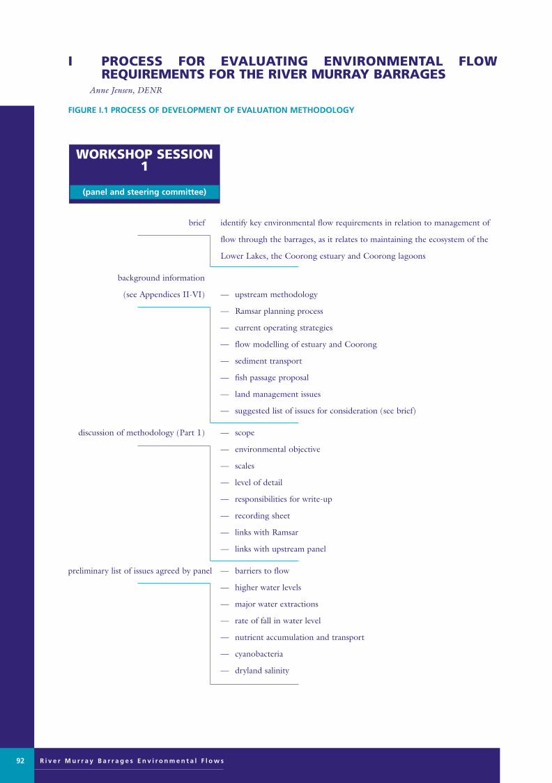
R i v e r M u r r a y B a r r a g e s E n v i r o n m e n t a l F l o w s
FIGURE I.1 PROCESS OF DEVELOPMENT OF EVALUATION METHODOLOGY
brief identify key environmental flow requirements in relation to management of
flow through the barrages, as it relates to maintaining the ecosystem of the
Lower Lakes, the Coorong estuary and Coorong lagoons
background information
(see Appendices II-VI) — upstream methodology
— Ramsar planning process
— current operating strategies
— flow modelling of estuary and Coorong
— sediment transport
— fish passage proposal
— land management issues
— suggested list of issues for consideration (see brief)
discussion of methodology (Part 1) — scope
— environmental objective
— scales
— level of detail
— responsibilities for write-up
— recording sheet
— links with Ramsar
— links with upstream panel
preliminary list of issues agreed by panel — barriers to flow
— higher water levels
— major water extractions
— rate of fall in water level
— nutrient accumulation and transport
— cyanobacteria
— dryland salinity
WORKSHOP SESSION1
(panel and steering committee)
I PROCESS FOR EVALUATING ENVIRONMENTAL FLOW REQUIREMENTS FOR THE RIVER MURRAY BARRAGES
Anne Jensen, DENR
92
Murray Barrages flow edit 28/8/01 11:10 AM Page 92

FIGURE I.1 PROCESS OF DEVELOPMENT OF EVALUATION METHODOLOGY
(continued from previous page)
sites visited/issues considered — Tolderol
— community concerns
— Goolwa Barrage
— Murray Mouth
— Mundoo Barrage
— Boundary Creek Barrage
— low-lying road fords
— Ewe Island Barrage
— Tauwitchere Barrage
— professional fisher’s concerns
— Southern Lagoon
— Hells Gate
— Northern Lagoon
— lakeshore erosion
evaluation of methodology — testing and revision of recording sheets
discussion of field trip observations
review of recording sheet
(see Figures I.1, I.2)
changed methodology
(see Figure I.1) — problem v cause v region
— opportunities to change barrage operations
(major/minor, short/medium/long term)
— environmental needs v region
report outline
WORKSHOP SESSION2
(panel and steering committee)
FIELD TRIP
(panel and support team)
R i v e r M u r r a y B a r r a g e s E n v i r o n m e n t a l F l o w s 93
Murray Barrages flow edit 28/8/01 11:10 AM Page 93
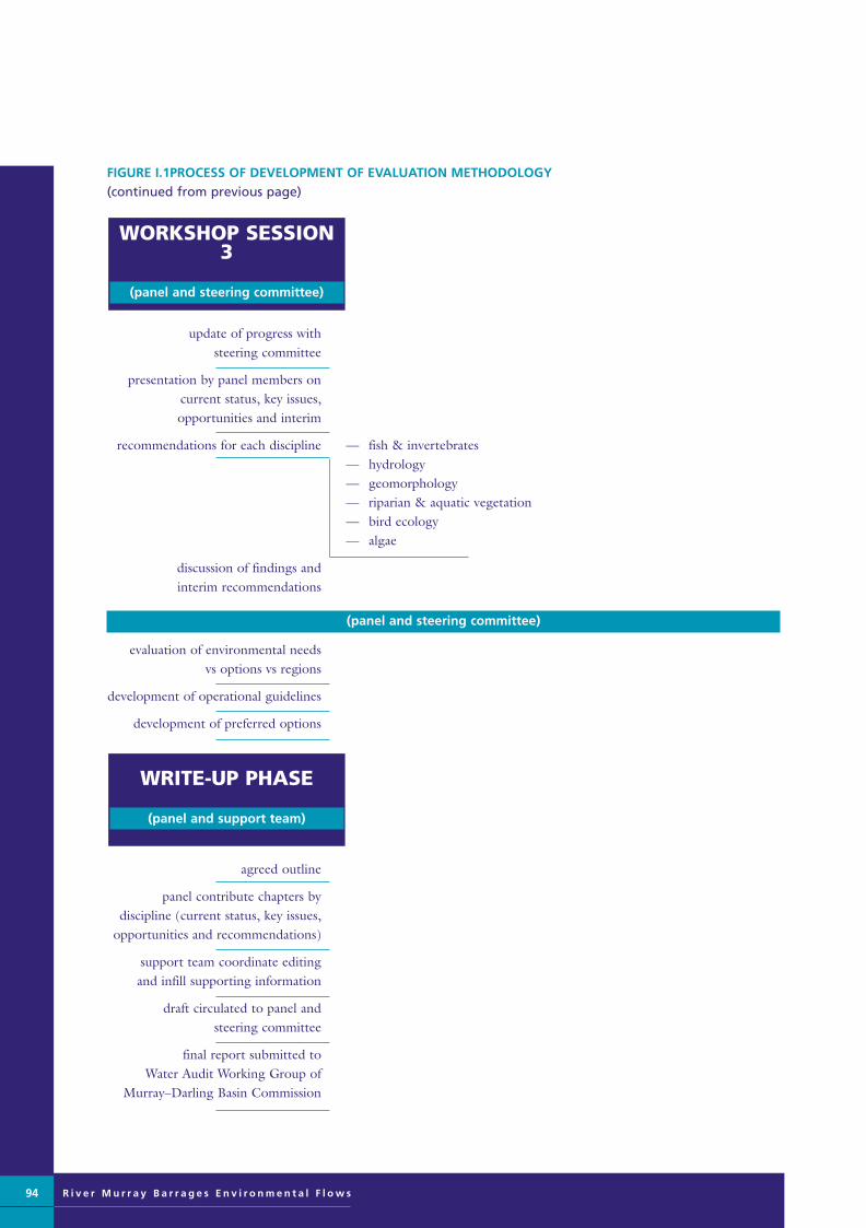
FIGURE I.1PROCESS OF DEVELOPMENT OF EVALUATION METHODOLOGY (continued from previous page)
update of progress with steering committee
presentation by panel members on current status, key issues, opportunities and interim
recommendations for each discipline — fish & invertebrates— hydrology— geomorphology— riparian & aquatic vegetation— bird ecology— algae
discussion of findings and interim recommendations
(panel and steering committee)
evaluation of environmental needs vs options vs regions
development of operational guidelines
development of preferred options
agreed outline
panel contribute chapters by discipline (current status, key issues,
opportunities and recommendations)
support team coordinate editing and infill supporting information
draft circulated to panel and steering committee
final report submitted to Water Audit Working Group of
Murray–Darling Basin Commission
WRITE-UP PHASE
(panel and support team)
WORKSHOP SESSION3
(panel and steering committee)
94 R i v e r M u r r a y B a r r a g e s E n v i r o n m e n t a l F l o w s
Murray Barrages flow edit 28/8/01 11:10 AM Page 94

FIGURE I.1 PROCESS OF DEVELOPMENT OF EVALUATION METHODOLOGY (continued from previous page)
• amended recording sheet based on upstream panel method provided for consideration by panel (Figure I.2)
• panel agrees to develop new recording sheets based on five landform-based regions by seven key issues, using arecording sheet based on evaluating the impacts and benefits of minor and major management opportunities overthe short, medium and long term (Figure I.3)
• field testing of recording sheet leads to minor modifications, moving the minor/major dichotomy under thetimescale categories, and inserting additional room at the top of the sheet to describe the issue, the problem andthe cause of the problem (Figure I.4)
• panel assesses task of filling out up to 35 recording sheets to cover the issue v region matrix (minimum 19 (√),maximum 26 (√ + ?) sheets required) (Figure I.5)
• panel tests recording sheet (for shore erosion in the eroding lakeshore region) (Figure I.6) and concluded that thetask would be very time-consuming
• panel lists key problems and causes and cross-checks by five regions (Figure I.7) and concluded that managementopportunities could be divided into two regions instead of five (ie upstream and downstream of the barrages)
• panel cross-checks environmental needs by opportunities (see Table 3.5) to assess the full benefits of themanagement options
• panel cross-checks environmental needs by region and adds codes for opportunities (see Table 3.5)
• panel develops operational guidelines to address key issues (see Part 3)
DEVELOPMENT OFRECORDING SHEET
R i v e r M u r r a y B a r r a g e s E n v i r o n m e n t a l F l o w s 95
Murray Barrages flow edit 28/8/01 11:10 AM Page 95

R i v e r M u r r a y B a r r a g e s E n v i r o n m e n t a l F l o w s
FIGURE I.2 AMENDED BARRAGES RECORDING SHEET, BASED ON UPSTREAM METHODOLOGY
Reach name or number: . . . . . . . . . . . . . . . . . . . . . . . . .Recorder: . . . . . . . . . . . . . . . . . . . . . . . . .Date: . . . . . . . . . . . . . . . . . . . . . .
OTHER
FISH
INVERTEBRATES
MACROPHYTES
ALGAE
FLOODPLAIN
RIPARIAN VEGETATION
GEOMORPHIC PROCESSES
1. CURRENT STATUS – SUMMARY
96
Murray Barrages flow edit 28/8/01 11:10 AM Page 96

FIGURE I.3 AMENDED BARRAGES RECORDING SHEET (STAGE 1)
Region: . . . . . . . . . . . . . . . . . . . . . . . .Problem: . . . . . . . . . . . . . . . . . . . . .Recorder: . . . . . . . . . . . . . . . . . .Date: . . . . . . . .
LONG
MEDIUM
SHORT
R i v e r M u r r a y B a r r a g e s E n v i r o n m e n t a l F l o w s 97
Murray Barrages flow edit 28/8/01 11:10 AM Page 97
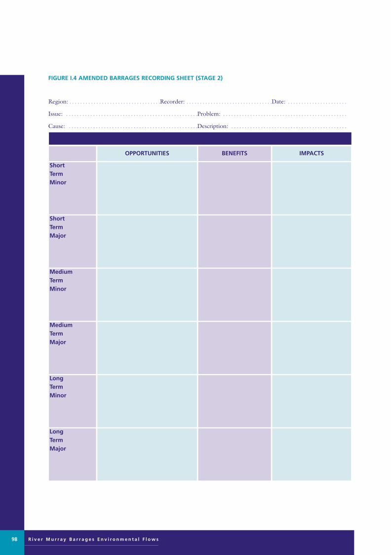
R i v e r M u r r a y B a r r a g e s E n v i r o n m e n t a l F l o w s
FIGURE I.4 AMENDED BARRAGES RECORDING SHEET (STAGE 2)
Region: . . . . . . . . . . . . . . . . . . . . . . . . . . . . . . . . . .Recorder: . . . . . . . . . . . . . . . . . . . . . . . . . . . . . . . .Date: . . . . . . . . . . . . . . . . . . . . . .
Issue: . . . . . . . . . . . . . . . . . . . . . . . . . . . . . . . . . . . . . . . . . . . . . . . . .Problem: . . . . . . . . . . . . . . . . . . . . . . . . . . . . . . . . . . . . . . . . . . . . . .
Cause: . . . . . . . . . . . . . . . . . . . . . . . . . . . . . . . . . . . . . . . . . . . . . . . .Description: . . . . . . . . . . . . . . . . . . . . . . . . . . . . . . . . . . . . . . . . . . .
. . . . . . . . . . . . . . . . . . . . . . . . . . . . . . . . . . . . . . . . . . . . . . . . . . . . . . . . . . . . . . . . . . . . . . . . . . . . . . . . . . . . . . . . . . . . . . . . . . . . . . . . . . . . . .
LongTermMajor
LongTermMinor
MediumTermMajor
MediumTermMinor
ShortTermMajor
ShortTermMinor
IMPACTSBENEFITSOPPORTUNITIES
98
Murray Barrages flow edit 28/8/01 11:10 AM Page 98

FIGURE I.5 ASSESSMENT OF RECORDING SHEETS NEEDED TO COVER THE ISSUE VERSUS REGION MATRIX
√ = data sheet required for this region
? = data sheet may be required for this region
blank = no data sheet required
√√Dryland salinity
???√√Increased frequencyof algal bloom
??√√√Increasing nutrients
levels and sedimentation
√√√??Reduced habitat foraquatic plants
√√√√√
Changed waterregime (lower
volumes, changedseasonality)
√√Freshening of
brackish & saline habitat
√√Reduced estuary
SOUTHERNLAGOON
NORTHERNLAGOONESTUARY
LAKES –PROGRADINGSHORELINE
LAKES –ERODINGSHORELINE
ISSUE/REGION
R i v e r M u r r a y B a r r a g e s E n v i r o n m e n t a l F l o w s 99
Murray Barrages flow edit 28/8/01 11:10 AM Page 99

R i v e r M u r r a y B a r r a g e s E n v i r o n m e n t a l F l o w s
FIGURE I.6 RECORDING SHEET TEST (FOR THE ISSUE OF SHORE EROSION IN THE ERODING LAKESHORESREGION)
– need investigation
– not very effectiveunless there aremajor changes
– impacts on otherusers if >20 cm
– limited if only 10-20 cm, needs tobe >0.5 m to beeffective
– tyre reefs andislands
– reduce water levels
– remove barrages toWellington
minor
major
Long - term(>10 years)
* investigate windeffects
– less turbulence
– more algalblooms
– establish riparianzone
– increased removalfrom lakes by plants
– increased macro-invertebrate habitat(positive effect onfood chain)
– improved aesthetics(rip vegetation)
– reduced wind
– reduced evaporation
– increased agriculturalproduction
– extended shore protection
– riparian vegetationaround all erodingshores
– network ofwindbreaks in keyareas eg Point Sturt(strategic revegetation)
minor
major
Medium - term(3 – 10 years)
– synergy withLAPs omfloodplainmanagement
– liaise with EPAon tyres
– visual impact oftyres
– lost productiveland to revegetation
– lower lake levels
– protect shores, stoperosion
– retain grazing land
– reduced nutrientsinto lakes
– shore protection
– establish riparianvegetation
– protect all shoresimmediately
– major protectiveplantings
– operate lakes atlower range of levels
minor
major
Short - term(1 – 3 years)
COMMENTSIMPACTSBENEFITSOPPORTUNITIES
100
Murray Barrages flow edit 28/8/01 11:10 AM Page 100
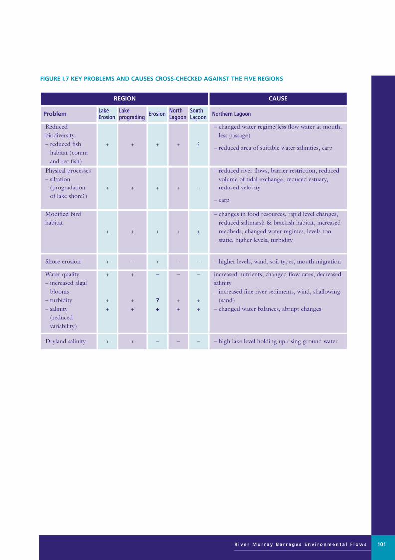
FIGURE I.7 KEY PROBLEMS AND CAUSES CROSS-CHECKED AGAINST THE FIVE REGIONS
– high lake level holding up rising ground water–––++Dryland salinity
increased nutrients, changed flow rates, decreasedsalinity– increased fine river sediments, wind, shallowing
(sand)– changed water balances, abrupt changes
–
++
–
++
–
?+
+
++
+
++
Water quality– increased algal
blooms– turbidity– salinity
(reduced variability)
– higher levels, wind, soil types, mouth migration––+–+Shore erosion
– changes in food resources, rapid level changes,reduced saltmarsh & brackish habitat, increasedreedbeds, changed water regimes, levels too static, higher levels, turbidity
+++++
Modified bird habitat
– reduced river flows, barrier restriction, reducedvolume of tidal exchange, reduced estuary,reduced velocity
– carp
–++++
Physical processes– siltation
(progradationof lake shore?)
– changed water regime(less flow water at mouth,less passage)
– reduced area of suitable water salinities, carp?++++
Reduced biodiversity– reduced fish
habitat (command rec fish)
Northern LagoonSouthLagoon
NorthLagoonErosionLake
progradingLakeErosionProblem
CAUSEREGION
R i v e r M u r r a y B a r r a g e s E n v i r o n m e n t a l F l o w s 101
Murray Barrages flow edit 28/8/01 11:10 AM Page 101

R i v e r M u r r a y B a r r a g e s E n v i r o n m e n t a l F l o w s
FIGURE I.8 SUMMARY OF ISSUES COVERED IN THE AMENDED FIELD RECORDING SHEET
Current Status of:
Hydrologycurrent flow regime
Changes from natural state
Geomorphologymajor gepmorphological influences
stability of syubstrate
changes from natural state
Riparian & Aquatic Vegetationinventory
major habitat types
condition of habitat types
changes from natural state
Bird Ecologyinventory
major habitat types
condition of habitat types
changes from natural state
Fish & Invertebratesinventory
major habitat types
condition of habitat types
changes from natural state
Algae Current Statusinventory
major habitat types
condition of habitat types
changes from natural state
Flow regime requirements for:• geomorphology
• Riparian & Aquatic Vegetation
• Bird Ecology
• Fish & Invertebrates
• Algae
Hydrology in terms of:
– current flow regime
– changes from natural state
102
Murray Barrages flow edit 28/8/01 11:10 AM Page 102

OBJECTIVE:
To identify changes in river operations for the River
Murray and Lower Darling that should result in general
improvements in the environmental condition of these
river reaches whilst considering the current needs of
existing water users.
Issue:
• that the river cannot be returned to its pristine or
pre-European settlement state.
Recommendation/aim:
• to at least maintain and, where possible, improve
the natural habitats and functions of the river
as it is today.
However, habitat/ecosystems resulting from anthropogenic
changes do not have precedence over identifiable
ecological benefits (habitat/function), derived from
modifying flow towards natural patterns.
Three major principles were adopted for the assessment:
• the natural diversity of habitats and biota within
the river channel, riparian zone and the floodplain
should be maintained
• the natural linkages between the river and the
floodplain should be maintained
• the natural metabolic functioning of aquatic
ecosystems should be maintained.
Two guiding principles on variability were adopted:
• elements of natural seasonality should be retainedas far as possible, in the interests of conserving aniche for natural rather than invasive exotic speciesand in maintaining some natural functions for theriver
• consistent and constant flow and water levelregimes should be avoided as much as possible,because this is the reverse of the natural regime ofthe River Murray.
The scientific panel assessment included the followingsteps for each reach:
• assess current values and conditions
• identify threatening processes (not just flow)
• determine management options with expectedenvironmental benefits
• set priorities on options from environmental perspective
• consider feasibility
• set overall priorities.
For each reach the panel identified:
• the different habitat types and current ecologicalcondition
• priority ecological impacts
• causal factors (flow-related and others)
• broad operating principles to redress these
• specific management actions required
II ASSESSMENT PROCESS FOR ENVIRONMENTAL FLOW REQUIREMENTS FOR THE RIVER MURRAY AND LOWER DARLING
Jane Doolan, Manager Wetlands and Waterways Unit, DCNR, Victoria
R i v e r M u r r a y B a r r a g e s E n v i r o n m e n t a l F l o w s 103
TABLE II.1 COMPOSITION OF RIVER MURRAY ENVIRONMENTAL FLOWS SCIENTIFIC PANEL
Senior Lecturer, University of Canberra
MDBC
Murray–Darling Freshwater Research Centre
Principal Scientist, CSIRO Water Resources
Lecturer, Latrobe University, Albury/Wodonga campus
Principal Scientist, Marine and Freshwater ResourcesInstitute, Victoria
Senior Research Scientist, CSIRO Land and WaterResources
Martin Thoms
Andy Close
Terry Hillman
Gary Jones
Phil Suter
John Koehn
Jane Roberts
geomorphology
river operations
floodplain ecology
water quality and algae
macroinvertebrates
fish
riparian vegetation andmacrophytes
OrganisationExpert appointedArea of expertise
Murray Barrages flow edit 28/8/01 11:10 AM Page 103

R i v e r M u r r a y B a r r a g e s E n v i r o n m e n t a l F l o w s
From the geomorphological perspective, the major taskswere to:
• identify major characteristics of flow regime tomaintain restore ecological values
• assess impact of current operating regime, biodiversity and ecological processes
• identify changes in current management toimprove ecological values
• set priorities on management actions according topredicted environmental benefits and assessmentof ease of implementation.
Outcomes were classified in the following categories:
1. minor changes to water management with some environmental benefit specific operational options for meeting that management action
• priorities for implementing operational options.
2. changes to water regimes with user impact but may beimplementable
3. identify flow regime that meet environmental needs.
The draft report of the River Murray Environmental FlowsScientific Panel is still in preparation. A summary of thedraft conclusion for the Wentworth to Wellington reach isgiven in the introduction of this report.
104
Murray Barrages flow edit 28/8/01 11:10 AM Page 104

The close linkages between the briefs of the Barrages
Environmental Flows Scientific Panel and the Ramsar
planning process demand close coordination between the
two activities. The following issues should be taken into
account:
1 the need for a joint approach to issuing a paper
on environmental flows from both MDBC and
the Ramsar plan
Benefits include:
• avoiding duplication
• maximum exposure
• community acceptance
• consider the Ramsar plan as a vehicle for implementation,
given its strong community focus and the requirements
for Cabinet approval.
2 the need to promote a focus on the lakes,
Coorong and estuary, so that this area is not
seen to be a passive recipient of the results of
decisions made upstream
The management issues to be taken into account include:
• interactions of flow management with other possiblechanges to the area (eg use; drainage scheme; climaticchange)
• consideration of interactions with other users of thearea
• identification of the constraints placed on managementof the lower end of the Murray Darling system fromdecisions made upstream, and if necessary to influencethese.
The following Ramsar discussion papers are in the processof production and circulation:
• waterbirds and wetland habitat conservation
• water quality in the Lower Lakes
• water management
• recreation, tourism and urban development
• Coorong and estuary issues
• Aboriginal issues.
The process for development of the Ramsar plan withextensive community involvement is shown in Figure III.1.
III ISSUES RAISED IN RAMSAR PLANNING PROCESS FOR THE LOWER LAKES AND COORONG
Bernice Cohen, Natural Resources Policy, DENR, South Australia
R i v e r M u r r a y B a r r a g e s E n v i r o n m e n t a l F l o w s 105
FIGURE III.1 RAMSAR PLANNING PROCESS
Murray Barrages flow edit 28/8/01 11:10 AM Page 105

R i v e r M u r r a y B a r r a g e s E n v i r o n m e n t a l F l o w s
MANAGEMENT OF LOWER LAKES
The following historical points are relevant:
• the concept of barrages has been strongly supported bylandowners along the lower reaches of the river andlakes since early days of settlement
• barrages were considered for Wellington to keep lowerriver reaches fresh, or at the Murray Mouth, keepinglakes Alexandrina and Albert fresh
• barrages would stabilise river levels, protect land fromflooding and allow irrigation by gravitation rather thanpumping
• in 1931 the River Murray Commission recommendedthat five barrages be constructed. Work commenced in1935 and the barrages were completed in 1940.
Operational management
• the barrages and the Lower Lakes are managed by SAWater on behalf of the Murray–Darling BasinCommission, which sets the management policy forthe Murray–Darling Basin catchment area
• operation and management of the Lower Lakes is bythe SA Water regional office in Murray Bridge.
Background
The following points are relevant to management of thebarrages:
• approximately 270 km of river miles are influenced bybarrages
• South Australia is heavily dependent on the RiverMurray for water (up to 90% in a dry year)
• Eyre Peninsula, Yorke Peninsula, Barossa, Onkaparingaare all reliant upon the lower reach, from Morgandownstream
• most pumping occurs in summer (when less water is inreservoirs).
• it is not possible to change the timing of pumpingfrom the Murray to top up reservoirs
• 3000 ML/day is the summer entitlement flow in theRiver Murray (Table IV.1)
Barrage structures
• earthen embankments and concrete structures (incorporate sluice structures)
• Tauwitchere Barrage is the easiest to operate
• barrage operation is fairly broad on a day to day basis,only quick decisions need to be made in a storm event.Gates are opened 10-30 at a time.
• there are areas of hydraulic constraint betweenTauwitchere and Goolwa, making it very hard to shiftwater in this area
Lake operation
• lake operation is dynamic to account for the wide variety in run-off volumes and patterns from theMurray–Darling catchment, and must allow maximumwater in lakes and minimise high tide, can lose reasonableamount of water during process (up to 24 hrs)
• 2 m depth average of lakes
• north-eastern shores of lakes are subject to erosion athigh water levels (0.85 m EL)
• high salinities occur in Lake Albert, to overcome thisLake Alexandrina’s level is lowered to 0.65 m EL sothat water flows out of Lake Albert and refills whenLake Alexandrina is higher. Problems and timing occurin this system at times of major tidal flows - alsolowering Lake Albert for long periods may allow waterinflow via groundwater (becoming increasingly saline)
• time periods are flexible between known floodingevents - there is several weeks warning in advance forflood events in Victoria, up to 6-8 weeks for floods of100 000 ML/day. As the flow gets closer there is morefine-tuning. Gate opening occurs by judgementdepending on how drawn down the lakes are; closingof gates is generally gradual, but it can occur quickly.
Three main strategic considerations for managementinclude:
• operating procedures
• operating constraints
• water quality (salinity).
Operating constraints
• water levels must be maintained above a minimumlevel of about EL 0.6 m for irrigation activities aroundthe lakes and reclaimed swamps up to Mannum. Levelsdown to EL 0.55 m can only be tolerated by irrigatorsfor short periods of time (days)
• lake levels above EL 0.85 m cause fresh water to bespilled over the low level island causeways, whichtogether with the barrages acts to exclude sea water,and cause inundation of shallow areas adjacent to thelakes (eg Waltowa Swamp - adjacent to Lake Albert)
IV CONSTRAINTS AND CURRENT OPERATION STRATEGIES FOR THE BARRAGES AND LOWER LAKES
John Parsons, Regional Manager, Murray Mallee, SA Water
106
Murray Barrages flow edit 28/8/01 11:10 AM Page 106

• land owners consider that high water levels aggravateforeshore erosion problems – thus for the purposes ofirrigation, recreation, water supply and bank stability,operating rules aim to maintain water levels within anarrow band of EL 0.6 m to EL 0.85 m, a range of0.25 m.
Salinity
Lake Albert salinity (measured at Meningie) ranges from1300 to 2000 EC, but can range from 1800 EC to 3000EC, following extended periods of low river flow (notesalinity of sea water is 50,000 EC). Productivity of irrigatedcrops and pastures is significantly reduced by salinitiesabove 1500 EC.
Lake Alexandrina (measured at Milang) ranges from 400EC to 1200 EC – generally reflecting salinity levels of theRiver Murray.
Groundwater surrounding the lakes has naturally highconcentrations of salt in the range of 10 000 to 20 000EC. A slight natural gradient of this saline groundwatertowards the lakes causes seepage and increasing salinity.Reductions in water levels below EL 0.65 m can greatlyincrease saline seepage, therefore raising/lowering cyclesaimed at improving water quality are generally limited tothe range EL 0.65 m to EL 0.85 m.
GENERAL OPERATING PROCEDURES
• The main operating target for the Lower Lakes is tomaintain an average water level of EL 0.75 m, or aheight of 0.75 m above mean sea level.
• Sufficient barrage gates are opened or closed to maintain this level. As River Murray flow increases,more gates are opened to maintain EL 0.75 m.Sometimes high tides and strong winds, often in combination, tend to reverse flow through the barrages,with the result that a slug of sea water could enter Lake Alexandrina. When these conditions are forecast, barrage attendants close gates until conditions abate.Ease of operation, wind and tide conditions influencewhich barrages are opened and closed.
• When River Murray flows are limited to ‘entitlement’flows over summer, evaporation from the lakes exceedsinflow and lake level drops, typically by 0.25 m.Therefore, the lakes are surcharged to EL 0.85 m atthe beginning of summer, in preparation for evaporation
dropping the level to a minimum of about
EL 0.6 m in autumn. The barrages remain closed
during this period.
In years of above entitlement flow, with sustained flow at
Lock 1 of more than 15 000 ML/d, opportunistic cycles
of raising and lowering lake water levels are employed.
This allows the more saline water in Lake Albert to
be drawn out to sea (via Lake Alexandrina) during the
lowering phase, and to be replaced with fresher, lower
salinity river water, with subsequent mixing resulting in
lower lake salinity.
Management issues
The following factors should be taken into account:
• November 1991 the Fish Management Plan for the
Murray–Darling Basin was adopted
• professional fishers are given advance notice of the
barrage opening and can take the freshwater fish that
are flushed out
• ad hoc management changes have been undertaken on
a minor scale in consultation with professional fishers
• in 1993–94 the commission approved funding to
develop options for the management of the Lower
Lakes and barrages to enhance environmental values
which particularly related to fish management, and
competing demands of water supply for recreation,
fisheries and the environmental requirements of the
area.
A trial in lake operation in 1992–93 was conducted as
follows:
• one raising/lowering cycle to improve water quality,
with one more cycle at high river
• 5000 GL of water was passed into the Lower Lakes
during the high river
• 400 barrage gates were opened at the peak of the flow
• at the end of the period of high flow, salinity in the
lakes was expected to be 350 EC and 1300 EC in the
Lakes Alexandrina and Albert respectively. Salinity was
in fact 800 EC and 1700 EC.
R i v e r M u r r a y B a r r a g e s E n v i r o n m e n t a l F l o w s 107
Murray Barrages flow edit 28/8/01 11:10 AM Page 107

R i v e r M u r r a y B a r r a g e s E n v i r o n m e n t a l F l o w s
TABLE IV.1 FLOW TO SOUTH AUSTRALIA
* Based on 96 years of flow data (1891-1987)
1 Current & Option = adding 6 500 ML/d to Peak Flow from Lake Victoria
2 Current & Option = adding 16 000 ML/d to Peak Flow from Lake Victoria.
100
100
100
100
98
100
74
56
50
45
41
34
30
26
20
16
14
13
11
11
9
7
5
4
4
2
1
0
100
100
100
99
74
66
56
46
41
34
30
27
22
18
14
13
11
11
10
10
7
5
5
4
4
1
1
0
100
100
96
73
63
54
49
39
33
29
25
20
15
13
13
11
10
10
9
8
5
5
4
4
4
1
1
0
100
100
100
100
99
97
95
89
83
75
64
56
51
46
43
39
32
32
31
26
22
18
15
10
7
2
1
0
91.5
152.5
305
458
610
763
915
4220
1373
1525
1678
1830
4938
2135
2288
2440
2593
2745
2898
3050
3355
3660
3965
4270
4575
6100
7625
9750
3000
5000
10000
15000
20000
25000
30000
35000
40000
45000
50000
60000
65000
70000
75000
80000
85000
90000
95000
100000
110000
120000
130000
140000
150000
200000
250000
300000
CURRENT &OPTION 2
CURRENT &OPTION 1
CURRENTNATURALMONTHLY
FLOW*(GL/MONTH)
DAILY FLOW*(ML/D)
% OF YEARS WHEN FLOW EXCEEDED
108
Murray Barrages flow edit 28/8/01 11:10 AM Page 108

TABLE IV.2 PARTICULARS OF BARRAGES (SOURCE: SA WATER)
3658 m
322
3.86 m
Radial Gates
13.72x3.81 m
–
–
–
9 752 c. m
567 tons
658 c. m(278 772 sup.ft.)
14 620 c. m
51 684 c. m
$418 700
2271 m
111
3.86 m
Radial Gates
–
–
–
–
3 223 c. m
210 tons
35 205 c. m
225 c. m(95 484 sup.ft.)
4 010 c. m
36 510 c. m
$174 960
244 m
6
3.58 m
Stop Logs
–
–
–
–
343 c. m
23 tons
8 122 c. m
107 c. m(45 485 sup. ft.)
467 c. m
3 917 c. m
$21 250
792 m
26
3.58 m
Stop Logs
–
–
–
2 254 c. m
106 tons
7 199 c. m
48 c. m(20 508 sup, ft.)
2 163 c. m
13 340 c. m
$131 150
632 m
128
3.58 m
Stop Logs
30.48x6.10 m
20.65 m
4 770 No.
1 050 c. m
13 550 c. m
770 tons
20 443 c. m
511 c. m(216 581 sup. ft.)
49 925 c. m
–
$750 000
Total length ofBarrage
Number ofOpenings
Length of eachopening
Type of Opening
Size of Lock
Navigable Pass
Timber Piles
Steel Piping
Concrete
Steel Reinforcement
Stone Protection
Jarrah
Excavation
Earth Embankments
Cost
TAUWITCHEREBARRAGE
EWE ISLANDBARRAGE
BOUNDARYCREEK
BARRAGE
MUNDOOBARRAGE
GOOLWACHANNELBARRAGE
R i v e r M u r r a y B a r r a g e s E n v i r o n m e n t a l F l o w s 109
Murray Barrages flow edit 28/8/01 11:10 AM Page 109

R i v e r M u r r a y B a r r a g e s E n v i r o n m e n t a l F l o w s
The following factors are relevant to the discussion:
• allocations made in the past were high to encourageuse of water and nor all water allocated was used
• with recent increases in the value of water and pressure to increase production, the rate of use of these allocations has escalated
• this trend of increasing diversions led to the capapplied by the MDBC, to halt further diversions at thelevel of 93–94 diversions while the detail of usage iscompared to this designated level
• current flows are directly affected by the rate and pattern of diversions
• changes to flow regimes will have a direct affect onwater users
• approximately 30-40% of mean natural flows stilloccur, but this figure includes large flood events. Onlyapproximately 20% of median natural flows still occur
• only management of lake levels at the barrages (± 0.1 m) can be overtaken by major wind-generatedfluctuations (eg 0.5 m in 24 hours)
• the large evaporative loss from the large surface area ofthe lakes masks the effect of evapotranspiration byplants
• the greatest potential for additional flows at the barrages is from reducing upstream demand.
Hydrographs and diagrams of changes to flow patternshave been included in the hydrology section.
V CONSTRAINTS AND OPERATING STRATEGIES FOR THE RIVER MURRAY SYSTEM
Andy Close, Murray–Darling Basin Commission
110
Murray Barrages flow edit 28/8/01 11:10 AM Page 110
Prudence Tucker presented results from her Honours thesis (Tucker 1996).
KEY RESEARCH FINDINGS (SUMMARY)
• when the barrages at the Murray Mouth are open, sediments from Lake Alexandrina are transported intothe Coorong Northern Lagoon (Figure VI.1)
• the barrages induce the selective transport of fine sediments into the Northern Lagoon (Figure VI.2)
• these suspended sediments have a unique particle sizedistribution such that their redistribution can be tracedthroughout the system (Figure VI.3)
• the selective transport of sediments into the lagoon isparalleled by the preferential transport (Figure VI.4)
• suspended Lake Alexandrina sediments are beingdeposited in the system, thus the effects are accumulative,influencing the condition of the Coorong for anunknown period of time.
• in line with the selective transport of fine sedimentsinto the lagoon system there is a process of preferentialnutrient transport into the system, with 90 000 timesthe concentration of phosphorus associated with theLake Alexandrina suspended sediments as opposed tophosphorus in solution
• combined with flow data obtained from the RiverMurray Flow model, for 21 July 1996 there was anestimated 239 kg of phosphorus being transportedinto the Coorong Lagoon.
POTENTIAL IMPACT OF BARRAGEOPERATION ON THE COORONGNORTHERN LAGOON
• the release of freshwater into the Coorong occurs most frequently during the winter months. It is duringthis period that nutrient and sediment loads in the riversystem are highest, eventually impacting on the LowerLakes
• low river water quality compounds the low chemicalquality evident in Lake Alexandrina towards the end ofsummer
• high wind speeds and winter water levels in the lakepromote shoreline erosion and sediment resuspensionprocesses within the system
• turbulent conditions prevail during winter, leading to afurther decline in the chemical condition of LakeAlexandrina with the release of nutrients from the porewaters of the sediments
• the selective process of fine sediment transportbetween Lake Alexandrina and the Coorong is associatedwith the transport of high concentrations of totalphosphorus
• the barrages effectively act as a point source of contaminants to the lagoon
• short-term benefits of suspended sediments in the systeminclude lower light penetration for the protection ofmicrofauna and juvenile fish from predators at highertrophic levels. However, it may be affecting the intricateecological balance within the system
• the physical impacts of suspended sediments may result in changes to the food chains of the system byinhibiting the growth of aquatic plants and benthicflora and fauna in a blanketing/smothering process
• the expansion of the calcareous benthic faunal Bryozoapopulations (tenfold since 1988) indicates that theecological balance in the Coorong Lagoon is beingaffected, possibly by the influx of nutrients associatedwith the suspended sediments
• the calcareous fauna not only provide evidence forchanges taking place in the ecosystem but have becomepotential sites of sediment deposition
• whilst widespread algal outbreaks are not frequent inthe Northern Lagoon, nutrients are present. However,the dynamic nature of the system promotes dispersal ofany manifestation
• the fact that evidence of deterioration in the waterquality is not immediately obvious leads to delays inmanagement response. Without management theproblem is compounded as fine sediments continue toaccumulate.
MANAGEMENT TO MINIMISEIMPACTS OF THE BARRAGES ONTHE ECOLOGY OF THECOORONG NORTHERN LAGOON
The problem must be addressed at both regional and locallevels.
Short-term objective
• change operation of the barrages to reduce the immediateimpact of the suspended sediments and associatednutrients on the Coorong ecosystem, to promote aflow mimicking natural conditions.
This approach may involve
• opening the barrage during falling tidal conditions inwinter
VI IMPACTS OF THE BARRAGES ON SEDIMENTATION INTERACTIONSBETWEEN THE LOWER LAKES AND THE COORONG
Prudence Tucker
R i v e r M u r r a y B a r r a g e s E n v i r o n m e n t a l F l o w s 111
Murray Barrages flow edit 28/8/01 11:10 AM Page 111

R i v e r M u r r a y B a r r a g e s E n v i r o n m e n t a l F l o w s
• releasing some water from Lake Alexandrina duringthe summer months when sediment and nutrient loadsare low
Medium-term objective
• to establish predictive models for identifying suspendedsediment transport and redistribution patterns and tomonitor the transport of suspended sediments into theNorthern Lagoon of the Coorong
• this research could then be used as a basis for theimplementation of changes to barrage operation
Long-term objective
• local and regional catchment management to reducethe external sediment and nutrient loading to LakeAlexandrina
• additional research on dynamic processes is required to design an ecosystem approach, which is stronglyrecommended for management of estuarine systems(Imperial and Hennessey 1996).
112
TABLE VI.1 DATA HIGHLIGHTING THE CHANGING CONDITION OF THE SURFACE WATERS OF THE PELICAN POINT CHANNEL
Murray Barrages flow edit 28/8/01 11:10 AM Page 112

R i v e r M u r r a y B a r r a g e s E n v i r o n m e n t a l F l o w s 113
TABLE VI.2 PERCENTAGE OF SILT-CLAY RELATIVE TO SAND, LAKE ALEXANDRINA SUBSTRATE
TABLE VI.3 PARTICLE SIZE DISTRIBUTION OF FINE DEPOSITED SEDIMENT
Murray Barrages flow edit 28/8/01 11:10 AM Page 113
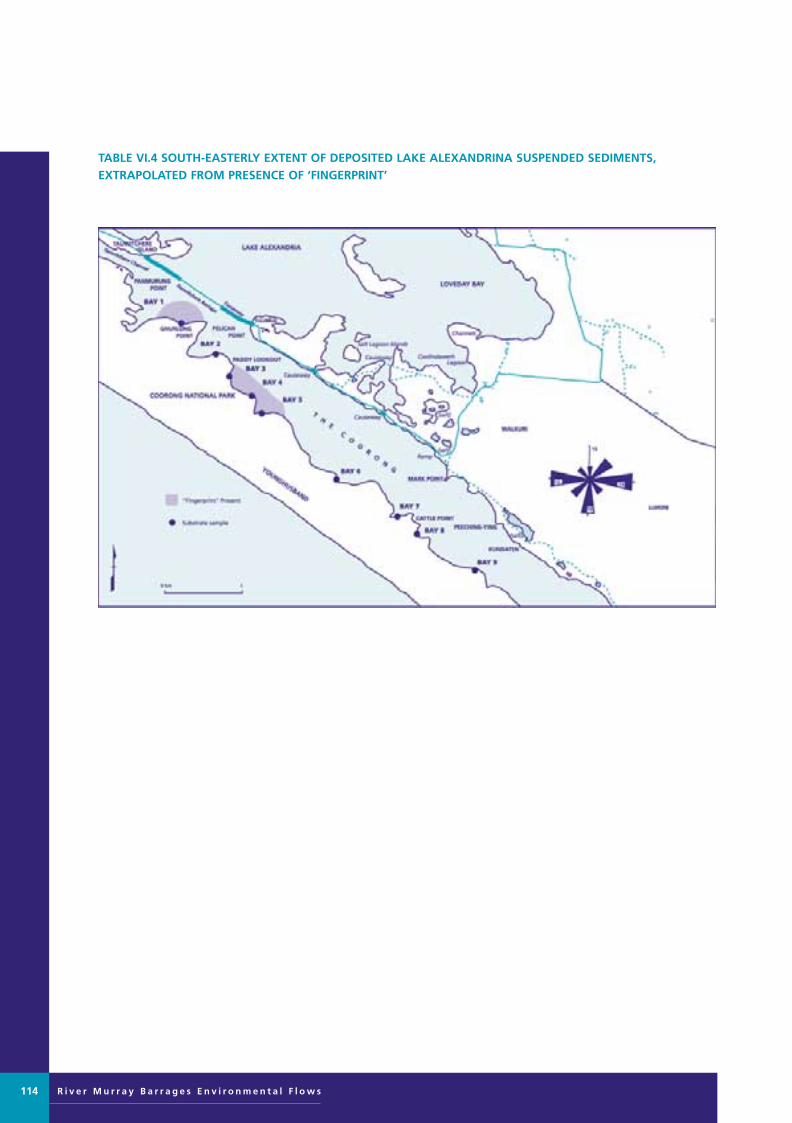
R i v e r M u r r a y B a r r a g e s E n v i r o n m e n t a l F l o w s114
TABLE VI.4 SOUTH-EASTERLY EXTENT OF DEPOSITED LAKE ALEXANDRINA SUSPENDED SEDIMENTS, EXTRAPOLATED FROM PRESENCE OF ‘FINGERPRINT’
Murray Barrages flow edit 28/8/01 11:10 AM Page 114
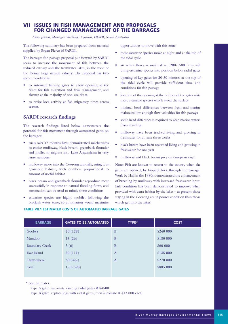
The following summary has been prepared from materialsupplied by Bryan Pierce of SARDI.
The barrages fish passage proposal put forward by SARDIseeks to increase the movement of fish between thereduced estuary and the freshwater lakes, in the zone ofthe former large natural estuary. The proposal has two recommendations:
• to automate barrage gates to allow opening at keytimes for fish migration and flow management, andclosure at the majority of non-use times
• to revise lock activity at fish migratory times acrossseason.
SARDI research findings
The research findings listed below demonstrate the potential for fish movement through automated gates onthe barrages:
• trials over 12 months have demonstrated mechanismsto entice mulloway, black bream, greenback flounderand mullet to migrate into Lake Alexandrina in verylarge numbers
• mulloway move into the Coorong annually, using it asgrow-out habitat, with numbers proportional toamount of useful habitat
• black bream and greenback flounder reproduce mostsuccessfully in response to natural flooding flows, andautomation can be used to mimic these conditions
• estuarine species are highly mobile, following thebrackish water zone, so automation would maximise
opportunities to move with this zone
• most estuarine species move at night and at the top ofthe tidal cycle
• attractant flows as minimal as 1200-1500 litres willbring estuarine species into position below radial gates
• opening of key gates for 20-30 minutes at the top ofthe tidal cycle will provide sufficient time andconditions for fish passage
• location of the opening at the bottom of the gates suitsmost estuarine species which avoid the surface
• minimal head differences between fresh and marinemaintains low enough flow velocities for fish passage
• some head difference is required to keep marine watersfrom invading
• mulloway have been tracked living and growing infreshwater for at least three weeks
• black bream have been recorded living and growing infreshwater for one year
• mulloway and black bream prey on european carp.
Note: Fish are known to return to the estuary when the
gates are opened, by looping back through the barrage.
Work by Hall in the 1980s demonstrated the enhancement
of breeding by mulloway with increased freshwater input.
Fish condition has been demonstrated to improve when
provided with extra habitat by the lakes – at present those
staying in the Coorong are in poorer condition than those
which get into the lakes.
VII ISSUES IN FISH MANAGEMENT AND PROPOSALS FOR CHANGED MANAGEMENT OF THE BARRAGES
Anne Jensen, Manager Wetland Program, DENR, South Australia
R i v e r M u r r a y B a r r a g e s E n v i r o n m e n t a l F l o w s 115
TABLE VII.1 ESTIMATED COSTS OF AUTOMATED BARRAGE GATES
* cost estimates:type A gate: automate existing radial gates @ $4500type B gate: replace logs with radial gates, then automate @ $12 000 each.
$240 000
$180 000
$60 000
$135 000
$270 000
$885 000
B
B
B
A
A
20 (128)
15 (26)
5 (6)
30 (111)
60 (322)
130 (593)
Goolwa
Mundoo
Boundary Creek
Ewe Island
Tauwitchere
total
COSTTYPE*GATES TO BE AUTOMATEDBARRAGE
Murray Barrages flow edit 28/8/01 11:10 AM Page 115

R i v e r M u r r a y B a r r a g e s E n v i r o n m e n t a l F l o w s
Estimate of value of lower RiverMurray fishery
The following estimated values were reported from a contingent valuation by Baker and Pierce (1997):
recreational sector $9.6 m
non-consumptive sector* $45.2 m
commercial sector $1.1 m
Total $55.9 m
* environmental concerns/preservation value
Present value of estimated net benefits (1996–97 prices)
commercial fishing benefits only $115.9 m
all benefits $186.1 m
benefit: cost ratio 74.38
Other issues
The following issues must also be taken into account indetermining the operation of automated gates:
• saltwater management, quantify saltwater intrusionand options to minimise impacts, eg deepwaterdrainage and benthic dams
• optimise flow management to benefit recruitment ofestuarine species
• monitoring, including radio tracking to determinebehavioural needs
• quantify economic benefits to every sector
• examine needs of non-commercial species, eg congolliand common galaxias.
116
Murray Barrages flow edit 28/8/01 11:10 AM Page 116

The following issues were highlighted for consideration:
• fox control in the Coorong National Park becomesharder when water levels are low, there is movementbetween the Peninsula and the area of land betweenLake Albert and Lake Alexandrina
• the movement of the Murray Mouth is important inownership, it has moved significantly in the past 8–10years, and therefore boundaries change
• tourist impacts are high which also depend on thewater level, especially in the Southern Lagoon.
VIII INTERACTIONS WITH COORONG RESERVE MANAGEMENT ISSUES
Phil Hollow, Coorong District Ranger, DENR
R i v e r M u r r a y B a r r a g e s E n v i r o n m e n t a l F l o w s 117
Murray Barrages flow edit 28/8/01 11:10 AM Page 117
R i v e r M u r r a y B a r r a g e s E n v i r o n m e n t a l F l o w s
You have had a bit of a look around today. Let’s have a closer look at some of the areas/issues that have beencreated over time by the construction of the barrages, andeventually decide if we want to make these problems worseor seek ways to lessen the impact and actually give natureback an environment that will suit our native aquatic andavifauna.
This once magnificent estuary has been reduced by roughly90%. I would like to suggest our birds and fish have been roughly diminished by about the same amount. Most of the time this area is left with two distinct waterenvironments ie fresh and saltwater. There is anotherimportant water regime ie brackish that either does notexist for long periods or continues at about 10% of its original area. This brackish area has increased in recentyears with the cooperation from SA Water operations personnel by simple barrage operations to maximise thearea of brackish water eg Goolwa to Tauwitchere. Thefishing industry initiative has been to maximise the use ofwater in the estuary region before it leaves to enter the sea.
Clearly, right around the world estuary systems are themost productive area for aquatic fauna and support veryhigh densities of birds.
The Fish Passage Proposal put forward by the fishingindustry and SARDI addresses the massive decline innative fish stocks of this region. The benefits are far morewidespread. The automation of some gates on all barragestructures will allow for:
a) Improved usage of seldom used or redundantMundoo and Boundary Creek barrages;
b) Increase the food chain in the estuary region forbirds and fish by allowing small fish and nutrients through to the tidal flats of theCoorong;
c) The hydraulically driven, computer operated system can assist and be very useful to SA Water / MDBC, as an extra management tool toalleviate salt water intrusions that are natural and sometimes accidental;
d) Transparency of the barrage structure for fish,particularly during lunar phases.
The Fish Passage Proposal is a joint fishing industry andSARDI idea. The details and fine scale needed to make thisa successful world first fish passage will not be releaseduntil the fishing industry is locked into a jointmanagement group program and operate the automatedgates to the benefit of the community.
We can talk more generally about the proposal later. There
are a couple of issues I want to bring to the surface beforeI go:
1 The proposed levee bank across the islands fromBoundary Creek to Tauwitchere Island
If a levee is built this will be another ecological disaster.Levee banks right up to Lock 1 assist anything and everything that is not native. Carp habitats instantly cometo mind. Much of our river and lake fauna are dynamic andopportunistic.
A policy of no levee bank will maintain the biodiversitythat is sadly lacking in this region. The barrages have provided this as a clear cut fresh – salt water regime.Another levee is no different.
A levee bank will turn the islands into a massive reed bed[similar to those at Pelican Point-very extensive]– causingfurther degradation natural habitat. The area from PelicanPoint to the Murray Mouth provides habitat for about 52 bird species in spring and summer.
The creeks that flow over these islands with strongnortherly winds allow freshwater to wash over the islandscreating a minor thoroughfare for small fish (congolli andgalaxias) and turtles to cross the islands.
These creeks also provide important nutrient sources forvarious aquatic invertebrates in the Coorong region (againtucker for birds and fish).
Importantly look at the islands that are surrounded byfreshwater. Yep- they are engulfed in freshwater reeds,these islands will end in the same way. Further denyingwaders and waterfowl of areas that are continually indecline.
2 Lake levels
The maintenance of high lake levels ie 74 cm AHD andhigher have caused ecological disaster year after year. Inthe spring of ‘92 & ‘93 hundreds of addled swan eggswere washed off their nests because of extremely high lakelevels coupled with moderate to high River Murray flows.
Maintenance of high lake levels is having a huge impact,continually recharging the local aquifers. There will eventually be massive land salinisation problems aroundthe lakes because of the rising water table bringing saltcloser to the surface.
Apart from the Langhorne Creek area. Another 20-30 years then what, a saline Lake Albert (no algalblooms) then Alexandrina.
There should be far greater flexibility in lake levels.Summer time levels could be half of what they are now.Then produce the naturally high levels of winter.
IX ON SITE TALK TO EXPERT PANEL Gary Hera-Singh, DENR, South AustraliaTranscript
118
Murray Barrages flow edit 28/8/01 11:10 AM Page 118
Related Documents