Dear NPS 319 Task Force Committee: The Red River Regional Council is pleased to submit to you the revised copy of our 319 NPS Grant Proposal entitled “Red River Riparian Project: High Priority Watersheds in the Lower Red River Basin-Phase V”. There are a few major changes that have been made to our application, particularily with the size of our project area, staff, and budget. We have narrowed the scope of our project area to only include the Park River, Fordville Dam watershed, and the Tolna Coulee subwatershed on the Sheyenne River. Recently, we learned of the NPS Task Force’s approval of the Walsh County SCD’s application for watershed restoration in a portion of the Homme Dam watershed. With their goals in mind, we will work cooperatively with them in addressing riparian needs on the South Branch of the Park River. We will continue to address water quality concerns on the Middle, North, and Main branches of the Park River. The Fordville Dam watershed, and the surrounding impaired river miles surrounding it, is another focus area for riparian improvements. The Fordville Dam reservoir has hyper-eutrophic conditions. A 50% reduction in nutrients of N and P would possibly result in the reservoir being able to meet water quality standards. The Tolna Coulee subwatershed of the Middle Sheyenne River near Pekin, ND will continue to be an area we address. While this may be a small area, there are several livestock producers that would benefit from rotational grazing and off-channel water facility. E. coli is a concern in the larger Middle Sheyenne watershed as it affects Lake Ashtabula. The following is a summary of 319 funding requested: 319 funds needed for Best Management Practices: $ 223,800 Total 319 funds requested: $ 390,315 319 funds needed for other Program objectives: $ 166,515 Thank you for your consideration. Sincerely, Sarah Braaten Johnston Environmental Project Manager Red River Regional Council Enc.

Welcome message from author
This document is posted to help you gain knowledge. Please leave a comment to let me know what you think about it! Share it to your friends and learn new things together.
Transcript
Dear NPS 319 Task Force Committee:
The Red River Regional Council is pleased to submit to you the revised copy of our 319 NPS Grant Proposal entitled “Red River Riparian Project: High Priority Watersheds in the Lower Red River Basin-Phase V”. There are a few major changes that have been made to our application, particularily with the size of our project area, staff, and budget.
We have narrowed the scope of our project area to only include the Park River, Fordville Dam watershed, and the Tolna Coulee subwatershed on the Sheyenne River. Recently, we learned of the NPS Task Force’s approval of the Walsh County SCD’s application for watershed restoration in a portion of the Homme Dam watershed. With their goals in mind, we will work cooperatively with them in addressing riparian needs on the South Branch of the Park River. We will continue to address water quality concerns on the Middle, North, and Main branches of the Park River.
The Fordville Dam watershed, and the surrounding impaired river miles surrounding it, is another focus area for riparian improvements. The Fordville Dam reservoir has hyper-eutrophic conditions. A 50% reduction in nutrients of N and P would possibly result in the reservoir being able to meet water quality standards. The Tolna Coulee subwatershed of the Middle Sheyenne River near Pekin, ND will continue to be an area we address. While this may be a small area, there are several livestock producers that would benefit from rotational grazing and off-channel water facility. E. coli is a concern in the larger Middle Sheyenne watershed as it affects Lake Ashtabula.
The following is a summary of 319 funding requested:
319 funds needed for Best Management Practices: $ 223,800
Total 319 funds requested: $ 390,315 319 funds needed for other Program objectives: $ 166,515
Thank you for your consideration.
Sincerely,
Sarah Braaten Johnston Environmental Project Manager Red River Regional Council Enc.
Red River Riparian Project p. 1 of 47
PROJECT TITLE: Red River Riparian Project - High Priority Watersheds in the Lower Red River Basin- Phase V
NAME, ADDRESS, PHONE AND E-MAIL OF LEAD PROJECT SPONSOR/SUBGRANTEE
Dawn Keeley
Executive Director Phone: 701-352-3550
Red River Regional Council Fax: 701-352-3015
516 Cooper Ave., Suite 101 email: [email protected]
Grafton, ND 58237
STATE CONTACT PERSON: Greg Sandness Title: NPS Pollution Manager
PHONE: 701-328-5232 FAX: 701-328-5200 E-MAIL: [email protected]
State: North Dakota Watersheds: High Priority Watersheds in the
HYDROLOGIC UNIT CODES: (identified below) Lower Red River Basin of North
High Priority Watershed: Yes Dakota
Project Types Water Body Types NPS Category
Staffing and Support Groundwater x Agriculture
x Watershed x Lakes/Reservoirs x Urban Runoff
Groundwater x Rivers x Resource
I&E x Streams x Hydromodification
x Wetlands x Resource
Project Area:
Watersheds:
Park River ND-09020310-013-S_00, ND-09020310-001-L_00, ND-09020310-010S_00,
ND-09020310-016-S_00, ND-09020310-020-S_00, ND-09020310-039-S_00,
ND-09020310-037-S_00;
Forest River ND-09020308-001-S_00, ND-09020308-015-S_00, ND-09020308-001-L_00
Sheyenne River ND-09020203-001-S_00;
Summarization of Major Goal: The main goal of this program is to improve the water quality of
impaired water bodies that have been identified on the Clean Water Act (CWA) Section 303(d)
listing. The Red River Riparian Project will provide technical and financial assistance for riparian
restoration to landowners, communities, water resource districts, and soil conservation districts
within targeted high priority watersheds in the Lower Red River Basin in North Dakota. Anticipated
results include long-term measurable improvements of water quality, increased riparian function and
river system health.
Project Description: This watershed project will:
1) Result in the implementation of best management practices (BMP’s) for the restoration and
management of riparian areas seriously impacted by anthropogenic practices and changes in
climate within high priority watersheds of the Lower Red River Basin in North Dakota.
Red River Riparian Project p. 2 of 47
2) Maximize the reduction of non-point source (NPS) water pollution by targeting high priority
watershed and sub-watersheds;
3) Coordinate the delivery of multiple programs involving riparian management through funding
from the Environmental Protection Agency (EPA) 319 Program, the U.S. Department of
Agriculture (USDA), state conservation funding sources (Outdoor Heritage Fund), and other
state and non-governmental sources through joint watershed committees.
4) Provide direct assistance to landowners and communities in restoring riparian areas;
5) Instill ownership and promote stewardship of river reaches through support of local school
and volunteer group involvement in restoration implementation and subsequent monitoring
activities;
6) Increase the awareness of proper riparian management. Enhance the expertise of resource
managers, policy makers, and landowners by partaking in local, regional and state meetings
and presenting information on restoration.
7) Conduct photo point monitoring to visually evaluate effectiveness of past restoration efforts
conducted by the Red River Riparian Project in its program history, and share results with
other natural resource managers.
FY 2014 319 funds requested: $390,315
Matching Funds: $260,210
Total Project Cost: $650,525
319 Funded FTE Positions: 1.2 FTE
3
Red River Riparian Project p. 3 of 47
2.0 STATEMENT OF NEED
The Red River Riparian Project has been addressing the riparian needs of landowners in the Red
River Valley since 1998. The project has received EPA funding through the North Dakota
Department of Health 319 Program since the project’s inception. Originally the project area
included much of the Red River Basin in North Dakota and Minnesota. Within the past eight
years, the project has worked on the regional scale addressing water quality, with the project area
focusing on northeastern North Dakota watersheds. Phase 4 work items are summarized in
Appendix I. In Phase 5, the project area is scaled down further to allow for additional focus on
areas of riparian need and water quality impairments.
2.1 Water Quality Priority
The degradation of riparian areas has a direct impact on non-point source water by increased
sediment loads through riverbank erosion and reduced filtering of agricultural nutrients and
pollutants. Record floods this past spring, involving two or three floods throughout the months
of May and June, have resulted in overwhelming restoration demand that goes unmet to address
stream bank erosion, sedimentation, and loss of vegetation. In order to meet the goals of reducing
non-point source pollution, stakeholders on impaired streams require assistance for restoration of
degraded riparian areas.
Total Maximum Daily Loads
A water body is considered water quality limited when its water quality does not meet applicable
water quality standards or is not expected to meet applicable water quality standards. Section
303(d) of the Clean Water Act and its accompanying regulations (CFR Part 130 Section 7)
require each state to identify water bodies (i.e., reservoirs, rivers, and streams) which are
considered water quality limited requiring load allocations, waste load allocations, or total
maximum daily loads. Pollutants that cause impairment are, by federal and state definition, “any
man-made or man-induced alteration of the chemical, physical, biological, and radiological
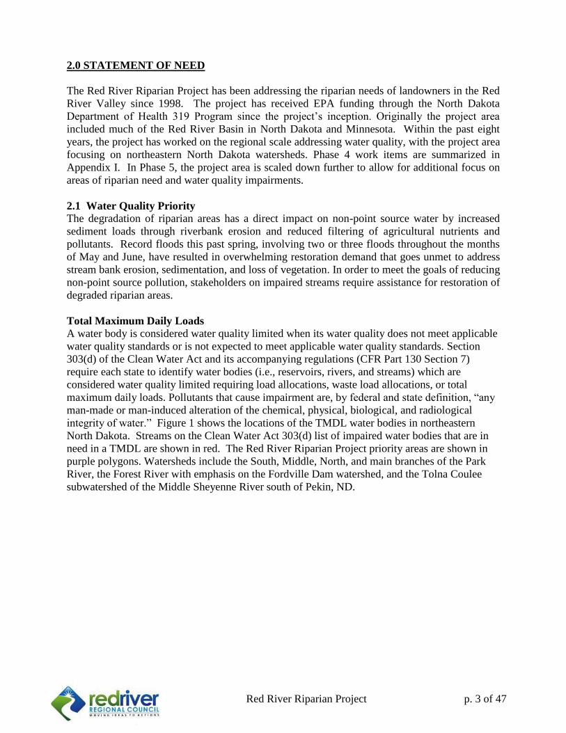
integrity of water.” Figure 1 shows the locations of the TMDL water bodies in northeastern
North Dakota. Streams on the Clean Water Act 303(d) list of impaired water bodies that are in
need in a TMDL are shown in red. The Red River Riparian Project priority areas are shown in
purple polygons. Watersheds include the South, Middle, North, and main branches of the Park
River, the Forest River with emphasis on the Fordville Dam watershed, and the Tolna Coulee
subwatershed of the Middle Sheyenne River south of Pekin, ND.
4
Red River Riparian Project p. 4 of 47
Figure 1. Priority Watersheds for the Red River Riparian Project (J. Gross, NDDH 2013)
2.2 Impacts to Water Bodies and Riparian Areas
Impairments found in north eastern North Dakota streams have included Copper, Selenium,
Lead, Cadmium, e. coli, sedimentation/siltation, or combination of benthic or fishes assessments.
Over 363 miles of streams are experiencing some form of impairment in our region.
Northeastern North Dakota watersheds have been impacted for over a century by land
management decisions in agricultural production, grazing operations, and urbanization. Riparian
forests have been impacted heavily by the decline of the American Elm brought on by Dutch
Elm Disease. The subsequent invasion of non-native invasive plant species into riparian areas
have greatly affected the composition of riparian plant communities, by the substitution of low
functioning, shallow rooted species in these areas. The restoration of highly functional plants,
shrubs, and trees allow for the re-stabilization of stream banks in some instances.
On top of the already degraded riparian conditions created by land management choices and the
subsequent changes in ecology, some watersheds have experienced devastating changes in
hydrology. Changes in hydrologic regime, thought to be a combined result of changes in climate
couples with changes in methods of water management, result in what appears to be accelerated
erosion rates of stream banks and loss of riparian vegetative cover in some areas.

5
Red River Riparian Project p. 5 of 47
In Phase III of the Red River Riparian Project, Stream Visual Assessment Protocol (SVAP) was
used to assess the condition of aquatic ecosystem conditions throughout three streams in
northeastern North Dakota in 2008 (Table 1). Assessments were completed with the cooperation
of NRCS and the local Soil Conservation Districts.
Table 1. Stream Visual Assessment Protocol (SVAP) Results 3 Northeastern ND Streams
Stream Visual Assessment Protocol (SVAP) 2008: Ranking of Condition
Stream SVAP Rank Number of Sites
South Branch of Park River Good 6
Fair (high) 27
Fair (medium) 5
Fair (low) 18
Poor 34
No Ranking 5
Total sites 78
Stream SVAP Rank Number of Sites
Turtle River Good 5
Fair (high) 6
Fair (medium) 7
Fair (low) 7
Poor 50
No Ranking 0
Total sites 74 Stream SVAP Rank Number of Sites
Little South Pembina River Good 0
Fair (high) 2
Fair (medium) 0
Fair (low) 9
Poor 20
No Ranking 0
Total sites 31
The 2008 SVAP assessment of three streams indicated the need for riparian restoration work.
Since that time, water quality results from the 2012 ND 303(d) list indicate measureable
impairment levels in these streams for parameters such as sedimentation/siltation, e. coli
bacteria. These results, combined with the recent damage from the 2013 floods, provide further
indication that riparian areas are lacking in function in many areas of our streams. Moderate to
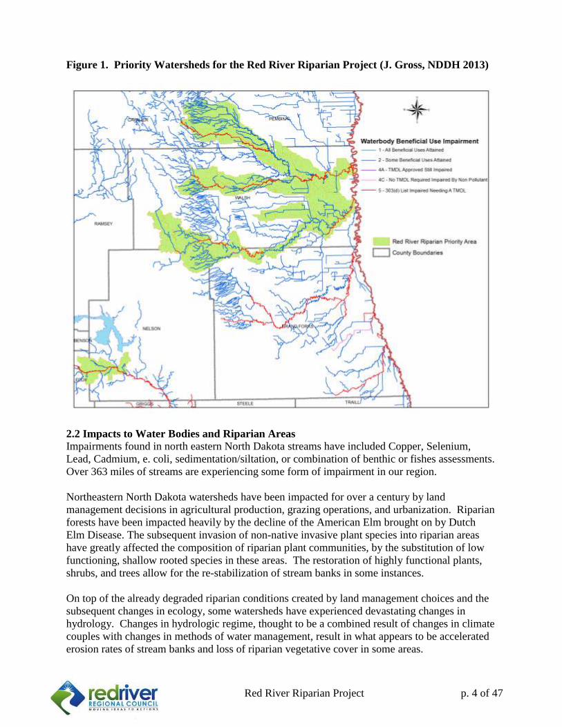
severe damage to stream banks was seen in some areas after the spring floods of 2013, especially
in the Tongue River, Pembina River, and the South branch of the Park River (Figure 2). In
addition to this evidence, the Red River Riparian Project has received overwhelming response
from landowners for restoration work, and the demand is more than what the program is
currently able to meet.
6
Red River Riparian Project p. 6 of 47
Figure 2. South Branch of Park River after late spring flood caused by heavy rains in Spring 2013
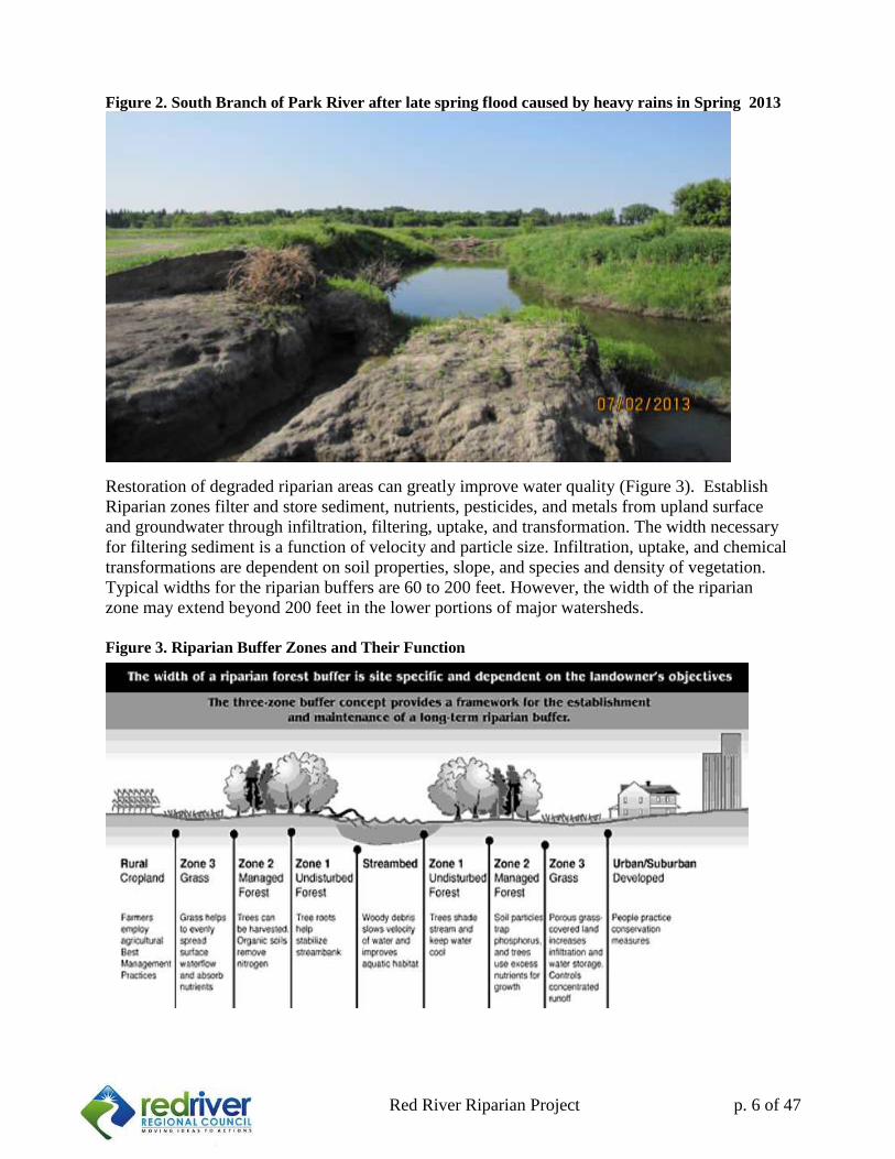
Restoration of degraded riparian areas can greatly improve water quality (Figure 3). Establish
Riparian zones filter and store sediment, nutrients, pesticides, and metals from upland surface
and groundwater through infiltration, filtering, uptake, and transformation. The width necessary
for filtering sediment is a function of velocity and particle size. Infiltration, uptake, and chemical
transformations are dependent on soil properties, slope, and species and density of vegetation.
Typical widths for the riparian buffers are 60 to 200 feet. However, the width of the riparian
zone may extend beyond 200 feet in the lower portions of major watersheds.
Figure 3. Riparian Buffer Zones and Their Function
7
Red River Riparian Project p. 7 of 47
Riparian zones also control the hydrodynamic interaction of the stream with the adjacent
uplands, stabilizing stream banks, moderating flood discharges, and improving groundwater
recharge. Riparian areas or ecotones also support high biological diversity and productivity of
vegetation, mammals, birds, and fish.
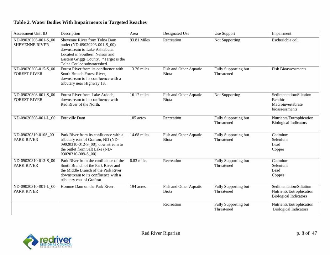
Identified Water Bodies
The following water bodies are identified in the ND 2012 Integrated Section 305(b) Water
Quality Assessment Report & Section 303(d) List of Impaired Water Bodies, (Table 2). There
are 138 miles of impaired streams, of which 55 miles are not supporting fish and other aquatic
biota. The remaining 83 miles of impaired streams are fully supporting fish and other aquatic
biota, however, are threatened. There are 379 acres of impaired reservoirs in our project area,
belonging to Homme Dam and Fordville Dam.
Prioritization of river reaches within high priority watersheds of the, South Branch of the Park
River, Forest River, and Middle Sheyenne in Nelson County will be the key components of this
riparian project proposal. The Section 303(d) list of impaired water bodies with sediment as an
impairment will have continued landowner outreach and restoration efforts. The Middle
Sheyenne River in Nelson County has impairment due to e. coli. The Riparian Project would
like to continue working with livestock producers in Osago, Bergen, and Nesheim Townships.
We have had success implementing rotational grazing with off channel livestock watering
system through use of pipelines, and we have more producers interested in these practices.
8
Red River Riparian p. 8 of 47
Table 2. Water Bodies With Impairments in Targeted Reaches
Assessment Unit ID Description Area Designated Use Use Support Impairment
ND-09020203-001-S_00
SHEYENNE RIVER
Sheyenne River from Tolna Dam
outlet (ND-09020203-001-S_00)
downstream to Lake Ashtabula.
Located in Southern Nelson and
Eastern Griggs County. *Target is the
Tolna Coulee subwatershed.
93.81 Miles Recreation Not Supporting Escherichia coli
ND-09020308-015-S_00
FOREST RIVER
Forest River from its confluence with
South Branch Forest River,
downstream to its confluence with a
tributary near Highway 18.
13.26 miles Fish and Other Aquatic
Biota
Fully Supporting but
Threatened
Fish Bioassessments
ND-09020308-001-S_00
FOREST RIVER
Forest River from Lake Ardoch,
downstream to its confluence with
Red River of the North.
16.17 miles Fish and Other Aquatic
Biota
Not Supporting Sedimentation/Siltation
Benthic-
Macroinvertebrate
bioassessments
ND-09020308-001-L_00 Fordville Dam 185 acres Recreation Fully Supporting but
Threatened
Nutrients/Eutrophication
Biological Indicators
ND-09020310-010S_00
PARK RIVER
Park River from its confluence with a
tributary east of Grafton, ND (ND-
09020310-012-S_00), downstream to
the outlet from Salt Lake (ND-
09020310-009-S_00).
14.68 miles Fish and Other Aquatic
Biota
Fully Supporting but
Threatened
Cadmium
Selenium
Lead
Copper
ND-09020310-013-S_00
PARK RIVER
Park River from the confluence of the
South Branch of the Park River and
the Middle Branch of the Park River
downstream to its confluence with a
tributary east of Grafton.
6.83 miles Recreation Fully Supporting but
Threatened
Cadmium
Selenium
Lead
Copper
ND-09020310-001-L_00
PARK RIVER
Homme Dam on the Park River. 194 acres Fish and Other Aquatic
Biota
Fully Supporting but
Threatened
Sedimentation/Siltation
Nutrients/Eutrophication
Biological Indicators
Recreation Fully Supporting but
Threatened
Nutrients/Eutrophication
Biological Indicators
9
Red River Riparian p. 9 of 47
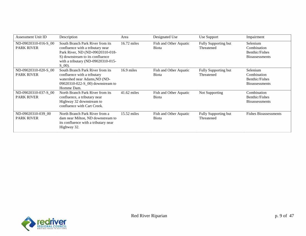
Assessment Unit ID Description Area Designated Use Use Support Impairment
ND-09020310-016-S_00
PARK RIVER
South Branch Park River from its
confluence with a tributary near
Park River, ND (ND-09020310-018-
S) downstream to its confluence
with a tributary (ND-09020310-015-
S_00).
16.72 miles Fish and Other Aquatic
Biota
Fully Supporting but
Threatened
Selenium
Combination
Benthic/Fishes
Bioassessments
ND-09020310-020-S_00
PARK RIVER
South Branch Park River from its
confluence with a tributary
watershed near Adams,ND (ND-
09020310-022-S_00) downstream to
Homme Dam.
16.9 miles Fish and Other Aquatic
Biota
Fully Supporting but
Threatened
Selenium
Combination
Benthic/Fishes
Bioassessments
ND-09020310-037-S_00
PARK RIVER
North Branch Park River from its
confluence, a tributary near
Highway 32 downstream to
confluence with Cart Creek.
41.62 miles Fish and Other Aquatic
Biota
Not Supporting Combination
Benthic/Fishes
Bioassessments
ND-09020310-039_00
PARK RIVER
North Branch Park River from a
dam near Milton, ND downstream to
its confluence with a tributary near
Highway 32.
15.52 miles Fish and Other Aquatic
Biota
Fully Supporting but
Threatened
Fishes Bioassessments
10
Red River Riparian Project p. 10 of 47
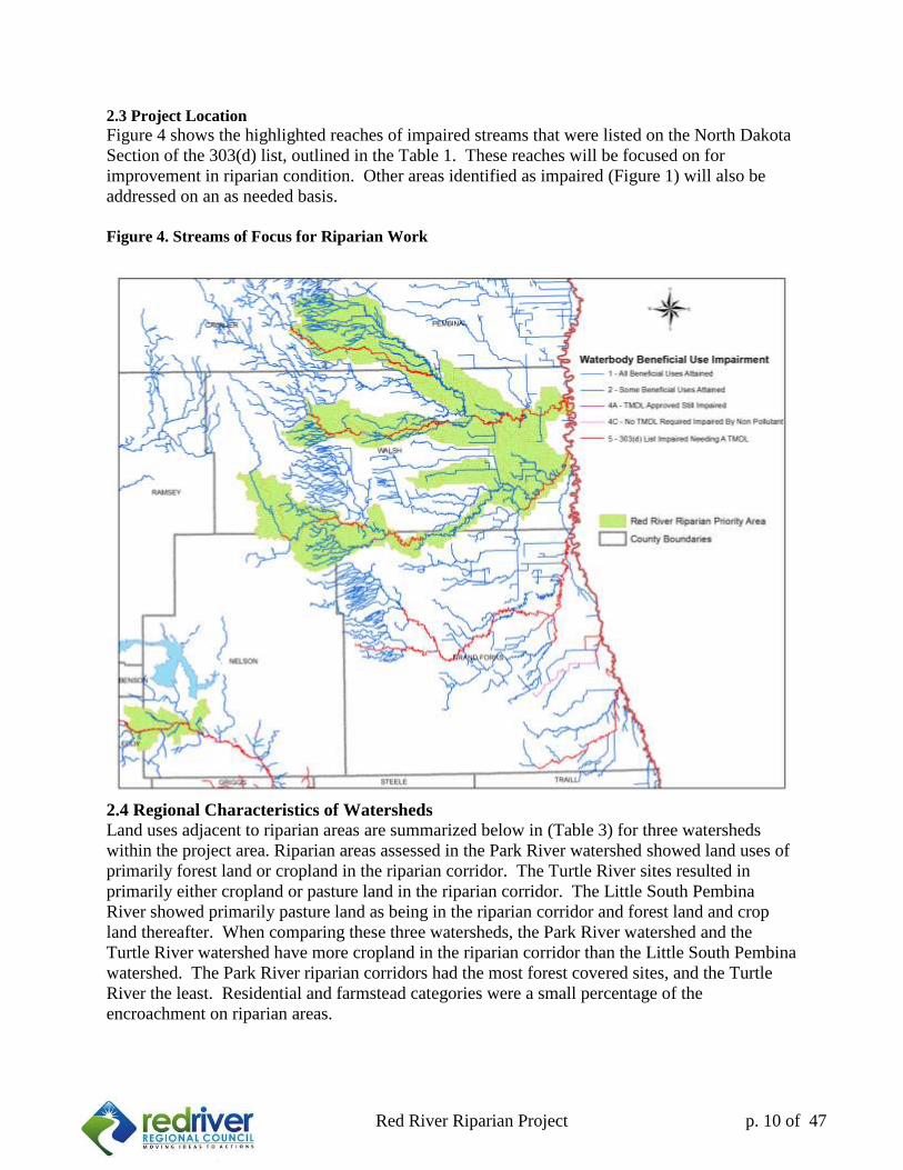
2.3 Project Location
Figure 4 shows the highlighted reaches of impaired streams that were listed on the North Dakota
Section of the 303(d) list, outlined in the Table 1. These reaches will be focused on for
improvement in riparian condition. Other areas identified as impaired (Figure 1) will also be
addressed on an as needed basis.
Figure 4. Streams of Focus for Riparian Work
2.4 Regional Characteristics of Watersheds
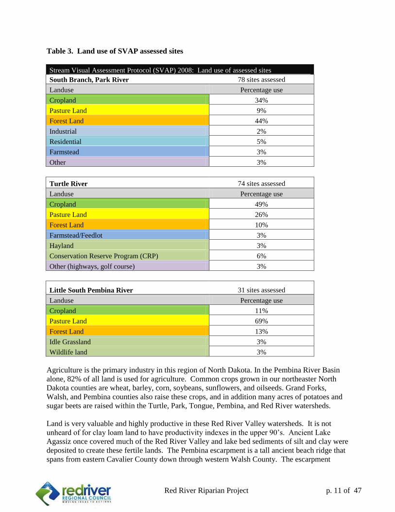
Land uses adjacent to riparian areas are summarized below in (Table 3) for three watersheds
within the project area. Riparian areas assessed in the Park River watershed showed land uses of
primarily forest land or cropland in the riparian corridor. The Turtle River sites resulted in
primarily either cropland or pasture land in the riparian corridor. The Little South Pembina
River showed primarily pasture land as being in the riparian corridor and forest land and crop
land thereafter. When comparing these three watersheds, the Park River watershed and the
Turtle River watershed have more cropland in the riparian corridor than the Little South Pembina
watershed. The Park River riparian corridors had the most forest covered sites, and the Turtle
River the least. Residential and farmstead categories were a small percentage of the
encroachment on riparian areas.
11
Red River Riparian Project p. 11 of 47
Table 3. Land use of SVAP assessed sites
Stream Visual Assessment Protocol (SVAP) 2008: Land use of assessed sites
South Branch, Park River 78 sites assessed
Landuse Percentage use
Cropland 34%
Pasture Land 9%
Forest Land 44%
Industrial 2%
Residential 5%
Farmstead 3%
Other 3%
Turtle River 74 sites assessed
Landuse Percentage use
Cropland 49%
Pasture Land 26%
Forest Land 10%
Farmstead/Feedlot 3%
Hayland 3%
Conservation Reserve Program (CRP) 6%
Other (highways, golf course) 3%
Little South Pembina River 31 sites assessed
Landuse Percentage use
Cropland 11%
Pasture Land 69%
Forest Land 13%
Idle Grassland 3%
Wildlife land 3%
Agriculture is the primary industry in this region of North Dakota. In the Pembina River Basin
alone, 82% of all land is used for agriculture. Common crops grown in our northeaster North
Dakota counties are wheat, barley, corn, soybeans, sunflowers, and oilseeds. Grand Forks,
Walsh, and Pembina counties also raise these crops, and in addition many acres of potatoes and
sugar beets are raised within the Turtle, Park, Tongue, Pembina, and Red River watersheds.
Land is very valuable and highly productive in these Red River Valley watersheds. It is not
unheard of for clay loam land to have productivity indexes in the upper 90’s. Ancient Lake
Agassiz once covered much of the Red River Valley and lake bed sediments of silt and clay were
deposited to create these fertile lands. The Pembina escarpment is a tall ancient beach ridge that
spans from eastern Cavalier County down through western Walsh County. The escarpment
12
Red River Riparian Project p. 12 of 47
contains deposits of sand and gravel within layers of shale. The weathering of these shale layers
can set the basis for highly erodible soils comprised of silty clay loam. The Pembina, Tongue,
and Park Rivers at times flow through areas of Highly Erodible Land (HEL) as categorized by
NRCS.
2.5 Sources of pollutants and degradation
The agriculturally dominated areas of northeastern North Dakota have water quality impairments
for various reasons. Cultivation leads to soil transport and erosion that can result in high
amounts of runoff and sedimentation when water runs through riparian areas of poor function.
Some areas have nutrient rich soil to begin with, and as soil erodes and is transported into the
rivers as sediments, the water quality results reflect these erosional inputs. Selenium is one
example of a naturally occurring element that becomes a pollutant when too much of it exists in
the surface water. Fertilization of crops and season long livestock grazing along riparian areas
can also contribute to water quality impairments, in particular excess phosphorus and nitrogen
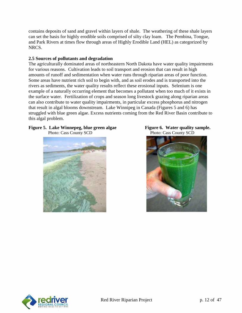
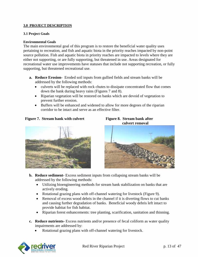
that result in algal blooms downstream. Lake Winnipeg in Canada (Figures 5 and 6) has
struggled with blue green algae. Excess nutrients coming from the Red River Basin contribute to
this algal problem.
Figure 5. Lake Winnepeg, blue green algae Figure 6. Water quality sample. Photo: Cass County SCD Photo: Cass County SCD
13
Red River Riparian Project p. 13 of 47
3.0 PROJECT DESCRIPTION
3.1 Project Goals
Environmental Goals
The main environmental goal of this program is to restore the beneficial water quality uses
pertaining to recreation, and fish and aquatic biota in the priority reaches impacted by non-point
source pollution. Fish and aquatic biota in priority reaches are impacted to levels where they are
either not supporting, or are fully supporting, but threatened in use. Areas designated for
recreational water use improvements have statuses that include not supporting recreation, or fully
supporting, but threatened recreational use.
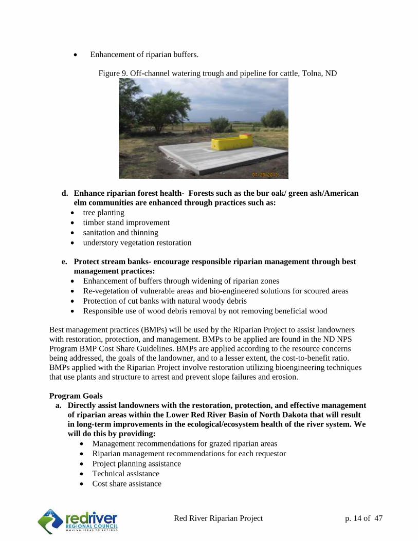
a. Reduce Erosion- Eroded soil inputs from gullied fields and stream banks will be
addressed by the following methods:
culverts will be replaced with rock chutes to dissipate concentrated flow that comes
down the bank during heavy rains (Figures 7 and 8).
Riparian vegetation will be restored on banks which are devoid of vegetation to
prevent further erosion.
Buffers will be enhanced and widened to allow for more degrees of the riparian
corridor to be intact and serve as an effective filter.
Figure 7. Stream bank with culvert Figure 8. Stream bank after
culvert removal
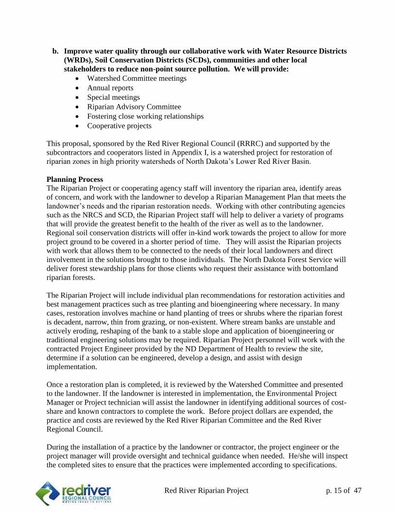
b. Reduce sediment- Excess sediment inputs from collapsing stream banks will be
addressed by the following methods:
Utilizing bioengineering methods for stream bank stabilization on banks that are
actively eroding.
Rotational grazing plans with off-channel watering for livestock (Figure 9).
Removal of excess wood debris in the channel if it is diverting flows to cut banks
and causing further degradation of banks. Beneficial woody debris left intact to
provide habitat for fish habitat.
Riparian forest enhancements: tree planting, scarification, sanitation and thinning.
c. Reduce nutrients- Excess nutrients and/or presence of fecal coliform as water quality
impairments are addressed by:
Rotational grazing plans with off-channel watering for livestock.
14
Red River Riparian Project p. 14 of 47
Enhancement of riparian buffers.
Figure 9. Off-channel watering trough and pipeline for cattle, Tolna, ND
d. Enhance riparian forest health- Forests such as the bur oak/ green ash/American
elm communities are enhanced through practices such as:
tree planting
timber stand improvement
sanitation and thinning
understory vegetation restoration
e. Protect stream banks- encourage responsible riparian management through best
management practices:
Enhancement of buffers through widening of riparian zones
Re-vegetation of vulnerable areas and bio-engineered solutions for scoured areas
Protection of cut banks with natural woody debris
Responsible use of wood debris removal by not removing beneficial wood
Best management practices (BMPs) will be used by the Riparian Project to assist landowners
with restoration, protection, and management. BMPs to be applied are found in the ND NPS
Program BMP Cost Share Guidelines. BMPs are applied according to the resource concerns
being addressed, the goals of the landowner, and to a lesser extent, the cost-to-benefit ratio.
BMPs applied with the Riparian Project involve restoration utilizing bioengineering techniques
that use plants and structure to arrest and prevent slope failures and erosion.
Program Goals
a. Directly assist landowners with the restoration, protection, and effective management
of riparian areas within the Lower Red River Basin of North Dakota that will result
in long-term improvements in the ecological/ecosystem health of the river system. We
will do this by providing:
Management recommendations for grazed riparian areas
Riparian management recommendations for each requestor
Project planning assistance
Technical assistance
Cost share assistance
15
Red River Riparian Project p. 15 of 47
b. Improve water quality through our collaborative work with Water Resource Districts
(WRDs), Soil Conservation Districts (SCDs), communities and other local
stakeholders to reduce non-point source pollution. We will provide:
Watershed Committee meetings
Annual reports
Special meetings
Riparian Advisory Committee
Fostering close working relationships
Cooperative projects
This proposal, sponsored by the Red River Regional Council (RRRC) and supported by the
subcontractors and cooperators listed in Appendix I, is a watershed project for restoration of
riparian zones in high priority watersheds of North Dakota’s Lower Red River Basin.
Planning Process
The Riparian Project or cooperating agency staff will inventory the riparian area, identify areas
of concern, and work with the landowner to develop a Riparian Management Plan that meets the
landowner’s needs and the riparian restoration needs. Working with other contributing agencies
such as the NRCS and SCD, the Riparian Project staff will help to deliver a variety of programs
that will provide the greatest benefit to the health of the river as well as to the landowner.
Regional soil conservation districts will offer in-kind work towards the project to allow for more
project ground to be covered in a shorter period of time. They will assist the Riparian projects
with work that allows them to be connected to the needs of their local landowners and direct
involvement in the solutions brought to those individuals. The North Dakota Forest Service will
deliver forest stewardship plans for those clients who request their assistance with bottomland
riparian forests.
The Riparian Project will include individual plan recommendations for restoration activities and
best management practices such as tree planting and bioengineering where necessary. In many
cases, restoration involves machine or hand planting of trees or shrubs where the riparian forest
is decadent, narrow, thin from grazing, or non-existent. Where stream banks are unstable and
actively eroding, reshaping of the bank to a stable slope and application of bioengineering or
traditional engineering solutions may be required. Riparian Project personnel will work with the
contracted Project Engineer provided by the ND Department of Health to review the site,
determine if a solution can be engineered, develop a design, and assist with design
implementation.
Once a restoration plan is completed, it is reviewed by the Watershed Committee and presented
to the landowner. If the landowner is interested in implementation, the Environmental Project
Manager or Project technician will assist the landowner in identifying additional sources of cost-
share and known contractors to complete the work. Before project dollars are expended, the
practice and costs are reviewed by the Red River Riparian Committee and the Red River
Regional Council.
During the installation of a practice by the landowner or contractor, the project engineer or the
project manager will provide oversight and technical guidance when needed. He/she will inspect
the completed sites to ensure that the practices were implemented according to specifications.
16
Red River Riparian Project p. 16 of 47
The landowner is reimbursed for up to 60% of the project cost plus any additional cost share
provided through the Riparian Project from sources such as ND Game and Fish Department or a
local water resource board.
Once restoration is implemented in priority reaches, it will be necessary to monitor those reaches
as well as individual demonstration sites in order to measure the success of the practice and the
benefits to watershed health. Experience gained on the Riparian Project suggests that long-term
monitoring (5-10 years) is necessary to observe measurable results from riparian restoration and
management. An additional description of the Riparian Project proposal monitoring plan is
included in Section 5.0 Evaluation and Monitoring Plan.
17
Red River Riparian Project p. 17 of 47
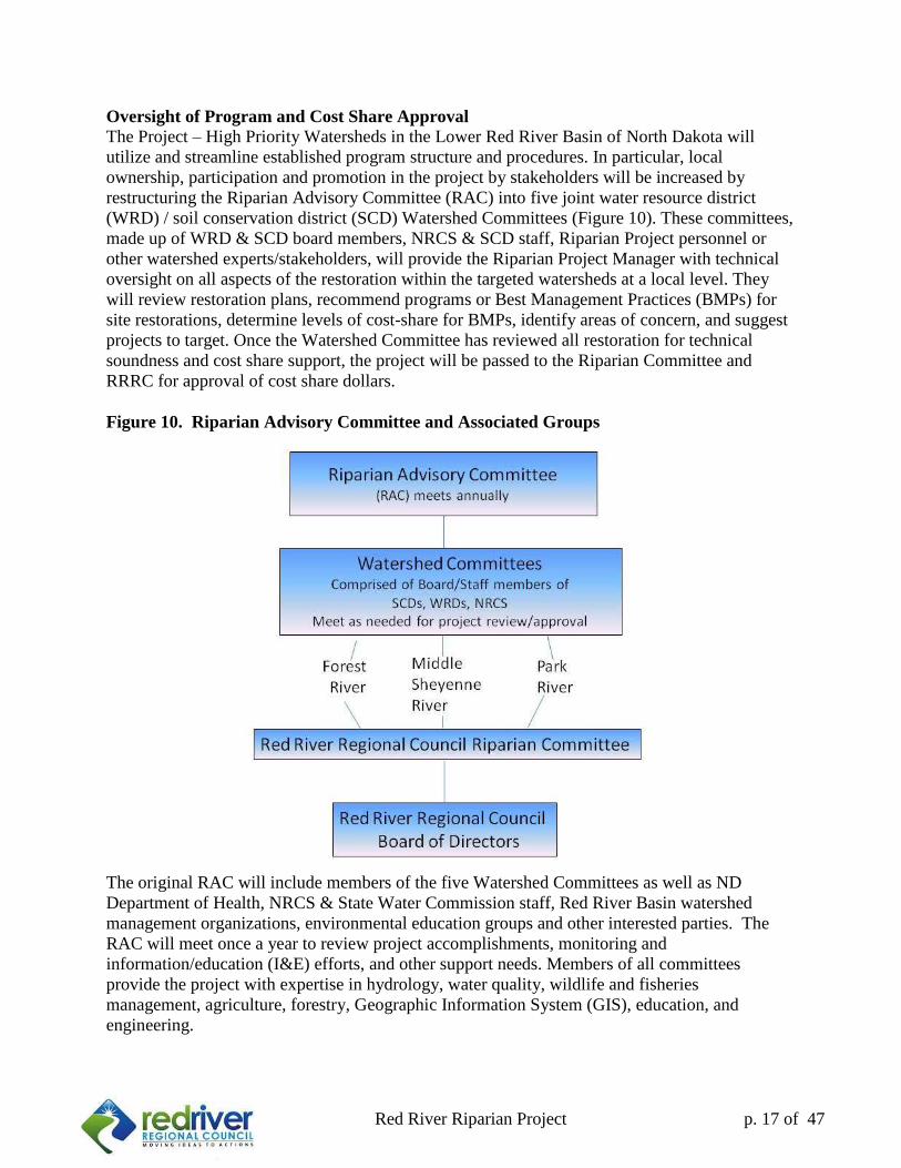
Oversight of Program and Cost Share Approval
The Project – High Priority Watersheds in the Lower Red River Basin of North Dakota will
utilize and streamline established program structure and procedures. In particular, local
ownership, participation and promotion in the project by stakeholders will be increased by
restructuring the Riparian Advisory Committee (RAC) into five joint water resource district
(WRD) / soil conservation district (SCD) Watershed Committees (Figure 10). These committees,
made up of WRD & SCD board members, NRCS & SCD staff, Riparian Project personnel or
other watershed experts/stakeholders, will provide the Riparian Project Manager with technical
oversight on all aspects of the restoration within the targeted watersheds at a local level. They
will review restoration plans, recommend programs or Best Management Practices (BMPs) for
site restorations, determine levels of cost-share for BMPs, identify areas of concern, and suggest
projects to target. Once the Watershed Committee has reviewed all restoration for technical
soundness and cost share support, the project will be passed to the Riparian Committee and
RRRC for approval of cost share dollars.
Figure 10. Riparian Advisory Committee and Associated Groups
The original RAC will include members of the five Watershed Committees as well as ND
Department of Health, NRCS & State Water Commission staff, Red River Basin watershed
management organizations, environmental education groups and other interested parties. The
RAC will meet once a year to review project accomplishments, monitoring and
information/education (I&E) efforts, and other support needs. Members of all committees
provide the project with expertise in hydrology, water quality, wildlife and fisheries
management, agriculture, forestry, Geographic Information System (GIS), education, and
engineering.
18
Red River Riparian Project p. 18 of 47
3.2 Objectives and Tasks:
GOAL: Restore the riparian function of waterbodies within the priority watersheds by
delivering the technical expertise and financial support needed to effectively
stabilize degraded areas and improve management within the riparian corridors.
Objective 1. Manage the project, coordinate efforts with local entities, and facilitate
delivery of assistance.
Task 1. Coordinate delivery of multiple programs involving riparian management by
combining efforts of the project sponsors and contributing agencies. Provide
project manager and utilize staff and administrative support within the Red River
Regional Council, including telephone, audit, accounting, supplies, and secretarial
support.
Products: 1.2 FTE positions overseen by the RRRC Executive Director of
which:
1) 1.0 FTE Environmental Project Manager provides program
management, project management and design.
2) 0.2 FTE Administrative support provided at process
reimbursements, assist with clients, and provide general
secretarial support.
Cost: $ 235,950 (October 2014-September 2016) for 1.2 FTE
Task 2. Utilize advisory committees to assist the Riparian Project Manager with project
oversight. Five Joint WRD/SCD Watershed Committees will consist of local
board members and expertise appropriate for each watershed in the project.
Federal, state, and local agencies and non-governmental organizations with
expertise in water quality, forestry, agricultural conservation, hydrology,
engineering, and wildlife management will be utilized.
Products: 1) Watershed committee meetings
Cost: In-kind match will be recorded, estimated at $8,000 per year for a
total of $16,000 during the two year project phase.
Task 3. Provide riparian technical assistance to landowners. Directly assist landowners
with the protection, responsible management, and restoration in targeted river
reaches within high priority watersheds of the Lower Red River Basin of North
Dakota (Restoration listed in Table 9 – BMP Budget). Coordinate with range and
engineering technical assistance.
Products: 1) Provide technical assistance to landowners with riparian
restoration. Also, assist with project coordination, outreach to
stakeholders and cooperators, development of management plans,
prescription of practices, and assistance in coordinating
implementation.
Cost: No additional cost - Included in the cost of the Environmental Project
Manager
19
Red River Riparian Project p. 19 of 47
Objective 2. Monitor river reaches where best management practices for restoration and
management have been implemented. Monitoring will help demonstrate the weaknesses and
strengths of projects, and provide a learning opportunity on how to improve upon implementing
effective practices.
Task 4. Using photo point monitoring protocols to provide follow-up monitoring on a
sample size of 4 projects that were implemented in high priority watersheds.
Recommend repairs to projects that do not meet the operation and maintenance
requirements that were agreed to.
Products: 1) Site Reports with photos points and vegetation surveys
Cost: No additional cost. Completed by (RRRC) Environmental Project
Manager
Objective 3. Provide technical and financial assistance to restore, protect, and manage
riparian areas along a minimum of 10 river miles in the Lower Red River
Basin.
Task 5. Provide financial assistance to landowners and establish best management
practices for riparian management, grazing management, riparian vegetation
restoration plantings, bioengineering and other construction restoration as listed in
Table 10 – BMP Budget.
Products: 1) A minimum of 15 Riparian Management Plans which may
include restoration designs, grazing plans, forest management
plans, tree planting plans
2) 10 miles of restored riparian areas (12.0 restored acres is
equivalent to 1 mile of restoration). Landowner technical
assistance may include forest management practices and range
planning as needed.
Cost: $373,000 (Estimated BMP costs October 2014 – September 2016)
Objective 4: Educate stakeholders is through the collection of pertinent information that
can be used to demonstrate change in these river systems with and without
riparian enhancements.
Task 6. Use specialized survey equipment and software to establish reference cross
sectional data for priority reaches of the target watershed to be used in restoration
design planning of degraded areas.
Products: 1) Regional stream baseline cross-sectional data report
Cost: Total: $35,200
$28,550 Trimble S6 Robotic Total Station Survey Station
$1,859 S6 Power Kit, $1,459 Target Kit, $482 Carry Case
+$2,850 RIVERmorph software
Task 7. Conduct stream bank surveys using Trimble survey equipment, and incorporate
Rosgen Natural Channel Design bio-engineering practices to NRCS specifications.
Includes additional training in applying methods to restoration design and NRCS
technical service provider training.
20
Red River Riparian Project p. 20 of 47
Products: 1) Bio-engineered designs using Rosgen methods
Cost: $2,000 David Rosgen training class and NRCS training,
RIVERmorph Software previously listed in Task 6.
Objective 5. Increase understanding of riparian ecosystems and riparian management methods
focused towards restoration/management of riparian functionality and
sustainability in the Lower Red River Basin.
Task 8. Instill ownership and promote stewardship of river reaches through support of
local school and volunteer group involvement in restoration implementation and
subsequent monitoring activities. Provide technical support for local secondary
school curriculums, volunteer groups, or agencies.
Products: 1) Volunteer buffer plantings with local groups and participation in
riparian presentation at water festivals/ ECO-Ed camps.
2) Provide riparian information and education materials which
instills ownership in sites as well as riparian values.
Cost: Costs covered by Task 3 (RRRC)
Task 9. Inform and educate basin stakeholders and natural resource professionals on the
benefits of healthy riparian areas to influence land management choices that result
in measurable watershed health improvements. Develop information and
education materials for recommendations that are adopted by the Riparian
Advisory Committee.
Products: 1) Tours of demonstration sites and restored areas annually or upon
request.
2) Project display and website development.
3) Distribute information from past university assisted projects
including NDSU grazing recommendations, and the UND
Tongue River Hydrology Study in the City of Cavalier.
4) Organize a riparian field training session.
Cost: No additional Cost (RRRC)
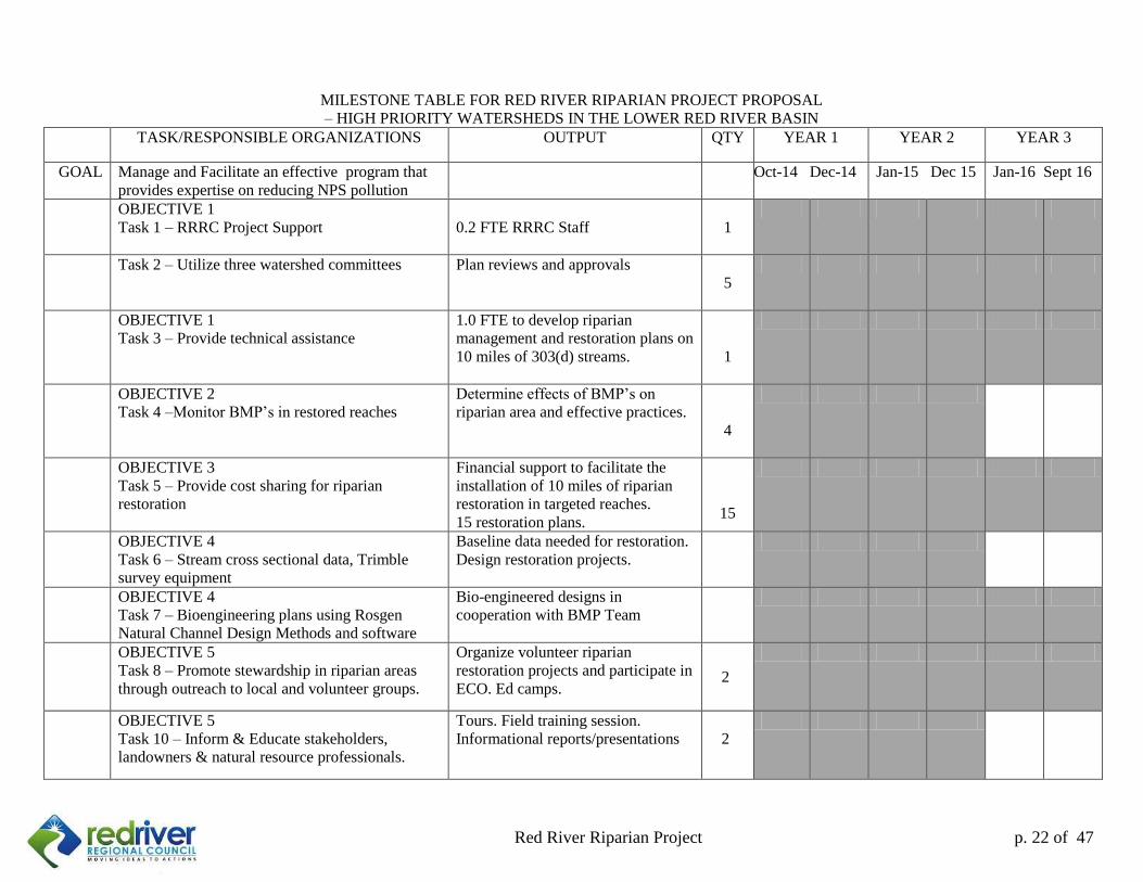
3.3 Milestone Table: Please see table on page 22.
3.4 Environmental Permits: From 2001 to 2006 the Red River Regional Council secured a
Regional General Permit (RGP 00-03) from the United States Army Corps of Engineers (US
ACE) for the reshaping of river banks, installation of stabilization structures in the channel, and
re-vegetation of the sites using practices described in the permit. Due to changes and additions to
permitting requirements with the US ACE, the RRRC no longer needs a Regional General
Permit to cover most practices being installed, but will pursue this as an option if deemed
necessary in the future. Most project work can be covered under a Nationwide Permit with the
US ACE. Projects that include cultural resources identified by the North Dakota Department of
Health NPS Program will receive a review by ND State Historic Preservation Office.
3.5 Lead Agency: The Red River Regional Council (RRRC) will be the lead project sponsor.
The RRRC is the appropriate coordination agency to implement this project because it has
21
Red River Riparian Project p. 21 of 47
successfully sponsored the Red River Basin Riparian Project since 1994. The RRRC provides a
direct link to landowners and local elected officials who have the responsibility to manage soil
and water resources. The RRRC also works closely with the Red River Riparian Committee
which serves as the subcommittee for riparian project oversight. The project will be directed by
the Environmental Projects Manager, and implemented with the assistance of the Project
Technician under the direction of the Executive Director, Red River Regional Council, and
oversight by the Red River Riparian Committee and Regional Council. The Environmental
Projects Manager is familiar with all aspects of the riparian project and has expertise in riparian
ecology, range science, forestry, forest stand improvement, and a working knowledge of all
riparian restoration practices including bioengineering.
3.6 Roles/Responsibilities for Proper Oversight and Management of BMPs: During the
project period of performance, the RRRC will be responsible for ensuring that project
participants comply with all aspects of the NPS 319 Program. Procedures in the North Dakota
NPS Management Program Cost-share Guidelines for NPS Control BMPs (June 2013) will be
followed closely.
22
Red River Riparian Project p. 22 of 47
MILESTONE TABLE FOR RED RIVER RIPARIAN PROJECT PROPOSAL
– HIGH PRIORITY WATERSHEDS IN THE LOWER RED RIVER BASIN
TASK/RESPONSIBLE ORGANIZATIONS OUTPUT QTY YEAR 1 YEAR 2 YEAR 3
GOAL Manage and Facilitate an effective program that
provides expertise on reducing NPS pollution
Oct-14 Dec-14 Jan-15 Dec 15 Jan-16 Sept 16
OBJECTIVE 1
Task 1 – RRRC Project Support
0.2 FTE RRRC Staff
1
Task 2 – Utilize three watershed committees Plan reviews and approvals
5
OBJECTIVE 1
Task 3 – Provide technical assistance
1.0 FTE to develop riparian
management and restoration plans on
10 miles of 303(d) streams.
1
OBJECTIVE 2
Task 4 –Monitor BMP’s in restored reaches
Determine effects of BMP’s on
riparian area and effective practices.
4
OBJECTIVE 3
Task 5 – Provide cost sharing for riparian
restoration
Financial support to facilitate the
installation of 10 miles of riparian
restoration in targeted reaches.
15 restoration plans.
15
OBJECTIVE 4
Task 6 – Stream cross sectional data, Trimble
survey equipment
Baseline data needed for restoration.
Design restoration projects.
OBJECTIVE 4
Task 7 – Bioengineering plans using Rosgen
Natural Channel Design Methods and software
Bio-engineered designs in
cooperation with BMP Team
OBJECTIVE 5
Task 8 – Promote stewardship in riparian areas
through outreach to local and volunteer groups.
Organize volunteer riparian
restoration projects and participate in
ECO. Ed camps. 2
OBJECTIVE 5
Task 10 – Inform & Educate stakeholders,
landowners & natural resource professionals.
Tours. Field training session.
Informational reports/presentations
2
23
Red River Riparian Project p. 23 of 47
4.0 COORDINATION PLAN:
4.1 Lead Project Sponsor and Subcontractors: This proposal is sponsored by the Red River
Regional Council (RRRC). The Red River Riparian Committee is a subcommittee of the RRRC
assigned with oversight responsibilities of this riparian project proposal. The RRRC will be the
lead project sponsor and will be responsible for coordination of all aspects of the project. As
such, the RRRC will contract with the ND Department of Health (NDDH) and develop and
oversee subcontracts with the project partners to complete the work described in this proposal.
The RRRC will be responsible for all financial aspects of the project including requesting
reimbursement from the NDDH, payments to subcontractors, cost share disbursements to
participants, identification and tracking of cash match and in-kind assistance from local sources,
and overall project accounting. Specific responsibilities of the Environmental Project Manager
will include coordinating with project personnel, drafting and administering subcontracts,
reporting progress to the RRRC, overseeing financial reporting, submitting semi-annual, annual
and final reports, coordinating Joint Watershed Committees, conducting Riparian Advisory
Committee meetings, leading information and education activities, representing and promoting
the Riparian Project, and coordinating with other basin environmental and water management
efforts in the Lower Red River Basin of North Dakota.
Soil Conservation Districts in the five counties will provide in-kind services towards the Red
River Riparian Project as time permits. Each soil conservation district has been asked to pledge
both money and time to support this project. Tasks that some soil conservation districts in the
region have volunteered to assist with include gathering landowner information, conducting
initial site visit, providing GIS maps of the project area, and tree planting design drawings. Soil
conservation districts and the Red River Riparian Project also have the opportunity to write for
project specific grants such as grants from the Great Plains Fish Habitat Partnership, the National
Wild Turkey Federation, the North Dakota Natural Resources Trust, North Dakota Outdoor
Heritage Fund and many others.
The project will continue to work with cooperating agencies, such as NRCS, on ongoing
monitoring efforts to determine the effectiveness of riparian restoration efforts in meeting overall
program goals not only in the 319 Program but also the Conservation Reserve Program (CRP),
Wetland Reserve Program (WRP), Emergency Watershed Program (EWP), Environmental
Quality Incentives Program (EQIP) and other USDA programs. Information gained from these
assessments would be useful not only to the Riparian Project, but to other state and federal
programs.
Educating basin stakeholders on the benefits of healthy riparian areas and providing training to
basin resource managers will continue to be a high priority of the Riparian Project. The project
will host training workshops, conduct tours of restoration sites, provide grazing assistance to
producers, and maintain a website to offer landowners, cooperators and stakeholders information
on the latest in riparian restoration and management techniques.
Educational efforts will focus on: 1) continuing to provide training to restoration contractors and
local soil and water resource district staff; 2) participating in basin water quality and
24
Red River Riparian Project p. 24 of 47
management workshops and conferences; 3) supporting existing and future basin-wide
educational efforts; and 4) distributing project information to basin stakeholders.
The riparian project will also utilize the services of NDSU Extension Grazing Specialist Kevin
Sedivec to provide onsite consultations with ranchers and review of range management
prescriptions in riparian forest management plans. The ND Forest Service will provide forest
stewardship plans to landowners on an as needed basis as part of their role in providing forestry
support to landowners in North Dakota.
4.2 Local Support for Riparian Project: This Red River Riparian Project proposal is supported
locally by landowners, county water boards, soil conservation districts, and communities in the
Lower Red River basin. This support is described in Section 2.0 Statement of Need in this
proposal. The list of project cooperators is listed in Appendix 2. The project is also supported by
the members of the Red River and Upper Sheyenne River Joint Water Resource District boards
and the Red River Basin Commission.
25
Red River Riparian Project p. 25 of 47
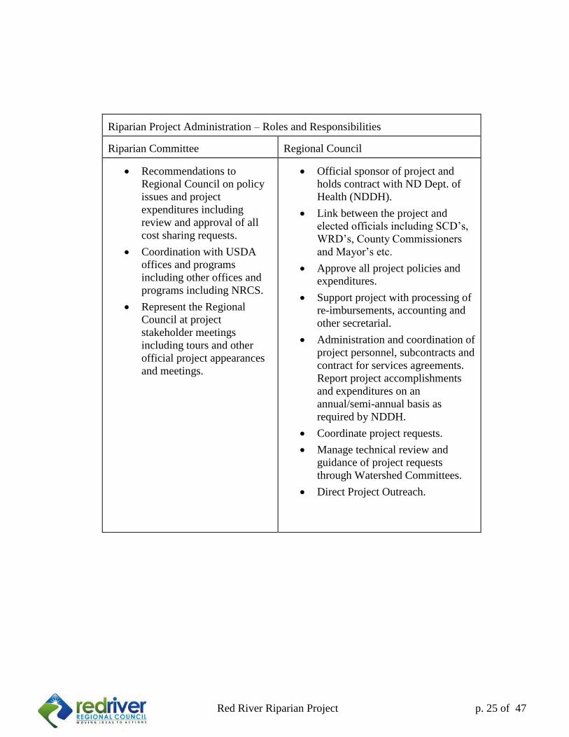
Riparian Project Administration – Roles and Responsibilities Riparian Committee
Regional Council
Recommendations to
Regional Council on policy
issues and project
expenditures including
review and approval of all
cost sharing requests.
Coordination with USDA
offices and programs
including other offices and
programs including NRCS.
Represent the Regional
Council at project
stakeholder meetings
including tours and other
official project appearances
and meetings.
Official sponsor of project and
holds contract with ND Dept. of
Health (NDDH).
Link between the project and
elected officials including SCD’s,
WRD’s, County Commissioners
and Mayor’s etc.
Approve all project policies and
expenditures.
Support project with processing of
re-imbursements, accounting and
other secretarial.
Administration and coordination of
project personnel, subcontracts and
contract for services agreements.
Report project accomplishments
and expenditures on an
annual/semi-annual basis as
required by NDDH.
Coordinate project requests.
Manage technical review and
guidance of project requests
through Watershed Committees.
Direct Project Outreach.
26
Red River Riparian Project p. 26 of 47
4.3 Coordination with Other Pertinent Programs: The project will coordinate with the NPS
BMP Team for engineering support assistance, including design of projects to NRCS
specifications. Cooperation with State agencies will be significant with the Riparian Project. In
addition, the riparian project will continue to work closely with the Turtle River Development
Phase 319 Watershed Project in the Lower Red River Basin. The Riparian Project has also
cooperated with the International Water Institute, Cass County SCD and the Natural Resource
Conservation Service (NRCS) to further watershed education, resource manager training, and
research activities in the basin and will continue to coordinate these activities in the Lower Red
River Basin. The NRCS provides many opportunities for cooperation on riparian restoration. The
Riparian Project has assisted with delivery of the EWP, EQIP and Continuous CRP throughout
the basin. The project also worked directly with NRCS personnel to plan and implement several
riparian restoration projects. This proposal continues collaboration as the new farm bill provides
additional funding for programs such as Conservation Security Program (CSP), Farmland
Protection Program (FPP), WRP, EQIP, Wildlife Habitat Incentive Program (WHIP), CRP, and
Continuous CRP. The Riparian Project will also be cooperating extensively with non-
governmental organizations, including the Greenway on the Red Trust and the Natural Resources
Trust, for expansion and improved management of riparian corridors in the Basin.
The Minnesota Pollution Control Agency's Section 319 Program, EPA Region 5, Minnesota
Department of Natural Resources and the Minnesota State Board of Soil and Water Conservation
Districts are aware of the project, and joint cooperation on both sides of the Lower Red River
Basin will be maintained. These agencies along with the Red River Basin Commission, the
International Joint Commission, the Red River Water Management Consortium, and others will
be kept up to date on the project through meetings, newsletters and conferences.
4.4 Similar Activities: The Aquatic Ecosystem Committee of the International Red River Board
has recommended that participating agencies work towards reducing Red River nutrient loading
to increase the health of Lake Winnipeg. Studies have indicated that up to 80 percent of
sediment/phosphorus loading comes from river bank erosion
5.0 EVALUATION AND MONITORING PLAN:
5.2 Monitoring Strategy: A riparian monitoring plan will be developed to assess vegetative
response to the project’s restoration practices and improved management of the riparian zone.
This plan will be designed to provide measurable data to track the success of restoration and Best
Management Practices.
Photo point monitoring will be conducted to track changes in the riparian area over time.
Monitoring will be conducted using the methods described in the US Forest Service publication
“Photo Point Monitoring Handbook: Part A-Field Procedures”(Hall , 2002) .This general
technical report (PNW-GTR-526) may be accessed at http://www.fs.fed.us/pnw/pubs/gtr526/.
Vegetation monitoring will be conducted to provide measurement of riparian vegetation cover
using the three sampling methods: cross-section method, greenline method, and woody species
regeneration method. These methods are described in the following US Forest Service
publication “Monitoring the vegetation resources in riparian areas” (Winward, 2000). This
27
Red River Riparian Project p. 27 of 47
general technical report (RMRS-GTR-47) may be accessed at
http://www.fs.fed.us/rm/pubs/rmrs_gtr047.pdf. Plant nomenclature will be referenced from
USDA Plants Database at http://plants.usda.gov.
5.3 Data Management
Data will be managed and reported via GIS wherever possible. Reports of project monitoring
results will be available for each monitored reach at the end of the project period. These reports
and any interim reports will be made available and shared with other agencies and projects
conducting current and future riparian restoration within the region. Project evaluations will be
conducted on a continuing basis by the member agencies of the Riparian Advisory Committee as
well as the Red River Regional Council Board of Directors.
5.4 Stream bank stability modeling
In phase IV, UND was contracted to study the Tongue River within the limits of the City of
Cavalier to help address stream bank failures below the dam that were threatening homes. In this
modeling process, the environmental projects manager, Sarah Braaten became familiar with the
USDA Bank Stability and Toe Erosion Model (BSTEM) for bank stability estimation. BSTEM
allowed us to understand the factors behind slope failure as it pertains to stream banks and assign
stability ratings. BSTEM ratings will be assessed on stream projects involving the stabilization
of cutbanks to determine the current state of stability of the bank under current environmental
and soil conditions. The software is free of charge and may be downloaded at
http://ars.usda.gov/Research/docs.htm?docid=5044.
5.5 Long term funding of operation and maintenance of projects
Individual landowners are responsible for the costs of operation and maintenance of the
implemented BMP for the duration of its lifespan, as listed in the BMP manual. The landowner
signs a document agreeing to this operation and maintenance obligation. If there are BMPs
funded with NRCS cost share, the NRCS is responsible for any applicable operation and
maintenance agreements for those cost shared practices.
6.0 Budget
Please see the follow page for the program budget.
Red River Riparian Project p. of 33
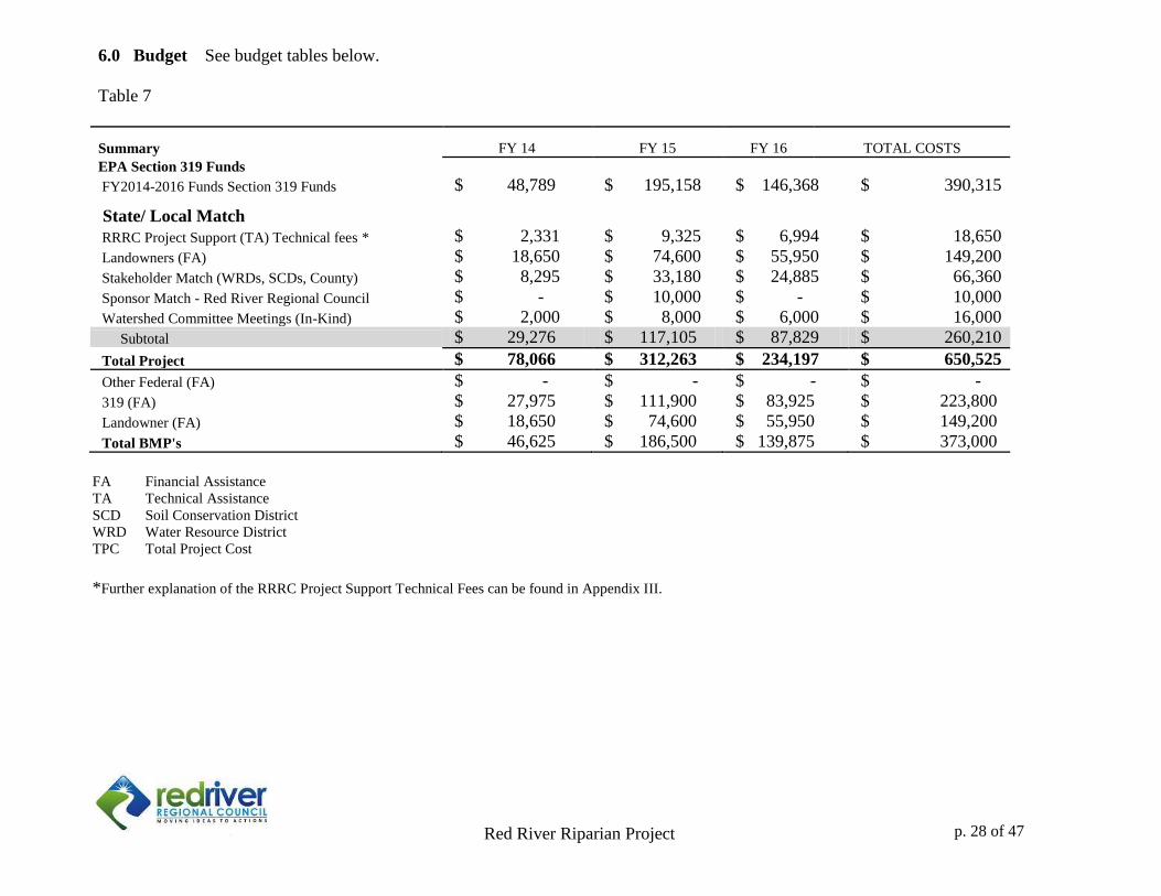
6.0 Budget See budget tables below.
Table 7
TOTAL COSTS Summary FY 14 FY 15 FY 16
EPA Section 319 Funds
FY2014-2016 Funds Section 319 Funds $ 48,789 $ 195,158 $ 146,368 $ 390,315
State/ Local Match
RRRC Project Support (TA) Technical fees * $ 2,331 $ 9,325 $ 6,994 $ 18,650
Landowners (FA) $ 18,650 $ 74,600 $ 55,950 $ 149,200
Stakeholder Match (WRDs, SCDs, County) $ 8,295 $ 33,180 $ 24,885 $ 66,360
Sponsor Match - Red River Regional Council $ - $ 10,000 $ - $ 10,000
Watershed Committee Meetings (In-Kind) $ 2,000 $ 8,000 $ 6,000 $ 16,000
Subtotal $ 29,276 $ 117,105 $ 87,829 $ 260,210
Total Project $ 78,066 $ 312,263 $ 234,197 $ 650,525
Other Federal (FA) $ - $ - $ - $ -
319 (FA) $ 27,975 $ 111,900 $ 83,925 $ 223,800
Landowner (FA) $ 18,650 $ 74,600 $ 55,950 $ 149,200
Total BMP's $ 46,625 $ 186,500 $ 139,875 $ 373,000
F FA Financial Assistance
TA Technical Assistance
SCD Soil Conservation District
WRD Water Resource District
TPC Total Project Cost
*Further explanation of the RRRC Project Support Technical Fees can be found in Appendix III.
p. 28 of 47
Red River Riparian Project p. of 33
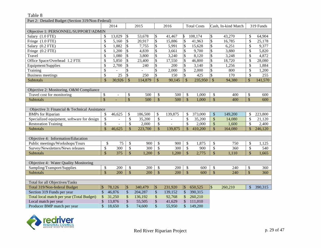
Table 8
Part 2: Detailed Budget (Section 319/Non-Federal)
2014 2015 2016 Total Costs Cash, In-kind Match 319 Funds
Objective 1: PERSONNEL/SUPPORT/ADMIN
Salary (1.0 FTE) $ 13,029 $ 53,678 $ 41,467 $ 108,174 $ 43,270 $ 64,904
Fringe (1.0 FTE) $ 5,160 $ 20,917 $ 15,886 $ 41,963 $ 16,785 $ 25,178
Salary (0.2 FTE) $ 1,882 $ 7,755 $ 5,991 $ 15,628 $ 6,251 $ 9,377
Fringe (0.2 FTE) $ 1,200 $ 4,839 $ 3,661 $ 9,700 $ 3,880 $ 5,820
Travel $ 1,080 $ 3,800 $ 3,240 $ 8,120 $ 3,248 $ 4,872
Office Space/Overhead 1.2 FTE $ 5,850 $ 23,400 $ 17,550 $ 46,800 $ 18,720 $ 28,080
Equipment/Supplies $ 2,700 $ 240 $ 200 $ 3,140 $ 1,256 $ 1,884
Training $ - $ - $ 2,000 $ 2,000 $ 800 $ 1,200
Business meetings $ 25 $ 250 $ 150 $ 425 $ 170 $ 255
Subtotals $ 30,926 $ 114,879 $ 90,145 $ 235,950 $ 94,380 $ 141,570
Objective 2: Monitoring, O&M Compliance
Travel cost for monitoring $ - $ 500 $ 500 $ 1,000 $ 400 $ 600
Subtotals $ - $ 500 $ 500 $ 1,000 $ 400 $ 600
Objective 3: Financial & Technical Assistance
BMPs for Riparian $ 46,625 $ 186,500 $ 139,875 $ 373,000 $ 149,200 $ 223,800
Specialized equipment, software for design $ - $ 35,200 $ - $ 35,200 $ 14,080 $ 21,120
Restoration Training $ - $ 2,000 $ - $ 2,000 $ 1,600 $ 2,400
Subtotals $ 46,625 $ 223,700 $ 139,875 $ 410,200 $ 164,080 $ 246,120
Objective 4: Information/Education
Public meetings/Workshops/Tours $ 75 $ 900 $ 900 $ 1,875 $ 750 $ 1,125
Survey/Newsletters/News releases $ 300 $ 300 $ 300 $ 900 $ 360 $ 540
Subtotals $ 375 $ 1,200 $ 1,200 $ 2,775 $ 1,110 $ 1,665
Objective 4: Water Quality Monitoring
Sampling/Transport/Supplies $ 200 $ 200 $ 200 $ 600 $ 240 $ 360
Subtotals $ 200 $ 200 $ 200 $ 600 $ 240 $ 360
Total for all Objectives/Tasks
Total 319/Non-federal Budget $ 78,126 $ 340,479 $ 231,920 $ 650,525 $ 260,210 $ 390,315
Section 319 Funds per year $ 46,876 $ 204,287 $ 139,152 $ 390,315
Total local match per year (Total Budget) $ 31,250 $ 136,192 $ 92,768 $ 260,210
Local match per year $ 13,876 $ 55,505 $ 41,629 $ 111,010
Producer BMP match per year $ 18,650 $ 74,600 $ 55,950 $ 149,200
p. 29 of 47
Red River Riparian Project p. of 33
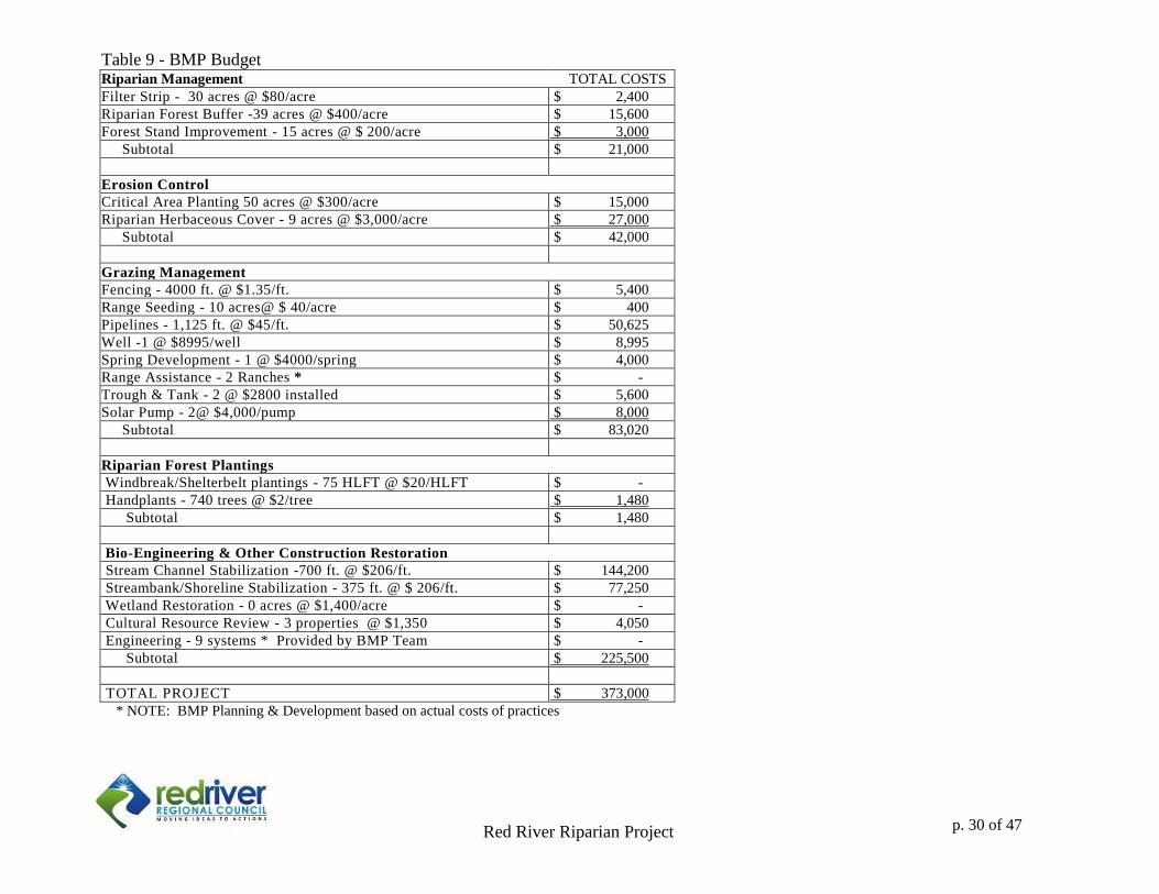
Table 9 - BMP Budget Riparian Management TOTAL COSTS
Filter Strip - 30 acres @ $80/acre $ 2,400
Riparian Forest Buffer -39 acres @ $400/acre $ 15,600
Forest Stand Improvement - 15 acres @ $ 200/acre $ 3,000
Subtotal $ 21,000
Erosion Control
Critical Area Planting 50 acres @ $300/acre $ 15,000
Riparian Herbaceous Cover - 9 acres @ $3,000/acre $ 27,000
Subtotal $ 42,000
Grazing Management
Fencing - 4000 ft. @ $1.35/ft. $ 5,400
Range Seeding - 10 acres@ $ 40/acre $ 400
Pipelines - 1,125 ft. @ $45/ft. $ 50,625
Well -1 @ $8995/well $ 8,995
Spring Development - 1 @ $4000/spring $ 4,000
Range Assistance - 2 Ranches * $ -
Trough & Tank - 2 @ $2800 installed $ 5,600
Solar Pump - 2@ $4,000/pump $ 8,000
Subtotal $ 83,020
Riparian Forest Plantings
Windbreak/Shelterbelt plantings - 75 HLFT @ $20/HLFT $ -
Handplants - 740 trees @ $2/tree $ 1,480
Subtotal $ 1,480
Bio-Engineering & Other Construction Restoration
Stream Channel Stabilization -700 ft. @ $206/ft. $ 144,200
Streambank/Shoreline Stabilization - 375 ft. @ $ 206/ft. $ 77,250
Wetland Restoration - 0 acres @ $1,400/acre $ -
Cultural Resource Review - 3 properties @ $1,350 $ 4,050
Engineering - 9 systems * Provided by BMP Team $ -
Subtotal $ 225,500
TOTAL PROJECT $ 373,000
* NOTE: BMP Planning & Development based on actual costs of practices
p. 30 of 47
1
Red River Riparian Project p. 1 of 34
7.0 Public Involvement
Public involvement in the Red River Riparian Project is assured through advisory committees
and oversight of project activities by the Red River Riparian Committee and the Red River
Regional Council. Furthermore, stakeholder meetings and surveys have an integral part of the
development and prioritization of the delivery mechanism for this project. Annual tours are open
to the public.
p. 31 of 47
2
Red River Riparian Project p. 2 of 34
Appendix I
Red River Riparian Project Annual Report 2013
Red River Riparian Project 1
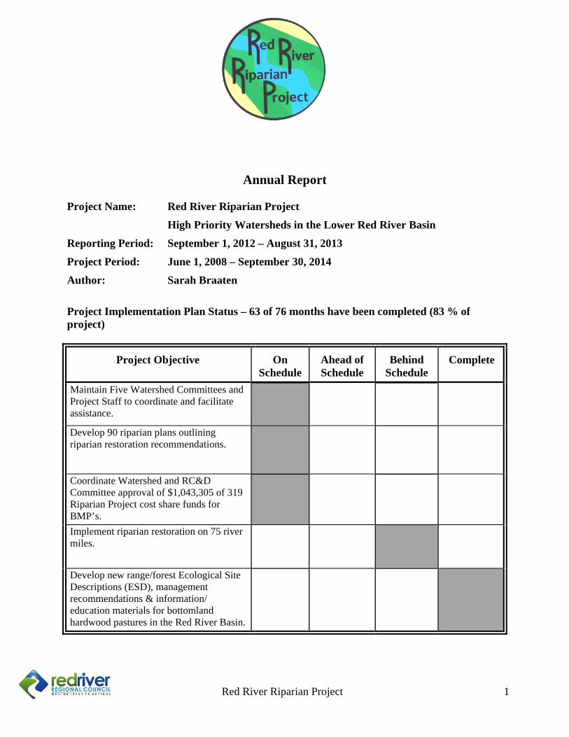
Annual Report
Project Name: Red River Riparian Project
High Priority Watersheds in the Lower Red River Basin
Reporting Period: September 1, 2012 – August 31, 2013
Project Period: June 1, 2008 – September 30, 2014
Author: Sarah Braaten
Project Implementation Plan Status – 63 of 76 months have been completed (83 % of project)
Project Objective On Schedule
Ahead of Schedule
Behind Schedule
Complete
Maintain Five Watershed Committees and Project Staff to coordinate and facilitate assistance.
Develop 90 riparian plans outlining riparian restoration recommendations.
Coordinate Watershed and RC&D Committee approval of $1,043,305 of 319 Riparian Project cost share funds for BMP’s.
Implement riparian restoration on 75 river miles.
Develop new range/forest Ecological Site Descriptions (ESD), management recommendations & information/ education materials for bottomland hardwood pastures in the Red River Basin.
Red River Riparian Project 2
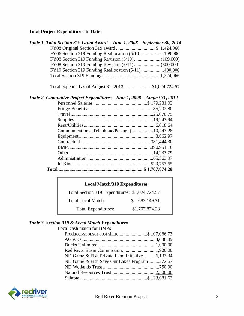
Total Project Expenditures to Date: Table 1. Total Section 319 Grant Award – June 1, 2008 – September 30, 2014 FY08 Original Section 319 award .................................$ 1,424,966 FY06 Section 319 Funding Reallocation (5/10) ...................109,000 FY08 Section 319 Funding Revision (5/10) ...................... (109,000) FY08 Section 319 Funding Revision (5/11) ...................... (600,000) FY10 Section 319 Funding Reallocation (5/11) ...................400,000 Total Section 319 Funding .................................................1,224,966 Total expended as of August 31, 2013 ........................$1,024,724.57 Table 2. Cumulative Project Expenditures - June 1, 2008 – August 31, 2012
Personnel Salaries .............................................$ 179,281.03 Fringe Benefits ......................................................85,202.80 Travel .....................................................................25,070.75 Supplies ..................................................................19,243.94 Rent/Utilities ............................................................6,818.64 Communications (Telephone/Postage) ..................10,443.28 Equipment ................................................................8,862.97 Contractual ...........................................................381,444.30 BMP .....................................................................390,951.16 Other ......................................................................14,233.79 Administration .......................................................65,563.97 In-Kind .................................................................520,757.65
Total .......................................................................$ 1,707,874.28
Local Match/319 Expenditures
Total Section 319 Expenditures: $1,024,724.57
Total Local Match: $ 683,149.71
Total Expenditures: $1,707,874.28
Table 3. Section 319 & Local Match Expenditures
Local cash match for BMPs Producer/sponsor cost share ........................$ 107,066.73 AGSCO ..............................................................4,038.89 Ducks Unlimited ................................................1,000.00 Red River Basin Commission ............................1,920.00 ND Game & Fish Private Land Initiative ..........6,133.34 ND Game & Fish Save Our Lakes Program .........272.67 ND Wetlands Trust ...............................................750.00 Natural Resources Trust .....................................2,500.00 Subtotal .......................................................$ 123,681.63
Red River Riparian Project 3
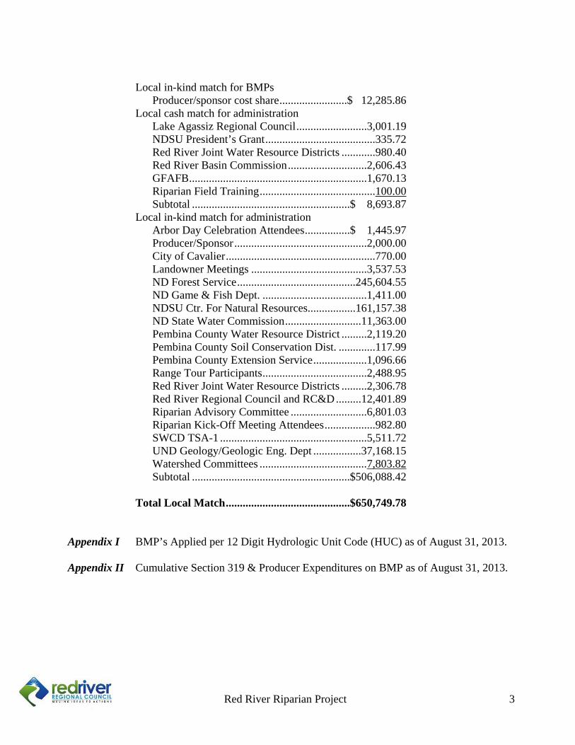
Local in-kind match for BMPs
Producer/sponsor cost share ........................$ 12,285.86 Local cash match for administration
Lake Agassiz Regional Council .........................3,001.19 NDSU President’s Grant .......................................335.72 Red River Joint Water Resource Districts ............980.40 Red River Basin Commission ............................2,606.43 GFAFB ...............................................................1,670.13 Riparian Field Training .........................................100.00 Subtotal ........................................................$ 8,693.87
Local in-kind match for administration Arbor Day Celebration Attendees ................$ 1,445.97 Producer/Sponsor ...............................................2,000.00 City of Cavalier .....................................................770.00 Landowner Meetings .........................................3,537.53 ND Forest Service ..........................................245,604.55 ND Game & Fish Dept. .....................................1,411.00 NDSU Ctr. For Natural Resources.................161,157.38 ND State Water Commission ...........................11,363.00 Pembina County Water Resource District .........2,119.20 Pembina County Soil Conservation Dist. .............117.99 Pembina County Extension Service ...................1,096.66 Range Tour Participants .....................................2,488.95 Red River Joint Water Resource Districts .........2,306.78 Red River Regional Council and RC&D .........12,401.89 Riparian Advisory Committee ...........................6,801.03 Riparian Kick-Off Meeting Attendees ..................982.80 SWCD TSA-1 ....................................................5,511.72 UND Geology/Geologic Eng. Dept .................37,168.15 Watershed Committees ......................................7,803.82 Subtotal ........................................................$506,088.42
Total Local Match ............................................$650,749.78 Appendix I BMP’s Applied per 12 Digit Hydrologic Unit Code (HUC) as of August 31, 2013. Appendix II Cumulative Section 319 & Producer Expenditures on BMP as of August 31, 2013.
Red River Riparian Project
Red River Riparian Project 4
Progress of Objectives and Tasks for High Priority Watersheds
Tasks Reported Progress (this period) Current Status (cumulative)
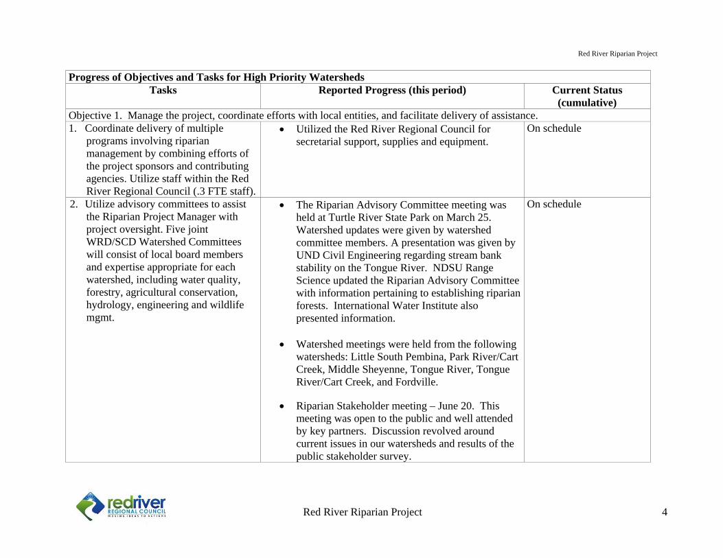
Objective 1. Manage the project, coordinate efforts with local entities, and facilitate delivery of assistance. 1. Coordinate delivery of multiple
programs involving riparian management by combining efforts of the project sponsors and contributing agencies. Utilize staff within the Red River Regional Council (.3 FTE staff).
Utilized the Red River Regional Council for secretarial support, supplies and equipment.
On schedule
2. Utilize advisory committees to assist the Riparian Project Manager with project oversight. Five joint WRD/SCD Watershed Committees will consist of local board members and expertise appropriate for each watershed, including water quality, forestry, agricultural conservation, hydrology, engineering and wildlife mgmt.
The Riparian Advisory Committee meeting was held at Turtle River State Park on March 25. Watershed updates were given by watershed committee members. A presentation was given by UND Civil Engineering regarding stream bank stability on the Tongue River. NDSU Range Science updated the Riparian Advisory Committee with information pertaining to establishing riparian forests. International Water Institute also presented information.
Watershed meetings were held from the following watersheds: Little South Pembina, Park River/Cart Creek, Middle Sheyenne, Tongue River, Tongue River/Cart Creek, and Fordville.
Riparian Stakeholder meeting – June 20. This meeting was open to the public and well attended by key partners. Discussion revolved around current issues in our watersheds and results of the public stakeholder survey.
On schedule
Red River Riparian Project
Red River Riparian Project 5
Progress of Objectives and Tasks for High Priority Watersheds Tasks Reported Progress (this period) Current Status
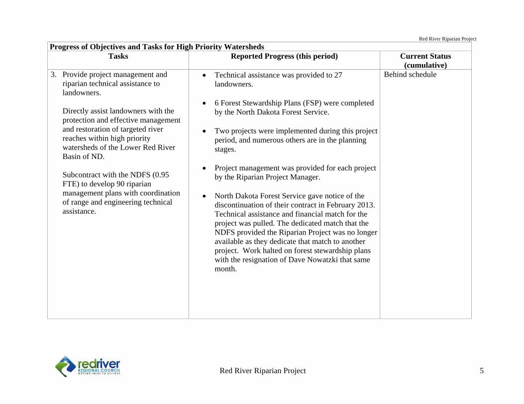
(cumulative)3. Provide project management and
riparian technical assistance to landowners.
Directly assist landowners with the protection and effective management and restoration of targeted river reaches within high priority watersheds of the Lower Red River Basin of ND.
Subcontract with the NDFS (0.95 FTE) to develop 90 riparian management plans with coordination of range and engineering technical assistance.
Technical assistance was provided to 27 landowners.
6 Forest Stewardship Plans (FSP) were completed
by the North Dakota Forest Service.
Two projects were implemented during this project period, and numerous others are in the planning stages.
Project management was provided for each project
by the Riparian Project Manager.
North Dakota Forest Service gave notice of the discontinuation of their contract in February 2013. Technical assistance and financial match for the project was pulled. The dedicated match that the NDFS provided the Riparian Project was no longer available as they dedicate that match to another project. Work halted on forest stewardship plans with the resignation of Dave Nowatzki that same month.
Behind schedule
Red River Riparian Project
Red River Riparian Project 6
Progress of Objectives and Tasks for High Priority Watersheds Tasks Reported Progress (this period) Current Status
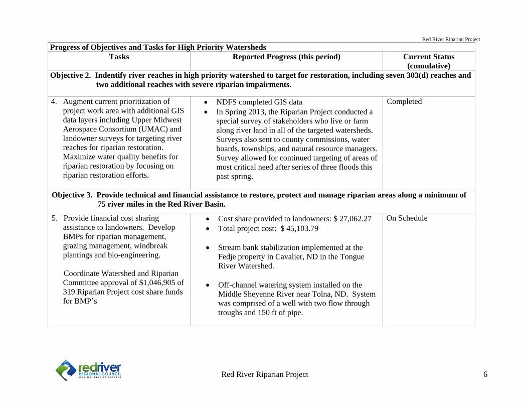
(cumulative)Objective 2. Indentify river reaches in high priority watershed to target for restoration, including seven 303(d) reaches and two additional reaches with severe riparian impairments.
4. Augment current prioritization of project work area with additional GIS data layers including Upper Midwest Aerospace Consortium (UMAC) and landowner surveys for targeting river reaches for riparian restoration. Maximize water quality benefits for riparian restoration by focusing on riparian restoration efforts.
NDFS completed GIS data In Spring 2013, the Riparian Project conducted a
special survey of stakeholders who live or farm along river land in all of the targeted watersheds. Surveys also sent to county commissions, water boards, townships, and natural resource managers. Survey allowed for continued targeting of areas of most critical need after series of three floods this past spring.
Completed
Objective 3. Provide technical and financial assistance to restore, protect and manage riparian areas along a minimum of 75 river miles in the Red River Basin.
5. Provide financial cost sharing assistance to landowners. Develop BMPs for riparian management, grazing management, windbreak plantings and bio-engineering.
Coordinate Watershed and Riparian
Committee approval of $1,046,905 of 319 Riparian Project cost share funds for BMP’s
Cost share provided to landowners: $ 27,062.27 Total project cost: $ 45,103.79
Stream bank stabilization implemented at the
Fedje property in Cavalier, ND in the Tongue River Watershed.
Off-channel watering system installed on the
Middle Sheyenne River near Tolna, ND. System was comprised of a well with two flow through troughs and 150 ft of pipe.
On Schedule
Red River Riparian Project
Red River Riparian Project 7
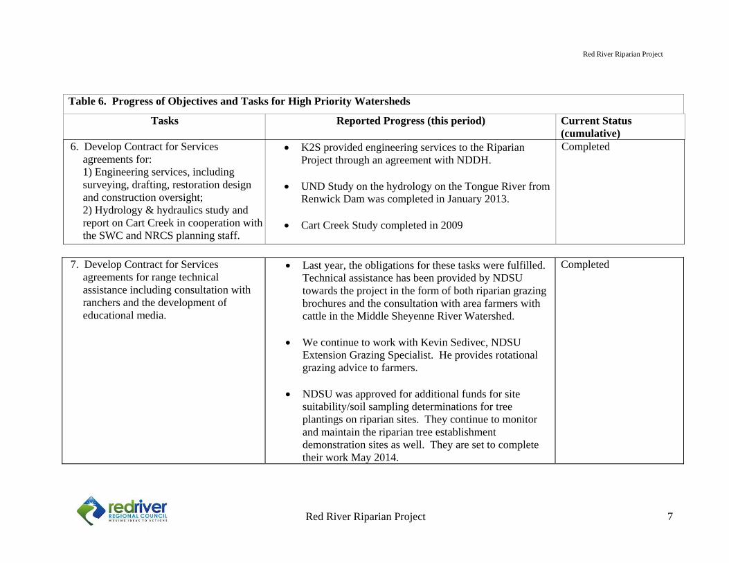
7. Develop Contract for Services
agreements for range technical assistance including consultation with ranchers and the development of educational media.
Last year, the obligations for these tasks were fulfilled. Technical assistance has been provided by NDSU towards the project in the form of both riparian grazing brochures and the consultation with area farmers with cattle in the Middle Sheyenne River Watershed.
We continue to work with Kevin Sedivec, NDSU Extension Grazing Specialist. He provides rotational grazing advice to farmers.
NDSU was approved for additional funds for site
suitability/soil sampling determinations for tree plantings on riparian sites. They continue to monitor and maintain the riparian tree establishment demonstration sites as well. They are set to complete their work May 2014.
Completed
Table 6. Progress of Objectives and Tasks for High Priority Watersheds
Tasks Reported Progress (this period) Current Status (cumulative)
6. Develop Contract for Services agreements for: 1) Engineering services, including surveying, drafting, restoration design and construction oversight; 2) Hydrology & hydraulics study and report on Cart Creek in cooperation with the SWC and NRCS planning staff.
K2S provided engineering services to the Riparian Project through an agreement with NDDH.
UND Study on the hydrology on the Tongue River from Renwick Dam was completed in January 2013.
Cart Creek Study completed in 2009
Completed
Red River Riparian Project
Red River Riparian Project 8
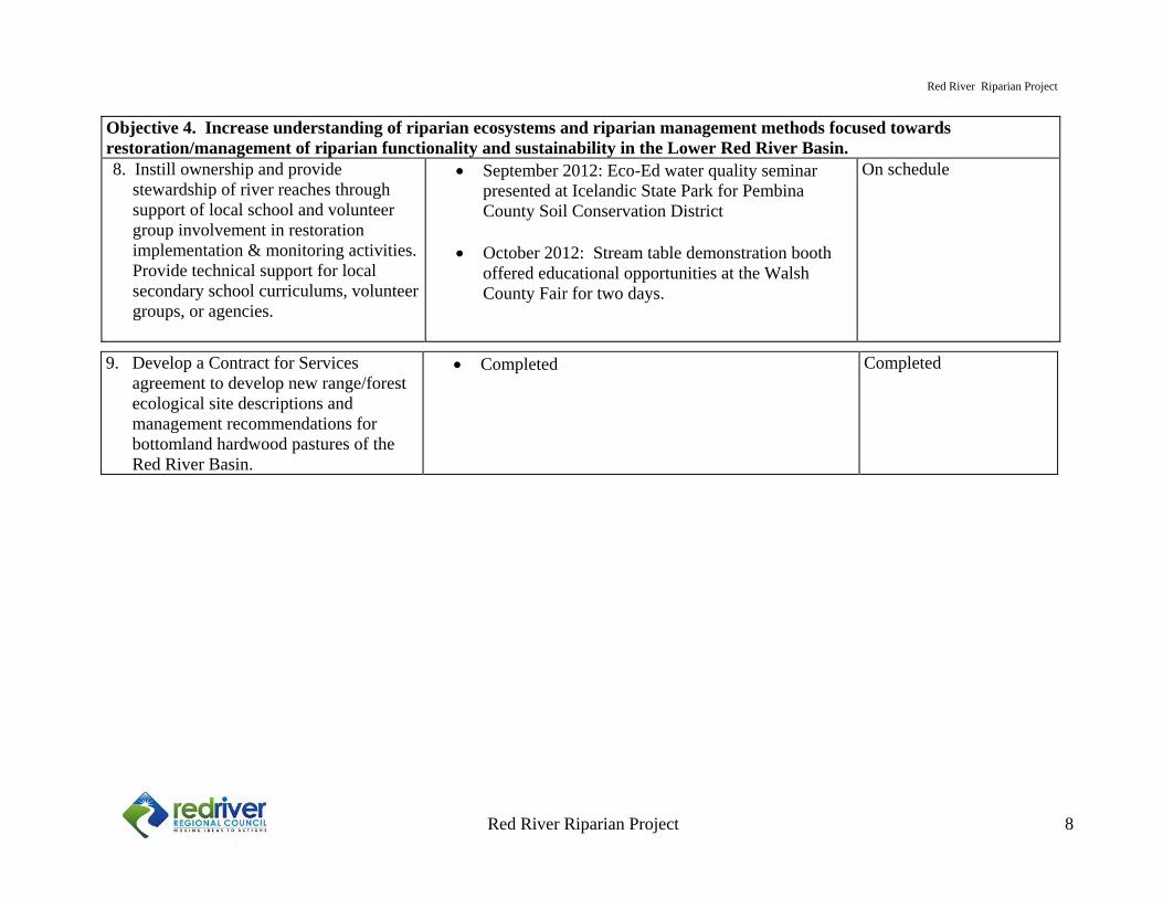
Objective 4. Increase understanding of riparian ecosystems and riparian management methods focused towards restoration/management of riparian functionality and sustainability in the Lower Red River Basin.8. Instill ownership and provide
stewardship of river reaches through support of local school and volunteer group involvement in restoration implementation & monitoring activities.
Provide technical support for local secondary school curriculums, volunteer groups, or agencies.
September 2012: Eco-Ed water quality seminar presented at Icelandic State Park for Pembina County Soil Conservation District
October 2012: Stream table demonstration booth offered educational opportunities at the Walsh County Fair for two days.
On schedule
9. Develop a Contract for Services agreement to develop new range/forest ecological site descriptions and management recommendations for bottomland hardwood pastures of the Red River Basin.
Completed Completed
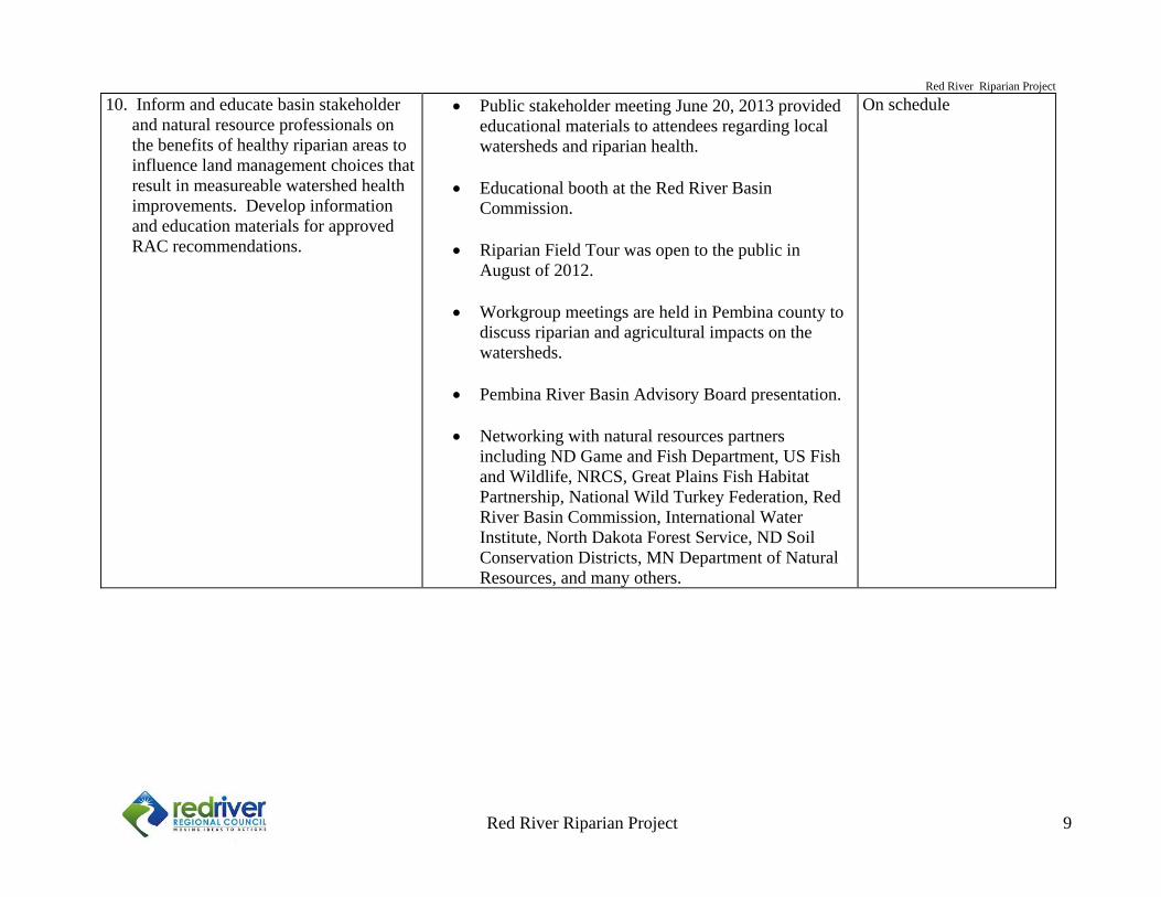
Red River Riparian Project
Red River Riparian Project 9
10. Inform and educate basin stakeholder and natural resource professionals on the benefits of healthy riparian areas to influence land management choices that result in measureable watershed health improvements. Develop information and education materials for approved RAC recommendations.
Public stakeholder meeting June 20, 2013 provided educational materials to attendees regarding local watersheds and riparian health.
Educational booth at the Red River Basin Commission.
Riparian Field Tour was open to the public in
August of 2012.
Workgroup meetings are held in Pembina county to discuss riparian and agricultural impacts on the watersheds.
Pembina River Basin Advisory Board presentation.
Networking with natural resources partners
including ND Game and Fish Department, US Fish and Wildlife, NRCS, Great Plains Fish Habitat Partnership, National Wild Turkey Federation, Red River Basin Commission, International Water Institute, North Dakota Forest Service, ND Soil Conservation Districts, MN Department of Natural Resources, and many others.
On schedule
Red River Riparian Project 10
Local Recommendations and Comments
Sarah Braaten Riparian Project Manager The climate conditions of 2013 were much different than we had expected following the drought of 2012, which left us in a hydrologic deficit. The drought of 2012 resulted in a drawdown of water tables and base flows on our streams. Local residents took interest in what the bottom of the rivers looked like. Conditions were much different come spring of 2013. Flooding hit the region in the first week of May with the first flood, which was comprised of runoff from a deep snowpack in the Red River Valley. Flooding occurred again in the third week of May, when heavy rains hit the area and resulted in the widespread overland flooding of the Red, Pembina, Tongue, Forest and Park River watersheds. Renwick Dam became threatened by a potential dam breach due to high flows on the Tongue River. Only two weeks thereafter, an additional flood occurred, resulting in a third crest for the region’s rivers. Stream banks that were no longer able to handle saturation and inundation collapsed. Trees tipped into streams taking the bank with them. Scoured banks resulted from repeated high flows, and stream channels in some locations migrated in their longitude. Stream flows have been high in the northern watersheds of the Pembina and Tongue Rivers, with discharges of around 400 cfs on the Pembina River in August. We continue to work with the conditions that we are given, wet or dry, to restore riparian areas and water quality. The past year has been a busy year with much success in the areas of education of landowners. We have spent many hours with landowners, educating them one on one with what is happening to their stretch of the river and what can be done to help the riparian areas and water quality. While many landowners agree with recommended strategies for effective riparian management, many are at a loss in being able to implement those recommendations. Sometimes the recommendations become impractical when cost is factored in. Sometimes there are issues in getting a qualified contractor who will do the job for the cost that is estimated. Sometimes we just don’t have a long enough project season for those farmers who don’t have time to implement projects and farm at the same time. With these ways projects can fall to the wayside, this spring I asked local stakeholders to answer a few questions pertaining to project planning and implementation. A majority of the demographic who answered are currently farming or having farmed in the past (71.5%) of 130 respondents. Here are the questions we asked and the answers we received:
Red River Riparian Project 11
Q1: When it comes to planning and implementing projects, in your opinion, what are the biggest factors that limit the planning process?
1. Cost: The cost of the project is too high, or more than I’m willing to pay 2. Regulation: Permitting process 3. Time: Too busy to make time in the summer for planning the project 4. Technical: I need more information and understanding of the project (technical advice) 5. Farm: The recommended practices are not practical to my farm operation 6. Methods: I’m not convinced that the project will work as planned 7. Labor: Challenges locating qualified contractors 8. Risk: The project seems too risky, or I’m worried about downstream effects 9. Other avenues: I can get help from other programs It is no surprise that the cost of implementing projects is the biggest challenge landowners are faced with. Some BMP’s are expensive, even more so with the cost of labor and materials increasing from year to year. These responses are a good indicator that we should look at either more affordable solutions, or try to increase funds so that the landowner pays less, or both. We are looking at using more affordable solutions that incorporate more bio-engineering and less hard armor approaches. We are also looking at helping individual landowner projects get funded through the Outdoor Heritage Fund. We continue to help landowners through the permitting process in every way possible.
Q2: In your opinion, do you feel that rivers have water quality problems in our portion of the state? Yes 71
Yes, but only in a small portion 26 . No 15 Not Sure 15
Most people who responded to this question believe that there are water quality problems in the region. 11.8% of the respondents didn’t feel there was a problem, and the same number of people weren’t sure. It is important that we continue to educate the public on the kinds of water quality impairments we have in our streams. Knowledge is power in these kinds of scenarios.
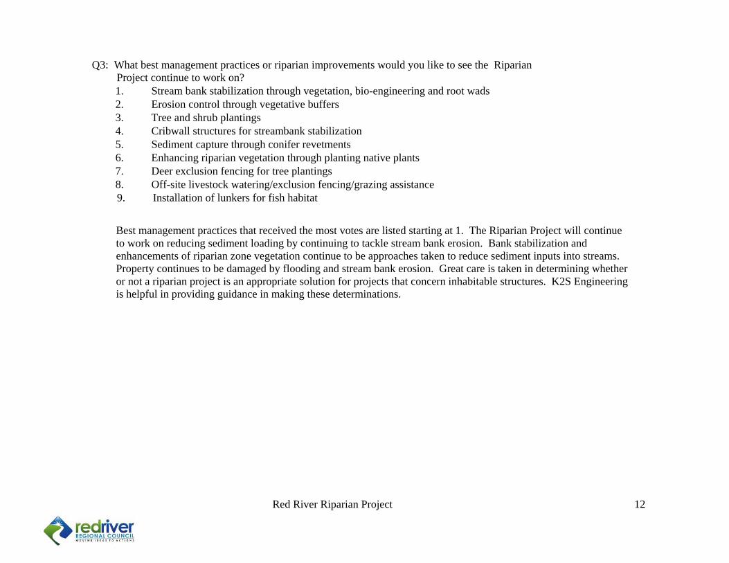
Red River Riparian Project 12
Best management practices that received the most votes are listed starting at 1. The Riparian Project will continue to work on reducing sediment loading by continuing to tackle stream bank erosion. Bank stabilization and enhancements of riparian zone vegetation continue to be approaches taken to reduce sediment inputs into streams. Property continues to be damaged by flooding and stream bank erosion. Great care is taken in determining whether or not a riparian project is an appropriate solution for projects that concern inhabitable structures. K2S Engineering is helpful in providing guidance in making these determinations.
Q3: What best management practices or riparian improvements would you like to see the Riparian Project continue to work on?
1. Stream bank stabilization through vegetation, bio-engineering and root wads 2. Erosion control through vegetative buffers 3. Tree and shrub plantings 4. Cribwall structures for streambank stabilization 5. Sediment capture through conifer revetments 6. Enhancing riparian vegetation through planting native plants 7. Deer exclusion fencing for tree plantings 8. Off-site livestock watering/exclusion fencing/grazing assistance
9. Installation of lunkers for fish habitat
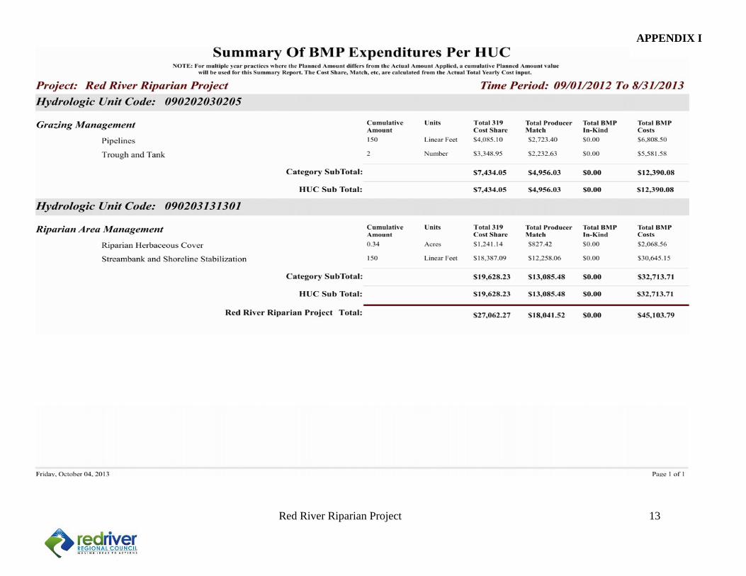
Red River Riparian Project 13
APPENDIX I
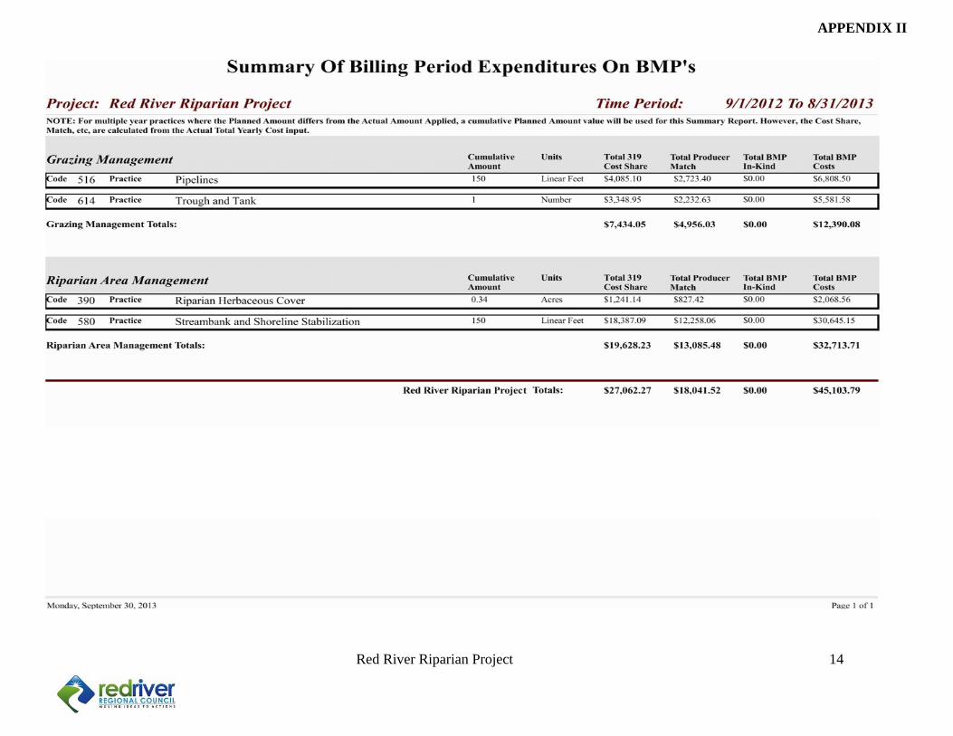
Red River Riparian Project 14
APPENDIX II
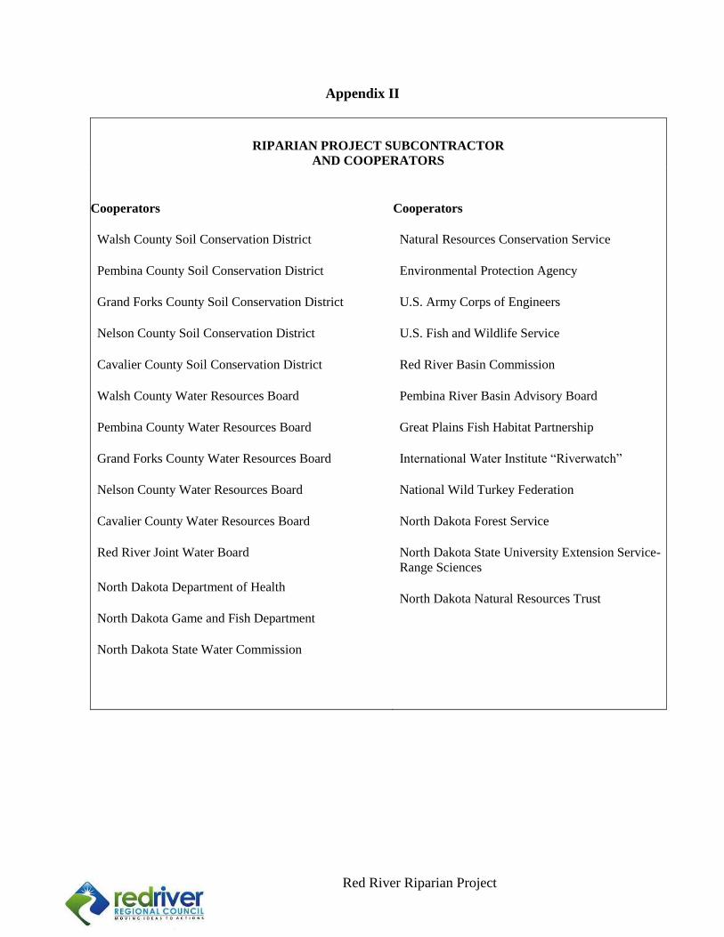
1
Red River Riparian Project p. 1 of 34
Appendix II
RIPARIAN PROJECT SUBCONTRACTOR
AND COOPERATORS
Cooperators
Walsh County Soil Conservation District Pembina County Soil Conservation District Grand Forks County Soil Conservation District Nelson County Soil Conservation District Cavalier County Soil Conservation District Walsh County Water Resources Board Pembina County Water Resources Board Grand Forks County Water Resources Board Nelson County Water Resources Board Cavalier County Water Resources Board Red River Joint Water Board
North Dakota Department of Health North Dakota Game and Fish Department North Dakota State Water Commission
Cooperators Natural Resources Conservation Service Environmental Protection Agency U.S. Army Corps of Engineers U.S. Fish and Wildlife Service Red River Basin Commission Pembina River Basin Advisory Board Great Plains Fish Habitat Partnership International Water Institute “Riverwatch” National Wild Turkey Federation North Dakota Forest Service North Dakota State University Extension Service- Range Sciences North Dakota Natural Resources Trust
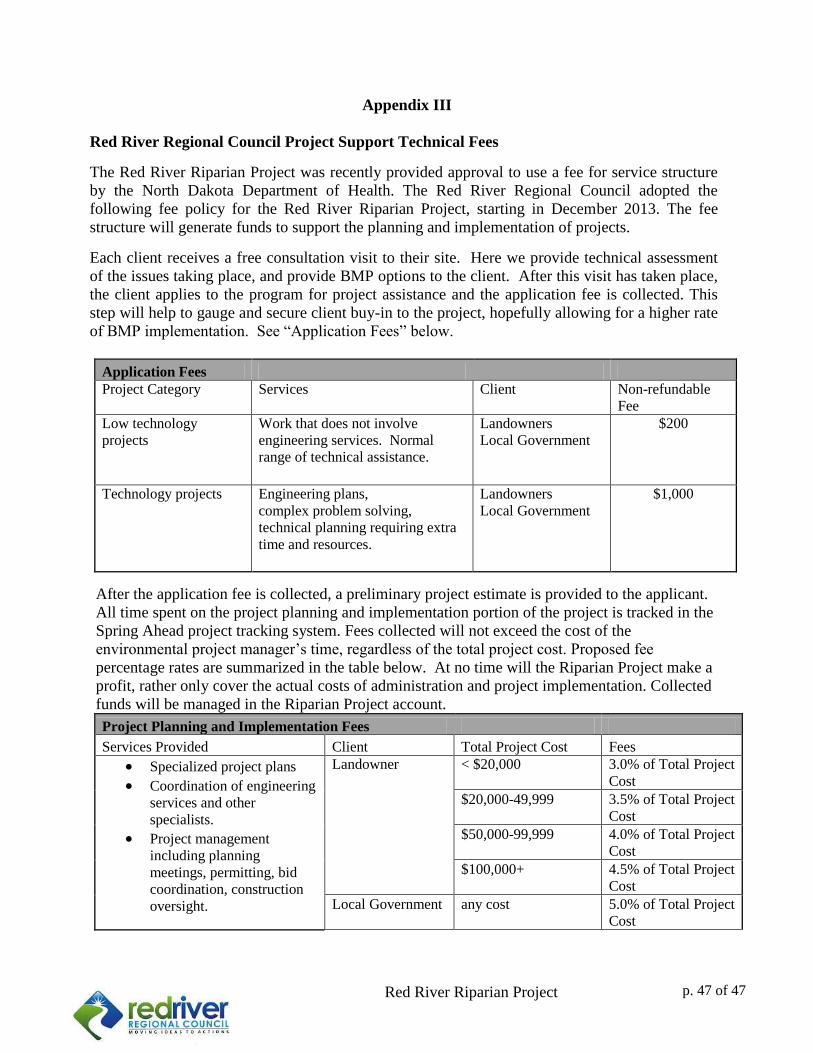
2
Red River Riparian Project p. 2 of 34
Appendix III
Red River Regional Council Project Support Technical Fees
The Red River Riparian Project was recently provided approval to use a fee for service structure
by the North Dakota Department of Health. The Red River Regional Council adopted the
following fee policy for the Red River Riparian Project, starting in December 2013. The fee
structure will generate funds to support the planning and implementation of projects.
Each client receives a free consultation visit to their site. Here we provide technical assessment
of the issues taking place, and provide BMP options to the client. After this visit has taken place,
the client applies to the program for project assistance and the application fee is collected. This
step will help to gauge and secure client buy-in to the project, hopefully allowing for a higher rate
of BMP implementation. See “Application Fees” below.
Application Fees Project Category Services Client Non-refundable
Fee Low technology
projects Work that does not involve
engineering services. Normal
range of technical assistance.
Landowners
Local Government $200
Technology projects Engineering plans,
complex problem solving, technical planning requiring extra
time and resources.
Landowners
Local Government $1,000
After the application fee is collected, a preliminary project estimate is provided to the applicant.
All time spent on the project planning and implementation portion of the project is tracked in the
Spring Ahead project tracking system. Fees collected will not exceed the cost of the
environmental project manager’s time, regardless of the total project cost. Proposed fee
percentage rates are summarized in the table below. At no time will the Riparian Project make a
profit, rather only cover the actual costs of administration and project implementation. Collected
funds will be managed in the Riparian Project account.
Project Planning and Implementation Fees
Services Provided Client Total Project Cost Fees
Specialized project plans
Coordination of engineering
services and other
specialists.
Project management
including planning
meetings, permitting, bid
coordination, construction
oversight.
Landowner < $20,000 3.0% of Total Project
Cost
$20,000-49,999 3.5% of Total Project
Cost
$50,000-99,999 4.0% of Total Project
Cost
$100,000+ 4.5% of Total Project
Cost
Local Government any cost 5.0% of Total Project
Cost
p. 47 of 47
Related Documents