March2005 Prevention/Protection and Mitigation from Risk of Tsunami Disasters -A Concept Note- Government of India Ministry of Home Affairs National Disaster Management Division 1

Welcome message from author
This document is posted to help you gain knowledge. Please leave a comment to let me know what you think about it! Share it to your friends and learn new things together.
Transcript
March2005
Prevention/Protection and Mitigation from Risk of Tsunami Disasters
-A Concept Note-
Government of India
Ministry of Home Affairs National Disaster Management Division
1
PREFACE
The concept note is prepared in the wake of the Tsunami Disaster of Dec. 26th, 2004 covering several countries of north Indian Ocean and various States/UTs of India. It is proposed to be discussed in an inter-ministerial meeting of relevant line Ministries/Departments for appropriate action by all concerned. In preparing the Concept Note, the multi-hazard situation prevalent in the Coastal States/UTs, has been taken into consideration. It has been noted that National Cyclone Risk Mitigation program as well as DRM program have already been on going in the States/UTs. Also, that many safety measure against storm surge disasters, like biological shield, wave breakers and protection walls, high elevation shelters etc as well as warning systems are equally relevant for safety against tsunamis. The concept note covers the following topics:
- Tsunami Characteristics, Do’s & Don’ts in pre, during, and post-tsunami time phases - Tsunami Risk in India and its Assessment in any given area - Multi-hazard situation in west and east coast of India and Mitigation Measures - Specific design solutions against various tsunami effects - Warning systems and Communication - Institutional arrangement and design criteria
The various suggested actions can be dovetailed into the ongoing projects and programs.
A. S. Arya National Seismic Advisor
Acknowledgement The Concept Note was initiated by Shri Saroj K. Jha, Director (NDM III), MHA. Much data collection on the subject from the internet was done by Mr. Ankush Agarwal, Technical Officer, MHA-UNDP, and contributions were made by Shri G.S. Mandal, National Advisor and Shri Santosh Kumar, Professor, NIDM. A.S. Arya National Seismic Advisor
2
List of Contents Chapter 1 Tsunami Characteristics
1.1 What is a tsunami? 1.2 How are tsunamis generated? 1.3 How often do tsunamis occur? 1.4 How fast does a tsunami travel? 1.5 How big is a tsunami? 1.6 What does a tsunami look like when it reaches shore? 1.7 How is a tsunami different from a wind-generated wave? Chapter 2 What to Do or Not To Do Under Risk From Tsunami
2.1 If you are in an area at risk from tsunamis 2.2 If you are visiting an area at risk from tsunamis 2.3 Protect Your Property 2.4 What to Do if You Feel a Strong Coastal Earthquake 2.5 If you are on land 2.6 If you are on a boat 2.7 What to Do After a Tsunami
Chapter 3 Tsunami Risk In India and Its Assessment
3.1 Some Historical Tsunamis 3.2 Tsunamis in India 3.3 Tsunami risk 3.4 Scenario Tsunami 3.5 Tsunami Hazard Map 3.6 Tsunami Vulnerability Assessment 3.7 Tsunami Risk Assessment 3.8 Practical Applications
Chapter 4 Multi-Hazard Situation In Coastal States/UT’s
4.1 Natural Hazards in the coastal States in India Chapter 5 Approach toward Multi Hazard Safety Measures In Coastal Areas
5.1 General Measures 5.2 Specific Measures for safety from Tsunamis/Storm Surges
5.2.1 Structural measures 5.2.2 Non-Structural Measures
5.3 Actions Required in Coastal Areas for Protection against Tsunami / cyclone mitigation Chapter 6 Specific Measures For Safety from Tsunamis
6.1 Tsunami Effects and Design Solutions 6.2 Specific Design Principles for Tsunamis
6.2.1 Know the Tsunami Risk at the site 6.2.2 Avoid new developments in Tsunami Run-up Areas
3
6.2.3 Site Planning Strategies to reduce Tsunami Risk 6.2.4 Tsunami Resistant Buildings – New Developments 6.2.5 Protection of existing buildings and infrastructure – Assessment, Retrofit, Protection measures 6.2.6 Special Precautions in locating and designing infrastructure and critical facilities 6.2.7 Planning for Evacuation
Chapter 7 Tsunami Warning and Communication System
7.1 The Present status of Tsunami Warnings in India. 7.2 International Status of Tsunami Warning and Communication System
7.2.1 Tsunami Warning System 7.2.2 The Tsunami Warning System 7.2.3 Instrumentation 7.2.4 Tsunami Warning Centers 7.2.5 Tsunami Watch and Warning Dissemination 7.2.6 Tsunami Warning Dissemination
7.3 Some concepts of Work Plan for the Tsunami Warning System in India
Chapter 8 Institutional Arrangements and Design Criteria for Tsunami/Cyclone Mitigation
8.1 Institutional Arrangements 8.2 Development of Design Criteria
8.2.1 Basis of Design Criteria 8.2.2 Use Importance of the Buildings
8.2.3 Performance Level Desired 8.2.4 RCC Design Criteria for All Coastal Areas
4
CHAPTER 1
TSUNAMI CHARACTERISTICS 1.1 What is a tsunami?
• A tsunami is a series of waves with a long wavelength and period (time between crests). Time between crests of the wave can vary from a few minutes to over an hour.
• Tsunamis are often incorrectly called tidal waves; they have no relation to the daily ocean tides.
• Tsunami (soo-NAH-mee) is a Japanese word meaning harbour wave.
• Tsunamis can occur at any time of day or night.
1.2 How are tsunamis generated?
• Tsunamis are generated by any large, impulsive displacement of the sea bed level.
• Earthquakes generate tsunamis by vertical movement of the sea floor. If the sea floor movement is horizontal, a tsunami is not generated. Earthquakes of M > 6.5 are critical for tsunami generation.
• Tsunamis are also triggered by landslides into or under the water surface, and can be generated by volcanic activity and meteorite impacts.
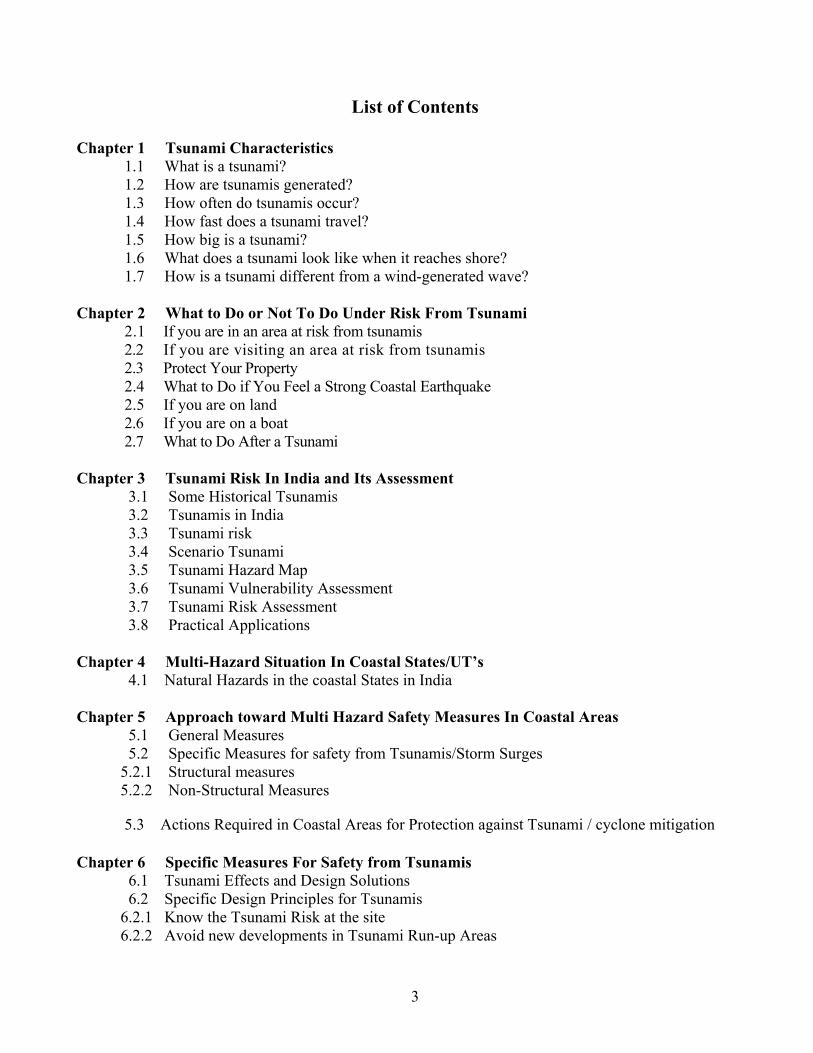
A 4 Possible bore formation on shores waves approach shore
they slow down, the waves lengths shorten and become higher
3
2 Tsunami wave train formation
Submarine fault movement, landslide, or volcanic activity
1
Wave train of Tsunami
1.3 How often do tsunamis occur?
• On the average, there are two tsunamis per year somewhere in the world which cause damage near the source.
5
• Approximately every 15 years a destructive, Pacific-wide tsunami occurs.
• The destructive tsunami on Dec 26th, 2004 on the Indian Coast seems to have occurred for the first time in the history.
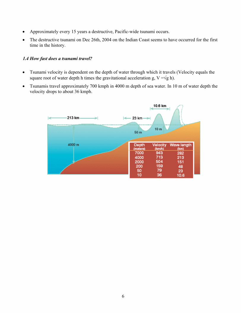
1.4 How fast does a tsunami travel?
• Tsunami velocity is dependent on the depth of water through which it travels (Velocity equals the square root of water depth h times the gravitational acceleration g, V =√g h).
• Tsunamis travel approximately 700 kmph in 4000 m depth of sea water. In 10 m of water depth the velocity drops to about 36 kmph.
6
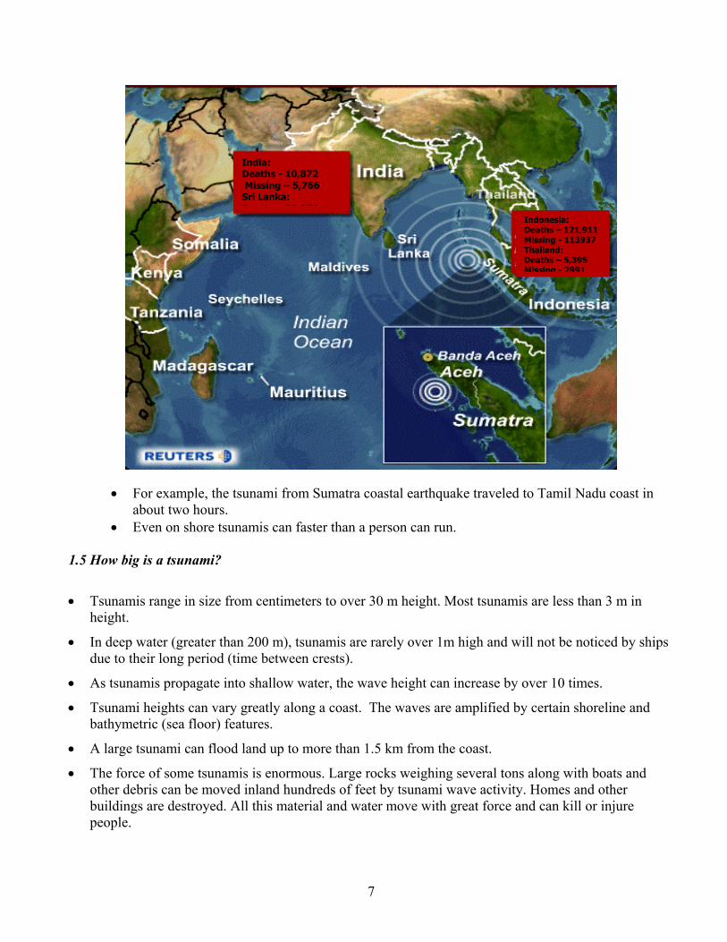
India: Deaths - 10,872 Missing – 5,766 Sri Lanka: D th 30 974
Indonesia: Deaths – 121,911Missing - 113937Thailand: Deaths – 5,395 Missing - 2991
• For example, the tsunami from Sumatra coastal earthquake traveled to Tamil Nadu coast in
about two hours. • Even on shore tsunamis can faster than a person can run.
1.5 How big is a tsunami?
• Tsunamis range in size from centimeters to over 30 m height. Most tsunamis are less than 3 m in height.
• In deep water (greater than 200 m), tsunamis are rarely over 1m high and will not be noticed by ships due to their long period (time between crests).
• As tsunamis propagate into shallow water, the wave height can increase by over 10 times.
• Tsunami heights can vary greatly along a coast. The waves are amplified by certain shoreline and bathymetric (sea floor) features.
• A large tsunami can flood land up to more than 1.5 km from the coast.
• The force of some tsunamis is enormous. Large rocks weighing several tons along with boats and other debris can be moved inland hundreds of feet by tsunami wave activity. Homes and other buildings are destroyed. All this material and water move with great force and can kill or injure people.
7
1.6 What does a tsunami look like when it reaches shore?
• Normally, a tsunami appears as a rapidly advancing or receding tide.
• It some cases a bore (wall of water) or series of breaking waves may form.
• Some times a tsunami causes the water near the shore to recede, exposing the ocean floor, then the wave crest comes with a high speed.
• Tsunamis can travel up rivers and streams that lead to the sea.
1.7 How is a tsunami different from a wind-generated wave?
• Wind-generated waves usually have periods (time between crests) of 5 to 20 seconds. Tsunami periods are usually between 5 minutes and an hour.
• Wind-generated waves break as they shoal and lose energy offshore. Tsunamis act more like a flooding wave. A 6 m tsunami is a 6 m rise in sea level.
8
CHAPTER 2
WHAT TO DO OR NOT TO DO UNDER RISK FROM TSUNAMI
2.1 If you are in an area at risk from tsunamis
• You should find out if your home, school, workplace, or other frequently visited locations are in tsunami hazard areas.
• Know the height of your street above sea level and the distance of your street from the coast or
other high-risk waters. Evacuation orders may be based on these numbers. Also find out the height above sea level and the distance from the coast of outbuildings that house animals, as well as pastures or corrals.
• Plan evacuation routes from your home, school, workplace, or any other place you could be where tsunamis present a risk.
If possible, pick areas (30 meters) above sea level or go as far as 3 kilometers inland, away from the coastline. If you cannot get this high or far, go as high or far as you can. Every meter inland or upward may make a difference. You should be able to reach your safe location on foot within 15 minutes. After a disaster, roads may become impassable or blocked. Be prepared to evacuate by foot if necessary. Footpaths normally lead uphill and inland, while many roads parallel coastlines. Follow posted tsunami evacuation routes; these will lead to safety. Local emergency management officials can advise you on the best route to safety and likely shelter locations.
• If your children's school is in an identified inundation zone, find out what the school evacuation plan is. Find out if the plan requires you to pick your children up from school or from another location. Telephone lines during a tsunami watch or warning may be overloaded and routes to and from schools may be jammed.
• Practice your evacuation routes. Familiarity may save your life. Be able to follow your escape route at night and during inclement weather. Practicing your plan makes the appropriate response more of a reaction, requiring less thinking during an actual emergency situation.
• Use a Weather Radio or stay tuned to a local radio or television station to keep informed of local watches and warnings.
• Talk to your insurance agent.
Homeowners' policies may not cover flooding from a tsunami. Ask about the Flood Insurance Program.
• Discuss tsunamis with your family. Everyone should know what to do in a tsunami situation. Discussing tsunamis ahead of time will help reduce fear and save precious time in an emergency. Review flood safety and
9
preparedness measures with your family.
2.2 If you are visiting an area at risk from tsunamis
Check with the hotel, motel, or campground operators for tsunami evacuation information and find out what the warning system is for tsunamis. It is important to know designated escape routes before a warning is issued.
2.3 Protect Your Property
You should avoid building or living in buildings within 200 meters of the high tide coastline. These areas are more likely to experience damage from tsunamis, strong winds, or coastal storms.
• Make a list of items to bring inside in the event of a tsunami. A list will help you remember anything that can be swept away by tsunami water.
• Elevate coastal homes. Most tsunami waves are less than 3 meters. Elevating your house will help reduce damage to your property from most tsunamis.
• Take precautions to prevent flooding. • Have an engineer check your home and advise about ways to make it more resistant to
tsunami water. There may be ways to divert waves away from your property. Improperly built walls could make your situation worse. Consult with a professional for advice. Ensure that any outbuildings, pastures, or corrals are protected in the same way as your home. When installing or changing fence lines, consider placing them in such a way that your animals are able to move to higher ground in the event of a tsunami.
2.4 What to Do if You Feel a Strong Coastal Earthquake If you feel an earthquake that lasts 20 seconds or longer when you are in a coastal area, you should:
• Drop, cover, and hold on. You should first protect yourself from the earthquake damages.
• When the shaking stops Gather members of your household and move quickly to higher ground away from the coast. A tsunami may be coming within minutes.
• Avoid downed power lines and stay away from buildings and bridges From which Heavy objects might fall during an aftershock.
10
2.5 If you are on land:
• Be aware of tsunami facts. This knowledge could save your life! Share this knowledge with your relatives and friends. It could save their lives!
• If you are in school and you hear there is a tsunami warning, you should follow the advice of teachers and other school personnel.
• If you are at home and hear there is a tsunami warning, you should make sure your entire family is aware of the warning. Your family should evacuate your house if you live in a tsunami evacuation zone. Move in an orderly, calm and safe manner to the evacuation site or to any safe place outside your evacuation zone. Follow the advice of local emergency and law enforcement authorities.
• If you are at the beach or near the ocean and you feel the earth shake, move immediately to higher ground, DO NOT wait for a tsunami warning to be announced. Stay away from rivers and streams that lead to the ocean as you would stay away from the beach and ocean if there is a tsunami. A regional tsunami from a local earthquake could strike some areas before a tsunami warning could be announced.
• Tsunamis generated in distant locations will generally give people enough time to move to higher ground. For locally-generated tsunamis, where you might feel the ground shake, you may only have a few minutes to move to higher ground.
• High, multi-story, reinforced concrete hotels are located in many low-lying coastal areas. The upper floors of these hotels can provide a safe place to find refuge should there be a tsunami warning and you cannot move quickly inland to higher ground.
• Homes and small buildings located in low-lying coastal areas are not designed to withstand tsunami impacts. Do not stay in these structures should there be a tsunami warning.
• Offshore reefs and shallow areas may help break the force of tsunami waves, but large and dangerous wave can still be a threat to coastal residents in these areas.
Staying away from all low-lying areas is the safest advice when there is a tsunami warning.
2.6 If you are on a boat:
Since tsunami wave activity is imperceptible in the open ocean, do not return to port if you are at sea and a tsunami warning has been issued for your area. Tsunamis can cause rapid changes in water level and unpredictable dangerous currents in harbors and ports.
If there is time to move your boat or ship from port to deep water (after a tsunami warning has been issued), you should weigh the following considerations:
• Most large harbors and ports are under the control of a harbor authority and/or a vessel traffic system. These authorities direct operations during periods of increased readiness (should a tsunami be expected), including the forced movement of vessels if deemed necessary. Keep in contact with the authorities should a forced movement of vessel be directed.
11
• Smaller ports may not be under the control of a harbor authority. If you are aware there is a tsunami warning and you have time to move your vessel to deep water, then you may want to do so in an orderly manner, in consideration of other vessels.
• Owners of small boats may find it safest to leave their boat at the pier and physically move to higher ground, particularly in the event of a locally-generated tsunami.
• Concurrent severe weather conditions (rough seas outside of safe harbor) could present a greater hazardous situation to small boats, so physically moving yourself to higher ground may be the only option.
• Damaging wave activity and unpredictable currents can affect harbors for a period of time following the initial tsunami impact on the coast. Contact the harbor authority before returning to port making sure to verify that conditions in the harbor are safe for navigation and berthing.
2.7 What to Do After a Tsunami
• You should continue using a Weather Radio or staying tuned to a Coast Guard emergency frequency station or a local radio or television station for updated emergency information. The Tsunami may have damaged roads, bridges, or other places that may be unsafe.
• Check yourself for injuries and get first aid if necessary before helping injured or trapped persons.
• If someone needs to be rescued, call professionals with the right equipment to help Many people have been killed or injured trying to rescue others in flooded areas. • Help people who require special assistance— Infants, elderly people, those without transportation, large families who may need additional help in an emergency situation, people with disabilities, and the people who care for them. • Avoid disaster areas.
Your presence might hamper rescue and other emergency operations and put you at further risk from the residual effects of floods, such as contaminated water, crumbled roads, landslides, mudflows, and other hazards.
• Use the telephone only for emergency calls. Telephone lines are frequently overwhelmed in disaster situations. They need to be clear for emergency calls to get through.
• Stay out of a building if water remains around it. Tsunami water, like floodwater, can undermine foundations, causing buildings to sink, floors to crack, or walls to collapse.
• When re-entering buildings or homes, use extreme caution.
12
Tsunami-driven floodwater may have damaged buildings where you least expect it. Carefully watch every step you take.
• Wear long pants, a long-sleeved shirt, and sturdy shoes. The most common injury following a disaster is cut feet.
• Use battery-powered lanterns or flashlights when examining buildings.
Battery-powered lighting is the safest and easiest to use, and it does not present a fire hazard for the user, occupants, or building. DO NOT USE CANDLES.
• Examine walls, floors, doors, staircases, and windows to make sure that the building is not in
danger of collapsing. • Inspect foundations for cracks or other damage.
Cracks and damage to a foundation can render a building uninhabitable.
• Look for fire hazards. There may be broken or leaking gas lines, flooded electrical circuits, or submerged furnaces or electrical appliances. Flammable or explosive materials may have come from upstream. Fire is the most frequent hazard following floods.
• Check for gas leaks. If you smell gas or hear a blowing or hissing noise, open a window and get everyone outside quickly. Turn off the gas using the outside main valve if you can, and call the gas company from a neighbor's home. If you turn off the gas for any reason, it must be turned back on by a professional.
• Look for electrical system damage. If you see sparks or broken or frayed wires, or if you smell burning insulation, turn off the electricity at the main fuse box or circuit breaker. If you have to step in water to get to the fuse box or circuit breaker, call an electrician first for advice. Electrical equipment should be checked and dried before being returned to service.
• Check for damage to sewage and water lines. If you suspect sewage lines are damaged, avoid using the toilets and call a plumber. If water pipes are damaged, contact the water company and avoid using water from the tap. You can obtain safe water from undamaged water heaters or by melting ice cubes that were made before the tsunami hit. Turn off the main water valve before draining water from these sources. Use tap water only if local health officials advise it is safe.
• Watch out for wild animals Especially poisonous snakes that may have come into buildings with the water. Use a stick to poke through debris. Tsunami floodwater flushes snakes and animals out of their homes.
• Watch for loose plaster, drywall, and ceilings that could fall.
13
• Take pictures of the damage Both of the building and its contents, for insurance claims. Open the windows and doors to help dry the building.
• Shovel mud before it solidifies. • Check food supplies.
Any food that has come in contact with floodwater may be contaminated and should be thrown out.
• Expect aftershocks If the earthquake was very large (magnitude 8 to 9+ on the Richter scale) and located nearby. Some aftershocks could be as large as magnitude 7+ and capable of generating another tsunami. The number of aftershocks will decrease over the course of several days, weeks, or months depending on how large the main shock was.
• Watch your animals closely. Keep all your animals under your direct control. Hazardous materials abound in flooded areas. Your pets may be able to escape from your home or through a broken fence. Pets may become disoriented, particularly because flooding usually affects scent markers that normally allow them to find their homes. The behavior of pets may change dramatically after any disruption, becoming aggressive or defensive, so be aware of their well-being and take measures to protect them from hazards, including displaced wild animals, and to ensure the safety of other people and animals.
14
CHAPTER 3
TSUNAMI RISK IN INDIA AND ITS ASSESSMENT 3.1 Some Historical Tsunamis Prior to the Tsunami of 26 December 2004, the most destructive Pacific-wide Tsunami of recent history was generated along the coast of Chile on May 22, 1960. No accurate assessment of the damage and deaths attributable to this Tsunami along the coast of Chile can be given; however, all coastal towns between the 36th and 44th (latitude) parallels either were destroyed or heavily damaged by the action of the waves and the quake. The combined Tsunami and earthquake toll included 2,000 killed, 3000 injured 2,000,000 homeless and $550 million damages. Off Corral, the waves were estimated to be 20.4 meters (67 feet) high. The Tsunami caused 61 deaths in Hawaii, 20 in the Philippines, and 100 or more in Japan. Estimated damages were $50 million in Japan, $24 million Hawaii and several millions along the west coast of the United States and Canada. Wave heights varied from slight oscillations in some areas to range of 12.2 meters (40 feet) at Pitcairn Islands; 10.7 meters (35 feet) at Hilo, Hawaii and 6.1 meters (20 feet) at various places in Japan.
The hydrographic survey in Japan after the great Kwato earthquake of September 1, 1923 showed that vertical displacements of the order of 100 meters had occurred over a large area of sea floor. Tsunamis are very common over the Pacific Ocean because it is surrounded on all sides by a seismically active belt. In the Hawain Islands, Tsunamis approach from all directions, namely, from Japan, the Aleutian Islands and from South America.
3.2 Tsunamis in India
The Indian coastal belt has not recorded many Tsunamis in the past. Waves accompanying earthquake activity have been reported over the North Bay of Bengal. During an earthquake in 1881 which had its epicenter near the centre of the Bay of Bengal, Tsunamis were reported. The earthquake of 1941 in Bay of Bengal caused some damage in Andaman region. This was unusual because most Tsunamis are generated by shocks which occur at or near the flanks of continental slopes. During the earthquakes of 1819 and 1845 near the Rann of Kutch, there were rapid movements of water into the sea. There is no mention of waves resulting from these earthquakes along the coast adjacent to the Arabian sea, and it is unlikely that Tsunamis were generated. Further west, in the Persian Gulf, the 1945 Mekran earthquake (magnitude 8.1) generated Tsunami of 12 to 15 metres height. This caused a huge deluge, with considerable loss of life and property at Ormara and Pasi. The estimated height of Tsunami at Gulf of Combay was 15m but no report of damage is available. The estimated height of waves was about 2 metres at Mumbai, where boats were taken away from their moorings and casualties occurred. A list showing the Tsunami that affected Indian coast in the past is given in Table-3.2. The information given in the Table is sketchy and authenticity cannot be confirmed except the Tsunami of 26th December 2004. Above facts indicate the coastal region of Gujarat is vulnerable to Tsunamis from great earthquakes in Mekran coast. Earthquake of magnitude 7 or more may be dangerous. It may be noted that all earthquake do not generate Tsunami. Research is still being undertaken in this field. For the Indian region, two potential sources have been identified, namely Mekran coast and Andaman to Sumatra region.
15
Model generated Travel time of 26th December Tsunami is shown in Fig 3.1. Fig. 3.2 indicates the wave heights generated by the model which show the wave heights in Indian coast could have been between 2-4 meter. (Actual on some coasts was observed more than 4m)
Table -3.1 A Global List of Some Historical Tsunami Deaths
Year Place Number of Lives lost1692 Port Royal, Jamaica 30001703 Tsunamis in Honshu, Japan following a large
earthquake 5000
1707 38 foot Tsunami, Japan 30,0001741 Following Volcanic eruptions 30 feet wave in Japan 14001753 Combine effect of an earthquake and Tsunami in
Lisbon, Portugal 50,000
1783 A Tsunami in Italy 30,0001868 Tsunami Chile and Hawaii More than 250001883 Krakatoa Volcanic explosion and Tsunami in Indonesia 36,0001896 Tsunami Sanrika , Japan 27,0001933 Tsunami, Sanrika Japan 30001946 32 foot high waves in Hilo, Hawaii 159May 22, 1960
Along the coast of Chille Approx. 2000 (+ 3000 person missing)
rendered homeless. 1946 Honsu, Japan Earthquake Spawan Tsunami 20001964 195 foot waves engulf Kodiak, Alaska after the Good
Friday Earthquake 131
17 August 1976
Philippines 8000
19 August 1977
Indonesia 189
18 July 1979
Indonesia 540
12 September 1979
New Guinea 100
12 December 1979
Columbia 500
26 May 1983
Sea of Japan Approx. 100
1998 Papua New Guinea 26 December 2004
Earthquake 9.1 in Richter Scale. The Bay of Bengal. Powerful Tsunami which swept several coastal areas of South East Asia (Indonesia, India, Srilanka, Maldives etc.)
Approx. 170000 (+ 130000 missing)
16
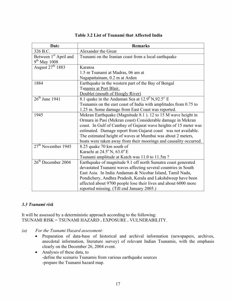
Table 3.2 List of Tsunami that Affected India
Date Remarks
326 B.C. Alexander the Great Between 1st April and 9th May 1008
Tsunami on the Iranian coast from a local earthquake
August 27th 1883 Karatoa 1.5 m Tsunami at Madras, 06 am at Nagapattainam, 0.2 m at Arden
1884 Earthquake in the western part of the Bay of Bengal Tsnamis at Port Blair, Doublet (mouth of Hoogly River)
26th June 1941 8.1 quake in the Andaman Sea at 12.90 N,92.5o E Tsunamis on the east coast of India with amplitudes from 0.75 to 1.25 m. Some damage from East Coast was reported.
1945 Mekran Earthquake (Magnitude 8.1 ). 12 to 15 M wave height in Ormara in Pasi (Mekran coast) Considerable damage in Mekran coast. In Gulf of Cambay of Gujarat wave heights of 15 meter was estimated. Damage report from Gujarat coast was not available. The estimated height of waves at Mumbai was about 2 meters, boats were taken away from their moorings and causality occurred.
27th November 1945 8.25 quake 70 km south of Karachi at 24.5o N, 63.0o E Tsunami amplitude at Kutch was 11.0 to 11.5m ?
26th December 2004 Earthquake of magnitude 9.1 off north Sumatra coast generated devastated Tsunami waves affecting several countries in South East Asia. In India Andaman & Nicobar Island, Tamil Nadu, Pondichery, Andhra Pradesh, Kerala and Lakshdweep have been affected about 9700 people lose their lives and about 6000 more reported missing. (Till end January 2005.)
3.3 Tsunami risk It will be assessed by a deterministic approach according to the following: TSUNAMI RISK = TSUNAMI HAZARD . EXPOSURE . VULNERABILITY.
(a) For the Tsunami Hazard assessment:
• Preparation of data-base of historical and archival information (newspapers, archives, anecdotal information, literature survey) of relevant Indian Tsunamis, with the emphasis clearly on the December 26, 2004 event.
• Analyses of these data, to -define the scenario Tsunamis from various earthquake sources -prepare the Tsunami hazard map.
17
(b) For the Exposure • List all habitations below 15 m contour level and locate on a map. • List and locate all vital installations below 15 m contour level (Ports, Harbours, Schools,
Hospitals, Power Plants, Bridges, etc.) (c) For the VULNERABILITY assessment:
• Based on the earthquake vulnerability assessment, define the vulnerability of various exposed elements on the coastal, island and reef environments and in the Ports and Harbours
• Prepare vulnerability charts and matrices. (d) For the RISK assessment:
• Integrate these hazard and exposure data with vulnerability assessments to obtain the risk assessment.
3.4 Scenario Tsunami
The following parameters will need to be defined:
• Tsunami source region: • Mode of generation: • Potential wave heights • Maximum Run-up (maximum height of the water onshore observed/inferred above the mean
sea level. Usually measured at the horizontal inundation limit) • Tsunami intensity I=0.5 log 2H (Pelinovsky, 1996)
with H = average maximum run-up height >3 m. Imax = 2.5
3.5 Tsunami Hazard Map
The Tsunami hazard map may be empirically defined using a deterministic approach, based upon potential maximum wave heights for the scenario tsunamis. The definition of the tsunami hazard zones, as preliminary estimates, is given in Table 3.3. For the terrestrial environment the hazard may be presented as inundation levels, in terms of run-up heights at specified land contours. For the marine environment (“ON WATER”) Harbour, Bay and Reefs – hazard may be given in terms of potential maximum wave heights.
18
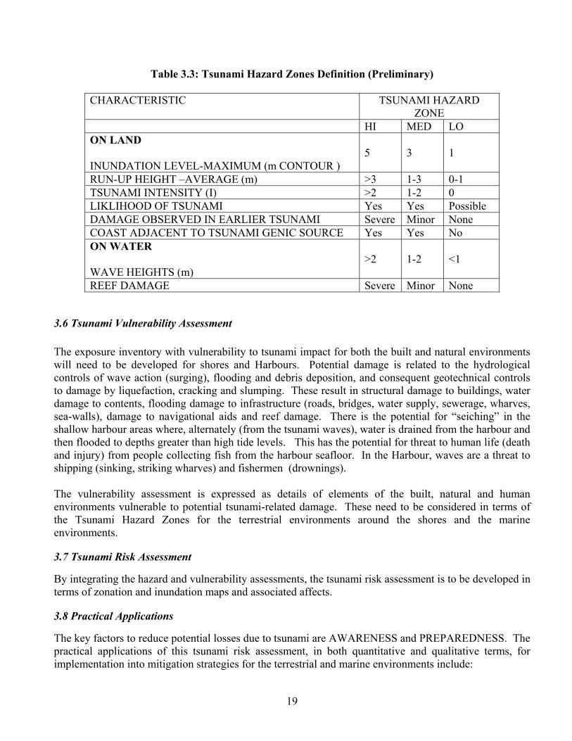
Table 3.3: Tsunami Hazard Zones Definition (Preliminary)
CHARACTERISTIC TSUNAMI HAZARD ZONE
HI MED LO ON LAND
INUNDATION LEVEL-MAXIMUM (m CONTOUR )
5
3
1
RUN-UP HEIGHT –AVERAGE (m) >3 1-3 0-1 TSUNAMI INTENSITY (I) >2 1-2 0 LIKLIHOOD OF TSUNAMI Yes Yes Possible DAMAGE OBSERVED IN EARLIER TSUNAMI Severe Minor None COAST ADJACENT TO TSUNAMI GENIC SOURCE Yes Yes No ON WATER
WAVE HEIGHTS (m)
>2
1-2
<1
REEF DAMAGE Severe Minor None
3.6 Tsunami Vulnerability Assessment
The exposure inventory with vulnerability to tsunami impact for both the built and natural environments will need to be developed for shores and Harbours. Potential damage is related to the hydrological controls of wave action (surging), flooding and debris deposition, and consequent geotechnical controls to damage by liquefaction, cracking and slumping. These result in structural damage to buildings, water damage to contents, flooding damage to infrastructure (roads, bridges, water supply, sewerage, wharves, sea-walls), damage to navigational aids and reef damage. There is the potential for “seiching” in the shallow harbour areas where, alternately (from the tsunami waves), water is drained from the harbour and then flooded to depths greater than high tide levels. This has the potential for threat to human life (death and injury) from people collecting fish from the harbour seafloor. In the Harbour, waves are a threat to shipping (sinking, striking wharves) and fishermen (drownings).
The vulnerability assessment is expressed as details of elements of the built, natural and human environments vulnerable to potential tsunami-related damage. These need to be considered in terms of the Tsunami Hazard Zones for the terrestrial environments around the shores and the marine environments.
3.7 Tsunami Risk Assessment
By integrating the hazard and vulnerability assessments, the tsunami risk assessment is to be developed in terms of zonation and inundation maps and associated affects.
3.8 Practical Applications
The key factors to reduce potential losses due to tsunami are AWARENESS and PREPAREDNESS. The practical applications of this tsunami risk assessment, in both quantitative and qualitative terms, for implementation into mitigation strategies for the terrestrial and marine environments include:
19
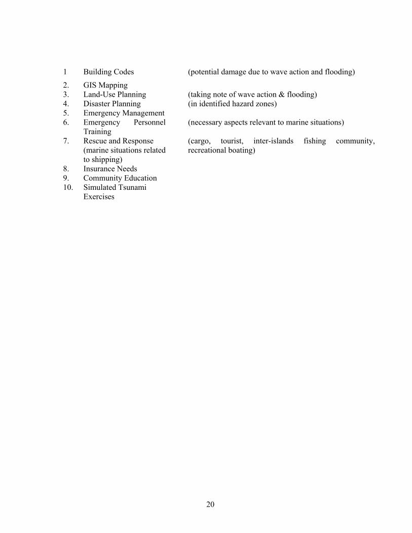
1 Building Codes (potential damage due to wave action and flooding)
2. GIS Mapping 3. Land-Use Planning (taking note of wave action & flooding) 4. Disaster Planning (in identified hazard zones) 5. Emergency Management 6. Emergency Personnel
Training (necessary aspects relevant to marine situations)
7. Rescue and Response (marine situations related to shipping)
(cargo, tourist, inter-islands fishing community, recreational boating)
8. Insurance Needs 9. Community Education 10. Simulated Tsunami
Exercises
20

CHAPTER 4
MULTI-HAZARD SITUATION IN COASTAL STATES/UT’S
4.1 Natural Hazards in the coastal States in India The following hazards are seen to occur in the coastal areas:
1. Earthquakes 2. Cyclonic wind 3. Storm surge in cyclones 4. Flooding by incessant rain 5. Tsunami
Fire is also known to occur quite frequently in many such areas. The situation on the west and east coast of India is given in Table 4.1 & 4.2 respectively.
Table 4.1 West Coast of India
Name of coastal State
EQ. Hazard
Cyclonic Wind (m/s)
Storm Surge (m)
Astronomical High Tide (m)
Flood Proneness
Tsunami Prone-ness (m)
Gujarat V, IV, III 50 & 47 2.5 – 5.0 1.1 – 5.3 In 5 coastal districts
10 – 12 (1945 Eq.)
Dadra & Nagar Haveli
III 44 5.0 1.1 – 5.3 -
+
Daman & Diu III 50 & 44 5.0 1.1 – 5.3 - +
Maharashtra IV & III 44 & 39 2.9 –4.2 * - +
Goa III & II 39 3.4 * - +
Karnataka III & II 39 3.2 – 3.7 * - +
Kerala III 39 2.3 –3.5 * In 9 coast Districts
3 – 5
Lakshadweep III 39 * * *
- +
* To be obtained from survey of India * * To be obtained from IMD + To be estimated as per Ch. 3
21
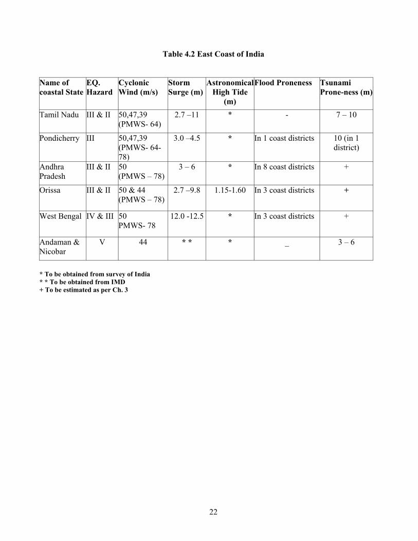
Table 4.2 East Coast of India Name of coastal State
EQ. Hazard
Cyclonic Wind (m/s)
Storm Surge (m)
AstronomicalHigh Tide
(m)
Flood Proneness Tsunami Prone-ness (m)
Tamil Nadu III & II 50,47,39 (PMWS- 64)
2.7 –11 * - 7 – 10
Pondicherry III 50,47,39 (PMWS- 64-78)
3.0 –4.5 * In 1 coast districts 10 (in 1 district)
Andhra Pradesh
III & II 50 (PMWS – 78)
3 – 6 * In 8 coast districts +
Orissa III & II 50 & 44 (PMWS – 78)
2.7 –9.8 1.15-1.60 In 3 coast districts +
West Bengal IV & III 50 PMWS- 78
12.0 -12.5 * In 3 coast districts +
Andaman & Nicobar
V 44 * * * _ 3 – 6
* To be obtained from survey of India * * To be obtained from IMD + To be estimated as per Ch. 3
22
CHAPTER 5
APPROACH TOWARD MULTI HAZARD SAFETY MEASURES IN COASTAL AREAS
5.1 General Measures Adopting integrated multi-hazard approach with emphasis on cyclone and tsunami risk mitigation in
coastal areas
Implementation of early warning system for cyclones and tsunamis
Streamlining the relief distribution system in disaster affected areas
Design, practice and implementation of evacuation plans with emphasis on self reliance for
sustenance with the locals (coastal community)
Component on planning for reconstruction and rehabilitation should be added in disaster management
plans at all levels
Emphasis on mental health and to socio-psychological issues should be accorded in every plan
Identification and strengthening of existing academic centers in order to improve disaster prevention,
reduction and mitigation capabilities
Capacity building programmes to be taken up on priority basis
o Training of all concerned including community
o Public awareness programmes
o Enhancing capabilities of the Institutes working in field of disaster mitigation and
management
5.2 Specific Measures for safety from Tsunamis/Storm Surges
5.2.1 Structural measures:
1. Construction of cyclone shelters
2. Plantation of mangroves and coastal forests along the coast line
3. Development of a network of local knowledge centers (rural/urban) along the coast lines to
provide necessary training and emergency communication during crisis time (e.g. centers
developed by M.S. Swaminathan Foundation in Pondicherry)
4. Construction of location specific sea walls and coral reefs in consultation with experts
23
5. Development of break waters along the coast to provide necessary cushion against cyclone and
tsunami hazards
6. Development of tsunami detection, forecasting and warning dissemination centres
7. Development of a “Bio-Shield” - a narrow strip of land along coastline. Permanent structures
should come up in this zone with strict implementation of suggested norms. Bio-Shield can be
developed as coastal zone disaster management sanctuary, which must have thick plantation and
public spaces for public awareness, dissemination and demonstration.
8. Identification of vulnerable structures and appropriate retrofitting for tsunami/cyclone resistance
of all such buildings as well as appropriate planning, designing, construction of new facilities like:
Critical infrastructures e.g. power stations, warehouses, oil and other storage tanks etc. located
along the coastline.
All other infrastructure facilities located in the coastal areas
Public buildings and private houses
All marine structures
Construction and maintenance of national and state highways and other coastal roads
5.2.2 Non-Structural Measures:
1. Strict implementation of the coastal zone regulations (within 500 m of the high tide line with
elevation of less than 15 m above m.s.l.
2. Mapping the coastal area for multiple hazards, vulnerability and risk analysis upto taluka /village
level. Development of Disaster Information Management System (DIMS) in all the coastal states.
3. Aggressive capacity building requirements for the local people and the administration for facing
the disasters in wake of tsunami and cyclone, ‘based on cutting edge level’
4. Developing tools and techniques for risk transfer in highly vulnerable areas
5. Launching a series of public awareness campaign throughout the coastal area
6. Training of local administration in forecasting warning dissemination and evacuation techniques
7. Awareness generation and training among the fishermen, coast guards, officials from fisheries
department and port authorities and local district officials etc., in connection with evacuation and
post tsunami storm surge management activities. Regular drills should be conducted to test the
efficacy of the DM plans.
8. Studies focusing on the tsunami risk in India may be taken under NCRM project.
24
5.3 Actions Required in Coastal Areas for Protection against Tsunami / cyclone mitigation
To achieve the satisfactory level of disaster mitigation in coastal areas, following activities need
to be carried out.
Revision of Coastal Zone Regulation Act in wake of tsunami storm surge hazards and strict
implementation of the same. The current Coastal Regulations Zone (extract) is attached as
Appendix A to this chapter. This responsibility may be given to respective state disaster
management authorities. A special task force for this purpose may be constitutes comprising the
representatives from various departments of the government and other relevant organizations (e.g.
Departments of Forestry, Fisheries, Soil Conservation, Town and Country Planning Organization,
Navy, Coast Guard and IMD etc.)
A state of the art EOC may be established with in the authority for monitoring purpose.
Initiating disaster watch (bay watch) safety measures along important beaches in the country,
providing round the clock monitoring, warning and lifeguard facilities etc.
Organization of sensitization workshops on cyclone/tsunami risk mitigation in various states for
senior bureaucrats / politicians for these states.
Organizing drills on regular basis to check the viability of all plans and to check the readiness of
all concerned
Training of professionals, policy planners and others involved with disaster mitigation and
management programmes in the states
Retrofitting of important buildings
I. Fire stations / police stations/ army structures/ hospitals
II. VIP residences / offices/ railways, airport, etc.
III. Schools/colleges
IV. Hazardous industries
V. Other critical structures (i.e. power stations, warehouses, oil and other storage tanks etc)
Designing incentives: Providing legislative back up to encourage people to adopt cyclone,
tsunami resistant features in their homes e.g. tax rebate in terms of house tax and/or income tax.
Developing public –private partnerships.
25
CHAPTER 6
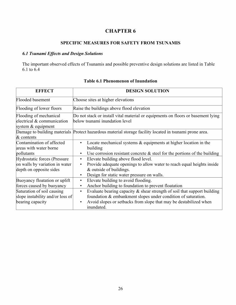
SPECIFIC MEASURES FOR SAFETY FROM TSUNAMIS 6.1 Tsunami Effects and Design Solutions
The important observed effects of Tsunamis and possible preventive design solutions are listed in Table 6.1 to 6.4
Table 6.1 Phenomenon of Inundation
EFFECT DESIGN SOLUTION
Flooded basement Choose sites at higher elevations
Flooding of lower floors Raise the buildings above flood elevation Flooding of mechanical electrical & communication system & equipment
Do not stack or install vital material or equipments on floors or basement lying below tsunami inundation level
Damage to building materials & contents
Protect hazardous material storage facility located in tsunami prone area.
Contamination of affected areas with water borne pollutants
• Locate mechanical systems & equipments at higher location in the building
• Use corrosion resistant concrete & steel for the portions of the building Hydrostatic forces (Pressure on walls by variation in water depth on opposite sides
• Elevate building above flood level. • Provide adequate openings to allow water to reach equal heights inside
& outside of buildings. • Design for static water pressure on walls.
Buoyancy floatation or uplift forces caused by buoyancy
• Elevate building to avoid flooding. • Anchor building to foundation to prevent floatation
Saturation of soil causing slope instability and/or loss of bearing capacity
• Evaluate bearing capacity & shear strength of soil that support building foundation & embankment slopes under condition of saturation.
• Avoid slopes or setbacks from slope that may be destabilized when inundated.
26
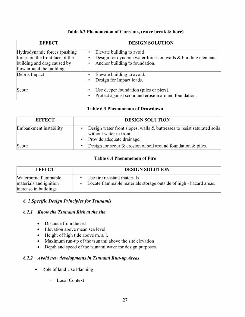
Table 6.2 Phenomenon of Currents, (wave break & bore)
EFFECT DESIGN SOLUTION
Hydrodynamic forces (pushing forces on the front face of the building and drag caused by flow around the building
• Elevate building to avoid • Design for dynamic water forces on walls & building elements. • Anchor building to foundation.
Debris Impact • Elevate building to avoid. • Design for Impact loads.
Scour • Use deeper foundation (piles or piers). • Protect against scour and erosion around foundation.
Table 6.3 Phenomenon of Drawdown
EFFECT DESIGN SOLUTION
Embankment instability • Design water front slopes, walls & buttresses to resist saturated soils without water in front
• Provide adequate drainage. Scour • Design for scour & erosion of soil around foundation & piles.
Table 6.4 Phenomenon of Fire
EFFECT DESIGN SOLUTION
Waterborne flammable materials and ignition increase in buildings
• Use fire resistant materials • Locate flammable materials storage outside of high - hazard areas.
6. 2 Specific Design Principles for Tsunamis
6.2.1 Know the Tsunami Risk at the site
• Distance from the sea • Elevation above mean sea level • Height of high tide above m. s. l. • Maximum run-up of the tsunami above the site elevation • Depth and speed of the tsunami wave for design purposes.
6.2.2 Avoid new developments in Tsunami Run-up Areas
• Role of land Use Planning
- Local Context
27
- Understanding Trade offs - Review and update existing Safety elements - Review and update existing Land Use Elements - Review and update existing Zoning, and other regulations
• Land Use Planning Strategies
6.2.3 Site Planning Strategies to reduce Tsunami Risk
• Avoiding by building on high ground – necessary for vital installations • Slowing the tsunami wave by frictional techniques – forests, ditches, slopes and berms • Deflecting the tsunami away by using angled walls – suitable for important installations • Brute resistance through stiffened strong structural design – costly buildings • High rise buildings with open ground storey, designed for wave forces – Hotels, offices etc • Stilted buildings for various uses.
6.2.4 Tsunami Resistant Buildings – New Developments
• Locally applicable Tsunami Hazard Information on Design Intensities • Performance Objectives • Mandatory use of building Codes – Design Criteria • Safety under Multi-hazard environment • Qualified Engineers and Architects - knowledge about Earthquake, Wind and Tsunami resistant
planning and design • Ensure quality construction
6.2.5 Protection of existing buildings and infrastructure – Assessment, Retrofit, Protection measures
• Inventory of existing assets • Assessment of Vulnerability and deficiencies to be taken care of through retrofitting • Methods of retrofitting and use in design • External protection methods from the onslaught of tsunami
6.2.6 Special Precautions in locating and designing infrastructure and critical facilities
• Considerations in relocating and redevelopment of infrastructure • Considerations in relocating and redevelopment of critical facilities
6.2.7 Planning for Evacuation
• Vertical evacuation – High rise buildings, special shelters • Horizontal evacuation – Locating high grounds, building high enough mounds • Awareness about evacuation areas and routes
28
CHAPTER 7
TSUNAMI WARNING AND COMMUNICATION SYSTEM
7.1 The Present status of Tsunami Warnings in India.
Tsunami is least probability event in India. As such, there is no codal provisions of Tsunami warnings in India as yet though, there is a good seismological network in India to record any earthquake within the country and its neighborhood. The need of a Tsunami Warning Centre (TWC) in India is now being conceptualized at the Government of India level. The Department of Ocean Development in Cooperation with Departments of Space and Science and Technology is evolving a plan of tsunami warning system in the Bay of Bengal and the Arabian Sea. The data from observing points to Warning Centre(s) will be sent through satellite links, Specific systems called Deep Ocean Assessment and Reporting of Tsunamis (DART) using Bottom Pressure Recorder, acoustic modem, acoustic release system, battery pack bolted to platform and float action and recovery aids will be deployed.
7.2 International Status of Tsunami Warning and Communication System
Present techniques of Tsunami prediction are severely limited. The only way to determine, with certainty, if an earthquake is accompanies by a Tsunami, is to note the occurrence and epicenter of the earthquake and then detect the arrival of the Tsunami at a network of tide stations. While it is possible to predict when a Tsunami will arrive at coastal locations, it is not yet possible to predict the wave height, number of waves, duration of hazard, or the forces to be expected from such waves at specific locations.
Tsunami Warning System is based on the concept that Tsunamis travel at much slower velocity (500 to 700 km per hour or 0.20 km/sec) as compared to seismic waves (6 to 8 km per second). That is seismic waves move 30 to 40 times faster than Tsunami waves. Thus, after the occurrence of a damaging earthquake and quick determination of epicenter, warning time of a few minutes to 2 to 3 hours is available depending upon the distance from the epicenter to the coast line. This time can be utilized for warning the coastal community if quick detection and rapid communication systems are established.
7.2.1 Tsunami Warning System
Following most common methods of detection is in use:-
• Japan has a network of land/sea sensors that records seismic activity and feeds information to a national agency able to issue evacuation warnings within a minute of occurrence of any earthquake. Earthquake warning issued by Japan Meteorological Agency are relayed via satellite to the Municipal offices and automatically broadcast from several sets of loudspeakers.
29
• Pacific Ocean issues warnings of tidal waves heading in a particular direction.
• Presently land and sea based sensors connected to satellite based link are available.
• Satellite telemetry is used for data collection and dissemination; receive and display of Tsunami warning utilizing existing Geostationary operational Environmental Satellite (GOES) and Data Collection Interrogation System (DCIS). An earthquake activates seismic instrument, which transmits signal to the GOES platform which responds automatically transmitting an alert code to an active device at warning site.
• Developing Tsunami and earthquake data base verification, Tsunami model, preparation
of hazard assessment maps for the coast line combing historical and modeling result, establishment of seismic and tidal sensors using satellite telemetry to provide early warning information.
• Extensive network of seismic and tidal station, as well as communication systems, to
ensure that the warning information is prompt and accurate. System performs with detection of an earthquake, which has required magnitude to trigger the alarm attached to the seismograph. The alarm thresholds are set so that ground vibrations of the amplitude and duration associated with an earthquake of approximate amplitude 6.5 or greater or Richter scale anywhere in Pacific will cause them to sound. 7.2.2 The Tsunami Warning System
Tsunami Warning System (TWS) in the Pacific, comprised of 28 participating international Member States, has the functions of monitoring seismological and tidal stations throughout the Pacific Basin to evaluate potentially Tsunamigenic earthquake and disseminating Tsunami warning information. The Pacific Tsunami Warning Center (PTWC) is the operational center of the Pacific TWS. Located near Honolulu, Hawaii, PTWC provides Tsunami warning information to national authorities in the Pacific Basin.
7.2.3 Instrumentation
PTWS has the following components:
i) Seismometers including ocean bottom seismometers ii) Tide gauge stations/Seal level recorder. iii) Pressure recorder in the ocean bottom by moored systems iv) Satellite based communication links.
7.2.4 Tsunami Warning Centers
As part of an international cooperative effort to save lives and protect property, the National Oceanic and Atmospheric Administration’s (NOAA) National Weather Service operates two Tsunami warning centres. The Alaska Tsunami Warning Center (ATWC) IN Palmer, Alaska,
30
serves as the regional Tsunami Warning Center for Alaska, British Columbia, Washington, Oregon, and California.
The Pacific Tsunami Warning Center in Ewa Beach, Hawaii, serves as the regional Tsunami Warning Centre for Hawaii and as a national/international warning center for Tsunamis that pose a Pacific-wide threat. This international warning effort become a formal arrangement in 1965 when PTWC assumed the international warning responsibilities of the Pacific Tsunami Warning System (PTWS). The PTWS is composed of 26 international Member States that are organized as the International Coordination Group for the Tsunami Warning System in the Pacific.
7.2.5 Tsunami Watch and Warning Dissemination
The objective of the PTWS is to detect, locate, and determine the magnitude of potentially Tsunamigenic earthquake occurring in the Pacific Basin or its immediate margins. Earthquake information is provided by seismic stations operated by PTWC, ATWC, the U.S. Geological Survey’s National Earthquake Information Centre and international sources. If the location and magnitude of an earthquake meet the known criteria for generation of a Tsunami, a Tsunami warning is issued to warm of an imminent Tsunami hazard. The warning includes predicted Tsunami arrival times at selected coastal communities within the geographic area defined by the maximum distance the Tsunami could travel in a few hours. A Tsunami watch with additional predicted Tsunami arrival times is issued for a geographic area defined by the distance the Tsunami could travel in a subsequent time period. If a significant Tsunami is detected by sea-level monitoring instrumentation, the Tsunami warning is extended to the entire Pacific Basin. Seal level (or tidal) information is provided by NOAA’s National Ocean Service, PTWC, ATWC, university monitoring networks and other participating nations of the PTWS. The International Tsunami Information Center, part of the Intergovernmental Oceanographic Commission, monitors and evaluates the performance and effectiveness of the Pacific Tsunami Warning System. This effort encourages the most effective data collection, data analysis, Tsunami impact assessment and warning dissemination to all TWS participants.
7.2.6 Tsunami Warning Dissemination
Tsunami watch, warning and information bulletins are disseminated to appropriate emergency officials and the general public by a variety of communication methods.
-Tsunami watch, warning and information bulletins issued by PTWC and Atlantic Tsunami Warning Centre (ATWC) are disseminated to local, state, national and international users as well as the media. These users, in turns, disseminate the Tsunami information to the public, generally over commercial radio and television channels. -The NOAA Weather Radio System, based on a large number of VHF transmitter sites, provides direct broadcast of Tsunami information to the public.
31
-The US Coast Guard also broadcasts urgent marine warnings and related Tsunami information to coastal users equipped with medium frequency (MF) and very high frequency (VHF) marine radios. -Local authorities and emergency managers are responsible for formulating and executing evacuation plans for areas under a Tsunami warning. The public is advised to stay-turned to the local media for evacuation orders and latest Tsunami warnings. People are advised not to return to low lying coastal areas until all clear signals are issued from the Warning Centre.
7.3 Some concepts of Work Plan for the Tsunami Warning System in India
• Assumption: Least probability event. Return period once after several hundred years. No parallel in recorded history like Tsunami of 26 December 2004. Proposed system should be sustainable and cost - effective.
• Observational system should be of multi use type (Oceanography, Meteorology,
Geophysics)
• Policy decision: Codal Provision to issue Tsunami warning.
• Identification/Establishment of Nodal Department
• Identification of Vulnerable area
• Fixation of critical value for the issuance of Tsunami warnings (Magnitude 7.0 or above in Richter Scale )
• Assessment of Present Capacity: (observation network and
communication of data & warnings, gap areas and needs)
• Cost effective and sustainable communication system (Radio and Satellite based
communication)
• Awareness Programme – Targets
(i) For Scientific communities (Those Researchers connected with aspects of Tsunami)
(ii) Coordinators and Operators of Warning System (iii) Disaster Managers (iv) General Public
• Research
(i) Compilation of historical records (ii) Development of model to predict probable maximum Tsunami heights along different
coastal locations in India.
32
(iii)Propagation time charts
• Mitigation measures Since the return period of destructive Tsunami are very large , Tsunami mitigation measure should be considered along with mitigation measure of other natural hazards like tropical cyclone, coastal flooding, coastal erosion (due strong monsoon and other natural hazards) etc. However, specific Tsunami protective measures may be undertaken for the vital coastal installations like important ports, nuclear plants along the coast high value coastal installation properties.
.
33
CHAPTER 8
INSTITUTIONAL ARRANGEMENTS AND DESIGN CRITERIA FOR TSUNAMI / CYCLONE MITIGATION
8.1 Institutional Arrangements
The present three-tier disaster management structure i.e. national, state and district to continue,
with tsunami risk management added to the natural hazards.
Development of ‘Disaster Information Management System’ (DMIS) upto village level
Development of Disaster Management Sanctuaries along the coast, which will have facilities like
simulators, museums, mock ups, plantation, capacity building training facilities etc.
Constitution of special Task Force with representation from IMD, Forestry, Fisheries, soil
conservation, Town and Country Planning Organization, Navy, Coast Guard etc. under respective
state disaster management authorities.
Capacity building at the local level in terms of
o Training
o Organization development
o Institutionalization of the programmes and
o Public awareness
o
8.2 Development of Design Criteria
8.2.1 Basis of Design Criteria
Considering the multi-hazard proneness of the coastal districts, the design criteria will have to cover the following aspects: 1. Design wind velocity under cyclone condition. 2. Effective wind pressure near sea coast. 3. Height of storm surge with concurrent tide level. 4. Tsunami effects - Height & velocity of Tsunami wave - Hydrostatic water pressure. - Debris Impact - Wave break impact. 5. Earthquake effects – Design seismic co-efficient 6. Fire safety
34
7. Flood inundation & flood flow (velocity of flow). 8. Building aspects - Shape, Size & Height of building. - Use importance of the building. - On stilts or without stilts - The roof to act as shelter, hence flat (in that case design live load for the roofs. - Choice of building material and construction technology - Durability of the building (design life). - Thermal comfort. 8.2.2 Use Importance of the Buildings
1. Ordinary (housing, storage) 2. Important (hospital, school, fire station, power house, substation, telephone exchange, VIP
residence etc.) 3. Very important installations, cyclone/tsunami shelters
8.2.3 Performance Level Desired
• Minimum – Non-collapse though structurally damaged. • Safe – Damaged but without significant structural damage. • Operational – Capable of avoiding/resisting all expected hazards & forces.
Table 8.1 General Design Values/Factors for Coastal States/UT’s
Housing Important
Buildings Cyclone shelter/ very imp. Installation
Wind speed IS: 875(3) IS: 875(3) PMWS Factor k1 For k2 Pressurek3
1.0 1.05 1.00
1.08 1.05 1.00
1.08 1.05 1.00
Seismic coeff. IS:1893 (1)
I=1.0, R as per code
I=1.5, R as per code
I=1.8, R as per code
Storm Surge As per Vulnerability Atlas of India, 1997 riding over maximum astronomical tide level
Fire safety 1.5 hr rating 2 hr rating ≥ 2 hr rating Plinth height at recorded high flood level or 10 yr flood 50 yr flood 100 yr flood
Flood safety Otherwise
Use plinth height of 60 cm above ground level & needed stilts 8.2.4 RCC Design Criteria for All Coastal Areas
35
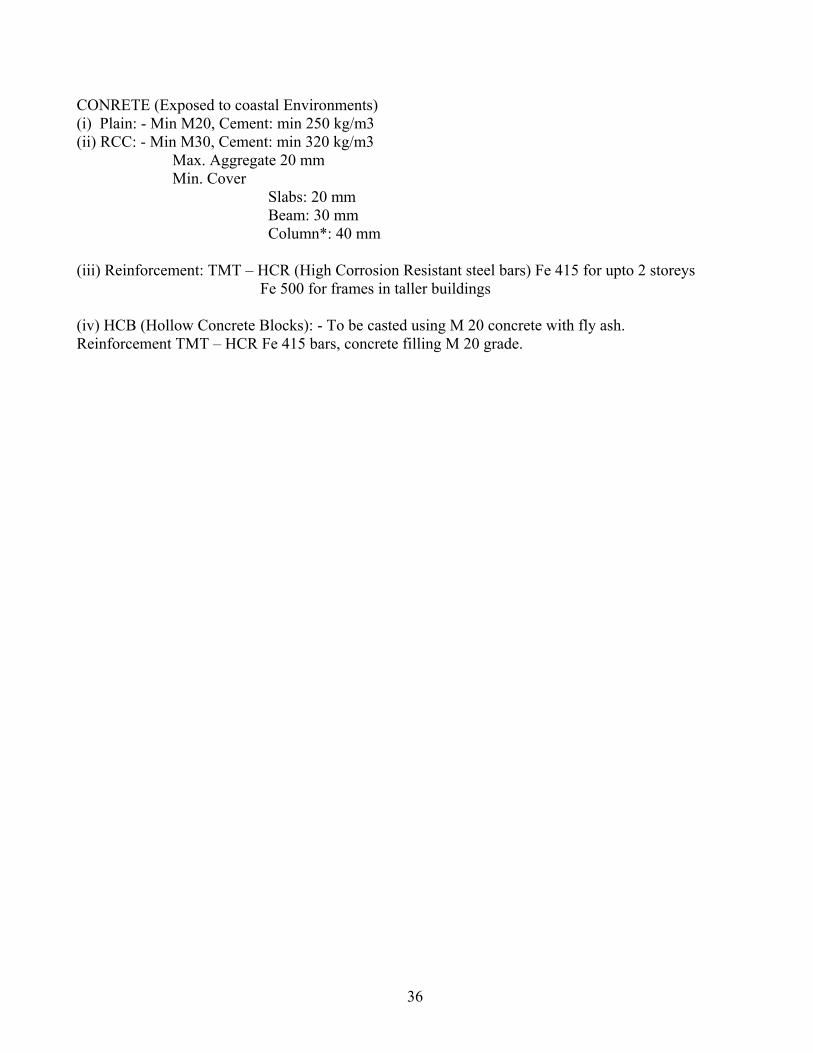
CONRETE (Exposed to coastal Environments) (i) Plain: - Min M20, Cement: min 250 kg/m3 (ii) RCC: - Min M30, Cement: min 320 kg/m3 Max. Aggregate 20 mm Min. Cover Slabs: 20 mm Beam: 30 mm Column*: 40 mm (iii) Reinforcement: TMT – HCR (High Corrosion Resistant steel bars) Fe 415 for upto 2 storeys Fe 500 for frames in taller buildings (iv) HCB (Hollow Concrete Blocks): - To be casted using M 20 concrete with fly ash. Reinforcement TMT – HCR Fe 415 bars, concrete filling M 20 grade.
36
Related Documents