Pilot’s Guide to ForeFlight Mobile ForeFlight, LLC 47th Edition - Covers ForeFlight Mobile v8.2 on iPad

Welcome message from author
This document is posted to help you gain knowledge. Please leave a comment to let me know what you think about it! Share it to your friends and learn new things together.
Transcript

Pilot’s Guide to ForeFlight Mobile
ForeFlight, LLC
47th Edition - Covers ForeFlight Mobile v8.2 on iPad
...............................................................................................Introduction 17
....................................................................................................................................iPad Tips 17
..............................................................Setting-up ForeFlight Mobile 19
........................................................................................................Airports 20
..................................................................................................................About the Design 21
......................................................................................Finding an Airport using Search 21
.....................................................................................Finding an Airport using Browse 22
............................................................................................................Favorite Airports List 23
...............................................................................................................Recent Airports List 24
....................................................................................Favorite and Recent Airport Sync 24
....................................................................................................Viewing Airport Weather 25
.....................................................................Model Output Statistics (MOS) Forecasts 26
........................................................................................................................Runway Winds 28
............................................................................................................Viewing a Procedure 29
.......................................................................................................Swipe to Change Plates 30
.................................................................................Using Geo-Referenced Procedures 32
....................................................................................................................FBO Information 33
...................................................................................................................................................Fuel prices 33
..................................................................................................................................................Comments 34
...............Airport/Facility Directory (A/FD) or Canada Flight Supplement (CFS) 35
................................................................................Airport and Aircraft Flight Tracking 36
ForeFlight Mobile v8.2! 2
.............................................................................................................Maps 37
..................................................................................................................About the Design 37
..........................................................................................................Pinch, Zoom, and Pan 38
........................................................................................Changing Maps / Map Overlay 38
..................................................................................................Global Aeronautical Maps 44
.................................................................................................................Aeronautical Maps Features 45
.................................................................................................................Aeronautical Maps Symbols 47
.........................................................................................................................Maps Settings 48
...............................................................................................................................Map Touch 50
.............................................................................................................Smart Airway Labels 52
........................................................................................................................Airport pop-up 53
.........................................................................................Weather Overlay Color Coding 54
........................................................Attitude Indicator / Synthetic Vision (iPad only) 56
.............................................IMPORTANT NOTICE: ATTITUDE INDICATOR DISPLAY 57
.........................................................................................................................Stratus 2/2S Positioning 59
...................................................................................................................Calibrate the AI/SV display 59
...............................................................................................Synthetic Vision required downloads 60
.................................................Finding an Airport or Navigation Aid using Search 61
.........................................................................................Planning a Flight using Search 62
..........................................................................................Planning a Flight using Touch 64
............................................................................................................Airspace Information 66
................................................................................................................................Route Line 66
ForeFlight Mobile v8.2! 3
.................................................................................................Managing User Waypoints 66
..............................................................................................................User Waypoint Sync 68
......................................Working with the Navigation Log, Edit and Profile Views 68
.....................................................................................................................................................Overview 68
......................................................................................................................................................Edit View 71
....................................................................................................................................Procedure Advisor 73
........................................................................................................................................................Reverse 80
..........................................................................................................................................................Routes 81
..............................................................................................................................................NavLog View 82
.................................................................................................................................................Profile View 83
.........................................................................................................................Single-waypoint Search 89
................................................................................................Engaging the Moving Map 89
.......................................................................................................................................................Track Up 90
...........................................................................................................................................Distance Rings 91
................................................................................................................................................Track Vector 92
...................................................................................................................................Direct-To 93
...........................................................................................................................................Ruler 93
...................................................................Viewing and Hiding the Instrument Panel 94
..........................................................................................................Using Favorite Routes 95
.............................................................................................................Using Recent Routes 96
......................................................................................Favorite and Recent Route Sync 96
....................................................................................................................Clearing a Route 97
............................................................................................................Alerts 98
ForeFlight Mobile v8.2! 4
..................................................................................................................About The Design 98
.................................................................................................Runway Proximity Advisor 98
........................................................................................................Cabin Altitude Advisor 99
.............................................................................................................................Traffic Alerts 99
..................................................................................................................................TFR Alerts 99
.................................................................................................................................Sink Rate 101
.................................................................................................................................500’ AGL 102
............................................................................................................Pack 103
................................................................................................................About the Design 103
...................................................................................................................Pack for a Flight 105
.............................................................................................................................................................iPad 105
........................................................................................................................................................iPhone 106
............................................................................................................Sync 108
................................................................................................................About the Design 108
.............................................................................................................................Using Sync 108
.....................................................................................Cockpit Sharing 111
................................................................................................................About the Design 111
.......................................................................................................Using Cockpit Sharing 111
..........................................................................................................Plates 112
................................................................................................................About the Design 112
...........................................................................................................About Plate Binders 113
ForeFlight Mobile v8.2! 5
................................................................................................................Creating a Binder 113
..................................................................................................................Managing Plates 113
..............................NOTAM Advisor for Approach Plates and Airport Diagrams 115
...............................................................................................FBOs on Airport Diagrams 116
.........................................................................................Printing Plates From a Binder 117
................................................................................Ensuring Your Plates Don’t Expire 117
................................................Plates and Taxi Diagrams on a Map 118
................................................................................................................About the Design 118
............................................................................................Displaying a Plate on a Map 119
.....................................................................Changing or Hiding the Plate on a Map 120
........................................................................................Adjusting Plate Transparency 120
................................................................................................Track Logs 121
................................................................................................................About the Design 121
....................................................................................................Enabling Track Logging 121
.............................................................................................................Start/Stop Logging 121
.................................................................................................................Track Log Listing 122
..............................................................Synchronizing Track Logs to other Devices 123
................................................................Viewing a Track Log on an iPad or iPhone 124
.............................................................................................................Sharing Track Logs 124
............................................................................Exporting Track Logs to other Apps 125
..........................................................Viewing Track Logs in ForeFlight on the web 126
ForeFlight Mobile v8.2! 6
..............................................................................................Documents 127
................................................................................................................About the Design 127
................................................................................................About Document Binders 128
................................................................................................................Creating a Binder 128
.............................................................................Adding Documents from a Catalog 128
.............................................................................................................Document Syncing 129
.................................................Importing Documents from iTunes or other Apps 133
.........................................................................................................Viewing a Document 134
................................................................................................Searching in a Document 135
.............................................................................................................Adding Bookmarks 136
................................................................................Managing Documents in a Binder 136
...........................................................................Deleting Documents from your iPad 137
.....................................................................Ensuring Your Documents Don’t Expire 137
.......................................Annotating Plates and PDF Documents 138
................................................................................................................About the Design 138
........................................................................................................Types of Annotations 139
..................................................................................Adding and Editing Annotations 139
...............................................................................................................Choosing Annotation Color 140
....................................................................................................Fill Color: Transparent or “No Fill” 141
.............................................................................................................................................Drawing/Ink 142
.....................................................................................................................................................Text Box 142
..................................................................................................................................................Rectangle 143
ForeFlight Mobile v8.2! 7
..........................................................................................................................................Ellipse (Circle) 144
.............................................................................................................................................................Line 144
.....................................................................................................................................................Polygon 144
......................................................................................................................................................Polyline 145
...............................................................................................................................................Sticky-note 145
............................................................................................................................Undo/Redo 146
.....................................................................................Selecting Multiple Annotations 146
...........................................................................Copying and Pasting an Annotation 146
........................................................................................................Deleting Annotations 147
.....................................................................................................Imagery 148
................................................................................................................About the Design 148
........................................................................................................Selecting a Collection 149
...........................................................................................................................NATIONAL - Featured 149
..................................................................................................................................CONUS WEATHER 151
....................................................................................................................................................GFS MOS 155
..............................................................................................................................................ADVISORIES 155
..........................................................................................................................................WINDS ALOFT 156
..........................................................................................................................................................ICING 156
...........................................................................................................................................TURBULENCE 159
..................................................................................................................................................SATELLITE 160
....................................................................................................................................DOPPLER RADAR 161
..................................................................................................................PILOT WEATHER REPORTS 161
...............................................................................................................Viewing an Image 162
ForeFlight Mobile v8.2! 8
......................................................................................................Using Favorite Images 162
...................................................................................................................................Send To 162
................................................................................................File & Brief 163
................................................................................................................About the Design 163
................................................................................Before Creating a New Flight Plan 164
..............................................................................................Creating a New Flight Plan 165
...................................Choosing between FAA/Domestic and ICAO Flight Plans 166
.......................................................................Creating an FAA/Domestic Flight Plan 167
..........................................................................................Creating an ICAO Flight Plan 167
.........................................................................................Obtaining a Weather Briefing 168
......................................................Filing your Flight Plan (FAA/Domestic or ICAO) 168
................................................................Flight Plan Acknowledgment Notification 169
.............................................................................................................Flight Notifications 169
..............................................................Amending or Canceling a LMFS Flight Plan 172
...........................................................Activating or Closing a LMFS VFR Flight Plan 173
.............................................................................Close VFR Flight Plan “PUSH” Alerts 174
...........................................................Amending or Canceling a DUATS Flight Plan 174
...........................................................................................Managing Flight Plan Forms 174
...........................................................................................................................Flight Alerts 174
................................................................................ForeFlight Briefing 176
................................................................................................................About the Design 176
ForeFlight Mobile v8.2! 9

.....................................................................................................Navigating the Briefing 177
............................................................................................Translated Text vs Raw Text 177
.................................................................................................................Briefing Sections 178
...............................................................................................................................Adverse Conditions 178
....................................................................................................................................................Synopsis 179
.....................................................................................................................................Current Weather 179
...................................................................................................................................................Forecasts 179
....................................................................................................................................................NOTAMs 180
..........................................................................................................................................Miscellaneous 180
.............................................................................................ScratchPads 181
................................................................................................................About the Design 181
.............................................................................................................Open a ScratchPad 181
......................................................................................................ScratchPad Templates 182
...................................................................................Change Pen Size, Color, Opacity 182
............................................................................................................................Undo/Redo 183
................................................................................................Clear ScratchPad Content 183
...................................................................................................Edit a ScratchPad Name 183
.............................................................................Reposition ScratchPad Thumbnails 184
..............................................................................................................Send a ScratchPad 184
...........................................................................................................Delete a ScratchPad 184
...........................................................................................................More 185
............................................................................................................................Downloads 185
ForeFlight Mobile v8.2! 10
...................................................................................................................................About the Design 185
............................................................................................................................Grouped Downloads 187
....................................................................................................................Select Data to Download 187
................................................................................................................................Downloading Data 189
.....................................................................................................Downloading in the Background 189
.....................................................................................................................................Keeping Current 190
..................................................................................................................Deleting Data Downloads 190
.....................................................................A Quick Tour of the Data Available for Download 191
.................................................................................................................Preflight Download Check 192
.............................................................................................................Troubleshooting Downloads 192
................................................................................................................................Accounts 194
...................................................................................................................................About the Design 194
...................................................................................................Viewing your Active Subscription 194
...............................................Purchasing or Renewing a Subscription in the United States 195
..................................................................Purchasing or Renewing a Subscription in Canada 196
...........................................................................................Signing In to your ForeFlight Account 196
.......................................................................................Signing Out of your ForeFlight Account 196
...................................................................................................Changing your Password or Email 197
..........................................................................................Removing Devices from your Account 197
..............................................................................................................Providing a DUATS Account 197
..............................................................................................Signing Out of your DUATS Account 198
....................................................................................................................................Aircraft 199
.............................................................................................................Create or Edit Aircraft Profile 199
...........................................................................................................................Delete Aircraft Profile 200
.................................................................................................................................Logbook 201
ForeFlight Mobile v8.2! 11
................................................................................................................Weight & Balance 202
...................................................................................................................................Settings 203
...................................................................................................................User Waypoints 209
.............................................................................................................Latitude/Longitude Formats 209
..............................................................................................................................Track Logs 210
...................................................................................................................................Devices 211
.....................................................Location Disabled / Troubleshooting GPS position issues 211
......................................................................................................................................About 212
............................................................................................Apple Watch 213
................................................................................................................................Overview 213
..............................................................................................................................Setting Up 213
........................................................................................................................Airports Page 215
................................................................................................................Instruments Page 216
............................................................................................................................Timer Page 217
.......................................................................................ADS-B Weather 218
................................................................................................................................Overview 218
.................................................................................Data Access in ForeFlight Mobile 218
................................................................................Stratus ESG (Stratus 1S/2/2S Only) 219
..........................................................................Stratus Replay (Stratus 1S/2/2S Only) 220
..............................................................................................................Status Information 220
.....................................................................................................Animated ADS-B Radar 224
......................................................................................ADS-B Tower Location on Map 225
ForeFlight Mobile v8.2! 12
...........................................................................................ADS-B Traffic 226
................................................................................................................................Overview 226
.........................................................................................IMPORTANT TRAFFIC NOTICE 226
...............................................................................Traffic Access in ForeFlight Mobile 226
..............................................................................................................Status Information 227
....................................................................................................................Traffic Symbols 227
.............................................................................................Hide Distant Traffic Setting 229
..................................................................................Ownship ADS-B Out Information 229
..........................................................................................................................Traffic Alerts 230
.............................................................Stratus Flight Data Recorder 231
................................................................................................................................Overview 231
........................................Recording a Track Log Using the Flight Data Recorder 231
...................................................................Stratus Firmware Update 233
................................................................................................................................Overview 233
........................................................................................................................Update Steps 233
...............................................................................ForeFlight Connect 234
................................................................................................................................Overview 234
..................................................................................................................Garmin Connext 234
..................................................................................................................Pairing with Flight Stream 234
........................................................................................................................................Using Connext 235
...........................................................................................................GPS and ADS-B from Connext 236
ForeFlight Mobile v8.2! 13
.......................................Sending a Route to Connext (requires Flight Stream 210 or 510) 237
...................................Getting a Route from Connext (requires Flight Stream 210 or 510) 238
...............................................................................................Calibrating Flight Stream 210 AHRS 239
..................................................................................................................Garmin GTX 345 240
.......................................................................................................................Connecting to GTX 345 240
........................................................................................................................................Using GTX 345 240
...........................................................................................................GPS and ADS-B from GTX 345 241
....................................................................................................................Garmin GDL 39 242
.........................................................................................................................Connecting to GDL 39 242
...........................................................................................................................................Using GDL 39 242
.............................................................................................................GPS and ADS-B from GDL 39 243
..................................................................................................................................L-3 Lynx 245
...............................................................................................................................Connecting to Lynx 245
................................................................................................................................................Using Lynx 245
..................................................................................................................GPS and ADS-B from Lynx 246
.........................................................................................................Avidyne IFD 540/440 247
................................................................................................................Connecting to IFD 540/440 247
..................................................................................................Getting a Route from IFD 540/440 247
..........................................................................................................................GPS from IFD 540/440 248
....................................................................................................................Dynon SkyView 249
...................................................................................................................Configuring SkyView WiFi 249
...............................................................................................Connecting ForeFlight and SkyView 249
..............................................................................................................Sending a Route to SkyView 250
..........................................................................................................Getting a Route from SkyView 252
ForeFlight Mobile v8.2! 14
...................................................................................................GPS and ARHS data from SkyView 253
.................................................................................................................FreeFlight ADS-B 254
...........................................................................Connecting ForeFlight and FreeFlight RANGR 254
..............................................................................GPS and ADS-B data from FreeFlight RANGR 255
.............................................................................................XM Weather 256
..................................................................................................................SiriusXM SXAR-1 256
................................................................................................Connecting ForeFlight and SXAR-1 257
.......................................................................................................SXAR-1 Available Weather Data 257
.................................................................................................................SXAR-1 Status Information 259
............................................................................................Baron Mobile Link/WXWorx 260
...............................................................................................Mobile Link Available Weather Data 260
........................................................................................................Mobile Link Status Information 261
...............................................................................LogTen Integration 262
..............................................................Flight Simulator Integration 263
...................................................................................................................................X-Plane 263
........................................................................................................................Infinite Flight 264
...........................................................................................Prepar3D/Flight Simulator X 265
...................................................................................................................................Redbird 265
........................................................................................................................................ELITE 265
......................................................................................................................................Frasca 266
.......................................................................................Sharing Flights 267
.....................................................................................................................................Twitter 267
ForeFlight Mobile v8.2! 15
........................................................................................................................................Email 267
................................................................................................Miscellany 268
..........................................................................Radar Legends (when from Internet) 268
...........................................................................Rain - Radar Intensity (dBZ) vs. Color 269
................................................Mixed Rain/Snow - Radar Intensity (dBZ) vs. Color 270
........................................................................Snow - Radar Intensity (dBZ) vs. Color 271
..................................................Four-color Radar - Radar Intensity (dBZ) vs. Color 272
.......................Baron Mobile Link/WXWorx XM Radar Intensity (dBZ) vs. Color 273
..........................................................................Radar Legends (when from Internet) 274
........................................................................................................................PIREP Legend 274
................................................................................Color-Enhanced Infrared Satellite 275
........................................................................................Learning More 277
............................................................Pilot’s Guide Change History 278
ForeFlight Mobile v8.2! 16
IntroductionThis pilot’s guide provides an overview of ForeFlight Mobile and its capabilities on
the iPad. After reading this guide, you will have the ability to:
• Plan flights quickly
• Gather preflight intelligence information efficiently, and
• Use ForeFlight Mobile to best support your type of flying.
This guide presumes a basic level of proficiency with general iPad use and navigation. If you are new to Apple iOS devices, including the iPad, you will want to view the guided tours available on Apple’s website at www.apple.com/ipad/guided-tours/ as well as the iPad User Guide at support.apple.com/manuals/
IPAD TIPS
There are a few handy iPad features you’ll want to know about when using ForeFlight Mobile:
✤ Multiple Orientations: The iPad supports portrait (tall) and landscape (wide) orientations. When you rotate an iPad from one orientation to another, an application typically alters its user interface to better take advantage of the space supplied.
✤ Rotation Lock: Having the screen content rotate when you rotate the iPad isn’t always a good thing. Rotation lock is helpful for preventing Terminal Procedure rotation or accidental rotation in turbulence. Fortunately, you can choose when the screen rotates and when it doesn’t. There are a few methods for locking the orientation of content on your iPad’s screen:
Physical Switch: A physical switch is located immediately above the volume buttons on the right side of some iPad models (models without the switch are the iPad Pro, iPad Mini 4, and iPad Air 2). When switched on, this prevents an application from changing its orientation as you change the orientation of the iPad. On some iPads, this switch instead functions as a “mute” switch. You can change the function of this back to a “lock” switch by using the iPad’s Settings application. Tap General, and use the options in the Use Side Switch to: section. If this section is not displayed, you may need to update your iPad’s version of the iOS operating system to enable this.
ForeFlight Mobile v8.2! 17
iPad Soft-Lock: Swipe up from the bottom of the screen to open the Control Center and find the rotation lock soft-button. This method is not available if you have the physical slider switch set to manage screen lock.
ForeFlight Procedures Lock: ForeFlight Mobile also provides a soft-lock switch on the Procedures viewer for more flexibility.
✤ Settings App: The iPad includes a special application called Settings. Within Settings, you can modify the way the iPad and its applications behave. ForeFlight-specific settings are addressed in the Settings section of this guide. All ForeFlight settings are available in the More view of ForeFlight Mobile as well.
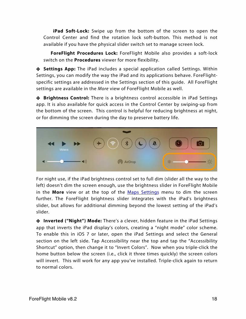
✤ Brightness Control: There is a brightness control accessible in iPad Settings app. It is also available for quick access in the Control Center by swiping-up from the bottom of the screen. This control is helpful for reducing brightness at night, or for dimming the screen during the day to preserve battery life.
For night use, if the iPad brightness control set to full dim (slider all the way to the left) doesn’t dim the screen enough, use the brightness slider in ForeFlight Mobile in the More view or at the top of the Maps Settings menu to dim the screen further. The ForeFlight brightness slider integrates with the iPad’s brightness slider, but allows for additional dimming beyond the lowest setting of the iPad’s slider.
✤ Inverted (“Night”) Mode: There’s a clever, hidden feature in the iPad Settings app that inverts the iPad display’s colors, creating a “night mode” color scheme. To enable this in iOS 7 or later, open the iPad Settings and select the General section on the left side. Tap Accessibility near the top and tap the “Accessibility Shortcut” option, then change it to “Invert Colors”. Now when you triple-click the home button below the screen (i.e., click it three times quickly) the screen colors will invert. This will work for any app you’ve installed. Triple-click again to return to normal colors.
ForeFlight Mobile v8.2! 18
Setting-up ForeFlight MobileFirst, download ForeFlight Mobile to your iPad, iPhone or iPod Touch from the
Apple App store. See www.foreflight.com/support/getting-started for detailed instructions.
If this is your first time using ForeFlight Mobile on that device, you’ll get a 30-day free trial of the data. The free trial includes all standard (not Pro) features, but you won’t be able to “bulk download” charts and plates for different states.
You can purchase a subscription anytime at www.foreflight.com/buy.
IMPORTANT: If you have a subscription, follow these steps:
✤ Sign in: Your ForeFlight Mobile subscription is associated with your email address. This address does not have to be the same as the AppleID email address used in the Apple App store. Sign in on the More > Accounts tab (iPad) or the Menu > Account page (iPhone). See Signing in to your ForeFlight account.
✤ Choose Chart Data to Download: See Select Data to Download. Tap on More > Downloads (iPad) or Menu > Downloads (iPhone), then tap on the Country area(s) for which you have a subscription. For example if you have a US subscription, you would tap on United States. Choose the types of charts to download, then scroll down and select (tap) each state you want to download. Then tap the <Downloads button to go back to the Download status page, and tap the blue Download button to download the data.
✤ Confirm Data Sync: If you have previously used ForeFlight Mobile 6.2 or later on any device(s), your User Waypoints, Favorites (Routes, Airports, Plates, Imagery) and Recents (Routes, Airports, Plates Imagery) will automatically be loaded after you sign-in. If you have lots of User Waypoints, Favorites or Recents, it may take a few minutes for the data to load.
✤ If using an iPad: Tap on Documents > Catalog and choose any documents you would like to have in-flight. The Pilot’s Guide is in the ForeFlight category; the FAA category has A/FD Supplementals, Legends, and FAR’s and FAA Handbooks.
Before flying, be sure to complete the pre-flight check, including Downloading Data, and use Pack to confirm you have charts, METARs, NOTAMs, TFRs and Fuel prices covering your route.
ForeFlight Mobile v8.2! 19
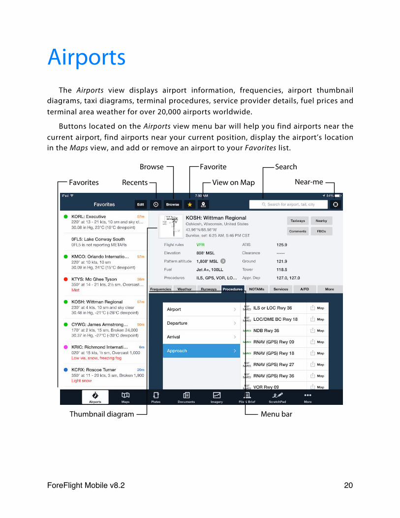
AirportsThe Airports view displays airport information, frequencies, airport thumbnail
diagrams, taxi diagrams, terminal procedures, service provider details, fuel prices and terminal area weather for over 20,000 airports worldwide.
Buttons located on the Airports view menu bar will help you find airports near the current airport, find airports near your current position, display the airport’s location in the Maps view, and add or remove an airport to your Favorites list.
Thumbnail diagram
Favorite Browse
Recents View on MapFavorites Near-me
Search
Menu bar
ForeFlight Mobile v8.2! 20
ABOUT THE DESIGN
The Airports view is designed to fill the whole screen, reduce scrolling, and reduce the effort required for your eyes to lock on to important airport information. The colors selected reduce brightness, draw attention to the top half of the page, and help highlight critical information.
Airport Detail information is displayed on the top half of the Airports view. Refer to this portion of the view when preparing to taxi or when approaching an airport, as it contains elements such as the current flight rule; field elevation and pattern altitude; automated weather frequencies, and controller frequencies.
Additional information from one of the eight available lower views is displayed in the bottom half of the screen. There are views for airport related frequencies, current and forecast weather, runway details, terminal procedures, notices to airmen, airport services, the Airport/Facility Directory entry, and supplemental airport information.
FINDING AN AIRPORT USING SEARCH
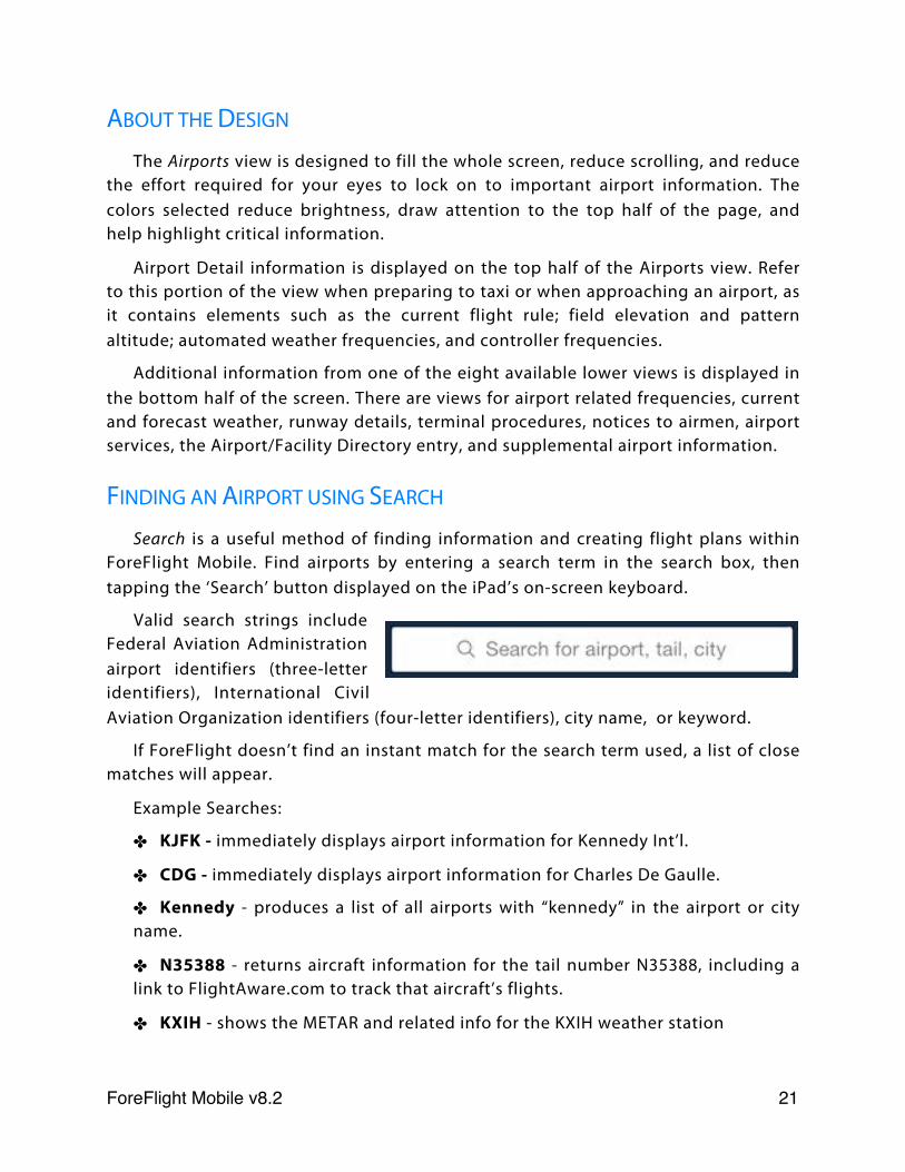
Search is a useful method of finding information and creating flight plans within ForeFlight Mobile. Find airports by entering a search term in the search box, then tapping the ‘Search’ button displayed on the iPad’s on-screen keyboard.
Valid search strings include Federal Aviation Administration airport identifiers (three-letter identifiers), International Civil Aviation Organization identifiers (four-letter identifiers), city name, or keyword.
If ForeFlight doesn’t find an instant match for the search term used, a list of close matches will appear.
Example Searches:
✤ KJFK - immediately displays airport information for Kennedy Int’l.
✤ CDG - immediately displays airport information for Charles De Gaulle.
✤ Kennedy - produces a list of all airports with “kennedy” in the airport or city name.
✤ N35388 - returns aircraft information for the tail number N35388, including a link to FlightAware.com to track that aircraft’s flights.
✤ KXIH - shows the METAR and related info for the KXIH weather station
ForeFlight Mobile v8.2! 21
FINDING AN AIRPORT USING BROWSE
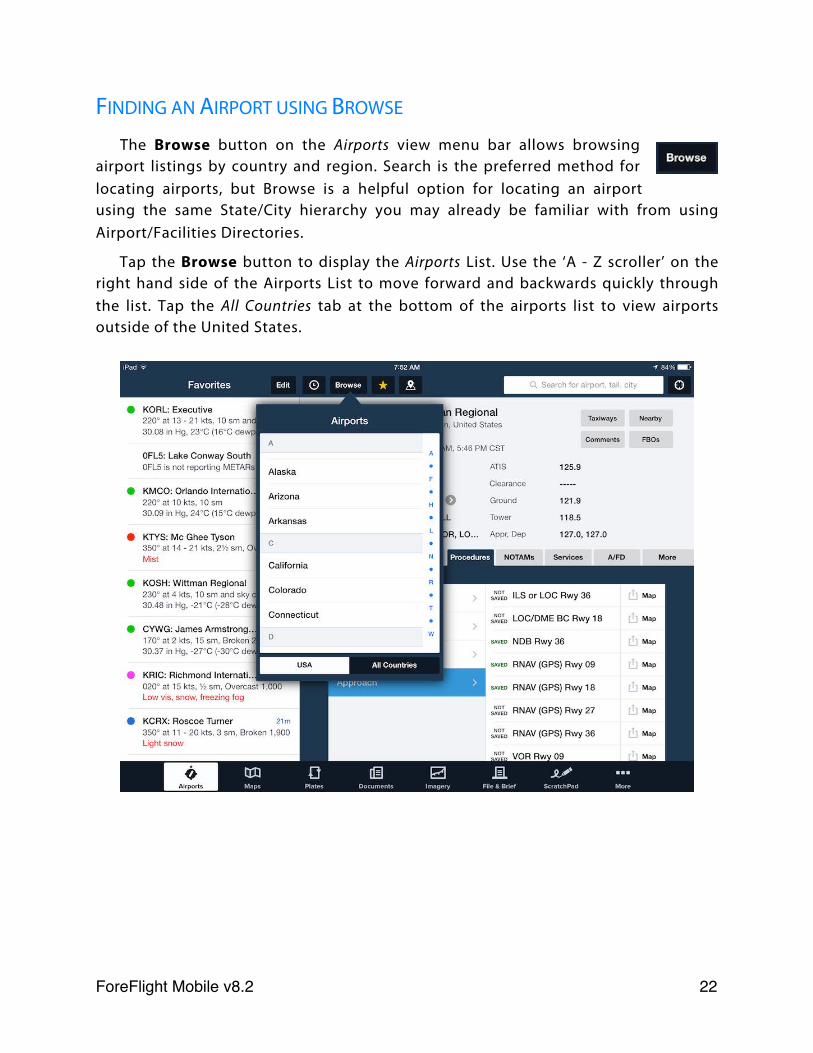
The Browse button on the Airports view menu bar allows browsing airport listings by country and region. Search is the preferred method for locating airports, but Browse is a helpful option for locating an airport using the same State/City hierarchy you may already be familiar with from using Airport/Facilities Directories.
Tap the Browse button to display the Airports List. Use the ‘A - Z scroller’ on the right hand side of the Airports List to move forward and backwards quickly through the list. Tap the All Countries tab at the bottom of the airports list to view airports outside of the United States.
ForeFlight Mobile v8.2! 22
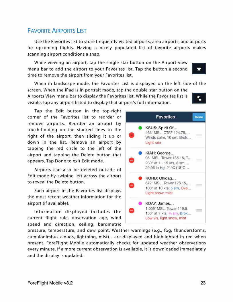
FAVORITE AIRPORTS LIST
Use the Favorites list to store frequently visited airports, area airports, and airports for upcoming flights. Having a nicely populated list of favorite airports makes scanning airport conditions a snap.
While viewing an airport, tap the single star button on the Airport view menu bar to add the airport to your Favorites list. Tap the button a second time to remove the airport from your Favorites list.
When in landscape mode, the Favorites List is displayed on the left side of the screen. When the iPad is in portrait mode, tap the double-star button on the Airports View menu bar to display the Favorites list. While the Favorites list is visible, tap any airport listed to display that airport’s full information.
Tap the Edit button in the top-right corner of the Favorites list to reorder or remove airports. Reorder an airport by touch-holding on the stacked lines to the right of the airport, then sliding it up or down in the list. Remove an airport by tapping the red circle to the left of the airport and tapping the Delete button that appears. Tap Done to exit Edit mode.
Airports can also be deleted outside of Edit mode by swiping left across the airport to reveal the Delete button.
Each airport in the Favorites list displays the most recent weather information for the airport (if available).
Information displayed includes the current flight rule, observation age, wind speed and direction, ceiling, barometric pressure, temperature, and dew point. Weather warnings (e.g., fog, thunderstorms, cumulonimbus clouds, lightning, mist) - are displayed and highlighted in red when present. ForeFlight Mobile automatically checks for updated weather observations every minute. If a more current observation is available, it is downloaded immediately and the display is updated.
ForeFlight Mobile v8.2! 23
ForeFlight uses the following convention for conveying the airport’s current Flight Category:
Green VFR
Blue MVFR
Red IFR
Magenta LIFR
RECENT AIRPORTS LIST
Tap the history button to display the Recents list. The Recents list displays the last twenty airports viewed in the order they were viewed.
To remove airports from the Recents list, there are two methods available: clear and swipe-to-delete. Tap the Clear button to remove all airports from the list. To remove a single entry from the Recents list use the standard Apple ‘swipe-to-delete’ function: swipe your finger across the airport, then tap the red “Delete” button.
FAVORITE AND RECENT AIRPORT SYNC
Changes to your Favorite and Recent airports, including adding, removing and changing the order of Airports, are automatically synchronized to each device that is signed-in to your ForeFlight Mobile account. For more information, see the Sync chapter.
ForeFlight Mobile v8.2! 24

VIEWING AIRPORT WEATHER
Current Flight Category and a summary of weather (METAR) are shown for each airport on the Favorite Airports list. Tap the “Weather” tab to view detailed weather data for the selected airport, including METAR, TAFs, Model Output Statistics (MOS) forecasts, the Forecast Discussion for that area (US only), and Winds and Temperatures aloft with calculated difference from ISA (International Standard Atmosphere). Scroll down to see future forecasted TAFs and Winds Aloft.
The forecast Temperatures Aloft at different altitudes are colored based on temperature range:
Grey Above +2° C
Magenta From +2° C down to -25° C
Tan Below -26° C
ForeFlight Mobile v8.2! 25
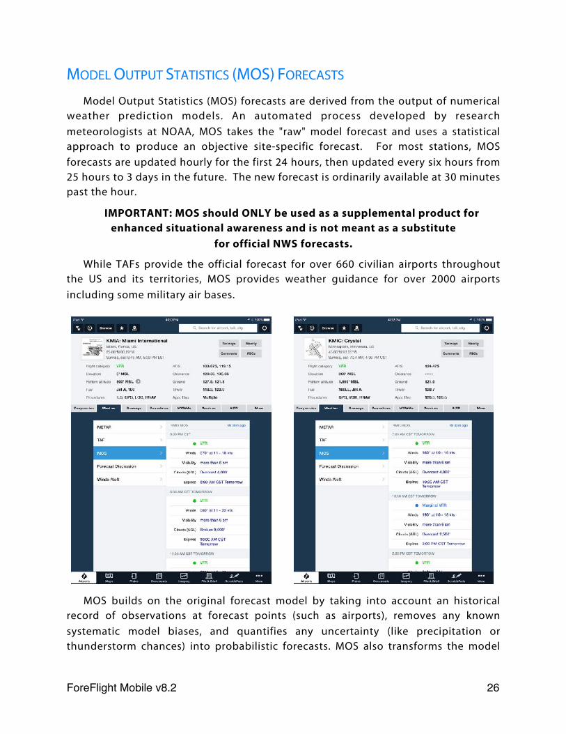
MODEL OUTPUT STATISTICS (MOS) FORECASTS
Model Output Statistics (MOS) forecasts are derived from the output of numerical weather prediction models. An automated process developed by research meteorologists at NOAA, MOS takes the "raw" model forecast and uses a statistical approach to produce an objective site-specific forecast. For most stations, MOS forecasts are updated hourly for the first 24 hours, then updated every six hours from 25 hours to 3 days in the future. The new forecast is ordinarily available at 30 minutes past the hour.
IMPORTANT: MOS should ONLY be used as a supplemental product for enhanced situational awareness and is not meant as a substitute
for official NWS forecasts.
While TAFs provide the official forecast for over 660 civilian airports throughout the US and its territories, MOS provides weather guidance for over 2000 airports including some military air bases.
MOS builds on the original forecast model by taking into account an historical record of observations at forecast points (such as airports), removes any known systematic model biases, and quantifies any uncertainty (like precipitation or thunderstorm chances) into probabilistic forecasts. MOS also transforms the model
ForeFlight Mobile v8.2! 26
data into sensible weather elements basic to aviation such as sky cover, ceiling height, visibility, wind speed and direction, the probability of precipitation, and the precipitation type.
MOS is a point forecast similar to a TAF. That is, MOS is valid at the station (airport) and should never be used as zone or area forecast. Pilots should use MOS in a similar way they may use a TAF keeping in mind that TAFs are constructed by highly trained meteorologists and will ordinarily be more accurate than a MOS forecast for the same airport. Additionally, MOS cannot be used as a forecast for dispatch to the airport or for IFR alternate requirements as required by FAA regulations. TAFs and the area forecast (FA) must be used for this purpose.
The use of "Nearest MOS" is provided strictly for convenience. Keep in mind that a forecast for an airport that is 20 miles away, for example, may not be representative of the forecast for the intended airport.
Despite its advantages, the MOS has some important limitations vs. TAFs:
✤ MOS is only available for US airports and some airports in US territories.
✤ MOS forecasts are never amended.
✤ MOS does not predict temporary conditions.
✤ MOS cannot forecast multiple cloud layers.
✤ MOS does not predict specific cloud layers above 12,000’ AGL.
✤ MOS cannot forecast weather in the terminal area’s vicinity (e.g., showers, fog).
✤ MOS cannot forecast precipitation intensity and cannot distinguish between rain and drizzle.
✤ MOS cannot distinguish between freezing rain, freezing drizzle and ice pellets.
✤ MOS cannot predict variable winds.
✤ MOS cannot forecast non-convective low level wind shear (LLWS) or no significant weather (NSW).
ForeFlight Mobile v8.2! 27
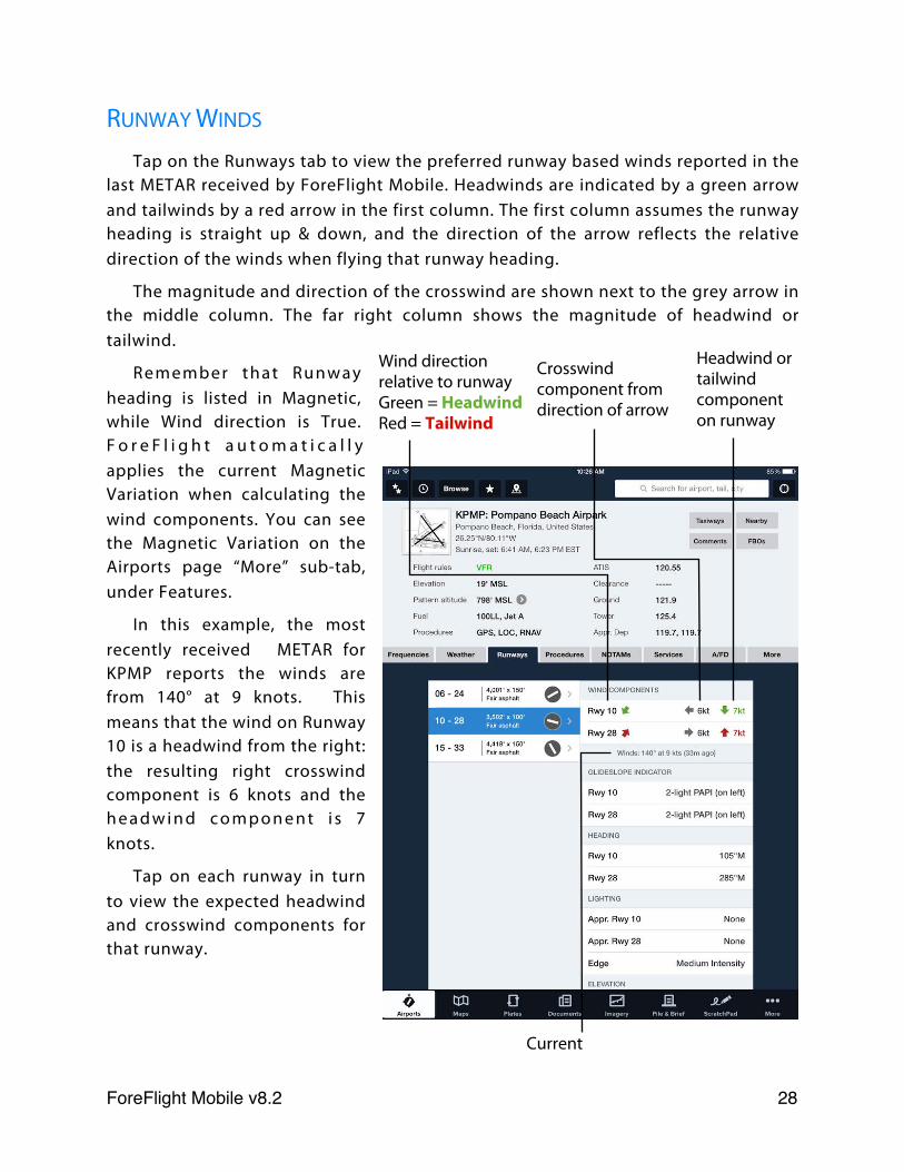
RUNWAY WINDS
Tap on the Runways tab to view the preferred runway based winds reported in the last METAR received by ForeFlight Mobile. Headwinds are indicated by a green arrow and tailwinds by a red arrow in the first column. The first column assumes the runway heading is straight up & down, and the direction of the arrow reflects the relative direction of the winds when flying that runway heading.
The magnitude and direction of the crosswind are shown next to the grey arrow in the middle column. The far right column shows the magnitude of headwind or tailwind.
Remember that Runway heading is listed in Magnetic, while Wind direction is True. F o r e F l i g h t a u t o m a t i c a l l y applies the current Magnetic Variation when calculating the wind components. You can see the Magnetic Variation on the Airports page “More” sub-tab, under Features.
In this example, the most recently received METAR for KPMP reports the winds are from 140° at 9 knots. This means that the wind on Runway 10 is a headwind from the right: the resulting right crosswind component is 6 knots and the h e a d w i n d c o m p o n e n t i s 7 knots.
Tap on each runway in turn to view the expected headwind and crosswind components for that runway.
Current
Wind direction relative to runwayGreen = HeadwindRed = Tailwind
Crosswind component from direction of arrow
Headwind or tailwind component on runway
ForeFlight Mobile v8.2! 28
VIEWING A PROCEDURE
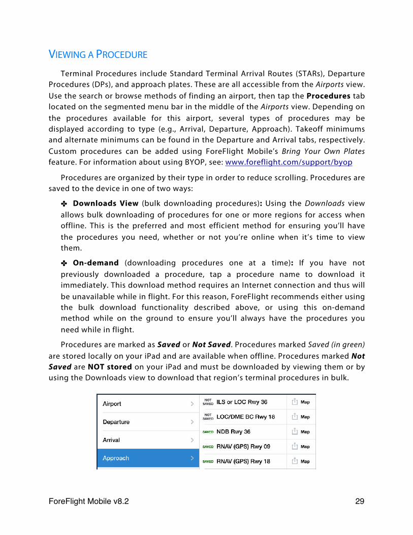
Terminal Procedures include Standard Terminal Arrival Routes (STARs), Departure Procedures (DPs), and approach plates. These are all accessible from the Airports view. Use the search or browse methods of finding an airport, then tap the Procedures tab located on the segmented menu bar in the middle of the Airports view. Depending on the procedures available for this airport, several types of procedures may be displayed according to type (e.g., Arrival, Departure, Approach). Takeoff minimums and alternate minimums can be found in the Departure and Arrival tabs, respectively. Custom procedures can be added using ForeFlight Mobile’s Bring Your Own Plates feature. For information about using BYOP, see: www.foreflight.com/support/byop
Procedures are organized by their type in order to reduce scrolling. Procedures are saved to the device in one of two ways:
✤ Downloads View (bulk downloading procedures): Using the Downloads view allows bulk downloading of procedures for one or more regions for access when offline. This is the preferred and most efficient method for ensuring you’ll have the procedures you need, whether or not you’re online when it’s time to view them.
✤ On-demand (downloading procedures one at a time): If you have not previously downloaded a procedure, tap a procedure name to download it immediately. This download method requires an Internet connection and thus will be unavailable while in flight. For this reason, ForeFlight recommends either using the bulk download functionality described above, or using this on-demand method while on the ground to ensure you’ll always have the procedures you need while in flight.
Procedures are marked as Saved or Not Saved. Procedures marked Saved (in green) are stored locally on your iPad and are available when offline. Procedures marked Not Saved are NOT stored on your iPad and must be downloaded by viewing them or by using the Downloads view to download that region’s terminal procedures in bulk.
ForeFlight Mobile v8.2! 29
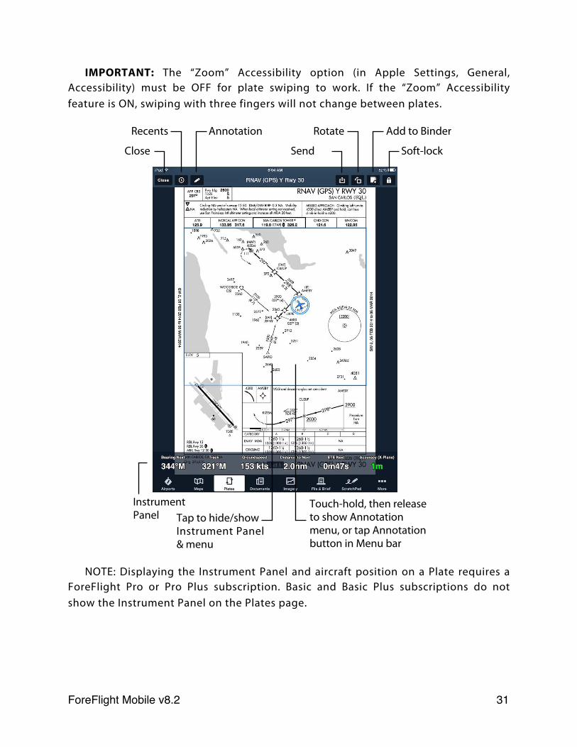
From the Procedures tab, touch a procedure’s name to display the ForeFlight procedure viewer. The procedure viewer includes buttons for: accessing a list of recently viewed procedures, sending a plate to the Map (if you have a Pro or Pro Plus subscription) printing a procedure, adding a procedure to your current Plates binder, and locking the procedure.
ForeFlight Mobile’s Lock button disables touch interaction (zooming and scrolling) with the terminal procedure viewer, which minimizes the risk of accidental closure when in turbulence. It also disables the automatic rotation that would normally occur when the iPad is turned. The lock button can also, optionally, disable all buttons on the screen, including those that change views. That feature is configured in Settings.
Multi-page procedures can be viewed be sliding pages left or right with a single finger.
To print the plate, tap the Send To button in the upper toolbar and choose “Printer.” An AirPrint capable printer is required. For more information about this requirement, see:
support.apple.com/kb/HT4356
Tap the Rotate button in the upper toolbar to rotate the plate clockwise 90 degrees per tap.
Note: Procedures are also available directly from the Plates view.
SWIPE TO CHANGE PLATES
When viewing a plate from the Airports page or the Plates page (including in a binder) you can quickly change between plates by swiping three fingers from Right to Left (or Left to Right).
When viewing plates at an Airport, swiping from Right to Left with three fingers will display the next Procedure in that airport’s list and swiping from Left to Right will display the previous Procedure in that airport’s list.
When viewing plates in a binder on the Plates page, swiping from Right to Left with three fingers will display the next Procedure in the binder and swiping from Left to Right will display the previous Procedure in the binder.
In either case the lists do not “wrap around” so when you get to the end of the list, additional swipes in the same direction will not take you to the end (or beginning) of the list or binder.
ForeFlight Mobile v8.2! 30
IMPORTANT: The “Zoom” Accessibility option (in Apple Settings, General, Accessibility) must be OFF for plate swiping to work. If the “Zoom” Accessibility feature is ON, swiping with three fingers will not change between plates.
NOTE: Displaying the Instrument Panel and aircraft position on a Plate requires a ForeFlight Pro or Pro Plus subscription. Basic and Basic Plus subscriptions do not show the Instrument Panel on the Plates page.
Close
Annotation
Send
Rotate Add to Binder
Soft-lock
Instrument Panel Tap to hide/show
Instrument Panel & menu
Touch-hold, then release to show Annotation menu, or tap Annotation button in Menu bar
Recents
ForeFlight Mobile v8.2! 31
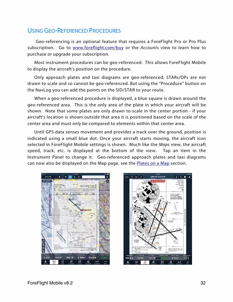
USING GEO-REFERENCED PROCEDURES
Geo-referencing is an optional feature that requires a ForeFlight Pro or Pro Plus subscription. Go to www.foreflight.com/buy or the Accounts view to learn how to purchase or upgrade your subscription.
Most instrument procedures can be geo-referenced. This allows ForeFlight Mobile to display the aircraft's position on the procedure.
Only approach plates and taxi diagrams are geo-referenced; STARs/DPs are not drawn to scale and so cannot be geo-referenced. But using the “Procedure” button on the NavLog you can add the points on the SID/STAR to your route.
When a geo-referenced procedure is displayed, a blue square is drawn around the geo-referenced area. This is the only area of the plate in which your aircraft will be shown. Note that some plates are only drawn to-scale in the center portion - if your aircraft’s location is shown outside that area it is positioned based on the scale of the center area and must only be compared to elements within that center area.
Until GPS data senses movement and provides a track over the ground, position is indicated using a small blue dot. Once your aircraft starts moving, the aircraft icon selected in ForeFlight Mobile settings is shown. Much like the Maps view, the aircraft speed, track, etc. is displayed at the bottom of the view. Tap an item in the Instrument Panel to change it. Geo-referenced approach plates and taxi diagrams can now also be displayed on the Map page, see the Plates on a Map section.
ForeFlight Mobile v8.2! 32
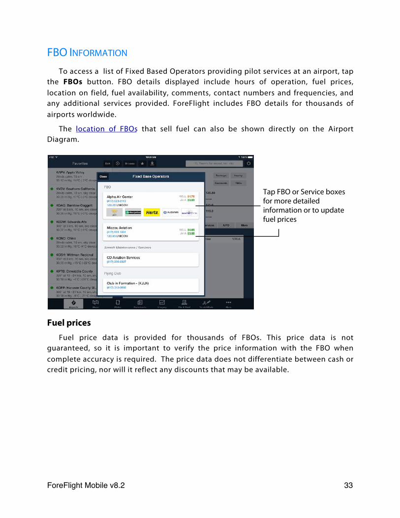
FBO INFORMATION
To access a list of Fixed Based Operators providing pilot services at an airport, tap the FBOs button. FBO details displayed include hours of operation, fuel prices, location on field, fuel availability, comments, contact numbers and frequencies, and any additional services provided. ForeFlight includes FBO details for thousands of airports worldwide.
The location of FBOs that sell fuel can also be shown directly on the Airport Diagram.
Fuel pricesFuel price data is provided for thousands of FBOs. This price data is not
guaranteed, so it is important to verify the price information with the FBO when complete accuracy is required. The price data does not differentiate between cash or credit pricing, nor will it reflect any discounts that may be available.
Tap FBO or Service boxes for more detailed information or to update fuel prices
ForeFlight Mobile v8.2! 33
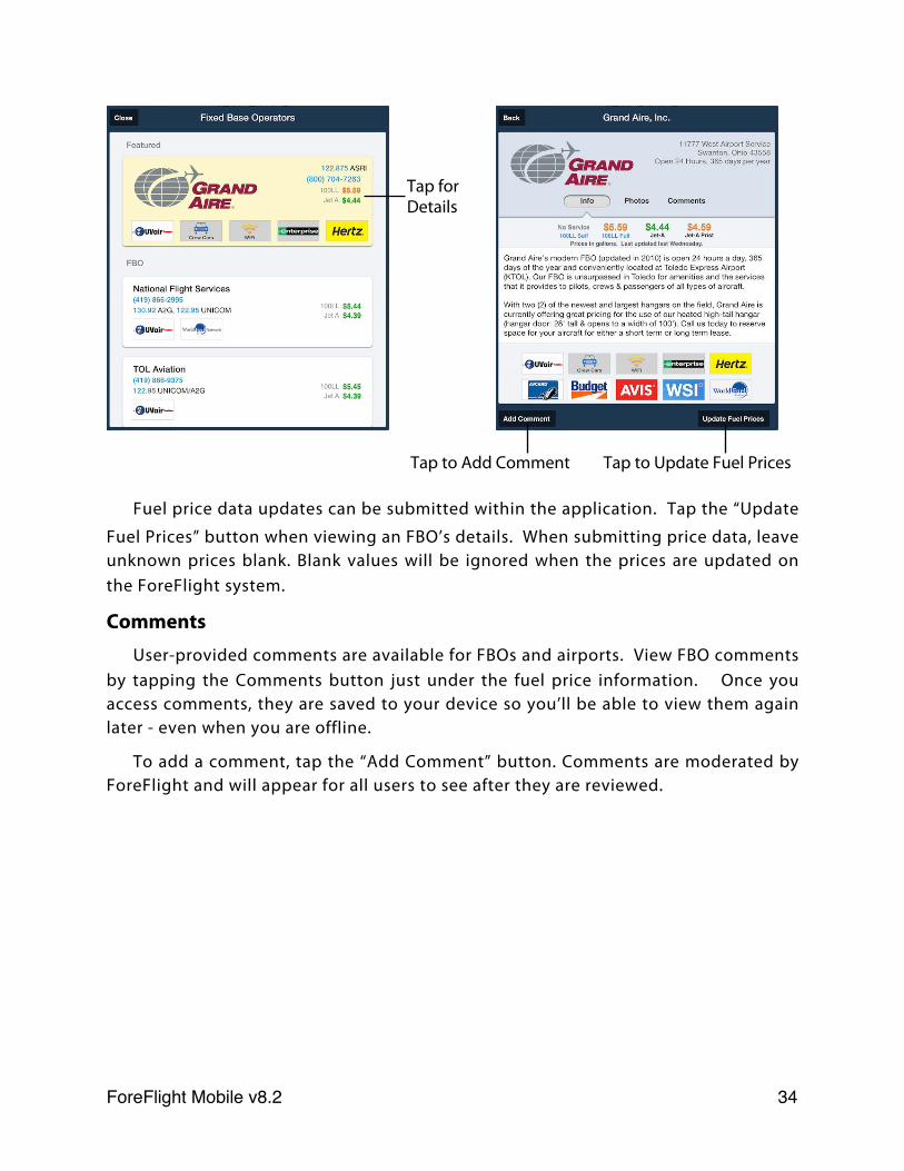
Fuel price data updates can be submitted within the application. Tap the “Update
Fuel Prices” button when viewing an FBO’s details. When submitting price data, leave unknown prices blank. Blank values will be ignored when the prices are updated on the ForeFlight system.
CommentsUser-provided comments are available for FBOs and airports. View FBO comments
by tapping the Comments button just under the fuel price information. Once you access comments, they are saved to your device so you’ll be able to view them again later - even when you are offline.
To add a comment, tap the “Add Comment” button. Comments are moderated by ForeFlight and will appear for all users to see after they are reviewed.
Tap for Details
Tap to Add Comment Tap to Update Fuel Prices
ForeFlight Mobile v8.2! 34
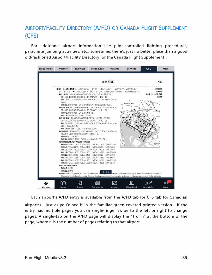
AIRPORT/FACILITY DIRECTORY (A/FD) OR CANADA FLIGHT SUPPLEMENT
(CFS)For additional airport information like pilot-controlled lighting procedures,
parachute jumping activities, etc., sometimes there’s just no better place than a good old-fashioned Airport/Facility Directory (or the Canada Flight Supplement).
Each airport’s A/FD entry is available from the A/FD tab (or CFS tab for Canadian
airports) - just as you’d see it in the familiar green-covered printed version. If the entry has multiple pages you can single-finger swipe to the left or right to change pages. A single-tap on the A/FD page will display the “1 of n” at the bottom of the page, where n is the number of pages relating to that airport.
ForeFlight Mobile v8.2! 35
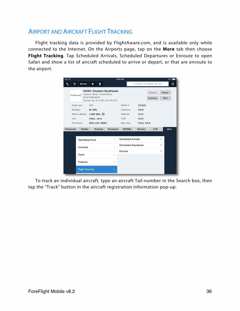
AIRPORT AND AIRCRAFT FLIGHT TRACKING
Flight tracking data is provided by FlightAware.com, and is available only while connected to the Internet. On the Airports page, tap on the More tab then choose Flight Tracking. Tap Scheduled Arrivals, Scheduled Departures or Enroute to open Safari and show a list of aircraft scheduled to arrive or depart, or that are enroute to the airport.
To track an individual aircraft, type an aircraft Tail-number in the Search box, then tap the “Track” button in the aircraft registration information pop-up.
ForeFlight Mobile v8.2! 36
Maps
ABOUT THE DESIGN
The Maps view is the place to visualize airspace, weather, terrain and other factors that may affect your route. The maps view is also the place to chart your progress during a flight. The maps themselves take center stage with supporting data surrounding them.
Search box
Radar / Satellite Animation
Track Log Record
Zoom to Route
Zoom In or Out
Instrument Panel
Route line (future legs)
Route line (active leg)
Route line (past legs)
Edit, NavLog, Profile
Map layer Map Settings
Synthetic Vision
Hide/Show Flight Plan(! indicates Pack needed before flight)
Hide/Show Instrument PanelFavorites Recents Auto-center
Airway label
ForeFlight Mobile v8.2! 37
PINCH, ZOOM, AND PAN
Each map in the Maps view supports the standard iPad gestures for zooming and panning. Drag your finger on the map to slide it to a new region. Use two fingers in a pinch or expand gesture to change the zoom scale of the map. You can also double tap the map to zoom in one level or tap once with two fingers at the same time to zoom out one level. Anytime you display a new route on the map the zoom level and region shown will auto-adjust to bring your route into view.
Tap the Zoom to Route button in the lower left of the Maps screen to automatically zoom the map in or out to show the entire Route.
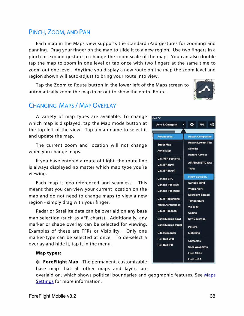
CHANGING MAPS / MAP OVERLAY
A variety of map types are available. To change which map is displayed, tap the Map mode button at the top left of the view. Tap a map name to select it and update the map.
The current zoom and location will not change when you change maps.
If you have entered a route of flight, the route line is always displayed no matter which map type you’re viewing.
Each map is geo-referenced and seamless. This means that you can view your current location on the map and do not need to change maps to view a new region - simply drag with your finger.
Radar or Satellite data can be overlaid on any base map selection (such as VFR charts). Additionally, any marker or shape overlay can be selected for viewing. Examples of these are TFRs or Visibility. Only one marker-type can be selected at once. To de-select a overlay and hide it, tap it in the menu.
Map types:
✤ ForeFlight Map - The permanent, customizable base map that all other maps and layers are overlaid on, which shows political boundaries and geographic features. See Maps Settings for more information.
ForeFlight Mobile v8.2! 38
✤ Aeronautical - ForeFlight’s Global Aeronautical Maps. These displays dynamic and customizable aeronautical data , such as airports, airspace, ARTCCs, VORs, waypoints, and more. See Global Aeronautical Maps for more information.
✤ Aerial Map - Satellite image map including street labels. Like the Street Map, this map can only be used when connected to the Internet. However, views you display while connected to the Internet are cached in memory and may be available in-flight, provided the cache is not cleared or filled to capacity.
✤ Street Map - Detailed street map. However, views you display while connected to the Internet are cached in memory and may be available in-flight, provided the cache is not cleared or filled to capacity.
✤ U.S. VFR Sectional - Terminal Area Charts (TACs) are automatically displayed when a VFR sectional is zoomed in to major cities containing a TAC inset.
✤ U.S. IFR Enroute - low or high.
✤ Canada VNC - VFR Terminal Area Charts (VTAs) are automatically displayed when a VNC is zoomed in to major cities containing a VTA inset. Requires ForeFlight Canada subscription.
✤ Canada IFR Enroute - low or high. Requires ForeFlight Canada subscription.
✤ U.S. IFR (planning) - IFR planning chart covering contiguous 48 states.
✤ World Aeronautical - VFR chart covering the contiguous 48 states + Alaska. WAC charts covering northern Mexico (extending south to the tip of Baja) and the northern Caribbean (extending south to Guadeloupe island) can also be downloaded. Tap More > Downloads > Caribbean, Mexico, Central America, then turn World Aeronautical Charts to ON.
✤ U.S. IFR (ocean) - Atlantic and Pacific ocean IFR charts.
✤ Carib/Mexico IFR - IFR Low or High charts covering Mexico and the Caribbean. Tap More > Downloads > Canada, Mexico, Central America, then turn IFR Low Charts and/or IFR High Charts to ON.
✤ U.S. Helicopter - Three-color charts showing aeronautical information useful to helicopter pilots navigating in 9 major metro areas with heavy helicopter activity. Includes helicopter routes, heliports, navaids and obstructions. Can be selected with any U.S. base map.
✤ Heli Gulf VFR - U.S. VFR Sectional-style chart of the Gulf of Mexico (GOM) showing airspace, GOM blocks, airspace, and oil rig and weather station locations. Can be selected with any U.S. base map.
ForeFlight Mobile v8.2! 39
✤ Heli Gulf IFR - IFR style chart of the Gulf of Mexico (GOM) showing GOM blocks, GPS waypoints, airspace and weather station locations. Can be selected with any U.S. base map.
Map overlays:
✤ Radar (Composite) - Radar for the US and Canada showing a composite of multiple angles of radar scan.
✤ Radar (Lowest Tilt) - Radar for the US and Canada showing only the lowest angle (tilt) radar scan, useful for determining where precipitation is actually reaching the ground.
Both radar layers can be animated by tapping the “play” button in the lower left corner of the map. The radar layers check for updates every three minutes. For more details, see the Radar Legend, and radar color vs. intensity legends for Rain, Mixed Rain/Snow, and Snow.
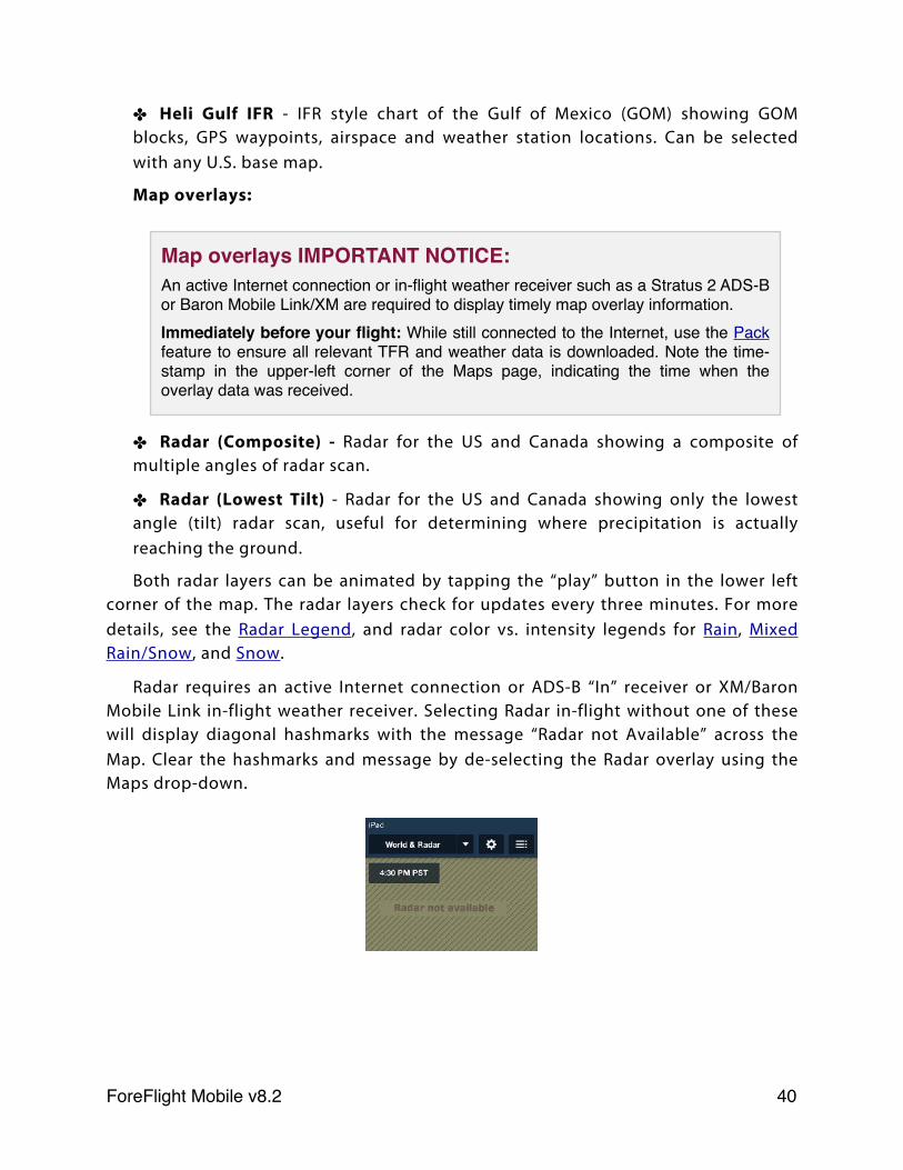
Radar requires an active Internet connection or ADS-B “In” receiver or XM/Baron Mobile Link in-flight weather receiver. Selecting Radar in-flight without one of these will display diagonal hashmarks with the message “Radar not Available” across the Map. Clear the hashmarks and message by de-selecting the Radar overlay using the Maps drop-down.
Map overlays IMPORTANT NOTICE:An active Internet connection or in-flight weather receiver such as a Stratus 2 ADS-B or Baron Mobile Link/XM are required to display timely map overlay information.Immediately before your flight: While still connected to the Internet, use the Pack feature to ensure all relevant TFR and weather data is downloaded. Note the time-stamp in the upper-left corner of the Maps page, indicating the time when the overlay data was received.
ForeFlight Mobile v8.2! 40
✤ Satellite - Visible or Infrared depending on time of day. This can be animated by pressing the “play” button in the lower left corner of the map. The satellite map checks for updates every three minutes, but new images are typically transmitted every 30 minutes. Satellite requires an active Internet connection or XM/Baron Mobile Link in-flight weather. The Satellite overlay is not available with an ADS-B weather receiver. Selecting Satellite in-flight without a XM/Baron Mobile Link receiver will display diagonal hashmarks with the message “Satellite not Available” across the Map. Clear the hashmarks and message by de-selecting the Satellite overlay using the Maps drop-down.
✤ Hazard Advisor - Terrain-based map, colored red or yellow based on terrain height relative to aircraft position (yellow for terrain between 1,000’ and 100’ below the aircraft, red for higher terrain). Also shows obstacles in local area within 1,000’ of aircraft altitude. Available on iPad 2 and iPhone 4 (or newer) with a ForeFlight Pro or Pro Plus subscription.
✤ Search & Rescue Grids: These map overlays are available when Search and Rescue is enabled in Settings. For more details see the Search and Rescue Supplement in Documents > Catalog > ForeFlight:
✤ CAP Grid - “Conventional” 15-minute quadrangle grid squares, in the format ORD385.
✤ Cell CAP Grid - “new” grid based on 1 degree of latitude/longitude, in the format 40092AA.
✤ GARS Grid - Grid Area Reference System made up of 30-minute cells with 15-minute quadrants and 5-minute areas, in the format 175LX.
✤ Traffic - When connected to a Stratus ADS-B receiver, the Traffic option is shown. When selected, ADS-B traffic received by the Stratus is displayed on the map. Suggested: iPad 2 or iPhone 4 (or newer). TRAFFIC DISPLAY WILL BE LIMITED UNLESS YOUR AIRCRAFT IS EQUIPPED WITH ADS-B OUT. SEE ADS-B TRAFFIC SECTION FOR MORE DETAILS.
✤ TFRs - covers regions provided by FAA as well as 3rd party sources (Stadium TFRs). Tap a TFR shape to see more details. TFR shapes are shown in yellow until 8 hours before the scheduled start time. Within 8 hours of the TFR being active, it is shown in red until the end of the TFR.
ForeFlight Mobile v8.2! 41
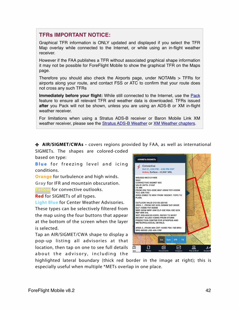
✤ AIR/SIGMET/CWAs - covers regions provided by FAA, as well as international SIGMETs. The shapes are colored-coded based on type: B l u e f o r f r e e z i n g l e v e l a n d i c i n g conditions.Orange for turbulence and high winds.Gray for IFR and mountain obscuration. Yellow for convective outlooks. Red for SIGMETs of all types. Light Blue for Center Weather Advisories.These types can be selectively filtered from the map using the four buttons that appear at the bottom of the screen when the layer is selected.Tap an AIR/SIGMET/CWA shape to display a pop-up l ist ing al l advisories at that location, then tap on one to see full details a b o u t t h e a d v i s o r y , i n c l u d i n g t h e highlighted lateral boundary (thick red border in the image at right); this is especially useful when multiple *METs overlap in one place.
TFRs IMPORTANT NOTICE:Graphical TFR information is ONLY updated and displayed if you select the TFR Map overlay while connected to the Internet, or while using an in-flight weather receiver.However if the FAA publishes a TFR without associated graphical shape information it may not be possible for ForeFlight Mobile to show the graphical TFR on the Maps page.Therefore you should also check the Airports page, under NOTAMs > TFRs for airports along your route, and contact FSS or ATC to confirm that your route does not cross any such TFRsImmediately before your flight: While still connected to the Internet, use the Pack feature to ensure all relevant TFR and weather data is downloaded. TFRs issued after you Pack will not be shown, unless you are using an ADS-B or XM in-flight weather receiver.For limitations when using a Stratus ADS-B receiver or Baron Mobile Link XM weather receiver, please see the Stratus ADS-B Weather or XM Weather chapters.
ForeFlight Mobile v8.2! 42
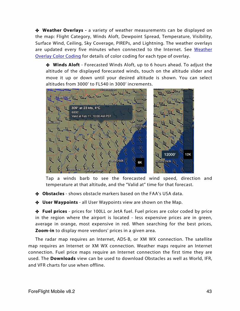
✤ Weather Overlays - a variety of weather measurements can be displayed on the map: Flight Category, Winds Aloft, Dewpoint Spread, Temperature, Visibility, Surface Wind, Ceiling, Sky Coverage, PIREPs, and Lightning. The weather overlays are updated every five minutes when connected to the Internet. See Weather Overlay Color Coding for details of color coding for each type of overlay.
✤ Winds Aloft - Forecasted Winds Aloft, up to 6 hours ahead. To adjust the altitude of the displayed forecasted winds, touch on the altitude slider and move it up or down until your desired altitude is shown. You can select altitudes from 3000’ to FL540 in 3000’ increments.
Tap a winds barb to see the forecasted wind speed, direction and temperature at that altitude, and the “Valid at” time for that forecast.
✤ Obstacles - shows obstacle markers based on the FAA’s USA data.
✤ User Waypoints - all User Waypoints view are shown on the Map.
✤ Fuel prices - prices for 100LL or JetA fuel. Fuel prices are color coded by price in the region where the airport is located - less expensive prices are in green, average in orange, most expensive in red. When searching for the best prices, Zoom-in to display more vendors’ prices in a given area.
The radar map requires an Internet, ADS-B, or XM WX connection. The satellite map requires an Internet or XM WX connection. Weather maps require an Internet connection. Fuel price maps require an Internet connection the first time they are used. The Downloads view can be used to download Obstacles as well as World, IFR, and VFR charts for use when offline.
ForeFlight Mobile v8.2! 43
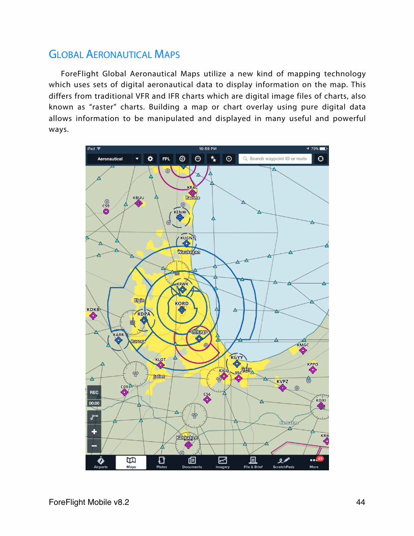
GLOBAL AERONAUTICAL MAPS
ForeFlight Global Aeronautical Maps utilize a new kind of mapping technology which uses sets of digital aeronautical data to display information on the map. This differs from traditional VFR and IFR charts which are digital image files of charts, also known as “raster” charts. Building a map or chart overlay using pure digital data allows information to be manipulated and displayed in many useful and powerful ways.
ForeFlight Mobile v8.2! 44
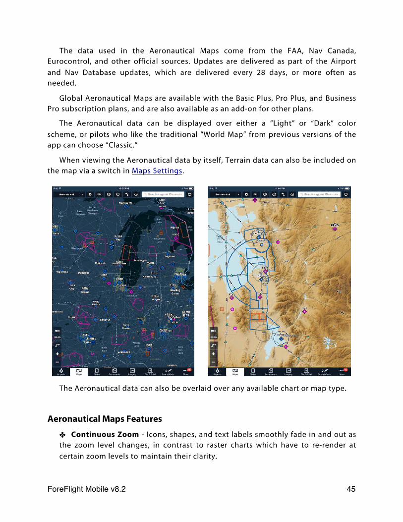
The data used in the Aeronautical Maps come from the FAA, Nav Canada, Eurocontrol, and other official sources. Updates are delivered as part of the Airport and Nav Database updates, which are delivered every 28 days, or more often as needed.
Global Aeronautical Maps are available with the Basic Plus, Pro Plus, and Business Pro subscription plans, and are also available as an add-on for other plans.
The Aeronautical data can be displayed over either a “Light” or “Dark” color scheme, or pilots who like the traditional “World Map” from previous versions of the app can choose “Classic.”
When viewing the Aeronautical data by itself, Terrain data can also be included on the map via a switch in Maps Settings.
The Aeronautical data can also be overlaid over any available chart or map type.
Aeronautical Maps Features
✤ Continuous Zoom - Icons, shapes, and text labels smoothly fade in and out as the zoom level changes, in contrast to raster charts which have to re-render at certain zoom levels to maintain their clarity.
ForeFlight Mobile v8.2! 45
✤ Decluttering - The information shown on the map changes along with the zoom level, with large-scale features like ARTCC boundaries and major airports appearing when zoomed out, and small-scale features like waypoints, VORs, and smaller airports appearing as you zoom in. This prevents the map from becoming too cluttered with information, and ensures that the most relevant information at any zoom level is shown.
✤ Always-Up Labels - Labels for airports, waypoints, and other map features always appear in the proper orientation, even when the rest of the map is upside down, as when flying south in “Track Up” mode.
✤ Customizable Data - The data shown on the map can be customized to the type of planning or flying you’re doing. Airspaces can be turned on or off, airways can be set to either high or low IFR, and ARTCC borders, heliports, and private airports can be toggled on or off. See Maps Settings for more information.
✤ Adjustable Text Size - The text size of labels for every map element can be adjusted using a slider. See Maps Settings for more information.
✤ Single Tap - When the Aeronautical layer is enabled, tapping on the icon for any map item will open that item’s detail view, allowing you to bypass the tap-hold action and “Add to Route” popup that is normally required to see details about a map item.
✤ Embedded Airport Diagrams - ForeFlight airport diagrams are directly integrated with the Aeronautical Maps, fading in as you zoom into an airport. The diagrams include labels for runways, taxiways, hold pads, and FBOs.
ForeFlight Mobile v8.2! 46
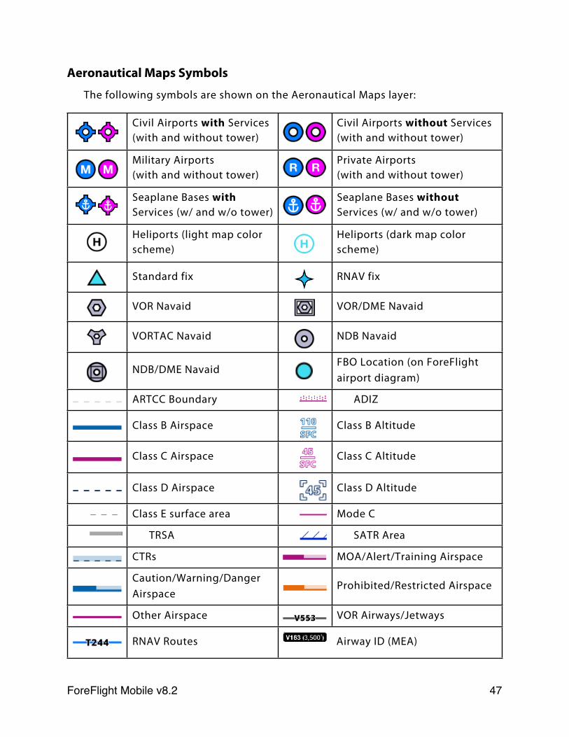
Aeronautical Maps Symbols
The following symbols are shown on the Aeronautical Maps layer:
Civil Airports with Services (with and without tower)
Civil Airports without Services (with and without tower)
Military Airports(with and without tower)
Private Airports(with and without tower)
Seaplane Bases with Services (w/ and w/o tower)
Seaplane Bases without Services (w/ and w/o tower)
Heliports (light map color scheme)
Heliports (dark map color scheme)
Standard fix RNAV fix
VOR Navaid VOR/DME Navaid
VORTAC Navaid NDB Navaid
NDB/DME NavaidFBO Location (on ForeFlight airport diagram)
ARTCC Boundary ADIZ
Class B Airspace Class B Altitude
Class C Airspace Class C Altitude
Class D Airspace Class D Altitude
Class E surface area Mode C
TRSA SATR Area
CTRs MOA/Alert/Training Airspace
Caution/Warning/Danger Airspace
Prohibited/Restricted Airspace
Other Airspace VOR Airways/Jetways
RNAV Routes Airway ID (MEA)
ForeFlight Mobile v8.2! 47
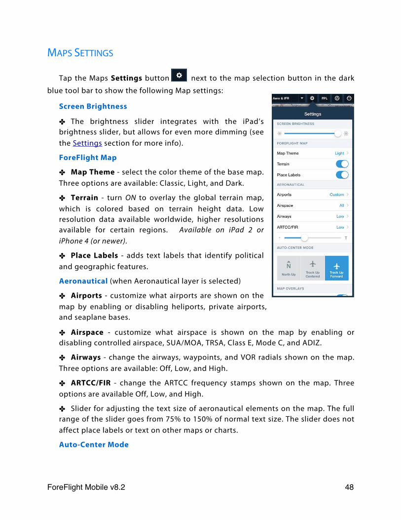
MAPS SETTINGS
Tap the Maps Settings button next to the map selection button in the dark
blue tool bar to show the following Map settings:
Screen Brightness
✤ The brightness slider integrates with the iPad’s brightness slider, but allows for even more dimming (see the Settings section for more info).
ForeFlight Map
✤ Map Theme - select the color theme of the base map. Three options are available: Classic, Light, and Dark.
✤ Terrain - turn ON to overlay the global terrain map, which is colored based on terrain height data. Low resolution data available worldwide, higher resolutions available for certain regions. Available on iPad 2 or iPhone 4 (or newer).
✤ Place Labels - adds text labels that identify political and geographic features.
Aeronautical (when Aeronautical layer is selected)
✤ Airports - customize what airports are shown on the map by enabling or disabling heliports, private airports, and seaplane bases.
✤ Airspace - customize what airspace is shown on the map by enabling or disabling controlled airspace, SUA/MOA, TRSA, Class E, Mode C, and ADIZ.
✤ Airways - change the airways, waypoints, and VOR radials shown on the map. Three options are available: Off, Low, and High.
✤ ARTCC/FIR - change the ARTCC frequency stamps shown on the map. Three options are available Off, Low, and High.
✤ Slider for adjusting the text size of aeronautical elements on the map. The full range of the slider goes from 75% to 150% of normal text size. The slider does not affect place labels or text on other maps or charts.
Auto-Center Mode
ForeFlight Mobile v8.2! 48
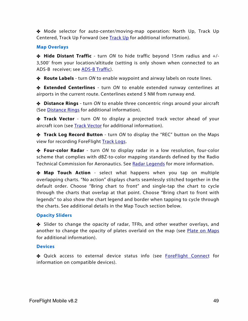
✤ Mode selector for auto-center/moving-map operation: North Up, Track Up Centered, Track Up Forward (see Track Up for additional information).
Map Overlays
✤ Hide Distant Traffic - turn ON to hide traffic beyond 15nm radius and +/- 3,500’ from your location/altitude (setting is only shown when connected to an ADS-B receiver; see ADS-B Traffic).
✤ Route Labels - turn ON to enable waypoint and airway labels on route lines.
✤ Extended Centerlines - turn ON to enable extended runway centerlines at airports in the current route. Centerlines extend 5 NM from runway end.
✤ Distance Rings - turn ON to enable three concentric rings around your aircraft (See Distance Rings for additional information).
✤ Track Vector - turn ON to display a projected track vector ahead of your aircraft icon (see Track Vector for additional information).
✤ Track Log Record Button - turn ON to display the “REC” button on the Maps view for recording ForeFlight Track Logs.
✤ Four-color Radar - turn ON to display radar in a low resolution, four-color scheme that complies with dBZ-to-color mapping standards defined by the Radio Technical Commission for Aeronautics. See Radar Legends for more information.
✤ Map Touch Action - select what happens when you tap on multiple overlapping charts. “No action” displays charts seamlessly stitched together in the default order. Choose “Bring chart to front” and single-tap the chart to cycle through the charts that overlap at that point. Choose “Bring chart to front with legends” to also show the chart legend and border when tapping to cycle through the charts. See additional details in the Map Touch section below.
Opacity Sliders
✤ Slider to change the opacity of radar, TFRs, and other weather overlays, and another to change the opacity of plates overlaid on the map (see Plate on Maps for additional information).
Devices
✤ Quick access to external device status info (see ForeFlight Connect for information on compatible devices).
ForeFlight Mobile v8.2! 49
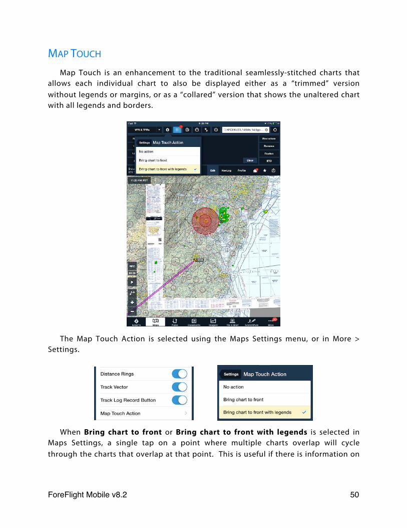
MAP TOUCH
Map Touch is an enhancement to the traditional seamlessly-stitched charts that allows each individual chart to also be displayed either as a “trimmed” version without legends or margins, or as a “collared” version that shows the unaltered chart with all legends and borders.
The Map Touch Action is selected using the Maps Settings menu, or in More > Settings.
When Bring chart to front or Bring chart to front with legends is selected in Maps Settings, a single tap on a point where multiple charts overlap will cycle through the charts that overlap at that point. This is useful if there is information on
ForeFlight Mobile v8.2! 50
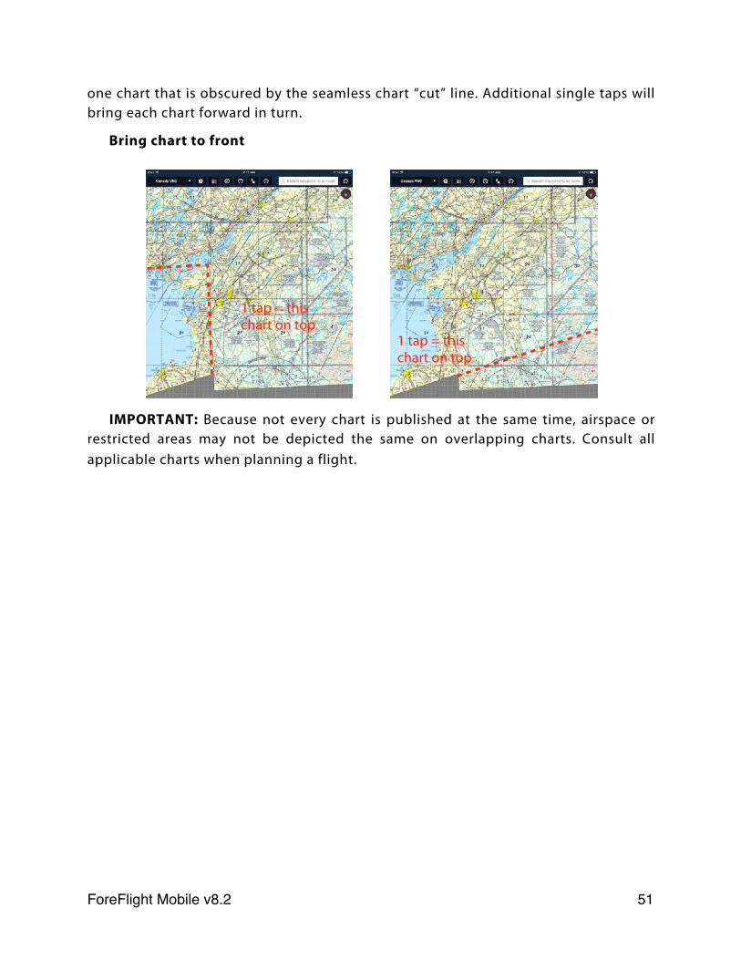
one chart that is obscured by the seamless chart “cut” line. Additional single taps will bring each chart forward in turn.
Bring chart to front
IMPORTANT: Because not every chart is published at the same time, airspace or restricted areas may not be depicted the same on overlapping charts. Consult all applicable charts when planning a flight.
1 tap = this chart on top
1 tap = this chart on top
ForeFlight Mobile v8.2! 51
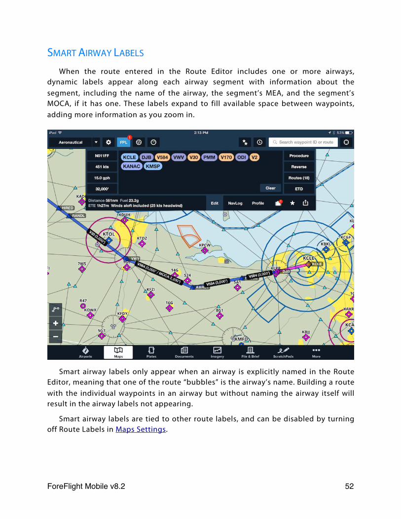
SMART AIRWAY LABELS
When the route entered in the Route Editor includes one or more airways, dynamic labels appear along each airway segment with information about the segment, including the name of the airway, the segment’s MEA, and the segment’s MOCA, if it has one. These labels expand to fill available space between waypoints, adding more information as you zoom in.
Smart airway labels only appear when an airway is explicitly named in the Route Editor, meaning that one of the route “bubbles” is the airway’s name. Building a route with the individual waypoints in an airway but without naming the airway itself will result in the airway labels not appearing.
Smart airway labels are tied to other route labels, and can be disabled by turning off Route Labels in Maps Settings.
ForeFlight Mobile v8.2! 52
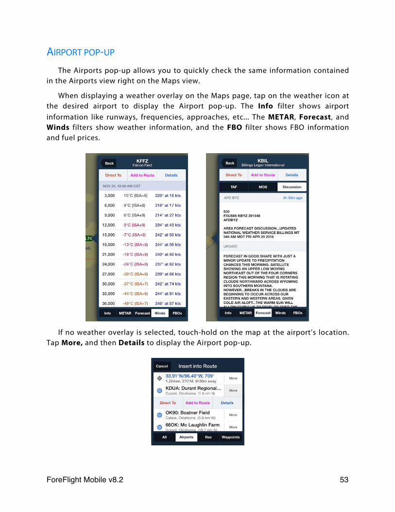
AIRPORT POP-UP
The Airports pop-up allows you to quickly check the same information contained in the Airports view right on the Maps view.
When displaying a weather overlay on the Maps page, tap on the weather icon at the desired airport to display the Airport pop-up. The Info filter shows airport information like runways, frequencies, approaches, etc... The METAR, Forecast, and Winds filters show weather information, and the FBO filter shows FBO information and fuel prices.
If no weather overlay is selected, touch-hold on the map at the airport’s location. Tap More, and then Details to display the Airport pop-up.
ForeFlight Mobile v8.2! 53
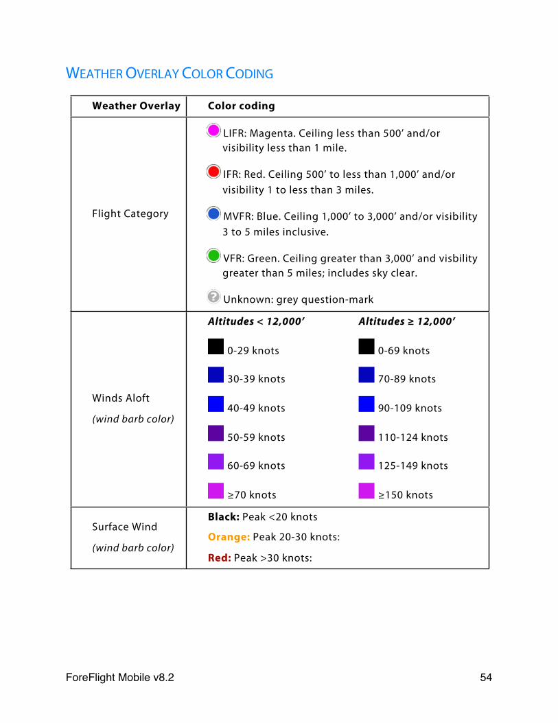
WEATHER OVERLAY COLOR CODING
Weather Overlay Color codingColor coding
Flight Category
LIFR: Magenta. Ceiling less than 500’ and/or visibility less than 1 mile.
IFR: Red. Ceiling 500’ to less than 1,000’ and/or visibility 1 to less than 3 miles.
MVFR: Blue. Ceiling 1,000’ to 3,000’ and/or visibility 3 to 5 miles inclusive.
VFR: Green. Ceiling greater than 3,000’ and visbility greater than 5 miles; includes sky clear.
Unknown: grey question-mark
Winds Aloft
(wind barb color)
Altitudes < 12,000’
0-29 knots
30-39 knots
40-49 knots
50-59 knots
60-69 knots
≥70 knots
Altitudes ≥ 12,000’
0-69 knots
70-89 knots
90-109 knots
110-124 knots
125-149 knots
≥150 knots
Surface Wind
(wind barb color)
Black: Peak <20 knots
Orange: Peak 20-30 knots:
Red: Peak >30 knots:
Black: Peak <20 knots
Orange: Peak 20-30 knots:
Red: Peak >30 knots:
ForeFlight Mobile v8.2! 54
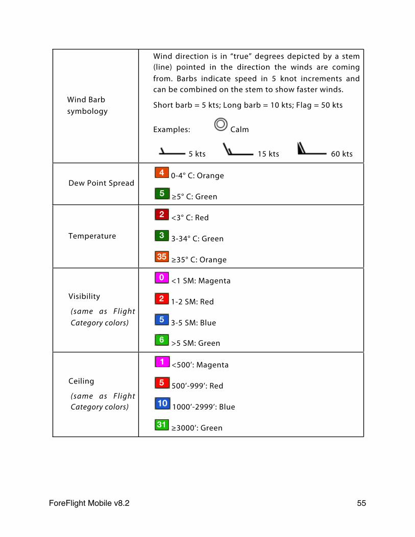
Wind Barb symbology
Wind direction is in “true” degrees depicted by a stem (line) pointed in the direction the winds are coming from. Barbs indicate speed in 5 knot increments and can be combined on the stem to show faster winds.
Short barb = 5 kts; Long barb = 10 kts; Flag = 50 kts
Examples: Calm
5 kts 15 kts 60 kts
Wind direction is in “true” degrees depicted by a stem (line) pointed in the direction the winds are coming from. Barbs indicate speed in 5 knot increments and can be combined on the stem to show faster winds.
Short barb = 5 kts; Long barb = 10 kts; Flag = 50 kts
Examples: Calm
5 kts 15 kts 60 kts
Dew Point Spread 0-4° C: Orange
≥5° C: Green
0-4° C: Orange
≥5° C: Green
Temperature
<3° C: Red
3-34° C: Green
≥35° C: Orange
<3° C: Red
3-34° C: Green
≥35° C: Orange
Visibility
(same as Flight Category colors)
<1 SM: Magenta
1-2 SM: Red
3-5 SM: Blue
>5 SM: Green
<1 SM: Magenta
1-2 SM: Red
3-5 SM: Blue
>5 SM: Green
Ceiling
(same as Flight Category colors)
<500’: Magenta
500’-999’: Red
1000’-2999’: Blue
≥3000’: Green
<500’: Magenta
500’-999’: Red
1000’-2999’: Blue
≥3000’: Green
ForeFlight Mobile v8.2! 55
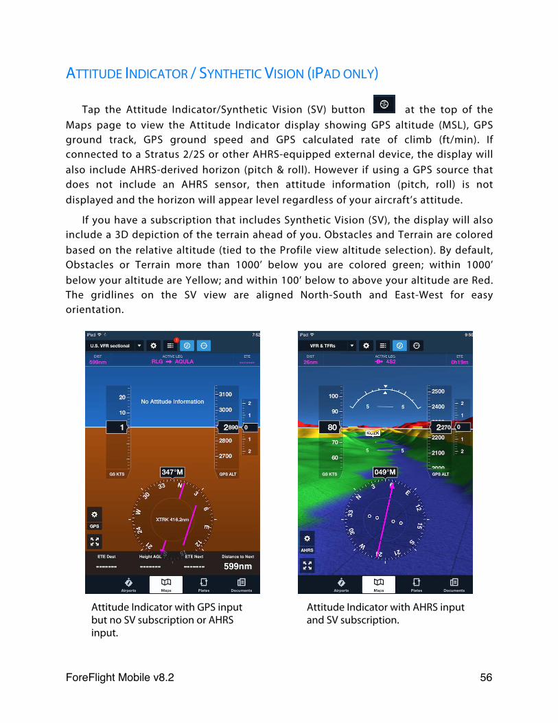
ATTITUDE INDICATOR / SYNTHETIC VISION (IPAD ONLY)
Tap the Attitude Indicator/Synthetic Vision (SV) button at the top of the Maps page to view the Attitude Indicator display showing GPS altitude (MSL), GPS ground track, GPS ground speed and GPS calculated rate of climb (ft/min). If connected to a Stratus 2/2S or other AHRS-equipped external device, the display will also include AHRS-derived horizon (pitch & roll). However if using a GPS source that does not include an AHRS sensor, then attitude information (pitch, roll) is not displayed and the horizon will appear level regardless of your aircraft’s attitude.
If you have a subscription that includes Synthetic Vision (SV), the display will also include a 3D depiction of the terrain ahead of you. Obstacles and Terrain are colored based on the relative altitude (tied to the Profile view altitude selection). By default, Obstacles or Terrain more than 1000’ below you are colored green; within 1000’ below your altitude are Yellow; and within 100’ below to above your altitude are Red. The gridlines on the SV view are aligned North-South and East-West for easy orientation.
Attitude Indicator with GPS input but no SV subscription or AHRS input.
Attitude Indicator with AHRS input and SV subscription.
ForeFlight Mobile v8.2! 56
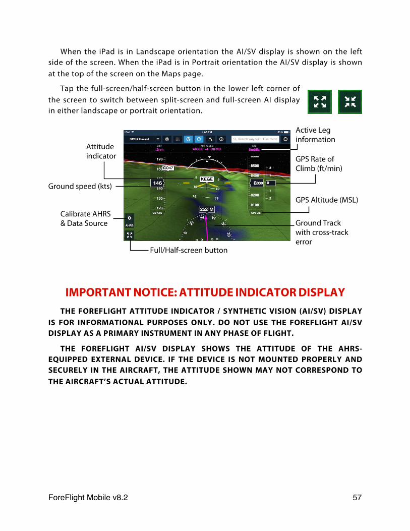
When the iPad is in Landscape orientation the AI/SV display is shown on the left side of the screen. When the iPad is in Portrait orientation the AI/SV display is shown at the top of the screen on the Maps page.
Tap the full-screen/half-screen button in the lower left corner of the screen to switch between split-screen and full-screen AI display in either landscape or portrait orientation.
IMPORTANT NOTICE: ATTITUDE INDICATOR DISPLAY
THE FOREFLIGHT ATTITUDE INDICATOR / SYNTHETIC VISION (AI/SV) DISPLAY IS FOR INFORMATIONAL PURPOSES ONLY. DO NOT USE THE FOREFLIGHT AI/SV DISPLAY AS A PRIMARY INSTRUMENT IN ANY PHASE OF FLIGHT.
THE FOREFLIGHT AI/SV DISPLAY SHOWS THE ATTITUDE OF THE AHRS-EQUIPPED EXTERNAL DEVICE. IF THE DEVICE IS NOT MOUNTED PROPERLY AND SECURELY IN THE AIRCRAFT, THE ATTITUDE SHOWN MAY NOT CORRESPOND TO THE AIRCRAFT’S ACTUAL ATTITUDE.
Calibrate AHRS & Data Source
Attitude indicator
Ground speed (kts)
GPS Altitude (MSL)
Ground Track with cross-track error
GPS Rate of Climb (ft/min)
Active Leg information
Full/Half-screen button
ForeFlight Mobile v8.2! 57
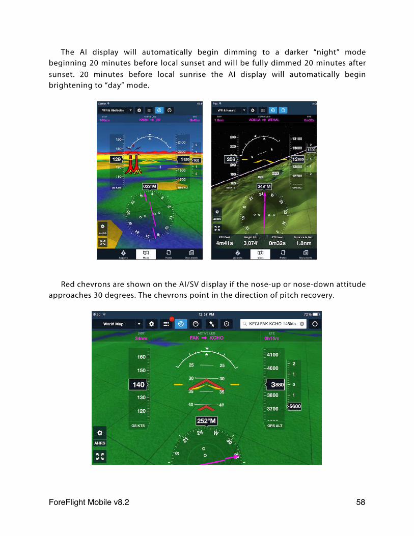
The AI display will automatically begin dimming to a darker “night” mode beginning 20 minutes before local sunset and will be fully dimmed 20 minutes after sunset. 20 minutes before local sunrise the AI display will automatically begin brightening to “day” mode.
Red chevrons are shown on the AI/SV display if the nose-up or nose-down attitude approaches 30 degrees. The chevrons point in the direction of pitch recovery.
ForeFlight Mobile v8.2! 58
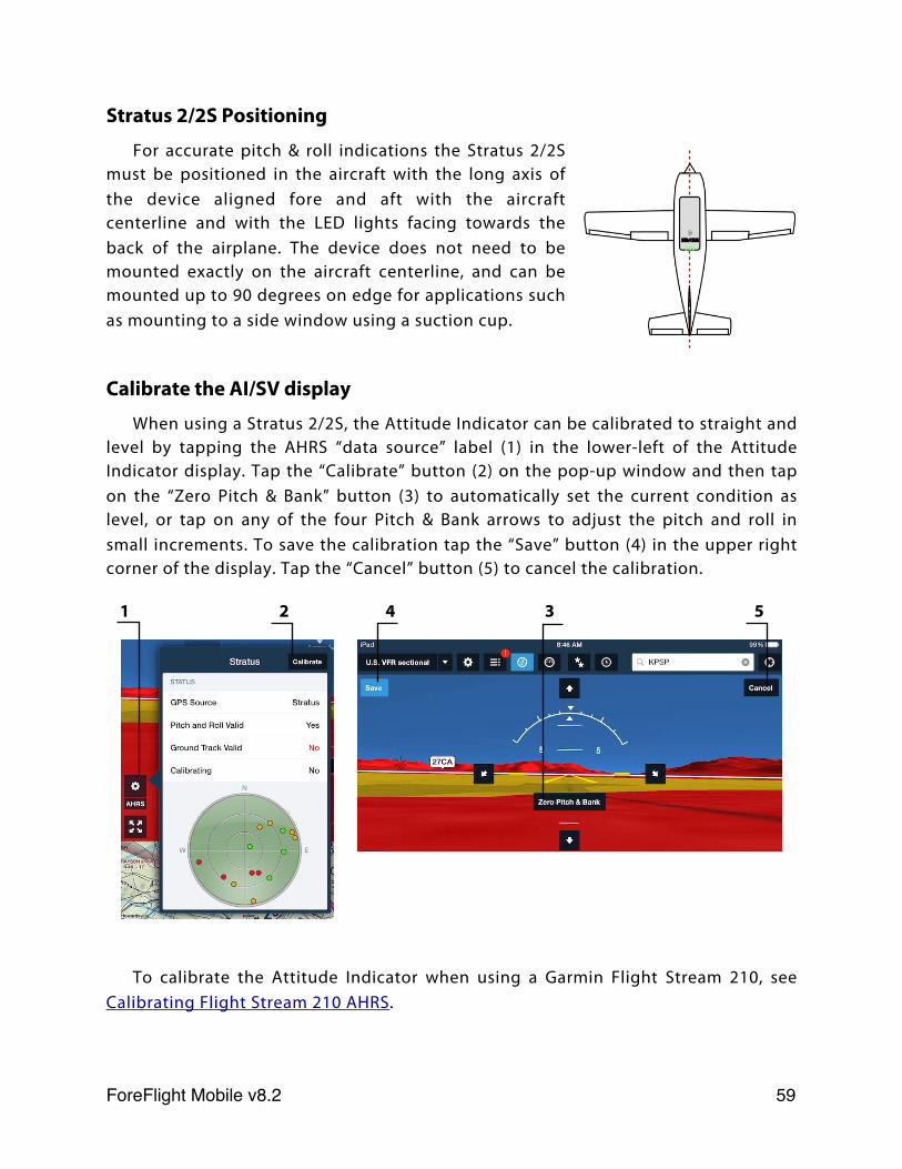
Stratus 2/2S Positioning
For accurate pitch & roll indications the Stratus 2/2S must be positioned in the aircraft with the long axis of the device aligned fore and aft with the aircraft centerline and with the LED lights facing towards the back of the airplane. The device does not need to be mounted exactly on the aircraft centerline, and can be mounted up to 90 degrees on edge for applications such as mounting to a side window using a suction cup.
Calibrate the AI/SV display
When using a Stratus 2/2S, the Attitude Indicator can be calibrated to straight and level by tapping the AHRS “data source” label (1) in the lower-left of the Attitude Indicator display. Tap the “Calibrate” button (2) on the pop-up window and then tap on the “Zero Pitch & Bank” button (3) to automatically set the current condition as level, or tap on any of the four Pitch & Bank arrows to adjust the pitch and roll in small increments. To save the calibration tap the “Save” button (4) in the upper right corner of the display. Tap the “Cancel” button (5) to cancel the calibration.
To calibrate the Attitude Indicator when using a Garmin Flight Stream 210, see Calibrating Flight Stream 210 AHRS.
1 2 4 3 5
ForeFlight Mobile v8.2! 59
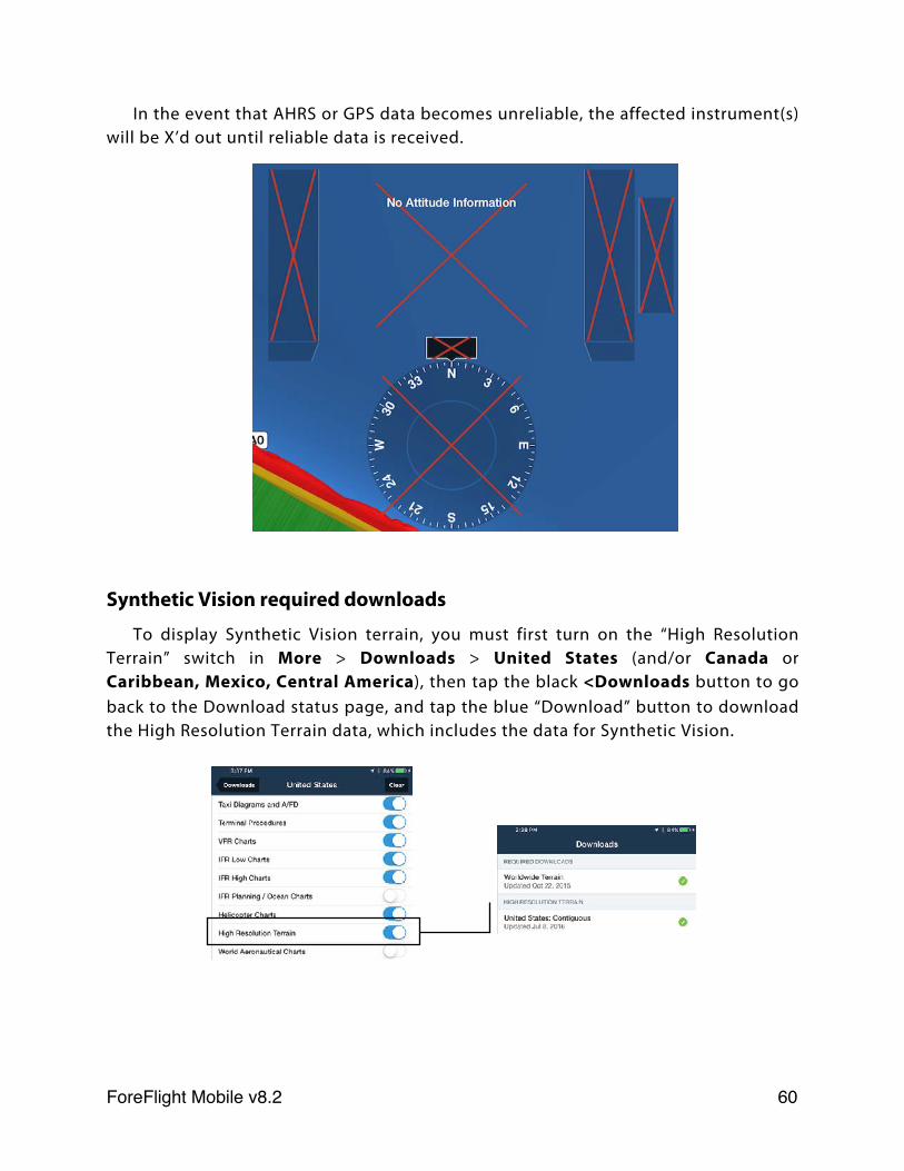
In the event that AHRS or GPS data becomes unreliable, the affected instrument(s) will be X’d out until reliable data is received.
Synthetic Vision required downloads
To display Synthetic Vision terrain, you must first turn on the “High Resolution Terrain” switch in More > Downloads > United States (and/or Canada or Caribbean, Mexico, Central America), then tap the black <Downloads button to go back to the Download status page, and tap the blue “Download” button to download the High Resolution Terrain data, which includes the data for Synthetic Vision.
ForeFlight Mobile v8.2! 60
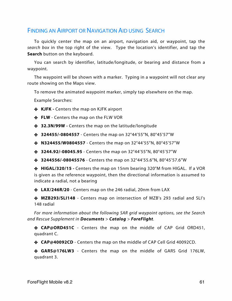
FINDING AN AIRPORT OR NAVIGATION AID USING SEARCH
To quickly center the map on an airport, navigation aid, or waypoint, tap the search box in the top right of the view. Type the location’s identifier, and tap the Search button on the keyboard.
You can search by identifier, latitude/longitude, or bearing and distance from a waypoint.
The waypoint will be shown with a marker. Typing in a waypoint will not clear any route showing on the Maps view.
To remove the animated waypoint marker, simply tap elsewhere on the map.
Example Searches:
✤ KJFK - Centers the map on KJFK airport
✤ FLW - Centers the map on the FLW VOR
✤ 32.3N/99W - Centers the map on the latitude/longitude
✤ 324455/-0804557 - Centers the map on 32°44’55”N, 80°45’57”W
✤ N324455/W0804557 - Centers the map on 32°44’55”N, 80°45’57”W
✤ 3244.92/-08045.95 - Centers the map on 32°44’55”N, 80°45’57”W
✤ 3244556/-08045576 - Centers the map on 32°44’55.6”N, 80°45’57.6”W
✤ HIGAL/320/15 - Centers the map on 15nm bearing 320°M from HIGAL. If a VOR is given as the reference waypoint, then the directional information is assumed to indicate a radial, not a bearing
✤ LAX/246R/20 - Centers map on the 246 radial, 20nm from LAX
✤ MZB293/SLI148 - Centers map on intersection of MZB’s 293 radial and SLI’s 148 radial
For more information about the following SAR grid waypoint options, see the Search and Rescue Supplement in Documents > Catalog > ForeFlight.
✤ CAP@ORD451C - Centers the map on the middle of CAP Grid ORD451, quadrant C.
✤ CAP@40092CD - Centers the map on the middle of CAP Cell Grid 40092CD.
✤ GARS@176LW3 - Centers the map on the middle of GARS Grid 176LW, quadrant 3.
ForeFlight Mobile v8.2! 61

✤ MGRS@15RTN50008000 - Centers the map on the middle of MGRS grid UTM zone 15, latitude band R, 100,000m grid square TN, easting 5000, northing 8000.
PLANNING A FLIGHT USING SEARCH
Create a route across any of the available maps by typing in multiple identifiers in the Search box, separated by a space, in the order in which you will visit them.
When typing a search, look for the helpful hints that appear underneath the search box. These hints provide example route searches that act as great reminders for quickly visualizing your route. Any of the search options specified in the “Finding an Airport or Navigation Aid using Search” section are supported as route waypoints. Additionally airways, arrivals and departures are supported, as well as any custom waypoints you have created.
Your current location, if it can be determined, can be used as the origin for your route, as in the last example in the screenshot above: D KSGR. ForeFlight will replace the “D” with the coordinate for your position.
Entire airways can be viewed on the map by searching for just the airway identifier, for instance: V16. Airways can also be used in a route, just as ATC would issue them. For example: NIKOL V244 ILC. ARINC 424 coordinates (ex: 5275N) can also be entered in the Search box or NavLog.
DPs and STARs (as well as associated transitions) are also supported in a route. If the DP or STAR requires a runway input, ForeFlight Mobile will prompt you for one and provide an example. When briefing and flying these procedures, it is critical to always refer to the official arrival/departure plate from the Airport view as the ForeFlight Maps view is not able to show heading vectors, altitude info, and certain other details you'll need.
When building a route in the search box you can also provide basic performance information about your aircraft. These can be in any order, but must come after the route waypoints. These include:
✤ True airspeed in knots or miles per hour. Knots is the default unit unless MPH selected in the Settings view.
✤ Altitude in feet.
ForeFlight Mobile v8.2! 62
✤ Fuel burn in gallons, liters or pounds per hour. GPH is the default unit.
Example route searches:
✤ KJFK KSFO - this is a simple direct route from NY to San Francisco.
✤ D KSFO - this is a direct route from your current position to San Francisco.
✤ KJFK FLW 32.3N/99W - this is a route from NY to the FLW VOR to a lat/lon waypoint.
✤ KSFO FLW/320/15 - this is a route from KSFO to a point on the 320 radial 15nm from FLW VOR. If a VOR is not given as the reference waypoint, then the directional information is assumed to indicate a bearing, not a radial.
✤ KCLT 36R.MERIL7 RDU J209 ORF J121 SIE CAMRN4 KJFK - this route includes a runway-specific departure, multiple jet airways and an arrival.
✤ KUZA KOSH 165kts 17gph 8000ft - this is a route from Rock Hill to Oshkosh with a true airspeed of 165 knots, a fuel burn rate of 17 gallons per hour, and an altitude of 8,000’.
✤ KUZA KOSH 165 17 8000 - this is the same route and performance data as the previous example, this time using the default units.
✤ KJFK YQM V311 YQX 5050N 5330N 5315N EGLL - This hypothetical route from JFK to London Heathrow uses ARINC 424 coordinates between Gander and Heathrow. See http://code7700.com/arinc_424_shorthand.html for additional information.
A route search can also include a tail number of an aircraft setup in the More > Aircraft view. When that aircraft has performance data it will be automatically used. In this case, you won’t need to include altitude, fuel burn, or true airspeed - unless you’d like to use different numbers than you provided in the aircraft’s profile.
Lastly, you can also indicate a departure time in your route search; ForeFlight will use this time to incorporate the proper winds aloft forecasts into your time and fuel usage calculations. If you don’t provide a time, ForeFlight Mobile assumes you are departing ASAP. You can include the departure time as a specific time or as a time relative to now, as a local time or Zulu time, like this:
✤ KUZA KOSH 165 17 8000 1315Z - The route details will be calculated for conditions starting at 1315Z. The time can be designated in Zulu time, as in the example, or local time, such as: 13:15, 1:15p, 1:15pm, 1:15a, 1:15am, or 1:15 (with no am/pm given, ForeFlight will assume you desire the next upcoming 1:15).
✤ KUZA KOSH 165 17 8000 +60 - The route details will be calculated for conditions starting 60 minutes from now. This relative time must begin with a +
ForeFlight Mobile v8.2! 63
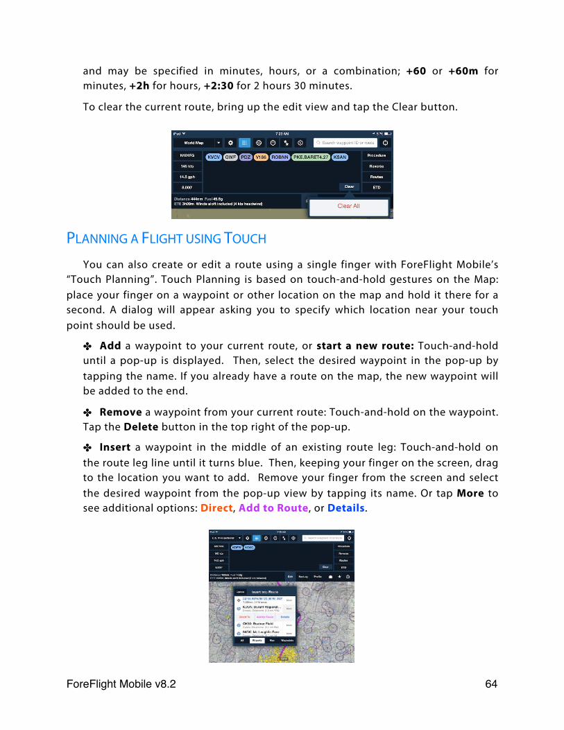
and may be specified in minutes, hours, or a combination; +60 or +60m for minutes, +2h for hours, +2:30 for 2 hours 30 minutes.
To clear the current route, bring up the edit view and tap the Clear button.
PLANNING A FLIGHT USING TOUCH
You can also create or edit a route using a single finger with ForeFlight Mobile’s “Touch Planning”. Touch Planning is based on touch-and-hold gestures on the Map: place your finger on a waypoint or other location on the map and hold it there for a second. A dialog will appear asking you to specify which location near your touch point should be used.
✤ Add a waypoint to your current route, or start a new route: Touch-and-hold until a pop-up is displayed. Then, select the desired waypoint in the pop-up by tapping the name. If you already have a route on the map, the new waypoint will be added to the end.
✤ Remove a waypoint from your current route: Touch-and-hold on the waypoint. Tap the Delete button in the top right of the pop-up.
✤ Insert a waypoint in the middle of an existing route leg: Touch-and-hold on the route leg line until it turns blue. Then, keeping your finger on the screen, drag to the location you want to add. Remove your finger from the screen and select the desired waypoint from the pop-up view by tapping its name. Or tap More to see additional options: Direct, Add to Route, or Details.
ForeFlight Mobile v8.2! 64
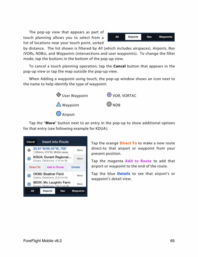
The pop-up view that appears as part of touch planning allows you to select from a list of locations near your touch point, sorted by distance. The list shown is filtered by All (which includes airspaces), Airports, Nav (VORs, NDBs), and Waypoints (intersections and user waypoints). To change the filter mode, tap the buttons in the bottom of the pop-up view.
To cancel a touch planning operation, tap the Cancel button that appears in the pop-up view or tap the map outside the pop-up view.
When Adding a waypoint using touch, the pop-up window shows an icon next to the name to help identify the type of waypoint:
User Waypoint VOR, VORTAC
Waypoint NDB
Airport
Tap the “More” button next to an entry in the pop-up to show additional options for that entry (see following example for KDUA):
Tap the orange Direct To to make a new route direct-to that airport or waypoint from your present position.
Tap the magenta Add to Route to add that airport or waypoint to the end of the route.
Tap the blue Details to see that airport’s or waypoint’s detail view.
ForeFlight Mobile v8.2! 65
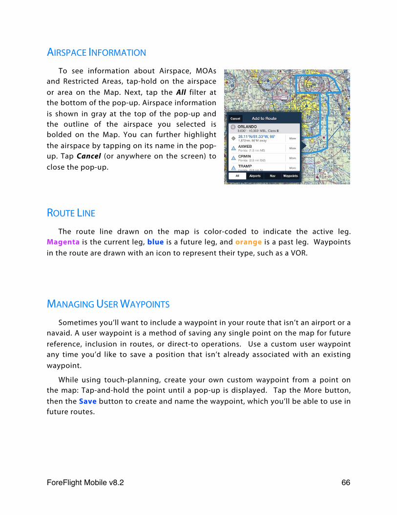
AIRSPACE INFORMATION
To see information about Airspace, MOAs and Restricted Areas, tap-hold on the airspace or area on the Map. Next, tap the All filter at the bottom of the pop-up. Airspace information is shown in gray at the top of the pop-up and the outline of the airspace you selected is bolded on the Map. You can further highlight the airspace by tapping on its name in the pop-up. Tap Cancel (or anywhere on the screen) to close the pop-up.
ROUTE LINE
The route line drawn on the map is color-coded to indicate the active leg. Magenta is the current leg, blue is a future leg, and orange is a past leg. Waypoints in the route are drawn with an icon to represent their type, such as a VOR.
MANAGING USER WAYPOINTS
Sometimes you’ll want to include a waypoint in your route that isn’t an airport or a navaid. A user waypoint is a method of saving any single point on the map for future reference, inclusion in routes, or direct-to operations. Use a custom user waypoint any time you’d like to save a position that isn’t already associated with an existing waypoint.
While using touch-planning, create your own custom waypoint from a point on the map: Tap-and-hold the point until a pop-up is displayed. Tap the More button, then the Save button to create and name the waypoint, which you’ll be able to use in future routes.
ForeFlight Mobile v8.2! 66
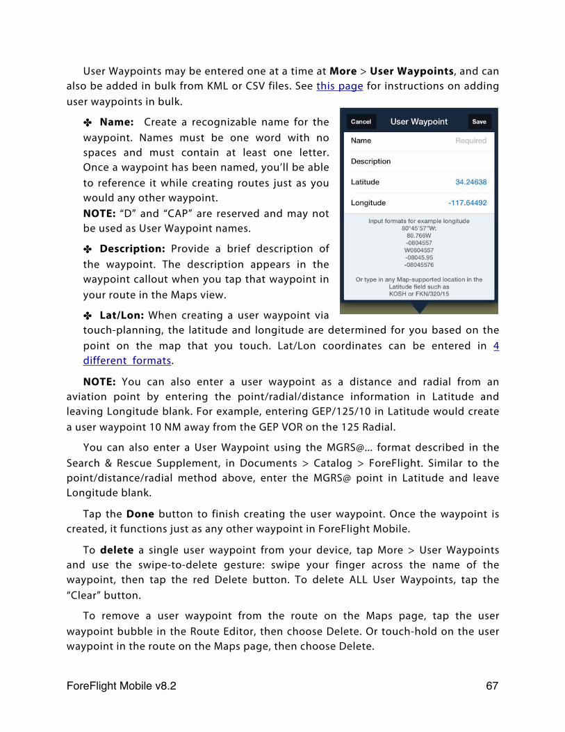
User Waypoints may be entered one at a time at More > User Waypoints, and can also be added in bulk from KML or CSV files. See this page for instructions on adding user waypoints in bulk.
✤ Name: Create a recognizable name for the waypoint. Names must be one word with no spaces and must contain at least one letter. Once a waypoint has been named, you’ll be able to reference it while creating routes just as you would any other waypoint.NOTE: “D” and “CAP” are reserved and may not be used as User Waypoint names.
✤ Description: Provide a brief description of the waypoint. The description appears in the waypoint callout when you tap that waypoint in your route in the Maps view.
✤ Lat/Lon: When creating a user waypoint via touch-planning, the latitude and longitude are determined for you based on the point on the map that you touch. Lat/Lon coordinates can be entered in 4 different formats.
NOTE: You can also enter a user waypoint as a distance and radial from an aviation point by entering the point/radial/distance information in Latitude and leaving Longitude blank. For example, entering GEP/125/10 in Latitude would create a user waypoint 10 NM away from the GEP VOR on the 125 Radial.
You can also enter a User Waypoint using the MGRS@... format described in the Search & Rescue Supplement, in Documents > Catalog > ForeFlight. Similar to the point/distance/radial method above, enter the MGRS@ point in Latitude and leave Longitude blank.
Tap the Done button to finish creating the user waypoint. Once the waypoint is created, it functions just as any other waypoint in ForeFlight Mobile.
To delete a single user waypoint from your device, tap More > User Waypoints and use the swipe-to-delete gesture: swipe your finger across the name of the waypoint, then tap the red Delete button. To delete ALL User Waypoints, tap the “Clear” button.
To remove a user waypoint from the route on the Maps page, tap the user waypoint bubble in the Route Editor, then choose Delete. Or touch-hold on the user waypoint in the route on the Maps page, then choose Delete.
ForeFlight Mobile v8.2! 67
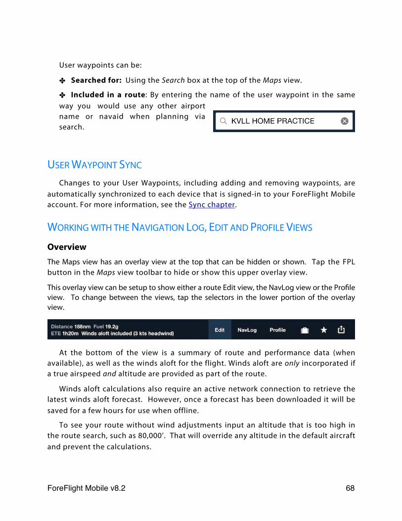
User waypoints can be:
✤ Searched for: Using the Search box at the top of the Maps view.
✤ Included in a route: By entering the name of the user waypoint in the same way you would use any other airport name or navaid when planning via search.
USER WAYPOINT SYNC
Changes to your User Waypoints, including adding and removing waypoints, are automatically synchronized to each device that is signed-in to your ForeFlight Mobile account. For more information, see the Sync chapter.
WORKING WITH THE NAVIGATION LOG, EDIT AND PROFILE VIEWS
OverviewThe Maps view has an overlay view at the top that can be hidden or shown. Tap the FPL button in the Maps view toolbar to hide or show this upper overlay view.
This overlay view can be setup to show either a route Edit view, the NavLog view or the Profile view. To change between the views, tap the selectors in the lower portion of the overlay view.
At the bottom of the view is a summary of route and performance data (when available), as well as the winds aloft for the flight. Winds aloft are only incorporated if a true airspeed and altitude are provided as part of the route.
Winds aloft calculations also require an active network connection to retrieve the latest winds aloft forecast. However, once a forecast has been downloaded it will be saved for a few hours for use when offline.
To see your route without wind adjustments input an altitude that is too high in the route search, such as 80,000’. That will override any altitude in the default aircraft and prevent the calculations.
ForeFlight Mobile v8.2! 68
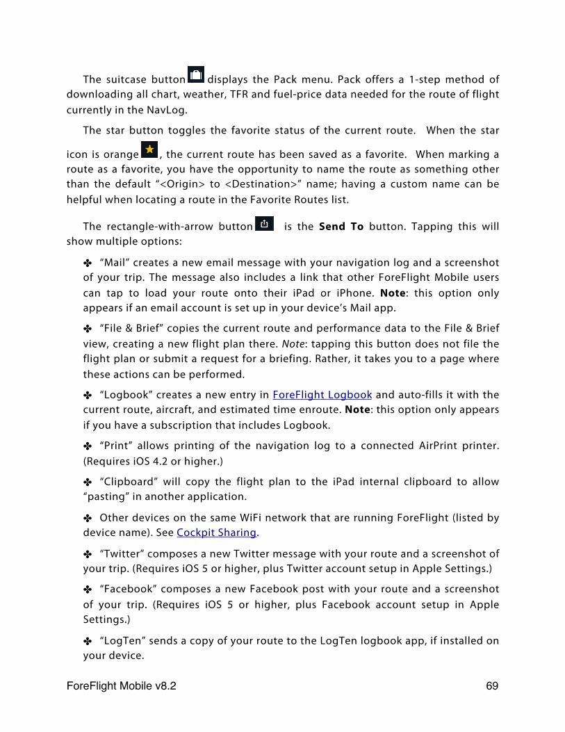
The suitcase button displays the Pack menu. Pack offers a 1-step method of downloading all chart, weather, TFR and fuel-price data needed for the route of flight currently in the NavLog.
The star button toggles the favorite status of the current route. When the star
icon is orange , the current route has been saved as a favorite. When marking a route as a favorite, you have the opportunity to name the route as something other than the default “<Origin> to <Destination>” name; having a custom name can be helpful when locating a route in the Favorite Routes list.
The rectangle-with-arrow button is the Send To button. Tapping this will show multiple options:
✤ “Mail” creates a new email message with your navigation log and a screenshot of your trip. The message also includes a link that other ForeFlight Mobile users can tap to load your route onto their iPad or iPhone. Note: this option only appears if an email account is set up in your device’s Mail app.
✤ “File & Brief” copies the current route and performance data to the File & Brief view, creating a new flight plan there. Note: tapping this button does not file the flight plan or submit a request for a briefing. Rather, it takes you to a page where these actions can be performed.
✤ “Logbook” creates a new entry in ForeFlight Logbook and auto-fills it with the current route, aircraft, and estimated time enroute. Note: this option only appears if you have a subscription that includes Logbook.
✤ “Print” allows printing of the navigation log to a connected AirPrint printer. (Requires iOS 4.2 or higher.)
✤ “Clipboard” will copy the flight plan to the iPad internal clipboard to allow “pasting” in another application.
✤ Other devices on the same WiFi network that are running ForeFlight (listed by device name). See Cockpit Sharing.
✤ “Twitter” composes a new Twitter message with your route and a screenshot of your trip. (Requires iOS 5 or higher, plus Twitter account setup in Apple Settings.)
✤ “Facebook” composes a new Facebook post with your route and a screenshot of your trip. (Requires iOS 5 or higher, plus Facebook account setup in Apple Settings.)
✤ “LogTen” sends a copy of your route to the LogTen logbook app, if installed on your device.
ForeFlight Mobile v8.2! 69

✤ “Aspen” will copy the flight plan to your Aspen Connected Panel.
ForeFlight Mobile v8.2! 70
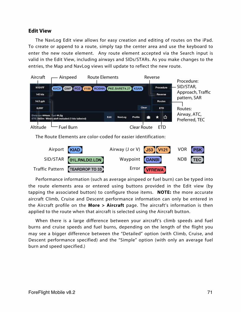
Edit View
The NavLog Edit view allows for easy creation and editing of routes on the iPad. To create or append to a route, simply tap the center area and use the keyboard to enter the new route element. Any route element accepted via the Search input is valid in the Edit View, including airways and SIDs/STARs. As you make changes to the entries, the Map and NavLog views will update to reflect the new route.
The Route Elements are color-coded for easier identification:
Airport Airway (J or V) VOR
SID/STAR Waypoint NDB
Traffic Pattern Error
Performance information (such as average airspeed or fuel burn) can be typed into the route elements area or entered using buttons provided in the Edit view (by tapping the associated button) to configure those items. NOTE: the more accurate aircraft Climb, Cruise and Descent performance information can only be entered in the Aircraft profile on the More > Aircraft page. The aircraft’s information is then applied to the route when that aircraft is selected using the Aircraft button.
When there is a large difference between your aircraft’s climb speeds and fuel burns and cruise speeds and fuel burns, depending on the length of the flight you may see a bigger difference between the “Detailed” option (with Climb, Cruise, and Descent performance specified) and the “Simple” option (with only an average fuel burn and speed specified.)
Aircraft Airspeed Route Elements Reverse
Altitude Fuel Burn Clear Route ETD
Procedure: SID/STAR, Approach, Traffic pattern, SAR
Routes: Airway, ATC, Preferred, TEC
ForeFlight Mobile v8.2! 71
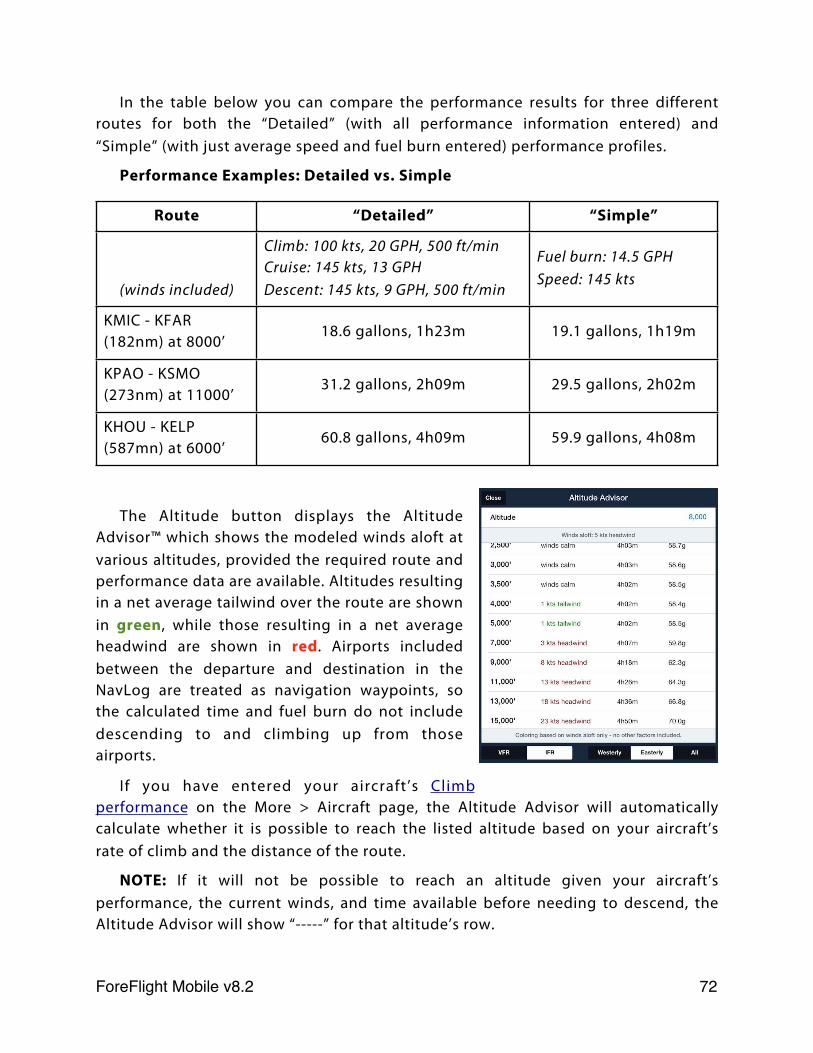
In the table below you can compare the performance results for three different routes for both the “Detailed” (with all performance information entered) and “Simple” (with just average speed and fuel burn entered) performance profiles.
Performance Examples: Detailed vs. Simple
Route “Detailed” “Simple”
(winds included)
Climb: 100 kts, 20 GPH, 500 ft/minCruise: 145 kts, 13 GPHDescent: 145 kts, 9 GPH, 500 ft/min
Fuel burn: 14.5 GPHSpeed: 145 kts
KMIC - KFAR (182nm) at 8000’
18.6 gallons, 1h23m 19.1 gallons, 1h19m
KPAO - KSMO(273nm) at 11000’
31.2 gallons, 2h09m 29.5 gallons, 2h02m
KHOU - KELP (587mn) at 6000’
60.8 gallons, 4h09m 59.9 gallons, 4h08m
The Altitude button displays the Altitude Advisor™ which shows the modeled winds aloft at various altitudes, provided the required route and performance data are available. Altitudes resulting in a net average tailwind over the route are shown in green, while those resulting in a net average headwind are shown in red. Airports included between the departure and destination in the NavLog are treated as navigation waypoints, so the calculated time and fuel burn do not include descending to and climbing up from those airports.
If you have entered your aircraft’s Climb performance on the More > Aircraft page, the Altitude Advisor will automatically calculate whether it is possible to reach the listed altitude based on your aircraft’s rate of climb and the distance of the route.
NOTE: If it will not be possible to reach an altitude given your aircraft’s performance, the current winds, and time available before needing to descend, the Altitude Advisor will show “-----” for that altitude’s row.
ForeFlight Mobile v8.2! 72
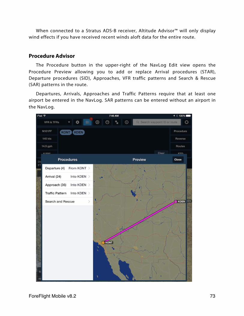
When connected to a Stratus ADS-B receiver, Altitude Advisor™ will only display wind effects if you have received recent winds aloft data for the entire route.
Procedure AdvisorThe Procedure button in the upper-right of the NavLog Edit view opens the
Procedure Preview allowing you to add or replace Arrival procedures (STAR), Departure procedures (SID), Approaches, VFR traffic patterns and Search & Rescue (SAR) patterns in the route.
Departures, Arrivals, Approaches and Traffic Patterns require that at least one airport be entered in the NavLog. SAR patterns can be entered without an airport in the NavLog.
ForeFlight Mobile v8.2! 73
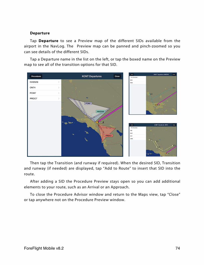
Departure
Tap Departure to see a Preview map of the different SIDs available from the airport in the NavLog. The Preview map can be panned and pinch-zoomed so you can see details of the different SIDs.
Tap a Departure name in the list on the left, or tap the boxed name on the Preview map to see all of the transition options for that SID.
Then tap the Transition (and runway if required). When the desired SID, Transition and runway (if needed) are displayed, tap “Add to Route” to insert that SID into the route.
After adding a SID the Procedure Preview stays open so you can add additional elements to your route, such as an Arrival or an Approach.
To close the Procedure Advisor window and return to the Maps view, tap “Close” or tap anywhere not on the Procedure Preview window.
ForeFlight Mobile v8.2! 74
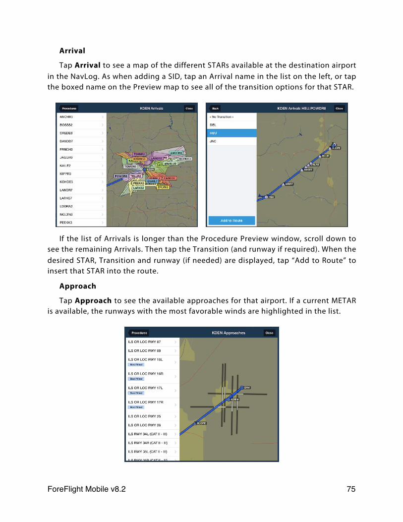
Arrival
Tap Arrival to see a map of the different STARs available at the destination airport in the NavLog. As when adding a SID, tap an Arrival name in the list on the left, or tap the boxed name on the Preview map to see all of the transition options for that STAR.
If the list of Arrivals is longer than the Procedure Preview window, scroll down to see the remaining Arrivals. Then tap the Transition (and runway if required). When the desired STAR, Transition and runway (if needed) are displayed, tap “Add to Route” to insert that STAR into the route.
Approach
Tap Approach to see the available approaches for that airport. If a current METAR is available, the runways with the most favorable winds are highlighted in the list.
ForeFlight Mobile v8.2! 75
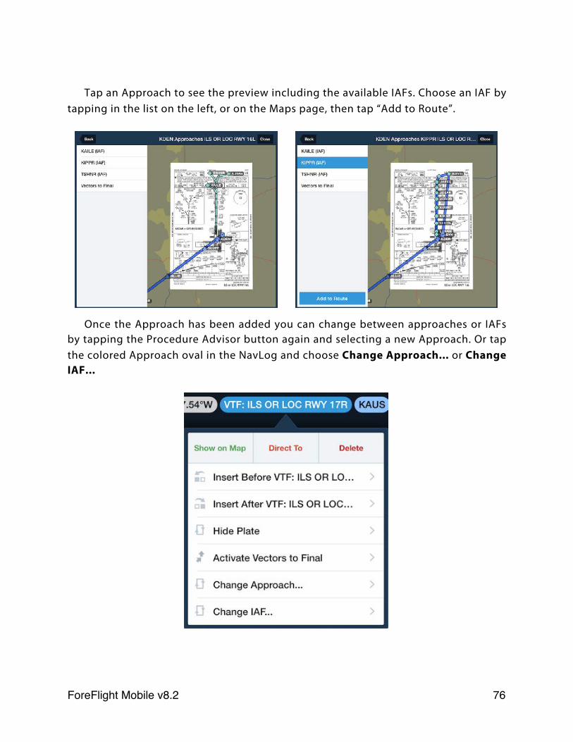
Tap an Approach to see the preview including the available IAFs. Choose an IAF by tapping in the list on the left, or on the Maps page, then tap “Add to Route”.
Once the Approach has been added you can change between approaches or IAFs by tapping the Procedure Advisor button again and selecting a new Approach. Or tap the colored Approach oval in the NavLog and choose Change Approach... or Change IAF...
ForeFlight Mobile v8.2! 76
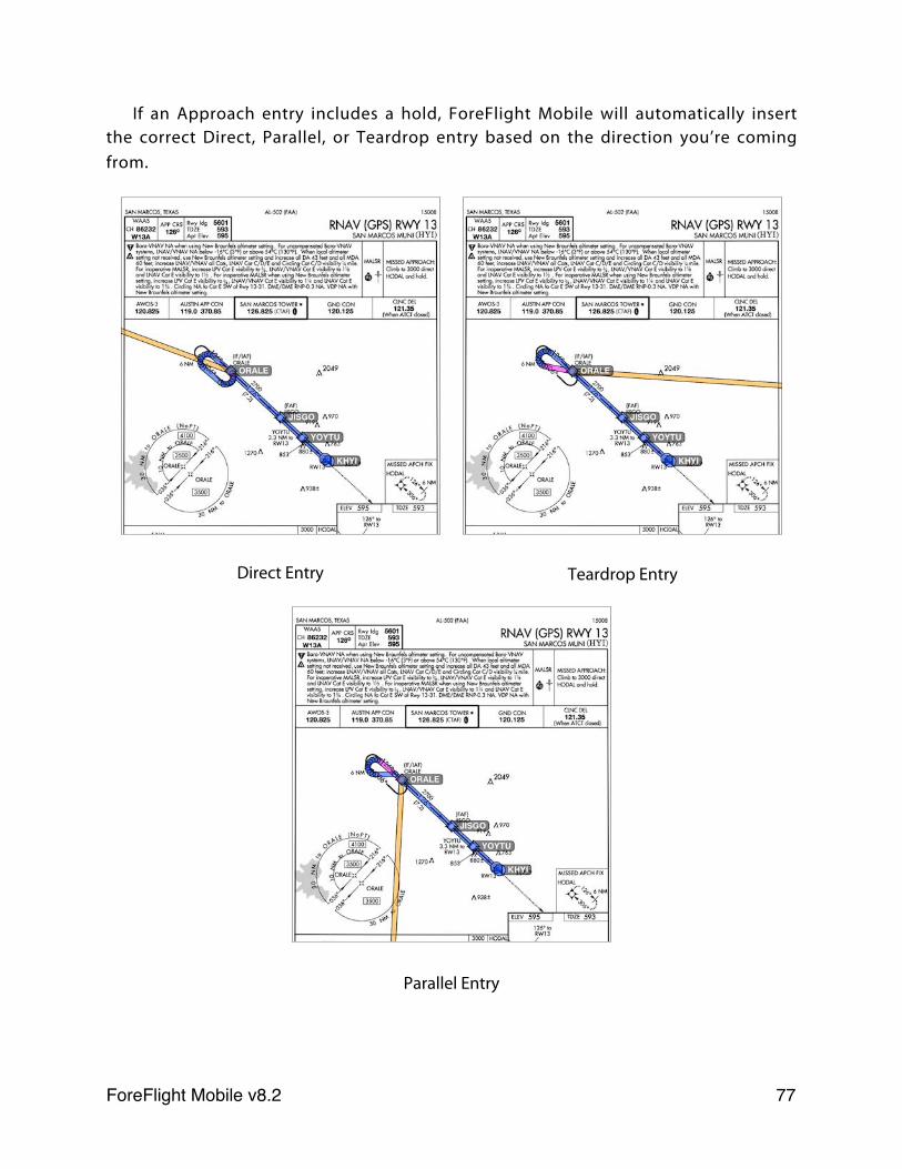
If an Approach entry includes a hold, ForeFlight Mobile will automatically insert the correct Direct, Parallel, or Teardrop entry based on the direction you’re coming from.
Direct Entry Teardrop Entry
Parallel Entry
ForeFlight Mobile v8.2! 77
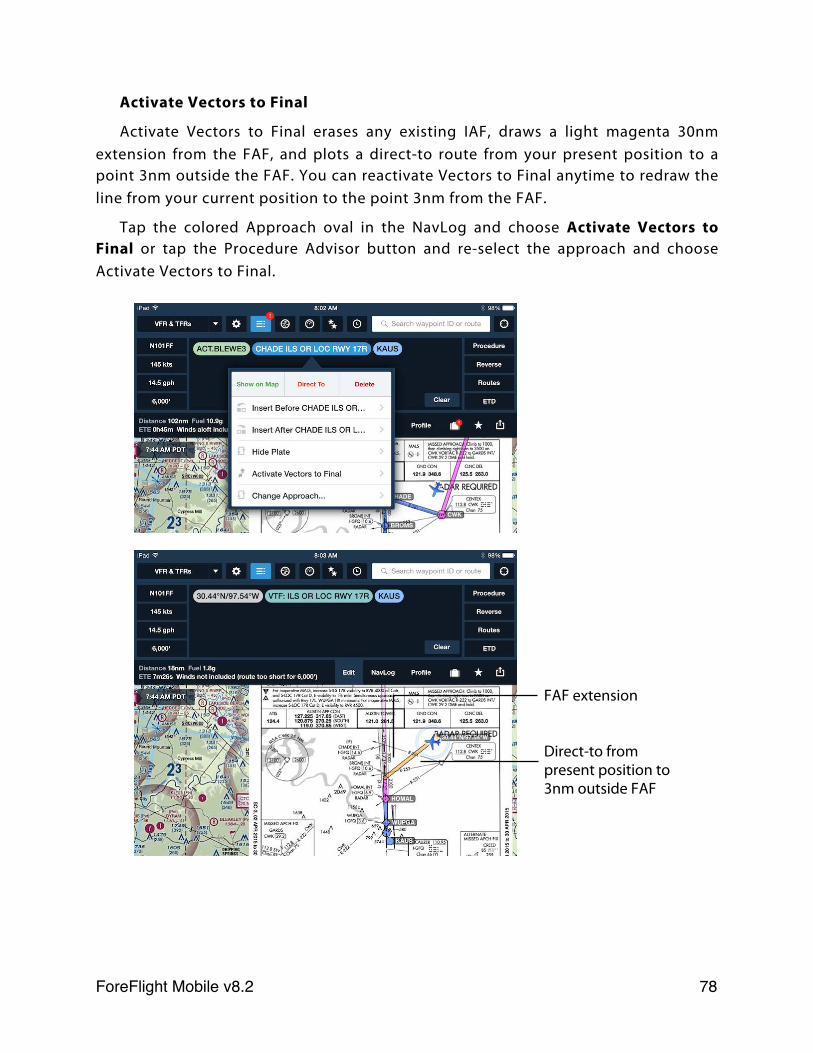
Activate Vectors to Final
Activate Vectors to Final erases any existing IAF, draws a light magenta 30nm extension from the FAF, and plots a direct-to route from your present position to a point 3nm outside the FAF. You can reactivate Vectors to Final anytime to redraw the line from your current position to the point 3nm from the FAF.
Tap the colored Approach oval in the NavLog and choose Activate Vectors to Final or tap the Procedure Advisor button and re-select the approach and choose Activate Vectors to Final.
FAF extension
Direct-to from present position to 3nm outside FAF
ForeFlight Mobile v8.2! 78
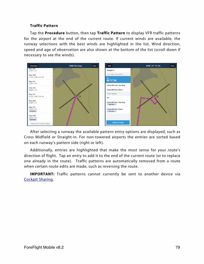
Traffic Pattern
Tap the Procedure button, then tap Traffic Pattern to display VFR traffic patterns for the airport at the end of the current route. If current winds are available, the runway selections with the best winds are highlighted in the list. Wind direction, speed and age of observation are also shown at the bottom of the list (scroll down if necessary to see the winds).
After selecting a runway the available pattern entry options are displayed, such as Cross Midfield or Straight-in. For non-towered airports the entries are sorted based on each runway’s pattern side (right or left).
Additionally, entries are highlighted that make the most sense for your route’s direction of flight. Tap an entry to add it to the end of the current route (or to replace one already in the route). Traffic patterns are automatically removed from a route when certain route edits are made, such as reversing the route.
IMPORTANT: Traffic patterns cannot currently be sent to another device via Cockpit Sharing.
ForeFlight Mobile v8.2! 79
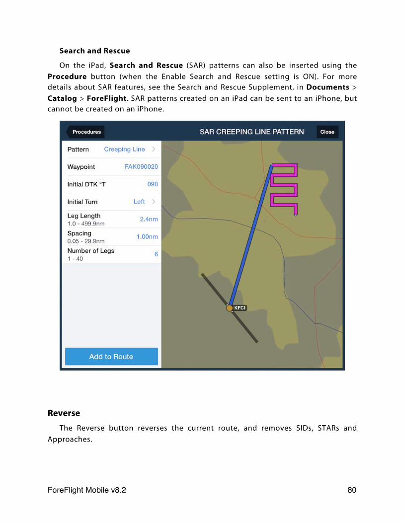
Search and Rescue
On the iPad, Search and Rescue (SAR) patterns can also be inserted using the Procedure button (when the Enable Search and Rescue setting is ON). For more details about SAR features, see the Search and Rescue Supplement, in Documents > Catalog > ForeFlight. SAR patterns created on an iPad can be sent to an iPhone, but cannot be created on an iPhone.
ReverseThe Reverse button reverses the current route, and removes SIDs, STARs and
Approaches.
ForeFlight Mobile v8.2! 80
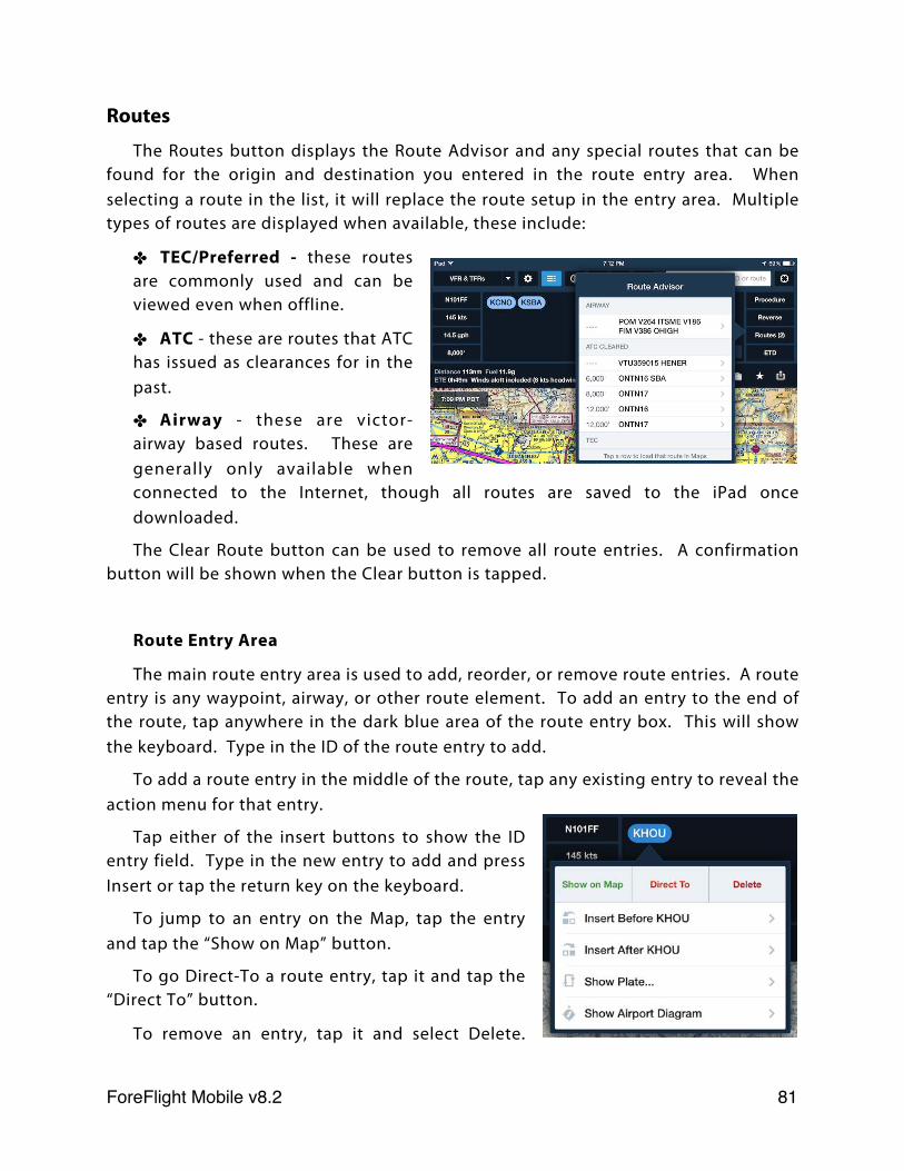
Routes
The Routes button displays the Route Advisor and any special routes that can be found for the origin and destination you entered in the route entry area. When selecting a route in the list, it will replace the route setup in the entry area. Multiple types of routes are displayed when available, these include:
✤ TEC/Preferred - these routes are commonly used and can be viewed even when offline.
✤ ATC - these are routes that ATC has issued as clearances for in the past.
✤ Airway - these are victor-airway based routes. These are generally only available when connected to the Internet, though all routes are saved to the iPad once downloaded.
The Clear Route button can be used to remove all route entries. A confirmation button will be shown when the Clear button is tapped.
Route Entry Area
The main route entry area is used to add, reorder, or remove route entries. A route entry is any waypoint, airway, or other route element. To add an entry to the end of the route, tap anywhere in the dark blue area of the route entry box. This will show the keyboard. Type in the ID of the route entry to add.
To add a route entry in the middle of the route, tap any existing entry to reveal the action menu for that entry.
Tap either of the insert buttons to show the ID entry field. Type in the new entry to add and press Insert or tap the return key on the keyboard.
To jump to an entry on the Map, tap the entry and tap the “Show on Map” button.
To go Direct-To a route entry, tap it and tap the “Direct To” button.
To remove an entry, tap it and select Delete.
ForeFlight Mobile v8.2! 81
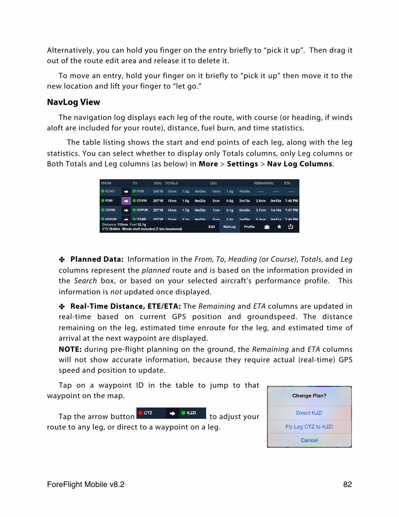
Alternatively, you can hold you finger on the entry briefly to “pick it up”. Then drag it out of the route edit area and release it to delete it.
To move an entry, hold your finger on it briefly to “pick it up” then move it to the new location and lift your finger to “let go.”
NavLog View
The navigation log displays each leg of the route, with course (or heading, if winds aloft are included for your route), distance, fuel burn, and time statistics.
The table listing shows the start and end points of each leg, along with the leg statistics. You can select whether to display only Totals columns, only Leg columns or Both Totals and Leg columns (as below) in More > Settings > Nav Log Columns.
✤ Planned Data: Information in the From, To, Heading (or Course), Totals, and Leg columns represent the planned route and is based on the information provided in the Search box, or based on your selected aircraft’s performance profile. This information is not updated once displayed.
✤ Real-Time Distance, ETE/ETA: The Remaining and ETA columns are updated in real-time based on current GPS position and groundspeed. The distance remaining on the leg, estimated time enroute for the leg, and estimated time of arrival at the next waypoint are displayed.NOTE: during pre-flight planning on the ground, the Remaining and ETA columns will not show accurate information, because they require actual (real-time) GPS speed and position to update.
Tap on a waypoint ID in the table to jump to that waypoint on the map.
Tap the arrow button to adjust your route to any leg, or direct to a waypoint on a leg.
ForeFlight Mobile v8.2! 82
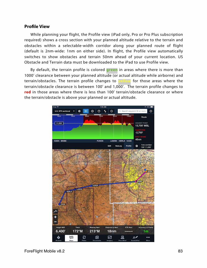
Profile View
While planning your flight, the Profile view (iPad only, Pro or Pro Plus subscription required) shows a cross section with your planned altitude relative to the terrain and obstacles within a selectable-width corridor along your planned route of flight (default is 2nm-wide: 1nm on either side). In flight, the Profile view automatically switches to show obstacles and terrain 50nm ahead of your current location. US Obstacle and Terrain data must be downloaded to the iPad to use Profile view.
By default, the terrain profile is colored green in areas where there is more than 1000’ clearance between your planned altitude (or actual altitude while airborne) and terrain/obstacles. The terrain profile changes to yellow for those areas where the terrain/obstacle clearance is between 100’ and 1,000'. The terrain profile changes to red in those areas where there is less than 100’ terrain/obstacle clearance or where the terrain/obstacle is above your planned or actual altitude.
ForeFlight Mobile v8.2! 83
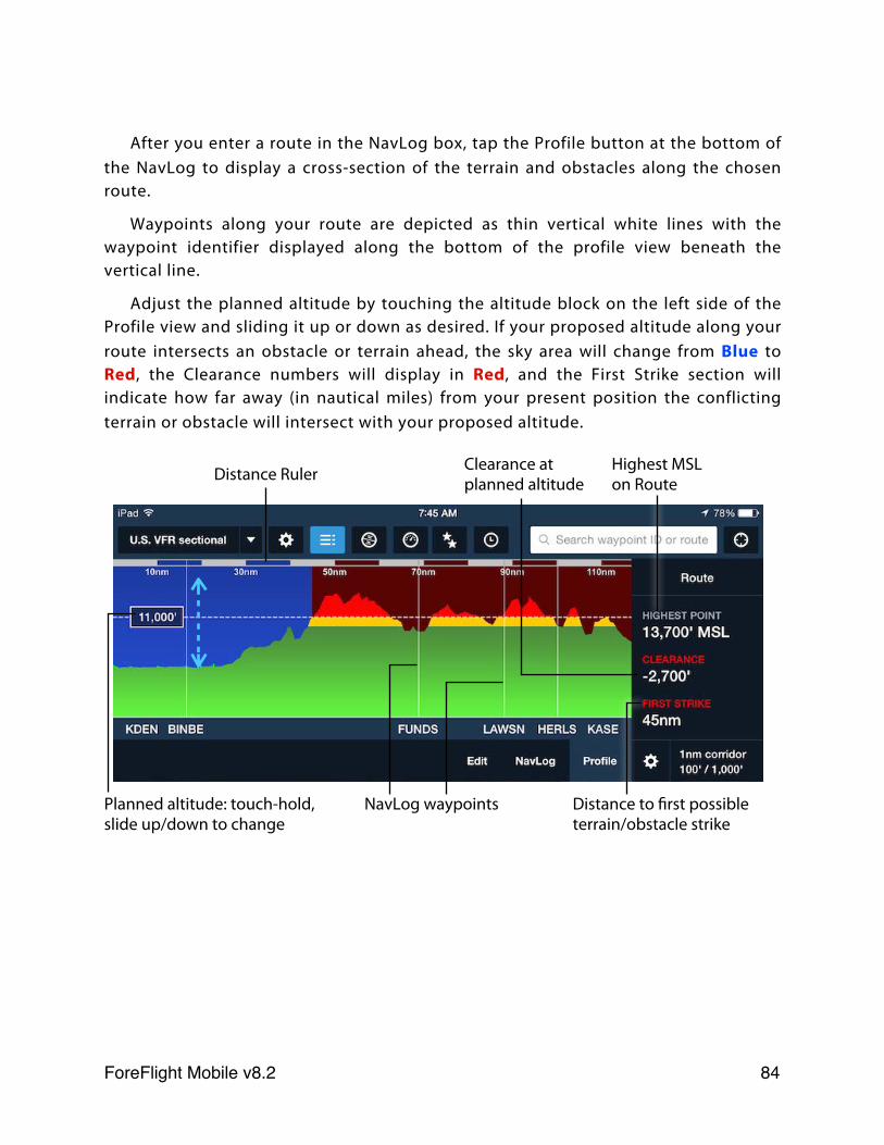
After you enter a route in the NavLog box, tap the Profile button at the bottom of the NavLog to display a cross-section of the terrain and obstacles along the chosen route.
Waypoints along your route are depicted as thin vertical white lines with the waypoint identifier displayed along the bottom of the profile view beneath the vertical line.
Adjust the planned altitude by touching the altitude block on the left side of the Profile view and sliding it up or down as desired. If your proposed altitude along your route intersects an obstacle or terrain ahead, the sky area will change from Blue to Red, the Clearance numbers will display in Red, and the First Strike section will indicate how far away (in nautical miles) from your present position the conflicting terrain or obstacle will intersect with your proposed altitude.
Planned altitude: touch-hold, NavLog waypoints Distance to first possibleslide up/down to change terrain/obstacle strike
Distance Ruler Clearance at planned altitude
Highest MSL on Route
ForeFlight Mobile v8.2! 84
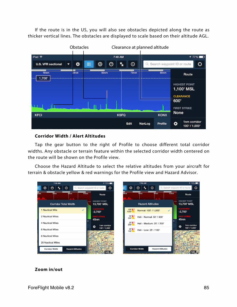
If the route is in the US, you will also see obstacles depicted along the route as thicker vertical lines. The obstacles are displayed to scale based on their altitude AGL.
Corridor Width / Alert Altitudes
Tap the gear button to the right of Profile to choose different total corridor widths. Any obstacle or terrain feature within the selected corridor width centered on the route will be shown on the Profile view.
Choose the Hazard Altitude to select the relative altitudes from your aircraft for terrain & obstacle yellow & red warnings for the Profile view and Hazard Advisor.
Zoom in/out
Obstacles Clearance at planned altitude
ForeFlight Mobile v8.2! 85
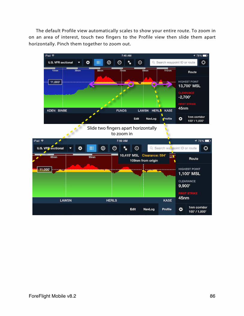
The default Profile view automatically scales to show your entire route. To zoom in on an area of interest, touch two fingers to the Profile view then slide them apart horizontally. Pinch them together to zoom out.
Slide two fingers apart horizontally to zoom in
ForeFlight Mobile v8.2! 86
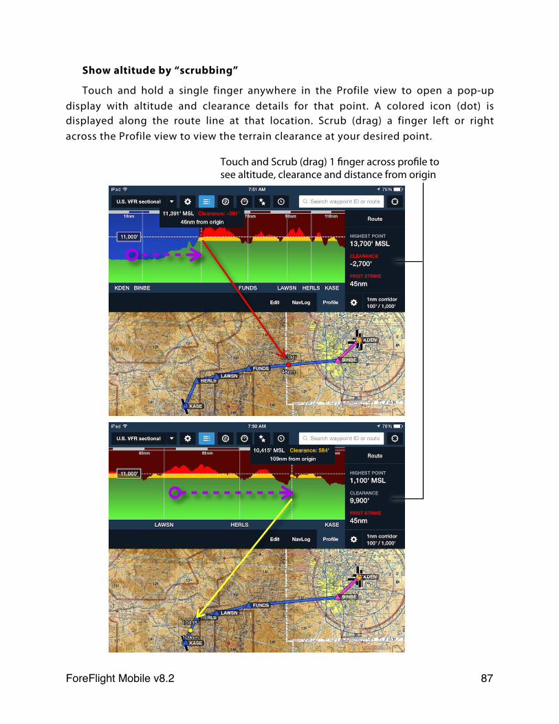
Show altitude by “scrubbing”
Touch and hold a single finger anywhere in the Profile view to open a pop-up display with altitude and clearance details for that point. A colored icon (dot) is displayed along the route line at that location. Scrub (drag) a finger left or right across the Profile view to view the terrain clearance at your desired point.
Touch and Scrub (drag) 1 finger across profile to see altitude, clearance and distance from origin
ForeFlight Mobile v8.2! 87
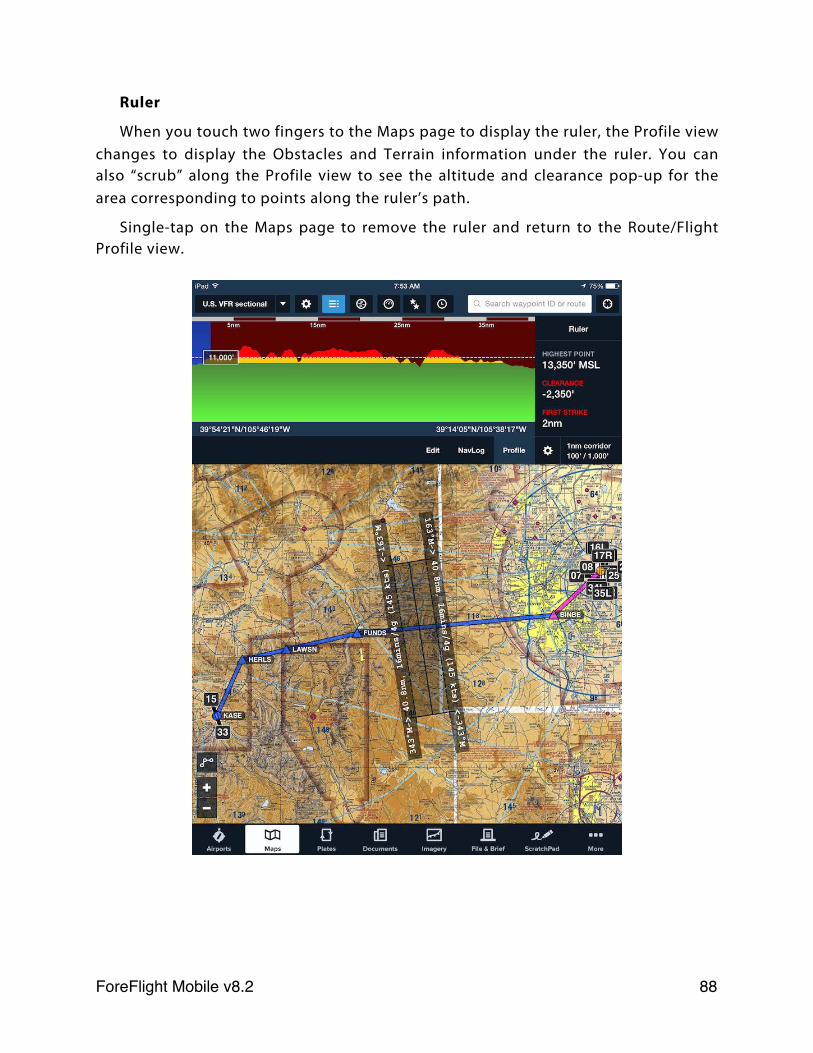
Ruler
When you touch two fingers to the Maps page to display the ruler, the Profile view changes to display the Obstacles and Terrain information under the ruler. You can also “scrub” along the Profile view to see the altitude and clearance pop-up for the area corresponding to points along the ruler’s path.
Single-tap on the Maps page to remove the ruler and return to the Route/Flight Profile view.
ForeFlight Mobile v8.2! 88
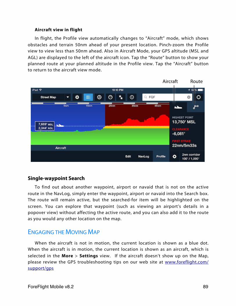
Aircraft view in flight
In flight, the Profile view automatically changes to “Aircraft” mode, which shows obstacles and terrain 50nm ahead of your present location. Pinch-zoom the Profile view to view less than 50nm ahead. Also in Aircraft Mode, your GPS altitude (MSL and AGL) are displayed to the left of the aircraft icon. Tap the “Route” button to show your planned route at your planned altitude in the Profile view. Tap the “Aircraft” button to return to the aircraft view mode.
Single-waypoint SearchTo find out about another waypoint, airport or navaid that is not on the active
route in the NavLog, simply enter the waypoint, airport or navaid into the Search box. The route will remain active, but the searched-for item will be highlighted on the screen. You can explore that waypoint (such as viewing an airport’s details in a popover view) without affecting the active route, and you can also add it to the route as you would any other location on the map.
ENGAGING THE MOVING MAP
When the aircraft is not in motion, the current location is shown as a blue dot. When the aircraft is in motion, the current location is shown as an aircraft, which is selected in the More > Settings view. If the aircraft doesn’t show up on the Map, please review the GPS troubleshooting tips on our web site at www.foreflight.com/support/gps
Aircraft Route
ForeFlight Mobile v8.2! 89
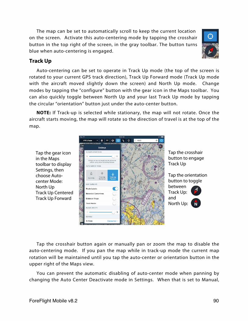
The map can be set to automatically scroll to keep the current location on the screen. Activate this auto-centering mode by tapping the crosshair button in the top right of the screen, in the gray toolbar. The button turns blue when auto-centering is engaged.
Track Up
Auto-centering can be set to operate in Track Up mode (the top of the screen is rotated to your current GPS track direction), Track Up Forward mode (Track Up mode with the aircraft moved slightly down the screen) and North Up mode. Change modes by tapping the “configure” button with the gear icon in the Maps toolbar. You can also quickly toggle between North Up and your last Track Up mode by tapping the circular “orientation” button just under the auto-center button.
NOTE: If Track-up is selected while stationary, the map will not rotate. Once the aircraft starts moving, the map will rotate so the direction of travel is at the top of the map.
Tap the crosshair button again or manually pan or zoom the map to disable the auto-centering mode. If you pan the map while in track-up mode the current map rotation will be maintained until you tap the auto-center or orientation button in the upper right of the Maps view.
You can prevent the automatic disabling of auto-center mode when panning by changing the Auto Center Deactivate mode in Settings. When that is set to Manual,
Tap the crosshair button to engage Track Up
Tap the orientation button to toggle between Track Up: and North Up:
Tap the gear icon in the Maps toolbar to display Settings, then choose Auto-center Mode:North UpTrack Up CenteredTrack Up Forward
ForeFlight Mobile v8.2! 90
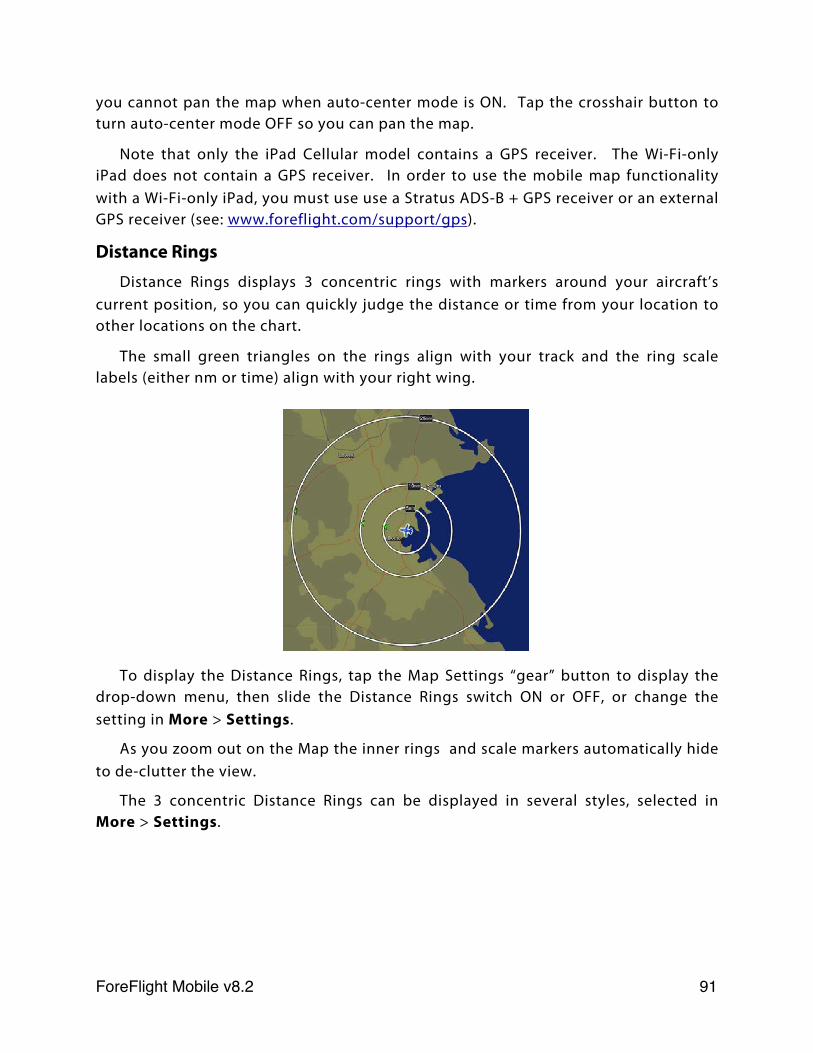
you cannot pan the map when auto-center mode is ON. Tap the crosshair button to turn auto-center mode OFF so you can pan the map.
Note that only the iPad Cellular model contains a GPS receiver. The Wi-Fi-only iPad does not contain a GPS receiver. In order to use the mobile map functionality with a Wi-Fi-only iPad, you must use use a Stratus ADS-B + GPS receiver or an external GPS receiver (see: www.foreflight.com/support/gps).
Distance RingsDistance Rings displays 3 concentric rings with markers around your aircraft’s
current position, so you can quickly judge the distance or time from your location to other locations on the chart.
The small green triangles on the rings align with your track and the ring scale labels (either nm or time) align with your right wing.
To display the Distance Rings, tap the Map Settings “gear” button to display the drop-down menu, then slide the Distance Rings switch ON or OFF, or change the setting in More > Settings.
As you zoom out on the Map the inner rings and scale markers automatically hide to de-clutter the view.
The 3 concentric Distance Rings can be displayed in several styles, selected in More > Settings.
ForeFlight Mobile v8.2! 91
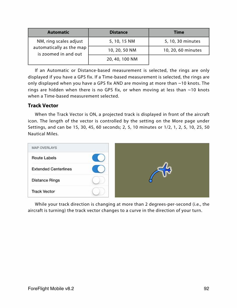
Automatic Distance Time
NM, ring scales adjust automatically as the map
is zoomed in and out
5, 10, 15 NM 5, 10, 30 minutesNM, ring scales adjust automatically as the map
is zoomed in and out10, 20, 50 NM 10, 20, 60 minutes
NM, ring scales adjust automatically as the map
is zoomed in and out20, 40, 100 NM
If an Automatic or Distance-based measurement is selected, the rings are only displayed if you have a GPS fix. If a Time-based measurement is selected, the rings are only displayed when you have a GPS fix AND are moving at more than ~10 knots. The rings are hidden when there is no GPS fix, or when moving at less than ~10 knots when a Time-based measurement selected.
Track VectorWhen the Track Vector is ON, a projected track is displayed in front of the aircraft
icon. The length of the vector is controlled by the setting on the More page under Settings, and can be 15, 30, 45, 60 seconds; 2, 5, 10 minutes or 1/2, 1, 2, 5, 10, 25, 50 Nautical Miles.
While your track direction is changing at more than 2 degrees-per-second (i.e., the aircraft is turning) the track vector changes to a curve in the direction of your turn.
ForeFlight Mobile v8.2! 92
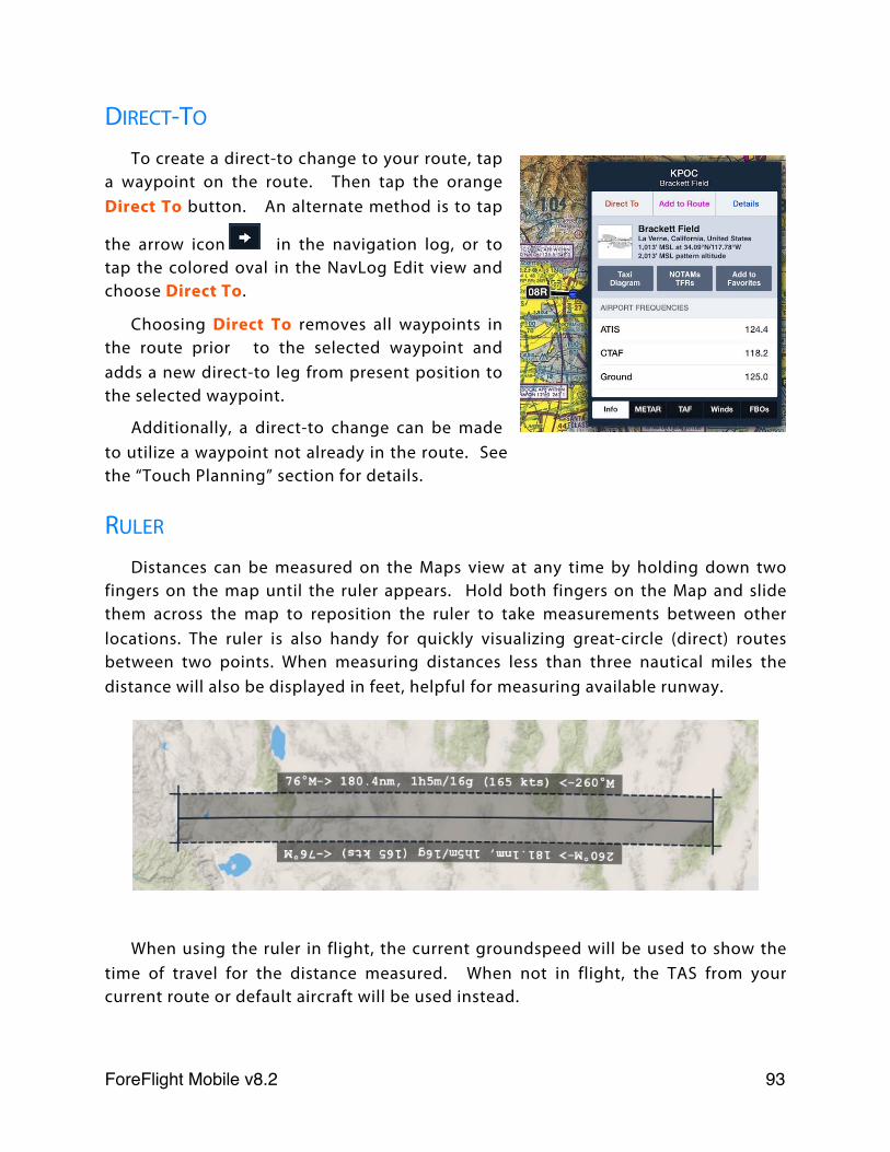
DIRECT-TO
To create a direct-to change to your route, tap a waypoint on the route. Then tap the orange Direct To button. An alternate method is to tap
the arrow icon in the navigation log, or to tap the colored oval in the NavLog Edit view and choose Direct To.
Choosing Direct To removes all waypoints in the route prior to the selected waypoint and adds a new direct-to leg from present position to the selected waypoint.
Additionally, a direct-to change can be made to utilize a waypoint not already in the route. See the “Touch Planning” section for details.
RULER
Distances can be measured on the Maps view at any time by holding down two fingers on the map until the ruler appears. Hold both fingers on the Map and slide them across the map to reposition the ruler to take measurements between other locations. The ruler is also handy for quickly visualizing great-circle (direct) routes between two points. When measuring distances less than three nautical miles the distance will also be displayed in feet, helpful for measuring available runway.
When using the ruler in flight, the current groundspeed will be used to show the time of travel for the distance measured. When not in flight, the TAS from your current route or default aircraft will be used instead.
ForeFlight Mobile v8.2! 93
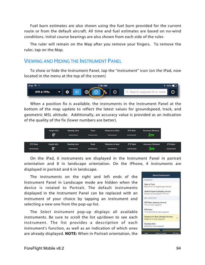
Fuel burn estimates are also shown using the fuel burn provided for the current route or from the default aircraft. All time and fuel estimates are based on no-wind conditions. Initial course bearings are also shown from each side of the ruler.
The ruler will remain on the Map after you remove your fingers. To remove the ruler, tap on the Map.
VIEWING AND HIDING THE INSTRUMENT PANEL
To show or hide the Instrument Panel, tap the “instrument” icon (on the iPad, now located in the menu at the top of the screen)
When a position fix is available, the instruments in the Instrument Panel at the bottom of the map update to reflect the latest values for groundspeed, track, and geometric MSL altitude. Additionally, an accuracy value is provided as an indication of the quality of the fix (lower numbers are better).
On the iPad, 6 instruments are displayed in the Instrument Panel in portrait orientation and 8 in landscape orientation. On the iPhone, 4 instruments are displayed in portrait and 6 in landscape.
The instruments on the right and left ends of the Instrument Panel in Landscape mode are hidden when the device is rotated to Portrait. The default instruments displayed in the Instrument Panel can be replaced with an instrument of your choice by tapping an instrument and selecting a new one from the pop-up list.
The Select Instrument pop-up displays all available instruments. Be sure to scroll the list up/down to see each instrument. The l ist provides a description of each instrument’s function, as well as an indication of which ones are already displayed. NOTE: When in Portrait orientation, the
ForeFlight Mobile v8.2! 94
2 additional instruments visible in Landscape are shown as being “(already shown)” even though they are not visible on the screen.
The following instruments are available in the Instrument Panel:
Standard Next Waypoint Destination Other
Groundspeed ETE Next ETE Dest Current Lat/Lon
GPS Altitude ETA Next ETA Dest Zulu Time
Pressure Alt * Distance to Next Distance to Dest Blank
Height AGL # Bearing Next Bearing to Dest
Height MEF # Course Next Descent to Dest
Track Cross Track Error
Accuracy Nearest Airport
Rate of Turn Nearest Navaid
Vertical Speed
Pressure Alt is the pressure altitude as detected by a barometer sensor, if present. *: iPhone 6/6+, iPad Air 2, or appropriately equipped external device required.
Height AGL shows the GPS altitude above the highest terrain within a 1/4 nm circle around your present location. #: iPad only, Pro or Pro Plus subscription required.
Height MEF shows a dynamic Maximum Elevation Figure for a 1/2 degree latitude by 1/2 degree longitude box centered on your aircraft’s location. MEF is calculated as: the tallest obstacle or terrain in that box, rounded up to the nearest 200 feet. #: iPad only, Pro or Pro Plus subscription required.
Nearest Airport shows the Cardinal position and distance from the nearest airport to your present location.
Nearest Navaid shows the Navaid identifier and the radial and distance from that Navaid.
USING FAVORITE ROUTES
To view a favorite route, tap the double-star button in the dark blue tool bar at the top of the Maps view. A list of your favorite routes is displayed.
ForeFlight Mobile v8.2! 95
Tap a route in the list to make it the current route.
To delete a route from the favorites list, use swipe-to-delete on the route.
The favorites list can be re-ordered by tapping the Edit button. Once in Edit mode a three-bar icon is displayed on the right of each route in the list. Tap-and-hold on the three bar icon until the row appears to lift up, then drag the row to the desired location in the list. You can also delete the route by tapping the red button on the left.
Note that removing routes from your Favorites list will not affect items displayed in the File and Brief view.
USING RECENT ROUTES
Every route shown on the Map is automatically saved to the Recent routes list. This provides a great way to quickly jump to a previously viewed routing or performance configuration.
View this list by tapping the clock icon in the dark blue tool bar at the top of the view. Tap a route in the list to make it the active route.
Delete a route from the recents list using swipe-to-delete, or delete all routes from the recents list by tapping the Clear button at the top of the list.
FAVORITE AND RECENT ROUTE SYNC
Changes to your Favorite and Recent routes, including adding, removing and change the order of the routes, are automatically synchronized to each device that is signed-in to your ForeFlight Mobile account. For more information, see the Sync chapter.
ForeFlight Mobile v8.2! 96
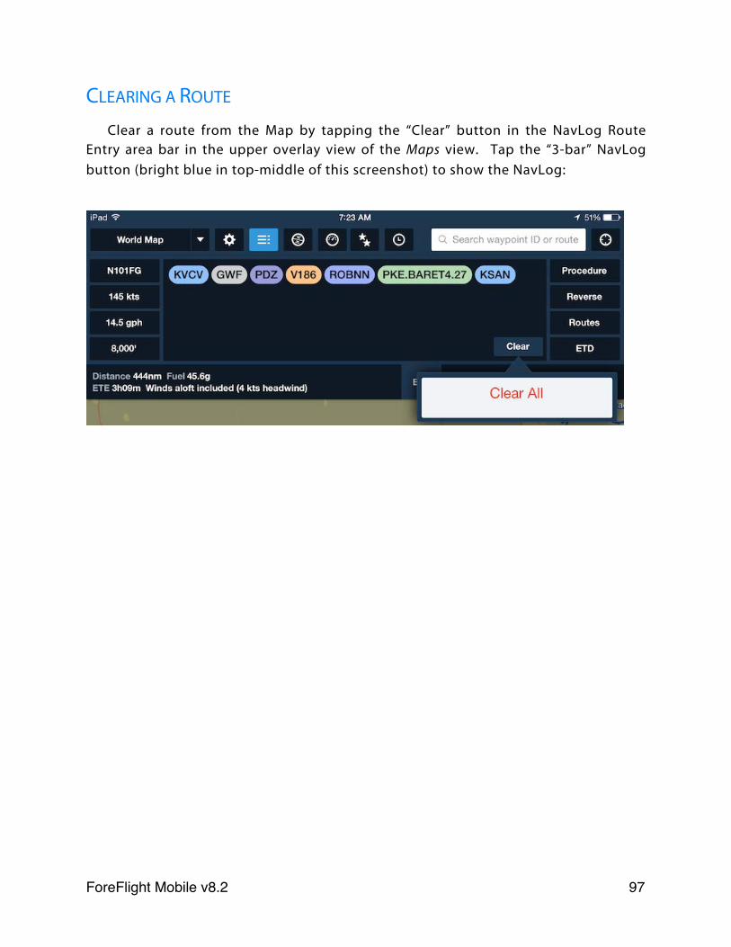
CLEARING A ROUTE
Clear a route from the Map by tapping the “Clear” button in the NavLog Route Entry area bar in the upper overlay view of the Maps view. Tap the “3-bar” NavLog button (bright blue in top-middle of this screenshot) to show the NavLog:
ForeFlight Mobile v8.2! 97
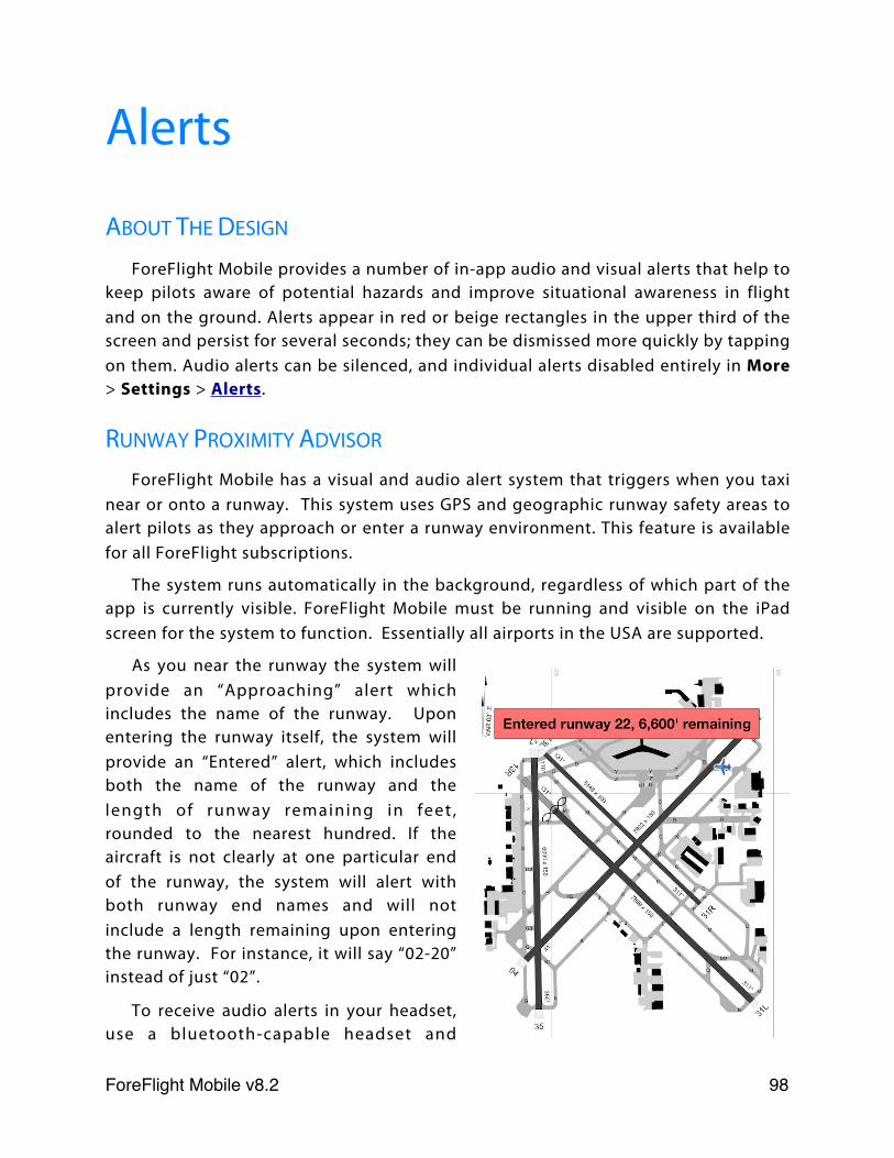
Alerts
ABOUT THE DESIGN
ForeFlight Mobile provides a number of in-app audio and visual alerts that help to keep pilots aware of potential hazards and improve situational awareness in flight and on the ground. Alerts appear in red or beige rectangles in the upper third of the screen and persist for several seconds; they can be dismissed more quickly by tapping on them. Audio alerts can be silenced, and individual alerts disabled entirely in More > Settings > Alerts.
RUNWAY PROXIMITY ADVISOR
ForeFlight Mobile has a visual and audio alert system that triggers when you taxi near or onto a runway. This system uses GPS and geographic runway safety areas to alert pilots as they approach or enter a runway environment. This feature is available for all ForeFlight subscriptions.
The system runs automatically in the background, regardless of which part of the app is currently visible. ForeFlight Mobile must be running and visible on the iPad screen for the system to function. Essentially all airports in the USA are supported.
As you near the runway the system will provide an “Approaching” alert which includes the name of the runway. Upon entering the runway itself, the system will provide an “Entered” alert, which includes both the name of the runway and the length of runway remaining in feet , rounded to the nearest hundred. If the aircraft is not clearly at one particular end of the runway, the system will alert with both runway end names and will not include a length remaining upon entering the runway. For instance, it will say “02-20” instead of just “02”.
To receive audio alerts in your headset, use a bluetooth-capable headset and
ForeFlight Mobile v8.2! 98
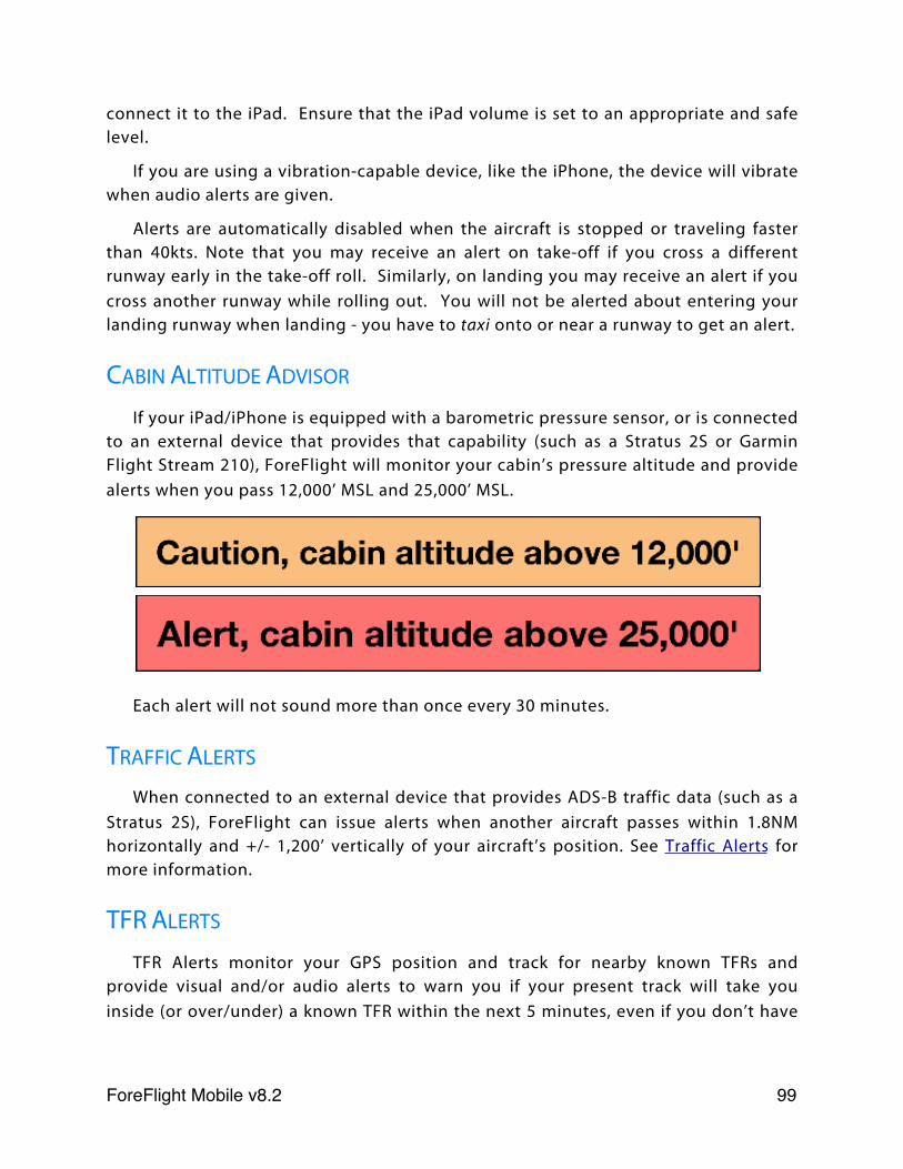
connect it to the iPad. Ensure that the iPad volume is set to an appropriate and safe level.
If you are using a vibration-capable device, like the iPhone, the device will vibrate when audio alerts are given.
Alerts are automatically disabled when the aircraft is stopped or traveling faster than 40kts. Note that you may receive an alert on take-off if you cross a different runway early in the take-off roll. Similarly, on landing you may receive an alert if you cross another runway while rolling out. You will not be alerted about entering your landing runway when landing - you have to taxi onto or near a runway to get an alert.
CABIN ALTITUDE ADVISOR
If your iPad/iPhone is equipped with a barometric pressure sensor, or is connected to an external device that provides that capability (such as a Stratus 2S or Garmin Flight Stream 210), ForeFlight will monitor your cabin’s pressure altitude and provide alerts when you pass 12,000’ MSL and 25,000’ MSL.
Each alert will not sound more than once every 30 minutes.
TRAFFIC ALERTS
When connected to an external device that provides ADS-B traffic data (such as a Stratus 2S), ForeFlight can issue alerts when another aircraft passes within 1.8NM horizontally and +/- 1,200’ vertically of your aircraft’s position. See Traffic Alerts for more information.
TFR ALERTS
TFR Alerts monitor your GPS position and track for nearby known TFRs and provide visual and/or audio alerts to warn you if your present track will take you inside (or over/under) a known TFR within the next 5 minutes, even if you don’t have
ForeFlight Mobile v8.2! 99
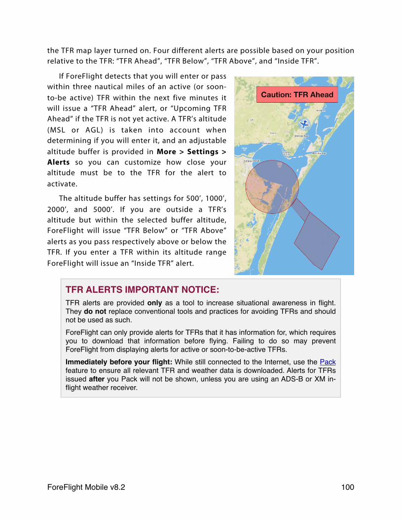
the TFR map layer turned on. Four different alerts are possible based on your position relative to the TFR: “TFR Ahead”, “TFR Below”, “TFR Above”, and “Inside TFR”.
If ForeFlight detects that you will enter or pass within three nautical miles of an active (or soon-to-be active) TFR within the next five minutes it will issue a “TFR Ahead” alert, or “Upcoming TFR Ahead” if the TFR is not yet active. A TFR’s altitude (MSL or AGL) is taken into account when determining if you will enter it, and an adjustable altitude buffer is provided in More > Settings > Alerts so you can customize how close your altitude must be to the TFR for the alert to activate.
The altitude buffer has settings for 500’, 1000’, 2000’, and 5000’. If you are outside a TFR’s altitude but within the selected buffer altitude, ForeFlight will issue “TFR Below” or “TFR Above” alerts as you pass respectively above or below the TFR. If you enter a TFR within its altitude range ForeFlight will issue an “Inside TFR” alert.
TFR ALERTS IMPORTANT NOTICE:TFR alerts are provided only as a tool to increase situational awareness in flight. They do not replace conventional tools and practices for avoiding TFRs and should not be used as such.ForeFlight can only provide alerts for TFRs that it has information for, which requires you to download that information before flying. Failing to do so may prevent ForeFlight from displaying alerts for active or soon-to-be-active TFRs.Immediately before your flight: While still connected to the Internet, use the Pack feature to ensure all relevant TFR and weather data is downloaded. Alerts for TFRs issued after you Pack will not be shown, unless you are using an ADS-B or XM in-flight weather receiver.
ForeFlight Mobile v8.2! 100
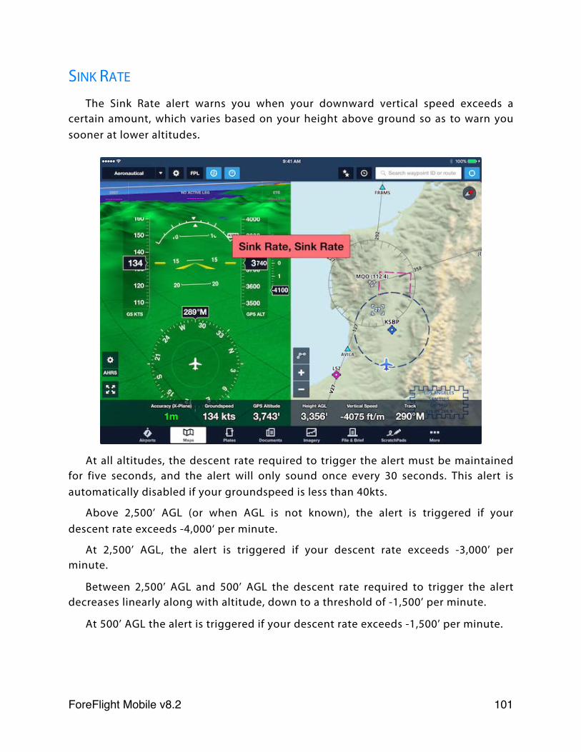
SINK RATE
The Sink Rate alert warns you when your downward vertical speed exceeds a certain amount, which varies based on your height above ground so as to warn you sooner at lower altitudes.
At all altitudes, the descent rate required to trigger the alert must be maintained for five seconds, and the alert will only sound once every 30 seconds. This alert is automatically disabled if your groundspeed is less than 40kts.
Above 2,500’ AGL (or when AGL is not known), the alert is triggered if your descent rate exceeds -4,000‘ per minute.
At 2,500’ AGL, the alert is triggered if your descent rate exceeds -3,000’ per minute.
Between 2,500’ AGL and 500’ AGL the descent rate required to trigger the alert decreases linearly along with altitude, down to a threshold of -1,500’ per minute.
At 500’ AGL the alert is triggered if your descent rate exceeds -1,500’ per minute.
ForeFlight Mobile v8.2! 101
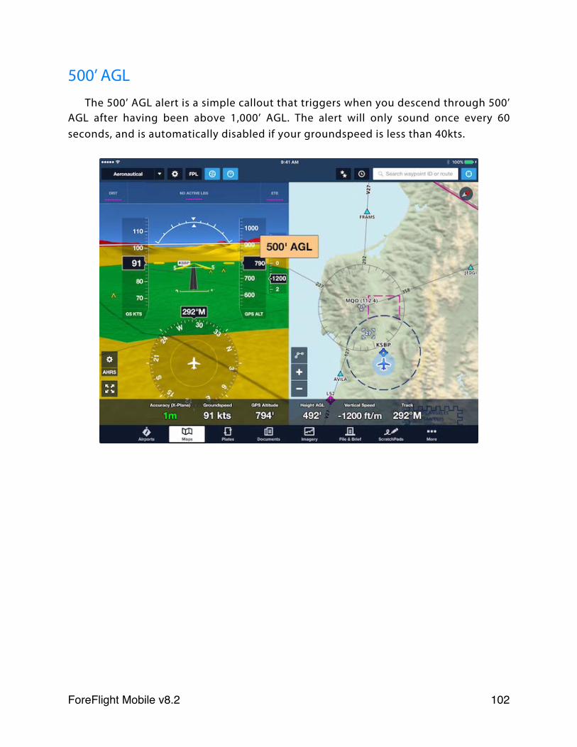
500’ AGLThe 500’ AGL alert is a simple callout that triggers when you descend through 500’
AGL after having been above 1,000’ AGL. The alert will only sound once every 60 seconds, and is automatically disabled if your groundspeed is less than 40kts.
ForeFlight Mobile v8.2! 102
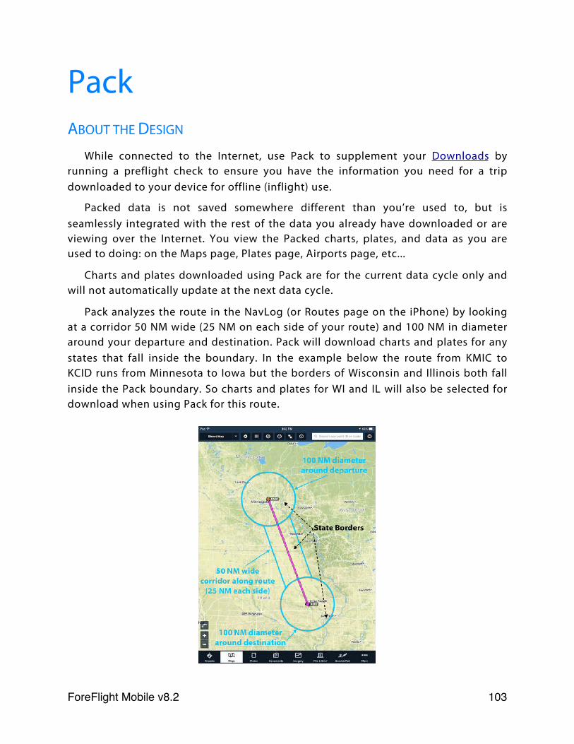
PackABOUT THE DESIGN
While connected to the Internet, use Pack to supplement your Downloads by running a preflight check to ensure you have the information you need for a trip downloaded to your device for offline (inflight) use.
Packed data is not saved somewhere different than you’re used to, but is seamlessly integrated with the rest of the data you already have downloaded or are viewing over the Internet. You view the Packed charts, plates, and data as you are used to doing: on the Maps page, Plates page, Airports page, etc...
Charts and plates downloaded using Pack are for the current data cycle only and will not automatically update at the next data cycle.
Pack analyzes the route in the NavLog (or Routes page on the iPhone) by looking at a corridor 50 NM wide (25 NM on each side of your route) and 100 NM in diameter around your departure and destination. Pack will download charts and plates for any states that fall inside the boundary. In the example below the route from KMIC to KCID runs from Minnesota to Iowa but the borders of Wisconsin and Illinois both fall inside the Pack boundary. So charts and plates for WI and IL will also be selected for download when using Pack for this route.
ForeFlight Mobile v8.2! 103
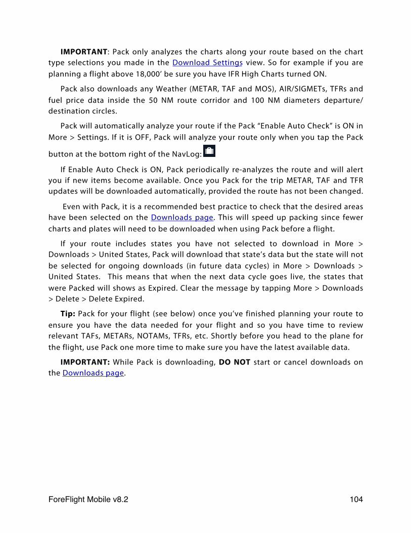
IMPORTANT: Pack only analyzes the charts along your route based on the chart type selections you made in the Download Settings view. So for example if you are planning a flight above 18,000’ be sure you have IFR High Charts turned ON.
Pack also downloads any Weather (METAR, TAF and MOS), AIR/SIGMETs, TFRs and fuel price data inside the 50 NM route corridor and 100 NM diameters departure/destination circles.
Pack will automatically analyze your route if the Pack “Enable Auto Check” is ON in More > Settings. If it is OFF, Pack will analyze your route only when you tap the Pack
button at the bottom right of the NavLog:
If Enable Auto Check is ON, Pack periodically re-analyzes the route and will alert you if new items become available. Once you Pack for the trip METAR, TAF and TFR updates will be downloaded automatically, provided the route has not been changed.
Even with Pack, it is a recommended best practice to check that the desired areas have been selected on the Downloads page. This will speed up packing since fewer charts and plates will need to be downloaded when using Pack before a flight.
If your route includes states you have not selected to download in More > Downloads > United States, Pack will download that state’s data but the state will not be selected for ongoing downloads (in future data cycles) in More > Downloads > United States. This means that when the next data cycle goes live, the states that were Packed will shows as Expired. Clear the message by tapping More > Downloads > Delete > Delete Expired.
Tip: Pack for your flight (see below) once you’ve finished planning your route to ensure you have the data needed for your flight and so you have time to review relevant TAFs, METARs, NOTAMs, TFRs, etc. Shortly before you head to the plane for the flight, use Pack one more time to make sure you have the latest available data.
IMPORTANT: While Pack is downloading, DO NOT start or cancel downloads on the Downloads page.
ForeFlight Mobile v8.2! 104
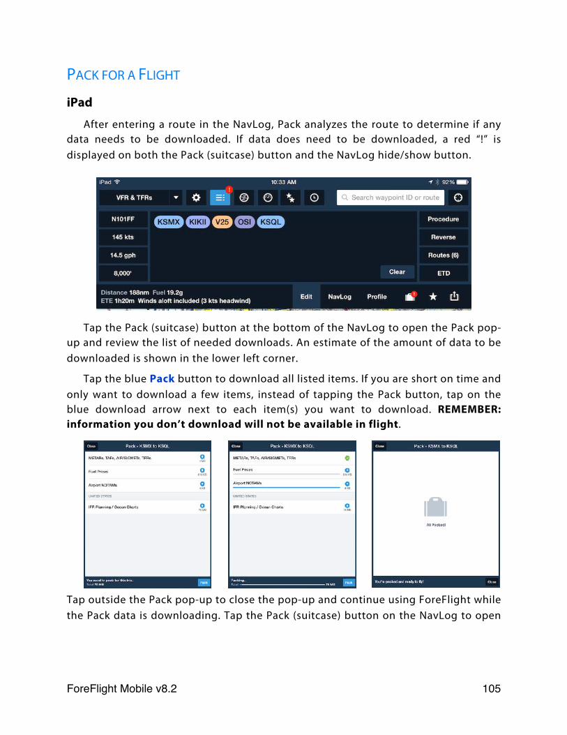
PACK FOR A FLIGHT
iPad
After entering a route in the NavLog, Pack analyzes the route to determine if any data needs to be downloaded. If data does need to be downloaded, a red “!” is displayed on both the Pack (suitcase) button and the NavLog hide/show button.
Tap the Pack (suitcase) button at the bottom of the NavLog to open the Pack pop-up and review the list of needed downloads. An estimate of the amount of data to be downloaded is shown in the lower left corner.
Tap the blue Pack button to download all listed items. If you are short on time and only want to download a few items, instead of tapping the Pack button, tap on the blue download arrow next to each item(s) you want to download. REMEMBER: information you don’t download will not be available in flight.
Tap outside the Pack pop-up to close the pop-up and continue using ForeFlight while the Pack data is downloading. Tap the Pack (suitcase) button on the NavLog to open
ForeFlight Mobile v8.2! 105
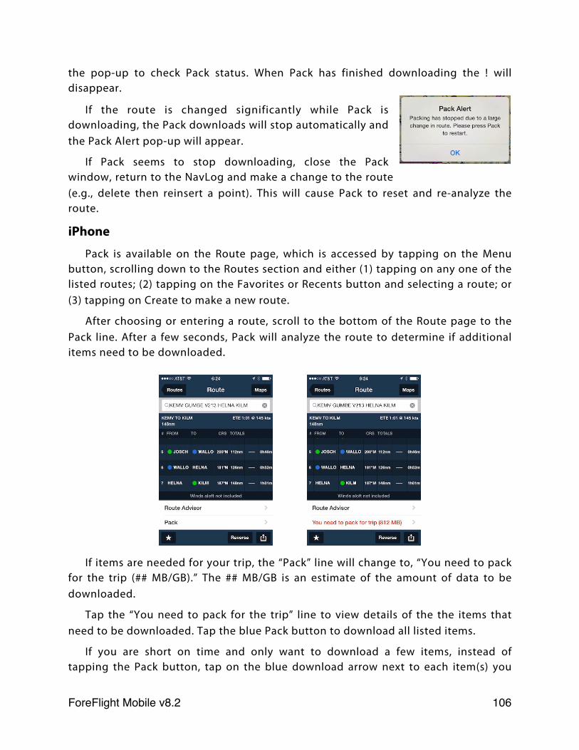
the pop-up to check Pack status. When Pack has finished downloading the ! will disappear.
If the route is changed significantly while Pack is downloading, the Pack downloads will stop automatically and the Pack Alert pop-up will appear.
If Pack seems to stop downloading, close the Pack window, return to the NavLog and make a change to the route (e.g., delete then reinsert a point). This will cause Pack to reset and re-analyze the route.
iPhone
Pack is available on the Route page, which is accessed by tapping on the Menu button, scrolling down to the Routes section and either (1) tapping on any one of the listed routes; (2) tapping on the Favorites or Recents button and selecting a route; or (3) tapping on Create to make a new route.
After choosing or entering a route, scroll to the bottom of the Route page to the Pack line. After a few seconds, Pack will analyze the route to determine if additional items need to be downloaded.
If items are needed for your trip, the “Pack” line will change to, “You need to pack for the trip (## MB/GB).” The ## MB/GB is an estimate of the amount of data to be downloaded.
Tap the “You need to pack for the trip” line to view details of the the items that need to be downloaded. Tap the blue Pack button to download all listed items.
If you are short on time and only want to download a few items, instead of tapping the Pack button, tap on the blue download arrow next to each item(s) you
ForeFlight Mobile v8.2! 106
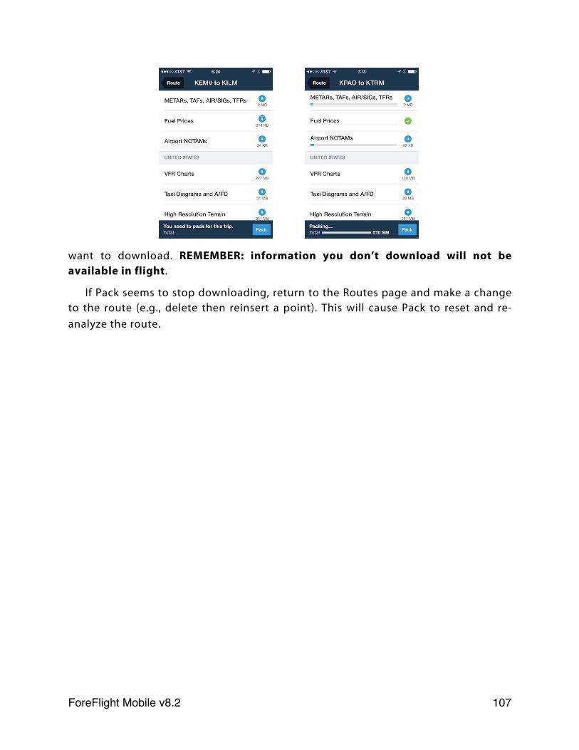
want to download. REMEMBER: information you don’t download will not be available in flight.
If Pack seems to stop downloading, return to the Routes page and make a change to the route (e.g., delete then reinsert a point). This will cause Pack to reset and re-analyze the route.
ForeFlight Mobile v8.2! 107
SyncABOUT THE DESIGN
Sync is a fast, cloud-based system that works seamlessly in the background to synchronize Recent and Favorite Airports, Routes, Weather Imagery, User Waypoints, Aircraft Profiles, ScratchPads (iPads only), Flight Plans (both filed and un-filed), and Weight & Balance profiles between all devices signed-in to your ForeFlight account. Because sync’d information is also stored in the cloud, changes made on one device will automatically be delivered to the other device when it is connected to the Internet.
IMPORTANT: Sync is disabled by default for multi-pilot accounts with a shared single login.
USING SYNC
Activate Sync on each device in More > Settings by turning Synchronize User Data ON. After Sync is turned on, User Waypoints and the Recent and Favorite Airports, Routes, Aircraft Profiles, ScratchPads (iPads only), Flight plans from the File & Brief page, weather Imagery, and Weight & Balance profiles are synchronized to all devices.
If you change the order of items in a Favorites or Recents list on one device, the order of the items in the list will be synchronized to all other devices.
For example, suppose you have an iPad and an iPhone signed-in to your account, and two User Waypoints: WPT1 and WPT2 on your devices:
ForeFlight Mobile v8.2! 108
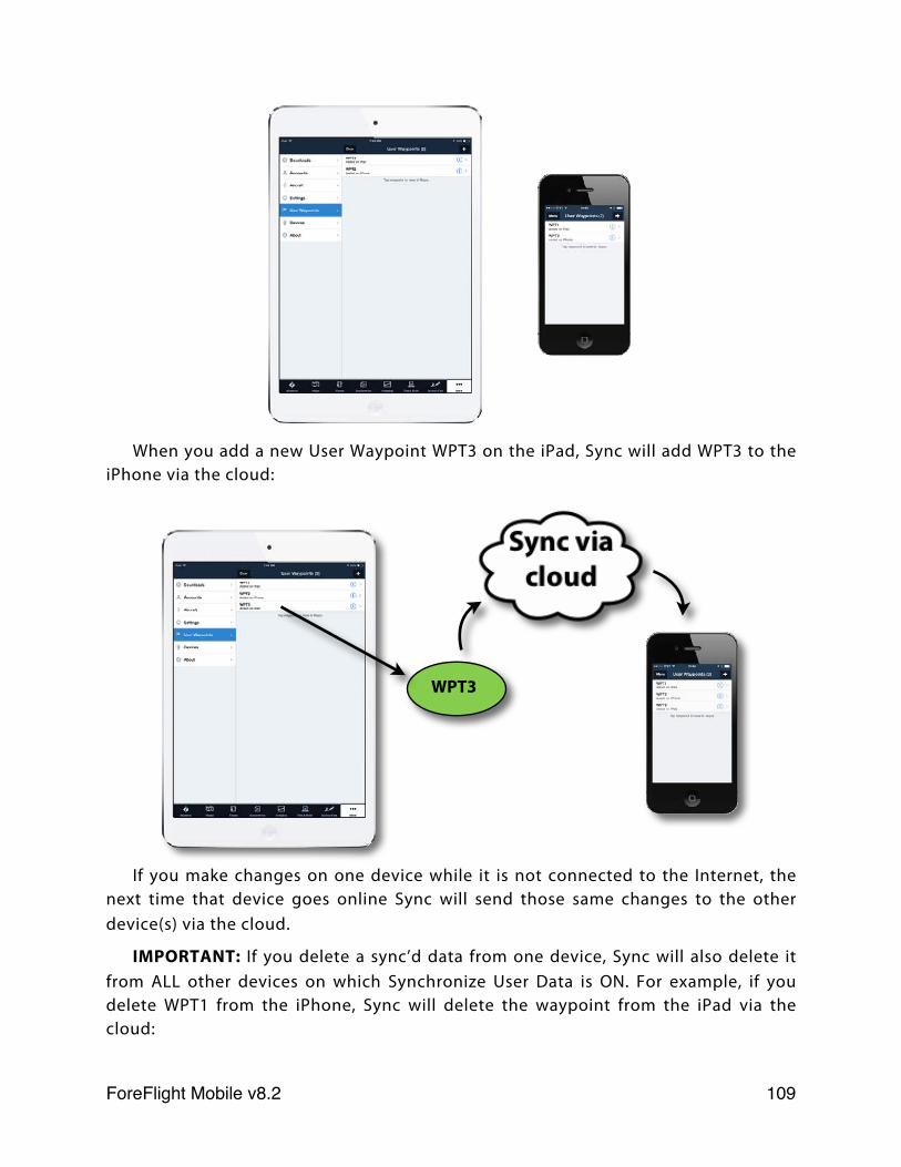
When you add a new User Waypoint WPT3 on the iPad, Sync will add WPT3 to the iPhone via the cloud:
If you make changes on one device while it is not connected to the Internet, the next time that device goes online Sync will send those same changes to the other device(s) via the cloud.
IMPORTANT: If you delete a sync’d data from one device, Sync will also delete it from ALL other devices on which Synchronize User Data is ON. For example, if you delete WPT1 from the iPhone, Sync will delete the waypoint from the iPad via the cloud:
WPT3
ForeFlight Mobile v8.2! 109
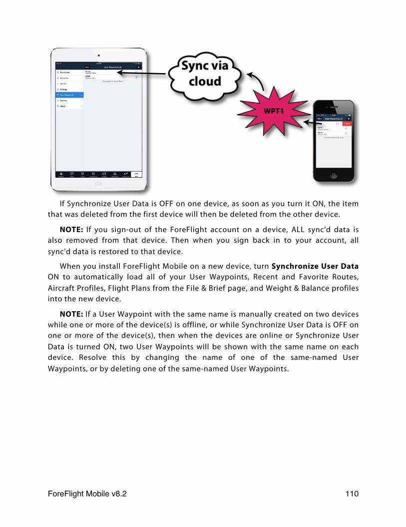
If Synchronize User Data is OFF on one device, as soon as you turn it ON, the item that was deleted from the first device will then be deleted from the other device.
NOTE: If you sign-out of the ForeFlight account on a device, ALL sync’d data is also removed from that device. Then when you sign back in to your account, all sync’d data is restored to that device.
When you install ForeFlight Mobile on a new device, turn Synchronize User Data ON to automatically load all of your User Waypoints, Recent and Favorite Routes, Aircraft Profiles, Flight Plans from the File & Brief page, and Weight & Balance profiles into the new device.
NOTE: If a User Waypoint with the same name is manually created on two devices while one or more of the device(s) is offline, or while Synchronize User Data is OFF on one or more of the device(s), then when the devices are online or Synchronize User Data is turned ON, two User Waypoints will be shown with the same name on each device. Resolve this by changing the name of one of the same-named User Waypoints, or by deleting one of the same-named User Waypoints.
WPT1
ForeFlight Mobile v8.2! 110
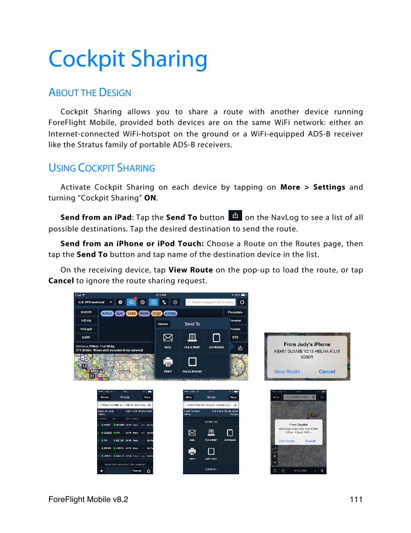
Cockpit SharingABOUT THE DESIGN
Cockpit Sharing allows you to share a route with another device running ForeFlight Mobile, provided both devices are on the same WiFi network: either an Internet-connected WiFi-hotspot on the ground or a WiFi-equipped ADS-B receiver like the Stratus family of portable ADS-B receivers.
USING COCKPIT SHARING
Activate Cockpit Sharing on each device by tapping on More > Settings and turning “Cockpit Sharing” ON.
Send from an iPad: Tap the Send To button on the NavLog to see a list of all possible destinations. Tap the desired destination to send the route.
Send from an iPhone or iPod Touch: Choose a Route on the Routes page, then tap the Send To button and tap name of the destination device in the list.
On the receiving device, tap View Route on the pop-up to load the route, or tap Cancel to ignore the route sharing request.
ForeFlight Mobile v8.2! 111
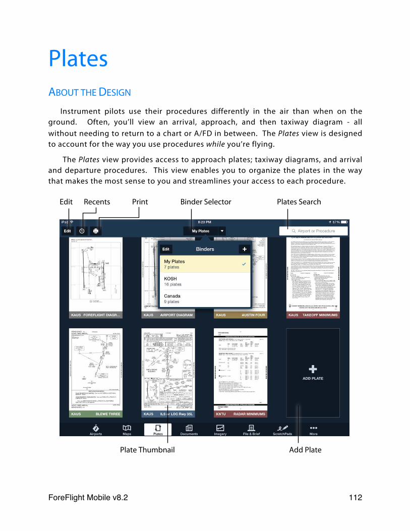
PlatesABOUT THE DESIGN
Instrument pilots use their procedures differently in the air than when on the ground. Often, you’ll view an arrival, approach, and then taxiway diagram - all without needing to return to a chart or A/FD in between. The Plates view is designed to account for the way you use procedures while you’re flying.
The Plates view provides access to approach plates; taxiway diagrams, and arrival and departure procedures. This view enables you to organize the plates in the way that makes the most sense to you and streamlines your access to each procedure.
Edit Recents Print Binder Selector Plates Search
Plate Thumbnail Add Plate
ForeFlight Mobile v8.2! 112
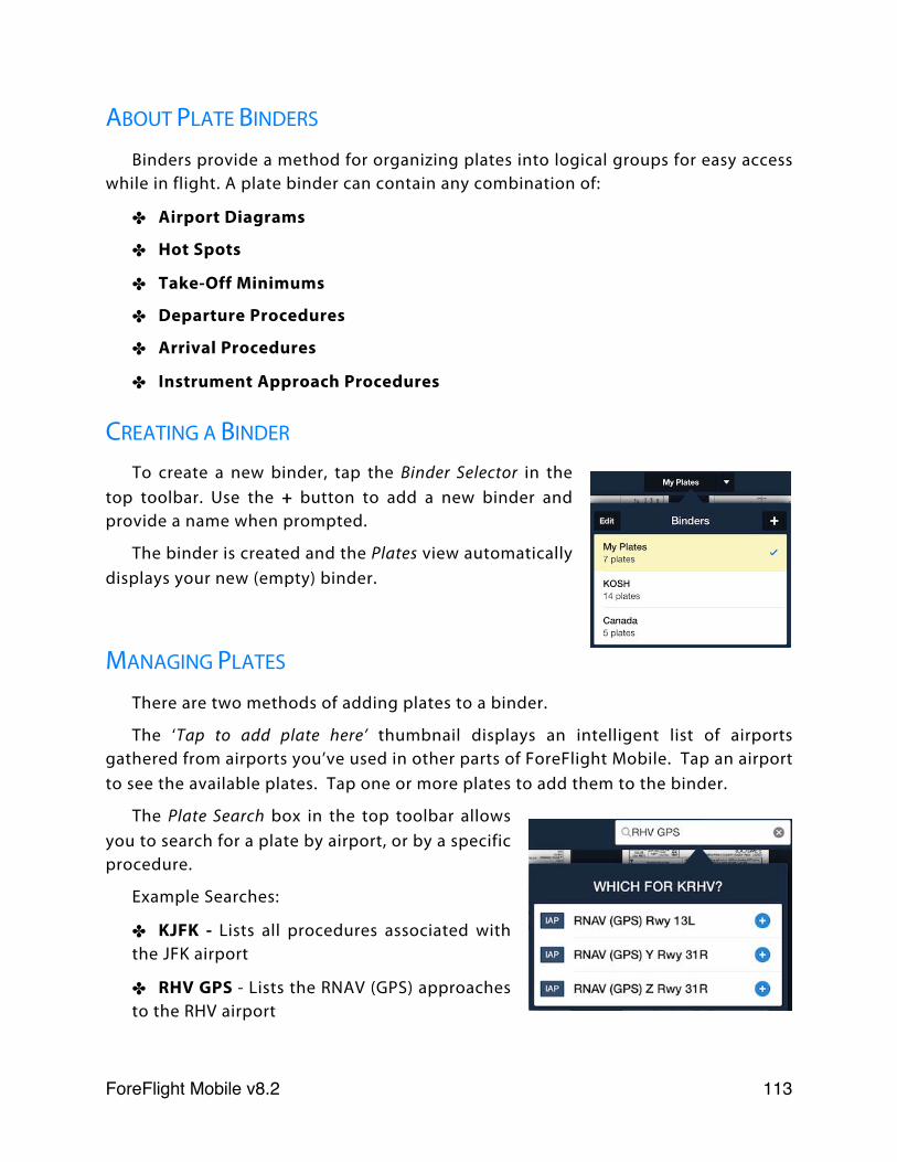
ABOUT PLATE BINDERS
Binders provide a method for organizing plates into logical groups for easy access while in flight. A plate binder can contain any combination of:
✤ Airport Diagrams
✤ Hot Spots
✤ Take-Off Minimums
✤ Departure Procedures
✤ Arrival Procedures
✤ Instrument Approach Procedures
CREATING A BINDER
To create a new binder, tap the Binder Selector in the top toolbar. Use the + button to add a new binder and provide a name when prompted.
The binder is created and the Plates view automatically displays your new (empty) binder.
MANAGING PLATES
There are two methods of adding plates to a binder.
The ‘Tap to add plate here’ thumbnail displays an intelligent list of airports gathered from airports you’ve used in other parts of ForeFlight Mobile. Tap an airport to see the available plates. Tap one or more plates to add them to the binder.
The Plate Search box in the top toolbar allows you to search for a plate by airport, or by a specific procedure.
Example Searches:
✤ KJFK - Lists all procedures associated with the JFK airport
✤ RHV GPS - Lists the RNAV (GPS) approaches to the RHV airport
ForeFlight Mobile v8.2! 113
✤ MDW ILS 13- Displays the ILS Rwy 13C approach to MDW airport in the procedure viewer.
Tap the icon to the right of any procedure to add it to the current plate binder. Tap the procedure name to view it.
To reorder or delete plates in a binder, tap the Edit button on the left side of the top toolbar.
To change the order in which a plate is displayed in the binder, hold and drag the plate to the new location. Note that you can add the same plate to the same binder more than once. For example, you might create a binder that contains plates for three local airports. You could elect to include each airport’s taxiway diagram both before each airport’s departure procedures and after each airport’s approach plates, making it easier to find the diagram in context during both arrival and departure operations.
To remove a plate from the binder tap the X icon in the upper left of the plate thumbnail.
ForeFlight Mobile v8.2! 114
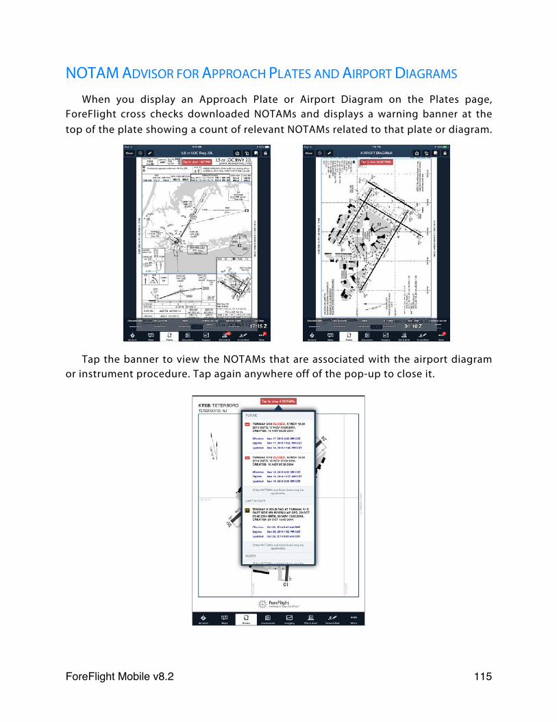
NOTAM ADVISOR FOR APPROACH PLATES AND AIRPORT DIAGRAMS
When you display an Approach Plate or Airport Diagram on the Plates page, ForeFlight cross checks downloaded NOTAMs and displays a warning banner at the top of the plate showing a count of relevant NOTAMs related to that plate or diagram.
Tap the banner to view the NOTAMs that are associated with the airport diagram or instrument procedure. Tap again anywhere off of the pop-up to close it.
ForeFlight Mobile v8.2! 115
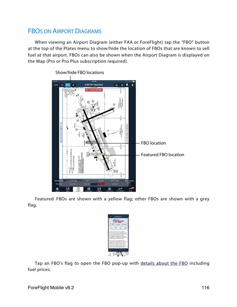
FBOS ON AIRPORT DIAGRAMS
When viewing an Airport Diagram (either FAA or ForeFlight) tap the “FBO” button at the top of the Plates menu to show/hide the location of FBOs that are known to sell fuel at that airport. FBOs can also be shown when the Airport Diagram is displayed on the Map (Pro or Pro Plus subscription required).
Featured FBOs are shown with a yellow flag; other FBOs are shown with a grey flag.
Tap an FBO’s flag to open the FBO pop-up with details about the FBO including fuel prices.
Show/hide FBO locations
FBO location
Featured FBO location
ForeFlight Mobile v8.2! 116
PRINTING PLATES FROM A BINDER
Tap the Print button in the top toolbar of the Plates view. The Printer Options dialog box is displayed. From here, select a printer and a number of copies. Tap the Print button to send the selected number of copies of ALL plates in the binder to your printer.
To print only one procedure, tap the plate’s thumbnail to display it in the procedure viewer, then tap the Send To button and choose “Printer.”
Printing requires an AirPrint capable printer. For more information about this requirement, see:
support.apple.com/kb/ht4356
ENSURING YOUR PLATES DON’T EXPIRE
When you view a plate or add it to your binder, ForeFlight uses either a copy of the plate stored locally on your iPad (by virtue of the fact that you’ve already downloaded it), or uses your iPad’s Internet connection to fetch the plate and store it locally on your iPad. In either case, the plates are viewable until they expire - whether you have an Internet connection at the time you view them or not.
When these plates expire, they are only automatically replaced if you have used the Downloads view to download new terminal procedures for the states/regions associated with the plates in your binder. Otherwise, the plates are only replaced when you open the binder and have an Internet connection. In-flight is not the time to discover this.
Be sure to check your selections in More > Downloads to ensure ForeFlight is set to download terminal procedures for all states covered in your binders and that all requested data has been downloaded. This ensures all plates in your binder will be current and available to you at any time - on the ground or in the air.
ForeFlight Mobile v8.2! 117
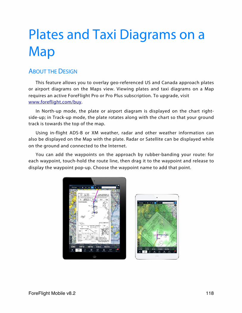
Plates and Taxi Diagrams on a MapABOUT THE DESIGN
This feature allows you to overlay geo-referenced US and Canada approach plates or airport diagrams on the Maps view. Viewing plates and taxi diagrams on a Map requires an active ForeFlight Pro or Pro Plus subscription. To upgrade, visit www.foreflight.com/buy.
In North-up mode, the plate or airport diagram is displayed on the chart right-side-up; in Track-up mode, the plate rotates along with the chart so that your ground track is towards the top of the map.
Using in-flight ADS-B or XM weather, radar and other weather information can also be displayed on the Map with the plate. Radar or Satellite can be displayed while on the ground and connected to the Internet.
You can add the waypoints on the approach by rubber-banding your route: for each waypoint, touch-hold the route line, then drag it to the waypoint and release to display the waypoint pop-up. Choose the waypoint name to add that point.
ForeFlight Mobile v8.2! 118
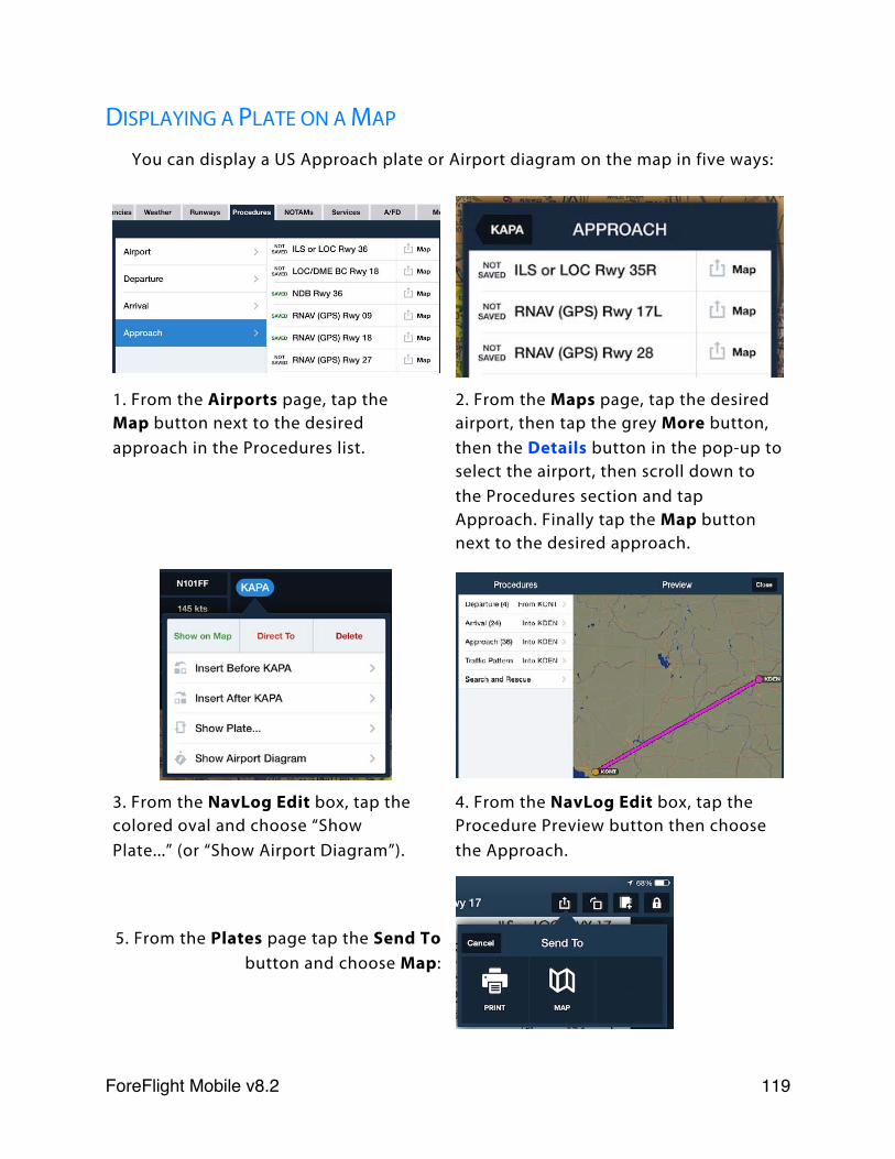
DISPLAYING A PLATE ON A MAP
You can display a US Approach plate or Airport diagram on the map in five ways:
1. From the Airports page, tap the Map button next to the desired approach in the Procedures list.
2. From the Maps page, tap the desired airport, then tap the grey More button, then the Details button in the pop-up to select the airport, then scroll down to the Procedures section and tap Approach. Finally tap the Map button next to the desired approach.
3. From the NavLog Edit box, tap the colored oval and choose “Show Plate...” (or “Show Airport Diagram”).
4. From the NavLog Edit box, tap the Procedure Preview button then choose the Approach.
5. From the Plates page tap the Send To button and choose Map:
ForeFlight Mobile v8.2! 119
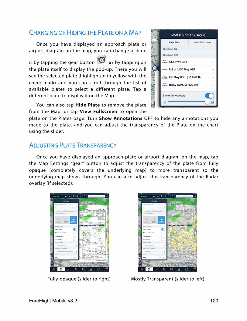
CHANGING OR HIDING THE PLATE ON A MAP
Once you have displayed an approach plate or airport diagram on the map, you can change or hide
it by tapping the gear button or by tapping on the plate itself to display the pop-up. There you will see the selected plate (highlighted in yellow with the check-mark) and you can scroll through the list of available plates to select a different plate. Tap a different plate to display it on the Map.
You can also tap Hide Plate to remove the plate from the Map, or tap View Fullscreen to open the plate on the Plates page. Turn Show Annotations OFF to hide any annotations you made to the plate, and you can adjust the transparency of the Plate on the chart using the slider.
ADJUSTING PLATE TRANSPARENCY
Once you have displayed an approach plate or airport diagram on the map, tap the Map Settings “gear” button to adjust the transparency of the plate from fully opaque (completely covers the underlying map) to more transparent so the underlying map shows through. You can also adjust the transparency of the Radar overlay (if selected).
Fully-opaque (slider to right) Mostly Transparent (slider to left)
ForeFlight Mobile v8.2! 120
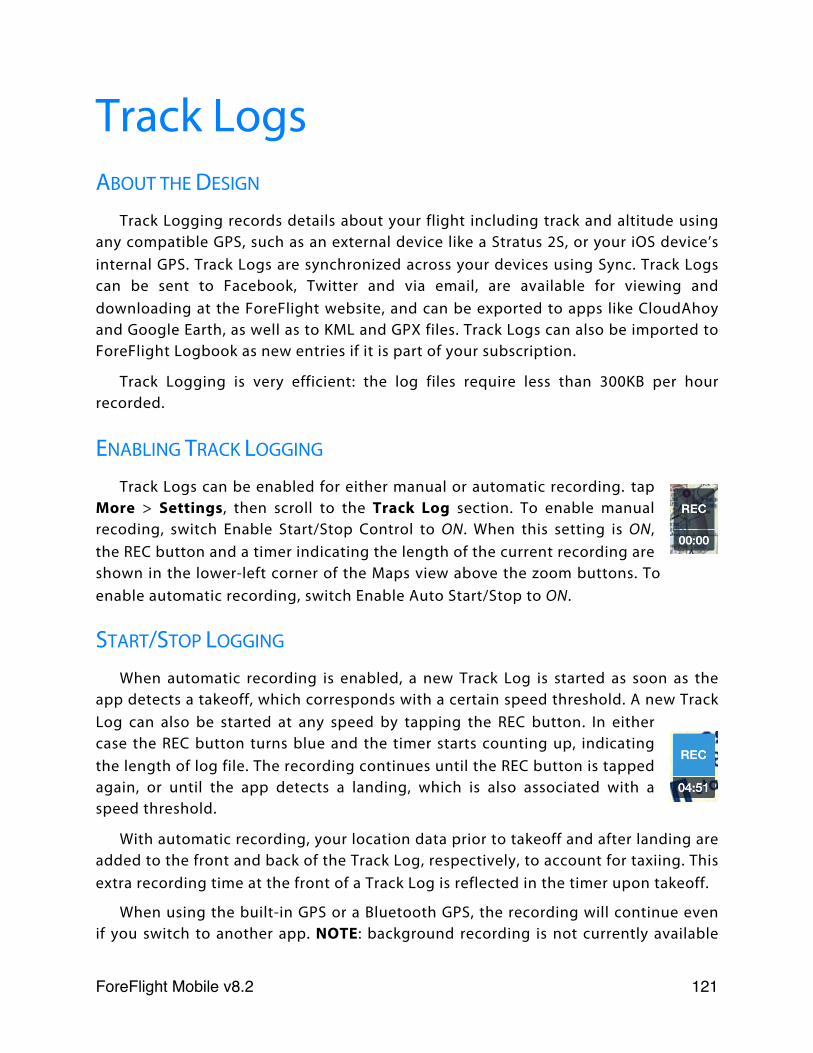
Track LogsABOUT THE DESIGN
Track Logging records details about your flight including track and altitude using any compatible GPS, such as an external device like a Stratus 2S, or your iOS device’s internal GPS. Track Logs are synchronized across your devices using Sync. Track Logs can be sent to Facebook, Twitter and via email, are available for viewing and downloading at the ForeFlight website, and can be exported to apps like CloudAhoy and Google Earth, as well as to KML and GPX files. Track Logs can also be imported to ForeFlight Logbook as new entries if it is part of your subscription.
Track Logging is very efficient: the log files require less than 300KB per hour recorded.
ENABLING TRACK LOGGING
Track Logs can be enabled for either manual or automatic recording. tap More > Settings, then scroll to the Track Log section. To enable manual recoding, switch Enable Start/Stop Control to ON. When this setting is ON, the REC button and a timer indicating the length of the current recording are shown in the lower-left corner of the Maps view above the zoom buttons. To enable automatic recording, switch Enable Auto Start/Stop to ON.
START/STOP LOGGING
When automatic recording is enabled, a new Track Log is started as soon as the app detects a takeoff, which corresponds with a certain speed threshold. A new Track Log can also be started at any speed by tapping the REC button. In either case the REC button turns blue and the timer starts counting up, indicating the length of log file. The recording continues until the REC button is tapped again, or until the app detects a landing, which is also associated with a speed threshold.
With automatic recording, your location data prior to takeoff and after landing are added to the front and back of the Track Log, respectively, to account for taxiing. This extra recording time at the front of a Track Log is reflected in the timer upon takeoff.
When using the built-in GPS or a Bluetooth GPS, the recording will continue even if you switch to another app. NOTE: background recording is not currently available
ForeFlight Mobile v8.2! 121
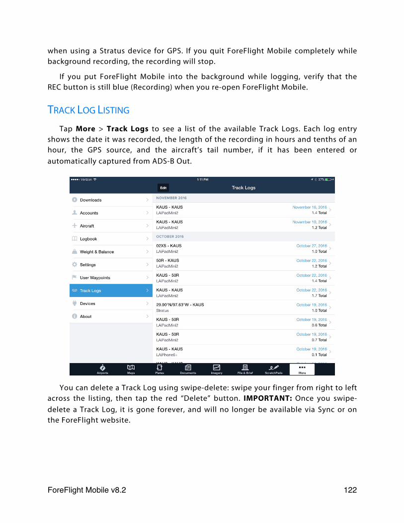
when using a Stratus device for GPS. If you quit ForeFlight Mobile completely while background recording, the recording will stop.
If you put ForeFlight Mobile into the background while logging, verify that the REC button is still blue (Recording) when you re-open ForeFlight Mobile.
TRACK LOG LISTING
Tap More > Track Logs to see a list of the available Track Logs. Each log entry shows the date it was recorded, the length of the recording in hours and tenths of an hour, the GPS source, and the aircraft’s tail number, if it has been entered or automatically captured from ADS-B Out.
You can delete a Track Log using swipe-delete: swipe your finger from right to left across the listing, then tap the red “Delete” button. IMPORTANT: Once you swipe-delete a Track Log, it is gone forever, and will no longer be available via Sync or on the ForeFlight website.
ForeFlight Mobile v8.2! 122
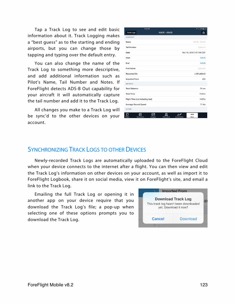
Tap a Track Log to see and edit basic information about it. Track Logging makes a “best guess” as to the starting and ending airports, but you can change those by tapping and typing over the default entry.
You can also change the name of the Track Log to something more descriptive, and add additional information such as Pilot’s Name, Tail Number and Notes. If ForeFlight detects ADS-B Out capability for your aircraft it will automatically capture the tail number and add it to the Track Log.
All changes you make to a Track Log will be sync’d to the other devices on your account.
SYNCHRONIZING TRACK LOGS TO OTHER DEVICES
Newly-recorded Track Logs are automatically uploaded to the ForeFlight Cloud when your device connects to the internet after a flight. You can then view and edit the Track Log’s information on other devices on your account, as well as import it to ForeFlight Logbook, share it on social media, view it on ForeFlight’s site, and email a link to the Track Log.
Emailing the full Track Log or opening it in another app on your device require that you download the Track Log’s file; a pop-up when selecting one of these options prompts you to download the Track Log.
ForeFlight Mobile v8.2! 123
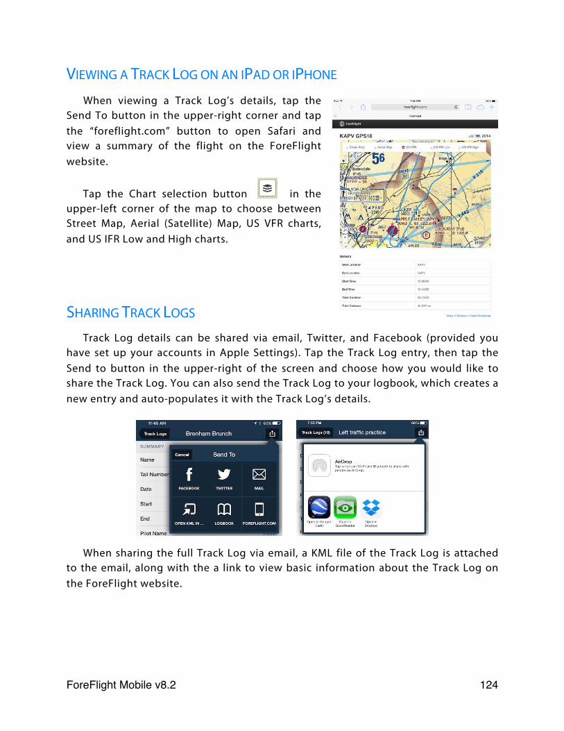
VIEWING A TRACK LOG ON AN IPAD OR IPHONE
When viewing a Track Log’s details, tap the Send To button in the upper-right corner and tap the “foreflight.com” button to open Safari and view a summary of the flight on the ForeFlight website.
Tap the Chart selection button in the upper-left corner of the map to choose between Street Map, Aerial (Satellite) Map, US VFR charts, and US IFR Low and High charts.
SHARING TRACK LOGS
Track Log details can be shared via email, Twitter, and Facebook (provided you have set up your accounts in Apple Settings). Tap the Track Log entry, then tap the Send to button in the upper-right of the screen and choose how you would like to share the Track Log. You can also send the Track Log to your logbook, which creates a new entry and auto-populates it with the Track Log’s details.
When sharing the full Track Log via email, a KML file of the Track Log is attached to the email, along with the a link to view basic information about the Track Log on the ForeFlight website.
ForeFlight Mobile v8.2! 124
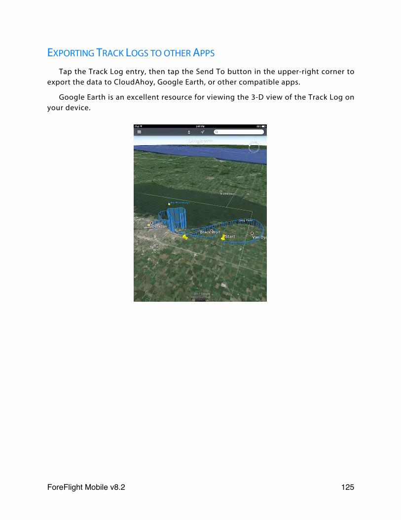
EXPORTING TRACK LOGS TO OTHER APPS
Tap the Track Log entry, then tap the Send To button in the upper-right corner to export the data to CloudAhoy, Google Earth, or other compatible apps.
Google Earth is an excellent resource for viewing the 3-D view of the Track Log on your device.
ForeFlight Mobile v8.2! 125
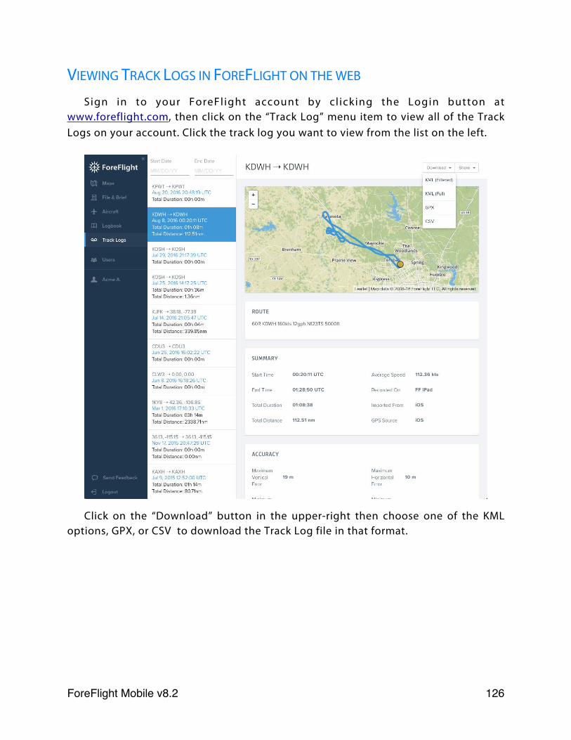
VIEWING TRACK LOGS IN FOREFLIGHT ON THE WEB
Sign in to your ForeFl ight account by cl icking the Login button at www.foreflight.com, then click on the “Track Log” menu item to view all of the Track Logs on your account. Click the track log you want to view from the list on the left.
Click on the “Download” button in the upper-right then choose one of the KML options, GPX, or CSV to download the Track Log file in that format.
ForeFlight Mobile v8.2! 126
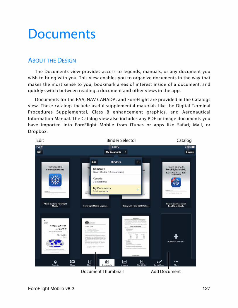
Documents
ABOUT THE DESIGN
The Documents view provides access to legends, manuals, or any document you wish to bring with you. This view enables you to organize documents in the way that makes the most sense to you, bookmark areas of interest inside of a document, and quickly switch between reading a document and other views in the app.
Documents for the FAA, NAV CANADA, and ForeFlight are provided in the Catalogs view. These catalogs include useful supplemental materials like the Digital Terminal Procedures Supplemental, Class B enhancement graphics, and Aeronautical Information Manual. The Catalog view also includes any PDF or image documents you have imported into ForeFlight Mobile from iTunes or apps like Safari, Mail, or Dropbox.
Edit Binder Selector Catalog
Document Thumbnail Add Document
ForeFlight Mobile v8.2! 127

ABOUT DOCUMENT BINDERS
Binders provide a method for organizing documents into logical groups for easy access while in flight. A document binder can contain any combination of:
✤ FAA Documents
✤ NAV CANADA Documents
✤ ForeFlight Documents
✤ Imported PDF files
✤ Imported image files (PNG, JPG, TIF, GIF)
CREATING A BINDER
To create a new binder, tap the Binder Selector in the top toolbar. Use the + button to add a new binder and provide a name when prompted.
The binder is created and the Documents view automatically displays your new (empty) binder.
ADDING DOCUMENTS FROM A CATALOG
The Catalog view lets you add documents to your binder from the FAA, NAV CANADA, or ForeFlight catalogs. If you have a ForeFlight Pro or Pro Plus subscription, see Document Syncing f o r d e t a i l s a b o u t a u t o m a t i c a l l y a d d i n g documents to ForeFlight Mobile.
T h e C a t a l o g v i e w a l s o l e t s y o u a d d documents to your binder that you have previously imported into the app. You can bring up the Catalog view by tapping the Catalog button in the top-right corner, or by tapping the ‘Tap to add doc here’ thumbnail at the bottom of your binder.
The Catalog view has two panes. On the left pane is a list of the available catalogs. Tap the catalog name to view that catalog. On the right pane is the list of documents for that catalog.
ForeFlight Mobile v8.2! 128
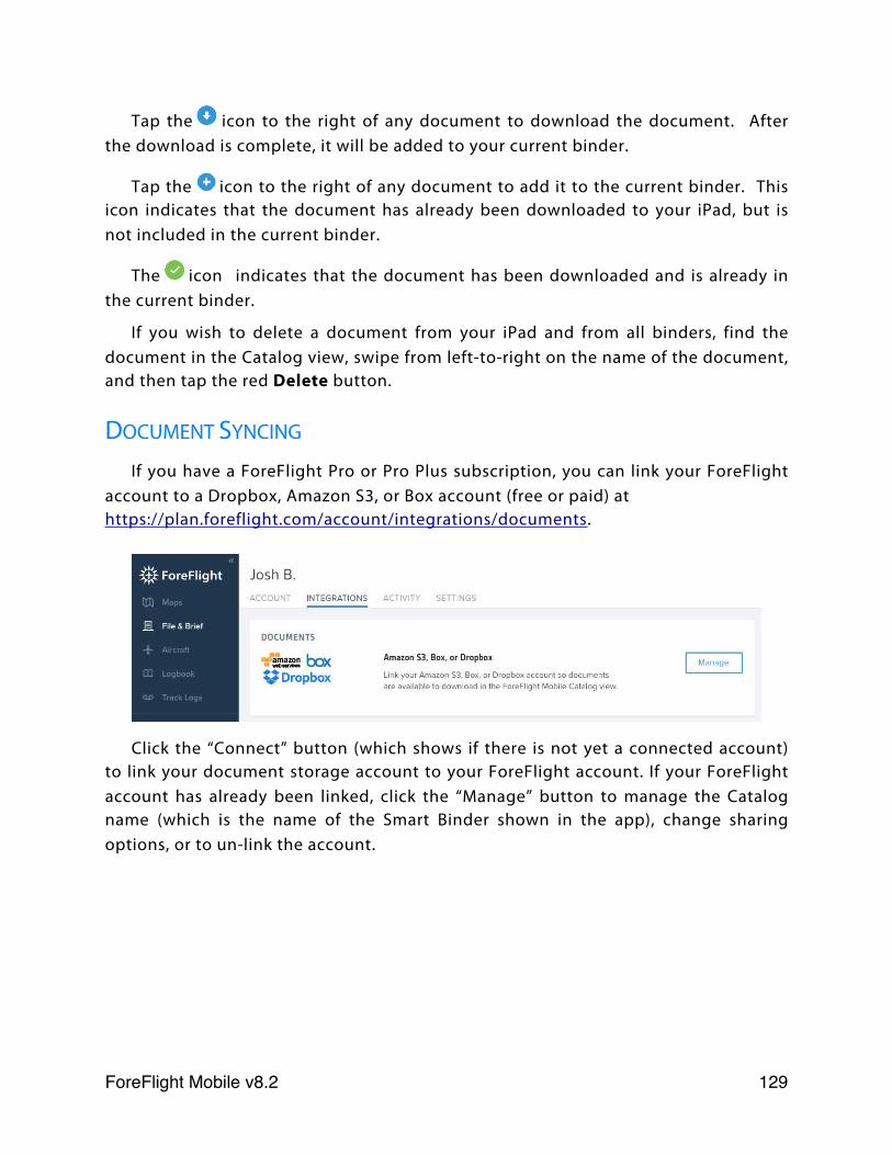
Tap the icon to the right of any document to download the document. After the download is complete, it will be added to your current binder.
Tap the icon to the right of any document to add it to the current binder. This icon indicates that the document has already been downloaded to your iPad, but is not included in the current binder.
The icon indicates that the document has been downloaded and is already in the current binder.
If you wish to delete a document from your iPad and from all binders, find the document in the Catalog view, swipe from left-to-right on the name of the document, and then tap the red Delete button.
DOCUMENT SYNCING
If you have a ForeFlight Pro or Pro Plus subscription, you can link your ForeFlight account to a Dropbox, Amazon S3, or Box account (free or paid) at https://plan.foreflight.com/account/integrations/documents.
Click the “Connect” button (which shows if there is not yet a connected account) to link your document storage account to your ForeFlight account. If your ForeFlight account has already been linked, click the “Manage” button to manage the Catalog name (which is the name of the Smart Binder shown in the app), change sharing options, or to un-link the account.
ForeFlight Mobile v8.2! 129
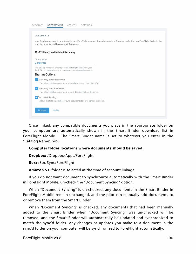
Once linked, any compatible documents you place in the appropriate folder on your computer are automatically shown in the Smart Binder download list in ForeFlight Mobile. The Smart Binder name is set to whatever you enter in the “Catalog Name” box.
Computer folder locations where documents should be saved:
Dropbox: /Dropbox/Apps/ForeFlight
Box: /Box Sync/ForeFlight
Amazon S3: folder is selected at the time of account linkage
If you do not want document to synchronize automatically with the Smart Binder in ForeFlight Mobile, un-check the “Document Syncing” option:
When “Document Syncing” is un-checked, any documents in the Smart Binder in ForeFlight Mobile remain unchanged, and the pilot can manually add documents to or remove them from the Smart Binder.
When “Document Syncing” is checked, any documents that had been manually added to the Smart Binder when “Document Syncing” was un-checked will be removed, and the Smart Binder will automatically be updated and synchronized to match the sync’d folder. Any changes or updates you make to a document in the sync’d folder on your computer will be synchronized to ForeFlight automatically.
ForeFlight Mobile v8.2! 130
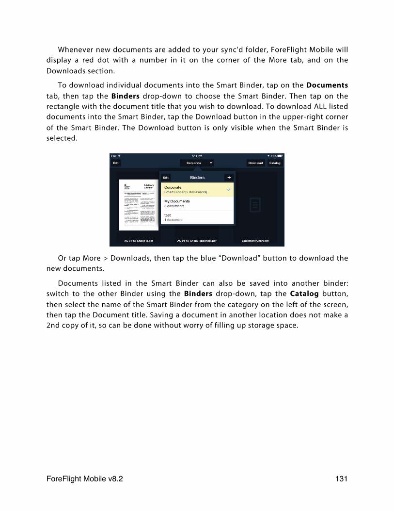
Whenever new documents are added to your sync’d folder, ForeFlight Mobile will display a red dot with a number in it on the corner of the More tab, and on the Downloads section.
To download individual documents into the Smart Binder, tap on the Documents tab, then tap the Binders drop-down to choose the Smart Binder. Then tap on the rectangle with the document title that you wish to download. To download ALL listed documents into the Smart Binder, tap the Download button in the upper-right corner of the Smart Binder. The Download button is only visible when the Smart Binder is selected.
Or tap More > Downloads, then tap the blue “Download” button to download the new documents.
Documents listed in the Smart Binder can also be saved into another binder: switch to the other Binder using the Binders drop-down, tap the Catalog button, then select the name of the Smart Binder from the category on the left of the screen, then tap the Document title. Saving a document in another location does not make a 2nd copy of it, so can be done without worry of filling up storage space.
ForeFlight Mobile v8.2! 131
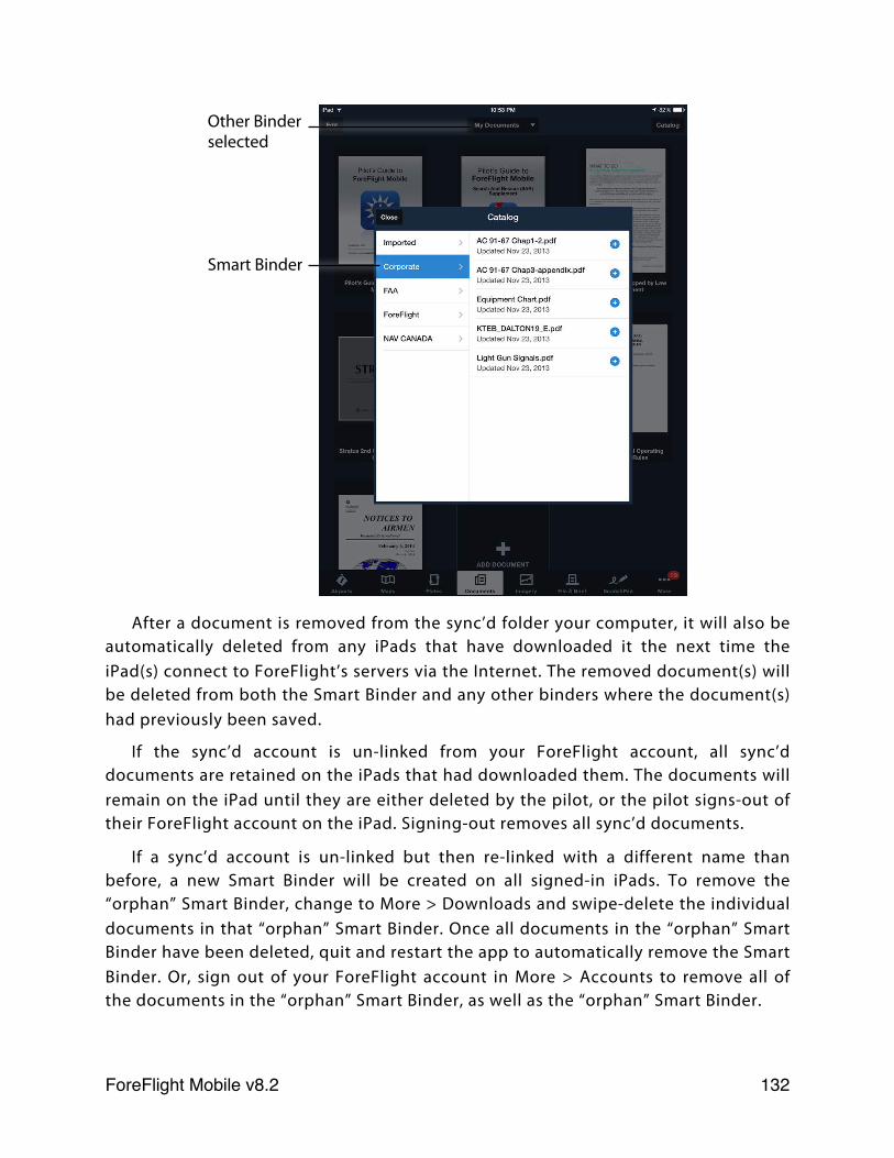
After a document is removed from the sync’d folder your computer, it will also be automatically deleted from any iPads that have downloaded it the next time the iPad(s) connect to ForeFlight’s servers via the Internet. The removed document(s) will be deleted from both the Smart Binder and any other binders where the document(s) had previously been saved.
If the sync’d account is un-linked from your ForeFlight account, all sync’d documents are retained on the iPads that had downloaded them. The documents will remain on the iPad until they are either deleted by the pilot, or the pilot signs-out of their ForeFlight account on the iPad. Signing-out removes all sync’d documents.
If a sync’d account is un-linked but then re-linked with a different name than before, a new Smart Binder will be created on all signed-in iPads. To remove the “orphan” Smart Binder, change to More > Downloads and swipe-delete the individual documents in that “orphan” Smart Binder. Once all documents in the “orphan” Smart Binder have been deleted, quit and restart the app to automatically remove the Smart Binder. Or, sign out of your ForeFlight account in More > Accounts to remove all of the documents in the “orphan” Smart Binder, as well as the “orphan” Smart Binder.
Other Binder selected
Smart Binder
ForeFlight Mobile v8.2! 132
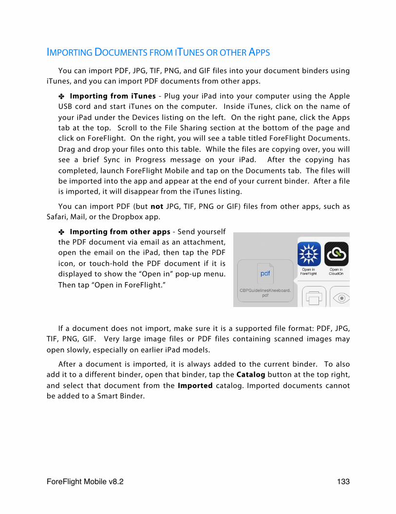
IMPORTING DOCUMENTS FROM ITUNES OR OTHER APPS
You can import PDF, JPG, TIF, PNG, and GIF files into your document binders using iTunes, and you can import PDF documents from other apps.
✤ Importing from iTunes - Plug your iPad into your computer using the Apple USB cord and start iTunes on the computer. Inside iTunes, click on the name of your iPad under the Devices listing on the left. On the right pane, click the Apps tab at the top. Scroll to the File Sharing section at the bottom of the page and click on ForeFlight. On the right, you will see a table titled ForeFlight Documents. Drag and drop your files onto this table. While the files are copying over, you will see a brief Sync in Progress message on your iPad. After the copying has completed, launch ForeFlight Mobile and tap on the Documents tab. The files will be imported into the app and appear at the end of your current binder. After a file is imported, it will disappear from the iTunes listing.
You can import PDF (but not JPG, TIF, PNG or GIF) files from other apps, such as Safari, Mail, or the Dropbox app.
✤ Importing from other apps - Send yourself the PDF document via email as an attachment, open the email on the iPad, then tap the PDF icon, or touch-hold the PDF document if it is displayed to show the “Open in” pop-up menu. Then tap “Open in ForeFlight.”
If a document does not import, make sure it is a supported file format: PDF, JPG, TIF, PNG, GIF. Very large image files or PDF files containing scanned images may open slowly, especially on earlier iPad models.
After a document is imported, it is always added to the current binder. To also add it to a different binder, open that binder, tap the Catalog button at the top right, and select that document from the Imported catalog. Imported documents cannot be added to a Smart Binder.
ForeFlight Mobile v8.2! 133
VIEWING A DOCUMENT
Tap any document thumbnail in a binder to launch the ForeFlight Document Viewer. This viewer supports standard pinch and expand zooming, and panning touch gestures. Swipe left and right with a single finger to change pages. You can close the document by pinching (zoom out gesture) from the view on any page and you can open a document by expanding (zoom in gesture) from the Binder view.
Tap once on a document page to bring up the toolbar at the top and page scrubber at the bottom. Tap again on the document to hide these overlays.
Shows the table of contents for a document (if available) and any pages you have bookmarked. This menu is only shown for PDF documents.
Toggles between full page view and thumbnail view, which shows a thumbnail for each page in the document. This button is only shown for PDF documents.
Display the Annotation menu. This button is only shown for PDF documents
Search for text in the document. This button is only shown for PDF documents
Bookmarks a page in the document. This button is only shown for PDF documents.
Shows a menu for Printing or Emailing a document. Emailing is not available for copyrighted document catalogs.
Disables touch interaction (zooming and scrolling), which minimizes the risk of accidental closure when in turbulence. It also disables the automatic rotation that would normally occur when the iPad is turned. The lock button can also, optionally, disable all buttons on the screen, including those that change views. That feature is configured in Settings (“Lock Disables Buttons”).
Document View Toolbar Buttons
ForeFlight Mobile v8.2! 134
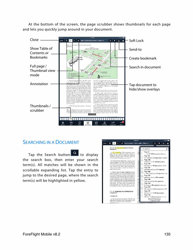
At the bottom of the screen, the page scrubber shows thumbnails for each page and lets you quickly jump around in your document.
SEARCHING IN A DOCUMENT
Tap the Search button to display the search box, then enter your search term(s). All matches will be shown in the scrollable expanding list. Tap the entry to jump to the desired page, where the search term(s) will be highlighted in yellow.
Close
Show Table of Contents or Bookmarks
Full page / Thumbnail view mode
Annotation
Thumbnails / scrubber
Soft Lock
Send-to
Create bookmark
Search in document
Tap document to hide/show overlays
ForeFlight Mobile v8.2! 135
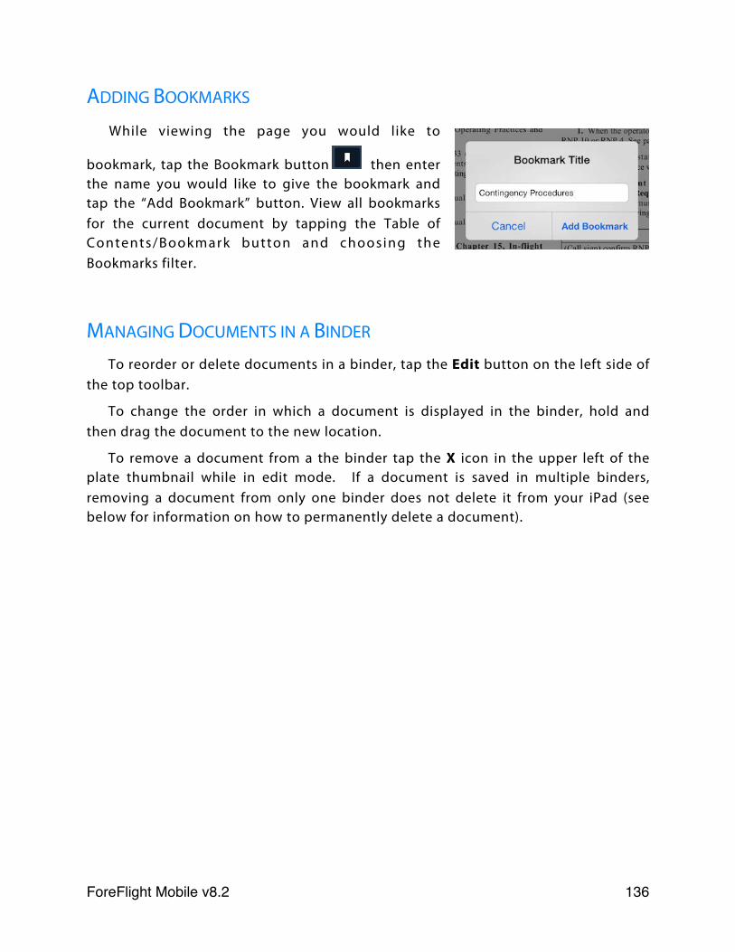
ADDING BOOKMARKS
While viewing the page you would like to
bookmark, tap the Bookmark button then enter the name you would like to give the bookmark and tap the “Add Bookmark” button. View all bookmarks for the current document by tapping the Table of Contents/Bookmark button and choosing the Bookmarks filter.
MANAGING DOCUMENTS IN A BINDER
To reorder or delete documents in a binder, tap the Edit button on the left side of the top toolbar.
To change the order in which a document is displayed in the binder, hold and then drag the document to the new location.
To remove a document from a the binder tap the X icon in the upper left of the plate thumbnail while in edit mode. If a document is saved in multiple binders, removing a document from only one binder does not delete it from your iPad (see below for information on how to permanently delete a document).
ForeFlight Mobile v8.2! 136
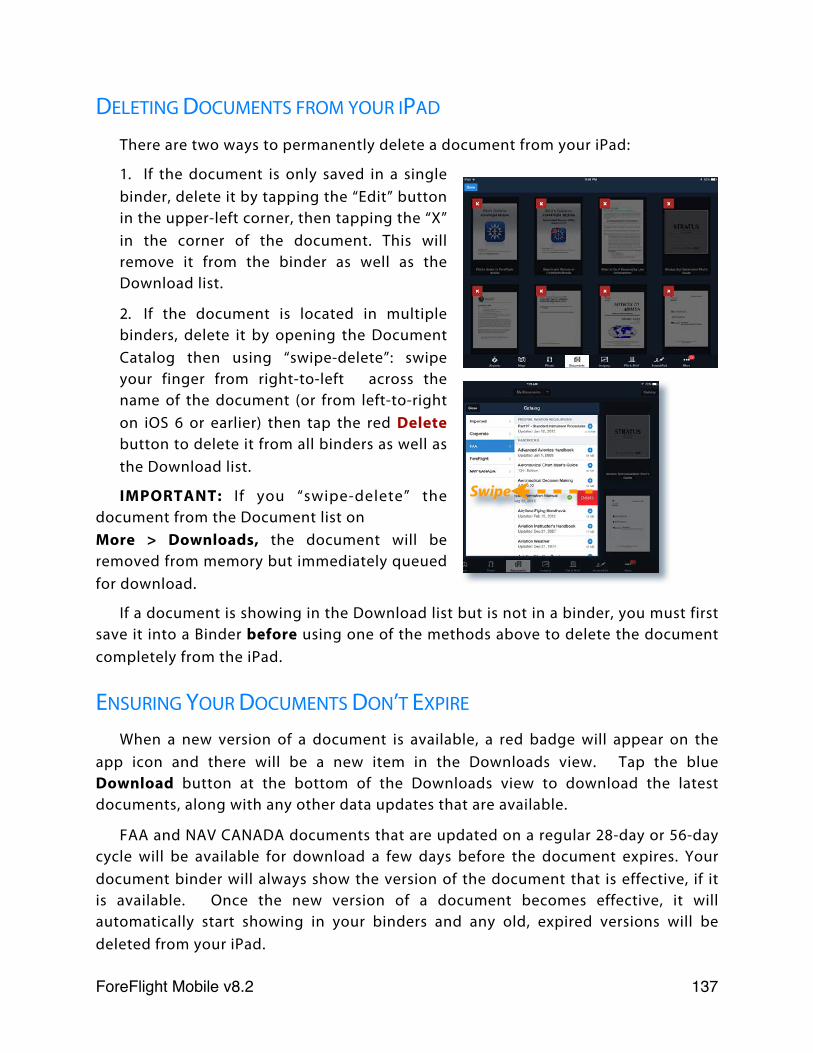
DELETING DOCUMENTS FROM YOUR IPAD
There are two ways to permanently delete a document from your iPad:
1. If the document is only saved in a single binder, delete it by tapping the “Edit” button in the upper-left corner, then tapping the “X” in the corner of the document. This will remove it from the binder as well as the Download list.
2. If the document is located in multiple binders, delete it by opening the Document Catalog then using “swipe-delete”: swipe your finger from right-to-left across the name of the document (or from left-to-right on iOS 6 or earlier) then tap the red Delete button to delete it from all binders as well as the Download list.
IMPORTANT: If you “swipe-delete” the document from the Document list on More > Downloads, the document will be removed from memory but immediately queued for download.
If a document is showing in the Download list but is not in a binder, you must first save it into a Binder before using one of the methods above to delete the document completely from the iPad.
ENSURING YOUR DOCUMENTS DON’T EXPIRE
When a new version of a document is available, a red badge will appear on the app icon and there will be a new item in the Downloads view. Tap the blue Download button at the bottom of the Downloads view to download the latest documents, along with any other data updates that are available.
FAA and NAV CANADA documents that are updated on a regular 28-day or 56-day cycle will be available for download a few days before the document expires. Your document binder will always show the version of the document that is effective, if it is available. Once the new version of a document becomes effective, it will automatically start showing in your binders and any old, expired versions will be deleted from your iPad.
Swipe
ForeFlight Mobile v8.2! 137
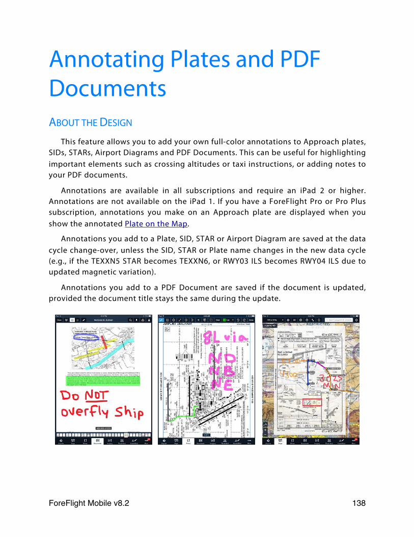
Annotating Plates and PDF DocumentsABOUT THE DESIGN
This feature allows you to add your own full-color annotations to Approach plates, SIDs, STARs, Airport Diagrams and PDF Documents. This can be useful for highlighting important elements such as crossing altitudes or taxi instructions, or adding notes to your PDF documents.
Annotations are available in all subscriptions and require an iPad 2 or higher. Annotations are not available on the iPad 1. If you have a ForeFlight Pro or Pro Plus subscription, annotations you make on an Approach plate are displayed when you show the annotated Plate on the Map.
Annotations you add to a Plate, SID, STAR or Airport Diagram are saved at the data cycle change-over, unless the SID, STAR or Plate name changes in the new data cycle (e.g., if the TEXXN5 STAR becomes TEXXN6, or RWY03 ILS becomes RWY04 ILS due to updated magnetic variation).
Annotations you add to a PDF Document are saved if the document is updated, provided the document title stays the same during the update.
ForeFlight Mobile v8.2! 138
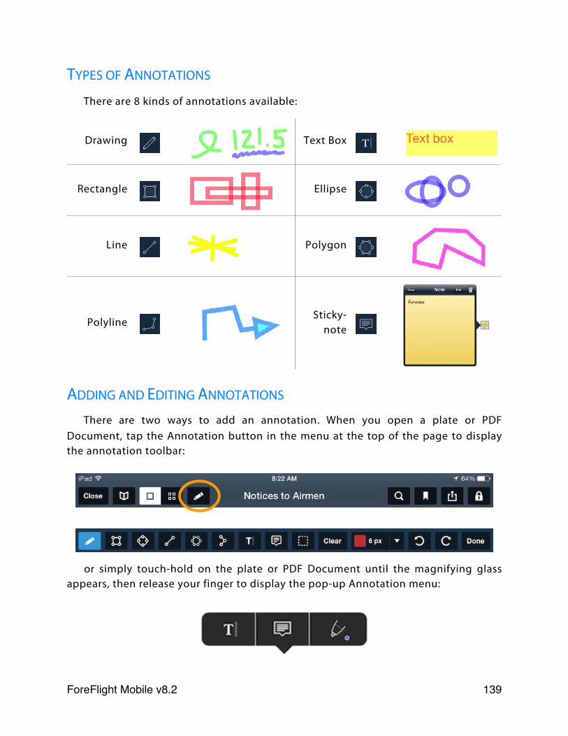
TYPES OF ANNOTATIONS
There are 8 kinds of annotations available:
Drawing Text Box
Rectangle Ellipse
Line Polygon
PolylineSticky-
note
ADDING AND EDITING ANNOTATIONS
There are two ways to add an annotation. When you open a plate or PDF Document, tap the Annotation button in the menu at the top of the page to display the annotation toolbar:
or simply touch-hold on the plate or PDF Document until the magnifying glass appears, then release your finger to display the pop-up Annotation menu:
ForeFlight Mobile v8.2! 139
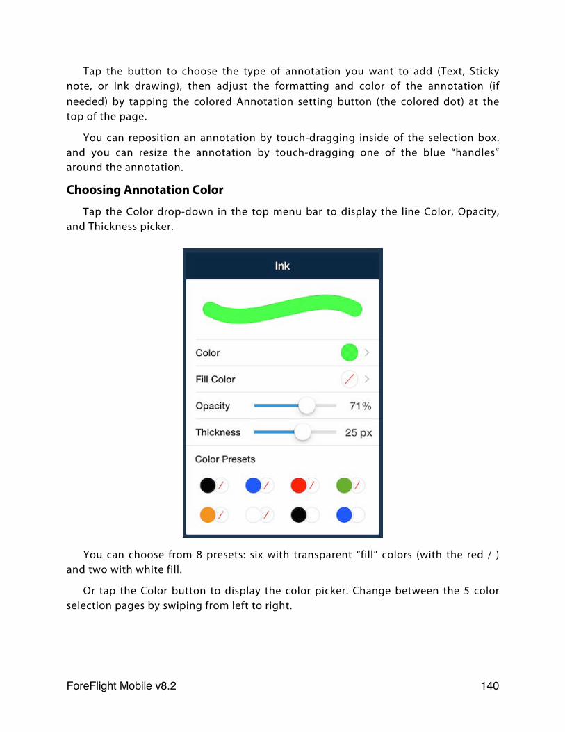
Tap the button to choose the type of annotation you want to add (Text, Sticky note, or Ink drawing), then adjust the formatting and color of the annotation (if needed) by tapping the colored Annotation setting button (the colored dot) at the top of the page.
You can reposition an annotation by touch-dragging inside of the selection box. and you can resize the annotation by touch-dragging one of the blue “handles” around the annotation.
Choosing Annotation Color
Tap the Color drop-down in the top menu bar to display the line Color, Opacity, and Thickness picker.
You can choose from 8 presets: six with transparent “fill” colors (with the red / ) and two with white fill.
Or tap the Color button to display the color picker. Change between the 5 color selection pages by swiping from left to right.
ForeFlight Mobile v8.2! 140
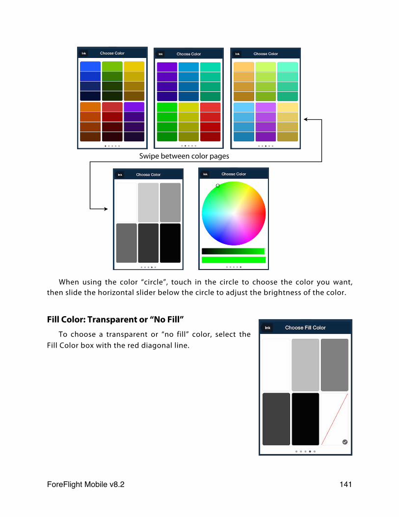
When using the color “circle”, touch in the circle to choose the color you want, then slide the horizontal slider below the circle to adjust the brightness of the color.
Fill Color: Transparent or “No Fill”To choose a transparent or “no fill” color, select the
Fill Color box with the red diagonal line.
Swipe between color pages
ForeFlight Mobile v8.2! 141
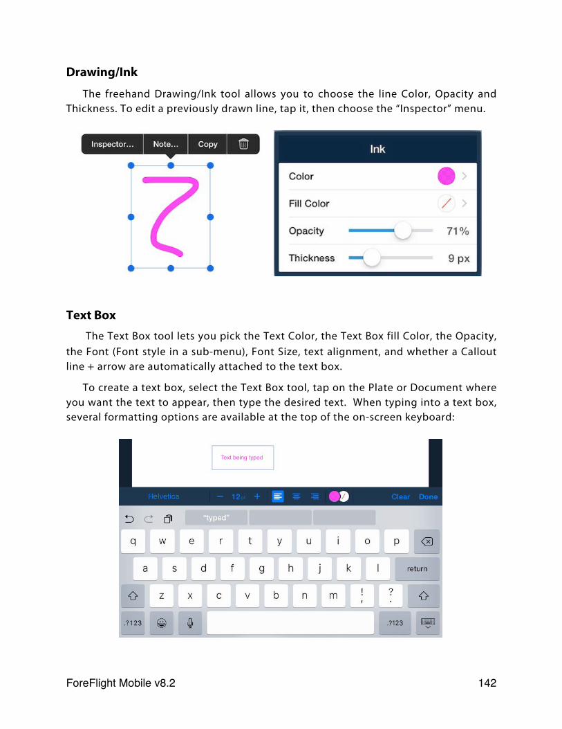
Drawing/Ink
The freehand Drawing/Ink tool allows you to choose the line Color, Opacity and Thickness. To edit a previously drawn line, tap it, then choose the “Inspector” menu.
Text Box The Text Box tool lets you pick the Text Color, the Text Box fill Color, the Opacity,
the Font (Font style in a sub-menu), Font Size, text alignment, and whether a Callout line + arrow are automatically attached to the text box.
To create a text box, select the Text Box tool, tap on the Plate or Document where you want the text to appear, then type the desired text. When typing into a text box, several formatting options are available at the top of the on-screen keyboard:
ForeFlight Mobile v8.2! 142
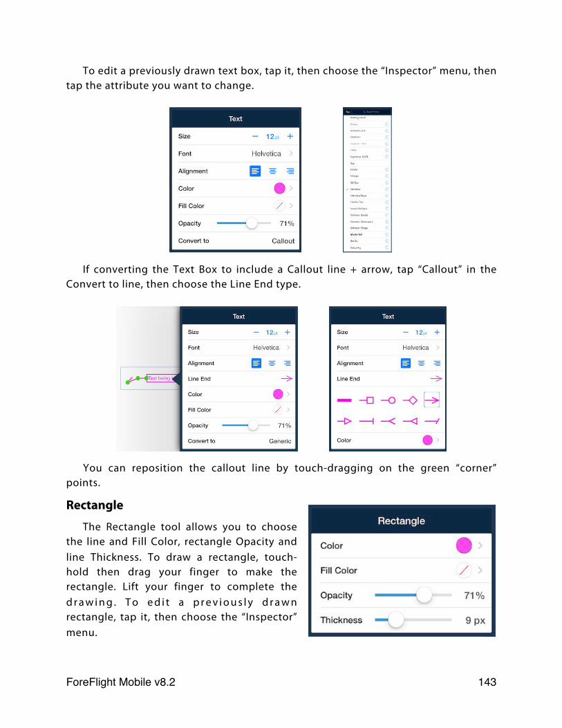
To edit a previously drawn text box, tap it, then choose the “Inspector” menu, then tap the attribute you want to change.
If converting the Text Box to include a Callout line + arrow, tap “Callout” in the Convert to line, then choose the Line End type.
You can reposition the callout line by touch-dragging on the green “corner” points.
Rectangle
The Rectangle tool allows you to choose the line and Fill Color, rectangle Opacity and line Thickness. To draw a rectangle, touch-hold then drag your finger to make the rectangle. Lift your finger to complete the d r a w i n g . T o e d i t a p r e v i o u s l y d r a w n rectangle, tap it, then choose the “Inspector” menu.
ForeFlight Mobile v8.2! 143
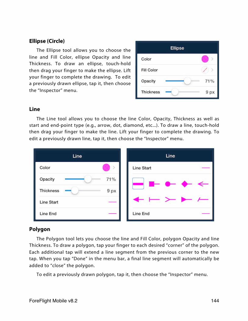
Ellipse (Circle)The Ellipse tool allows you to choose the
line and Fill Color, ellipse Opacity and line Thickness. To draw an ellipse, touch-hold then drag your finger to make the ellipse. Lift your finger to complete the drawing. To edit a previously drawn ellipse, tap it, then choose the “Inspector” menu.
Line
The Line tool allows you to choose the line Color, Opacity, Thickness as well as start and end-point type (e.g., arrow, dot, diamond, etc...). To draw a line, touch-hold then drag your finger to make the line. Lift your finger to complete the drawing. To edit a previously drawn line, tap it, then choose the “Inspector” menu.
Polygon
The Polygon tool lets you choose the line and Fill Color, polygon Opacity and line Thickness. To draw a polygon, tap your finger to each desired “corner” of the polygon. Each additional tap will extend a line segment from the previous corner to the new tap. When you tap “Done” in the menu bar, a final line segment will automatically be added to “close” the polygon.
To edit a previously drawn polygon, tap it, then choose the “Inspector” menu.
ForeFlight Mobile v8.2! 144
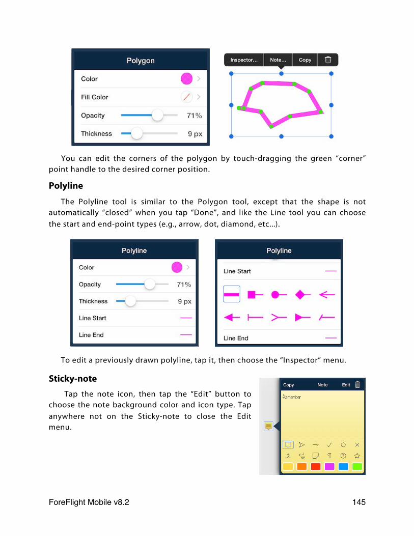
You can edit the corners of the polygon by touch-dragging the green “corner” point handle to the desired corner position.
Polyline
The Polyline tool is similar to the Polygon tool, except that the shape is not automatically “closed” when you tap “Done”, and like the Line tool you can choose the start and end-point types (e.g., arrow, dot, diamond, etc...).
To edit a previously drawn polyline, tap it, then choose the “Inspector” menu.
Sticky-note Tap the note icon, then tap the “Edit” button to
choose the note background color and icon type. Tap anywhere not on the Sticky-note to close the Edit menu.
ForeFlight Mobile v8.2! 145
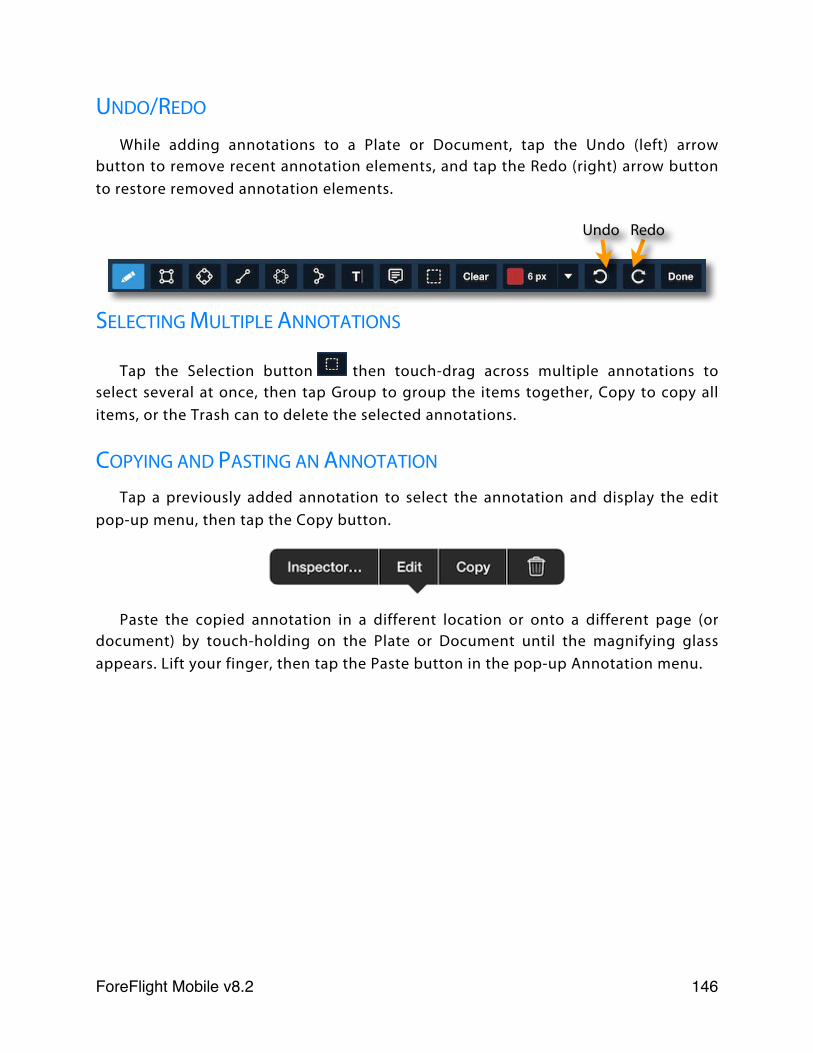
UNDO/REDO
While adding annotations to a Plate or Document, tap the Undo (left) arrow button to remove recent annotation elements, and tap the Redo (right) arrow button to restore removed annotation elements.
SELECTING MULTIPLE ANNOTATIONS
Tap the Selection button then touch-drag across multiple annotations to select several at once, then tap Group to group the items together, Copy to copy all items, or the Trash can to delete the selected annotations.
COPYING AND PASTING AN ANNOTATION
Tap a previously added annotation to select the annotation and display the edit pop-up menu, then tap the Copy button.
Paste the copied annotation in a different location or onto a different page (or document) by touch-holding on the Plate or Document until the magnifying glass appears. Lift your finger, then tap the Paste button in the pop-up Annotation menu.
Undo Redo
ForeFlight Mobile v8.2! 146
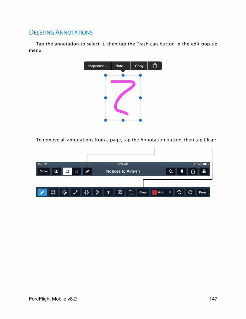
DELETING ANNOTATIONS
Tap the annotation to select it, then tap the Trash-can button in the edit pop-up menu.
To remove all annotations from a page, tap the Annotation button, then tap Clear:
ForeFlight Mobile v8.2! 147
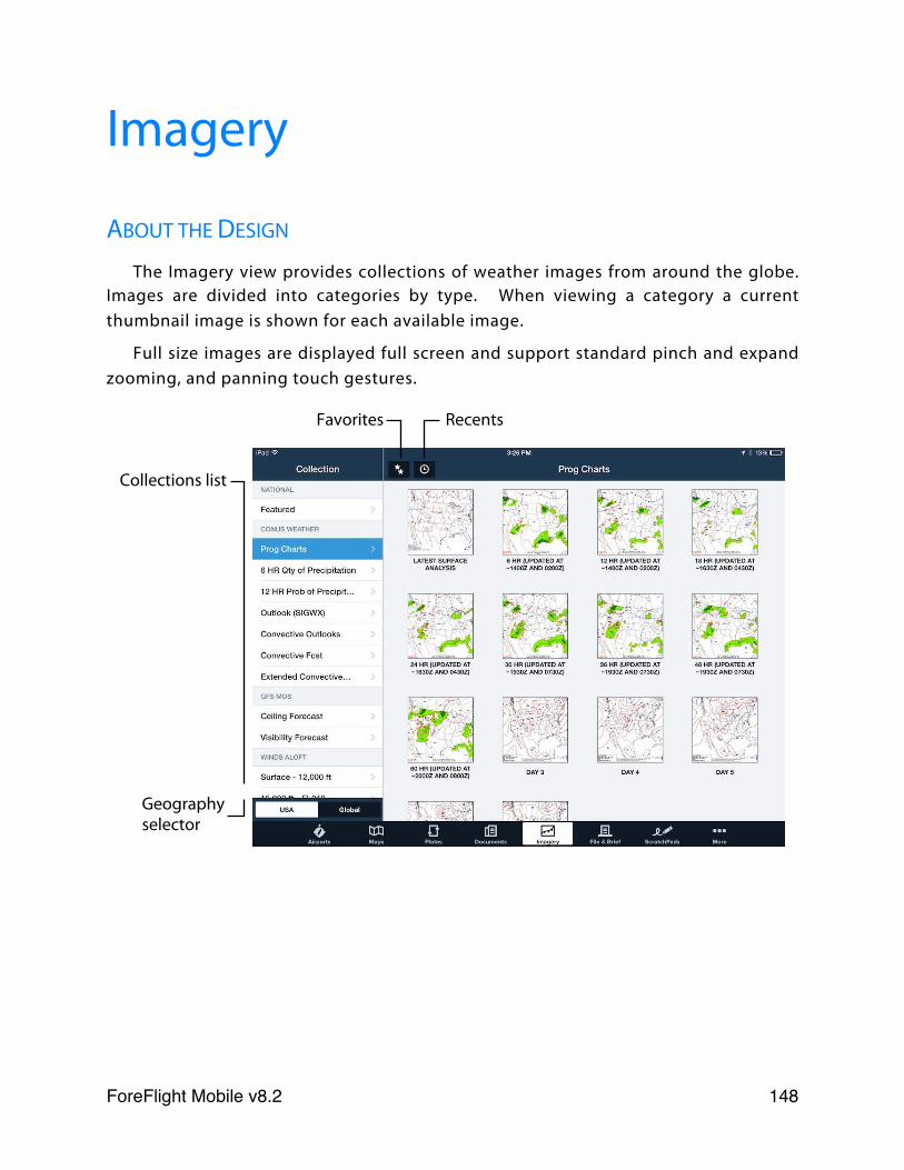
Imagery
ABOUT THE DESIGN
The Imagery view provides collections of weather images from around the globe. Images are divided into categories by type. When viewing a category a current thumbnail image is shown for each available image.
Full size images are displayed full screen and support standard pinch and expand zooming, and panning touch gestures.
Favorites Recents
Geography selector
Collections list
ForeFlight Mobile v8.2! 148
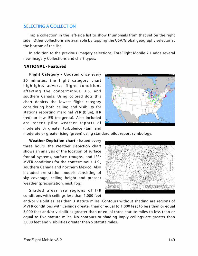
SELECTING A COLLECTION
Tap a collection in the left-side list to show thumbnails from that set on the right side. Other collections are available by tapping the USA/Global geography selector at the bottom of the list.
In addition to the previous Imagery selections, ForeFlight Mobile 7.1 adds several new Imagery Collections and chart types:
NATIONAL - Featured
Flight Category - Updated once every
30 minutes, the flight category chart h i g h l i g h t s a d v e r s e f l i g h t c o n d i t i o n s af fect ing the conterminous U.S . and southern Canada. Using colored dots this chart depicts the lowest flight category considering both ceiling and visibility for stations reporting marginal VFR (blue), IFR (red) or low IFR (magenta). Also included a r e r e c e n t p i l o t w e a t h e r r e p o r t s o f moderate or greater turbulence (tan) and moderate or greater icing (green) using standard pilot report symbology.
Weather Depiction chart - Issued every three hours, the Weather Depiction chart shows an analysis of the location of surface frontal systems, surface troughs, and IFR/MVFR conditions for the conterminous U.S., southern Canada and northern Mexico. Also included are station models consisting of sky coverage, ceiling height and present weather (precipitation, mist, fog).
S h a d e d a r e a s a r e r e g i o n s o f I F R conditions with ceilings less than 1,000 feet and/or visibilities less than 3 statute miles. Contours without shading are regions of MVFR conditions with ceilings greater than or equal to 1,000 feet to less than or equal 3,000 feet and/or visibilities greater than or equal three statute miles to less than or equal to five statute miles. No contours or shading imply ceilings are greater than 3,000 feet and visibilities greater than 5 statute miles.
ForeFlight Mobile v8.2! 149
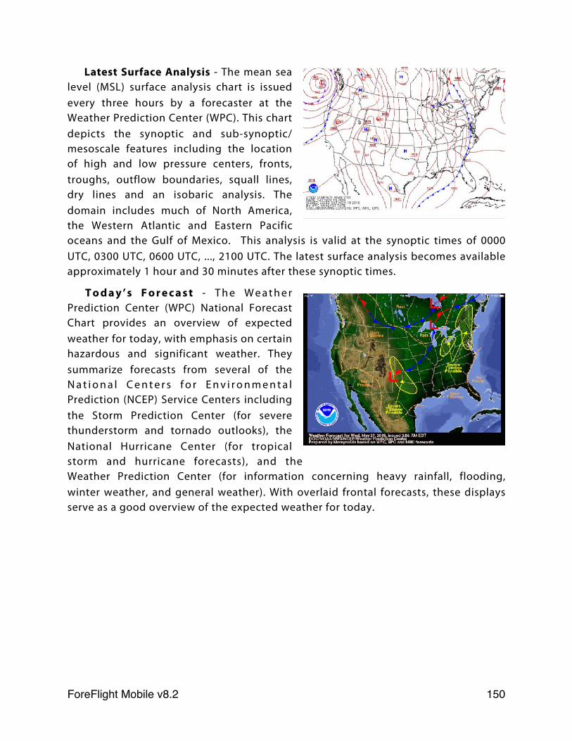
Latest Surface Analysis - The mean sea level (MSL) surface analysis chart is issued every three hours by a forecaster at the Weather Prediction Center (WPC). This chart depicts the synoptic and sub-synoptic/mesoscale features including the location of high and low pressure centers, fronts, troughs, outflow boundaries, squall lines, dry lines and an isobaric analysis. The domain includes much of North America, the Western Atlantic and Eastern Pacific oceans and the Gulf of Mexico. This analysis is valid at the synoptic times of 0000 UTC, 0300 UTC, 0600 UTC, ..., 2100 UTC. The latest surface analysis becomes available approximately 1 hour and 30 minutes after these synoptic times.
T o d a y ’ s F o r e c a s t - T h e W e a t h e r Prediction Center (WPC) National Forecast Chart provides an overview of expected weather for today, with emphasis on certain hazardous and significant weather. They summarize forecasts from several of the N a t i o n a l C e n t e r s f o r E n v i r o n m e n t a l Prediction (NCEP) Service Centers including the Storm Prediction Center (for severe thunderstorm and tornado outlooks), the National Hurricane Center (for tropical storm and hurricane forecasts), and the Weather Prediction Center (for information concerning heavy rainfall, flooding, winter weather, and general weather). With overlaid frontal forecasts, these displays serve as a good overview of the expected weather for today.
ForeFlight Mobile v8.2! 150

CONUS WEATHER
Prog Charts - The Prog Chart collection contains the latest surface analysis chart which is updated once every three hours. This is not a forecast, but represents the latest surface conditions valid in the recent past. This collection also contains short and extended range forecasts that are also known as "prog" charts. Short range forecasts are updated at various times throughout the day as labeled below each thumbnail image.
The primary goal of the short range forecasts are to depict the evolution of major weather systems that will affect the conterminous U.S. during the next 60 hours. These forecasts combine the Weather Prediction Center (WPC) forecasts of surface fronts, MSL pressure (isobars) and high/low circulation centers along with a depiction of the expected weather type (precipitation). The precipitation forecast shown on this chart defines expected coverage and is valid at the time on the chart (not over a range of time).
Prog charts use the following colors to depict different weather types (precipitation):
• Rain (Chance) - There is chance of measurable rain (≥0.01") at the valid time.• Rain (Likely) - Measurable rain (≥0.01") is likely at the valid time.• Snow (Chance) - There is chance of measurable snowfall (≥0.01" liquid equivalent) at
the valid time.• Snow (Likely) - Measurable snow (≥0.01" liquid equivalent) is likely at the valid time.• Mix (Chance) - There is a chance of measurable mixed precipitation (≥0.01" liquid
equivalent) at the valid time. "Mixed" can refer to precipitation where a combination of rain and snow, rain and sleet, or snow and sleet are forecast.
• Mix (Likely) - Measurable mixed precipitation (≥0.01" liquid equivalent) is likely at the valid time. "Mixed" can refer to precipitation where a combination of rain and snow, rain and sleet, or snow and sleet are forecast.
• Ice (Chance) - There is a chance of measurable freezing rain (≥0.01") at the valid time.• Ice (Likely) - Measurable freezing rain (≥0.01") is likely at the valid time.• T-Storm (Chance) - There is a chance of thunderstorms at the valid time. Areas are
displayed with diagonal hatching enclosed in a dark red border.• T-Storm (Likely and/or Severe) - Thunderstorms are likely and/or the potential exists
for some storms to reach severe levels at the valid time.Extended range Progs are also prepared by forecasters at the WPC. A new
extended range forecast is issued daily around 0330 UTC and updated again at 1500
ForeFlight Mobile v8.2! 151
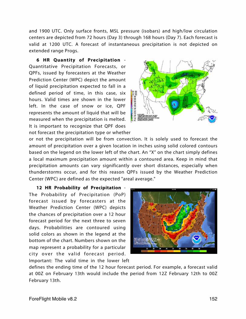
and 1900 UTC. Only surface fronts, MSL pressure (isobars) and high/low circulation centers are depicted from 72 hours (Day 3) through 168 hours (Day 7). Each forecast is valid at 1200 UTC. A forecast of instantaneous precipitation is not depicted on extended range Progs.
6 HR Quantity of Precipitation - Quantitative Precipitation Forecasts, or QPFs, issued by forecasters at the Weather Prediction Center (WPC) depict the amount of liquid precipitation expected to fall in a defined period of time, in this case, six hours. Valid times are shown in the lower left. In the case of snow or ice, QPF represents the amount of liquid that will be measured when the precipitation is melted. It is important to recognize that QPF does not forecast the precipitation type or whether or not the precipitation will be from convection. It is solely used to forecast the amount of precipitation over a given location in inches using solid colored contours based on the legend on the lower left of the chart. An “X” on the chart simply defines a local maximum precipitation amount within a contoured area. Keep in mind that precipitation amounts can vary significantly over short distances, especially when thunderstorms occur, and for this reason QPFs issued by the Weather Prediction Center (WPC) are defined as the expected "areal average."
12 HR Probability of Precipitation - The Probability of Precipitation (PoP) forecast issued by forecasters at the Weather Prediction Center (WPC) depicts the chances of precipitation over a 12 hour forecast period for the next three to seven days. Probabilities are contoured using solid colors as shown in the legend at the bottom of the chart. Numbers shown on the map represent a probability for a particular c i t y o v e r t h e v a l i d f o r e c a s t p e r i o d . Important: The valid time in the lower left defines the ending time of the 12 hour forecast period. For example, a forecast valid at 00Z on February 13th would include the period from 12Z February 12th to 00Z February 13th.
ForeFlight Mobile v8.2! 152
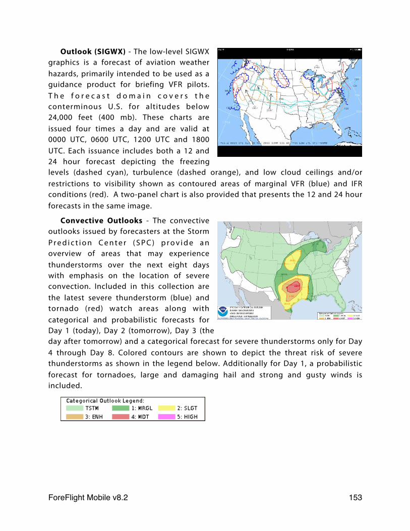
Outlook (SIGWX) - The low-level SIGWX graphics is a forecast of aviation weather hazards, primarily intended to be used as a guidance product for briefing VFR pilots. T h e f o r e c a s t d o m a i n c o v e r s t h e conterminous U.S. for altitudes below 24,000 feet (400 mb). These charts are issued four times a day and are valid at 0000 UTC, 0600 UTC, 1200 UTC and 1800 UTC. Each issuance includes both a 12 and 24 hour forecast depicting the freezing levels (dashed cyan), turbulence (dashed orange), and low cloud ceilings and/or restrictions to visibility shown as contoured areas of marginal VFR (blue) and IFR conditions (red). A two-panel chart is also provided that presents the 12 and 24 hour forecasts in the same image.
Convective Outlooks - The convective outlooks issued by forecasters at the Storm P r e d i c t i o n C e n t e r ( S P C ) p r o v i d e a n overview of areas that may experience thunderstorms over the next eight days with emphasis on the location of severe convection. Included in this collection are the latest severe thunderstorm (blue) and tornado (red) watch areas along with categorical and probabilistic forecasts for Day 1 (today), Day 2 (tomorrow), Day 3 (the day after tomorrow) and a categorical forecast for severe thunderstorms only for Day 4 through Day 8. Colored contours are shown to depict the threat risk of severe thunderstorms as shown in the legend below. Additionally for Day 1, a probabilistic forecast for tornadoes, large and damaging hail and strong and gusty winds is included.
ForeFlight Mobile v8.2! 153
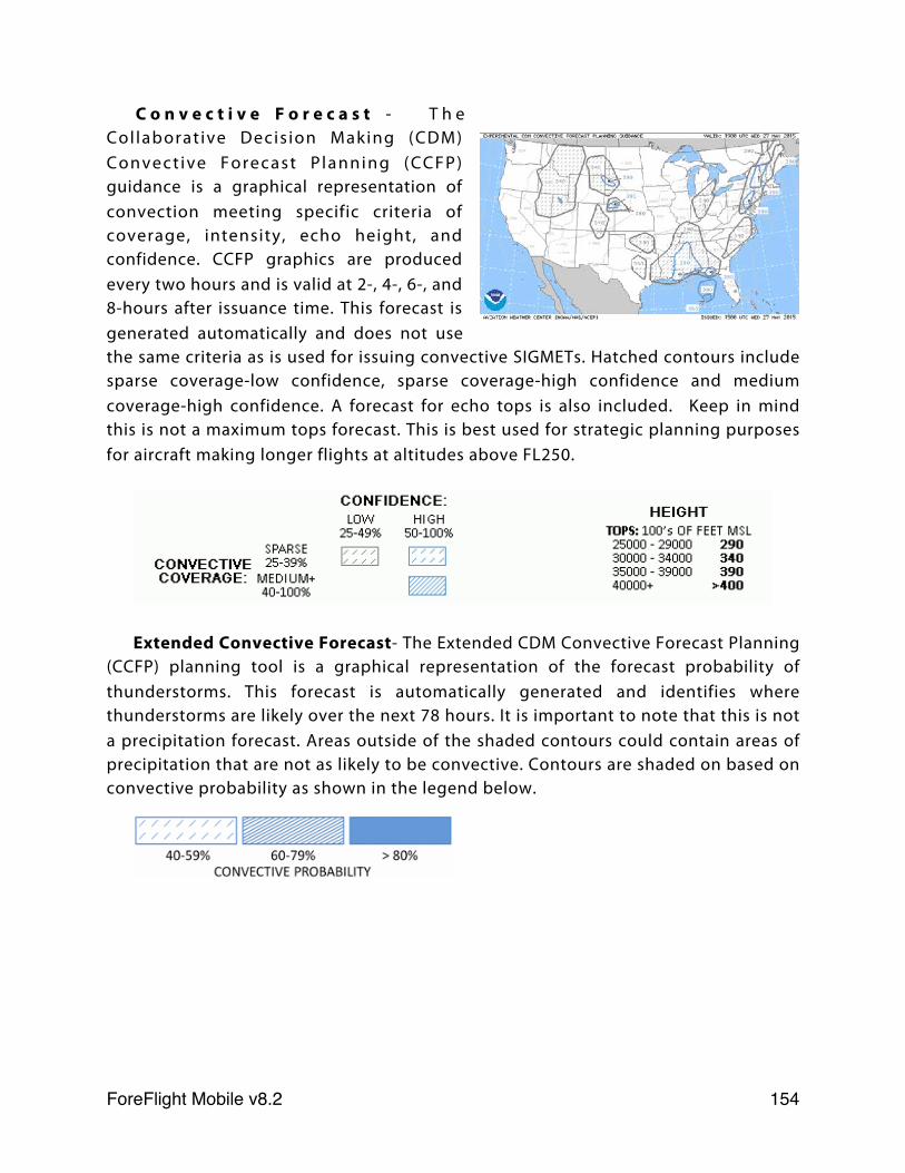
C o n v e c t i v e F o r e c a s t - T h e Col laborat ive Decis ion Making (CDM) Convect ive Forecast P lanning (CCFP) guidance is a graphical representation of convection meeting specific criteria of coverage, intensity, echo height, and confidence. CCFP graphics are produced every two hours and is valid at 2-, 4-, 6-, and 8-hours after issuance time. This forecast is generated automatically and does not use the same criteria as is used for issuing convective SIGMETs. Hatched contours include sparse coverage-low confidence, sparse coverage-high confidence and medium coverage-high confidence. A forecast for echo tops is also included. Keep in mind this is not a maximum tops forecast. This is best used for strategic planning purposes for aircraft making longer flights at altitudes above FL250.
Extended Convective Forecast- The Extended CDM Convective Forecast Planning (CCFP) planning tool is a graphical representation of the forecast probability of thunderstorms. This forecast is automatically generated and identifies where thunderstorms are likely over the next 78 hours. It is important to note that this is not a precipitation forecast. Areas outside of the shaded contours could contain areas of precipitation that are not as likely to be convective. Contours are shaded on based on convective probability as shown in the legend below.
ForeFlight Mobile v8.2! 154
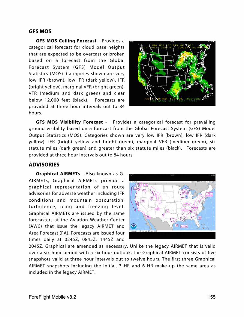
GFS MOS
GFS MOS Ceiling Forecast - Provides a categorical forecast for cloud base heights that are expected to be overcast or broken based on a forecast from the Global Forecast System (GFS) Model Output Statistics (MOS). Categories shown are very low IFR (brown), low IFR (dark yellow), IFR (bright yellow), marginal VFR (bright green), VFR (medium and dark green) and clear below 12,000 feet (black). Forecasts are provided at three hour intervals out to 84 hours.
GFS MOS Visibility Forecast - Provides a categorical forecast for prevailing ground visibility based on a forecast from the Global Forecast System (GFS) Model Output Statistics (MOS). Categories shown are very low IFR (brown), low IFR (dark yellow), IFR (bright yellow and bright green), marginal VFR (medium green), six statute miles (dark green) and greater than six statute miles (black). Forecasts are provided at three hour intervals out to 84 hours.
ADVISORIESGraphical AIRMETs - Also known as G-
AIRMETs, Graphical AIRMETs provide a graphical representation of en route advisories for adverse weather including IFR conditions and mountain obscuration, turbulence, ic ing and freezing level . Graphical AIRMETs are issued by the same forecasters at the Aviation Weather Center (AWC) that issue the legacy AIRMET and Area Forecast (FA). Forecasts are issued four times daily at 0245Z, 0845Z, 1445Z and 2045Z. Graphical are amended as necessary. Unlike the legacy AIRMET that is valid over a six hour period with a six hour outlook, the Graphical AIRMET consists of five snapshots valid at three hour intervals out to twelve hours. The first three Graphical AIRMET snapshots including the Initial, 3 HR and 6 HR make up the same area as included in the legacy AIRMET.
ForeFlight Mobile v8.2! 155
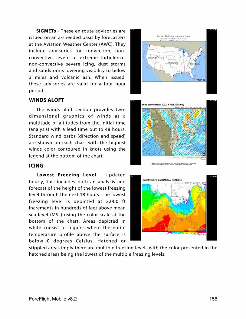
SIGMETs - These en route advisories are issued on an as-needed basis by forecasters at the Aviation Weather Center (AWC). They include advisories for convection, non-convective severe or extreme turbulence, non-convective severe icing, dust storms and sandstorms lowering visibility to below 3 miles and volcanic ash. When issued, these advisories are valid for a four hour period.
WINDS ALOFT
The winds aloft section provides two-d i m e n s i o n a l g r a p h i c s o f w i n d s a t a multitude of altitudes from the initial time (analysis) with a lead time out to 48 hours. Standard wind barbs (direction and speed) are shown on each chart with the highest winds color contoured in knots using the legend at the bottom of the chart.
ICINGLowest Freezing Level - Updated
hourly, this includes both an analysis and forecast of the height of the lowest freezing level through the next 18 hours. The lowest freezing level is depicted at 2,000 ft increments in hundreds of feet above mean sea level (MSL) using the color scale at the bottom of the chart. Areas depicted in white consist of regions where the entire temperature profile above the surface is below 0 degrees Celsius. Hatched or stippled areas imply there are multiple freezing levels with the color presented in the hatched areas being the lowest of the multiple freezing levels.
ForeFlight Mobile v8.2! 156
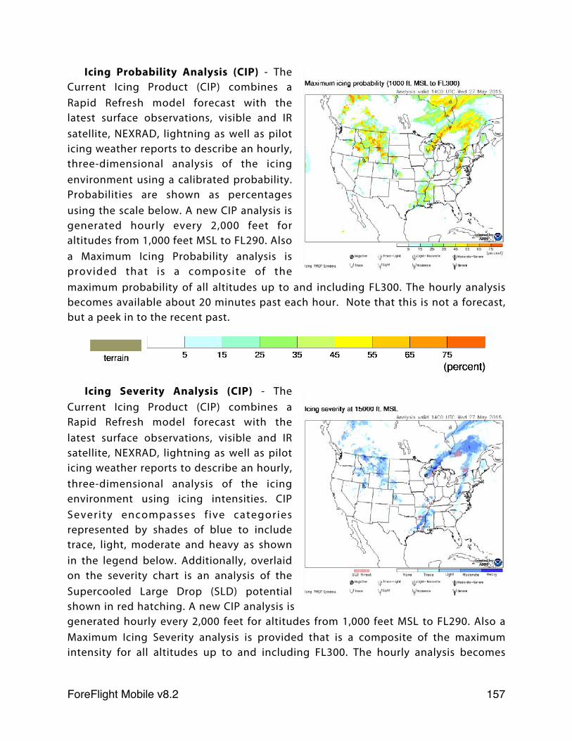
Icing Probability Analysis (CIP) - The Current Icing Product (CIP) combines a Rapid Refresh model forecast with the latest surface observations, visible and IR satellite, NEXRAD, lightning as well as pilot icing weather reports to describe an hourly, three-dimensional analysis of the icing environment using a calibrated probability. Probabilities are shown as percentages using the scale below. A new CIP analysis is generated hourly every 2,000 feet for altitudes from 1,000 feet MSL to FL290. Also a Maximum Icing Probability analysis is provided that is a composite of the maximum probability of all altitudes up to and including FL300. The hourly analysis becomes available about 20 minutes past each hour. Note that this is not a forecast, but a peek in to the recent past.
Icing Severity Analysis (CIP) - The Current Icing Product (CIP) combines a Rapid Refresh model forecast with the latest surface observations, visible and IR satellite, NEXRAD, lightning as well as pilot icing weather reports to describe an hourly, three-dimensional analysis of the icing environment using icing intensities. CIP Severity encompasses f ive categories represented by shades of blue to include trace, light, moderate and heavy as shown in the legend below. Additionally, overlaid on the severity chart is an analysis of the Supercooled Large Drop (SLD) potential shown in red hatching. A new CIP analysis is generated hourly every 2,000 feet for altitudes from 1,000 feet MSL to FL290. Also a Maximum Icing Severity analysis is provided that is a composite of the maximum intensity for all altitudes up to and including FL300. The hourly analysis becomes
ForeFlight Mobile v8.2! 157
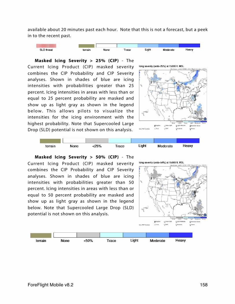
available about 20 minutes past each hour. Note that this is not a forecast, but a peek in to the recent past.
Masked Icing Severity > 25% (CIP) - The Current Icing Product (CIP) masked severity combines the CIP Probability and CIP Severity analyses. Shown in shades of blue are icing intensities with probabilities greater than 25 percent. Icing intensities in areas with less than or equal to 25 percent probability are masked and show up as light gray as shown in the legend below. This a l lows pi lots to v isual ize the intensities for the icing environment with the highest probability. Note that Supercooled Large Drop (SLD) potential is not shown on this analysis.
Masked Icing Severity > 50% (CIP) - The Current Icing Product (CIP) masked severity combines the CIP Probability and CIP Severity analyses. Shown in shades of blue are icing intensities with probabilities greater than 50 percent. Icing intensities in areas with less than or equal to 50 percent probability are masked and show up as light gray as shown in the legend below. Note that Supercooled Large Drop (SLD) potential is not shown on this analysis.
ForeFlight Mobile v8.2! 158
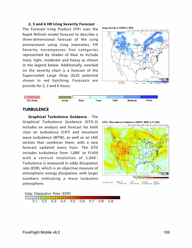
2, 3 and 6 HR Icing Severity Forecast - The Forecast Icing Product (FIP) uses the Rapid Refresh model forecast to describe a three-dimensional forecast of the icing environment using icing intensities. FIP Severity encompasses f ive categories represented by shades of blue to include trace, light, moderate and heavy as shown in the legend below. Additionally, overlaid on the severity chart is a forecast of the Supercooled Large Drop (SLD) potential shown in red hatching. Forecasts are provide for 2, 3 and 6 hours.
TURBULENCE
Graphical Turbulence Guidance - The Graphical Turbulence Guidance (GTG-3) includes an analysis and forecast for both clear air turbulence (CAT) and mountain wave turbulence (MTW), as well as an (All) section that combines them, with a new forecast updated every hour. The GTG includes turbulence from 1,000’ to FL450 with a vert ica l resolut ion of 2 ,000 ’ . Turbulence is measured in eddy dissipation rate (EDR), which is an objective measure of atmospheric energy dissipation, with larger numbers indicating a more turbulent atmosphere.
ForeFlight Mobile v8.2! 159
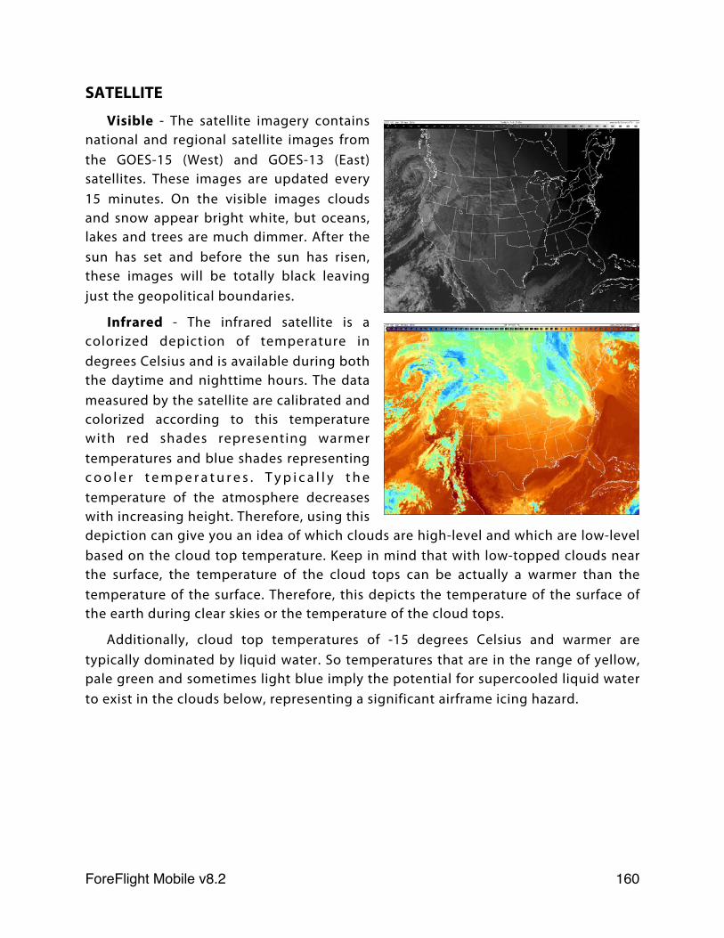
SATELLITE
Visible - The satellite imagery contains national and regional satellite images from the GOES-15 (West) and GOES-13 (East) satellites. These images are updated every 15 minutes. On the visible images clouds and snow appear bright white, but oceans, lakes and trees are much dimmer. After the sun has set and before the sun has risen, these images will be totally black leaving just the geopolitical boundaries.
Infrared - The infrared satellite is a colorized depiction of temperature in degrees Celsius and is available during both the daytime and nighttime hours. The data measured by the satellite are calibrated and colorized according to this temperature with red shades representing warmer temperatures and blue shades representing c o o l e r t e m p e r a t u r e s . T y p i c a l l y t h e temperature of the atmosphere decreases with increasing height. Therefore, using this depiction can give you an idea of which clouds are high-level and which are low-level based on the cloud top temperature. Keep in mind that with low-topped clouds near the surface, the temperature of the cloud tops can be actually a warmer than the temperature of the surface. Therefore, this depicts the temperature of the surface of the earth during clear skies or the temperature of the cloud tops.
Additionally, cloud top temperatures of -15 degrees Celsius and warmer are typically dominated by liquid water. So temperatures that are in the range of yellow, pale green and sometimes light blue imply the potential for supercooled liquid water to exist in the clouds below, representing a significant airframe icing hazard.
ForeFlight Mobile v8.2! 160
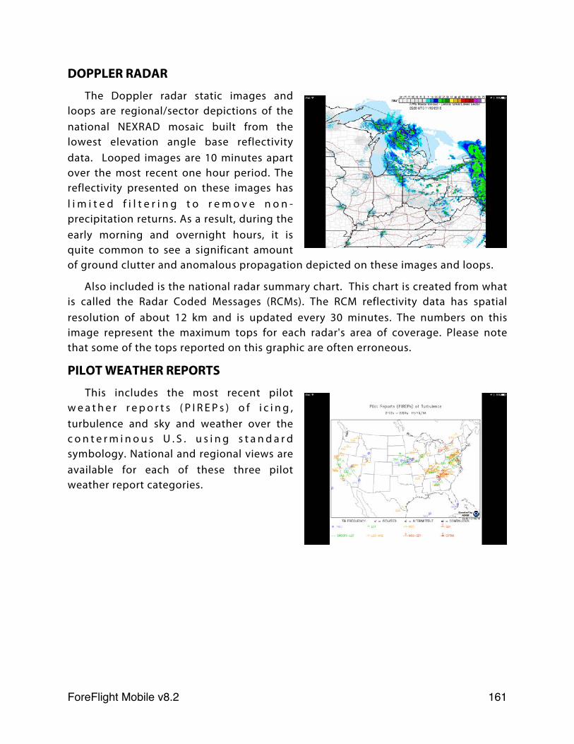
DOPPLER RADAR
The Doppler radar static images and loops are regional/sector depictions of the national NEXRAD mosaic built from the lowest elevation angle base reflectivity data. Looped images are 10 minutes apart over the most recent one hour period. The reflectivity presented on these images has l i m i t e d f i l t e r i n g t o r e m o v e n o n -precipitation returns. As a result, during the early morning and overnight hours, it is quite common to see a significant amount of ground clutter and anomalous propagation depicted on these images and loops.
Also included is the national radar summary chart. This chart is created from what is called the Radar Coded Messages (RCMs). The RCM reflectivity data has spatial resolution of about 12 km and is updated every 30 minutes. The numbers on this image represent the maximum tops for each radar's area of coverage. Please note that some of the tops reported on this graphic are often erroneous.
PILOT WEATHER REPORTS
This includes the most recent pilot w e a t h e r r e p o r t s ( P I R E P s ) o f i c i n g , turbulence and sky and weather over the c o n t e r m i n o u s U . S . u s i n g s t a n d a r d symbology. National and regional views are available for each of these three pilot weather report categories.
ForeFlight Mobile v8.2! 161
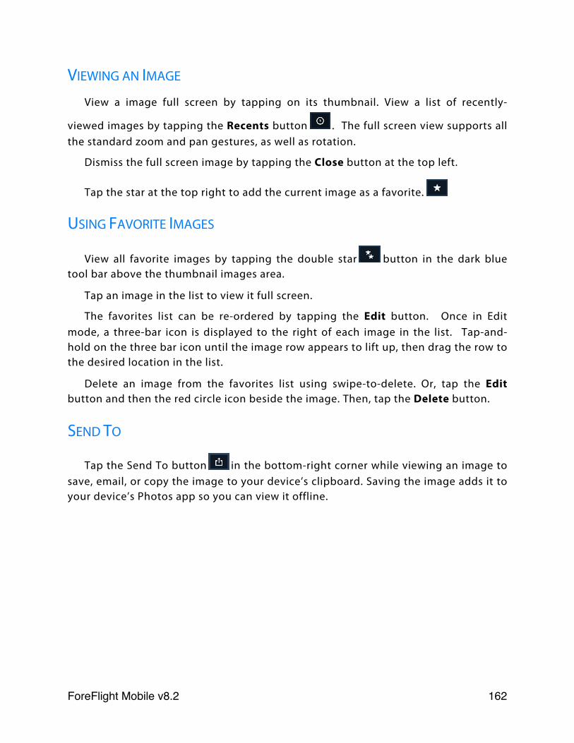
VIEWING AN IMAGE
View a image full screen by tapping on its thumbnail. View a list of recently-
viewed images by tapping the Recents button . The full screen view supports all the standard zoom and pan gestures, as well as rotation.
Dismiss the full screen image by tapping the Close button at the top left.
Tap the star at the top right to add the current image as a favorite.
USING FAVORITE IMAGES
View all favorite images by tapping the double star button in the dark blue tool bar above the thumbnail images area.
Tap an image in the list to view it full screen.
The favorites list can be re-ordered by tapping the Edit button. Once in Edit mode, a three-bar icon is displayed to the right of each image in the list. Tap-and-hold on the three bar icon until the image row appears to lift up, then drag the row to the desired location in the list.
Delete an image from the favorites list using swipe-to-delete. Or, tap the Edit button and then the red circle icon beside the image. Then, tap the Delete button.
SEND TO
Tap the Send To button in the bottom-right corner while viewing an image to save, email, or copy the image to your device’s clipboard. Saving the image adds it to your device’s Photos app so you can view it offline.
ForeFlight Mobile v8.2! 162
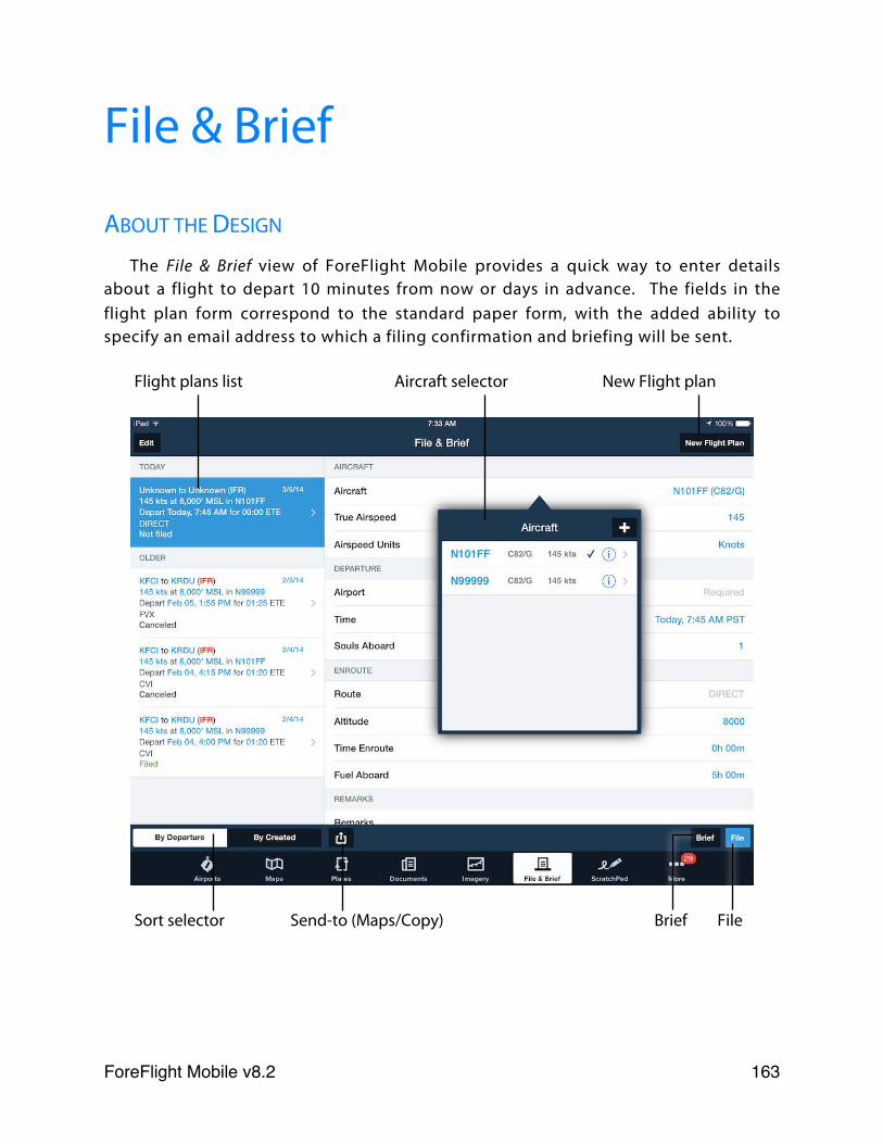
File & Brief
ABOUT THE DESIGN
The File & Brief view of ForeFlight Mobile provides a quick way to enter details about a flight to depart 10 minutes from now or days in advance. The fields in the flight plan form correspond to the standard paper form, with the added ability to specify an email address to which a filing confirmation and briefing will be sent.
Flight plans list Aircraft selector New Flight plan
Sort selector Send-to (Maps/Copy) Brief File
ForeFlight Mobile v8.2! 163
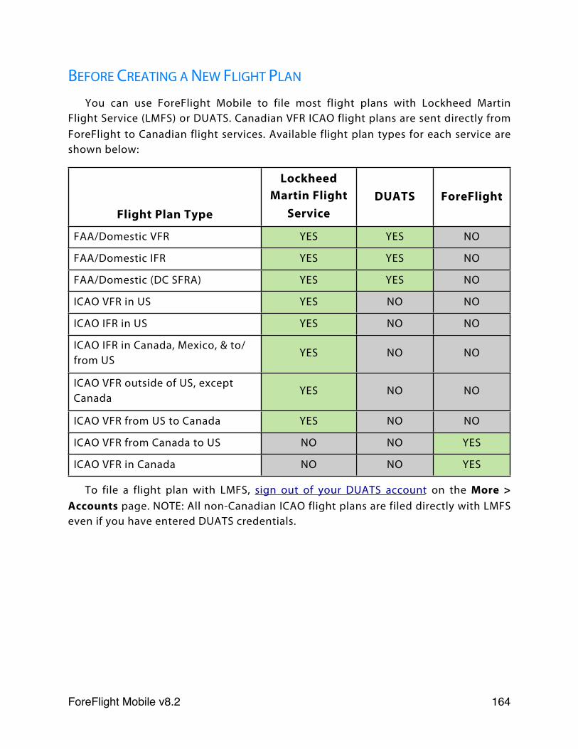
BEFORE CREATING A NEW FLIGHT PLAN
You can use ForeFlight Mobile to file most flight plans with Lockheed Martin Flight Service (LMFS) or DUATS. Canadian VFR ICAO flight plans are sent directly from ForeFlight to Canadian flight services. Available flight plan types for each service are shown below:
Flight Plan Type
Lockheed Martin Flight
ServiceDUATS ForeFlight
FAA/Domestic VFR YES YES NO
FAA/Domestic IFR YES YES NO
FAA/Domestic (DC SFRA) YES YES NO
ICAO VFR in US YES NO NO
ICAO IFR in US YES NO NO
ICAO IFR in Canada, Mexico, & to/from US
YES NO NO
ICAO VFR outside of US, except Canada
YES NO NO
ICAO VFR from US to Canada YES NO NO
ICAO VFR from Canada to US NO NO YES
ICAO VFR in Canada NO NO YES
To file a flight plan with LMFS, sign out of your DUATS account on the More > Accounts page. NOTE: All non-Canadian ICAO flight plans are filed directly with LMFS even if you have entered DUATS credentials.
ForeFlight Mobile v8.2! 164
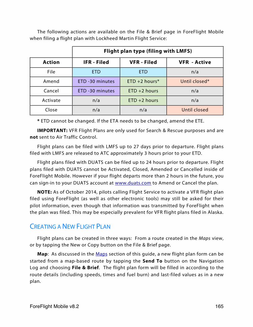
The following actions are available on the File & Brief page in ForeFlight Mobile when filing a flight plan with Lockheed Martin Flight Service:
Flight plan type (filing with LMFS)Flight plan type (filing with LMFS)Flight plan type (filing with LMFS)
Action IFR - Filed VFR - Filed VFR - Active
File ETD ETD n/a
Amend ETD -30 minutes ETD +2 hours* Until closed*
Cancel ETD -30 minutes ETD +2 hours n/a
Activate n/a ETD +2 hours n/a
Close n/a n/a Until closed
* ETD cannot be changed. If the ETA needs to be changed, amend the ETE.
IMPORTANT: VFR Flight Plans are only used for Search & Rescue purposes and are not sent to Air Traffic Control.
Flight plans can be filed with LMFS up to 27 days prior to departure. Flight plans filed with LMFS are released to ATC approximately 3 hours prior to your ETD.
Flight plans filed with DUATS can be filed up to 24 hours prior to departure. Flight plans filed with DUATS cannot be Activated, Closed, Amended or Cancelled inside of ForeFlight Mobile. However if your flight departs more than 2 hours in the future, you can sign-in to your DUATS account at www.duats.com to Amend or Cancel the plan.
NOTE: As of October 2014, pilots calling Flight Service to activate a VFR flight plan filed using ForeFlight (as well as other electronic tools) may still be asked for their pilot information, even though that information was transmitted by ForeFlight when the plan was filed. This may be especially prevalent for VFR flight plans filed in Alaska.
CREATING A NEW FLIGHT PLAN
Flight plans can be created in three ways: From a route created in the Maps view, or by tapping the New or Copy button on the File & Brief page.
Map: As discussed in the Maps section of this guide, a new flight plan form can be started from a map-based route by tapping the Send To button on the Navigation Log and choosing File & Brief. The flight plan form will be filled in according to the route details (including speeds, times and fuel burn) and last-filed values as in a new plan.
ForeFlight Mobile v8.2! 165
New: To create a new flight plan form from scratch, tap File & Brief button at the bottom-right, then tap the New Flight Plan button in the upper-right corner. This displays a new flight plan form and automatically fills in some details by using the last filed values such as pilot name, phone number, and aircraft. The majority of the fields will be blank.
Send To: To use a previous flight plan form as a template for a new one, select the desired plan form from the list and press the Send To button in the lower-left of the plan and choose Copy. This creates a new flight plan form and fills in all details based on the selected plan with an updated departure time; any fields can be changed as needed.
Tapping the Send To button on the File & Brief page and choosing Maps will display the current flight plan on the Maps page. Use this option if you edit the route or altitude on plan on the File & Briefs page. Changes made on the Maps page are not automatically reflected in the plan on the FIle & Brief page, so if you make changes you will need to tap the Send To button on the Navigation Log and choose File & Brief to start a new plan with the updated details.
CHOOSING BETWEEN FAA/DOMESTIC AND ICAO FLIGHT PLANS
ICAO flight plans are required when:
1) The flight will enter international airspace, including Oceanic airspace controlled by FAA facilities.
2) The flight expects routing or separation based on Performance Based Navigation (PBN), e.g., RNAV SIDs and STARs
3) The flight will enter Reduced Vertical Separation Minima (RVSM) airspace, e.g., FL290 or above.
4) The flight expects services based on ADS-B.
Flights that remain wholly within domestic United States airspace and do not meet any of the 4 criteria listed above can still use a FAA/Domestic flight plan.
So if you are filing a regular VFR, IFR, or non RVSM flight-level IFR flight plan, you can file using the FAA/Domestic flight plan. If you're planning to file for a GPS T-route or Q-route or to fly a GPS approach at your destination, then you can still file using the FAA/Domestic flight plan.
ForeFlight Mobile v8.2! 166
CREATING AN FAA/DOMESTIC FLIGHT PLAN
The majority of the flight plan form has the same usage as the corresponding field on the paper form. A few items are described below in greater detail.
In the Flight Rules section at the top, the options are VFR, IFR and VFR (DC SFRA).
When VFR (DC SFRA) is selected, you need to provide an appropriate gate for SFRA entry as your departure point (when inbound to the SFRA) or the appropriate exit gate in the destination field (when outbound). Your ETE value should match when you expect to enter the SFRA (when inbound) or exit it (when outbound). If you wish to do non-towered airport pattern work within the SFRA enter + REQ PTTN in your remarks.
ForeFlight Mobile can store profiles for your aircraft. In the Aircraft section, the aircraft used for the most recently filed flight plan will be chosen by default.
Tap the Aircraft row to edit or change the aircraft. To change the selected aircraft for the current flight, tap on the appropriate tail number in the list of aircraft. New aircraft can also be created. See the Aircraft section of this guide for more details.
You can add a call sign to your flight plan by enabling the Call Sign field in More > Settings > File & Brief. When a flight plan is filed under a call sign, the call sign is transmitted to ATC in place of the aircraft’s tail number, and the tail number is copied to the flight plan’s remarks so as to be available to ATC. If no call sign is entered the flight plan will be filed under the aircraft’s tail number.
The Route entry in the Enroute section can be as simple as DIRECT (leave blank for DIRECT routing) or as complex as you like, but note that the departure and destination airports are specified separately and thus should not be entered in the Enroute field.
All required fields are marked as such. Your email address is required for receiving a filing confirmation and a copy of the briefing for your flight. This email address is independent of your ForeFlight account, and you can change it at any time. If you enter a different email address than your ForeFlight account, briefings and flight plan emails will be sent to both addresses.
CREATING AN ICAO FLIGHT PLAN
For details about creating an ICAO flight plan and entering the ICAO-specific aircraft information in More > Aircraft, refer to “Filing with ForeFlight” available in the Document catalog under ForeFlight.
ForeFlight Mobile v8.2! 167
OBTAINING A WEATHER BRIEFING
This section pertains to the old text briefing. To read about the new, graphical briefing, see ForeFlight Briefing.
After defining your flight details, you can receive a weather briefing by tapping the Brief button at the bottom right. ForeFlight will request the briefing from Lockheed Martin Flight Service (or from DUATS if you entered your information on the More > Accounts > Account Logins) and present the briefing as a collection of logical sections.
Sections listed in bold have content for you to review; plain sections are empty. Once you have selected a section, you can use the left and right arrows at the top right to skip to the previous or next section, respectively.
Tapping the top left button (labeled with the origin and destination) takes you back to the briefing section list. Tap File & Brief at the top left to return to the flight plan form.
Briefings are stored on the iPad. To show a previous briefing, tap the Briefing button again when viewing the previously briefed flight plan.
Existing briefings can be refreshed to show the latest data. Select the desired plan form from the list at the left, tap the Brief button at the bottom right, and tap the Refresh button at the bottom left of the briefing segment list to refresh the briefing.
Briefings can only be obtained or refreshed when an active network connection is available.
FILING YOUR FLIGHT PLAN (FAA/DOMESTIC OR ICAO)Once your flight plan form is complete, you can file it using the File button at the
bottom right of the form and confirming the action by pressing the File button on the pop-up. An active ForeFlight subscription is required to file a flight plan.
The flight plan will either be accepted and you will be notified of a successful file, or it will be rejected and ForeFlight Mobile will identify the error reported by LMFS or DUATS. If rejected, you can correct the error and re-file.
Once a flight plan has been filed, it will no longer be editable, but it can be Amended. To create a new flight plan form from the filed plan, tap the Send To
button and choose Copy.
ForeFlight Mobile v8.2! 168
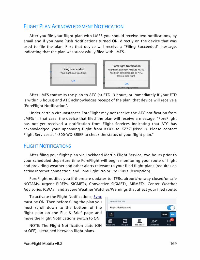
FLIGHT PLAN ACKNOWLEDGMENT NOTIFICATION
After you file your flight plan with LMFS you should receive two notifications, by email and if you have Push Notifications turned ON, directly on the device that was used to file the plan. First that device will receive a “Filing Succeeded” message, indicating that the plan was successfully filed with LMFS.
After LMFS transmits the plan to ATC (at ETD -3 hours, or immediately if your ETD is within 3 hours) and ATC acknowledges receipt of the plan, that device will receive a “ForeFlight Notification”.
Under certain circumstances ForeFlight may not receive the ATC notification from LMFS; in that case, the device that filed the plan will receive a message, “ForeFlight has not yet received a notification from Flight Services indicating that ATC has acknowledged your upcoming flight from KXXX to KZZZ (N9999). Please contact Flight Services at 1-800-WX-BRIEF to check the status of your flight plan.”
FLIGHT NOTIFICATIONS
After filing your flight plan via Lockheed Martin Flight Service, two hours prior to your scheduled departure time ForeFlight will begin monitoring your route of flight and providing weather and other alerts relevant to your filed flight plans (requires an active Internet connection, and ForeFlight Pro or Pro Plus subscription).
ForeFlight notifies you if there are updates to: TFRs, airport/runway closed/unsafe NOTAMs, urgent PIREPs, SIGMETs, Convective SIGMETs, AIRMETs, Center Weather Advisories (CWAs), and Severe Weather Watches/Warnings that affect your filed route.
To activate the Flight Notifications, Sync must be ON. Then before filing the plan you must scroll down to the bottom of the flight plan on the File & Brief page and move the Flight Notifications switch to ON.
NOTE: The Flight Notification state (ON or OFF) is retained between flight plans.
ForeFlight Mobile v8.2! 169
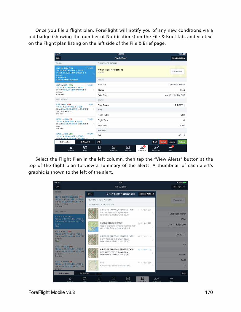
Once you file a flight plan, ForeFlight will notify you of any new conditions via a red badge (showing the number of Notifications) on the File & Brief tab, and via text on the Flight plan listing on the left side of the File & Brief page.
Select the Flight Plan in the left column, then tap the “View Alerts” button at the top of the flight plan to view a summary of the alerts. A thumbnail of each alert’s graphic is shown to the left of the alert.
ForeFlight Mobile v8.2! 170
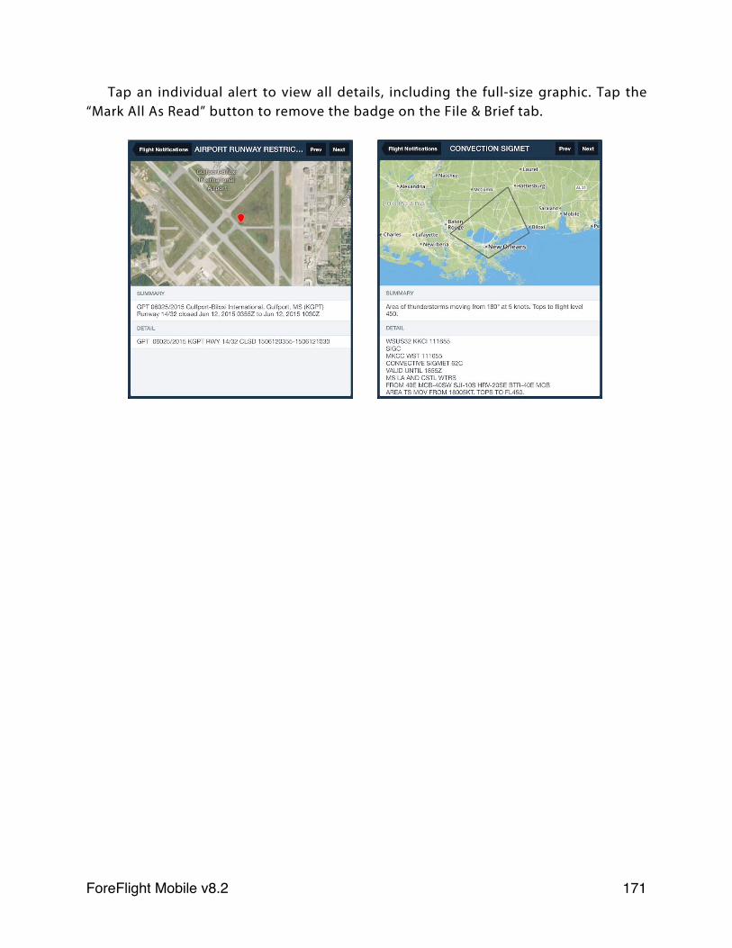
Tap an individual alert to view all details, including the full-size graphic. Tap the “Mark All As Read” button to remove the badge on the File & Brief tab.
ForeFlight Mobile v8.2! 171
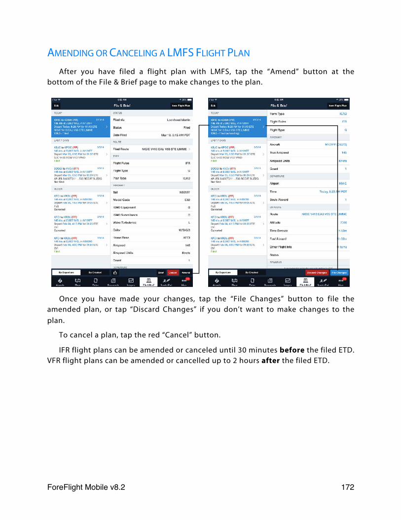
AMENDING OR CANCELING A LMFS FLIGHT PLAN
After you have filed a flight plan with LMFS, tap the “Amend” button at the bottom of the File & Brief page to make changes to the plan.
Once you have made your changes, tap the “File Changes” button to file the amended plan, or tap “Discard Changes” if you don’t want to make changes to the plan.
To cancel a plan, tap the red “Cancel” button.
IFR flight plans can be amended or canceled until 30 minutes before the filed ETD. VFR flight plans can be amended or cancelled up to 2 hours after the filed ETD.
ForeFlight Mobile v8.2! 172
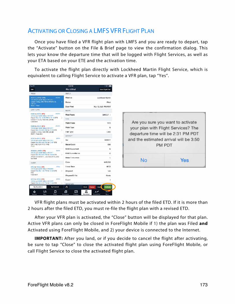
ACTIVATING OR CLOSING A LMFS VFR FLIGHT PLAN
Once you have filed a VFR flight plan with LMFS and you are ready to depart, tap the “Activate” button on the File & Brief page to view the confirmation dialog. This lets your know the departure time that will be logged with Flight Services, as well as your ETA based on your ETE and the activation time.
To activate the flight plan directly with Lockheed Martin Flight Service, which is equivalent to calling Flight Service to activate a VFR plan, tap “Yes”.
VFR flight plans must be activated within 2 hours of the filed ETD. If it is more than 2 hours after the filed ETD, you must re-file the flight plan with a revised ETD.
After your VFR plan is activated, the “Close” button will be displayed for that plan. Active VFR plans can only be closed in ForeFlight Mobile if 1) the plan was Filed and Activated using ForeFlight Mobile, and 2) your device is connected to the Internet.
IMPORTANT: After you land, or if you decide to cancel the flight after activating, be sure to tap “Close” to close the activated flight plan using ForeFlight Mobile, or call Flight Service to close the activated flight plan.
ForeFlight Mobile v8.2! 173
CLOSE VFR FLIGHT PLAN “PUSH” ALERTS
If you activated a VFR flight plan using ForeFlight Mobile and have not closed the plan 20 minutes after your calculated ETA (Departure time + ETE), ForeFlight will send a “push” notification to your devices reminding you to close your flight plan. You can close the plan using the “Close” button on the File & Brief page, or by calling 1-800-WX-BRIEF.
If the plan still has not been closed 30 minutes after your calculated ETA (Departure time + ETA) LMFS will send ForeFlight an “OVERDUE” status update, and ForeFlight will then send another “push” notification to your devices reminding you to close your flight plan immediately.
AMENDING OR CANCELING A DUATS FLIGHT PLAN
Once a DUATS flight plan has been filed using ForeFlight Mobile, it cannot be Amended, Cancelled or Closed using ForeFlight Mobile. However if you have entered your own DUATS sign-in credentials in ForeFlight Mobile at More > Accounts AND the flight departs in more than 2 hours, you can modify or cancel the flight plan by signing-in to your DUATS account at www.duats.com.
MANAGING FLIGHT PLAN FORMS
When viewing the listing of flight plan forms, you may wish to remove some to keep the length of the list under control. To remove a flight plan form, swipe your finger from right to left across the entry, then tap the red “Delete” button. This will not close or cancel a filed plan, but will remove its details from ForeFlight Mobile.
FLIGHT ALERTS
Flight Alerts (IFR flight plans only, requires a ForeFlight Pro or Pro Plus subscription) notify you when ATC issues an expected route for an IFR flight plan filed using ForeFlight Mobile.
When updated expected route information becomes available from ATC, ForeFlight’s servers send a notification of that route information directly to your devices. ForeFlight also sends you a message if our servers do not receive an expected route for your flight from ATC. ForeFlight’s servers also send you an email with the expected route.
ForeFlight Mobile v8.2! 174
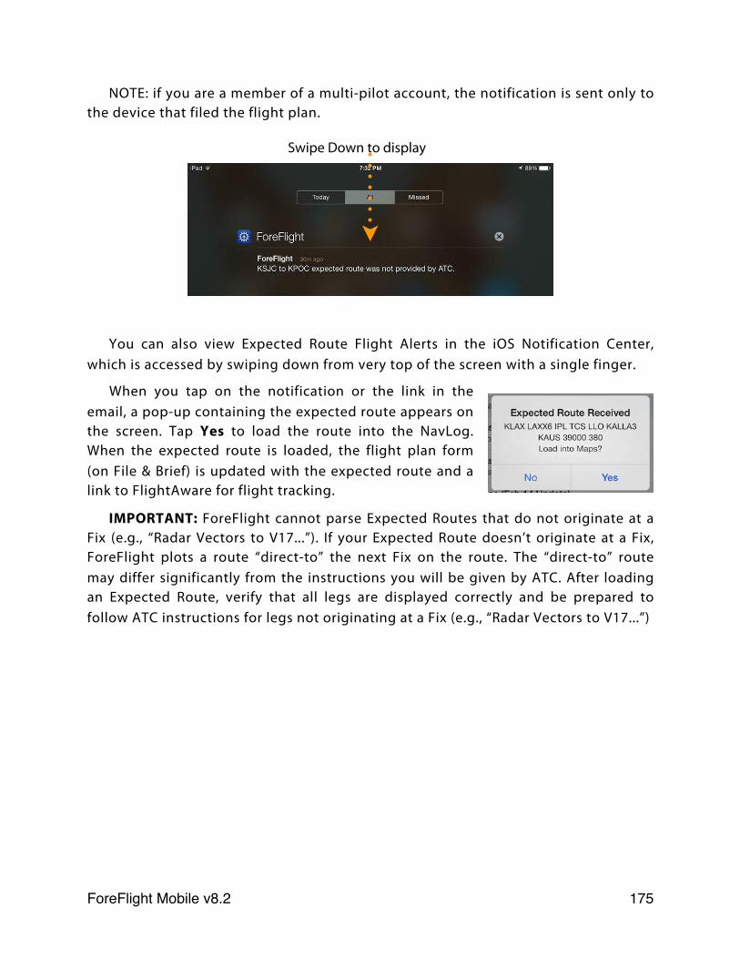
NOTE: if you are a member of a multi-pilot account, the notification is sent only to the device that filed the flight plan.
You can also view Expected Route Flight Alerts in the iOS Notification Center, which is accessed by swiping down from very top of the screen with a single finger.
When you tap on the notification or the link in the email, a pop-up containing the expected route appears on the screen. Tap Yes to load the route into the NavLog. When the expected route is loaded, the flight plan form (on File & Brief) is updated with the expected route and a link to FlightAware for flight tracking.
IMPORTANT: ForeFlight cannot parse Expected Routes that do not originate at a Fix (e.g., “Radar Vectors to V17...”). If your Expected Route doesn’t originate at a Fix, ForeFlight plots a route “direct-to” the next Fix on the route. The “direct-to” route may differ significantly from the instructions you will be given by ATC. After loading an Expected Route, verify that all legs are displayed correctly and be prepared to follow ATC instructions for legs not originating at a Fix (e.g., “Radar Vectors to V17...”)
Swipe Down to display
ForeFlight Mobile v8.2! 175
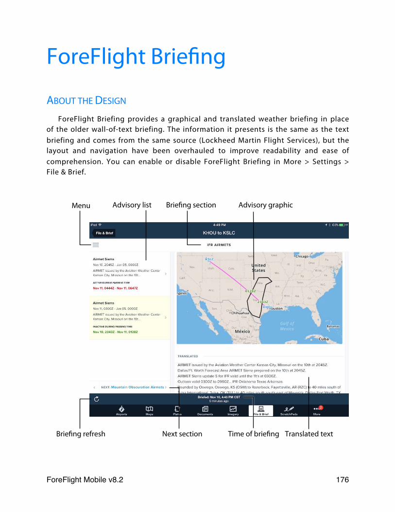
ForeFlight Briefing
ABOUT THE DESIGN
ForeFlight Briefing provides a graphical and translated weather briefing in place of the older wall-of-text briefing. The information it presents is the same as the text briefing and comes from the same source (Lockheed Martin Flight Services), but the layout and navigation have been overhauled to improve readability and ease of comprehension. You can enable or disable ForeFlight Briefing in More > Settings > File & Brief.
Menu Advisory list
Translated textBriefing refresh Next section
Briefing section Advisory graphic
Time of briefing
ForeFlight Mobile v8.2! 176
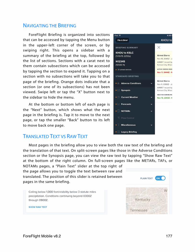
NAVIGATING THE BRIEFING
ForeFlight Briefing is organized into sections that can be accessed by tapping the Menu button in the upper-left corner of the screen, or by swiping right. This opens a sidebar with a summary of the briefing at the top, followed by the list of sections. Sections with a carat next to them contain subsections which can be accessed by tapping the section to expand it. Tapping on a section with no subsections will take you to that page of the briefing. Orange dots indicate that a section (or one of its subsections) has not been viewed. Swipe left or tap the “X” button next to the sidebar to hide the menu.
At the bottom or bottom left of each page is the “Next” button, which shows what the next page in the briefing is. Tap it to move to the next page, or tap the smaller “Back” button to its left to move back one page.
TRANSLATED TEXT VS RAW TEXT
Most pages in the briefing allow you to view both the raw text of the briefing and the translation of that text. On split-screen pages like those in the Adverse Conditions section or the Synopsis page, you can view the raw text by tapping “Show Raw Text” at the bottom of the right column. On full-screen pages like the METARs, TAFs, or NOTAMs pages, a “Plain Text” slider at the top right of the page allows you to toggle the text between raw and translated. The position of this slider is retained between pages in the same briefing.
ForeFlight Mobile v8.2! 177
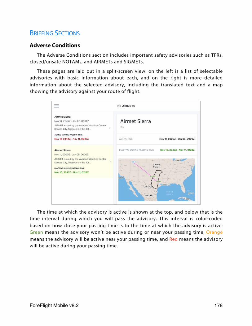
BRIEFING SECTIONS
Adverse Conditions
The Adverse Conditions section includes important safety advisories such as TFRs, closed/unsafe NOTAMs, and AIRMETs and SIGMETs.
These pages are laid out in a split-screen view: on the left is a list of selectable advisories with basic information about each, and on the right is more detailed information about the selected advisory, including the translated text and a map showing the advisory against your route of flight.
The time at which the advisory is active is shown at the top, and below that is the time interval during which you will pass the advisory. This interval is color-coded based on how close your passing time is to the time at which the advisory is active: Green means the advisory won’t be active during or near your passing time, Orange means the advisory will be active near your passing time, and Red means the advisory will be active during your passing time.
ForeFlight Mobile v8.2! 178
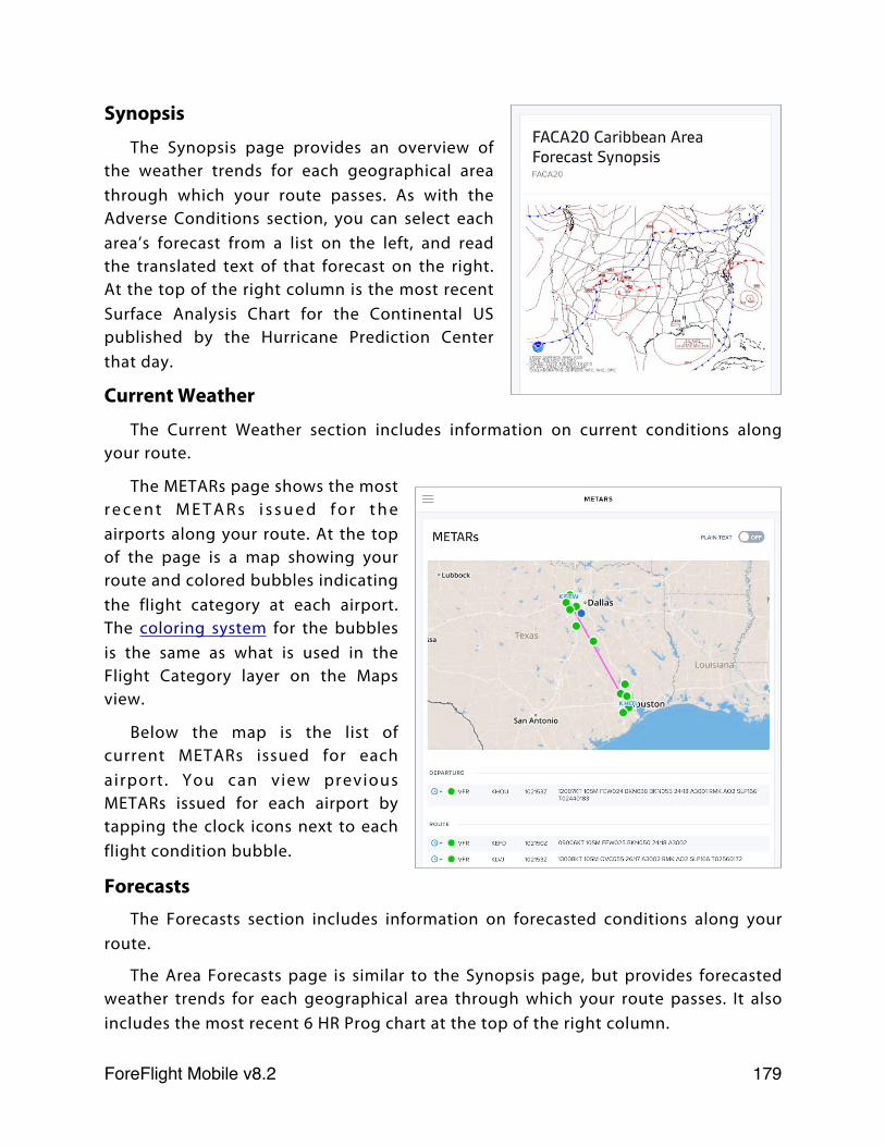
Synopsis
The Synopsis page provides an overview of the weather trends for each geographical area through which your route passes. As with the Adverse Conditions section, you can select each area’s forecast from a list on the left, and read the translated text of that forecast on the right. At the top of the right column is the most recent Surface Analysis Chart for the Continental US published by the Hurricane Prediction Center that day.
Current Weather
The Current Weather section includes information on current conditions along your route.
The METARs page shows the most r e c e n t M E T A R s i s s u e d f o r t h e airports along your route. At the top of the page is a map showing your route and colored bubbles indicating the flight category at each airport. The coloring system for the bubbles is the same as what is used in the Flight Category layer on the Maps view.
Below the map is the list of current METARs issued for each airport . You can view previous METARs issued for each airport by tapping the clock icons next to each flight condition bubble.
ForecastsThe Forecasts section includes information on forecasted conditions along your
route.
The Area Forecasts page is similar to the Synopsis page, but provides forecasted weather trends for each geographical area through which your route passes. It also includes the most recent 6 HR Prog chart at the top of the right column.
ForeFlight Mobile v8.2! 179

T h e T A F s p a g e displays TAFs for every airport that issues them along your route. Like the METARs page, it includes a map at the top showing your route and flight categories that correspond to the TAFs that will be valid for each airport during your passing time.
Below the map is a list of TAFs that will be valid at or near the time you pass each airport. Highlighted TAFs will be valid at the time of your passing, which is shown in a box on the left. If a TAF will be valid within an hour of your passing, but not during your passing, the time difference between when that TAF is valid and your time of passing is shown on the left, with an arrow pointing at the TAF. These numbers can be positive or negative. For example, if a new TAF becomes valid 29 minutes after I pass an airport, that time difference is shown next to the TAF, as in the screenshot above. This feature is meant to let you know when weather might take a turn for the worse near your passing time.
NOTAMs
The NOTAMs section includes all the NOTAMs for your flight, apart from the closed/unsafe NOTAMs, which are found in the Adverse Conditions section.
Nearly all of these pages have the same layout, with a map showing your route at the top and the NOTAMs below. The only exception is the Enroute Obstruction NOTAMs page, which has a table at the top showing the total number of obstructions along your route, and how many of them are within 500 feet, 1000 feet, or beyond 1000 feet of your filed altitude, and how many have an unknown MSL altitude.
MiscellaneousThe Miscellaneous section includes any NHC bulletins that have been issued, as
well as a page showing three days of convective outlooks issued by the Storm Prediction Center.
ForeFlight Mobile v8.2! 180
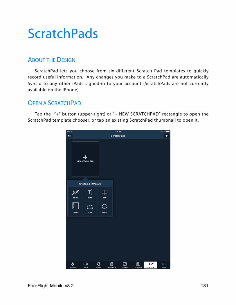
ScratchPads
ABOUT THE DESIGN
ScratchPad lets you choose from six different Scratch Pad templates to quickly record useful information. Any changes you make to a ScratchPad are automatically Sync’d to any other iPads signed-in to your account (ScratchPads are not currently available on the iPhone).
OPEN A SCRATCHPAD
Tap the “+” button (upper-right) or “+ NEW SCRATCHPAD” rectangle to open the ScratchPad template chooser, or tap an existing ScratchPad thumbnail to open it.
ForeFlight Mobile v8.2! 181
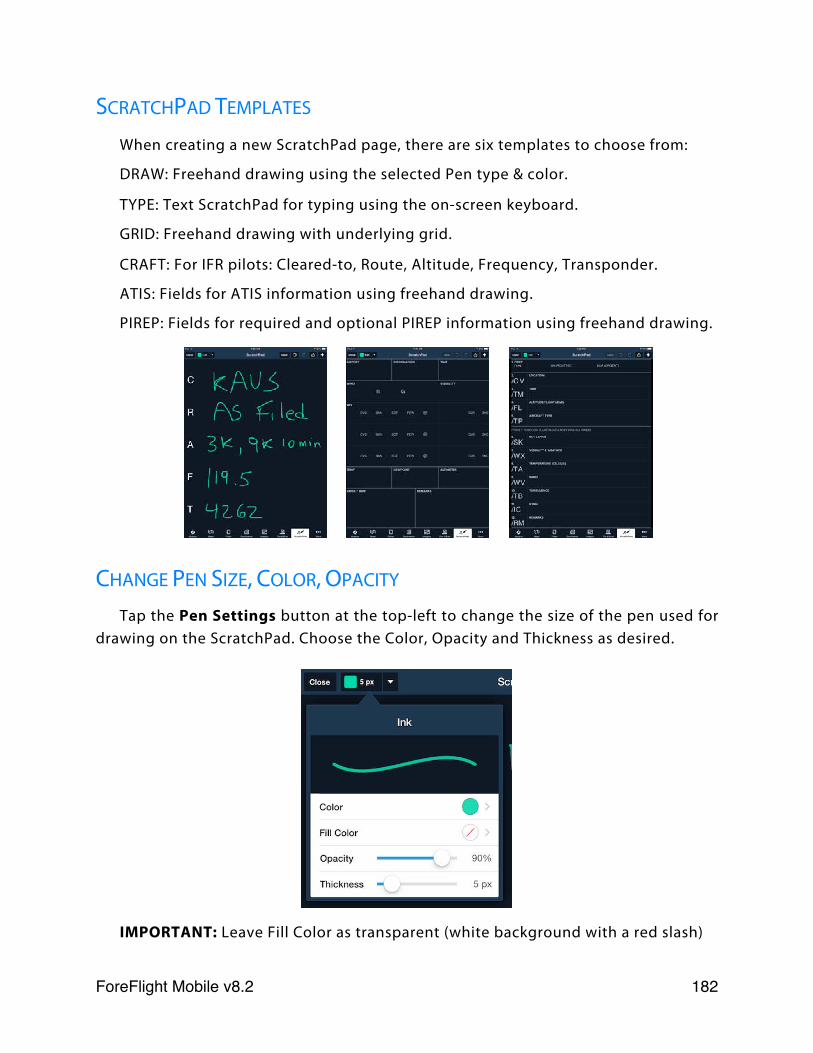
SCRATCHPAD TEMPLATES
When creating a new ScratchPad page, there are six templates to choose from:
DRAW: Freehand drawing using the selected Pen type & color.
TYPE: Text ScratchPad for typing using the on-screen keyboard.
GRID: Freehand drawing with underlying grid.
CRAFT: For IFR pilots: Cleared-to, Route, Altitude, Frequency, Transponder.
ATIS: Fields for ATIS information using freehand drawing.
PIREP: Fields for required and optional PIREP information using freehand drawing.
CHANGE PEN SIZE, COLOR, OPACITY
Tap the Pen Settings button at the top-left to change the size of the pen used for drawing on the ScratchPad. Choose the Color, Opacity and Thickness as desired.
IMPORTANT: Leave Fill Color as transparent (white background with a red slash)
ForeFlight Mobile v8.2! 182
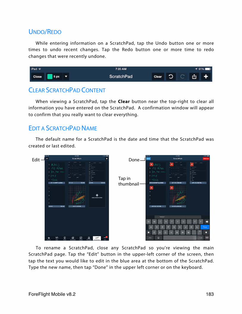
UNDO/REDO
While entering information on a ScratchPad, tap the Undo button one or more times to undo recent changes. Tap the Redo button one or more time to redo changes that were recently undone.
CLEAR SCRATCHPAD CONTENT
When viewing a ScratchPad, tap the Clear button near the top-right to clear all information you have entered on the ScratchPad. A confirmation window will appear to confirm that you really want to clear everything.
EDIT A SCRATCHPAD NAME
The default name for a ScratchPad is the date and time that the ScratchPad was created or last edited.
To rename a ScratchPad, close any ScratchPad so you’re viewing the main ScratchPad page. Tap the “Edit” button in the upper-left corner of the screen, then tap the text you would like to edit in the blue area at the bottom of the ScratchPad. Type the new name, then tap “Done” in the upper left corner or on the keyboard.
Edit Done
Tap in thumbnail
ForeFlight Mobile v8.2! 183
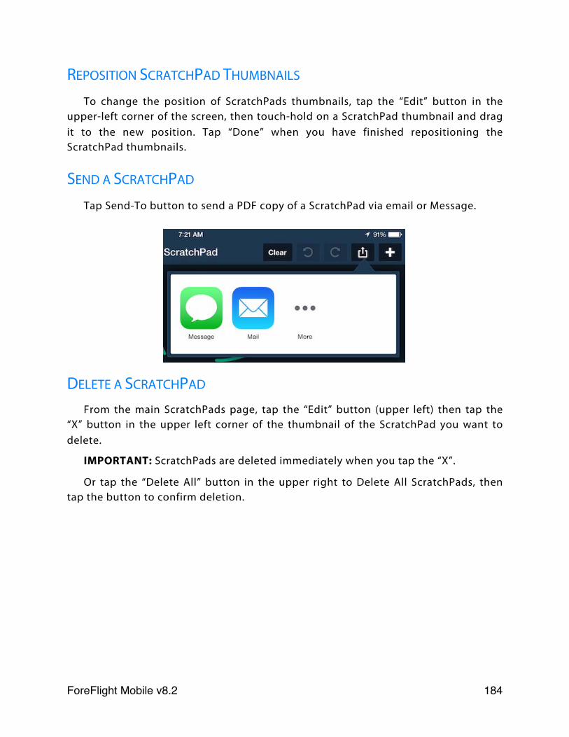
REPOSITION SCRATCHPAD THUMBNAILS
To change the position of ScratchPads thumbnails, tap the “Edit” button in the upper-left corner of the screen, then touch-hold on a ScratchPad thumbnail and drag it to the new position. Tap “Done” when you have finished repositioning the ScratchPad thumbnails.
SEND A SCRATCHPAD
Tap Send-To button to send a PDF copy of a ScratchPad via email or Message.
DELETE A SCRATCHPAD
From the main ScratchPads page, tap the “Edit” button (upper left) then tap the “X” button in the upper left corner of the thumbnail of the ScratchPad you want to delete.
IMPORTANT: ScratchPads are deleted immediately when you tap the “X”.
Or tap the “Delete All” button in the upper right to Delete All ScratchPads, then tap the button to confirm deletion.
ForeFlight Mobile v8.2! 184
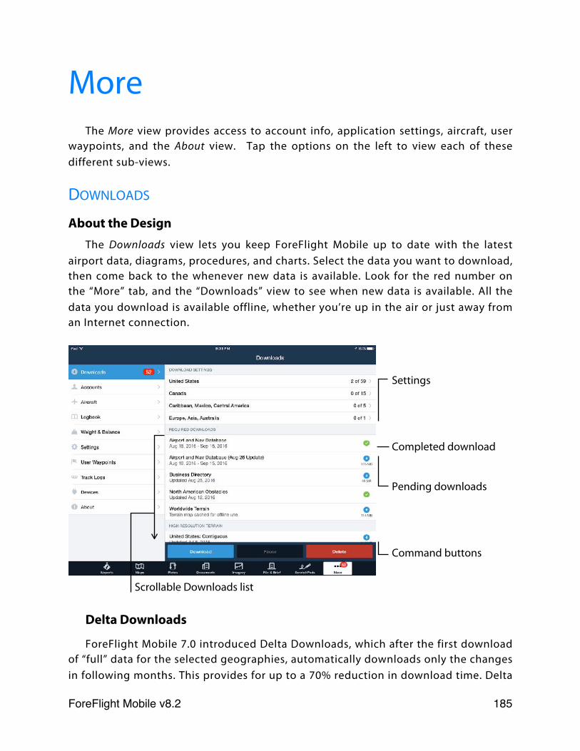
MoreThe More view provides access to account info, application settings, aircraft, user
waypoints, and the About view. Tap the options on the left to view each of these different sub-views.
DOWNLOADS
About the DesignThe Downloads view lets you keep ForeFlight Mobile up to date with the latest
airport data, diagrams, procedures, and charts. Select the data you want to download, then come back to the whenever new data is available. Look for the red number on the “More” tab, and the “Downloads” view to see when new data is available. All the data you download is available offline, whether you’re up in the air or just away from an Internet connection.
Delta Downloads
ForeFlight Mobile 7.0 introduced Delta Downloads, which after the first download of “full” data for the selected geographies, automatically downloads only the changes in following months. This provides for up to a 70% reduction in download time. Delta
Settings
Completed download
Pending downloads
Command buttons
Scrollable Downloads list
ForeFlight Mobile v8.2! 185
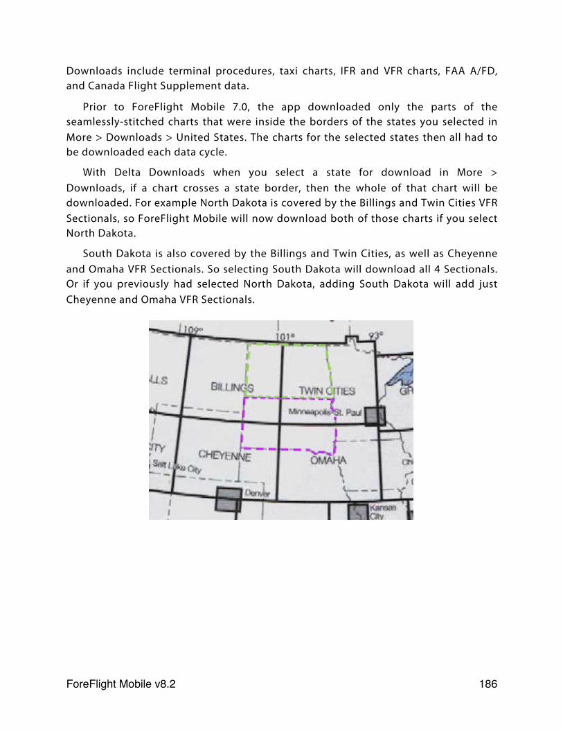
Downloads include terminal procedures, taxi charts, IFR and VFR charts, FAA A/FD, and Canada Flight Supplement data.
Prior to ForeFlight Mobile 7.0, the app downloaded only the parts of the seamlessly-stitched charts that were inside the borders of the states you selected in More > Downloads > United States. The charts for the selected states then all had to be downloaded each data cycle.
With Delta Downloads when you select a state for download in More > Downloads, if a chart crosses a state border, then the whole of that chart will be downloaded. For example North Dakota is covered by the Billings and Twin Cities VFR Sectionals, so ForeFlight Mobile will now download both of those charts if you select North Dakota.
South Dakota is also covered by the Billings and Twin Cities, as well as Cheyenne and Omaha VFR Sectionals. So selecting South Dakota will download all 4 Sectionals. Or if you previously had selected North Dakota, adding South Dakota will add just Cheyenne and Omaha VFR Sectionals.
ForeFlight Mobile v8.2! 186
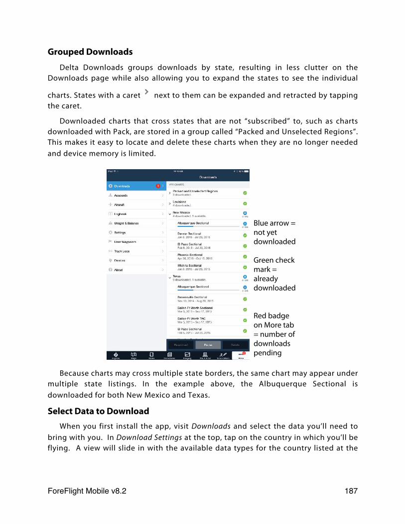
Grouped Downloads
Delta Downloads groups downloads by state, resulting in less clutter on the Downloads page while also allowing you to expand the states to see the individual
charts. States with a caret next to them can be expanded and retracted by tapping the caret.
Downloaded charts that cross states that are not “subscribed” to, such as charts downloaded with Pack, are stored in a group called “Packed and Unselected Regions”. This makes it easy to locate and delete these charts when they are no longer needed and device memory is limited.
Because charts may cross multiple state borders, the same chart may appear under multiple state listings. In the example above, the Albuquerque Sectional is downloaded for both New Mexico and Texas.
Select Data to DownloadWhen you first install the app, visit Downloads and select the data you’ll need to
bring with you. In Download Settings at the top, tap on the country in which you’ll be flying. A view will slide in with the available data types for the country listed at the
Blue arrow = not yet downloaded
Green check mark = already downloaded
Red badge on More tab = number of downloads pending
ForeFlight Mobile v8.2! 187
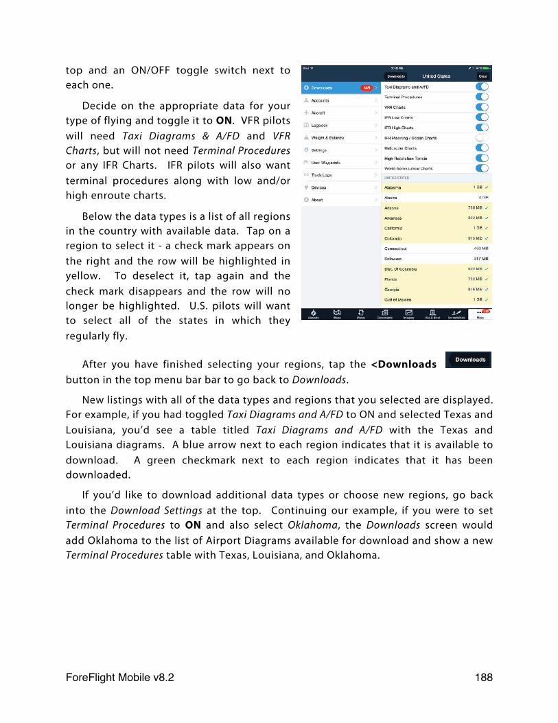
top and an ON/OFF toggle switch next to each one.
Decide on the appropriate data for your type of flying and toggle it to ON. VFR pilots will need Taxi Diagrams & A/FD and VFR Charts, but will not need Terminal Procedures or any IFR Charts. IFR pilots will also want terminal procedures along with low and/or high enroute charts.
Below the data types is a list of all regions in the country with available data. Tap on a region to select it - a check mark appears on the right and the row will be highlighted in yellow. To deselect it, tap again and the check mark disappears and the row will no longer be highlighted. U.S. pilots will want to select all of the states in which they regularly fly.
After you have finished selecting your regions, tap the <Downloads button in the top menu bar bar to go back to Downloads.
New listings with all of the data types and regions that you selected are displayed. For example, if you had toggled Taxi Diagrams and A/FD to ON and selected Texas and Louisiana, you’d see a table titled Taxi Diagrams and A/FD with the Texas and Louisiana diagrams. A blue arrow next to each region indicates that it is available to download. A green checkmark next to each region indicates that it has been downloaded.
If you’d like to download additional data types or choose new regions, go back into the Download Settings at the top. Continuing our example, if you were to set Terminal Procedures to ON and also select Oklahoma, the Downloads screen would add Oklahoma to the list of Airport Diagrams available for download and show a new Terminal Procedures table with Texas, Louisiana, and Oklahoma.
ForeFlight Mobile v8.2! 188
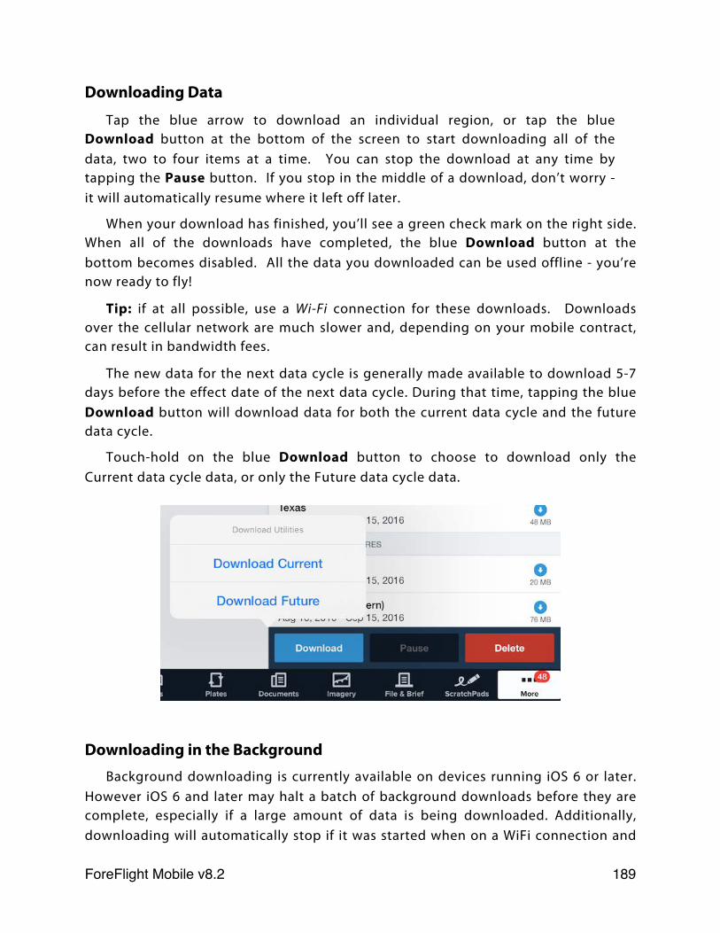
Downloading Data
Tap the blue arrow to download an individual region, or tap the blue Download button at the bottom of the screen to start downloading all of the data, two to four items at a time. You can stop the download at any time by tapping the Pause button. If you stop in the middle of a download, don’t worry - it will automatically resume where it left off later.
When your download has finished, you’ll see a green check mark on the right side. When all of the downloads have completed, the blue Download button at the bottom becomes disabled. All the data you downloaded can be used offline - you’re now ready to fly!
Tip: if at all possible, use a Wi-Fi connection for these downloads. Downloads over the cellular network are much slower and, depending on your mobile contract, can result in bandwidth fees.
The new data for the next data cycle is generally made available to download 5-7 days before the effect date of the next data cycle. During that time, tapping the blue Download button will download data for both the current data cycle and the future data cycle.
Touch-hold on the blue Download button to choose to download only the Current data cycle data, or only the Future data cycle data.
Downloading in the BackgroundBackground downloading is currently available on devices running iOS 6 or later.
However iOS 6 and later may halt a batch of background downloads before they are complete, especially if a large amount of data is being downloaded. Additionally, downloading will automatically stop if it was started when on a WiFi connection and
ForeFlight Mobile v8.2! 189
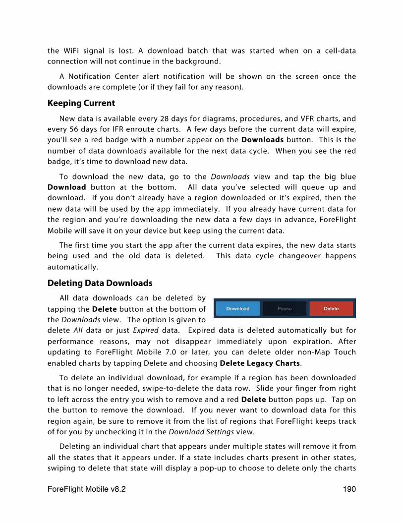
the WiFi signal is lost. A download batch that was started when on a cell-data connection will not continue in the background.
A Notification Center alert notification will be shown on the screen once the downloads are complete (or if they fail for any reason).
Keeping Current
New data is available every 28 days for diagrams, procedures, and VFR charts, and every 56 days for IFR enroute charts. A few days before the current data will expire, you’ll see a red badge with a number appear on the Downloads button. This is the number of data downloads available for the next data cycle. When you see the red badge, it’s time to download new data.
To download the new data, go to the Downloads view and tap the big blue Download button at the bottom. All data you’ve selected will queue up and download. If you don’t already have a region downloaded or it’s expired, then the new data will be used by the app immediately. If you already have current data for the region and you’re downloading the new data a few days in advance, ForeFlight Mobile will save it on your device but keep using the current data.
The first time you start the app after the current data expires, the new data starts being used and the old data is deleted. This data cycle changeover happens automatically.
Deleting Data DownloadsAll data downloads can be deleted by
tapping the Delete button at the bottom of the Downloads view. The option is given to delete All data or just Expired data. Expired data is deleted automatically but for performance reasons, may not disappear immediately upon expiration. After updating to ForeFlight Mobile 7.0 or later, you can delete older non-Map Touch enabled charts by tapping Delete and choosing Delete Legacy Charts.
To delete an individual download, for example if a region has been downloaded that is no longer needed, swipe-to-delete the data row. Slide your finger from right to left across the entry you wish to remove and a red Delete button pops up. Tap on the button to remove the download. If you never want to download data for this region again, be sure to remove it from the list of regions that ForeFlight keeps track of for you by unchecking it in the Download Settings view.
Deleting an individual chart that appears under multiple states will remove it from all the states that it appears under. If a state includes charts present in other states, swiping to delete that state will display a pop-up to choose to delete only the charts
ForeFlight Mobile v8.2! 190
that are unique to that state, or to delete all of its charts including those that appear under other states. If a state has only “unique” charts, no pop-up appears.
A Quick Tour of the Data Available for Download
✤ Airport and Nav Database is an international A/FD with over 27,000 airports and NAVAIDS from 220 countries. This data is used in the Airports view (frequencies, runways, hours, FBOs, etc) and in the Maps view (locations, routes, NAVAIDS, airspaces), and includes data used in the Aeronautical data layer.
✤ Business Directory contains the information about FBOs and services at airports.
✤ North American Obstacles are FAA-provided towers, bridges, etc. These are shown as markers on the Map view when enabled.
✤ Worldwide Terrain is the low-resolution terrain data used to add terrain features to the base map via the switch in Maps Settings. This map provides global coverage and is only available if downloaded.
✤ Taxi Diagrams and A/FD contains thumbnail diagrams with FBO locations for over 1,200 worldwide airports and taxi diagrams for U.S. airports. These are displayed at the top of an airport in the Airports view. Additionally, A/FD pages for that region are included. These are displayed in the lower portion of the Airports view.
✤ Terminal procedures and approach plates for U.S. airports or Canadian airports, viewable in the Procedures tab of an airport in the Airports view.
✤ VFR, IFR High, and IFR Low Charts (United States) contains FAA seamless sectionals and enroute charts of the U.S. and southern Canada for use in Maps.
✤ VNC Charts (Canada) contains Nav Canada seamless VNC and VFR Terminal Area (VTA) charts.
✤ IFR High, and IFR Low Charts (Canada) contain Nav Canada seamless enroute charts of Canada and the Atlantic ocean.
✤ Helicopter Charts - US Helicopter charts for 9 major metro areas (downloaded when switch is ON and containing state is selected) and US Gulf of Mexico VFR and IFR Helicopter charts (downloaded when Gulf of Mexico is selected).
✤ High Resolution Terrain (ForeFlight Mobile Pro or Pro Plus only) contains high-resolution terrain data used for the Terrain map layer, Hazard Advisor™, and Synthetic Vision.
ForeFlight Mobile v8.2! 191
✤ Documents are updated via this Downloads view once added to a binder in the Documents view.
Approximately 8GB of data is available for download each month in the continental United States, and 2GB in Alaska.
Note: It isn't necessary to have all the data downloaded to make the app function properly. The downloads are only required for in-cockpit (or offline) use. Most pilots will download the states they will be flying through and leave other states alone if they are not flying there. If plans change, you can just grab the additional states in a few minutes of downloading. Downloading all items for all states can be unnecessarily time consuming - particularly if there are items you’re likely to only reference when you’re on the ground with an Internet connection.
Preflight Download CheckRemember: If it’s not downloaded, you’re not going to see it in flight.
Before your flight, make sure you have the necessary data downloaded:
✤ Use the Pack feature to automatically download relevant METARs, TAFs, AIR/SIGMETs, TFRs, Fuel prices and Airport NOTAMs.
✤ Go to Settings for your iPad and switch Airplane Mode ON. This will keep the app from retrieving data over the Internet, simulating the condition in flight.
✤ Launch ForeFlight Mobile
✤ Tap More and then Downloads and ensure there is a green check mark next to each region where you’ll be flying.
✤ Tap Airports and search for each airport on your route. If you’re flying IFR, make sure there is a green “saved” mark next to each procedure.
✤ Tap Maps and search for each airport on your route. Toggle between VFR, IFR Low, and IFR High, panning around each chart to ensure that it is downloaded properly on your device. Make sure to zoom into the airports you will be flying to and ensure that the charts are downloaded.
Troubleshooting DownloadsForeFlight hosts all of the data for downloads on a network of servers located
across the United States and around the world. When you start a download, the data comes from the server that is closest to you in order to provide fast and reliable downloads.
Depending on the amount of data you are downloading, download time can be considerable. If downloading all items for the USA, 8-10 GB of data will be
ForeFlight Mobile v8.2! 192
downloaded. Even on a fast Wi-Fi connection, this will take a significant amount of time.
ForeFlight strongly recommends that you only download data for regions you will fly over or near. This will save a significant time and disk space.
Given the nature of networks and the large amount of data transferred every month, connection errors can occur. If a download fails, the app will automatically retry a few times. If you see a red error message on the download, that means the retry attempts did not work and you will need to restart the download for that particular item.
Try these troubleshooting tips:
✤ Enable Diagnostic Logs - in More > Settings, turn Enable Diagnostic Logs ON to save a log file of your download attempt. Then try the download again. If the download doesn’t work, make sure that your Mail client is set-up with an email address that can send message. Then in ForeFlight Mobile, tap More > Settings then tap the word “Settings” in the header area at the top of the page, 3 times in quick succession. This creates a diagnostic email pre-addressed to the ForeFlight Pilot Support Team at [email protected]. Send that email along with an explanation of your download difficulty and we will investigate.
✤ Try downloading on another network - if you’re using your home Wi-Fi, try a download over a different Wi-Fi hotspot or, in a pinch, over 3G/4G.
✤ Update the firmware on your router - some older Wi-Fi routers are not compatible with the iPad. Visit your manufacturer’s website to see if there is a firmware update available.
✤ Reboot your iPad by pressing and holding the button on the top of the iPad. A red slider appears on the screen - swipe where indicated to shut down your device. Wait a few seconds, then press the button again to start it back up. Once it has finished starting up, try the downloads again.
✤ Double check Download Settings to ensure the proper regions and data types are still selected.
ForeFlight Mobile v8.2! 193
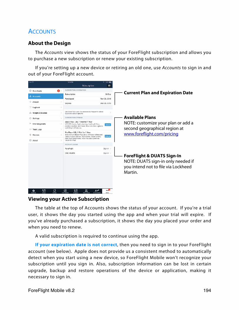
ACCOUNTS
About the Design
The Accounts view shows the status of your ForeFlight subscription and allows you to purchase a new subscription or renew your existing subscription.
If you’re setting up a new device or retiring an old one, use Accounts to sign in and out of your ForeFlight account.
Current Plan and Expiration Date
Available PlansNOTE: customize your plan or add a second geographical region at www.foreflight.com/pricing
ForeFlight & DUATS Sign-InNOTE: DUATS sign-in only needed if you intend not to file via Lockheed Martin.
Viewing your Active SubscriptionThe table at the top of Accounts shows the status of your account. If you’re a trial
user, it shows the day you started using the app and when your trial will expire. If you’ve already purchased a subscription, it shows the day you placed your order and when you need to renew.
A valid subscription is required to continue using the app.
If your expiration date is not correct, then you need to sign in to your ForeFlight account (see below). Apple does not provide us a consistent method to automatically detect when you start using a new device, so ForeFlight Mobile won’t recognize your subscription until you sign in. Also, subscription information can be lost in certain upgrade, backup and restore operations of the device or application, making it necessary to sign in.
ForeFlight Mobile v8.2! 194
Purchasing or Renewing a Subscription in the United States
To purchase or renew a subscription for the US, visit www.foreflight.com/pricing or tap on a plan:
✤ $99.99 (USD) Basic Plus - US, 1 Pilot for 1 Year
✤ $199.99 (USD) Pro Plus - US, 1 Pilot for 1 Year
The Basic Plus plan includes all the essential ForeFlight features, including VFR sectionals and High and Low IFR Enroute charts, extensive flight planning capabilities, flight plan filing and briefing (including ForeFlight Graphical Briefing), aviation weather information, and more. The Basic Plus plan also includes the Logbook and Weight & Balance features.
The Pro Plus plan has everything that comes with the Basic Plus plan, as well as more advanced features such as geo-referenced plates and airport diagrams, Plates on Maps, Hazard Advisor™, flight plan notifications, route Profile View, and Cloud Documents, which allows you to sync documents you’ve uploaded through ForeFlight Manage to all your devices. Finally, the Pro Plus plan includes Synthetic Vision for iPad, providing a detailed 3D terrain view. When connected to an AHRS receiver such as the Stratus 2/2S your view includes pitch/roll.
These subscriptions do not provide access to Canadian terminal procedures or IFR enroute charts from Nav Canada. You can add Canadian data to your plan at www.foreflight.com/pricing.
After you tap on the plan you wish to purchase, follow instructions for entering your email address and iTunes password. This will place an order through your iTunes account, which will show up on your credit card like other iTunes purchases (e.g., music or apps).
After your purchase is complete, you’ll have immediate access to the app and all data downloads. You’ll also receive an email with your new ForeFlight Account password, and an email from Apple with your iTunes receipt.
If you have trouble placing an order due to a slow network connection or a “jailbroken” device, you can purchase a subscription online at www.foreflight.com/pricing.
If you’d like to place an order for multiple iPads, please visit www.foreflight.com/pricing or send an email to [email protected].
ForeFlight Mobile v8.2! 195
Purchasing or Renewing a Subscription in Canada
To purchase or renew a subscription for Canada, visit www.foreflight.com/pricing or tap on a plan:
✤ $99.99 (USD) Basic Plus - Canada, 1 Pilot for 1 Year
✤ $199.99 (USD) Pro Plus - Canada, 1 Pilot for 1 Year
These plans have all the same features as their respective US plans, with the exception that Canadian aeronautical products from Nav Canada are provided in place of US data. These include monthly data updates to download terminal procedures from the Canada Air Pilot (CAP), Canadian IFR low and High enroute charts, and Canadian VNC & VTR charts and Canadian Flight Supplement (CFS).
Canadian subscriptions do not provide access to US plates, sectionals, or enroute charts. You can add US data to your plan at www.foreflight.com/pricing. Note: If you purchase Synthetic Vision it applies to all geographies on your subscription plan.
Signing In to your ForeFlight Account
After you purchase a subscription, you are automatically signed in on that iPad or iPhone.
To use your subscription on a new device, you’ll need to sign in to your ForeFlight Account inside the application:
✤ Tap the “More” tab at the bottom, then “Accounts” in the left side list
✤ In the Account Logins section, tap ForeFlight
✤ Enter your email and password for your ForeFlight account. (Your auto-generated password was emailed to you when you originally placed your order.)
If you can’t find your password, enter the email address that you originally used to purchase your subscription and tap the Forgot Password button. An email will be sent to you with your password.
Signing Out of your ForeFlight AccountWhen you’re ready to retire your old iPhone or iPad and won’t be using it
anymore, remember to sign out of your ForeFlight Account on that device:
✤ Tap the “More” option at the bottom, then “Accounts” in the left side list
✤ In the Account Logins section, tap ForeFlight
✤ Tap Sign Out at the bottom and confirm.
ForeFlight Mobile v8.2! 196
This will “unhook” the device from your account. Afterwards, we recommend deleting the app from your device to free up space if you don’t plan to use the app on that device again. Tap-and-hold on the ForeFlight icon until it starts to wiggle, then tap the “X” button displayed on the top-left corner of the icon.
Changing your Password or Email
To change your password or email address inside the app:
✤ In the Account Logins table at the bottom, tap ForeFlight
✤ A screen is displayed with your email address and password. Tap Change Password or Change Email at the bottom.
✤ Follow the on-screen instructions for changing your password or email.
You can also use the ForeFlight Manage website to change your email, password, and manage which devices are associated with your account. ForeFlight Manage is available at: www.foreflight.com/manage.
Removing Devices from your Account
If you are signed in to your ForeFlight account on other devices, they will be shown on the Accounts view under “Also Signed In On”. You can remove a device from your account, which is the same as signing out of your account on that device, by tapping the red Remove button and entering your ForeFlight credentials.
Providing a DUATS AccountA CSC DUATS account can also be optionally provided by tapping the DUATS
option at the bottom of the Accounts view. When your DUATS account is set, the File & Brief view will use it when filing or briefing flight plans.
When your CSC DUATS account is not provided and you select the “FAA/Domestic” flight plan option, ForeFlight Mobile will automatically use the ForeFlight corporate DUATS account. If you select the “ICAO” flight plan option, ForeFlight Mobile will file the plan with Lockheed Martin Flight Service.
ForeFlight Mobile v8.2! 197
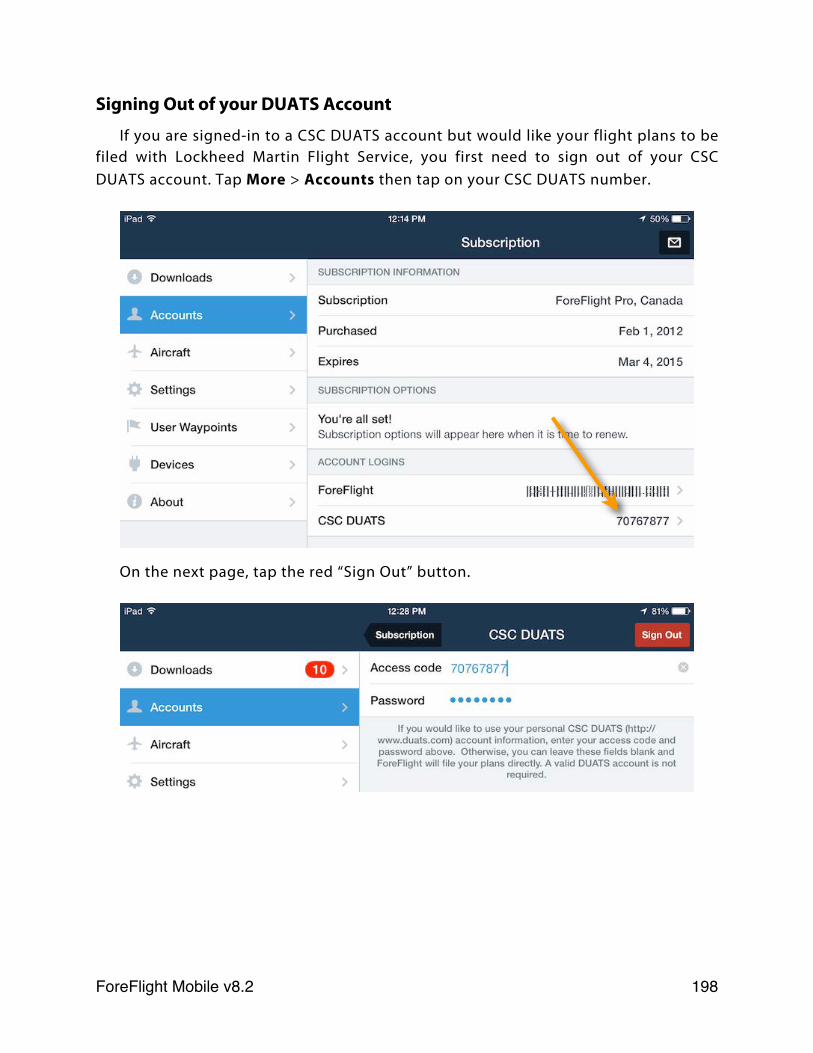
Signing Out of your DUATS Account
If you are signed-in to a CSC DUATS account but would like your flight plans to be filed with Lockheed Martin Flight Service, you first need to sign out of your CSC DUATS account. Tap More > Accounts then tap on your CSC DUATS number.
On the next page, tap the red “Sign Out” button.
ForeFlight Mobile v8.2! 198
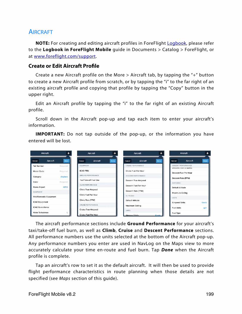
AIRCRAFT
NOTE: For creating and editing aircraft profiles in ForeFlight Logbook, please refer to the Logbook in ForeFlight Mobile guide in Documents > Catalog > ForeFlight, or at www.foreflight.com/support.
Create or Edit Aircraft ProfileCreate a new Aircraft profile on the More > Aircraft tab, by tapping the “+” button
to create a new Aircraft profile from scratch, or by tapping the “i” to the far right of an existing aircraft profile and copying that profile by tapping the “Copy” button in the upper right.
Edit an Aircraft profile by tapping the “i” to the far right of an existing Aircraft profile.
Scroll down in the Aircraft pop-up and tap each item to enter your aircraft’s information.
IMPORTANT: Do not tap outside of the pop-up, or the information you have entered will be lost.
The aircraft performance sections include Ground Performance for your aircraft’s taxi/take-off fuel burn, as well as Climb, Cruise and Descent Performance sections. All performance numbers use the units selected at the bottom of the Aircraft pop-up. Any performance numbers you enter are used in NavLog on the Maps view to more accurately calculate your time en-route and fuel burn. Tap Done when the Aircraft profile is complete.
Tap an aircraft's row to set it as the default aircraft. It will then be used to provide flight performance characteristics in route planning when those details are not specified (see Maps section of this guide).
ForeFlight Mobile v8.2! 199
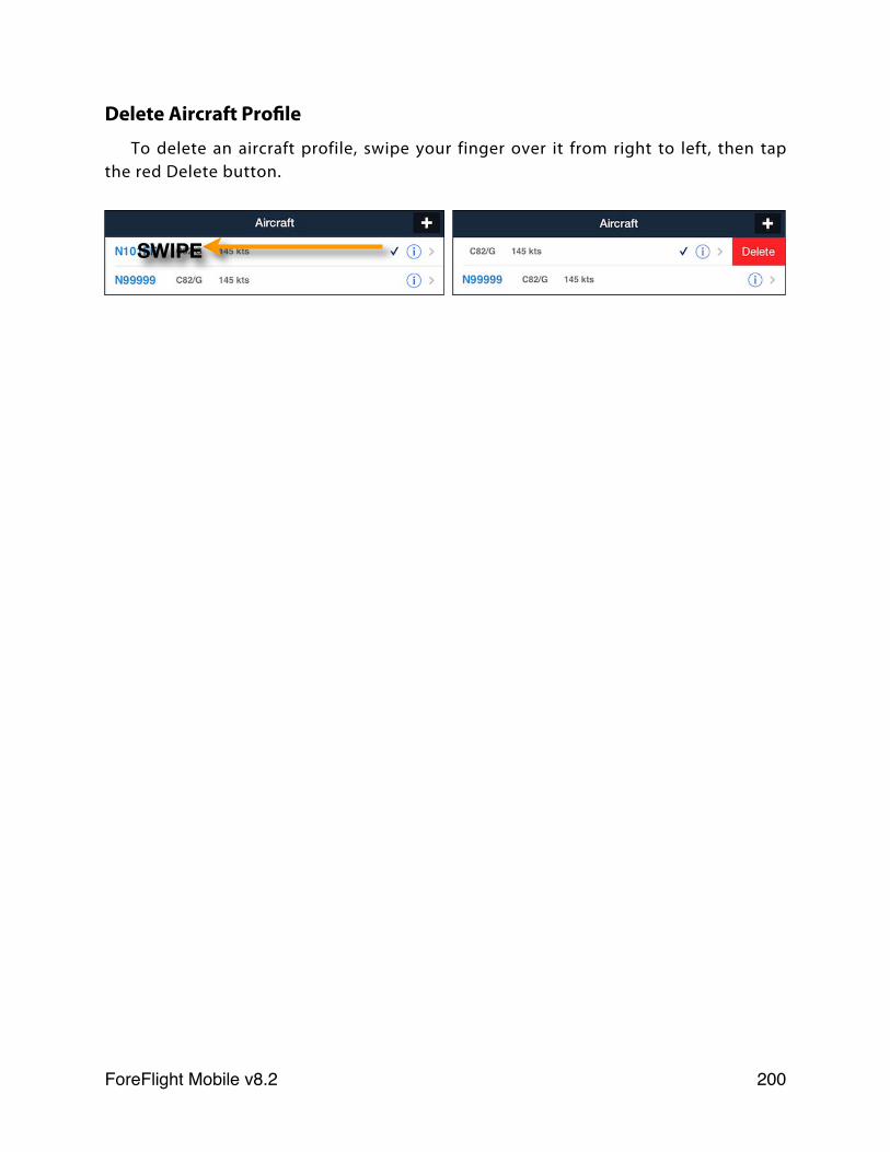
Delete Aircraft Profile
To delete an aircraft profile, swipe your finger over it from right to left, then tap the red Delete button.
SWIPE
ForeFlight Mobile v8.2! 200
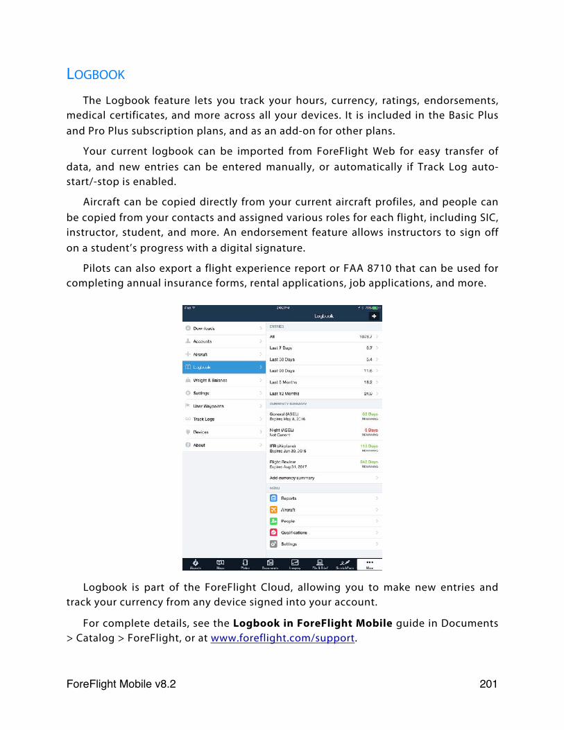
LOGBOOK
The Logbook feature lets you track your hours, currency, ratings, endorsements, medical certificates, and more across all your devices. It is included in the Basic Plus and Pro Plus subscription plans, and as an add-on for other plans.
Your current logbook can be imported from ForeFlight Web for easy transfer of data, and new entries can be entered manually, or automatically if Track Log auto-start/-stop is enabled.
Aircraft can be copied directly from your current aircraft profiles, and people can be copied from your contacts and assigned various roles for each flight, including SIC, instructor, student, and more. An endorsement feature allows instructors to sign off on a student’s progress with a digital signature.
Pilots can also export a flight experience report or FAA 8710 that can be used for completing annual insurance forms, rental applications, job applications, and more.
Logbook is part of the ForeFlight Cloud, allowing you to make new entries and track your currency from any device signed into your account.
For complete details, see the Logbook in ForeFlight Mobile guide in Documents > Catalog > ForeFlight, or at www.foreflight.com/support.
ForeFlight Mobile v8.2! 201
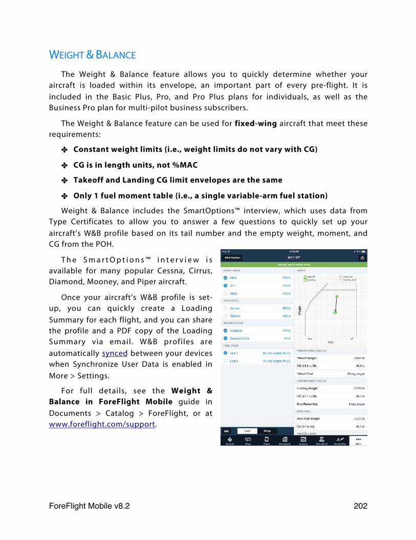
WEIGHT & BALANCE
The Weight & Balance feature allows you to quickly determine whether your aircraft is loaded within its envelope, an important part of every pre-flight. It is included in the Basic Plus, Pro, and Pro Plus plans for individuals, as well as the Business Pro plan for multi-pilot business subscribers.
The Weight & Balance feature can be used for fixed-wing aircraft that meet these requirements:
✤ Constant weight limits (i.e., weight limits do not vary with CG)
✤ CG is in length units, not %MAC
✤ Takeoff and Landing CG limit envelopes are the same
✤ Only 1 fuel moment table (i.e., a single variable-arm fuel station)
Weight & Balance includes the SmartOptions™ interview, which uses data from Type Certificates to allow you to answer a few questions to quickly set up your aircraft’s W&B profile based on its tail number and the empty weight, moment, and CG from the POH.
T h e S m a r t O p t i o n s ™ i n t e r v i e w i s available for many popular Cessna, Cirrus, Diamond, Mooney, and Piper aircraft.
Once your aircraft’s W&B profile is set-up, you can quickly create a Loading Summary for each flight, and you can share the profile and a PDF copy of the Loading Summary via email. W&B profiles are automatically synced between your devices when Synchronize User Data is enabled in More > Settings.
For full details, see the Weight & Balance in ForeFlight Mobile guide in Documents > Catalog > ForeFlight, or at www.foreflight.com/support.
ForeFlight Mobile v8.2! 202
SETTINGS
ForeFlight Mobile supports a variety of settings to let you customize how you like to use and view your data. Settings are changed in the More view or the main Settings application on the iPad.
All settings will be reset to their default values if you uninstall ForeFlight Mobile.
✤ Brightness Slider - integrates with the iPad’s brightness slider, but allows for additional dimming if the lowest setting of the iPad’s slider is not dark enough.
Airport View
✤ Show Weather First - turn ON to show the METAR view first when viewing an airport. Turn off to see that last-viewed data category first.
Weather View
✤ Past TAF Translations - turn ON to see expired TAF forecast time periods in the weather view. Turn OFF to hide expired TAF forecast periods.
Route View
✤ Airway Decoding - set to Bends Only to filter out airway intersections that do not cause a course change. VORs and NDBs will always be shown in an airway.
✤ Airway Entry/Exit - select Any Waypoint or Radio Navaids Only for auto routing from the “Routes” button in the NavLog.
Map View
✤ Auto Center Mode - select Track Up, Track Up Forward, or North Up.
✤ Auto Center Deactivate - select from automatic (auto center mode will turn off the instant you manually pan or zoom the map) or manual (the auto center crosshair button must be pressed to disable auto center mode).
✤ Extended Centerlines - turn ON to see extended runway centerlines for airports in the current route. Centerlines extend 5 NM from runway end.
✤ Distance Rings - turn ON to show 3 concentric rings centered around your aircraft’s location, in the the style selected in Distance Rings Style.
✤ Distance Rings Style - choose between: Automatic, which changes the NM scale of the rings as you zoom in and out on the Maps; Distance-based: 5, 10, 25 NM or 10, 20, 50 NM or 20, 40, 100 NM; or Time-based, which adjust the size of the rings based on groundspeed to show where your aircraft will be in: 5, 10, 30 minutes or 10, 20, 60 minutes.
ForeFlight Mobile v8.2! 203
✤ Track Vector - turn ON to display a vector in front of your aircraft’s icon.
✤ Track Vector Length - tap to select the length of the track vector: 15, 30, 45, 60 seconds; 2, 5, 10 minutes; 1/2, 1, 2, 5, 10, 25, 50 Nautical Miles.
✤ Profile Corridor Width - total width of the profile corridor; obstacles and terrain within the corridor are shown in the Profile view: 1/2, 1, 2, 4, 6, 8, 20 Nautical Miles wide.
✤ Route Labels - turn ON to see labels on route waypoints on Map. When ON, these labels will each hide/show to prevent overlapping with each other.
✤ Nav Log Columns - select columns to display in NavLog on Maps page: Totals Only, Leg only or Both (default).
✤ Current Location Marker - select an image to be used on Maps view to show your current location when in motion.
✤ Initial Map - whether the last-viewed map should be shown when the app starts, or a different base map.
✤ Hazard Advisor - select minimum groundspeed for Hazard Advisor layer to be active when it is selected on Maps.
✤ Hazard Altitudes - altitudes for the Red and Yellow colors in Hazard Advisor and Profile view. First number is the altitude below the aircraft for the Red color (also includes above current altitude), 2nd number is the altitude below the aircraft for the Yellow color: Normal (100’/1000’); Heli - Normal (50’/300’); Heli - Medium (25’/200’); Heli - Low (25’/100’).
✤ Map Touch Action - No Action: charts are seamlessly stitched together; Bring chart to front: single-tap on a chart to bring it forward, covering any adjacent overlapping charts; Bring chart to front with legends: same behavior as Bring chart to front but also displays the frontmost chart’s legend and borders.
✤ Four-color Radar - turn ON to display radar in a low resolution, four-color scheme that complies with dBZ-to-color mapping standards defined by the Radio Technical Commission for Aeronautics. See Radar Legends for more information.
✤ Cockpit Sharing - turn ON to allow sharing routes between devices running ForeFlight Mobile on the same WiFi network.
✤ Show Annotations on Map - turn ON to show plate or airport diagram annotations when displaying a Plate or Airport Diagram on the Map.
✤ Auto-Receive Panel Flight Plans - turn ON to automatically load new routes received from a Garmin Connext connected panel to your NavLog. Turn OFF to receive a notification when a new route is available and manually load it.
ForeFlight Mobile v8.2! 204
Plate and Document Views
✤ Lock Disables Buttons - turn ON to disable all buttons on Plates and Documents views when lock button is bright blue in top toolbar. This will also disable the bottom buttons that are used to change to other views like Airports, Maps, etc.
Traffic
✤ Hide Distant Traffic (when connected to a Stratus ADS-B receiver) - turn this ON to hide traffic more than 15NM from your current GPS location and/or more than 3,500’ above or below your current GPS altitude.
Search and Rescue
✤ Enable Search and Rescue - turn ON to enable the SAR grid overlays and SAR patterns (iPad only). See Search and Rescue Supplement, available in Documents > Catalog > ForeFlight. SAR features are accessed via the Procedure Preview.
✤ SAR Waypoints as Lat/Lon (iPad only) - turn ON to display the waypoint labels in a SAR pattern as Latitude/Longitude, instead of SAR-01, SAR-02, etc...
Pack
✤ Enable Auto-Check - turn ON to have Pack automatically check whether downloads are needed prior to the flight. Turn OFF to only activate Pack by tapping the Pack “suitcase” button at the bottom of the NavLog.
Track Log
✤ Enable Start/Stop Control - turn ON to show the Track Log “REC” button and the Track Log timer in the bottom-left of the Maps view. Starting or stopping a Track Log by tapping the REC button overrides the Track Log auto start/stop functionality, if that setting is enabled.
✤ Enable Auto Start/Stop - turn ON to automatically record Track Logs without tapping the REC button.
File & Brief
✤ New Plan Format - Same as Last Filed, ICAO, or FAA/Domestic: lets you choose the default type of plan that will be created when you tap the New Flight Plan button on the File & Brief page. An individual flight plan type can be changed while creating the flight plan on the File & Brief page.
✤ ForeFlight Briefing - turn ON to use ForeFlight Briefing when requesting a weather briefing from the File & Brief view. Turn OFF to use the legacy text briefing instead.
ForeFlight Mobile v8.2! 205
✤ Enable Call Sign Field - turn ON to add a field below the Aircraft field in the flight plan form where you can specify a call sign for the flight. If no call sign is entered your aircraft’s tail number will be used instead.
Taxi Diagram
✤ Auto Show Taxi - turn ON to automatically switch to the current airport’s taxi diagram, when available, upon landing.
✤ Show Taxi on Map - turn ON to show the automatically-displayed taxi diagram overlaid on the Maps page; turn OFF to show on the Plates page.
Preferences
✤ Alerts - adjust settings related to in-app alerts. See Alerts for more information about each alert.
✤ Speak All Alerts - turn ON to receive audio alerts via your device’s speaker or a connected headset for all active alerts in ForeFlight. When toggled ON a confirmation message is played; use the iPad/iPhone volume buttons to adjust volume.
General
✤ 500’ AGL Alerts - turn ON to receive an alert when your aircraft descends past 500’ AGL.
✤ Cabin Altitude Alerts (requires iPad/iPhone or external device equipped with barometric sensor) - turn ON to receive alerts when your aircraft passes 12,000’ MSL and 25,000’ MSL.
✤ Runway Proximity Alerts - turn ON to receive alerts when nearing or entering a runway.
✤ Sink Rate Alerts - turn ON to receive an alert when your descending vertical speed becomes excessive (-4,000’ per minute above 2,500’ AGL, -3,000’ per minute at 2,500’ AGL, down to -1,500’ per minute at 500’ AGL).
✤ Traffic Alerts - turn ON to receive an alert when traffic is within 1.8 NM and +/- 1,200’ GPS altitude of your aircraft’s current position. NOTE: Traffic audio alerts are only issued when ADS-B Out is detected in your aircraft.
TFRs
✤ TFR Alerts - turn ON to receive alerts when you are approaching or near a TFR.
✤ Include DC SFRA/FRZ - turn OFF to prevent ForeFlight from issuing TFR alerts for Washington DC’s Special Flight Rules Area and Flight Restricted
ForeFlight Mobile v8.2! 206
Zone. Other TFRs within the SFRA/FRZ (e.g. stadium TFRs) will still trigger alerts when this setting is OFF - only the SFRA/FRZ are affected by it. Pilots are encouraged to leave this setting ON unless they regularly fly through the SFRA/FRZ.
✤ Altitude Buffer - height in feet added above and below TFRs that determines whether an alert is displayed based on your altitude relative to the TFR. For example, approaching a TFR whose top is 4,000’ below your current altitude will trigger an alert if the altitude buffer is set to 5,000’, but will not trigger an alert if the altitude buffer is set to a smaller height. Available buffers are 500’, 1,000’, 2,000’, and 5,000’.
✤ Units/Time - menu containing the following settings:
✤ Show Local Times - turn ON to see times in the local time zone. Turn off to see times in Zulu time.
✤ Wind Speed - select preferred units.
✤ Pressure - select preferred units.
✤ Temperature - select preferred units.
✤ Visibility - select preferred units.
✤ Latitude/Longitude - select preferred units for viewing coordinates.
✤ Aircraft Speed - select preferred units for airspeed and groundspeed.
✤ Distance - select preferred units for distance.
✤ Allow Device to Sleep - turn ON to allow your device to sleep while running ForeFlight Mobile, including when on Plates view or when downloading data. Turn OFF to ensure that the iPad will not enter sleep mode while ForeFlight Mobile is running in the foreground, even if your iPad is set to usually sleep after a certain period of inactivity.
✤ Automatic Clock Check - turn ON to automatically verify that your iPad’s system time is set correctly. If it is found to be incorrect, you will get an alert. Proper system time is important for many features in the app.
✤ Confirm Before Dial (iPhone only) - turn ON to display a pop-up when you tap on a phone number so you can confirm that you want to call the number.
✤ Enable Ownship - ALWAYS: shows your aircraft position on charts, and with ForeFlight Mobile Pro, on approach plates and airport diagrams; NEVER: your aircraft position is not shown on any chart or plate. This is required for certain operators; LIMITED: with ForeFlight Mobile Pro, shows your aircraft position on
ForeFlight Mobile v8.2! 207
the airport diagram when your speed is under 80 knots; above 80 knots, or when GPS location accuracy degrades below the requirements in AC-120-76C, the aircraft position will not be shown.
✤ Show Heliports - turn ON to view heliports in nearby airports lists. You can always search for heliports (and use them in routes) regardless of this setting.
✤ Show Private Airports - turn ON to see private airports in nearby airports lists. Private Airports include any airport not open to the public, including Military airports.
✤ Start on Last Screen - turn OFF to start on the Airports view on next launch. This can help if one view is causing the application to quit immediately after launch.
✤ Extra Keyboard Keys - turn OFF to hide the row of numbers 0-9 shown above the regular keyboard. When OFF, 0-9 are still accessible using the “.?123” key in the lower-left of the keyboard.
✤ Synchronize User Data - turn ON to synchronize user data automatically between devices via the cloud. See Sync for details.
✤ Enable Diagnostic Logs - turn ON to record diagnostic information as you download chart data. This information can then be sent to the ForeFlight Pilot Support Team to help troubleshoot problems you may be having downloading data.
ForeFlight Mobile v8.2! 208
USER WAYPOINTS
For more information about User Waypoints see Managing User Waypoints. Go to More > User Waypoints to display previously saved user waypoints. To edit a
waypoint’s details, tap the button. You can create a new user waypoint by using the + button in the upper right. This is the easiest way to create a waypoint if you elect to describe the waypoint using lat/lon (as opposed to selecting the point on a map).
Tap a waypoint’s name in the list to view it on the Maps view. Swipe-to-delete can be used to remove a waypoint. The clear button will remove all waypoints.
Waypoints can also be inserted by tapping on the Maps view. Tap & hold your finger on the Map for a moment then release it. A list of possible waypoints will pop up. Tap the grey “More” button next to the Lat/Lon coordinates and tap the blue “Save” button to to view the “User Waypoint” pop-up. Give the waypoint a name and optionally a description, then press the Save button to save it.
Waypoint names cannot contain any whitespace such as spaces or tabs. Waypoints can be added to a route on the Maps view like any other waypoint - just type the waypoint name as part of the route. User Waypoints can be added in bulk as well, using a KML or CSV file. See the ForeFlight website for details: www.foreflight.com/support/user-waypoints.
Latitude/Longitude FormatsFor *input* of latitude/longitude in User Waypoints or the Search box on the Maps
page, 4 formats are supported:
DD.dd
DD MM SS
DD MM.mm
DD MM SSs
Examples of these formats using this location 32°44’55.6”N, 80°45’57.6”W are:
DD.dd 32.75N/080.77W
DD MM SS 324456/-0804558
DD MM.mm 3244.93/-08045.96
DD MM SSs 3244556/-08045576
ForeFlight Mobile v8.2! 209
NOTES:
1) Latitude is always DD, and Longitude is always DDD.
2) Include a minus sign for Longitudes west and Latitudes south.
3) After *input* into the User Waypoint, these formats are *stored* in the DD.dd format. Or when tapping File & Brief from the NavLog, the DUATS filing form stores in the DDMMSSs format.
For *reading* Airport coordinates and ad-hoc tap-and-add coordinates ForeFlight allows you to select from 3 formats:
DD.dd
DD MM.mm
DD MM SS
To change formats within ForeFlight Mobile, tap More bottom-right, tap Settings, and under Units/Time, tap Latitude/Longitude, then select the format you want.
TRACK LOGS
The Track Logs view is where you can view and edit details about recorded Track Logs and export them to your logbook, share them via email, Facebook, or Twitter, or open them in other apps, such as Google Earth and CloudAhoy.
See Track Logs for more information.
ForeFlight Mobile v8.2! 210
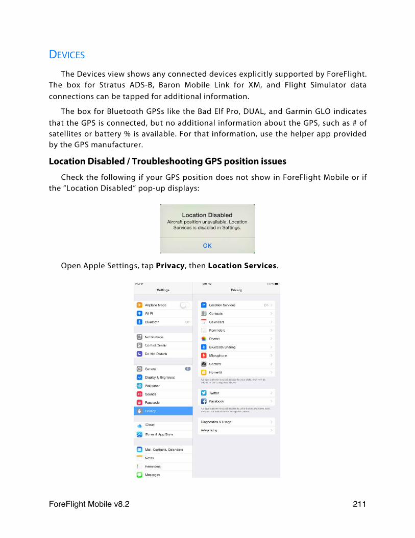
DEVICES
The Devices view shows any connected devices explicitly supported by ForeFlight. The box for Stratus ADS-B, Baron Mobile Link for XM, and Flight Simulator data connections can be tapped for additional information.
The box for Bluetooth GPSs like the Bad Elf Pro, DUAL, and Garmin GLO indicates that the GPS is connected, but no additional information about the GPS, such as # of satellites or battery % is available. For that information, use the helper app provided by the GPS manufacturer.
Location Disabled / Troubleshooting GPS position issues
Check the following if your GPS position does not show in ForeFlight Mobile or if the “Location Disabled” pop-up displays:
Open Apple Settings, tap Privacy, then Location Services.
ForeFlight Mobile v8.2! 211
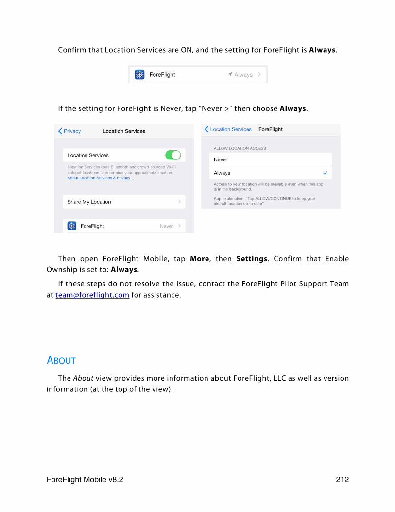
Confirm that Location Services are ON, and the setting for ForeFlight is Always.
If the setting for ForeFight is Never, tap “Never >” then choose Always.
Then open ForeFlight Mobile, tap More, then Settings. Confirm that Enable Ownship is set to: Always.
If these steps do not resolve the issue, contact the ForeFlight Pilot Support Team at [email protected] for assistance.
ABOUT
The About view provides more information about ForeFlight, LLC as well as version information (at the top of the view).
ForeFlight Mobile v8.2! 212
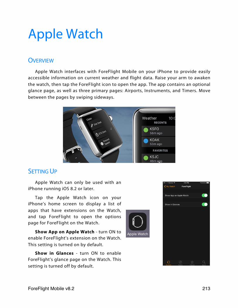
Apple Watch
OVERVIEW
Apple Watch interfaces with ForeFlight Mobile on your iPhone to provide easily accessible information on current weather and flight data. Raise your arm to awaken the watch, then tap the ForeFlight icon to open the app. The app contains an optional glance page, as well as three primary pages: Airports, Instruments, and Timers. Move between the pages by swiping sideways.
SETTING UP
Apple Watch can only be used with an iPhone running iOS 8.2 or later.
Tap the Apple Watch icon on your iPhone’s home screen to display a list of apps that have extensions on the Watch, and tap ForeFlight to open the options page for ForeFlight on the Watch.
Show App on Apple Watch - turn ON to enable ForeFlight’s extension on the Watch. This setting is turned on by default.
Show in Glances - turn ON to enable ForeFlight’s glance page on the Watch. This setting is turned off by default.
ForeFlight Mobile v8.2! 213
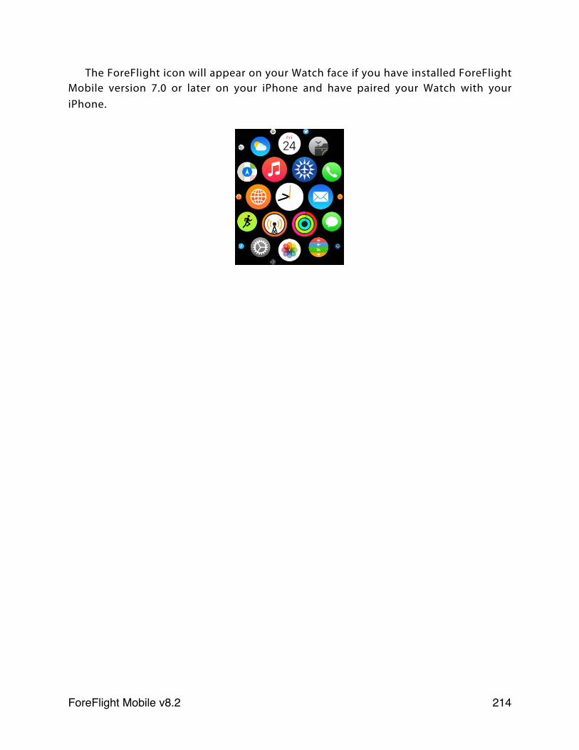
The ForeFlight icon will appear on your Watch face if you have installed ForeFlight Mobile version 7.0 or later on your iPhone and have paired your Watch with your iPhone.
ForeFlight Mobile v8.2! 214
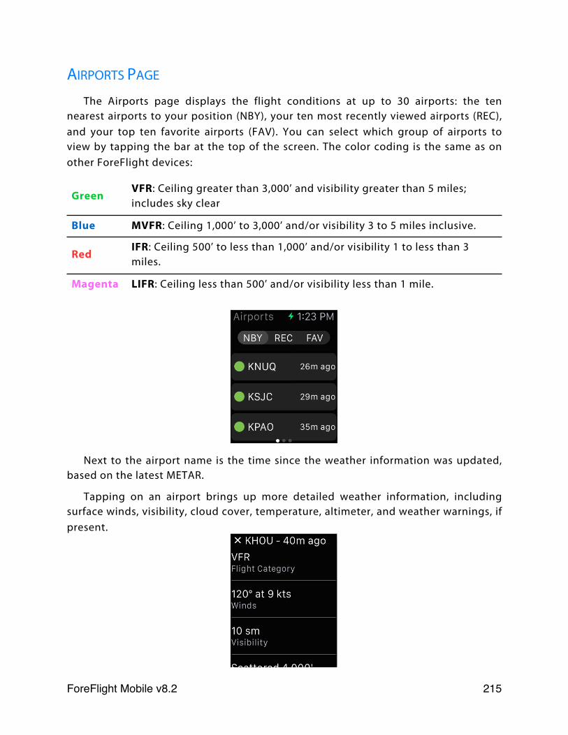
AIRPORTS PAGE
The Airports page displays the flight conditions at up to 30 airports: the ten nearest airports to your position (NBY), your ten most recently viewed airports (REC), and your top ten favorite airports (FAV). You can select which group of airports to view by tapping the bar at the top of the screen. The color coding is the same as on other ForeFlight devices:
GreenVFR: Ceiling greater than 3,000’ and visibility greater than 5 miles; includes sky clear
Blue MVFR: Ceiling 1,000’ to 3,000’ and/or visibility 3 to 5 miles inclusive.
RedIFR: Ceiling 500’ to less than 1,000’ and/or visibility 1 to less than 3 miles.
Magenta LIFR: Ceiling less than 500’ and/or visibility less than 1 mile.
Next to the airport name is the time since the weather information was updated, based on the latest METAR.
Tapping on an airport brings up more detailed weather information, including surface winds, visibility, cloud cover, temperature, altimeter, and weather warnings, if present.
ForeFlight Mobile v8.2! 215
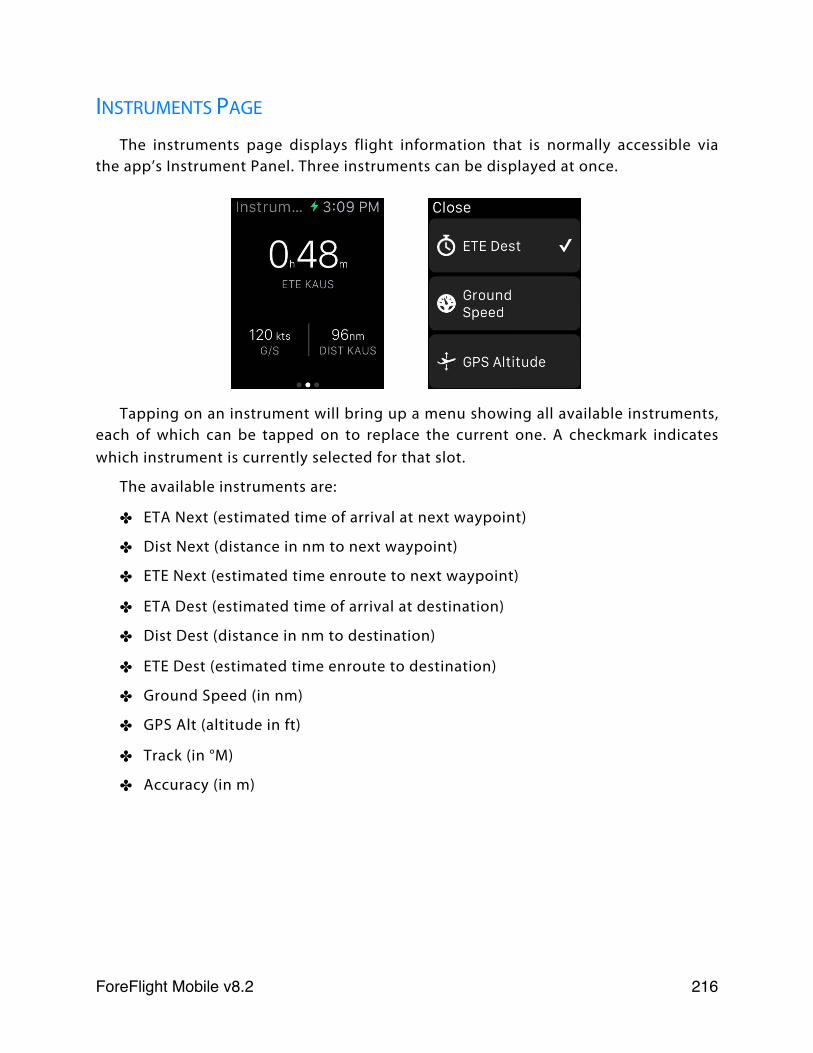
INSTRUMENTS PAGE
The instruments page displays flight information that is normally accessible via the app’s Instrument Panel. Three instruments can be displayed at once.
Tapping on an instrument will bring up a menu showing all available instruments, each of which can be tapped on to replace the current one. A checkmark indicates which instrument is currently selected for that slot.
The available instruments are:
✤ ETA Next (estimated time of arrival at next waypoint)
✤ Dist Next (distance in nm to next waypoint)
✤ ETE Next (estimated time enroute to next waypoint)
✤ ETA Dest (estimated time of arrival at destination)
✤ Dist Dest (distance in nm to destination)
✤ ETE Dest (estimated time enroute to destination)
✤ Ground Speed (in nm)
✤ GPS Alt (altitude in ft)
✤ Track (in °M)
✤ Accuracy (in m)
ForeFlight Mobile v8.2! 216
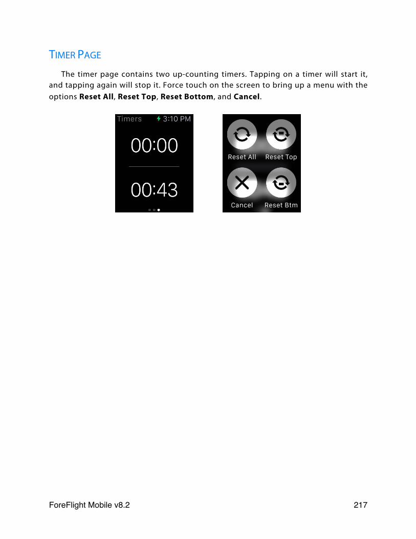
TIMER PAGE
The timer page contains two up-counting timers. Tapping on a timer will start it, and tapping again will stop it. Force touch on the screen to bring up a menu with the options Reset All, Reset Top, Reset Bottom, and Cancel.
ForeFlight Mobile v8.2! 217
ADS-B Weather
OVERVIEW
ForeFlight Mobile supports the Appareo Stratus ADS-B receivers. These devices provide ForeFlight Mobile with the ability to access ADS-B/FIS-B data from the network of ADS-B ground s t a t i o n s . P l e a s e c o n s u l t t h e S t r a t u s documentation to learn about how to set up and connect the device.
Multiple iPads or iPhones running ForeFlight Mobile can simultaneously connect to a Stratus using Wi-Fi. There is no significant practical limit to the number of iOS devices that can be connected to Stratus at once. However the iPad 1 is not recommended for use with the Stratus ADS-B receivers due to the iPad 1’s limited processor power.
DATA ACCESS IN FOREFLIGHT MOBILE
ForeFlight Mobile will automatically pull data from a Stratus when a connection is detected. When connected to a Stratus, ForeFlight Mobile will generally not use an available 3G/4G connection for data or chart gathering. However it is recommended that cellular data be turned OFF when using a Stratus.
These are the supported data items when using Stratus in ForeFlight Mobile:
✤ Radar - local and CONUS, shown on Maps. See radar color vs. intensity legends for Rain.
✤ METARs and METAR-derived data shown on Maps, such as temperature
✤ TAFs
✤ Winds Aloft
✤ TFRs on Maps page SEE IMPORTANT NOTICE BELOW
✤ PIREPs on Maps page
✤ AIRMETs/SIGMETs on Maps page
Important Note:If using a Stratus 1, ForeFlight Mobile must be running for ADS-B data to be saved. Do not “sleep” the app or turn off the screen while using Stratus 1, as no data will be received.
ForeFlight Mobile v8.2! 218
✤ Special Use Airspace status - shown on Maps page when viewing airspace details. Hold finger on airspace to view pop-over. Make sure All is selected at bottom of pop-over to see airspace details.
✤ Outage messages - messages about outages in ADS-B system can be viewed in Stratus status view.
The items listed above are viewed just as they are when on the ground using an Internet connection. There is no user-configuration required beyond ensuring the iPad or iPhone is connected to the Stratus Wi-Fi network.
STRATUS ESG (STRATUS 1S/2/2S ONLY)Stratus ESG is Appareo’s all-in-one certified ADS-B Out transponder solution. The
Stratus 1S, 2, or 2S can connect to Stratus ESG via USB cable (included in the Stratus ESG installation kit provided by the avionics dealer) to take advantage of the Stratus ESG’s certified WAAS GPS receiver and aircraft-mounted ADS-B antenna to boost GPS accuracy and provide improved ADS-B In tower reception. When connected via the USB cable, the Stratus ESG also supplies power to the Stratus 1S, 2, or 2S to keep the battery charged.
When a Stratus 1S, 2, or 2S is connected to the Stratus ESG, the Accuracy instrument in ForeFlight’s Instrument Panel will show “Accuracy (ESG)” to indicate that it is receiving GPS position data from the ESG.
TFRs IMPORTANT NOTICE:While using a Stratus ADS-B receiver, up-to-date graphical TFR information is ONLY displayed if you select the TFR Map overlay.However if the FAA publishes a TFR without associated graphical shape information it may not be possible for ForeFlight Mobile to show the graphical TFR on the Maps page.You should ALWAYS check the Airports page, under NOTAMs > TFRs for airports along your route, and contact FSS or ATC to confirm that your route does not cross any such TFRs.TFR data may not be updated or displayed if you are using a Stratus 1 and your iPad is “asleep” or is not connected to the Stratus. Stratus Replay in the Stratus 2 saves 30 minutes of recent TFR data for display when ForeFlight Mobile is re-opened. TFR data may also not be updated or displayed if the Stratus receiver is not receiving data from ADS-B towers, or if the ADS-B towers are not broadcasting information about that TFR.
ForeFlight Mobile v8.2! 219
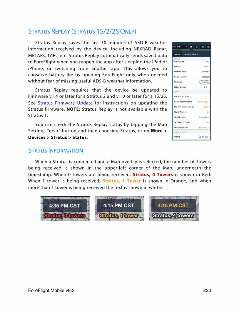
STRATUS REPLAY (STRATUS 1S/2/2S ONLY)Stratus Replay saves the last 30 minutes of ASD-B weather
information received by the device, including NEXRAD Radar, METARs, TAFs, etc. Stratus Replay automatically sends saved data to ForeFlight when you reopen the app after sleeping the iPad or iPhone, or switching from another app. This allows you to conserve battery life by opening ForeFlight only when needed without fear of missing useful ADS-B weather information.
Stratus Replay requires that the device be updated to Firmware v1.4 or later for a Stratus 2 and v1.0 or later for a 1S/2S. See Stratus Firmware Update for instructions on updating the Stratus firmware. NOTE: Stratus Replay is not available with the Stratus 1.
You can check the Stratus Replay status by tapping the Map Settings “gear” button and then choosing Stratus, or on More > Devices > Stratus > Status.
STATUS INFORMATION
When a Stratus is connected and a Map overlay is selected, the number of Towers being received is shown in the upper-left corner of the Map, underneath the timestamp. When 0 towers are being received, Stratus, 0 Towers is shown in Red. When 1 tower is being received, Stratus, 1 Tower is shown in Orange, and when more than 1 tower is being received the text is shown in white:
ForeFlight Mobile v8.2! 220

To see more detailed Stratus status information, tap the Map Settings “gear” button and then tap the Stratus entry, or tap on More > Devices > Stratus > Status.
The following details and Settings are provided on the Status view:
✤ Connected - shows “Yes” if a Stratus is connected via Wi-Fi.
✤ Battery - indicates remaining battery life in percent remaining. Not shown when charging Stratus.
✤ Power Source - indicates whether Stratus is being charged.
✤ Serial Number - Stratus serial number, only needed for technical support concerns.
✤ Firmware version - current version of firmware installed on Stratus.
✤ General NOTAMs - list of NOTAMs provided by ADS-B that were not assigned to an airport in ForeFlight Mobile.
✤ Local/National Update - date of most recent radar data, local data is generally < 5m old, national is generally < 15m old.
✤ Text Update - last time a new text report was downloaded (ex. METAR, TAF, Winds Aloft).
Scroll down to see additional settings and GPS Satellite Status
ForeFlight Mobile v8.2! 221
✤ Text Report Count - number of ADS-B-provided text reports in ForeFlight Mobile.
✤ Receiving From - number of ground-based towers currently providing Stratus with data. Number of towers is also shown on the Map below the timestamp.
✤ Stratus Replay Status (Stratus 1S/2S/2 Only) - indicates if the ADS-B data saved by Stratus, while ForeFlight Mobile was in the background or the iPad was sleeping, has been sent to ForeFlight Mobile. Up to 30 minutes of data is saved.
✤ Traffic Update (978/UAT) and (1090) - when traffic data was received on either band (1090 requires Stratus 2/2S).
✤ Ownship ADS-B Out - if your aircraft is equipped with ADS-B Out, tap this entry to display the information detected by the Stratus about your ADS-B Out transmissions.
✤ LED Brightness - used to adjust brightness of LEDs on Stratus.
✤ Turn On When Plugged In - when ON the Stratus will turn on when power is provided over the USB cable and turn OFF when power is removed. When power is removed the Stratus will turn OFF in 2 minutes only if the speed is < 5 knots. If speed is > 5 knots, the Stratus will not turn off until the speed drops below 5 knots, or the power button is pressed.
✤ Use As GPS - when ON, the Maps and other views will use GPS fix info from Stratus.
✤ Logging - used only for diagnosing problems, this manages logging of ADS-B data stream received by Stratus. Leave this OFF normally, as it reduces app performance.
✤ Power-Saving mode - reduces the WiFi transmit power to increase battery life.
✤ Show ADS-B Towers - show the location on the Map of the ADS-B Towers currently being received.
✤ WiFi Settings - implements WiFi security for the Stratus local network. Disabling SSID Broadcast makes your network’s name invisible to other iPads/iPhones, preventing them from joining your Stratus network unless they know the name of the network. Enabling WPA2 Security allows you to add a passcode to your device’s WiFi which must be entered in the WPA2 Passcode box when joining the network. Changes to the Stratus WiFi Settings require that the device be restarted. Note: If you forget the Network name or WPA2 passcode you set for your device, perform a factory reset to return it to default conditions: SSID Broadcast - Enabled, WPA Security - OFF, and no
ForeFlight Mobile v8.2! 222
passcode. You can perform a factory reset by holding the Stratus power button for 30 seconds
✤ Ignore Mfg. AHRS Settings (Stratus 2 and 2S) - when ON, Stratus will automatically recalibrate its AHRS every time it is powered on. It is recommended that this setting remain OFF unless the Stratus is providing subpar AHRS readings, which can happen after the Stratus is dropped or subjected to very large temperature variations. If you are receiving subpar AHRS readings, turn this setting ON and power cycle the Stratus while keeping the device as stationary as possible. The setting should then be turned back to OFF.
✤ Save AHRS Calibration (Stratus 2 and 2S) - when ON, Stratus will save a manual AHRS calibration between power cycles so it does not automatically re-adjust to straight and level every time it is turned back on. This setting is useful for pilots who cannot calibrate the Stratus on the ground due to their aircraft (or Stratus device) not being straight and level, such as with tail dragger aircraft. Note: The use of this feature depends on the Stratus not being moved after it is calibrated; moving the Stratus between flights will cause the saved calibration to become inaccurate, requiring a re-calibration during the next flight.
✤ Flight Data Recorder (Stratus 2/2S only) - when “Enabled “ is ON, Stratus will begin recording a track log as soon as it is turned on and the GPS senses motion (see Stratus Flight Data Recorder for more information)
✤ Track Logs (Stratus 2/2S only) - tap to view any track logs recorded by Stratus.
✤ Auto-Detect Segments (Stratus 2S only) - when ON, Stratus will automatically detect trip segments based on your ground speed and create a separate track log for each segment.
✤ GPS Satellite Status - shows location and signal lock for GPS satellites currently visible.
ForeFlight Mobile v8.2! 223

ANIMATED ADS-B RADAR
When the Radar overlay is selected on the Maps page, the animation play button is displayed in the lower-left corner of the screen. ForeFlight Mobile will animate (loop) up to 5 frames of NEXRAD data. Regional NEXRAD (within ~250 nm of your position) is updated every 5 minutes, while CONUS radar is updated every 15 minutes.
If you tap the play button before 2 or more frames of radar data have been received, you will see a message that the radar cannot be animated until more data is received.
Tap the Maps Settings (gear) button and then select Stratus > Status to see how many radar frames have been received.
ForeFlight Mobile v8.2! 224
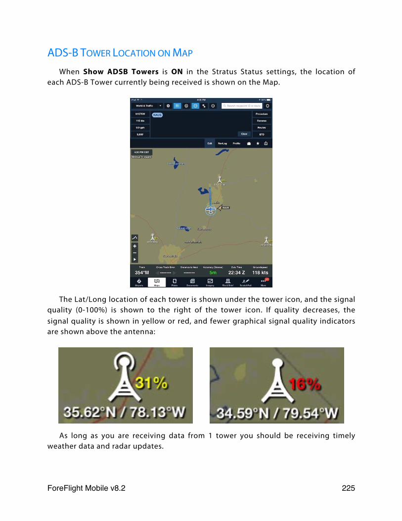
ADS-B TOWER LOCATION ON MAP
When Show ADSB Towers is ON in the Stratus Status settings, the location of each ADS-B Tower currently being received is shown on the Map.
The Lat/Long location of each tower is shown under the tower icon, and the signal quality (0-100%) is shown to the right of the tower icon. If quality decreases, the signal quality is shown in yellow or red, and fewer graphical signal quality indicators are shown above the antenna:
As long as you are receiving data from 1 tower you should be receiving timely weather data and radar updates.
ForeFlight Mobile v8.2! 225
ADS-B Traffic
OVERVIEW
ForeFlight Mobile supports the Appareo Stratus ADS-B receivers. These devices provide ForeFlight Mobile with the ability to access ADS-B/FIS-B data from the network of ADS-B ground stations. Please consult the Stratus documentation to learn about how to set up and connect the device.
Multiple iPads or iPhones running ForeFlight Mobile can simultaneously connect to a Stratus using Wi-Fi. There is no significant practical limit to the number of iOS devices that can be connected to Stratus at once. However, the iPad 1 is not recommended for use with the Stratus ADS-B receivers due to the iPad 1’s limited processor power.
IMPORTANT TRAFFIC NOTICE
TRAFFIC DISPLAY FEATURES MAY NOT SHOW ALL AIRCRAFT IN THE AREA AND ARE NOT TO BE USED AS A PRIMARY MEANS OF AIRCRAFT VISIBILITY, DETECTION OR AVOIDANCE. TRAFFIC DISPLAYED WILL VARY DEPENDING ON ADS-B COVERAGE AREAS AND ON THE TYPE AND VERSION OF ADS-B “IN” AND ADS-B “OUT” EQUIPMENT INSTALLED IN YOUR AIRCRAFT AND OTHER AIRCRAFT.
IF YOUR AIRCRAFT IS NOT EQUIPPED WITH ADS-B “OUT”, YOU WILL NOT RECEIVE A COMPLETE PICTURE OF TRAFFIC. YOU MAY EVEN RECEIVE NO TRAFFIC AT ALL. THIS IS DUE TO THE DESIGN AND IMPLEMENTATION OF THE ADS-B/TIS-B SYSTEM BY THE FAA.
TRAFFIC ACCESS IN FOREFLIGHT MOBILE
The Stratus 1/1S includes a single-band 978 MHz UAT receiver, while the Stratus 2/2S includes a dual-band 978 MHz UAT + 1090 MHz receiver. ADS-B traffic may be transmitted over one or both bands. Aircraft operating above 18,000’ use the 1090ES band, though these aircraft continue to broadcast on 1090ES when descending below 18,000’.
Important Note:ADS-B traffic data is NOT saved by Stratus Replay. When using any Stratus device, ForeFlight Mobile must be running in order for ADS-B traffic to be displayed.
ForeFlight Mobile v8.2! 226
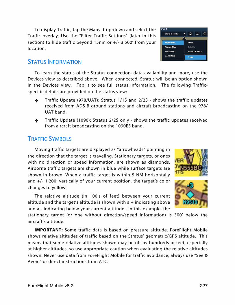
To display Traffic, tap the Maps drop-down and select the Traffic overlay. Use the “Filter Traffic Settings” (later in this section) to hide traffic beyond 15nm or +/- 3,500’ from your location.
STATUS INFORMATION
To learn the status of the Stratus connection, data availability and more, use the Devices view as described above. When connected, Stratus will be an option shown in the Devices view. Tap it to see full status information. The following Traffic-specific details are provided on the status view:
✤ Traffic Update (978/UAT): Stratus 1/1S and 2/2S - shows the traffic updates received from ADS-B ground stations and aircraft broadcasting on the 978/UAT band.
✤ Traffic Update (1090): Stratus 2/2S only - shows the traffic updates received from aircraft broadcasting on the 1090ES band.
TRAFFIC SYMBOLS
Moving traffic targets are displayed as “arrowheads” pointing in the direction that the target is traveling. Stationary targets, or ones with no direction or speed information, are shown as diamonds. Airborne traffic targets are shown in blue while surface targets are shown in brown. When a traffic target is within 5 NM horizontally and +/- 1,200’ vertically of your current position, the target’s color changes to yellow.
The relative altitude (in 100’s of feet) between your current altitude and the target’s altitude is shown with a + indicating above and a - indicating below your current altitude. In this example, the stationary target (or one without direction/speed information) is 300’ below the aircraft’s altitude.
IMPORTANT: Some traffic data is based on pressure altitude. ForeFlight Mobile shows relative altitudes of traffic based on the Stratus’ geometric/GPS altitude. This means that some relative altitudes shown may be off by hundreds of feet, especially at higher altitudes, so use appropriate caution when evaluating the relative altitudes shown. Never use data from ForeFlight Mobile for traffic avoidance, always use “See & Avoid” or direct instructions from ATC.
ForeFlight Mobile v8.2! 227
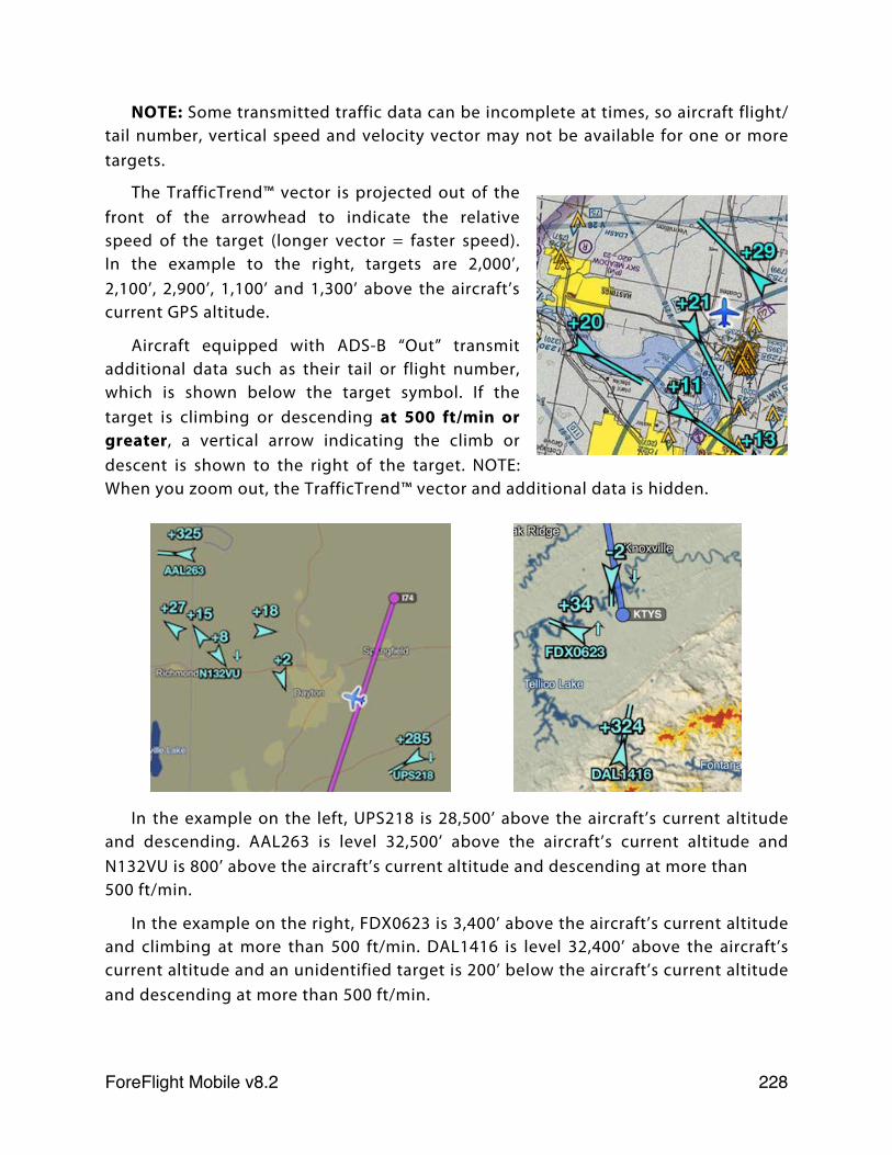
NOTE: Some transmitted traffic data can be incomplete at times, so aircraft flight/tail number, vertical speed and velocity vector may not be available for one or more targets.
The TrafficTrend™ vector is projected out of the front of the arrowhead to indicate the relative speed of the target (longer vector = faster speed). In the example to the right, targets are 2,000’, 2,100’, 2,900’, 1,100’ and 1,300’ above the aircraft’s current GPS altitude.
Aircraft equipped with ADS-B “Out” transmit additional data such as their tail or flight number, which is shown below the target symbol. If the target is climbing or descending at 500 ft/min or greater, a vertical arrow indicating the climb or descent is shown to the right of the target. NOTE: When you zoom out, the TrafficTrend™ vector and additional data is hidden.
In the example on the left, UPS218 is 28,500’ above the aircraft’s current altitude and descending. AAL263 is level 32,500’ above the aircraft’s current altitude and N132VU is 800’ above the aircraft’s current altitude and descending at more than 500 ft/min.
In the example on the right, FDX0623 is 3,400’ above the aircraft’s current altitude and climbing at more than 500 ft/min. DAL1416 is level 32,400’ above the aircraft’s current altitude and an unidentified target is 200’ below the aircraft’s current altitude and descending at more than 500 ft/min.
ForeFlight Mobile v8.2! 228

You can tap on any target to display a pop-up with additional information, which can include target tail or flight number, heading, speed, and whether the information was broadcast via 978UAT or 1090ES. Tap anywhere to close the pop-up.
HIDE DISTANT TRAFFIC SETTING
The Hide Distant Traffic setting, shown when your iPad or iPhone is connected to a Stratus ADS-B receiver, is accessed via the “Gear” button on the Maps page or on the More page under Devices > Stratus > Status.
When switched ON, this setting hides traffic that is more than 15NM away from your current GPS location and/or more than 3,500’ above or below your current altitude. This allows you to hide distant traffic targets and may be useful if you are flying in busy airspace or near large airports with lots of commercial traffic.
OWNSHIP ADS-B OUT INFORMATION
If your aircraft is equipped with ADS-B Out that is correctly configured and transmitting, tap the Ownship ADS-B Out entry in Stratus Status to see the tail-number, altitude and location being broadcast by your ADS-B Out equipment.
If your aircraft is not equipped with ADS-B Out, or the ADS-B Out is improperly configured or is not transmitting, the Ownship ADS-B Out entry shows Not Detected.
ForeFlight Mobile v8.2! 229
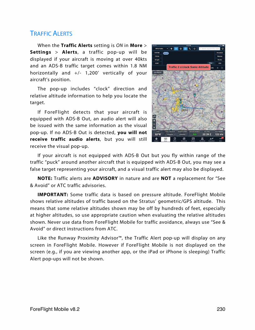
TRAFFIC ALERTS
When the Traffic Alerts setting is ON in More > Settings > Alerts , a traffic pop-up will be displayed if your aircraft is moving at over 40kts and an ADS-B traffic target comes within 1.8 NM horizontally and +/- 1,200’ vertically of your aircraft’s position.
The pop-up includes “clock” direction and relative altitude information to help you locate the target.
If ForeFlight detects that your aircraft is equipped with ADS-B Out, an audio alert will also be issued with the same information as the visual pop-up. If no ADS-B Out is detected, you will not receive traffic audio alerts, but you will still receive the visual pop-up.
If your aircraft is not equipped with ADS-B Out but you fly within range of the traffic “puck” around another aircraft that is equipped with ADS-B Out, you may see a false target representing your aircraft, and a visual traffic alert may also be displayed.
NOTE: Traffic alerts are ADVISORY in nature and are NOT a replacement for “See & Avoid” or ATC traffic advisories.
IMPORTANT: Some traffic data is based on pressure altitude. ForeFlight Mobile shows relative altitudes of traffic based on the Stratus’ geometric/GPS altitude. This means that some relative altitudes shown may be off by hundreds of feet, especially at higher altitudes, so use appropriate caution when evaluating the relative altitudes shown. Never use data from ForeFlight Mobile for traffic avoidance, always use “See & Avoid” or direct instructions from ATC.
Like the Runway Proximity Advisor™, the Traffic Alert pop-up will display on any screen in ForeFlight Mobile. However if ForeFlight Mobile is not displayed on the screen (e.g., if you are viewing another app, or the iPad or iPhone is sleeping) Traffic Alert pop-ups will not be shown.
ForeFlight Mobile v8.2! 230
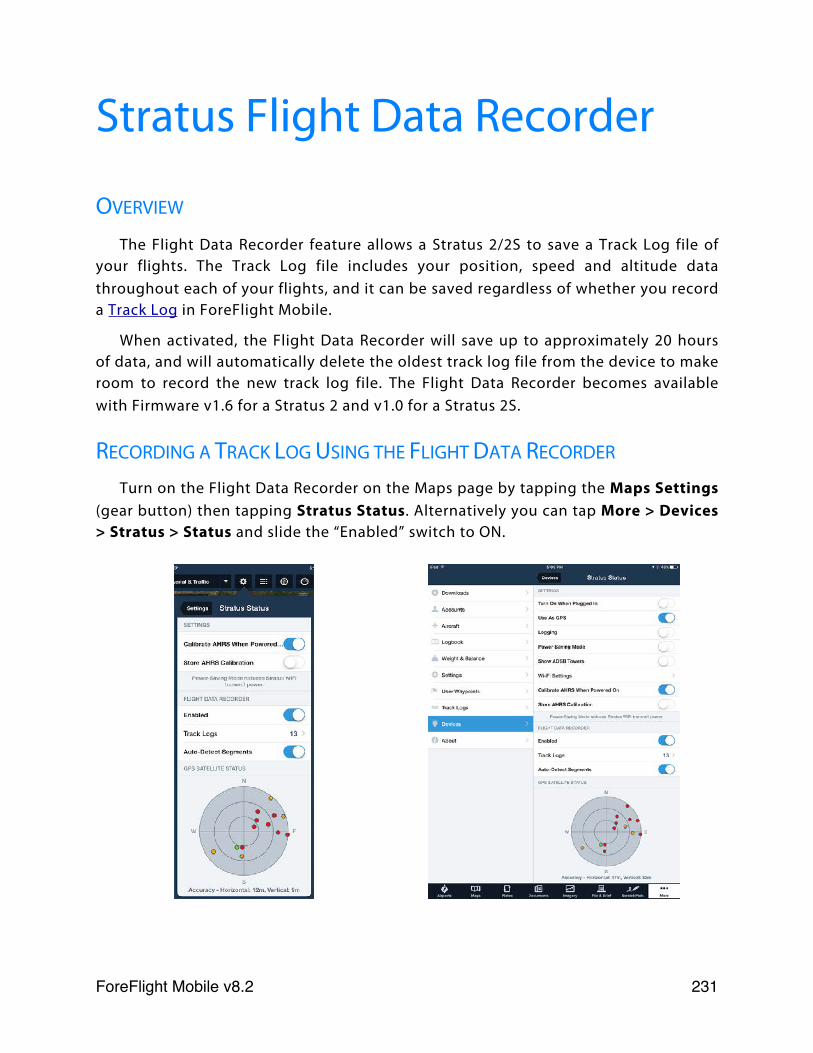
Stratus Flight Data Recorder
OVERVIEW
The Flight Data Recorder feature allows a Stratus 2/2S to save a Track Log file of your flights. The Track Log file includes your position, speed and altitude data throughout each of your flights, and it can be saved regardless of whether you record a Track Log in ForeFlight Mobile.
When activated, the Flight Data Recorder will save up to approximately 20 hours of data, and will automatically delete the oldest track log file from the device to make room to record the new track log file. The Flight Data Recorder becomes available with Firmware v1.6 for a Stratus 2 and v1.0 for a Stratus 2S.
RECORDING A TRACK LOG USING THE FLIGHT DATA RECORDER
Turn on the Flight Data Recorder on the Maps page by tapping the Maps Settings (gear button) then tapping Stratus Status. Alternatively you can tap More > Devices > Stratus > Status and slide the “Enabled” switch to ON.
ForeFlight Mobile v8.2! 231
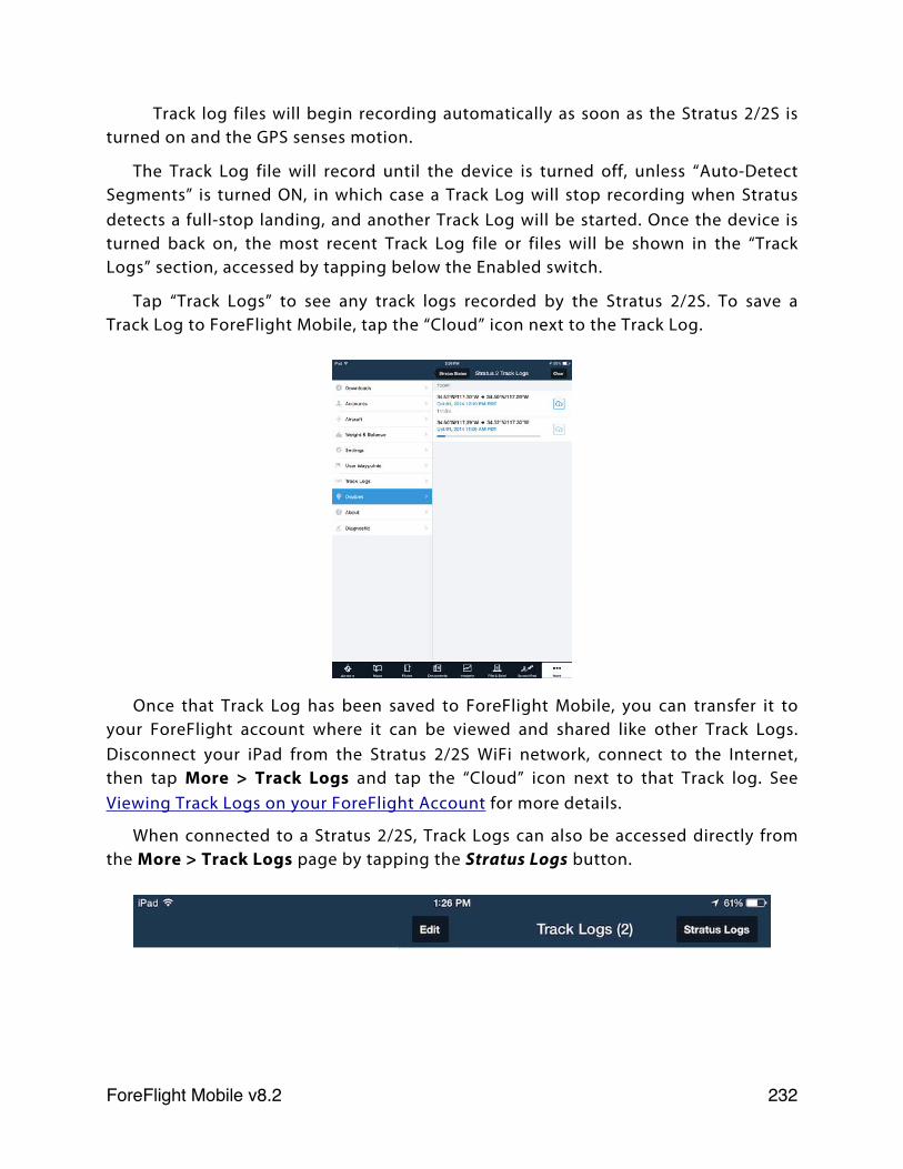
Track log files will begin recording automatically as soon as the Stratus 2/2S is turned on and the GPS senses motion.
The Track Log file will record until the device is turned off, unless “Auto-Detect Segments” is turned ON, in which case a Track Log will stop recording when Stratus detects a full-stop landing, and another Track Log will be started. Once the device is turned back on, the most recent Track Log file or files will be shown in the “Track Logs” section, accessed by tapping below the Enabled switch.
Tap “Track Logs” to see any track logs recorded by the Stratus 2/2S. To save a Track Log to ForeFlight Mobile, tap the “Cloud” icon next to the Track Log.
Once that Track Log has been saved to ForeFlight Mobile, you can transfer it to your ForeFlight account where it can be viewed and shared like other Track Logs. Disconnect your iPad from the Stratus 2/2S WiFi network, connect to the Internet, then tap More > Track Logs and tap the “Cloud” icon next to that Track log. See Viewing Track Logs on your ForeFlight Account for more details.
When connected to a Stratus 2/2S, Track Logs can also be accessed directly from the More > Track Logs page by tapping the Stratus Logs button.
ForeFlight Mobile v8.2! 232
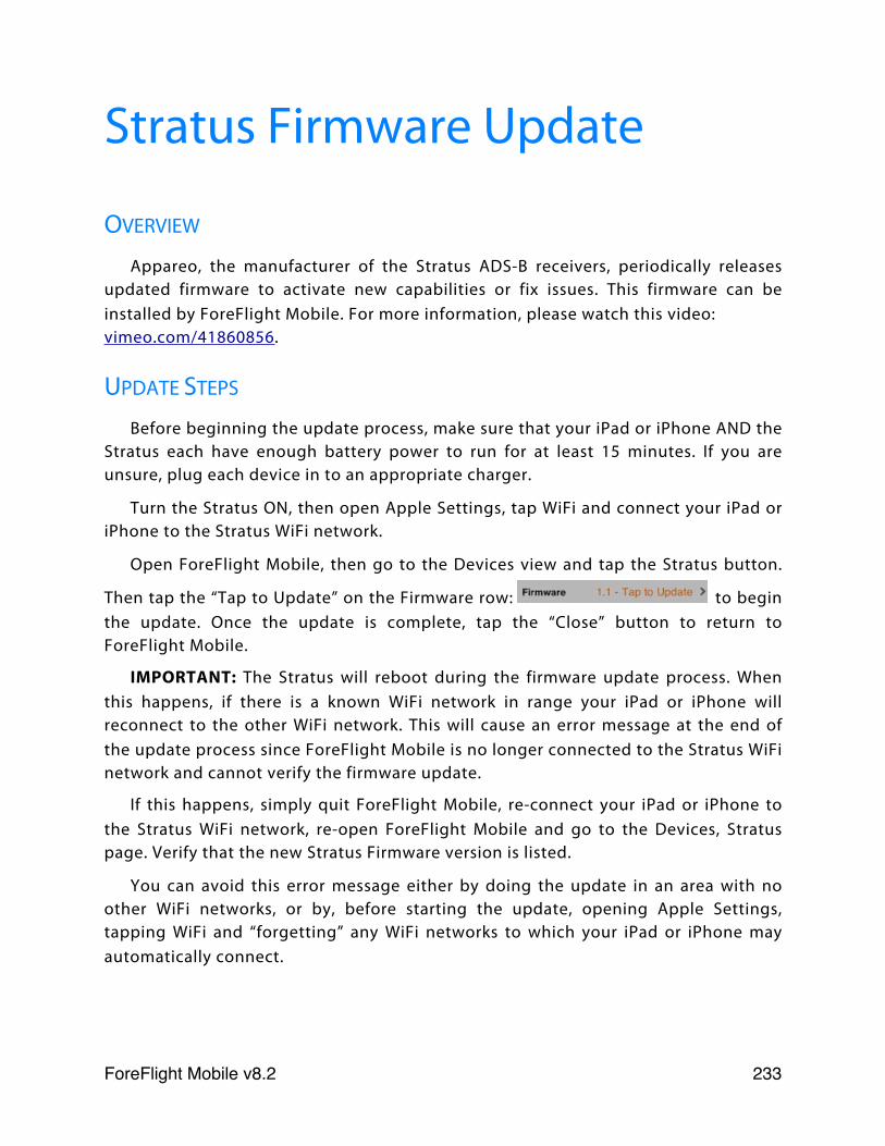
Stratus Firmware Update
OVERVIEW
Appareo, the manufacturer of the Stratus ADS-B receivers, periodically releases updated firmware to activate new capabilities or fix issues. This firmware can be installed by ForeFlight Mobile. For more information, please watch this video:vimeo.com/41860856.
UPDATE STEPS
Before beginning the update process, make sure that your iPad or iPhone AND the Stratus each have enough battery power to run for at least 15 minutes. If you are unsure, plug each device in to an appropriate charger.
Turn the Stratus ON, then open Apple Settings, tap WiFi and connect your iPad or iPhone to the Stratus WiFi network.
Open ForeFlight Mobile, then go to the Devices view and tap the Stratus button.
Then tap the “Tap to Update” on the Firmware row: to begin the update. Once the update is complete, tap the “Close” button to return to ForeFlight Mobile.
IMPORTANT: The Stratus will reboot during the firmware update process. When this happens, if there is a known WiFi network in range your iPad or iPhone will reconnect to the other WiFi network. This will cause an error message at the end of the update process since ForeFlight Mobile is no longer connected to the Stratus WiFi network and cannot verify the firmware update.
If this happens, simply quit ForeFlight Mobile, re-connect your iPad or iPhone to the Stratus WiFi network, re-open ForeFlight Mobile and go to the Devices, Stratus page. Verify that the new Stratus Firmware version is listed.
You can avoid this error message either by doing the update in an area with no other WiFi networks, or by, before starting the update, opening Apple Settings, tapping WiFi and “forgetting” any WiFi networks to which your iPad or iPhone may automatically connect.
ForeFlight Mobile v8.2! 233
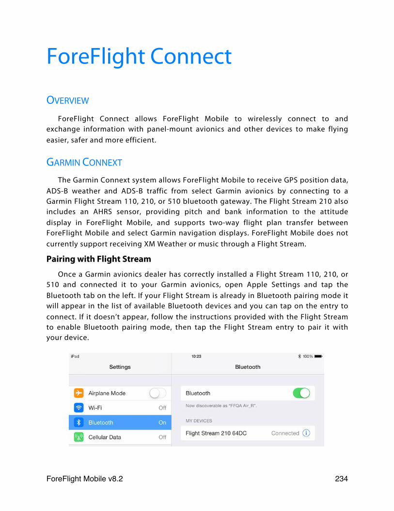
ForeFlight Connect
OVERVIEW
ForeFlight Connect allows ForeFlight Mobile to wirelessly connect to and exchange information with panel-mount avionics and other devices to make flying easier, safer and more efficient.
GARMIN CONNEXT
The Garmin Connext system allows ForeFlight Mobile to receive GPS position data, ADS-B weather and ADS-B traffic from select Garmin avionics by connecting to a Garmin Flight Stream 110, 210, or 510 bluetooth gateway. The Flight Stream 210 also includes an AHRS sensor, providing pitch and bank information to the attitude display in ForeFlight Mobile, and supports two-way flight plan transfer between ForeFlight Mobile and select Garmin navigation displays. ForeFlight Mobile does not currently support receiving XM Weather or music through a Flight Stream.
Pairing with Flight Stream
Once a Garmin avionics dealer has correctly installed a Flight Stream 110, 210, or 510 and connected it to your Garmin avionics, open Apple Settings and tap the Bluetooth tab on the left. If your Flight Stream is already in Bluetooth pairing mode it will appear in the list of available Bluetooth devices and you can tap on the entry to connect. If it doesn’t appear, follow the instructions provided with the Flight Stream to enable Bluetooth pairing mode, then tap the Flight Stream entry to pair it with your device.
ForeFlight Mobile v8.2! 234
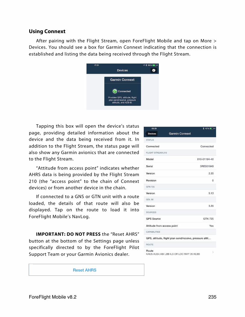
Using Connext
After pairing with the Flight Stream, open ForeFlight Mobile and tap on More > Devices. You should see a box for Garmin Connext indicating that the connection is established and listing the data being received through the Flight Stream.
Tapping this box will open the device’s status page, providing detailed information about the device and the data being received from it. In addition to the Flight Stream, the status page will also show any Garmin avionics that are connected to the Flight Stream.
“Attitude from access point” indicates whether AHRS data is being provided by the Flight Stream 210 (the “access point” to the chain of Connext devices) or from another device in the chain.
If connected to a GNS or GTN unit with a route loaded, the details of that route will also be displayed. Tap on the route to load it into ForeFlight Mobile’s NavLog.
IMPORTANT: DO NOT PRESS the “Reset AHRS” button at the bottom of the Settings page unless specifically directed to by the ForeFlight Pilot Support Team or your Garmin Avionics dealer.
ForeFlight Mobile v8.2! 235
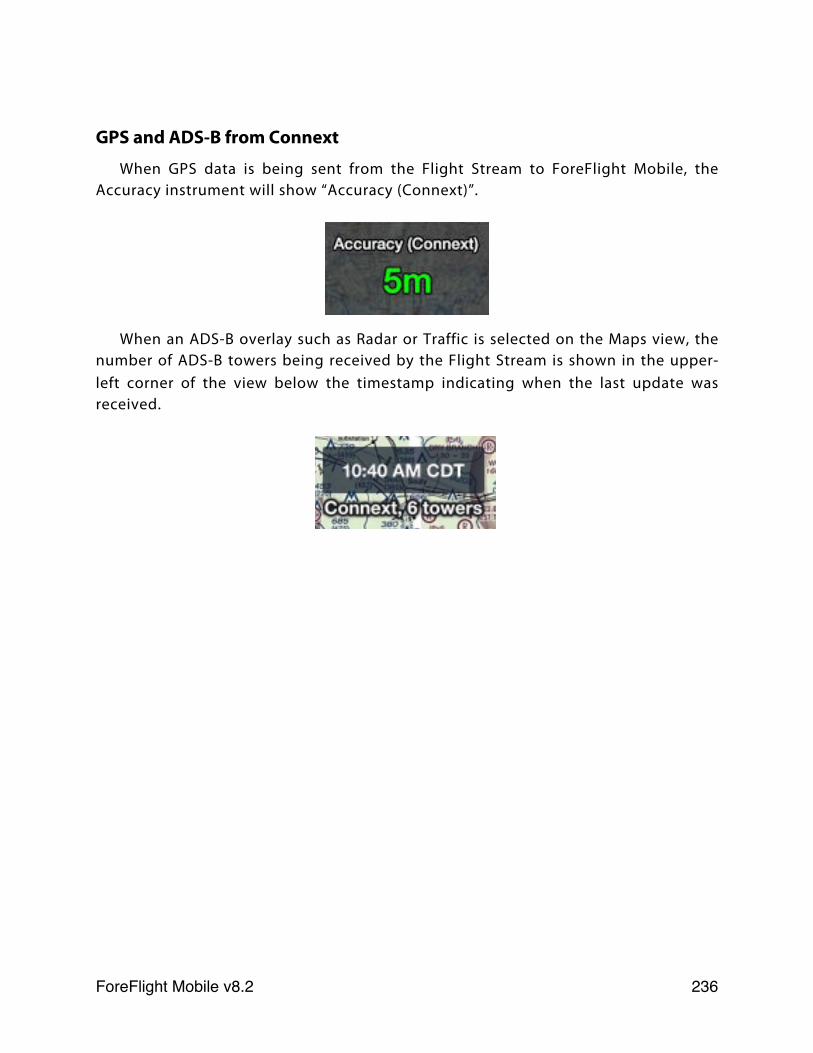
GPS and ADS-B from Connext
When GPS data is being sent from the Flight Stream to ForeFlight Mobile, the Accuracy instrument will show “Accuracy (Connext)”.
When an ADS-B overlay such as Radar or Traffic is selected on the Maps view, the number of ADS-B towers being received by the Flight Stream is shown in the upper-left corner of the view below the timestamp indicating when the last update was received.
ForeFlight Mobile v8.2! 236
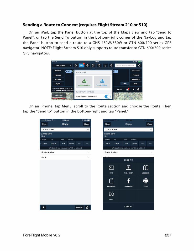
Sending a Route to Connext (requires Flight Stream 210 or 510)
On an iPad, tap the Panel button at the top of the Maps view and tap “Send to Panel”, or tap the Send To button in the bottom-right corner of the NavLog and tap the Panel button to send a route to a GNS 430W/530W or GTN 600/700 series GPS navigator. NOTE: Flight Stream 510 only supports route transfer to GTN 600/700 series GPS navigators.
On an iPhone, tap Menu, scroll to the Route section and choose the Route. Then tap the “Send to” button in the bottom-right and tap “Panel.”
ForeFlight Mobile v8.2! 237
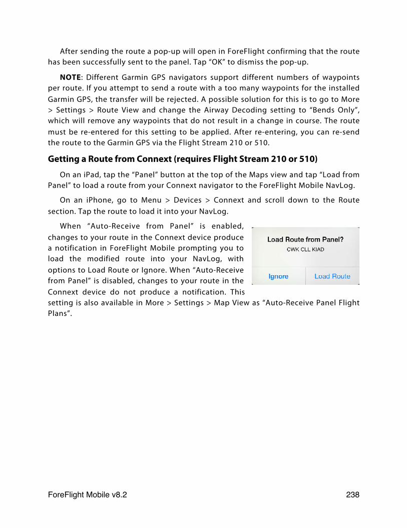
After sending the route a pop-up will open in ForeFlight confirming that the route has been successfully sent to the panel. Tap “OK” to dismiss the pop-up.
NOTE: Different Garmin GPS navigators support different numbers of waypoints per route. If you attempt to send a route with a too many waypoints for the installed Garmin GPS, the transfer will be rejected. A possible solution for this is to go to More > Settings > Route View and change the Airway Decoding setting to “Bends Only”, which will remove any waypoints that do not result in a change in course. The route must be re-entered for this setting to be applied. After re-entering, you can re-send the route to the Garmin GPS via the Flight Stream 210 or 510.
Getting a Route from Connext (requires Flight Stream 210 or 510)
On an iPad, tap the “Panel” button at the top of the Maps view and tap “Load from Panel” to load a route from your Connext navigator to the ForeFlight Mobile NavLog.
On an iPhone, go to Menu > Devices > Connext and scroll down to the Route section. Tap the route to load it into your NavLog.
When “Auto-Receive from Panel” is enabled, changes to your route in the Connext device produce a notification in ForeFlight Mobile prompting you to load the modified route into your NavLog, with options to Load Route or Ignore. When “Auto-Receive from Panel” is disabled, changes to your route in the Connext device do not produce a notification. This setting is also available in More > Settings > Map View as “Auto-Receive Panel Flight Plans”.
ForeFlight Mobile v8.2! 238
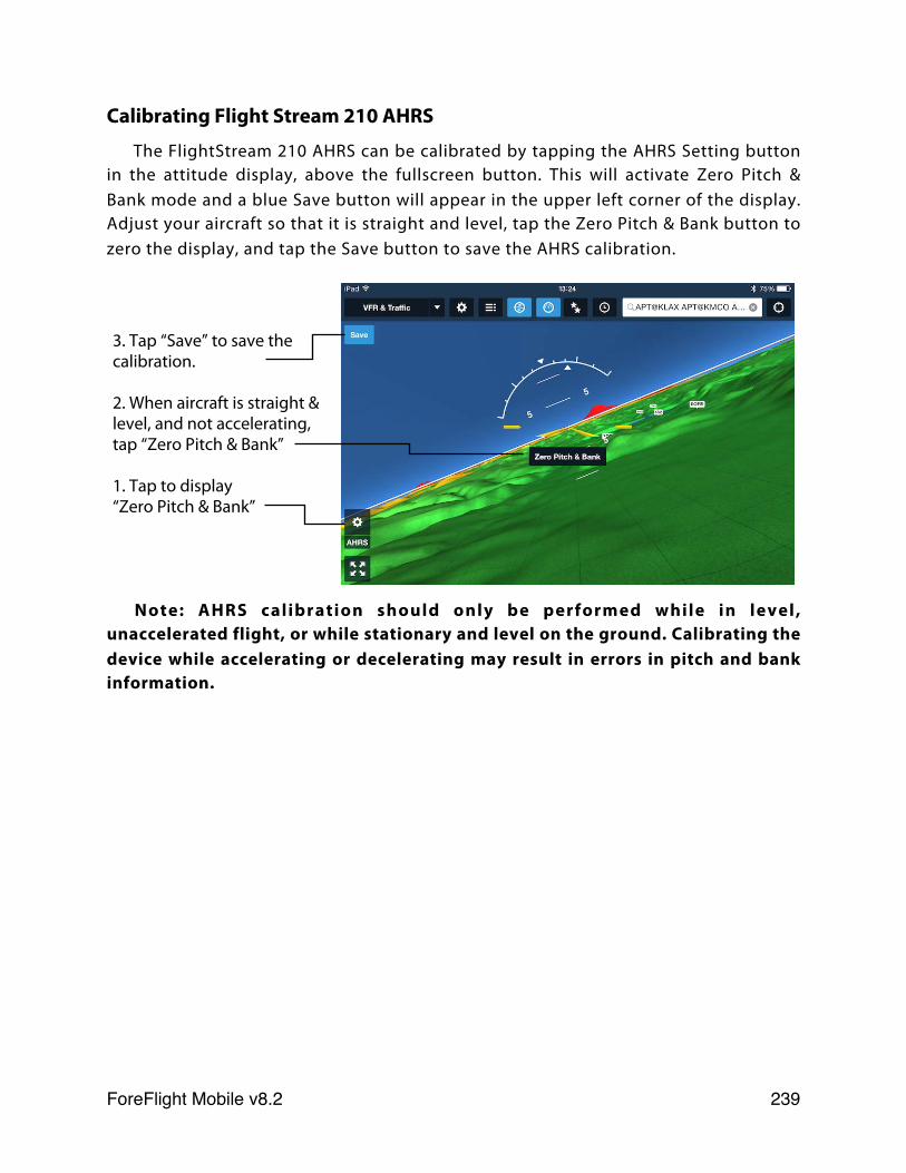
Calibrating Flight Stream 210 AHRS
The FlightStream 210 AHRS can be calibrated by tapping the AHRS Setting button in the attitude display, above the fullscreen button. This will activate Zero Pitch & Bank mode and a blue Save button will appear in the upper left corner of the display. Adjust your aircraft so that it is straight and level, tap the Zero Pitch & Bank button to zero the display, and tap the Save button to save the AHRS calibration.
Note: AHRS calibration should only be performed while in level, unaccelerated flight, or while stationary and level on the ground. Calibrating the device while accelerating or decelerating may result in errors in pitch and bank information.
3. Tap “Save” to save the calibration.
2. When aircraft is straight & level, and not accelerating, tap “Zero Pitch & Bank”
1. Tap to display “Zero Pitch & Bank”
ForeFlight Mobile v8.2! 239
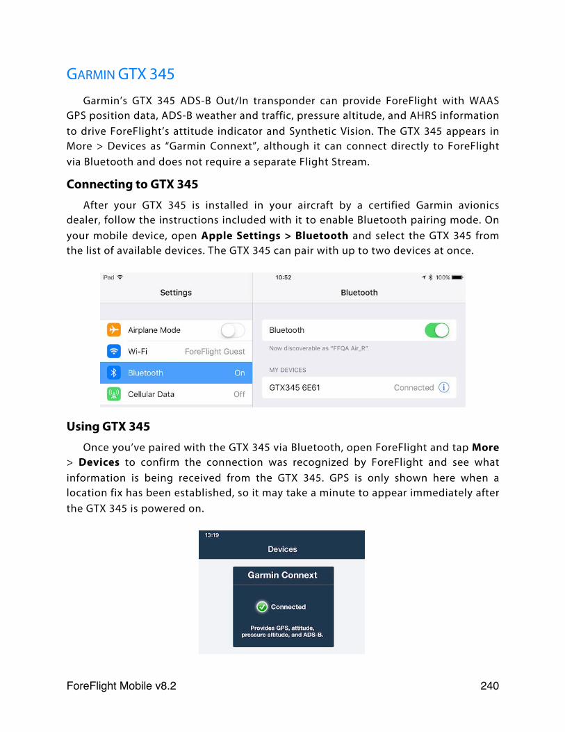
GARMIN GTX 345Garmin’s GTX 345 ADS-B Out/In transponder can provide ForeFlight with WAAS
GPS position data, ADS-B weather and traffic, pressure altitude, and AHRS information to drive ForeFlight’s attitude indicator and Synthetic Vision. The GTX 345 appears in More > Devices as “Garmin Connext”, although it can connect directly to ForeFlight via Bluetooth and does not require a separate Flight Stream.
Connecting to GTX 345After your GTX 345 is installed in your aircraft by a certified Garmin avionics
dealer, follow the instructions included with it to enable Bluetooth pairing mode. On your mobile device, open Apple Settings > Bluetooth and select the GTX 345 from the list of available devices. The GTX 345 can pair with up to two devices at once.
Using GTX 345Once you’ve paired with the GTX 345 via Bluetooth, open ForeFlight and tap More
> Devices to confirm the connection was recognized by ForeFlight and see what information is being received from the GTX 345. GPS is only shown here when a location fix has been established, so it may take a minute to appear immediately after the GTX 345 is powered on.
ForeFlight Mobile v8.2! 240
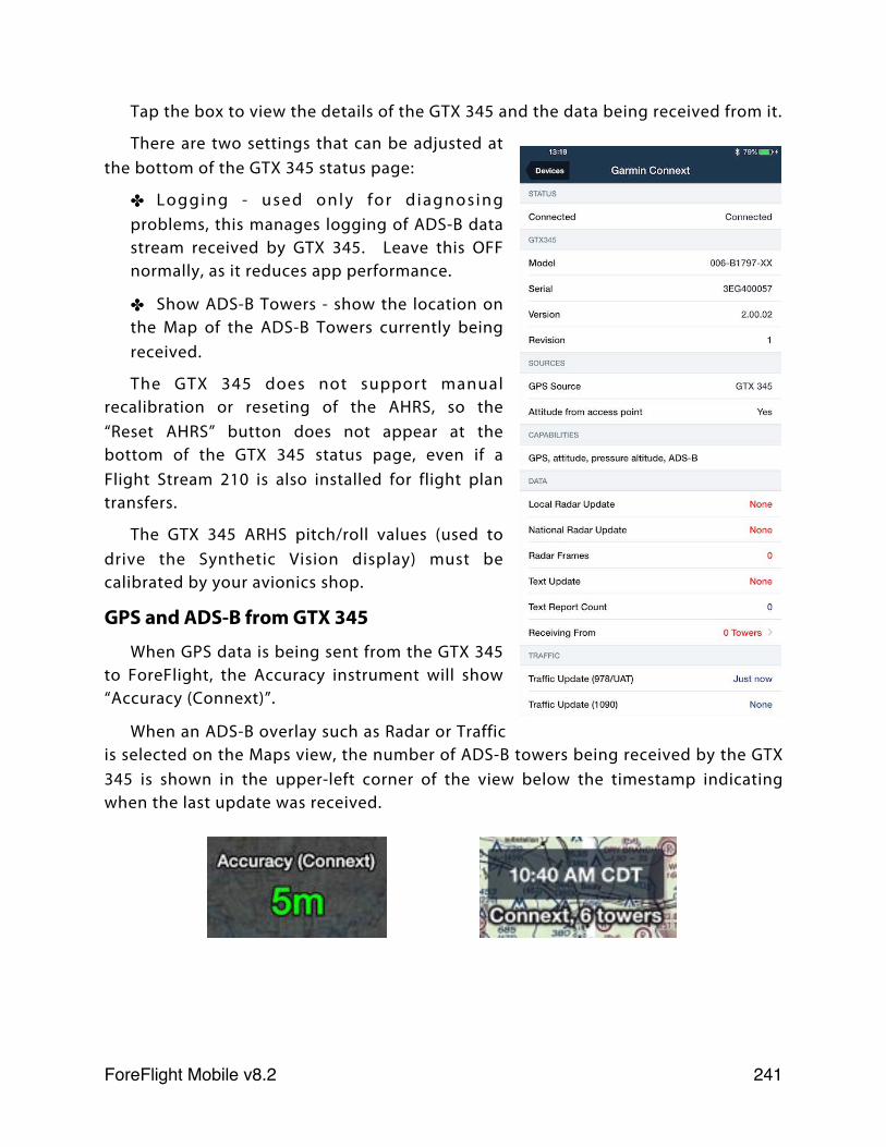
Tap the box to view the details of the GTX 345 and the data being received from it.
There are two settings that can be adjusted at the bottom of the GTX 345 status page:
✤ Logging - used only for d iagnosing problems, this manages logging of ADS-B data stream received by GTX 345. Leave this OFF normally, as it reduces app performance.
✤ Show ADS-B Towers - show the location on the Map of the ADS-B Towers currently being received.
The GTX 345 does not support manual recalibration or reseting of the AHRS, so the “Reset AHRS” button does not appear at the bottom of the GTX 345 status page, even if a Flight Stream 210 is also installed for flight plan transfers.
The GTX 345 ARHS pitch/roll values (used to drive the Synthetic Vision display) must be calibrated by your avionics shop.
GPS and ADS-B from GTX 345
When GPS data is being sent from the GTX 345 to ForeFlight, the Accuracy instrument will show “Accuracy (Connext)”.
When an ADS-B overlay such as Radar or Traffic is selected on the Maps view, the number of ADS-B towers being received by the GTX 345 is shown in the upper-left corner of the view below the timestamp indicating when the last update was received.
ForeFlight Mobile v8.2! 241
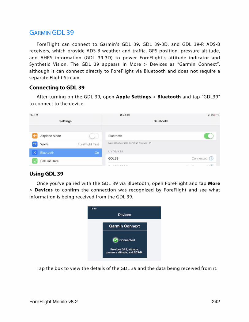
GARMIN GDL 39ForeFlight can connect to Garmin’s GDL 39, GDL 39-3D, and GDL 39-R ADS-B
receivers, which provide ADS-B weather and traffic, GPS position, pressure altitude, and AHRS information (GDL 39-3D) to power ForeFlight’s attitude indicator and Synthetic Vision. The GDL 39 appears in More > Devices as “Garmin Connext”, although it can connect directly to ForeFlight via Bluetooth and does not require a separate Flight Stream.
Connecting to GDL 39After turning on the GDL 39, open Apple Settings > Bluetooth and tap “GDL39”
to connect to the device.
Using GDL 39
Once you’ve paired with the GDL 39 via Bluetooth, open ForeFlight and tap More > Devices to confirm the connection was recognized by ForeFlight and see what information is being received from the GDL 39.
Tap the box to view the details of the GDL 39 and the data being received from it.
ForeFlight Mobile v8.2! 242
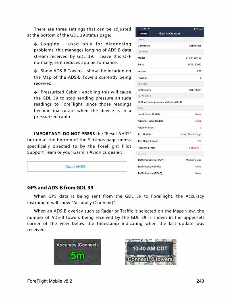
There are three settings that can be adjusted at the bottom of the GDL 39 status page:
✤ Logging - used only for d iagnosing problems, this manages logging of ADS-B data stream received by GDL 39. Leave this OFF normally, as it reduces app performance.
✤ Show ADS-B Towers - show the location on the Map of the ADS-B Towers currently being received.
✤ Pressurized Cabin - enabling this will cause the GDL 39 to stop sending pressure altitude readings to ForeFlight, since those readings become inaccurate when the device is in a pressurized cabin.
IMPORTANT: DO NOT PRESS the “Reset AHRS” button at the bottom of the Settings page unless specifically directed to by the ForeFlight Pilot Support Team or your Garmin Avionics dealer.
GPS and ADS-B from GDL 39When GPS data is being sent from the GDL 39 to ForeFlight, the Accuracy
instrument will show “Accuracy (Connext)”.
When an ADS-B overlay such as Radar or Traffic is selected on the Maps view, the number of ADS-B towers being received by the GDL 39 is shown in the upper-left corner of the view below the timestamp indicating when the last update was received.
ForeFlight Mobile v8.2! 243
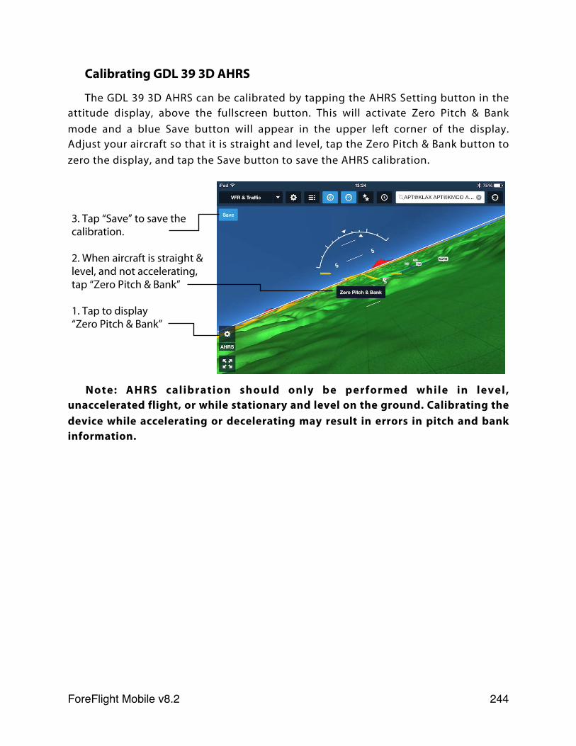
Calibrating GDL 39 3D AHRS
The GDL 39 3D AHRS can be calibrated by tapping the AHRS Setting button in the attitude display, above the fullscreen button. This will activate Zero Pitch & Bank mode and a blue Save button will appear in the upper left corner of the display. Adjust your aircraft so that it is straight and level, tap the Zero Pitch & Bank button to zero the display, and tap the Save button to save the AHRS calibration.
Note: AHRS calibration should only be performed while in level, unaccelerated flight, or while stationary and level on the ground. Calibrating the device while accelerating or decelerating may result in errors in pitch and bank information.
3. Tap “Save” to save the calibration.
2. When aircraft is straight & level, and not accelerating, tap “Zero Pitch & Bank”
1. Tap to display “Zero Pitch & Bank”
ForeFlight Mobile v8.2! 244
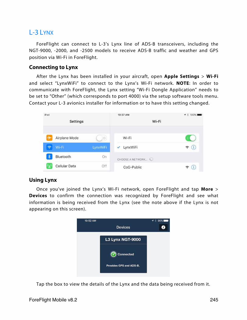
L-3 LYNX
ForeFlight can connect to L-3’s Lynx line of ADS-B transceivers, including the NGT-9000, -2000, and -2500 models to receive ADS-B traffic and weather and GPS position via Wi-Fi in ForeFlight.
Connecting to LynxAfter the Lynx has been installed in your aircraft, open Apple Settings > Wi-Fi
and select “LynxWiFi” to connect to the Lynx’s Wi-Fi network. NOTE: In order to communicate with ForeFlight, the Lynx setting “Wi-Fi Dongle Application” needs to be set to “Other” (which corresponds to port 4000) via the setup software tools menu. Contact your L-3 avionics installer for information or to have this setting changed.
Using LynxOnce you’ve joined the Lynx’s Wi-Fi network, open ForeFlight and tap More >
Devices to confirm the connection was recognized by ForeFlight and see what information is being received from the Lynx (see the note above if the Lynx is not appearing on this screen).
Tap the box to view the details of the Lynx and the data being received from it.
ForeFlight Mobile v8.2! 245
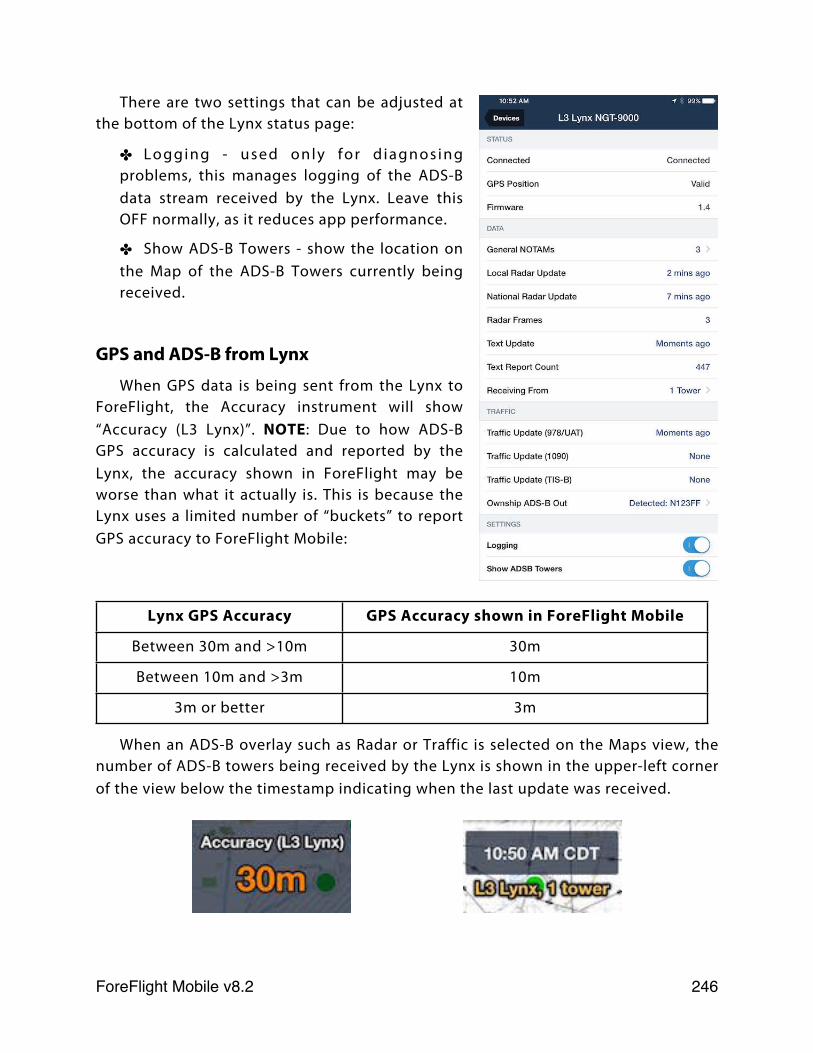
There are two settings that can be adjusted at the bottom of the Lynx status page:
✤ Logging - used only for d iagnosing problems, this manages logging of the ADS-B data stream received by the Lynx. Leave this OFF normally, as it reduces app performance.
✤ Show ADS-B Towers - show the location on the Map of the ADS-B Towers currently being received.
GPS and ADS-B from Lynx
When GPS data is being sent from the Lynx to ForeFlight, the Accuracy instrument will show “Accuracy (L3 Lynx)”. NOTE: Due to how ADS-B GPS accuracy is calculated and reported by the Lynx, the accuracy shown in ForeFlight may be worse than what it actually is. This is because the Lynx uses a limited number of “buckets” to report GPS accuracy to ForeFlight Mobile:
Lynx GPS Accuracy GPS Accuracy shown in ForeFlight Mobile
Between 30m and >10m 30m
Between 10m and >3m 10m
3m or better 3m
When an ADS-B overlay such as Radar or Traffic is selected on the Maps view, the number of ADS-B towers being received by the Lynx is shown in the upper-left corner of the view below the timestamp indicating when the last update was received.
ForeFlight Mobile v8.2! 246
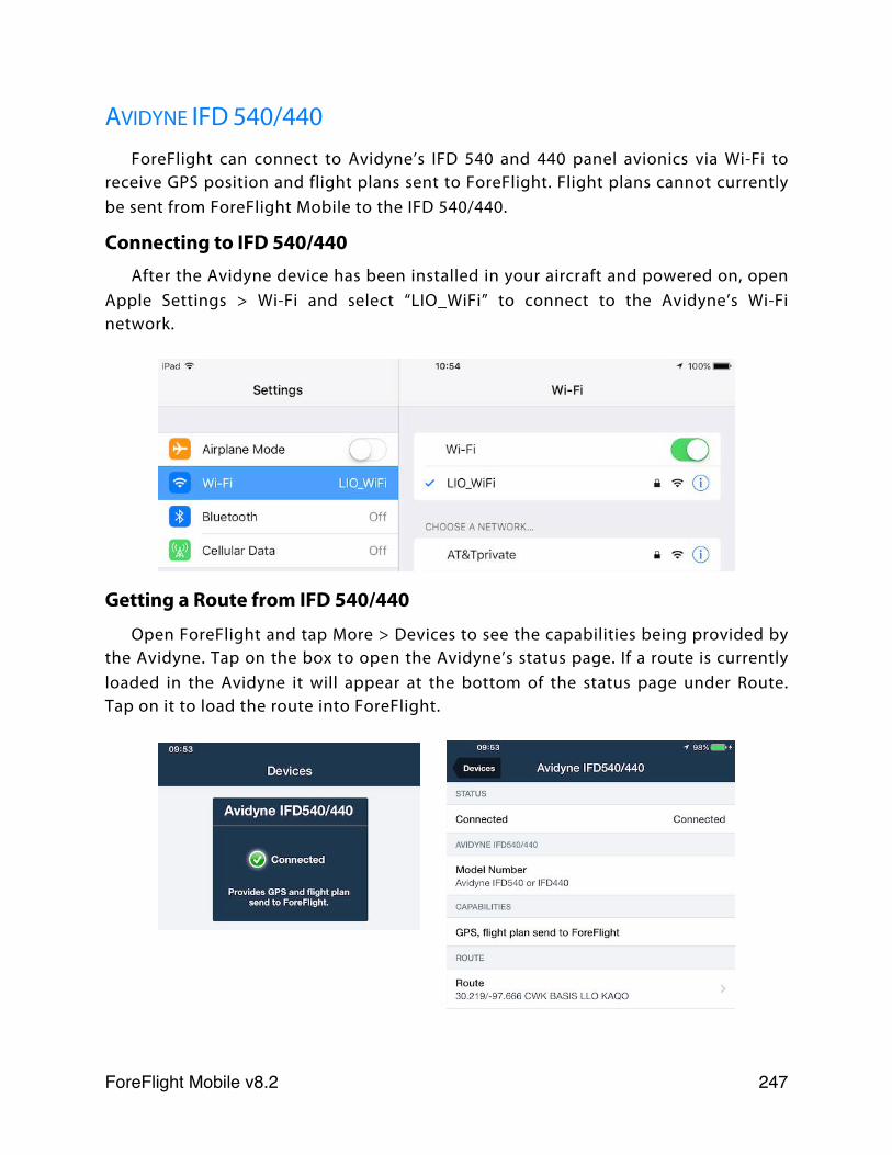
AVIDYNE IFD 540/440ForeFlight can connect to Avidyne’s IFD 540 and 440 panel avionics via Wi-Fi to
receive GPS position and flight plans sent to ForeFlight. Flight plans cannot currently be sent from ForeFlight Mobile to the IFD 540/440.
Connecting to IFD 540/440After the Avidyne device has been installed in your aircraft and powered on, open
Apple Settings > Wi-Fi and select “LIO_WiFi” to connect to the Avidyne’s Wi-Fi network.
Getting a Route from IFD 540/440
Open ForeFlight and tap More > Devices to see the capabilities being provided by the Avidyne. Tap on the box to open the Avidyne’s status page. If a route is currently loaded in the Avidyne it will appear at the bottom of the status page under Route. Tap on it to load the route into ForeFlight.
ForeFlight Mobile v8.2! 247
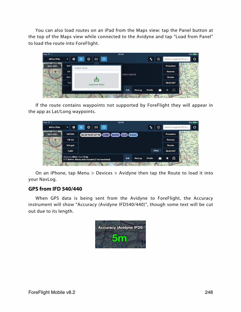
You can also load routes on an iPad from the Maps view: tap the Panel button at the top of the Maps view while connected to the Avidyne and tap “Load from Panel” to load the route into ForeFlight.
If the route contains waypoints not supported by ForeFlight they will appear in the app as Lat/Long waypoints.
On an iPhone, tap Menu > Devices > Avidyne then tap the Route to load it into your NavLog.
GPS from IFD 540/440
When GPS data is being sent from the Avidyne to ForeFlight, the Accuracy instrument will show “Accuracy (Avidyne IFD540/440)”, though some text will be cut out due to its length.
ForeFlight Mobile v8.2! 248
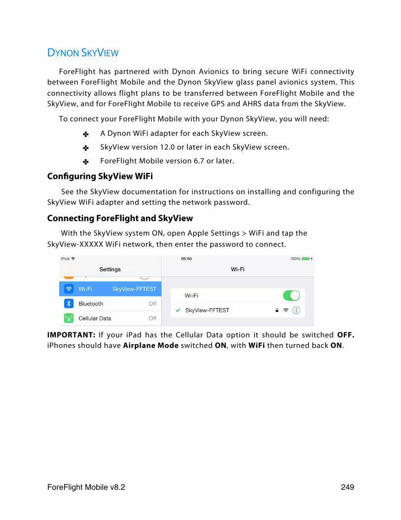
DYNON SKYVIEW
ForeFlight has partnered with Dynon Avionics to bring secure WiFi connectivity between ForeFlight Mobile and the Dynon SkyView glass panel avionics system. This connectivity allows flight plans to be transferred between ForeFlight Mobile and the SkyView, and for ForeFlight Mobile to receive GPS and AHRS data from the SkyView.
To connect your ForeFlight Mobile with your Dynon SkyView, you will need:
✤ A Dynon WiFi adapter for each SkyView screen.
✤ SkyView version 12.0 or later in each SkyView screen.
✤ ForeFlight Mobile version 6.7 or later.
Configuring SkyView WiFi
See the SkyView documentation for instructions on installing and configuring the SkyView WiFi adapter and setting the network password.
Connecting ForeFlight and SkyView With the SkyView system ON, open Apple Settings > WiFi and tap the
SkyView-XXXXX WiFi network, then enter the password to connect.
IMPORTANT: If your iPad has the Cellular Data option it should be switched OFF. iPhones should have Airplane Mode switched ON, with WiFi then turned back ON.
ForeFlight Mobile v8.2! 249
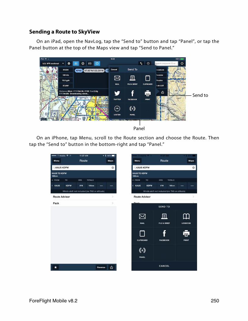
Sending a Route to SkyView
On an iPad, open the NavLog, tap the “Send to” button and tap “Panel”, or tap the Panel button at the top of the Maps view and tap “Send to Panel.”
On an iPhone, tap Menu, scroll to the Route section and choose the Route. Then tap the “Send to” button in the bottom-right and tap “Panel.”
Send to
Panel
ForeFlight Mobile v8.2! 250
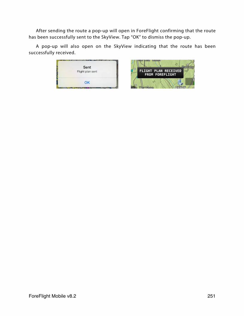
After sending the route a pop-up will open in ForeFlight confirming that the route has been successfully sent to the SkyView. Tap “OK” to dismiss the pop-up.
A pop-up will also open on the SkyView indicating that the route has been successfully received.
ForeFlight Mobile v8.2! 251
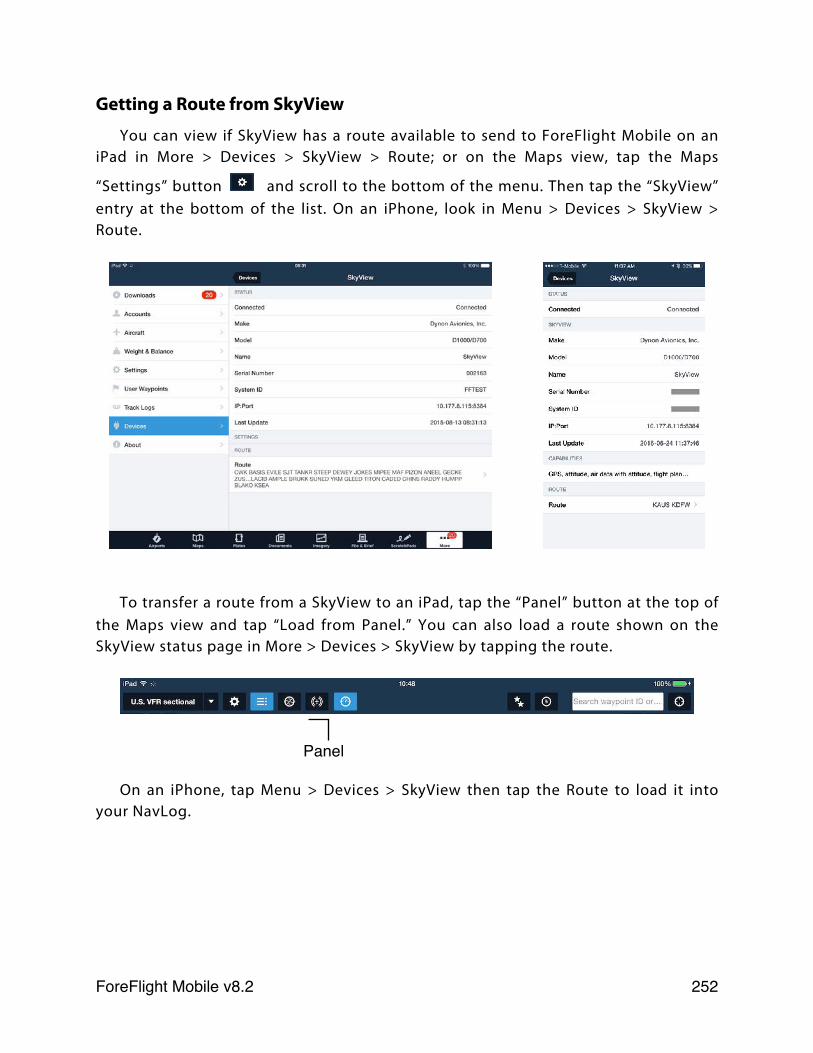
Getting a Route from SkyView
You can view if SkyView has a route available to send to ForeFlight Mobile on an iPad in More > Devices > SkyView > Route; or on the Maps view, tap the Maps
“Settings” button and scroll to the bottom of the menu. Then tap the “SkyView” entry at the bottom of the list. On an iPhone, look in Menu > Devices > SkyView > Route.
To transfer a route from a SkyView to an iPad, tap the “Panel” button at the top of the Maps view and tap “Load from Panel.” You can also load a route shown on the SkyView status page in More > Devices > SkyView by tapping the route.
On an iPhone, tap Menu > Devices > SkyView then tap the Route to load it into your NavLog.
Panel
ForeFlight Mobile v8.2! 252
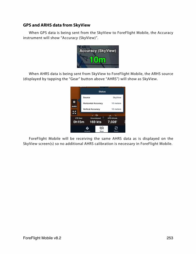
GPS and ARHS data from SkyView
When GPS data is being sent from the SkyView to ForeFlight Mobile, the Accuracy instrument will show “Accuracy (SkyView)”.
When AHRS data is being sent from SkyView to ForeFlight Mobile, the ARHS source (displayed by tapping the “Gear” button above “AHRS”) will show as SkyView.
ForeFlight Mobile will be receiving the same AHRS data as is displayed on the SkyView screen(s) so no additional AHRS calibration is necessary in ForeFlight Mobile.
ForeFlight Mobile v8.2! 253
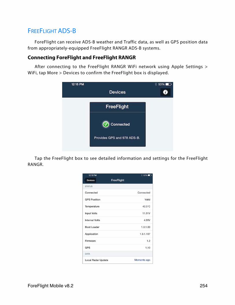
FREEFLIGHT ADS-BForeFlight can receive ADS-B weather and Traffic data, as well as GPS position data
from appropriately-equipped FreeFlight RANGR ADS-B systems.
Connecting ForeFlight and FreeFlight RANGR
After connecting to the FreeFlight RANGR WiFi network using Apple Settings > WiFi, tap More > Devices to confirm the FreeFlight box is displayed.
Tap the FreeFlight box to see detailed information and settings for the FreeFlight RANGR.
ForeFlight Mobile v8.2! 254
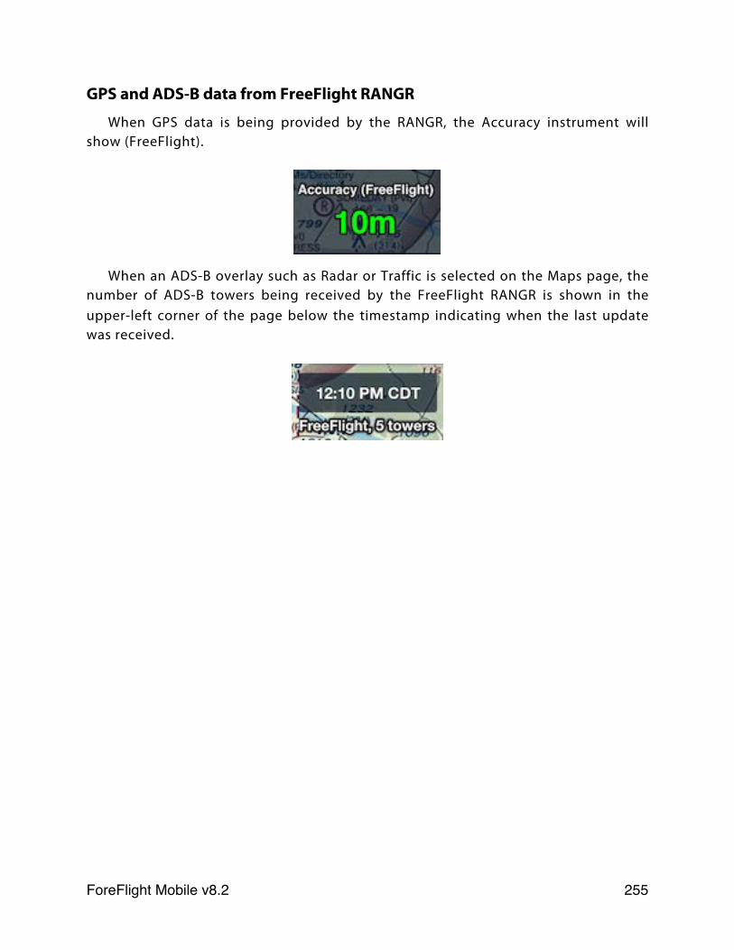
GPS and ADS-B data from FreeFlight RANGR
When GPS data is being provided by the RANGR, the Accuracy instrument will show (FreeFlight).
When an ADS-B overlay such as Radar or Traffic is selected on the Maps page, the number of ADS-B towers being received by the FreeFlight RANGR is shown in the upper-left corner of the page below the timestamp indicating when the last update was received.
ForeFlight Mobile v8.2! 255
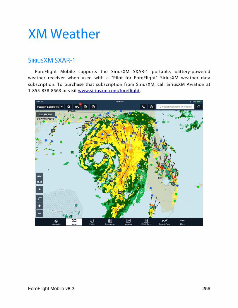
XM Weather
SIRIUSXM SXAR-1ForeFlight Mobile supports the SiriusXM SXAR-1 portable, battery-powered
weather receiver when used with a “Pilot for ForeFlight” SiriusXM weather data subscription. To purchase that subscription from SiriusXM, call SiriusXM Aviation at 1-855-838-8563 or visit www.siriusxm.com/foreflight.
ForeFlight Mobile v8.2! 256
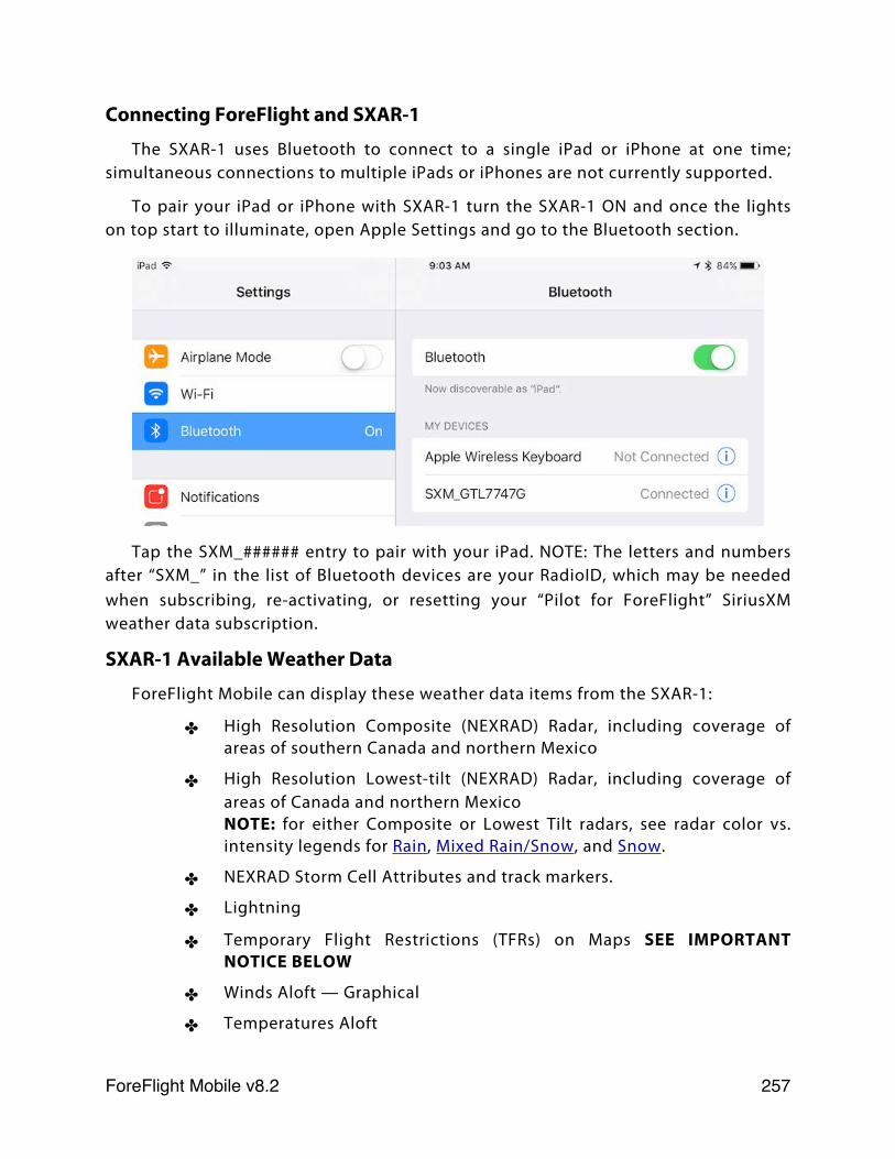
Connecting ForeFlight and SXAR-1
The SXAR-1 uses Bluetooth to connect to a single iPad or iPhone at one time; simultaneous connections to multiple iPads or iPhones are not currently supported.
To pair your iPad or iPhone with SXAR-1 turn the SXAR-1 ON and once the lights on top start to illuminate, open Apple Settings and go to the Bluetooth section.
Tap the SXM_###### entry to pair with your iPad. NOTE: The letters and numbers after “SXM_” in the list of Bluetooth devices are your RadioID, which may be needed when subscribing, re-activating, or resetting your “Pilot for ForeFlight” SiriusXM weather data subscription.
SXAR-1 Available Weather Data
ForeFlight Mobile can display these weather data items from the SXAR-1:
✤ High Resolution Composite (NEXRAD) Radar, including coverage of areas of southern Canada and northern Mexico
✤ High Resolution Lowest-tilt (NEXRAD) Radar, including coverage of areas of Canada and northern MexicoNOTE: for either Composite or Lowest Tilt radars, see radar color vs. intensity legends for Rain, Mixed Rain/Snow, and Snow.
✤ NEXRAD Storm Cell Attributes and track markers.
✤ Lightning
✤ Temporary Flight Restrictions (TFRs) on Maps SEE IMPORTANT NOTICE BELOW
✤ Winds Aloft — Graphical
✤ Temperatures Aloft
ForeFlight Mobile v8.2! 257
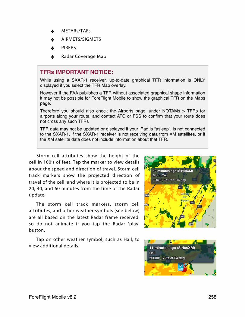
✤ METARs/TAFs
✤ AIRMETS/SIGMETS
✤ PIREPS
✤ Radar Coverage Map
Storm cell attributes show the height of the cell in 100’s of feet. Tap the marker to view details about the speed and direction of travel. Storm cell track markers show the projected direction of travel of the cell, and where it is projected to be in 20, 40, and 60 minutes from the time of the Radar update.
The storm cell track markers, storm cell attributes, and other weather symbols (see below) are all based on the latest Radar frame received, so do not animate if you tap the Radar ‘play’ button.
Tap on other weather symbol, such as Hail, to view additional details.
TFRs IMPORTANT NOTICE:While using a SXAR-1 receiver, up-to-date graphical TFR information is ONLY displayed if you select the TFR Map overlay.However if the FAA publishes a TFR without associated graphical shape information it may not be possible for ForeFlight Mobile to show the graphical TFR on the Maps page.Therefore you should also check the Airports page, under NOTAMs > TFRs for airports along your route, and contact ATC or FSS to confirm that your route does not cross any such TFRsTFR data may not be updated or displayed if your iPad is “asleep”, is not connected to the SXAR-1, if the SXAR-1 receiver is not receiving data from XM satellites, or if the XM satellite data does not include information about that TFR.
ForeFlight Mobile v8.2! 258
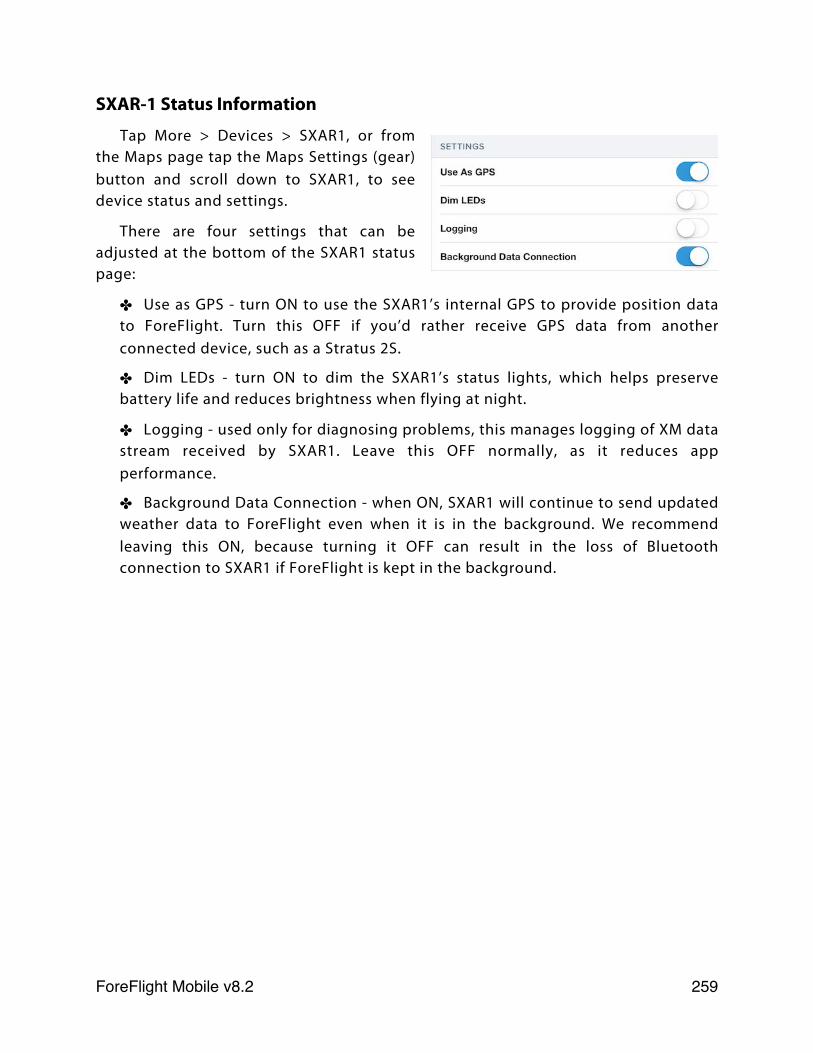
SXAR-1 Status Information
Tap More > Devices > SXAR1, or from the Maps page tap the Maps Settings (gear) button and scroll down to SXAR1, to see device status and settings.
There are four settings that can be adjusted at the bottom of the SXAR1 status page:
✤ Use as GPS - turn ON to use the SXAR1’s internal GPS to provide position data to ForeFlight. Turn this OFF if you’d rather receive GPS data from another connected device, such as a Stratus 2S.
✤ Dim LEDs - turn ON to dim the SXAR1’s status lights, which helps preserve battery life and reduces brightness when flying at night.
✤ Logging - used only for diagnosing problems, this manages logging of XM data stream received by SXAR1. Leave this OFF normally, as it reduces app performance.
✤ Background Data Connection - when ON, SXAR1 will continue to send updated weather data to ForeFlight even when it is in the background. We recommend leaving this ON, because turning it OFF can result in the loss of Bluetooth connection to SXAR1 if ForeFlight is kept in the background.
ForeFlight Mobile v8.2! 259
BARON MOBILE LINK/WXWORX
The Baron Services Mobile Link plugs-in to a WXWorx XM WX receiver, and provides a WiFi connection so that ForeFlight Mobile can access the XM WX data. Please consult the Mobile Link documentation to learn how to setup and connect the device.
The Mobile Link firmware 2.0 or higher allows data access to up to 4 devices at a time. ForeFlight Mobile attempts to get data access whenever it is launched and again any time data is requested by the user. ForeFlight Mobile will release its access when the app is closed via the physical home button.
If a device or app has gained access to the data and does not release it properly, the Mobile Link will automatically release the access for that device after 60 seconds.
The Mobile Link status view in ForeFlight Mobile will state whether data access has been obtained, see the “Status information” section below for more information.
Mobile Link Available Weather Data
ForeFlight Mobile can display these weather data items from the Baron Mobile Link/WXWorx:
✤ Radar - for any subscribed region, shown on Maps. See radar color vs. intensity legend.
✤ Satellite - for any subscribed region, shown on Maps
✤ METARs and METAR-derived data shown on Maps, such as temperature
✤ TAFs
✤ Winds Aloft
✤ TFRs on Maps SEE IMPORTANT NOTICE BELOW
✤ PIREPs on Maps
✤ AIRMETs/SIGMETs on Maps
✤ Lightning on Maps (requires Mobile Link firmware version 2.0 or higher)
Data is accessed just as it is when on the ground using an Internet connection. There is no user-configuration required beyond ensuring the Wi-Fi connection to the Mobile Link is properly established.
ForeFlight Mobile v8.2! 260
Mobile Link Status InformationTo learn the status of the Mobile Link connection, subscription, data availability
and more, please use the Devices view as described above. When connected to the Mobile Link Wi-Fi access point, Mobile Link will be an option shown in the Devices view. Tap it to see full status information. This information is useful for troubleshooting if you experience problems with the Baron Mobile Link/WXWorx combination.
TFRs IMPORTANT NOTICE:While using a Baron Mobile Link XM WX receiver, up-to-date graphical TFR information is ONLY displayed if you select the TFR Map overlay.However if the FAA publishes a TFR without associated graphical shape information it may not be possible for ForeFlight Mobile to show the graphical TFR on the Maps page.Therefore you should also check the Airports page, under NOTAMs > TFRs for airports along your route, and contact ATC or FSS to confirm that your route does not cross any such TFRsTFR data may not be updated or displayed if your iPad is “asleep”, is not connected to the Baron Mobile Link, if the Baron Mobile Link receiver is not receiving data from XM satellites, or if the XM satellite data does not include information about that TFR.
ForeFlight Mobile v8.2! 261
LogTen IntegrationForeFlight Mobile can export routes or flight plans to the LogTen app, when
LogTen is installed. To create a new logbook entry in LogTen based on a route, create the route on the Maps view and tap the Send To button in the Navigation Log. This will show LogTen as one option. Tap that to open LogTen and create a new log entry.
Logbook entries can also be created from the File & Brief view, once LogTen is installed on the iPad. Run ForeFlight Mobile, go to File & Brief and select the plan to export. Tap the blue LogTen button below the flight plan details list on the right to open LogTen with a new logbook entry.
ForeFlight Mobile v8.2! 262
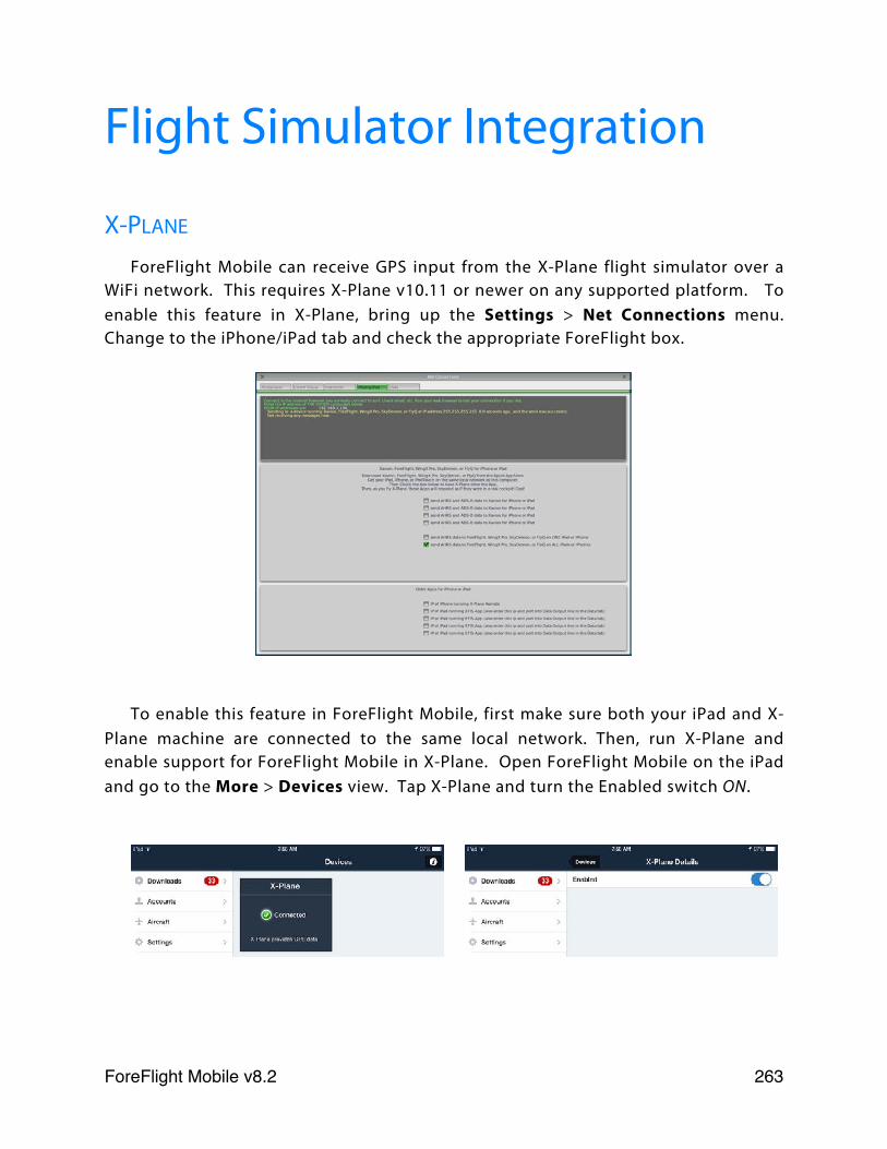
Flight Simulator Integration
X-PLANE
ForeFlight Mobile can receive GPS input from the X-Plane flight simulator over a WiFi network. This requires X-Plane v10.11 or newer on any supported platform. To enable this feature in X-Plane, bring up the Settings > Net Connections menu. Change to the iPhone/iPad tab and check the appropriate ForeFlight box.
To enable this feature in ForeFlight Mobile, first make sure both your iPad and X-Plane machine are connected to the same local network. Then, run X-Plane and enable support for ForeFlight Mobile in X-Plane. Open ForeFlight Mobile on the iPad and go to the More > Devices view. Tap X-Plane and turn the Enabled switch ON.
ForeFlight Mobile v8.2! 263
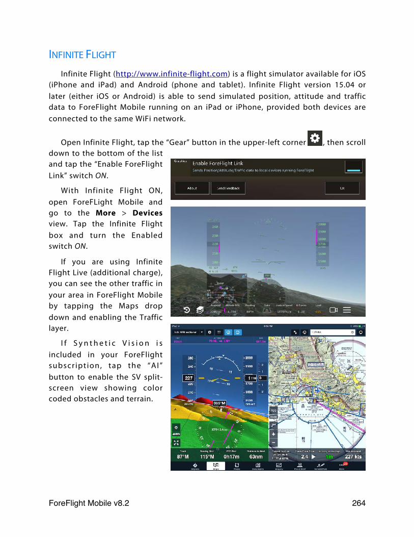
INFINITE FLIGHT
Infinite Flight (http://www.infinite-flight.com) is a flight simulator available for iOS (iPhone and iPad) and Android (phone and tablet). Infinite Flight version 15.04 or later (either iOS or Android) is able to send simulated position, attitude and traffic data to ForeFlight Mobile running on an iPad or iPhone, provided both devices are connected to the same WiFi network.
Open Infinite Flight, tap the “Gear” button in the upper-left corner , then scroll down to the bottom of the list and tap the “Enable ForeFlight Link” switch ON.
With Infinite Flight ON, open ForeFLight Mobile and go to the More > Devices view. Tap the Infinite Flight box and turn the Enabled switch ON.
If you are using Infinite Flight Live (additional charge), you can see the other traffic in your area in ForeFlight Mobile by tapping the Maps drop down and enabling the Traffic layer.
I f S y n t h e t i c V i s i o n i s included in your ForeFlight subscr ipt ion, tap the “AI” button to enable the SV split-screen view showing color coded obstacles and terrain.
ForeFlight Mobile v8.2! 264
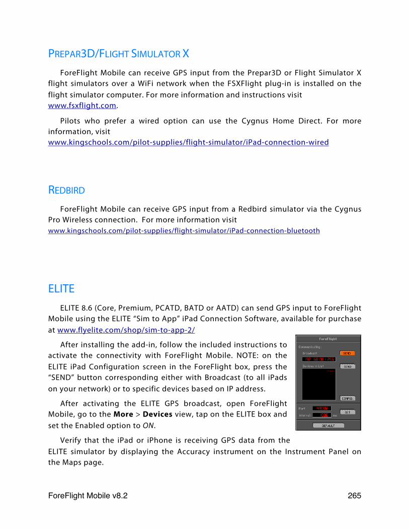
PREPAR3D/FLIGHT SIMULATOR XForeFlight Mobile can receive GPS input from the Prepar3D or Flight Simulator X
flight simulators over a WiFi network when the FSXFlight plug-in is installed on the flight simulator computer. For more information and instructions visit www.fsxflight.com.
Pilots who prefer a wired option can use the Cygnus Home Direct. For more information, visitwww.kingschools.com/pilot-supplies/flight-simulator/iPad-connection-wired
REDBIRD
ForeFlight Mobile can receive GPS input from a Redbird simulator via the Cygnus Pro Wireless connection. For more information visitwww.kingschools.com/pilot-supplies/flight-simulator/iPad-connection-bluetooth
ELITEELITE 8.6 (Core, Premium, PCATD, BATD or AATD) can send GPS input to ForeFlight
Mobile using the ELITE “Sim to App” iPad Connection Software, available for purchase at www.flyelite.com/shop/sim-to-app-2/
After installing the add-in, follow the included instructions to activate the connectivity with ForeFlight Mobile. NOTE: on the ELITE iPad Configuration screen in the ForeFlight box, press the “SEND” button corresponding either with Broadcast (to all iPads on your network) or to specific devices based on IP address.
After activating the ELITE GPS broadcast, open ForeFlight Mobile, go to the More > Devices view, tap on the ELITE box and set the Enabled option to ON.
Verify that the iPad or iPhone is receiving GPS data from the ELITE simulator by displaying the Accuracy instrument on the Instrument Panel on the Maps page.
ForeFlight Mobile v8.2! 265
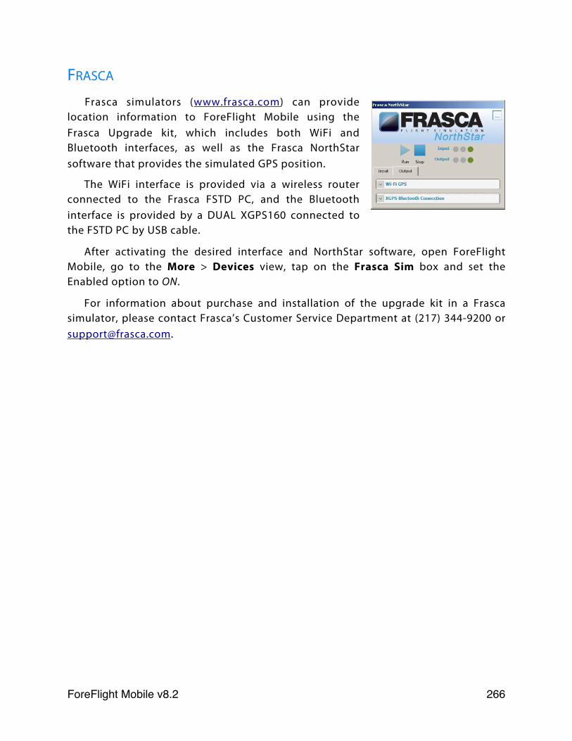
FRASCA
Frasca simulators (www.frasca.com) can provide location information to ForeFlight Mobile using the Frasca Upgrade kit, which includes both WiFi and Bluetooth interfaces, as well as the Frasca NorthStar software that provides the simulated GPS position.
The WiFi interface is provided via a wireless router connected to the Frasca FSTD PC, and the Bluetooth interface is provided by a DUAL XGPS160 connected to the FSTD PC by USB cable.
After activating the desired interface and NorthStar software, open ForeFlight Mobile, go to the More > Devices view, tap on the Frasca Sim box and set the Enabled option to ON.
For information about purchase and installation of the upgrade kit in a Frasca simulator, please contact Frasca’s Customer Service Department at (217) 344-9200 or [email protected].
ForeFlight Mobile v8.2! 266
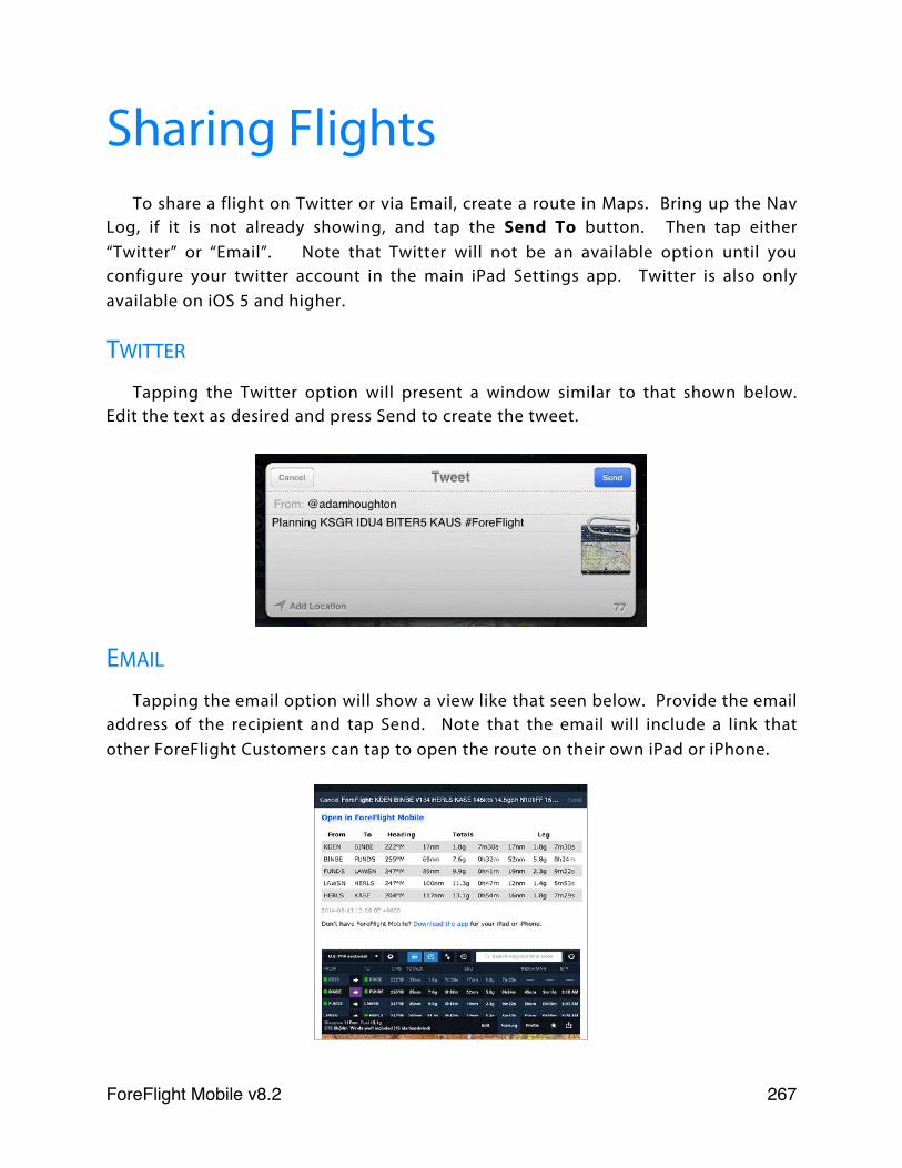
Sharing Flights To share a flight on Twitter or via Email, create a route in Maps. Bring up the Nav
Log, if it is not already showing, and tap the Send To button. Then tap either “Twitter” or “Email”. Note that Twitter will not be an available option until you configure your twitter account in the main iPad Settings app. Twitter is also only available on iOS 5 and higher.
Tapping the Twitter option will present a window similar to that shown below. Edit the text as desired and press Send to create the tweet.
Tapping the email option will show a view like that seen below. Provide the email address of the recipient and tap Send. Note that the email will include a link that other ForeFlight Customers can tap to open the route on their own iPad or iPhone.
ForeFlight Mobile v8.2! 267
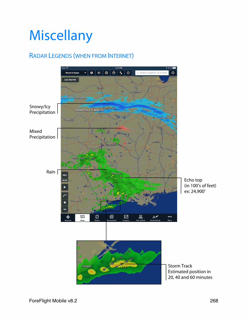
MiscellanyRADAR LEGENDS (WHEN FROM INTERNET)
Rain
Snowy/Icy Precipitation
Mixed Precipitation
Echo top(in 100’s of feet)ex: 24,900’
Storm Track Estimated position in 20, 40 and 60 minutes
ForeFlight Mobile v8.2! 268
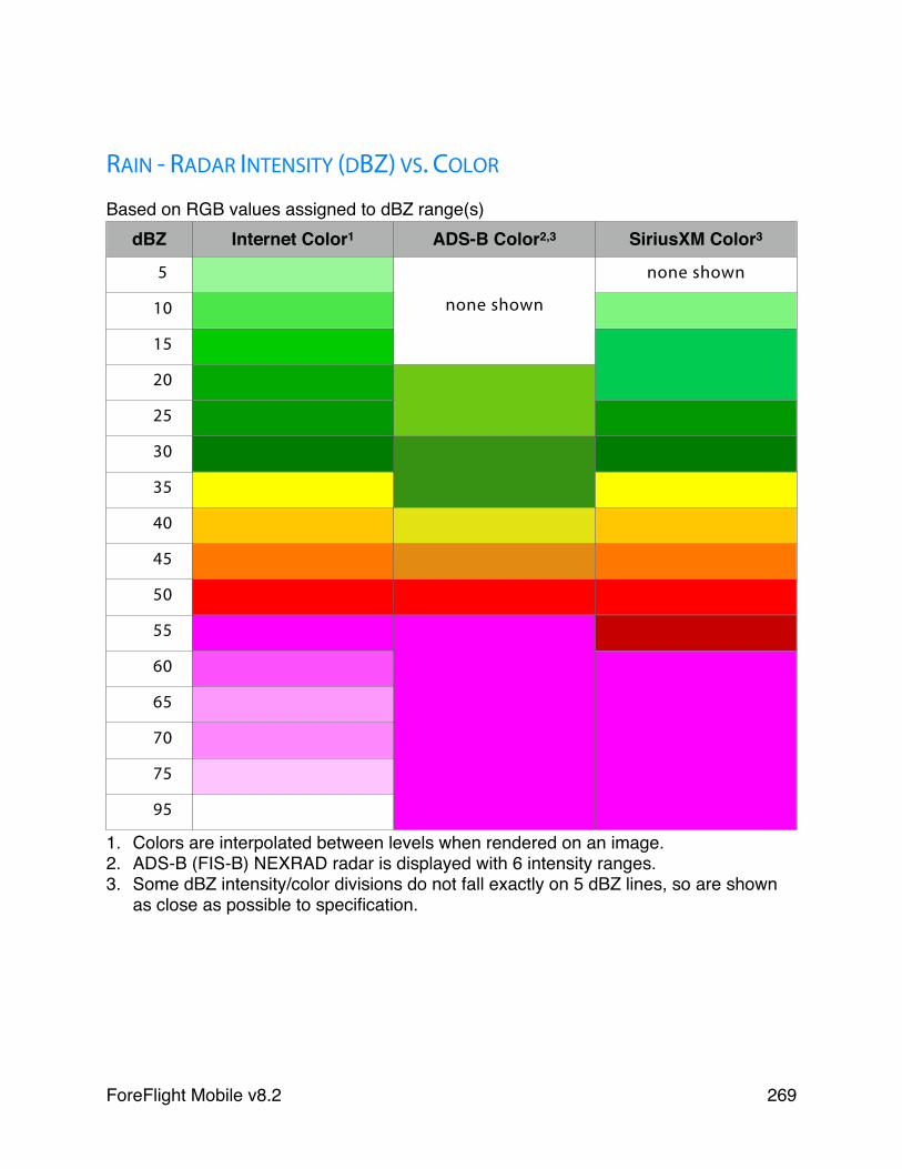
RAIN - RADAR INTENSITY (DBZ) VS. COLOR
Based on RGB values assigned to dBZ range(s)dBZ Internet Color1 ADS-B Color2,3 SiriusXM Color3
5
none shown
none shown
10 none shown
15
none shown
20
25
30
35
40
45
50
55
60
65
70
75
95
1. Colors are interpolated between levels when rendered on an image.2. ADS-B (FIS-B) NEXRAD radar is displayed with 6 intensity ranges.3. Some dBZ intensity/color divisions do not fall exactly on 5 dBZ lines, so are shown
as close as possible to specification.
ForeFlight Mobile v8.2! 269
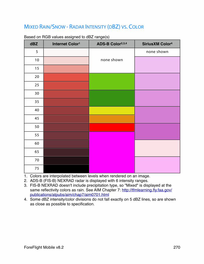
MIXED RAIN/SNOW - RADAR INTENSITY (DBZ) VS. COLOR
Based on RGB values assigned to dBZ range(s)dBZ Internet Color1 ADS-B Color2,3,4 SiriusXM Color4
5 none shown
10 none shown
15
20
25
30
35
40
45
50
55
60
65
70
75
1. Colors are interpolated between levels when rendered on an image.2. ADS-B (FIS-B) NEXRAD radar is displayed with 6 intensity ranges.3. FIS-B NEXRAD doesn't include precipitation type, so "Mixed" is displayed at the
same reflectivity colors as rain. See AIM Chapter 7: http://tfmlearning.fly.faa.gov/publications/atpubs/aim/chap7/aim0701.html
4. Some dBZ intensity/color divisions do not fall exactly on 5 dBZ lines, so are shown as close as possible to specification.
ForeFlight Mobile v8.2! 270
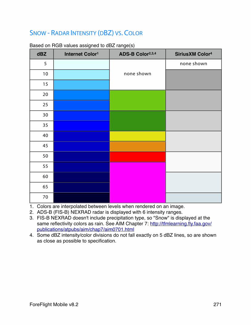
SNOW - RADAR INTENSITY (DBZ) VS. COLOR
Based on RGB values assigned to dBZ range(s)dBZ Internet Color1 ADS-B Color2,3,4 SiriusXM Color4
5 none shown
10 none shown
15
20
25
30
35
40
45
50
55
60
65
70
1. Colors are interpolated between levels when rendered on an image.2. ADS-B (FIS-B) NEXRAD radar is displayed with 6 intensity ranges.3. FIS-B NEXRAD doesn't include precipitation type, so "Snow" is displayed at the
same reflectivity colors as rain. See AIM Chapter 7: http://tfmlearning.fly.faa.gov/publications/atpubs/aim/chap7/aim0701.html
4. Some dBZ intensity/color divisions do not fall exactly on 5 dBZ lines, so are shown as close as possible to specification.
ForeFlight Mobile v8.2! 271
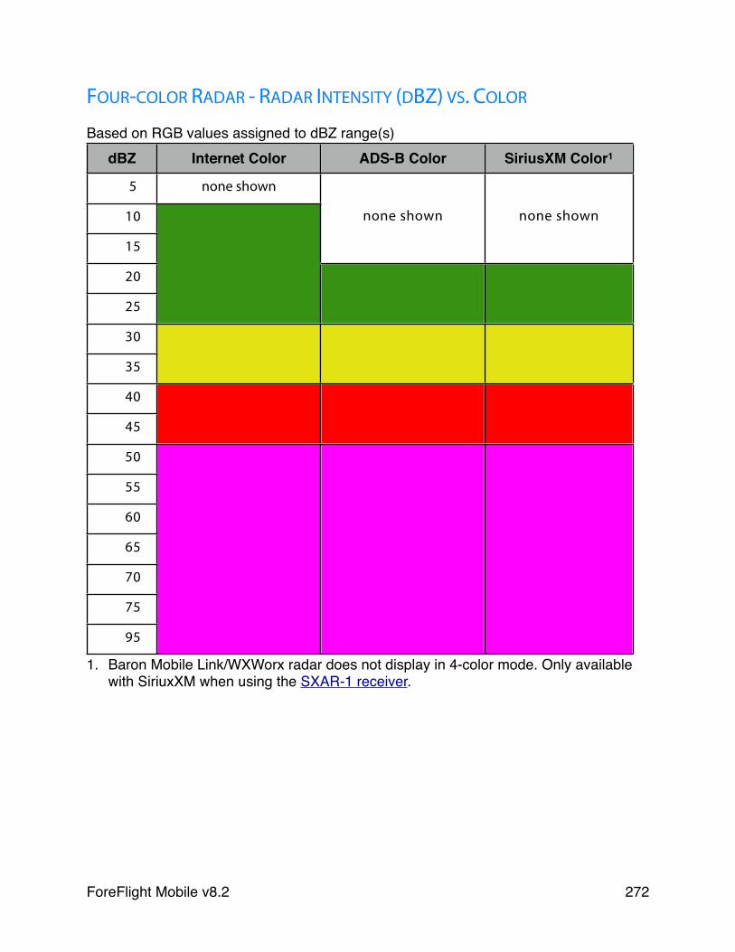
FOUR-COLOR RADAR - RADAR INTENSITY (DBZ) VS. COLOR
Based on RGB values assigned to dBZ range(s)dBZ Internet Color ADS-B Color SiriusXM Color1
5 none shown
10 none shown none shown
15
20
25
30
35
40
45
50
55
60
65
70
75
95
1. Baron Mobile Link/WXWorx radar does not display in 4-color mode. Only available with SiriuxXM when using the SXAR-1 receiver.
ForeFlight Mobile v8.2! 272
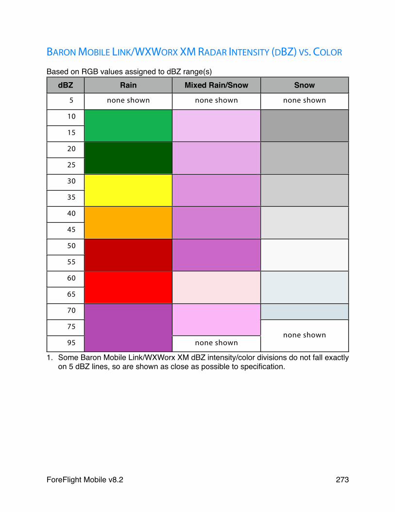
BARON MOBILE LINK/WXWORX XM RADAR INTENSITY (DBZ) VS. COLOR
Based on RGB values assigned to dBZ range(s)dBZ Rain Mixed Rain/Snow Snow
5 none shown none shown none shown
10
15
20
25
30
35
40
45
50
55
60
65
70
75none shown
95 none shownnone shown
1. Some Baron Mobile Link/WXWorx XM dBZ intensity/color divisions do not fall exactly on 5 dBZ lines, so are shown as close as possible to specification.
ForeFlight Mobile v8.2! 273
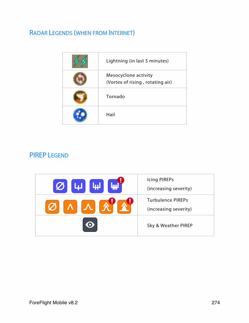
RADAR LEGENDS (WHEN FROM INTERNET)
Lightning (in last 5 minutes)
Mesocyclone activity(Vortex of rising , rotating air)
Tornado
Hail
PIREP LEGEND
Icing PIREPs
(increasing severity)
Turbulence PIREPs
(increasing severity)
Sky & Weather PIREP
ForeFlight Mobile v8.2! 274
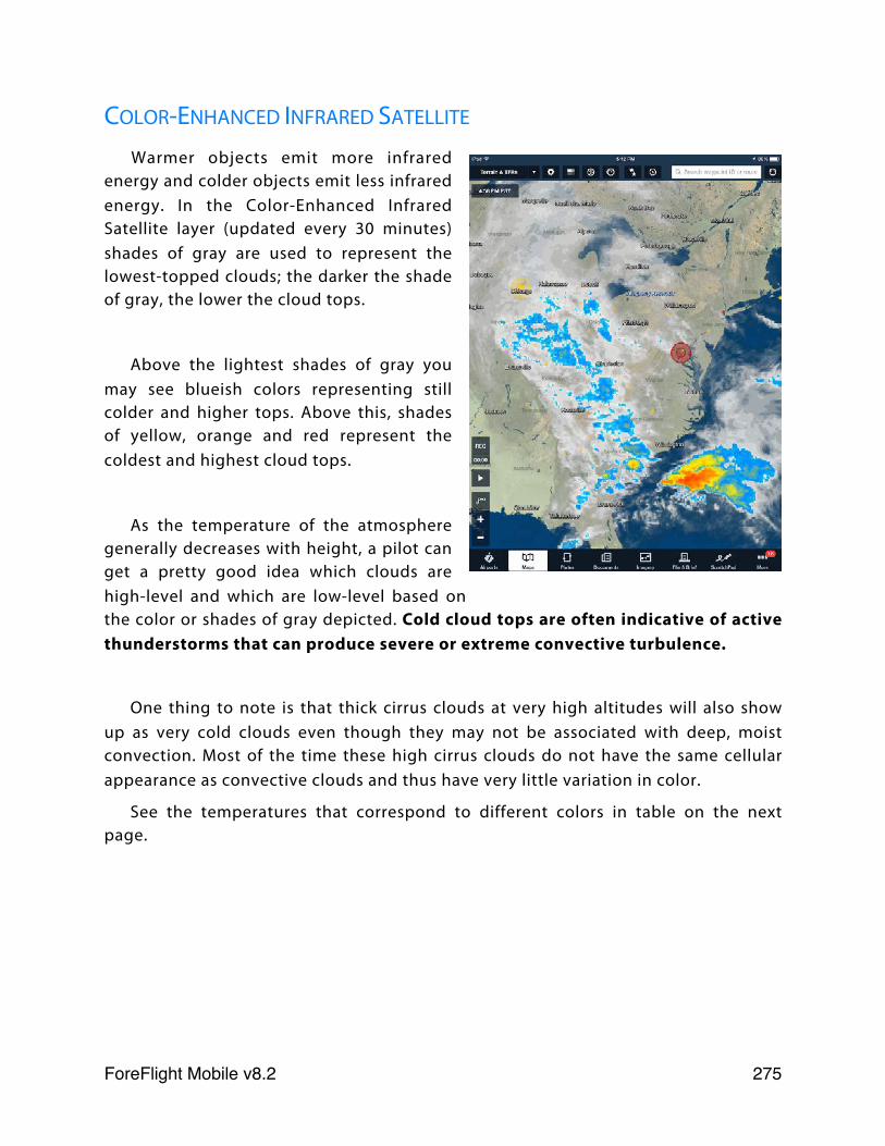
COLOR-ENHANCED INFRARED SATELLITE
Warmer objects emit more infrared energy and colder objects emit less infrared energy. In the Color-Enhanced Infrared Satellite layer (updated every 30 minutes) shades of gray are used to represent the lowest-topped clouds; the darker the shade of gray, the lower the cloud tops.
Above the lightest shades of gray you may see blueish colors representing still colder and higher tops. Above this, shades of yellow, orange and red represent the coldest and highest cloud tops.
As the temperature of the atmosphere generally decreases with height, a pilot can get a pretty good idea which clouds are high-level and which are low-level based on the color or shades of gray depicted. Cold cloud tops are often indicative of active thunderstorms that can produce severe or extreme convective turbulence.
One thing to note is that thick cirrus clouds at very high altitudes will also show up as very cold clouds even though they may not be associated with deep, moist convection. Most of the time these high cirrus clouds do not have the same cellular appearance as convective clouds and thus have very little variation in color.
See the temperatures that correspond to different colors in table on the next page.
ForeFlight Mobile v8.2! 275
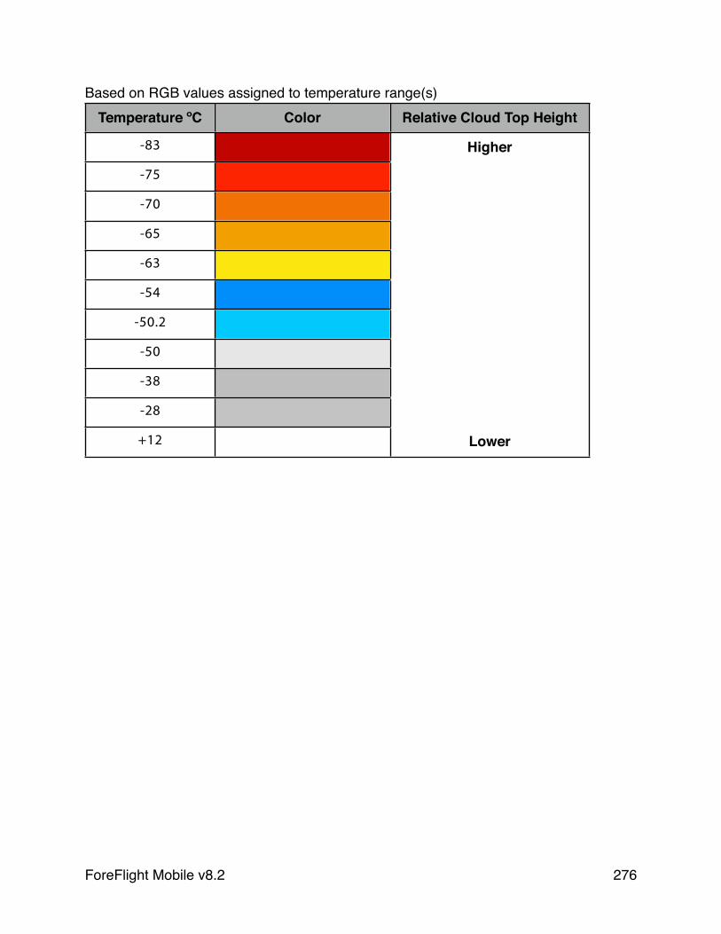
Based on RGB values assigned to temperature range(s)Temperature ºC Color Relative Cloud Top Height
-83 Higher
-75
-70
-65
-63
-54
-50.2
-50
-38
-28
+12 Lower
ForeFlight Mobile v8.2! 276

Learning MoreTo learn even more about ForeFlight Mobile, please visit our website for
frequently asked questions (FAQs) and video tutorials.
FAQs: www.foreflight.com/support
Videos: www.foreflight.com/videos
“ForeFlight 101 - Beginner Tutorial” and “ForeFlight 201 - Advanced Course” video presentations: www.foreflight.com/support/training/
To help us at ForeFlight learn more about how you fly, please send any and all feedback on our applications to [email protected] - we read and respond to each note we receive. We also get a kick out of hearing your flying stories, so please do share!
ForeFlight Mobile v8.2! 277
Pilot’s Guide Change HistoryFor v8.2 NOTE: REQUIRES iOS 9.2 or LATER
✤ The global data-driven Aeronautical Maps now provide additional aeronautical data types, including airspace altitudes, ARTCC frequency stamps, Mode C rings, Class E surface areas, TRSAs, and SATRs.
✤ New in-flight alerts for sink rate and 500’ AGL provide added situational awareness. Also, Runway Proximity Advisor now tells you how many feet of runway remain when you enter a runway at either end.
✤ The Screen Brightness slider in the Maps Settings is now linked to the iPad’s brightness slider and also allows for additional dimming if the lowest setting of the iPad’s slider is not dark enough.
✤ A new optional field in the flight plan form allows you to file with a call sign. This field can be enabled in More > Settings > File & Brief.
✤ ForeFlight’s filing capabilities now support VFR and IFR flight plans within or between both the U.S. and Canada, in either direction.
✤ Updated Rain Radar Intensity color mapping for SiriusXM SXAR1.
For v8.1 NOTE: REQUIRES iOS 9.2 or LATER✤ For pilots who prefer a portable, satellite weather solution, ForeFlight
Mobile supports the SiriusXM SXAR-1 weather receiver.
✤ To preserve documents on the iPad in the case of an inadvertent account “unlinking” or a system connection issue, the Smart Binder created when you link your ForeFlight account to a Dropbox, Box, or Amazon S3 account is no longer deleted immediately after the account is un-linked or the system connection is interrupted. See full details in the updated Document Syncing section.
For v8.0 NOTE: REQUIRES iOS 9.2 or LATER✤ Introducing the Global Data-driven Aeronautical maps, including a
selectable Aeronautical data layer (requires Basic Plus, Pro Plus, or Business Pro subscription) can be overlaid over any underlying chart, or can be displayed over a “light” or “dark” background map.
ForeFlight Mobile v8.2! 278
✤ TFR Alerts will display a visual and/or audio alert if your track will take you into a known TFR within the next 5 minutes, even if the TFR layer is not selected ON.
✤ Added support for the Garmin Flight Stream 510, the Garmin GDL39 family of portable ADS-B receivers, and L3 Lynx family of installed ADS-B transceivers, via the ForeFlight Connect program.
✤ Color updates for Download and Pause buttons on More > Downloads.
✤ A firmware update for the Stratus 2 enables support for the Stratus ESG ADS-B Out transponder.
For v7.7 NOTE: REQUIRES iOS 9.2 or LATER✤ A new weather layer called “Radar (Lowest Tilt)” provides a better view
of where precipitation is actually reaching the ground. The older Radar layer is still available but has been renamed “Radar (Composite)”. Radar (Lowest Tilt) is only available while connected to the Internet. Radar received via ADS-B is Composite.
✤ A new option in Maps Settings called “Four-color Radar” allows you to display radar in a low-resolution color scheme that mimics most onboard radars. This setting works for both radar layers.
✤ A “Descent to Dest” instrument has been added to the Instrument Panel, showing the rate of descent required to reach 0’ AGL at your destination given your current speed and altitude.
✤ The Lightning layer has improved decluttering to show more lightning at once, indicating where dangerous convection may be occurring.
✤ A firmware update for Stratus 1S and 2S devices adds additional settings for AHRS calibration and Stratus Log recording, and enables support for the Stratus ESG ADS-B Out transponder.
For v7.6 NOTE: REQUIRES iOS 8.2 or LATER✤ Logbook enhancements, including unlimited imagery attachments,
FAA 8710 report exporting, medical and knowledge test certificates, and type ratings. See the Logbook in ForeFlight Mobile guide for details.
✤ ForeFlight can connect via Bluetooth to the new Garmin GTX 345/335 ADS-B Out transponders to receive ADS-B weather and traffic, GPS position, and AHRS information.
✤ ForeFlight can connect via Wifi to the Avidyne IFD 540/440 panel avionics to receive GPS and flight plans from the Avidyne.
ForeFlight Mobile v8.2! 279
For v7.5 NOTE: REQUIRES iOS 8.2 or LATER✤ Introducing two new subscription plans for individuals: Basic Plus and
Pro Plus, along with Business Pro for multi-pilot account. Each offers new features and added value over the previous plans.
✤ ForeFlight Logbook is now available with Basic Plus and Pro Plus subscriptions, allowing pilots to import their existing logbook and log new flights automatically.
✤ Area Forecast Discussions are available for US airports in the Weather tab on the Airports view, and in airport popups in the Maps view.
✤ Document and Plate Annotation controls (including color and line selection) have been made more consistent and easier to use across different types of Annotations.
For v7.4 NOTE: REQUIRES iOS 8.2 or LATER✤ The wall-of-text briefing has been upgraded to ForeFlight Briefing,
giving you a graphical, interactive, and translated pre-flight briefing.
✤ Track Logs can start and stop recording automatically at takeoff and landing, and are automatically uploaded to the Cloud after the flight.
✤ Center Weather Advisories (CWAs) and international SIGMETs have been added to the AIR/SIGMETs layer on the Maps view.
✤ The AIR/SIGMET/CWAs layer can be filtered by the type of hazard shown (e.g., Icing, turbulence, IFR, convection).
✤ Support has been added for Apple’s Spotlight Search, which now includes relevant results from inside the app.
For v7.3 NOTE: REQUIRES iOS 8.0 or LATER✤ ForeFlight Mobile supports two-way flight plan transfer with select
Garmin avionics through the Garmin Connext Flight Stream 210.
✤ A tool allowing you to view and remove other devices signed in to your ForeFlight account has been added to More > Accounts.
For v7.2 NOTE: REQUIRES iOS 8.0 or LATER✤ ForeFlight Mobile can connect to the Garmin Connext FlightStream
110 and 210 bluetooth gateways to receive ADS-B and GPS data from other Garmin avionics.
ForeFlight Mobile v8.2! 280
✤ ForeFlight Mobile can connect to the new Stratus 1S and 2S ADS-B receivers.
✤ Aircraft Weight & Balance profiles (ForeFlight Mobile Pro subscription required) are now synced between devices when Synchronize User Data is enabled in More > Settings.
✤ Flight Notification Graphics are included with flight alerts on the File & Brief page.
✤ The ForeFlight app on Apple Watch has an improved Airports page, allowing for weather information from up to 30 airports to be viewed: the ten nearest airports to your position (NBY), your ten most recently viewed airports (REC), and your top ten favorite airports (FAV).
For v7.1 NOTE: REQUIRES iOS 8.0 or LATER✤ Support for Dynon SkyView has been extended to include Basic as well
as Pro subscriptions.
✤ ForeFlight Mobile can now connect with FreeFlight ADS-B systems to receive weather, traffic, and GPS data. When connected, the Accuracy instrument will list FreeFlight as providing the GPS data.
✤ Downloaded U.S. charts are now grouped by states; tap the rotating caret to show the individual charts included in that state. A new heading, “Packed and Unselected Regions” contains charts covering states that are not “subscribed” to in More > Downloads > United States. This includes charts downloaded with Pack before a trip.
✤ The weather imagery available on the Imagery page has been expanded and the page has been reorganized so it is easier to find the images you need to plan your flight.
ForeFlight Mobile v8.2! 281
Related Documents