LANDMARK DESIGNATION REPORT Cermak Road Bridge District Cermak Road, Predominately Between Grove and Jefferson Streets Preliminary Landmark recommendation approved by the Commission on Chicago Landmarks, May 1, 2003 CITY OF CHICAGO Richard M. Daley, Mayor Department of Planning and Development Lori T. Healey, Commissioner LANDMARK DESIGNATION REPORT

Welcome message from author
This document is posted to help you gain knowledge. Please leave a comment to let me know what you think about it! Share it to your friends and learn new things together.
Transcript
LANDMARK DESIGNATION REPORT
Cermak Road BridgeDistrictCermak Road, Predominately Between Grove andJefferson Streets
Preliminary Landmark recommendation approved by the Commission on ChicagoLandmarks, May 1, 2003
CITY OF CHICAGORichard M. Daley, Mayor
Department of Planning and DevelopmentLori T. Healey, Commissioner
LANDMARK DESIGNATION REPORT
The Commission on Chicago Landmarks, whose nine members are appointed by the Mayor andthe City Council, was established in 1968 by city ordinance. The Commission is responsible for recom-mending to the City Council which individual buildings, sites, objects, or districts should be designatedas Chicago Landmarks, which protects them by law.
The landmark designation process begins with a staff study and a preliminary summary ofinformation related to the potential designation criteria. The next step is a preliminary vote by thelandmarks commission as to whether the proposed landmark is worthy of consideration. This vote notonly initiates the formal designation process, but it places the review of city permits for the property underthe jurisdiction of the Commission until a final landmark recommendation is acted on by the City Council.
This Landmark Designation Report is subject to possible revision and amendment during thedesignation process. Only language contained within the designation ordinance adopted by the CityCouncil should be regarded as final.
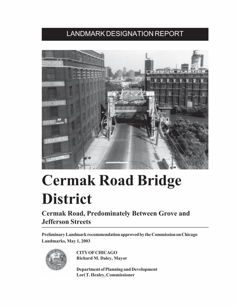
Cover: The Cermak Road Bridge District consists of the City’s finest intact ensemble ofriverfront industrial buildings grouped around the last remaining double leaf ScherzerRolling Lift bridge in operation in Chicago.
Ce
rma
k Rd
21
st St
Grove St
Lumber St
Jefferson St
Canal St
S O U T H B R A N C H O F T H E C H I C A G O R I V E R
1 0 0 F E E T
3
2
1
4
5
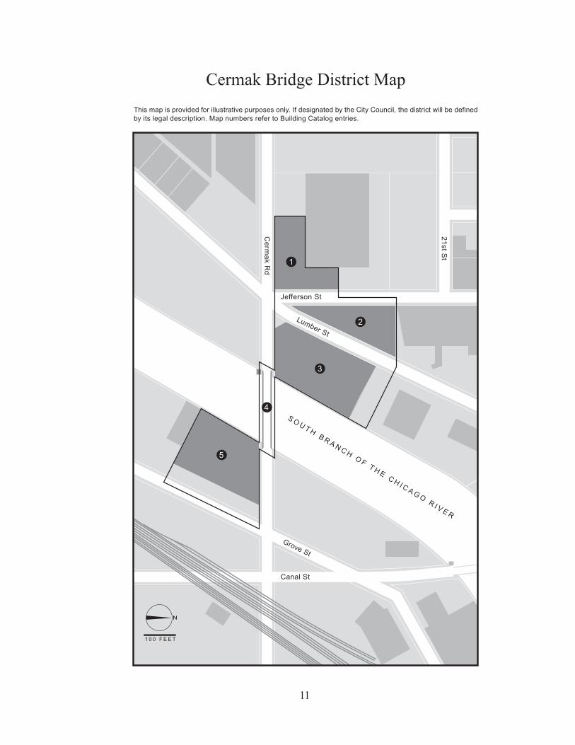
CERMAK ROAD BRIDGE DISTRICTCERMAK ROAD, PREDOMINATELY BETWEEN GROVE STREET AND
JEFFERSON STREET
PERIOD OF SIGNIFICANCE: 1901-1924
The Cermak Road Bridge District, located along Cermak Road and the South Branch of theChicago River on Chicago’s Lower West Side, is a significant ensemble of riverfront industrialbuildings grouped around the city’s sole-surviving double leaf Scherzer Rolling Lift bridge.Encouraged by the completion of the Illinois and Michigan Canal in 1848 and the constructionof the Chicago & Alton Railroad in the 1850s, industrial development along the Chicago Riverbegan in earnest and had grown exponentially by the end of the nineteenth century. As a pivotalpoint for maritime traffic as well as the crossroads of railroad routes, Chicago’s location gavethe merchants and manufacturers who established operations along the river a great advantage.
By 1900, newly-dredged slips and private rail sidings prompted an expansion of the city’sindustrial district beyond the Loop with merchants and manufacturers building huge warehousesand factories along the banks of the North and South branches of the river, including thebuildings in the Cermak Road Bridge District. Together the buildings and bridge of the CermakRoad Bridge District form the finest intact grouping of an industrial riverfront precinct in the city,commemorating the importance of the interconnected river and rail network that criss-crossedthe city to the development of Chicago. The structures in the Cermak Road Bridge District alsoreflect Chicago’s vital role as a central depot that quickly evolved into the preeminentdistribution center for the western United States. As a ready supply of raw materials flowedinto the city and an uninterrupted stream of manufactured goods were shipped out to everyregion of the United States, Chicago gained the reputation as a national center of commerce.
2
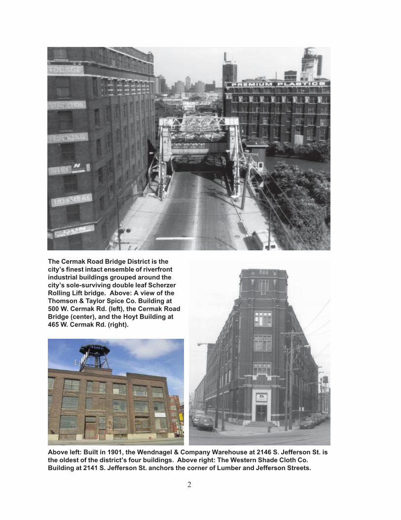
The Cermak Road Bridge District is thecity’s finest intact ensemble of riverfrontindustrial buildings grouped around thecity’s sole-surviving double leaf ScherzerRolling Lift bridge. Above: A view of theThomson & Taylor Spice Co. Building at500 W. Cermak Rd. (left), the Cermak RoadBridge (center), and the Hoyt Building at465 W. Cermak Rd. (right).
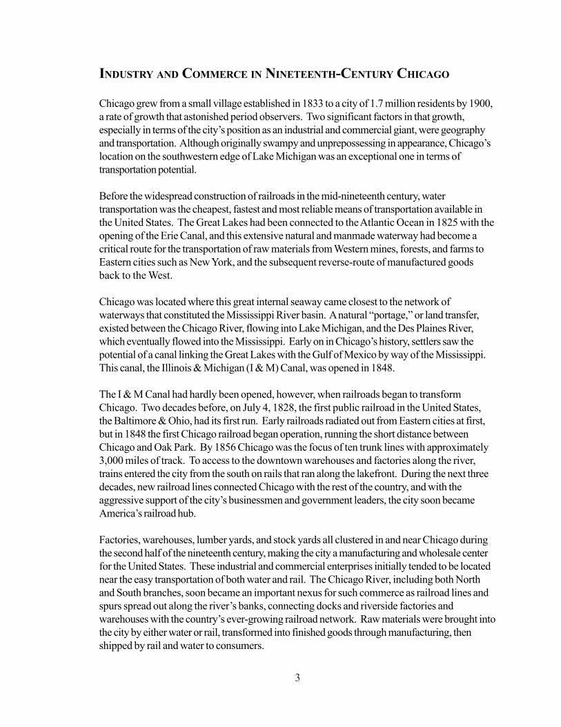
Above left: Built in 1901, the Wendnagel & Company Warehouse at 2146 S. Jefferson St. isthe oldest of the district’s four buildings. Above right: The Western Shade Cloth Co.Building at 2141 S. Jefferson St. anchors the corner of Lumber and Jefferson Streets.
3
INDUSTRY AND COMMERCE IN NINETEENTH-CENTURY CHICAGO
Chicago grew from a small village established in 1833 to a city of 1.7 million residents by 1900,a rate of growth that astonished period observers. Two significant factors in that growth,especially in terms of the city’s position as an industrial and commercial giant, were geographyand transportation. Although originally swampy and unprepossessing in appearance, Chicago’slocation on the southwestern edge of Lake Michigan was an exceptional one in terms oftransportation potential.
Before the widespread construction of railroads in the mid-nineteenth century, watertransportation was the cheapest, fastest and most reliable means of transportation available inthe United States. The Great Lakes had been connected to the Atlantic Ocean in 1825 with theopening of the Erie Canal, and this extensive natural and manmade waterway had become acritical route for the transportation of raw materials from Western mines, forests, and farms toEastern cities such as New York, and the subsequent reverse-route of manufactured goodsback to the West.
Chicago was located where this great internal seaway came closest to the network ofwaterways that constituted the Mississippi River basin. A natural “portage,” or land transfer,existed between the Chicago River, flowing into Lake Michigan, and the Des Plaines River,which eventually flowed into the Mississippi. Early on in Chicago’s history, settlers saw thepotential of a canal linking the Great Lakes with the Gulf of Mexico by way of the Mississippi.This canal, the Illinois & Michigan (I & M) Canal, was opened in 1848.
The I & M Canal had hardly been opened, however, when railroads began to transformChicago. Two decades before, on July 4, 1828, the first public railroad in the United States,the Baltimore & Ohio, had its first run. Early railroads radiated out from Eastern cities at first,but in 1848 the first Chicago railroad began operation, running the short distance betweenChicago and Oak Park. By 1856 Chicago was the focus of ten trunk lines with approximately3,000 miles of track. To access to the downtown warehouses and factories along the river,trains entered the city from the south on rails that ran along the lakefront. During the next threedecades, new railroad lines connected Chicago with the rest of the country, and with theaggressive support of the city’s businessmen and government leaders, the city soon becameAmerica’s railroad hub.
Factories, warehouses, lumber yards, and stock yards all clustered in and near Chicago duringthe second half of the nineteenth century, making the city a manufacturing and wholesale centerfor the United States. These industrial and commercial enterprises initially tended to be locatednear the easy transportation of both water and rail. The Chicago River, including both Northand South branches, soon became an important nexus for such commerce as railroad lines andspurs spread out along the river’s banks, connecting docks and riverside factories andwarehouses with the country’s ever-growing railroad network. Raw materials were brought intothe city by either water or rail, transformed into finished goods through manufacturing, thenshipped by rail and water to consumers.
4
Contemporary photographs from the 1860s through 1900 show the intensely commercial usesto which the Chicago River was originally put. The river was full of ships, passing by industrialbuildings of varying sizes and complexity. Raw materials of all sorts were brought towarehouses and storage yards along the river, including lumber, metal ores, and grain. Near theLake Michigan shore, grandly-scaled warehouses to house grain were built on the south bank ofthe river, at the terminus of the Illinois Central Railroad. On the north bank of the river, east oftoday’s North Michigan Avenue, stood Cyrus McCormick’s reaper factory where iron ore wasshaped into mass-produced farm equipment.
One of the most significant uses of the riverfront, in sheer acreage, was for lumber storage.Chicago was the lumber capital of the Midwest, with over 1 billion board feet of lumber broughtto the city and processed in 1880. The South Branch of the river, both north and south of theCermak Road Bridge District, was especially devoted to lumber yards where timber fromsurrounding states such as Michigan and Wisconsin was sorted, stored, dried, and reconfiguredinto lots to be shipped to retailers and builders throughout the Midwest.
The land that is part of the Cermak Road Bridge District, although surrounded by lumber yards,remained largely unused through the mid-1880s. Robinson’s fire insurance atlas of 1886 showsthat the only building built within the boundaries of the district was a warehouse for the AltonRail Company, located on the future site of the W. M. Hoyt Co. building at 465 W. CermakRd.
The peak years for the Chicago lumber trade were in the 1880s and early 1890s, ending in1892. With the exhaustion of lumber supplies reachable by water and rail from Chicago, thecity’s dominance as the lumber capital of the United States began to wane. Cheaper yellowpine from forests in Georgia and other southern states began to take preeminence, and lumberbrought into Chicago in the early twentieth century was predominantly for local consumption forhousing and other construction.
As lumber yards along the South Branch closed in the 1890s and early 1900s, land adjacent tothe river remained attractive for warehouses and factories. At the same time, increasing landvalues were forcing wholesalers and manufacturers out of downtown Chicago. Early inChicago’s history, during the 1830s through 1860s, the area now known as the Loop hadhoused a wide variety of land uses, including residential, governmental, retail, wholesale, andmanufacturing. Even after the Fire of 1871 and into the 1890s, the established retail and officearea of downtown Chicago, centered along Michigan Avenue and State, Dearborn, and LaSalleStreets, was flanked to the north and west by warehouse districts devoted to wholesale,warehouse and light manufacturing uses. The most famous of these was the wholesale fooddistrict along South Water Street, just south of and parallel to the Chicago River betweenMichigan and the South Branch of the Chicago River.
This “girdle” of factories and warehouses had increasingly become an impediment to downtownreal estate growth by 1900. Manufacturers and wholesale companies were encouraged, firstthrough free-market real estate practice, then through the 1909 Plan of Chicago (which
5
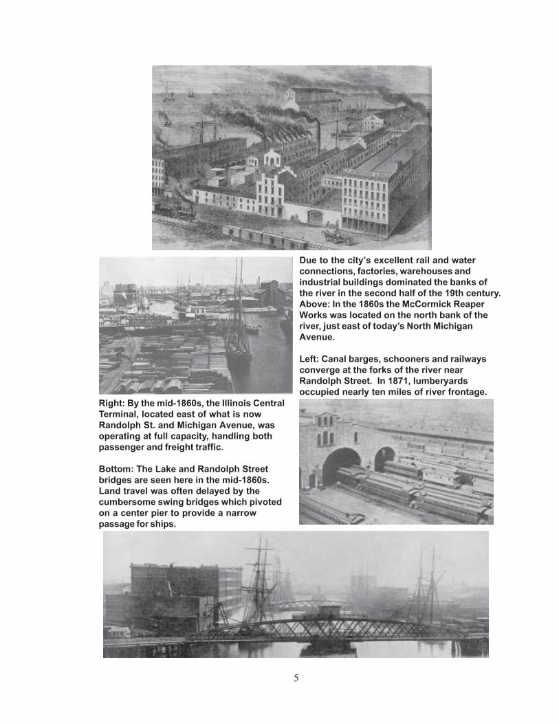
Due to the city’s excellent rail and waterconnections, factories, warehouses andindustrial buildings dominated the banks ofthe river in the second half of the 19th century.Above: In the 1860s the McCormick ReaperWorks was located on the north bank of theriver, just east of today’s North MichiganAvenue.
Left: Canal barges, schooners and railwaysconverge at the forks of the river nearRandolph Street. In 1871, lumberyardsoccupied nearly ten miles of river frontage.
Right: By the mid-1860s, the Illinois CentralTerminal, located east of what is nowRandolph St. and Michigan Avenue, wasoperating at full capacity, handling bothpassenger and freight traffic.
Bottom: The Lake and Randolph Streetbridges are seen here in the mid-1860s.Land travel was often delayed by thecumbersome swing bridges which pivotedon a center pier to provide a narrowpassage for ships.
6
brought about the redevelopment of the south bank of the Chicago River for Wacker Drive), tosell their downtown properties and move elsewhere in the city.
Consequently, due to the abundance of low cost land and the proliferation of railroads, lumberyards, factories, elevators, warehouses, docks and depots that once lined the river downtownpushed north and south along both branches. By 1900, four major rail lines (the Chicago &Alton, the Pittsburgh, Ft. Wayne & Chicago, the Chicago & Western Indiana, and the Atchison,Topeka & Santa Fe) ran along the South Branch of the river through area surrounding CermakRoad. Many of the industrial buildings constructed in the Cermak Road Bridge District hadslips and private rail sidings to allow them to take advantage of the interconnected network ofwater and rail transportation that converged in the area.
It was during this period, from 1901 to 1924, that the four buildings in the Cermak Road BridgeDistrict, as well as the Cermak Road Bridge, were built. Two of the buildings housedcompanies previously located in this wholesale-manufacturing section of downtown Chicago,the W. M. Hoyt Co. and the Thomson & Taylor Spice Company, which moved to newbuildings in the district in 1909 and 1911, respectively. These companies could build newmodern buildings here for relatively modest sums. For example, Thomson & Taylor built theirseven-story building for $350,000.
Both of these companies were wholesale grocers, dealing with food stuffs such as canned food,spices, and coffee. Chicago and its Makers, a history of Chicago published in 1929, notedthat wholesale grocers were a significant part of Chicago’s important wholesale trade andcommented on the general geographic and transportation advantages possessed by Chicago:
From the day the very first settlers came to what is now the cityof Chicago, the place was a central depot, a distributing center,of provisions. Its location at the head of navigation on the GreatLakes, and the crossroads of the routes followed by the coureursdu bois, gave it great advantage over all other points.
Companies such as W. H. Hoyt and Thomson & Taylor were suppliers to small grocers andgeneral stores throughout the Midwest during the late nineteenth and early twentieth centuries,taking advantage of Chicago’s central location and excellent transportation connections, both bywater and rail, to the rest of the United States.
FACTORY AND WAREHOUSE ARCHITECTURE IN
THE CERMAK ROAD BRIDGE DISTRICT
The Cermak Road Bridge District is a significant grouping of riverfront industrial buildings,reflecting the history of the Chicago River as an important spine of industrial and warehouseactivity. In its heyday as a center of commerce, the river was lined with a variety of factory andwarehouse buildings of varying sizes, configurations, and architectural styles, representing theprogression of industrial architectural design in Chicago throughout the nineteenth and early
7
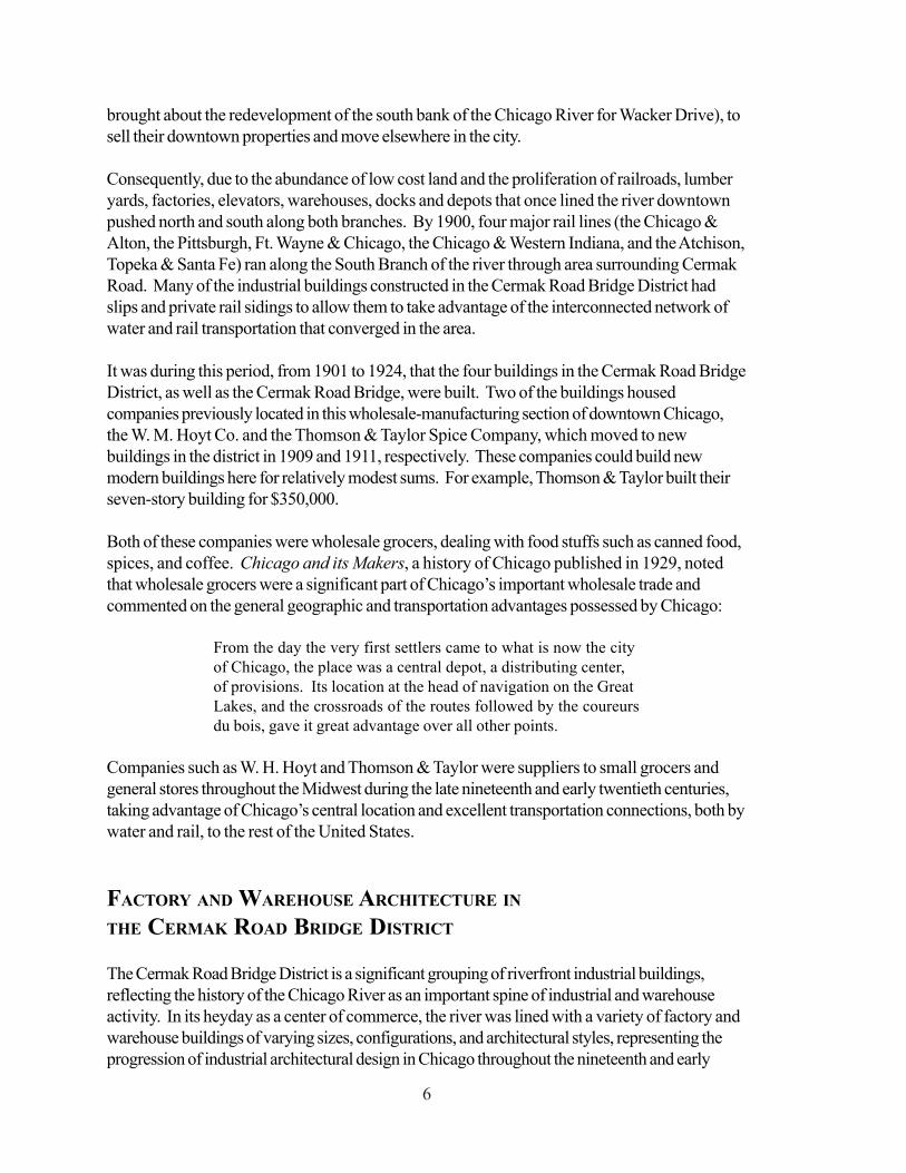
Above: In 1890 the Rush Street Bridgewas one of the city’s busiest bridges.During this time warehouse districts linedboth sides of the Main Branch of the river.
Left: Before establishing its operations at465 W. Cermak Rd., the W.M. Hoyt whole-sale grocery house was headquartered inthis building that stood on what is nowthe London Guarantee Building (360 N.Michigan Avenue).
Bottom: The South Water Street producemarket is shown here. The bustlingmarket which was south of and parallel tothe Chicago River between MichiganAvenue and the South Branch of the riverwas relocated in 1925 to make way forWacker Drive.
8
twentieth centuries. Most of these buildings have been destroyed for more recent development.The buildings found within the Cermak Road Bridge District represent the best surviving clusterof riverfront industrial architecture remaining in Chicago.
Nineteenth- and early twentieth-century industrial architecture in Chicago, including that found inthe District, was typical of industrial buildings found in other industrial cities in the United States.The buildings in the district are multi-story loft buildings with brick exteriors covering interiorssupported by either metal or concrete frames. They were designed with wide-open interiorfloors meant to provide companies the greatest degree of flexibility in the use of interior space.Such interiors permitted either light manufacture or warehouse uses within the same generalenvelope of space. Being adjacent to railroad lines and, in the case of the W. M. Hoyt andThomson & Taylor Company buildings, the South Branch of the Chicago River, buildings withinthe district had easy access to means of transportation for the goods housed or manufactured inthem.
As buildings built for starkly utilitarian uses, the buildings in the district have architectural stylesthat are simple and direct, with relatively little applied ornament. The visual appeal of thesebuildings rests with the straightforward use of materials, including colors and textures, as well asthe simple overall architectural expression. This is especially true of the Wendnagel & CompanyWarehouse at 2120-36 S. Jefferson, the oldest building in the district, built in two stages in1901 and 1906, with its common-brick walls ornamented with simple coffered spandrels andcorbeled roof parapet.
The three later buildings in the district show greater efforts towards decorative embellishment.All three have chamfered corners that provide dramatic massing that takes advantage of thenon-rectilinear street patterns found in the district, created in response to the slightly northeast-southwest orientation of the Chicago River. The Thomson & Taylor Spice Company Building at500 W. Cermak Rd., built in 1911, also uses dramatic massing and contrasting limestone detailsused for lintels and window details. The Western Shade Cloth Company Building at theintersection of Lumber and Jefferson Streets and Cermak Road, combines the visual drama ofits “flatiron” site with simplified Collegiate Gothic details, including multiple windows groupedwithin rectilinear stone surrounds. The W. M. Hoyt Building at 465 W. Cermak Rd., built in1909, is the most high-style, elaborately detailed building within the district, utilizing dramaticPrairie-style stone ornament around the building’s main entrance and just under its rooftopparapet as well as in its pier and spandrel expression. Individually, these buildings arehandsome examples of early twentieth-century Chicago industrial architecture. Taken as agroup, they are exceptional in their ability to visually express an almost-vanished aspect ofChicago’s historic industrial streetscapes.
9
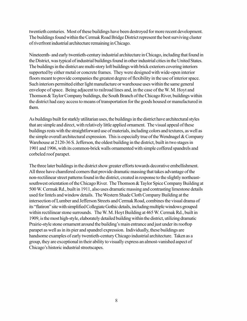
Left: A contemporary view ofthe Western Shade ClothCompany Building (left) andthe Thomson & Taylor SpiceCompany Building located atthe corner of Lumber Streetand Cermak Road in theCermak Road Bridge District.
Below: A historic view of thedistrict looking northeast. TheThomson & Taylor Building(left), the Cermak RoadBridge, and the Hoyt Building(right) are seen in this photofrom 1940. PennsylvaniaRailroad Bridge 458, a verticallift bridge constructed in 1915,is seen in the distance. Thebridge is located just south of18th Street and east of CanalStreet.
10
BRIDGES AND THE CHICAGO RIVER
Since its earliest days, bridges have been vital to the commercial and industrial growth ofChicago. By enabling land and water transportation to circulate through the same area withrelatively little interference, bridges facilitated the smooth transportation of raw materials andmanufactured goods through the area and were especially important to the development of theindustrial and manufacturing operations along the river. Even as the city and the river grewtogether and made each other great, however, a tension existed between them. While the riverbrought business and industry to the city, its Y-shape with branches running north and southoften made land traffic a challenge.
Developments in bridge design in Chicago was an evolutionary process that began in 1831 withthe construction of the city’s first bridge, a span that was privately funded for the purpose ofproviding citizens a means of crossing the north branch of the river to patronize a tavern on theeast bank. This bridge, however, was not moveable, so no ships of any size were able to pass.The advantage of a bridge that would allow people and horses to pass and could quickly bemoved out of the way for boats was quickly recognized.
The city’s first movable bridge was built in 1834 at Dearborn Street. A menace to rivernavigation, the wooden drawbridge which once was stuck open for two days was demolished in1839. Other movable bridges followed, including floating bridges (which were hinged to theriver bank on one end and floated on a pontoon on the other end), swing bridges (which rotatedon a center pier), jack-knife bridges (which were hinged at two places on each leaf and foldedback toward the bank) and vertical lift bridges (massive structures whose span was raised bymechanisms housed in towers that stood on either side of the river). Designing an efficient andsomewhat aesthetically pleasing movable bridge was a challenge for designers and engineers.
In 1893, William Scherzer patented a bridge design that showed a lot of promise. It was a“rolling lift” bridge, a two-leafed bridge that worked like facing rocking chairs that rocked backaway from each other leaving a clear space between. The Cermak Road Bridge is the onlyremaining double leaf Scherzer Rolling Lift Bridge in Chicago. Constructed in 1906, the bridgecontinues to be owned and operated by the city. This early movable bridge was the first of twotypes of bascule bridges to be erected in Chicago, and it was an important predecessor to theChicago type trunnion bascule bridges that today are a familiar sight along the Chicago Riverand around the world.
11
Ce
rma
k Rd
21
st St
Grove St
Lumber St
Jefferson St
Canal St
S O U T H B R A N C H O F T H E C H I C A G O R I V E R
1 0 0 F E E T
3
2
1
4
5
This map is provided for illustrative purposes only. If designated by the City Council, the district will be definedby its legal description. Map numbers refer to Building Catalog entries.
Cermak Bridge District Map
12
BUILDING CATALOG
1. Wendnagel & Company Warehouse2130-46 S. Jefferson Street/600 W. Cermak RoadDate: 1901
North Addition, 1906Architect: Unknown
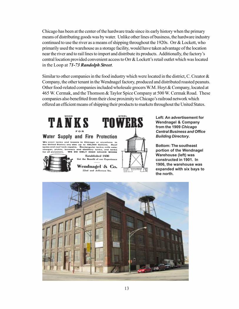
In 1901, the Economist reported that Wendnagel & Company began the construction of athree-story brick factory on the northwest corner of 22nd and Jefferson Streets. Specializing inthe manufacture of brewers’ vats, wooden tanks and fire protection tanks that sat atop many ofthe rooftops of buildings throughout the city, Wendnagel enjoyed a thriving business. As buildingconstruction boomed in Chicago and throughout the Midwest, so too did the demand forWendnagel’s fire protection tanks. Consequently, just five years after the completion of itsfactory on Jefferson Street, the company made plans to expand the building. In 1906, a three-story addition, carefully crafted to match the design, details and materials of the original building,was constructed on the north side of the factory.
Both the original factory building and the 1906 addition are constructed of brown brick set atopa raised base of rusticated limestone. The building displays its simple but fine craftsmanship in itssolid brickwork. Details include recessed spandrel panels and a parapet decorated with astepped brick pattern resembling dentils. The building’s straightforward design is enhanced byquality materials such as limestone sills and rust-colored face brick which accents the verticalpiers. Both the original 1901 factory building and the 1906 addition possess excellent integrityand have experienced only minor changes such as the infill of some window openings. In thelate 1990s, a large addition constructed of white metal was added to the rear of the originalfactory and the 1906 addition. This modern addition, which is setback and clearly distinguishedfrom the historic portions of the factory by it color and building materials, is not included in theboundaries of the district.
According to company advertisements from 1908, Wendnagel & Company was founded in1856. The company’s first factory was located at 792-794 State Street and the business wasmanaged by its founder, Louis Wendnagel. An advertisement from the Lakeside ClassifiedDirectory of 1911 states that the company erected tanks anywhere in the United States,including: rectangular tanks, milk vats, roof tanks, vinegar, pickle, brewery and distillery tanks.
By 1914, Wendnagel & Company maintained its operations in the original portion of the factoryon Jefferson Street and began leasing space in the north addition to commercial tenants. TheSanborn Company Fire Insurance Map for 1914 shows that the building also housed twotenants, the Orr & Lockett Hardware Company and C. Creator’s & Company. Orr &Lockett, whose advertising slogan was “Chicago’s Representative Hardware House,”specialized in the manufacture of tools, hardware, refrigerators, dumb-waiters and contractors’supplies.
13
Chicago has been at the center of the hardware trade since its early history when the primarymeans of distributing goods was by water. Unlike other lines of business, the hardware industrycontinued to use the river as a means of shipping throughout the 1920s. Orr & Lockett, whoprimarily used the warehouse as a storage facility, would have taken advantage of the locationnear the river and to rail lines to import and distribute its products. Additionally, the factory’scentral location provided convenient access to Orr & Lockett’s retail outlet which was locatedin the Loop at 71-73 Randolph Street.
Similar to other companies in the food industry which were located in the district, C. Creator &Company, the other tenant in the Wendnagel factory, produced and distributed roasted peanuts.Other food-related companies included wholesale grocers W.M. Hoyt & Company, located at465 W. Cermak, and the Thomson & Taylor Spice Company at 500 W. Cermak Road. Thesecompanies also benefitted from their close proximity to Chicago’s railroad network whichoffered an efficient means of shipping their products to markets throughout the United States.
Left: An advertisement forWendnagel & Companyfrom the 1909 ChicagoCentral Business and OfficeBuilding Directory.
Bottom: The southeastportion of the WendnagelWarehouse (left) wasconstructed in 1901. In1906, the warehouse wasexpanded with six bays tothe north.
14
2. The Western Shade Cloth Company Building2141 S. Jefferson StreetDate: 1924Architect: Lockwood Greene & Co.
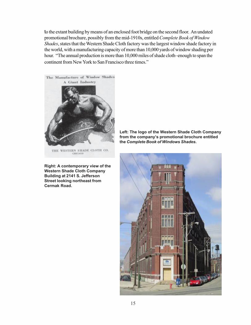
Completed in 1924, the Western Shade Cloth Company Building was the last of district’s fourindustrial buildings to be constructed. This triangular four- and five-story red brick building wasdesigned by the architectural firm of Lockwood Greene & Co. The highly symmetrical buildingis articulated by four-story vertical piers with geometric limestone capitals. Other ornamentalfeatures include limestone detailing consisting of window surrounds, stringcourses and copings.
The building is marked by a five-story tower on the Cermak Road facade, which anchors thebuilding on its triangular lot. A one story entrance foyer projects from the base of the tower.Designed with a castellated parapet, the projecting entry gives the industrial building a refinedcharacter. The rich red brick entry is accentuated by a grey limestone surround which framesthe doorway and transom window. The words “Western Shade Cloth Company” are inscribedabove the window. Above the entry, four narrow windows topped by transoms and framed bylimestone surrounds are situated on the second, third and fourth stories of the tower. Multiplelimestone stringcourses distinguish the top of the tower, which is further accented by a groupingof three narrow windows which is also set in a limestone frame. Geometric limestone pendantsflank the windows on the tower’s fifth story. The parapet of the tower features a limestonestringcourse of simplified geometric ornament.
As is common in the evolution of industrial buildings, the Western Shade Cloth CompanyBuilding was expanded a number of times to accommodate the functional needs of the business.Its four and five story factory stretches north to an unadorned two story warehouse. This twostory wing, which extends along the northwest side of the triangular site, was constructed at thesame time as the four- and five- story portion of the building. Unlike the corner portion of thefactory, which retains a high degree of integrity, the two story wing has experienced significantalterations. This portion plus four annexes and additions to the rear of the building that wereconstructed along the northeast portion of the site are located outside the boundaries of thedistrict.
Little is known about the building’s architects, Lockwood Greene & Company. The firm,whose office was located at 38 S. Dearborn Street, primarily designed manufacturing buildingsin Chicago. Another known surviving building by Lockwood Greene & Company is theEgyptian Lacquer Manufacturing Co. Building, designed in 1926 in the Egyptian Revival style,located in the East Garfield Park neighborhood at 3052 W. Carroll Avenue. This one-storybuilding features exuberant details including a scarab ornament over the entrance and decorativefriezes, which surround the door.
The Western Shade Cloth Company which manufactured cloth shades and window treatmentsalso had an enormous presence in the area surrounding the district. Its milling operation washoused in a factory building at 2100 S. Jefferson Street (now demolished) and was connected
15
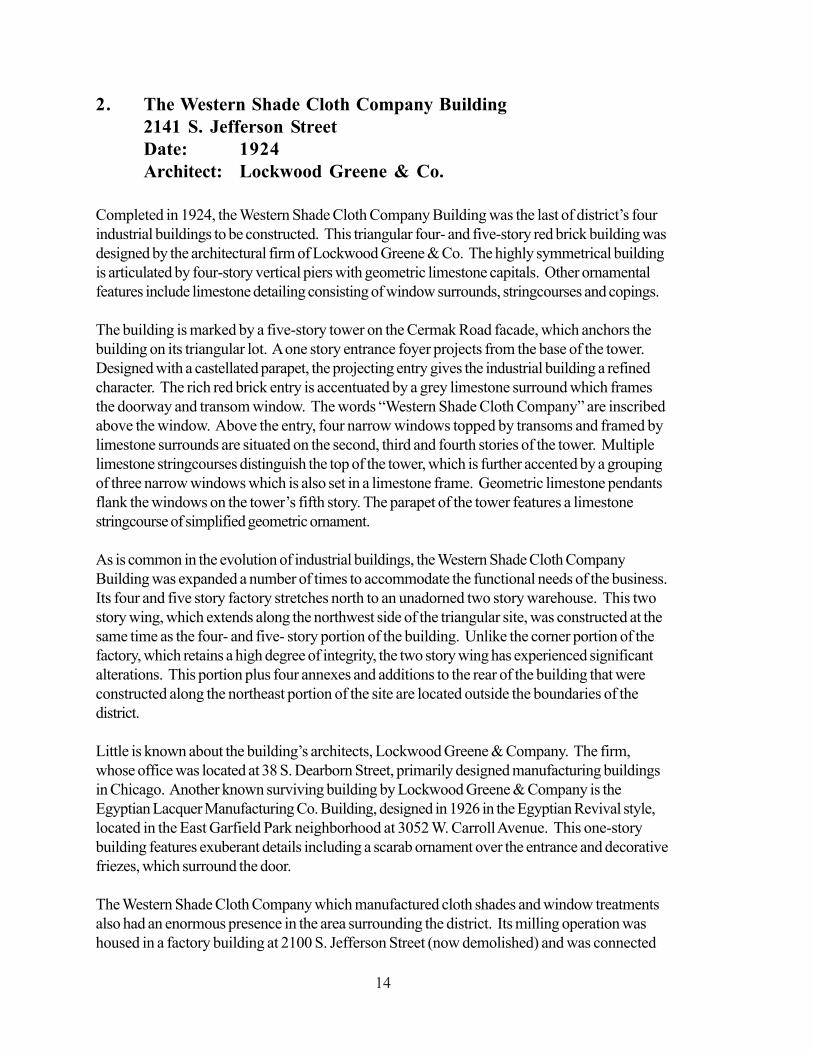
to the extant building by means of an enclosed foot bridge on the second floor. An undatedpromotional brochure, possibly from the mid-1910s, entitled Complete Book of WindowShades, states that the Western Shade Cloth factory was the largest window shade factory inthe world, with a manufacturing capacity of more than 10,000 yards of window shading perhour. “The annual production is more than 10,000 miles of shade cloth–enough to span thecontinent from New York to San Francisco three times.”
Left: The logo of the Western Shade Cloth Companyfrom the company’s promotional brochure entitledthe Complete Book of Windows Shades.
Right: A contemporary view of theWestern Shade Cloth CompanyBuilding at 2141 S. JeffersonStreet looking northeast fromCermak Road.
16
3. Thomson & Taylor Spice Company Building500 W. Cermak RoadDate: 1911Architects: Chatten & Hammond
This massive industrial building was constructed in 1911 for the Thomson & Taylor SpiceCompany. As one of the City’s earliest dealers of foodstuffs, Thomson & Taylor importedspices, coffees, and indigoes, and manufactured mustards, baking powders, flavoring extracts,dry and liquid spices, and ground hops, herbs and seeds. They were also the proprietors ofhousehold products and staples such as “Red Cross Lye and Potash” and “Gold Band Coffee.”
The company was founded in Chicago just after the Civil War in 1865 by Alex M. Thomson,James E. Taylor, and George Thomson. By 1887, Thomson & Taylor occupied two four-storybuildings located at 34-40 S. Water Street (now demolished) and had grown to be one of thelargest importers and manufacturers of spices in the United States. The increasing success ofthe business prompted the company to construct an seven-story industrial building on the cornerof Lake Street and Michigan Avenue (demolished) which served as the Thomson Taylor’sheadquarters until 1911 when it relocated to the emerging manufacturing district along 22nd
Street (now Cermak Road) and the South Branch of the Chicago River.
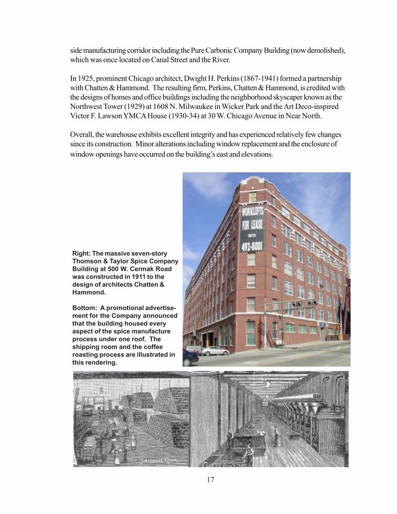
Thomson & Taylor’s seven-story red-brick manufacturing building anchors the northeasterncorner of the intersection of Cermak Road and Lumber Street. Bordered to the east by theChicago River, the angular building was built at a cost of $350,000 by the architectural firm ofChatten & Hammond according to The Economist. The imposing warehouse is ornamentedwith terra cotta crafted by the American Terra Cotta and Ceramic Company which articulatesits base, shaft and capitals. Pilasters are capped with three horizontal bands of white glazedterra cotta and a white inset panel featuring an abstract geometric ornament. A terra cotta stringcourse is situated above the pilasters and additional string courses stretch above and below theseventh floor windows. Parapets at the southeast and southwest corners of the building arefurther accentuated with simple terra cotta brackets and finely crafted brickwork.
During the time the warehouse was occupied by Thomson & Taylor, it housed every aspect ofthe spice manufacture process. Storage was located in the basement, shipping and receiving onthe first floor, spice packing and a laboratory on the third floor, additional storage and coffeeroasting and grinding on floors four, five and six, and packaging and rolling on the top floor.
The architectural firm of Chatten & Hammond designed factories and residences in Chicagoand the Midwest and was founded in 1907 by Melville Clarke Chatten (1873-1957) andCharles Herrick Hammond (1882-1969). After earning a degree in architecture from theUniversity of Illinois Urbana-Champaign in 1896, Melville Chatten practiced architecture withthe firm of Frost & Granger from 1899 to 1905. C. Herrick Hammond graduated from theArmour Institute of Technology (now IIT) in 1904. Both traveled to Paris and studied at theEcole des Beaux Arts before returning to Chicago and establishing the firm. In addition to theThomson & Taylor Building, Chatten & Hammond designed other factories in this near south
17
side manufacturing corridor including the Pure Carbonic Company Building (now demolished),which was once located on Canal Street and the River.
In 1925, prominent Chicago architect, Dwight H. Perkins (1867-1941) formed a partnershipwith Chatten & Hammond. The resulting firm, Perkins, Chatten & Hammond, is credited withthe designs of homes and office buildings including the neighborhood skyscaper known as theNorthwest Tower (1929) at 1608 N. Milwaukee in Wicker Park and the Art Deco-inspiredVictor F. Lawson YMCA House (1930-34) at 30 W. Chicago Avenue in Near North.
Overall, the warehouse exhibits excellent integrity and has experienced relatively few changessince its construction. Minor alterations including window replacement and the enclosure ofwindow openings have occurred on the building’s east and elevations.
Right: The massive seven-storyThomson & Taylor Spice CompanyBuilding at 500 W. Cermak Roadwas constructed in 1911 to thedesign of architects Chatten &Hammond.
Bottom: A promotional advertise-ment for the Company announcedthat the building housed everyaspect of the spice manufactureprocess under one roof. Theshipping room and the coffeeroasting process are illustrated inthis rendering.
18
4. Cermak Road BridgeCermak Road and the South Branch of the Chicago RiverDate: 1906Principal Designer: William ScherzerChief Engineer: Isham Randolph
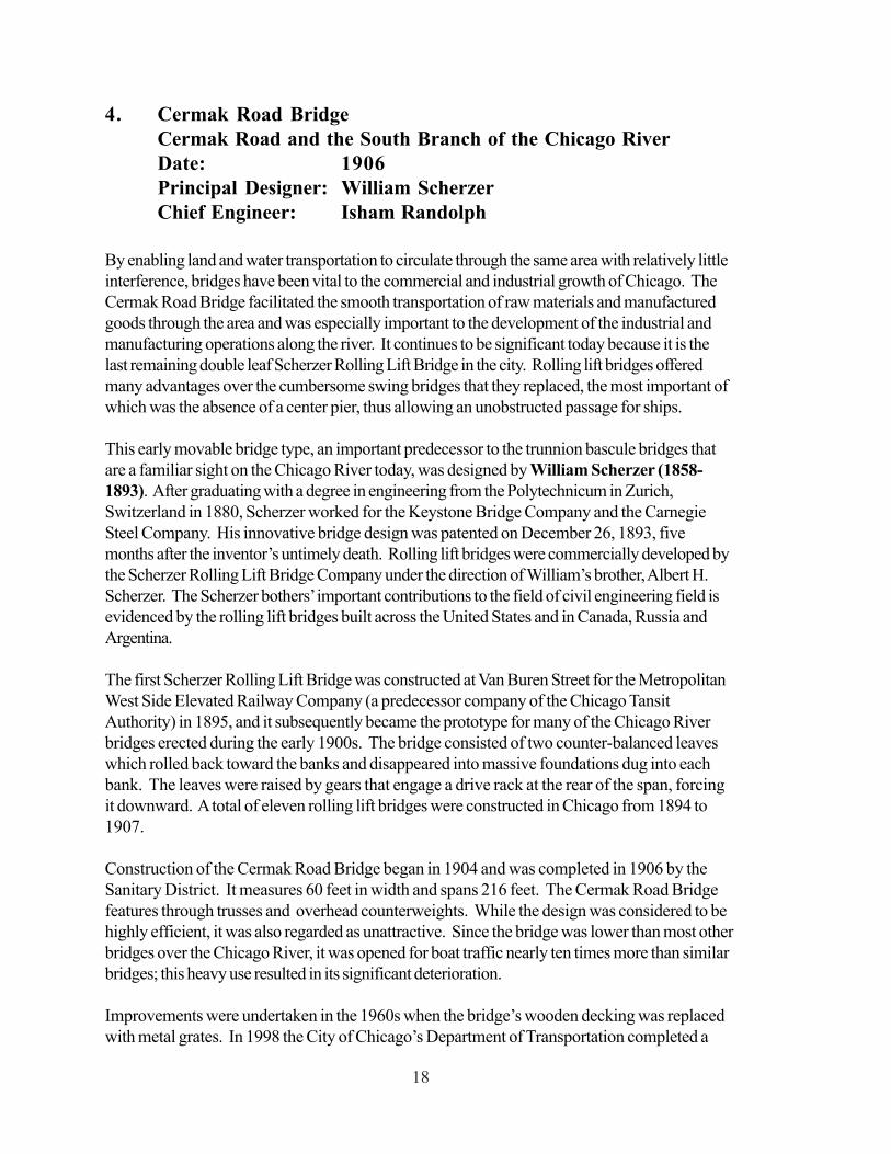
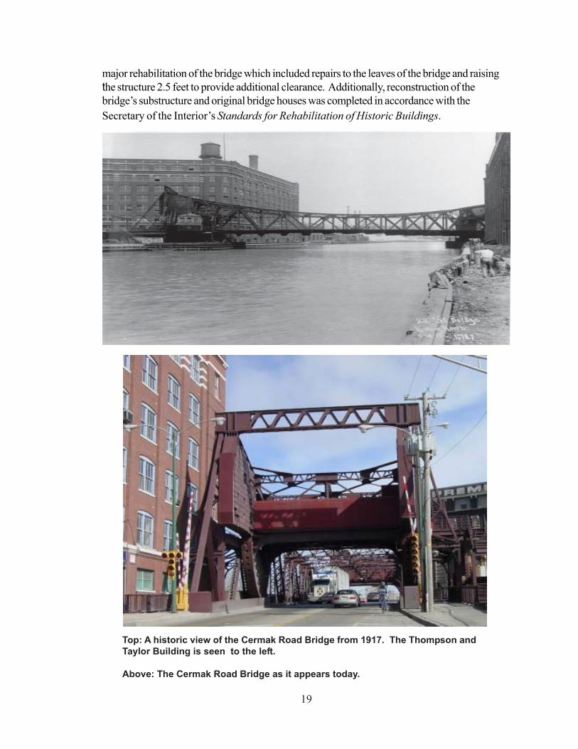
By enabling land and water transportation to circulate through the same area with relatively littleinterference, bridges have been vital to the commercial and industrial growth of Chicago. TheCermak Road Bridge facilitated the smooth transportation of raw materials and manufacturedgoods through the area and was especially important to the development of the industrial andmanufacturing operations along the river. It continues to be significant today because it is thelast remaining double leaf Scherzer Rolling Lift Bridge in the city. Rolling lift bridges offeredmany advantages over the cumbersome swing bridges that they replaced, the most important ofwhich was the absence of a center pier, thus allowing an unobstructed passage for ships.
This early movable bridge type, an important predecessor to the trunnion bascule bridges thatare a familiar sight on the Chicago River today, was designed by William Scherzer (1858-1893). After graduating with a degree in engineering from the Polytechnicum in Zurich,Switzerland in 1880, Scherzer worked for the Keystone Bridge Company and the CarnegieSteel Company. His innovative bridge design was patented on December 26, 1893, fivemonths after the inventor’s untimely death. Rolling lift bridges were commercially developed bythe Scherzer Rolling Lift Bridge Company under the direction of William’s brother, Albert H.Scherzer. The Scherzer bothers’ important contributions to the field of civil engineering field isevidenced by the rolling lift bridges built across the United States and in Canada, Russia andArgentina.
The first Scherzer Rolling Lift Bridge was constructed at Van Buren Street for the MetropolitanWest Side Elevated Railway Company (a predecessor company of the Chicago TansitAuthority) in 1895, and it subsequently became the prototype for many of the Chicago Riverbridges erected during the early 1900s. The bridge consisted of two counter-balanced leaveswhich rolled back toward the banks and disappeared into massive foundations dug into eachbank. The leaves were raised by gears that engage a drive rack at the rear of the span, forcingit downward. A total of eleven rolling lift bridges were constructed in Chicago from 1894 to1907.
Construction of the Cermak Road Bridge began in 1904 and was completed in 1906 by theSanitary District. It measures 60 feet in width and spans 216 feet. The Cermak Road Bridgefeatures through trusses and overhead counterweights. While the design was considered to behighly efficient, it was also regarded as unattractive. Since the bridge was lower than most otherbridges over the Chicago River, it was opened for boat traffic nearly ten times more than similarbridges; this heavy use resulted in its significant deterioration.
Improvements were undertaken in the 1960s when the bridge’s wooden decking was replacedwith metal grates. In 1998 the City of Chicago’s Department of Transportation completed a
19
major rehabilitation of the bridge which included repairs to the leaves of the bridge and raisingthe structure 2.5 feet to provide additional clearance. Additionally, reconstruction of thebridge’s substructure and original bridge houses was completed in accordance with theSecretary of the Interior’s Standards for Rehabilitation of Historic Buildings.
Top: A historic view of the Cermak Road Bridge from 1917. The Thompson andTaylor Building is seen to the left.
Above: The Cermak Road Bridge as it appears today.
20
5. W. M. Hoyt Company Building465 W. Cermak RoadDate: 1909Architects: Nimmons & Fellows
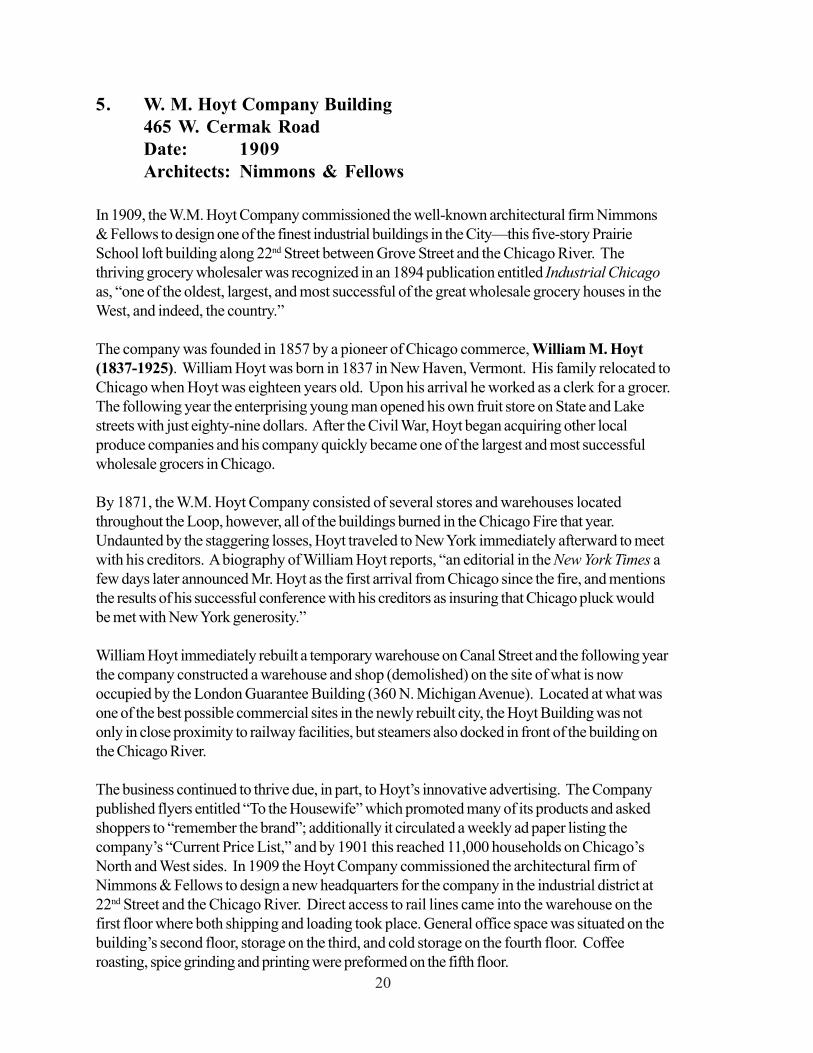
In 1909, the W.M. Hoyt Company commissioned the well-known architectural firm Nimmons& Fellows to design one of the finest industrial buildings in the City—this five-story PrairieSchool loft building along 22nd Street between Grove Street and the Chicago River. Thethriving grocery wholesaler was recognized in an 1894 publication entitled Industrial Chicagoas, “one of the oldest, largest, and most successful of the great wholesale grocery houses in theWest, and indeed, the country.”
The company was founded in 1857 by a pioneer of Chicago commerce, William M. Hoyt(1837-1925). William Hoyt was born in 1837 in New Haven, Vermont. His family relocated toChicago when Hoyt was eighteen years old. Upon his arrival he worked as a clerk for a grocer.The following year the enterprising young man opened his own fruit store on State and Lakestreets with just eighty-nine dollars. After the Civil War, Hoyt began acquiring other localproduce companies and his company quickly became one of the largest and most successfulwholesale grocers in Chicago.
By 1871, the W.M. Hoyt Company consisted of several stores and warehouses locatedthroughout the Loop, however, all of the buildings burned in the Chicago Fire that year.Undaunted by the staggering losses, Hoyt traveled to New York immediately afterward to meetwith his creditors. A biography of William Hoyt reports, “an editorial in the New York Times afew days later announced Mr. Hoyt as the first arrival from Chicago since the fire, and mentionsthe results of his successful conference with his creditors as insuring that Chicago pluck wouldbe met with New York generosity.”
William Hoyt immediately rebuilt a temporary warehouse on Canal Street and the following yearthe company constructed a warehouse and shop (demolished) on the site of what is nowoccupied by the London Guarantee Building (360 N. Michigan Avenue). Located at what wasone of the best possible commercial sites in the newly rebuilt city, the Hoyt Building was notonly in close proximity to railway facilities, but steamers also docked in front of the building onthe Chicago River.
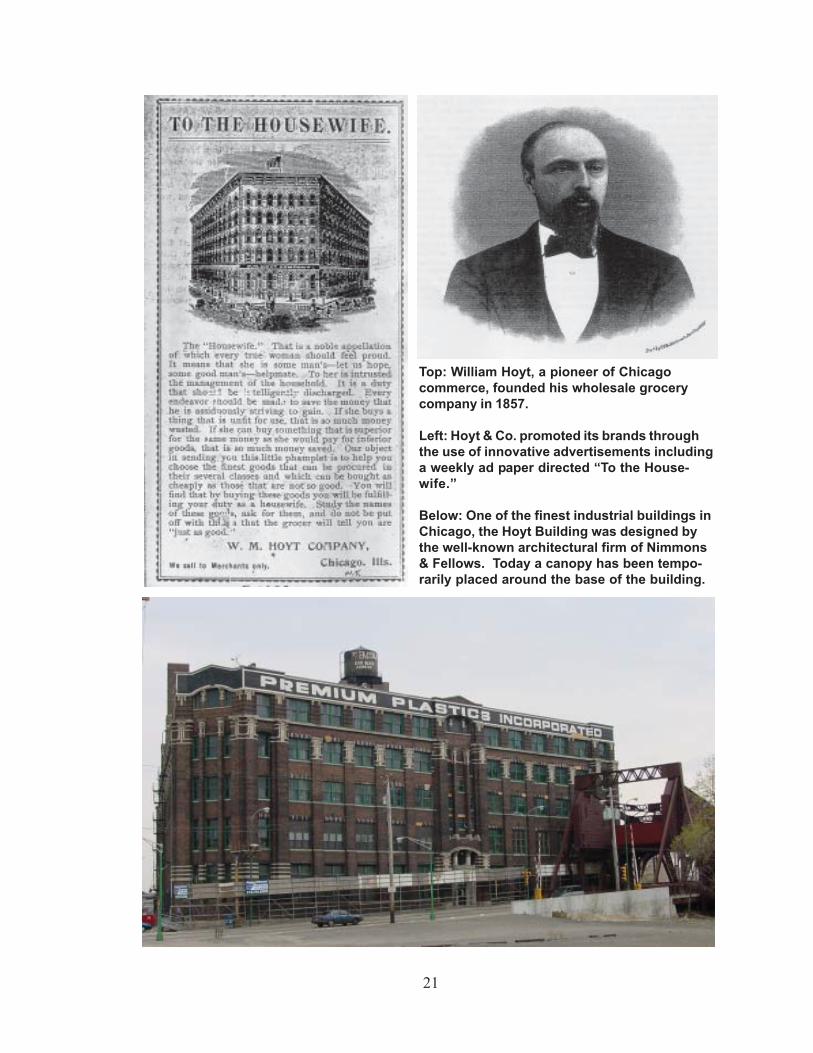
The business continued to thrive due, in part, to Hoyt’s innovative advertising. The Companypublished flyers entitled “To the Housewife” which promoted many of its products and askedshoppers to “remember the brand”; additionally it circulated a weekly ad paper listing thecompany’s “Current Price List,” and by 1901 this reached 11,000 households on Chicago’sNorth and West sides. In 1909 the Hoyt Company commissioned the architectural firm ofNimmons & Fellows to design a new headquarters for the company in the industrial district at22nd Street and the Chicago River. Direct access to rail lines came into the warehouse on thefirst floor where both shipping and loading took place. General office space was situated on thebuilding’s second floor, storage on the third, and cold storage on the fourth floor. Coffeeroasting, spice grinding and printing were preformed on the fifth floor.
21
Top: William Hoyt, a pioneer of Chicagocommerce, founded his wholesale grocerycompany in 1857.
Left: Hoyt & Co. promoted its brands throughthe use of innovative advertisements includinga weekly ad paper directed “To the House-wife.”
Below: One of the finest industrial buildings inChicago, the Hoyt Building was designed bythe well-known architectural firm of Nimmons& Fellows. Today a canopy has been tempo-rarily placed around the base of the building.
22
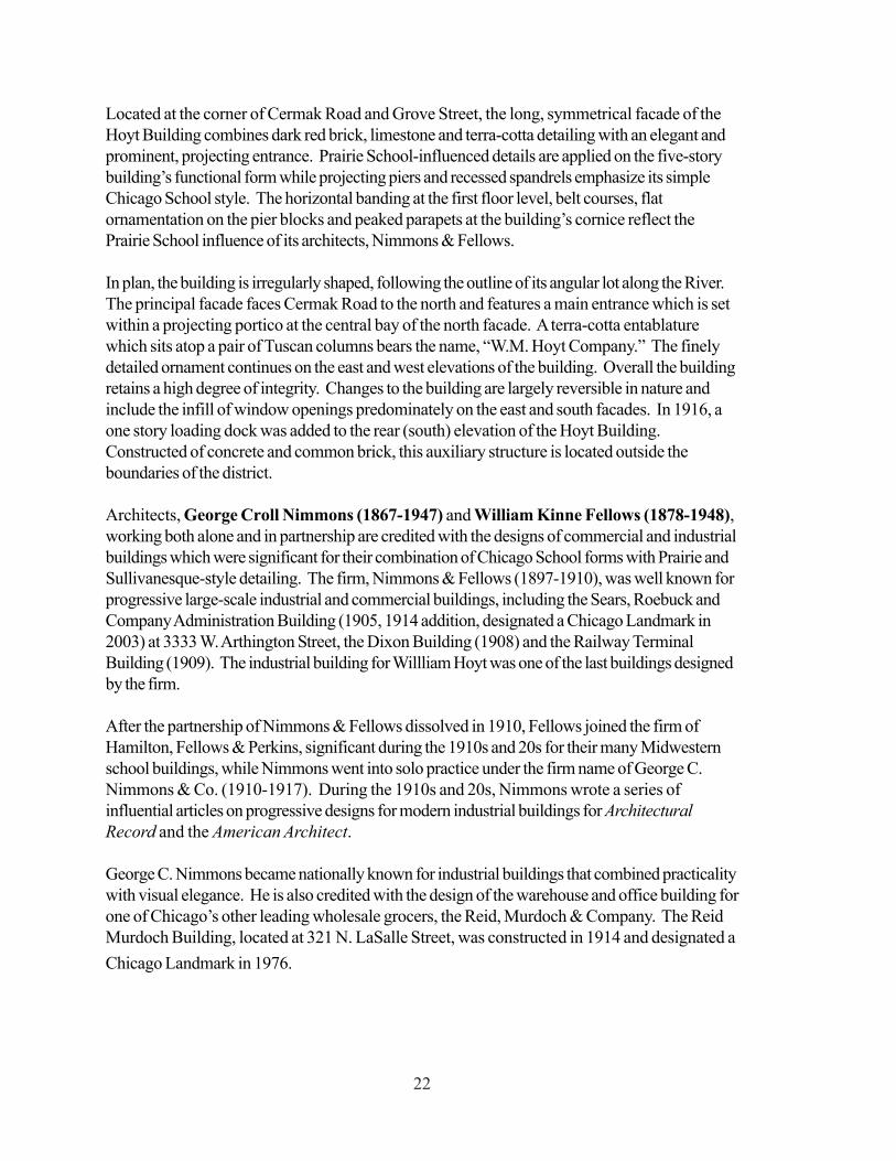
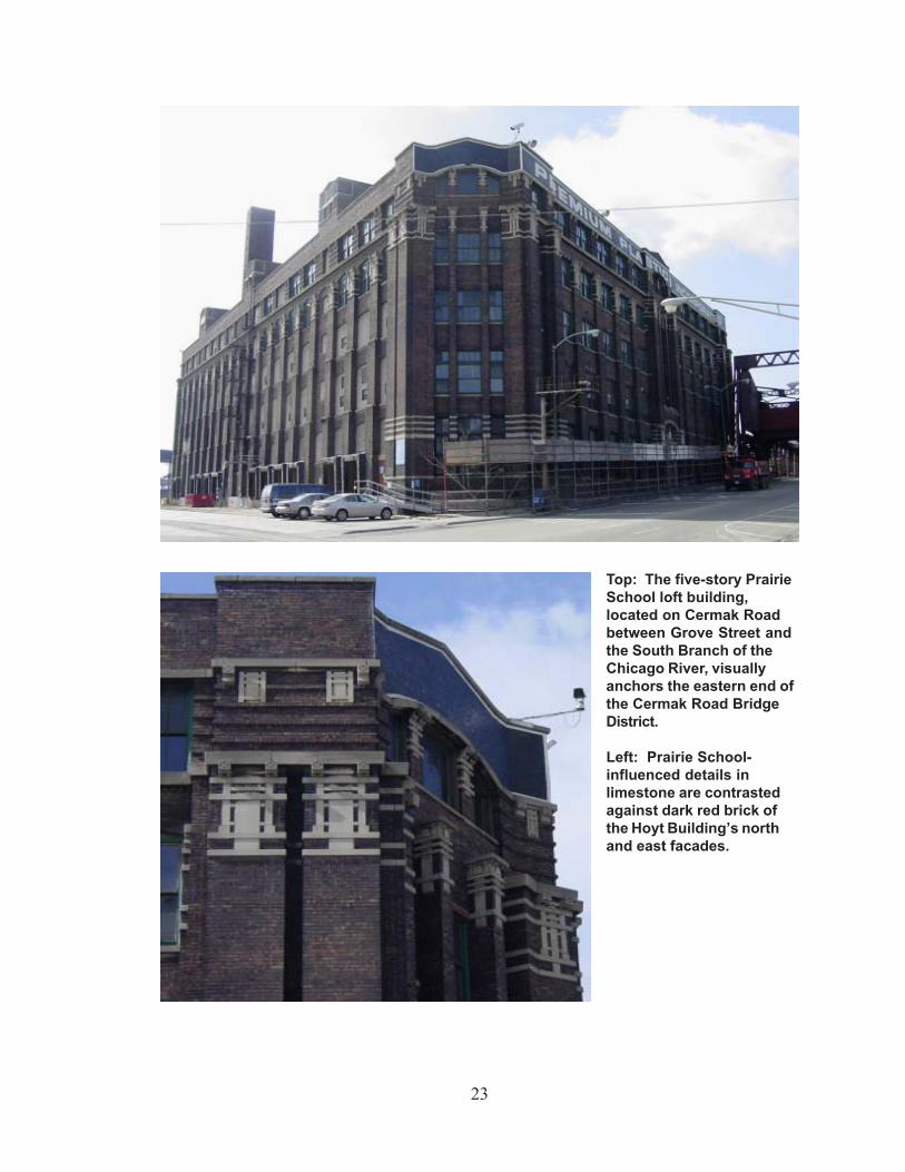
Located at the corner of Cermak Road and Grove Street, the long, symmetrical facade of theHoyt Building combines dark red brick, limestone and terra-cotta detailing with an elegant andprominent, projecting entrance. Prairie School-influenced details are applied on the five-storybuilding’s functional form while projecting piers and recessed spandrels emphasize its simpleChicago School style. The horizontal banding at the first floor level, belt courses, flatornamentation on the pier blocks and peaked parapets at the building’s cornice reflect thePrairie School influence of its architects, Nimmons & Fellows.
In plan, the building is irregularly shaped, following the outline of its angular lot along the River.The principal facade faces Cermak Road to the north and features a main entrance which is setwithin a projecting portico at the central bay of the north facade. A terra-cotta entablaturewhich sits atop a pair of Tuscan columns bears the name, “W.M. Hoyt Company.” The finelydetailed ornament continues on the east and west elevations of the building. Overall the buildingretains a high degree of integrity. Changes to the building are largely reversible in nature andinclude the infill of window openings predominately on the east and south facades. In 1916, aone story loading dock was added to the rear (south) elevation of the Hoyt Building.Constructed of concrete and common brick, this auxiliary structure is located outside theboundaries of the district.
Architects, George Croll Nimmons (1867-1947) and William Kinne Fellows (1878-1948),working both alone and in partnership are credited with the designs of commercial and industrialbuildings which were significant for their combination of Chicago School forms with Prairie andSullivanesque-style detailing. The firm, Nimmons & Fellows (1897-1910), was well known forprogressive large-scale industrial and commercial buildings, including the Sears, Roebuck andCompany Administration Building (1905, 1914 addition, designated a Chicago Landmark in2003) at 3333 W. Arthington Street, the Dixon Building (1908) and the Railway TerminalBuilding (1909). The industrial building for Willliam Hoyt was one of the last buildings designedby the firm.
After the partnership of Nimmons & Fellows dissolved in 1910, Fellows joined the firm ofHamilton, Fellows & Perkins, significant during the 1910s and 20s for their many Midwesternschool buildings, while Nimmons went into solo practice under the firm name of George C.Nimmons & Co. (1910-1917). During the 1910s and 20s, Nimmons wrote a series ofinfluential articles on progressive designs for modern industrial buildings for ArchitecturalRecord and the American Architect.
George C. Nimmons became nationally known for industrial buildings that combined practicalitywith visual elegance. He is also credited with the design of the warehouse and office building forone of Chicago’s other leading wholesale grocers, the Reid, Murdoch & Company. The ReidMurdoch Building, located at 321 N. LaSalle Street, was constructed in 1914 and designated aChicago Landmark in 1976.
23
Top: The five-story PrairieSchool loft building,located on Cermak Roadbetween Grove Street andthe South Branch of theChicago River, visuallyanchors the eastern end ofthe Cermak Road BridgeDistrict.
Left: Prairie School-influenced details inlimestone are contrastedagainst dark red brick ofthe Hoyt Building’s northand east facades.
24
LATER HISTORY
By the 1920s, when the last of the buildings within the district was built, industrial developmentwithin Chicago was turning away from the Chicago River towards planned industrial parks builtspecifically around railroad lines. Chicago’s Central Manufacturing District, built in two stagesbeginning in 1905 in the city’s Bridgeport and McKinley Park neighborhoods, is an early andnationally significant example of such industrial development.
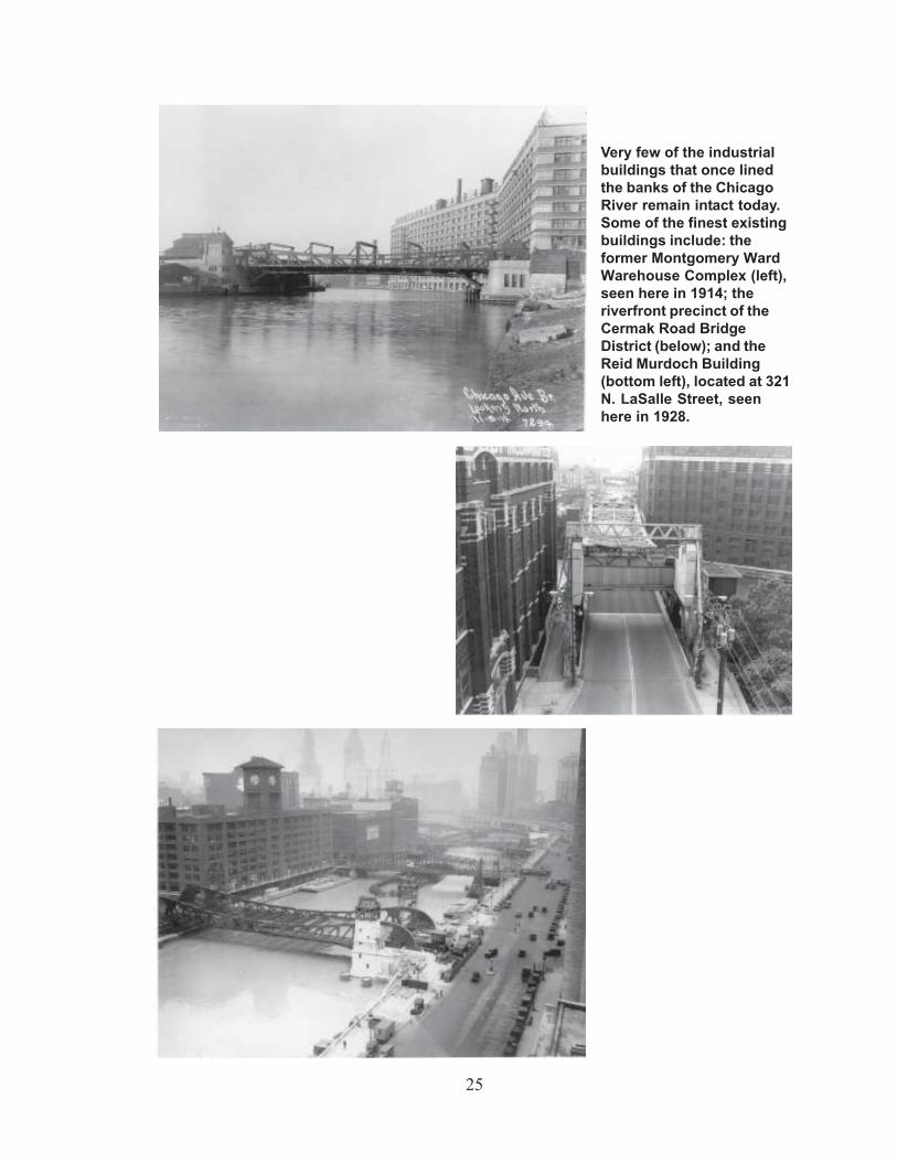
As manufacturing and wholesale companies moved to such industrial parks, existing industrialbuildings along the Chicago River began to be abandoned or demolished. This trend began inthe 1910s and ‘20s with the development of Union Station, with its adjacent riverfront tracks,on the western bank of the river’s South Branch, followed by the Chicago Daily News Building,built just north of Union Station in 1929.
Especially in the post-World War II period, downtown industrial buildings along the ChicagoRiver were replaced by office skyscrapers, including the Illinois Center complex east ofMichigan Avenue, and residential highrises such as Marina City. Only two isolated warehousebuildings survive along the main branch of the Chicago River: the former Reid, Murdoch &Company Building (built in 1914) and the former Helene Curtis Company building at 325 N.Wells (built 1912), which previously housed a wholesale coffee company.
The North and South Branches of the river adjacent to downtown also retain a few industrialbuildings. The former Montgomery Ward Warehouse complex, built in 1906-08 and 1930,centered on Chicago Avenue, and the former North American Cold Storage Company building(now Fulton House condominiums), built in 1908 at 345 N. Canal St., survive on the NorthBranch. On the South Branch stand the former Butler Brothers Warehouses at 111 and 165 N.Canal St. (built 1913 and 1922) and a 10-story industrial building at 329 W. 18th Street.
The conversion of some of these buildings to residential uses in the last two decades, however,has involved changes such as non-historic windows and the addition of projecting balconies,strongly lessening the remaining historic integrity. The Reid, Murdoch & Company Building, theoriginal 1906-08 section of Montgomery Ward, both designated Chicago Landmarks, and theButler Brothers Warehouse building at 111 N. Canal remain the best surviving downtownexamples of the once vibrant industrial district along the river.
Three of the four buildings in the Cermak Road Bridge District (the W. H. Hoyt Company, theThomson & Taylor Spice Company, and the Western Shade Cloth Company buildings), plusthe Cermak Bridge itself, were individually color coded “orange” in the Chicago HistoricResources Survey. Together, the buildings in the Cermak Road Bridge District remain one of themost intact and significant groupings of industrial buildings along the Chicago River and are animportant physical reminder of the importance of this part of Chicago’s economic andarchitectural history.
25
Very few of the industrialbuildings that once linedthe banks of the ChicagoRiver remain intact today.Some of the finest existingbuildings include: theformer Montgomery WardWarehouse Complex (left),seen here in 1914; theriverfront precinct of theCermak Road BridgeDistrict (below); and theReid Murdoch Building(bottom left), located at 321N. LaSalle Street, seenhere in 1928.

26
CRITERIA FOR DESIGNATION
According to the Municipal Code of Chicago (Sect. 2 120 620 and 630), the Commission onChicago Landmarks has the authority to make a preliminary recommendation of landmarkdesignation for a building, structure, object, or district if the Commission determines it meetstwo or more of the stated “criteria for landmark designation,” as well as possesses a significantdegree of its historic design integrity.
The following should be considered by the Commission on Chicago Landmarks in determiningwhether to recommend that the Cermak Road Bridge District be designated as a ChicagoLandmark.
Criterion 1: Critical Part of the City’s HistoryIts value as an example of the architectural, cultural, economic, historic, social, or otheraspect of the heritage of the City of Chicago, State of Illinois or the United States.
• The Cermak Road Bridge District is one of Chicago’s most significant survivinggroupings of early twentieth-century factories and warehouses along theChicago River, the City’s earliest industrial corridor and its most importantduring the nineteenth and early twentieth centuries.
• The Cermak Road Bridge District exemplifies Chicago’s national importance asa historic center of commerce and industry and the significance thatmanufacturing and wholesale trades had in the City’s economic history.
Criterion 4: Important ArchitectureIts exemplification of an architectural type or style distinguished by innovation, rarity,uniqueness, or overall quality of design, detail, materials, or craftsmanship.
• The Cermak Road Bridge District is a distinguished group of early twentieth-century factories and warehouses, two building types of great significance in thehistory of Chicago.
• The buildings within the Cermak Road Bridge District are significant industrialexamples of architectural styles of importance to Chicago architectural history,including Prairie, Chicago School, and Gothic Revival.
• The buildings in the Cermak Road Bridge District are distinguished by excellentcraftsmanship and use of materials, including brick, stone, and terra cotta.
• The Cermak Road Bridge, located in the district, is last remaining double leafScherzer Rolling Lift bridge in operation in Chicago. Important for itssignificance in the field of engineering, this bridge type offered many advantagesover the swing bridges that they replaced and was an important predecessor tobascule bridges.
27
Criterion 6: Distinctive Theme as a DistrictIts representation of an architectural, cultural, economic, historic, social , or other themeexpressed through distinctive areas, districts, places, buildings, structures, works of art,or other objects that may or may not be contiguous.
• The buildings within the Cermak Road Bridge District display a distinct visualunity based on consistent building scale, setbacks, overall design, use of buildingmaterials and detailing.
• The district shares a common historic theme as a significant surviving cluster ofearly twentieth-century industrial buildings that exemplify the importance of theinteraction of the Chicago River and railroads in the history of Chicago industry.
Criterion 7: Unique Visual FeatureIts unique location or distinctive physical appearance or presence representing anestablished and familiar visual feature of a neighborhood, community, or the City ofChicago.
• The Cermak Road Bridge District’s ensemble of large riverfront industrialbuildings grouped around the city’s sole-surviving double leaf Scherzer RollingLift bridge, give it a distinctive physical appearance, significant to both theimmediate Near West neighborhood and to the City of Chicago.
• The district’s proximity to and visibility from the river, rail lines, and theexpressway make it an important and familiar sight to many passing through thearea.
Integrity CriteriaThe integrity of the proposed landmark must be preserved in light of its location, design,setting, materials, workmanship and ability to express its historic community,architectural or aesthetic interest or value.
The Cermak Road Bridge District possesses good integrity in both its overall streetscapes andits individual structures, including the Cermak Road Bridge and the four buildings included in thedistrict. The district’s buildings retain the physical characteristics that define their historicsignificance. These include brick walls and limestone and terra-cotta trim used for window anddoor details.
The most common changes to individual buildings are largely reversible in nature. Upper-floorwindows may have altered sash configurations and been bricked-in, but original windowopenings remain, and replacement sash could replicate historic windows. Additionally, three ofbuildings in the district, the W.M. Hoyt Company, the Western Shade Company, and theWendnagel Warehouse, have been expanded over the years to include rear additions that arenot historically significant. In each case, the district boundaries only include that portion of the
28
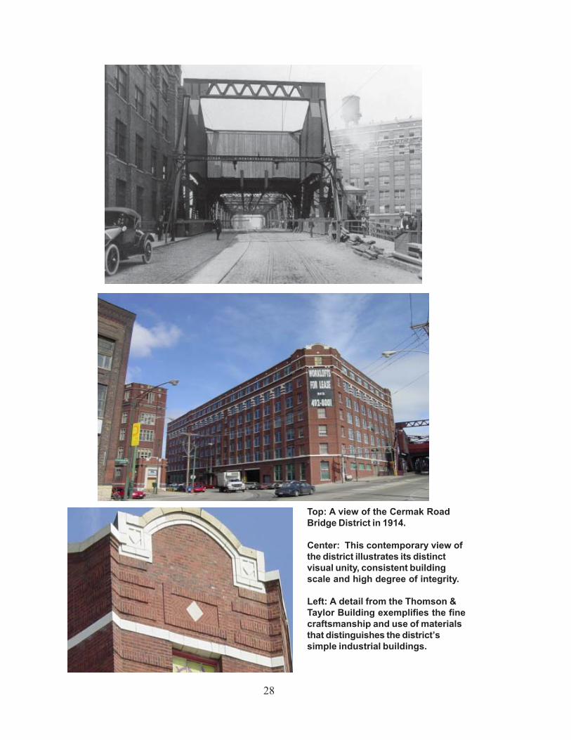
Top: A view of the Cermak RoadBridge District in 1914.
Center: This contemporary view ofthe district illustrates its distinctvisual unity, consistent buildingscale and high degree of integrity.
Left: A detail from the Thomson &Taylor Building exemplifies the finecraftsmanship and use of materialsthat distinguishes the district’ssimple industrial buildings.
29
building which has been deemed historically or architecturally significant for the purposes of thisdesignation.
The Cermak Road Bridge was sensitively rehabilitated in 1998, retaining its historic visualcharacter, overall historic structural forms, and its historic relationship to Cermak Road itself andthe buildings flanking the bridge.
The overall sense of historic place remains along these blocks of Cermak within the proposeddistrict. In general, historic building lot sizes and building placement have respected the historiccharacter of the streets. The district’s streetscapes provide an important sense of historic“place” when seen as a whole. The physical character of individual buildings in terms of scale,setback from streets, and general configuration of door and window openings have remainedconsistent and work together to provide the viewer with a strong sense of the historic overallcharacter of the streetscapes. In addition, the historic relationship of the Cermak streetscape asa whole with the Cermak Road Bridge remains.
SIGNIFICANT HISTORICAL
AND ARCHITECTURAL FEATURES
Whenever a building, structure, object, or district is under consideration for landmarkdesignation, the Commission on Chicago Landmarks is required to identify the “significanthistorical and architectural features” of the property. This is done to enable the owners and thepublic to understand which elements are considered most important to preserve the historicaland architectural character of the proposed landmark.
Based on its preliminary evaluation of the Cermak Road Bridge District, the Commission staffrecommends that the significant features be identified as:
• all exterior elevations, including rooflines, visible from the public rights-of-way.
ADDRESS RANGES
463-487 W. Cermak Rd. (odds)500-620 W. Cermak Rd. (evens)2200-2222 S. Grove St. (evens)2115-2143 S. Jefferson St. (odds)2130-2146 S. Jefferson St. (evens)2113-2149 S. Lumber St. (odds)2114-2146 S. Lumber St. (evens)
30
SELECTED BIBLIOGRAPHY
Andreas, A. T. History of Chicago. Vol. 3, 1872-1885. Chicago: A. T. Andreas Co., 1886.Barton, E. E. A Business Tour of Chicago Depicting Fifty Years’ Progress, Sights and
Scenes in the Great City. Chicago: E. E. Barton, 1887.Chicago City Directories, various dates between 1850 - 1920s.City of Chicago, Department of Public Works. Chicago Public Works: A History. Daphne
Christensen, ed. Chicago, 1973.City of Chicago, Department of Transportation, Bureau of Bridges and Transit. The Cermak
Road Bridge. Chicago, 1997.City of Chicago. Historic Building Permit Records.Commercial and Architectural Chicago. Chicago: G. W. Orear, 1887.Cronon, William. Nature’s Metropolis: Chicago and the Great West. New York: W. W.
Norton Company, 1992.The Economist. Chicago: Economist Publishing Co, various issues between 1923 - 1924.Gilbert, Paul and Bryson, Charles Lee. Chicago and Its Makers. Chicago: Felix Mendelsohn,
Publisher, 1929.Hall, Henry. America’s Successful Men of Affairs: An Encyclopedia of Contemporary
Biography. New York: New York Tribune v. 2, 1891.A History of the City of Chicago: Its Men and Institutions. Chicago: The Inter Ocean,
1900.Hool, George A. and W. S. Kinne, editors. Moveable and Long-Span Steel Bridges. New
York: McGraw-Hill Book Company, Inc., 1943.Hoyt, William M. Clipping File. Chicago Historical Society.
Industrial Chicago: The Commercial Interests. Chicago: The Good SpeedPublishing Co., 1894.
Kogan, Herman and Rick. Yesterday’s Chicago: Seemann’s Historic Cities No. 22. Miami:E. A. Seemann Publishing, Inc., 1976
Marquis, Albert Nelson. Who’s Who In Chicago: The Book of Chicagoans. Chicago: A. N.Marquis & Company, 1926.
Mayer, Harold M. and Wade, Richard C. Chicago: Growth of a Metropolis. Chicago:University of Chicago Press, 1969.
Nimmons, George C. “The Building of a Great Machine Plant.” Architectural Record. April,1906.
———. “Industrial Buildings: Their Great Architectural Opportunities and an Appeal to theArchitects to Help the American Industries Whose Buildings They Have Neglected inthe Past” American Architect. January 5, 1926.
Robinson, E. Robinson’s Atlas of the City of Chicago. Vol. 3. Chicago, 1886.Sinkevitch, Alice, ed. AIA Guide to Chicago. New York: Harcourt Brace & Co., 1993.Taussig, Meredith. Cortland Street Drawbridge, Cermak Road Bridge. Chicago Landmarks
Division designation, 1989.Viskochil, Larry A. Chicago at the Turn of the Century in Photographs. New York: Dover
Publications, Inc., 1984.Withey, Henry F. and Elsie Rathburn Withey. Biographical Dictionary of American
Architects (Deceased). Los Angeles: Hennessey & Ingalls, Inc., 1970.
31
ACKNOWLEDGMENTS
CITY OF CHICAGORichard M. Daley, Mayor
Department of Planning and DevelopmentLori T. Healey, CommissionerBrian Goeken, Deputy Commissioner for Landmarks
Project StaffHeidi Sperry, research, writing, and photographyTerry Tatum, writing and editing
Special thanks to Donna Ann Harris for her assistance in preparing this report.
IllustrationsChicago Department of Transportation: pp. 2 (top), 9 (bottom), 19 (top), 25 and 27 (top).Department of Planning & Development, Landmarks Division: pp. 2 (bottom right, left), 9 (top),
13 (bottom), 15 (bottom), 17 (top), 19 (bottom), 21 (bottom), 23 and 28 (center,bottom).
From Chicago: Growth of a Metropolis: p.5.From Chicago and Its Makers: p.7 (top, center).From Chicago at the Turn of the Century in Photographs: p.7 (bottom).From Chicago Central Business and Office Building Directory, 1909: p.13 (top).Chicago Historical Society: pp.15 (top) and 21 (top left, right).From The Graphic: p.17 (bottom).
COMMISSION ON CHICAGO LANDMARKS
David Mosena, ChairmanJohn W. Baird, SecretaryPhyllis EllinLori T. HealeySeymour PerskyBen WeeseLisa Willis
The Commission is staffed by theChicago Department of Planning and Development33 N. LaSalle Street, Suite 1600, Chicago, IL 60602
312-744-3200; 744-2958 (TTY)http://www.cityofchicago.org/landmarks
Printed May 2003; Revised and Reprinted March 2006.
Related Documents