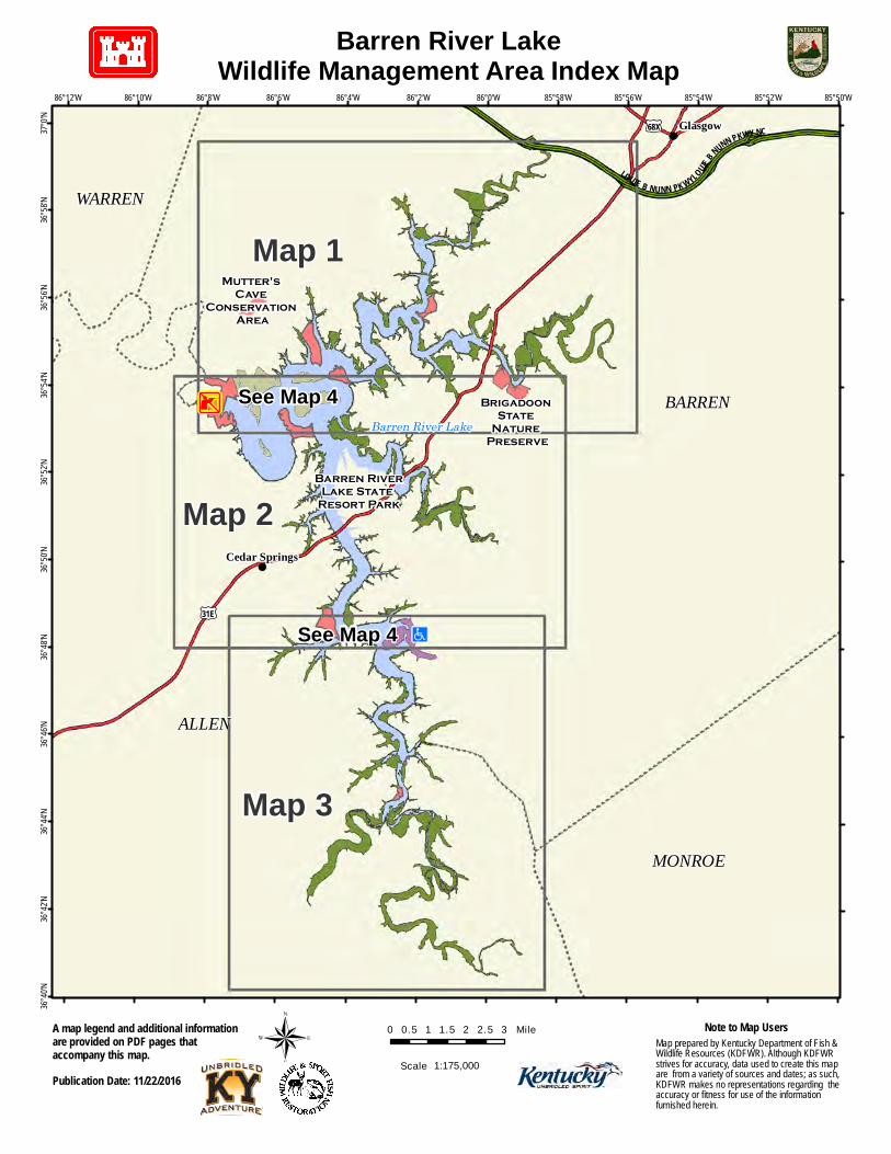
Brigadoon State Nature Preserve Mutter's Cave Conservation Area Map 1 Map 3 Map 2 Glasgow Cedar Springs BARREN ALLEN MONROE WARREN Barren River Lake # LO UI E B N U N N P K W YL O UIE B N U N N P K W YNC £ ¤ 31E £ ¤ 68X 85°50'W 85°52'W 85°54'W 85°56'W 85°58'W 86°0'W 86°2'W 86°4'W 86°6'W 86°8'W 86°10'W 86°12'W 37°0'N 36°58'N 36°56'N 36°54'N 36°52'N 36°50'N 36°48'N 36°46'N 36°44'N 36°42'N 36°40'N ® 0 0.5 1 1.5 2 2.5 3 Mile Barren River Lake Wildlife Management Area Index Map Map prepared by Kentucky Department of Fish & Wildlife Resources (KDFWR). Although KDFWR strives for accuracy, data used to create this map are from a variety of sources and dates; as such, KDFWR makes no representations regarding the accuracy or fitness for use of the information furnished herein. Note to Map Users Publication Date: 11/22/2016 A map legend and additional information are provided on PDF pages that accompany this map. 1:175,000 Scale ¾ t Barren River Lake State Resort Park See Map 4 See Map 4

Welcome message from author
This document is posted to help you gain knowledge. Please leave a comment to let me know what you think about it! Share it to your friends and learn new things together.
Transcript
Brigadoon State
Nature Preserve
Mutter's Cave
Conservation Area
Map 1
Map 3
Map 2
Glasgow
Cedar Springs
BARREN
ALLEN
MONROE
WARREN
Barren River Lake#
LOUIE B NUNN PKWYLOUIE B NUNN PKWY NC
£¤31E
£¤68X
85°50'W85°52'W85°54'W85°56'W85°58'W86°0'W86°2'W86°4'W86°6'W86°8'W86°10'W86°12'W
37°0'N
36°58'
N36°
56'N
36°54'
N36°
52'N
36°50'
N36°
48'N
36°46'
N36°
44'N
36°42'
N36°
40'N
® 0 0.5 1 1.5 2 2.5 3 Mile
Barren River LakeWildlife Management Area Index Map
Map prepared by Kentucky Department of Fish & Wildlife Resources (KDFWR). Although KDFWRstrives for accuracy, data used to create this mapare from a variety of sources and dates; as such,KDFWR makes no representations regarding theaccuracy or fitness for use of the informationfurnished herein.
Note to Map Users
Publication Date: 11/22/2016
A map legend and additional informationare provided on PDF pages thataccompany this map.
1:175,000Scale
¾t
Barren RiverLake State
Resort Park
See Map 4
See Map 4
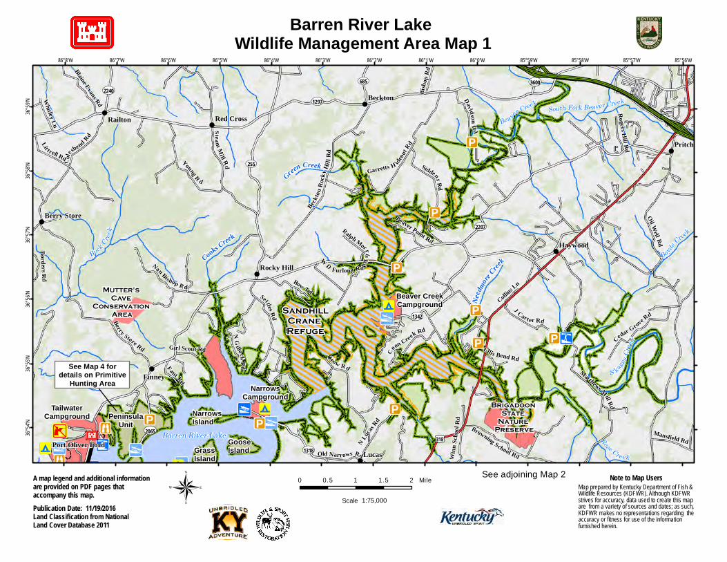
Barren River Lake Wildlife Management Area Map 1
!
!
!
!
!
!
!
!
!
!
Cooks Creek
!i
!i
!9
!9
Finney
Railton
Beckton
Red Cross
Rocky Hill
Berry Store
Brigadoon State
Nature Preserve
Mutter's Cave
Conservation Area
Grass Island
Goose Island
Narrows Island
#
BuckCree
k
S kagg
s Cree
k
BoydsCreek
Rose Creek
BeaverCreek South Fork Beaver Creek
Barren River Lake£¤31E
UV255
UV1297
UV2207
UV2240
UV2065
UV685
UV1342
UV1318
UV3600Oil W
ell Rd
Siddens Rd
Berry Store Rd
Matthews Mill Rd
Crow Rd
Colesb
end Rd
Settles Rd
Lit trell Rd Young R d
Beckton
Rock
y Hil l
R d
S teamMill Rd
Nan Bishop R d
DavidsonRd
Cedar Grove Rd
J Cart er Rd
Coon Creek Rd
Blaine Evans Rd
NG
illockRd
Mansfield Rd
Whitley Ln
Fant Rd
Bisho
p Rd
W D Furlong RdBow Trl
Garretts H ideou
t Rd
Rogers Hill Rd
Old Narrows Rd
Borders Rd
Beaver Point RdRalph MorrisRd
Ellis Bend Rd
Collins Ln
Girl Scout Rd
Lucas
Haywood
Pritchardsville
Port Oliver Ford
85°56'W85°57'W85°58'W85°59'W86°0'W86°1'W86°2'W86°3'W86°4'W86°5'W86°6'W86°7'W86°8'W
36°59'
N36°
58'N
36°57'
N36°
56'N
36°55'
N36°
54'N
0 0.5 1 1.5 2 MileMap prepared by Kentucky Department of Fish & Wildlife Resources (KDFWR). Although KDFWRstrives for accuracy, data used to create this mapare from a variety of sources and dates; as such,KDFWR makes no representations regarding theaccuracy or fitness for use of the informationfurnished herein.
Note to Map Users
Publication Date: 11/19/2016Land Classification from NationalLand Cover Database 2011
A map legend and additional informationare provided on PDF pages thataccompany this map. ® Scale 1:75,000
See adjoining Map 2
TailwaterCampground
Beaver CreekCampground
See Map 4 fordetails on Primitive
Hunting Area NarrowsCampground
SandhillCrane Refuge
N Lucas
Rd
Needm
oreCree
k
Green Creek
Browning School RdWinn
Scho
olRd
PeninsulaUnit
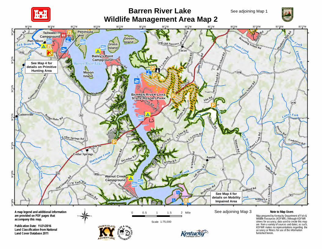
Barren River Lake Wildlife Management Area Map 2
!9
!i
!9!9
Coon Creek
Canoe Creek
Hurricane Creek
Peninsula Unit
Grass Island
Goose Island
Mason Island
Lucas
Austin
Gainesville
Cedar Springs
#
PeterCreek
Difficult Creek
Dry Branch
Dry Creek
Caney Fork
Rose Creek
Elmore Branch
Lick Branch
Barren River Lake
£¤31E
UV921
UV1318
UV517
UV3179
UV1855
UV252
UV87
UV1533
UV1318
Peter
CreekR
d
Ramp R d
Bridge Holw Rd
O ld GlasgowRd
SpencerRd
Church Rd
Bradshaw Rd
MooresScho
ol Rd
S teen
berge
n Rd
State Park Rd
Matthe
ws
Mil lRd
Gainesv
ille-po
rtOliv
erRd
Holder
Rd
S Lucas Rd
Winn
Scho
olRd
Mutter
Rd
Erwin Rd
Jeff
Hicks Rd
Devasher R d
Britt
Mil l
Rd
Cooktown Rd
Watson Rd
Dorse y Rd
J E
lmo Rd
Elm Rd
Cedar Springs Rd
Wilker
son Rd
J W York Rd
Aaron Ln
Trac
y Chu
rch R
d
A G Graves Rd
Sikes Rd
Old Narrows Rd
Maple Dr
Willow Ln
Ida Dr
Sullivan Rd
R W
hitlow
Rd
Barton Shockley Rd
Hatcher Rd
Redbird Rd
Simeo
n Whit
e Rd
Winn
Scho
olRd
85°57'W85°58'W85°59'W86°0'W86°1'W86°2'W86°3'W86°4'W86°5'W86°6'W86°7'W86°8'W86°9'W
36°54'
N36°
53'N
36°52'
N36°
51'N
36°50'
N36°
49'N
36°48'
N
0 0.5 1 1.5 2 MileMap prepared by Kentucky Department of Fish & Wildlife Resources (KDFWR). Although KDFWRstrives for accuracy, data used to create this mapare from a variety of sources and dates; as such,KDFWR makes no representations regarding theaccuracy or fitness for use of the informationfurnished herein.
Note to Map Users
Publication Date: 11/21/2016Land Classification from NationalLand Cover Database 2011
A map legend and additional informationare provided on PDF pages thataccompany this map. ® Scale 1:75,000
See adjoining Map 1
See adjoining Map 3
Barren River Lake State Resort Park
Walnut CreekCampground
TailwaterCampground
Bailey's PointCampground
See Map 4 fordetails on Mobility
Impaired Area
See Map 4 fordetails on Primitive
Hunting Area
N Lucas
Rd
Browning School Rd
Port Oliver
!
!
!
!
!
!
!i
!
TailwaterCampground
Bailey's PointCampground
NarrowsCampground
!9!9
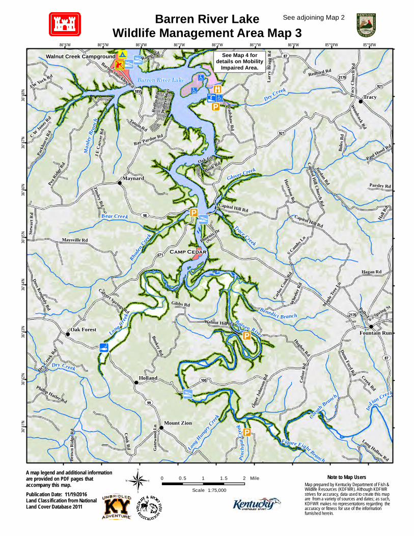
Barren River State Park
#
Peninsula Unit
Grass Island
Goose Island
UV252
UV2065
UV517
UV1533
Tailw
ater R
d
Narrows Rd
Hix Rd
Baileys Point Rd
Port Oliver Rd
Gaine
sville
-port
Olive
r Rd
Gentry Rd
Hatcher Rd
Yacht Club Dr
Houston Harbor RdNarrows Island
Mason Island
86°4'W86°5'W86°6'W86°7'W86°8'W
36°54'
N36°
53'N
® 0 0.5 1 Mile
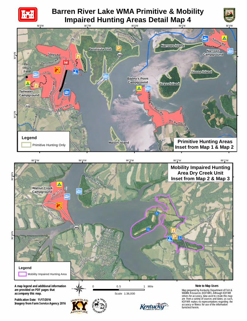
Barren River Lake WMA Primitive & MobilityImpaired Hunting Areas Detail Map 4
Map prepared by Kentucky Department of Fish & Wildlife Resources (KDFWR). Although KDFWRstrives for accuracy, data used to create this mapare from a variety of sources and dates; as such,KDFWR makes no representations regarding theaccuracy or fitness for use of the informationfurnished herein.
Note to Map Users
Publication Date: 11/17/2016Imagery from Farm Service Agency 2016
A map legend and additional informationare provided on PDF pages thataccompany this map. 1:36,000Scale
#
UV1855BRADS HAW RD
RAMP RD
JEFFHIC
KS RD
TATUM RD
GREE
R LN
BARTON SHOCKLEY RD
PARKV
IEW S HORES DR
CAMPSITE LN
BONIT
A LN
ROY HOLDER RD
CATFISH LN
SKIPJA
CK LN
86°1'W86°2'W86°3'W86°4'W86°5'W
36°49
'N36
°48'N
Walnut CreekCampground
LegendMobility Impaired Hunting Area
LegendPrimitive Hunting Only Primitive Hunting Areas
Inset from Map 1 & Map 2
PortOliverFord
Mobility Impaired HuntingArea Dry Creek Unit
Inset from Map 2 & Map 3
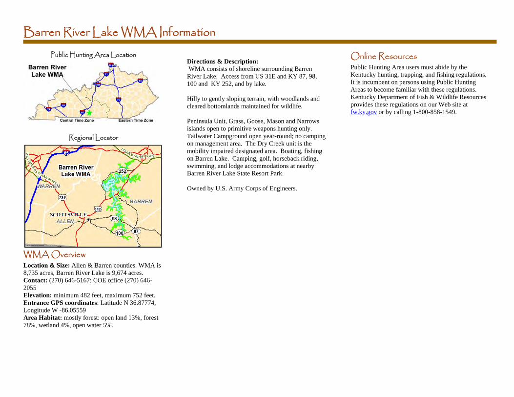
Barren River Lake WMA Information
Public Hunting Area Location
Regional Locator
WMA Overview Location & Size: Allen & Barren counties. WMA is 8,735 acres, Barren River Lake is 9,674 acres. Contact: (270) 646-5167; COE office (270) 646-2055 Elevation: minimum 482 feet, maximum 752 feet. Entrance GPS coordinates: Latitude N 36.87774, Longitude W -86.05559 Area Habitat: mostly forest: open land 13%, forest 78%, wetland 4%, open water 5%.
Directions & Description: WMA consists of shoreline surrounding Barren River Lake. Access from US 31E and KY 87, 98, 100 and KY 252, and by lake. Hilly to gently sloping terrain, with woodlands and cleared bottomlands maintained for wildlife. Peninsula Unit, Grass, Goose, Mason and Narrows islands open to primitive weapons hunting only. Tailwater Campground open year-round; no camping on management area. The Dry Creek unit is the mobility impaired designated area. Boating, fishing on Barren Lake. Camping, golf, horseback riding, swimming, and lodge accommodations at nearby Barren River Lake State Resort Park. Owned by U.S. Army Corps of Engineers.
Online Resources Public Hunting Area users must abide by the Kentucky hunting, trapping, and fishing regulations. It is incumbent on persons using Public Hunting Areas to become familiar with these regulations. Kentucky Department of Fish & Wildlife Resources provides these regulations on our Web site at fw.ky.gov or by calling 1-800-858-1549.
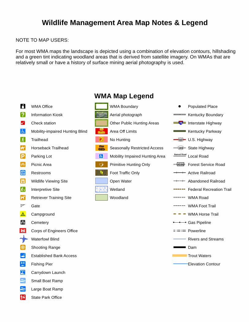
WMA Map Legend!? WMA Office
!] Information Kiosk¾!i Check station¾s Mobility-impaired Hunting Blind
!F Trailhead
!È Horseback Trailhead
!i Parking Lot
!5 Picnic Area
!_ Restrooms


![F U N with Fish & Wildlife - Kentucky Department of Fish & …1].pdf · · 2013-06-19F U N with Fish & Wildlife Kentucky Department of Fish & Wildlife Resources ... V J U R W R](https://static.cupdf.com/doc/110x72/5ae193927f8b9a1c248e8dcb/f-u-n-with-fish-wildlife-kentucky-department-of-fish-1pdf2013-06-19f-u-n.jpg)