Pathogen Management Plan joondalup.wa.gov.au 2013 - 2016

Welcome message from author
This document is posted to help you gain knowledge. Please leave a comment to let me know what you think about it! Share it to your friends and learn new things together.
Transcript
Pathogen Management Plan
joondalup.wa.gov.au
2013 - 2016
City of Joondalup Pathogen Management Plan | 2013 – 2016
City of Joondalup Pathogen Management Plan | 2013 – 2016 1
Section Page1.0 Introduction 3
1.1 Purpose of the Plan 4
1.2 Strategic Context 5
1.3 What are Pathogens? 6
1.4 Phytophthora 7
1.5 Armillaria 10
2.0 Pathogen Risk Analysis 12
2.1 Introduction 12
2.2 Study Area 12
2.3 Pathogen Assessment and Mapping 14
2.4 High Resolution Multi-Spectral Imagery 16
3.0 Pathogen Management 17
3.1 Pathogen Interpretation and Mapping 18
3.2 Bushland Management 18
3.3 Hygiene Measures 18
3.4 Access 19
3.5 Signage 19
3.6 Communication and Education 20
3.7 Partnerships 21
3.8 Treatment 21
3.9 Monitoring and Reporting 22
4.0 Management Plan Review 23
5.0 References 24
6.0 Appendices 25
Acknowledgements Mr Paul Barber, Arbor Carbon, Environmental and Arboricultural Consultants
Mr Mike Stukely, Vegetation Health Services – Science Division, Department of Environment and Conservation
Professor Giles Hardy, Centre for Phytophthora Science and Management, Murdoch University
Contents
2 City of Joondalup Pathogen Management Plan | 2013 – 2016
City of Joondalup Pathogen Management Plan | 2013 – 2016 3
1. IntroductionThe City of Joondalup is situated along the Swan Coastal Plain, 30 kilometres from the Perth Central Business District. The City covers an area of 96.5 kilometres which encompasses a diverse range of natural areas including 17 kilometres of coastal foreshore, a chain of wetlands and a variety of bushland ecosystems.
The City’s southern boundary is located approximately 16 kilometres from the Perth Central Business District, and is bounded by the City of Wanneroo to the east and north, the City of Stirling to the south, and the Indian Ocean to the west.
There are a variety of regionally, nationally and internationally significant natural areas located within the City including the Yellagonga Regional Park, the Marmion Marine Park, the Neerabup National Park and a number of Bush Forever sites which contain species of high conservation value.
Vegetated areas within the City are at risk from pathogens which pose a serious threat to the biodiversity values within the City’s parks and bushland areas. Effective pathogen management is required to ensure that measures are taken to mitigate the effects and limit the spread of pathogens within the City.
In order to protect native vegetation and ecosystems within the City of Joondalup a Pathogen Management Plan has been developed. The Plan identifies the level of risk for pathogens becoming introduced to City parks and natural areas and prioritises the areas for further on ground investigations.
The Plan also provides guidance on the management of pathogens within the City in order to minimise the spread of pathogens. Strategies to engage the community in order to raise the awareness of pathogens within the City of Joondalup are also identified within the Plan.
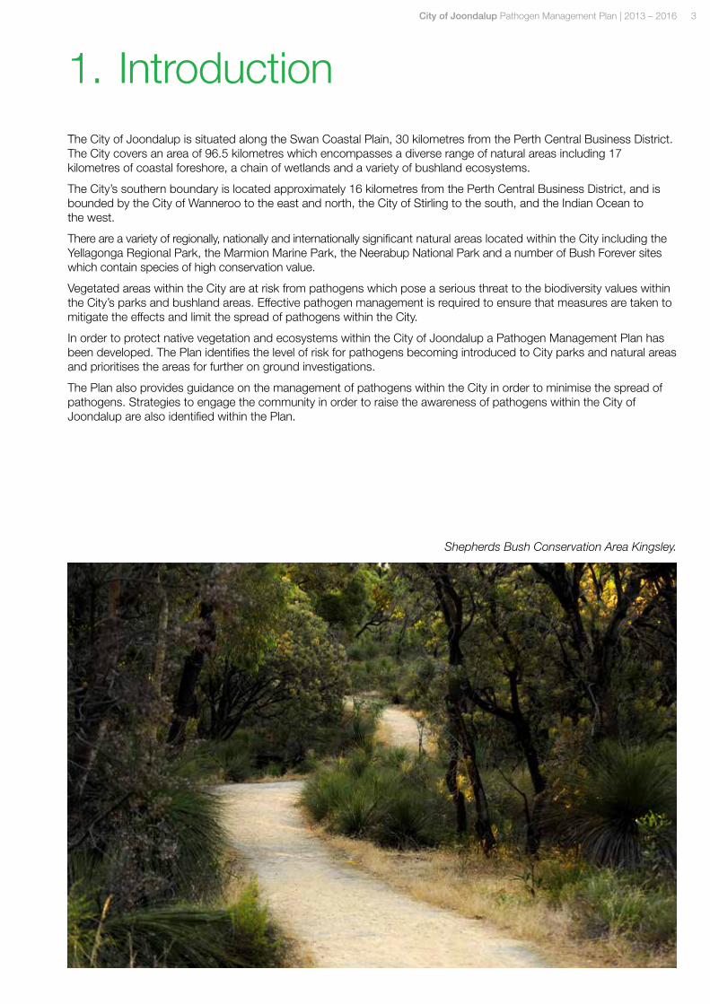
Shepherds Bush Conservation Area Kingsley.
4 City of Joondalup Pathogen Management Plan | 2013 – 2016
The Pathogen Management Plan aims to establish the level of risk of pathogens within City parks and natural areas and identifies areas of high risk where management actions should be concentrated.
The Pathogen Management Plan includes the following:
• Desktop assessment of parks and natural areas for pathogens including Phytophthora species and Armillaria to establish the level of risk within the City;
• Development of preventive and management strategies and procedures to be employed within activities relating to the use of City parks, streetscapes and natural areas;
• Identification of control and treatment measures for infested areas; and
• Development of education and communication mechanisms to raise the awareness of pathogens within the organisation and the community.
The objective of the Pathogen Management Plan is to protect biodiversity values within the City of Joondalup by minimising the risk of introducing and spreading pathogens including species of Phytophthora and Armillaria luteobubalina within landscaped and natural areas of the City.
1.1 Purpose of the Plan
City of Joondalup Pathogen Management Plan | 2013 – 2016 5
The purpose of the Pathogen Management Plan aligns with the environmental aims and objectives of a number of City of Joondalup Plans including:
Strategic Plan
The City of Joondalup Strategic Plan 2012 – 2022 highlights the focus on preservation, rehabilitation and maintenance of the City’s natural environmental assets and the importance of engaging with the community, key stakeholders and relevant agencies.
Environment Plan
The City of Joondalup Environment Plan 2007 – 2011 identifies the key environmental pressures and threats and provides the strategic response to the major issues affecting the City of Joondalup.
Biodiversity Action Plan
The City of Joondalup Biodiversity Action Plan 2009 – 2019 provides direction for the City’s biodiversity management activities and recommends the development of Dieback Management Plans as an action.
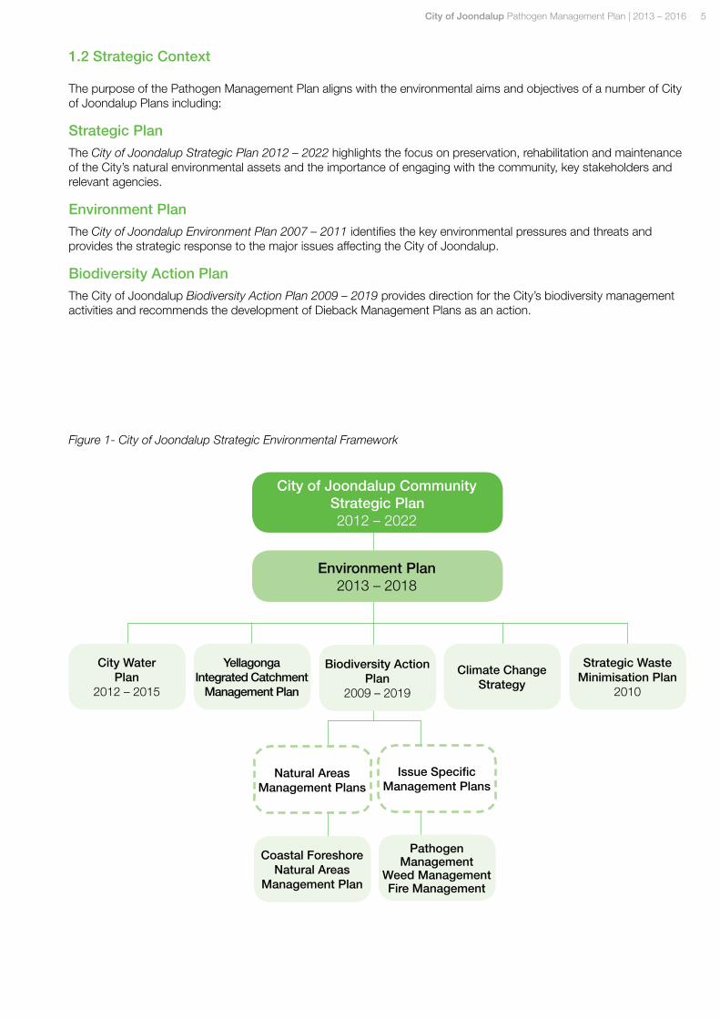
1.2 Strategic Context
City of Joondalup Community Strategic Plan 2012 – 2022
Environment Plan 2013 – 2018
City Water Plan
2012 – 2015
Yellagonga Integrated Catchment
Management Plan
Biodiversity Action Plan
2009 – 2019
Climate Change Strategy
Strategic Waste Minimisation Plan
2010
Figure 1- City of Joondalup Strategic Environmental Framework
Natural Areas Management Plans
Issue Specific Management Plans
Coastal Foreshore Natural Areas
Management Plan
Pathogen Management
Weed Management Fire Management
6 City of Joondalup Pathogen Management Plan | 2013 – 2016
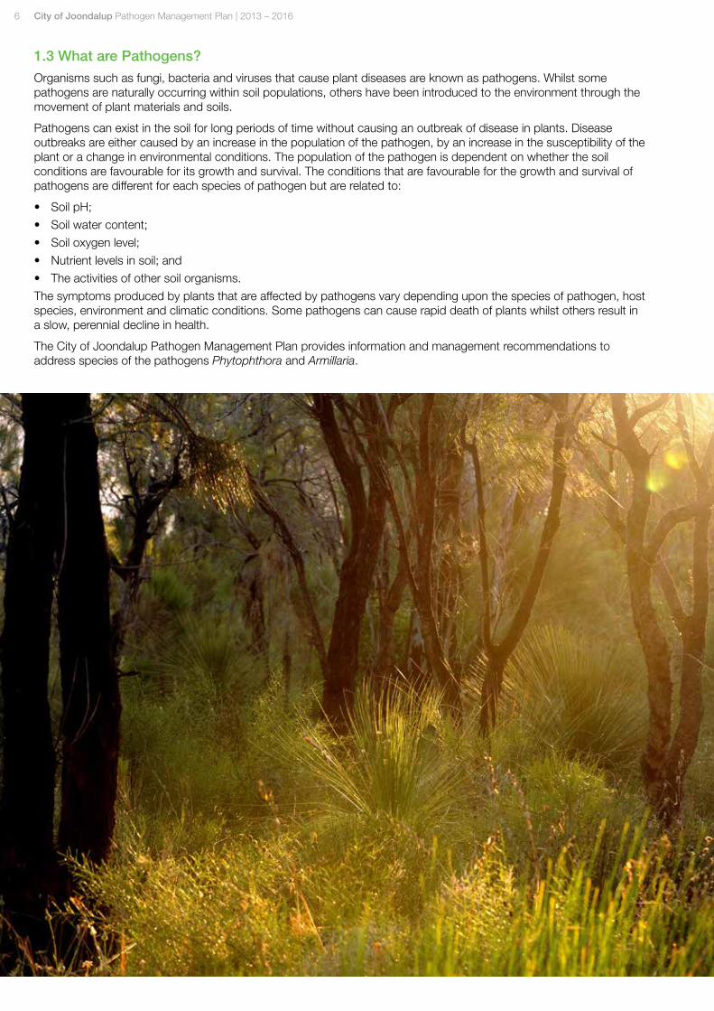
1.3 What are Pathogens?
Organisms such as fungi, bacteria and viruses that cause plant diseases are known as pathogens. Whilst some pathogens are naturally occurring within soil populations, others have been introduced to the environment through the movement of plant materials and soils.
Pathogens can exist in the soil for long periods of time without causing an outbreak of disease in plants. Disease outbreaks are either caused by an increase in the population of the pathogen, by an increase in the susceptibility of the plant or a change in environmental conditions. The population of the pathogen is dependent on whether the soil conditions are favourable for its growth and survival. The conditions that are favourable for the growth and survival of pathogens are different for each species of pathogen but are related to:
• Soil pH;
• Soil water content;
• Soil oxygen level;
• Nutrient levels in soil; and
• The activities of other soil organisms.
The symptoms produced by plants that are affected by pathogens vary depending upon the species of pathogen, host species, environment and climatic conditions. Some pathogens can cause rapid death of plants whilst others result in a slow, perennial decline in health.
The City of Joondalup Pathogen Management Plan provides information and management recommendations to address species of the pathogens Phytophthora and Armillaria.
City of Joondalup Pathogen Management Plan | 2013 – 2016 7
1.4 Phytophthora
Ecology and Biology
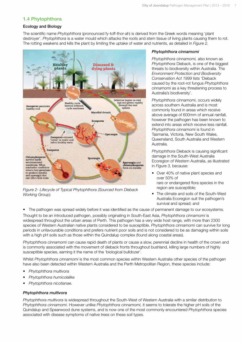
The scientific name Phytophthora (pronounced fy-toff-thor-ah) is derived from the Greek words meaning ‘plant destroyer’. Phytophthora is a water mould which attacks the roots and stem tissue of living plants causing them to rot. The rotting weakens and kills the plant by limiting the uptake of water and nutrients, as detailed in Figure 2.
Phytophthora cinnamomi
Phytophthora cinnamomi, also known as Phytophthora Dieback, is one of the biggest threats to biodiversity within Australia. The Environment Protection and Biodiversity Conservation Act 1999 lists ‘Dieback caused by the root-rot fungus Phytophthora cinnamomi as a key threatening process to Australia’s biodiversity’.
Phytophthora cinnamomi, occurs widely across southern Australia and is most commonly found in areas which receive above average of 600mm of annual rainfall, however the pathogen has been known to extend into areas which receive less rainfall. Phytophthora cinnamomi is found in Tasmania, Victoria, New South Wales, Queensland, South Australia and Western Australia.
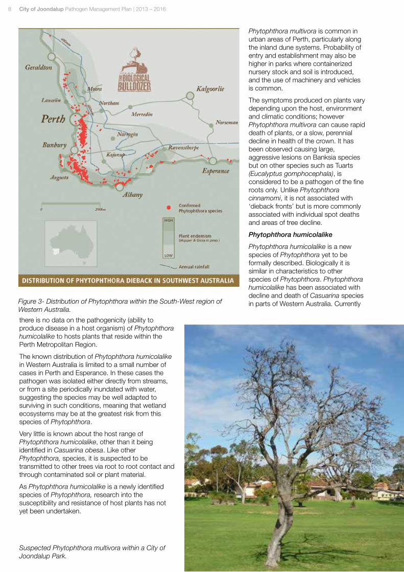
Phytophthora Dieback is causing significant damage in the South-West Australia Ecoregion of Western Australia, as illustrated in Figure 3, because:
• Over 40% of native plant species and over 50% of rare or endangered flora species in the region are susceptible;
• The climate and soils of the South-West Australia Ecoregion suit the pathogen’s survival and spread; and
• The pathogen was spread widely before it was identified as the cause of permanent damage to our ecosystems.
Thought to be an introduced pathogen, possibly originating in South-East Asia, Phytophthora cinnamomi is widespread throughout the urban areas of Perth. This pathogen has a very wide host range, with more than 2300 species of Western Australian native plants considered to be susceptible. Phytophthora cinnamomi can survive for long periods in unfavourable conditions and prefers nutrient poor soils and is not considered to be as damaging within soils with a high pH soils such as those within the Quindalup complex (found along coastal areas).
Phytophthora cinnamomi can cause rapid death of plants or cause a slow, perennial decline in health of the crown and is commonly associated with the movement of dieback fronts throughout bushland, killing large numbers of highly susceptible species, earning it the name of the ‘biological bulldozer’.
Whilst Phytophthora cinnamomi is the most common species within Western Australia other species of the pathogen have also been detected within Western Australia and the Perth Metropolitan Region, these species include:
• Phytophthora multivora
• Phytophthora humicolalike
• Phytophthora nicotianae.
Phytophthora multivora
Phytophthora multivora is widespread throughout the South-West of Western Australia with a similar distribution to Phytophthora cinnamomi. However unlike Phytophthora cinnamomi, it seems to tolerate the higher pH soils of the Quindalup and Spearwood dune systems, and is now one of the most commonly encountered Phytophthora species associated with disease symptoms of native trees on these soil types.
Figure 2- Lifecycle of Typical Phytophthora (Sourced from Dieback Working Group).
8 City of Joondalup Pathogen Management Plan | 2013 – 2016
Phytophthora multivora is common in urban areas of Perth, particularly along the inland dune systems. Probability of entry and establishment may also be higher in parks where containerized nursery stock and soil is introduced, and the use of machinery and vehicles is common.
The symptoms produced on plants vary depending upon the host, environment and climatic conditions; however Phytophthora multivora can cause rapid death of plants, or a slow, perennial decline in health of the crown. It has been observed causing large, aggressive lesions on Banksia species but on other species such as Tuarts (Eucalyptus gomphocephala), is considered to be a pathogen of the fine roots only. Unlike Phytophthora cinnamomi, it is not associated with ‘dieback fronts’ but is more commonly associated with individual spot deaths and areas of tree decline.
Phytophthora humicolalike
Phytophthora humicolalike is a new species of Phytophthora yet to be formally described. Biologically it is similar in characteristics to other species of Phytophthora. Phytophthora humicolalike has been associated with decline and death of Casuarina species in parts of Western Australia. Currently
there is no data on the pathogenicity (ability to produce disease in a host organism) of Phytophthora humicolalike to hosts plants that reside within the Perth Metropolitan Region.
The known distribution of Phytophthora humicolalike in Western Australia is limited to a small number of cases in Perth and Esperance. In these cases the pathogen was isolated either directly from streams, or from a site periodically inundated with water, suggesting the species may be well adapted to surviving in such conditions, meaning that wetland ecosystems may be at the greatest risk from this species of Phytophthora.
Very little is known about the host range of Phytophthora humicolalike, other than it being identified in Casuarina obesa. Like other Phytophthora, species, it is suspected to be transmitted to other trees via root to root contact and through contaminated soil or plant material.
As Phytophthora humicolalike is a newly identified species of Phytophthora, research into the susceptibility and resistance of host plants has not yet been undertaken.
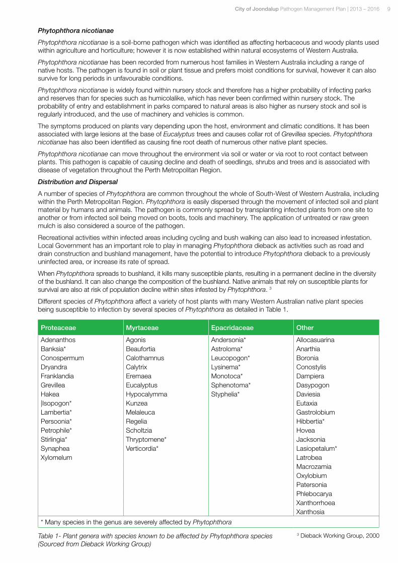
Suspected Phytophthora multivora within a City of Joondalup Park.
Figure 3- Distribution of Phytophthora within the South-West region of Western Australia.
City of Joondalup Pathogen Management Plan | 2013 – 2016 9
Phytophthora nicotianae
Phytophthora nicotianae is a soil-borne pathogen which was identified as affecting herbaceous and woody plants used within agriculture and horticulture; however it is now established within natural ecosystems of Western Australia.
Phytophthora nicotianae has been recorded from numerous host families in Western Australia including a range of native hosts. The pathogen is found in soil or plant tissue and prefers moist conditions for survival, however it can also survive for long periods in unfavourable conditions.
Phytophthora nicotianae is widely found within nursery stock and therefore has a higher probability of infecting parks and reserves than for species such as humicolalike, which has never been confirmed within nursery stock. The probability of entry and establishment in parks compared to natural areas is also higher as nursery stock and soil is regularly introduced, and the use of machinery and vehicles is common.
The symptoms produced on plants vary depending upon the host, environment and climatic conditions. It has been associated with large lesions at the base of Eucalyptus trees and causes collar rot of Grevillea species. Phytophthora nicotianae has also been identified as causing fine root death of numerous other native plant species.
Phytophthora nicotianae can move throughout the environment via soil or water or via root to root contact between plants. This pathogen is capable of causing decline and death of seedlings, shrubs and trees and is associated with disease of vegetation throughout the Perth Metropolitan Region.
Distribution and Dispersal
A number of species of Phytophthora are common throughout the whole of South-West of Western Australia, including within the Perth Metropolitan Region. Phytophthora is easily dispersed through the movement of infected soil and plant material by humans and animals. The pathogen is commonly spread by transplanting infected plants from one site to another or from infected soil being moved on boots, tools and machinery. The application of untreated or raw green mulch is also considered a source of the pathogen.
Recreational activities within infected areas including cycling and bush walking can also lead to increased infestation. Local Government has an important role to play in managing Phytophthora dieback as activities such as road and drain construction and bushland management, have the potential to introduce Phytophthora dieback to a previously uninfected area, or increase its rate of spread.
When Phytophthora spreads to bushland, it kills many susceptible plants, resulting in a permanent decline in the diversity of the bushland. It can also change the composition of the bushland. Native animals that rely on susceptible plants for survival are also at risk of population decline within sites infested by Phytophthora. 3
Different species of Phytophthora affect a variety of host plants with many Western Australian native plant species being susceptible to infection by several species of Phytophthora as detailed in Table 1.
Proteaceae Myrtaceae Epacridaceae Other
Adenanthos Agonis Andersonia* Allocasuarina Banksia* Beaufortia Astroloma* Anarthia Conospermum Calothamnus Leucopogon* Boronia Dryandra Calytrix Lysinema* ConostylisFranklandia Eremaea Monotoca* Dampiera Grevillea Eucalyptus Sphenotoma* Dasypogon Hakea Hypocalymma Styphelia* Daviesia |Isopogon* Kunzea Eutaxia Lambertia* Melaleuca Gastrolobium Persoonia* Regelia Hibbertia* Petrophile* Scholtzia Hovea Stirlingia* Thryptomene* Jacksonia Synaphea Verticordia* Lasiopetalum* Xylomelum Latrobea
MacrozamiaOxylobium Patersonia Phlebocarya Xanthorrhoea Xanthosia
* Many species in the genus are severely affected by Phytophthora
Table 1- Plant genera with species known to be affected by Phytophthora species (Sourced from Dieback Working Group)
3 Dieback Working Group, 2000
10 City of Joondalup Pathogen Management Plan | 2013 – 2016
1.5 Armillaria
Ecology and Biology
Armillaria luteobubalina is a soil-borne fungus that causes root rot of a wide variety of plants including many species of native flora. The fungus is native to Australia and can cause major damage to natural ecosystems. Armillaria lives and feeds on the wood of infected plants and spreads on infected roots as branching threads which can also be found under the bark of trees on the lower portion of the trunk. Armillaria reduces the function of the roots and affects the internal structure of the tree, often resulting in a slow decline in health and eventually death in trees.
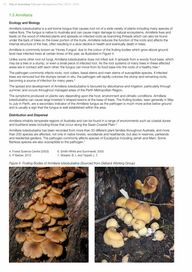
Armillaria is commonly known as ‘Honey Fungus’ due to the colour of the fruiting bodies which grow above ground level near infected trees at certain times of the year, as illustrated in Figure 4.
Unlike some other root rot fungi, Armillaria luteobubalina does not infest soil. It spreads from a woody food base, which may be a tree or a stump, or even a small piece of infected root. As the root systems of many trees in these affected areas are in contact with each other, the fungus can move from its food base into the roots of a healthy tree.4
The pathogen commonly infects roots, root collars, basal stems and main stems of susceptible species. If infected trees are removed but the stumps remain in situ, the pathogen will rapidly colonise the stump and remaining roots, becoming a source of infection for many years.5
The spread and development of Armillaria luteobubalina is favoured by disturbance and irrigation, particularly through summer, and occurs throughout managed areas of the Perth Metropolitan Region.
The symptoms produced on plants vary depending upon the host, environment and climatic conditions. Armillaria luteobubalina can cause large inverted V shaped lesions at the base of trees. The fruiting bodies, seen generally in May to July in Perth, are a secondary indicator of the Armillaria fungus as the pathogen is much more active below ground and is usually a sign that the fungus is well established within the area.
Distribution and Dispersal
Armillaria inhabits temperate regions of Australia and can be found in a range of environments such as coastal dunes and bushland areas including those that occur along the Swan Coastal Plain.6
Armillaria luteobubalina has been recorded from more than 50 different plant families throughout Australia, and more than 200 species are affected, not only in native forests, woodlands and heathlands, but also in reserves, parklands and residential gardens. The pathogen commonly affects species of Eucalyptus including Jarrah and Marri. Some Banksia species are also susceptible to the pathogen.7
Figure 4- Fruiting Bodies of Armillaria luteobubalina (Sourced from Dieback Working Group)
4. Forest Science Centre (2003)5. P Barber, 2012
6.。Smith-White and Summerell, 20037.。Shearer, B. L and Tippett J. T,
City of Joondalup Pathogen Management Plan | 2013 – 2016 11
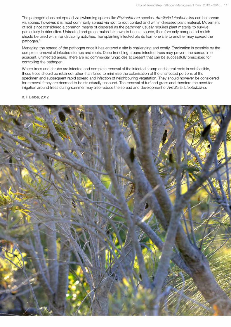
The pathogen does not spread via swimming spores like Phytophthora species. Armillaria luteobubalina can be spread via spores; however, it is most commonly spread via root to root contact and within diseased plant material. Movement of soil is not considered a common means of dispersal as the pathogen usually requires plant material to survive, particularly in drier sites. Untreated and green mulch is known to been a source, therefore only composted mulch should be used within landscaping activities. Transplanting infected plants from one site to another may spread the pathogen.8
Managing the spread of the pathogen once it has entered a site is challenging and costly. Eradication is possible by the complete removal of infected stumps and roots. Deep trenching around infected trees may prevent the spread into adjacent, uninfected areas. There are no commercial fungicides at present that can be successfully prescribed for controlling the pathogen.
Where trees and shrubs are infected and complete removal of the infected stump and lateral roots is not feasible, these trees should be retained rather than felled to minimise the colonisation of the unaffected portions of the specimen and subsequent rapid spread and infection of neighbouring vegetation. They should however be considered for removal if they are deemed to be structurally unsound. The removal of turf and grass and therefore the need for irrigation around trees during summer may also reduce the spread and development of Armillaria luteobubalina.
8.。P Barber, 2012
12 City of Joondalup Pathogen Management Plan | 2013 – 2016
2.0 Pathogen Risk Analysis 2.1 Introduction
The City of Joondalup engaged consultants Arbor Carbon to undertake a Pathogen Desktop Risk Analysis of vegetated areas within the City. The aim of the Study was to establish the level of risk for infestation of pathogen species within City parks and reserves.
The Pathogen Risk Assessment Study included:
• Identification of areas within the City at risk of pathogen infestation including the likelihood of introduction to or establishment / spread of pathogens within the area.
• Identification of vegetation communities of high priority and assessment of the level of risk pathogens pose to the area.
• Assessment of the manageability of the risk within the Study Area.
• Prioritised list of reserves for further investigations.
For the Risk Analysis consultants Arbor Carbon categorised the four species of Phytophthora and Armillaria luteobubalina under one group known as ‘threatening pathogens’. Results from the Pathogen Desktop Risk Analysis Report have been utilised to inform the development of the City of Joondalup Pathogen Management Plan.
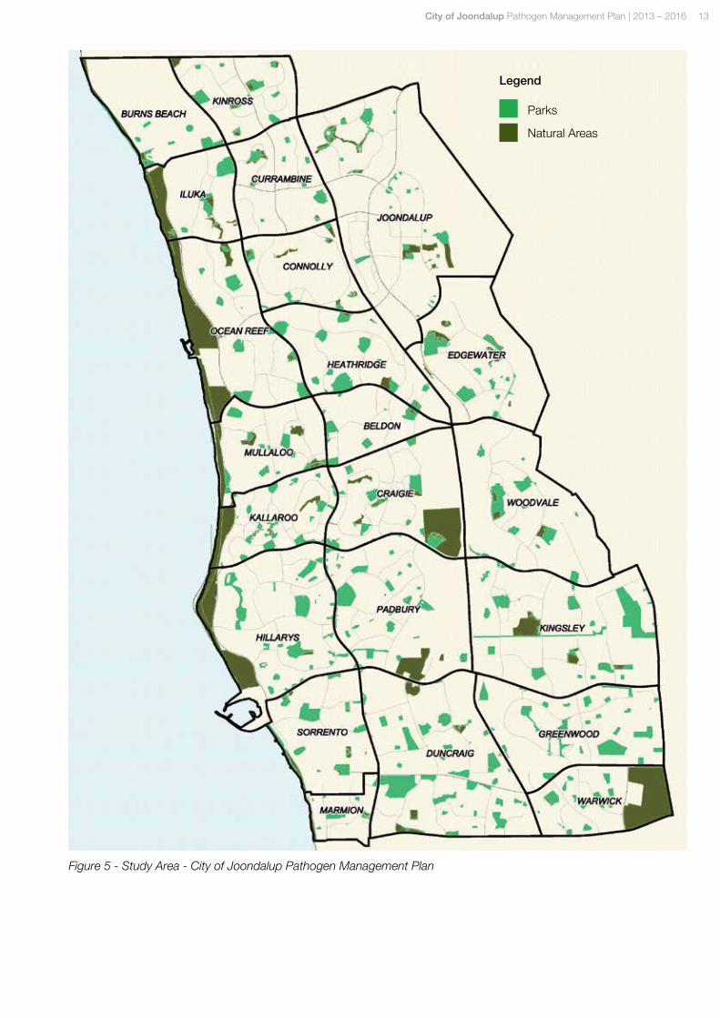
2.2 Study Area
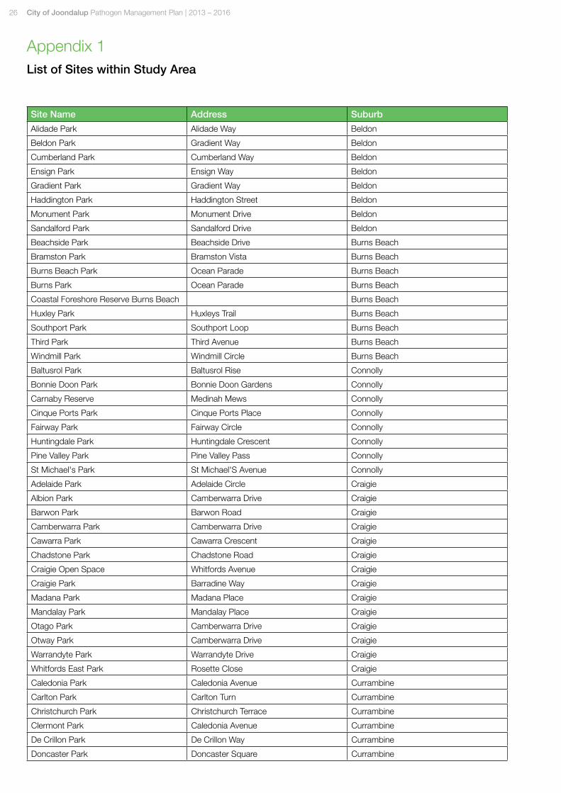
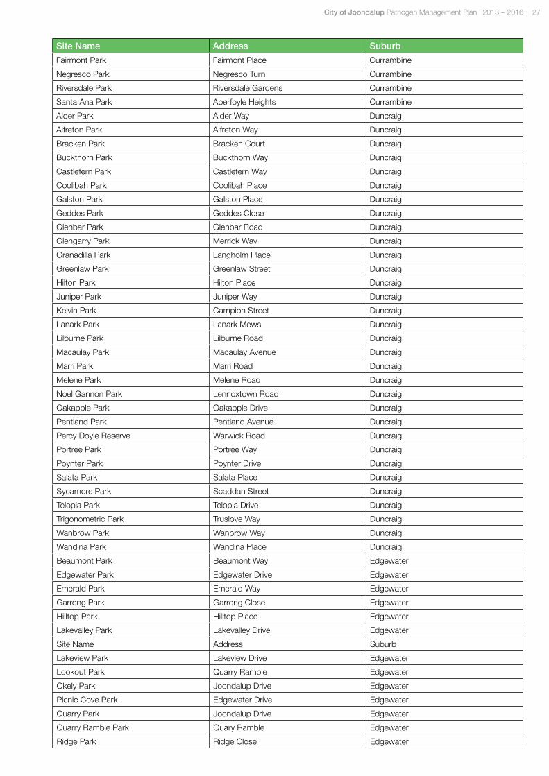
The Study Area for the Pathogen Desktop Risk Analysis includes City parks and natural areas as illustrated in Figure 4. A list of the sites included within the Pathogen Risk Assessment Study is included within Appendix 1.
City of Joondalup Pathogen Management Plan | 2013 – 2016 13
Figure 5 - Study Area - City of Joondalup Pathogen Management Plan
Parks
Natural Areas
Legend
14 City of Joondalup Pathogen Management Plan | 2013 – 2016
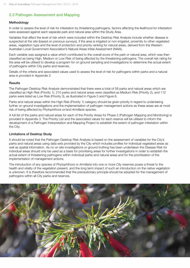
2.3 Pathogen Assessment and Mapping
Methodology
In order to assess the level of risk for infestation by threatening pathogens, factors affecting the likelihood for infestation were assessed against each separate park and natural area within the Study Area.
Variables that affect the level of risk which were included within the Desktop Risk Analysis include whether disease is suspected at the site (based on previous surveys), if the area is irrigated or non-irrigated, proximity to other vegetated areas, vegetation type and the level of protection and priority ranking for natural areas, derived from the Western Australian Local Government Association’s Natural Areas Initial Assessment (NAIA).
Each variable was assigned a value which contributed to the overall score of the park or natural area, which was then classified as being High, Medium or Low Risk of being affected by the threatening pathogens. The overall risk rating for the area will be utilised to develop a program for on ground sampling and investigations to determine the actual extent of pathogens within City parks and reserves.
Details of the criteria and associated values used to assess the level of risk for pathogens within parks and a natural area is provided in Appendix 2.
Results
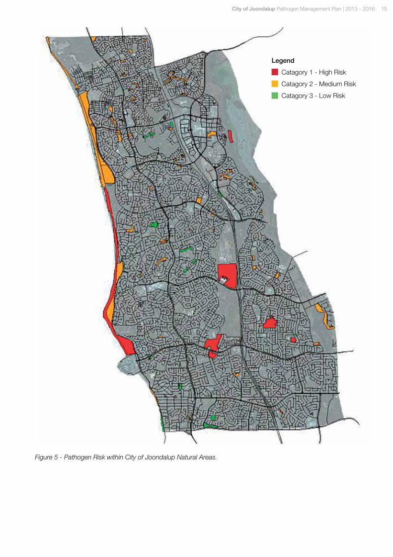
The Pathogen Desktop Risk Analysis demonstrated that there were a total of 58 parks and natural areas which are classified as High Risk (Priority 1), 210 parks and natural areas were classified as Medium Risk (Priority 2), and 112 parks were listed as Low Risk (Priority 3), as illustrated in Figure 5 and Figure 6.
Parks and natural areas within the High Risk (Priority 1) category should be given priority in regard to undertaking further on ground investigations and the implementation of pathogen management actions as these areas are at most risk of being affected by Phytophthora or/and Armillaria species.
A full list of the parks and natural areas for each of the Priority Areas for Phase 2 (Pathogen Mapping and Monitoring) is provided in Appendix 3. The Priority List and the associated values for each reserve will be utilised to inform the development of a Pathogen Interpretation and Mapping Project to establish the extent of pathogen infestation within the City.
Limitations of Desktop Study
It should be noted that the Pathogen Desktop Risk Analysis is based on the assessment of variables for the City’s parks and natural areas using data sets provided by the City which includes profiles for individual vegetated areas as well as spatial information. As no on site investigations or ground truthing has been undertaken the Disease Risk for individual areas should only be used as a basis for prioritising areas for further investigations in order to establish the actual extent of threatening pathogens within individual parks and natural areas and for the prioritisation of the implementation of management actions.
The introduction of any species of Phytophthora or Armillaria into one or more City reserves poses a threat to the health and vitality of the vegetation present, and the long term impact of such an introduction on the native vegetation is unknown. It is therefore recommended that the precautionary principle should be adopted for the management of pathogens within all City parks and reserves.
City of Joondalup Pathogen Management Plan | 2013 – 2016 15
Legend
Catagory 1 - High Risk
Catagory 2 - Medium Risk
Catagory 3 - Low Risk
Figure 5 - Pathogen Risk within City of Joondalup Natural Areas.
16 City of Joondalup Pathogen Management Plan | 2013 – 2016
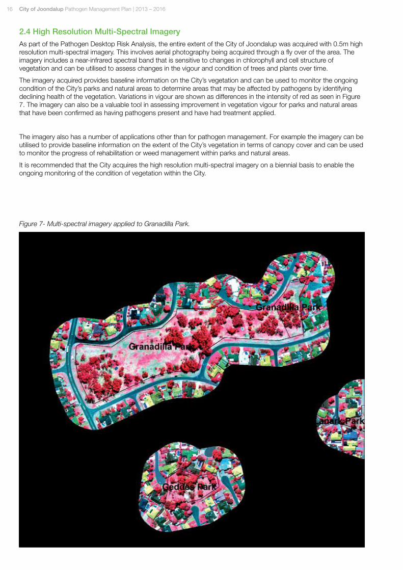
2.4 High Resolution Multi-Spectral Imagery
As part of the Pathogen Desktop Risk Analysis, the entire extent of the City of Joondalup was acquired with 0.5m high resolution multi-spectral imagery. This involves aerial photography being acquired through a fly over of the area. The imagery includes a near-infrared spectral band that is sensitive to changes in chlorophyll and cell structure of vegetation and can be utilised to assess changes in the vigour and condition of trees and plants over time.
The imagery acquired provides baseline information on the City’s vegetation and can be used to monitor the ongoing condition of the City’s parks and natural areas to determine areas that may be affected by pathogens by identifying declining health of the vegetation. Variations in vigour are shown as differences in the intensity of red as seen in Figure 7. The imagery can also be a valuable tool in assessing improvement in vegetation vigour for parks and natural areas that have been confirmed as having pathogens present and have had treatment applied.
The imagery also has a number of applications other than for pathogen management. For example the imagery can be utilised to provide baseline information on the extent of the City’s vegetation in terms of canopy cover and can be used to monitor the progress of rehabilitation or weed management within parks and natural areas.
It is recommended that the City acquires the high resolution multi-spectral imagery on a biennial basis to enable the ongoing monitoring of the condition of vegetation within the City.
Figure 7- Multi-spectral imagery applied to Granadilla Park.
City of Joondalup Pathogen Management Plan | 2013 – 2016 17
3.0 Pathogen Management At present there is no reliable mechanism for the complete eradication of Phytophthora species and the control of Armillaria luteobubalina is both expensive and labour intensive. Management strategies need to be developed to protect biodiversity values and minimise the spread of these pathogens within the City.
The aim of pathogen management is to:
• Protect biodiversity values within the City with a particular focus on the structure and function of susceptible ecosystems;
• Protect social and economic assets within City parks and natural areas;
• Minimise the spread of pathogens from infected areas to areas that are free from pathogens; and
• Raise community awareness of pathogens and the risk to environmental, social and economic values within the City of Joondalup.
Management strategies should be employed to reduce the spread of pathogens within the City, and initiatives developed to engage the community in order to raise the awareness of pathogen management within the City.
Protecting the biodiversity values of the City’s significant bushland areas is a key objective of pathogen management, therefore priority for investigation and the implementation of management recommendations should be given to the City’s Major Conservation Areas being:
• Lilburne Park;
• Warwick Open Space;
• Hepburn Conservation Area;
• Shepherd’s Bush Park; and
• Craigie Open Space.
The following section provides details of the strategies that should be implemented over the life of the Pathogen Management Plan in order to effectively manage the threat of pathogens within the City of Joondalup.
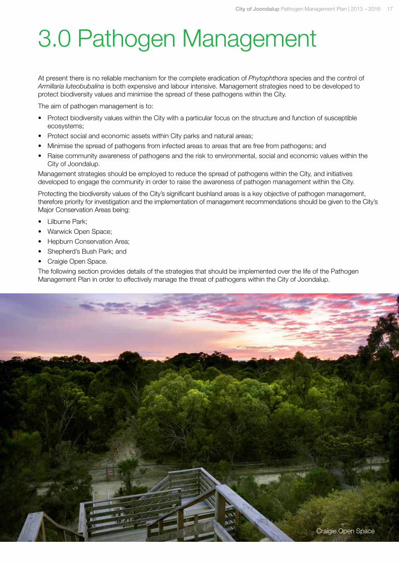
Craigie Open Space
18 City of Joondalup Pathogen Management Plan | 2013 – 2016
3.1 Pathogen Interpretation and Mapping
Establishing the extent of Pathogens within the City is essential to minimising the spread of Phytophthora species and Armillaria luteobubalina within parks and natural areas. Whilst initial desktop investigations have been undertaken to inform the development of this Plan, as detailed in Section 2.3, further investigation is required to ascertain the actual extent of pathogens within the City.
Ground truthing and soil sampling involves site assessments of the park or natural area by a qualified consultant to survey the area for signs of pathogen infestation. Soil and plant samples are also taken from the site which are analysed for the presence of pathogens.
Site investigations to determine the presence of pathogens will enable appropriate responses to effectively manage parks and natural areas where pathogens are confirmed to be present.
As ground truthing and soil sampling can be resource intensive it is recommended that a staged approach is taken to the on ground investigations. It is recommended that a schedule for site investigations is established with parks and natural areas being assessed according to the assigned priority (commencing with Priority 1 reserves) as detailed in Appendix 3.
Once the program for onsite investigations of pathogens has commenced and results of analysis are available it is crucial that this information is communicated to relevant internal and external stakeholders to ensure management actions are applied within the park or natural area.
It is recommended that mapping and a spatial layer be established within the City’s Geographic Information System (GIS) to provide information on the areas within the City that are known to have pathogens present.
Management Recommendation 1:
Using Reserve Priority Rankings establish a program for undertaking ground truthing and soil sampling at City parks and natural areas to determine the extent of pathogens within the City of Joondalup.
Management Recommendation 2:
Develop a spatial layer on the City’s Geographic Information System (GIS) to provide information to City staff regarding areas of known pathogen infestation.
3.2 Bushland Management
Operational activities of managing bushland reserves have the potential to spread pathogens from one area to another. Pathogens can be spread in small quantities of soil, such as mud attached to tyres, tools or walking shoes.
In order to minimise the risk of spreading pathogens a number of factors should be considered when planning and carrying out bushland management activities. This includes timing of activities such as fire break maintenance, slashing and weeding during dry soil conditions. It is essential that soil movement is minimised and that any materials, tools and vehicles that are bought onto the site are free of pathogens.
Other activities undertaken by the City also risk introducing pathogens to a previously uninfected area, or increase its rate of spread, these include road and drain construction and maintenance. Major land developments, landscaping activities and earthworks which involve the importation or movement of soil and plant material pose significant threats for the introduction and spread of the pathogens throughout the City.
Clear and consistent guidance should be provided to staff and community groups that undertake bushland management activities within vegetated areas of the City in order to minimise the spread of pathogens and prevent new infestations.
Management Recommendation 3:
Develop and implement City of Joondalup Bushland Management Manual to provide staff and community groups with guidance for activities undertaken within parks and natural areas to minimise the spread of pathogens.
City of Joondalup Pathogen Management Plan | 2013 – 2016 19
3.3 Hygiene Measures
Whether or not pathogens have been identified within a reserve, it is necessary to manage vegetated areas for Phytophthora and Armillaria in order to prevent its introduction to, or spread within parks and natural areas. Hygiene and quarantine measures are essential to managing pathogens as prevention is much more effective and economical than controlling a pathogen once it is established within a site. The movement of soil and plant parts, such as in plant based mulch from one site to another should be avoided unless it has been confirmed as pathogen free.
Tools, machinery, vehicles and boots should be cleaned of soil after being used within areas of known or suspected infestation. City officers and contractors should also avoid working within infested sites during or immediately after rain or irrigation.
Fire management can also contribute to the introduction and spread of pathogens. Fire prevention activities, such as firebreak construction, can spread infested soil. The Implementation of hygiene procedures when undertaking fire management activities can lead to increased protection of natural areas.
The supply of plant stock, soil and mulch that contains pathogens is one of the most common ways that pathogens such as Phytophthora and Armillaria luteobubalina establish within an area. It is recommended that the City only purchases plant stock from nurseries accredited under the Nursery Industry Accreditation Scheme Australia (NIASA) and that mulch, soil and gravel supplied for landscaping activities is pathogen free.
Modification of operations that have a high risk of introducing or spreading Phytophthora and Armillaria is also required, particularly when these operations are to occur at sites in or adjacent to areas of high conservation value. The development of guidelines and procedures outlining hygiene measures for City staff, contractors and community groups using City parks and natural areas is essential to controlling the spread of pathogen within the City.
The provisions within the City’s Hygiene Guidelines and Management Procedures may also be applicable to the control of other plant diseases within the City including Sting Nematodes.
Management Recommendation 4:
Develop and implement Pathogen Hygiene Guidelines and Management Procedures to provide direction to staff and contractors working within the City’s parks and natural areas in order to limit the spread of pathogens within the City of Joondalup.
Management Recommendation 5:
Develop and implement Purchasing Guidelines for the Supply of Landscaping Materials to provide information to City staff, contractors and community groups with information relating to the purchase of plant stock, soil and mulch for City parks and natural areas.
3.4 Access
Many of the City’s parks and natural areas have unrestricted access and are often traversed by numerous tracks and paths, increasing the likelihood of pathogens being introduced or spread in the area.
Vehicle access for City parks and natural areas should be restricted, particularly for areas that are known or suspected as having pathogens present. Visitors should be encouraged to avoid using these areas during wet conditions. Visitors should always use tracks and pathways and avoid passing through vegetated areas. Tracks and pathways should be well maintained and have effective drainage. The establishment of new tracks within areas of known infestation should be avoided.
Quarantine measures should be adopted for areas that are known or suspected of being infected by Phytophthora or Armillaria. Access to these areas by City staff, contractors and the community should be restricted with signage being placed at the entrance of the site explaining the disease status of the park or natural area. Signage should also provide information on how visitors can minimise the spread of the disease within the area.
For high risks areas or areas where Pathogens are known or suspected, cleaning stations should be installed to ensure that footwear, vehicles and tools are free of soil when entering and exiting infected parks or natural areas.
Management Recommendation 6:
Develop a Visitors Guide for City staff, contractors and community groups to provide information regarding access to City parks and natural areas that are known or suspected of having pathogens present.
20 City of Joondalup Pathogen Management Plan | 2013 – 2016
Management Recommendation 7:
Establish cleaning stations and informational signage at the entrance of City parks and natural areas that are known or suspected of having pathogens present.
3.5 Signage
Communicating the disease status of an area to visitors is an important part of preventing and managing the spread of pathogens. In order to provide a consistent approach to signage within the City it is proposed that the Western Australian Dieback Signage System is adopted for use within parks and natural areas. The Signage System was developed by the State Government in partnership with key industry groups as part of a state wide Communication Plan that aims to provide consistent and relevant themes and messages in relation to the management of Phytophthora Dieback within Western Australia.
The Signage System contains a range of signs that can be used depending on the management objectives of the area. The different signs that make up the Signage System are detailed in the Western Australian Dieback Signage Protocol, which is included in Appendix 4. The signage utilises a standard set of symbols as illustrated in Figure 8.
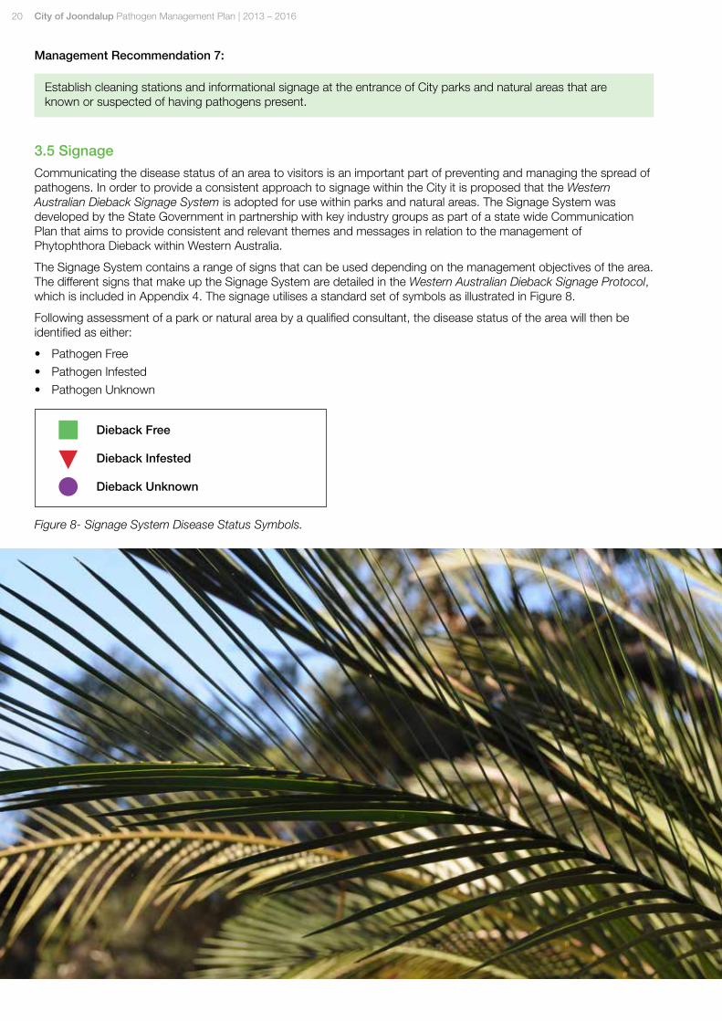
Following assessment of a park or natural area by a qualified consultant, the disease status of the area will then be identified as either:
• Pathogen Free
• Pathogen Infested
• Pathogen Unknown
Figure 8- Signage System Disease Status Symbols.
Dieback Free
Dieback Infested
Dieback Unknown
City of Joondalup Pathogen Management Plan | 2013 – 2016 21
The Signage System also provides information to visitors to assist in minimising the spread of pathogens. Typically signage would be placed at the entrances of the park or natural area with markers being used along paths and tracks.
It is proposed that the term Pathogen be used in place of Dieback for signage within the City of Joondalup in order to address all four species of Phytophthora as well as Armillaria luteobubalina in accordance with the objectives of the Pathogen Management Plan.
Management Recommendation 8:
Following site assessment and establishment of the disease status implement the Western Australian Dieback Signage System within City of Joondalup parks and natural areas.
3.6 Communication and Education
Raising the awareness of pathogens within the City of Joondalup is critical to minimising the introduction and spread of disease within vegetated areas of the City. In order to provide ongoing and consistent messages to the community regarding the importance of pathogen management an awareness campaign will be developed and implemented as part of the City’s Think Green – Environmental Education Program.
The objectives of the awareness campaign will be to:
• Increase the level of awareness of pathogen management within the community;
• Identify attitudes and behaviours of community members; and
• Develop and implement communication tools that are effective in encouraging measurable changes in behaviour regarding pathogen management within City parks and natural areas.
The campaign will provide information on what pathogens are, how they can be spread and ways of managing the diseases. The program will target the general community, environment groups and schools.
Training of City parks and natural areas staff and members of local environment groups that work within vegetated areas will assist to reduce the risk of introducing and spreading pathogens within the City.
Regular training will ensure that staff and community members are kept up to date with industry developments regarding pathogen management and will include topics such as:
• Communicating outcomes of monitoring programs;
• Hygiene and cleaning requirements;
• Quarantine measures; and
• Treatment options.
22 City of Joondalup Pathogen Management Plan | 2013 – 2016
Management Recommendation 9:
As part of the City’s Think Green Environmental Education Program, develop and implement initiatives that raise the awareness of pathogen management within the community.
Management Recommendation 10:
Ensure City staff and community groups who work within City parks and natural areas undertake relevant training to increase awareness of pathogen control measures.
3.7 Partnerships
Keeping up to date with developments in the area of pathogen management will ensure that the City is implementing best practices approaches to the management of Phytophthora and Armillaria species. There are a number of private companies, research organisations and working groups within Western Australia that focus on building the capacity of land managers to effectively address pathogens, including the Dieback Information Group and Centre for Phytophthora Science & Management at Murdoch University. The City should actively partner with these organisations to participate in research projects and take up opportunities for sharing information related to best practice approaches to the management of pathogen species.
Management Recommendation 11:
Investigate opportunities to partner with industry groups and research institutions to enable the City to build capacity and gain information relating to best practice approaches to pathogen management.
3.8 Treatment
Once on site investigations have determined that pathogens are present within a park or natural area treatment options should be investigated. Treatment may include removal of infected parts of the specimen, modification of the growing environment and chemical treatments such as Phosphite and growth enhancers.
Phosphite (Phosphonate) is a biodegradable, inexpensive chemical that is systemically transmitted throughout treated plants and has a very low toxicity to animals. Whilst Phosphite does not kill the pathogen, it acts as a booster to native plants enabling them to fight off the pathogen for a significantly longer period of time. Phosphite can be applied ahead of an advancing Phytophthora front to form a protective barrier. It can also be applied in an already infested area to protect susceptible plants that have not yet been infected.
Phosphite needs to enter a plant’s water transport system in order for it to be effective. This can be done by injecting phosphite directly into the trunk (or roots) of trees, or spraying the leaves of plants.
It is important to note that there is no chemical that will eradicate Phytophthora species and Armillaria luteobubalina. However, an integrated approach can successfully control the spread and impact of the diseases. An integrated approach may combine strategic chemical treatment, controlling access, maximising drainage and implementing hygiene and quarantine measures.
As treatment options for Phytophthora species and Armillaria luteobubalina are both expensive and labour intensive, preventing the introduction of the diseases into vegetated areas is the main objective of pathogen management.
Management Recommendation 12:
Apply appropriate treatment options for parks and natural areas that have been confirmed to have pathogens present. Investigate and trial newly developed treatment options to determine the best approach to treating pathogens within the City.
City of Joondalup Pathogen Management Plan | 2013 – 2016 23
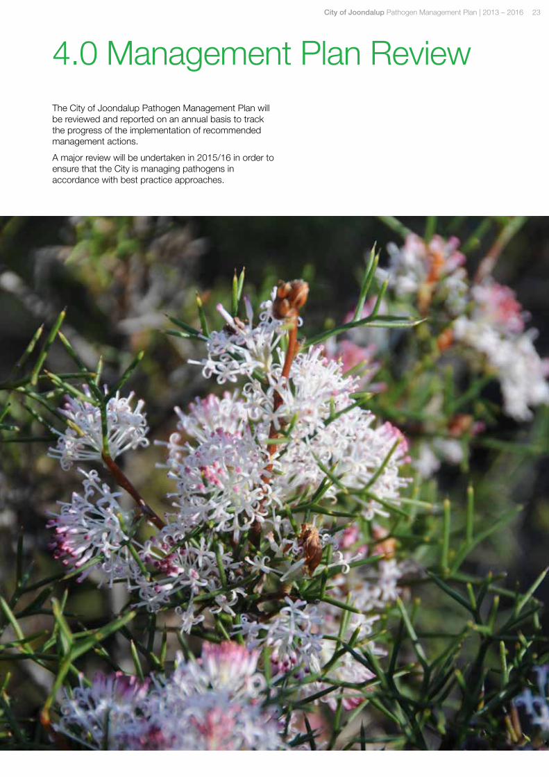
4.0 Management Plan ReviewThe City of Joondalup Pathogen Management Plan will be reviewed and reported on an annual basis to track the progress of the implementation of recommended management actions.
A major review will be undertaken in 2015/16 in order to ensure that the City is managing pathogens in accordance with best practice approaches.
24 City of Joondalup Pathogen Management Plan | 2013 – 2016
5.0 ReferencesBarber, P - Arbor Carbon (2012) Desktop Risk Analysis of Phytophthora and Armillaria to Reserves Within the City of Joondalup, Perth Western Australia
Dieback Working Group (2000) Managing Dieback Guidelines for Local Government, Perth Western Australia
Dieback Working Group (2008) Standart Dieback Signage Protocol for use, Perth WA.
Dieback Working Group (2008) Managing Phytophthora Dieback in Bushland, Perth Western Australia
Forest Science Centre (2003) Ian W. Smith & David I. Smith, Armillaria Root Rot: A Disease of Native and Introduced Trees, Victoria Australia
Smith-White J.L and Summerell B.A (2003) Armillaria Root Rot- Under the Microscope, Microbiology Australia
Project Dieback (2008) Standard Dieback Signage Protocol, Western Australia
Shearer, B.L., Crane, C.E. and Cochrane, A. (2004) Quantification of the susceptibility of the native flora of the south-west botanical province, Western Australia, to Phytophthora cinnamomi, Australian Journal of Botany. 52: 435-443
Shearer, B. L and Tippett J. T (1988) Distribution and Impact of Armillaria luteobubalina in the Eucalyptus marginata Forest of South-Western Australia, Australian Journal of Botany 36(4) 433 – 445
University of Western Australia (2004) Soil Health- Development and Prevention of Plant Disease www.soilhealth.see.uwa.edu.au
Western Australian Local Government Association (2004) Local Government Biodiversity Planning Guidelines, Western Australia

City of Joondalup Pathogen Management Plan | 2013 – 2016 25
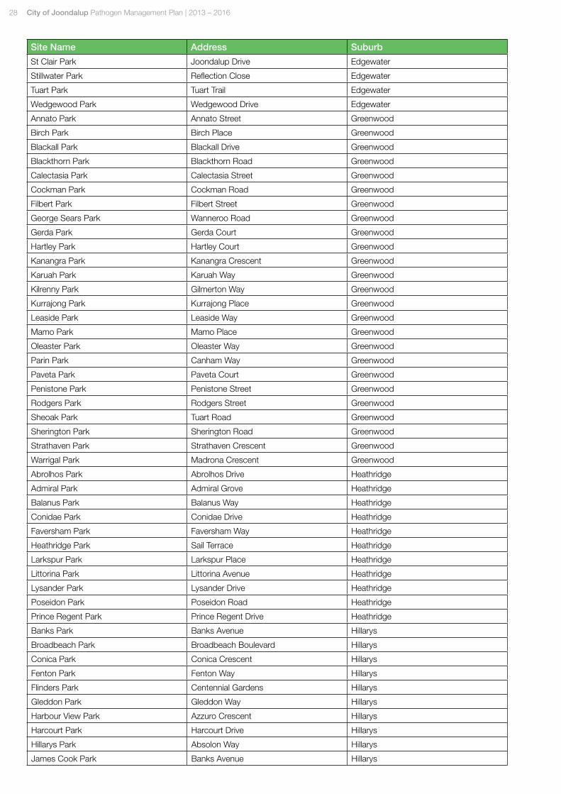
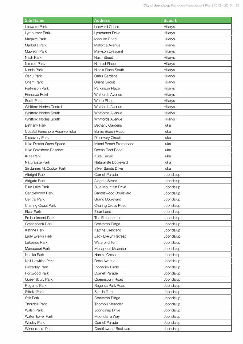
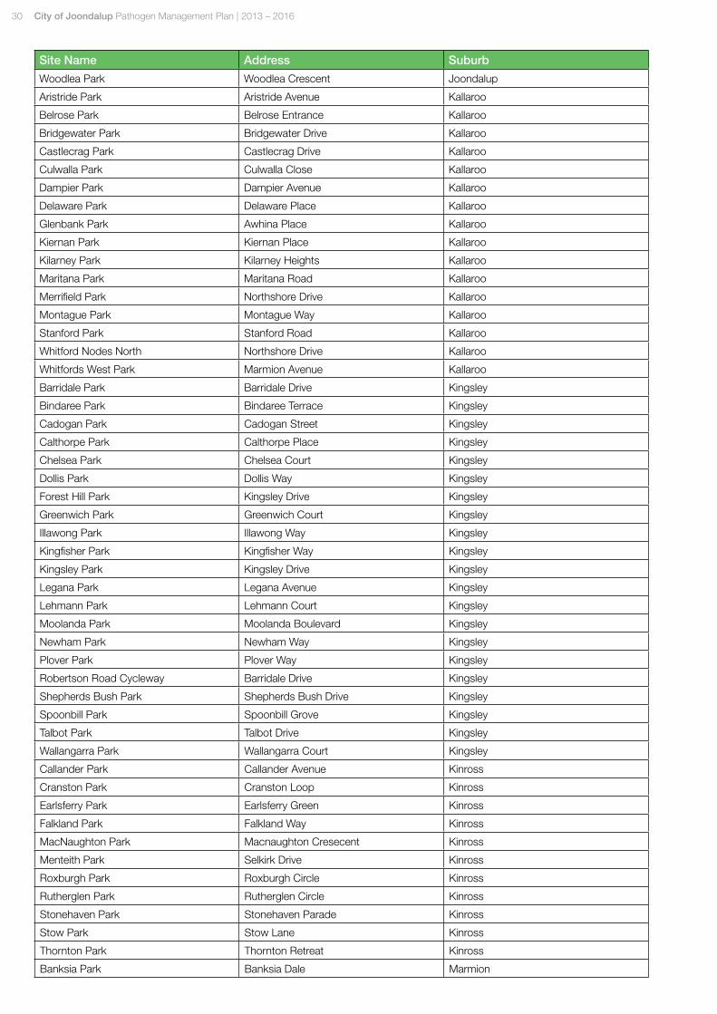
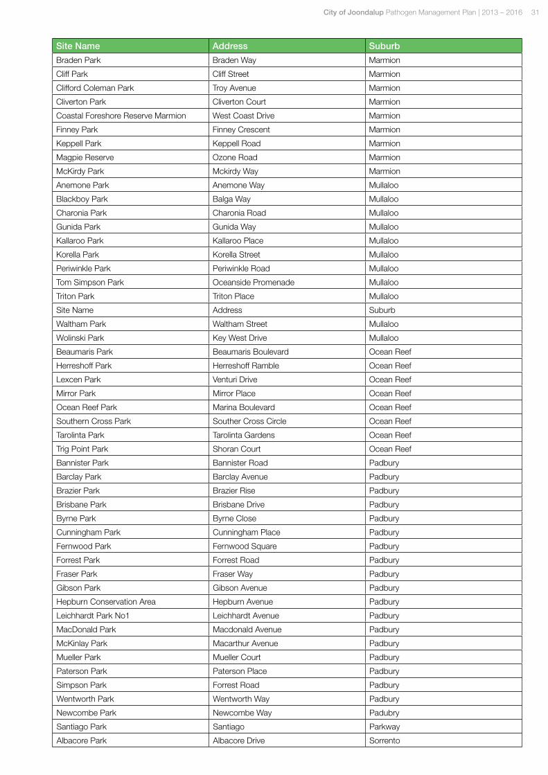
6.0 AppendicesAppendix 1 – Sites included in Pathogen Risk Assessment Study
Appendix 2 – Pathogen Desktop Risk Assessment Criteria
Appendix 3 – Priority List of Parks and Natural Areas for Pathogen Mapping and Monitoring
Appendix 4 – Western Australian Dieback Signage Protocol
26 City of Joondalup Pathogen Management Plan | 2013 – 2016
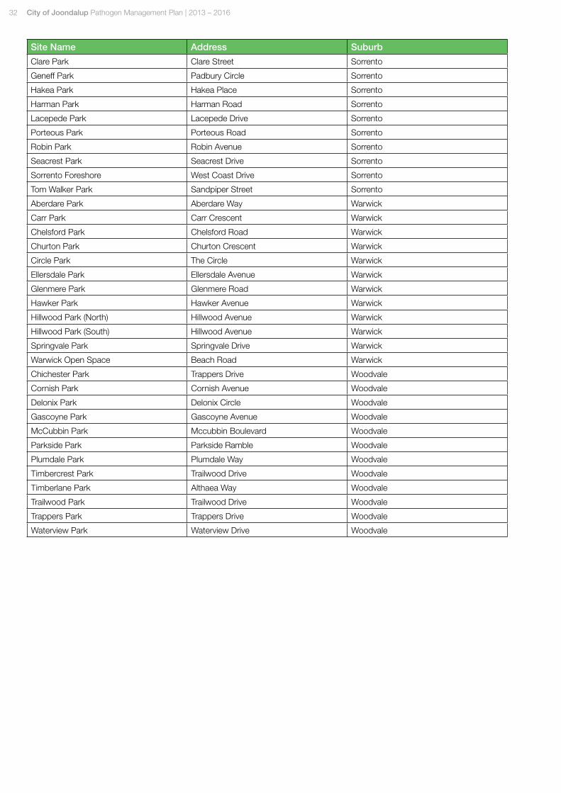
Appendix 1List of Sites within Study Area
Site Name Address Suburb
Alidade Park Alidade Way Beldon
Beldon Park Gradient Way Beldon
Cumberland Park Cumberland Way Beldon
Ensign Park Ensign Way Beldon
Gradient Park Gradient Way Beldon
Haddington Park Haddington Street Beldon
Monument Park Monument Drive Beldon
Sandalford Park Sandalford Drive Beldon
Beachside Park Beachside Drive Burns Beach
Bramston Park Bramston Vista Burns Beach
Burns Beach Park Ocean Parade Burns Beach
Burns Park Ocean Parade Burns Beach
Coastal Foreshore Reserve Burns Beach Burns Beach
Huxley Park Huxleys Trail Burns Beach
Southport Park Southport Loop Burns Beach
Third Park Third Avenue Burns Beach
Windmill Park Windmill Circle Burns Beach
Baltusrol Park Baltusrol Rise Connolly
Bonnie Doon Park Bonnie Doon Gardens Connolly
Carnaby Reserve Medinah Mews Connolly
Cinque Ports Park Cinque Ports Place Connolly
Fairway Park Fairway Circle Connolly
Huntingdale Park Huntingdale Crescent Connolly
Pine Valley Park Pine Valley Pass Connolly
St Michael's Park St Michael'S Avenue Connolly
Adelaide Park Adelaide Circle Craigie
Albion Park Camberwarra Drive Craigie
Barwon Park Barwon Road Craigie
Camberwarra Park Camberwarra Drive Craigie
Cawarra Park Cawarra Crescent Craigie
Chadstone Park Chadstone Road Craigie
Craigie Open Space Whitfords Avenue Craigie
Craigie Park Barradine Way Craigie
Madana Park Madana Place Craigie
Mandalay Park Mandalay Place Craigie
Otago Park Camberwarra Drive Craigie
Otway Park Camberwarra Drive Craigie
Warrandyte Park Warrandyte Drive Craigie
Whitfords East Park Rosette Close Craigie
Caledonia Park Caledonia Avenue Currambine
Carlton Park Carlton Turn Currambine
Christchurch Park Christchurch Terrace Currambine
Clermont Park Caledonia Avenue Currambine
De Crillon Park De Crillon Way Currambine
Doncaster Park Doncaster Square Currambine
City of Joondalup Pathogen Management Plan | 2013 – 2016 27
Site Name Address Suburb
Fairmont Park Fairmont Place Currambine
Negresco Park Negresco Turn Currambine
Riversdale Park Riversdale Gardens Currambine
Santa Ana Park Aberfoyle Heights Currambine
Alder Park Alder Way Duncraig
Alfreton Park Alfreton Way Duncraig
Bracken Park Bracken Court Duncraig
Buckthorn Park Buckthorn Way Duncraig
Castlefern Park Castlefern Way Duncraig
Coolibah Park Coolibah Place Duncraig
Galston Park Galston Place Duncraig
Geddes Park Geddes Close Duncraig
Glenbar Park Glenbar Road Duncraig
Glengarry Park Merrick Way Duncraig
Granadilla Park Langholm Place Duncraig
Greenlaw Park Greenlaw Street Duncraig
Hilton Park Hilton Place Duncraig
Juniper Park Juniper Way Duncraig
Kelvin Park Campion Street Duncraig
Lanark Park Lanark Mews Duncraig
Lilburne Park Lilburne Road Duncraig
Macaulay Park Macaulay Avenue Duncraig
Marri Park Marri Road Duncraig
Melene Park Melene Road Duncraig
Noel Gannon Park Lennoxtown Road Duncraig
Oakapple Park Oakapple Drive Duncraig
Pentland Park Pentland Avenue Duncraig
Percy Doyle Reserve Warwick Road Duncraig
Portree Park Portree Way Duncraig
Poynter Park Poynter Drive Duncraig
Salata Park Salata Place Duncraig
Sycamore Park Scaddan Street Duncraig
Telopia Park Telopia Drive Duncraig
Trigonometric Park Truslove Way Duncraig
Wanbrow Park Wanbrow Way Duncraig
Wandina Park Wandina Place Duncraig
Beaumont Park Beaumont Way Edgewater
Edgewater Park Edgewater Drive Edgewater
Emerald Park Emerald Way Edgewater
Garrong Park Garrong Close Edgewater
Hilltop Park Hilltop Place Edgewater
Lakevalley Park Lakevalley Drive Edgewater
Site Name Address Suburb
Lakeview Park Lakeview Drive Edgewater
Lookout Park Quarry Ramble Edgewater
Okely Park Joondalup Drive Edgewater
Picnic Cove Park Edgewater Drive Edgewater
Quarry Park Joondalup Drive Edgewater
Quarry Ramble Park Quary Ramble Edgewater
Ridge Park Ridge Close Edgewater
28 City of Joondalup Pathogen Management Plan | 2013 – 2016
Site Name Address Suburb
St Clair Park Joondalup Drive Edgewater
Stillwater Park Reflection Close Edgewater
Tuart Park Tuart Trail Edgewater
Wedgewood Park Wedgewood Drive Edgewater
Annato Park Annato Street Greenwood
Birch Park Birch Place Greenwood
Blackall Park Blackall Drive Greenwood
Blackthorn Park Blackthorn Road Greenwood
Calectasia Park Calectasia Street Greenwood
Cockman Park Cockman Road Greenwood
Filbert Park Filbert Street Greenwood
George Sears Park Wanneroo Road Greenwood
Gerda Park Gerda Court Greenwood
Hartley Park Hartley Court Greenwood
Kanangra Park Kanangra Crescent Greenwood
Karuah Park Karuah Way Greenwood
Kilrenny Park Gilmerton Way Greenwood
Kurrajong Park Kurrajong Place Greenwood
Leaside Park Leaside Way Greenwood
Mamo Park Mamo Place Greenwood
Oleaster Park Oleaster Way Greenwood
Parin Park Canham Way Greenwood
Paveta Park Paveta Court Greenwood
Penistone Park Penistone Street Greenwood
Rodgers Park Rodgers Street Greenwood
Sheoak Park Tuart Road Greenwood
Sherington Park Sherington Road Greenwood
Strathaven Park Strathaven Crescent Greenwood
Warrigal Park Madrona Crescent Greenwood
Abrolhos Park Abrolhos Drive Heathridge
Admiral Park Admiral Grove Heathridge
Balanus Park Balanus Way Heathridge
Conidae Park Conidae Drive Heathridge
Faversham Park Faversham Way Heathridge
Heathridge Park Sail Terrace Heathridge
Larkspur Park Larkspur Place Heathridge
Littorina Park Littorina Avenue Heathridge
Lysander Park Lysander Drive Heathridge
Poseidon Park Poseidon Road Heathridge
Prince Regent Park Prince Regent Drive Heathridge
Banks Park Banks Avenue Hillarys
Broadbeach Park Broadbeach Boulevard Hillarys
Conica Park Conica Crescent Hillarys
Fenton Park Fenton Way Hillarys
Flinders Park Centennial Gardens Hillarys
Gleddon Park Gleddon Way Hillarys
Harbour View Park Azzuro Crescent Hillarys
Harcourt Park Harcourt Drive Hillarys
Hillarys Park Absolon Way Hillarys
James Cook Park Banks Avenue Hillarys
City of Joondalup Pathogen Management Plan | 2013 – 2016 29
Site Name Address Suburb
Leeward Park Leeward Chase Hillarys
Lymburner Park Lymburner Drive Hillarys
Maquire Park Maquire Road Hillarys
Marbella Park Mallorca Avenue Hillarys
Mawson Park Mawson Crescent Hillarys
Nash Park Nash Street Hillarys
Nimrod Park Nimrod Place Hillarys
Ninnis Park Ninnis Place South Hillarys
Oahu Park Oahu Gardens Hillarys
Orient Park Orient Circuit Hillarys
Parkinson Park Parkinson Place Hillarys
Pinnaroo Point Whitfords Avenue Hillarys
Scott Park Webb Place Hillarys
Whitford Nodes Central Whitfords Avenue Hillarys
Whitford Nodes South Whitfords Avenue Hillarys
Whitford Nodes South Whitfords Avenue Hillarys
Bethany Park Bethany Gardens Iluka
Coastal Foreshore Reserve Iluka Burns Beach Road Iluka
Discovery Park Discovery Circuit Iluka
Iluka District Open Space Miami Beach Promenade Iluka
Iluka Foreshore Reserve Ocean Reef Road Iluka
Kuta Park Kuta Circuit Iluka
Naturaliste Park Naturaliste Boulevard Iluka
Sir James McCusker Park Silver Sands Drive Iluka
Albright Park Cornell Parade Joondalup
Aldgate Park Aldgate Street Joondalup
Blue Lake Park Blue Mountain Drive Joondalup
Candlewood Park Candlewood Boulevard Joondalup
Central Park Grand Boulevard Joondalup
Charing Cross Park Charing Cross Road Joondalup
Elcar Park Elcar Lane Joondalup
Embankment Park The Embankment Joondalup
Greenshank Park Cockatoo Ridge Joondalup
Katrine Park Katrine Crescent Joondalup
Lady Evelyn Park Lady Evelyn Retreat Joondalup
Lakeside Park Waterbird Turn Joondalup
Manapouri Park Manapouri Meander Joondalup
Nanika Park Nanika Crescent Joondalup
Neil Hawkins Park Boas Avenue Joondalup
Piccadilly Park Piccadilly Circle Joondalup
Portwood Park Cornell Parade Joondalup
Queensbury Park Queensbury Road Joondalup
Regents Park Regents Park Road Joondalup
Sittella Park Sittella Turn Joondalup
Stilt Park Cockatoo Ridge Joondalup
Thornbill Park Thornbill Meander Joondalup
Walsh Park Joondalup Drive Joondalup
Water Tower Park Moondarra Way Joondalup
Wesley Park Cornell Parade Joondalup
Windermere Park Candlewood Boulevard Joondalup
30 City of Joondalup Pathogen Management Plan | 2013 – 2016
Site Name Address Suburb
Woodlea Park Woodlea Crescent Joondalup
Aristride Park Aristride Avenue Kallaroo
Belrose Park Belrose Entrance Kallaroo
Bridgewater Park Bridgewater Drive Kallaroo
Castlecrag Park Castlecrag Drive Kallaroo
Culwalla Park Culwalla Close Kallaroo
Dampier Park Dampier Avenue Kallaroo
Delaware Park Delaware Place Kallaroo
Glenbank Park Awhina Place Kallaroo
Kiernan Park Kiernan Place Kallaroo
Kilarney Park Kilarney Heights Kallaroo
Maritana Park Maritana Road Kallaroo
Merrifield Park Northshore Drive Kallaroo
Montague Park Montague Way Kallaroo
Stanford Park Stanford Road Kallaroo
Whitford Nodes North Northshore Drive Kallaroo
Whitfords West Park Marmion Avenue Kallaroo
Barridale Park Barridale Drive Kingsley
Bindaree Park Bindaree Terrace Kingsley
Cadogan Park Cadogan Street Kingsley
Calthorpe Park Calthorpe Place Kingsley
Chelsea Park Chelsea Court Kingsley
Dollis Park Dollis Way Kingsley
Forest Hill Park Kingsley Drive Kingsley
Greenwich Park Greenwich Court Kingsley
Illawong Park Illawong Way Kingsley
Kingfisher Park Kingfisher Way Kingsley
Kingsley Park Kingsley Drive Kingsley
Legana Park Legana Avenue Kingsley
Lehmann Park Lehmann Court Kingsley
Moolanda Park Moolanda Boulevard Kingsley
Newham Park Newham Way Kingsley
Plover Park Plover Way Kingsley
Robertson Road Cycleway Barridale Drive Kingsley
Shepherds Bush Park Shepherds Bush Drive Kingsley
Spoonbill Park Spoonbill Grove Kingsley
Talbot Park Talbot Drive Kingsley
Wallangarra Park Wallangarra Court Kingsley
Callander Park Callander Avenue Kinross
Cranston Park Cranston Loop Kinross
Earlsferry Park Earlsferry Green Kinross
Falkland Park Falkland Way Kinross
MacNaughton Park Macnaughton Cresecent Kinross
Menteith Park Selkirk Drive Kinross
Roxburgh Park Roxburgh Circle Kinross
Rutherglen Park Rutherglen Circle Kinross
Stonehaven Park Stonehaven Parade Kinross
Stow Park Stow Lane Kinross
Thornton Park Thornton Retreat Kinross
Banksia Park Banksia Dale Marmion
City of Joondalup Pathogen Management Plan | 2013 – 2016 31
Site Name Address Suburb
Braden Park Braden Way Marmion
Cliff Park Cliff Street Marmion
Clifford Coleman Park Troy Avenue Marmion
Cliverton Park Cliverton Court Marmion
Coastal Foreshore Reserve Marmion West Coast Drive Marmion
Finney Park Finney Crescent Marmion
Keppell Park Keppell Road Marmion
Magpie Reserve Ozone Road Marmion
McKirdy Park Mckirdy Way Marmion
Anemone Park Anemone Way Mullaloo
Blackboy Park Balga Way Mullaloo
Charonia Park Charonia Road Mullaloo
Gunida Park Gunida Way Mullaloo
Kallaroo Park Kallaroo Place Mullaloo
Korella Park Korella Street Mullaloo
Periwinkle Park Periwinkle Road Mullaloo
Tom Simpson Park Oceanside Promenade Mullaloo
Triton Park Triton Place Mullaloo
Site Name Address Suburb
Waltham Park Waltham Street Mullaloo
Wolinski Park Key West Drive Mullaloo
Beaumaris Park Beaumaris Boulevard Ocean Reef
Herreshoff Park Herreshoff Ramble Ocean Reef
Lexcen Park Venturi Drive Ocean Reef
Mirror Park Mirror Place Ocean Reef
Ocean Reef Park Marina Boulevard Ocean Reef
Southern Cross Park Souther Cross Circle Ocean Reef
Tarolinta Park Tarolinta Gardens Ocean Reef
Trig Point Park Shoran Court Ocean Reef
Bannister Park Bannister Road Padbury
Barclay Park Barclay Avenue Padbury
Brazier Park Brazier Rise Padbury
Brisbane Park Brisbane Drive Padbury
Byrne Park Byrne Close Padbury
Cunningham Park Cunningham Place Padbury
Fernwood Park Fernwood Square Padbury
Forrest Park Forrest Road Padbury
Fraser Park Fraser Way Padbury
Gibson Park Gibson Avenue Padbury
Hepburn Conservation Area Hepburn Avenue Padbury
Leichhardt Park No1 Leichhardt Avenue Padbury
MacDonald Park Macdonald Avenue Padbury
McKinlay Park Macarthur Avenue Padbury
Mueller Park Mueller Court Padbury
Paterson Park Paterson Place Padbury
Simpson Park Forrest Road Padbury
Wentworth Park Wentworth Way Padbury
Newcombe Park Newcombe Way Padubry
Santiago Park Santiago Parkway
Albacore Park Albacore Drive Sorrento
32 City of Joondalup Pathogen Management Plan | 2013 – 2016
Site Name Address Suburb
Clare Park Clare Street Sorrento
Geneff Park Padbury Circle Sorrento
Hakea Park Hakea Place Sorrento
Harman Park Harman Road Sorrento
Lacepede Park Lacepede Drive Sorrento
Porteous Park Porteous Road Sorrento
Robin Park Robin Avenue Sorrento
Seacrest Park Seacrest Drive Sorrento
Sorrento Foreshore West Coast Drive Sorrento
Tom Walker Park Sandpiper Street Sorrento
Aberdare Park Aberdare Way Warwick
Carr Park Carr Crescent Warwick
Chelsford Park Chelsford Road Warwick
Churton Park Churton Crescent Warwick
Circle Park The Circle Warwick
Ellersdale Park Ellersdale Avenue Warwick
Glenmere Park Glenmere Road Warwick
Hawker Park Hawker Avenue Warwick
Hillwood Park (North) Hillwood Avenue Warwick
Hillwood Park (South) Hillwood Avenue Warwick
Springvale Park Springvale Drive Warwick
Warwick Open Space Beach Road Warwick
Chichester Park Trappers Drive Woodvale
Cornish Park Cornish Avenue Woodvale
Delonix Park Delonix Circle Woodvale
Gascoyne Park Gascoyne Avenue Woodvale
McCubbin Park Mccubbin Boulevard Woodvale
Parkside Park Parkside Ramble Woodvale
Plumdale Park Plumdale Way Woodvale
Timbercrest Park Trailwood Drive Woodvale
Timberlane Park Althaea Way Woodvale
Trailwood Park Trailwood Drive Woodvale
Trappers Park Trappers Drive Woodvale
Waterview Park Waterview Drive Woodvale
City of Joondalup Pathogen Management Plan | 2013 – 2016 33
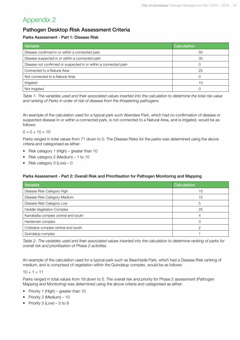
Appendix 2Pathogen Desktop Risk Assessment CriteriaParks Assessment - Part 1: Disease Risk
Variable Calculation
Disease confirmed in or within a connected park 50
Disease suspected in or within a connected park 35
Disease not confirmed or suspected in or within a connected park 0
Connected to a Natural Area 25
Not connected to a Natural Area 0
Irrigated 10
Not irrigated 0
Table 1- The variables used and their associated values inserted into the calculation to determine the total risk value and ranking of Parks in order of risk of disease from the threatening pathogens.
An example of the calculation used for a typical park such Aberdare Park, which had no confirmation of disease or suspected disease in or within a connected park, is not connected to a Natural Area, and is irrigated, would be as follows:
0 + 0 + 10 = 10
Parks ranged in total values from 71 down to 0. The Disease Risks for the parks was determined using the above criteria and categorised as either:
• Risk category 1 (High) – greater than 10
• Risk category 2 (Medium) – 1 to 10
• Risk category 3 (Low) – 0
Parks Assessment - Part 2: Overall Risk and Prioritisation for Pathogen Monitoring and Mapping
Variable Calculation
Disease Risk Category High 15
Disease Risk Category Medium 10
Disease Risk Category Low 5
Heddle Vegetation Complex 25
Karrakatta complex central and south 4
Herdsman complex 3
Cottesloe complex central and south 2
Quindalup complex 1
Table 2- The variables used and their associated values inserted into the calculation to determine ranking of parks for overall risk and prioritisation of Phase 2 activities.
An example of the calculation used for a typical park such as Beachside Park, which had a Disease Risk ranking of medium, and is comprised of vegetation within the Quindalup complex, would be as follows:
10 + 1 = 11
Parks ranged in total values from 19 down to 5. The overall risk and priority for Phase 2 assessment (Pathogen Mapping and Monitoring) was determined using the above criteria and categorised as either:
• Priority 1 (High) – greater than 10
• Priority 2 (Medium) – 10
• Priority 3 (Low) – 5 to 9
34 City of Joondalup Pathogen Management Plan | 2013 – 2016
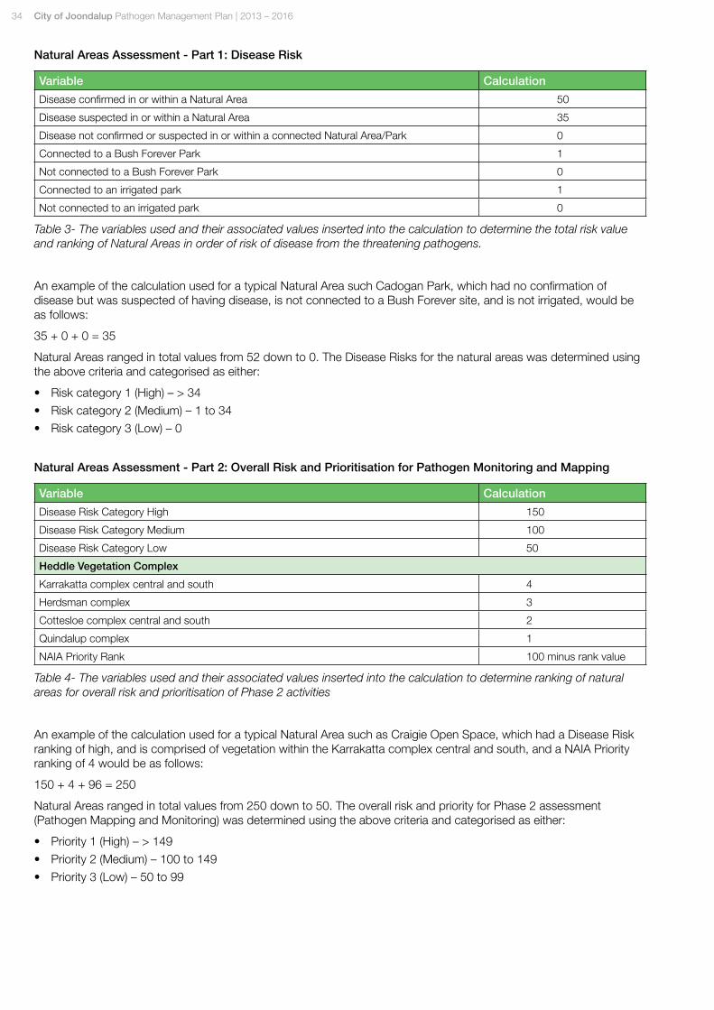
Natural Areas Assessment - Part 1: Disease Risk
Variable Calculation
Disease confirmed in or within a Natural Area 50
Disease suspected in or within a Natural Area 35
Disease not confirmed or suspected in or within a connected Natural Area/Park 0
Connected to a Bush Forever Park 1
Not connected to a Bush Forever Park 0
Connected to an irrigated park 1
Not connected to an irrigated park 0
Table 3- The variables used and their associated values inserted into the calculation to determine the total risk value and ranking of Natural Areas in order of risk of disease from the threatening pathogens.
An example of the calculation used for a typical Natural Area such Cadogan Park, which had no confirmation of disease but was suspected of having disease, is not connected to a Bush Forever site, and is not irrigated, would be as follows:
35 + 0 + 0 = 35
Natural Areas ranged in total values from 52 down to 0. The Disease Risks for the natural areas was determined using the above criteria and categorised as either:
• Risk category 1 (High) – > 34
• Risk category 2 (Medium) – 1 to 34
• Risk category 3 (Low) – 0
Natural Areas Assessment - Part 2: Overall Risk and Prioritisation for Pathogen Monitoring and Mapping
Variable Calculation
Disease Risk Category High 150
Disease Risk Category Medium 100
Disease Risk Category Low 50
Heddle Vegetation Complex
Karrakatta complex central and south 4
Herdsman complex 3
Cottesloe complex central and south 2
Quindalup complex 1
NAIA Priority Rank 100 minus rank value
Table 4- The variables used and their associated values inserted into the calculation to determine ranking of natural areas for overall risk and prioritisation of Phase 2 activities
An example of the calculation used for a typical Natural Area such as Craigie Open Space, which had a Disease Risk ranking of high, and is comprised of vegetation within the Karrakatta complex central and south, and a NAIA Priority ranking of 4 would be as follows:
150 + 4 + 96 = 250
Natural Areas ranged in total values from 250 down to 50. The overall risk and priority for Phase 2 assessment (Pathogen Mapping and Monitoring) was determined using the above criteria and categorised as either:
• Priority 1 (High) – > 149
• Priority 2 (Medium) – 100 to 149
• Priority 3 (Low) – 50 to 99

City of Joondalup Pathogen Management Plan | 2013 – 2016 35
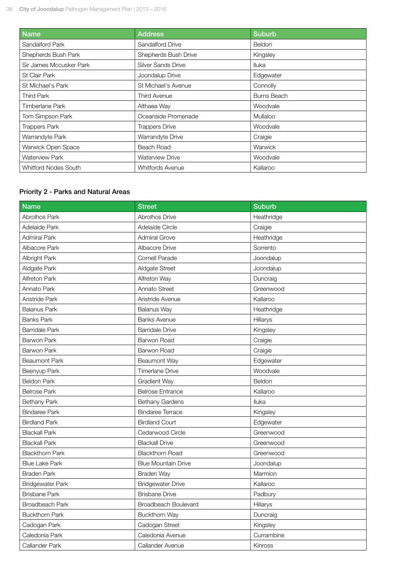
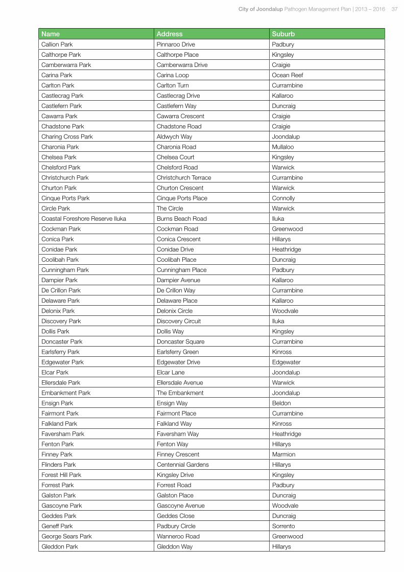
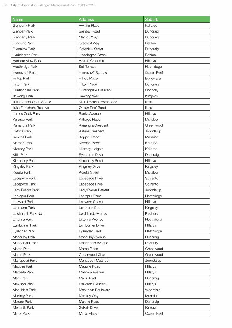
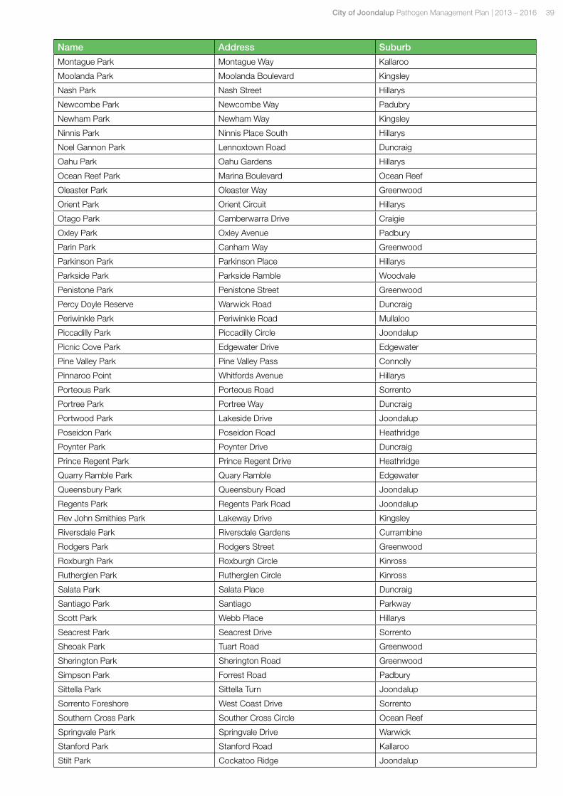
Appendix 3Overall Risk / Priority Listings for Parks and Natural Areas
Priority 1 - Parks and Natural Areas
Name Address Suburb
Aberdare Park Aberdare Way Warwick
Baltusrol Park Baltusrol Rise Connolly
Beachside Park Beachside Drive Burns Beach
Beaumaris Park Beaumaris Boulevard Ocean Reef
Blackboy Park Balga Way Mullaloo
Blue Lake Park Blue Mountain Drive Joondalup
Bonnie Doon Park Bonnie Doon Gardens Connolly
Brazier Park Brazier Rise Padbury
Burns Beach Park Ocean Parade Burns Beach
Burns Beach Park Ocean Parade Burns Beach
Cadogan Park Cadogan Street Kingsley
Central Park Lakeside Drive Joondalup
Chichester Park Trappers Drive Woodvale
Clermont Park Caledonia Avenue Currambine
Craigie Open Space Whitfords Avenue Craigie
Cranston Park Cranston Loop Kinross
Emerald Park Emerald Way Edgewater
Fairway Park Fairway Circle Connolly
Fernwood Park Fernwood Square Padbury
Garrong Park Garrong Close Edgewater
Gibson Park Gibson Avenue Padbury
Granadilla Park Granadilla Street Duncraig
Greenshank Park Cockatoo Ridge Joondalup
Hawker Park Hawker Avenue Warwick
Hepburn Conservation Area Hepburn Avenue Padbury
Hillarys Park Absolon Way Hillarys
Juniper Park Juniper Way Duncraig
Lakeside Park Waterbird Turn Joondalup
Lakevalley Park Lakevalley Drive Edgewater
Legana Park Legana Avenue Kingsley
Lexcen Park Venturi Drive Ocean Reef
Lilburne Park Lilburne Road Duncraig
Macnaughton Park Macnaughton Cresecent Kinross
Maritana Park Maritana Road Kallaroo
Merrifield Park Northshore Drive Kallaroo
Nanika Park Nanika Crescent Joondalup
Naturaliste Park Naturaliste Boulevard Iluka
Negresco Park Negresco Turn Currambine
Neil Hawkins Park Boas Avenue Joondalup
Plumdale Park Plumdale Way Woodvale
Quarry Park Regatta Drive Edgewater
Robertson Road Cycleway Barridale Drive Kingsley
Robin Park Robin Avenue Sorrento
36 City of Joondalup Pathogen Management Plan | 2013 – 2016
Name Address Suburb
Sandalford Park Sandalford Drive Beldon
Shepherds Bush Park Shepherds Bush Drive Kingsley
Sir James Mccusker Park Silver Sands Drive Iluka
St Clair Park Joondalup Drive Edgewater
St Michael's Park St Michael's Avenue Connolly
Third Park Third Avenue Burns Beach
Timberlane Park Althaea Way Woodvale
Tom Simpson Park Oceanside Promenade Mullaloo
Trappers Park Trappers Drive Woodvale
Warrandyte Park Warrandyte Drive Craigie
Warwick Open Space Beach Road Warwick
Waterview Park Waterview Drive Woodvale
Whitford Nodes South Whitfords Avenue Kallaroo
Priority 2 - Parks and Natural Areas
Name Street Suburb
Abrolhos Park Abrolhos Drive Heathridge
Adelaide Park Adelaide Circle Craigie
Admiral Park Admiral Grove Heathridge
Albacore Park Albacore Drive Sorrento
Albright Park Cornell Parade Joondalup
Aldgate Park Aldgate Street Joondalup
Alfreton Park Alfreton Way Duncraig
Annato Park Annato Street Greenwood
Aristride Park Aristride Avenue Kallaroo
Balanus Park Balanus Way Heathridge
Banks Park Banks Avenue Hillarys
Barridale Park Barridale Drive Kingsley
Barwon Park Barwon Road Craigie
Barwon Park Barwon Road Craigie
Beaumont Park Beaumont Way Edgewater
Beenyup Park Timerlane Drive Woodvale
Beldon Park Gradient Way Beldon
Belrose Park Belrose Entrance Kallaroo
Bethany Park Bethany Gardens Iluka
Bindaree Park Bindaree Terrace Kingsley
Birdland Park Birdland Court Edgewater
Blackall Park Cedarwood Circle Greenwood
Blackall Park Blackall Drive Greenwood
Blackthorn Park Blackthorn Road Greenwood
Blue Lake Park Blue Mountain Drive Joondalup
Braden Park Braden Way Marmion
Bridgewater Park Bridgewater Drive Kallaroo
Brisbane Park Brisbane Drive Padbury
Broadbeach Park Broadbeach Boulevard Hillarys
Buckthorn Park Buckthorn Way Duncraig
Cadogan Park Cadogan Street Kingsley
Caledonia Park Caledonia Avenue Currambine
Callander Park Callander Avenue Kinross
City of Joondalup Pathogen Management Plan | 2013 – 2016 37
Name Address Suburb
Callion Park Pinnaroo Drive Padbury
Calthorpe Park Calthorpe Place Kingsley
Camberwarra Park Camberwarra Drive Craigie
Carina Park Carina Loop Ocean Reef
Carlton Park Carlton Turn Currambine
Castlecrag Park Castlecrag Drive Kallaroo
Castlefern Park Castlefern Way Duncraig
Cawarra Park Cawarra Crescent Craigie
Chadstone Park Chadstone Road Craigie
Charing Cross Park Aldwych Way Joondalup
Charonia Park Charonia Road Mullaloo
Chelsea Park Chelsea Court Kingsley
Chelsford Park Chelsford Road Warwick
Christchurch Park Christchurch Terrace Currambine
Churton Park Churton Crescent Warwick
Cinque Ports Park Cinque Ports Place Connolly
Circle Park The Circle Warwick
Coastal Foreshore Reserve Iluka Burns Beach Road Iluka
Cockman Park Cockman Road Greenwood
Conica Park Conica Crescent Hillarys
Conidae Park Conidae Drive Heathridge
Coolibah Park Coolibah Place Duncraig
Cunningham Park Cunningham Place Padbury
Dampier Park Dampier Avenue Kallaroo
De Crillon Park De Crillon Way Currambine
Delaware Park Delaware Place Kallaroo
Delonix Park Delonix Circle Woodvale
Discovery Park Discovery Circuit Iluka
Dollis Park Dollis Way Kingsley
Doncaster Park Doncaster Square Currambine
Earlsferry Park Earlsferry Green Kinross
Edgewater Park Edgewater Drive Edgewater
Elcar Park Elcar Lane Joondalup
Ellersdale Park Ellersdale Avenue Warwick
Embankment Park The Embankment Joondalup
Ensign Park Ensign Way Beldon
Fairmont Park Fairmont Place Currambine
Falkland Park Falkland Way Kinross
Faversham Park Faversham Way Heathridge
Fenton Park Fenton Way Hillarys
Finney Park Finney Crescent Marmion
Flinders Park Centennial Gardens Hillarys
Forest Hill Park Kingsley Drive Kingsley
Forrest Park Forrest Road Padbury
Galston Park Galston Place Duncraig
Gascoyne Park Gascoyne Avenue Woodvale
Geddes Park Geddes Close Duncraig
Geneff Park Padbury Circle Sorrento
George Sears Park Wanneroo Road Greenwood
Gleddon Park Gleddon Way Hillarys
38 City of Joondalup Pathogen Management Plan | 2013 – 2016
Name Address Suburb
Glenbank Park Awhina Place Kallaroo
Glenbar Park Glenbar Road Duncraig
Glengarry Park Merrick Way Duncraig
Gradient Park Gradient Way Beldon
Greenlaw Park Greenlaw Street Duncraig
Haddington Park Haddington Street Beldon
Harbour View Park Azzuro Crescent Hillarys
Heathridge Park Sail Terrace Heathridge
Herreshoff Park Herreshoff Ramble Ocean Reef
Hilltop Park Hilltop Place Edgewater
Hilton Park Hilton Place Duncraig
Huntingdale Park Huntingdale Crescent Connolly
Illawong Park Illawong Way Kingsley
Iluka District Open Space Miami Beach Promenade Iluka
Iluka Foreshore Reserve Ocean Reef Road Iluka
James Cook Park Banks Avenue Hillarys
Kallaroo Park Kallaroo Place Mullaloo
Kanangra Park Kanangra Crescent Greenwood
Katrine Park Katrine Crescent Joondalup
Keppell Park Keppell Road Marmion
Kiernan Park Kiernan Place Kallaroo
Kilarney Park Kilarney Heights Kallaroo
Killin Park Sycamore Drive Duncraig
Kimberley Park Kimberley Road Hillarys
Kingsley Park Kingsley Drive Kingsley
Korella Park Korella Street Mullaloo
Lacepede Park Lacepede Drive Sorrento
Lacepede Park Lacepede Drive Sorrento
Lady Evelyn Park Lady Evelyn Retreat Joondalup
Larkspur Park Larkspur Place Heathridge
Leeward Park Leeward Chase Hillarys
Lehmann Park Lehmann Court Kingsley
Leichhardt Park No1 Leichhardt Avenue Padbury
Littorina Park Littorina Avenue Heathridge
Lymburner Park Lymburner Drive Hillarys
Lysander Park Lysander Drive Heathridge
Macaulay Park Macaulay Avenue Duncraig
Macdonald Park Macdonald Avenue Padbury
Mamo Park Mamo Place Greenwood
Mamo Park Cedarwood Circle Greenwood
Manapouri Park Manapouri Meander Joondalup
Maquire Park Maquire Road Hillarys
Marbella Park Mallorca Avenue Hillarys
Marri Park Marri Road Duncraig
Mawson Park Mawson Crescent Hillarys
Mccubbin Park Mccubbin Boulevard Woodvale
Mckirdy Park Mckirdy Way Marmion
Melene Park Melene Road Duncraig
Menteith Park Selkirk Drive Kinross
Mirror Park Mirror Place Ocean Reef
City of Joondalup Pathogen Management Plan | 2013 – 2016 39
Name Address Suburb
Montague Park Montague Way Kallaroo
Moolanda Park Moolanda Boulevard Kingsley
Nash Park Nash Street Hillarys
Newcombe Park Newcombe Way Padubry
Newham Park Newham Way Kingsley
Ninnis Park Ninnis Place South Hillarys
Noel Gannon Park Lennoxtown Road Duncraig
Oahu Park Oahu Gardens Hillarys
Ocean Reef Park Marina Boulevard Ocean Reef
Oleaster Park Oleaster Way Greenwood
Orient Park Orient Circuit Hillarys
Otago Park Camberwarra Drive Craigie
Oxley Park Oxley Avenue Padbury
Parin Park Canham Way Greenwood
Parkinson Park Parkinson Place Hillarys
Parkside Park Parkside Ramble Woodvale
Penistone Park Penistone Street Greenwood
Percy Doyle Reserve Warwick Road Duncraig
Periwinkle Park Periwinkle Road Mullaloo
Piccadilly Park Piccadilly Circle Joondalup
Picnic Cove Park Edgewater Drive Edgewater
Pine Valley Park Pine Valley Pass Connolly
Pinnaroo Point Whitfords Avenue Hillarys
Porteous Park Porteous Road Sorrento
Portree Park Portree Way Duncraig
Portwood Park Lakeside Drive Joondalup
Poseidon Park Poseidon Road Heathridge
Poynter Park Poynter Drive Duncraig
Prince Regent Park Prince Regent Drive Heathridge
Quarry Ramble Park Quary Ramble Edgewater
Queensbury Park Queensbury Road Joondalup
Regents Park Regents Park Road Joondalup
Rev John Smithies Park Lakeway Drive Kingsley
Riversdale Park Riversdale Gardens Currambine
Rodgers Park Rodgers Street Greenwood
Roxburgh Park Roxburgh Circle Kinross
Rutherglen Park Rutherglen Circle Kinross
Salata Park Salata Place Duncraig
Santiago Park Santiago Parkway
Scott Park Webb Place Hillarys
Seacrest Park Seacrest Drive Sorrento
Sheoak Park Tuart Road Greenwood
Sherington Park Sherington Road Greenwood
Simpson Park Forrest Road Padbury
Sittella Park Sittella Turn Joondalup
Sorrento Foreshore West Coast Drive Sorrento
Southern Cross Park Souther Cross Circle Ocean Reef
Springvale Park Springvale Drive Warwick
Stanford Park Stanford Road Kallaroo
Stilt Park Cockatoo Ridge Joondalup
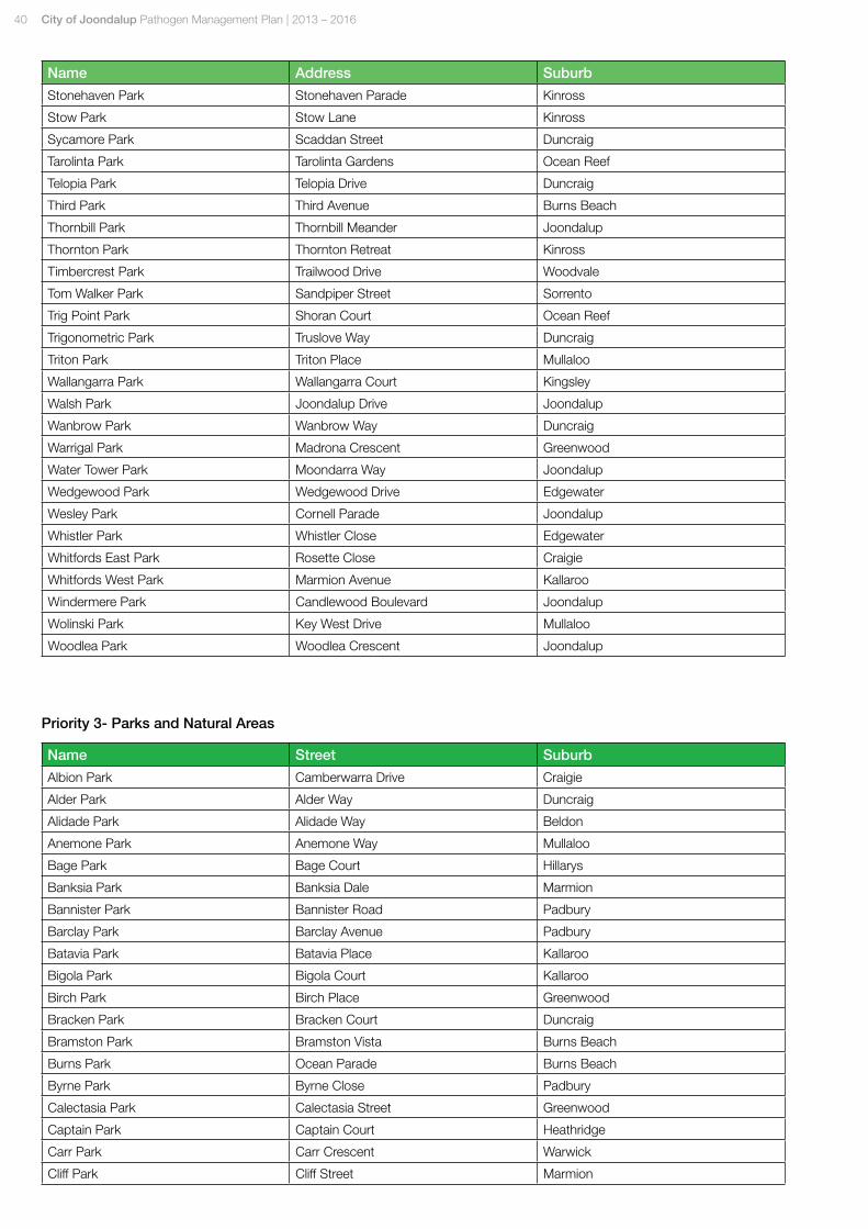
40 City of Joondalup Pathogen Management Plan | 2013 – 2016
Name Address Suburb
Stonehaven Park Stonehaven Parade Kinross
Stow Park Stow Lane Kinross
Sycamore Park Scaddan Street Duncraig
Tarolinta Park Tarolinta Gardens Ocean Reef
Telopia Park Telopia Drive Duncraig
Third Park Third Avenue Burns Beach
Thornbill Park Thornbill Meander Joondalup
Thornton Park Thornton Retreat Kinross
Timbercrest Park Trailwood Drive Woodvale
Tom Walker Park Sandpiper Street Sorrento
Trig Point Park Shoran Court Ocean Reef
Trigonometric Park Truslove Way Duncraig
Triton Park Triton Place Mullaloo
Wallangarra Park Wallangarra Court Kingsley
Walsh Park Joondalup Drive Joondalup
Wanbrow Park Wanbrow Way Duncraig
Warrigal Park Madrona Crescent Greenwood
Water Tower Park Moondarra Way Joondalup
Wedgewood Park Wedgewood Drive Edgewater
Wesley Park Cornell Parade Joondalup
Whistler Park Whistler Close Edgewater
Whitfords East Park Rosette Close Craigie
Whitfords West Park Marmion Avenue Kallaroo
Windermere Park Candlewood Boulevard Joondalup
Wolinski Park Key West Drive Mullaloo
Woodlea Park Woodlea Crescent Joondalup
Priority 3- Parks and Natural Areas
Name Street Suburb
Albion Park Camberwarra Drive Craigie
Alder Park Alder Way Duncraig
Alidade Park Alidade Way Beldon
Anemone Park Anemone Way Mullaloo
Bage Park Bage Court Hillarys
Banksia Park Banksia Dale Marmion
Bannister Park Bannister Road Padbury
Barclay Park Barclay Avenue Padbury
Batavia Park Batavia Place Kallaroo
Bigola Park Bigola Court Kallaroo
Birch Park Birch Place Greenwood
Bracken Park Bracken Court Duncraig
Bramston Park Bramston Vista Burns Beach
Burns Park Ocean Parade Burns Beach
Byrne Park Byrne Close Padbury
Calectasia Park Calectasia Street Greenwood
Captain Park Captain Court Heathridge
Carr Park Carr Crescent Warwick
Cliff Park Cliff Street Marmion
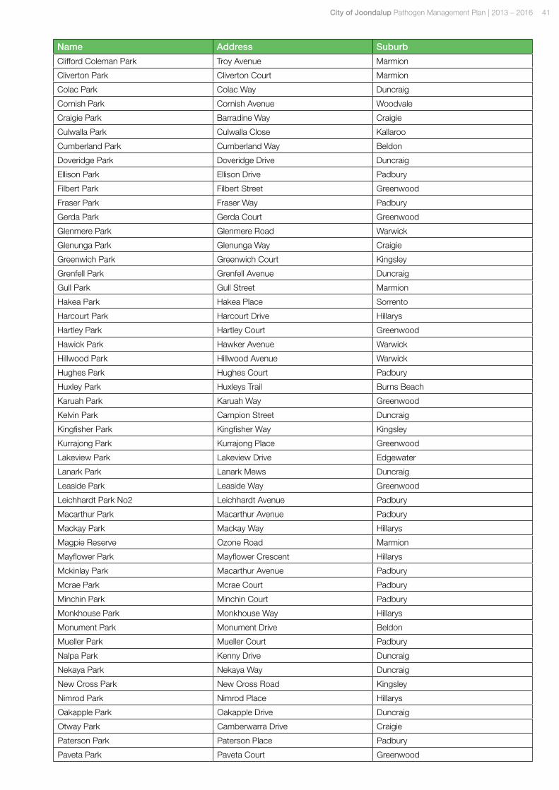
City of Joondalup Pathogen Management Plan | 2013 – 2016 41
Name Address Suburb
Clifford Coleman Park Troy Avenue Marmion
Cliverton Park Cliverton Court Marmion
Colac Park Colac Way Duncraig
Cornish Park Cornish Avenue Woodvale
Craigie Park Barradine Way Craigie
Culwalla Park Culwalla Close Kallaroo
Cumberland Park Cumberland Way Beldon
Doveridge Park Doveridge Drive Duncraig
Ellison Park Ellison Drive Padbury
Filbert Park Filbert Street Greenwood
Fraser Park Fraser Way Padbury
Gerda Park Gerda Court Greenwood
Glenmere Park Glenmere Road Warwick
Glenunga Park Glenunga Way Craigie
Greenwich Park Greenwich Court Kingsley
Grenfell Park Grenfell Avenue Duncraig
Gull Park Gull Street Marmion
Hakea Park Hakea Place Sorrento
Harcourt Park Harcourt Drive Hillarys
Hartley Park Hartley Court Greenwood
Hawick Park Hawker Avenue Warwick
Hillwood Park Hillwood Avenue Warwick
Hughes Park Hughes Court Padbury
Huxley Park Huxleys Trail Burns Beach
Karuah Park Karuah Way Greenwood
Kelvin Park Campion Street Duncraig
Kingfisher Park Kingfisher Way Kingsley
Kurrajong Park Kurrajong Place Greenwood
Lakeview Park Lakeview Drive Edgewater
Lanark Park Lanark Mews Duncraig
Leaside Park Leaside Way Greenwood
Leichhardt Park No2 Leichhardt Avenue Padbury
Macarthur Park Macarthur Avenue Padbury
Mackay Park Mackay Way Hillarys
Magpie Reserve Ozone Road Marmion
Mayflower Park Mayflower Crescent Hillarys
Mckinlay Park Macarthur Avenue Padbury
Mcrae Park Mcrae Court Padbury
Minchin Park Minchin Court Padbury
Monkhouse Park Monkhouse Way Hillarys
Monument Park Monument Drive Beldon
Mueller Park Mueller Court Padbury
Nalpa Park Kenny Drive Duncraig
Nekaya Park Nekaya Way Duncraig
New Cross Park New Cross Road Kingsley
Nimrod Park Nimrod Place Hillarys
Oakapple Park Oakapple Drive Duncraig
Otway Park Camberwarra Drive Craigie
Paterson Park Paterson Place Padbury
Paveta Park Paveta Court Greenwood
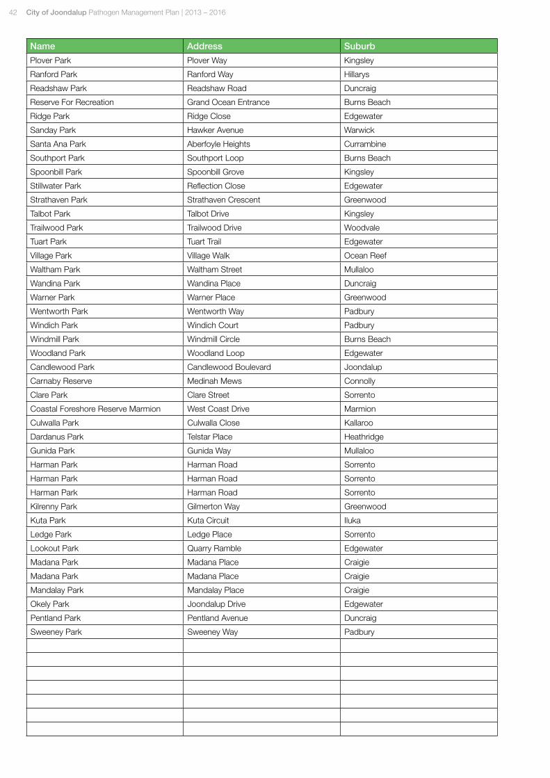
42 City of Joondalup Pathogen Management Plan | 2013 – 2016
Name Address Suburb
Plover Park Plover Way Kingsley
Ranford Park Ranford Way Hillarys
Readshaw Park Readshaw Road Duncraig
Reserve For Recreation Grand Ocean Entrance Burns Beach
Ridge Park Ridge Close Edgewater
Sanday Park Hawker Avenue Warwick
Santa Ana Park Aberfoyle Heights Currambine
Southport Park Southport Loop Burns Beach
Spoonbill Park Spoonbill Grove Kingsley
Stillwater Park Reflection Close Edgewater
Strathaven Park Strathaven Crescent Greenwood
Talbot Park Talbot Drive Kingsley
Trailwood Park Trailwood Drive Woodvale
Tuart Park Tuart Trail Edgewater
Village Park Village Walk Ocean Reef
Waltham Park Waltham Street Mullaloo
Wandina Park Wandina Place Duncraig
Warner Park Warner Place Greenwood
Wentworth Park Wentworth Way Padbury
Windich Park Windich Court Padbury
Windmill Park Windmill Circle Burns Beach
Woodland Park Woodland Loop Edgewater
Candlewood Park Candlewood Boulevard Joondalup
Carnaby Reserve Medinah Mews Connolly
Clare Park Clare Street Sorrento
Coastal Foreshore Reserve Marmion West Coast Drive Marmion
Culwalla Park Culwalla Close Kallaroo
Dardanus Park Telstar Place Heathridge
Gunida Park Gunida Way Mullaloo
Harman Park Harman Road Sorrento
Harman Park Harman Road Sorrento
Harman Park Harman Road Sorrento
Kilrenny Park Gilmerton Way Greenwood
Kuta Park Kuta Circuit Iluka
Ledge Park Ledge Place Sorrento
Lookout Park Quarry Ramble Edgewater
Madana Park Madana Place Craigie
Madana Park Madana Place Craigie
Mandalay Park Mandalay Place Craigie
Okely Park Joondalup Drive Edgewater
Pentland Park Pentland Avenue Duncraig
Sweeney Park Sweeney Way Padbury
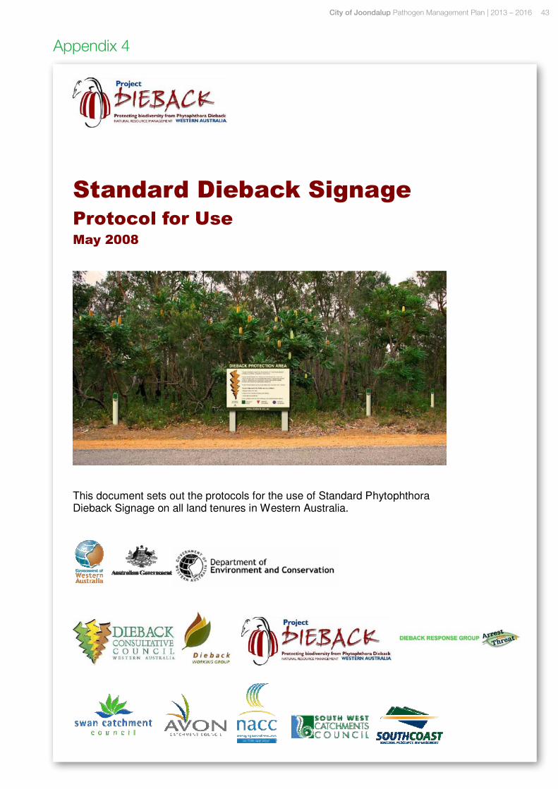
City of Joondalup Pathogen Management Plan | 2013 – 2016 43
Appendix 4

T: 08 9400 4000 F: 08 9300 1383 Boas Avenue Joondalup WA 6027 PO Box 21 Joondalup WA 6919
joondalup.wa.gov.au
This document is available in alternate formats upon request.
Related Documents